Embed Size (px)
Citation preview
Orange Line Bus Rapid TransitProject Plan Update
Metro TransitJuly 2014
METRO Orange Line BRT
Project Plan Update
July 2014Page 2
Contents1 Background 42 Scope 6 2.1 Mode 2.2 Stations 2.3 Guideway 2.4 RightofWayNeeds 2.5 Technology 2.6 FareCollection 2.7 BrandingandMarketing 3 Service Planning 34 3.1 GarageandTerminals 3.2 RunTimeandFrequency 3.3 Service Structure 3.4 Fleet 3.5 Ridership 4 Budget and Funding 38 4.1 CapitalandOperatingCosts 4.2 FundingDistribution 5 Schedule 406 CoordinationwithConcurrentProjects 40 6.1 I-35WLakeTransitAccessProject 6.2 I-494/35WInterchangeVisionLayout 6.3 66thStreetReconstruction 7 EnvironmentalProcess 428 AgencyPartners 42 AppendixA:Stations Appendix B: Service Planning
MetroTransitBRT/SmallStartsProjectOffice707 16th Avenue SouthMinneapolis,MN55454www.metrotransit.org/OrangeLineAdoptedbyMetropolitanCouncilonJuly9,2014
CoverphotocourtesyoftheMinnesotaDepartmentofTransportation.
ForadditionalinformationontheOrangeLine,pleasecontactChristinaMorrisonat612-349-7690orbrtprojects@metrotransit.org.
July 2014 Page 3
METRO Orange Line BRT
Project Plan Update
List of FiguresFigure1.MapofMETROOrangeLineAlignmentandStations 4
Figure2.MapofExistingandPlannedMETROSystemandArterialBRTCorridors 5
Figure3.ExistingRoute535StopGroups andPotentialStationLocations 7
Figure4.PhotosofExistingMARQ2Operations 7
Figure5.LakeStreetStationPreferredPlatformLocationandConnectingBusStops 8
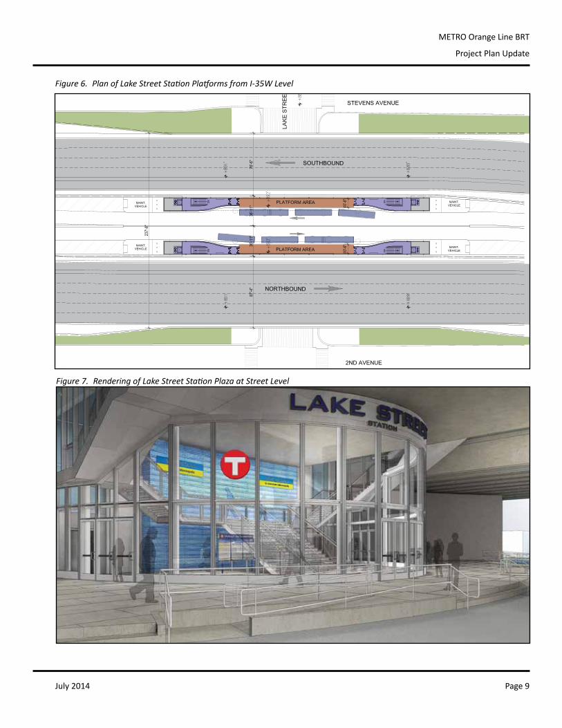
Figure6.PlanofLakeStreetStationPlatformsfromI-35WLevel 9
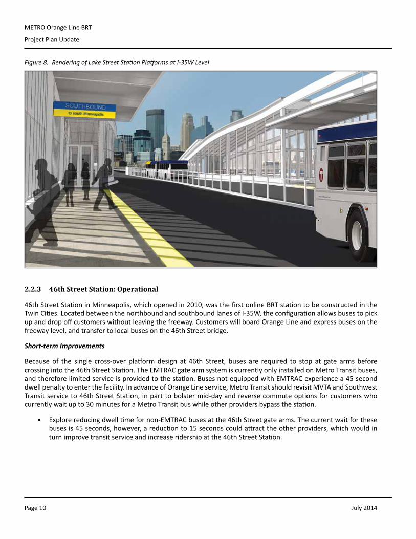
Figure7.RenderingofLakeStreetStationPlazaatStreetLevel 9
Figure8.RenderingofLakeStreetStationPlatformsatI-35WLevel 10
Figure9.46thStreetStationExistingPlatformLocationandConnectingBusStops 11
Figure10.AerialViewof46thStreetStation 11
Figure11.66thStreetAlternativesforPlatformLocations 12
Figure12.66thStreetStationPreferredPlatformLocationsandConnectingBusStops 13
Figure13.ConceptualDesignforNorthboundPlatformat66thStreetStation 13
Figure14.ConceptualDesignforSouthboundPlatformat66thStreetStation 13
Figure15.ConceptualElevationsforNorthboundPlatformat66thStreetStation 14
Figure16.ConceptualElevationsforSouthboundPlatformat66thStreetStation 15
Figure17.AmericanBoulevardAlternativesforPlatformLocations 17
Figure18.ComparisonofOptions1A,3A,and3B 19
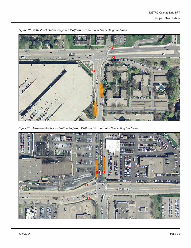
Figure19.76thStreetStationPreferredPlatformLocationsandConnectingBusStops 21
Figure20.AmericanBoulevardStationPreferredPlatformLocationsandConnectingBusStops 21
Figure21.98thStreetAlternativesforPlatformLocations 22
Figure22.98thStreetStationPreferredPlatformLocationandConnectingBusStops 25
Figure23.ConceptualDesignforCombinedNorthboundandSouthboundPlatformat98thStreetStation 25
Figure24.PossiblesitesforBurnsvilleTransitStationGateExpansion 26
Figure25.ConceptsforConnectingMARQ2andI-35WTransitAdvantages 27
Figure26.KnoxAvenueRouting 30
Figure27.98thStreetRouting 30
Figure28.BurnsvilleRoutingforSiteAlternatives 31
Figure29.METROBlueLineTicketVendingMachine 33
Figure30.METROOrangeLineVehicleBranding 33
Figure31.METROOrangeLineConceptRouteMapandConnectingService 35
Figure32.METROOrangeLineEstimatedNorthboundRunTimes 36
Figure33.METROOrangeLineEstimatedSouthboundRunTimes 37
Figure34.METROOrangeLineEstimatedOperatingCosts 38
Figure35.METROOrangeLineProposedFundingDistribution 38
Figure36.METROOrangeLineEstimatedCapitalCosts 39
July 2014Page 4
METRO Orange Line BRT
Project Plan Update
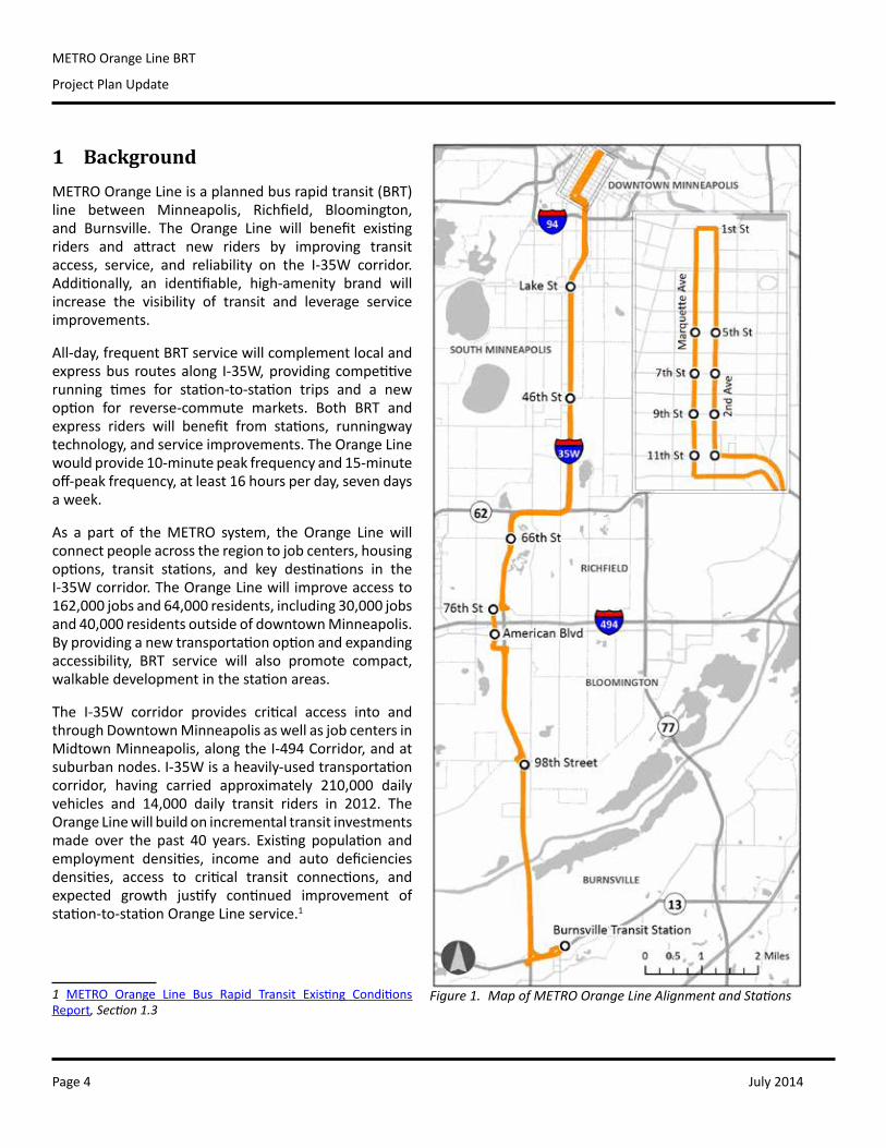
1 BackgroundMETROOrangeLineisaplannedbusrapidtransit(BRT)line between Minneapolis, Richfield, Bloomington,and Burnsville. The Orange Line will benefit existingriders and attract new riders by improving transitaccess, service, and reliability on the I-35W corridor.Additionally, an identifiable, high-amenity brand willincrease the visibility of transit and leverage serviceimprovements.
All-day,frequentBRTservicewillcomplementlocalandexpressbus routesalong I-35W,providingcompetitiverunning times for station-to-station trips and a newoption for reverse-commute markets. Both BRT andexpress riders will benefit from stations, runningwaytechnology,andserviceimprovements.TheOrangeLinewouldprovide10-minutepeakfrequencyand15-minuteoff-peakfrequency,atleast16hoursperday,sevendaysaweek.
As a part of theMETRO system, the Orange Linewillconnectpeopleacrosstheregiontojobcenters,housingoptions, transit stations, and key destinations in theI-35Wcorridor.TheOrangeLinewillimproveaccessto162,000jobsand64,000residents,including30,000jobsand40,000residentsoutsideofdowntownMinneapolis.Byprovidinganewtransportationoptionandexpandingaccessibility, BRT service will also promote compact,walkabledevelopmentinthestationareas.
The I-35W corridor provides critical access into andthroughDowntownMinneapolisaswellasjobcentersinMidtownMinneapolis,alongtheI-494Corridor,andatsuburbannodes.I-35Wisaheavily-usedtransportationcorridor, having carried approximately 210,000 dailyvehicles and 14,000 daily transit riders in 2012. TheOrangeLinewillbuildonincrementaltransitinvestmentsmade over the past 40 years. Existing population andemployment densities, income and auto deficienciesdensities, access to critical transit connections, andexpected growth justify continued improvement ofstation-to-stationOrangeLineservice.1
1 METRO Orange Line Bus Rapid Transit Existing ConditionsReport, Section 1.3
Figure 1. Map of METRO Orange Line Alignment and Stations
July 2014 Page 5
METRO Orange Line BRT
Project Plan Update
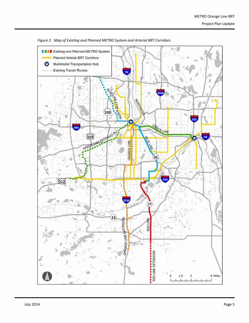
Figure 2. Map of Existing and Planned METRO System and Arterial BRT Corridors
July 2014Page 6
METRO Orange Line BRT
Project Plan Update
2 Scope
2.1 Mode
Between1992and2010,manytransitalternativesandimprovementswerestudiedintheI-35Wcorridor2,including:
• bus(nobuild);• lightrailtransitintheI-35Wmedian,orontheSooLineRailroadcorridor;• high-occupancyvehiclelanes;• transportationdemandmanagementstrategies;• improvedfeederbusservice;• busrapidtransit;• high-occupancytolllanes;and• expressbus.
FollowingaMnDOTI-35WBRTstudyin2005,incrementalstationinvestmentbegunin2008aspartoftwoprojects:freeway reconstruction in theCrosstownCommonsarea,and theUrbanPartnershipAgreement.The46thStreetandDowntown stations have beenoperational since 2010 and currently servemany I-35Wexpress and limited-stopbusroutes.Thelocally-preferredalternativeforthiscorridor,HighwayBRT,wasadoptedintotheregional2030 TransportationPolicyPlanin2010.
2.2 Stations
2.2.1 Downtown Stations: Operational
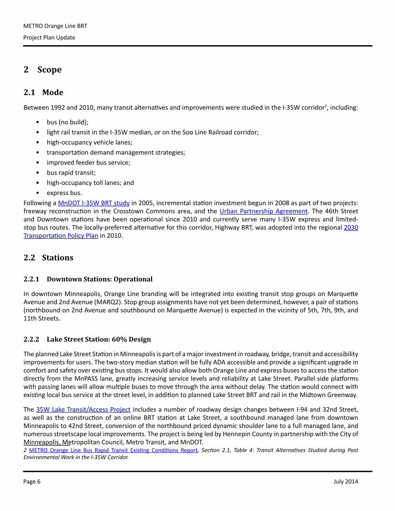
IndowntownMinneapolis,OrangeLinebrandingwillbeintegratedintoexistingtransitstopgroupsonMarquetteAvenueand2ndAvenue(MARQ2).Stopgroupassignmentshavenotyetbeendetermined,however,apairofstations(northboundon2ndAvenueandsouthboundonMarquetteAvenue)isexpectedinthevicinityof5th,7th,9th,and11thStreets.
2.2.2 Lake Street Station: 60% Design
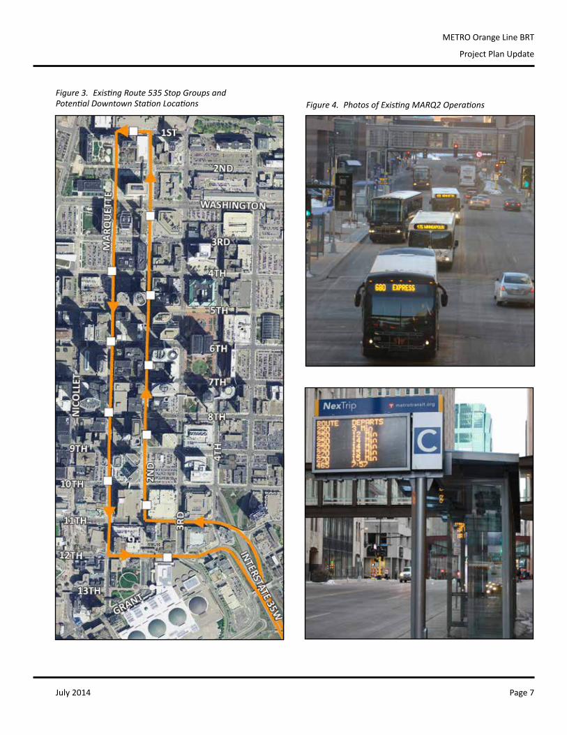
TheplannedLakeStreetStationinMinneapolisispartofamajorinvestmentinroadway,bridge,transitandaccessibilityimprovementsforusers.Thetwo-storymedianstationwillbefullyADAaccessibleandprovideasignificantupgradeincomfortandsafetyoverexistingbusstops.ItwouldalsoallowbothOrangeLineandexpressbusestoaccessthestationdirectlyfromtheMnPASSlane,greatlyincreasingservicelevelsandreliabilityatLakeStreet.Parallelsideplatformswithpassinglaneswillallowmultiplebusestomovethroughtheareawithoutdelay.Thestationwouldconnectwithexistinglocalbusserviceatthestreetlevel,inadditiontoplannedLakeStreetBRTandrailintheMidtownGreenway.
The 35WLakeTransit/AccessProjectincludesanumberofroadwaydesignchangesbetweenI-94and32ndStreet,aswell as the constructionof an online BRT station at Lake Street, a southboundmanaged lane fromdowntownMinneapolisto42ndStreet,conversionofthenorthboundpriceddynamicshoulderlanetoafullmanagedlane,andnumerousstreetscapelocalimprovements.TheprojectisbeingledbyHennepinCountyinpartnershipwiththeCityofMinneapolis,MetropolitanCouncil,MetroTransit,andMnDOT.2 METRO Orange Line Bus Rapid Transit Existing Conditions Report, Section 2.1, Table 4: Transit Alternatives Studied during Past Environmental Work in the I-35W Corridor.
July 2014 Page 7
METRO Orange Line BRT
Project Plan Update
Figure 3. Existing Route 535 Stop Groups and Potential Downtown Station Locations Figure 4. Photos of Existing MARQ2 Operations
July 2014Page 8
METRO Orange Line BRT
Project Plan Update
A public engagement process has been underway for several years in the Lake Street area. A Project AdvisoryCommittee(PAC),comprisedofresidents,businessowners,communityinstitutionsandpolicymakers,meetsmonthlyandadvisespartneragencies.TheLakeStreetBRTStationismovingintofinaldesignin2014.
Short-term Improvements
The existing Lake Street bus stops on I-35W are some of themost austere and uncomfortable waiting areas inthesystem,plaguedbyacombinationof issues:exposedconditions, freewaycongestionandnoise,deterioratinginfrastructure,alackofmaintenance,andasignificantreductionofnorthboundbusservicein2011.
Severalnear-termsolutionsshouldbecoordinatedtoprovideaclearpathfromthecurrentconditionstothesignificantinvestmentofOrangeLineBRT.
• Installpermanenttrashreceptacles.• Replacetherideralertsignagefrequently.Inadequatematerialscreateuncertaintyforpassengersusingthe
station,andindicatesabandonmentofthestop.• Refurbishthesouthboundshelter,orreplaceitwithstockavailableelsewhereinthesystem.Alarger,welllit
shelterwouldprovidegreatersecurityandseparationfromtraffic.• CoordinateMnDOT, City, andMetro Transit staff to visit the site and assess damaged infrastructure (e.g.
fencing)andovergrownvegetation.• Provide informationonsiteabout the35LakeTransit/AccessProjectandOrangeLineplanning to inform
customersaboutlong-termimprovements,andtobetterengagetransitridersintheplanningprocess.• WorkwithMnDOTtocoordinatetransitaccesstoandthroughtheareaduringconstruction.
Figure 5. Lake Street Station Preferred Platform Location and Connecting Bus Stops
July 2014 Page 9
METRO Orange Line BRT
Project Plan Update
selected freeway level brt platformp r o j e c t p a r t n e r s :Hennepin countycity of minneapolismn/dot metro transit
seH Inc.ee&K, a perkins eastman companycH2m Hill Zan assoc.
Figure 6. Plan of Lake Street Station Platforms from I-35W Level
LAKE STREET STATION
3
Figure 7. Rendering of Lake Street Station Plaza at Street Level
July 2014Page 10
METRO Orange Line BRT
Project Plan Update
2.2.3 46th Street Station: Operational
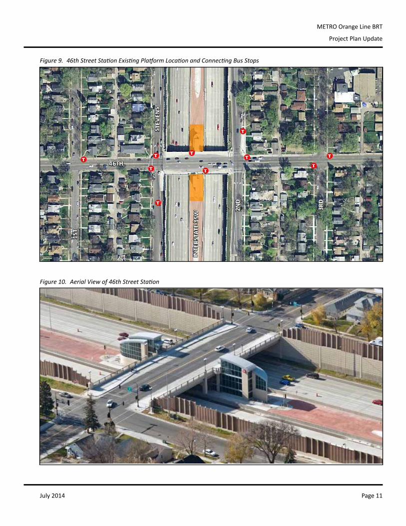
46thStreetStationinMinneapolis,whichopenedin2010,wasthefirstonlineBRTstationtobeconstructedintheTwinCities.LocatedbetweenthenorthboundandsouthboundlanesofI-35W,theconfigurationallowsbusestopickupanddropoffcustomerswithoutleavingthefreeway.CustomerswillboardOrangeLineandexpressbusesonthefreewaylevel,andtransfertolocalbusesonthe46thStreetbridge.
Short-term Improvements
Because of the single cross-over platformdesign at 46th Street, buses are required to stop at gate arms beforecrossingintothe46thStreetStation.TheEMTRACgatearmsystemiscurrentlyonlyinstalledonMetroTransitbuses,andthereforelimitedserviceisprovidedtothestation.BusesnotequippedwithEMTRACexperiencea45-seconddwellpenaltytoenterthefacility.InadvanceofOrangeLineservice,MetroTransitshouldrevisitMVTAandSouthwestTransitserviceto46thStreetStation, inparttobolstermid-dayandreversecommuteoptionsforcustomerswhocurrentlywaitupto30minutesforaMetroTransitbuswhileotherprovidersbypassthestation.
• Explorereducingdwelltimefornon-EMTRACbusesatthe46thStreetgatearms.Thecurrentwaitforthesebusesis45seconds,however,areductionto15secondscouldattracttheotherproviders,whichwouldinturnimprovetransitserviceandincreaseridershipatthe46thStreetStation.
PLATFORM
18
Figure 8. Rendering of Lake Street Station Platforms at I-35W Level
July 2014 Page 11
METRO Orange Line BRT
Project Plan Update
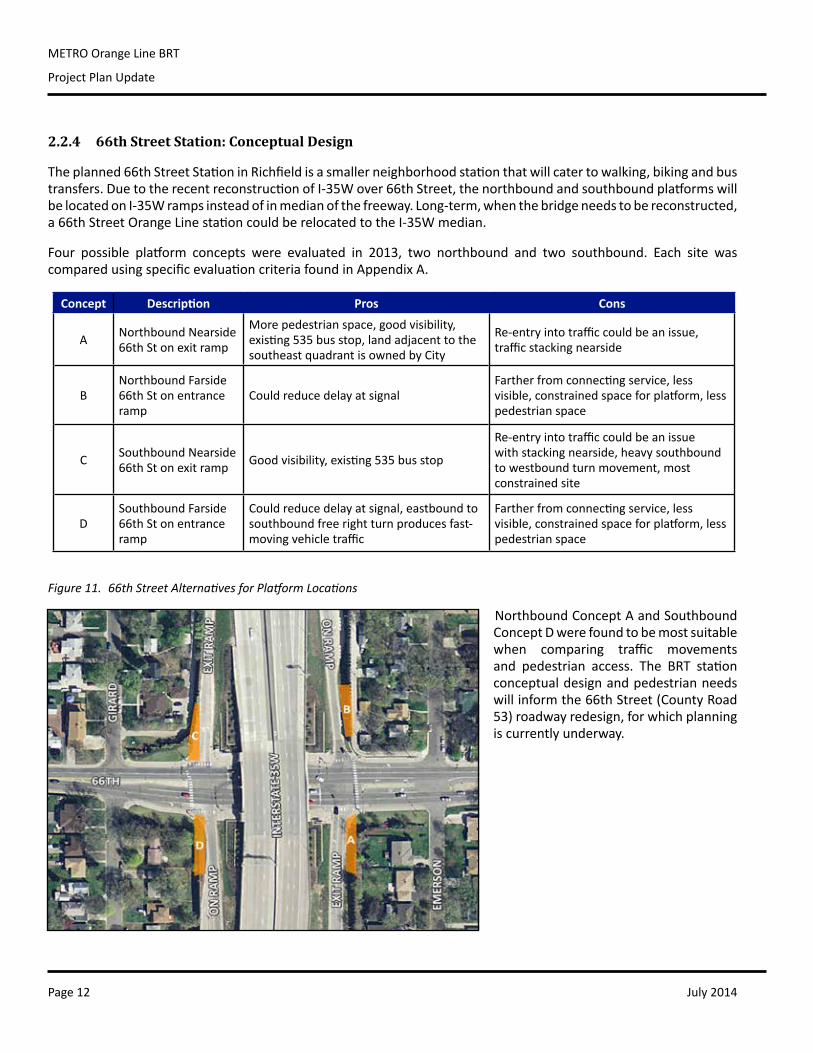
Figure 9. 46th Street Station Existing Platform Location and Connecting Bus Stops
Figure 10. Aerial View of 46th Street Station
July 2014Page 12
METRO Orange Line BRT
Project Plan Update
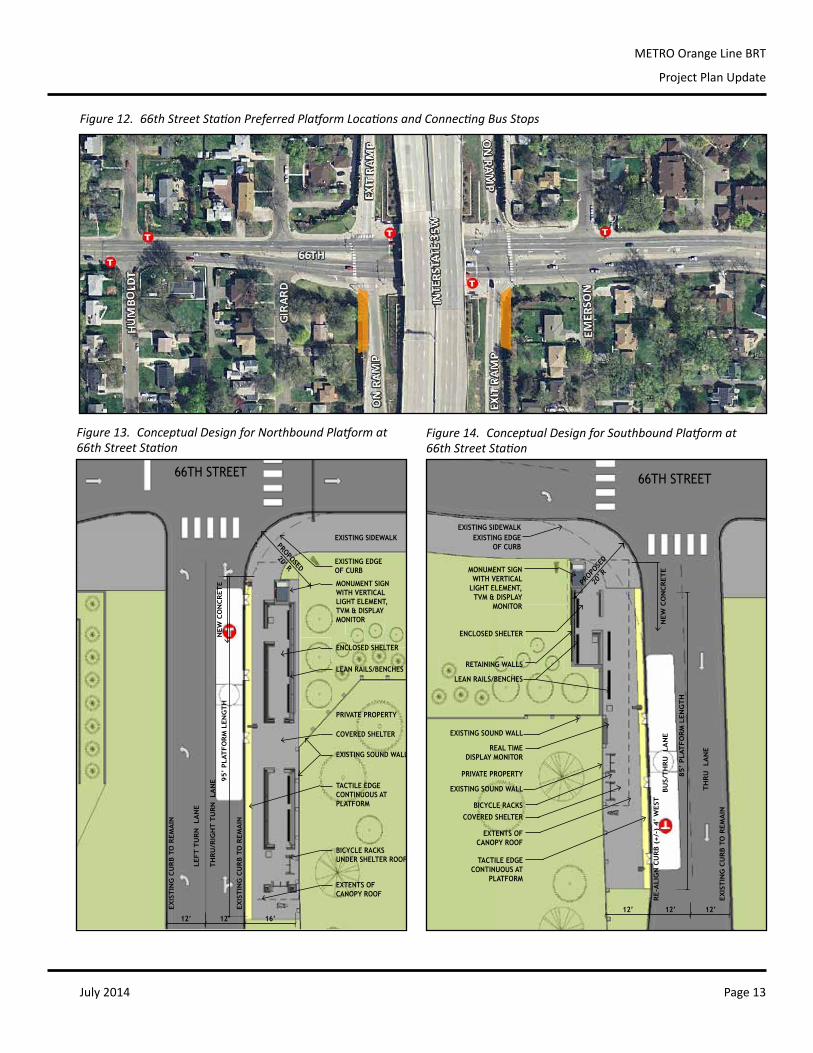
2.2.4 66th Street Station: Conceptual Design
Theplanned66thStreetStationinRichfieldisasmallerneighborhoodstationthatwillcatertowalking,bikingandbustransfers.DuetotherecentreconstructionofI-35Wover66thStreet,thenorthboundandsouthboundplatformswillbelocatedonI-35Wrampsinsteadofinmedianofthefreeway.Long-term,whenthebridgeneedstobereconstructed,a66thStreetOrangeLinestationcouldberelocatedtotheI-35Wmedian.
Four possible platform concepts were evaluated in 2013, two northbound and two southbound. Each site wascomparedusingspecificevaluationcriteriafoundinAppendixA.
NorthboundConceptAandSouthboundConceptDwerefoundtobemostsuitablewhen comparing traffic movementsand pedestrian access. The BRT stationconceptualdesignandpedestrianneedswillinformthe66thStreet(CountyRoad53)roadwayredesign,forwhichplanningiscurrentlyunderway.
Concept Description Pros Cons
A NorthboundNearside66th St on exit ramp
Morepedestrianspace,goodvisibility,existing535busstop,landadjacenttothesoutheastquadrantisownedbyCity
Re-entryintotrafficcouldbeanissue,trafficstackingnearside
BNorthboundFarside66th St on entrance ramp
CouldreducedelayatsignalFartherfromconnectingservice,lessvisible,constrainedspaceforplatform,lesspedestrianspace
C SouthboundNearside66th St on exit ramp Goodvisibility,existing535busstop
Re-entryintotrafficcouldbeanissuewithstackingnearside,heavysouthboundtowestboundturnmovement,mostconstrainedsite
DSouthboundFarside66th St on entrance ramp
Couldreducedelayatsignal,eastboundtosouthboundfreerightturnproducesfast-movingvehicletraffic
Fartherfromconnectingservice,lessvisible,constrainedspaceforplatform,lesspedestrianspace
Figure 11. 66th Street Alternatives for Platform Locations
July 2014 Page 13
METRO Orange Line BRT
Project Plan Update
PRODUCED BY AN AUTODESK STUDENT PRODUCT
PR
OD
UC
ED
BY
AN
AU
TO
DE
SK
ST
UD
EN
T P
RO
DU
CT
PRODUCED BY AN AUTODESK STUDENT PRODUCT
PR
OD
UC
ED
BY
AN
AU
TO
DE
SK
ST
UD
EN
T P
RO
DU
CT
LEFT T
UR
N LA
NE
EXISTING SIDEWALK
TH
RU
/RIG
HT T
UR
N LA
NE
I-35
W
EXISTING EDGE OF CURB
EXISTING SOUND WALL
PRODUCED BY AN AUTODESK STUDENT PRODUCT
PR
OD
UC
ED
BY
AN
AU
TO
DE
SK
ST
UD
EN
T P
RO
DU
CT
PRODUCED BY AN AUTODESK STUDENT PRODUCT
PR
OD
UC
ED
BY
AN
AU
TO
DE
SK
ST
UD
EN
T P
RO
DU
CT
PRODUCED BY AN AUTODESK STUDENT PRODUCT
PR
OD
UC
ED
BY
AN
AU
TO
DE
SK
ST
UD
EN
T P
RO
DU
CT
PRODUCED BY AN AUTODESK STUDENT PRODUCT
PR
OD
UC
ED
BY
AN
AU
TO
DE
SK
ST
UD
EN
T P
RO
DU
CT
PRODUCED BY AN AUTODESK STUDENT PRODUCT
PR
OD
UC
ED
BY
AN
AU
TO
DE
SK
ST
UD
EN
T P
RO
DU
CT
PRODUCED BY AN AUTODESK STUDENT PRODUCT
PR
OD
UC
ED
BY
AN
AU
TO
DE
SK
ST
UD
EN
T P
RO
DU
CT
PRODUCED BY AN AUTODESK STUDENT PRODUCT
PR
OD
UC
ED
BY
AN
AU
TO
DE
SK
ST
UD
EN
T P
RO
DU
CT
PRODUCED BY AN AUTODESK STUDENT PRODUCT
PR
OD
UC
ED
BY
AN
AU
TO
DE
SK
ST
UD
EN
T P
RO
DU
CT
PRODUCED BY AN AUTODESK STUDENT PRODUCT
PR
OD
UC
ED
BY
AN
AU
TO
DE
SK
ST
UD
EN
T P
RO
DU
CT
PRODUCED BY AN AUTODESK STUDENT PRODUCT
PR
OD
UC
ED
BY
AN
AU
TO
DE
SK
ST
UD
EN
T P
RO
DU
CT
PRODUCED BY AN AUTODESK STUDENT PRODUCT
PR
OD
UC
ED
BY
AN
AU
TO
DE
SK
ST
UD
EN
T P
RO
DU
CT
PRODUCED BY AN AUTODESK STUDENT PRODUCT
PR
OD
UC
ED
BY
AN
AU
TO
DE
SK
ST
UD
EN
T P
RO
DU
CT
PRODUCED BY AN AUTODESK STUDENT PRODUCT
PR
OD
UC
ED
BY
AN
AU
TO
DE
SK
ST
UD
EN
T P
RO
DU
CT
PRODUCED BY AN AUTODESK STUDENT PRODUCT
PR
OD
UC
ED
BY
AN
AU
TO
DE
SK
ST
UD
EN
T P
RO
DU
CT
PRODUCED BY AN AUTODESK STUDENT PRODUCT
PR
OD
UC
ED
BY
AN
AU
TO
DE
SK
ST
UD
EN
T P
RO
DU
CT
PRODUCED BY AN AUTODESK STUDENT PRODUCT
PR
OD
UC
ED
BY
AN
AU
TO
DE
SK
ST
UD
EN
T P
RO
DU
CT
PRODUCED BY AN AUTODESK STUDENT PRODUCT
PR
OD
UC
ED
BY
AN
AU
TO
DE
SK
ST
UD
EN
T P
RO
DU
CT
PRODUCED BY AN AUTODESK STUDENT PRODUCT
PR
OD
UC
ED
BY
AN
AU
TO
DE
SK
ST
UD
EN
T P
RO
DU
CT
PRODUCED BY AN AUTODESK STUDENT PRODUCT
PR
OD
UC
ED
BY
AN
AU
TO
DE
SK
ST
UD
EN
T P
RO
DU
CT
PRODUCED BY AN AUTODESK STUDENT PRODUCT
PR
OD
UC
ED
BY
AN
AU
TO
DE
SK
ST
UD
EN
T P
RO
DU
CT
PRODUCED BY AN AUTODESK STUDENT PRODUCT
PR
OD
UC
ED
BY
AN
AU
TO
DE
SK
ST
UD
EN
T P
RO
DU
CT
PRODUCED BY AN AUTODESK STUDENT PRODUCT
PR
OD
UC
ED
BY
AN
AU
TO
DE
SK
ST
UD
EN
T P
RO
DU
CT
PRIVATE PROPERTY
MONUMENT SIGNWITH VERTICAL LIGHT ELEMENT,TVM & DISPLAY MONITOR
ENCLOSED SHELTER
LEAN RAILS/BENCHES
BICYCLE RACKSUNDER SHELTER ROOF
COVERED SHELTER
66TH STREET
TACTILE EDGECONTINUOUS ATPLATFORM
EXTENTS OF CANOPY ROOF
12’
PROPOSED20’ R
12’ 16’
EXIS
TIN
G C
UR
B T
O R
EM
AIN
EXIS
TIN
G C
UR
B T
O R
EM
AIN
NEW
CO
NC
RET
E95’
PLA
TFO
RM
LEN
GT
H
PRODUCED BY AN AUTODESK STUDENT PRODUCT
PR
OD
UC
ED
BY
AN
AU
TO
DE
SK
ST
UD
EN
T P
RO
DU
CT
PRODUCED BY AN AUTODESK STUDENT PRODUCT
PR
OD
UC
ED
BY
AN
AU
TO
DE
SK
ST
UD
EN
T P
RO
DU
CT
EXISTING SIDEWALK
TH
RU
LA
NE I-35
W
EXISTING EDGE OF CURB
EXISTING SOUND WALL
PR
OD
UC
ED
BY
AN
AU
TO
DE
SK
ST
UD
EN
T P
RO
DU
CT
PRODUCED BY AN AUTODESK STUDENT PRODUCT
PR
OD
UC
ED
BY
AN
AU
TO
DE
SK
ST
UD
EN
T P
RO
DU
CT
PRODUCED BY AN AUTODESK STUDENT PRODUCT
PRODUCED BY AN AUTODESK STUDENT PRODUCT
PR
OD
UC
ED
BY
AN
AU
TO
DE
SK
ST
UD
EN
T P
RO
DU
CT
PRODUCED BY AN AUTODESK STUDENT PRODUCT
PR
OD
UC
ED
BY
AN
AU
TO
DE
SK
ST
UD
EN
T P
RO
DU
CT
PRODUCED BY AN AUTODESK STUDENT PRODUCT
PR
OD
UC
ED
BY
AN
AU
TO
DE
SK
ST
UD
EN
T P
RO
DU
CT
PRODUCED BY AN AUTODESK STUDENT PRODUCT
PR
OD
UC
ED
BY
AN
AU
TO
DE
SK
ST
UD
EN
T P
RO
DU
CT
PRODUCED BY AN AUTODESK STUDENT PRODUCT
PR
OD
UC
ED
BY
AN
AU
TO
DE
SK
ST
UD
EN
T P
RO
DU
CT
PRODUCED BY AN AUTODESK STUDENT PRODUCT
PR
OD
UC
ED
BY
AN
AU
TO
DE
SK
ST
UD
EN
T P
RO
DU
CT
PRODUCED BY AN AUTODESK STUDENT PRODUCT
PR
OD
UC
ED
BY
AN
AU
TO
DE
SK
ST
UD
EN
T P
RO
DU
CT
PRODUCED BY AN AUTODESK STUDENT PRODUCT
PR
OD
UC
ED
BY
AN
AU
TO
DE
SK
ST
UD
EN
T P
RO
DU
CT
PR
OD
UC
ED
BY
AN
AU
TO
DE
SK
ST
UD
EN
T P
RO
DU
CT
PRODUCED BY AN AUTODESK STUDENT PRODUCT
PR
OD
UC
ED
BY
AN
AU
TO
DE
SK
ST
UD
EN
T P
RO
DU
CT
PRODUCED BY AN AUTODESK STUDENT PRODUCT
PR
OD
UC
ED
BY
AN
AU
TO
DE
SK
ST
UD
EN
T P
RO
DU
CT
PRODUCED BY AN AUTODESK STUDENT PRODUCT
PR
OD
UC
ED
BY
AN
AU
TO
DE
SK
ST
UD
EN
T P
RO
DU
CT
PRODUCED BY AN AUTODESK STUDENT PRODUCT
PRODUCED BY AN AUTODESK STUDENT PRODUCT
PR
OD
UC
ED
BY
AN
AU
TO
DE
SK
ST
UD
EN
T P
RO
DU
CT
PRODUCED BY AN AUTODESK STUDENT PRODUCT
PR
OD
UC
ED
BY
AN
AU
TO
DE
SK
ST
UD
EN
T P
RO
DU
CT
PRIVATE PROPERTY
LEAN RAILS/BENCHES
COVERED SHELTER
66TH STREET
TACTILE EDGECONTINUOUS AT
PLATFORM
EXTENTS OF CANOPY ROOF
N
PRODUCED BY AN AUTODESK STUDENT PRODUCT
PR
OD
UC
ED
BY
AN
AU
TO
DE
SK
ST
UD
EN
T P
RO
DU
CT
PRODUCED BY AN AUTODESK STUDENT PRODUCT
PR
OD
UC
ED
BY
AN
AU
TO
DE
SK
ST
UD
EN
T P
RO
DU
CT
PRODUCED BY AN AUTODESK STUDENT PRODUCTP
RO
DU
CE
D B
Y A
N A
UT
OD
ES
K S
TU
DE
NT
PR
OD
UC
T
PRODUCED BY AN AUTODESK STUDENT PRODUCT
PR
OD
UC
ED
BY
AN
AU
TO
DE
SK
ST
UD
EN
T P
RO
DU
CT
PRODUCED BY AN AUTODESK STUDENT PRODUCT
PR
OD
UC
ED
BY
AN
AU
TO
DE
SK
ST
UD
EN
T P
RO
DU
CT
PRODUCED BY AN AUTODESK STUDENT PRODUCT
PR
OD
UC
ED
BY
AN
AU
TO
DE
SK
ST
UD
EN
T P
RO
DU
CT
PRODUCED BY AN AUTODESK STUDENT PRODUCT
PR
OD
UC
ED
BY
AN
AU
TO
DE
SK
ST
UD
EN
T P
RO
DU
CT
PRODUCED BY AN AUTODESK STUDENT PRODUCT
PR
OD
UC
ED
BY
AN
AU
TO
DE
SK
ST
UD
EN
T P
RO
DU
CT
PRODUCED BY AN AUTODESK STUDENT PRODUCT
PR
OD
UC
ED
BY
AN
AU
TO
DE
SK
ST
UD
EN
T P
RO
DU
CT
PRODUCED BY AN AUTODESK STUDENT PRODUCT
PR
OD
UC
ED
BY
AN
AU
TO
DE
SK
ST
UD
EN
T P
RO
DU
CT
ENCLOSED SHELTER
MONUMENT SIGNWITH VERTICAL
LIGHT ELEMENT,TVM & DISPLAY
MONITOR
BICYCLE RACKS
BU
S/T
HR
U LA
NE
RETAINING WALLS
85’
PLA
TFO
RM
LEN
GT
H
12’ 12’ 12’
PROPO
SED
20’ R
EXIS
TIN
G C
UR
B T
O R
EM
AIN
RE-A
LIG
N C
UR
B (
+/-
) 4’
WEST
NEW
CO
NC
RET
E
REAL TIMEDISPLAY MONITOR
EXISTING SOUND WALL
Figure 12. 66th Street Station Preferred Platform Locations and Connecting Bus Stops
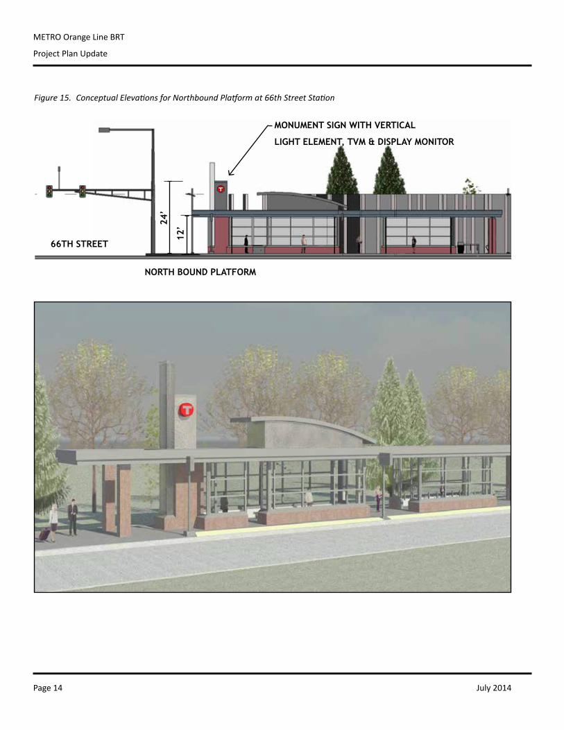
Figure 13. Conceptual Design for Northbound Platform at 66th Street Station
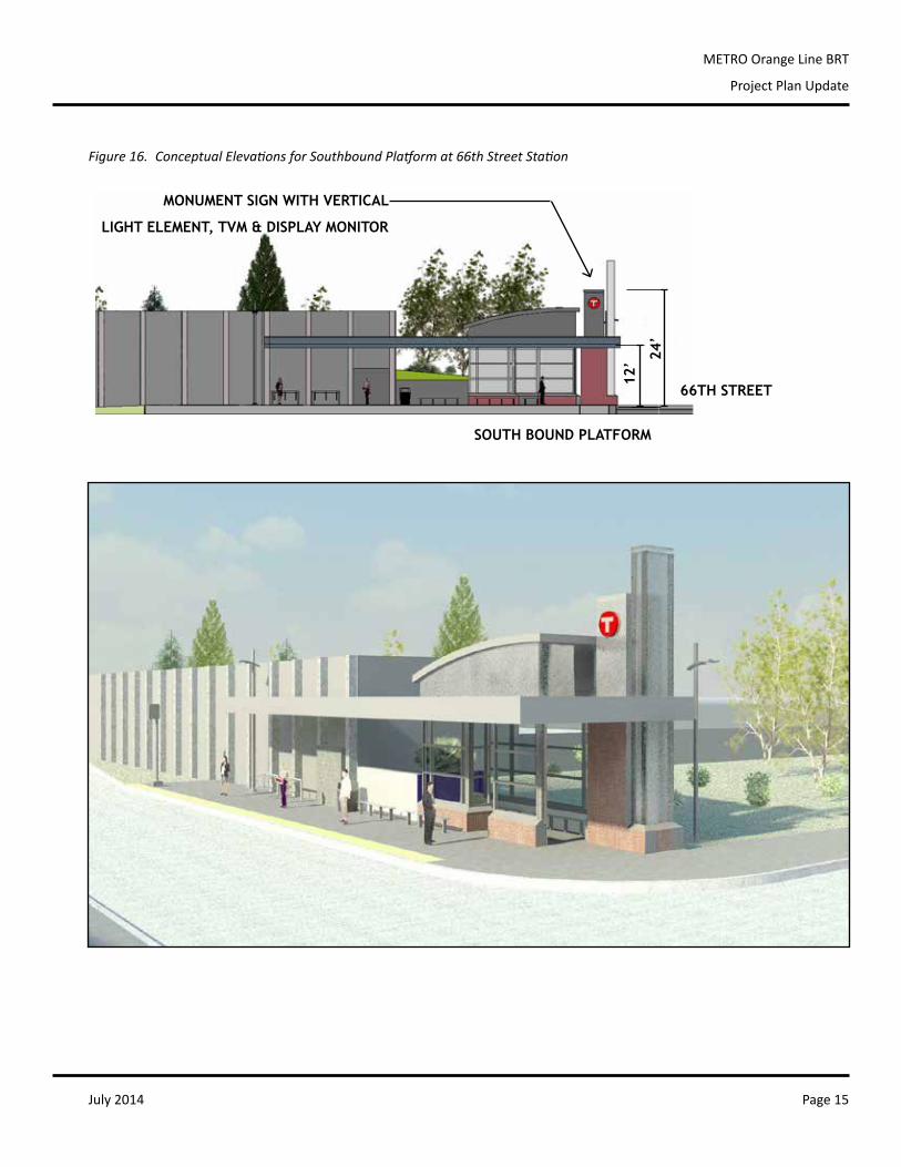
Figure 14. Conceptual Design for Southbound Platform at 66th Street Station
July 2014Page 14
METRO Orange Line BRT
Project Plan Update
1/32" = 1'-0"5
66th NB Elevation 1/32" = 1'-0"
266th SB Elevation
1/32" = 1'-0"3
98th N & S Elevation
1/32" = 1'-0"4
98th Porkchop Elevation
1/32" = 1'-0"1
98th Porkchop Elevation from 98th
PRODUCED BY AN AUTODESK STUDENT PRODUCT
PR
OD
UC
ED
BY
AN
AU
TO
DE
SK
ST
UD
EN
T P
RO
DU
CT
PRODUCED BY AN AUTODESK STUDENT PRODUCT
PR
OD
UC
ED
BY
AN
AU
TO
DE
SK
ST
UD
EN
T P
RO
DU
CT
12’24
’
MONUMENT SIGN WITH VERTICAL
LIGHT ELEMENT, TVM & DISPLAY MONITOR
66TH STREET
NORTH BOUND PLATFORM
Figure 15. Conceptual Elevations for Northbound Platform at 66th Street Station
July 2014 Page 15
METRO Orange Line BRT
Project Plan Update
PRODUCED BY AN AUTODESK STUDENT PRODUCT
PR
OD
UC
ED
BY
AN
AU
TO
DE
SK
ST
UD
EN
T P
RO
DU
CT
PRODUCED BY AN AUTODESK STUDENT PRODUCT
PR
OD
UC
ED
BY
AN
AU
TO
DE
SK
ST
UD
EN
T P
RO
DU
CT
1/32" = 1'-0"5
66th NB Elevation 1/32" = 1'-0"
266th SB Elevation
1/32" = 1'-0"3
98th N & S Elevation
1/32" = 1'-0"4
98th Porkchop Elevation
1/32" = 1'-0"1
98th Porkchop Elevation from 98th
PRODUCED BY AN AUTODESK STUDENT PRODUCT
PR
OD
UC
ED
BY
AN
AU
TO
DE
SK
ST
UD
EN
T P
RO
DU
CT
PRODUCED BY AN AUTODESK STUDENT PRODUCT
PR
OD
UC
ED
BY
AN
AU
TO
DE
SK
ST
UD
EN
T P
RO
DU
CT
MONUMENT SIGN WITH VERTICAL
LIGHT ELEMENT, TVM & DISPLAY MONITOR
12’ 24
’
66TH STREET
SOUTH BOUND PLATFORM
Figure 16. Conceptual Elevations for Southbound Platform at 66th Street Station
July 2014Page 16
METRO Orange Line BRT
Project Plan Update
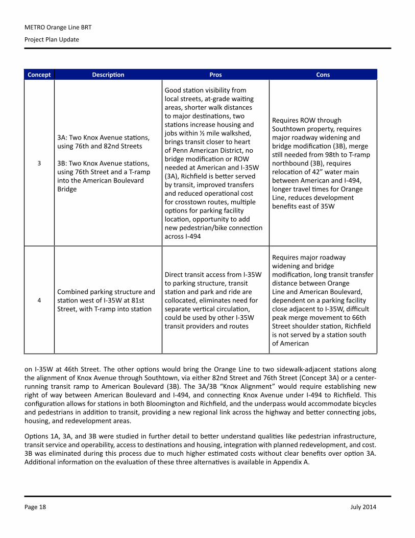
2.2.5 76th Street and American Boulevard Stations: Planning
Station improvements for the American Boulevard area are integrated into planning for the larger I-494/35Winterchangedesign.TheexistingKnoxAvenuepark-and-ride lot inRichfield,builtonMnDOT right-of-wayneededfortheplannedinterchange,willberelocatedandreplacedwithanewparkingrampneartheAmericanBoulevardstation.The2013processforstationplanningwascompletedaspartoftheI-494/35WInterchangeVisionLayoutDevelopmentledbyMnDOT.
The494/35WTechnicalAdvisoryCommittee(TAC)firstreviewedthreepreliminaryconceptsdevelopedduringpriorinterchangeplanning in2010.Basedon thispriorwork, theTAC further refinedconcepts,aswell asaddingnewlocationsanddesignsthatwerenotpreviouslyconsidered.Fouroptions,showninthetablebelow,werethenstudiedbasedonagreed-uponevaluationcriteriainthreecategories:transitstationdesign,busoperations,andtransitriderbenefit.
The ratingswerebasedona simple relativecomparisonofpositive,neutral andnegative impacts to thedefinedevaluationcriteria.AcopyofthecriteriaandevaluationmatrixisincludedinAppendixA.TheTACgroupcomparedtheseratings,discussedindividualvariations,andreachedconsensusonrelativebenefitandimpactofeachconcept.Concepts1A,3A,and3Bwereselectedtobedevelopedinfurtherdetail.
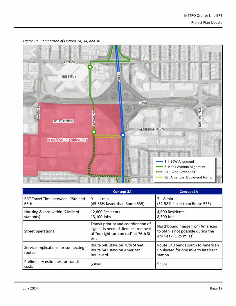
ThesethreedetailedconceptsconsideredtwodifferentapproachestotheOrangeLinealignment.Inthefirstoption,theOrangeLinewouldstayonI-35W,stoppingatanewtwo-storymedianstation,similartotheexistingBRTstation
Concept Description Pros Cons
1
1A:MedianStationonI-35WunderedgeofAmericanBoulevard Bridge 1B:MedianStationonI-35Wcentered under American Boulevard Bridge 1C:MedianStationoverI-35W,atAmerican Boulevard level
Efficientbusoperations,goodstationvisibilityfromfreeway,eliminatesverticalcirculationbetweenstations(1C),couldbeusedbyotherI-35Wtransitprovidersandroutes
Noiselevelsonfreewayplatforms,requiresmajorroadwaywideningandbridgemodification,verticalcirculationtowersneeded,difficultpeakmerge movement to 66th Street shoulderstation,RichfieldisnotservedbyastationatAmerican
2 MedianStationonI-35Wat81stStreet
Efficientbusoperations,goodstationvisibilityfromfreeway,nobridgemodificationneededatAmerican,couldbeusedbyotherI-35Wtransitprovidersandroutes
Noiselevelsonfreewayplatforms,requiresmajorroadwaywidening,verticalcirculationtowersneeded,Richfieldisnotservedbyastationat81st,longtransittransferdistancebetweenOrangeLineandAmericanBoulevard,dependentonaparkingfacilitycloseadjacenttoI-35W,requiresanewskywaytoconnecttoparkingfacilityandlocalstreets
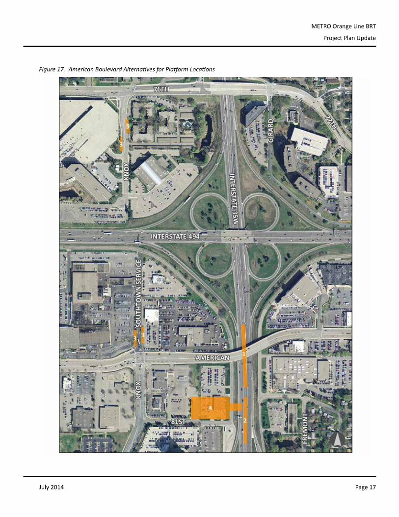
July 2014 Page 17
METRO Orange Line BRT
Project Plan Update
Figure 17. American Boulevard Alternatives for Platform Locations
July 2014Page 18
METRO Orange Line BRT
Project Plan Update
on I-35Wat46thStreet.Theotheroptionswouldbring theOrangeLine to twosidewalk-adjacent stationsalongthealignmentofKnoxAvenuethroughSouthtown,viaeither82ndStreetand76thStreet(Concept3A)oracenter-running transit ramp to American Boulevard (3B). The 3A/3B “Knox Alignment” would require establishing newrightofwaybetweenAmericanBoulevard and I-494, and connectingKnoxAvenueunder I-494 toRichfield. ThisconfigurationallowsforstationsinbothBloomingtonandRichfield,andtheunderpasswouldaccommodatebicyclesandpedestriansinadditiontotransit,providinganewregionallinkacrossthehighwayandbetterconnectingjobs,housing,andredevelopmentareas.
Options1A,3A,and3Bwerestudiedinfurtherdetailtobetterunderstandqualitieslikepedestrianinfrastructure,transitserviceandoperability,accesstodestinationsandhousing,integrationwithplannedredevelopment,andcost.3Bwaseliminatedduringthisprocessduetomuchhigherestimatedcostswithoutclearbenefitsoveroption3A.AdditionalinformationontheevaluationofthesethreealternativesisavailableinAppendixA.
Concept Description Pros Cons
3
3A:TwoKnoxAvenuestations,using76thand82ndStreets 3B:TwoKnoxAvenuestations,using76thStreetandaT-rampinto the American Boulevard Bridge
Goodstationvisibilityfromlocalstreets,at-gradewaitingareas,shorterwalkdistancestomajordestinations,twostationsincreasehousingandjobswithin½milewalkshed,bringstransitclosertoheartofPennAmericanDistrict,nobridgemodificationorROWneededatAmericanandI-35W(3A),Richfieldisbetterservedbytransit,improvedtransfersandreducedoperationalcostforcrosstownroutes,multipleoptionsforparkingfacilitylocation,opportunitytoaddnewpedestrian/bikeconnectionacrossI-494
RequiresROWthroughSouthtownproperty,requiresmajorroadwaywideningandbridgemodification(3B),mergestillneededfrom98thtoT-rampnorthbound(3B),requiresrelocationof42”watermainbetweenAmericanandI-494,longertraveltimesforOrangeLine,reducesdevelopmentbenefitseastof35W
4CombinedparkingstructureandstationwestofI-35Wat81stStreet,withT-rampintostation
DirecttransitaccessfromI-35Wtoparkingstructure,transitstationandparkandridearecollocated,eliminatesneedforseparateverticalcirculation,couldbeusedbyotherI-35Wtransitprovidersandroutes
Requiresmajorroadwaywideningandbridgemodification,longtransittransferdistancebetweenOrangeLineandAmericanBoulevard,dependentonaparkingfacilitycloseadjacenttoI-35W,difficultpeak merge movement to 66th Streetshoulderstation,RichfieldisnotservedbyastationsouthofAmerican
July 2014 Page 19
METRO Orange Line BRT
Project Plan Update
BEST BUY
SOUTHTOWN
I-494
I-35W
AMERICAN BLVD
PENN
AVE
LYND
ALE AVE
76TH ST
KNO
X AVEPENN AMERICAN DISTRICT
ORANGE LINE AMERICAN BOULEVARD ALIGNMENT ALTERNATIVES
1: I-35W Alignment3: Knox Avenue Alignment3A: 82nd Street TSP3B: American Boulevard Ramp
Figure 18. Comparison of Options 1A, 3A, and 3B
Concept 3A Concept 1A
BRTTravelTimebetween98thand66th
9 – 11 min (45-55%fasterthanRoute535)
7 – 8 min (52-58%fasterthanRoute535)
Housing&Jobswithin½Mileofstation(s)
12,800Residents 13,100Jobs
4,600Residents 8,300Jobs
Streetoperations
Transitpriorityandcoordinationofsignalsisneeded.Requestremovalof“norightturnonred”at76thStexit
NorthboundmergefromAmericanto66thisnotpossibleduringtheAMPeak(1.25miles)
Serviceimplicationsforconnectingroutes
Route540stayson76thStreet,Route542staysonAmericanBoulevard
Route540bendssouthtoAmericanBoulevardforonemiletointersectstation
Preliminaryestimatesfortransitcosts $30M $36M
July 2014Page 20
METRO Orange Line BRT
Project Plan Update
The I-494/35W Interchange TAC recommendedOption 3A tomove forward for the further study, informing theinterchangedesignandthelocationofafuturepark-and-ridefacility.RoutingtheOrangeLineviaKnoxAvenue,using76thand82ndStreet,providesabetteropportunitytointegratefrequent,reliabletransitintoagrowingneighborhood.Thetwo-stationconfigurationprovidesseveralbenefitstothecorridor:
• Enhancingthetransitcustomerexperience.Eachsitewouldprovidecomfortable,sidewalk-adjacentstations,withopportunitiesforlandscaping,publicart,bicycleparking,transitconnections,andenhancedstreetscape.
• Putting transitwhere peoplewant to be. KnoxAvenuemaximizeswalk access tomajor destinations andhousing,andminimizesimpactstoexistingtransitridersbyprovidingstationsonbothsidesofI-494.
• Integratingtransitintoexistingandplanneddevelopment.Becauseofconcurrentroadway,transitway,andlanduseplanning,thereisarareopportunitytoproactivelyplacethestationsinproximitymoredevelopablelandandexistingdevelopment.Thismaximizesthelong-termlandusebenefitsofhavingastationandbuildsonstrongexistingridership.
• Eliminatinglong-termoperationalissues.Evenundercurrentcongestion,mergingfromamedianstationatAmericanBoulevardtoashoulderstationat66thStreethasbeendeemedoperationallyinfeasible,particularlyintheAMpeakperiod.ThismaneuverwouldrequireOrangeLineservicereductionstoAmericanBoulevardorto66thStreetduringthebusiestpartoftheday.
• Reducingcapital,maintenance,andoperatingcost.Option3AislesscostlythanbothOptions1Aand3B,whilestillvastlyimprovingtransitserviceandaccess.Connectingeast-westbusroutesareabletorunsimplified,griddedroutes,reducingbusoperatingcostsandpassengerdelay.Street-levelstationseliminatetheneedforelevators,stairs,andskyways,reducingannualmaintenanceneedsandcosts.
• Expandingoptionsformeetingparkandridedemand.Twostationswidenthesearchareaforlocatingapark-and-ridefacility,andincreaseopportunitiesforjointdevelopmentorshared-useparking.
Concurrent Land Use Planning
TheKnoxAvenuealignmentbuildsoncityplanningfocusedonthelong-termredevelopmentofthePenn American District,andareaalongAmericanBoulevardprimarilybetweenPennAvenueandI-35W.Withitsfavorablelocationintheregion,thePennAmericanareadevelopedasaretailshoppinghubmorethan40yearsagoduringthefirstphaseofsuburbangrowth intheTwinCities.Shifts intheeconomyandchangingmarketpreferences,alongwiththeprevalenceofagingbuildingsandlargeamountsof landdevotedtoparkingintheDistrict,presentsignificantopportunitiesforredevelopment.
The PennAmericanDistrictPlanwasadoptedbytheCityofBloomingtoninJanuary2014,helpingtheDistrictmeetitspotentialbydefiningaclearvisiontoguideredevelopmentandinvestmentsinpublicinfrastructure.KeyelementsofthePennAmericanvisioninclude:
• Addingnew,pedestrian-friendlystreetsandcreatingsmallerdevelopmentblocksasredevelopmentoccurs;• Increasingdevelopmentintensityanddiversifyingthemixoflanduses;• Improvingthequalityandcharacterofbuildingsandpublicspaces;• Increasingmobilitythroughtargetedimprovementstoroads,bikeways,andsidewalks;and• Leveragingtheproposedsubstantialinvestmentsintransitandtransportationinfrastructure.
July 2014 Page 21
METRO Orange Line BRT
Project Plan Update
Figure 19. 76th Street Station Preferred Platform Locations and Connecting Bus Stops
Figure 20. American Boulevard Station Preferred Platform Locations and Connecting Bus Stops
July 2014Page 22
METRO Orange Line BRT
Project Plan Update
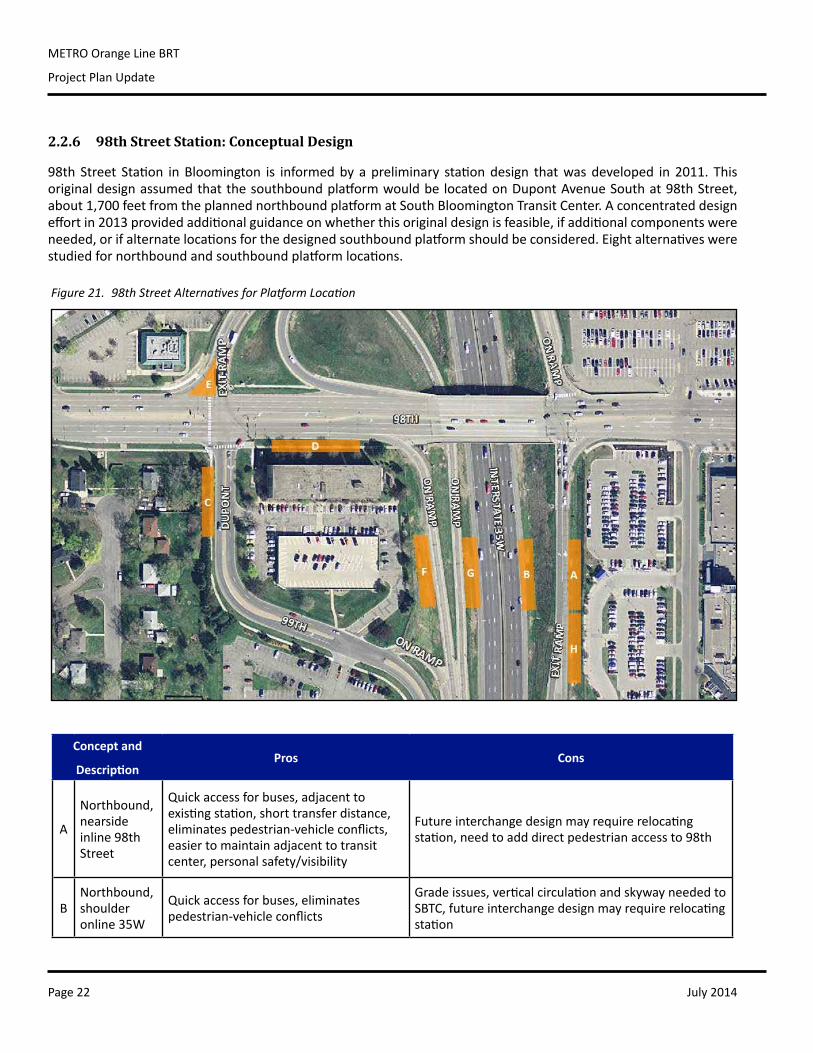
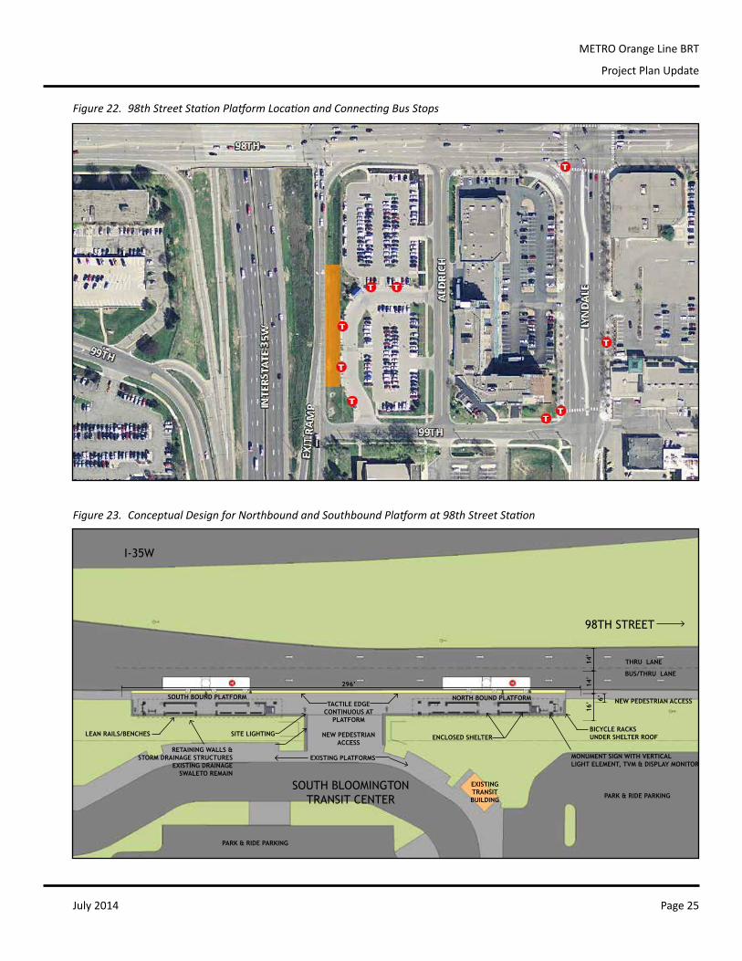
2.2.6 98th Street Station: Conceptual Design
98th Street Station inBloomington is informedbyapreliminary stationdesign thatwasdeveloped in2011. ThisoriginaldesignassumedthatthesouthboundplatformwouldbelocatedonDupontAvenueSouthat98thStreet,about1,700feetfromtheplannednorthboundplatformatSouthBloomingtonTransitCenter.Aconcentrateddesigneffortin2013providedadditionalguidanceonwhetherthisoriginaldesignisfeasible,ifadditionalcomponentswereneeded,orifalternatelocationsforthedesignedsouthboundplatformshouldbeconsidered.Eightalternativeswerestudiedfornorthboundandsouthboundplatformlocations.
Figure 21. 98th Street Alternatives for Platform Location
Concept and
DescriptionPros Cons
A
Northbound,nearsideinline 98th Street
Quickaccessforbuses,adjacenttoexistingstation,shorttransferdistance,eliminatespedestrian-vehicleconflicts,easiertomaintainadjacenttotransitcenter,personalsafety/visibility
Futureinterchangedesignmayrequirerelocatingstation,needtoadddirectpedestrianaccessto98th
BNorthbound,shoulderonline35W
Quickaccessforbuses,eliminatespedestrian-vehicleconflicts
Gradeissues,verticalcirculationandskywayneededtoSBTC,futureinterchangedesignmayrequirerelocatingstation
July 2014 Page 23
METRO Orange Line BRT
Project Plan Update
Concept and
DescriptionPros Cons
CSouthbound,farsideinlineDupontAve
AccesstoHOVonrampforbuses,fastertransferstowestboundbuses(NormandaleCollege),fasterthrough-travelfortransitridersgoingtoBurnsville,ridersstillhaveoptionofgoingdirectlytoSBTConexpressroutes
DistancefromSBTCandparkandride,novisualtiestotransitcenter,notlegibleaspartofanorth/southpair,impactonadjacentresidentialproperty,minimalspaceforstationplatform,multipledifficultpedestriancrossingstoaccessstation
D
Southbound,inline 98th Street betweenDupontand35W
Fasterthrough-travelfortransitridersgoingtoBurnsville,ridersstillhaveoptionofgoingdirectlytoSBTConexpressroutes,somevisualtietoSBTC
DistancefromSBTCandparkandride,notlegibleaspartofanorth/southpair,leftturnfromexitrampintofarrightlaneof98th,adjacenttosideofbuilding,noHOVadvantageatonramp,highPMpeaktrafficeastboundon98th,multipledifficultpedestriancrossingstoaccessstation,moredifficulttransfertowestboundtransit
E
Southbound,nearsideinline exit ramp
AccesstoHOVonrampforbuses,fastertransferstowestboundbuses(NormandaleCollege),fasterthrough-travelfortransitridersgoingtoBurnsville,ridersstillhaveoptionofgoingdirectlytoSBTConexpressroutes,somevisualtietoSBTC
DistancefromSBTCandparkandride,notlegibleaspartofanorth/southpair,fast-movingtrafficturningrightonto98th,multipledifficultpedestriancrossingstoaccessstation,requiresthemostroadwaymodificationoftherampand98th
FSouthbound,farsideinlineon ramp
Fasterthrough-travelfortransitridersgoingtoBurnsville,ridersstillhaveoptionofgoingdirectlytoSBTConexpressroutes,somevisualtietoSBTC
Gradeissues,distancefromSBTCandparkandride,notlegibleaspartofanorth/southpair,leftturnfromexitrampintofarrightlaneof98th,noHOVadvantageatonramp,highPMpeaktrafficeastboundon98th,multipledifficultpedestriancrossingstoaccessstation,moredifficulttransfertowestboundtransitand98thStreetdestinations,potentialrightofwayissues
GSouthbound,shoulderonline35W
Quickaccessforbuses,eliminatespedestrian-vehicleconflicts
Gradeissues,verticalcirculationandskywayneededtoSBTC,moredifficulttransfertowestboundtransitand98thStreetdestinations,potentialrightofwayissues
H
Southbound,nearsideinline 98th Street
Routeissimilartoexisting465,eliminatespedestrian-vehicleconflicts,createsasingletransithubwithdirectaccesstobustransfers,easiertomaintainadjacenttotransitcenter,legibleaspartofanorth/southpair,personalsafety/visibility,bringsridersdirectlybacktopark-and-ride,bestaccessto98th/Lyndaledestinations,relativelylowcosttoaddontotonorthboundplatform
LongesttimepenaltyforridersgoingthroughtoBurnsville,multipleturnstogetintostation,combinednorthbound/southboundplatformmayconfuseriders,trafficsignaldelay
July 2014Page 24
METRO Orange Line BRT
Project Plan Update
Short-term Improvements
Thepark-and-ridefacilityatSouthBloomingtonTransitCenterisovercapacityduringtheschoolyear,withcommutervehicles regularly spilling intocommercialand institutionalareasadjacent to thesite3. SBTChaspopularexpressservicetodowntownMinneapolisandtheUniversityofMinnesota,andparkingdemandhasquicklyoutstrippedtheavailablespaces.WhilethedevelopmentofanAmericanBoulevardpark-and-ridefacilityshouldhelprelievebroaderparkingdemandinSouthBloomingtonlong-term,usercomplaintsandillegalparkinghavebecomecommonplace,acceleratingtheneedtofindnear-termsolutionsatthisstation.Duringthe2013conceptualdesignwork,additionalissueswereraised,includingchangingassumptionsaboutthedesignofafutureinterchange,thestatusandpossiblerestrictionson the transit centerparcel4, future landuse intensification,andbicycleandpedestrian connectionsacrossI-35W.Toprovidecoordinatedandcomprehensivetransportationandlanduseplanning,a98thStreetStationAreaPlanshouldbedeveloped.3 2013 Annual Regional Park-and-Ride System Report. 201 vehicles were counted at South Bloomington, a facility with only 195 designated parking spaces.4 The park and ride was purchased with the Right-of-way Acquisition Loan Fund (RALF) to landbank for a proposed full interchange at 98th Street. Because MnDOT is unable to purchase highway right-of-way until a road is programmed for construction, many acres which will are needed for future road right-of-way have been lost to development. To address this, the 1982 Minnesota legislature established a revolving loan fund program to acquire undeveloped property threatened by development that is located within an officially-mapped metropolitan highway right-of-way. The transit center was proposed as an interim use until which time that the interchange is reconstructed and an online bus station can be constructed.
TheOrangeLineisnotproposedtoserveNormandaleCollegedirectly,butratherconnecttoimprovedcross-townbusservicetoincreaseoveralltransitaccess,viaeithertheAmericanBoulevardor98thStreetstation,orboth.Itiscriticalthat98thStreetStationplanningcarefullyconsiderthisconnectionbecause17%ofalldaily535tripsin2012beganorendedatNormandaleCollege.Additionally,expressroutes597and465complementserviceinthesouthernportionoftheproposedroute,especiallyatSouthBloomingtonTransitCenter,whereimportantconnectionstolocalbusesaremade.
Various ridership benefits and impacts were weighed and evaluated by a subset of the Orange Line TechnicalAdvisoryCommittee.Ratingswerebasedonasimplerelativecomparisonofpositive,neutralandnegativeimpactstothedefinedevaluationcriteria.AcopyofthecriteriaandevaluationmatrixisincludedinAppendixA.Thegroupcomparedtheseratings,discussed individualvariations,andreachedconsensusonrelativebenefitand impactofeachconcept.Overall,ConceptAandHwerepreferredintheevaluationbecausetheyprovidethesafestandmostlegibleenvironmentforpassengersmakingbustransfersandwalkingtodestinations,andbecauseoftheproximitytotheexistingtransitcenterandparkandride.Arecenttransitridersurveyreinforcedthedesiretocreateasingletransithub,withstrongconnectionstolocalandexpressroutes:
Most Important for 98th Street Station Design
• Ease of transfer to other routes• Speed of service to Burnsville • Close proximity to park and ride
Least Important for 98th Street Station Design
• Bike parking and pedestrian infrastructure • Convenient to walk to destinations east of 35W• Ease of transfer to Normandale College
Route 18 34%
Route 465 20%
Route 539 25%
Route 554 5%
Route 597 16%
Which other routes do you use at 98th Street Station?
Which other routes do you use at 98th Street Station?
July 2014 Page 25
METRO Orange Line BRT
Project Plan Update
PR
OD
UC
ED
BY
AN
AU
TO
DE
SK
ST
UD
EN
T P
RO
DU
CT
PRODUCED BY AN AUTODESK STUDENT PRODUCT
PR
OD
UC
ED
BY
AN
AU
TO
DE
SK
ST
UD
EN
T P
RO
DU
CT
PRODUCED BY AN AUTODESK STUDENT PRODUCT
THRU LANE
EXISTING PLATFORMS
BUS/THRU LANE
MONUMENT SIGN WITH VERTICAL LIGHT ELEMENT, TVM & DISPLAY MONITOR
ENCLOSED SHELTERBICYCLE RACKSUNDER SHELTER ROOF
98TH STREET
TACTILE EDGECONTINUOUS AT
PLATFORM
I-35W
NEW PEDESTRIAN ACCESSSOUTH BOUND PLATFORM NORTH BOUND PLATFORM
SITE LIGHTINGLEAN RAILS/BENCHES
RETAINING WALLS &STORM DRAINAGE STRUCTURES
EXISTING DRAINAGE SWALETO REMAIN
NEW PEDESTRIANACCESS
EXISTINGTRANSITBUILDING
PARK & RIDE PARKING
PARK & RIDE PARKING
296’ 14’
14’
16’ 6’
SOUTH BLOOMINGTONTRANSIT CENTER
Figure 22. 98th Street Station Platform Location and Connecting Bus Stops
Figure 23. Conceptual Design for Northbound and Southbound Platform at 98th Street Station
July 2014Page 26
METRO Orange Line BRT
Project Plan Update
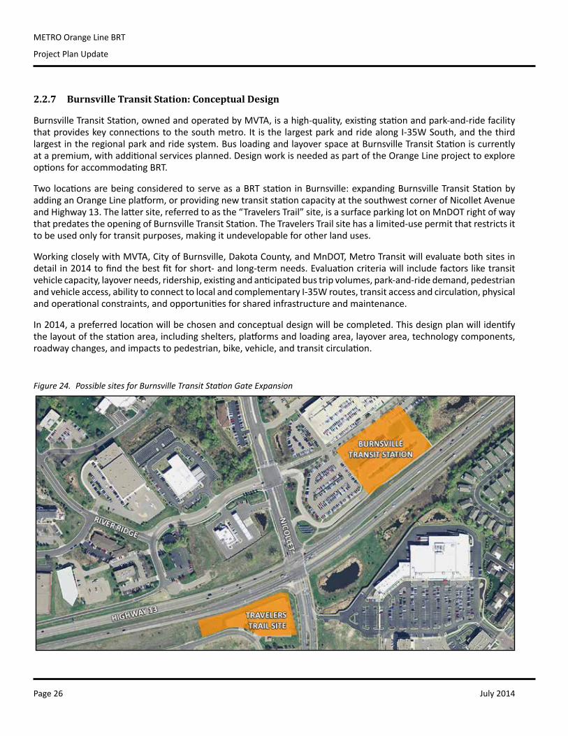
2.2.7 Burnsville Transit Station: Conceptual Design
BurnsvilleTransitStation,ownedandoperatedbyMVTA,isahigh-quality,existingstationandpark-and-ridefacilitythatprovideskeyconnectionstothesouthmetro.It isthelargestparkandridealongI-35WSouth,andthethirdlargestintheregionalparkandridesystem.BusloadingandlayoverspaceatBurnsvilleTransitStationiscurrentlyatapremium,withadditionalservicesplanned.DesignworkisneededaspartoftheOrangeLineprojecttoexploreoptionsforaccommodatingBRT.
TwolocationsarebeingconsideredtoserveasaBRTstation inBurnsville:expandingBurnsvilleTransitStationbyaddinganOrangeLineplatform,orprovidingnewtransitstationcapacityatthesouthwestcornerofNicolletAvenueandHighway13.Thelattersite,referredtoasthe“TravelersTrail”site,isasurfaceparkinglotonMnDOTrightofwaythatpredatestheopeningofBurnsvilleTransitStation.TheTravelersTrailsitehasalimited-usepermitthatrestrictsittobeusedonlyfortransitpurposes,makingitundevelopableforotherlanduses.
WorkingcloselywithMVTA,CityofBurnsville,DakotaCounty,andMnDOT,MetroTransitwillevaluatebothsitesindetailin2014tofindthebestfitforshort-andlong-termneeds.Evaluationcriteriawill includefactorsliketransitvehiclecapacity,layoverneeds,ridership,existingandanticipatedbustripvolumes,park-and-ridedemand,pedestrianandvehicleaccess,abilitytoconnecttolocalandcomplementaryI-35Wroutes,transitaccessandcirculation,physicalandoperationalconstraints,andopportunitiesforsharedinfrastructureandmaintenance.
In2014,apreferredlocationwillbechosenandconceptualdesignwillbecompleted.Thisdesignplanwillidentifythelayoutofthestationarea,includingshelters,platformsandloadingarea,layoverarea,technologycomponents,roadwaychanges,andimpactstopedestrian,bike,vehicle,andtransitcirculation.
Figure 24. Possible sites for Burnsville Transit Station Gate Expansion
July 2014 Page 27
METRO Orange Line BRT
Project Plan Update
2.3 Guideway
2.3.1 Downtown
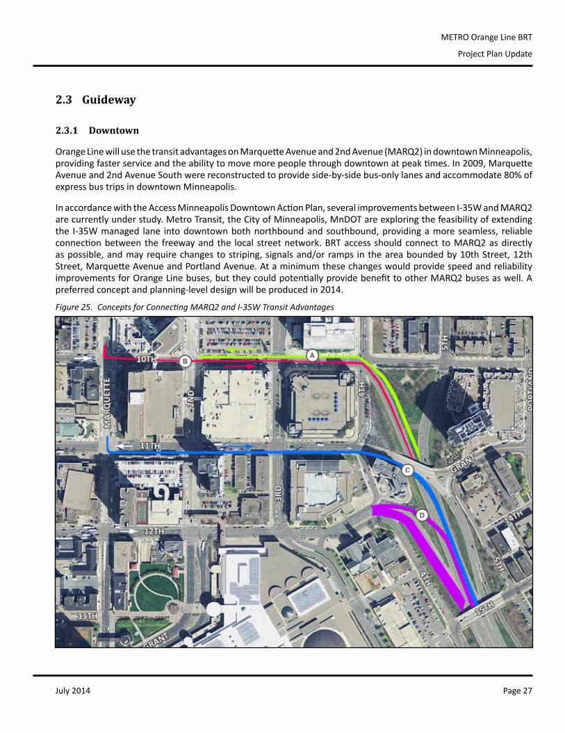
OrangeLinewillusethetransitadvantagesonMarquetteAvenueand2ndAvenue(MARQ2)indowntownMinneapolis,providingfasterserviceandtheabilitytomovemorepeoplethroughdowntownatpeaktimes.In2009,MarquetteAvenueand2ndAvenueSouthwerereconstructedtoprovideside-by-sidebus-onlylanesandaccommodate80%ofexpressbustripsindowntownMinneapolis.
InaccordancewiththeAccessMinneapolisDowntownActionPlan,severalimprovementsbetweenI-35WandMARQ2arecurrentlyunderstudy.MetroTransit,theCityofMinneapolis,MnDOTareexploringthefeasibilityofextendingthe I-35Wmanaged lane intodowntownbothnorthboundandsouthbound,providingamoreseamless, reliableconnectionbetween the freewayand the local streetnetwork.BRTaccess shouldconnect toMARQ2asdirectlyaspossible,andmayrequirechangestostriping,signalsand/orramps in theareaboundedby10thStreet,12thStreet,MarquetteAvenueandPortlandAvenue.AtaminimumthesechangeswouldprovidespeedandreliabilityimprovementsforOrangeLinebuses,buttheycouldpotentiallyprovidebenefittootherMARQ2busesaswell.Apreferredconceptandplanning-leveldesignwillbeproducedin2014.
Figure 25. Concepts for Connecting MARQ2 and I-35W Transit Advantages
July 2014Page 28
METRO Orange Line BRT
Project Plan Update
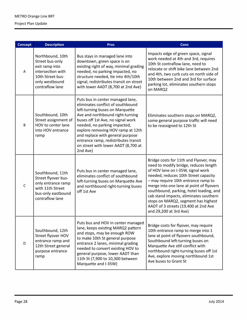
Concept Description Pros Cons
A
Northbound,10thStreetbus-onlyexit ramp into intersectionwith10thStreetbus-onlywestboundcontraflowlane
Busstaysinmanagedlaneintodowntown,greenspaceisonexistingrightofway,minimalgradingneeded,noparkingimpacted,nostructureneeded,tieinto4th/10thsignal,redistributestransitonstreetwithlowerAADT(8,700at2ndAve)
Impactsedgeofgreenspace,signalworkneededat4thand3rd,requires10thStcontraflowlane,needtorelocateorshiftbikelanebetween2ndand4th,twocurbcutsonnorthsideof10thbetween2ndand3rdforsurfaceparkinglot,eliminatessouthernstopsonMARQ2
B
Southbound,10thStreetassignmentofHOVtocenterlaneintoHOVentranceramp
Putsbusincentermanagedlane,eliminatesconflictofsouthboundleft-turningbusesonMarquetteAveandnorthboundright-turningbusesoff1stAve,nosignalworkneeded,noparkingimpacted,exploreremovingHOVrampat12thandreplacewithgeneralpurposeentranceramp,redistributestransitonstreetwithlowerAADT(8,700at2ndAve)
EliminatessouthernstopsonMARQ2,somegeneralpurposetrafficwillneedtobereassignedto12thSt
C
Southbound,11thStreetflyoverbus-only entrance ramp with11thStreetbus-onlyeastboundcontraflowlane
Putsbusincentermanagedlane,eliminatesconflictofsouthboundleft-turningbusesonMarquetteAveandnorthboundright-turningbusesoff1stAve
Bridgecostsfor11thandFlyover,mayneedtomodifybridge,reduceslengthofHOVlaneonI-35W,signalworkneeded,reduces10thStreetcapacity–mayrequire10thentranceramptomergeintoonelaneatpointofflyoverssouthbound,parking,hotelloading,andcabstandimpacts,eliminatessouthernstopsonMARQ2,segmenthashighestAADTof3streets(19,400at2ndAveand29,200at3rdAve)
D
Southbound,12thStreetflyoverHOVentrance ramp and 12th Street general purposeentranceramp
PutsbusandHOVincentermanagedlane,keepsexistingMARQ2patternandstops,maybeenoughROWtomake10thStgeneralpurposeentrance2lanes,minimalgradingneededtoconvertexistingHOVtogeneralpurpose,lowerAADTthan11thSt(7,900to10,300betweenMarquetteandI-35W)
Bridgecostsforflyover,mayrequire10th entrance ramp to merge into 1 laneatpointofflyoverssouthbound,Southboundleft-turningbusesonMarquetteAvestillconflictwithnorthboundright-turningbusesoff1stAve,exploremovingnorthbound1stAvebusestoGrantSt
July 2014 Page 29
METRO Orange Line BRT
Project Plan Update
2.3.2 I-35W
TheOrangeLinealignmentwilluseacombinationofmanagedlanes,bus-onlyshoulders,dedicatedtransitguideway,HOVrampbypasslanes,andshortsegmentsofmixedtraffic.
Center-running Managed Lanes
Northofthe66thStreet,METROOrangeLinebuseswillusecenter-runningMnPASSlanes,whichhelpmaintaintrafficflow,reducecongestionandgiveasafe,reliablecommutetothoseridingtransit,travelinginacarpoolorvanpool,orusingaMnPASStransponder.Thepricedhigh-occupancylanesexistonI-35WfromHighway13toapproximately22ndStreetnorthbound,and42ndStreettoHighway13southbound.Asnotedabove,MetroTransit,theCityofMinneapolis,MnDOTarestudyingtheextensionofmanagedlanestoconnectintodowntownMinneapolis.
OnemajorgapintheI-35Wmanagedlanesystem,betweendowntownand42ndStreetsouthbound,isbeingplannedbyMnDOTforimplementationwiththeOrangeLineandthe35LakeTransit/AccessProject.Thispavementreclamationprojectwillalsoconvertthenorthboundpriced-dynamicshoulderlaneintoafullmanagedlane.
Bus-only Shoulders
Southof46thStreet,allOrangeLinestationsarelocatedeitherontheoutsideshoulderorinofflinelocations.Thetransitwaywilluseacombinationofbus-onlyshouldersandhigh-occupancyvehiclebypassrampsthroughthissectionoftheprojecttomaintainreliability.
Withmorethanthreetimesthenumberofmilesthanallothermetroareascombined,theTwinCitiesisaleaderintheuseofbus-onlyshoulders.Whileacost-effectivewayforbusestoavoidtraffic,therearecertainconditionsunderwhichoperatorsmaychosenottousetheshoulder.Operatorsconsiderthefollowingfactorswhendecidingwhethertouseabus-onlyshoulder:
• Roadconditions.Sinkingdraincovers,potholesorotherroaddefectscaninterruptuse;• Weather.Heavysnow,slushandicemustbeadequatelyclearedtoallowforsafeoperations;• Obstructions.Roaddebris, stalledmotoristsandconstructionvehiclesareunavoidableobstacles thatprevent
busesfromusingshoulders;• Traffic.Bus-onlyshouldersmayonlybeusedwhentraffichasslowedtolessthan35milesperhour(themaximum
speedis15milesperhourgreaterthantraffic,withamaximumspeedof35milesperhour);and• Othervehicles.Extra-widevehiclesinmixed-trafficcanpreventtheuseofbus-onlyshouldersbecauseofclearance
issues.Emergencyvehiclesalsotakepriority. Between 98th Street and 82nd Street, bus shoulders do not yet exist. Bridge piers at certain locationsmay preventexpansionoftheshoulderwithoutsignificantgradechangesandretainingwalls.However,overtimeCityofBloomingtonhasacquiredlandadjacenttobothsidesofI-35Wforfutureexpansionneeds.AdditionaldiscussionisneededwiththeCityandMnDOTtounderstandthelong-termneedsfortransitadvantagesinthisareashouldcongestiongrowenoughtomakethemergetoandfromthemanagedlaneinfeasible.BetweentheMinnesotaRiverBridgeand98thStreetStation,travelingnorthbound,thereisanexistingclimbinglanefortrucktrafficthatshouldbestudiedtoaccommodatetransitifabus-onlyshoulderispursued.
River Bridge Crossing
MnDOTisadvancingtheengineeringfortheI-35WMinnesotaRiverBridgereplacementprojectinpreparationforaspring
July 2014Page 30
METRO Orange Line BRT
Project Plan Update
of2017letting.High-levelscopingdonein2014shouldaimtopreserveandenhancetransitadvantagesforOrangeLinebusesandexpressbuses.Bothacenter-runningmanagedlaneandanoutsidebusshoulder shouldbe included in thedesignof theplannedbridge.
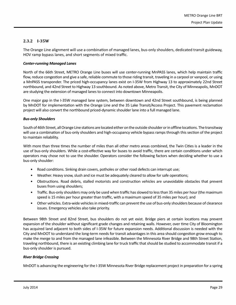
2.3.3 76th Street, Knox Avenue, and 82nd Street
Southboundfrom66thStreet,theOrangeLinewillusethebus-onlyshoulderandexitat76thStreet.Buseswillturnrightonto76thandleftontoKnoxAvenue,andcontinuedownto82ndStreetwhereitre-entersI-35W.
Northbound from 98th Street, buses will use either themanagedlaneorafuturebus-onlyshouldertoexitat82ndStreet, turning left onto 82nd Street and right onto KnoxAvenue.Buseswillthenturnrightonto76thStreetandleftontoI-35W,usingtheHOVrampbypasstoenterthebus-onlyshoulder.
The cross-section of Knox Avenue between AmericanBoulevardand76thStreetwillbedesignedindetailthisyear,workingtominimizepropertyandaccessimpactstoexistingdevelopment. It will include, at a minimum, a dedicatedtransit guideway as well as a new bicycle and pedestrianconnectionacrossI-494.WorkingwiththeCitiesofRichfieldandBloomington,MetroTransitwilldeterminetheinterestandfeasibilityofotherimprovementsforthisnewunderpass,includingthepotentialtoaddgeneralpurposetravellanesorstreetscapeenhancements.
This routing is similar to the current Route 535, whichutilizes76th,KnoxAvenue,and82ndStreet.BecauseofthededicatedguidewayandnewKnoxAvenuerightofway,theOrangeLinewillpassthroughsevenfewertrafficsignalsthanthe535,resultinginatimesavingsofbetween45%and55%forBRTthroughthisarea.
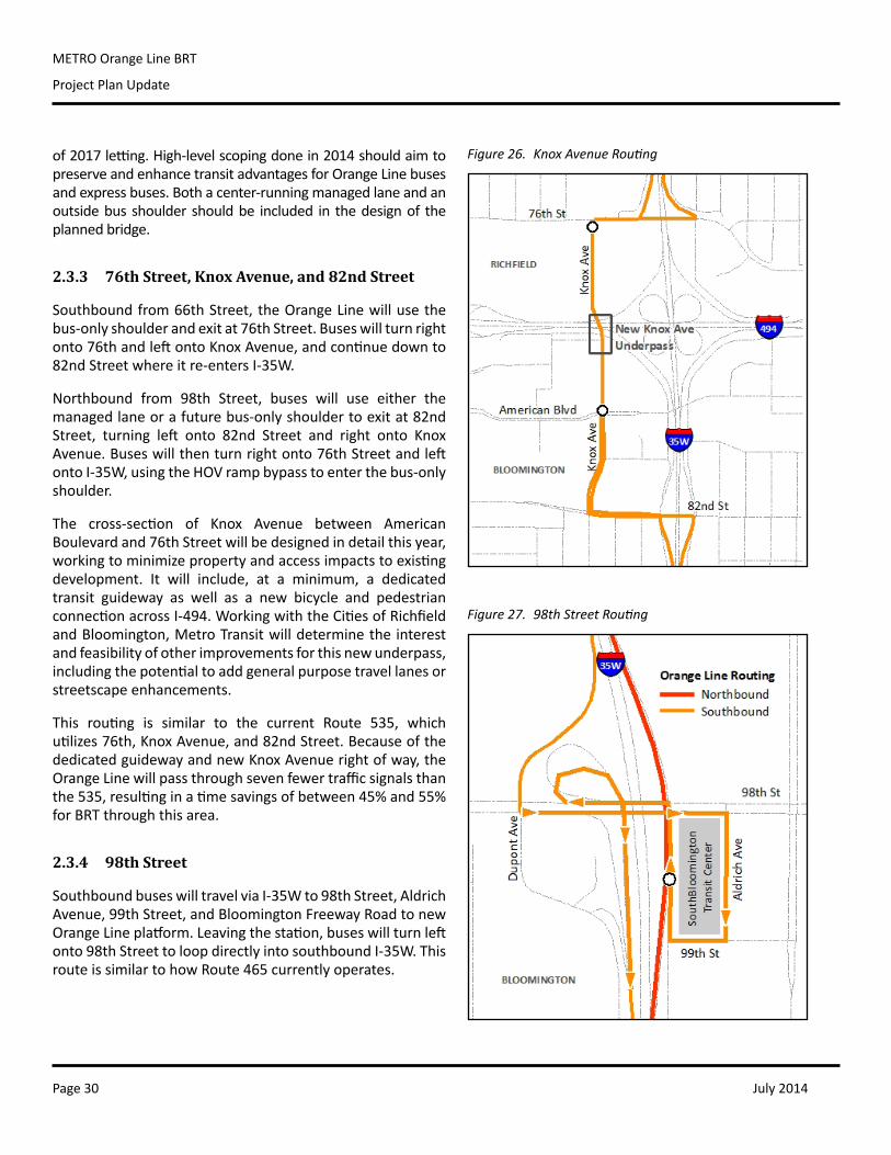
2.3.4 98th Street
SouthboundbuseswilltravelviaI-35Wto98thStreet,AldrichAvenue,99thStreet,andBloomingtonFreewayRoadtonewOrangeLineplatform.Leavingthestation,buseswillturnleftonto98thStreettoloopdirectlyintosouthboundI-35W.ThisrouteissimilartohowRoute465currentlyoperates.
Figure 26. Knox Avenue Routing
Figure 27. 98th Street Routing
July 2014 Page 31
METRO Orange Line BRT
Project Plan Update
Northbound,buseswill exit at98thStreetdirectly to the sameOrangeLineplatform, then re-enternorthboundI-35W.AHOVrampbypassentranceisavailablenorthbound.
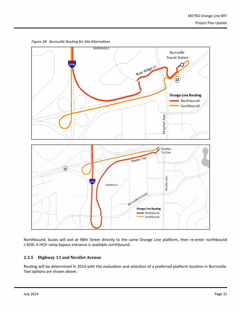
2.3.5 Highway 13 and Nicollet Avenue
Routingwillbedeterminedin2014withtheevaluationandselectionofapreferredplatformlocationinBurnsville.Twooptionsareshownabove.
Figure 28. Burnsville Routing for Site Alternatives
July 2014Page 32
METRO Orange Line BRT
Project Plan Update
2.4 Right of Way Needs
2.4.1 Knox Avenue Guideway and Park and Ride
KnoxAvenue is apublic street inRichfieldnorthof I-494,and inBloomington southofAmericanBoulevard.ThealignmentofKnoxAvenuebetweenAmericanandI-494wasneverplatted.Itisaprivately-ownedservicedrivefortheSouthtownshoppingcenter.MetroTransitcurrentlyusesthisservicedrivetoreachbusstopswithintheproperty.Approximatelytwoacres(900linearfeet)areneededtoestablishapublicly-ownedtransitwayalongtheKnoxAvenuealignmentbetweenAmericanBoulevardandI-494.
Theplannedpark-and-ridefacilitynearAmericanBoulevardwillbestudiedinmoredetailduring2014.MetroTransitwillbedevelopingalistofpreferredlocationsforapproximately500parkingspacestomeetpreviouspark-and-ridedemandforecastsandmitigateparkinglostthroughinterchangeconstruction.Thisanalysiswillalsoevaluateothersupportfacilityneedssuchasdriverfacilitiesorbusturnaroundandlayoverneeds,andworkwithpropertyownerstounderstandinterestandviabilityofajointdevelopmentventure.
Thecombinationofthetransitwayandpark-and-ridefacilityareexpectedtoimpact1to3parcelsofprivateproperty,dependingondesign,placement,andpropertyownerinterestinjointdevelopmentorjointuse.
2.4.2 Lake Street Station
Aportionoftherightofwayneededtobuildthe35LakeTransitAccessProject(highwayandtransitcomponents)willbeassumedbytheOrangeLine.Exactparcelacquisitionwillbeidentifiedintheproject’senvironmentalassessment,whichincludestheLakeStreetStationinitsscope.
2.5 Technology
OrangeLineBRTwillbuildonprevioustechnologyinfrastructurealongthecorridor.Technologyhasaffectedallaspectsofapassenger’strip,suchasupdatedinformationabouttheavailabilityofparkingatpark-and-rides,next-busarrivalinformation,estimatedtraveltimes,web-basedtripplanningtools,real-timetransitinformation,andrechargeablefarecards.
Real-time Information
Next-bus arrival information is currently available onmonitors and annunciators on 2nd Avenue andMarquetteAvenuesdowntown,aswellasatthe46thStreetStationandSouthBloomingtonTransitCenter.Visualandaudioreal-timeinformationwillbeaddedatallremainingOrangeLineplatforms.
TransitridersarealsoabletoaccesstheinformationusingNexTriponline,onamobiledevice,orbyphone.
Transit Signal Priority
Transit Signal Priority (TSP) is planned in areas where the Orange Line will intersect general purpose traffic. IncoordinationwiththeCitiesofRichfieldandBloomington,HennepinCounty,andMnDOT,MetroTransitwillpursue
July 2014 Page 33
METRO Orange Line BRT
Project Plan Update
TSP or other transit advantages in the followingareas:
• Variousdowntown locations,dependingonpreferredroutingfromI-35WtoMARQ2;
• Northboundandsouthboundat66thStreetfromtheexitramps;
• Removalofthe“norightonred”restrictionsouthbound at 76th Street from the exitramp;
• Northbound and southbound at AmericanBoulevard;
• Westbound on 82nd Street from the exitrampandwestbound(coordinatedsignals);
• Eastbound on 76th Street between KnoxAvenue and the I-35W entrance ramp(coordinatedsignals);
• Southbound left-turn at 98th Street fromtheexitrampandeastboundsignalon98thStreet;
• Southboundramp-meterdumponentrancerampfrom98thStreettoI-35W;and
• NorthboundatI-35WandBurnsvilleParkway,ifTravelersTrailischosenaspreferredsite.
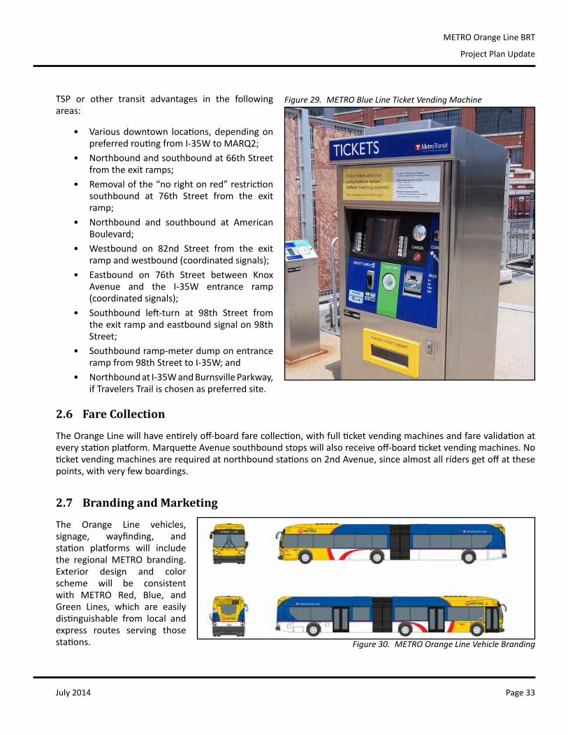
2.6 Fare Collection
TheOrangeLinewillhaveentirelyoff-boardfarecollection,withfullticketvendingmachinesandfarevalidationateverystationplatform.MarquetteAvenuesouthboundstopswillalsoreceiveoff-boardticketvendingmachines.Noticketvendingmachinesarerequiredatnorthboundstationson2ndAvenue,sincealmostallridersgetoffatthesepoints,withveryfewboardings.
2.7 Branding and Marketing
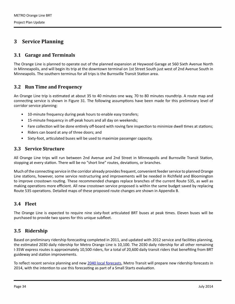
The Orange Line vehicles,signage, wayfinding, andstation platforms will includethe regional METRO branding.Exterior design and colorscheme will be consistentwith METRO Red, Blue, andGreen Lines, which are easilydistinguishable from local andexpress routes serving thosestations.
Figure 29. METRO Blue Line Ticket Vending Machine
Figure 30. METRO Orange Line Vehicle Branding
July 2014Page 34
METRO Orange Line BRT
Project Plan Update
3 Service Planning
3.1 Garage and Terminals
TheOrangeLineisplannedtooperateoutoftheplannedexpansionatHeywoodGarageat560SixthAvenueNorthinMinneapolis,andwillbeginitstripatthedowntownterminalon1stStreetSouthjustwestof2ndAvenueSouthinMinneapolis.ThesouthernterminusforalltripsistheBurnsvilleTransitStationarea.
3.2 Run Time and Frequency
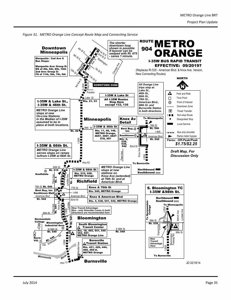
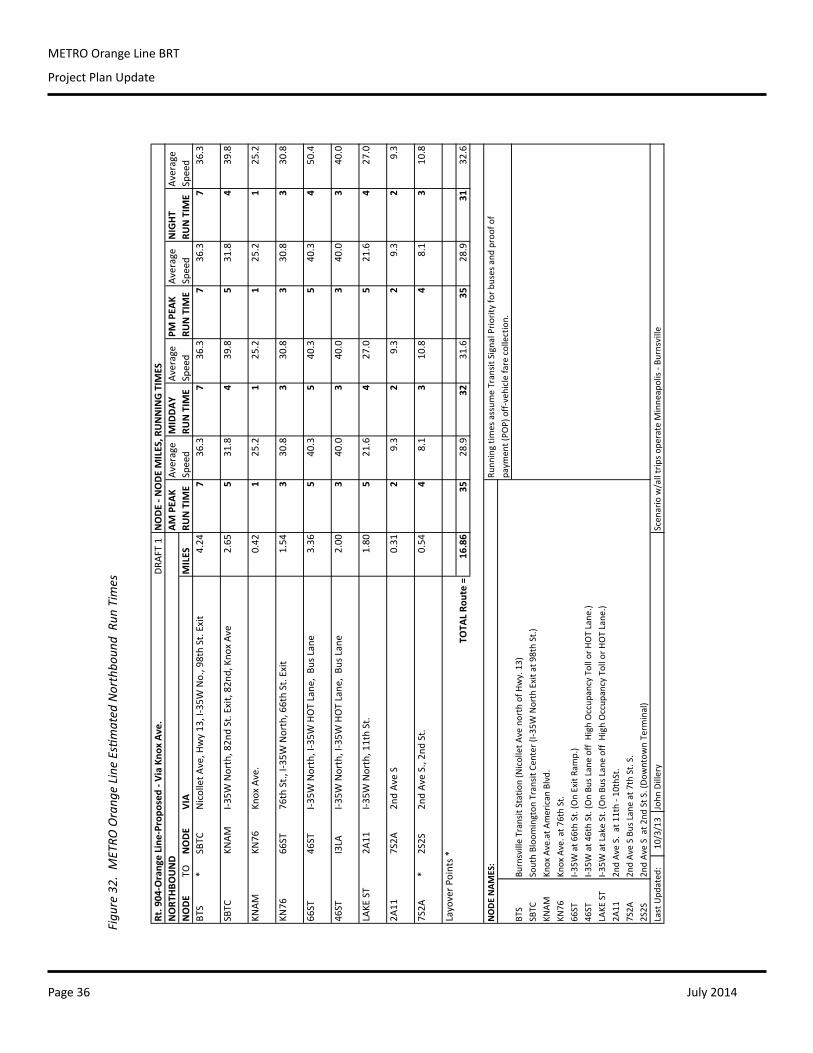
AnOrangeLinetripisestimatedatabout35to40minutesoneway,70to80minutesroundtrip.Aroutemapandconnectingservice isshowninFigure31.Thefollowingassumptionshavebeenmadeforthispreliminary levelofcorridorserviceplanning:
• 10-minutefrequencyduringpeakhourstoenableeasytransfers;• 15-minutefrequencyinoff-peakhoursandalldayonweekends;• Farecollectionwillbedoneentirelyoff-boardwithrovingfareinspectiontominimizedwelltimesatstations;• Riderscanboardatanyofthreedoors;and• Sixty-foot,articulatedbuseswillbeusedtomaximizepassengercapacity.
3.3 Service Structure
AllOrange Line tripswill runbetween2ndAvenue and2nd Street inMinneapolis andBurnsville Transit Station,stoppingateverystation.Therewillbeno“shortline”routes,deviations,orbranches.
Muchoftheconnectingserviceinthecorridoralreadyprovidesfrequent,convenientfeederservicetoplannedOrangeLinestations,however,someservicerestructuringandimprovementswillbeneededinRichfieldandBloomingtontoimprovecrosstownrouting.TheserecommendedchangesreplacebranchesofthecurrentRoute535,aswellasmakingoperationsmoreefficient.AllnewcrosstownserviceproposediswithinthesamebudgetsavedbyreplacingRoute535operations.DetailedmapsoftheseproposedroutechangesareshowninAppendixB.
3.4 Fleet
TheOrange Line is expected to requirenine sixty-foot articulatedBRTbuses at peaktimes. Elevenbuseswill bepurchasedtoprovidetwosparesforthisuniquesubfleet.
3.5 Ridership
Basedonpreliminaryridershipforecastingcompletedin2011,andupdatedwith2012serviceandfacilitiesplanning,theestimated2030dailyridershipforMetroOrangeLineis10,100.The2030dailyridershipforallotherremainingI-35Wexpressroutesisapproximately10,500riders,foratotalof20,600dailytransitridersthatbenefitingfromBRTguidewayandstationimprovements.
Toreflectrecentserviceplanningandnew2040localforecasts,MetroTransitwillpreparenewridershipforecastsin2014,withtheintentiontousethisforecastingaspartofaSmallStartsevaluation.
July 2014 Page 35
METRO Orange Line BRT
Project Plan Update
DowntownMinneapolis
METROORANGE
Minneapolis
I-35
W
Hw
y 65
Rts. 21, 53
ROUTE
Hwy 62
I-494
I-35
W
DOWNTOWN ZONE
Washington
46th St
66th St
N
NORTH
P Park and Ride
Downtown Zone
Time Point
Point of Interest
Non-stop Route
Local Service
Fares: Off-Peak/Peak
T Timed Transfer
Bus only shoulder
Ramp meter bypass
Designated Stop
Franklin
EFFECTIVE: 09/2019?
I-35W BUS RAPID TRANSIT
I-35
W
82nd St
W 98th St
Bloomington
Richfield
2nd
A
ve S
1st St S2nd St S
11th St S
12th St S3r
d A
ve S
7th St S
Fra
nce
Ave
South Bloomington Transit Center
T
Lake St
P
Rts. 4, 538, 541, 542, METRO Orange
Rts. 18, 465, 541, 549 554, 597, METRO Orange Line
BloomingtonIndustrial Area
JD 02/18/14
American Blvd
$1.75/$2.25
I-35W & Lake St
Chi
cago
Ave
I-35
W
Hwy 13
Nic
olle
t Ave
Burnsville
Burnsville Transit StationP
Rts. 421, 426, 444, 460, 465-U,METRO Orange
Mar
quet
te
Av
eAll Orange Line trips stop at: Lake St., 46th St., 66th St., 76th St.,American Blvd., 98th St. andBurnsville Stationin both directions.
Draft Map, For Discussion Only
T
NormandaleCollege
P
P
I-35W & 66th St
Knox & American Blvd
Rts. 515, 558, METRO Orange
I-35W & 46th St
Rts. 11, 46, 146,METRO Orange,465?, 490?, 684?
578, 597
PP
I-35W & 66th St.
I-35W & Lake St.,I-35W & 46th St.
E 98th St
Minnesota River
Marquette / 2nd Ave S Bus Stops:
Marquette Ave: Group D:NS of 4th, 6th, 8th, 10th 2nd Ave: Group G:FS of 11th, 9th, 7th, 5th
8th St S
4th St S
Old Shakopee
Rd
Rt. 549Rt. 549
Rt. 549Norm
Vill.
Pen
n A
ve
Best Buy, Inc
Southtown Mall
Southdale
Lynd
ale
Ave
Rt. 515
Rt. 540
Rt. 542
American Blvd
77th St76th St
Rt. 46
Rt.
4
Rt.
4
(Replaces Rt 535 - American Blvd. & Knox Ave. Version,
New Connecting Routes)
METRO Orange Line stops at new On-Line Stations in the Median of I-35Wassumed to be inplace at both locations.
All I-35W Routes Stop Here
except 133, 135
METRO Orange Lineserves stops on ramps to/from I-35W at 66th St.
Kno
x A
ve
Rts. 540, METRO Orange
Knox & 76th St
NorthboundSouthbound
American BlvdRt. 542
Kno
x A
ve
82nd St
76th St
I-35
W
Blo
omin
gton
F
reew
ay R
d Dup
ont A
ve
S. Bloomington TCI-35W &98th St.
NorthboundSouthbound
To Burnsville
P
To Minneapolis
99th St
Lynd
ale
Ave
To
No
rma
nd
ale
C
oll
eg
e
Ald
rich
Ave
98th StRt. 539
New TransitAdvantageHere
I-35
WMETRO Orange Line stops at new stations onKnox Ave (extended)at 76th St. and atAmerican Blvd.
To Burnsville
To Minneapolis
I-35
W
I-494
P
P
Rt. 540
Southtown
Best Buy, Inc
Rts. 4, 538, 539, 542
Knox AvDetail
The shorterdowntown loop shown is possibleif layover can beswaped with Rt. 675- saves 1 minute.
904
Pen
n A
ve
New Transit Advantage:Bus - only Shoulder Lanes in bothdirections are recommended here
Lynd
ale
Lynd
ale
Pen
n A
veR
t. 5
41
Rt.
54
1
90th St
Figure 31. METRO Orange Line Concept Route Map and Connecting Service
July 2014Page 36
METRO Orange Line BRT
Project Plan Update
Rt. 904
‐Orange Line
‐Propo
sed ‐ V
ia Kno
x Av
e.DR
AFT 1
NODE ‐ N
ODE MILES, R
UNNING TIM
ESNORT
HBO
UND
AM PEA
KAv
erage
MIDDAY
Average
PM PEA
KAv
erage
NIGHT
Average
NODE
TONODE
VIA
MILES
RUN TIM
ESpeed
RUN TIM
ESpeed
RUN TIM
ESpeed
RUN TIM
ESpeed
BTS
*SBTC
Nicollet A
ve, H
wy 13
, I‐35W
No., 98th St. Exit
4.24
736
.37
36.3
736
.37
36.3
SBTC
KNAM
I‐35W
North, 82n
d St. Exit, 82
nd, Kno
x Av
e2.65
531
.84
39.8
531
.84
39.8
KNAM
KN76
Knox Ave.
0.42
125
.21
25.2
125
.21
25.2
KN76
66ST
76th St., I‐35
W North, 66th St. Exit
1.54
330
.83
30.8
330
.83
30.8
66ST
46ST
I‐35W
North, I‐35W
HOT Lane
, Bu
s Lane
3.36
540
.35
40.3
540
.34
50.4
46ST
I3LA
I‐35W
North, I‐35W
HOT Lane
, Bu
s Lane
2.00
340
.03
40.0
340
.03
40.0
LAKE
ST
2A11
I‐35W
North, 11th St.
1.80
521
.64
27.0
521
.64
27.0
2A11
7S2A
2nd Av
e S
0.31
29.3
29.3
29.3
29.3
7S2A
*2S2S
2nd Av
e S., 2nd
St.
0.54
48.1
310
.84
8.1
310
.8
Layover P
oints *
TOTA
L Ro
ute =
16.86
3528
.932
31.6
3528
.931
32.6
NODE NAM
ES:
Runn
ing tim
es assum
e Transit Signal Prio
rity for b
uses and
proof of
paym
ent (PO
P) off‐vehicle fare collection.
BTS
Burnsville Transit Statio
n (Nicollet A
ve north of H
wy. 13)
SBTC
South Bloo
mington
Transit Ce
nter (I‐35W
North Exit a
t 98th St.)
KNAM
Knox Ave.at A
merican
Blvd.
KN76
Knox Ave. at 7
6th St.
66ST
I‐35W
at 6
6th St. (On Exit Ra
mp.)
46ST
I‐35W
at 4
6th St. (On Bu
s Lane off High
Occup
ancy Toll or H
OT Lane
.)LAKE
ST
I‐35W
at Lake St. (On Bu
s Lane off High
Occup
ancy Toll or H
OT Lane
.)2A
112n
d Av
e S. at 1
1th ‐ 1
0thSt.
7S2A
2nd Av
e S Bu
s Lane at 7th St. S.
2S2S
2nd Av
e S at 2
nd St S
. (Do
wntow
n Term
inal)
Last Upd
ated
:10
/3/13
John
Dillery
Scen
ario w/all trips o
perate M
inne
apolis ‐ B
urnsville
Figu
re 3
2. M
ETRO
Ora
nge
Line
Esti
mat
ed N
orth
boun
d R
un T
imes
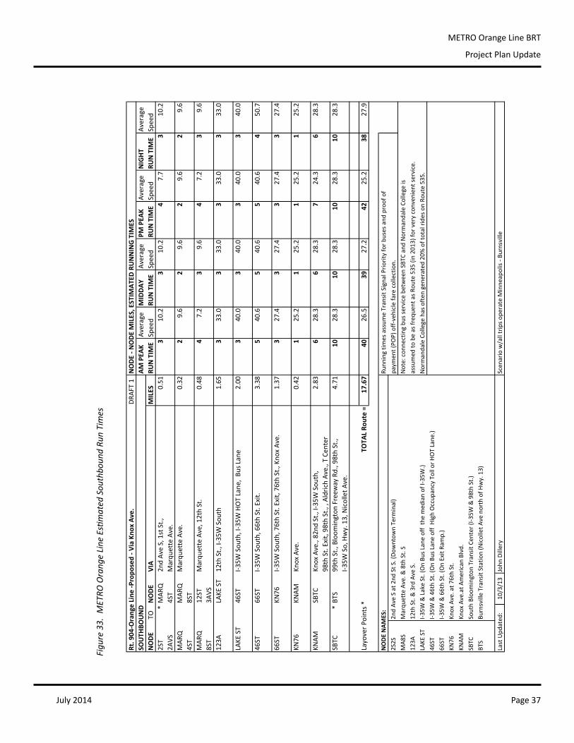
July 2014 Page 37
METRO Orange Line BRT
Project Plan Update
Rt. 904
‐Orange Line
‐Propo
sed ‐ V
ia Kno
x Av
e.DR
AFT 1
NODE ‐ N
ODE MILES, ESTIM
ATED
RUNNING TIM
ESSO
UTH
BOUND
AM PEA
KAv
erage
MIDDAY
Average
PM PEA
KAv
erage
NIGHT
Average
NODE
TONODE
VIA
MILES
RUN TIM
ESpeed
RUN TIM
ESpeed
RUN TIM
ESpeed
RUN TIM
ESpeed
2ST
*MAR
Q2n
d Av
e S, 1st St.,
0.51
310
.23
10.2
47.7
310
.22A
VS4ST
Marqu
ette Ave.
MAR
QMAR
QMarqu
ette Ave.
0.32
29.6
29.6
29.6
29.6
4ST
8ST
MAR
Q12
STMarqu
ette Ave, 12th St.
0.48
47.2
39.6
47.2
39.6
8ST
3AVS
123A
LAKE
ST
12th St., I‐35
W Sou
th1.65
333
.03
33.0
333
.03
33.0
LAKE
ST
46ST
I‐35W
Sou
th, I‐35W
HOT Lane
, Bu
s Lane
2.00
340
.03
40.0
340
.03
40.0
46ST
66ST
I‐35W
Sou
th, 66th St. Exit.
3.38
540
.65
40.6
540
.64
50.7
66ST
KN76
I‐35W
Sou
th, 76th St. Exit, 76
th St., Kno
x Av
e.
1.37
327
.43
27.4
327
.43
27.4
KN76
KNAM
Knox Ave.
0.42
125
.21
25.2
125
.21
25.2
KNAM
SBTC
Knox Ave., 82
nd St., I‐35
W Sou
th,
2.83
628
.36
28.3
724
.36
28.3
98th St. Exit, 98th St., , A
ldrich Av
e., T Cen
ter
SBTC
*BT
S99
th St., Bloom
ington
Freew
ay Rd., 98th St.,
4.71
1028
.310
28.3
1028
.310
28.3
I‐35W
So, Hwy. 13, Nicollet A
ve.
Layover P
oints *
TOTA
L Ro
ute =
17.67
4026
.539
27.2
4225
.238
27.9
NODE NAM
ES:
Runn
ing tim
es assum
e Transit Signal Prio
rity for b
uses and
proof of
2S2S
2nd Av
e S at 2nd
St S
. (Do
wntow
n Term
inal)
paym
ent (PO
P) off‐vehicle fare collection.
MA8
SMarqu
ette Ave. &
8th St. S
Note: con
necting bu
s service between SBTC
and
Normandale College is
123A
12th St. & 3rd Ave S.
assumed
to be as freq
uent as R
oute 535
(in 20
13) for very conven
ient se
rvice.
LAKE
ST
I‐35W
& Lake St. (On Bu
s Lane off the med
ian of I‐35
W.)
Normandale College has often
gen
erated
20%
of total ride
s on Ro
ute 53
5.
46ST
I‐35W
& 46th St. (On Bu
s Lane off High
Occup
ancy Toll or H
OT Lane
.)66
STI‐3
5W & 66th St. (On Exit Ra
mp.)
KN76
Knox Ave. at 7
6th St.
KNAM
Knox Ave.at A
merican
Blvd.
SBTC
South Bloo
mington
Transit Ce
nter (I‐35W
& 98th St.)
BTS
Burnsville Transit Statio
n (Nicollet A
ve north of H
wy. 13)
Last Upd
ated
:10
/3/13
John
Dillery
Scen
ario w/all trips o
perate M
inne
apolis ‐ B
urnsville
Figu
re 3
3. M
ETRO
Ora
nge
Line
Esti
mat
ed S
outh
boun
d Ru
n Ti
mes
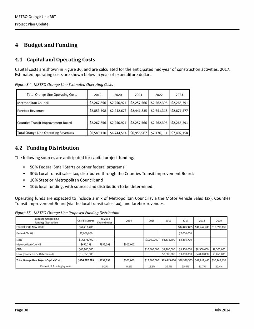
July 2014Page 38
METRO Orange Line BRT
Project Plan Update
4 Budget and Funding
4.1 Capital and Operating Costs
CapitalcostsareshowninFigure36,andarecalculatedfortheanticipatedmid-yearofconstructionactivities,2017.Estimatedoperatingcostsareshownbelowinyear-of-expendituredollars.
4.2 Funding Distribution
Thefollowingsourcesareanticipatedforcapitalprojectfunding.
• 50%FederalSmallStartsorotherfederalprograms;• 30%Localtransitsalestax,distributedthroughtheCountiesTransitImprovementBoard;• 10%StateorMetropolitanCouncil;and• 10%localfunding,withsourcesanddistributiontobedetermined.
OperatingfundsareexpectedtoincludeamixofMetropolitanCouncil(viatheMotorVehicleSalesTax),CountiesTransitImprovementBoard(viathelocaltransitsalestax),andfareboxrevenues.
Figure 34. METRO Orange Line Estimated Operating Costs
2019 2020 2021 2022 2023
Metropolitan Council $2,267,856 $2,250,921 $2,257,566 $2,262,396 $2,265,291
Farebox Revenues $2,053,398 $2,242,673 $2,441,835 $2,651,318 $2,871,577
Counties Transit Improvement Board $2,267,856 $2,250,921 $2,257,566 $2,262,396 $2,265,291
$6,589,110 $6,744,514 $6,956,967 $7,176,111 $7,402,158
Total Orange Line Operating Costs
Total Orange Line Operating Revenues
Proposed Orange Line Funding Distribution
Cost by SourcePre 2014
Expenditures2014 2015 2016 2017 2018 2019
Federal 5309 New Starts $67,713,700 $14,852,865 $34,462,400 $18,398,435
Federal CMAQ $7,000,000 $7,000,000
State $14,673,400 $7,000,000 $3,836,700 $3,836,700
Metropolitan Council $652,293 $352,293 $300,000
CTIB $45,100,000 $10,500,000 $8,800,000 $8,800,000 $8,500,000 $8,500,000
Local (Source To Be Determined) $15,558,300 $3,008,300 $3,850,000 $4,850,000 $3,850,000
Total Orange Line Project Capital Cost $150,697,693 $352,293 $300,000 $17,500,000 $15,645,000 $38,339,565 $47,812,400 $30,748,435
0.2% 0.2% 11.6% 10.4% 25.4% 31.7% 20.4%Percent of Funding by Year
Figure 35. METRO Orange Line Proposed Funding Distribution
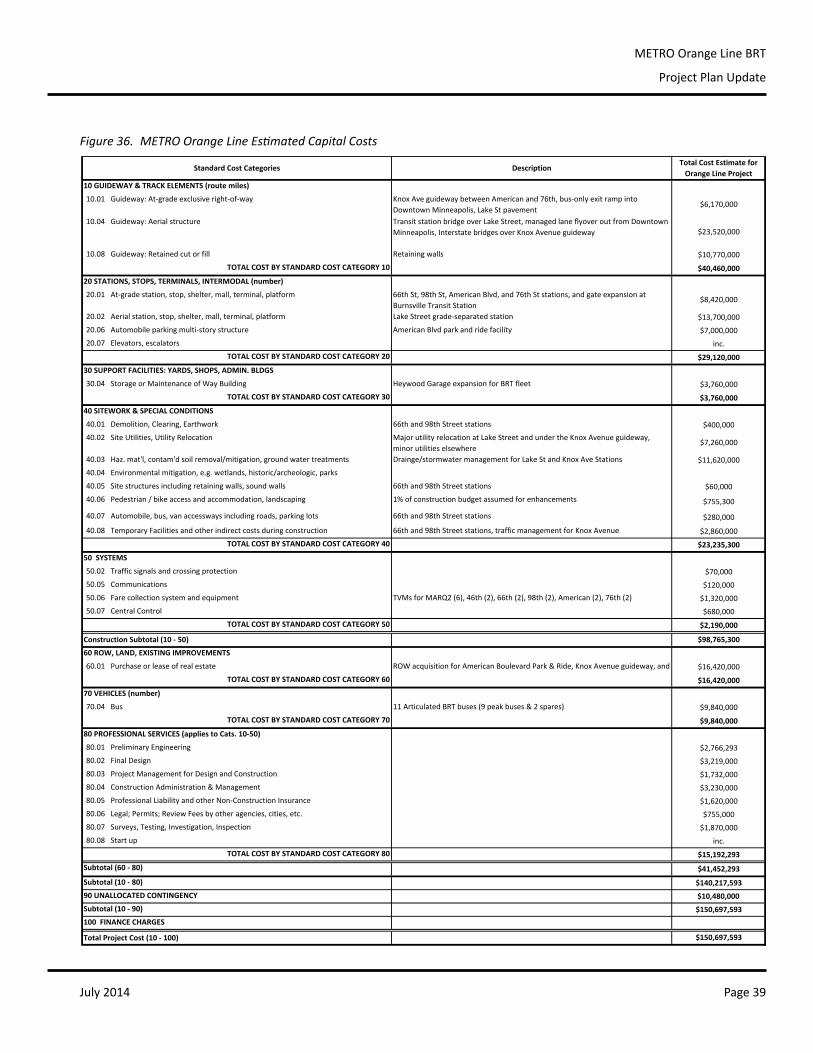
July 2014 Page 39
METRO Orange Line BRT
Project Plan Update
10 GUIDEWAY & TRACK ELEMENTS (route miles)
10.01 Guideway: At‐grade exclusive right‐of‐way
10.04 Guideway: Aerial structure
10.08 Guideway: Retained cut or fill
TOTAL COST BY STANDARD COST CATEGORY 10
20 STATIONS, STOPS, TERMINALS, INTERMODAL (number)
20.01 At‐grade station, stop, shelter, mall, terminal, platform
20.02 Aerial station, stop, shelter, mall, terminal, platform
20.06 Automobile parking multi‐story structure
20.07 Elevators, escalators
TOTAL COST BY STANDARD COST CATEGORY 20
30 SUPPORT FACILITIES: YARDS, SHOPS, ADMIN. BLDGS
30.04 Storage or Maintenance of Way Building
TOTAL COST BY STANDARD COST CATEGORY 30
40 SITEWORK & SPECIAL CONDITIONS
40.01 Demolition, Clearing, Earthwork
40.02 Site Utilities, Utility Relocation
40.03 Haz. mat'l, contam'd soil removal/mitigation, ground water treatments
40.04 Environmental mitigation, e.g. wetlands, historic/archeologic, parks
40.05 Site structures including retaining walls, sound walls
40.06 Pedestrian / bike access and accommodation, landscaping
40.07 Automobile, bus, van accessways including roads, parking lots
40.08 Temporary Facilities and other indirect costs during construction
TOTAL COST BY STANDARD COST CATEGORY 40
50 SYSTEMS
50.02 Traffic signals and crossing protection
50.05 Communications
50.06 Fare collection system and equipment
50.07 Central Control
TOTAL COST BY STANDARD COST CATEGORY 50
60 ROW, LAND, EXISTING IMPROVEMENTS
60.01 Purchase or lease of real estate
TOTAL COST BY STANDARD COST CATEGORY 60
70 VEHICLES (number)
70.04 Bus
TOTAL COST BY STANDARD COST CATEGORY 70
80 PROFESSIONAL SERVICES (applies to Cats. 10‐50)
80.01 Preliminary Engineering
80.02 Final Design
80.03 Project Management for Design and Construction
80.04 Construction Administration & Management
80.05 Professional Liability and other Non‐Construction Insurance
80.06 Legal; Permits; Review Fees by other agencies, cities, etc.
80.07 Surveys, Testing, Investigation, Inspection
80.08 Start up
TOTAL COST BY STANDARD COST CATEGORY 80
Subtotal (60 ‐ 80)
Subtotal (10 ‐ 80)
90 UNALLOCATED CONTINGENCY
Subtotal (10 ‐ 90)
100 FINANCE CHARGES
Total Project Cost (10 ‐ 100)
Transit station bridge over Lake Street, managed lane flyover out from Downtown Minneapolis, Interstate bridges over Knox Avenue guideway $23,520,000
Standard Cost Categories DescriptionTotal Cost Estimate for Orange Line Project
Knox Ave guideway between American and 76th, bus‐only exit ramp into Downtown Minneapolis, Lake St pavement
$6,170,000
Lake Street grade‐separated station $13,700,000
$40,460,000
66th St, 98th St, American Blvd, and 76th St stations, and gate expansion at Burnsville Transit Station
$8,420,000
Retaining walls $10,770,000
Heywood Garage expansion for BRT fleet $3,760,000
$29,120,000
American Blvd park and ride facility $7,000,000
inc.
66th and 98th Street stations $400,000Major utility relocation at Lake Street and under the Knox Avenue guideway, minor utilities elsewhere
$7,260,000
Drainge/stormwater management for Lake St and Knox Ave Stations $11,620,000
$3,760,000
66th and 98th Street stations $280,000
66th and 98th Street stations, traffic management for Knox Avenue $2,860,000
$23,235,300
66th and 98th Street stations $60,0001% of construction budget assumed for enhancements $755,300
TVMs for MARQ2 (6), 46th (2), 66th (2), 98th (2), American (2), 76th (2) $1,320,000
$680,000
$2,190,000
$120,000
$70,000
11 Articulated BRT buses (9 peak buses & 2 spares) $9,840,000
$16,420,000
Construction Subtotal (10 ‐ 50) $98,765,300
ROW acquisition for American Boulevard Park & Ride, Knox Avenue guideway, and $16,420,000
$2,766,293
$3,219,000
$1,732,000
$9,840,000
$1,870,000
inc.
$15,192,293
$3,230,000
$1,620,000
$755,000
$150,697,593
$150,697,593
$41,452,293
$140,217,593
$10,480,000
Figure 36. METRO Orange Line Estimated Capital Costs
July 2014Page 40
METRO Orange Line BRT
Project Plan Update
5 ScheduleThe project is currently in the pre-project development phase, although some individual stationwork has beenadvancedmorequicklytomeetspecificdeadlinesforMnDOTbridgeandroadwayreconstruction.Forexample,theLakeStreetStationiscurrentlyunder60%designandismovingintofinaldesignin2014.
ThefollowingtimelineisanticipatedforMETROOrangeLineimplementation:
• Pre-ProjectDevelopment:early2014• ApplytotheFederalSmallStartsProgram:mid-2014• ProjectDevelopment:2014-2015• Engineering:2015-2016• Construction:2016-2019• OpenforService:late2019
6 Coordination with Concurrent Projects
6.1 I-35W Lake Transit Access Project
TheI-35WLakeTransitAccessProjectincludesanumberofroadwaydesignchangesbetweenI-94and32ndStreet,aswell as theconstructionofanonlineBRTstationat LakeStreetand streetscape improvements. It isbeing ledbyHennepinCountyinpartnershipwiththeCityofMinneapolis,MetropolitanCouncil,MetroTransit,andMnDOT.Environmental processes and funding between Orange Line and the Transit Access Project are being closelycoordinated,andtheLakeStreetstationwillbebidaspartofthelargerroadwayandbridgecontract.
Arobustpublicengagementprocesshasbeenunderway forseveralyears in thisprojectarea.AProjectAdvisoryCommittee(PAC),comprisedofresidents,businessowners,communityinstitutionsandpolicymakers,meetsmonthly.ThePAChasadvisedpartneragenciesas theLakeStreetBRTStationmoved intofinaldesign in2014.Additionalinformationonthemeetingsandproposedstationdesigncanbefoundattheprojectwebsiteatwww.35lake.com.
6.2 I-494/35W Interchange Vision Layout
TheI-494/35Winterchange,constructedoverfiftyyearsago,supportsmorethan500,000dailyvehiclesandservesasakeyaccesspointforcrossingthemetropolitanarea.Hightrafficvolumesandeconomicgrowthhaveledtolongstandingcongestion,safety,andfloodingissuesattheinterchange.In2013,MnDOTinitiatedanI-494/35WInterchangeVisionLayoutprocesstostudyalternativestoimprovesafety,reducecongestion,allowforfuturedevelopment,andimproveaccesstotransit.ThisworkwascompletedinconjunctionwiththeCitiesofRichfieldandBloomington,MetropolitanCouncil,MetroTransit,MinnesotaValleyTransitAuthority,andtheFederalHighwayAdministration.
Asaresultofthetechnicalstudyandpublicinput,aturbineinterchangeconceptwiththreeloopsandtheOrangeLineKnoxAvenuealignmentandstationshavebeencarriedforwardforadditionaldesign.MetroTransitwillcontinuetoworkcloselywithMnDOTtointegratethedesignandenvironmentalprocessesforofthetransitcomponentsandinterchange.
July 2014 Page 41
METRO Orange Line BRT
Project Plan Update
6.3 County State Aid Highway 53 (66th Street) Reconstruction
HennepinCountyisworkingwiththeCityofRichfieldtodevelopapreliminarydesignplanforthereconstructionof66thStreettoimprovesafetyforpedestrians,bicyclistsandvehicles,andtoimprovetheconditionofthepavement.Theprojectwillreplacethedeterioratingroadwayandsidewalks.TheprojectextendsfromXerxesAvenueto16thAvenueSouth,andincludestheplanned66thStreetOrangeLineStationatI-35W.
TheRichfieldTransportationCommission,withsignificant involvementfrommembersoftheCityCouncil,variousotheradvisoryCommissions,theRichfieldChamberofCommerce,andHennepinCountyandCityStaff,conductedmultiplevisioningsessionsandpublicopenhousesfortheprojectin2013and2014.Planswillbepreparedin2014and2015,leadingtostreetconstructionbetween2016and2018.
July 2014Page 42
METRO Orange Line BRT
Project Plan Update
7 Environmental Process TheI-35Wcorridorhasalonghistoryofintegratedtransitinvestment,andtheOrangeLineplanningreflectsadditionalopportunitiestoimplementtransitimprovementsincoordinationwithupcomingroadwayandbridgeprojects.
Environmental impacts andbenefits related to Lake Street Station infrastructure arebeing consideredunder thelargerscopeofthe35LakeTransitAccessProject,whichincludesroadway,transit,andbridgeimprovementsalongI-35Wfrom46thStreettoI-94.TheFederalHighwayAdministration(FHWA),incooperationwithMnDOT,ispreparingan Environmental Assessment (EA) for the 35 Lake project, and FHWA has requested that the Federal TransitAdministration(FTA)becomeaCooperatingAgency.TheserviceimpactsandbenefitsoftheLakeStreetStationwillbeconsideredunderthescopeoftheOrangeLineenvironmentalprocess.
Similarly,designfortheI-494/35WInterchangehasbeencloselycoordinatedwithBRTplanning.Originally,amedianstationwasenvisionedatAmericanBoulevard,anditwasexpectedthatthisstationwouldfollowaparallelprocesstotheEAapproachatLakeStreet.However,asstationplanningprogressedin2013,thepreferredconfigurationevolvedfrom onemedian freeway station to two at-grade neighborhood stations,with the capital-intensive investmentsshiftingfromthecenterofI-35WtoKnoxAvenueandtheproposedunderpassatI-494.Duetothepreferreddesignand thecurrent lackof funding tobeginenvironmentalworkon the interchange, the infrastructureof these twostationsandtheKnoxAvenueguidewayshouldbe includedunderthescopeoftheOrangeLinedocumentratherthan coordinated throughan interchangedocument.Designand constructionphasingwill continue tobe closelycoordinatedwithMnDOTandFHWA.
Uponadoption,thisProjectPlanUpdatewillprovidethebasisforMetroTransittotransmitaformalprojectdescriptiontoFTA.FTAwillreviewtheprojectscope,previousplanning,publicengagementanddecision-makingprocessestodate,andpotentialenvironmental impacts,andproposeaNationalEnvironmentalProtectionAct (NEPA)ClassofActionforenvironmentaldocumentation.
8 Agency PartnersMetroTransitisthetransitauthorityandaserviceoftheMetropolitanCouncil,theTwinCities’metropolitanplanningorganization.MetroTransit is theproject leadforplanning,projectdevelopment,engineering,anddesign.MetroTransitwillalsobetheoperatoroftheline.MetroTransitandMetropolitanCouncilownandoperatetheexistingdowntownstations,46thStreetStation,SouthBloomingtonTransitCenterandHeywoodGarage.
MinnesotaDepartmentofTransportation(MnDOT)iscloselyinvolvedintheengineeringandconstructionofhighwayBRTinthecorridor,aswellasaprojectleadforboththe35LakeTransitAccessProjectandI-494/35WInterchangeVisionLayout.MnDOTownsandoperatesI-35WandStateHighway13,aswellasandassociatedramps,signals,andrightofway.
MinnesotaValleyTransitAuthority (MVTA) is thepublic transportationagency forAppleValley,Burnsville,Eagan,Rosemount,andSavage.MVTAalsoownsandoperatesBurnsvilleTransitStation,aswellasoperatingserviceonmanyI-35Wexpressroutes.
HennepinCountyisthecurrentleadfor60%designoftheLakeStreetTransitStation,and85%oftheOrangeLinealignmentrunsthroughHennepinCounty.LakeStreet,98thStreet,and66thStreetareallHennepinCountyRoads.HennepinCountyRegionalRailAuthoritywasestablishedasaseparatepoliticalentitytoplan,designandimplementlightrailtransitinHennepinCounty,buthasbeenheavilyinvolvedintheplanningofbusrapidtransitaswell.
July 2014 Page 43
METRO Orange Line BRT
Project Plan Update
Dakota County contains 15%of theOrange Line alignment. TheDakota County Regional RailroadAuthoritywasformedtoplan,acquire,constructandoperaterailroads,includinglightrailtransit.InadditiontoLRT,theRegionalRailroadAuthorityoverseesthecontinuingdevelopmentandimplementationofMETRORedLinebusrapidtransitintheCedarAvenueCorridor.
TheCitiesofMinneapolis,Richfield,Bloomington,Burnsvillearecriticalpartnersinstationdesign,serviceplanning,andlanduseplanning.TheyalsoownandmaintainthefollowinglocalstreetsegmentsthatarepartoftheOrangeLinealignment:Marquetteand2ndAvenue(Minneapolis),76thStreetandKnoxAvenue(Richfield),KnoxAvenue,82ndStreet,AldrichAvenue,99thStreet,andBloomingtonFerryRoad(Bloomington),andNicolletAvenue(Burnsville).
TheCountiesTransit ImprovementBoard (CTIB) is comprisedoffivecounties:Anoka,Dakota,Hennepin,RamseyandWashington.Theboardhasutilizedaquarter-cent sales taxandamotorvehicle sales tax,permittedby theLegislature, to invest inandadvancetransitprojectsbyawardingannualcapitalandoperatinggrants.TheBoardworksincollaborationwiththeMetropolitanCouncilandCarverandScottcounties.
AllpartnersparticipateinthetechnicaladvisoryandpolicyadvisorycommitteesfortheOrangeLineproject.

1 METRO Orange Line BRT Project Plan AppendicesAppendixA:Stations
Appendix B: Service Planning
METRO Orange Line BRT Project Plan Update
APPENDIX A
July 2014
Evaluation Criteria for 66th Street Platform Options
Transit Station Criteria
• ConstructionCost–Comparativecostofroadwaycomponents,anyTSP,andtransitstations.• Traveltime—Minimizetraveltimeforbusestravelingstationtostation,andthelengthoftheroute.• NeighborhoodCompatibility–Thetransitstationfootprintfitwithinexistingnoisewalls.• ProximitytoLocalStreets–Minimizedistancetocrossstreetsandconnectingbusservice.• Visibility–Visibletotransitandautomobileusersfrom66thStreet.
Bus Operations Criteria
• BusTravelTime–Mustbereliable,stayonschedule,andmeetriderexpectations.• Maintenance–Designminimizesspecializedmaintenanceatthestation,andsimplifiesfrequent,year-round
maintenance.
Transit User Criteria
• Transfertime–Amountoftimetocompleteatransferfromalocalbustostationplatform,andviceversa.• PersonalSafety–Potentialconflictpoints/crossingsforpedestriansandvehicles,visibilityintoandoutofthe
station,minimizingisolation,andpreventingobscuredsightlines.• Legibility–Stationsarelegibletothosethatarenewtotransit.• Triptime–Minimizetraveltimeimpactsonexistingtransitriders.
Evaluation Criteria for American Boulevard Platform Options
Transit Station Criteria
• FreewayTrafficOperations and Speed– Impacton freewayoperations, and the ability of buses to reachmainlinespeeds.
• ConstructionCost–Comparativecostofroadwaycomponentsandtransitstation.• CompetitiveforFunding–Designpositionstheprojectstocompeteforavailablefundingfromavarietyof
sources,includingfederaltransitdollars.• Traveltime—Minimizetraveltimeforbusestravelingstationtostation,andthelengthoftheroute.• RoadwayCompatibility—Thetransitstationlocationandfootprintarecompatiblewithfutureinterchange
conceptsandphasing.• ProximitytoLocalStreets–Minimizedistancetocrossstreetsandconnectingbusservice.• LandUse—LocationisconsistentwiththeCity’slanduseplan/developmentplans,andisproximatetoland
withredevelopmentpotential.• Expandability–Abilitytoexpand/relocatethetransitfacilitytoaccommodatefuturetransitgrowth.• Right-of-Way Required – Estimated impact/magnitude of additional right-of-way required for facility, and
July 2014
METRO Orange Line BRT Project Plan Update
APPENDIX A
costsassociated.• Access–Improvestransitaccessfortransit-dependentpeople.• AffordableHousing–Improvesaccesstoaffordablehousing.• Visibility–Visibletotransitandautomobileusers,fromlocalstreetsandthehighway.• Developmentpotential—Minimizeimpactondevelopment,andmaximizedevelopmentpotential.
Bus Operations Criteria
• BusTravelTime–Mustbereliable,stayonschedule,andmeetriderexpectations.• Bus Transfer Complexity – The number of potential conflict points and delays between different service
providersusingthetransitstation.• SpecialOperations–Theexistenceofspecialmaneuversortrafficoperations.• CoordinationwithOtherTransitProviders–Astationplatformthatcanbeaccessedandusedbyothertransit
services(e.g.MVTA).• Maintenance–Designminimizesspecializedmaintenanceatthestation,andsimplifiesfrequent,year-round
maintenance.• RouteStructure—Optimizebusroutestructurestoavoidloopsandreducetransfers.
Transit Rider User Criteria
• ProximitytoDestinations–Locationofthetransitstationmustbeinproximitytoriders’actualoriginsanddestinationswithinthisarea(housing,shopping,andemployment).
• Transfertime–Amountoftimetocompleteatransferfromalocalbusfromabusstoptostationplatform.• PersonalSafety–Potentialconflictpoints/crossingsforpedestriansandvehicles,visibilityintoandoutofthe
station,minimizingisolation,andpreventingobscuredsightlines.• Legibility–Stationsarelegibletothosethatarenewtotransit.• Amenities–Abilitytoprovidestationenhancements,likepedestrianamenities,bicycleparking,landscaping,
andpublicart.• Triptime–Minimizeimpactsonexistingtransitriders.
Evaluation Criteria for 98th Street Platform Options
Transit Station Criteria
• FreewayTrafficOperationsandSpeed–Impactonfreewayoperationsandtheabilityofbusesmergeintoandoutofguideway.
• ConstructionCost–Comparativecostofroadwaycomponentsandtransitstation.• Traveltime—Minimizetraveltimeforbusestravelingstationtostation,andthelengthoftheroute.• Roadway Compatibility– The transit station location and footprint are compatiblewith existing roadway,
METRO Orange Line BRT Project Plan Update
APPENDIX A
July 2014
turningmovements,andtrafficflow.• ProximitytoLocalStreets–Minimizedistancetocrossstreetsandconnectingbusservice.• Expandability–Abilitytoexpandorrelocatethetransitfacilitytoaccommodatefuturetransitgrowth.• PropertyImpacts–Additionalright-of-wayrequiredforfacility,andcostsassociated.• Visibility–Visibletotransitandautomobileusers,fromlocalstreetsandthehighway.
Bus Operations Criteria
• BusTravelTime–Mustbereliable,stayonschedule,andmeetriderexpectations.• Bus Transfer Complexity – The number of potential conflict points and delays between different service
providersusingthetransitstation• SpecialOperations–Theexistenceofspecialmaneuversortrafficoperations.• CoordinationwithOtherTransitProviders–Astationplatformthatcanbeaccessedandusedbyothertransit
servicesifdesired(e.g.MVTA).• Maintenance–Designminimizesspecializedmaintenanceatthestation,andsimplifiesfrequent,year-round
maintenance.• RouteStructure—Optimizebusroutestructurestoavoidloopsandreducetransfers.
Transit User Criteria
• Transfertime–Amountoftimetocompleteatransferfromalocalbustostationplatform,andviceversa.• PersonalSafety–Potentialconflictpoints/crossingsforpedestriansandvehicles,visibilityintoandoutofthe
station,minimizingisolation,andpreventingobscuredsightlines.• Legibility–Stationsarelegibletothosethatarenewtotransit.
• Triptime–Minimizetraveltimeimpactsonexistingtransitriders.
Evaluation of Three Options for American Boulevard Area
Service Impacts Analysis
DATE: March19,2014 TO: I-494/35WVisionLayoutTAC FROM: KateChristopherson&ChristinaMorrison,BRT/SmallStartsProjectOffice SUBJECT: ServiceImpactsAnalysisofAmericanBoulevardStationAlternatives
Background
ThreelocationswereevaluatedforMETROOrangeLine’sAmericanBoulevardStation.ThefirstalternativeisanonlinestationonI-35WbelowtheAmericanBoulevardbridge.Thesecondalternativeisanonlinestationat81stStreet.Thethirdalternativewouldconsistoftwoofflineat-gradestationsatKnoxAvenueandAmericanBoulevard,andatKnoxAvenueand76thStreet.Becausethesecondalternativeisnotbeingrecommendedforfurtherstudy,onlythefirstandthirdalternativesaredetailedinthisServiceImpactsAnalysis.
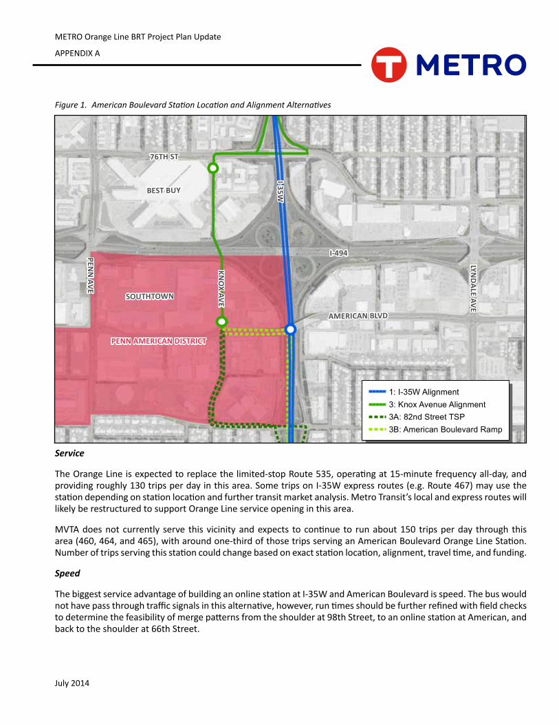
July 2014
METRO Orange Line BRT Project Plan Update
APPENDIX A
Figure 1. American Boulevard Station Location and Alignment Alternatives
Service
TheOrangeLineisexpectedtoreplacethelimited-stopRoute535,operatingat15-minutefrequencyall-day,andprovidingroughly130tripsperdayinthisarea.SometripsonI-35Wexpressroutes(e.g.Route467)mayusethestationdependingonstationlocationandfurthertransitmarketanalysis.MetroTransit’slocalandexpressrouteswilllikelyberestructuredtosupportOrangeLineserviceopeninginthisarea.
MVTAdoesnot currently serve this vicinityandexpects tocontinue to runabout150 tripsperday through thisarea(460,464,and465),witharoundone-thirdofthosetripsservinganAmericanBoulevardOrangeLineStation.Numberoftripsservingthisstationcouldchangebasedonexactstationlocation,alignment,traveltime,andfunding.
Speed
ThebiggestserviceadvantageofbuildinganonlinestationatI-35WandAmericanBoulevardisspeed.Thebuswouldnothavepassthroughtrafficsignalsinthisalternative,however,runtimesshouldbefurtherrefinedwithfieldcheckstodeterminethefeasibilityofmergepatternsfromtheshoulderat98thStreet,toanonlinestationatAmerican,andbacktotheshoulderat66thStreet.
BEST BUY
SOUTHTOWN
I-494
I-35W
AMERICAN BLVD
PENN
AVE
LYND
ALE AVE
76TH ST
KNO
X AVEPENN AMERICAN DISTRICT
ORANGE LINE AMERICAN BOULEVARD ALIGNMENT ALTERNATIVES
1: I-35W Alignment3: Knox Avenue Alignment3A: 82nd Street TSP3B: American Boulevard Ramp
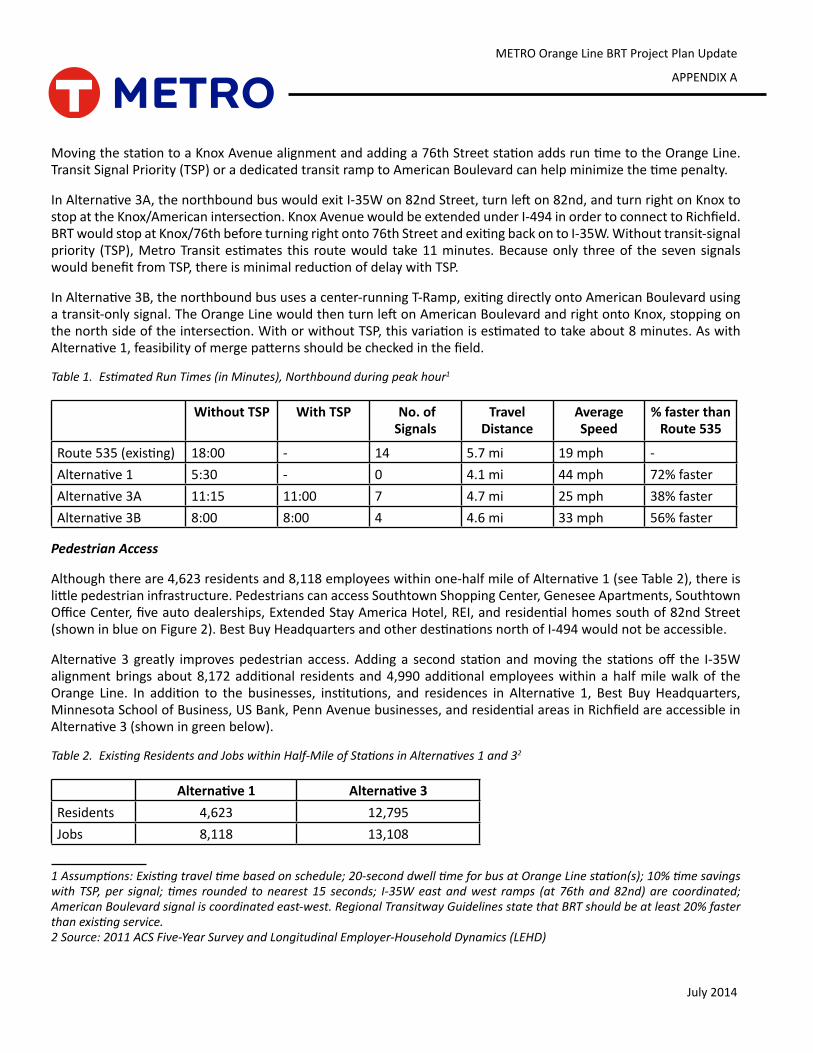
METRO Orange Line BRT Project Plan Update
APPENDIX A
July 2014
MovingthestationtoaKnoxAvenuealignmentandaddinga76thStreetstationaddsruntimetotheOrangeLine.TransitSignalPriority(TSP)oradedicatedtransitramptoAmericanBoulevardcanhelpminimizethetimepenalty.
InAlternative3A,thenorthboundbuswouldexitI-35Won82ndStreet,turnlefton82nd,andturnrightonKnoxtostopattheKnox/Americanintersection.KnoxAvenuewouldbeextendedunderI-494inordertoconnecttoRichfield.BRTwouldstopatKnox/76thbeforeturningrightonto76thStreetandexitingbackontoI-35W.Withouttransit-signalpriority (TSP),MetroTransitestimates this routewould take11minutes.Becauseonly threeof thesevensignalswouldbenefitfromTSP,thereisminimalreductionofdelaywithTSP.
InAlternative3B,thenorthboundbususesacenter-runningT-Ramp,exitingdirectlyontoAmericanBoulevardusingatransit-onlysignal.TheOrangeLinewouldthenturnleftonAmericanBoulevardandrightontoKnox,stoppingonthenorthsideoftheintersection.WithorwithoutTSP,thisvariationisestimatedtotakeabout8minutes.AswithAlternative1,feasibilityofmergepatternsshouldbecheckedinthefield.
Table 1. Estimated Run Times (in Minutes), Northbound during peak hour1
Without TSP With TSP No. of Signals
Travel Distance
Average Speed
% faster than Route 535
Route535(existing) 18:00 - 14 5.7mi 19 mph -Alternative1 5:30 - 0 4.1mi 44 mph 72%fasterAlternative3A 11:15 11:00 7 4.7mi 25 mph 38%fasterAlternative3B 8:00 8:00 4 4.6mi 33 mph 56%faster
Pedestrian Access
Althoughthereare4,623residentsand8,118employeeswithinone-halfmileofAlternative1(seeTable2),thereislittlepedestrianinfrastructure.PedestrianscanaccessSouthtownShoppingCenter,GeneseeApartments,SouthtownOfficeCenter,fiveautodealerships,ExtendedStayAmericaHotel,REI,andresidentialhomessouthof82ndStreet(showninblueonFigure2).BestBuyHeadquartersandotherdestinationsnorthofI-494wouldnotbeaccessible.
Alternative3greatly improvespedestrianaccess.Addinga second stationandmoving the stationsoff the I-35Walignmentbringsabout8,172additional residentsand4,990additionalemployeeswithinahalfmilewalkof theOrange Line. In addition to the businesses, institutions, and residences in Alternative 1, Best BuyHeadquarters,MinnesotaSchoolofBusiness,USBank,PennAvenuebusinesses,andresidentialareasinRichfieldareaccessibleinAlternative3(showningreenbelow).
Table 2. Existing Residents and Jobs within Half-Mile of Stations in Alternatives 1 and 32
Alternative 1 Alternative 3Residents 4,623 12,795Jobs 8,118 13,108
1 Assumptions: Existing travel time based on schedule; 20-second dwell time for bus at Orange Line station(s); 10% time savings with TSP, per signal; times rounded to nearest 15 seconds; I-35W east and west ramps (at 76th and 82nd) are coordinated; American Boulevard signal is coordinated east-west. Regional Transitway Guidelines state that BRT should be at least 20% faster than existing service.2 Source: 2011 ACS Five-Year Survey and Longitudinal Employer-Household Dynamics (LEHD)
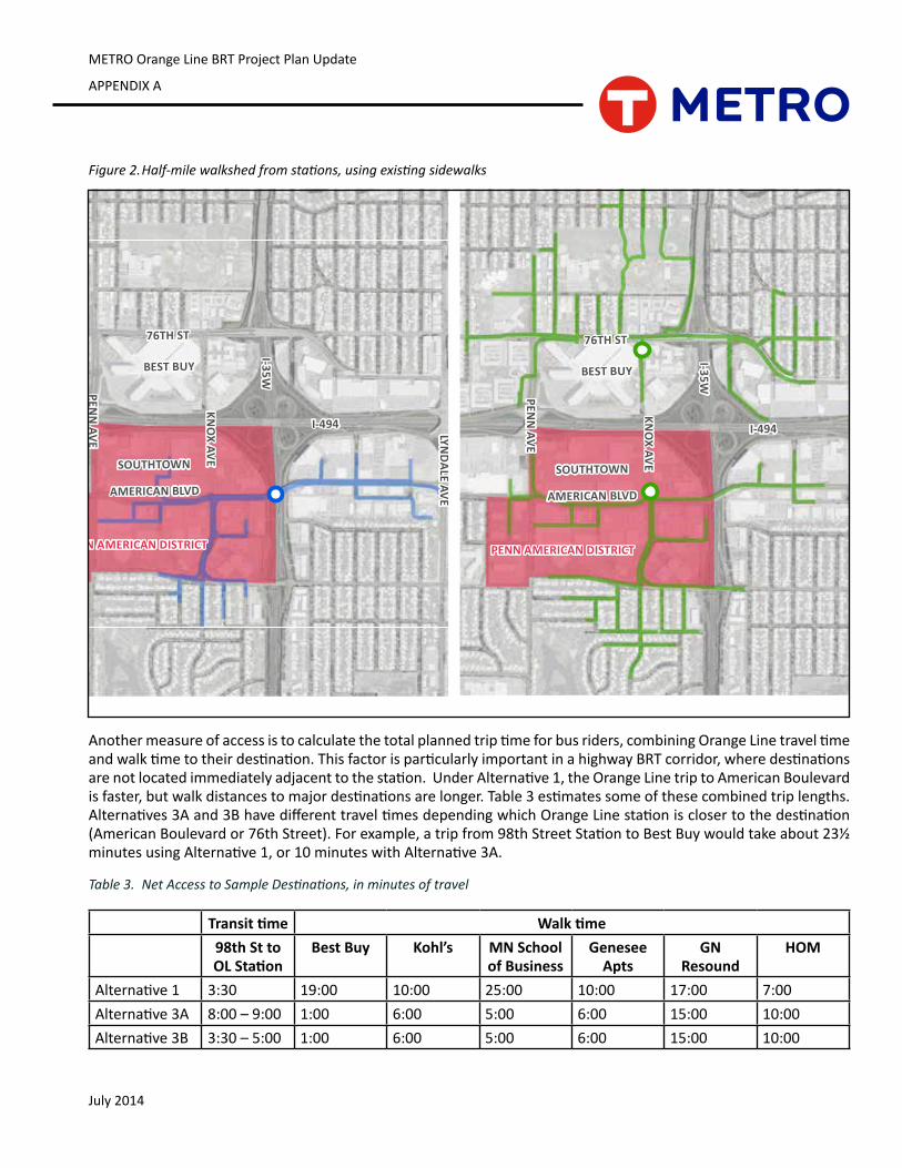
July 2014
METRO Orange Line BRT Project Plan Update
APPENDIX A
Figure 2. Half-mile walkshed from stations, using existing sidewalks
Anothermeasureofaccessistocalculatethetotalplannedtriptimeforbusriders,combiningOrangeLinetraveltimeandwalktimetotheirdestination.ThisfactorisparticularlyimportantinahighwayBRTcorridor,wheredestinationsarenotlocatedimmediatelyadjacenttothestation.UnderAlternative1,theOrangeLinetriptoAmericanBoulevardisfaster,butwalkdistancestomajordestinationsarelonger.Table3estimatessomeofthesecombinedtriplengths.Alternatives3Aand3BhavedifferenttraveltimesdependingwhichOrangeLinestationisclosertothedestination(AmericanBoulevardor76thStreet).Forexample,atripfrom98thStreetStationtoBestBuywouldtakeabout23½minutesusingAlternative1,or10minuteswithAlternative3A.
Table 3. Net Access to Sample Destinations, in minutes of travel
Transit time Walk time98th St to OL Station
Best Buy Kohl’s MN School of Business
Genesee Apts
GN Resound
HOM
Alternative1 3:30 19:00 10:00 25:00 10:00 17:00 7:00Alternative3A 8:00 – 9:00 1:00 6:00 5:00 6:00 15:00 10:00Alternative3B 3:30 – 5:00 1:00 6:00 5:00 6:00 15:00 10:00
BEST BUY
SOUTHTOWN
I-494
I-35W
AMERICAN BLVD
PENN
AVE LYND
ALE AVE
76TH ST
KNO
X AVE
PENN AMERICAN DISTRICT
BEST BUY
SOUTHTOWN
I-494
I-35W
AMERICAN BLVD
PENN
AVE LYND
ALE AVE
76TH ST
KNO
X AVE
PENN AMERICAN DISTRICT
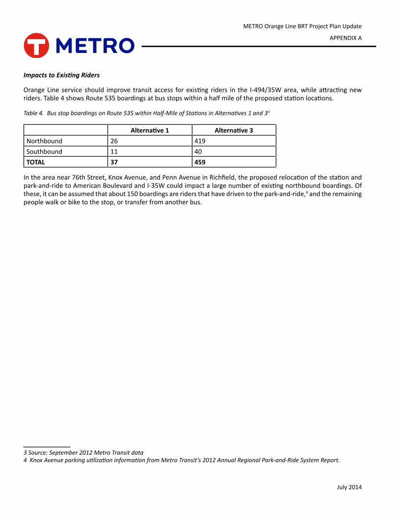
METRO Orange Line BRT Project Plan Update
APPENDIX A
July 2014
Impacts to Existing Riders
OrangeLine service should improve transit access forexisting riders in the I-494/35Warea,whileattractingnewriders.Table4showsRoute535boardingsatbusstopswithinahalfmileoftheproposedstationlocations.
Table 4. Bus stop boardings on Route 535 within Half-Mile of Stations in Alternatives 1 and 33
Alternative 1 Alternative 3Northbound 26 419Southbound 11 40TOTAL 37 459
Intheareanear76thStreet,KnoxAvenue,andPennAvenueinRichfield,theproposedrelocationofthestationandpark-and-ridetoAmericanBoulevardandI-35Wcouldimpactalargenumberofexistingnorthboundboardings.Ofthese,itcanbeassumedthatabout150boardingsareridersthathavedriventothepark-and-ride,4 and the remaining peoplewalkorbiketothestop,ortransferfromanotherbus.
3 Source: September 2012 Metro Transit data4 Knox Avenue parking utilization information from Metro Transit’s 2012 Annual Regional Park-and-Ride System Report.
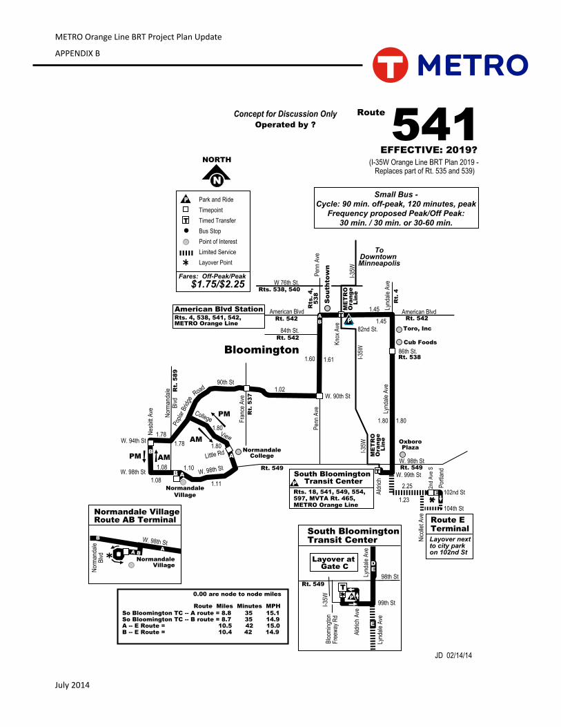
July 2014
METRO Orange Line BRT Project Plan Update
APPENDIX B
541Route
Bloomington
NormandaleCollege
W. 98th St
Pen
n A
ve
N
NORTH
Normandale
Village
Nor
man
dale
Blv
d W. 90th St
Pop
lar B
ridge
So
uth
tow
n
Kno
x A
ve
W. 98th St
Normandale Village
Normandale VillageRoute AB Terminal
90th St
Fra
nce
Ave
Rt.
58
9
Rt. 542
84th St.
Rt. 542
American BlvdRts. 4, 538, 541, 542,METRO Orange Line
W. 98th St
Road
Rts
. 4
,5
38
T
B
Pen
n A
ve
P
Fares: Off-Peak/Peak
$1.75/$2.25
T
Park and Ride
Timepoint
Timed Transfer
Bus Stop
Point of Interest
Limited Service
Layover Point
Rt. 549
EFFECTIVE: 2019?
(I-35W Orange Line BRT Plan 2019 - Replaces part of Rt. 535 and 539)
Operated by ?
Rt.
53
7
Nor
man
dale
Blv
d A BA
Concept for Discussion Only
OxboroPlaza
JD 02/14/14
Small Bus -Cycle: 90 min. off-peak, 120 minutes, peak
Frequency proposed Peak/Off Peak:30 min. / 30 min. or 30-60 min.
B
AM
PM
B
AB
W. 94th St
Nes
bitt
Ave
A
A
Rts. 538, 540W 76th St.
American Blvd Station
1.11
1.80
1.611.60
1.02
1.78
1.08
0.00 are node to node miles
So Bloomington TC -- A route = 8.8 35 15.1So Bloomington TC -- B route = 8.7 35 14.9A -- E Route = 10.5 42 15.0B -- E Route = 10.4 42 14.9
College
View
Little Rd
PM
AM
ME
TR
O
Ora
ng
e
Lin
e
Rt.
4
Lynd
ale
Ave
Lynd
ale
Ave
86th St.
Rt. 542American Blvd
Rt. 538
W. 98th St
W. 99th St
102nd St
Nic
olle
t Ave
104th St
Por
tland
2nd
Ave
S
E
DE
E
E
South BloomingtonTransit Center
98th St
Blo
omin
gton
Fre
eway
Rd
99th St
Ald
rich
Ave
I-35
W P
Layover at Gate C
Route E Terminal
Layover nextto city parkon 102nd St
Lynd
ale
Ave
T
Ald
rich
Rt. 549
Rt. 549
Lynd
ale
Ave
TSouth Bloomington Transit CenterP
Rts. 18, 541, 549, 554, 597, MVTA Rt. 465,METRO Orange Line
ME
TR
O
Ora
ng
e
Lin
e
I-35
WI-
35W
1.80
1.78
1.08 1.10
82nd St.
Cub Foods
Toro, Inc
1.45
1.45
1.80 1.80
1.23
2.25
Route Miles Minutes MPH
I-35
W
ToDowntown Minneapolis
P
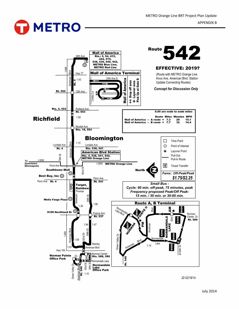
METRO Orange Line BRT Project Plan Update
APPENDIX B
July 2014
54224th Ave
Nicollet Ave
Portland Ave
12th Ave
I-35W
Penn Ave
France Ave
Hwy 100
Am
eric
an
Blv
d
84th
St
Hwy 77A
mer
ican
Richfield
T
I-49
4
Stanley
82nd
St
Rts. 5, 553
Rt. 552
Rts. 18, 554
Rt.
5
Rt. 541Rt. 4
I-49
4
84th
St
Am
eric
an B
lvd
NNorth
Penn Ave
A
B
AB
Southtown Mall
Lyndale Ave
Rt. 553
Rts. 538, 541
METRO Orange Line
$1.75/$2.25
Route
Rt. 537
Thomas
Target,
Rainbow
Best Buy, Inc
EFFECTIVE: 2019?
(Route with METRO Orange Line
Knox Ave. American Blvd. Station
Update Connecting Routes)
Wells Fargo Plaza
8100 Northland Dr
Knox Ave
Fares: Off-Peak/Peak
Time Point
Point of Interest
Layover Point
Timed TransferT
Pull-Out
Pull-In Route
Bloomington
AB
AB
Rt. 4
Lyndale Ave
1.43
1.00
1.15
1.36
1.97
1.59
1.471.84
1.80
ToDowntownMinneapolis
Concept for Discussion Only
T
Am
eric
an
Blv
d
I-35W
82nd
St
Rts. 4, 538, 541, 542,METRO Orange Line
American Blvd Station
76th
St
AB
NormandaleLakeOffice Park83
rd S
t
84th
St
American Blvd
Normandale Lake
Rts. 588, 589
Am
eric
an B
lvd
Norman Center
Rt.
54
0
Gre
en V
alle
y D
r
A B
Norman Pointe Office Park
Rt.
54
0
Rt. 589
Normandale
Lake
Norman Center Dr
Route A, B Terminal
Am
eric
anB
lvd
Gre
en V
alle
y D
r
56
00
56
01
NO
RM
AN
PO
INTE II
82
00
NO
RM
AN
DA
LE
L
AK
E
84
00
85
00
80
00
83
00
W 8
4th
St.
PM
AM
C D
American Blvd
Normandale
Lake Blvd
83rd
JD 02/18/14
Ma
ll o
f A
me
ric
a24th Ave S
Lind
auLa
Mall of America Terminal
D
rop
off
are
a
L
ayo
ve
r a
rea
Pic
k U
p a
t G
ate
D
Rts.: 5, 54, 415,444, 515,
538, 539, 540, 542,METRO Blue Line,METRO Red Line
Mall of America
D
1.10
1.10
0.00 are node to node miles
Mall of America -- A route = 7.3 29 15.1Mall of America -- B route = 7.7 32 14.4
Route Miles Minutes MPH
Small Bus -Cycle: 90 min. off-peak, 75 minutes, peak
Frequency proposed Peak/Off Peak:15 min. / 30 min. or 30-60 min.
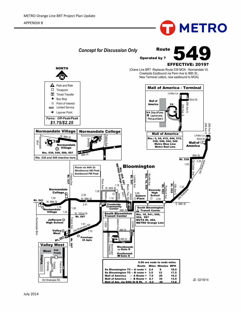
July 2014
METRO Orange Line BRT Project Plan Update
APPENDIX B
549Route
France A
veBloomington
NormandaleCollege
W. 98th St
JeffersonHigh School
ValleyWest
Penn A
ve
CreeksideCommunity
Center
OxboroPlaza
Nicollet A
ve
KennedyHigh
School
Old Sha
kope
e
N
NORTH
Portland A
ve
Old C
edar Ave.Lyndale A
ve
I-35
W
Penelope 35 Apts
Old Shakopee Rd
NormandaleVillage
Norm
andale Blvd
New
ton
Normandale CollegeF
rance Ave
98th StD
riveway
Old
Sha
kope
e
24th Ave S
.
Mall of America
26th Ave S
.
82nd St.Rts.: 5, 54, 415, 444, 515, 538, 540, 542, 549
Metro Blue LineMetro Red Line
Mall of America
E
Mall ofAmerica
24th Ave. S
.
Mall of America - Terminal
Drop off area Layover areaPick up at Gate C
82nd St.26th Ave S
.
10th Ave S
86th St.
Valley West
France A
ve
Old Shakopee Rd
Cub
Foods
Va
lle
y
West
Central
Drivew
ay
P
Rts. 18, 541, 549, 554, 597MVTA Rt. 465,METRO Orange Line
South BloomingtonTransit Center
T
Aldrich
99th St
Rt. 5
52
Rt. 5
53
Rts
. 18
, 55
4
Rt. 5
41
Rt. 5
97
W. 98th StE. 98th St
Bloom
. Fw
y. Rd
Rts
. 465, 5
97
ME
TR
O O
range L
ine
Rt. 597
W. 102nd St
98th St
Bloom
ingtonF
reeway R
d
99th St
Aldrich A
ve
I-35W
South Bloominton Transit Center
P
Eastbound: Gate D
Westbound: Gate D
Lyndale Ave
B
P
Fares: Off-Peak/Peak
$1.75/$2.25
T
Park and Ride
Timepoint
Timed Transfer
Bus Stop
Point of Interest
Layover Point
Rt. 597
(Orane Line BRT -Replaces Route 539 MOA - Normandale Vil.Creekside Eastbound via Penn Ave to 98th St.,New Terminal Letters, new eastbound to MOA)
C
A
Rt. 538
Concept for Discussion Only
JD 02/18/14
B
A
B
France A
veR
t. 53
7
W. 98th St
Normandale Village
Normandale Village
Norm
andaleB
lvd
Rts. 539, 549, 589, 597
Rts. 539 and 549 interline here.
B
B
Lindau La.
Lindau La.
ARt. 541
EFFECTIVE: 2019?
Operated by ?
A
0.00 are node to node miles
So Bloomington TC -- A route = 2.4 8 18.0
So Bloomington TC -- B route = 3.5 12 17.5
Mall of America -- A Route = 7.0 26 16.2
Mall of America -- B Route = 8.1 35 13.9
Mall of Am. via 94th St B Rt. = 9.2 40 13.8
Route Miles Minutes MPH
1.63
1.33
0.50
0.80
W. 94th St
James
Limited Service
1.10
1.18
1.00
2.381.05
2.41
1.91
1.361.16
1.24
1.70
2.26
Route via 94th St:
Westbound AM Peak
Eastbound PM Peak