Embed Size (px)
Citation preview

OCTOBER 2016
Welsh Government Contract No. C147/2010/2011
Agreed Additional Work Requirement Dated 8th March 2016
NERC CEH Project: NEC05945
Options for a New Integrated Natural Resource Monitoring Framework for Wales
Project Report - Phase I

How to cite this document: Emmett, B.A., Bell, C., Chadwick, D., Cheffings, C., Henrys, P., Prosser, H., Siriwardena, G., Smart, S., Williams, B., (2016) Options for a New Integrated Natural Resource Monitoring Framework for Wales; Phase 1, Main Report to Welsh Government (Contract reference: C147/2010/11; Agreed Additional Work Requirement Dated 8th March 2016). NERC/Centre for Ecology & Hydrology (NERC CEH Project: NEC05945)

Page 1
Options for a New Integrated Natural Resources
Monitoring Framework for Wales
Phase 1 Project Report
Welsh Government Contract No. C147/2010/2011 Agreed Additional Work Requirement Dated 8th March 2016
NERC CEH Project Number: NEC05945
Authors: Bridget Emmett3, Chris Bell3, David Chadwick1, Chris Cheffings8, Peter Henrys3, Havard Prosser7, Gavin Siriwardena2, Simon Smart3, Bronwen Williams3 Other Contributors: David Allen9, Alun Attwood9, Dawn Balmer2, Jeremy Biggs6, Kath Bollington9, Colin Chapman11, Si Creer1, Andy Davey13, Tara Froggatt4, France Gerard3, Rob Griffiths3, Paul Guest11, Tristan Hatton-Ellis9, Claire Horton11, Liz Howe9, Dave Johnston9, Kelvin Jones2, David Jones1, Chris Jones9, Barnaby Letheren9, Kate Lewthwaite12, Dylan Lloyd9, Lindsay Maskell3, Katie Metcalfe5, Helen Millband9, Nick Moran2, Dan Morton3, Andy Musgrove2, Stuart Neil11, Hayley New10, David Noble2, Lisa Norton3, Oliver Pescott3, David Robinson3, Paul Robinson8, Clare Rowland3, Cath Shellswell10, Rachel Taylor2, Lawrence Way8, Dylan Williams9, Martin Williams11, Ben Wilson9
The Welsh Government Senior Responsible Officer: James Skates11
Steering Group members and meeting attendees: Catherine Duigan9 (Chair) David Allen9, Joanne Amesbury11, Alun Attwood9, Colin Chapman11, Howard Davies11, Emily Finney11, Dai Harris11, Jenni Hartley11, Claire Horton11, Betsan John11, Peter Jones9, Dewi Jones11, Dave Jones11, Jim Latham9, Chris Lea11, Fiona McFarlane11, Helen Minnice-Smith11, Kathleen Mulready11, Stuart Neil11, Victoria Seddon11, Steve Spode11, Bob Vaughan9, Clive Walmsley9, Susan Williams9
October 2016
Key:
1Bangor University 2British Trust for Ornithology 3Centre for Ecology & Hydrology 4Dwr Cymru Welsh Water 5Environment Systems Ltd 6Freshwater Habitats Trust 7Independent
8Joint Nature Conservation Committee 9Natural Resources Wales 10Plantlife International 11The Welsh Government 12Woodland Trust 13WRc plc

Page 2
Intentionally blank

Options for a New Integrated Natural Resource Monitoring Framework for Wales
Page 3
Options for a New Integrated Natural Resource Monitoring Framework for Wales
Table of Contents 1 Background to the Future Options Project ................................................................................................... 5
1.1 Requirements of the Future Options Project ........................................................................................ 5 1.2 Future Options Governance .................................................................................................................. 6
Future Options Project Team ................................................................................................................ 7 2 Work Programme .......................................................................................................................................... 8
Mapping of Evidence Requirements ..................................................................................................... 9 2.1.1 Bilateral meetings ......................................................................................................................... 9 2.1.2 Stakeholder Workshop 1 ............................................................................................................ 11
3 Review and mapping of current evidence activities ................................................................................... 13 Evidence categories ............................................................................................................................ 13 Collation of Active Monitoring Schemes ............................................................................................. 16 Monitoring schemes: Analysis of Gaps, Overlaps and Opportunities ................................................. 17 3.3.1 Gaps ............................................................................................................................................ 18 3.3.2 Overlaps...................................................................................................................................... 18 3.3.3 Opportunities ............................................................................................................................. 19 Suitability of Monitoring Schemes for Inclusion into NRMF ............................................................... 21 Developing Methods for Sub-National Reporting ............................................................................... 23 3.5.1 Pilot Delivery .............................................................................................................................. 23 3.5.2 Feedback Summary .................................................................................................................... 24 3.5.3 A Case study ............................................................................................................................... 25 3.5.4 Other considerations identified during the Pilot ........................................................................ 25
4 Opportunities from New Approaches and Technologies ............................................................................ 27 Key Findings ........................................................................................................................................ 27 Summaries of Briefing Papers ............................................................................................................. 28 4.2.1 Citizen Science paper - key points .............................................................................................. 28 4.2.2 Earth Observation paper - key points ......................................................................................... 31 4.2.3 Molecular/eDNA paper- key points ............................................................................................ 34 4.2.4 Data and Informatics paper - key points .................................................................................... 37 4.2.5 Emergency Response paper - key points .................................................................................... 39 4.2.6 Freshwater Monitoring paper - key points ................................................................................. 43
5 Scoping Recommendations ......................................................................................................................... 45 Approved Recommendations.............................................................................................................. 45
6 Advantages and Disadvantages; Risks & Risk Management ....................................................................... 48 Potential Benefits ................................................................................................................................ 48 Potential Risks: .................................................................................................................................... 48 Potential Risk Management Strategies: .............................................................................................. 49 Alternative Options ............................................................................................................................. 50 6.4.1 “Experts-only” Option ................................................................................................................ 50 6.4.2 “Citizen Science only” option ..................................................................................................... 50 6.4.3 “Earth Observation only” option ................................................................................................ 51 6.4.4 “Modelling only” Option ............................................................................................................ 52 6.4.5 “As Is” 2016 Option .................................................................................................................... 52 6.4.6 NRMF option .............................................................................................................................. 53 6.4.7 NRMF “phasing in” option .......................................................................................................... 54 6.4.8 Options - Conclusion .................................................................................................................. 55
7 Conclusions ................................................................................................................................................. 56 8 Acknowledgements ..................................................................................................................................... 57

Options for a New Integrated Natural Resource Monitoring Framework for Wales
Page 4
Table of Appendices (The appendices are presented in a separate document)
Appendix A Glossary of Acronyms Appendix B Who Was Involved – People and Organisations Appendix C Bilateral Meeting Notes
Bilateral Meeting - NRW and CEH Monitoring Activities Bilateral Meeting - Industry Stakeholder - Tackling climate change in the Agricultural Sector Bilateral Meeting - Species and Habitat Monitoring (NRW/CEH) Bilateral Meeting - Natural Resources Monitoring (NRM) Bilateral Meeting - Developing Biological Indicators Bilateral Meeting - Forest Policy (National Forest Inventory) Bilateral Meeting - Landscape & Landmap Bilateral Meeting - Data and Informatics Bilateral Meeting - RDP Monitoring and Evaluation Bilateral Meeting - Historic/CADW Bilateral Meeting - Plant Health
Appendix D1 Stakeholder Workshops An Introduction & Who Was Involved Workshop 1 Workshop 2 Workshop 3 Combined Workshop Invitation Lists and Responses
Appendix D2 Stakeholder Workshop 1 - Output tables detail Policies and Reporting Pathways Evidence Providers Evidence Categories Data Sources
Appendix D3 Matrix of Evidence & Category Assessments Appendix E Technical/Topic Briefing Papers Section Contents Appendix F Briefing paper – Earth Observation Appendix G Briefing Paper - Citizen Science Appendix H Briefing pager – Molecular/eDNA Appendix I Briefing pager – Freshwater Monitoring Appendix J Briefing pager – Emergency Response Appendix K Briefing pager – Data & Informatics Appendix L1 Stakeholder Workshop 3 Summary Appendix L2 Stakeholder Workshop 3 – Benefit Realisation and Risk Summary Appendix M1 Partnership Working - Pilot Survey Report Appendix M2 Pilot Survey Feedback Summary Appendix N1 Steering Group Members and Engagement Appendix N2 Steering Group Minutes Appendix O Stakeholder Meetings Project TeamNotes (Drafts)

Options for a New Integrated Natural Resource Monitoring Framework for Wales
Page 5
1 Background to the Future Options Project This project was tasked with identifying options and developing recommendations for a new integrated natural resources monitoring framework (hereafter referred to as NRMF)2 for Wales reflecting the ambitions and integrating principles of the Environment Act (EA) and Well Being of Future Generations Act (WFG)3.
1.1 Requirements of the Future Options Project
The objective of the project was to identify future monitoring options; including activity, funding and governance that best deliver alignment and optimisation of monitoring activity for delivery across Welsh Government (WG) Departments and Natural Resources Wales (NRW). Exploration activity was to include the following:
Mapping evidence needs across Departments and NRW
Reviewing current monitoring and evidence capture activity
Mapping of activity overlap and identification of redundancy
Identification and risk assessment of evidence gaps
Identification of alignment opportunity and interfaces, e.g. GMEP4, Natura 2000, Water Framework Directive (WFD)
Identification of reporting pathways e.g. State of Natural Resources Reports (SoNaRR), Well-being of Future Generations, Rural Development Plan (RDP)
Identification of opportunities and new technologies, e.g. Earth observation (EO), citizen science, NGO activity, Local Record Centres (LRCs)
Mapping funding opportunities and challenges
Consider future resourcing models including data capture activity
Consider future governance of a Natural Resources Monitoring Programme
Exploration and recommendations had to be based on a phased approach; phase 1 immediate opportunities that can be out in place by 2017, phase 2 medium term opportunities that can be achieved over a 3 year period and phase 3 to long term opportunities that could be achieved over a 10 year period. Exploration activities were to include a series of thematic and sequential workshops attended by and contributed to by Steering Group members and wider stakeholders, as identified by the Steering Group. Workshop themes and brief descriptions were required:
Workshop 1 mapping of monitoring activity and evidence gaps, this will include mapping of monitoring activity against requirement, policy / programme, regulatory, legislative and discretionary
2 A glossary of acronyms is provided as Appendix A. 3 It should be noted most activities were carried out prior to the EU referendum. Some implications of this outcome have been explored but only within the Future Options Project team and the Future Options Steering Group, not the wider community. 4 GMEP: Glastir Monitoring & Evaluation Program

Options for a New Integrated Natural Resource Monitoring Framework for Wales
Page 6
Workshop 2 identification of monitoring and indicator overlap, this will include identification of where duplicate monitoring occurs, for example designated site monitoring and GMEP, WFD saltmarsh and GMEP, also identification of indicator overlap, where a single metric is being used across multiple reporting requirements for example soil carbon as an RDP, Glastir, WFG, proposed EU Soil Directive, SoNaRR and Area Statements
Workshop 3 future recommendations including activity, funding and governance including stakeholder sign off
A final report, presented here, was to include the products of the exploration, thematic workshops, and a series of options, for a future Natural Resources Monitoring Programme based on a phase 1, 2 and 3 approach. The options were to include supporting evidence, cost and resource implications, funding models and governance structure.
1.2 Future Options Governance A Welsh Government and Natural Resources Wales Task and Finish Steering Group was established (Table 1 shows members and meeting attendees). The group was chaired by Dr Catherine Duigan (Evidence Analysis, NRW) with secretariat provided by WG. Membership of the Steering Group was agreed from nominations from WG and NRW to reflect key activities focussed primarily in the terrestrial sector as part of the phased approach.
Catherine Duigan Chair NRW
James Skates Senior Responsible Officer (SRO) WG
Stuart Neil Agricultural Statistics WG
Dewi Jones Agriculture & Climate Change Policy WG
Betsan John Glastir Policy Officer WG
Joanne Amesbury Social Sciences WG
Clive Walmsley Climate Change NRW
Colin Chapman Data Management WG
David Allen Monitoring Strategy NRW
Fiona McFarlane Forestry & Policy WG
Jenni Hartley Biodiversity Policy WG
Bob Vaughan Land Management NRW
Dai Harris Biodiversity Policy WG
Steve Spode Natural Resource Management Policy WG
Victoria Seddon RDP Monitoring & Evaluation WG
Howard Davies Covering Bethan John and Catherine Lawton WG
Kathleen Mulready Covering Jo Amesbury WG
Dave Jones RDP Statistical Analyst WG
Alun Attwood Evidence, Monitoring and Reporting NRW
Chris Lea Core Evidence Group WG
Jim Latham Woodland NRW
Claire Horton Data Management WG
Emily Finney Natural Resource Management Policy WG
Helen Minnice-Smith Agriculture and Climate Change Policy WG
Peter Jones Habitats NRW
Susan Williams Social Sciences NRW
Table 1: Attendees of the Future Options Task and Finish Steering Group meetings (excluding project team members). Full details of meeting dates and attendees of each is given in Appendix N1
Recommendations put forward by the project team based on the bilateral meetings and workshops were to be agreed by the Steering Group, which would then be presented to the Core Evidence Group for scrutiny and finally to Ministers. Activity resultant from any Ministerial decision post-option submission was not a consideration of the Senior Responsible Officer (SRO), Chair or wider Steering Group.

Options for a New Integrated Natural Resource Monitoring Framework for Wales
Page 7
Future Options Project Team A Future Options project team was established to cover different elements of primarily land-based monitoring but with some knowledge of freshwater activities to reflect the required phased approach. It was agreed that due to ongoing policy developments in the marine sector this would be left until Phases II and III. Further information on the people and organisations involved in this project is detailed in Appendix B. The project was funded as an extension to the ongoing Glastir Monitoring and Evaluation Programme (https://gmep.wales/). The project team was led by Prof. Bridget Emmett of the Centre for Ecology & Hydrology (CEH) with representatives from Joint Nature Conservation Committee (JNCC), British Trust for Ornithology (BTO), Bangor University (BU), Independents, WRc plc (an environmental consultancy) and the Centre for Ecology & Hydrology (Table 2).
Role Area of expertise/role Name Organisation
PL Project lead/soil/integrated assessment Bridget Emmett CEH
PM Project management Chris Bell CEH
Sec Secretariat Emma Waters CEH
Member Policy and monitoring strategy Havard Prosser Independent
Specialist Freshwaters Andy Davey WRc
Member Habitats/UK links/citizen science Chris Cheffings JNCC
Member Biodiversity/professional surveys/modelling Simon Smart CEH
Member Biodiversity/citizen science/ Statistics/statistics Gavin Siriwardena BTO
Member Agriculture and climate change Dave Chadwick BU
Member Data management/informatics/statistics Pete Henrys CEH
Specialist Earth observation Fance Gerard CEH
Table 2: Members of the Future Options Task and Finish Project Team.
In addition, a total of 50 individuals from 14 organisations contributed to a series of Briefing Papers scoping out particular methods, approaches and technologies to inform the Future Options team and wider stakeholder community (Table 3).
Briefing Paper Name (Organisation)
Molecular Genetics S. Creer (BU), D.L. Jones (BU), R. Griffiths (CEH), T.W. Hatton-Ellis (NRW)
Earth Observation France Gerard (CEH), Clare Rowland (CEH), Dan Morton (CEH), Lisa Norton (CEH), Lindsay Maskell (CEH), Katie MedCalf (Environment Systems Ltd), Chris Cheffings (JNCC), Lawrence Way (JNCC), Paul Robinson (JNCC), Claire Horton (WG)
Emergency Response Havard Prosser (Independent), Kath Bollington (NRW), Martin Williams (WG), Chris Jones (NRW)
Data & Informatics Peter Henrys (CEH), David Chadwick (BU), Gavin Siriwardena (BTO), Barnaby Letheren (NRW), Colin Chapman (WG), Stuart Neil (WG), Paul Guest (WG)
Water Andy Davey (WRc), Bridget Emmett (CEH), Simon Smart (CEH), Tara Froggatt (DCWW), Jeremy Biggs (Freshwater Habitats Trust), David Allen (NRW), Alun Attwood (NRW), Tristan Hatton-Ellis (NRW), Dave Johnston (NRW), Helen Millband (NRW), Ben Wilson (NRW), Catherine Duigan (NRW), James Skates (WG)
Citizen Science Gavin Siriwardena (BTO), Dawn Balmer (BTO), Andy Musgrove (BTO), Rachel Taylor (BTO), Kelvin Jones (BTO), David Noble (BTO), Nick Moran (BTO), Oliver Pescott (CEH), Simon Smart (CEH), David Robinson (CEH), Tara Froggatt (DCWW), Katie Metcalfe (Environment Systems), Jeremy Biggs (Freshwater Habitats Trust), Chris Cheffings (JNCC), Dylan Lloyd (NRW), David Allen (NRW), Liz Howe (NRW), Dylan Williams (NRW), Cath Shellswell (Plantlife), Hayley New (Plantlife), Andrew Davey (WRc plc), Colin Chapman (WG), Kate Lewthwaite (Woodland Trust)
Table 3: Briefing Paper topics, authors and contributors

Options for a New Integrated Natural Resource Monitoring Framework for Wales
Page 8
2 Work Programme
A series of activities with overarching governance were agreed at the first Steering Group meeting (Figure 1). These were:
Figure 1: Project activities and governance
Three workshops (Appendices D to L) to capture stakeholder needs and priorities:
Workshop 1 - the policy landscape and evidence needs and mapping of current monitoring activities
Workshop 2 - opportunities and risks associated with different methods, approaches and new technologies.
Workshop 3 – review of Future Options draft recommendations and a benefits realisation exercise.

Options for a New Integrated Natural Resource Monitoring Framework for Wales
Page 9
To inform Workshop 2 discussions, a series of four Briefing Papers (Appendices E to I) were commissioned on the subjects of:
Earth Observation (Appendix F)
Citizen Science (Appendix G)
Molecular genetics (Appendix H)
Freshwater Monitoring (Appendix I)
With two additional Briefing Papers commissioned as a result of discussions during Workshop 2:
Emergency response (Appendix J)
Data and informatics (Appendix K)
Four meetings with the Steering Group to inform and review progress with more regular contact and meetings with the Steering Group Chair (Appendices N1 & N2).
The Steering Group agreed there should be a focus on the evidence requirements of the land-based sectors to ensure sufficient depth of analysis was possible within the timeframe of the project (4 months). However the interaction of land with other sectors (air, freshwater and marine) was also recognised and this was taken into account wherever possible to meet the requirements of the integrated and holistic approach embedded within the Environment Act and the Well Being of Future Generations Act. In addition, the Senior Responsible Officer commissioned:
Twelve bilateral meetings to explore evidence needs, ongoing activities and opportunities and risks of a new integrated NRMF across departments/sectors (Appendix C).
a Pilot project to explore the potential for aligning sub-national reporting approaches to a national baseline exploiting methods developed under the Glastir Monitoring and Evaluation Project (GMEP) (Appendix M1)
The result of this prioritisation is that some key stakeholders were not engaged in bilateral meetings e.g. those concerned with Animal Health, Marine and Air quality. Other areas such as freshwaters were the subject of a Bilateral meeting with NRW to help inform a Briefing Paper but did not include WG and water industry bodies. These meetings need to be undertaken during Phase II as should meetings with departments responsible for the economic and health and well-being agendas. Finally, cost and resource implications could not be explored in depth as the relevant information was not available.
Mapping of Evidence Requirements
2.1.1 Bilateral meetings A series of 12 bilateral meetings between the Future Options project team and different departments in the Welsh Government, Natural Resources Wales and other stakeholders were held between 4th March and 9th June 2016. The aim of these meetings was to: explore the evidence needs of the sector, capture current monitoring activities and identify the potential opportunities/risks

Options for a New Integrated Natural Resource Monitoring Framework for Wales
Page 10
associated with a more aligned and integrated monitoring framework. The topics of these meetings were:
1. NRW and CEH Monitoring Activities 2. Agriculture and climate change 3. Species and Habitat Monitoring (NRW/CEH) 4. Natural Resources Monitoring (NRM) 5. Developing Biological Indicators 6. Forest Policy 7. Landscape & Landmap 8. Data and Informatics 9. Water 10. RDP Monitoring and Evaluation 11. Cadw/Historic 12. Plant Health
A total of 14 organisations and more than 38 individuals attended these bilaterals from the following organisations:
ADAS AHDB Dairy Bangor University CADW
CEH Farmers' Union of Wales (FUW) Hybu Cig Cymru IBERS
JNCC Lantra Menter a Busnes
National Farmers Union Cymru (NFU) NRW WG
Notes from those meetings, including implications of a future National Resources Monitoring Framework, are available in Appendix C and are summarised below:
1. There is a need to better align monitoring with evidence needs, recognising the new domestic legislation (and now post EU referendum), but ensuring flexibility. This should involve moving to monitoring and evaluation in the round rather than assessment of individual schemes. Independence from specific policies and programmes in its ownership / management would be most likely to ensure the most resilient model in the light of continuing policy evolution (NRM; RDP; (Recommendation 1).
2. There are currently critical gaps in ongoing monitoring and evidence, e.g. terrestrial designated sites, pesticide use, tracking of plant health (as opposed to reactive measurement), the urban environment, success of restoration of ancient woodland, integration with data relating to economic and well-being agendas. Furthermore, there are no currently agreed indicators or monitoring activities for some key issues, e.g. efficiency of animal production, climate change (Biodiversity, Plant Health, Agri and Greenhouse Gases, RDP; Recommendation 1, 2).
3. There are significant opportunities to make more of existing activities and data across sectors, e.g. use of GMEP data for unbiased condition assessment of the benefits of designation / scheduling for landscapes, and historic features use of High Nature Value Farmland GMEP layer for landscape assessment in Landmap, assessment of Invasive and Non-Native Species (INNS) from GMEP survey (Landmap, CADW, National Forest Inventory (NFI), Plant Health; Recommendation 5, 6).
4. There is need for improved alignment of reporting metrics to enable improved data sharing, e.g. alignment of habitat classes for vegetation extent and condition reporting between

Options for a New Integrated Natural Resource Monitoring Framework for Wales
Page 11
NRW and GMEP, comparison of metrics for connectivity, monitoring invasives, etc. (NRW; Recommendation 5, 6).
5. There were opportunities for small modifications of ongoing monitoring work to significantly increase value and relevance across departments and Cabinet, e.g. expanding current monitoring to include all evidence needs across the RDP, soil sampling for fertiliser use advice does not currently include carbon which is needed for greenhouse gas reporting, inclusion of e.g. pesticide questions and other topics into the GMEP Farmer Practice Survey, use of GMEP data to create a public perception layer of Landmap (Agri and GHG5; Plant Health; Landmap; Recommendation 5).
6. Exploration of new opportunities and coordination of assessment/monitoring schemes would be beneficial, e.g. how to incentivise self-reporting by farmers, partnerships with industry, how to better combine structured and unstructured data through modelling to maximize their evidence value, how to expand citizen science to new monitoring targets and how to include a risk-based approach (Agri and GHG, Indicators, NFI, Water, Recommendation 5).
7. A greater use of modelling was highlighted but there was a need to consider the Macpherson report6 recommendations concerning the quality assurance of models to ensure their robustness and quality that inform government policy. (Indicators, RDP, Recommendation 8)
8. There was no current framework for domestic emergency response which a new integrated monitoring framework could address (NFI, Plant health; Recommendation 2, 3)
9. There is a need for greater focus on technologies and resources to increase data sharing and data conversion to robust evidence products including standards, ontologies, quality tags and assessments of suitability of data for different uses (including identification of gaps), recognising many legal, data ownership and Intellectual Property rights (IPR) issues, as well as coordination of that sharing of data (Data and Informatics, Plant Health, Water; Recommendation 6)
10. Creation of a coordination body of some kind with membership drawn across departments and representative of data users and providers would increase integration and coordination of monitoring and evidence needs. This body would also facilitate greater sharing of skills between organisations and informing the natural resource research agenda. A remit to link to organisations across UK and globally to reduce duplication and identify technology and methodological opportunities early should be included (RDP, NRW, Plant Health, Water, JNCC; Recommendation 3, 4).
2.1.2 Stakeholder Workshop 1
This workshop was convened to explore with the wider community three critical first steps towards forming a new NRMF which revolved around the fundamental question:
“Why is it needed, what is needed and who is currently doing it?”
5 GHG: Greenhouse Gases 6 “Review of quality assurance of government models”, HM Treasury, 5 March 2013 https://www.gov.uk/government/publications/review-of-quality-assurance-of-government-models
Options for a New Integrated Natural Resource Monitoring Framework for Wales
Page 12
Activities were therefore planned to capture and map the following:
1. Evidence needs (“the why?”) 2. Evidence categories (“the what?”) – discussed in Section 3 3. Evidence providers (“the who?”) – discussed in Section 3
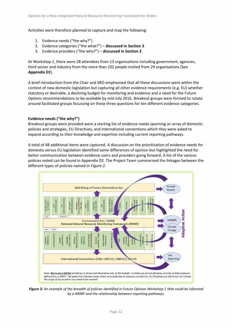
At Workshop 1, there were 28 attendees from 13 organisations including government, agencies, third sector and industry from the more than 102 people invited from 29 organisations (See Appendix D1). A brief introduction from the Chair and SRO emphasised that all these discussions were within the context of new domestic legislation but capturing all other evidence requirements (e.g. EU) whether statutory or desirable, a declining budget for monitoring and evidence and a need for the Future Options recommendations to be available by mid-July 2016. Breakout groups were formed to rotate around facilitated groups focussing on these three questions for ten different evidence categories. Evidence needs (“the why?”) Breakout groups were provided were a starting list of evidence needs spanning an array of domestic policies and strategies, EU Directives, and international conventions which they were asked to expand according to their knowledge and expertise including current reporting pathways. A total of 48 additional items were captured. A discussion on the prioritisation of evidence needs for domestic versus EU legislation identified some differences of opinion but highlighted the need for better communication between evidence users and providers going forward. A list of the various policies noted can be found in Appendix D2. The Project Team summarised the linkages between the different types of policies named in Figure 2.
Figure 2: An example of the breadth of policies identified in Future Options Workshop 1 that could be informed
by a NRMF and the relationship between reporting pathways.

Options for a New Integrated Natural Resource Monitoring Framework for Wales
Page 13
3 Review and mapping of current evidence activities As part of Workshop 1 and various bilateral meetings the current range of ongoing monitoring and evidence activities were captured, although it is recognised this still may not be complete. Efforts were made to ensure this was not duplicating any current efforts (e.g. UK Environmental Observation Framework (UKEOF) or NRW), but it was confirmed there was no up-to-date and complete list of current monitoring activities elsewhere.
Evidence categories At Stakeholder workshop 1, participants were asked to consider 10 proposed evidence categories and a range of subcategories to help to manage the review and to map activities. They were also asked to enhance a list of ongoing monitoring activities within these categories. The proposed list of evidence categories from the project team were:
Biodiversity
Ecosystem resilience
Greenhouse Gases
Health and Well-Being
Historic
Landscape
Natural hazards/disasters
Provisioning and supporting services
Recreation
Soil With minor edits (adding “Natural and man-made/industrial hazards/disasters”) this was accepted as a useful approach by the workshop. Comments on proposed subcategories were then requested to capture the breadth of activities within each category. The final drafted list was as follows(Table 4) (note some 2nd tier sub-categories contribute to several 1st tier categories):
Evidence category (1st Tier) Evidence sub-category (2nd Tier)
Biodiversity Priority Species - localised Priority Species - widespread Functional / Widespread Species Priority Habitats Broad Habitats Invasive non-native species High nature value (HNV) farmland Red lists Statutory/non-statutory sites Trophic cascades Food webs Favourable conservation status (global, EU, national)
Ecosystem resilience Diversity/Functional Diversity Structural diversity Connectivity Extent/landcover/urbanisation

Options for a New Integrated Natural Resource Monitoring Framework for Wales
Page 14
Condition or management Forestry Commission status Trophic cascades Food webs Farm viability (economic) High nature value farmland Data needed for models and mapping tools Data of activities likely to enhance Data on evidence of response/vulnerability to an extreme Payments for ecosystem services (PES) opportunity?
Greenhouse Gases Agricultural GHG inventory Land use, Land use change and forestry GHG inventory Soil and Biomass Global footprint Woodland area Woodland carbon code Woodland management Farm woodlands Farm biomass (hedges, corridors etc.) Farm energy generation Energy efficiency Agricultural production efficiency Adaptation/ Resilience measures Anaerobic digestion
Soil Carbon/organic matter Nutrients pH Biodiversity Contaminants Physical attributes (erosion, compaction, etc.) Peatland code Planning policy Wales Area of sealed soil surface Rare soils
Historic Condition of Scheduled Ancient Monument (SAMs) and listed buildings Condition of Historic Environment Features (HEFs) Number and condition of veteran trees Tree preservation orders (TPOs) Historic landscapes & Parks and Gardens Ancient woodland inventory Buildings at risk register Historic Environment Record/National Monuments Record
Landscape Landmap GMEP Visual Quality Index Visitor numbers/appreciation of HEFs and SAMs Landscape character assessment Hedgerows (preferred visual features) Field trees (preferred visual features)
Health and Well-Being Physical and mental health Social resilience

Options for a New Integrated Natural Resource Monitoring Framework for Wales
Page 15
Waste Noise and litter / fly-tipping Access to green space Hazards e.g. contaminated land Deprivation (index of multiple deprivation indices) Hiraeth (welsh word ~ longing, belonging, sense of adventure) Clean air/pollution Poverty and environmental quality Access to clean soil Dark skies / Light pollution Crime (arson e.g. wildlife crime; poaching, off-roading) Access to water
Recreation Public Right of Way (PROW) condition Path length/condition Utilisation Tourism Recreation Landscape quality Length of PROW per unit area Accessibility/affordability
"Natural hazards / disasters AND Manmade and Industrial"
Disease/vector/pathogen Volcanoes Radionuclides Genetically Modified Organisms Wales Resilience Forum Forest fires (risk) Heather/grass fires (risk) Extreme weather Coastal erosion Acute air pollution Drought Flooding Landslides/Earthquakes
Provisioning and supporting services
Pollination Agricultural production Diversity of production Timber Production Energy Production Renewables Nutrient cycling Primary production Food and drink action plans Landscape services Soil formation and remediation Climate mediation (local) Flood risk mediation Cultural services
Table 4: Evidence Categories; post-workshop1 draft

Options for a New Integrated Natural Resource Monitoring Framework for Wales
Page 16
Attendees were then asked to add monitoring schemes and other data sources which they currently use or think would be useful for a NRMF within of these categories. More than 58 schemes were added as a result of this activity.
Collation of Active Monitoring Schemes The project team then expanded the land-based monitoring schemes produced during the workshop. Data catalogues exploited included:
Reynolds B., G McShane, B A Emmett, J Farrar and M.G.Pilkington (2005) An Audit of Baseline Monitoring for the Detection of Landscape–scale Environment Change in Wales. CEH report to the Countryside Council for Wales CEH Project No. C02659; CCW Contract No. FC 73-05-52
UK Earth Observation Framework Catalogue; http://www.ukeof.org.uk/
Wales Gov.stats.co.uk – Environment and countryside and other topics; http://gov.wales/statistics-and-research/?topic=Environment+and+countryside&lang=en
Well Being of Future Generation National Indicators; http://gov.wales/topics/people-and-communities/people/future-generations-act/national-indicators/?lang=en
The Environment Information Data Centre; NERC’s data Centre for terrestrial and Freshwater sciences); http://eidc.ceh.ac.uk/
The list of all monitoring and evidence schemes captured by the team during workshops and from accessing different catalogues and policy documents can be found in the working documents in Appendix D2. The project team then assessed each scheme with respect to their likely contribution to a new NRMF within the time available. The project team took into account assessments made by a range of stakeholders of various monitoring programmes during the bilateral meetings. Several stakeholders asked that it be emphasised that:
1. All monitoring schemes will have a valid purpose which is why they were originally established. This Future Options assessment was whether they could have additional value as a contributor to a NRMF.
2. It should not be assumed all schemes will be willing to join a NRMF. Contribution of resources and provision of data may be constrained due to funding requirements, data ownership, legal and IPR issues; participation may therefore be conditional on financial contributions or management agreements.
It should be noted the final list of schemes is not complete but provides an initial insight into the current coverage of different evidence categories. Also, as some schemes deliver into multiple evidence categories, the number of data streams across all categories is greater than the number of schemes. As far as we were able to check, all schemes noted were active in 2016. Identifying the funding models for each scheme and security of those funding streams going forward was beyond the scope of this project. On a simple numerical basis, the category of Biodiversity had the largest number of known schemes/data streams, whilst Landscape had the smallest (see Section 3.4). This is in part a result of the granularity of Biodiversity schemes across different taxa and of a focus on widespread or rare species. There are also many different elements to biodiversity, each of which can have different drivers and patterns of change. The development of high-level biodiversity indicators that aggregate

Options for a New Integrated Natural Resource Monitoring Framework for Wales
Page 17
some of these data together to provide simple assessment tools for groups of taxa, including sectoral applications, has been the subject of much study over the last 15 years through the UK Biodiversity Indicator Forum7 managed by the Joint Nature Conservation Committee. Within other categories – a similar approach of aggregating multiple data layers has been taken e.g. the Landmap classification for the landscape sector. For soils, work has identified various indicators but without
any final agreed consensus (Environment Agency 2006; SNIFFER 2006; Environment Agency 2008)8 and without any attempt to date to integrate these into aggregated indicators. For other categories, indicators have only recently been attempted for national scale metrics, (e.g. for resilience, provisioning and supporting services, agricultural efficiency). A combination of historical requirements, driven by, e.g., EU Directives and variable engagement by the public through citizen science initiatives are the primary cause of the contrast in the number of data sources across the different categories. Many stakeholders highlighted the opportunity to develop a new set of monitoring activities to inform the development of indicators for these 10 evidence categories and 114 subcategories which underpin a range of new domestic policy evidence needs. In was noted in the RDP bilateral that no policy or programme should own a future NRMF to ensure future relevance and utility in the long term. Indicators can be adapted over time but must always be based on a fundamental set of natural resource metrics that are consistent over time.
Monitoring schemes: Analysis of Gaps, Overlaps and Opportunities Some clear gaps emerged from the analysis whilst other categories such as biodiversity appear better served. Overall:
i. Biodiversity had the greatest number of schemes, but coverage is highly variable even within groups, and some groups are only poorly covered. There is a need to focus efforts on producing meaningful metrics at a range of scales, but there needs to be acceptance that it is not possible to produce regional trends or, necessarily, specific analyses with respect to particular drivers, using existing data. More intensive survey methods or more complete geographical coverage than are provided by ongoing surveys may be needed to address particular monitoring or evaluation questions, even for the (relatively) well-monitored groups.
ii. A low number of surveys within an evidence category does not necessarily mean poor coverage. A single multi-purpose scheme such as GMEP can provide many data streams even within a single category, e.g. soils. Likewise, a single programme such as Landmap can integrate many data sources providing an efficient approach to data capture and their conversion to re-useable evidence products. Categories also differ in the number of possible independent forms of variation that each require an individual monitoring programme.
iii. Resilience is a poorly understood concept; however there are data to support monitoring of
all of the attributes of resilience defined in the Welsh legislation. How/whether these should be combined is a subject for further work.
7 http://jncc.defra.gov.uk/page-1818 ; accessed 4th August 2016 8 Environment Agency (2006): “The development and use of soil quality indicators for assessing the role of soil in
environmental interactions”. Science Report SC030265 SNIFFER 2006: National Soil Monitoring Network: Review and Assessment Study; Project LQ09 Environment Agency (2008): Design and operation of a UK soil monitoring network. Science Report SC060073

Options for a New Integrated Natural Resource Monitoring Framework for Wales
Page 18
iv. Many surveys of hazards are unstructured. It would be helpful to assess whether structured or targeted approaches could be more cost-effective.
v. Data are available for assessments of human health and well-being, but they require correlations or spatial measures of a range of environmental attributes against population attributes.
3.3.1 Gaps
We were not able to identify schemes for:
i. some designated sites and features; ii. tracking of plant health and disease - currently there is only a reactive assessment on
incident outbreak; iii. animal health - routine testing for bovine tuberculosis occurs, but other schemes were not
identified as the meeting with the animal team was not possible in the time available; this therefore needs to be revisited;
iv. pesticide/contaminant use (only available at UK level); v. contaminant abundance in the environment with the exception of presence of contaminants
in predatory birds, which relies on members of the public sending in carcasses, and routine sampling of food for radionuclides in food;
vi. assessment of change in soil at depth – only topsoil (0-15cm); vii. key metrics for peat condition e.g. peat depth or water table height;
viii. progress of agricultural efficiency and climate change target meeting. It was also noted that there is insufficient power / spatial coverage for most categories of reporting at a local level, including assessment of the success of local management interventions, and many schemes have limited funding security or have no ongoing funding (e.g. GMEP), putting at risk many data sources listed.
3.3.2 Overlaps Some overlaps became apparent when reviewing the evidence database. These need further exploration to test whether these were true overlaps, or were artefacts resulting from the use of too coarse a category. Some direct duplication did appear possibly to be occurring in the biodiversity category, particularly for birds and plants. However, any analysis of overlaps needs to be conducted with care because effective monitoring of particular groups within a category (such as rare versus common, mobile versus sedentary or breeding versus wintering species), for different regions (e.g. upland versus lowland) or for specific purposes (e.g. long-term trends, distribution or Glastir evaluation) each requires a different monitoring approach to maximize sensitivity and effectiveness. Thus, it may be possible to conduct relevant analyses for a given question using two different datasets, but one would represent a compromise in the quality of inference possible, such as in the certainty with which conclusions could be drawn. An example would be deriving long-term trends in bird or butterfly populations from structured surveys like the Breeding Bird Survey (BBS) or the Wider Countryside Butterfly Survey (WCBS), as opposed to from unstructured records. Quality of evidence therefore needs to be a central issue in any assessment of overlaps and cost-effectiveness. Note also that data on common species may be collected from multiple schemes each targeting different rare

Options for a New Integrated Natural Resource Monitoring Framework for Wales
Page 19
species: these data may therefore include considerable redundancy, but their collection incurs no cost over that paid to collect the information for target species. Two further points that need to be taken into account in any evaluation of overlaps are:
i. New or different monitoring schemes have previously generally been introduced because there is a monitoring gap of policy or conservation interest. For example, bird, invertebrate and plant surveys were included in GMEP because the existing (volunteer) monitoring available would not have allowed effective evaluation of Glastir. There is certainly overlap in the outputs available from different approaches, e.g. both BBS and Bird Atlas provide data on bird distributions, but the applications to which each can be put are often very different.
ii. Volunteer motivation is critical in citizen science schemes and this can result in sampling
appearing sub-optimal or redundant. For example, a monitoring gap might involve rare species, in which case any structured survey is likely to produce large numbers of zero records, which are important, but not easy to motivate volunteers to collect. Including recording of more common species in similar habitat gives volunteers a purpose and facilitates the collection of more data relevant to the target, even if the latter information is redundant. Similarly, much data collection from unstructured data harvesting for some taxa will be redundant, because higher quality data are already available from other schemes, but records from remote or unpopular locations could be very valuable.
3.3.3 Opportunities The analysis identified some examples of opportunities which informed Recommendations 1, 5, 6 and 7 including:
i. better re-use of data to fill gaps; ii. combining data to derive new innovative data / evidence products;
iii. the potential for multi-purpose surveys / collabrative working to create greater value and efficiencies.
Specific examples of these are:
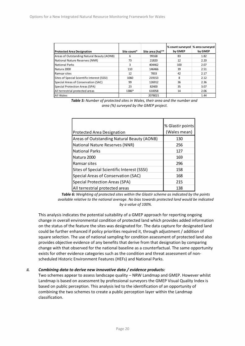
i. Better re-use of data to fill gaps: Approximately 20% or 610,058 hectares of Wales is protected in some way for its natural resources (Table 5). However, there is little field-based assessment of the ongoing change in condition of this land, or of the specific elements that provided the rationale for protection/designation and that may be a specific species or habitat. An analysis was undertaken of how much protected land was surveyed by GMEP and therefore could be assessed for ongoing change in condition. The field survey element of GMEP provides national estimates of change in condition and extent of habitats, soil, headwaters and ponds, pollinators and birds, historic features and landscape. It uses a stratified random sample of Wales consisting of 300 1km squares or 30,000 hectares (1.44% of Wales).
The analysis indicated GMEP surveyed 12,567 hectares of protected land or 2.06% suggesting a greater than random representation (relative to the national sample of 1.44% if Wales) of protected, relative to unprotected, land within the GMEP field survey sample (Table 5). This is due to prioritisation of protected land in the Glastir scheme, as indicated by the ca. 40% (range +27 – 296%) higher than the national average availability of Glastir points for protected land (Table 6).
Options for a New Integrated Natural Resource Monitoring Framework for Wales
Page 20
Table 5: Number of protected sites in Wales, their area and the number and area (%) surveyed by the GMEP project.
Table 6: Weighting of protected sites within the Glastir scheme as indicated by the points
available relative to the national average. No bias towards protected land would be indicated by a value of 100%.
This analysis indicates the potential suitability of a GMEP approach for reporting ongoing change in overall environmental condition of protected land which provides added information on the status of the feature the sites was designated for. The data capture for designated land could be further enhanced if policy priorities required it, through adjustment / addition of square selection. The use of national sampling for condition assessment of protected land also provides objective evidence of any benefits that derive from that designation by comparing change with that observed for the national baseline as a counterfactual. The same opportunity exists for other evidence categories such as the condition and threat assessment of non-scheduled Historic Environment Features (HEFs) and National Parks.
ii. Combining data to derive new innovative data / evidence products:
Two schemes appear to assess landscape quality – NRW Landmap and GMEP. However whilst Landmap is based on assessment by professional surveyors the GMEP Visual Quality Index is based on public perception. This analysis led to the identification of an opportunity of combining the two schemes to create a public perception layer within the Landmap classification.
Protected Area Designation
% Glastir points
(Wales mean)
Areas of Outstanding Natural Beauty (AONB) 130
National Nature Reserves (NNR) 256
National Parks 127
Natura 2000 169
Ramsar sites 296
Sites of Special Scientific Interest (SSSI) 158
Special Areas of Conservation (SAC) 168
Special Protection Areas (SPA) 215
All terrestrial protected areas 138
Protected Area Designation Site count* Site area (ha)**
% count surveyed
by GMEP
% area surveyed
by GMEP
Areas of Outstanding Natural Beauty (AONB) 6 99168 83 1.82
National Nature Reserves (NNR) 73 21820 12 2.20
National Parks 3 404462 100 2.07
Natura 2000 110 146466 39 2.51
Ramsar sites 12 7833 42 2.17
Sites of Special Scientific Interest (SSSI) 1060 219153 8 2.12
Special Areas of Conservation (SAC) 99 126912 36 2.36
Special Protection Areas (SPA) 23 82400 35 3.07
All terrestrial protected areas 1386* 610058 14 2.06
All Wales 2078021 1.44

Options for a New Integrated Natural Resource Monitoring Framework for Wales
Page 21
iii. The potential for multi-purpose surveys / collaborative working to create greater value and efficiencies: GMEP provides evidence of how a multi-purpose scheme where surveyors are capturing multiple data streams in a single visit to locations can be practical and efficient. The design of the programme was based on a past monitoring programme (www.countrysidesurvey.org.uk), thus allowing for tracking historical trends to 1978. Additional data streams were then added for:
i. birds and pollinators using methods adapted from citizen science schemes (Common Birds Census, BBS, UK Butterfly Monitoring Scheme (UKBMS), WCBS);
ii. historic features and footpath condition using a newly developed rapid assessment approach in collaboration with CADW;
iii. landscape quality using public perception surveys; iv. greenhouse gas emissions using modelling; v. farmer surveys to assess change in practice and constraints on uptake of Glastir
options.
This allows GMEP to contribute to 9 of the 10 evidence categories (with options for the data to contribute to the final category of Health and Well Being). The approach also allows for integrated assessment to enable co-dependencies, trade-offs and co-benefits to be explored, as indicated in the results presented via the GMEP data portal (https://gmep.wales/).
Suitability of Monitoring Schemes for Inclusion into NRMF Many schemes were identified as being potentially relevant and useful for a NRMF (Figures 3 and 4) (see Recommendation 1 and 3 and Appendix D3). This assessment is primarily based on the following categories determined by the project team, broadly considering the provision of evidence of national temporal trends:
the scheme provides full national coverage and is well structured without major biases (green);
the scheme could be developed to be a useful component with additional work (amber);
the scheme was set up for a different purpose and is unlikely to be useful as coverage is incomplete (red).
Several critical constraints of this assessment should be noted which have relevance for Recommendation 1:
1. It should be noted that schemes’ involvement in a future NRMF cannot be assumed as provision of data would be subject to agreement by the organisation, which could be constrained by an array of data ownership, funding, legal and IPR constraints.
2. This assessment does not consider the spatial or temporal granularity required, or the
specific monitoring target (e.g. temporal trend, spatial distribution or effects of management/environmental change). For example the data intensity needed for evidence of regional distribution of a species over a decadal time step is far less than that required to assess the impact of a bundle of Glastir interventions on a 5-year time step. This would need to be reviewed again once reporting pathways and specific needs are agreed.

Options for a New Integrated Natural Resource Monitoring Framework for Wales
Page 22
3. The funding models for all the schemes and the likely continuation of that funding was outwith the scope of this project.
4. The suitability of any scheme in part depends on the question posed, which is likely to vary
over time as policies change. Suitability for informing about temporal trends does not necessarily inform suitability with respect to identifying specific effects of management or climate, for example. How to ensure a flexible approach whilst maintaining continuity of trend data is also not without challenges.
Figure 3: Number of monitoring schemes in the land-based sector and an assessment of their likely
relevance/utility for a NRMF – View 1
Figure 4: Number of monitoring schemes in the land-based sector and an assessment of their likely
relevance/utility for a NRMF- View 2.
0 5 10 15 20 25 30 35 40 45 50
Biodiversity
Natural hazards/disasters/man-made/Industrial
Health and well-Being
Greenhouse Gases
Ecosystem resilience
Provisioning and supporting services
Soil
Recreation
Historics
Landscape
Good Potential Poor Unknown Not Assessed
0%10%20%30%40%50%60%70%80%90%
100%
Good Potential Poor Unknown Not Assessed

Options for a New Integrated Natural Resource Monitoring Framework for Wales
Page 23
Initial conclusions from this work which informed the development of Recommendations 1, 2, 3 and 5 are:
there are a large number of potentially useful schemes to include in a NRMF;
a large number of schemes are currently fragmented and there are opportunities to make more of ongoing schemes by greater collaborative working both via field, multi-purpose surveys and through sharing of data and joint data analysis;
in contrast some schemes are highly integrative and serve a large number of evidence categories (e.g. GMEP);
gaps reflect topics required for new domestic legislation such as e.g., resilience, ecosystem services and climate change mitigation, which have not previously featured;
further work needs to be done to identify which schemes have the power to deliver both national and local-based metrics that are needed for Local Area Statements (see Section 3.5).
Developing Methods for Sub-National Reporting WG requested that a pilot was carried out as part of the Future Options project to identify the potential value of the Glastir Monitoring and Evaluation Programme (GMEP) integrated multi-purpose survey approach for sub-national reporting. The aims were to explore potential increases in efficiency and to enable comparison of performance at a sub-national scale with the national baseline. It was thought this could be realised through application of common monitoring methodologies, sampling structures and indicators to provide a common framework for reporting. It was calculated that GMEP currently was already capturing 8362ha of National Parks, 3675ha of Natura 2000 sites, 4656ha of SSSIs and 479ha of National Nature Reserves, areas that could be further enhanced through additional monitoring by local staff. A pilot project to test this concept was developed in which staff from the Brecon Beacons and Snowdonia National Park Authorities, National Trust, Natural Resources Wales and Local Authorities attended a three day classroom and field demonstration of the GMEP field survey monitoring methodologies. This gave potential partners hands-on experience to evaluate the methods, sampling strategies, skills and support required for operating an integrated systematic national survey plus opportunity to assess how the national programme could be adapted for monitoring at the local scale. A full report on this activity can be found in Appendix M1.
3.5.1 Pilot Delivery
Eleven representatives from the Brecon Beacons and Snowdonia National Park Authorities, National Trust, Natural Resources Wales and Local Authorities attended a 1 day classroom session and a 2 day field demonstration. GMEP monitors land-use, plants, birds, pollinators, top soil condition, headwaters and ponds, landscape and historic features all within 300 1 km survey squares. All elements of the survey were demonstrated and the benefits and cost-efficiencies of co-locating all ecosystem surveys was demonstrated. The future NRMF was also discussed and considered. Representatives were asked to provide feedback (Appendix M2).

Options for a New Integrated Natural Resource Monitoring Framework for Wales
Page 24
3.5.2 Feedback Summary
All organisations acknowledged GMEP delivers an excellent monitoring programme with high levels of training and Quality Assurance.
80-100% expressed they want to receive trend data for annual national, regional and their organisation’s land holdings from the existing GMEP survey programme.
None of the organisations felt they would adopt the GMEP monitoring framework in its entirety. However, all organisations were interested in potentially adopting one or more individual elements of the framework. See Table 7.
Survey element % of respondents
Habitat mapping 100%
Vegetation 100%
Soil 80%
Pollinators 80%
Headwaters streams 60%
Ponds 60%
Birds 60%
Historic Environment Features 60%
Modelling 40%
Landscape photography 20%
Greenhouse gas measurements 20%
Table 7: GMEP survey elements the respondents* are interested in adopting into future monitoring. (*respondents included staff from Brecon Beacons and Snowdonia National Park Authorities, National Trust, Natural
Resources Wales and Local Authorities)
100% of respondents confirmed that the survey would need to be adapted to meet their organisational needs. Some of the suggested examples are listed below:
Integration with existing monitoring;
Inclusion of volunteers / local recorders / citizen science;
Options for use of open source software;
All partner organisations would require support if they were to undertake monitoring (Table 8). The table below shows the support/advice the respondents would require.
Support/Advice % of respondents
Statistical advice 100%
Data analysis 100%
Training 80%
Laboratory analysis 80%
Quality Assurance 60%
Interpretation 60%
Table 8: Support and advice the respondents would require if they were to undertake a structured survey similar to GMEP.

Options for a New Integrated Natural Resource Monitoring Framework for Wales
Page 25
3.5.3 A Case study A Case Study of the adoption of this approach was identified that can be used for illustrative purposes (Box 1).
Box 1
Case Study: College Valley Vegetation Monitoring (http://www.college-valley.co.uk/index.htm)
The College Valley Estate (6500ha) lies within the Northumberland National Park. The mainstay of the estate’s income is upland sheep and beef farming, forestry, holiday lettings and shooting. In 2011, there was a change in an agricultural tenancy and 1600 ha of moorland were taken back in-hand. The Scottish black faced ewes were removed from the Cheviot Massif which is a Site of Special Scientific interest. CEH were approached to devise a long-term vegetation monitoring programme across the whole Estate to provide baseline status of vegetation; monitor change within habitats; inform long term management decisions; and to monitor the effectiveness of agri-environment schemes. GMEP-style methods from Countryside Survey were adapted and, using base-line information from data supplied by Natural England and Northumberland National Park, survey points were randomly stratified. A rolling 5-year programme took place where each point was visited and vegetation sampling carried out and this was repeated over the following 5 years. MAVIS (https://www.ceh.ac.uk/services/modular-analysis-vegetation-information-system-mavis),
a programme for analysing vegetation data was used to assign vegetation into different classification systems. In this case, the need for high quality consistently recorded data across the whole valley over four years of planned summer campaigns meant that citizen science was not a viable option by College Valley Estate. The park staff considered that it would be impossible to guarantee personnel availability, skill level and ability to visit and to record in remote, difficult and relatively dull habitats, to ensure that data were high quality and consistently recorded over the survey period (4 years). Even if volunteers had helped to record in the field, there was a requirement for knowledge of the Estate’s current and past management and an understanding of its ecology to perform data collation, analysis, interpretation and reporting. This would have to be completed by a professional and it was considered to be more efficient and robust, in terms of turning data into evidence, to fund a small team of locally based, experienced consultants to do the whole package.
3.5.4 Other considerations identified during the Pilot Funding: Partners stated they currently have insufficient resources to fund the specialist skills training, laboratory analysis, survey equipment, data analysis and interpretation required for regular use aspects of the GMEP methodology to track ongoing change in environmental condition. Data ownership accessibility and confidentiality: The information GMEP collects is the property of the Welsh Government and individual land owners’

Options for a New Integrated Natural Resource Monitoring Framework for Wales
Page 26
names and land holdings cannot be identified in reporting. Data collected from the survey are presented in summary form only. GMEP surveyors are not permitted to disclose any sightings of priority species or instances of non-compliance against the requirements of the single farm payment scheme, for example. This has been critical in securing permission to survey (only 4% refusal), but this code will have to be reviewed if data are to be used for other future reporting requirements. One organisation would like to use the data to engage with the land owners and provide targeted management advice. GMEP data are currently stored in an ArcGIS geodatabase with access restricted to the GMEP consortium partners under licence. Dialogue with the Local Environmental Records Centres (LERC) will be critical as they play a significant role on managing biological record data. The balance between Widespread and Priority Species and habitats: Concerns were raised over the ‘broad scale’ monitoring of natural resources undertaken by GMEP. Current monitoring commitments of partner organisations involved in the Pilot are targeted to Priority Habitats (Habitats Directive Annex 1) and Species (Environment Act (Wales) Section 7 (which replaces section 42 of the NERC Act 2006)), or surveys are reactive in response to planning applications or community needs for example. Increased awareness of the importance to understand the stock and condition of both priority and common species and habitats to meet resilience objectives in the Environment Act will be required.
These findings were used to inform the development of Recommendations 1, 2, 5 and 7.

Options for a New Integrated Natural Resource Monitoring Framework for Wales
Page 27
4 Opportunities from New Approaches and Technologies A requirement of the Future Options Task and Finish Group was the:
“Identification of opportunities and new technologies, e.g. earth observation,
citizen science, NGO activity LRC’s”
Stakeholder Workshop 2 was convened to explore the opportunities from adopting new methods, approaches and technologies. A total of 122 people were invited from 39 organisations with 36 attendees from 16 organisations attending the event in Newtown (see Appendix D1). To inform the discussions, the project had commissioned 4 Briefing Papers on the following topics:
Earth Observation; Citizen Science; Molecular genetics (including environmental DNA (eDNA)); Freshwater monitoring. Two additional papers were commissioned after this workshop in response to issues raised at the meeting and the bilateral meeting with the Welsh Government data and informatics team: Emergency response; Data and Informatics.
Key Findings The key findings and recommendations from the papers were presented followed by question and answer session. Feedback from this meeting was then used to enhance the Briefing papers and additional authors were asked to contribute. The final papers are available in full in Appendices F to K. They are of variable length due to the very contrasting nature of the subjects. Some topics are fast-moving technologies such as Earth Observation. Other topics are more technical in nature which are intended to indicate a general agreed direction of travel (e.g. Data and Informatics) or an opportunity that a new aligned monitoring framework could contribute towards (e.g. Emergency Response). Here, we present the high level findings of each paper and an overall consensus reached at the workshop.
The broad consensus reached at the workshop was that no method, approach or technology can operate in isolation and that neither new nor traditional methods are without bias or limitation. The most probably effective approach is a combination of methods that exploits their individual strengths. Case studies are provided in the Briefing papers that demonstrate how this is already under development for a range of evidence streams e.g. citizen science to inform professional surveys or earth observation to better target field-based assessment in a risk-based approach. It should be noted that this mixed approach of methods is already in use, but sometimes without all of the collaborative working and coordination that many indicated would be beneficial (See Workshop 2 report (Appendix O/section 2) and various Bilateral reports (Appendix C)). The community also highlighted that, whilst there was enthusiasm to adopt new technologies as they become available and many were doing so, it was important to undertake a rigorous assessment of, e.g., their relevance to policy priorities, cost-benefit balances, start-up costs, requirements for statutory reporting (e.g. accredited methods and laboratories) and adequate comparison to current methods, prior to their adoption.

Options for a New Integrated Natural Resource Monitoring Framework for Wales
Page 28
These findings were used to inform the development of Recommendation 5.
Summaries of Briefing Papers
4.2.1 Citizen Science paper - key points
Citizen Science Introduction
“Citizen science” includes a wide range of activity relevant to natural resources monitoring, but with the field surveys conducted by volunteer or unpaid observers. We recognize five relevant types: (i) structured national surveys designed to collect particular evidence, (ii) the collation of records collected independently of any survey structure, (iii) local monitoring projects conceived and conducted by amateur naturalists, (iv) recording activity designed primarily to encourage public engagement, (v) “blind” sample collection (recordings or physical samples) for professional analysis. These types are most developed for the biodiversity evidence category, but are applicable more widely. This note considers the potential of citizen science data for monitoring. The value for public engagement may be a secondary benefit, but we do not consider it, or data of type (iv) here. This is because data collection lacks rigour or and spatial or temporal biases are not controlled in scheme design. Current State of Development
Long-running volunteer surveys (type (i)) underpin much of the monitoring of biodiversity in the UK, particularly with respect to birds and butterflies. Historically, the norm was for structured, detailed surveys of user-selected locations (e.g. the Butterfly Monitoring Scheme, Common Birds Census and Rothamsted moth recording), but there has been an increasing drive to replace or to augment these schemes with surveys based on random site selection, to avoid geographical or habitat biases and to produce results representative of national populations. Thus, the Breeding Bird Survey has reported on bird (and some mammal) populations since 1994. Newer schemes are now aiming to do the same for butterflies (Wider Countryside Butterfly Survey http://butterfly-conservation.org/113/wider-countryside-butterfly-survey.html) and plants (National Plant Monitoring Scheme http://www.npms.org.uk/). The National Bat Monitoring Programme (NBMP) has annual structured transects as well as targeted recording of roost sites and hibernacula. Statistical approaches to make the most of these data have been in development for more than 20 years and established procedures now exist for index production, separation of long-term trend from inter-annual fluctuation, dealing with spatial and temporal autocorrelation, spatial generalization (“gap-filling”), estimation of precision and the investigation of causes of change. Enhancements of the value of unstructured biodiversity recording via analysis and collecting contextual data are ongoing. In Wales, Local Environmental Record Centres function as a clearing house for the professional storage and dissemination of some unstructured data, although some societies and local schemes work directly with the Biological Records Centre. Key advantages/disadvantages of citizen science approaches (see Briefing Note for more)
Selected advantages:
Cheap with regard to survey effort (including identification training) compared to professional surveys.
Can increasingly be tied to remote-sensed data to provide habitat context; can also potentially validate or ground-truth remote-sensed data (see Box 1).
Quantity of information collected can help to compensate for lack of quality control for individual records.
New technologies increasingly allow more sophisticated data collection by untrained observers; together with automated verification, this may help to attract new cohorts of observers.
Fully structured surveys, especially those with randomized site selection, provide data equivalent to those from professional monitoring when protocols are designed and implemented appropriately.
Coverage of locations within easy reach of people tends to be good, for example for lowland farmland and suburban areas.
Current WG policy restricts professional survey data collection to areas for which land access permissions have been obtained, including elements (e.g. birds) visible from public rights of way (PROWs), but volunteer observers are free to survey from PROWs. Biases may exist in both although the risk of only surveying ‘nothing to hide’ land in professional surveys due to access refusals is surprisingly low within e.g. GMEP. Identifying land ownership is the bigger issue which may bring its own
Options for a New Integrated Natural Resource Monitoring Framework for Wales
Page 29
unknown bias – is this land of better or worse quality / condition? About a quarter of all land in Wales has no specific Customer Reference Number (CRN) which is needed to obtain access permission.
Selected disadvantages:
Considerable investment is needed in recruitment, reporting-back and engagement activities for surveyors, including continual replacement of older observers.
Data collected need to be input, checked, processed and analysed professionally, or by volunteer organizers such as LERCs or BTO regional representatives (although online and automated systems are increasingly helping). These activities require resourcing.
Not all taxa or monitoring activities can be assumed to be equally attractive to volunteers: taxa well covered by volunteer schemes are strongly aligned to taxonomic groups of higher public interest. Type (v) surveys require a different approach to make them attractive.
Sampling from precise locations (and repeat visits) cannot be guaranteed, so targeting specifically for local data applications may not be possible.
Repeat monitoring in the absence of change may cause observer fatigue, limiting long-term consistency.
Data that can be collected are restricted, in particular the collection of contextual data is often resisted by surveyors with a strong interest in a particular group, for example.
Complicated and high-intensity protocols both turn off some observers and may not be followed closely by those who do take part.
Avoidance of unpopular locations can cause important geographical biases in data collected.
Responsive recording may cause bias (e.g. collection of samples only when problems are perceived or submission of records of common species only when rare species are also present).
Quality control is more difficult to implement than with professional sampling.
Implementation (including costs)
Citizen science is critically dependent on volunteer motivation, and schemes may compete for a limited pool of volunteer effort. Often, national monitoring for Wales will not be seen as the primary driver. As a result, successful scheme design and delivery has to take account of these factors. The UK Environmental Observation Framework (UKEOF) provides guidance on extracting evidence from citizen science projects and motivational factors, together with a cost-benefit analysis tool.
Citizen science schemes of types (i), (ii), (iv) and (v) require professional infrastructure, which incurs significant costs, but field cost per unit effort is far lower than that of professional surveys. However, as observer expectations for outputs rise, costs may rise.
Online data capture systems can be expensive to develop, and have on-going hosting, updating, user web support and maintenance costs. Certain NGOs organize structured schemes or calls for unstructured data, typically supported by government or agency funding.
Interpretation issues
Citizen science is best suited to low-intensity, low-effort surveys that require only limited skills. Hence, the data produced are best for large-scale surveillance. Because citizen science includes diverse forms of data, from randomized, structured surveys to entirely opportunistic and biased sets of records, they cannot be considered as a single form of information. It must be recognised that there are inevitable geographical reporting biases.
Unstructured data sources need scoping to determine the level of reliable inference supported. Structured surveys are preferred, but harvesting unstructured records may be the only option. Experience to date
Almost all citizen science in monitoring to date has involved charismatic, diurnal animals, with evidence extracted on national trends and evaluation of environmental impacts. NRW place a high value on current and past citizen science data in Wales and use the information in national reporting and evidence gathering. It is important to note that survey coverage in Wales is typically sparser than in England, due to observer density: this will be critical for the feasibility of new monitoring. Low-intensity survey data are valuable for large-scale effects/trends, but more intensive monitoring and professional surveyors are required at small scales. Data Informatics
Data harvesting of unstructured records enables the collation of large quantities of data, but geographical and other biases will limit reliable inference. The development of Bayesian models for analysing unstructured data may help but are not a panacea for data limitations. Even Bayesian models need a certain amount of distributed data to be successful. The degree of structure in data sets underlies real evidence value. Exploiting unstructured records requires that the quantity and quality of data are maximised by working with Wales LERCs, National Biodiversity Network (NBN), and with centres of analytical expertise such as CEH and BTO. Engagement-focused initiatives are

Options for a New Integrated Natural Resource Monitoring Framework for Wales
Page 30
effective in increasing interest and educating, but the value of the data produced is low and this must be recognized at policy level. Data ownership is a sensitive issue with citizen science data, and intellectual property and investment need to be respected and rewarded. Next steps for development as a monitoring tool
Citizen science approaches are suited to surveillance, monitoring and evaluation applications, but not for local-scale regulatory applications. Structured surveys such as BBS, NBMP, WCBS and NPMS are valuable for future monitoring and can contribute to the evaluation of management impacts at large scales. Future developments can take four directions: new surveys, exploitation of further unstructured sources, more analyses of existing data and integration of citizen science and professional effort. New structured surveys might succeed, but observer interest will be a strong restriction. Harvesting unstructured records may contribute further, both by increased recording effort and by more central processing, especially where uptake would make structured surveys unfeasible. Developments include work by the Freshwater Habitats Trust to use semi-structured monitoring of freshwaters in Wales for water quality and biodiversity. The mySoil smartphone app provides novel capacity for reporting soil condition, by accessing unstructured data, although biases similar to those found in data for the UK Soil Observatory from Wales collected by a self-selected sample of farmers are possible. The growing use of automated, static bat detectors offer more complete and more standardized monitoring for this group. The use of volunteer effort to ground-truth Earth observation data is being scoped by JNCC and Environment Systems, with a view to monitoring environmental change. Conclusions The most cost-effective approach to future monitoring with representative or complete coverage may be to combine structured volunteer recording with professional effort, for example in remote areas which are not attractive to, or suitable for, volunteers. Combining citizen science with earth observation may also present significant opportunities although increased ‘command and control’ can reduce volunteer engagement.

Options for a New Integrated Natural Resource Monitoring Framework for Wales
Page 31
4.2.2 Earth Observation paper - key points
Earth Observation Introduction
The term Earth observation (EO) is used to cover ‘the gathering of information about planet Earth’. EO refers the use of remote sensing technologies that collect electromagnetic signals reflected, scattered or emitted by the Earth’s surface. The signals provide information on the properties of surfaces (e.g. temperature, colour, moisture content, height), from which biological attributes such as biomass, land cover and habitat type can be inferred. In practice the data can be photography, multi-spectral observations, radar observations or Lidar (near infrared) observations, collected from sensors on board satellites, aircraft or unmanned airborne vehicles (drones). Current State of Development
Visible and near infrared EO are used widely to map and monitor land cover, landscape features and the condition of vegetation. Lidar systems are used to measure the heights of surfaces, to map digital terrain, hedgerow and wall, and archaeological features. The combination of visual, Lidar and short-infrared techniques leads to improved mapping accuracy and the ability to distinguish more land cover classes.
BOX 1. Combining citizen science and Earth Observation:
Opportunistic ground-truthing of habitat maps in England.
Volunteer surveys to ground truth Earth Observation data could be a cost-effective development. In one example, maps derived from earth observations showing the potential extent of Priority Habitats were made available for ground-truthing. Final coverage was based on compilations of survey datasets of varying age and reliability. Natural England is developing ways that this initial pilot could be delivered by mobile phone technology.

Options for a New Integrated Natural Resource Monitoring Framework for Wales
Page 32
However these techniques require clear skies between the earth and the detector, whereas radar systems are not affected by cloud. Radar is used for digital terrain mapping and for monitoring forest biomass and crop growth. Using Lidar, radar or stereoscopic aerial photography to provide height data and a greenness measure enables the detailed mapping of hedgerows, and woody vegetation (line of trees, shrubs, small woodland patches) – See Box 2. EO derived Vegetation Indices such as the Normalised Difference Vegetation Index (NDVI) are very effective to monitor the greenness of vegetation over time, for example to scan forested areas for evidence of change. EO products available in Wales include a range of complete coverage products (UK land cover maps, Updated Phase 1 Habitat map for Wales, National Forest Inventory), and some that focus on specific land cover types such as monitoring of woody cover and Above Ground Net Primary Productivity in High Nature Value farming areas, within GMEP, and a detailed assessment of the extent and condition of the Welsh peat soil resource. There is also a fixed network of sensors to monitor soil moisture and phenology. Key advantages/disadvantages of Earth Observation approaches
Selected advantages:
Satellite EO can achieve a complete coverage of Wales in a very short period of time.
EO data is spatially and temporally consistent, available at a range of spatial and temporal scales and delivered through a variety of means (e.g. satellite, aircraft, drone).
EO has high sensitivity to detect some changes of land cover, land management, vegetation condition and pests and diseases in vegetation.
EO provides a bird’s eye view and allows the surveying and monitoring of dangerous, remote and restricted areas.
A wide range of EO data is freely available and relatively easy to access.
Once methods are established, and despite the large volumes of data, processing of EO to produce consistent measures can be highly automated
Selected disadvantages:
EO always requires some form of field based calibration and validation.
Cloud affects the availability of optical data.
Free satellite imagery is only available at 10 m resolution or above and so cannot provide the very detailed spatial information required to map or monitor small patches of cover (e.g. field margins or habitat mosaics within a land parcel). A general rule is that the required spatial resolution of the data should be half the size of the smallest feature of interest.
High data costs limit the use of certain observation types for carrying out frequent (e.g. annual) and large area monitoring. The most expensive data are typically those delivered through airborne campaigns (e.g. aerial photography, Lidar), or very high spatial resolution (cm to m) satellite imagery.
The volume of data is great and is expected to increase further. This requires adequate investment in data handling facilities.
There are some cover/habitat types and features that cannot be mapped or monitored using EO. Others require more effort to map and monitor. There is a compromise between maximising the number of land classes and achieving accurate mapping.
Using EO involves a steep learning curve to utilise tools and technology, especially with radar. As a result, setup costs are higher than running costs.
Implementation (inc costs)
To date, the most effective EO based approach to monitor for significant changes and update a land cover map is by searching for anomalies in the EO data, followed by targeted more detailed investigation of these areas. To support EO, field observations are crucial to establish a robust link between the surface variable of interest (e.g. land cover class, condition measure) and the EO data. Field observations are also required to validate the EO derived surface variables. For example, there is a strong case for using EO data in conjunction with field data such as aspect, elevation, soil type, and local climate. The Copernicus Sentinel-1, -2 and -3 satellite series are set to provide more frequent and spatially detailed data. For example, Sentinel-2 revisits the same location every 3 to 5 days, which is 4 times more frequently than Landsat (formerly the main source of data for land cover mapping). Sentinel-2 provides higher resolution data imagery with pixels as small as 10m (compared with 28m for Landsat). A high revisit frequency increases the chances of acquiring cloud-free data which in turn improves the quality of the mapping and monitoring. For areas with frequent cloud coverage, radar systems are needed. Sentinel-1 provides frequent, high spatial resolution radar data. Although radar ‘sees’ the landscape differently from optical, it is now being considered as a complementary source of information in land cover mapping.

Options for a New Integrated Natural Resource Monitoring Framework for Wales
Page 33
The most affordable and effective EO based options will be the ones that:
are based on well-established or tested approaches (i.e. repeatable in space and time)
require the least pre-processing or well-established automated pre-processing
exploit existing field based monitoring
are targeted to deliver a single measure (e.g. Forest cover; productivity; area of change; a basic set of cover classes)
avoid duplication of effort (e.g. benefit from archives of pre-processed data and intermediate products)
maximise the use of free data and open source software. Interpretation issues
EO based applications rely on the conversion of the raw EO signal into useful information about the environment, land or water surface. Depending on the information required, the approaches, algorithms and models used for the conversion vary widely. The resulting accuracy also varies. For monitoring, the key is to maintain consistency in the information that is retrieved from the EO data. Consistency is affected by several factors, including: changes in sensor design between missions, changes in sensor performance, changes in pre-processing steps, changes in the approach used to interpret the data. This can be managed through version control, detailed documentation of processing chains, product validation and the reprocessing of the historical data with the updated procedures or if re-processing is not an option the inclusion of strategies for avoiding or managing these inconsistencies. For enforcement purposes, validating the information derived from EO in a manner that satisfies Regulation and Policy is particularly important. Data Informatics
EO data has to be acquired from the supplier, stored and distributed. Easy access to (archived) data to build up time-series is important. EO data also has to go through some form of pre-processing before it can be used. A centralised national hub that acquires, stores, pre-processes and distributes standardised and version controlled EO data and intermediate products relevant to national monitoring would avoid duplication of effort, cut cost and expedite the use of the EO data. Certain downstream products such as a generic UK land cover map, Wales character map, a digital terrain model, a hotspot map of change will assist a variety of users and so would benefit from a centralised data management approach. Certain intermediate products are used repeatedly for a variety of applications, so reducing costs. Where expensive EO imagery is essential, procurement of country-wide coverage for shared data access will be the most cost-effective. Next steps for development as a monitoring tool
It is important for WG and NRW to stimulate engagement and thinking across the community (Wales and UK) to identify the types of change and drivers of change that EO is likely to help to monitor. The focus should be on simple and reliable variables such as NDVI and operational or near-operational systems that are geared towards monitoring and change detection. As overall priorities for information are clarified, a tiered approach helps in finding efficient solutions using EO’s strengths combined with the strengths of other methods. Following the Welsh Government’s investment in developing a pre-processed Landsat Archive for Wales, it is essential to develop a coordinated approach to the acquisition, pre-processing, and production of intermediate products and distribution of other EO data. This should concentrate on data from Sentinel 1 and 2 in the first instance and investigate the feasibility and cost of securing Lidar coverage for Wales, by adding Lidar acquisitions to the Welsh rolling 3 year aerial photography campaign.

Options for a New Integrated Natural Resource Monitoring Framework for Wales
Page 34
4.2.3 Molecular/eDNA paper- key points
Molecular/eDNA Introduction
For many years, out of necessity, researchers in the field of microbiology have been using molecular approaches to assess the biodiversity of communities using genetic approaches. However, the relatively high cost of such work has tended to restrict its use to the research community or to more specialist applications. Recent developments in sequencing technologies have greatly increased the accessibility and hence attractiveness of this technology, including its use in assessing the biodiversity of larger taxa. By focusing on a range of genetic source material (e.g. community-level or environmental DNA [eDNA]), habitats, and spatial scales, entire communities can be characterised more easily and cheaply across a wide range of taxonomic groups. Current State of Development
There are many forms of DNA. Genomic DNA is extracted from a single individual (or from a collection of individuals belonging to the same species). Community DNA consists of genomic fragments from many individuals representing a mix of different species. Community DNA is isolated from organisms in bulk samples, but separated from their habitat (e.g. soil, sediment, river benthos). Community DNA extracts have important potential in ecological studies, especially for biomonitoring purposes, since the focus is on the extant community. Environmental DNA (eDNA) is isolated directly from an environmental sample without first isolating any type of organism (e.g. soil, sediment, faeces, water, air, etc.). One of the most powerful aspects of eDNA analysis is the ability to sample biodiversity that is not easily sampled by other means or requires complicated procedures to extract organisms of interest. The combination of genomic, community and environmental DNA therefore provide a variety of sources of biodiversity information that can be analysed using the approaches here on.
Box 2
EO can accurately measure height using Lidar, radar or stereoscopic aerial photography. Height data, when combined with a greenness measure can deliver detailed maps of hedgerows, and woody vegetation (line of trees, shrubs, small woodland patches). The image below shows 2 examples of such a map.
Left: a hedgerow and woodland map derived using height information from airborne Lidar,
Integrated science for our changing worldwww.ceh.ac.uk
Woods, linear roadside hedges, farmland trees
1 – 1.5 m
1.5 – 3 m
3 – 6 m
6+ m
Hedgerow height
‘A’ road
Wood
Junction
Farm buildings
Hedgerow trees
Scrub
Raw data
Extracted data
Lane
Integrated science for our changing worldwww.ceh.ac.uk
Woods, linear roadside hedges, farmland trees
1 – 1.5 m
1.5 – 3 m
3 – 6 m
6+ m
Hedgerow height
‘A’ road
Wood
Junction
Farm buildings
Hedgerow trees
Scrub
Raw data
Extracted data
Lane
Integrated science for our changing worldwww.ceh.ac.uk
Woods, linear roadside hedges, farmland trees
1 – 1.5 m
1.5 – 3 m
3 – 6 m
6+ m
Hedgerow height
‘A’ road
Wood
Junction
Farm buildings
Hedgerow trees
Scrub
Raw data
Extracted data
Lane
Integrated science for our changing worldwww.ceh.ac.uk
Woods, linear roadside hedges, farmland trees
1 – 1.5 m
1.5 – 3 m
3 – 6 m
6+ m
Hedgerow height
‘A’ road
Wood
Junction
Farm buildings
Hedgerow trees
Scrub
Raw data
Extracted data
Lane

Options for a New Integrated Natural Resource Monitoring Framework for Wales
Page 35
eDNA methods have been used for fundamental research into the diversity of life and its function in a variety of habitats as well as to answer ecological questions relating to environmental or management change. Historically, organisms were sampled and analysed, but new eDNA analyses have shown that powerful biodiversity insights can be gained by bypassing the organism stage and instead focusing on traces of organisms in a range of environments. More recently, the methodologies have been used in larger scale monitoring to establish broader drivers of microbial diversity. For example, applications include the identification of species and communities of organisms throughout all biomes (e.g. the endangered Great Crested Newt (see Box 3), microbial soil diversity in GMEP and a range of fish species of biomonitoring importance for statutory reporting). The Countryside Survey provided a molecular assessment of the bacterial communities across England, Wales and Scotland and revealed strong relationships with the same geological and climatic features that determine the distributions of plant communities. Importantly, this revealed that at the broad level, predictions can be made about the type of bacterial communities found in different climatic and geological settings, and also the likely effects of land management based on direct effects on soil edaphic conditions. A significant advance in Wales has been the collation of plant barcodes for the majority of Welsh and UK flowering plants, covering 1,479 UK native flowering plant species http://www.gardenofwales.org.uk/science/barcode-wales/ – an invaluable resource for the future of botanical, pollinator and allergenic health research. Key Advantages/disadvantages
Selected advantages
Molecular approaches in general are more cost effective than traditional approaches
Molecular approaches offer sensitive, high-throughput assessment capability, that has been shown to equal or outperform traditional approaches
Sequencing studies provide broader scale monitoring of biodiversity, including the simultaneous analysis of invasive, rare and biomonitoring species of policy relevance.
For some groups (e.g. bacteria, fungi and microbial eukaryotes) molecular approaches are likely the only viable option for routine identification
DNA samples can be stored in small volumes and archived for future use. Selected disadvantages
Not all species feature in existing genetic databases
For some forms of eDNA analyses, (e.g. rivers) the spatial resolution of taxon detection is currently uncertain due to transport of genetic signals throughout catchments
Because molecular assessment of biodiversity focuses on cells, any approximate quantitative insights will not reflect numbers of individuals, but instead approximate estimations of species biomass
Detection of genes/organisms through DNA approaches may not derive from functionally active organisms because DNA may be highly resistant to degradation and may persist in the environment for a long time. Sequencing of RNA has been explored but requires a greater degree of labour.
There is currently no consensus as to which markers to use for particular groups
National scale monitoring is limited by the difficulties in identifying and counting different taxa, resource constraints (i.e. manpower, cost)
For many taxonomic groups, the skills base to monitor a diverse range of organisms may be inadequate or even completely lacking, especially in soils
Implementation Issues
Untested applications for national scale monitoring will need to be benchmarked against traditional approaches and this is best achieved by academics and stakeholders working together to achieve focal goals Physical sampling still has to take place, and once samples have been taken, downstream processing requires a modest number of personnel, and dedicated facilities including clean processing rooms, molecular genetic laboratories, facilities for quantitative Polymerase Chain Reaction (qPCR) sequencing facilities and access to High Performance Computing bioinformatics capability.

Options for a New Integrated Natural Resource Monitoring Framework for Wales
Page 36
Interpretation issues
The very sensitive nature of some molecular analyses can give rise to false positives, due to low level contamination or user error. These should be overcome via the appropriate use of controls, replication and quality filtering of the data. More data is required on spatial-temporal linkages between the living community and eDNA, especially in aquatic systems and in particular rivers and the marine environment. A number of projects are currently investigating the “ecology” of eDNA to fill the knowledge gaps. Because of the nature of many DNA taxonomy markers, comparing the relative abundance of one species to another will be biased, unless qPCR is used at the species level. Data Informatics
A number of open source bioinformatics software solutions now exist to deal with high-throughput biodiversity data. Analysis uses Linux operating systems, and requires data storage capacity and powerful computing resources when dealing with large datasets. Open access, publicly supported repositories also exist for long term storage of the data Next Steps/Recommendations
There is the need for effective knowledge exchange between the Welsh Government, stakeholders and the academic community on the leading edge of methodological developments. To this end, the UK eDNA working group (established ca. 2014) aims to meet yearly and features most, if not all, of the DEFRA organizations and a number of molecular ecology labs around the UK. It is important to identify priority areas that will most benefit from the utility of molecular genetic tools for biodiversity assessment. Where necessary, new proof of principle studies are required to compare traditional approaches with molecular approaches, including cost-benefit and socio-economic considerations.
Box 3
eDNA as a tool for detecting Great Crested Newts
Great Crested Newt is a globally threatened species that is strictly protected by UK and European Law, but is locally quite common in parts of England and Wales. Adult newts enter the water in spring to breed and remain until early summer when they return to land. The larvae may be present in the pond at any time of year but are difficult to detect using conventional surveys. Traditional surveys use a combination of trapping and searching by torchlight when the newts are active, but this is a relatively labour-intensive process and can only be carried out at certain times of year. In addition, a relatively high rate of false negatives means that several surveys are required before newts can be declared to be absent. These constraints are a problem for developers in areas where Great Crested Newts are present, because they can cause substantial delays and additional costs to projects. By collecting water samples and testing them for great crested newt eDNA, an approach developed by the Freshwater Habitats Trust can now be used to correctly identify ponds where newts are present or absent with a much higher success rate than previously. This provides decision makers with the information they need much more quickly, thus reducing costs to developers and facilitating conservation of this threatened amphibian. Natural England and Defra have now adopted this eDNA test as part of the formal process for consenting developments where Great Crested Newts are likely to be present.
Options for a New Integrated Natural Resource Monitoring Framework for Wales
Page 37
4.2.4 Data and Informatics paper - key points
Data and Informatics Introduction
For any future monitoring programme it is important to have a clear and comprehensive strategy to steer the collection, management, use and dissemination of its data, and the translation of data into information and evidence. In setting up the NRMF a key challenge will be to ensure that the data handling is consistent and that there is good communication between individual databases of the partners, who will need to have confidence in exploiting the data network for their uses. This must be based on ensuring the credibility of the data handling system and the data it contains. This is essential to deliver the principle of measure once, use many times, from which opportunities will be generated and efficiencies gained. The Welsh Government’s Open Data Plan sets out its commitment to publish data, where it is appropriate to do so, under the Open Government Licence (OGL) and to make information accessible to a wide audience without restriction. Integrated data analysis requires a formalised approach to data and informatics within a future monitoring programme. Developing a Strategy
A number of key themes must be considered when developing an appropriate strategy. These include: 1. Data strategy and governance 2. Management of data accessibility 3. Data standards 4. Auditability and provenance of evidence 5. Data capture technologies Data strategy and governance
In designing the NRMF, it is important to agree the strategy and governance arrangements for capturing, storing, managing, quality-controlling, and using and disseminating the data. Data flow, ownership, access permissions, roles and responsibilities, policies and procedures, and retention need to be considered. Fundamental to this is clearly defining the purpose of the monitoring and the expected use of the data and information. Data Accessibility
For the NNMF to work effectively, datasets and data products will need to be available for re-use in an appropriate format for their conversion and integration into robust evidence products. However data may not be publishable without restriction because of regulation, confidentiality, licensing or compliance associated with the data. Restrictions can limit the ability to disseminate derived outputs, or require raw data itself to be concealed and only made available in an aggregated form. Such data sets can often be central to analyses, but whilst usage restrictions are maintained, the potential of the data should be maximised. Use of metadata may be an option. Partners will need to know how to access the data and the appropriate restrictions. Data standards
To maximise the reuse and integration of data it is important to comply with standards where attributes and associated meta-data of data sets are clear, and that the underlying data structure is made as simple as possible and common across different sources. Data standards need to ensure consistency across data, which can be crucial for integrated analyses or presentation of evidence across multiple data layers. Both geographic and temporal consistencies, as well as consistency of terminology, measurements and data tags are particularly important. There are existing examples of good use of data standards within environmental science that should be used wherever possible. The data collection should consider how the data will be archived and what associated meta-data are required. The challenge of controlling data standards is increased by third party data sets that are used in integrated analyses or to supplement the evidence base. For these “independent” data sets it may be acceptable to insist on minimum data quality limits. Good communication across data providers is key to understanding where compromise is needed and where strict codes of practice are needed. Auditability and Provenance
When assessing the suitability of data for a particular use, it is important that the quality of the evidence can be assessed in a systematic fashion. A key element of evidence quality is having a clear audit trail back to data collection. This requires documenting of the workflow and data sets that contributed to the evidence. If this is clearly described in associated meta-data, then the user has an increased confidence in the evidence presented. If tested and challenged by comparison against existing models, expert knowledge, controlled studies or published research, then confidence in the product is increased and robustness satisfied. Based
Options for a New Integrated Natural Resource Monitoring Framework for Wales
Page 38
on these principles, sufficient resource should be allocated to support conversion of data into robust evidence products. It is also important to decide on the system for publishing data and evidence from NRMF. Before publication, checks are required on the quality control of the sampling and analytical protocols and data, and on the data analysis/interpretation. Partners will need to agree a protocol for how they do this, with appropriate caveats on what the evidence means. Data Capture
Over the last 10-20 years there have been huge gains in the field of informatics for data capture. The aim is to increase efficiencies and improved data quality via a reduction in any post-processing. This has led to an increasing move towards electronic data capture by surveyors who input the data either in the field via computer software, or post-hoc via web-based forms. For example, the 2007 Countryside Survey used a GIS-based solution with a strong database design and capture software facility. It was estimated that the move saved the Survey in excess of £700,000. The Breeding Bird Survey also successfully utilises a system of web forms to enable participants to fill in their own records online. This has helped to improve data standards and to reduce post-processing of paper-based data. An important issue to consider is how further development of data capture technology can be used to provide additional efficiencies and improve data quality. Options include:
Using open source software for field data collection that can be shared across providers and modified accordingly. An existing example of which is the COBWEB project9 that provides a facility to easily generate mobile apps for environmental citizen science.
Aligning data collection initiatives directly with database formats.
Adopting standardised software applications across professional surveyors, volunteers and across different environmental domains is also an option.
Using existing data and/or reference data to increase confidence is also an area of great potential. Ultimately, the pros and cons of each system should be considered specifically for the monitoring activity. It is essential to take advantage of any previous investment and expertise in particular systems. In many cases care must be taken though to ensure that use of different reference datasets does not impede data integration. Current Initiatives
There are many examples of current applications, which show good practice. Data catalogues such as lle.gov.wales, catalogue.ceh.ac.uk and data.gov.uk and evidence portals such as the NBN gateway, GMEP reporting portal, UK Soil Observatory, StatsWales, BTO Birdtrends and the future Atlas of Living Wales provide examples. Ongoing national and international activities should be exploited where possible. Though the operational functionality of data storage, archiving and tagging of data and the dissemination of key results and summaries are very different, it is important that they are not viewed in isolation. Data Management for new technologies and methods
Emerging technologies provide additional opportunities and challenges from a data and informatics perspective. Most notably, many new initiatives collect vast volumes of data and often require a considerable amount of processing prior to analysis. In addition to this, coordination of data capture and adherence to strict data collection protocols and consistency across observations must be maintained. The use of citizen science to aid data collection introduces a particular set of challenges with regard to data capture and protocols. To save post-processing time and to ensure consistency across the volunteers it is important that some central coordination effort is in place and that data collection exercises are suitable for non-professional surveyors in order to minimise errors and increase efficiencies. Using electronic data capture technologies can help with this. There are current examples already in place such as the iRecord suite of mobile applications used by many biological recording societies. There are also additional open source smart phone apps that could be easily configured to record environmental information, for example COBWEB, Fieldtrip GB10 and EpiCollect+11. With formal surveys conducted by volunteers, such as the Breeding Bird Survey, protocol and data quality control is intrinsic, but online systems can offer significant efficiency gains. eDNA approaches in environmental monitoring produce a large amount of data that are processed and condensed into environmental indicators of interest. The raw data themselves are then of little use except for re-analysis. The issues then centre on how and where the vast quantity of raw data are held. It is important to ensure these new data resources are kept and managed accordingly for data citation, retention period, etc.
9 https://cobwebproject.eu/ 10 http://fieldtripgb.blogs.edina.ac.uk/ 11 http://www.epicollect.net/

Options for a New Integrated Natural Resource Monitoring Framework for Wales
Page 39
Finally, the use of EO data requires a considerable amount of processing and storage which can be a challenge to computing infrastructures. There are, however, EO strategies and commitments in place across the political and administrative spectrum where such considerations are already being addressed (e.g. Defra Earth Observation Centre of Excellence). The underlying principle of developing EO as a new technology for Government, including related informatics activity, is through collaboration. Recommendations
1. To deal with the complexities involved in developing an effective informatics strategy, a collaborative approach will be necessary. To achieve this, the NRMF should have a data and informatics coordination board to oversee this strategy and to promote increased sharing of data and evidence.
2. In the short term, the emphasis should be on understanding current developments in this area across the Welsh Government and elsewhere, to avoid duplication of effort and to consolidate existing activity. Existing data catalogues such as Lle and data.gov.uk need to be assessed to see how they can be exploited further and contribute to a future natural resources gateway. Any current environmental data sets that are available via data.gov.uk should be identified. Utilising existing catalogues ensures that data already conform to certain data standards.
3. Ensuring robustness and consistency across data and evidence should be a clear priority in the short term. The consistency may be in the way that data are stored (e.g. same file formats), collected, described (e.g. species nomenclature) or analysed. The goal should be to provide a clear benchmark and guidance for all data providers and analysts for sharing of data and evidence. It will be important to establish where the data should reside and be disseminated in the long term.
4. In the longer term the aim should be to have a single gateway for all Welsh environmental data and evidence. This “hub” should provide a window to data products and evidence without necessarily being the one place where all data are stored. A clear distinction between evidence (derived data products meeting monitoring priorities) and raw data will be important to maintain. Evidence and data may, and in many cases should, exist on other platforms that make the most of existing infrastructures. Some data may be directly accessible, whereas for other data, all that is available is a meta-data record and link to a third party site. Whilst all available evidence should be clearly presented it may be that this is drawn from 3rd party sites via the use of web services such as WMS for displaying national maps. In reality, this gateway may represent a simple landing page from which other archives and infrastructures can be accessed – building on these existing initiatives will bring the biggest efficiency savings. This would enable clear distinction between raw data and summary results, but provide a single port of call for environmental information across Wales.
5. Although this development can provide efficiency savings a significant amount of resource is required to maintain and develop the infrastructure required. Currently there is little infrastructure available. A significant proportion of resource available should be ring fenced for data and informatics. It will be important to share funding resources between organizations that may contribute external data sets. An alternative option is to outsource the raw data management and access.
4.2.5 Emergency Response paper - key points
Emergency Response
Rationale
The Civil Contingencies Act 2004 defines an emergency as a situation or series of events that threatens or causes serious damage to human welfare, the environment, or security. In most cases the response to emergencies will be conducted at a local level by local responders, usually the emergency services, local authorities, health bodies and government agencies. These are termed Category 1 responders. The Police Service usually has the lead role in managing the immediate emergency response, although other agencies can take the lead, depending on the type of emergency. In the recovery phase the lead responsibility is normally formally transferred to the agency with the most significant role. Category One responders such as NRW have four main duties under the Act:
risk assessment;
emergency planning;
business continuity management;
maintaining public awareness and arrangements to warn, inform and advise the public. During the recovery phase, NRW’s role is to advise and support the multi-agency effort, and to perform its regulatory duties.

Options for a New Integrated Natural Resource Monitoring Framework for Wales
Page 40
These arrangements operate for local incidents, but for the most severe emergencies a co-ordinated combined government response may be essential. The Pan-Wales Response Plan sets out arrangements for the way that this response is implemented. The Wales Civil Contingency Group decides on whether the Plan is initiated. The primary source of scientific and technical advice for is provided by the government agencies working within the response team. The Scientific Technical Advisory Cell (STAC) advises on the monitoring requirements - both immediate and long term. An Air Quality Cell is a pre-established STAC specifically for responding to air quality emergencies. At the UK level via COBR protocols (Cabinet Office Briefing Rooms), the Scientific Advisory Group for Emergencies (SAGE) is responsible for coordinating scientific and technical advice. Objectives of Environmental Monitoring
Environmental monitoring is an integral part of emergency response to incidents involving releases of materials, chemicals or radioactivity to the environment. Environmental monitoring is essential to assess the impacts of an incident and needs to cover the main media – air, water, soil, vegetation and the food chain The monitoring data aids the implementation of counter-measures, and post-incident recovery plans. Monitoring has four main objectives
1. The most urgent need is for assessment of the impacts of an incident – whether man-made or natural – on public health. The public health focus is on assessing contaminant levels, and the resulting intake of these contaminants to humans. This needs to consider both short-term exposure and longer-term exposure. The human population is not homogenous, so exposure must be considered for groups characterised by age, diet types, and lifestyle. For example radiological protection is based on the EU Basic Safety Standards Directive, which requires assessment of the doses to members of the most highly exposed population groups (‘critical’ groups such as farmers and fishermen) from all relevant potential sources of anthropogenic radioactivity and all relevant potential exposure pathways to such radioactivity.
2. Environmental monitoring helps to inform risk reduction plans, which may include removing target groups of people and animals to areas where they are less exposed, or introducing protection measures to reduce exposure. For example iodate tablets can be issued to people most directly exposed to radioactivity. For example iodate tablets can be issued to people most directly exposed to radioactivity, or management controls for sheep can be introduced to reduce the impact of meat intake from radioactivity (post-Chernobyl controls)
3. Monitoring is necessary to assess the impacts on the natural environment. For example, an oil pollution incident often has most impact on birds, fish and shellfish. Studies are important if the emergency affects a nature designated area e.g. Special Areas of Conservation (SAC), RAMSAR12 site
4. Following the immediate assessment of impacts of an incident, monitoring has an essential role in tracking the recovery of systems to the baseline levels of contamination, state of health and population. This requires environmental monitoring information on baseline levels.
Key Components of National Monitoring for Emergency Response.
For a national monitoring programme to maximize its value for emergency response, the main requirements are 1. Modelling expertise using meteorological data and dispersion models to assess direction of pollutant
plume and likely pathway of dispersion/deposition. The environmental fate of pollutants also need to be considered. This informs immediate counter-measures to protect the public, either by moving them, or installing protection measures.
2. Modelling also facilitates planning of the monitoring network to target the most exposed areas, and to provide preliminary assessment of sensitive receptors. The assessment helps to decide on immediate ways to protect sensitive receptors,
3. Based on the monitoring plan, provision of adequate trained resources to sample the environment in line with the agreed monitoring plan – if possible before the incident reaches the environment, and subsequently. Sampling should be to agreed standards/protocols, with effective health and safety protection.
4. Deployment of continuous monitoring equipment for analysis of contaminant levels – particularly important for air and water. Analysis is to agreed protocols.
5. Accredited laboratory facilities for sample preparation and analysis of collected samples 6. Data analysis including validation of predicted model behaviour of the releases based on baseline
monitoring data
12 RAMSAR site: A wetland area designated for its conservation value under the 1971 UNESCO Convention on Wetlands of International Importance.

Options for a New Integrated Natural Resource Monitoring Framework for Wales
Page 41
7. Public health expertise to assess exposure of the population and sensitive sub-groups most likely to be exposed, in relation to standards for concentrations and exposure levels. This aids planning of counter measures
8. Real time information systems to ensure transparency for users Current Environmental Monitoring Facilities for Immediate Response
After an incident, the monitoring priorities are to assess human exposure from pollutants via the following pathways • By inhalation from the air directly or from deposited materials which are resuspended • By consumption of drinking water • By consumption of freshly collected vegetables exposed to the atmosphere • By consumption of milk from grazing animals • By consumption of eggs from free-range poultry • By consumption of fish and shellfish Facilities that are available for monitoring and modelling these pathways are the following. Air UK Radioactive Incident Monitoring Network (RIMNET) gamma-ray monitors for radioactivity UK Automatic Urban and Rural Network (AURN) UK Polycyclic Aromatic Hydrocarbon (PAH) and Toxic Organic Micro Pollutants (TOMP) network UK Eutrophying and Acidifying Pollutants (UKEAP) network (allows samples to be collected for a range of deposited materials) UK heavy metals network Wales’s local authority and NRW monitoring equipment. Continuous monitoring sites mainly in urban authorities. Results available from Wales Air Quality Forum. EA/NRW Mobile Monitoring Facility for NO2, SO2, PM10, PM2.5 & CO Mobile monitoring equipment from consultants EA/NRW and consultants for air quality modelling Drinking Water Water companies are responsible for monitoring the quality of public water supplies, under the regulation of the Drinking Water Inspectorate. Private water supplies are common in rural areas and local authorities have a risk-based sample monitoring programme. In the case of an incident, the monitoring programme would need to be intensified. Provision of adequate resources for sampling and analytical facilities is a potential gap. At the time of the Foot and Mouth epidemic, a private contractor was used to monitor private water supplies around Epynt. Vegetables, Milk, Eggs, Fish and Shellfish Food Standards Agency (FSA) has responsibility for monitoring foods. In practice, WG field officers help in sample collection. Analysis is carried out by accredited laboratories contracted by FSA. At the time of the Foot and Mouth disease outbreak in 2011, FSA analysed dioxin and PCB contents of a range of foods because of concerns about contamination from animal pyres. FSA carries out a routine monitoring programme around UK nuclear sites. Monitoring is done by FSA and NRW in Wales. Reports on Radioactivity in Food and the Environment are published annually by FSA and the environment agencies. Current Environmental Monitoring Facilities for Monitoring Natural Environment and Recovery Phase
Monitoring of the recovery phase is needed mainly to assess effectiveness of recovery interventions to the baseline state. This work focuses on monitoring herbage, soils, fresh waters, marine waters, and biota most likely to be affected by dispersion and deposition. Sampling requires adequate expertise provided by NRMF partners to comply with protocols. The UK Soil and Herbage Pollutant Survey completed in 2007 by EA provides the most comprehensive baseline survey. Samples of soil and herbage taken from 122 rural, 28 urban and 50 industrial locations were analysed for metals, polychlorinated biphenyls (PCBs), polycyclic aromatic hydrocarbons (PAHs) and

Options for a New Integrated Natural Resource Monitoring Framework for Wales
Page 42
dioxins. Analysis was done by FERA13. The Survey published sampling and analytical protocols for reference. Freshwaters and marine waters are monitored by NRW to assess compliance with the Water Framework Directive. In the case of an emergency, sampling and analytical facilities would need to be diverted from routine monitoring programmes. Monitoring of impacts on biota is monitored by NRW where incidents affect sites designated under the Habitats and Birds Directives. Impacts on Sites of Special Scientific Interest (SSSIs) also need assessment. Analysis of aquatic species helps to understand the impacts on food-webs for fish and birds. Marine areas are particularly sensitive to oil pollution. Opportunities
In developing a robust and responsive monitoring programme to deal with emergencies, the NRMF has a potential role for coordinating sampling and analysis, and data interpretation in support of the Category 1 responders to an emergency. The Framework could support the role of NRW as a Category 1 responder, and aid the Welsh Government is overseeing the recovery phase of an emergency. The role of the NRMF in the Science and Technical Advice would need further consideration. An important component of the NRMF would be in exploiting the innovations in data capture and analysis for monitoring during emergencies, Various data capture techniques are already for field surveys, and these proven methods would aid emergency monitoring. Other techniques such as earth observation and citizen science would be extremely useful if already proven in routine operation. A valuable contribution of the NRMF would be in detecting and responding to emerging issues such as the detection of tree and plant diseases.
13 Fera Science Limited (FERA), formerly the Food and Environment Research Agency. A joint venture co-owned by Capita and DEFRA.
Options for a New Integrated Natural Resource Monitoring Framework for Wales
Page 43
4.2.6 Freshwater Monitoring paper - key points
Freshwater Monitoring Summary
A presentation of options that the Welsh Government, in collaboration with other stakeholders, could explore for re-configuring freshwater monitoring activities in Wales to make more effective and efficient use of resources, which best deliver alignment and optimisation of monitoring activity for delivery across WG Departments and NRW. Building on NRW’s ongoing Monitoring Review and informed by discussions with monitoring experts from NRW and Dŵr Cymru Welsh Water (DCWW), it envisages a future in which: • all monitoring activities will be subject to a much more rigorous cost-benefit and affordability
assessment; • data collection will become increasingly multi-functional; • monitoring activities will be better co-ordinated across the public, private and third sectors; • freshwater monitoring will be more closely integrated with terrestrial and marine monitoring; and • data will be shared more openly, facilitating the use of data for multiple purposes. Seven areas are highlighted as possible options that WG, in collaboration with other stakeholders, may wish to consider in Phase 2 of the Future Options project. 1. define evidence needs to support natural resource management; 2. identify opportunities for greater co-operation and co-ordination between organisations; 3. optimise existing monitoring networks using a risk-based approach; 4. support closer integration of datasets and models; 5. consult on potential for wider collaboration; 6. promote and facilitate greater data sharing; and 7. assess opportunities presented by citizen science monitoring. Case studies are provided in the Briefing Paper to illustrate the successful application of some of these approaches. State of the art in Wales
NRW has already undertaken a review of some of its core monitoring programmes, notably its Water Framework Directive operational monitoring network for rivers and microbiological sampling at Bathing Waters. The review has delivered cost savings by reducing monitoring effort (i.e. numbers of sites and frequency of sampling) closer to the statutory minimum amount permitted by relevant national Regulations and EU Directives. In some cases, these changes have been informed by a statistical assessment of the increased chance of mis-judging compliance or mis-classifying status class. NRW intends to extend the review to other monitoring programmes. Two areas where there may be some significant flexibility to adjust the amount and allocation of sampling effort are: 1. freshwater Special Areas of Conservation (SACs) – the UK legal requirements for monitoring
under the Habitats Directive are less prescriptive than for the Water Framework Directive; 2. the WFD surveillance monitoring network – was originally designed as an England and Wales-
wide network and existing sites may not necessarily be fully representative of water bodies in Wales. The power of the network to quantify national and regional-level trends in status can now be tested using data from the first (2009-2015) river basin planning cycle, which will help reveal how cost savings may be delivered with minimum loss of information.
Conclusions
Freshwater monitoring activities in Wales need to evolve to meet future challenges. Food security, population growth, climate change, invasive species are placing growing pressures on the aquatic environment that need to be understood and managed. Domestic legislation is placing new obligations on NRW to undertake an integrated assessment of the state of natural of natural resources. At the same time, funding for freshwater monitoring is shrinking. This paper provides a starting point for stakeholders to discuss what the future of freshwater monitoring might look like and how the transition to a more integrated and cost-effective system of monitoring can

Options for a New Integrated Natural Resource Monitoring Framework for Wales
Page 44
be achieved. The following seven areas are highlighted as possible options that WG, in collaboration with other stakeholders, may wish to consider in Phase 2 of the Future Options project. 1. Define evidence needs to support natural resource management WG could set out a vision for how freshwater monitoring activities might support a Natural Resource Management Monitoring Programme, including the assessment of ecosystem resilience and ecosystem service delivery, and articulate the economic, social and environmental benefits of basing management decisions on sound evidence. Through consultation, this vision could be translated into an agenda for collective action involving all stakeholders. In terms of ongoing governance, consideration could be given to establishing an expert Standing Panel on Environmental Change, which could (i) provide a consensus summary of the significance and causes of contemporary environmental trends, (ii) identify evidence gaps and future threats, and (iii) make recommendations to WG on priorities for monitoring and any need for tactical redeployment of monitoring or modelling effort. 2. Identify opportunities for greater co-operation and co-ordination between organisations NRW, in collaboration with Phase 2 of Future Options, could undertake a comprehensive review of all freshwater monitoring activities in Wales with the goal of identifying opportunities for greater co-operation and co-ordination. Building on earlier work by the UK Environmental Observation Framework (UKEOF), the review could seek to identify information gaps, areas of duplication and overlap, and opportunities to harmonise methods and standards. Meta-data for each monitoring programme could be consolidated and made publically available to facilitate future co-ordination. 3. Optimise existing monitoring networks using a risk-based approach Proposed reductions to NRW’s statutory monitoring networks could be subject to an impact assessment to understand the associated increase in risk. The implications could be communicated to interested parties so that they can adapt their own data gathering and reporting activities accordingly. A series of statistical and modelling approaches could be used to develop the most efficient and cost-effective approaches including a cost-benefit analysis. 4. Support closer integration of datasets and models NRW, in collaboration with Phase 2 of Future Options, could explore how core NRW freshwater monitoring networks might be supplemented by data and information from other sources. Working with other stakeholders, consideration could be given to the pros and cons of using models to integrate disparate data sources, and how separate lines of evidence could be combined to build a coherent, unified assessment of the state of natural resources. 5. Consult on potential for wider collaboration NRW, in collaboration with Phase 2 of Future Options, could explore the possible benefits to Wales of pooling data with environmental regulators in England, Scotland and Northern Ireland and co-operating on the development of future tools and models, including the advantages and disadvantages of modelled data. Lessons learned and new technologies being exploited by other countries could also be explored. 6. Promote and facilitate greater data sharing WG could explore options for supporting the exchange of monitoring data between organisations in a way that encourages multifunctional data use. This could take the form of a consolidated data hub/warehouse or a de-centralised data sharing portal that allows organisations to retain ownership and control of their data. Existing data platforms such as WaterNet and the Lle Geo-Portal14 should be reviewed to identify how their use can be promoted and expanded. 7. Assess opportunities presented by citizen science monitoring NRW, in collaboration with Phase 2 of Future Options and relevant stakeholders such as the Freshwater Habitats Trust and Rivers Trusts, could investigate the potential for citizen science to complement and augment other established monitoring programmes. Taking into account the strengths and weaknesses of citizen-generated datasets and available sampling technologies (e.g. eDNA and water quality test kits), the review could identify opportunities to, for example, undertake large-scale biological surveys, monitor small water bodies and identify emerging issues.
14 http://lle.gov.wales/home

Options for a New Integrated Natural Resource Monitoring Framework for Wales
Page 45
5 Scoping Recommendations A set of draft recommendations was prepared based on the bilaterals, stakeholder workshops, pilot and project team activities. These were presented to the community for discussion and revision during Stakeholder Workshop 3. Of 126 invitees from 39 organisations, 39 attended from 16 organisations. The workshop included a benefits realisation exercise to explore possible advantages and disadvantages of the new proposal integrated Natural Resources Monitoring Framework including potential risks and risk management strategies. A full summary of the workshop including the feedback and suggested amendments are available in Appendix D1/section 3, Appendices L1 & L2 and Appendix O/section 3. The draft recommendations were then modified in response to this consultation and presented to the Steering Group at their 4th meeting (Appendix N2/section4). Further edits were agreed with the Steering Group and the Core Evidence Group, with a final sign-off of these revised recommendations by the Steering Group Chair and Senior Responsible Officer. The agreed 10 high-level recommendations are as follows:
Approved Recommendations
1. Working collaboratively the Welsh monitoring community should develop an
Integrated Natural Resources Monitoring Framework (NRMF). The new framework
should be adaptive, responsive to policy priorities and emerging risks whilst
maintaining a systematic programme of monitoring the stock and condition of natural
resources. This will make more effective use of people and funding and deliver
increased benefits.
2. NRMF should service the needs of a wide customer base for natural resources
evidence across Cabinet, NRW and partners in recognition of the social and economic
benefits arising from healthy and resilient natural resources.
3. A Coordination Board should be established that is representative of evidence users
and providers. This Board should be tasked with advising on the optimisation and
targeting of the collective survey, monitoring, analytical and interpretation resources
in Wales. This will deliver an adaptive approach to monitoring, increase efficiencies,
improve partnership working and help guide future management decisions to
improve the resilience of our natural resources and ecosystems and increase benefits.
4. The community should take advantage of the NRMF domestically and internationally
to build capacity, increase co-funding and investment into Wales, and use and
develop novel solutions and products with industry exploiting the full economic
potential of the NRMF for developing the economy.

Options for a New Integrated Natural Resource Monitoring Framework for Wales
Page 46
5. The NRMF should embrace, improve and integrate monitoring methods and
technologies and in so doing deliver and benefit from innovation, new opportunities
and make more effective use of resources. This should include a robust and
systematic assessment of new technologies and methods prior to their potential
adoption. This approach will improve strategic deployment of resources ensuring an
ongoing improvement programme.
6. The NRMF should follow the principle of collect once – reuse often. It should be a key
source of data and evidence underpinning the Environment and the Well Being of
Future Generations Acts, the State of Natural Resources Report, the National Natural
Resource Policy, and a range of legislative requirements including international
commitments.
7. To reduce duplication and increase efficiencies, NRMF should adopt a clear approach
to efficient and effective sharing of data to enable the conversion of data into robust
evidence products. A rebalancing of resources away from data collection to data
coordination, analysis and interpretation is needed. This approach should exploit new
technologies which allow for networking of data, information and analytical tools to
increase the value and utility of data.
8. The NRMF should include a modelling and scenario testing component to underpin
data interpretation, develop a predictive capacity and enable rapid feedback to policy
and management. This will support the ongoing development of more robust policies
which optimise the social and economic benefits derived from our natural resources
and ecosystems in the long term.
9. To realise the significant benefits of this integrated framework a three phased
approach over 5 years is required to convert the ambition into a practical programme
and align with ongoing activities and initiatives:
a. Phase I – an initial exploration period which was primarily focussed on
terrestrial systems (completed);
b. Phase II - including a delivery and improvement programme putting into
practice opportunities identified in Phase I and developing a comprehensive
framework across all natural resource and ecosystem monitoring spanning
air, land and freshwater and marine systems and their interface;
c. Phase III - implementing an integrated monitoring framework which is
refreshed on an ongoing cycle.
10. The NRMF should increase engagement across Welsh Government, public, private
and voluntary sectors; communicating the fundamental importance of Wales’ natural
resources to its economy and the well-being of future generations.

Options for a New Integrated Natural Resource Monitoring Framework for Wales
Page 47
The framework, as proposed in Recommendation 1 and others, can be represented
diagrammatically (as shown in Figure 5); demonstrating the some of the inputs and outputs
(and thus being ‘adaptive, responsive to policy priorities and emerging risks’) and able to
maintain a systematic programme of monitoring of Wales’ natural resources.
Figure 5: Illustrative Schematic for the Phase 1, Terrestrial component of NRMF.

Options for a New Integrated Natural Resource Monitoring Framework for Wales
Page 48
6 Advantages and Disadvantages; Risks & Risk Management
Stakeholder Workshop 3 was designed to both seek feedback on the recommendations but also undertake a benefits realisation exercise to both identify who, where and how benefits may flow from the recommendations proposed. Risks and risk management strategies were also captured. A summary of the workshop is provided in Appendices L1, L2 and O/section 3. In summary benefits, risks and risk management strategies were:
Potential Benefits The majority of workshop attendees agreed that many benefits could potentially be realised if the recommendations were taken forward. These benefits included:
i. Filling of gaps from current approaches ii. Building of confidence in evidence base
iii. Improved reputation due to systematic approach iv. Richer narrative at local level v. Opportunity to grow skills in Wales
vi. Increase in transparency of evidence base (would increase challenge between sectors/organisations)
vii. Potential to use for environment impact assessment viii. Increased power of data to detect change
ix. Increased access to data increase efficiency and ‘big data’ opportunities x. Opportunity for wales to become world leader – marketing, branding and upskilling
xi. Increase public engagement xii. Wales could link to UK / global assessments
xiii. Increased data re-use, citations and IPR registrations xiv. Improved consistency in indicators and measures across WG strategies xv. Driver of economic growth / jobs created
xvi. Builds on existing investment xvii. Embraces new technologies and markets
xviii. Have an established ‘go to’ market xix. Transparency, experts and facilities for teaching and training xx. Increased customer base and number of return customers
xxi. Links across traditional boundaries e.g. land-air-water and marine interfaces; natural resources and historic/archaeology, plant and animal health; health and well-being.
Potential Risks: However a range of potential risks were identified:
i. Set up costs could be higher but running costs and/or costs benefits improved ii. Not realised due to lack of resources i.e. ‘withers on the vine’
iii. Costs of getting it wrong iv. Cost of only doing easy wins so does not represent step-change needed v. Costs of developing new methods in the short-term
vi. Long term data collections could cease for short-term gains vii. New methods may not save money and some may actually cost more

Options for a New Integrated Natural Resource Monitoring Framework for Wales
Page 49
viii. Increased spatial coverage by new technologies ix. Some new technologies less people-orientated e.g. eDNA, so people disengage x. Fewer volunteers as schemes become more complex
xi. Important to recognise data we don’t need xii. Data management needs sufficient resourcing – could spend a lot within successful
outcome. xiii. Data linkages do not happen resulting in data silos xiv. Bad data interpretation could be promulgated xv. Compromise to provide integration may weaken data and analytical quality resulting in no
net benefit xvi. Data use could be overly driven by commercial not societal needs (there are examples where
commercialisation of UK data which result in less data sharing e.g. Met Office, Office for National Statistics (ONS), etc.)
xvii. Data sharing may not be possible due to IPR issues xviii. Disproportionate costs due to standardisation
xix. Spend to save – start-up costs could provide savings in the future xx. Standardised approach reduces agility
xxi. Coordination board not taking hard decisions to stop or re-target xxii. Coordination board becomes bureaucratic and process heavy weighed down with
administration xxiii. Coordination Board becomes slow to respond xxiv. Coordination Board is response for monitoring itself reducing credibility in the longer term xxv. Poor NRMF management
xxvi. Lack of buy-in by participating organisations xxvii. Smaller groups may feel they are being dictated to
xxviii. Funding for some organisations may be put at risk / organisations forgotten xxix. Lack and changing political will / buy-in xxx. Reporting structure may become more complex not less due to integrative nature of
evidence xxxi. Loss of capacity during rationalisation
xxxii. Scope creep xxxiii. Need to recognise the need for citizen engagement even without reporting xxxiv. External funders have different agendas xxxv. Too much emphasis on the economy
xxxvi. Benefits to well-being and will involve trade-offs between different parties at times xxxvii. Qualitative benefit may not be captured / exploited
xxxviii. Timescale for benefits to be realised longer than political cycle xxxix. Lack of exploitation due to inexperience in interpreting the data
xl. Phased approach mean some sectors come late to the table and funding xli. Unlikely to be delivered with declining budgets and long-term commitment is not possible
under political cycle
Potential Risk Management Strategies: Options for mitigating these risks were suggested including:
i. Testing of prototypes to avoid costly mistakes ii. Re-packaging of data to contribute to cost savings
iii. Quality assurance and meta-data needs to be transferred with data to inform interpretation and avoid mis-interpretation

Options for a New Integrated Natural Resource Monitoring Framework for Wales
Page 50
iv. Data sharing is a concept – it does not necessarily mean use by all parties. In some cases this may mean ‘making available to purchase’
v. Ensure quality of management and leadership of Coordination Board vi. Ensure effective monitoring of the Coordination board against clear milestones and
deliverables vii. Ensure good management of NRMF
viii. Exploit individual strengths of different methods/approaches and technologies – no single method, approach or technology is without limitations or bias
ix. Benchmarking of goals so progress can be tracked x. Clear Milestones for delivery by the new Coordination board and its functions i.e. monitoring
of success criteria xi. Potential need for sub-groups to focus on specific specialist tasks e.g. data and informatics
xii. Clear timelines to ensure all sectors land, air, freshwater and marine are involved in any future Phases
xiii. Increase external / collaborative funding xiv. Partnership/MoUs with other external funders xv. Accessibility of reporting and good communications to engage with wider customer base
ensuring good exploitation and understanding
Alternative Options The benefits realisation workshop together with information gathered during the Bilaterals and information supplied in the Briefing papers helped to inform an alternative options exercise undertaken by the project team was commissioned by the SRO:
6.4.1 “Experts-only” Option Advantages This option is based on expert experience and knowledge from natural resource monitoring and management in the UK, and the rest of the world. It is relatively cheap. It can provide a useful base for assessing options for future natural resource management. Disadvantages The option provides no direct evidence of the state of natural resources in Wales, apart from what is obtained in the ‘Citizen-science only” option made available through other funding streams e.g. charity sector; RCUK etc.. It provides no feedback as to how particular Welsh policies and programmes are delivering natural resource management. The best possible expertise can be tapped into, but the experts may still be wrong, for example because of unforeseen environmental changes. Translating evidence from other parts of the world to Wales has high risks that the information may not be applicable to local Welsh conditions, whether environmental, social or economic.
6.4.2 “Citizen Science only” option Advantages Potential reduction in public sector costs, as field cost per unit effort are far lower than for professional surveys. There is the potential to increase public engagement in the natural environment as a secondary benefit. Quantity of data can compensate for lack of quality control in some schemes. Alternatively, for groups with higher public interest, formal survey schemes or the collection of enhanced contextual information with unstructured records can increases the evidence value of citizen science effort. New technologies can allow for more sophisticated data collection by

Options for a New Integrated Natural Resource Monitoring Framework for Wales
Page 51
untrained observers and can be combined with automated verification. Coverage can be good near to where people live, which matches with a need for focus on services and benefits. Disadvantages To improve the robustness of data analysis and evidence products scoped by Future Options and to ensure their availability, it is likely that significant additional investment will be needed from the public sector into survey and data collection organization. Significant resource is often currently supporting the analysis of this data into robust evidence products that WG has little / no control over. Automation systems are increasingly helping in this regard. Quality control however remains a challenge with unstructured data and is difficult to implement. Funding would also be needed to extend current activities beyond iconic taxa – birds, butterflies, moths and rare plants – to extend to biodiversity as a whole and the 9 other evidence categories (i.e., 10 in total) agreed by the community as part of Future Options (Table 4) and to improve spatial coverage, e.g. Mid-Wales, to allow for national reporting. However, adequate spatial coverage of some areas of Wales and some targets is likely not to be possible via citizen science alone. Additional investment would also be needed to compensate for recruitment to replace older observers. Most schemes likely to be useful for national scale require funding of a professional infrastructure. A major change in current schemes would be need to develop the integrated, holistic and adaptive analysis required by the Environment Act, including funding and negotiation to organize coordination between multiple data providers. Repeated monitoring in the absence of change may cause observer fatigue whilst chasing perceived problems could result in bias at the national scale (see Citizen Science Briefing Paper – Appendix G). The collection of contextual data to understand change can be resisted due to strong interest in a particular taxa/species. Finally, it should be noted, a known limitation with citizen science is the fall in participation as requirements become more complicated and intensive. Thus dependence on volunteer monitoring may result in a negative feedback and reduce levels of overall participation or limit its expansion. In particular, this limits the range of evidence that can be extracted from data (e.g. effects of management versus simple distributions or temporal trends) and the extent to which monitoring effort can be (re-)directed according to policy demands.
6.4.3 “Earth Observation only” option Advantages EO provides a rapid and national scale method to map and monitor some changes in land cover, land management, vegetation condition and pests and disease. New EO measurements coming on line can resurvey areas at 3-5 day intervals to track changes in some land cover and features including crop type. It provides a bird’s-eye view of dangerous and restricted areas. EO land-cover data can provide insight into historical management features are difficult to detect or map from the ground or too costly but which continue to impact on our natural resources e.g. soil mapping data and aerial photographs of drainage ditches were used assess the extent and condition of the Welsh peat resources. A wide range of EO data is freely available and relatively easy to access relative to some field survey data. Adequate data processing facilities are required to handle large volumes of data, although once methods are set up, processing can be highly automated. Coordination of a set of EO products for re-use by the whole community would provide increase efficiency.

Options for a New Integrated Natural Resource Monitoring Framework for Wales
Page 52
EO provides a consistent measure of land cover attributes which can be re-visited using improved algorithms. This is in contrast to field surveys where re-visiting data to correct for poor QA is more difficult and retrospective measurements are impossible. One of the most effective EO approaches is in detecting anomalies to inform field investigations, e.g. landcover change that poses a risk to water quality, or scrub invasion of semi-natural habitats. Disadvantages EO is a complementary technique to field survey for landcover, since it depends on field observations to establish a robust link between the surface variable and the EO data. EO does not monitor some cover/habitat types or features and no stand-alone EO methods are available for plant or animal species presence/absence, soil condition, GHG emissions and as yet many other of the 10 evidence categories identified in this project. EO requires significant investment to use the tools and technology. As a consequence, set-up costs are higher than running costs and adequate investment in data handling facilities are required. EO using visual sensors requires cloud-free cover, although the ability to resurvey at 3-5 day intervals helps to reduce this disadvantage. Radar sensing removes the cloud problems, but sees the landscape in a different way. Free satellite imagery is only available at 10m or coarser resolution, limiting its use for monitoring small areas such as field margins. Higher resolution satellite data is expensive, as is airborne data collection.
6.4.4 “Modelling only” Option
Advantages Reduction in public sector costs. Scenario testing to provide insights in a range of potential futures depending on policy choices and their interaction with drivers. Disadvantages As with the Earth Observation option, all models require field data for parameterisation and validation. All sectors with well-developed and high profile modelling activities such as weather forecasting and climate change assessments rely on data assimilation and iterative feedback adjusting and improving model performance on an ongoing basis. Reliance on modelling alone would provide little robustness of evidence-based policy development or assessment.
6.4.5 “As Is” 2016 Option Advantages A mix of monitoring schemes are currently available and some have been used in support of the State of Natural Resources Report expected Sept 2016. These schemes consist of a range of public-sector funded schemes (e.g. NRW, GMEP, NFI, BRC), third sector/NGOs citizen science schemes and combinations of the two. This option would include no cuts in current public sector support for these schemes. This would therefore require re-commissioning of the GMEP programme to provide integrated and systematic data for a range of evidence categories but with a focus on assessing impact of the current Glastir and any future agri-environment scheme at a national scale. No additional change would limit time spent on developing a more coordinated and integrated framework. Data and staffing would be uninterrupted.

Options for a New Integrated Natural Resource Monitoring Framework for Wales
Page 53
Disadvantages Healthy natural resources underpin significant economic sectors in Wales including agriculture, fisheries, tourism and forestry, they also make a significant contribution across Cabinet policies including the health and well-being agenda. In order to develop polices which build social, economic and environmental resilience and to evaluate policy implementation, a robust natural resources monitoring framework is required. Current monitoring activities are of varying quality, not sufficiently aligned to the new legislative and policy landscape for WG requirements, disjointed and when considered as a whole are not as cost-effective as they could be. The failure to harness the combined resources of the monitoring community means that Wales will miss opportunities to achieve monitoring and resource management in a smarter way. Smarter monitoring leads to smarter management based on a risk-based approach (for example, smarter water abstraction licensing could reduce the need for new reservoirs to meet increasing water demands, but is dependent on better modelling and monitoring of river flows). The reduction of overall public sector expenditure means that an ‘As is 2016’ option places the future funding for monitoring at a high risk level. If continued at the current funding level, monitoring would grow as a proportion of overall funding of NRW and other public bodies. This will be difficult to justify, leading to greater risk of cessation of parts of the monitoring programme in Wales.
6.4.6 NRMF option Advantages The NRMF will:
maximise the coordination of monitoring and data analysis in a consistent way across Wales. By adopting the key principle of collect data once and use many times for the range of reporting needs, there will be substantial cost savings. The reputation of the data and interpretation should be enhanced.
deliver reliable data and analysis to underpin the State of Natural Resources Reports in a consistent and cost-effective way. By expanding the monitoring network, there will be greater confidence in the results, where an evidence vacuum often exists.
accelerate the effective monitoring of the state of natural resources and the trends. These outputs serve to assess the effectiveness of current policies and programmes, and target the most effective interventions to improve natural resources, for example for agri-environment schemes.
harness the combined resources of the monitoring community in Wales to identify and exploit the opportunities to achieve monitoring and resource management in a smarter way. Smarter monitoring leads to smarter management based on a risk-based approach.
rebalance overall effort towards greater data analysis to maximize the value of the monitoring programme. This will reduce the current problem in some sectors of large archives of monitoring data being collected without analysis.
assess new monitoring methods, such as earth observation and molecular sequencing, to improve spatial information and to understand underlying time trends and, where they are
Options for a New Integrated Natural Resource Monitoring Framework for Wales
Page 54
suitable and cost-effective, adopt them. If adopted in the Framework, this would place Wales at the forefront of monitoring practice.
provide business opportunities for Welsh companies to develop monitoring equipment and techniques, data analytical services and natural resource management methods to grow the economy. There is the opportunity to increase innovation, particularly by increasing access to external funds or collaborative projects with other partners.
provide an important coordinating facility for monitoring to respond to emergencies. Disadvantages Continued high (albeit reduced from 2016 levels) costs for professional survey and contribution towards volunteer field survey. Increased costs for coordination, data analysis, modelling and integration of methods, approaches and technologies. Coordination of a range of organisations with different objectives and cultures increases the risks of lack of delivery. There is a risk of lack of consistent political support and leadership and lack of buy-in by participating organisations due to perceived reduction in ownership by individual policies or programmes. The lack of single ownership by a policy or programme and changing political priorities leads to excessively changing priorities resulting in no consistent data and evidence streams over time, limiting interpretation and advice. Ambition for multiple evidence products from reduced funding support may be out of step with reality because data from citizen science schemes, for example, are lower in quality than was hoped. Governance is important. Cost-reduction depends greatly on the Coordination Board taking hard decisions on what to recommend with respect to stop or re-target, and the timing of decisions. This will require careful management and buy-in by all partners. There is a risk of reduced robustness because of compromises on standards. In particular it may be difficult to change methods of volunteers, who are motivated by other needs.
6.4.7 NRMF “phasing in” option Advantages A phased approach allows for organisations to consider whether/how to align to a new NRMF without risking a break in key long term data streams. It provides time for new relationships to be built across the potential wider customer base so as to achieve collective buy-in and commitment to the new NRMF and to organize funding support. Initial opportunities identified for increased re-use of data; combining data to derive new evidence products and greater collaborative working could be developed, as an initial proof-of-concept, to justify resource allocation including potential reduced perceived control by individual policies and programmes. There is potential to explore the possibilities for a new adaptive and risk-based approach to future monitoring. This could include modelling to provide early feedback, combined with EO and data analytical approaches to inform where to target an adaptive element of field survey approaches,

Options for a New Integrated Natural Resource Monitoring Framework for Wales
Page 55
which needs to combine professional, integrated, systematic approaches, structured, systematic volunteer field survey schemes and unstructured citizen science data collation. Disadvantages Loss of momentum as Wales and the UK as a whole adjusts to budget costs and post-Brexit realities. Cuts to monitoring are undertaken in an ad hoc and uncoordinated way resulting in key gaps and loss of personnel in current programmes (this is already happening due to lack of commissioning of current programmes, e.g. GMEP). Loss of confidence in the community of leadership and focus from the Welsh Government regarding the importance of new domestic legislation post-Brexit regarding more integrated and holistic management of Wales’ natural resources to underpin sustainable development commitments. Loss of leadership in monitoring resulting in decisions being made by other UK-scale organisations which then constrain options for Wales e.g. by the Office of National Statistics (ONS) for international reporting, third sector funding decisions, and allocation of National Capability funding by NERC and other funding bodies.
6.4.8 Options - Conclusion In conclusion, the project team‘s view and that endorsed by the Steering Group is that a new NRMF would appear to match the needs and commitments of the evidence requirements across Cabinet and reflective of the ambitions and integrating principles of the Environment Act and Well-Being of Future Generations Act. A phased approach is likely to be required however there is a major risk of loss of momentum and commitment by key partners plus ad hoc cuts to current monitoring if clear leadership from the Welsh Government is not provided during this phasing process.

Options for a New Integrated Natural Resource Monitoring Framework for Wales
Page 56
7 Conclusions WG is putting significant resources into managing natural resources through a range of schemes, e.g. Basic Payment Scheme for farmers, Glastir, Sustainable Management Scheme, Nature Fund, NRW forestry, National Parks, etc.. In addition, a range of cross-Cabinet policies are reliant on healthy natural resources including agriculture, fisheries and forestry. In order to develop post-Brexit polices that incorporate social, economic and environmental resilience and to evaluate policy implementation, a robust natural resources monitoring framework is required. Current monitoring activities are of varying quality, not sufficiently aligned to the new legislative and policy landscape for Welsh Government needs, disjointed and when considered as a whole are not as cost-effective as they could be. This project was tasked with identifying options and developing recommendations for an integrated natural resources monitoring framework for Wales reflecting the ambitions and integrating principles of the Environment Act and Well Being of Future Generations Act. The monitoring community, the Welsh Government, Natural Resources Wales, the project team, stakeholders and partners, have agreed on a set of recommendations which underpin the following vision: A National Natural Resources Monitoring Framework will be developed to service the needs of a wide customer base across Cabinet portfolios, and to deliver the full economic potential of our natural resources. This will be phased in over 5 years guided by a Coordination Board representative of evidence users and providers. It will optimise and target monitoring, analytical and interpretation resources in Wales and enable rapid feedback to policy and management. This framework will be a key source of data and evidence underpinning National Natural Resource Policy including State of Natural Resource Reporting and a wider range of legislative requirements including international commitments. It will embrace, improve and integrate monitoring methods and technologies and rebalance resources to enable data to be ‘collected once–reused often’ through more effective sharing of data. A modelling and scenario testing component will underpin data interpretation and provide a predictive capacity. Levels of engagement across Welsh Government, public and private sectors will be increased, helping to promote Wales’ position at the forefront of collaborative and innovative working. It has further been noted that reliance on options other than a new NRMF means there is no coordinated or integrated systematic evidence on how funding is helping to support or to enhance natural resources as required by the Environment Act. It may therefore be difficult to justify funding of programmes intended to support the constitutional commitment to sustainable development. Developing policy and programme options in the absence of an adequate evidence base is likely to lead to poor targeting and poor use of resources. The community supported the ten high level recommendations for a new collaborative approach moving forward. The Steering Group further identified that these recommendations will:
• contribute to the development of the economy; • make better use of resources across the monitoring community; • better inform wider Welsh Government policy across Cabinet portfolios; • enable more adaptive, responsive and targeted management of natural resources and
ecosystems;

Options for a New Integrated Natural Resource Monitoring Framework for Wales
Page 57
• be a key evidence source for National Natural Resource Policy including the State of Natural Resources Report and a wider range of legislative requirements including international commitments;
• provide more accurate, timely and efficient delivery of data, evidence and information; • deliver integration of expertise, data and technologies; • put Wales at the forefront of collaborative and innovative working.
There is now a unique and potentially relatively narrow window of opportunity post-Brexit for Wales to take the UK lead and build on its existing investment in natural resource management and monitoring. This could provide a long term and resilient evidence base to support policies that build social, economic and environmental resilience which underpin significant economic sectors in Wales which operate across Cabinet including the health and well-being agendas.
8 Acknowledgements This project has only been possible due to the willingness of the community to offer up their time and energy attending a wide range of meetings and workshops at short notice due to the short duration of the project (4 months). The Future Options project team would like to sincerely thank all who were so generous with their time, ideas, optimism and good humour during those intensive events.

Options for a New Integrated Natural Resource Monitoring Framework for Wales