Embed Size (px)
Citation preview
<Report Name> <Client Name>
A CRCSI Collaboration project in conjunction with
Optimising the supply Chain for Geocoded Addressing in Australia –
Current State Supply Chain
Final Review 6.0
4 March 2015

PROJECT ID 3.10
GAOP – Current State Supply Chain Review
ii Copy Right CRCSI March 2015
Disclaimer
This report has been prepared by Business Aspect on behalf of the Cooperative Research Centre for Spatial Information (CRCSI) for the benefit of its Government College Partners and ANZLIC. The CRCSI does not accept any responsibility whatsoever for, or in respect of, any use of or reliance upon this report by any third party.
This report contains technical detail and comments from a large range of stakeholders and jurisdictions which may, or may not; apply to all of those stakeholders or jurisdictions. The report outlines a range of potential opportunities and discussion points for the stakeholders involved in the geocoded address supply chain but in no way dictates a prescribed set of actions. The recommendations provide examples of how the issues raised by stakeholders may be resolved. The next steps in the consultation process will be to assess the recommendations, develop a set of proposed actions for the consideration of key stakeholders with nominated organisations and persons responsible for their progression, and where appropriate, align them to the strategic objectives of those organisations.
The CRCSI would like to thank; the Government CRCSI College and ANZLIC for the opportunity to undertake this study, its 43PL partners Business Aspect and Mercury Project Solutions, and the many stakeholders (including PSMA Australia Limited and Data Policy Branch of the Department of Communications) who spent a great deal of in kind hours working with the team to deliver this report.

PROJECT ID 3.10
GAOP – Current State Supply Chain Review
iii Copy Right CRCSI March 2015
Executive Summary This document describes the existing state of the national geocoded address supply chain as the basis for developing a user needs analysis for geocoded addresses and then makes recommendations designed to improve the efficiency of the supply chain. There is a clearly identified opportunity to design an efficient and effective geocoded address supply chain with a better understanding of user need, taking advantage of advanced information and communications technologies to provide an enhanced, scalable and sustainable foundation for location based services.
The current geocoded address supply chain was not designed – it simply evolved over the past 40 years where local knowledge was often the best resource for identifying location. At the same time, continual and significant improvements in information technologies are being applied to accommodate an ever increasing demand for identifying the correct location of addresses in support of a multitude of government, business and community functions. The opportunity now is to design an efficient and effective geocoded address management framework with a better understanding of user need, taking advantage of advanced information and communications technologies to provide an enhanced, scalable and sustainable foundation for location based services.
The analysis of the geocoded address supply chains that support the G-NAF (Geocoded National Address File) product development for PSMA Australia exposes significant inefficiencies and duplication of effort across governments. This imposes a considerable burden on the PSMA and the private sector to resolve inconsistencies and ambiguities that require significant effort and additional resources in delivering an authoritative national geocoded address dataset in the form of G-NAF, which today is not meeting all of the market requirements.
The geocoded address supply chain is inherently complex, non-linear and in many aspects convoluted, which creates contradictory evidence in applying confidence levels to address verification and geocoding processes using reference address files compiled from similar sources. Millions of unverified addresses are captured annually and follow various paths through the supply chain, often involving considerable duplication and manual intervention. While most addresses eventually become verified and many ultimately geocoded, a substantial minority will not be verified as authoritative even though they may become widely used.
Time delays from address data creation at local government level to then becoming available through G-NAF significantly reduces the usefulness of G-NAF to a range of users. This encourages by-pass mechanisms and work-around strategies by Value Added Resellers (VARs) and users to meet their business requirements. These delays are generally caused by the more lengthy supply chain pathways associated with the land development systems in each jurisdiction before aggregating nationally.
ANZLIC’s vision for the Australia/New Zealand Foundation Spatial Data Framework (FSDF) is that the foundation spatial data will become ubiquitous in all sectors of both the Australian and New Zealand economies1. Geocoded Addressing is a key spatial data theme identified in the FSDF, underpinning evidence-based decisions across government, industry and the community and a key business enabler for many organisations. As our digital economy grows, so does the need to have an authoritative National Geocoded Address dataset that can be used to link an increasing range of complex information to a unique address, location, house, property, premise or residence.
The current state of the national geocoded address supply chain will not support this vision as there are legislative, policy, business and technology impediments.
1 Australian and New Zealand Land Information Council (ANZLIC) – One ANZ Foundation Spatial Data Framework (2012).

PROJECT ID 3.10
GAOP – Current State Supply Chain Review
iv Copy Right CRCSI March 2015
Key to building an authoritative national geocoded address dataset that meets market expectations is the requirement for a national location management framework that will provide people, data, policy and legislation to harness all new information. This is yet to be established.
PROJECT ID 3.10
GAOP – Current State Supply Chain Review
v Copy Right CRCSI March 2015
Overview
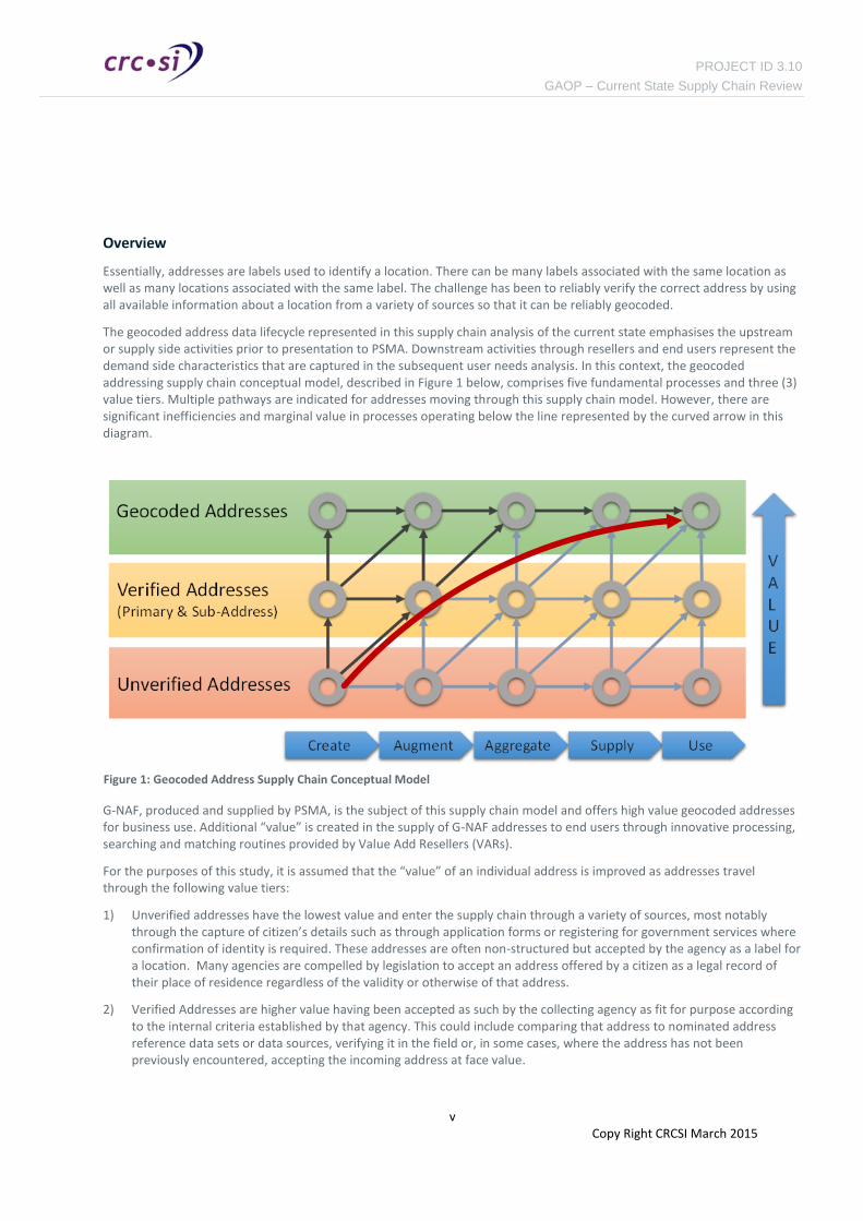
Essentially, addresses are labels used to identify a location. There can be many labels associated with the same location as well as many locations associated with the same label. The challenge has been to reliably verify the correct address by using all available information about a location from a variety of sources so that it can be reliably geocoded.
The geocoded address data lifecycle represented in this supply chain analysis of the current state emphasises the upstream or supply side activities prior to presentation to PSMA. Downstream activities through resellers and end users represent the demand side characteristics that are captured in the subsequent user needs analysis. In this context, the geocoded addressing supply chain conceptual model, described in Figure 1 below, comprises five fundamental processes and three (3) value tiers. Multiple pathways are indicated for addresses moving through this supply chain model. However, there are significant inefficiencies and marginal value in processes operating below the line represented by the curved arrow in this diagram.
G-NAF, produced and supplied by PSMA, is the subject of this supply chain model and offers high value geocoded addresses for business use. Additional “value” is created in the supply of G-NAF addresses to end users through innovative processing, searching and matching routines provided by Value Add Resellers (VARs).
For the purposes of this study, it is assumed that the “value” of an individual address is improved as addresses travel through the following value tiers:
1) Unverified addresses have the lowest value and enter the supply chain through a variety of sources, most notably through the capture of citizen’s details such as through application forms or registering for government services where confirmation of identity is required. These addresses are often non-structured but accepted by the agency as a label for a location. Many agencies are compelled by legislation to accept an address offered by a citizen as a legal record of their place of residence regardless of the validity or otherwise of that address.
2) Verified Addresses are higher value having been accepted as such by the collecting agency as fit for purpose according to the internal criteria established by that agency. This could include comparing that address to nominated address reference data sets or data sources, verifying it in the field or, in some cases, where the address has not been previously encountered, accepting the incoming address at face value.
Figure 1: Geocoded Address Supply Chain Conceptual Model

PROJECT ID 3.10
GAOP – Current State Supply Chain Review
vi Copy Right CRCSI March 2015
3) Geocoded Addresses are higher again in value having been confirmed by the source agency and assigned a latitude and longitude (geocode) identifying the address location. The accuracy of the location may vary and will not necessarily be appropriate for all users’ needs.
Primary Addresses, as defined in AS/NZS 4819, are generally created by local councils when a successful Development Application (DA) results in new addresses being assigned to land parcels for the purpose of rating and conveyancing transactions. In these cases local councils are deemed to be the authoritative source of Primary Addresses. Councils also create Sub Addresses (AS/NZS 4819) when establishing Strata titles. A Sub-Address is defined by AS/NZS 4819 as one being contained within a Primary Address.
An alternative address is an additional description (alias) for the primary and sub-address created by other participants in the supply chain that collect address data to support their business needs, such as identifying location of occupants, delivery of services and describing sites.
Participants in the Geocoded Addressing Supply Chain are involved in multiple processes where there is often a business need or commercial incentive to improve the quality of geocoded address. These participants include:
— Citizens interacting with government agencies to register for permits, services or regulatory obligations.
— Property developers and agents interacting with local councils for land development projects.
— Local Government Authorities (574 Local and Regional Councils in Australia2)
— Notifiable agencies (including utilities and essential service providers) interacting with property developers and Local Councils and ultimately the property owners.
— Jurisdictional aggregation agencies in each state (usually within the land titles administration)
— Federal agencies for public administration purposes
— National aggregation agency being PSMA
— Value add resellers adding value to the G-NAF data set and providing comprehensive addressing functions to address users.
— Business and Government users (consumers)
Key Findings
Stakeholder interviews, documentation reviews and industry analysis produced the following key findings of the current state (as-is) of the geocoded address supply chain:
1) There is considerable variation in the understanding of terms and definitions of addressing throughout the supply chain. This leads to inconsistencies in how addresses are created, interpreted and managed across the different state jurisdictions as well as variability between local government authorities and their respective state jurisdictions.
2) Local Government and hence the land valuation system is interested in the “property” address yet the surveyor and Land Titling system is interested in the “parcel” for identifying an associated address. This dichotomy of address references causes a large majority of the problems in resolving the correct or most likely address in the aggregation processes at state and national levels.
2 Australian Local Government association website (www.alga.asn.au)

PROJECT ID 3.10
GAOP – Current State Supply Chain Review
vii Copy Right CRCSI March 2015
3) The only legislated creators of addresses that are established through the land development process are Local Government Authorities (LGA). These addresses are either primary addresses (in the case of lot subdivisions) or sub-addresses (in the case where strata titles are created). However, addresses can also be created by other land planning and administration processes that are not necessarily validated by the LGA process. These addresses may never appear in G-NAF or may become a duplicate of an address that already exists in G-NAF.
4) There is no legislation in place to control address creation through the naming and numbering of streets and properties in private estates and complexes such as retirement villages, universities and hospitals. While these “private” addresses fall outside the normal council processes because they don’t include a surveyed division of land or affect land ownership, they are nevertheless an important additional address dataset which should be captured and managed as well as possible.
5) PSMA is recognised by all supply chain participants as the de-facto authoritative source of national geocoded addresses, being the G-NAF products. However, some users suggest that G-NAF needs to be more robust to better meet the needs of key emerging markets. This implies improving the governance related to data lineage to be recognised as a truly authoritative geocoded national address dataset. Authoritative source also implies that PSMA have more control over the upstream supply chain than is currently the case.
6) The supply chain is complex, non-linear and in many aspects convoluted, which creates contradictory evidence in applying confidence levels to address verification and geocoding processes using reference address files compiled from similar sources. Millions of unverified addresses are captured annually and follow various paths through the supply chain, often involving considerable duplication and manual intervention. While most addresses eventually become verified and many ultimately geocoded, a substantial minority will not be verified.
7) Time delays from address data creation at local government level to then becoming available through G-NAF significantly reduces the usefulness of G-NAF to many users. This encourages bypass mechanisms and work-around strategies by VARs and users to acquire addresses, however poorly managed, that meet their business requirements. These delays are usually a by-product of the land titling system where addresses are established when the development application is approved by the planning authority but not incorporated into G-NAF until the new property has been processed in the land titling system, which can be many months later.
8) Several competing initiatives to create “authoritative” national geocoded address datasets as potential alternatives to G-NAF are being pursued aggressively by different government agencies and the private sector. Some of these are being justified by the internal business requirements of specific agencies such as: limitations imposed by privacy legislation at Department of Human Services; operational imperatives for infrastructure connectivity at NBN Co; and opportunities for potential revenue generation at Australia Post.
9) Supply chain dynamics are largely passive and rely on progressive movement of address data along the supply chains from local government level to state and national levels of aggregation before becoming available in G-NAF. This limits the optimisation opportunities since creation and aggregation processes are invariably linked to the somewhat lengthy land administration processes in many jurisdictions.
10) Sharing of geocoded addresses (sourced from G-NAF) between government agencies is impeded by the current licensing model designed to support the existing funding model and protect the existing PSMA distribution channels. While guaranteeing product sustainability, this licensing regime limits business improvement initiatives for government agencies needing to collaborate in providing more cost effective and efficient community services.
11) Addresses have no authorised owner. PSMA develops a comprehensive, national geocoded address dataset yet has no control over the addresses themselves, which could be changed or misinterpreted by a new property owner without notice. The G-NAF address set that it creates could be seen as “optimal“, but is not “authoritative” as there is no authority that is ultimately accountable.
12) The reverse information flows, or back-channels, from Users to VARs to PSMA to Jurisdictions to Councils are too frequently ad-hoc, informal, undocumented or non-existent. This weakens the whole geocoded address supply chain

PROJECT ID 3.10
GAOP – Current State Supply Chain Review
viii Copy Right CRCSI March 2015
as valuable user feedback which could be used to improve the quality of both the address datasets and the systems that constitute the supply chain is lost.
In summary: many organisations are doing similar things with the same data by different address custodians on different timeframes with differing results and costing a lot.
Summary of User Needs
User needs are reflected in the findings of the current state analysis and the stakeholder expectations for an improved geocoded national address product or service through supply chain efficiency improvements that will reduce their costs and potentially deliver increased benefits to their business. For the purpose of this summary, and as stated in Chapter 4, all participants in the supply chain are geocoded address users. Their needs are outlined below.
Timeliness
A common finding was that many users, especially utilities, want newly created and updated addresses to appear in the dataset as soon as activity on the property to which the address belongs commences, even if the legal status of the property has not been finalised. These “provisional” addresses are useful in directing the considerable amount of work that takes place in new subdivisions. It also allows the various service organisations to better plan for increased demands and to update their own internal systems.
Accuracy
The current supply chain attempts to reconcile a number of address sources with often mixed results. Users want the data present in the address dataset to be unambiguously identified and as accurate as possible. A key principal for improving and sustaining data quality is to ensure the responsibility for creating and updating new addresses is as close as possible to the source.
Robustness
Users need to reduce the number of times a particular address needs to be verified to a minimum by having a robust, stable and auditable address dataset in place. A single successful validation call would provide a Persistent Identifier (PID) which could then form a short-hand tag equivalent to the address in its textual form. Such a PID could be sent to any other organisation from where it could be used to access the full address data without further validation steps.
Comprehensive
Users need to have a reliable and comprehensive national addressing system that allows for a wide variety of address types including the relationships, if any, between addresses. For example, it should be possible to store addressing information on every premise or dwelling in a retirement village; or every building, floor or unit in a university campus, if there is a case to be made for its usefulness. The address should be able to direct emergency services, couriers, taxis, meter readers and maintenance personnel to individual properties, access points, parcel delivery points, fire hydrants and electricity meters.
Accessibility
Users need to realise the benefits of value added services provided by VARs that are an important channel for G-NAF based address data and services. However, where VARs cannot and do not add significant value for a particular address use, other address users should be able to access and utilise the raw G-NAF as either data or as a service and adapt and enhance it to their own needs.
Security
User expectations for a more accurate, accessible, reliable and comprehensive national address service implies a need for effective access and security controls as the supply chain becomes more flexible and accessible by a wider range of address

PROJECT ID 3.10
GAOP – Current State Supply Chain Review
ix Copy Right CRCSI March 2015
users with the ability to contribute directly to improving the address dataset. Support for full auditing powers in order to trace all activity within the supply chain will be of equal importance.
Authoritative
Councils need to be empowered as the recognised authorities for all land parcel or property addresses and to develop jurisdictional-level services to hold and maintain this authoritative address dataset on behalf of all the councils in a jurisdiction. The jurisdictional address service (JAS) framework will ensure the development of authoritative geocoded addressing for each and every jurisdiction.
Shareable
Users of the address dataset need to communicate address information to each other easily and quickly, without restrictive licensing terms and conditions that might preclude or hinder such interchanges.
Jurisdictions need to be able to query each other’s address sets, allowing, for example, NSW should be able to access Queensland's Address Service in order to query a Queensland Address.
Cost-effective
Users expect the cost of a national geocoded address dataset to be not so high that it restricts its widespread use. A high cost, low quality product or service will always encourage alternative competing datasets to be developed. The success of the dataset will be in becoming a common standard for all users of Australian addresses and a platform for developing higher value functionality and business efficiencies.
Recommended improvements
Enhancements to the current state of the Geocoded Address Supply Chain can be achieved by the following measures:
1) Providing the right tools, resources and incentives for Local Councils, State Jurisdictions and PSMA to interact with a common geocoded address dataset that can be updated and maintained by authorised address data custodians in respective jurisdictions.
2) Leveraging the early address notifications and in-field validation of addresses by NBN Co and others to improve the quality of G-NAF by using these addresses to update the jurisdictional geocoded address datasets that flow to PSMA.
3) Enabling all Government Agencies to verify addresses with state jurisdictional address datasets and contribute new address data that can flow to PSMA for contribution to the national aggregation and production of G-NAF.
These enhancements are reflected in the Improved Logical Geocoded Address Supply Chain Model (refer to Figure 8 in Section 5 - Gap Analysis). However, an overriding concern is that the primary issue is a requirement to have a national location management framework that will support an authoritative national geocoded address dataset. This will require a more fundamental change to the design and implementation of a more appropriate system that will support the FSDF vision.
The following short-term improvements activities are suggested that could benefit from further involvement from the CRCSI Program 3 commitment to this Geocoded Address Optimisation Project.
Incremental improvements
Improvement 1: Undertake a review of national address standards
The CRCSI could initiate a review of the ISO standards to deal with the inconsistencies in definitions and terminology being used across and the geocoded address supply chain. The review will have stakeholder representation from all participant groups and seek endorsement from the Inter-Government Committee of Surveying and Mapping (ICSM) to

PROJECT ID 3.10
GAOP – Current State Supply Chain Review
x Copy Right CRCSI March 2015
Incremental improvements
recommend endorsement by the ISO.
Improvement 2: Provide an unrestricted one-time copy of G-NAF for non-commercial use
This will stimulate the development community to take the dataset and host it themselves, learn the data structures and start developing apps and web sites with G-NAF capabilities. General expertise and abilities among the IT community concerning G-NAF would improve and some of those resources could be used in development of the Jurisdictional Address Services (JAS). This will also provide immediate publicity for the Spatial Data Policy initiatives and open data strategies for foundation spatial datasets.
VARs would benefit from the innovations in application development that could be commercialised in collaboration with the reseller to a much wider market.
Consideration of revenue reduction for PSMA would need to be considered as it will potentially impact the business model; incentive structures and revenues from existing VARS would also need to be considered.
Improvement 3: Develop API/web services specification for national geocoded address interfaces
This will inform the geocoded address supply chain of the requirements for each jurisdiction (local councils, state and federal contributors) to expose and consume address verification and feedback services. This should be considered as fundamental national data infrastructure guidelines within the context of the FSDF program.
Improvement 4: Initiate a nation-wide survey of geocoded address requirements
Stakeholder involvement could be extended to a wider group to include all jurisdictions, local councils and utilities to provide statistical validity to the options and statements from stakeholders; solicit issues and ideas that will inform the national debate and contribute to promoting the cause for coordination and improved business benefits and social outcomes that flow from a truly authoritative national geocoded address reference dataset.
This survey should not be onerous in terms of the effort required to respond and should elicit specific views in a series of questions where either yes/no or scale ranging responses can be provided.

PROJECT ID 3.10
GAOP – Current State Supply Chain Review
xi Copy Right CRCSI March 2015
The following longer-term improvement opportunities are more transformational and should be further considered in the Future State report (Work Package 1.3).
Transformational Improvements
Improvement 5: Develop a “National Geocoded Address API” available to local councils, Notifiable Agencies and federated to the Jurisdictions.
This will give visibility of addressing earlier in the supply chain, including proposed addresses, to authorised participants and facilitate the assignment of persistent identifiers at address creation required by a majority of users. This project could leverage a range of current investments and developments in this area, including G-NAF Live, PSMA Cloud and NBN Co’s Electronic Location Management System (ELMS) project to interact with developers and other supply chain participants at the earliest point of intervention for address creation. Such a capability would:
― Provide an audit of “non-addressed” parcels across LGAs to prioritise areas to be cleansed.
― Provide access to authoritative locality boundaries and road names as provided by the jurisdictions for the public to be informed.
― Provide an appropriately managed channel for crowd sourcing of alternative / sub addresses and cleaning of existing addresses (backchannel).
― Provide a single location for Augmenting Agency address enquires (rather than approach local councils)
There are a number of research areas this improvement could benefit from to ensure a greater success than previously achieved, including trust models, provenance, supply chain best practice modelling, incentives and business models.
Improvement 6: Design and development of a next generation National Location Management Service to complement G-NAF..
This activity would require further investigation and a detailed business case to support the level of investment anticipated. Opportunities could be explored for additional private sector investment or other appropriate commercial arrangements that could be available to fund such a project that could provide additional sources of geocoded addresses information.
This improvement would look at new ways to automate processes up and down the supply chain. Provide improved models for managing additional sources of information and be able to track the provenance of the information over time.
PROJECT ID 3.10
GAOP – Current State Supply Chain Review
xii Copy Right CRCSI March 2015
Definitions and Terminology
Due to the variety of interpretations of address throughout the supply chain, the terminology used in this document is based on the following tables:
1. Table 1 provides authoritative definitions and sources where available;
2. Table 2 provides terminology proposed by the consulting team for the purpose of supporting concepts and guiding the discussion around the supply chain dynamics observed in this review.
Table 1: Authoritative Address Definitions
Term Description Source
Access Point The position along the road where the public would normally access an address site.
AS/NZS 4819
Address The descriptive elements describing a fixed location (for example, a plot of land, building, part of a building, way of access or other construction) which is represented by a structured composition of place names and point identifiers. It may be further embellished with the inclusion of other valuable attributes including geocodes and Delivery Point Identifier (DPID).
Structured information that allows the unambiguous determination of an object for purposes of identification and location.
ANZLIC
Address Contributor
A recognised authoritative entity that can provide verified addresses, includes jurisdictions (state agencies), ABS Census and Postal Address Files (PAF) being the only current address contributors.
PSMA
Addressing Authority
An entity that has the legislative authority to create any of the components of a standard compliant primary address, includes:
House number (Local Government)
Street Name (Local Government / State Government)
Locality (State Government)
“Agency responsible for addressing. Usually a local government.”
AS/NZS 4819
Address Site A site for which an address is being assigned AS/NZS 4819
Alternative Name / Alias
A name that is an alternative to another name for the same feature. AS/NZS 4819

PROJECT ID 3.10
GAOP – Current State Supply Chain Review
xiii Copy Right CRCSI March 2015
Term Description Source
Contributor Dataset
Jurisdiction address files, ABS Census and Postal Address Files (PAF) being the only current contributor datasets.
PSMA
G-NAF The national, authoritative geocoded address dataset. Amalgamated from 10 recognised address custodians, contains over 13 million geocoded physical addresses.
PSMA
Locality Gazetted locality names including gazetted extent (area).
A geographical area defining a community of interest. Can be rural or urban in character, and is usually a suburb in the latter case. Must be formally gazetted.
AS/NZS 4819
Lot Real property description, lot number and plan number identification of land. A lot can include one or more parcels.
ICSM Harmonised Data Model
Parcel (Land) A description of the smallest legal allotment of land. This includes boundary lines making up a polygon and attributes such as parcel area and appellation.
The smallest area of land capable of sale without further approval to subdivide. It may consist of more than one geographical piece, i.e. where a parcel is divided by a road.
A lot can contain one or many parcels.
This is approximate to the primary estate type as defined by ICSM, where there must be one and only one primary estate at any point in the three dimensional space that makes up the Commonwealth of Australia. There is no point in the three dimensional space that makes up the Commonwealth of Australia at which there is no primary estate.
The type of primary estate can be Crown Leasehold, Crown Reserve, Freehold, Road Reserve or Unallocated.
ICSM Harmonised Data Model
Physical Address
A physical address relates to any property or parcel identified by contributors and is used by them for administrative purposes.
PSMA
Primary Address Assigned by the authoritative/custodial address creator, must comply with AS/NZS 4819:2011.
This is the authoritative Address.
An address site that is not contained within another address site. It may contain a Sub-Address Site.
AS/NZS 4819
Property One or more Lots relating to the grouping of areas of land under a ICSM Harmonised

PROJECT ID 3.10
GAOP – Current State Supply Chain Review
xiv Copy Right CRCSI March 2015
Term Description Source
particular interest type and ownership. Data Model
Reference Dataset
Appropriately gazetted reference datasets, Includes:
— Cadastre
— Roads
— Localities
PSMA
Road Name Gazetted name of the road or street. Road names are needed to uniquely and clearly identify roads as well as the related Address.
The Road Names themselves need to be clear and unambiguous
AS/ANS 4819 specifies that:
— The Road Name shall include the road type.
— An Address shall not include more than one Road Name.
AS/NZS 4819
Sub-Address Site
An Address site that is contained within a Primary Address site (e.g. an apartment within a building or dwelling in a private estate).
AS/NZS 4819
User The individuals, organisations or programs that use the G-NAF data as part of an address management process.
PSMA
Table 2: Project Used Address Terminology
Term Description
Address Aggregator
An authorised entity (State Government / Local Government / Federal Government) that has the responsibility to collect and aggregate address information.
Address Augmenter
An authorised entity (State Government / Local Government/ Federal Government) that provides address information into the supply chain.
Address Augmenters collect addresses for their unique business requirements and subsequently verify that those addresses meet their requirements.
Address Creator An addressing authority as defined by AS/NZS 4819.
Address Plan Developer created description of proposed Parcel and Road/street layout.
Geocode Location identified by geographical coordinates
Geocoded An address that has been verified and has received a geocode. This is the highest value

PROJECT ID 3.10
GAOP – Current State Supply Chain Review
xv Copy Right CRCSI March 2015
Term Description
Address address type in the supply chain.
Notifiable Agency
An entity that is formally notified of a proposed land development, including sub-division. This is generally the appropriate utility services and emergency services providers; it may also include agencies involved in the development process (referral agencies). Local Councils tend to create and maintain informal lists of Notifiable Agencies.
Supply Chain Description as adopted from the manufacturing sector; The network of individuals, organizations, resources, activities and technology involved in the creation and sale of a product, from the delivery of source materials from the supplier to the manufacturer, through to its eventual delivery to the end user.
Value Added Reseller (VAR)
Commercial organisation authorised to on-sell G-NAF after adding value, either directly or as an embedded part of an application.
Unverified Address
An address that enters the supply chain through a variety of sources, most notably through the capture of citizen’s details where confirmation of identity is required by a government agency. These addresses are often non-structured but recognised as a compliant address according to the AS/NZS 4819 standard.
Verified Address An address that has been accepted by the collecting agency as fit for purpose according to criteria established by the respective agency but does not necessarily contain a geocode.

PROJECT ID 3.10
GAOP – Current State Supply Chain Review
xvi Copy Right CRCSI March 2015
Table of Contents i
Disclaimer ii
Executive Summary iii
Overview v
Key Findings vi
Summary of User Needs viii
Recommended improvements ix
Definitions and Terminology xii
1. Introduction 19
1.1. Background 19
1.2. Objectives 19
1.3. Scope 19
1.4. Out of scope 19
1.5. Target Audience 20
1.6. Report Structure 20
1.7. Limitations 20
2. Methodology 21
2.1. Stakeholder Engagement 21
2.2. Supply Chain Analysis 25
2.3. Reports 25
3. Current-State Geocoded Address Supply Chain 26
3.1. Introduction 26
3.2. Address Creator 28
3.3. Address Aggregator 32
3.4. Address Augmenter 39
3.5. G-NAF Value Add Resellers 41
3.6. Geocoded Address User 44
4. User Needs Analysis 49
5. Gap Analysis 54
5.1. Observations 54

PROJECT ID 3.10
GAOP – Current State Supply Chain Review
xvii Copy Right CRCSI March 2015
5.2. Summary of requirements 57
6. Improvement Opportunities 62
6.1. Short-term improvements 62
6.2. Longer-term improvements 63
Appendix A. Geocoded Address Supply Chain Process Maps 65
A.1. Address Creator (Local Government Segment) 66
A.2. Address Aggregator (State Jurisdictional Segment) 67
A.3. Address Aggregator (Federal Segment) 68
A.4. Address Aggregator (Notifiable Agency Segment) 69
A.5. Address Augmenter 70
A.6. Address Supplier (VAR Segment) 71
A.7. Address User (Consumer Segment) 72
A.8. Geocoded Address Supply Chain – Current State Composite 73
Tables
Table 1: Authoritative Address Definitions ......................................................... xii
Table 2: Project Used Address Terminology ...................................................... xiv
Table 3: Interviewed Stakeholders ...................................................................... 21
Table 4: Geocoded Address Supply Chain participants and roles ....................... 28
Figures
Figure 1: Geocoded Address Supply Chain Conceptual Model ............................. v
Figure 2: Phased Approach .................................................................................. 21
Figure 3: Notional Geocoded Address Supply Chain Model ............................... 24
Figure 4: Address data distribution representation ............................................ 26
Figure 5: Logical Geocoded Address Supply Chain Model .................................. 27
Figure 6: Geocoded Address Processing Timeline............................................... 37
Figure 7: Address Location relationship .............................................................. 54

PROJECT ID 3.10
GAOP – Current State Supply Chain Review
xviii Copy Right CRCSI March 2015
Figure 8: Improved Logical Geocoded Address Supply Chain Model .................. 57

PROJECT ID 3.10
GAOP – Current State Supply Chain Review
19
1. Introduction
1.1. Background
ANZLIC—the Spatial Information Council, representing the Australian and New Zealand Governments, and the governments of the states and territories of Australia, is committed to deliver the Foundation Spatial Data Framework (FSDF). When realised, the use of a common framework, embedded into the everyday business of government and private sector entities, will allow for seamless exchange of spatial information and knowledge across organisational, sector and jurisdictional boundaries.
Geocoded addressing is one of the foundation data themes of the FSDF. It is a key enabler for many organisations. As the digital economy grows, so does the need to have an authoritative national geocoded address product that can be used to link an increasing range of complex information to a unique address / location/ house/property / premise or residence.
As the demand and applications for addressing become more complex an authoritative address source will become vital to the digital economy. It is important that current capabilities are streamlined and structured to be ready for future changes.
Contemporary research conducted by the Cooperative Research Centre for Spatial Information (CRCSI) has suggested that one of the key technology enablers of a robust and efficient spatial data delivery infrastructure is the capability to implement automated, flexible and distributed end-to-end spatial data supply chain management. This management capability will underpin the rapidly evolving national spatial information infrastructure and will contribute to the accessibility of timely, high quality, consumer relevant spatial information products.
1.2. Objectives
The objectives of this review are to; identify and document the Australian geocoded address supply chain as it currently exists (the “As-Is”), document the limited set of key user requirements for geocoded addresses, and prioritise the immediate opportunities to introduce improvements into the geocoded address supply chain. This review will focus on base-lining, identifying and optimising the geocoded address supply chain.
The document contents would then inform a subsequent Stage 2 process examining how improvements might be made.
1.3. Scope
The scope involves taking a business process improvement approach to capture the expectations and goals that the project sponsor (ANZLIC) and key stakeholders want to achieve in a future state. It must align with strategic outcomes and provide a high level context for documenting a statement of requirements.
1.4. Out of scope
The following activities are explicitly Out of Scope for this review:
— The business models of PSMA.
— The purchasing processes for G-NAF by the Australian Government.
— The nature or extent of economic benefit for G-NAF.
This review will leverage and not duplicate outputs from other projects that have been recently completed or are underway (e.g. NAMF Review, G-NAF Review – KPMG, ICSM Local Government; Jurisdictional Addressing Review and the new ISO addressing Standards).

PROJECT ID 3.10
GAOP – Current State Supply Chain Review
20
1.5. Target Audience
The audience for this document includes the senior executive management of the CRCSI and ANZLIC.
1.6. Report Structure
The structure of this report is organised around the supply chain roles described in the notional supply chain model used in the stakeholder engagement interviews (refer to Figure 3 in the following section). Each node of the supply chain represents input, processing and output activities of one or more participants that are described in the relevant headings in Section 3 - Current-State Geocoded Address Supply Chain. Detailed representation of the geocoded address supply chain as flow diagrams are attached as Appendix A.
The Work package 1.1 deliverable of the Optimising the Supply Chain for Geocoded Addressing in Australia is described in detail in Section 3. The Work package 1.2 deliverable provides a User Needs Analysis and Recommendations, and is included in this document as Section 4. The gap analysis between the current state and user needs is discussed in Section 5 and recommendations regarding improvement opportunities in the short term and longer term are discussed in Section 6.
1.7. Limitations
There are many existing and potential geocoded address supply chain participants that have not been interviewed in the course of these investigations. These include the many utilities (telecommunications, electricity, gas and water) and government agencies in state and federal jurisdictions. While this can be a limitation in performing a comprehensive assessment of user needs, there is sufficient knowledge of the wider stakeholder requirements within the project team to present general observations to be tested.
In determining the extent of the geocoded address supply chain under review, activities prior to the creation of addresses by local councils, such as the development application process for land subdivisions approvals, are not being considered. Likewise, activities beyond the delivery of geocoded addresses from value add resellers to their clients are also not considered except for cases where feedback information flows occur.

PROJECT ID 3.10
GAOP – Current State Supply Chain Review
21
2. Methodology
Based on the agreed Project Management Plan, the approach for capturing the current state of the Geocoded Address supply chain progressed in 3 phases described in Figure 2 below.
Figure 2: Phased Approach
2.1. Stakeholder Engagement
A representative sample of stakeholders was identified to best represent the roles performed as part of the geocoded address supply chain segments.
Some stakeholders were active in more than one role. Table 3 below, shows the interviewed stakeholders by their primary role in the geocoded address supply chain.
Table 3: Interviewed Stakeholders
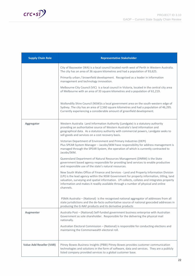
Supply Chain Role Representative Stakeholder
Creator
Sunshine Coast Regional Council (QLD)
The Sunshine Coast Regional Council is located 100kms north of Brisbane in South East Queensland. The city has an area of 3,124 square kilometres and had a population of 278,202.
The council manages a mix of highly urbanised brownfield developments, primarily along beachfront and foreshore areas as well as greenfield development in the hinterland.
Phase 1
•Desk research and documentation review
•Stakeholder identification
•Initial contact
Phase 2
•Develop a notional geocoded address supply chain model
•Stakeholder interviews
•Analysis, synthesis and confirmation of findings
•Stakeholder feedback and follow up
Phase 3
•Develop the logical geocoded address supply chain model
•Draft reports
•Refinement based on peer reviews and stakeholder comments
•Consolidate into final report
•Final report
PROJECT ID 3.10
GAOP – Current State Supply Chain Review
22
Supply Chain Role Representative Stakeholder
City of Bayswater (WA) is a local council located north west of Perth in Western Australia. The city has an area of 36 square kilometres and had a population of 93,625.
Primarily urban / brownfield development. Recognised as a leader in information management and technology innovation.
Melbourne City Council (VIC) is a local council in Victoria, located in the central city area of Melbourne with an area of 33 square kilometres and a population of 61,219.
Wollondilly Shire Council (NSW)is a local government area on the south-western edge of Sydney. The city has an area of 2,560 square kilometres and had a population of 46,295. Currently experiencing a considerable amount of greenfield development.
Aggregator
Western Australia Land Information Authority (Landgate) is a statutory authority providing an authoritative source of Western Australia’s land information and geographical data. As a statutory authority with commercial powers, Landgate seeks to sell goods and services on a cost recovery basis.
Victorian Department of Environment and Primary Industries (DEPI) Plus SPEAR System Manager – Jacobs/SKM have responsibility for address management is managed through the SPEAR System, the operation of which is currently contracted to Jacobs/SKM.
Queensland Department of Natural Resources Management (DNRM) is the State government based agency responsible for providing land services to enable productive and responsible use of the state’s natural resources.
New South Wales Office of Finance and Services - Land and Property Information Division (LPI) is the lead agency within the NSW Government for property information, titling, land valuation, surveying and spatial information. LPI collects, collates and integrates property information and makes it readily available through a number of physical and online channels.
PSMA Australia – (National) is the recognised national aggregator of addresses from all state jurisdictions and the de-facto authoritative source of national geocoded addresses in producing the G-NAF products and its derivative products
Augmenter
Australia Post – (National) Self-funded government business enterprise with Australian Government as sole shareholder. Responsible for the delivering the physical mail nationally.
Australian Electoral Commission – (National) is responsible for conducting elections and maintaining the Commonwealth electoral roll.
Value Add Reseller (VAR)
Pitney Bowes Business Insights (PBBI) Pitney Bowes provides customer communication technologies and solutions in the form of software, data and services. They are a publicly listed company provided services to a global customer base.

PROJECT ID 3.10
GAOP – Current State Supply Chain Review
23
Supply Chain Role Representative Stakeholder
Intec Solutions provides information quality and management solutions to a range of government and non-government clients across Australia. Their flagship product provides address validation and geographic coding services in both real-time and batch modes.
HERE Maps is a Nokia company specialising in mapping and location intelligence services. HERE creates global location and navigation products for 196 countries.
User (Consumer)
Australian Bureau of Statistics (national) strives to remain relevant to national needs by collecting the right sort of data, processing it to world-leading standards and delivering information solutions to clients. Their mission is to assist and encourage informed decision-making, research and discussion within governments and the community.
Department of Human Services (DHS) (national) is responsible for the development of service delivery policy and provide access to social, health and other payment services. The portfolio includes Medicare and Centrelink services.
ACT Emergency Services ) provides emergency management and operational response services for the ACT. Includes triple zero dispatch and SES deployment.
Department of Communications (NBNCo) is a federal government business enterprise responsible for the construction of national high-speed broadband infrastructure.
Insurance Australia Group (IAG) is a publicly listed company underwriting and selling insurance products to a number of national and international clients.
Sydney Water (NSW) is a statutory corporation owned by the NSW Government providing potable drinking water, waste water and storm water services to Greater Metropolitan Sydney.
Australian Tax Office is the principal revenue collection agency of the Australian Government and delivers a number of social and economic benefit incentive programs.
Stakeholders that were provided a project briefing but were not formally interviewed
— Western Australia Police Service
— Emergency Management Spatial Information Network Australia (EMSINA)
— Brisbane City Council
Based on the documentation review a notional ‘as-is’ supply chain model was developed, see Figure 3 below. The purpose of creating the notional supply chain model was to provide a common context for discussion with all stakeholders being interviewed.

PROJECT ID 3.10
GAOP – Current State Supply Chain Review
24
The notional geocoded address supply chain refers to existing spatial information supply chain function terminology (Collect > Ingest > Harmonise > Integrate > Maintain > Extract > Supply > Consume) developed by the CRCSI in previous work3. Supply chain roles are then categorised as Creator, Aggregator, Value Add Reseller, Augmenter and User.
Figure 3: Notional Geocoded Address Supply Chain Model
Prior to the interviews a briefing and context-setting document was created and supplied to interviewees. This document included the notional address supply chain as well as key address terminology and definitions. It also ensured a common understanding for the various supply chain elements during the interviews.
Face to face, structured interviews were undertaken by either one or two consultants and, where permitted, were recorded for later analysis and content confirmation. The stakeholder engagement process informed the development of a logical geocoded address supply chain model.
Each interviewee represented a ’node’ in the supply chain. The interview canvassed both the current state of their part of the geocoded address supply chain as well as input as to potential improvements that could be made. Each interview explored three perspectives surrounding the ‘node’ - Inputs, Processing, and Outputs.
Another key component of the organisation’s output is any feedback communication channels for error corrections associated with each input or output. These ‘back channels’ are important as they alone provide the feedback necessary to ensure the whole supply chain can corrects problems as they arise.
3 Alignment Study of Spatial Data Supply Chains - Maurits van der Vlugt (2012)
Geocoded Address Supply Chain (Level 0)
Cre
ato
rA
ug
me
nte
rA
ggre
gato
rSu
pp
lier
Use
r
ConsumeCollect Ingest - Harmonise - Integrate - Maintain Extract - Supply
Local Government
Jurisdictional
PSMA
AustPost
NotifiableAgency
OtherContributors
StateAgency
GNAF
User
VAR
Reference DataSub-Address
Primary Address

PROJECT ID 3.10
GAOP – Current State Supply Chain Review
25
2.2. Supply Chain Analysis
Due to the complexity and nature of the geocoded address supply chain, its diverse range of stakeholders and the preference of the project to deliver an executive readable product that conveyed the complexity, metrics and temporal bottlenecks of the address geocoding system, the following analytical models and notations were considered:
— UML Activity Modelling.
— Data Flow Diagramming.
— Business Process Modelling (with standardised notation).
— Manufacturing / Logistics Supply Chain Modelling (Value Stream notation).
— Neural Network Diagramming.
In order to meet all the projects artefact requirements, the adopted framework used swim lane elements of Business Process Modelling (BPM) notation to show the roles and phases of the supply chain combined with data flow diagramming. This framework was used to develop the holistic, end-to-end view of the supply chain as shown in Appendix A.
In compiling the end-to-end supply chain, it should be remembered that the output of one or more organisations will often be the input for the organisation(s) representing the next steps in the supply chain. In most cases, the experience of source node providing output to the next node as well as the experience of the destination node accepting Input from the source were both noted although it should be recognised that these both represent the same, single process.
It was then possible to construct the Logical Geocoded Address Supply Chian Model from the original notional model referred to previously in Figure 3.
The User Needs Analysis and Gap Assessment was conducted based on stakeholder interviews and recommendation were then suggested for short-term and longer-term supply chain improvement opportunities. This then leads to a revised Logical Geocoded Address Supply Chain Model representing an improved flow of address data that will benefit all stakeholders.
2.3. Reports
An early draft of the Geocoded Address Supply Chain Current State Analysis Report was presented to PSMA as subject matter experts to test alignment of terminology and supply chain dynamics. A revised version with consideration of PSMA contributions was then circulated to key stakeholders. Comments were noted and incorporated into a revised version for wider stakeholder distribution and feedback.
It was then decided to amalgamate the Current State Analysis report (work package 1.2) and User Needs Analysis report (work package 1.2) into a single consolidated report.
A final report was produced and presented to the CRCSI Program 3 management team for acceptance.

PROJECT ID 3.10
GAOP – Current State Supply Chain Review
26
3. Current-State Geocoded Address Supply Chain
This section reviews each component of the overall geocoded address supply chain and lists the characteristics of that component as reported by the interviewed stakeholders. The focus of the supply chain “as-is” analysis is on the aggregation and geocoding processes in the supply chain that ultimately lead to the creation and then use of the national geocoded address file product (G-NAF) by PSMA along with by products from Value Add Resellers.
3.1. Introduction
Addressing is the mechanism by which places, and the activities and people associated with them are located, accessed and managed. It is arguably a key component of Australian infrastructure and the ability to access current, accurate, accessible addressing information provides an overwhelming benefit to all aspects of Australian society.
Australia’s national geocoded address management infrastructure is fundamental in enabling the digital economy, However evidence suggests that it could be significantly improved. The issues found in this analysis are mainly related to the historical origins of addressing and the federated nature of our land titling and associated mapping activities. Addresses have been captured as a by-product of the Australian Land Titling systems which are based exclusively on official spatial descriptions of land (plans) and the lots defined for the purposes of subdividing, amalgamating or altering the basis of land ownership. Where development activity takes place and new places and properties are created without changes in land ownership, new property addressing information is not captured as the land titling system is not involved.
The following diagram (Figure 4) demonstrates how widely dispersed the flow of address data is with so many supply chain participants having separate and different address datasets to manage. Many organisations doing similar things with the same data by different address custodians on different timeframes with differing results.
Figure 4: Address data distribution representation

PROJECT ID 3.10
GAOP – Current State Supply Chain Review
27
Stakeholder interviews based on the notional geocoded address supply chain presented earlier in Figure 3 (Section 2.1 - Stakeholder Engagement) informed the development of the Logical Geocoded Address Supply Chain Model as described here in Figure 5.
Figure 5: Logical Geocoded Address Supply Chain Model
The role of Presenter was introduced to refer to citizens, being general public, developers or their agents interacting with government services. Included for context only and outside the scope of this review.
Analysis begins with the various address management roles: Creators, Aggregators, Augmenters, Suppliers and Users, and then identifies the organisational types – Local Government, jurisdictions, and VARs etc., which perform this role. This includes analysis of the inputs, processing and outputs of each organisation type identifying any differences between individual organisations. For example, both NSW's LPI and Victoria's Department of Environment and Primary Industry are jurisdictional aggregators, but operate with different information formats and upstream/downstream flows in developing their respective jurisdictional geocoded address repositories.
The following table demonstrates the multiple activities that supply chain participants perform that leads to the complex and somewhat convoluted current state in creating and using G-NAF products.
Geocoded Address Supply Chain (Level 0)
Cre
ato
rA
ugm
ente
rA
ggre
gato
rSu
pp
lier
Use
rP
rese
nte
r
ConsumeCollect Ingest > Harmonise > Integrate > Maintain Extract > Supply
Local Councils
State Jurisdictions
PSMA
AustraliaPost
NotifiableAgencies
Australian Electoral
Commission
GovAgencies
G-NAF
Users
Value Add Resellers
Contributed Addresses
Primary Addresses
Public - Citizens, Developers, Agents

PROJECT ID 3.10
GAOP – Current State Supply Chain Review
28
Table 4: Geocoded Address Supply Chain participants and roles
Participants in the Geocoded Address Supply Chain
Cre
atio
n
Agg
rega
tio
n
Ad
d V
alu
e
Au
gmen
tati
on
Sup
ply
Use
Citizens interacting with government agencies to register for permits, services or regulatory obligations (offering addresses in the creation stage).
Property Developers and agents interacting with Local Councils for land development projects (proposing addresses in the creation stage).
Local Government Authorities (574 Local Councils in Australia)
Notifiable Agencies (including utilities and essential service providers)
Jurisdictional aggregation agency in each state (usually within the land titles administration)
Federal Agencies for public administration purposes
National aggregation agency being the PSMA
Value Add Resellers
Business Users (consumers)
The next section examines inputs, processing and outputs of participants in the six supply chain segments in the above table. Supply chain diagrams for each segment are provided in Appendix A.
3.2. Address Creator
The address creator is the organisation authorised and tasked with creating new addresses as part of the process of altering the land ownership or property fabric. Local Governments are responsible for accepting, investigating and approving changes to properties caused by alterations to the number, arrangements and ownership of the parcels that comprise the property parcel fabric or boundary definition. An important part of every property is its accessibility, typically through a connection with the existing roads system. The definition of that accessibility is provided in the form of an address.

PROJECT ID 3.10
GAOP – Current State Supply Chain Review
29
Summary
— Applications for development trigger the creation of addresses.
— Addresses are created as a by-product of land development.
— The processes involved are highly variable between states and even between councils within a state
— In creating the address, adherence to AS/NZS 4819 is not uniformly enforced.
— The process only captures primary addresses that have a direct relationship to a newly created parcel.
— Sub-addresses including private estates and nursing homes are not routinely captured through this supply process.
— Systems that notify organisations of new addresses vary widely between states.
3.2.1. Primary Address Creator (Local Government)
Local Government Authorities across Australia are currently the primary organisations that create new properties. There are 574 local and regional councils across the eight (8) states and territories as follows:
— Australian Capital Territory (1) — New South Wales (152)
— Northern Territory (16) — Queensland (77)
— South Australia (69) — Tasmania (29)
— Victoria (79) — Western Australia (139)
Local governments create addresses upon receipt of a request from a current owner of land within their jurisdiction proposing changes to property parcel(s) associated with the development application process. This section provides a summary of interviews with the following Address Creator representative stakeholders.
Stakeholder Representative Overview
Local Councils
Important issues: — Lack of consistency in terms and definitions. — Need for correct numbering for high-rise and multi-building complexes. — Need to properly allocating and reserving street numbers and number
ranges so that future redevelopments can continue to be properly numbered.
— Lack of feedback channel to address aggregators is problematic — Contemplating assigning of 3D addresses as building plans become more
sophisticated. — Currently capturing sub-addresses including commercial (shop) sites. — A strong desire to capture address information early in the development
cycle, citizens experience problems due to lack of early addressing. — Official road names are usually adopted by developers, however feel
powerless to enforce correct address numbering when development applications are lodged.
— Private estates are not captured or there are significant delays as they are not captured as part of the current development approval processes.
— Allocation of road naming and review of address number allocation is managed at the state level and in accordance with the Standard and this provides more consistency.
— Development Applications are centralised and coordinated by the Planning

PROJECT ID 3.10
GAOP – Current State Supply Chain Review
30
Commission which provides consistency. — Local Councils have access to a public land development portal that displays
state-wide proposed and accepted addresses against the cadastral fabric. — Officers are very aware of AS/NZS 4819 and apply to all new addresses, not
retrospectively — New addresses – Lot/Plan files are sent to the jurisdictional aggregator and
notifiable agencies monthly.
Inputs
A developer (or their agent / surveyor / engineer) typically initiates the whole process which can optionally result in the creation of a new primary address. This usually occurs when the owner of one or more parcels requests the right to subdivide the parcel(s) into a greater number of smaller ones, each to be given a new title of ownership and individually sold. To do this, the developer submits a series of documents including a surveyed plan of the coordinates of the new parcels. In some cases, new roads will also be created to access the newly-created properties. While there are early steps being made around Australia to improve the quality of the information provided, there are currently almost no legal requirements for developers to do so and the majority of documents are received either as paper drawings and text, or as PDF documents, where the drawings are presented as embedded images.
For example Melbourne City Council and Victoria in general, have developed and promoted a property-based addressing scheme which departs from the traditional parcel-based scheme. Addresses are tied to properties and there can be many properties on a single parcel and many parcels on a single property. The address is tied to the property via a property number and links are maintained between the property and the underlying lot plan and parcels – the jurisdictional basis of land ownership. Development applications in Victoria receive a property number early on, since licensed surveyors/planners, (Applicants) acting on behalf of developers, can use the SPEAR (Surveying and Planning through Electronic Applications and Referrals) system to lodge applications. These are accessed by the council responsible for the development location (the “Responsible Authority”). Road names and road numbering are allocated by the council and automatically incorporated into SPEAR.
In general, few local governments provide online tools to make the developer’s job easier. For example Wollondilly Shire Council has begun trialling an eDocument addition to their land information system, which allows an online form to be filled in and documents (typically DOC, XLS and PDF) to be attached. The Shire noted that the allocation of street numbers has recently changed in NSW with the Department of Planning including an option on the input form to provide street numbers. As it's not mandatory, it is usually not filled in by developers, which leads to potential inconsistencies in processing. The Shire suggests that the allocation of Street Numbers be made mandatory when submitting a plan or not sought at all thereby ensuring consistency.
There are three different cases in which addresses are created.
1. Parcel-based Addressing In this case, the property and the parcel are essentially one and the same, and the address consists of a street number, a street name and a locality - say, 10 High St. These addresses are usually well managed by both parcel and property-based land systems because there is a simple relationship between the legal entity (the parcel or lot) and the property.
2. Strata Title-based Addressing In this case, there is a single base property (say 10 High St) containing multiple properties, each with their own strata title. This is similar to the first case in that the address is linked to the process of managing the legal title of the land. The strata titles that are created on the base property are each assigned a unique address in the Land Titling System. For example Unit 45, 10 High St.
3. Property-Based Addressing

PROJECT ID 3.10
GAOP – Current State Supply Chain Review
31
In this case, there are multiple properties involved, as is the case with strata-based addressing, but no strata titles are created and there is not a separate land title for each property. Examples of this addressing case include shopping malls, industrial parks, universities, hospitals and retirement villages and even apartment blocks run as “apartment hotels” to avoid the need to create strata titles. There can be both multiple properties on a single parcel and even a single property on multiple parcels.
There is actually no formal process to capture or allocate addresses as no land titling operations are performed. These property-based addresses are not captured by the title-based systems that traditionally capture addresses however, they are very important as the basis for deliveries, services, emergency fire and ambulance access etc. The densification of the cadastral parcel fabric suggests that more of these cases will occur.
As will been seen later, those organisations that are not so much concerned with the ownership status of the cadastral fabric but with the actual houses, apartments, premises, dwellings, shops and occupants within those properties, each have to spend a considerable amount of effort capturing and maintaining this extra address information which is absent from the addresses captured using the traditional land-title based address supply chain flows.
Processing
Local Councils enter details of the proposed plan into their internal systems and begin evaluating the plan to ensure it meets various planning constraints and council policies. Typically a discussion might then take place, between the developer and the Council, resulting in potential adjustments and changes to the development to meet the Council criteria. Street names and street numbers are allocated at this stage and after any required deliberation and discussion, the plan is then either accepted or rejected.
Planning terminology varies between jurisdictions: in New South Wales, it is known as the ‘Linen Plan’ stage; in Victoria, ‘Plan Certification’; in Queensland, ‘Plan Sealing’; and in Western Australia, ‘Plan Endorsement’. Effectively, it means that the relevant governing body has approved the development and subsequent steps can commence.
Communication between Council and developer is typically via email, although some correspondence requiring signatures are sent as physical documents.
In Victoria, Applicants can use the SPEAR system to monitor the progress of their application.
Outputs
Once a proposal is accepted, the fact that new parcels and addresses have been created is communicated to a list of notifiable authorities (NSW) or referral authorities (VIC). These are typically utilities (electricity, gas, water). For example, the Western Australian Planning Commission provides online portal access to update planning and address information along with copies of the development application to the following authorities requiring a “Letter of Clearance” to be given before the application can proceed:
— Local council
— Water Authority
— Environmental Protection Agency
— Main Roads
— Department of Health
— Western Power
— Alinta Gas
— Department of Parks and Wildlife
PROJECT ID 3.10
GAOP – Current State Supply Chain Review
32
— Telstra
— Swan River Trust
3.3. Address Aggregator
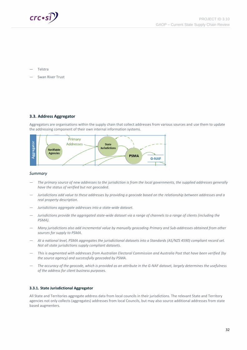
Aggregators are organisations within the supply chain that collect addresses from various sources and use them to update the addressing component of their own internal information systems.
Summary
— The primary source of new addresses to the jurisdiction is from the local governments, the supplied addresses generally have the status of verified but not geocoded.
— Jurisdictions add value to these addresses by providing a geocode based on the relationship between addresses and a real property description.
— Jurisdictions aggregate addresses into a state-wide dataset.
— Jurisdictions provide the aggregated state-wide dataset via a range of channels to a range of clients (including the PSMA).
— Many jurisdictions also add incremental value by manually geocoding Primary and Sub-addresses obtained from other sources for supply to PSMA.
— At a national level, PSMA aggregates the jurisdictional datasets into a Standards (AS/NZS 4590) compliant record set. Not all state jurisdictions supply compliant datasets.
— This is augmented with addresses from Australian Electoral Commission and Australia Post that have been verified (by the source agency) and successfully geocoded by PSMA.
— The accuracy of the geocode, which is provided as an attribute in the G-NAF dataset, largely determines the usefulness of the address for client business purposes.
3.3.1. State Jurisdictional Aggregator
All State and Territories aggregate address data from local councils in their jurisdictions. The relevant State and Territory agencies not only collects (aggregates) addresses from local Councils, but may also source additional addresses from state based augmenters.

PROJECT ID 3.10
GAOP – Current State Supply Chain Review
33
The summary of feedback is an overview of all responses and does not necessarily reflect the views of all stakeholders:
Stakeholder Representative Overview
State Aggregator Important issues: — All address supply chain improvements must show a benefit in terms of
either a commercial return, efficiency gain or quality improvement. — Desire a simple, common definition of addressing terms — Looking to extend the address catalogues to include building names and
features of interest. — A state-wide policy has been implemented to encourage the use of address
verification services at the point of address information capture across all agencies.
— Provisional address, is important so addressing is available between certification and registration, which, on large developments, can be 6-12 months.
— Would like support for proposed rather than just approved addresses to be carried onto G-NAF – as, perhaps an address status or state.
— Manual processes for feeding back information and limited resources to investigate anomalies and exceptions reduce the timeliness of responses.
— Potentially useful address information is missing or poorly captured because it is not mandatory or essential to other processes.
— Reduced funding means less opportunities to fix black spots. — Variability in the frequency and format of addresses received from local
government. — Proliferation of “pseudo-developers” such as mining companies and
Department of Public Works and Housing often bypass formal development processes.
— Aspire to develop an online “address capture tool” that would be available to councils for adding and editing addresses.
— Lack of standards for communicating proposed land developments. - Some questions regarding the maturity / funding of smaller councils and
their ability to provide stewardship over addresses. — Poor tracking of addresses through the development process, many
proposed addresses are never registered. — Address management is currently too manual and therefore expensive. — Negative updates occur where council data overwrites manually improved
jurisdiction data (require better feedback loops. — Inconsistencies between “ratings”; addresses and “GIS” addresses. — Addresses provided are only from councils – so any that are not based on
title-activity are never received. — Need support for early, provisional address capture and discovery. — Need to support non-standard addresses (e.g. Lot/Plan) which are removed
by PSMA as not meeting requirements. — Currency is affected by developers delaying registration as long as possible
to minimise costs.

PROJECT ID 3.10
GAOP – Current State Supply Chain Review
34
Inputs
Local government provides addresses as part of a new lot creation process. The address is provided as a relationship between the Council assigned address and the property description required for Title. New primary addresses are provided (generally by email) on a daily or weekly basis, but there is no control over the currency.
Local governments tend to be very aware of the AS/NZS 4819 Standard and generally assign correct / compliant street numbers and street names.
PSMA provides updates of G-NAF each 3 months as a bulk download. Access to G-NAF Live is provided daily. This is a real-time web service access to the jurisdiction supplied dataset. Not all jurisdictions subscribe to this service.
Access to PSMA’s AVS (Address Verification Service) provides additional address cleaning and matching capability. Not all jurisdictions subscribe to this service.
PSMA also provides:
— updates of addresses that have been verified by agencies but yet to be geocoded.
— addresses received from augmenters (as verified) but yet to be geocoded, which includes:
Level 0 – Addresses with no matches between AEC, Australia Post or Jurisdictions.
Level 1 – Addresses with one match between AEC, Australia Post or Jurisdictions.
Level 2 – Addresses with three matches from AEC, Australia Post and Jurisdiction.
Ad-hoc enquires are sourced from other state government agencies as informal requests to verify addresses, usually received via email. These can include updates from alternative capture sources such as Titling Database and Emergency Services Computer Aided Despatch systems.
Ad-hoc address enquires and verification requests from public enquiry relates to address information where the enquired address is generally unverified. In many cases, public sources such as Google Street View™ may be used as a means to verify addresses.
Processing
Jurisdictions are also the custodians of significant address reference datasets, these include:
— Digital Cadastre Database, which provides a geographical representation of lots created by the jurisdiction. The centre of the lot geography is often used as a geocode to attach to the council address using the real property description as a common key.
— Localities, which are named geographical areas defining a community or area of interest. Locality names and their extents are formally gazetted often following extensive public consultation. Jurisdictions are responsible for gazetting localities and adhere to strict guidelines to avoid duplication or ambiguity. The locality name makes up an important component of an address.
— Roads Register, which comprises a catalogue of road names and is often used when assigning new road names to avoid duplication and ambiguity. The register may also provide a list of appropriate road names that may be used in the future. In some jurisdictions, the road register is managed at the local government level. The road name is a significant component in the creation of a new address.
— All Jurisdictions interviewed create and maintain their own instance of an address database, for example QAMF (Qld Address management Framework - Property location Index) in Queensland, GURAS (Geocoded Urban and Rural Address System) in New South Wales and ADR (Address Data Register) in Western Australia. These datasets, the Jurisdictional Address Dataset, provide the authoritative address record set for each Jurisdiction.

PROJECT ID 3.10
GAOP – Current State Supply Chain Review
35
— Jurisdictions add additional geocoded addresses to the Jurisdictional Address Dataset by:
— Geocoding verified addresses supplied by local councils, usually by providing the coordinates of the parcel centroid based on a real property description relationship.
— Geocoding verified (Level 2) addresses supplied by PSMA. This process may include referencing additional resources such as:
manual matching to alternative datasets (e.g. Features of Interest).
online (Google Street View™).
contacting informal Local Government contacts.
manual field verification.
— Verifying and then geocoding ad-hoc addresses sourced from the public domain using a similar, manual process.
Outputs
The primary output from jurisdictions are geocoded addresses, these are delivered by:
— Regular updates to PSMA of geocoded addresses, according to the following schedule.
Australian Capital Territory, New South Wales and Western Australia provide daily updates
Victoria and Tasmania provide weekly updates.
Queensland, Northern Territory and South Australia provide quarterly updates (3 months).
— Provision of a jurisdictional address dataset according to each states business priorities:
Queensland provides free of charge public online (web service) access to QAMF (Queensland Address management Framework) Property location Index (PLI) as well as full monthly downloads on a Creative Commons licensing basis. The dataset is also available free of charge to government agencies.
Western Australia is based on a cost recovery model where agencies and the public are charged a fee to access the address dataset, this may either be access to the jurisdictional dataset or through on-selling the PSMA provided Address Verification Services (AVS).
Victorian geocoded addressing is available through the SPEAR system for land-title related applications and through VicMap for other geocoded address uses.
New South Wales Provides the Geocoded Urban and Rural Address System (GURAS) for state government addressing purposes.
As part of the address verification and geocoding process, jurisdictions may also send un-geocoded addresses to local government for further enhancement.
3.3.2. Notifiable Agencies
Another participant group in the Aggregator category is the Notifiable Agency. These are organisations that are contacted by local government when an address is changed or created. Some notifiable agencies also have a direct relationship with developers and receive proposed development applications directly from them, such as Telstra and Australia Post.
There appears to be little consistency nationally or across jurisdictions about which organisations are “notifiable” in the development application process. Each state or territory has a set of organisations that need to be aware of new developments and the new addresses attached to them. They include utilities, Emergency Services and, of course, the State Jurisdiction (which are a special case and are discussed separately, below). The Local Council can itself be a notifiable agency for sewerage and water services, for example.

PROJECT ID 3.10
GAOP – Current State Supply Chain Review
36
In NSW, each of the 152 local government bodies is required to send notifications of new and changed addresses to a specific list of notifiable agencies. In Victoria, the 79 Local Councils and other government bodies enter information into the SPEAR system so the notifiable agents only need a single source for all notification and response activity. Victorian organisations that need to be notified about new development applications are called referral authorities. SPEAR automatically sends a notification to all relevant Referral Authorities who can then use SPEAR to evaluate the application and accept or reject it.
It is worth noting that NBN Co is not a notifiable agency in any jurisdiction, even though the legislation requires all new developments to provision National Broadband Network connectivity.
Inputs
Notifiable Authorities receive address information either from the Local Government or directly from the developer. This is done using email in NSW and Queensland and via the SPEAR system in Victoria. Western Australia has a state planning authority that is responsible for coordinating and distributing all development information. The address information provided to a notifiable agency generally includes the lot and plan number and the various components of the address – street number, street name, street type and locality. Strata plans also include a unit number or other unique identifier for each strata title.
Processing
The notifiable authorities are usually also required to check the address for suitability for purpose and determine if it is acceptable. They can then return a confirmation or rejection of the address to the council which would then discuss any issues and remediate any problems that make the address unsuitable.
In Victoria, referral authorities can use the SPEAR system to issue a statement of compliance or a rejection back to the responsible authority (council). They also incorporate the new addresses into their internal systems which support their designated activities.
Outputs
Utilities, emergency service agencies and many other agencies, once notified, take no further active part in the supply chain but appear again as end users through commercial arrangements with VARs or directly with PSMA to access G-NAF for internal address verification activities. The exceptions are Australia Post and the Australian Electoral Commission who - in their role as address augmenters - provide quarterly address updates to PSMA.
3.3.3. National Aggregator (PSMA)
PSMA is the recognised national aggregator of addresses from all state jurisdictions and the de-facto authoritative source of national geocoded addresses in producing the G-NAF products and its derivative products. To provide some context for the PSMA aggregation role in the geocoded address lifecycle, the following indicative timeline shown in Figure 6 (developed by NBNCo) describes a lead time of 12 to 15 months before many new address are received by PSMA and a 3 month processing time before these addresses are available in the latest G-NAF product.
This time delay is apparent in the volume of new addresses that are contributed to PSMA from Australian Electoral Commission and Australia Post that bypass the land titling process as citizens and councils interact directly with other government agencies - an estimated 1 in 5 new addresses according to PSMA. It is noted that eventually theses addresses will appear in G-NAF at some later stage when the jurisdictional agency completes the land transaction process and pushes these “new” verified and often geocoded address to PSMA. However, the processing overheads created by dealing with multiple addresses related to the same location arriving at PSMA by such circuitous routes adds substantial complexity and cost to the G-NAF processing activities.

PROJECT ID 3.10
GAOP – Current State Supply Chain Review
37
Figure 6: Geocoded Address Processing Timeline
Inputs
The primary address inputs to the PSMA are:
— Geocoded address data from the state jurisdictional aggregators. The structure and format of the supplied address data is variable, as is the supply schedule, with no standard address delivery schema prescribed. The supply schedule for each jurisdiction is: (see state jurisdiction outputs)
Australian Capital Territory, New South Wales and Western Australia provide daily updates.
Victoria and Tasmania provide weekly updates.
Queensland, Northern Territory and South Australia provide quarterly updates (3 months).
— Verified addresses are provided quarterly from two ‘contributor’ agencies, Australia Post and Australian Electoral Commission. These contributed addresses augment those provided by the jurisdictions and require geocoding prior to being accepted into G-NAF. Addresses received from augmenting agencies are characterised as ‘verified’ as they have been processed by the agency and meet the requirements of the agency as being a valid address and add to the level of confidence in the data, as discussed in Section 3.4.
— A number of reference datasets are provided by the jurisdictions, digital cadastre, localities and road network (road names). Once aggregated, these form significant national datasets in their own right, they are also significant in cleaning, validating and geocoding the contributed addresses provided by augmenters. They play a role in independently validating the logical consistency and spatial attributes of every address in G-NAF.
— A small number of addresses are also provided through back-channels from VARs and from the public domain. This is usually done informally via email in the absence of a structured channel or protocol.

PROJECT ID 3.10
GAOP – Current State Supply Chain Review
38
— A number of stakeholders bemoaned the absence of a structured backchannel for the notification of addresses back to PSMA as described in NAMF as an Address Notification Service. If a convenient, structured service was available, stakeholders intimated that they would be more inclined to feed addresses back to PSMA on a more regular and structured basis. It was noted that PSMA has a notification web service operating; however there is considerable concern from jurisdictions as to the increased expectation and workload that would be created should PSMA push the widespread adoption of such a service. Consequently this capability is largely dormant due to insufficient resources.
Processing
PSMA adds value by aggregating the state jurisdictional address and augmenting these addresses from other contributors4. Aggregating and processing geocoded jurisdictional addresses into a structured, standard compliant (AS/NZS 4590) schema includes:
― Creation of incremental update file.
― Application of numerous rules to correct spelling, abbreviations and erroneous characters.
― Application of changes derived from jurisdictional reference datasets (Cadastre, Localities, Road Names).
The outcome is the G-NAF-Live product set, the dataset is updated daily.
Augmenting the aggregated jurisdictional datasets with contributed addresses from supply chain augmenters, and processing for acceptance into G-NAF, the processing includes:
― Address scrubbing (error correction technique).
― State-locality validation and geocoding where not already provided.
― Street validation.
― Street geocoding where not already provided.
― Address geocoding where not already provided.
― Merging.
― Post merge processing (including validation processes).
The outcome is the G-NAF product as a dataset assembled quarterly.
Output
The primary geocoded address outputs are:
— G-NAF is recognised as the authoritative record set for national geocoded addresses. The dataset is based on both the aggregated jurisdictional datasets with augmentation from nominated agencies. G-NAF is distributed to clients quarterly as a bulk physical download.
— The jurisdictional G-NAF dataset (G-NAF Live) is provided to jurisdictions as a web service providing both web service calls and batch processing capability. The service is provided in real time with underlying datasets updated daily.
— PSMA has recently engaged VARs for the G-NAF Live product to be provided as-a-service cloud offering to users across Australia with some state jurisdictions delivering daily updates to the service.
4 For a more detailed description of PSMA processing, see the GNAF Data Product Description.

PROJECT ID 3.10
GAOP – Current State Supply Chain Review
39
— An alternative channel for delivery of the G-NAF dataset is through PSMA’s Address Validation Service (AVS). The AVS provides web service access to the G-NAF dataset and includes enhancements such as parsing of incoming address strings, fuzzy logic matching and provision of an estimate of address matching accuracy.
3.4. Address Augmenter
Address Augmenters are organisations that collect addresses as part of their business practice and on supply those addresses to the national aggregator (PSMA).
Summary
— Currently, only two agencies act as augmenters to the national aggregator (PSMA), they are Australia Post and the Australian Electoral Commission.
— A number of other agencies have been approached to contribute and discussions are ongoing.
— Each agency collects addresses to meet internal business requirements.
— Each agency will apply their own unique business rules to “verify” the address is real and meets their business requirements.
— Address verification is often a manual and time consuming process and will often draw resources from other agencies (e.g. Local Government) for final verification.
— Augmenting agencies then provide those verified addresses to PSMA for geocoding and, where appropriate, inclusion in G-NAF

PROJECT ID 3.10
GAOP – Current State Supply Chain Review
40
This section provides a summary of interviews with the following Address Augmenter representative stakeholders.
Stakeholder Representative Overview
Australia Post (AP) Important issues: — Is currently under some commercial-in-confidence restrictions — Internal Address database is optimised for the letter and parcel delivery
businesses. — Geocoding only used in the planning of postal delivery routes. G-NAF is
used in the route-planning activity. — See large on-the-ground workforce as key differentiator allowing
comprehensive field verification. — National Address File (NAF – a derivative of the Postal Address File) supplied
to PSMA for the specific purpose of matching and reconciling disparate address data in G-NAF.
— Comprehensive “discovery” of non-title-based addresses being gained through physical delivery via addresses on letters and parcels and through local postie knowledge.
— Planning to leverage this knowledge into a commercial product hence restrictions on what can currently be discussed.
Australian Electoral Commission (AEC)
Important issues: — Considerable manual intervention to clean and validate addresses
submitted as part of the electoral roll registration process. — Significant project underway to geocode the electoral roll for analytical
purposes. A perceived impediment to this project is the large number of GNAF addresses that don’t have a parcel level geocode. A street / locality level geocode is considered too coarse for analytical purposes.
Interviews with Australia Post were limited due to commercial sensitivities related to their arrangement with their accredited Address Matching Approval System (AMAS) suppliers that are treated as confidential. Many of these service providers are also VARs for G-NAF.
Inputs
The majority of inputs to the address augmenters are unverified addresses obtained from agency clients through a variety of channels including online electoral enrolment forms, paper based electoral enrolment forms and scanned address images
Verified addresses are received from a number of sources including government and public sources. They are as a result of an enquiry to an external entity for an address to be verified. Many of the augmenting agencies use G-NAF either directly from PSMA or from a VAR for verifying addresses for internal business purposes.
Processing
Augmenting agencies collect and aggregate unverified addresses from a number of business driven channels. Millions of unverified addresses can be collected annually across agencies and verified by the agency to determine if the address is real and suitable for the agencies purpose. For example, an address is considered real or verified, if a letter can be delivered to that address or it is likely a person resides at that address.

PROJECT ID 3.10
GAOP – Current State Supply Chain Review
41
Addresses are verified by:
― Enquiring with an authoritative source such as local, state or federal government agencies.
― Comparing with a trusted record set, such as G-NAF.
― Desktop research, such as Google Maps / Street View™ or other public online mapping resources.
― Field staff physically visiting and confirming the address.
Where an entered address cannot be verified, legislation prevents the agency from altering (correcting) the entered address based on any address verification process.
Output
In their role as address augmenters, the primary output of this supply chain segment is provision of verified addresses to the national aggregator (PSMA). Verified addresses are delivered quarterly for processing and inclusion in G-NAF.
As part of the address verification process, augmenting agencies may also provide unverified addresses to authoritative agencies for assistance in the verification process. Unverified addresses may be sent to local, state or federal government agencies to assist in the verification process.
3.5. G-NAF Value Add Resellers
Value Add Resellers (VAR) are organisations within the geocoded address supply chain that purchase geocoded address products from the national address aggregator (PSMA) and on-sell those products or services to end users with additional value. As each VAR has a unique business model and business priorities that determine the value add proposition for their customer base. Typical value add products and services include:
― Address verification services using G-NAF in conjunction with other address reference datasets.
― Navigation and routing services including optimised “travelling salesman” products.
― Address cleaning and matching services (address verification).
Summary
― VARs are generally the first non-government entities encountered in the scope of this supply chain study.
― The most common geocoded address product that has value added to it is the quarterly distribution of the G-NAF dataset.
― While geocoded address services are available from PSMA, the inclusion of these in the VAR supply chain is currently limited.
― VARs add value by:
― Supplementing G-NAF data with addresses provided by alternative sources (couriers / crowd /commercial etc.).
― Optimising address data sets for search and retrieval using proprietary indexing and file formats.
― Developing proprietary parsing, searching and matching algorithms to improve address validation services.
— Providing a range of client focused delivery channels.

PROJECT ID 3.10
GAOP – Current State Supply Chain Review
42
― Of the VARs interviewed some feel constrained by:
— The quality and timeliness of G-NAF data compared to alternative sources, albeit less comprehensive.
— The existing G-NAF licensing model and the potential for exploitation by some resellers offering low-cost services potentially exploiting licensing loop-holes.
— Lack of an effective channel for providing address feedback and corrections to PSMA
— Inconsistencies in the delivery of the G-NAF product
— Lack of communication of PSMAs strategic roadmap discourages investment in address products.
This section provides a summary of interviews with the following VAR representative stakeholders.
Stakeholder Representative Overview
Pitney Bowes Business Insights (PBBI)
Pitney Bowes provides customer communication technologies and solutions in the form of software, data and services. They are a publicly listed company provided services to a global customer base.
Important issues: — Would prefer more frequent and smarter / incremental G-NAF updates. — Finding it increasingly difficult to differentiate products in the marketplace. — Very uncertain about PSMA’s role in the supply chain and their medium to
long term strategy. This discourages investment as the market is seen as risky. In some VAR segments, PSMA has become a direct competitor and taken market share. PSMA are seen as a competitive threat. This stifles innovation.
— Restrictive and ambiguous data licensing conditions discourages data sharing and encourages unscrupulous resellers to exploit licensing intent.(Business Model Issue)
Intec Solutions Provides information quality and management solutions to a range of government and non-government clients across Australia. Their flagship product provides address validation and geographic coding services in both real-time and batch modes.
Important issues: — Inconsistent terminology across the supply chain. — Within G-NAF, there appears to be a poor association between primary and
subsidiary addresses and their relationship with the underlying parcel description.
— Lack of formal feedback mechanisms to PSMA, presently relies on personal contacts.
— Can see opportunities for improvement in PSMA address data management, including: ― Better linkage between current and retired PIDs ― Better temporal management of data changes ― Better relationship between G-NAF and G-NAF-Live PIDs.
— Consider some PSMA products impinge on VARs markets making it very difficult to compete. ( Business Model related, not supply chain related)

PROJECT ID 3.10
GAOP – Current State Supply Chain Review
43
Stakeholder Representative Overview
HERE Maps A Nokia company specialising in mapping and location intelligence services. HERE creates global location and navigation products for 196 countries.
Important issues:
— Preference for a publicly available dataset to stimulate address activity and encourage error feedback.( Business Model related, not supply chain related
— Significant quantities of address data is provided by alternative sources. Some 70% of G-NAF is replaced in online products.
— Most common data sources are remote sensing technologies, i.e. mobile phones.
— Although G-NAF is used as a seed dataset, alternative data sources are demonstrably more current than G-NAF.
— Specialise in highly accurate locations of addresses at sub-parcel level.
Inputs
Due to the broad range of businesses drivers, operations and commercial / confidential arrangements of the interviewed VARs, the address supply chain inputs are summarised at a high level.
In addition to taking a download of the G-NAF dataset every 3 months from PSMA, most VARs also access the state jurisdiction geocoded addresses directly, these include:
— QAMF – PLI (Qld Address Management Framework)
— GURAS (NSW Geocoded Urban and Rural Address System)
— VicLands (VIC)
— Landgate (WA)
— Additional product augmentation may occur using a combination of unverified, verified and geocoded addresses from commercial (non-government) sources, such as:
― Courier companies ― Phone / telecommunication companies ― Remote sensing ― Commercial data providers
— Many VARs also use the PAF dataset from Australia Post to enhance their address cleaning and verification capability,
additional augmentation may also be provided by collecting, cleaning and assimilating the large numbers of addresses presented by clients to the service for verification and geocoding.
Processing
Much of the processing undertaken by VARs is commercial in confidence and not readily shared with the project. Broadly, VARs will:
— Assimilate the various address datasets into a common address file
— Apply formatting and character substitutions
— Update all proprietary alias and lookup tables from reference datasets (locality / road network etc.) for improved address matching

PROJECT ID 3.10
GAOP – Current State Supply Chain Review
44
— Optimise the datasets format for indexing, phonetic matching and fast searching
Output
The primary output developed by VARs is an enhanced repository of geocoded addresses. These addresses may then be further enriched through innovative delivery channels, including:
— Quarterly provision of physical geocoded address files
— Address validation web service platform and datasets for deployment within the agency
— Address validation available as an external hosted web service.
3.6. Geocoded Address User
Geocoded address users cannot be represented by a handful of archetypes, each has a unique business operating model, each has a unique processing methods and each has a unique demand for addresses to meet their requirements.
To some extent, most segments within the supply chain are geocoded address users, for many participants the processing that occurs within each node is often to meet internal requirements for addressing.
The following analysis is distilled from a number of stakeholder interviews and should be seen as representative of geocoded address users.
Summary
— Address consumers will collect addresses from a range of sources as part of their business activities.
— The collected addresses will often require processing in order to meet the users business requirements.
— The primary “output” of an address user is a product or service for internal use.
— Secondary outputs may be contributed to the supply chain for further processing and value-adding.
This section provides details of interviews with the following User representative stakeholders.
Stakeholder Representative Overview
ACT Emergency Services Important issues: — Current PSMA licensing constraints restricts sharing of addresses even
during emergency situations when there is high demand for timely access to location information.(PSMA Business Model )
— Lack of an effective feedback channel to PSMA discourages error updates. — Inconsistencies in terminology and definitions across agencies.
Insurance Australia Group (IAG) Important issues: — Address geocodes used to assess risk and optimise policy premiums — Additional value in supplying land use and coordinate height (z value) for
more-accurate determination of flood risk — Lack of information regarding unit level number, for example, only 125,000
units in G-NAF contain level information.

PROJECT ID 3.10
GAOP – Current State Supply Chain Review
45
Stakeholder Representative Overview
Department of Communications (NBN Co)
Important issues: — Require better visibility of address creation process during the developer –
local government phase. — PSMA should consider a business case for national online address portal. — Onerous and highly manual processes for tracking green-field
developments, this effort is duplicated across a number of utilities. — Require improved clarification of definitions and terminology in order to get
consistency of use. — Issues with G-NAF and G-NAF-Live PIDs and ability to track temporal
changes. — Seek clearer relationship between addresses and lot descriptions applicable
to parcels or properties.
Sydney Water Important issues: — Require more transparent visibility of the process around plan / address
creation, prefer address number and street name when development plan is initially lodged.
— Significant variability between council’s processes and applying and supplying numbering and road names. Very rare to get comprehensive address information for a subdivision at lodgement.
— Plan format provided by developers is highly variable, often paper copy and difficult to process.
— Current SW requirement for developers to access a NSW Pre-allocated plan number (PPN) enhances the process by providing a robust initial key.
Australian Tax Office (ATO) Important issues: — Require greater transparency of the address / parcel / development phase
of address creation — Not currently doing any form of address validation, there is a proposed
project using a VAR to validate addresses on lodged tax returns — Currently not using geocoding / spatial analytics to its full potential within
the organisation.

PROJECT ID 3.10
GAOP – Current State Supply Chain Review
46
Stakeholder Representative Overview
Department of Human Services (DHS)
Important issues: — DHS have the largest address dataset of any other agency and comprises a
range of address types. ― Centrelink dataset comprises 24 million geocoded addresses, this
compacts to 8 million on removing duplicates. ― Medicare dataset comprises 24 million geocoded addresses, this
compacts to 10 million when removing duplicates ― Many other smaller datasets
— Each has a mix of postal, residential and temporary addresses — Each has to be kept separate for privacy reasons — Currently use 3 different VAR products to manage address validation /
geocoding processes with a mix of authoritative address datasets, including PAF, G-NAF and VAR proprietary.
— Using multiple data sources, roughly 90% of addresses have been geocoded to a satisfactory level through internal augmentation and verification processes.
— Have had several instances where PSMA have changed G-NAF data structures without notice and created significant processing issues (PSMA Specific)
— Current pricing and licensing of G-NAF products is a huge impediment to cross-agency sharing of information and general uptake of geocoding technology.

PROJECT ID 3.10
GAOP – Current State Supply Chain Review
47
Stakeholder Representative Overview
Australian Bureau of Statistics (ABS) Important issues: — They are building their own ABS Address Register in preparation for next
Census (2016) ― Want to start the next census with each address resolving to a dwelling ― Remove duplicates which exists in G-NAF ― ABS have different definition of geocode ― Interested in ANZLIC’s suggestion of a Spatial Referencing System code
which could be a coordinate but also a Mesh Block code or LGA. ABS interested in Statistical Standard Area codes – don't keep lat, long. Mesh block code is essentially their geocode.
— ABS Need Land Use to target Census and Business Surveys appropriately. Using various sources to establish Land Use;
— Australian Electoral Commission — Own field surveys — Valuer General – Land Use available — Electricity Meter readings – Residential / Business tariffs
— Use G-NAF for three purposes: — Address Coding - use InTech Solutions addressing software but build
their own indexes — Building ASGS Geometries – Statistical Spatial Framework. — Building ABS Address Register – add Land Use and build own indexes
for InTech S/W ― Don't always know which address is the jurisdictional address as
opposed to Australia Post address. ABS has to pick one – not sure which one is authoritative – issue when the others are aliases. Sometimes PSMA doesn't realise there are multiple addresses for the same property and they are not identified as aliases.
— ABS has concept of a “Shell” address which resolves to, perhaps, a parcel but not to a dwelling. If Unit2/10 High St is the address, then 10 High St is the Shell or “Umbrella” address
Inputs
The range of end user address inputs is as varied as the business operating models for which addresses are captured and used. Of the stakeholders interviewed there was usually little or no verification of an address at point of entry. Many stakeholders felt this was desirable due to the expense involved in post-validation, however due to the implementation costs associated with existing systems it was considered unfeasible. The range of address inputs include:
— Agency clients input unverified addresses through a number of channels, including:
― Unstructured and unverified handwritten addresses on parcels, letters, correspondence and application forms.
― Structured but unverified addresses through online application forms and data capture.
― Some agencies collect millions of addresses annually in this way.
— A number of verified addresses are collected from recognised agencies, usually as part of the verification process.
— In order to meet internal business demand, users will source geocoded address from a number of sources and consume these addresses through a variety of channels as required by the business, including but not limited to:
― Geocoded addresses provided by jurisdictional aggregators via online web services.

PROJECT ID 3.10
GAOP – Current State Supply Chain Review
48
― Geocoded addresses provided as a monthly download file.
― Geocoded address services provided by a range of VARs.
Processing
The primary processing goal of many address users is to:
1) Accept a presented address according to business driven validation criteria;
2) Confirm that the captured address is appropriate for their business requirements; and
3) Geocode the address to a level that is appropriate to their business requirements.
This is achieved by cleaning and parsing unstructured addresses and verifying the result against nominated reference datasets.
Outputs
Most of the users interviewed captured, processed and stored addresses to meet their internal business requirements with the bulk of address outputs being unverified addresses being sent to a range of entities for verification.
Two users, Australian Electoral Commission and Australia Post, are also address augmenters and provide their verified addresses to PSMA for further inclusion in the geocoded address supply chain.

PROJECT ID 3.10
GAOP – Current State Supply Chain Review
49
4. User Needs Analysis
With reference to the current state analysis of the geocoded address supply chain a number of issues present themselves where the current state is deficient in meeting the end user needs. The gap between the current state of the geocoded address supply chain (Work Package 1.1) and the end user needs analysis (Work Package 1.2) can be expressed by expanding upon the following themes:
1) Councils vary considerably
2) Jurisdictions vary considerably
3) National Aggregator is an address accepter
4) Multiple national address versions
5) Survey plans don't need addresses
6) Plan-based and property-based addresses
7) Addresses and coordinates
8) Address versioning
4.1.1. Councils vary considerably
Five Councils within four jurisdictions participated in interviews. Within a single jurisdiction, all participating Councils need to interact with the single jurisdictional organisation in order to register plans, gazette roads and produce and distribute addresses, resulting in some measure of uniformity for interactions between councils and that jurisdiction. In addition, state-wide legislation ensures that the underlying legal framework each council works to is essentially the same across the jurisdiction.
However, each Council interacts with developers and their representatives independently, using their own choice of tools and information systems, data schemas, communications channels, processes and procedures. In addition each Council develops its own local plans, zoning and legislation to best suit its own goals and produce the desired outcomes. As long as they stay within the jurisdictional framework, they are free to use whatever means produce the best results for their own circumstances and resources.
Typically, Councils create and gazette streets and then assign street numbers to lots and forward the results to the jurisdictions and to other organisations interested in the changing address fabric. Council administrators are generally very conscious of the need to preserve the integrity of the street name and numbering regime since urban infill, rezoning, resumptions and easements can create irregularities and ambiguities if the regulations are not applied correctly.
Through the development of a national standard, AS/NZS 4819, for the creation of addressing, some attempt has been made to normalise how addresses are created. Some Councils follow the standard and others follow parts of the standard or incorporate parts into their own documented procedures. In any case, the large set of previously-existing addresses, many not conforming to any standard and including those that still consist of a lot and plan number on a street need to be supported and maintained by any builder of aggregated, comprehensive address datasets.
While the creation and management of an address for each activity in the titling system is now generally followed, there is no requirement to provide a coordinate or geocode as an additional address attribute. Many Councils have all the information necessary to assign an address geocode as they have the detailed survey information on each lot on the plan. However, there is no obligation on the Council to provide a geocode and Councils vary greatly in the systems they have that might support such spatial operations.

PROJECT ID 3.10
GAOP – Current State Supply Chain Review
50
4.1.2. Jurisdictions vary considerably
The analysis interviewed jurisdictional organisations in the four states of Queensland, New South Wales, Victoria and Western Australia. Each jurisdiction maintains its own, individually developed Land Titling system with its own terminologies, underpinning legislation, information systems, data schemes, tools, communications channels, processes and procedures. It is not surprising, then, that the addressing products produced from the jurisdictional land titling systems also vary widely across jurisdictions.
Western Australia, for instance, has the Western Australian Planning Commission to receive and certify development applications from developers and their surveyors and pass them initially to councils (where the addresses are created) and organisations such as utilities to check and sign off on the development and then to pass the approved development on to Landgate for registration and incorporation into the titling system.
In New South Wales and Queensland, the developers and surveyors interact with the LGA in the first instance and it is the council that assigns addresses and notifies the various utilities about the development activity. The council then forwards thus information to the land administration department (LPI and NRM respectively)) which, in turn, provides it to the Land Titles Office and the Valuer General.
In Victoria, the majority of development activity is mediated through a comprehensive online system, SPEAR, used by developers, surveyors, councils, the Jurisdictional authority (Department of Environment and Primary Industries), utilities and any other organisations, such that all can see both the proposed and actual state of developments across the state.
As is the case with Local Government Authorities, Jurisdictions do not need addresses (other than for communication with owners) in order to create entries in and maintain the land titling system. They also do not need to associate each address with a coordinate or geocode although most have Geographic Information Systems (GIS) systems that can provide one as they hold a spatial representation of the lots and plans as a cadastral layer.
4.1.3. National Aggregator is an address accepter
PSMA is the federal-level aggregator of address information and the producer of the G-NAF national geocoded address dataset. It does this by accepting address datasets from all the jurisdictions and both integrating and augmenting them with additional, independently-maintained national address datasets from the Australian Electoral Commission (AEC) and Australia Post (AP).
PSMA has the considerable task of integrating a wide set of addresses of differing formats, origins and processes, arriving to different schedules but required to be amalgamated into a coherent, consistent address set. It has no ability to mandate addressing formats and so must accept the addresses in the wide variety of forms in which they are supplied. As a result, PSMA has had to develop a large, complex, comprehensive and cumbersome set of business rules (more than 200,000), which it needs to apply to the incoming addresses in order to create the G-NAF product.
PSMA is also tasked with establishing one or more sets of geographic coordinates (geocodes) for each incoming address. It does this using the cadastral datasets also provided to it by the jurisdictions.
4.1.4. Multiple national address versions
There are a number of organisations that participate in the geocoded address supply chain at a national level. They have each developed and actively maintain their own national address dataset for their own internal purposes.
Australian Electoral Commission (AEC): The AEC maintains a database of electorates and every eligible Australian voter in order to correctly allocate their votes. To do this it maintains an electoral role which places people at addresses and addresses in electorates. It maintains its own electoral boundaries dataset which has the boundaries regularly reviewed and revised in order to maintain roughly-equal populations within each electorate.
Because the task is to allocate populations evenly into electorates and then individual residential addresses into those same electorates, the AEC needs to know the location of every residential property and the voters who reside there.
Note that each State and Territory also maintains its own set of electoral boundaries for use in State and Territory elections. These have all the same issues of population distribution, accuracy on Election Day and reflection in the electoral rolls.

PROJECT ID 3.10
GAOP – Current State Supply Chain Review
51
Australian Bureau of Statistics (ABS): The ABS is responsible for gathering, maintaining and presenting a wide range of statistics on the Australian population. The primary input is the census which is undertaken every five years and consists of the delivery and pick up of census forms for every Australian household on or around census night, effectively creating a “snapshot” of where Australians are and what they are doing.
In order to visit every household, ABS maintains its own address dataset and works to make it as accurate as possible before the next census. As its targets are individual dwellings, it would, for example, need to gather information on all residences in a retirement village. It currently does this using its own field surveys – people walking around as well as input from other address sources such as AEC and PSMA.
A strict ABS requirement is anonymity of the statistical data so the ABS uses its own hierarchy of land units built up from the lowest-level Mesh Block. A mesh block is designed to represent approximately 100 people so the ABS needs accurate geocoded address information as the basis for the design of mesh blocks and all the aggregated datasets that follow.
4.1.5. Survey plans don't need addresses
Addresses, both historically and currently, are a by-product of the land ownership system. They are typically created through changes in the cadastral fabric (i.e. ownership extents), where the subdivision, redefinition or aggregation of existing land parcels are redefined.
Local Councils are tasked with administering a defined area, including the management of its land cadastre. The Council levies taxes (rates) on the lots and the rates represent the main source of income for the council. The lots need to be accessible so a network of roads is defined such that most parcels have direct or indirect access to a road. The address then becomes a combination of the local area (suburb or locality), the road (street name) and the location along the road (street number).
The land titling system is based on the management of defined areas of land called lots and the registered survey plans of subdivision within which those lots are uniquely numbered. A lot is a recognized subdivision of property with a written legal description that addresses permissions or constraints upon its development. The land ownership system does not require actual addresses in order to function and addresses do not form part of a title document. Even Councils only strictly require addresses of the lot owners in order to serve rates notices. An address, to which a rates notice applies and a postal address so it can be sent such that payment is received, is seen as an accurate address for as long as it remains fit for purpose.
Addresses, therefore, are not an essential part of the very systems that create and alter them and have effectively been ’tacked on‘ as constituting a useful attribute of the lot, plan and title. Consequently, the accuracy, currency and completeness of addressing is not universally aligned with that of the lots, plans and titles themselves.
Strata Plans provide a further division of a survey plan into strata lots, each of which carries individual ownership and documentation within the land title system, and common areas which are jointly owned by all the lot owners in the plan. Addresses are defined for the strata lots such that each property has its own address (Unit 1, Flat 2 etc.) and a further address, typically that of the “Body Corporate” is assigned for the common areas.
Generally, there has been a recognition that the consistent capture of addresses as part of land ownership activity is desirable, and all jurisdictions (States and Territories) have mechanisms, procedures and legislation in place to capture these addresses as they are created and changed. The fact, however, that the land ownership and titling process can proceed without addresses (using lot and plan numbers to identify ownership) means that the address data has not been uniformly collected and maintained across the country.
4.1.6. Plan-based and property-based addresses
Even if we assume that all plan-based land activity as described above, will result in updates to relevant addressing datasets, plan-based addresses still form only a subset (albeit a large one) of the entities that could and should be addressable. For example, a large retirement village may be held under a single ownership and a single lot (and therefore have a single address as far as the land titling system and the council is concerned) but consist of a network of private roads and streets and perhaps hundreds of individual premises or dwellings, each, of course, contains people who might need to be accessed and to whom things might wish to be sent. As far as the council is concerned, it sends one rates notice to the owner of the entire village, relying on that owner to arrange how the rates are divided up and paid.

PROJECT ID 3.10
GAOP – Current State Supply Chain Review
52
However, there are many other cases in which a more-specific address is required for access to the retirement village. Emergency services such as fire, ambulance and police need to quickly access a particular property. Taxies, couriers, maintenance services and utility meter readers all need to know how to navigate to a particular property starting from the road entrance. In addition, government departments such as the Australian Bureau of Statistics (ABS) and the Australian Electoral Commission (AEC) need to address premises and the people in them at a level of detail greater than the street address the land ownership system supplies.
Councils are understandably reluctant to assume responsibility for the collection and maintenance of this extra address detail. Firstly, they have no control of the address details – a retirement village owner may unilaterally decide to change street names or numbers and is under no obligation to notify anyone of the changes. Secondly, if councils maintain and distribute such address information that proves to be in error, they could possibly be liable for any consequences arising from that error.
An alternative to land titles as the basis for addressing and one chosen by the State of Victoria is to link addresses to Properties rather than to lots. In most cases, a single property would fully occupy and be coincident with the land title (lot and plan). In other cases, such as the retirement village discussed above, a property-based addressing scheme would hold an address for each property within the single titled property (lot). All properties would be assigned a unique property number and carry their own addresses based on the information within the complex – private street names and numbers, building names and numbers, unit numbers and so on.
In all cases the extra address information can eventually be linked back to the underlying lot and plan in the land ownership system.
4.1.7. Addresses and coordinates
Addresses are not, themselves spatial, but refer to entities that do exist in the real world at a real location. For instance, the address 66 Smiths Creek Rd Uki carries no concept of location. There is no indication of where Smiths Creek Rd might be and there could be many of them across Australia while the number 66 does not indicate where, along the road, the address lies. The establishment of the location for the address requires extra, ancillary spatial information, specifically, the lot and plan number the address represents, in this case, Lot 13 of Plan Number 263408 in the state of New South Wales. The lot and plan numbers, in turn, link back to the actual deposited or registered plan, a document which defines the coordinates of the lot boundaries. A point can then be established inside the lot polygon and a single representative coordinate Latitude -28.41549, Longitude 153.343537. Thus the address becomes geocoded.
The point is that the geocoding of addresses requires access to the underlying survey plans or a spatial dataset such as a cadastre, itself based on the survey plans and is a non-trivial process.
The existing mechanisms that support the definition and establishment of an address do not lend themselves to carrying a geocode, referring instead, to the lot and plan number for the spatial context. Addresses are thus typically communicated along the supply chain without a geocode and it falls, in the end, to PSMA, in receipt of both Cadastral and Address information, to use the lot coordinates to create one or more geocodes that spatially represent the address.
A problem with this approach arises because the datasets have had to be fed up the supply chain as the development moves from council to jurisdiction to national aggregator and are not likely to be very current. It may be that the lot a particular address represents is not yet present in the cadastral dataset and so geocoding is curtailed.
It is widely recognised that the geocode is a useful attribute on an address so the ability to carry the geocode along with the address as it moves through the supply chain would be valuable. The ideal would be for a geocode to be calculated and associated with an address at the very moment it is created, in other words when the street numbers are first associated with a particular lot and plan. The address would thereafter always be geocoded and be able to directly and independently represent a location.
4.1.8. Address versioning
G-NAF records are uniquely identified using a Persistent Identifier or PID but the PID is only persistent and unique within a particular snapshot or version of G-NAF. The G-NAF data structure does not allow the tracing of PIDs forwards and backwards to PIDS representing the state before and after changes. A PID remains persistent while ever the core address

PROJECT ID 3.10
GAOP – Current State Supply Chain Review
53
attributes remain unchanged. However, this does introduce a difficult question about what to do in the case of locality or road name changes.
For example a property at 10 High St might carry a PID:12345. It is divided into two lots to create two new addresses 10a and 10b with PID:23456 and PID:34567. Subsequently, 10a is strata titled into Units 1 and 2 with PID:45678 and PID:56789. The most up to date version of G-NAF will now have three address records: 10b High St with PID:34567, Unit 1, 10a with PID:45678, and Unit 2, 10a with PID:56789. What is missing is the ability to connect PID:45678 and PID:56789 with the address of the lot before the split (PID:23456) and the relationship of that lot with the original lot PID:12345. Even if the retired records are subsequently removed from the G-NAF dataset, a robust and truly persistent link is maintained so the archived records could be extracted from an archival dataset to show the addressing state at any point in the past if the system was to be redesigned.
This same support for address relationships would also support address relationships such as that between the street address of a retirement village and a particular dwelling within the village.
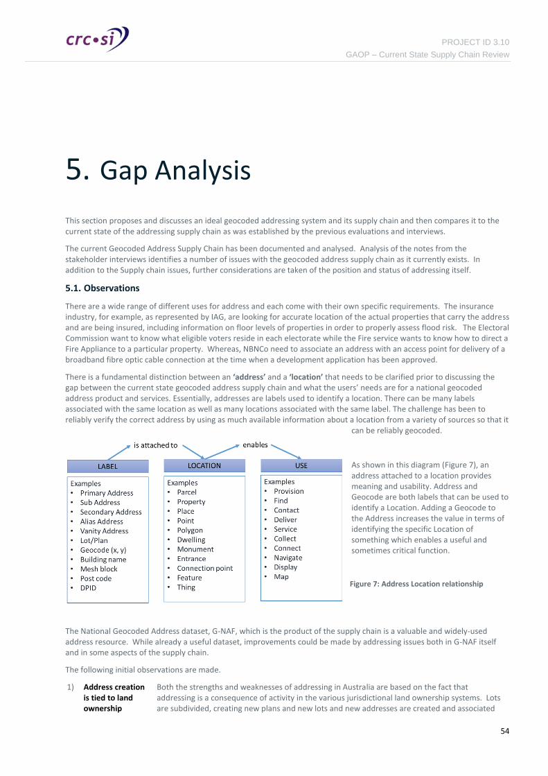
PROJECT ID 3.10
GAOP – Current State Supply Chain Review
54
5. Gap Analysis
This section proposes and discusses an ideal geocoded addressing system and its supply chain and then compares it to the current state of the addressing supply chain as was established by the previous evaluations and interviews.
The current Geocoded Address Supply Chain has been documented and analysed. Analysis of the notes from the stakeholder interviews identifies a number of issues with the geocoded address supply chain as it currently exists. In addition to the Supply chain issues, further considerations are taken of the position and status of addressing itself.
5.1. Observations
There are a wide range of different uses for address and each come with their own specific requirements. The insurance industry, for example, as represented by IAG, are looking for accurate location of the actual properties that carry the address and are being insured, including information on floor levels of properties in order to properly assess flood risk. The Electoral Commission want to know what eligible voters reside in each electorate while the Fire service wants to know how to direct a Fire Appliance to a particular property. Whereas, NBNCo need to associate an address with an access point for delivery of a broadband fibre optic cable connection at the time when a development application has been approved.
There is a fundamental distinction between an ‘address’ and a ‘location’ that needs to be clarified prior to discussing the gap between the current state geocoded address supply chain and what the users’ needs are for a national geocoded address product and services. Essentially, addresses are labels used to identify a location. There can be many labels associated with the same location as well as many locations associated with the same label. The challenge has been to reliably verify the correct address by using as much available information about a location from a variety of sources so that it
can be reliably geocoded.
As shown in this diagram (Figure 7), an address attached to a location provides meaning and usability. Address and Geocode are both labels that can be used to identify a Location. Adding a Geocode to the Address increases the value in terms of identifying the specific Location of something which enables a useful and sometimes critical function.
The National Geocoded Address dataset, G-NAF, which is the product of the supply chain is a valuable and widely-used address resource. While already a useful dataset, improvements could be made by addressing issues both in G-NAF itself and in some aspects of the supply chain.
The following initial observations are made.
1) Address creation is tied to land ownership
Both the strengths and weaknesses of addressing in Australia are based on the fact that addressing is a consequence of activity in the various jurisdictional land ownership systems. Lots are subdivided, creating new plans and new lots and new addresses are created and associated
Figure 7: Address Location relationship

PROJECT ID 3.10
GAOP – Current State Supply Chain Review
55
with those lots.
2) Addresses not
tied to land ownership are orphaned
Where development applications are submitted and development activity takes place without changes to ownership, such as in the creation of gated communities, university campuses, hospitals, business parks, retirement villages etc. there is now requirement to define addressing and so no mechanism exists to capture and maintain new addresses. These new, “complex” addresses do, however, exist and people live at them. The addresses only become known to Government when citizens interact with Government and supply these addresses. PSMA estimate that these addresses constitute approximately 20% of G-NAF.
3) Addresses are a
wider concept than ownership
The total set of “things at locations” in Australia that are “addressable” and would benefit from having a recognised address is greater than the set of parcels of owned land and their land titles. Further, the gap between the two sets is growing as our built environments become ever more complex and sophisticated and community-based ownership becomes more popular.
Addresses provide directed access to particular locations and structures and ultimately to the people and objects associated with those locations and structures. The range of different address uses is far greater than issues of ownership of the land the address occupies.
Large complexes under single ownership are becoming more common but there is nothing in place to capture and maintain such addresses.
4) Addresses have
no ultimate owner
Addresses are created by councils as part of their land management activity but are not thereafter required as part of the council's revenue generation activities. Even the Land Tenure and Titling system which is the main trigger for address creation, does not need addresses as part of a land title, the Lot and Plan details being sufficient. Other organisations collect and hold address data for their own purposes but are not custodians of any definitive or nationally-recognised addressing data.
PSMA, on the other hand, develops a comprehensive, national geocoded address dataset but has no control over the addresses themselves which could be changed without notice. The G-NAF address set that it creates could be seen as “optimal“ but is not “authoritative” as there is no authority that is ultimately accountable.
5) Address Supply
Chain has no back channels
The normal flow of addresses from Councils through Jurisdictions to PSMA and VARs to users is well documented. However the reverse information flows – from Users to VARs to PSMA to Jurisdictions to Councils are either ad-hoc, informal and undocumented or non-existent. This weakens the whole chain as valuable user feedback which could be used to improve the quality of both the address datasets and the systems that constitute the supply chain is lost.
6) Users need early
access to addresses
Councils create addresses as part of the maintenance of land ownership. They are created relatively early in the process as the council approves the lots of the proposed plan and allocates street names and numbers. This proposed address information will often remain within the council until the plan has been registered and so not be available to other organisations interested in planning to accommodate the new developments.
New South Wales and Queensland have had some success with a pre-approved plan number service allowing surveyors to request a unique number that can then be used for all subsequent activity.
Victoria's SPEAR system allows Councils to enter early address information which automatically becomes visible to the various Notifiable Authorities.

PROJECT ID 3.10
GAOP – Current State Supply Chain Review
56
Enhancements to the current state of the Geocoded Address Supply Chain can be achieved by the following measures:
1) Providing the right tools and incentives for Local Councils, State Jurisdictions and PSMA to interact with a common geocoded address dataset that can be updated and maintained by authorised address data custodians in respective jurisdictions.
2) Leveraging the early address notifications and in-field validation of addresses by NBN Co to improve the quality of G-NAF by using these addresses to update the jurisdictional geocoded address datasets that flow to PSMA.
3) Enabling all Government Agencies to verify addresses with state jurisdictional address datasets and contribute new address data that can flow to PSMA for contribution to the national aggregation and production of G-NAF.
These enhancements are reflected in the following Improved Logical Geocoded Address Supply Chain Model in Figure 8 below. However, an overriding concern is that the primary issue is a requirement to have a national location management framework that will support an authoritative national geocoded address dataset. This will require a more fundamental change to the design and implementation of a more appropriate system that will support the FSDF vision.

PROJECT ID 3.10
GAOP – Current State Supply Chain Review
57
Figure 8: Improved Logical Geocoded Address Supply Chain Model
5.2. Summary of requirements
User needs are reflected in the findings of the current state analysis and the stakeholder expectations for an improved geocoded national address product or service through supply chain efficiency improvements that will reduce their costs and increase the potential benefits to their business.
The current supply chain exhibits a number of shortcomings in meeting the user needs, and suggestions for improvement are set out in the following table.
Requirement Suggested Improvements
Timeliness
A common finding amongst a number of users canvased, especially utilities, want newly created and updated addresses to appear in the dataset
Councils should be designated as authoritative source for parcel and property addressing.
This is an essential prerequisite for managing address quality that should be maintained as close as possible to the source of address
Geocoded Address Supply Chain (Level 0)
Cre
ato
rA
ugm
ente
rA
ggre
gato
rSu
pplie
rU
ser
Pre
sen
ter
ConsumeCollect Ingest > Harmonise > Integrate > Maintain Extract > Supply
Local Councils
State Jurisdictions
PSMANotifiableAgencies
GovernmentAgencies
G-NAF
Users
Value Add Resellers
Contributed Addresses
Primary Addresses
Public - Citizens, Developers, Agents
NBNCo Addresses

PROJECT ID 3.10
GAOP – Current State Supply Chain Review
58
Requirement Suggested Improvements
as soon as activity on the property to which the address belongs commences, even if the legal status of the property has not been finalised. These “provisional” addresses are useful in directing the considerable amount of work that takes place in new subdivisions. It also allows the various service organisations to better plan for increased demands and to update their own internal systems.
In the cases where a development creates multiple new or modified properties but the land tenure is not affected, there is no trigger point in Council and no requirement for addressing to be assigned or approved. In this case, addresses may not become known to Government until a resident interacts with a Government department and supplies an address.
If these “provisional” addresses could be made more widely available as soon as the plan has been presented or approved by council then many of the issues about timeliness would be removed as the provisional address can be used for interactions with the property it represents.
creation in supply chain. In most cases the property and parcel address will be the same.
Jurisdictions should aggregate and publish authoritative addressing
Addresses created by council should immediately be accepted by a jurisdictional address management function for incorporation into a jurisdictional-wide address dataset and supporting address service. This service would then be accessible by all organisations with the need or interest in knowing about new or changed addresses within the jurisdiction.
This would streamline the address supply chain to provide frequent updates to the national aggregator's address dataset so that the new, provisional addresses are nationally visible shortly after they have been created.
By supporting the capture and promulgation of addresses from all development activity as soon as they are created or changed, the issue of timeliness should be significantly reduced.
Accuracy
The current supply chain attempts to reconcile a number of address sources with often mixed results. Users want the data present in the address dataset to be unambiguously identified and as accurate as possible.
A key principal to improving and sustaining data quality is to ensure the responsibility for creating and updating new addresses is as close as possible to the source.
Many of the inaccuracies in the address supply chain and dataset occur because there is no single, authoritative source of address or a uniformly-applied, mandatory process through which the address is created or captured.
Jurisdictional address verification services must support address information feedback
Jurisdictions should provide the mechanism for a wide range of address users to submit improvements to the address system by highlighting errors and potential problems and by making suggestions. These would be examined by the jurisdictional address body, in the first instance, and should also be forwarded to the relevant councils as they are the final, authoritative arbiters of address.
National institutions such as Australia Post (AP) and the Australian Electoral Commission (AEC) which are currently obliged to accept addresses supplied by residents would then be able to verify the supplied addresses using the authoritative jurisdictional datasets. There would then be less discrepancy between addresses from different sources as they would all have been verified to the same authoritative jurisdictional address
Robustness
Users need to reduce the number of times a particular address needs to be verified to a minimum by having a robust, stable and auditable address dataset in place.
A single successful validation call would provide a
Implement support for address history and traceability.
The lack of robustness is evident in at least two ways. Firstly the supply chain does not currently provide a means of tracing addresses through time and across the multiple subdivisions and changes to land tenure that affect addressing. In other words, there is no way of telling from a current address, what the address was of the parcel of

PROJECT ID 3.10
GAOP – Current State Supply Chain Review
59
Requirement Suggested Improvements
Permanent Identifier (PID) which could then form a short-hand tag equivalent to the address in its textual form. Such a PID could be sent to any other organisation from where it could be used to access the full address data without further validation steps.
land that was subdivided to create the new address. Secondly, robustness in the permanence of addresses is lacking because there is no authoritative address version – so multiple versions of the same addressable location can co-exist, leading to confusion and errors. Of course, this lack of robustness is especially true when considering non-land-title addresses.
The Address Supply Chain could be enhanced to support relationships between addresses. Changing the data model to support these relationships should be relatively easy, however some investigation will be required as to how the information necessary to populate the relationships can be provided.
Comprehensive
Users need to have a reliably, comprehensive national addressing system that allows for a wide variety of address types including the relationships, if any, between addresses. It should, for example, be able to store addressing information on every premise or dwelling in a retirement village, every building, floor or unit in a University Campus if there is a case to be made for its usefulness. The address should be able to direct fire, police and ambulance services, couriers, taxies, meter readers and maintenance personnel to individual properties. In the future, access points and parcel delivery points and fire hydrants and electricity meters will also be required by many users. .
The traditional and historic concept of an address has been a combination of locality, street name and street number, in turn based on and linked to the lot number of a plan of survey deposited or registered with the appropriate jurisdictional authority. Extending from this original address concept, geocoded addresses are text strings that direct access to locations and properties, points of interest and delivery points for services.
Councils should have responsibility for managing all addresses.
Councils should assign addresses for all development applications that change properties or “addressable locations”, even when land tenure is not affected. This change would ensure that a full set of addresses is captured whenever land development occurs.
Even those address-creation activities – indigenous lands, public housing etc. that currently fall outside the council's responsibility should be brought under the control of the Council so a consistent approach and a single source of addressing truth is maintained.
Jurisdictions should implement processes/policy to ensure capture, maintenance and delivery of addresses throughout the address development cycle for all development activity
Jurisdictions should be accountable for maintaining a comprehensive jurisdictional geocoded address dataset. Improvements to the address supply chain require better, more certain address creation and capture. In support of this, jurisdictions should establish an authoritative, actively maintained and resourced geocoded address dataset. This may require the implementation of appropriate regulations and systems for the mandatory provision of addressing information for all “addressable” locations within development applications.
Jurisdictions should each develop a standard, consistent service for access to their authoritative addressing data. This standard interface would become the default method in the supply chain by which the national aggregator would access the Jurisdictional Address Data in order to create the National Address dataset.
Accessibility
Users need to realise the benefits of value added services provided by VARs that are an important channel for G-NAF based address data and services. However, where VARs cannot and do not
Provide access to G-NAF as a Service
The address dataset should be easy to access using standard tools and without the need for the purchase of proprietary software. It should be accessible by both people and by their systems.
The geocoded address dataset should provide mechanisms such as

PROJECT ID 3.10
GAOP – Current State Supply Chain Review
60
Requirement Suggested Improvements
add significant value for a particular address use, other address users should be able to access and utilise the raw G-NAF as either data or as a service and adapt and enhance it to their own needs.
If G-NAF were to be provided as a flexible service, it could be more-widely used and more-easily extended by a wide range of address users. This effect has been noted with the widespread and growing use of the Google Maps interface for addressing, geocoding, reverse geocoding, mapping etc.
Web Service-based access with published and documented Application Programming Interfaces (APIs) so that its data and functionality can easily be incorporated into other systems. The data model should allow users to link their own data to addresses thus making it more searchable and discoverable
Security
Users’ expectations for a more accurate, more accessible, more reliable and comprehensive national address service implies a need for an effective access and security controls as the supply chain becomes more flexible and accessible by a wider range of address users with the ability to contribute directly to improving the address dataset. Just as important will be support for full auditing so that the supply chain can trace all activity within the supply chain.
Security is currently not a large issue as most of the supply chain is read-only and based on infrequent transfers of bulk data and updates.
In future, security may become more of an issue as the supply chain moves from supporting infrequent, batch-oriented address updates to a small set of VARs to providing data-as-a-service to a much broader address community through APIs such as those developed for the G-NAF Live product.
Develop a security model to support Councils and jurisdictional aggregators to update and maintain G-NAF.
Access to the Address dataset should be properly controlled so that only authorised users and systems gain access and then only to the address elements they are permitted to access or update.
Authoritative
Councils need to be empowered as the authorities for all land parcel or property addresses and to develop jurisdictional-level services to hold and maintain this authoritative address dataset on behalf of all the councils in a jurisdiction. The jurisdictional address service (JAS) framework will ensure the development of authoritative geocoded addressing for each and every jurisdiction.
Jurisdictions to provide standard address interface
Underlying all the other observations on the address supply chain is the fact that no addresses in Australia are truly “authoritative”. They are not a mandatory component of land titling, of land valuation or of council rates. This lack of authority leads to a lack of effort in their maintenance, leading to multiple different versions, to low quality of address maintenance and currency and consequently to a low trust in addressing systems and addressing generally.
Shareable Make sharing of G-NAF-based data easier across Government

PROJECT ID 3.10
GAOP – Current State Supply Chain Review
61
Requirement Suggested Improvements
It should be possible for users of the address dataset to communicate address information to each other easily and quickly, without restrictive licensing terms and conditions that might preclude or hinder such interchanges.
Jurisdictions need to be able to query each other’s address sets, allowing, for example, NSW to access Queensland's Address Service in order to query a Queensland Address.
The current G-NAF licensing arrangements mean that even within the Government sector, both ends of a transaction involving G-NAF-derived addresses are required to hold an enterprise license before address information can legally be exchanged. Address derived from one VAR's addressing system are not necessarily formatted for input into another VAR's addressing system, requiring an extra manual entry step. As described above, the lack of a truly permanent, traceable address ID also means address exchanges can't reliably use the PID as an effective short-hand for the address.
Cost-effective
Users expect the cost of a national geocoded address dataset to users to be not so high that it restricts its widespread use. A high cost, low quality product or service will always encourage alternative competing datasets to be developed. The success of the dataset will be in becoming a common standard for all users of Australian addresses and a platform for developing higher value functionality and business efficiencies.
Better pricing and access conditions for address products and services would probably lead to increased use from a great number of users. A larger number of users each paying less for the addressing services could potentially return just as much if not more revenue to the supply chain as the current, smaller number of users, each paying more.
Make the use of the National Geocoded Addressing service cheaper
Many potential users and improvers of the national address dataset and service that are currently deterred both by the cost of initial entry and by on-going costs, especially if they are relatively low-volume users of addressing. Most of these potential users are probably currently using free services such as those from Google, or making use of Google Enterprise licensing which provides both business-level addressing and mapping for less than a typical G-NAF VAR would charge.
While the community at large (through taxes) and developers in particular (through development fees) pay for the creation and aggregation of addresses, the only access to the final address product the current supply chain provides is through a small group of VARs with a volume-of-use threshold for cost-effectiveness that deters occasional or intermittent use. The practical outcome is that many potential G-NAF users are now using freely-available alternatives such as Google and such sources are bound to get better as they attract more users and so ad-viewers. For example, Google Maps can already provide driving or walking routes and directions to individual buildings on a University Campus. Such third-party addresses sources are not authoritative and continue to be provided only while it is profitable for Google and others to do so. It would be problematic for Australian address users to become overly dependent on such address alternatives that could disappear at any time.

PROJECT ID 3.10
GAOP – Current State Supply Chain Review
62
6. Improvement Opportunities
The following improvement suggestions are made based on the analysis of user needs and assessment of gaps in the current state of the geocoded address supply chain and where opportunities may exist for business process improvements. These recommendations are grouped into either incremental improvements related to existing practices and processes, or transformation initiatives to re-engineer the supply chain system.
6.1. Short-term improvements
These short-term improvement activities could benefit from further involvement from the CRCSI Program 3 commitment to this Geocoded Address Optimisation Project.
Improvement 1: Undertake a review of national address standards
The CRCSI could initiate a review of the ISO standards to deal with the inconsistencies in definitions and terminology being used across and the geocoded address supply chain. The review will have stakeholder representation from all participant groups and seek adoption from the Inter-government Committee of Surveying and Mapping (ICSM) to recommend endorsement by the ISO.
Improvement 2: Provide an unrestricted one-time copy of G-NAF for non-commercial use
This will stimulate the development community to take the dataset and host it themselves, learn the data structures and start developing apps and web sites with G-NAF capabilities. General expertise and abilities among the IT community concerning G-NAF would improve and some of those resources could be used in development of the Jurisdictional Address Services (JAS). This will also provide immediate publicity for the Spatial Data Policy initiatives and open data strategies for foundation spatial datasets.
VARs would benefit from the innovations in Apps development that could be commercialised in collaboration with the reseller to a much wider market.
Improvement 3: Develop a specification for national geocoded address interfaces
This will inform the geocoded address supply chain of the requirements for each jurisdiction (local councils, state and federal contributors) to expose and consume address verification, update and notification web services. This should be considered as fundamental national data infrastructure guidelines within the context of the FSDS program.
The specification should observe the Open Systems Interconnection (OSI) model and address layers 1 to 4 (1. Physical, 2. Data Link, 3. Network, 4. Transport).
Improvement 4: Initiate a nation-wide survey of geocoded address requirements
The CRCSI should extend the stakeholder involvement to a wider group to include all jurisdictions, local councils and utilities to solicit issues and ideas that will inform the national debate and contribute to promoting the cause for coordination and improved business benefits and social outcomes that flow from a truly authoritative national geocoded address reference dataset.
The primary purpose is to gather data related to volumes, costs, resources, technical capabilities and other information to assist in establishing the business case and investment options for establishing a more efficient and cost effective national solution.
This survey should not be onerous in terms of the effort require to respond and should elicit specific views in a series of questions where either yes/no or scale ranging responses can be provided.

PROJECT ID 3.10
GAOP – Current State Supply Chain Review
63
6.2. Longer-term improvements
The following longer-term improvement opportunities are more transformational and should be further considered in the Future State report Work Package 1.3).
Improvement 5: Develop a “National Geocoded Address Portal” available to local councils, Notifiable Agencies and federated to the Jurisdictions.
This will give visibility of addressing earlier in the supply chain, even proposed addresses, to authorised participants and facilitate the assignment of persistent identifiers at address creation required a majority of users. NBNCo could help facilitate this portal development through leveraging their investment in the internally developed Electronic Location Management System (ELMS) project to interact with developers and other supply chain participants at the earliest point of intervention for address creation. Such a capability would:
― Provide an audit of “non-addressed” parcels across LGAs to prioritise areas to be cleansed.
― Provide access to authoritative locality boundaries and road names as provided by the jurisdictions for the public to be informed.
― Provide an appropriately managed channel for crowd sourcing of alternative / sub addresses and cleaning of existing addresses (back-channel).
― Provide a single location for Augmenting Agency address enquires (rather than approach local councils).
Improvement 6: Design and development of a next generation National Location Management Service to complement G-NAF as part of the FSDS infrastructure.
This activity would require further investigation and a detailed business case to support the level of investment anticipated. Opportunities could be explored for private sector investment or other appropriate commercial arrangements that could be available to fund such a project.

PROJECT ID 3.10
GAOP – Current State Supply Chain Review
64

PROJECT ID 3.10
GAOP – Current State Supply Chain Review
65
Appendix A. Geocoded Address Supply Chain Process Maps
The following geocoded address supply chain process maps have been developed for each node in the supply chain:
A1: Address Creator (Local Government Segment)
A2: Address Aggregator (State Jurisdictional Segment)
A3: Address Aggregator (Federal Segment)
A4: Address Aggregator (Notifiable Agency Segment)
A5: Address Augmenter
A6: Address Supplier (VAR Segment)
A7: Address User (Consumer Segment)
A8: Geocoded Address Supply Chain – Current State Composite
The following notation and legend applies to the geocoded supply chain diagrams in this section:
Unverified Address: an address that enters the supply chain through a variety of sources, most notably through the capture of citizen’s details where confirmation of identity is required by a government agency. These addresses are often non-structured but recognised as a compliant address according to the AS/NZS 4819 standard.
Verified Address: an address that has been accepted by the collecting agency as fit for purpose according to criteria established by the respective agency but does not necessarily contain a geocode.
Geocoded Address: an address that has been verified and has received a geocode. This is the highest value address type in the supply chain.
The frequency of address provision is summarised as daily / weekly / monthly / quarterly.
The volume of address data delivered is represented by the line width.
UnverifiedAddress(Daily)
VerifiedAddress(Daily)
GeocodedAddress(Daily)

PROJECT ID 3.10
GAOP – Current State Supply Chain Review
A.1. Address Creator (Local Government Segment)
Creator (Local Government Segment)
Process OutputInput
UnverifiedAddress(Daily)
VerifiedAddress(Daily)
ProposedAddress(Daily)
UnverifiedAddresses(Quarterly)
ProposedAddress(Daily)
Manual resolution of individual address
May include resolution against alternative sources (Google)
May include field verification May include resolution against
Council Address Database ( 1 day – never)
Create new address numbers and street names May require Council
resolution Based on AS_NZS 4819 (1 day – 3 months)
Public Domain /
other
Proposed & ApprovedAddresses
(Daily)
Notifiable Agency
Jurisdictional Aggregator
Proposed & ApprovedAddresses
(Daily) State Planning AuthorityGeocoded
Addresses(Daily)
Developer
List of approvedStreet names
Localities(Daily – Quarterly)
VerifiedAddresses(Monthly)
Jurisdiction Aggregator
GeocodedAddresses
(Daily)
Public Domain /
other
GeocodedAddresses
(Daily)
Council AddressDatabase
UnverifiedAddress(Daily)
GeocodedAddresses
(Daily)
GeocodedAddresses
(Daily)
AEC
Developer
State PlanningAuthority
State / FederalGovernment
Agencies
AEC
State / FederalGovernment
Agencies
GeocodedAddresses
(Daily)
VerifiedAddress
(Daily - Quarterly)
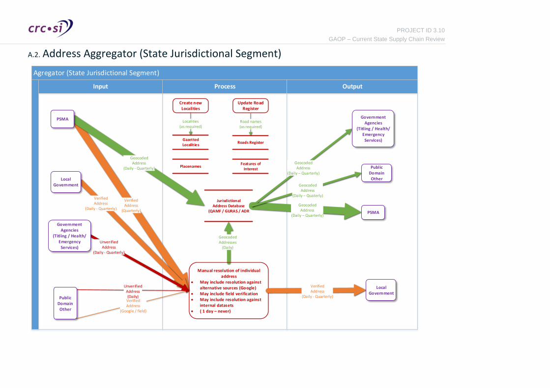
PROJECT ID 3.10
GAOP – Current State Supply Chain Review
A.2. Address Aggregator (State Jurisdictional Segment)
Agregator (State Jurisdictional Segment)
Process OutputInput
VerifiedAddress
(Quarterly)
Localities(as required)
VerifiedAddress
(Daily - Quarterly)
GeocodedAddresses
(Daily)
UnverifiedAddress
(Daily - Quarterly)
VerifiedAddress
(Google / field)
GeocodedAddress
(Daily – Quarterly)
UnverifiedAddress(Daily)
GeocodedAddress
(Daily - Quarterly)
GeocodedAddress
(Daily – Quarterly)
Create new Localities
JurisdictionalAddress Database
(QAMF / GURAS / ADR
LocalGovernment
GazettedLocalities
PSMA
Manual resolution of individual address
May include resolution against alternative sources (Google)
May include field verification May include resolution against
internal datasets ( 1 day – never)
GovernmentAgencies
(Titling / Health/ Emergency Services)
Public DomainOther
PSMA
Features of Interest
Placenames Public DomainOther
GovernmentAgencies
(Titling / Health/ Emergency
Services)Roads Register
GeocodedAddress
(Daily – Quaterly)
Update Road Register
Road names(as required)
LocalGovernment
VerifiedAddress
(Daily - Quarterly)

PROJECT ID 3.10
GAOP – Current State Supply Chain Review
A.3. Address Aggregator (Federal Segment)
GeocodedAddress
(Quaterly)
Aggregator (Federal Jurisdictional Segment (PSMA))
Process OutputInput
GeocodedAddress
(Daily - Quaterly)
GeocodedAddress
(Quarterly)
VerifiedAddresses(Quarterly)
VerifiedAddress
(Quarterly)
NonverifiedAddress(Daily)
GeocodedAddress
(Field verificaion)(Daily)
GNAF-Live(Daily)
VerifiedAddress
(Quarterly)
GeocodedAddress
(Quaterly)
GeocodedAddress
(Quaterly)
VerifiedAddress
(Quarterly)
GeocodedAddress
(Quarterly)
GNAF
JurisdictionalAggregator
AustraliaPost
AEC
Public DomainOther
Localities Road Names
JurisdictionalAggregator
ValueAdded
Reseller
GovernmentAgencies
Geoscience AustABS
ValueAdded
Reseller
Apply business rules for acceptance into GNAF
200,000 rules currently applied 3 months
JurisdictionalGNAF
GeocodedAddress
(Quarterly)
Digital Cadastre
Maintenance Pre-Processing File conversion and schema mapping Spelling and abbreviation correction Apply locality and road name updates
GeocodedAddress
(Quarterly)

PROJECT ID 3.10
GAOP – Current State Supply Chain Review
A.4. Address Aggregator (Notifiable Agency Segment)
Agregator (Notifiable Agency Segment)
Process OutputInput
ProposedAddress(Daily)
ProposedAddress(Daily)
Update internal systems with proposed address
information
CouncilApprovedAddresses
(Daily)
AddressDatabase
Developer
LocalGovernment

PROJECT ID 3.10
GAOP – Current State Supply Chain Review
A.5. Address Augmenter
UnverifiedNonGeocoded
Address
Augmenter ( Contributor Segment)
Process OutputInput
VerifiedAddress
UnverifiedNonGeocoded
Address
VerifiedAddress
UnverifiedNonGeocoded
Address
VerifiedAddress
VerifiedAddress
UnverifiedNonGeocoded
Address
UnverifiedNonGeocoded
Address
UnverifiedNonGeocoded
Address
GeocodedAddress
(Quaterly)
VerifiedAddress
(Quaterly)
VerifiedAddress
Verify addresses are suitable for business
need.(3days – never)
Address Register (AEC)Address Management
Database (ABS)Postal Address File (PAF)
Public
PSMA
Collect and aggregate unverified address information from public sources. Can
include; Online forms (register to vote) Customer service centres Letters and parcels Census information
LocalGovernment
PSMA
LocalGovernment
StateGovernment
FederalGovernment
StateGovernment
FederalGovernment
PublicSources
(Field verifiedGoogle
Etc)

PROJECT ID 3.10
GAOP – Current State Supply Chain Review
A.6. Address Supplier (VAR Segment)
Supplier (VAR Segment)
Process OutputInput
GeocodedAddress
(Quarterly)
VerifiedAddress(Daily)
GeocodedAddress
(Quarterly)
GeocodedAddress
(Quarterly)
UnverifiedAddress(Daily)
VerifiedAddress
(Quaterly)
GeocodedAddress
(Quarterly)
GeocodedAddress
(Quarterly)
Address verificationAddress geocoding
Product Pre-processing Proprietary Rules and
processing 3 weeks – 2 months
PSMA
JurisdictionalAggregator
GeocodedAddress
UnverifiedAddress
(Quarterly)
Non-Government /
PublicSources
ClientQueries
AustraliaPost
ClientQueries
PSMA
GeocodedAddress
Master Product(GNAF Premium)
etc
Features ofInterest
Digital RoadNetwork
Localities Aliases

PROJECT ID 3.10
GAOP – Current State Supply Chain Review
A.7. Address User (Consumer Segment)
User (Consumer Segment)
Process OutputInput
GeocodedAddress(Daily)
VerifiedAddress(Daily)
UnverifiedAddress(Daily)
UnverifiedAddress(Daily)
GeocodedAddress(Daily)
GeocodedAddress(Daily)
GeocodedAddress
(Quaterly)
UnverifiedAddress(Daily)
UnverifiedAddress(Daily)
GeocodedAddress(Daily)
VerifiedAddress(Daily)
UnverifiedAddress(Daily)
UnverifiedAddress(Daily)
VerifiedAddress
(Quaterly)
VerifiedAddress(Daily)
UnverifiedAddress(Daily)
GeocodedAddress(Daily)
VerifiedAddress(Daily)
JurisdictionalAggregator
PSMA
Client
GeoscienceAustralia
(POI)
VAR
JurisdictionalAggregator
PublicProvider
VAR
PSMA
PublicProvider
LocalGovernment
LocalGovernment
Address Geocoding Match to authoritative geocoded address file Manage business rules to asses appropriateness
of result for business requirements
Unverified AddressDatastore
Geocoded AddressDatastore
Verified AddressDatastore
Address Verification Clean and parse address Verify that the address exists Manage business rules to asses appropriateness of
result for business requirements

PROJECT ID 3.10
GAOP – Current State Supply Chain Review
A.8. Geocoded Address Supply Chain – Current State Composite
Geocoded Address Supply Chain (Level 0)
Cre
ato
rA
ggre
gat
or
Au
gmen
ter
Sup
plie
rU
ser
ConsumeCollect Ingest – Harmonise – Integrate - Maintain Extract - Supply
Citizen/Developer
Local Government
State PlanningAuthority
Jurisdiction Aggregator
State / Federal
GovernmentAgencies
Public Domain / other
Notifiable Agency
PSMA
ValueAdded
Reseller
AddressUser