Embed Size (px)
Citation preview

This work is licensed under a Creative Commons Attribution 4.0 International License
Newcastle University ePrints - eprint.ncl.ac.uk
Dunn JC, Buchanan GM, Stein RW, Whittingham MJ, McGowan
PJK. Optimising different types of biodiversity coverage of protected areas
with a case study using Himalayan Galliformes.Biological
Conservation 2016, 196, 22-30.
Copyright:
© 2016 Published by Elsevier Ltd. This is an open access article under the CC BY license
(http://creativecommons.org/licenses/by/4.0/).
DOI link to article:
http://dx.doi.org/10.1016/j.biocon.2016.01.015
Date deposited:
23/02/2016
Biological Conservation 196 (2016) 22–30
Contents lists available at ScienceDirect
Biological Conservation
j ourna l homepage: www.e lsev ie r .com/ locate /b ioc
Optimising different types of biodiversity coverage of protected areaswith a case study using Himalayan Galliformes☆
Jonathon C. Dunn a, Graeme M. Buchanan b, R. Will Stein c, Mark J. Whittingham a,1, Philip J.K. McGowan a,⁎,1a School of Biology, Newcastle University, Newcastle-upon-Tyne, Tyne and Wear NE1 7RU, UKb RSPB Centre for Conservation Science, RSPB, 2 Lochside View, Edinburgh park, Edinburgh EH12 9DH, UKc Department of Biological Sciences, Simon Fraser University, Burnaby, BC V5A 1S6, Canada
☆ Statement of authorship: JCD, MJW and PJKMwrote tJCD and GMB undertook the modelling. RWS generatedscores. JCD conducted all data preparation and other anadraft. PJKM and MJW devised, conceived and oversaw the⁎ Corresponding author.
E-mail address: [email protected] (P.J1 Joint last authors.
http://dx.doi.org/10.1016/j.biocon.2016.01.0150006-3207/Crown Copyright © 2016 Published by Elsevie
a b s t r a c t
a r t i c l e i n f oArticle history:Received 11 May 2015Received in revised form 22 December 2015Accepted 20 January 2016Available online xxxx
International targets have committed governments to expanding the global protected area (PA) network to 17%of the terrestrial surface by 2020. Optimising PA placement in the landscape is challenging due to a poorknowledge of biodiversity distribution and multiple definitions of conservation value. We explore these twoissues using a case study of a highly threatened bird Order in a region of conservation concernwhere PA networkeffectiveness for biodiversity has not been formally explored previously. To determine if the existing PA networkprotects the most important areas for 24 species of Himalayan Galliformes, we use a novel method to comparethe current network placement to results produced from Zonation prioritisation software and modelled speciesdistributions. Specifically, we identify areas of high species richness and then weight maps by three differentspecies specific conservation values. The current PA network captures ranges poorly. We found statistically sig-nificantly poorer fits between the optimal and the existing placement of the Himalayan PA network for Zonationresults that were: (i) unweighted; (ii) weighted by Red List score; and (iii) weighted by endemism to theHimalaya. Across these and two other Zonation results, the placement of the optimal PA network covered 58%more of Galliformes distributions than the existing network. We advocate some refinements to the existing PAnetwork to maximise Galliformes coverage and suggest that our method could be used to model the optimalPA network for a wide range of species and/or regions, somethingwhichwill support the assessment and attain-ment of CBD targets.
Crown Copyright © 2016 Published by Elsevier Ltd. This is an open access article under the CC BY license(http://creativecommons.org/licenses/by/4.0/).
Keywords:Species distribution modellingConservation priority-settingMaxentDegazettement
1. Introduction
The uneven spatial distribution of both anthropogenic threats(Cincotta et al., 2000) and biodiversity (Gaston, 2000) makes sitespecific prioritisation of scarce conservation resources a necessity. Thisis manifested most commonly in the form of protected areas (PAs)that aim to either halt or manage such threats (Bruner et al., 2001).PAs are seen as an important contribution to biodiversity conservation,with site based conservation reported to be appropriate for 82% of birds,mammals and amphibians (Boyd et al., 2008), although the PA coverageof species' ranges can be described as only adequate and highly variableat best (Rodrigues et al., 2004). There has been a significant expansionin the number of PAs and the area that they cover in the last 20 years
he first draft of the manuscript.phylogenetic distinctiveness
lyses. All authors read the finalproject.
.K. McGowan).
r Ltd. This is an open access article u
(Jenkins and Joppa, 2009) and the political recognition of the impor-tance of these areas is demonstrated in the Convention on BiologicalDiversity's Strategic Plan for 2011, with the commitment to extendglobal coverage to 17% of the terrestrial surface (Secretariat of theCBD, 2010) as Aichi Target 11. Assessing how useful protected areasare for biodiversity conservation is challenging (Butchart et al., 2015)and Target 11 requires a range of measures to be taken for ameaningfulappraisal to be made in addition to percentage targets in global cover-age. These measures include ensuring PAs: are suitably representative,particularly of important areas for biodiversity and ecosystem services;provide effective conservation through equitable management; and areecologically representative andwell connected. It is not easy tomeasurethese characteristics so that a useful assessment of the world's 150,000or so PAs can be made (Woodley et al., 2012). The Biodiversity Indica-tors Partnership has suggested that three measures are used:a) management effectiveness of protected areas; b) coverage ofprotected areas; c) protected area overlays with biodiversity (www.bipindicators.net/globalindicators). Existing datasets have been identi-fied to assess these three indicators and it is acknowledged that thereare challenges in developing a robust and practical way of assessingprogress towards Aichi Target 11.
nder the CC BY license (http://creativecommons.org/licenses/by/4.0/).

23J.C. Dunn et al. / Biological Conservation 196 (2016) 22–30
A key facet of this target is the ability to place protected areas in away that reflects the characteristics of biodiversity that we wish to con-serve (clause three of Aichi Target 11 commits countries to establishprotected areas in locations that are of ‘particular importance for biodi-versity and ecosystem services’). This presents two issues: i) definingthe characteristics of biodiversity we are concerned with; and ii) howwell we knowwhere biodiversity occurs. The first issue is that differentcharacteristics of biodiversity can be valued by conservationists in dif-ferent ways (Nunes and van den Bergh, 2001) and these values arenot always considered a scientific matter (Miller et al., 2006), reflectingthe underlying values of humans, rather than nature (Vane-Wright,2009). This can be problematic because conservation planners mayhave multiple objectives (Arponen, 2012). For example, biodiversityor conservation values that are the basis for area based prioritisationprogrammes that have been developed over the last 20 years includeinter alia endemism (Endemic Bird Areas; Stattersfield et al., 1998),overall species richness (hotspots; Myers et al., 2000), representative-ness (ecoregions; Olson et al., 2001), extinction avoidance (Alliancefor Zero Extinction sites; www.zeroextinction.org) and phylogeneticdistinctiveness (Jetz et al., 2014). The area covered by such programmesis so large that most of the terrestrial environment is covered by at leastone programme (Brooks et al., 2006), but crucially, multiple studieshave shown that different conservation values may be spatiallyincongruent (Ceballos and Ehrlich, 2006; Grenyer et al., 2006; Moritzet al., 2001; Orme et al., 2005; Prendergast et al., 1993; van Jaarsveld,1998).
The second issue is that our knowledge of the spatial distribution ofbiodiversity is often incomplete (Lomolino, 2004; Whittaker et al.,2005) and uncertainties in this may not be acknowledged in systematicspatial conservation planning (Gaston and Rodrigues, 2003; Polaskyet al., 2000; Rocchini et al., 2011). For example, the likelihood of speciesoccurrence is often ignored, focusing on binary presence/absence data.Therefore, while every species may occur in a PA network, not all spe-cies may be represented equally in terms of optimal habitat qualityand/or suitability (Rondinini et al., 2005, 2006) or represent coverageof sustainable populations, leaving important external populations vul-nerable to threats (Pressey et al., 2004; Witting and Loeschcke, 1995).Further investigation of these two issues is needed because, so far, PAexpansion has been found to have been inadequately targeted(Butchart et al., 2012, 2015) and a greater understanding of how to op-timally place and expand PAs to capture different facets of biodiversityand conservation value while accounting for uncertainties in species'distributions could help rectify this, making it easier to understandhow to achieve Aichi Target 11, thus enhancing the role of PAs inconserving biodiversity.
We undertake such an investigation using a case study: we look at abird Order (Galliformes) with 25% of its species listed as threatenedwith global extinction (IUCN, 2015) in a region that is of both increasingconservation concern (Hoffmann et al., 2010; Pandit et al., 2006) and isa target for protected area expansion (Venter et al., 2014). The GreaterHimalaya provides important habitat for 24 species of the OrderGalliformes (ENVIS, 2007), which are found throughout the entireHimalaya (ENVIS, 2007) and exhibit a range of extinction prospects.While the current Himalayan PA network has been shown to representthe ranges of all Himalayan Galliformes species in some way at leastonce (McGowan et al., 1999), we could be ignoring core parts of species'ranges and may not be capturing conservation value adequately(Terribile et al., 2009). The Galliformes lend themselves well to such astudy as it has yet to be assessed whether: (i) the current PA networkrepresents the most important areas for conservation within theHimalaya for Galliformes based on different types of conservationvalue; or (ii) the current protected network adequately representsthese species of conservation concern. Further investigation into theseissues could ultimately help to achieve Aichi Target 11 clause three inthe region. To achieve these aims, the present study combines nichemodelling with a reserve selection algorithm. First, wemap Galliformes
distributions in the Himalayas by creating environmental nichemodels.Second, we identify the areas of greatest conservation importance tothese species based on a range of different criteria before assessing thecoverage of these important areas within the current protected area(PA) network.
2. Materials and methods
2.1. Mapping Galliformes distributions within the Himalaya
Maxent uses a machine learning algorithm to produce niche models(version 3.3.3k; Phillips et al., 2006). Nichemodelling predicts a species'geographic distribution as a function of occurrence records and environ-mental data layers (Guisan and Thuiller, 2005; Guisan andZimmermann, 2000; Rushton et al., 2004) and can be particularlyappropriate where sampling biases in occurrence records make itdifficult to distinguish between a lack of survey effort and gaps in spe-cies occupancy (Funk and Richardson, 2002; Lombard et al., 2003;Polasky et al., 2000). Maxent has been found to perform well againstother distribution modelling systems, performing well across a varietyof metrics of model performance (Elith and Graham, 2009).
We created Maxent environmental niche models for 23 of the 24species of Galliformes within the Greater Himalayas that had sufficientpoint locality data (i.e. we were not able to create a niche model forthe Himalayan quail as there were not enough recent sighting records;Table 1; Dunn et al., 2015). Thesemodelswere createdusingpoint local-ity data from the GALLIFORM: Eurasian Database V.10 (Boakes et al.,2010: http://dryad.org) for 23 species of Galliformes that occur in theGreater Himalaya, which was accurate to approximately 1 km andcollected from a wide range of sources including museum specimens,ringing records, biological atlas data and trip reports. We omittedrecordswithout locality information or that had a locational uncertaintygreater than 1 km. For further details on the number of locality recordsavailable for each species see Table 1. We only used post 1980 data toensure temporal concordance between measures of land cover andsighting records (Boitani et al., 2011; Guisan and Zimmermann, 2000).
We used a range of candidate explanatory variables based on expertopinion (viamembers of the IUCNSSCGalliformes Specialist Group – fordetails see section Appendix A in the Appendices) as simple surrogatesto cover the main potential determinants of bioclimatic variation. Weused a subset of 4 bioclimatic variables (mean annual temperature, tem-perature seasonality, mean annual precipitation excluding snow andvariation in precipitation) that were downloaded from www.worldclim.org/bioclim, 3 topographic variables (elevation, slope and as-pect) that were downloaded from the 90 m Shuttle Radar TopographyMission (SRTM) at 30 arc sec (Jarvis et al., 2008). As a noncategoricalsummary of land cover we used Normalised Difference VegetationIndex (NDVI) variables from SPOT Vegetation sensor. Nine years ofdata (1999–2007)were downloaded fromwww.vito.be andwere com-bined to create an average monthly NDVI raster. Model variables werestandardised to the same spatial scale (1 km2), projected to a SouthAsia Albers equal area projection and processed usingArcMap. Variablesselected for inclusion in the final models were those that contributedN3% to the maximal model to avoid over fitting the models whilemaximising their predictive power. No attempts were made to omitcollinear variables as machine learning methods have been shown tostill perform well with such variables, especially when the study goalis predictive accuracy (Elith et al., 2011).
Our overall study site was delimited by the boundaries of specificWWF Ecoregions Olson et al. (2001); for full details see Table A.1 inthe Appendices). We incorporated ecoregions as a categorical variablein the analysis to prevent extrapolation beyond the focal regions inwhich species occurred. Regularisation values were chosen based onAICc as recommended by Warren and Seifert (2011) (Table A.2). Ourchoice of feature function was determined by the smoothness of the re-sponse curves and also by the number of sample points after Phillips
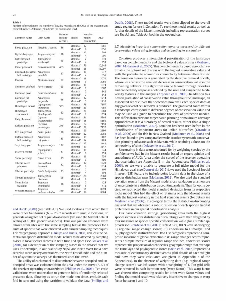
Table 1Further information on the number of locality records and the AICc of the maximal andminimal models. Asterisks (*) indicate the final model used.
Common name Latin nameNumberlocalityrecords
ModelNumbermodelparameters
AICc
Blood pheasant Ithaginis cruentus 56Maximal 17 1381Minimal* 7 1356
Blyth's tragopan Tragopan blythii 36Maximal 10 903Minimal* 4 901
Buff-throatedpartridge
Tetraophasisszechenyii
15Maximal 7 370Minimal* 4 359
Cheer pheasant Catreus wallichi 463Maximal* 76 10,946Minimal 28 11,097
Chestnut-breastedhill partridge
Arborophilamandelli
27Maximal 10 677Minimal* 4 656
Chukar Alectoris chukar 77Maximal* 18 2070Minimal 6 2080
Common peafowl Pavo cristatus 65Maximal 16 1673Minimal* 9 1667
Common quail Coturnix coturnix 12Maximal 2 342Minimal* 2 342
Common hillpartridge
Arborophilatorqueola
68Maximal 17 1714Minimal* 5 1710
Himalayan monalLophophorusimpejanus
303Maximal 79 7867Minimal* 36 7789
Himalayansnowcock
Tetraogallushimalayensis
62Maximal 20 1588Minimal* 6 1574
Kalij pheasantLophuraleucomenalos
202Maximal 81 5368Minimal* 28 5186
Koklass pheasantPucrasiamacrolopha
275Maximal 72 7150Minimal* 29 7132
Red junglefowl Gallus gallus 116Maximal 41 2999Minimal* 22 2968
Rufous-throatedhill partridge
Arborophilarufogularis
53Maximal 19 1187Minimal* 14 1183
Satyr tragopan Tragopan satyra 132Maximal* 23 3142Minimal 13 3147
Sclater's monalLophophorussclateri
37Maximal 10 944Minimal* 6 933
Snow partridge Lerwa lerwa 19Maximal 16 759Minimal* 9 499
Tibetan earedpheasant
Crossoptilonharmani
52Maximal 12 1329Minimal* 6 1314
Tibetan partridge Perdix hodgsoniae 33Maximal 7 896Minimal* 4 894
Tibetan snowcockTetraogallustibetanus
98Maximal* 20 2669Minimal 8 2677
Temminck'stragopan
Tragopantemminckii
16Maximal 7 425Minimal* 5 413
Western tragopanTragopanmelanocephalus
350Maximal 91 8393Minimal* 22 8384
24 J.C. Dunn et al. / Biological Conservation 196 (2016) 22–30
and Dudík (2008) (see Table A.3). We used locations from which therewere other Galliformes (N = 2567 records with unique locations) togenerate a targeted set of pseudo absences (we used theMaxent defaultsetting of 10,000 pseudo absences). Thus our pseudo absences werechosen from sites with the same sampling bias as the presences for asuite of species that were observed with similar sampling techniques.This ‘target group’ approach (Phillips and Dudík, 2008) reduces the po-tential for species distribution model results to be affected by samplingbiases in focal species records in both time and space (see Boakes et al.(2010) for a description of the sampling biases in the dataset that weuse). For example, in our case study Nepal and North West India havereceivedmore survey attention vs. the North East of India and the num-ber of systematic surveys has fluctuated since the 1980s.
The ability of each model to discriminate between occupied and un-occupied areas was estimated from the area under the curve (AUC) ofthe receiver operating characteristics (Phillips et al., 2006). Ten crossvalidations were undertaken to generate folds of randomly selectedpresence data, allowing us to run the model ten times, exclude eachfold in turn and using the partition to validate the data (Phillips and
Dudík, 2008). These model results were then clipped to the overallstudy region for use in Zonation. To see these model results as well asfurther details of the Maxent models including representation curvessee Fig. A.1 and Table A.4 both in the Appendices.
2.2. Identifying important conservation areas as measured by differentconservation values using Zonation and accounting for uncertainty
Zonation produces a hierarchical prioritisation of the landscapebased on complementarity and the biological value of sites (Moilanen,2007; Moilanen et al., 2005). This complementarity based algorithm es-timates the optimal set of areas with the highest cumulative value andwith the potential to account for connectivity between different sites.The Zonation hierarchy is generated by the iterative removal of cells,whose loss causes the smallest decrease in conservation value in theremaining network. This algorithm can be tailored through prioritiesand connectivity responses defined by the user and assigned to biodi-versity features in the analysis (Arponen et al., 2005). In addition to anested graduation of conservation value throughout the landscape, anassociated set of curves that describes how well each species does atany given level of cell removal is produced. The graduated zones withina landscape correspond to different degrees of conservation value andmay be used as a guide to determine the level of protection needed.This differs from previous target based planning or maximum coverageapproaches as it is a hierarchy of nested results, rather than a singleoptimisation (Moilanen, 2007). Zonation has been used before in theidentification of important areas for Italian butterflies (Girardelloet al., 2009) and for fish in New Zealand (Moilanen et al., 2008) andhas been found to give comparable results to other systematic conserva-tion planning software such as Marxan, while retaining a focus on theconnectivity of sites (Delavenne et al., 2012).
Uncertainty in data were accounted for by weighting species by theconfidence we had in the Maxent results based on expert opinion andsmoothness of AUCs (area under the curve) of the receiver operatingcharacteristics (see Appendix B in the Appendices; Phillips et al.,2006). As we were unable to generate a full niche model for theHimalayan quail (see Dunn et al. (2015)),we used the Species of SpecialInterest (SSI) feature to include point locality data in the place of aspecies distribution map (Moilanen, 2012). We also used the standarddeviation results from theMaxentmodel cross validations as ameasureof uncertainty in a distribution discounting analysis. Thus for each spe-cies, we subtracted the model standard deviation from its respectiveniche model. This had the effect of retaining only the Maxent resultswith the highest certainty in the final Zonation results (for details seeMoilanen et al. (2006)). In ecological terms, the distribution discountingensured that we obtained a robust reflection of each species' habitatpreferences in our spatial prioritisation analysis.
Our basic Zonation settings (prioritising areas with the highestspecies richness after distribution discounting) were then weighted byfour measures of species specific conservation value (for a similar ap-proach see Girardello et al. (2009); Table A.5): i) IUCN Red List category;ii) regional range change scores; iii) endemism to Himalaya; andiv) phylogenetic distinctiveness. Red List categories represent a com-posite measure of global extinction risk, range changes scores repre-sents a simple measure of regional range declines, endemism scoresrepresent the proportion of each species' geographic range that overlapsthe Himalaya and phylogenetic scores (Stein et al., 2015) represent ameasure of evolutionary distinctiveness (full details of each weightand how they were calculated are given in Appendix B of theAppendices). In the absence of weighting data (e.g. regional rangechange scores), we left scores with a weighting of 1. Ten grid cellswere removed in each iteration step (warp factor). This warp factorwas chosen after comparing results for other warp factor values andfinding that model result was relatively insensitive to changes in warpfactor between 1 and 10.

25J.C. Dunn et al. / Biological Conservation 196 (2016) 22–30
We compared the spatial distribution of five different Zonation sce-narios (one unweighted and four weighted) and examined representa-tion curves for eachmeasure of conservation value. The top 18.1% of thestudy area for each Zonation analysiswas extracted and compared usingthe Kappa statistic, a measure agreement between categorical resultsusingMap Comparison Kit 3.2.3 (Visser and De Nijs, 2006) and a Spear-man rank correlation of the continuous results using ENMTools(Warren et al., 2008, 2010). The 18.1% figure was chosen to representthemost important areas of the study area based on the current propor-tion of the Himalayas taken up by protected areas, which is also close tothe Aichi Target 11 figure of 17%.
2.3. Assessing the representation of important conservation areas forGalliformes conservation within the protected area network
Protected Area shapefiles (a total of 119 from IUCN PA categoriesI–IV) were downloaded from www.protectedplanet.net (downloaded01/02/2014; see Fig. 1 and Table A.6 for further details) and used inthe same Zonation analyses as before. In doing this, the most importantconservation areas within the landscape were ‘forced’ through theexisting PA network (for examples see Cabeza and Moilanen (2006);Kremen et al. (2008); Leathwick et al. (2008)). Thus, if important con-servation areas are spatially congruent with the existing PA network,the most important conservation areas within the landscape should be
Fig. 1.Maps showing: A) the location of the existing protected area network (N = 119 PAs indiscounting. For A), national parks are coloured by the country that they overlap most withareas and the coolest colours indicate the least important conservation areas: black = 0–20%90–95%, dark red = 95–98% and red = 98–100% (most important areas). The top fraction (1of a total of 654,772 km2, which is equal to the current area taken up by PAs.
in the same place. We compared representation curves at the level ofcell removal (proportion of landscape lost) that corresponded to thegeographic area of our existing protected area network. This was118,543 km2 out of a possible 654,772 km2, corresponding to 18.1% ofall land in our study site. This comparison was made across all speciesand shown both as an average value for both all species and specieswith the smallest proportion of their range within the top fraction ofthe Zonation result (denoted as ‘worst off species’).
Finally, we compared the top 18.1% of Zonation results from differ-ently weighted Zonation results to see howmuch they overlapped spa-tially with the existing PA network. If important areas of Galliformesbiodiversity are represented significantly less well in the currentprotected area network vs. the optimal Zonation results, it might sug-gest that protected areas are situated in the wrong place.
3. Results
3.1. Mapping Galliformes distributions within the Himalaya
The modelled distributions indicated that Galliformes were distrib-uted across the entire study area (Fig. 1). AUC values ranged from0.95 ± 0.01 (SE) for western tragopan to 0.47 ± 0.13 (SD) for commonquail (indicating a poormodel – for further details seeAppendix B). AUCvalues were high across the majority of our distribution models
total); and B) an example of the unweighted Zonation output map following distributionin terms of area. For B), the warmest colours indicate the most important conservation(least important areas), dark blue = 20–50%, blue = 50–75%, yellow = 75–90%, pink =8.1%) of each Zonation output corresponds to an area of approximately 118,513 km2 out

Table 2Spatial comparison of different Zonation solutions (optimal) based on both continuousoutput (Spearman rank coefficient, intercept and slope) and categorical output of top18.1% of the solution (Kappa, Klocation, Khistogram and fraction agreement). Zonation output
26 J.C. Dunn et al. / Biological Conservation 196 (2016) 22–30
(Table A.3) and across 23 species the mean AUC was 0.84 ± 0.08 (SD).Individual Maxent maps for each species are shown in the Appendices(Fig. A.1).
codes: BA= basic, DD= distribution discounting, EN = endemism, RL = Red List, PD=phylogenetic distinctiveness and RRC = relative range change. Values of Kappa (afterLandis and Koch (1977)): b0 = no agreement, 0–0.20 = slight, 0.21–0.40 = fair,0.41–0.60=moderate, 0.61–0.80= substantial, and 0.81–1= almost perfect agreement.
Categorical Continuous
Comparison Kappa Klocation Khistogram
Fractionagreement r2 Intercept Slope
BA X DD 0.79 0.79 1.00 0.94 1.00 0.00 1.00DD X EN 0.53 0.53 1.00 0.86 0.84 −0.34 0.67DD X RL 0.49 0.49 1.00 0.85 0.99 −0.01 0.99DD X PD 0.55 0.55 1.00 0.87 0.99 −0.01 0.99DD X RRC 0.56 0.56 1.00 0.87 0.99 −0.01 0.99EN X RL 0.61 0.61 1.00 0.88 0.99 0.26 1.26EN X PD 0.33 0.33 1.00 0.80 0.97 0.04 1.04EN X RRC 0.44 0.44 1.00 0.80 1.00 0.12 1.12RL X PD 0.24 0.24 1.00 0.77 0.98 −0.01 0.98RL X RRC 0.34 0.34 1.00 0.80 0.99 −0.01 0.99PD X RRC 0.39 0.39 1.00 0.82 0.98 −0.01 0.98
3.2. Identifying important conservation areas asmeasured by different con-servation values using Zonation and accounting for uncertainty
The results from the Zonation analysis broadly indicate the areas ofhigh Galliformes species richness were: North West India, CentralBhutan and North East India and along the southern border of China(as shown by the unweighted Zonation result map in Fig. 1). Theseareas were proven to be consistently important for Galliformes of con-servation concern, regardless of which of the four types of conservationvaluewere examined (Fig. 2). Zonation representation curves andmapsfor each type of conservation value are shown in Appendix B (Figs. A.3and A.4).
Examination of details did highlight some statistically significantdifferences (both categorical and continuous) between types of con-servation value (see Table 2 and Fig. A.5 in the Appendices). On itsown, weighting by Red List places greater importance towardsareas in Eastern India/Myanmar whereas weighting by endemismplaces greater importance on areas in Bhutan/Eastern India. Areasweighted by phylogenetic distinctiveness do not overlap withareas weighted by range changes in the North West of the Himalaya(Fig. 2). Similarly, areas weighted by endemism do not overlap withareas weighted by Red List in the South East of the Himalaya (Fig. 2).The area of overlap between every different Zonation scenario is29,688 km2, which is 4.5% of the total study site area and 25.2% of
Fig. 2. Maps showing the level of overlaps for: A) all Zonation results; and B) single ZonationAppendices. Most of the areas are coloured black, which indicates a lack of overlap between Zshow the extent of overlap. The area of overlap between all Zonation results corresponds to anetwork. The Zonation output codes: DD= distribution discounting, EN = endemism, RL = R
the area taken up by the top fraction (i.e. top 18.1%) of any one Zo-nation result.
Overlap between the basic Zonation result and the distributiondiscounted Zonation result (based upon uncertainty in predictedrange) is very high (Table 2). This suggests that accounting for uncer-tainty in Maxent results does not change the spatial location of theZonation result greatly.
results only. For a more detailed breakdown of the areas involved see Table A.7 in theonation results for each respective scenario, while the different colours for each scenarion area of approximately 29,688 km2 and 23.5% of this area overlaps with the current PAed List, PD = phylogenetic diversity and RRC = relative range change.

Table 3A comparison of the proportion of species' distributions remaining between the optimal and constrained Zonation results at the level corresponding to the protected area network (18.1%).A 1 tailed equality of proportions test revealed that the optimal Zonation results averaged across all species contained a significantly greater proportion of all species distributions than theconstrained Zonation results for DD (‘distribution discounting’), EN (‘endemic species’) and RL (‘Red List’) species (proportions are given to 2 d.p., hence small differences between X2
values between average Zonation results ‘EN’ and ‘RL’). The mean increase in distributions covered from the optimal vs. constrained analyses across the five conservation prioritisationscenarios was 58% (e.g. (0.3–0.19)/0.19= 0.58, thus a 58% increase for the optimal Zonation result vs. the constrained one). However, for the worst off species only, there were no signif-icant differences between constrained and optimal Zonation results across all results. Note: the overall size of the Zonation result areas between the optimal and constrained Zonationresults remains constant and only the proportion of species distributions represented by each Zonation result changes.
Average proportion distributions remaining Minimum proportion distributions remaining
Zonation result Optimal Constrained Χ2 p value Optimal Constrained Χ2 p value
DD 0.30 0.19 2.74 0.05 0.10 0.09 0.00 0.50EN 0.30 0.18 3.06 0.04 0.09 0.08 0.00 0.50RL 0.30 0.18 2.92 0.04 0.09 0.08 0.00 0.50PD 0.26 0.18 1.50 0.11 0.15 0.10 0.70 0.20RRC 0.28 0.19 2.07 0.08 0.10 0.09 0.00 0.50
27J.C. Dunn et al. / Biological Conservation 196 (2016) 22–30
3.3. Assessing the representation of important areas for Galliformesconservation within the protected area network
If wewere able to place the current PAnetwork in an optimalmanner,themaximumproportion of each species' Himalayan range thatwe couldsafeguard would be c.29% (on average across the five different conserva-tion prioritisation scenarios; see Table 3). However, our results indicatethat the existing PA network provides a poorer fit than the optimal Zona-tion result as derived via three out of five different conservationprioritisation methods. Specifically, the optimal Zonation results retainalmost twice the proportion of species' ranges in comparison to theconstrained Zonation result for: (i) total species richness (unweightedresults); (ii) for species at the greatest risk of global extinction (resultweighted by Red List score); and (iii) for species with the narrowestendemism to the Himalaya (result weighted by endemism).
While the top fraction of each optimal Zonation result corresponded toan area of 118,543 km2 of land, on average, only 21,095 km2 (17.8%) ofthat area was found to be inside the existing PA network (see Table 4).This means that 82.2% of land that is important for Galliformes of conser-vation concern (as measured across our different conservation values)does not have any legal protection. When the top fractions for eachZonation scenario were combined, just 23.6% of this area (6,993 km2)fell within the current PA network, which corresponds to 1.1% of thetotal study site area (see Fig. A.6 to see the combined top Zonation frac-tions that are outside the current PA network). Taken together, thesetwo results indicate that the existing PA network does not capture themost important areas for Galliformes of conservation concern.
4. Discussion
PAs have a vital role to play in achieving global biodiversity tar-gets (Rodrigues et al., 2004; Secretariat of the CBD, 2010), withsuch areas ideally placed where levels of biodiversity and the impact
Table 4A comparison of the spatial overlap between the top fraction of the optimal Zonation re-sults and the existing protected area network. The top fraction is constant and correspondsto 18.1% or 118,513 km2 of the study region. On average, only 17.8% of any top fraction iscontained inside the existing PA network (as measured across the five conservationprioritisation scenarios). Zonation result codes: BA = basic, DD = distributiondiscounting, EN = endemism, RL = Red List, PD = phylogenetic distinctiveness andRRC = relative range change.
Optimalresult
Area of top fraction inside PAnetwork, km2
Percentage of top fraction insidePA network
DD 21,336 15.6RL 20,868 17.9RRC 19,862 17.0PD 23,321 20.1EN 21,443 18.4
of threatening processes are high (Ricketts et al., 2005). Understand-ing the role of PAs in conserving biodiversity is very difficult, espe-cially given the multiple demands placed on them as shown byAichi Target 11. Assessing whether the placement of the PA networkin the Greater Himalaya for Galliformes is optimal is a particularlyimportant case study, as the region has been identified as a priorityfor conservation efforts and Galliformes contain a high proportionof species of conservation concern. We found that there were somedifferences in the location of important conservation areas identifiedbased on different ways of valuing biodiversity, and that for three ofthe five different ways of prioritising biodiversity conservation, theconfiguration of the existing PA network was significantly worsethan the optimal Zonation result. We can have a high degree of con-fidence in our results, because the methods that we used allowed usto account for uncertainties in our knowledge of the spatial distribu-tion of biodiversity.
4.1. Implications for the conservation of Galliformes
Protection of at least 17% of terrestrial land is required by CBD tar-gets (Secretariat of the CBD, 2010), but over 18% of the Greater Himala-yan area is already protected, passing this target. However, we foundevidence that the current PA network fails to adequately represent thedistributions of Galliformes in the Greater Himalaya at the level of theCBD target for both: i) unweighted Zonation results (all Galliformes);and ii) Zonation results weighted by IUCN Red List (Galliformes threat-ened with global extinction) and endemism to the Himalayas(Galliformes with the majority of their global range in the Himalaya).In contrast, we find that the current PA network reasonably representsthe distributions of Galliformes weighted by phylogenetic diversity andrange changes. The overlap between different priority areas is small interms of the overall proportion of the Greater Himalaya and only afifth of the overlapping area is already captured by the current Himala-yan protected area network. This implies that although different valuesof conservation are represented somewhere within the current PA net-work, they are often not in the same locations or in sufficient amountsto achieve the CBD target.
We found species at the greatest risk of global extinction and thosewith the narrowest endemism to the Himalaya to be less well coveredby the current PA network than the optimum Zonation result, whichsuggests that redesigning the PA network would result in greater cap-ture of the ranges of these species and so higher safeguarding of Hima-layan Galliformes. This need not be based exclusively on the modelleddata given here, but could incorporate locations identified as ImportantBird and Biodiversity Areas (IBAs; BirdLife International, 2008), whichprioritises bird species with high global extinction risk and endemismabove other criteria. At the very least, the most important areas of com-bined conservation value that are currently outside the PA networkcould be used as a guide to expand or better orientate the PA network.

28 J.C. Dunn et al. / Biological Conservation 196 (2016) 22–30
To aid conservation management, we have provided three resources inthe Appendix: (i) a map of the most important conservation areas out-side the existing PA network (Fig. A.6); (ii) a .kml file of these areas thatcan be used with Google Earth; and (iii) a table of seven localities withgeographic coordinates (Table A.8). Nevertheless, it is worrying thatwe are underrepresenting distributions for Galliformes species threat-ened with global extinction in the current Himalayan PA network by58% (average distribution of species covered – see Table 3).
4.2. Implications for Aichi Target 11
While our results have direct conservation implications for theHimalaya (caveats notwithstanding), in a broader sense they demon-strate thatmeeting theAichi percentage coverage targetmaybedifficultto achieve if we wish to simultaneously capture different conservationvalues in areas that are of ‘particular importance for biodiversity andecosystem services’. In this way our study can be said to act as a micro-cosm of the challenges other countries and areas face in meeting theircommitments to Aichi Target 11 and specifically clause three.
Percentage based targets have been criticised, as different levels ofPA coverage may be needed depending on the specific biodiversity out-comes that we wish to achieve (Rodrigues et al., 2004). For example, itmay be that more than 17% of the land in our study region requires for-mal protection tominimise Galliformes extinctions in the Himalaya andour study does not consider the efficacy of PAs in preventing extirpa-tions. To prevent extinctionswithin PAs, effective enforcement is essen-tial, but Clark et al. (2013) show that South East Asian PAs are noteffective in preventing habitat conversion and Hilaluddin and Ghose(2005) and Kaul et al. (2004) show that hunting of Galliformes is prev-alent across the Himalayas. These studies emphasise that both manage-ment effectiveness and biodiversity outcomes are important indetermining efficacy. This is because, even if the location of the PA net-work did adequately represent important Galliformes of conservationconcern, it might not offer much in the way of actual protection. Betterenforcement would require greater resources, and it is established thatprotected areas are underfunded (McCarthy et al., 2012). Therefore, thegovernments responsible might need to allocate greater funding tothese protected areas for them to be most effective.
Better managed PAs may result in greater conservation effective-ness/outcomes than the present configuration. A better approachcould be to identify which areas and habitats that harbour significantpopulations of Galliformes are needed to minimise extinctions and toredesign and/or expand the PA area network accordingly (Fuller et al.(2010) use this approach). We only looked at PAs in IUCN categoriesI–IV (PAs established primarily for biodiversity conservation) andother effective area based conservation measures are also being consid-ered (e.g. “multiple use” PAs in categories V–VI). For example, commu-nity forests in Nepal have been shown to have high conservation valueeven if they lack formal protection, as they generate livelihood opportu-nities that decrease pressures placed on PAs (Dahal et al., 2014).We didnot include categories V–VI because we sought to include PAsestablished primarily for biodiversity conservation vs. ‘multiple use’PAs in our analysis. This amounted to omitting 21 extra PAs from ourstudy, mainly from China. These 21 PAs provided a 117% increase inthe total area of the study region taken up by PAs. Despite this, only16% of the areas we identified as priorities for expansion fell withinthe existing V–VI category PAs, making it unlikely that including these‘multiple use’ PAs in our analysis will affect our results significantly.
4.3. Caveats
Our results come with some caveats: the first relates to our use of aspecies' environmental niche as a proxy for species occurrence. Thus,the realised niche of a species may depend on biogeographical, histori-cal or biotic factors in addition to the abiotic factors used in our model,potentially decreasing the reliability of some of these models (Guisan
and Thuiller, 2005; Rondinini et al., 2006). However, these areas shouldbe more accurate than extent of occurrences, as used in previous analy-ses (e.g. Venter et al., 2014). We investigated potential variations inmodel reliability by using a combination of distribution discountingand model weighting. Our results showed that accounting for variationin the nichemodelling process did not change the location of the resultsgiven by Zonation greatly. This is likely to be due to the use of the corearea algorithm rather than an artefact of the distribution discountingmethod itself. Nevertheless, by accounting for uncertainties in thisway, we are able to ensure that our results are robust.
The second caveat is related to the first, as by using niche modellingin conservation planning we run the risk of adding commission errors(false positives) to our analysis (Rondinini et al., 2006). If these commis-sion errors are large, we might overestimate the true proportion of im-portant conservation areas represented within the PA network(Rodrigues and Gaston, 2001). Given that some of our species arethreatened by hunting, it is possible that there are some instanceswhere they are locally extinct in areas of good habitat. One way to ac-count for this is to test our distributionmodels using field based studies,though this may be impractical across such a large area. However, it isimportant to point out that by using the core area algorithm in Zonation,we do retain areas of distributions with the highest probabilities of oc-currence for each species (Moilanen, 2007; Moilanen et al., 2005),which reduces the likelihood of commission errors and that such errorsmay be small in comparison to other methods of representing speciesdistributions such as extent of occurrence (Beresford et al., 2011;Rodrigues, 2011).
The third caveat is that PA placement is often biased towards eco-nomically low value areas (Joppa and Pfaff, 2010, 2011a), so the factthat we found the existing PA network to be less than optimally placedfor Galliformes could be an artefact of this pattern. However, it is unlike-ly that this is true, asmanyHimalayanGalliformes are typically found inforests, which can be in both economically high and low value areas. Anextension to our analysis would be to conduct a counter factual study tocompare our results with those obtained where the placement of theexisting PA network is randomised, potentially using a ‘matching’ ap-proach to control for the fact that PAs are not randomly distributedacross the landscape (e.g. Joppa and Pfaff, 2011b). One other explana-tion for our results is that the PA network was not designed explicitlyfor Galliformes alone. Thus, it would be informative to conduct ouranalysiswith other taxonomic groups before any changes to the existingPA network in the Himalaya were definitively made. This is important,as there are a disproportionately large number of other threatened ter-restrial species in the Himalaya (Hoffmann et al., 2010), with currentlevels of deforestation predicted towipe out almost a quarter of endem-ic species, including 366 endemic vascular plant taxa and 35 endemicvertebrate taxa by 2100 in the Indian Himalaya alone (Pandit et al.,2006).
Finally, it is important to note, that while the current network doesnot adequately represent Galliformes species of conservation concernat present, species distributions may move with climate change (Rootet al., 2003), so the placement of the PA network may be even moresub-optimal in the future (Hannah et al., 2007). This may have impor-tant ramifications, especially for alpine specialist species such as bloodpheasant (Ithaginis cruentus), which may be trapped on effective ‘skyislands’ (Heald, 1967) making them particularly susceptible to climatechange (Kupfer et al., 2005). We have also grouped together differentcategories of PA, with different levels of protection afforded (Dudley,2009) and some of the PAs cross-international boundaries (9% of the119 Himalayan PAs are transnational) with different management re-gimes between countries and different countries controlling differentproportions of the PA network. Therefore, in the future it may benecessary to investigate how climate changes may affect Galliformesdistributions, to assess the representation of Galliformes withindifferent types of PA categories and for greater cross border cooperationbetweenHimalayan countries to occur if we are to ensure the continued

29J.C. Dunn et al. / Biological Conservation 196 (2016) 22–30
survival of this bird Order. Similarly, we have not incorporatedprojected land use changes in our analysis. Incorporating projectedland use models (e.g. Pouzols et al., 2014) and agricultural costs (e.g.Dobrovolski et al., 2014) into our priority setting would be a useful ex-tension thatwould increase the relevance of our results for practitionersand policy makers.
5. Conclusion
Overall, in this paper we illustrate some of the difficulties in achiev-ing Aichi Target 11 by using Himalayan Galliformes as a case study. Wefound that the current protected area network failed to capture theseimportant localities for some types of conservation value. This suggeststhat expanding PA networks to achieve the 17% coverage of ‘areas ofparticular importance for biodiversity’ required by Aichi Target 11may be difficult to achieve, both globally and nationally. We testedfour different measures of species specific conservation value relatingto preserving biodiversity patterns and species with the highest needof protection, but other qualitatively differentmeasures, such as cost ef-fectiveness could be investigated further. In line with other studies, wesuggest that conservation planners and legislators also need to devotemore efforts to the problem of enforcement within Himalayan PAs ifwe are to effectively prevent extirpations. Finally, although an impor-tant group from a conservation point of view, Galliformes represent asmall fraction of the total biodiversity within the Himalayan regionand it is important for future research to assess whether the resultswe observe are congruent with results based on other taxa. This paperprovides an example of the need to consider different types of conserva-tion valuewhen assessing the spatial configuration of PAs. Themethodsthat we use could be applied to other species and regions, somethingthat will help attain CBD targets.
Acknowledgements
Many thanks go to Dr. Elizabeth Boakes for her help in accessing andmanipulating the original data from the GALLIFORM database. Thanksalso go to the IRMAC centre and Compute Canada, for their support ofRWS. We are grateful to two anonymous reviewers for their commentsthat improved this manuscript.
Map. KMZ file containing the Google map of the most importantareas described in this article.
Appendix A. Supplementary data
Supplementary data associated with this article can be found in theonline version, at doi: http://dx.doi.org/10.1016/j.biocon.2016.01.015.These data include the Google map of the most important areas de-scribed in this article.
References
Arponen, A., 2012. Prioritizing species for conservation planning. Biodivers. Conserv. 21,875–893.
Arponen, A., Heikkinen, R.K., Thomas, C.D., Moilanen, A., 2005. The value of biodiversity inreserve selection: representation, species weighting, and benefit functions. Conserv.Biol. 19, 2009–2014.
Beresford, A.E., Buchanan, G.M., Donald, P.F., Butchart, S.H.M., Fishpool, L.D.C., Rondinini,C., 2011. Poor overlap between the distribution of Protected Areas and globallythreatened birds in Africa. Anim. Conserv. 14, 99–107.
BirdLife International, 2008. Threatened Birds of the World 2008 CD-ROM.Boakes, E.H., McGowan, P.J.K., Fuller, R.A., Chang-Qing, D., Clark, N.E., O’Connor, K., Mace,
G.M., 2010. Distorted views of biodiversity: spatial and temporal bias in species oc-currence data. PLoS Biol. 8, e1000385.
Boitani, L., Maiorano, L., Baisero, D., Falcucci, A., Visconti, P., Rondinini, C., 2011. What spa-tial data do we need to develop global mammal conservation strategies? Philos.Trans. R. Soc. B Biol. Sci. 366, 2623–2632.
Boyd, C., Brooks, T.M., Butchart, S.H.M., Edgar, G.J., Da Fonseca, G.A.B., Hawkins, F.,Hoffmann,M., Sechrest, W., Stuart, S.N., Van Dijk, P.P., 2008. Spatial scale and the con-servation of threatened species. Conserv. Lett. 1, 37–43.
Brooks, T.M., Mittermeier, R.A., da Fonseca, G.A., Gerlach, J., Hoffmann, M., Lamoreux, J.F.,Mittermeier, C.G., Pilgrim, J.D., Rodrigues, A.S., 2006. Global biodiversity conservationpriorities. Science 313 (5783), 58–61.
Bruner, A.G., Gullison, R.E., Rice, R.E., da Fonseca, G.A.B., 2001. Effectiveness of parks inprotecting tropical biodiversity. Science (80-.) 291, 125–128.
Butchart, S.H.M., Clarke, M., Smith, R.J., Sykes, R.E., Scharlemann, J.P.W., Harfoot, M.,Buchanan, G.M., Angulo, A., Balmford, A., Bertzky, B., Brooks, T.M., Carpenter, K.E.,Comeros-Raynal, M.T., Cornell, J., Ficetola, G.F., Fishpool, L.D.C., Fuller, R.A.,Geldmann, J., Harwell, H., Hilton-Taylor, C., Hoffmann, M., Joolia, A., Joppa, L.,Kingston, N., May, I., Milam, A., Polidoro, A., Ralph, A., Richman, N., Rondinini, C.,Segan, D., Skolnik, B., Spalding, M., Stuart, S.N., Symes, A., Taylor, J., Visconti, P.,Watson, J., Wood, L., Burgess, N.D., 2015. Shortfalls and solutions for meeting nationaland global conservation area targets. Conserv. Lett. 8, 329–337.
Butchart, S.H.M., Scharlemann, J.P.W., Evans, M.I., Quader, S., Aricò, S., Arinaitwe, J.,Balman, M., Bennun, L.A, Bertzky, B., Besançon, C., Boucher, T.M., Brooks, T.M.,Burfield, I.J., Burgess, N.D., Chan, S., Clay, R.P., Crosby, M.J., Davidson, N.C., de Silva,N., Devenish, C., Dutson, G.C.L., Fernández, D.F.D., Fishpool, L.D.C., Fitzgerald, C.,Foster, M., Heath, M.F., Hockings, M., Hoffmann, M., Knox, D., Larsen, F.W.,Lamoreux, J.F., Loucks, C., May, I., Millett, J., Molloy, D., Morling, P., Parr, M., Ricketts,T.H., Seddon, N., Skolnik, B., Stuart, S.N., Upgren, A., Woodley, S., 2012. Protecting im-portant sites for biodiversity contributes to meeting global conservation targets. PLoSOne 7.
Cabeza, M., Moilanen, A., 2006. Replacement cost: a practical measure of site value forcost-effective reserve planning. Biol. Conserv. 132, 336–342.
Ceballos, G., Ehrlich, P.R., 2006. Global mammal distributions, biodiversity hotspots, andconservation. Proc. Natl. Acad. Sci. U. S. A. 103, 19374–19379.
Cincotta, R.P., Wisnewski, J., Engelman, R., 2000. Human population in the biodiversityhotspots. Nature 404, 990–992.
Clark, N.E., Boakes, E.H., McGowan, P.J.K., Mace, G.M., Fuller, R.A., 2013. Protected areas inSouth Asia have not prevented habitat loss: a study using historical models of land-use change. PLoS One 8, e65298.
Dahal, B.R., McAlpine, C.A., Maron, M., 2014. Bird conservation values of off-reserveforests in lowland Nepal. For. Ecol. Manag. 323, 28–38.
Delavenne, J., Metcalfe, K., Smith, R.J., Vaz, S., Martin, C.S., Dupuis, L., Coppin, F., Carpentier,A., 2012. Systematic conservation planning in the eastern English Channel: compar-ing the Marxan and Zonation decision-support tools. ICES J. Mar. Sci. 69, 75–83.
Dobrovolski, R., Loyola, R., DA Fonseca, G.A.B., Diniz-Filho, J.A.F., Araujo, M.B., 2014. Glob-alizing conservation efforts to save species and enhance food production. Bioscience64, 539–545.
Dudley, N., 2009. Guidelines for Applying Protected Area Management Categories, World.IUCN, Gland, Switzerland.
Dunn, J.C., Buchanan, G.M., Cuthbert, R.J., Whittingham, M.J., McGowan, P.J.K., 2015. Map-ping the potential distribution of the critically endangered Himalayan quail Ophrysiasuperciliosa using proxy species and species distribution modelling. Bird Conserv. Int.1–13.
Elith, J., Graham, C.H., 2009. Do they?Howdo they?Why do they differ?On finding reasonsfor differing performances of species distribution models. Ecography (Cop.) 32, 66–77.
Elith, J., Phillips, S.J., Hastie, T., Dudík, M., Chee, Y.E., Yates, C.J., 2011. A statistical explana-tion of MaxEnt for ecologists. Divers. Distrib. 17, 43–57.
ENVIS, 2007. Galliformes of India. Wildlife Institute of India, Dehradun, India.Fuller, R.A., McDonald-Madden, E., Wilson, K.A., Carwardine, J., Grantham, H.S., Watson,
J.E.M., Klein, C.J., Green, D.C., Possingham, H.P., 2010. Replacing underperformingprotected areas achieves better conservation outcomes. Nature 466, 365–367.
Funk, V.A., Richardson, K.S., 2002. Systematic data in biodiversity studies: use it or lose it.Syst. Biol. 51, 303–316.
Gaston, K.J., 2000. Global patterns in biodiversity. Nature 405, 220–227.Gaston, K.J., Rodrigues, A.S.L., 2003. Reserve selection in regions with poor biological data.
Conserv. Biol. 17, 188–195.Girardello, M., Griggio, M., Whittingham, M.J., Rushton, S.P., 2009. Identifying important
areas for butterfly conservation in Italy. Anim. Conserv. 12, 20–28.Grenyer, R., Orme, C.D.L., Jackson, S.F., Thomas, G.H., Davies, R.G., Davies, T.J., Jones, K.E.,
Olson, V.A., Ridgely, R.S., Rasmussen, P.C., Ding, T.-S., Bennett, P.M., Blackburn, T.M.,Gaston, K.J., Gittleman, J.L., Owens, I.P.F., 2006. Global distribution and conservationof rare and threatened vertebrates. Nature 444, 93–96.
Guisan, A., Thuiller, W., 2005. Predicting species distribution: offering more than simplehabitat models. Ecol. Lett. 8, 993–1009.
Guisan, A., Zimmermann, N.E., 2000. Predictive habitat distribution models in ecology.Ecol. Model. 135, 147–186.
Hannah, L., Midgley, G., Andelman, S., Araújo, M., Hughes, G., Martinez-Meyer, E., Pearson,R.,Williams, P., 2007. Protected area needs in a changing climate. Front. Ecol. Environ.5, 131–138.
Heald, W., 1967. Sky Islands. Van Nostrard, New York, USA.Hilaluddin, K., Ghose, D., 2005. Conservation implications of wild animal biomass extrac-
tions in Northeast India. Anim. Biodivers. Conserv. 28, 169–179.Hoffmann, M., Hilton-Taylor, C., Angulo, A., Bohm, M., Brooks, T.M., Butchart, S.H.M.,
Carpenter, K.E., Chanson, J., Collen, B., Cox, N.A., Darwall, W.R.T., Dulvy, N.K.,Harrison, L.R., Katariya, V., Pollock, C.M., Quader, S., Richman, N.I., Rodrigues, A.S.L.,Tognelli, M.F., Vie, J.C., Aguiar, J.M., Allen, D.J., Allen, G.R., Amori, G., Ananjeva, N.B.,Andreone, F., Andrew, P., Ortiz, A.L.A., Baillie, J.E.M., Baldi, R., Bell, B.D., Biju, S.D.,Bird, J.P., Black-Decima, P., Blanc, J.J., Bolanos, F., Bolivar, W., Burfield, I.J., Burton,J.A., Capper, D.R., Castro, F., Catullo, G., Cavanagh, R.D., Channing, A., Chao, N.L.,Chenery, A.M., Chiozza, F., Clausnitzer, V., Collar, N.J., Collett, L.C., Collette, B.B.,Fernandez, C.F.C., Craig, M.T., Crosby, M.J., Cumberlidge, N., Cuttelod, A., Derocher,A.E., Diesmos, A.C., Donaldson, J.S., Duckworth, J.W., Dutson, G., Dutta, S.K., Emslie,R.H., Farjon, A., Fowler, S., Freyhof, J., Garshelis, D.L., Gerlach, J., Gower, D.J., Grant,T.D., Hammerson, G.A., Harris, R.B., Heaney, L.R., Hedges, S.B., Hero, J.M., Hughes, B.,

30 J.C. Dunn et al. / Biological Conservation 196 (2016) 22–30
Hussain, S.A., Icochea, J., Inger, R.F., Ishii, N., Iskandar, D.T., Jenkins, R.K.B., Kaneko, Y.,Kottelat, M., Kovacs, K.M., Kuzmin, S.L., La Marca, E., Lamoreux, J.F., Lau, M.W.N.,Lavilla, E.O., Leus, K., Lewison, R.L., Lichtenstein, G., Livingstone, S.R., Lukoschek, V.,Mallon, D.P., McGowan, P.J.K., McIvor, A., Moehlman, P.D., Molur, S., Alonso, A.M.,Musick, J.A., Nowell, K., Nussbaum, R.A., Olech, W., Orlov, N.L., Papenfuss, T.J., Parra-Olea, G., Perrin, W.F., Polidoro, B.A., Pourkazemi, M., Racey, P.A., Ragle, J.S., Ram, M.,Rathbun, G., Reynolds, R.P., Rhodin, A.G.J., Richards, S.J., Rodriguez, L.O., Ron, S.R.,Rondinini, C., Rylands, A.B., de Mitcheson, Y.S., Sanciangco, J.C., Sanders, K.L.,Santos-Barrera, G., Schipper, J., Self-Sullivan, C., Shi, Y.C., Shoemaker, A., Short, F.T.,Sillero-Zubiri, C., Silvano, D.L., Smith, K.G., Smith, A.T., Snoeks, J., Stattersfield, A.J.,Symes, A.J., Taber, A.B., Talukdar, B.K., Temple, H.J., Timmins, R., Tobias, J.A.,Tsytsulina, K., Tweddle, D., Ubeda, C., Valenti, S.V., van Dijk, P.P., Veiga, L.M., Veloso,A., Wege, D.C., Wilkinson, M., Williamson, E.A., Xie, F., Young, B.E., Akcakaya, H.R.,Bennun, L., Blackburn, T.M., Boitani, L., Dublin, H.T., da Fonseca, G.A.B., Gascon, C.,Lacher, T.E., Mace, G.M., Mainka, S.A., McNeely, J.A., Mittermeier, R.A., Reid, G.M.,Rodriguez, J.P., Rosenberg, A.A., Samways, M.J., Smart, J., Stein, B.A., Stuart, S.N.,2010. The impact of conservation on the status of the world's vertebrates. Science(80-.) 330, 1503–1509.
IUCN, 2015. The IUCN Red List of Threatened Species. Version 2015-4. [WWW Docu-ment]. URL www.iucnredlist.org (accessed 11.29.15).
Jarvis, A., Reuter, H.I., Nelson, A., Guevara, E., 2008. Hole-filled SRTM for the Globe Version4 available from CGIAR-CSI SRTM 90m Database.
Jenkins, C.N., Joppa, L., 2009. Expansion of the global terrestrial protected area system.Biol. Conserv. 142, 2166–2174.
Jetz, W., Thomas, G.H., Joy, J.B., Redding, D.W., Hartmann, K., Mooers, A.O., 2014. Global dis-tribution and conservation of evolutionary distinctness in birds. Curr. Biol. 24, 919–930.
Joppa, L., Pfaff, A., 2010. Reassessing the forest impacts of protection: the challenge ofnonrandom location and a corrective method. Ann. N. Y. Acad. Sci. 1185, 135–149.
Joppa, L.N., Pfaff, A., 2011a. Global protected area impacts. Proc. R. Soc. B Biol. Sci. 278,1633–1638.
Joppa, L.N., Pfaff, A., 2011b. Global protected area impacts. Proc. Biol. Sci. 278, 1633–1638.Kaul, R., Jandrotia, J.S., McGowan, P.J.K., 2004. Hunting of largemammals and pheasants in
the Indian western Himalaya. Oryx 38, 426–431.Kremen, C., Cameron, A., Moilanen, A., Phillips, S.J., Thomas, C.D., Beentje, H., Dransfield, J.,
Fisher, B.L., Glaw, F., Good, T.C., Harper, G.J., Hijmans, R.J., Lees, D.C., Louis, E.,Nussbaum, R.A., Raxworthy, C.J., Razafimpahanana, A., Schatz, G.E., Vences, M.,Vieites, D.R., Wright, P.C., Zjhra, M.L., 2008. Aligning conservation priorities acrosstaxa in Madagascar with high-resolution planning tools. Science (80-.) 320, 222–226.
Kupfer, J., Balmat, J., Smith, J., 2005. Shifts in the Potential Distribution of Sky Island PlantCommunities in Response to Climate Change. In: Gottfried, G., Gebow, B., Eskew, L.,Edminster, C. (Eds.), Connecting Mountain Islands and Desert Seas: Biodiversityand Management of the Madrean Archipelago II. US Department of Agriculture,Fort Collins, CO, USA, pp. 485–490.
Landis, J.R., Koch, G.G., 1977. The measurement of observer agreement for categoricaldata. Biometrics 33, 159–174.
Leathwick, J., Moilanen, A., Francis, M., Elith, J., Taylor, P., Julian, K., Hastie, T., Duffy, C.,2008. Novel methods for the design and evaluation of marine protected areas in off-shore waters. Conserv. Lett. 1, 91–102.
Lombard, A.T., Cowling, R.M., Pressey, R.L., Rebelo, A.G., 2003. Effectiveness of land classesas surrogates for species in conservation planning for the Cape Floristic Region. Biol.Conserv. 112, 45–62.
Lomolino, M.V., 2004. Conservation Biogeography. In: Lomolino, M.V., Heaney, L.R. (Eds.),Frontiers in Biogeography: New Directions in the Geography of Nature. Sinauer, NewYork, USA, pp. 293–296.
McCarthy, D.P., Donald, P.F., Scharlemann, J.P.W., Graeme, M., Balmford, A., Green, J.M.H.,Bennun, L.A., Burgess, D., Fishpool, L.D.C., Garnett, S.T., David, L., Maloney, R.F.,Morling, P., Schaefer, H.M., Wiedenfeld, D.A., Butchart, S.H.M., 2012. Financial costsof meeting global biodiversity conservation targets: current spending and unmetneeds. Science (80-.) 338, 946–949.
McGowan, P., Chang-qing, D., Kaul, R., 1999. Protected areas and the conservation ofgrouse, partridges and pheasants in east Asia. Anim. Conserv. 2, 93–102.
Miller, R.M., Rodríguez, J.P., Aniskowicz-Fowler, T., Bambaradeniya, C., Boles, R., Eaton,M.A., Gärdenfors, U., Keller, V., Molur, S., Walker, S., Pollock, C., 2006. Extinction riskand conservation priorities. Science.
Moilanen, A., 2007. Landscape Zonation, benefit functions and target-based planning:unifying reserve selection strategies. Biol. Conserv. 134, 571–579.
Moilanen, A., 2012. Zonation version 3.1 User Manual. Biodiversity Conservation Infor-matics Group, Department of Biosciences, University of Helsinki, Helsinki, Finland.
Moilanen, A., Franco, A.M.A., Early, R.I., Fox, R., Wintle, B., Thomas, C.D., 2005. Prioritizingmultiple-use landscapes for conservation: methods for large multi-species planningproblems. Proc. R. Soc. B Biol. Sci. 272, 1885–1891.
Moilanen, A., Leathwick, J., Elith, J., 2008. A method for spatial freshwater conservationprioritization. Freshw. Biol. 53, 577–592.
Moilanen, A., Runge, M.C., Elith, J., Tyre, A., Carmel, Y., Fegraus, E., Wintle, B.A., Burgman,M., Ben-Haim, Y., 2006. Planning for robust reserve networks using uncertainty anal-ysis. Ecol. Model. 199, 115–124.
Moritz, C., Richardson, K.S., Ferrier, S., Monteith, G.B., Stanisic, J., Williams, S.E., Whiffin, T.,2001. Biogeographical concordance and efficiency of taxon indicators for establishingconservation priority in a tropical rainforest biota. Proc. R. Soc. B Biol. Sci. 268,1875–1881.
Myers, N., Mittermeier, R.A., Mittermeier, C.G., da Fonseca, G.A., Kent, J., 2000. Biodiversityhotspots for conservation priorities. Nature 403, 853–858.
Nunes, P.A.L., van den Bergh, J.C.J., 2001. Economic valuation of biodiversity: sense or non-sense? Ecol. Econ. 39, 203–222.
Olson, D.M., Dinerstein, E., Wikramanayake, E.D., Burgess, N.D., Powell, G.V.N., Underwood,E.C., D'amico, J.A., Itoua, I., Strand, H.E., Morrison, J.C., Loucks, C.J., Allnutt, T.F., Ricketts,
T.H., Kura, Y., Lamoreux, J.F.W., Wettengel,W.W., Hedao, P., Kassem, K.R., 2001. Terres-trial ecoregions of the world: a new map of life on earth. Bioscience.
Orme, C.D.L., Davies, R.G., Burgess, M., Eigenbrod, F., Pickup, N., Olson, V.A., Webster, A.J.,Ding, T.-S., Rasmussen, P.C., Ridgely, R.S., Stattersfield, A.J., Bennett, P.M., Blackburn,T.M., Gaston, K.J., Owens, I.P.F., 2005. Global hotspots of species richness are not con-gruent with endemism or threat. Nature 436, 1016–1019.
Pandit, M.K., Sodhi, N.S., Koh, L.P., Bhaskar, A., Brook, B.W., 2006. Unreported yet massivedeforestation driving loss of endemic biodiversity in Indian Himalaya. Biodivers.Conserv. 16, 153–163.
Phillips, S.J., Dudík, M., 2008. Modeling of species distributions with Maxent: new exten-sions and a comprehensive evaluation. Ecography (Cop.) 31, 161–175.
Phillips, S.J., Anderson, R.P., Schapire, R.E., 2006. Maximum entropy modeling of speciesgeographic distributions. Ecol. Model. 190, 231–259.
Polasky, S., Camm, J.D., Solow, A.R., Csuti, B., White, D., Ding, R., 2000. Choosing reservenetworks with incomplete species information. Biol. Conserv. 94, 1–10.
Pouzols, F.M., Toivonen, T., Di Minin, E., Kukkala, A.S., Kullberg, P., Kuusterä, J., Lehtomäki,J., Tenkanen, H., Verburg, P.H., Moilanen, A., 2014. Global protected area expansion iscompromised by projected land-use and parochialism. Nature 516, 383–386.
Prendergast, J.R., Quinn, R.M., Lawton, J.H., Eversham, B.C., Gibbons, D.W., 1993. Rare species,the coincidence of diversity hotspots and conservation strategies. Nature 365, 335–337.
Pressey, R.L., Watts, M.E., Barrett, T.W., 2004. Is maximizing protection the same as min-imizing loss? Efficiency and retention as alternative measures of the effectiveness ofproposed reserves. Ecol. Lett. 7, 1035–1046.
Ricketts, T.H., Dinerstein, E., Boucher, T., Brooks, T.M., Butchart, S.H.M., Hoffmann, M.,Lamoreux, J.F., Morrison, J., Parr, M., Pilgrim, J.D., Rodrigues, A.S.L., Sechrest, W.,Wallace, G.E., Berlin, K., Bielby, J., Burgess, N.D., Church, D.R., Cox, N., Knox, D.,Loucks, C., Luck, G.W., Master, L.L., Moore, R., Naidoo, R., Ridgely, R., Schatz, G.E.,Shire, G., Strand, H., Wettengel, W., Wikramanayake, E., 2005. Pinpointing andpreventing imminent extinctions. Proc. Natl. Acad. Sci. U. S. A. 102, 18497–18501.
Rocchini, D.R.D., Hortal, J., Lengyel, S., Lobo, J.M., Jimenez-Valverde, A., Ricotta, C., Bacaro,G., Chiarucci, A., 2011. Accounting for uncertainty when mapping species distribu-tions: the need for maps of ignorance. Prog. Phys. Geogr. 35, 211–226.
Rodrigues, A.S.L., 2011. Improving coarse species distribution data for conservation planningin biodiversity-rich, data-poor, regions: no easy shortcuts. Anim. Conserv. 14, 108–110.
Rodrigues, A.S.L., Gaston, K.J., 2001. How large do reserve networks need to be? Ecol. Lett.4, 602–609.
Rodrigues, A.S.L., Andelman, S.J., Bakarr, M.I., Boitani, L., Brooks, T.M., Cowling, R.M.,Fishpool, L.D.C., Fonseca, G.A.B., Gaston, K.J., Hoffmann, M., Long, J.S., Marquet, P.A.,Pilgrim, J.D., Pressey, R.L., Schipper, J., Sechrest, W., Stuart, S.N., Underhill, L.G.,Waller, R.W., Watts, M.E.J., Yan, X., Animale, B., 2004. Effectiveness of the globalprotected area network in representing species diversity. Nature 428, 640–643.
Rondinini, C., Stuart, S., Boitani, L., 2005. Habitat suitability models and the shortfall inconservation planning for African vertebrates. Conserv. Biol. 19, 1488–1497.
Rondinini, C., Wilson, K.A., Boitani, L., Grantham, H., Possingham, H.P., 2006. Tradeoffs ofdifferent types of species occurrence data for use in systematic conservation plan-ning. Ecol. Lett. 9, 1136–1145.
Root, T.L., Price, J.T., Hall, K.R., Schneider, S.H., 2003. Fingerprints of global warming onwild animals and plants. Nature 421, 57–60.
Rushton, S.P., Ormerod, S.J., Kerby, G., 2004. New paradigms for modelling species distri-butions? J. Appl. Ecol.
Secretariat of the CBD, 2010. Conference of the Parties 10 Decision X/2. Strategic Plan forBiodiversity 2011-2020, pp. 1–13.
Stattersfield, A.J., Crosby, M.J., Long, A.J., Wege, D.C., 1998. Endemic Bird Areas of theWorld: Priorities for Biodiversity Conservation. BirdLife International, Cambridge, UK.
Stein, R.W., Brown, J.W., Mooers, A.Ø., 2015. A molecular genetic time scale demonstratesCretaceous origins and multiple diversification rate shifts within the orderGalliformes (Aves). Mol. Phylogenet. Evol. 92, 155–164.
Terribile, L.C., de Oliveira, G., Albuquerque, F., Rodríguez, M.Á., Diniz-Filho, J.A.F., 2009.Global conservation strategies for two clades of snakes: combining taxon-specificgoals with general prioritization schemes. Divers. Distrib. 15, 841–851.
van Jaarsveld, A.S., 1998. Biodiversity assessment and conservation strategies. Science(80-.) 279, 2106–2108.
Vane-Wright, R.I., 2009. Planetary Awareness, Worldviews and the Conservation of Biodi-versity. In: Kellert, S.R., Speth, J. (Eds.), The Coming Transformation. Values to SustainHuman and Natural Communities. Yale School of Forestry & Environmental Studies,Yale, USA, New Haven, pp. 353–382.
Venter, O., Fuller, R.A., Segan, D.B., Carwardine, J., Brooks, T., Butchart, S.H.M., DiMarco, M.,Iwamura, T., Joseph, L., O'Grady, D., Possingham, H.P., Rondinini, C., Smith, R.J., Venter,M., Watson, J.E.M., 2014. Targeting global protected area expansion for imperiled bio-diversity. PLoS Biol. 12, e1001891.
Visser, H., De Nijs, T., 2006. The map comparison kit. Environ. Model. Softw. 21,346–358.
Warren, D.L., Seifert, S.N., 2011. Ecological niche modeling in Maxent: the importance ofmodel complexity and the performance of model selection criteria. Ecol. Appl. 21,335–342.
Warren, D.L., Glor, R.E., Turelli, M., 2008. Environmental niche equivalency versus conser-vatism: quantitative approaches to niche evolution. Evolution (N. Y.) 62, 2868–2883.
Warren, D.L., Glor, R.E., Turelli, M., 2010. ENMTools: a toolbox for comparative studies ofenvironmental niche models. Ecography (Cop.) 1, 607–611.
Whittaker, R.J., Araújo, M.B., Jepson, P., Ladle, R.J., Watson, J.E.M., Willis, K.J., 2005. Conser-vation Biogeography: assessment and prospect. Divers. Distrib. 11, 3–23.
Witting, L., Loeschcke, V., 1995. The optimization of biodiversity conservation. Biol.Conserv.
Woodley, S., Bertzky, B., Crawhall, N., Dudley, N., Londono, J., MacKinnon, K., Redford, K.,Sandwith, T., 2012. Meeting Aichi target 11: what does success look like for protectedarea systems? Parks 18 (1), 23–36.