Embed Size (px)
Citation preview
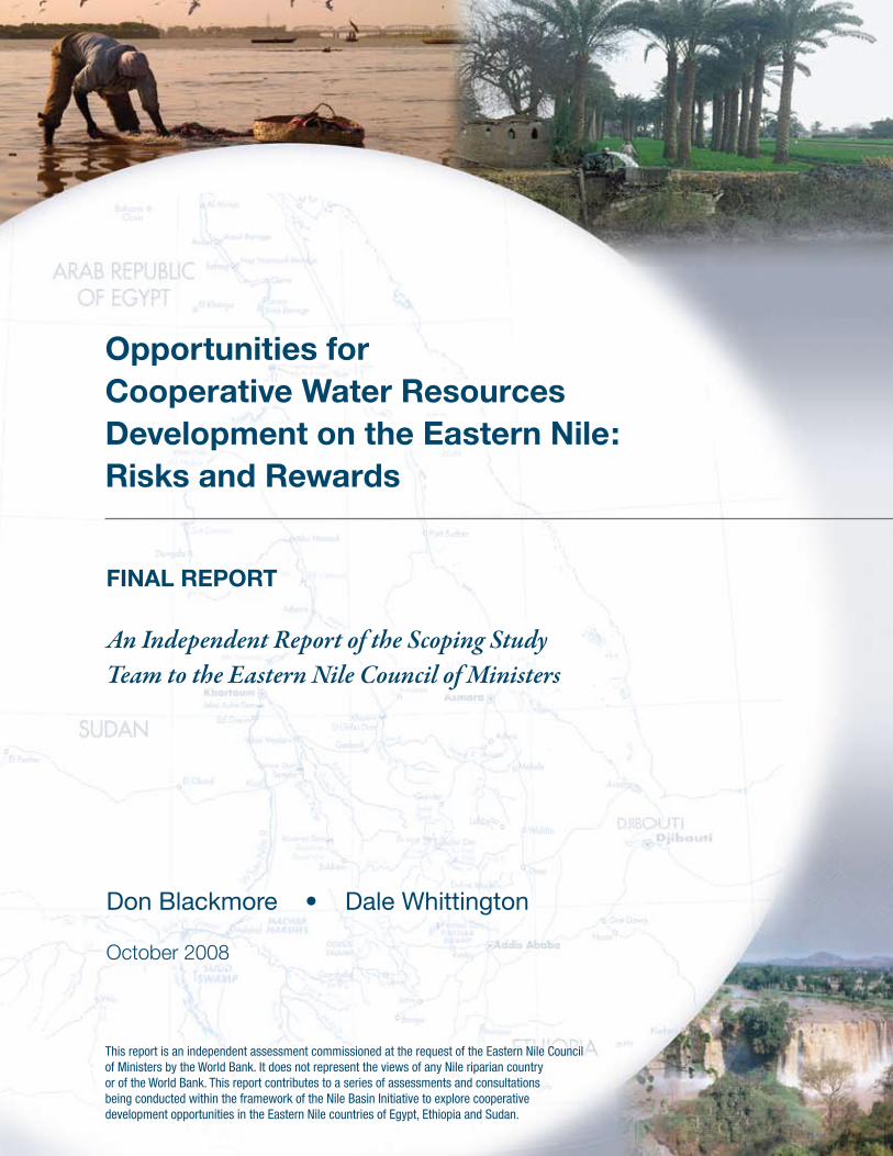
Opportunities forCooperative Water ResourcesDevelopment on the Eastern Nile:Risks and Rewards
FINAL REPORT
An Independent Report of the Scoping Study Team to the Eastern Nile Council of Ministers
Don Blackmore • Dale Whittington
October 2008
This report is an independent assessment commissioned at the request of the Eastern Nile Council of Ministers by the World Bank. It does not represent the views of any Nile riparian country or of the World Bank. This report contributes to a series of assessments and consultations being conducted within the framework of the Nile Basin Initiative to explore cooperative development opportunities in the Eastern Nile countries of Egypt, Ethiopia and Sudan.
Opportunities for Cooperative Water Resources Development on the Eastern Nile: Risks and Rewards
The Nile Basin Initiative (NBI), launched by the Nile Council of Ministers in 1999, is widely recognized
around the world as a bold and historic effort of nine Nile riparian states to create a new future in
which the Nile will be a catalyst for cooperation, prosperity and peace, and not the barrier that it has
been for so long. Political commitment and hard work have already yielded substantial results, and
the focus is now shifting to the implementation of joint management and development projects which
will bring major shared benefits to the poor, to the environment and to the region as a whole. In 2005,
the Eastern Nile Council of Ministers (ENCOM), comprising the Ministers of Water Affairs from Egypt,
Ethiopia and Sudan, launched “the first phase of identification of a major program of multipurpose
joint development in the Eastern Nile,” initiating a series of assessments and consultations to inform
the selection of a first set of investments under a Joint Multipurpose Program (JMP). As an input to
this initiative, ENCOM requested the World Bank to commission an independent scoping study on the
opportunities and risks of Eastern Nile river management and development.
The report of the Scoping Study Team to the Eastern Nile Council of Ministers, Opportunities for
Cooperative Water Resources Development on the Eastern Nile, does not seek to represent the views
of any riparian country or of the World Bank. The report does provide the strategic insights of an
independent team on the inter-woven physical behavior of the Eastern Nile river system, characterizing
its responses to potential future uses of shared water resources and infrastructure development. The
report is one of several emerging from studies underway in the Eastern Nile and it will need to be
considered alongside these other reports. It is, however, important to consider this report carefully.
First, it is important because the Eastern Nile lies at the heart of Nile cooperation, calling for difficult
decisions that will profoundly influence poverty, development and security in the region. Second, it
is important because the technical analysis in the report informs these decisions, providing evidence
that the Eastern Nile is already a stressed system where multilateral cooperation is a rational choice
for each country, and the most sustainable and beneficial strategy for the basin as a whole. Third,
against this backdrop of political complexity and broad opportunity, the report is important because of
its independent authorship by two objective and impartial individuals of international renown who have
made every effort to produce a report that is fair, frank and clear.
A Note on the Report of the Scoping Study Team to the Eastern Nile Council of Ministers
i
Opportunities for Cooperative Water Resources Development on the Eastern Nile: Risks and Rewards
The geographic focus of the report is important because the Eastern Nile in particular has a long
history of dispute which has fed the belief that Nile development is an intractable zero-sum game and
a major foreign policy, national security and economic development issue. Development partners and
observers are aware that ENCOM has worked long and hard to replace this belief with: a vision of
cooperative development (ENCOM’s Eastern Nile 2020 Vision is given on page v as it is central to the
Eastern Nile agenda and to the support of development partners); a joint institution (the Eastern Nile
Technical Regional Office) to move this vision toward reality; and demonstrated results on the ground to
realize the vision and bring shared benefits to each country.
The technical analysis presented in the report is important because it is the first-ever serious attempt
to explore the Eastern Nile as a river system shared by three countries and to identify both the physical
potential of the river system to yield opportunities for cooperative development and the risks of
cooperation and non-cooperation. The report concludes that there is space for a first set of mutually-
beneficial, “no regret” multipurpose investments (good projects that will not foreclose important future
options). The report also indicates that the safe yield of the Eastern Nile is being reached as water
losses are very high, so that there are major risks in proceeding down the present path of unilateral
development in a time of growing populations, increasing water demand and the uncertainty of climate
change. These conclusions need to be understood and debated transparently by ENCOM members,
both within their countries and amongst themselves. A decision to move forward to identify a first
set of JMP investments, bringing the countries together in joint planning, institutions, financing and
operations, cannot be taken lightly, and will not be easily implemented.
The independence and authorship of this report are also important, because this has resulted in clarity
and frankness, as well as a challenge to some “conventional wisdoms” that likely could not have been
achieved by a team from the riparian states or from development partners. The report takes, as its
pragmatic point of departure, the existing situation of uncoordinated infrastructure and plans. It uses
available information, tools, country aspirations and international perspectives to weave a tale of the
Eastern Nile, looking at the past, analyzing the present, and outlining implications for the future. From
national perspectives, some of these conclusions will be difficult to accept, for differing reasons. The
challenge will be for ENCOM to look at the Eastern Nile system as a common resource (“one sub-basin,
three countries”).
The report is not a master plan for the Eastern Nile, nor an assessment of individual options from economic,
social, and environmental perspectives. It does not identify a particular first project, advocate a particular
development path, or consider potential gains from conjunctive management of the Equatorial Lakes and
Eastern Nile systems. All of these tasks will need to be undertaken as the process of cooperation advances.
The report is a step on ENCOM’s journey, a “fit-for-purpose”, preliminary analysis of the physical system of
the Eastern Nile, which precedes the in-depth analysis of the planned Nile-wide and Eastern Nile decision
support and modeling systems. The authors have consulted widely, in each of the three countries as well as
collectively, and some conclusions have been drawn for the first time on the Opportunities for Cooperative
Water Resources Development on the Eastern Nile.
ii

Opportunities for Cooperative Water Resources Development on the Eastern Nile: Risks and Rewards
The needs are great. Poverty, conflict, food insecurity and environmental degradation plague the
region. The lives of many are at risk from hunger and starvation. Unsustainable livelihoods characterize
too much of the human settlement of the region – from the mountain slopes to the desert. Only a
small percentage of the population has access to electric power supplies, which are essential for
development, industrial expansion, inward investment and growth. Climate change will greatly increase
the risks faced by the EN countries. There is dispute and conflict in the region – but cooperation and
integration between nations are powerful alternatives to dispute within and among them. The JMP can
address these needs and make a major contribution to achieving food security, sustainable livelihoods,
access to electric power, industrial growth and inward investment, and regional security.
The peoples of the region, the world community and development partners have great expectations of
the NBI and of ENCOM, with high hopes of how cooperation will bring development benefits and foster
prosperity and peace. The NBI and ENCOM also have great expectations of the NBI development
partners, who have made strong commitments to support cooperative efforts. All these expectations
bring great responsibility to the NBI and to ENCOM to make the right choices for the people of the Nile,
and to NBI development partners to provide their wholehearted support.
David Grey
Senior Water Advisor for Africa and South Asia
World Bank
October 2008
iii

Opportunities for Cooperative Water Resources Development on the Eastern Nile: Risks and Rewardsiv

Opportunities for Cooperative Water Resources Development on the Eastern Nile: Risks and Rewards
The 2020 operational vision for the “Eastern Nile” and its co-riparian countries is a vision of strong
economies which will be working together and will be globally competitive. This will be achieved by
economic integration through joint physical, social, and economic infrastructure. The Eastern Nile sub-
basin will be characterized by: integrated multipurpose projects in power development and pooling,
transport, and irrigated agriculture; free movement of goods and services; and active inter-country
private sector cooperation, including high-technology industry. Together, this will provide an enabling
environment for inward investment and export of goods and services beyond the sub-basin, all within
an environment of trust, peace, and political stability.
Within this overall vision, the River Nile will serve as a key catalyst, with its yield increased and utilized
in a rational, fair, efficient, and environmentally sustainable manner, with effective flood and drought
management, watershed management, reversed desertification, and pollution control. The economic
risk associated with climate variability will be greatly lowered through integrated inter-country water
management, including effective rainwater harvesting and use. Basic needs – such as water supply and
sanitation services – of all the population will have been met in targeted poverty eradication programs.
A sound institutional and legal framework for cooperation will be in place, with high levels of confidence
and trust, and a strong record of promoting successful joint, win-win projects. This will be coupled
with strong capacity and phased implementation plans, linked to restructured and shared education,
training, and research programs.
Eastern Nile Council of Ministers Meeting, Addis Ababa, Ethiopia, January 2001
2020 Operational Vision of the Eastern Nile
v

Opportunities for Cooperative Water Resources Development on the Eastern Nile: Risks and Rewardsvi

Opportunities for Cooperative Water Resources Development on the Eastern Nile: Risks and Rewards
This report presents the findings and conclusions of an independent team of international experts (Don
Blackmore and Dale Whittington), who were commissioned to assess objectively the water resources of
the Eastern Nile and the opportunities available for cooperative development. The Eastern Nile Council
of Ministers (ENCOM) agreed in February 2005 to launch a first phase of identification of a major
program of multipurpose joint development of the Eastern Nile. This report provides an overview of the
strategic issues surrounding the identification of a first set of investments within a Joint Multipurpose
Program (JMP) and offers guidance to ENCOM in its deliberations.
At the request of ENCOM, the Team adopted three major criteria for evaluating JMP investments.
First, these investments should provide benefits to all three participating riparian countries (Egypt,
Ethiopia and Sudan): each should benefit as a result of cooperation. Second, the investments should
be multipurpose: they should yield various types of benefits that can be shared by all three nations and
that will foster economic integration. Third, the investments should cause “no regrets”: they should not
foreclose desirable investment options in the future or set the Eastern Nile riparians on a development
path from which serious negative consequences might arise in the long term. The first two of these
criteria limited the Team’s investigation to upstream sub-basins that lie at least partly in Ethiopia.
During the study, the Team used a computer simulation model of the river basin that incorporated
information about the countries’ water resources infrastructure, current water uses, and existing
development plans. This analytical approach enabled the identification of the key issues the countries need
to consider to achieve their agreed Eastern Nile 2020 Vision. The Team first examined the opportunities and
risks associated with three sub-basins as possible locations for launching an initial set of JMP investments:
the Baro–Akobo–Sobat, the Tekeze-Atbara, and the Abbay (Blue Nile). They then drew general conclusions
regarding the opportunities and risks associated with joint development of the Eastern Nile.
The Team’s investigation of the JMP opportunities in the Baro–Akobo–Sobat sub-basin found
no evidence that large-scale infrastructure, including extensive pumping and drainage, would be
economically, socially, or environmentally feasible in the near term. Evidence from the latest satellite
data on the hydrology of the Machar Marshes showed that little water can be gained by reducing
Executive Summary
vii
Opportunities for Cooperative Water Resources Development on the Eastern Nile: Risks and Rewards
channel spills from the Baro–Akobo. Water storage or “water conservation” projects to increase
downstream flows in the White Nile would also raise complex environmental and social issues. The
Team thus concluded that although the Baro–Akobo–Sobat sub-basin has significant potential for
local development initiatives, it does not appear to offer attractive opportunities for a first set of JMP
investments for the Eastern Nile riparians. The Team believes that more studies of the Baro-Akobo-
Sobat sub-basin are needed before the Eastern Nile riparians can invest there with confidence.
In the Tekeze-Atbara sub-basin, potential hydropower generation sites are relatively small. This is an
advantage from the perspective of planning additions to the Ethiopian power grid, but such projects
are not likely to create multipurpose benefits of sufficient magnitude to foster regional cooperation and
economic integration among the Eastern Nile riparians. The Team thus concluded that none of the
currently identified projects in this sub-basin are suitable for a first set of JMP investments.
The examination of the Blue Nile sub-basin found that new water storage facilities would generate
large amounts of hydropower and would provide important multipurpose benefits to downstream
riparians, including flood control, sediment management, and improved navigation. Resettlement
and environmental issues would be minimal (and can be mitigated), and reservoir evaporation losses
would be small. The Team thus concluded that the Blue Nile sub-basin in Ethiopia provides the best
opportunities for a first set of JMP investments. Water storage and hydropower generation facilities
in this sub-basin could be complemented by investments in watershed management and irrigated
agriculture. Subsequent analytical work then focused on alternative scenarios for development in the
Blue Nile sub-basin.
This report presents seven Blue-Main Nile scenarios designed to illustrate how increasing upstream
withdrawals in Sudan and Ethiopia, selected new infrastructure projects, and climate change could
affect the possibilities for an initial set of JMP projects. The Nile waters are already heavily used, and
reservoir evaporation and channel losses are extremely high. Consumptive uses of water are growing,
and the Eastern Nile riparians are rapidly approaching the safe yield of the system. As upstream
withdrawals continue to increase, the Aswan High Dam Reservoir will operate at lower levels, much
closer to its design levels, than in the past few decades. Continued unilateral development, high system
losses, growing demand, climate change and other factors would soon result in stress, putting the
Eastern Nile water resources at serious risk. A cooperative approach to managing the Nile waters is
thus needed in order to manage this risk effectively, increase water availability, and capture the broader
economic benefits that can be derived from coordinated system development. There would be little
incentive for upstream riparians to invest in the large-scale investments and to agree to the operation
policies needed unless they also shared in these benefits.
From deliberations on the results of river basin simulation modeling, the Team believes that it is
possible for riparians to undertake an initial set of JMP investments on the Eastern Nile that will
meet the mutually agreed upon criteria. The anchor investment of this JMP initiative could be a large
multipurpose water storage and hydropower facility on the Blue Nile in Ethiopia. Although detailed
viii
Opportunities for Cooperative Water Resources Development on the Eastern Nile: Risks and Rewards
economic, financial, and environmental analyses to plan for such a project remain to be done, it is clear
that a large multipurpose project on the Blue Nile, coupled with complementary investments, could offer
significant benefits to all three Eastern Nile riparians.
Ethiopia stands to benefit in financial terms from the sale of large amounts of hydropower to Sudan
and Egypt. Revenues from the sale of the hydropower could repay any loans for dam construction
and could fund efforts to improve livelihoods, including watershed protection, reforestation, enhanced
rainfed agriculture, and irrigation in the Ethiopian highlands. The largest volumes of water resources
in the Eastern Nile basin are in the Ethiopian highlands, the source of the three Eastern Nile sub-
basins. In these sub-basins, 500 billion cubic meters (bcm) of water evaporate annually from surface
water bodies, from the land surface, or through vegetation. Actions to make better use of this water
for enhanced food and fiber production – including programs to reduce soil erosion – should be a
cornerstone of any JMP.
Sudan would benefit in several ways from large upstream storage on the Blue Nile. Increased regulation
would improve hydropower generation and also water delivery to the Gezira scheme, enabling more
intensive, profitable year-round cultivation. The sediment loads reaching the Sennar and Roseires
reservoirs would be reduced. The flood peak in Khartoum could be reduced with coordinated reservoir
operation. Navigation would be improved in the spring and summer months before the arrival of the
Blue Nile flood. And depending on the outcome of the power trade negotiations, Sudan could receive
an alternative source of reliable, potentially inexpensive electricity.
Egypt also stands to benefit from upstream water storage in important ways. Like Sudan, Egypt could
receive an alternative source of reliable electricity. Egypt could also benefit in terms of long-term water
security from the coordination of new upstream storage with the Aswan High Dam to mitigate future
drought conditions and the consequences of climate change. In addition, there would be increased
opportunities for trade and regional integration with its Nile neighbors.
At present, there are sufficient water resources to permit Eastern Nile riparians to undertake a first
set of JMP investments in the Blue Nile sub-basin that includes new water storage and hydropower
generation facilities, irrigation development, and watershed management. Four factors support this
conclusion. First, evaporation savings from running the Aswan High Dam Reservoir at much lower
levels are about 4 bcm annually. These savings occur because Sudan and Ethiopia are using (and
evaporating) more water upstream; as inflows at Aswan are reduced, storage becomes lower, and
evaporation accordingly decreases. Second, operating at lower levels reduces spills from the Aswan
High Dam Reservoir. Third, the river flows of the last century have been higher than was assumed
when the reservoir was designed, allowing for additional water use. Fourth, most of the consumptive
use of water in the Eastern Nile basin is in irrigated agriculture, and there are significant opportunities
to increase water availability by improving water use efficiency in both existing and any new irrigation
schemes. We did not make detailed calculations of such potential water savings, but are confident that
they are sizeable.
ix

Opportunities for Cooperative Water Resources Development on the Eastern Nile: Risks and Rewards
There is, however, a tradeoff between risks and rewards. Better management of reservoir evaporation
losses will allow increased water withdrawals, but will result in occasional deficits in low-flow (drought)
years. Regional cooperation is necessary to manage such tradeoffs and to maximize economic
benefits.
The analyses suggest several emerging challenges that pose new, complex risks for the Eastern Nile
riparians. Nile water allocation is only one of these challenges, and perhaps not the most difficult to
resolve. The benefits of regional cooperation will derive not only from overcoming the hurdle of achieving
equitable water allocation, but also from working together to find solutions to an array of basin-wide
issues including climate change, salinity build-up, sedimentation, and watershed management and
reforestation.
x
Opportunities for Cooperative Water Resources Development on the Eastern Nile: Risks and Rewards
Acknowledgements ........................................................................................................................ xiv
Acronyms .........................................................................................................................................xv
Chapter 1
Introduction ......................................................................................................................................1
Chapter 2
Background ......................................................................................................................................7
Chapter 3
Analytical Approach of the Scoping Study Team ........................................................................15
Chapter 4
Current Conditions (Status Quo) (Scenario A) ............................................................................19
Chapter 5
Evolving Conditions: Implications of Unilateral Developments (Scenario B) ........................... 29
Chapter 6
Prospects for JMP Investments in Selected Sub-basins .......................................................... 35
Chapter 7
Modeling Results: Blue Nile Development Scenarios (C, D, E, F)
and a Climate Change Scenario (G) ............................................................................................ 53
Chapter 8
Summary and Conclusions .......................................................................................................... 69
References .....................................................................................................................................73
Appendices
A – The Nile Decision Support Tool (DST) Simulation Model ........................................................... 77
B – The Concept of a Reservoir’s “Memory” ...................................................................................81
Contents
xi

Opportunities for Cooperative Water Resources Development on the Eastern Nile: Risks and Rewards
Figures
The Nile River Basin1 .................................................................................................................. 3
The Eastern Nile and its sub-basins2 .......................................................................................... 4
Annual rainfall in the Eastern Nile Basin3 .................................................................................... 9
Distribution of mean annual temperature in the Eastern Nile Basin4 ...........................................10
Population and per-capita GDP (2005) of Nile Basin countries5 .................................................11
Food security and life expectancy (2002) in Nile Basin countries6 ..............................................12
Effect of sea level rise on the Nile Delta7 .....................................................................................14
Inflows, evaporative losses, and total flow of the Nile system at different points in the basin8 .... 20
Historic flows at Aswan9 ............................................................................................................ 23
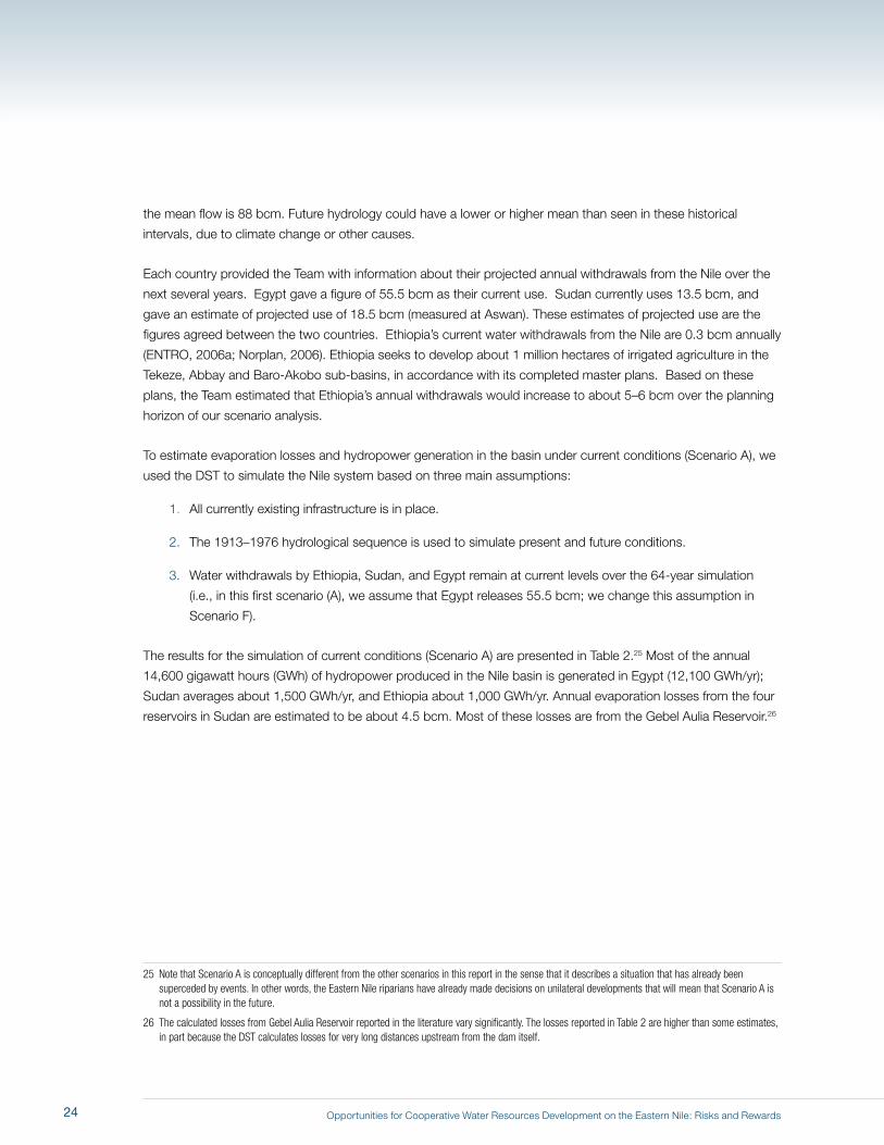
Storage in Aswan over the 64-year hydrological sequence in Scenario A, current conditions10 ...27
Monthly releases from the Aswan High Dam (actual), 1979-200111 ............................................ 28
Hydropower comparison in Scenarios A (current conditions) and B (evolving conditions)12 ....... 32
Storage in Aswan over the 64-year hydrological sequence in Scenarios A and B13 .................... 33
Annual water balance for the Eastern Nile Basin14 ...................................................................... 36
View of the Baro River, looking upstream from the west15 .......................................................... 38
The Baro-Sobat-Akobo river system, Gambella and Machar Marshes16 ..................................... 39
Evapotranspiration in the Machar Marshes over the course of 200117 ........................................ 40
Water balance for the Machar Marshes wetland system18 ...........................................................42
Potential hydropower and irrigation projects in the Baro-Sobat-Akobo Sub-basin19 ................... 43
Potential hydropower sites in the Tekeze Sub-basin in Ethiopia20 ............................................... 46
Potential hydropower and irrigation projects in the Tekeze-Atbara 21
Sub-basin of the Eastern Nile....................................................................................................47
Abbay Sub-basin of the Eastern Nile, showing potential major hydropower dam sites22 ............ 50
Karadobi dam site in the Abbay gorge, from the east23 ...............................................................51
Border dam site along the Abbay, from the west24 ......................................................................51
Hydrograph of Blue Nile flows in Khartoum for an illustrative high flood year (1929)25 ................. 56
Hydrograph of Blue Nile flows in Khartoum for an illustrative drought year (1940)26 .................... 56
Estimates of annual hydropower and irrigation benefits from development 27
in Scenarios A, B, C, and D ..................................................................................................... 59
Estimates of annual evaporative losses from storage in Scenarios A, B, C, and D28 ................... 60
Storage in Aswan over 64-year hydrological sequence in Scenarios A, B, and D29 .....................61
Deficits at Aswan in Scenario D30 ............................................................................................... 62
Deficits at Aswan in Scenarios E and F31 .................................................................................... 62
The risk/reward tradeoff32 ........................................................................................................... 66
Storage in Aswan over 64-year hydrological sequence in Scenarios 33
E and G ................................................................................................................................... 67
The concept of long-term memory, using the example of balances in a bank account34 ............ 82
xii
Opportunities for Cooperative Water Resources Development on the Eastern Nile: Risks and Rewards
Tables
Current storage infrastructure on the Eastern Nile1 ................................................................... 22
Summary of Scenario A results (existing conditions)2 .................................................................25
Summary of changes in results from Scenario A to Scenario B3 ............................................... 30
Summary of scenario assumptions (A-G)4 ................................................................................ 54
Model results, Scenario C (one dam on Abbay)5 ....................................................................... 55
Model results, Scenario D (full Blue Nile cascade + 3 bcm additional irrigation withdrawals)6 ... 57
Model results, Scenario E (full Blue Nile cascade + 6 bcm irrigation withdrawals in 7
addition to those in Scenario B) ............................................................................................... 63
Model results, Scenario F8 ........................................................................................................ 64
xiii
Opportunities for Cooperative Water Resources Development on the Eastern Nile: Risks and Rewards
We were supported in our work by numerous experts working both in the Nile basin and at the World
Bank. We especially appreciate the assistance we received from the Eastern Nile Technical Regional
Office (ENTRO) in making data available, for facilitating stakeholder meetings, and for spending time
with us to discuss our findings. Barbara Miller, Nagaraja Harshadeep, Winston Yu, Claudia Sadoff, Marc
Jeuland, and Aris Georgakakos all contributed greatly to the analysis and insights in this report.
Acknowledgements
xiv
Opportunities for Cooperative Water Resources Development on the Eastern Nile: Risks and Rewards
bcm Billion cubic meters
C Centigrade
cm Centimeters
DST Decision Support Tool
ENCOM Eastern Nile Council of Ministers
ENTRO Eastern Nile Technical Regional Office
FAO Food and Agriculture Organization
GWh Gigawatt hours
JMP Joint Multipurpose Program
kWh Kilowatt hour
mcm Million cubic meters
MW Megawatt
NBI Nile Basin Initiative
RWG Regional Working Group of the JMP
USBR United States Bureau of Reclamation
USD US dollar
Acronyms
xv

Opportunities for Cooperative Water Resources Development on the Eastern Nile: Risks and Rewardsxvi
Opportunities for Cooperative Water Resources Development on the Eastern Nile: Risks and Rewards
1 Introduction
At their seventeenth meeting, on June 24, 2004 in Sharm El Sheikh, Egypt, the Eastern Nile Council
of Ministers (ENCOM)1 adopted a planning approach to Eastern Nile development that included two
investment tracks. The first, a fast track, would include an initial set of investments to ensure the
accelerated delivery of tangible outputs from the Nile Basin Initiative (NBI).2 The second, a multipurpose
track, would involve longer-term planning for multi-country, multi-sectoral development.
At their nineteenth meeting, on February 15–16, 2005 in Alexandria, Egypt, in order to accelerate the
multipurpose track, ENCOM agreed to launch an identification phase for a major program of multipurpose
joint development of the Eastern Nile. ENCOM requested that development partners support the preparation
of a plan for joint multipurpose investments. ENCOM also endorsed a proposal for an independent study to
help guide the integrated development of the water-related resources of Ethiopia, Sudan, and Egypt, and to
facilitate the selection of an initial set of investments for a Joint Multipurpose Program (JMP) for the Eastern
Nile. The World Bank agreed to commission this study on behalf of ENCOM.
In October 2005 an independent panel of two international experts (Don Blackmore and Dale Whittington)
was constituted to undertake a strategic assessment of the water resources situation in the Eastern Nile and
to advise ENCOM on cooperative prospects that the Eastern Nile riparians might consider undertaking as a
JMP.3 They were charged with bringing the main water resources issues facing Ethiopia, Sudan, and Egypt
into sharper focus and “scoping out” the pros and cons of different investment directions for a JMP. The
independent panel thus became known as the Scoping Study Team.
1 ENCOM comprises the Ministers of Water Affairs from Egypt, Ethiopia and Sudan.
2 Formally established in 1999, the Nile Basin Initiative (NBI) is a partnership of the riparian countries of the Nile. It includes Burundi, the Democratic Republic of Congo, Egypt, Ethiopia, Eritrea (observer), Kenya, Rwanda, Sudan, Tanzania and Uganda. The NBI is guided by a shared vision: “to achieve sustainable socioeconomic development through equitable utilization of, and benefit from, the common Nile Basin water resources,” and includes basin-wide technical assistance and capacity building programs, as well as subsidiary investment-oriented programs in the Eastern Nile (Egypt, Ethiopia and Sudan) and the Nile Equatorial Lakes (Burundi, the Democratic Republic of Congo, Egypt, Kenya, Rwanda, Sudan, Tanzania and Uganda) regions.
3 Don Blackmore was Chief Executive of the Murray–Darling Basin Commission in Australia from 1990 to 2004 and is now an independent consultant. Dale Whittington is Professor of Environmental Sciences and Engineering, and City and Regional Planning at the University of North Carolina at Chapel Hill, USA, and Professor, Manchester Business School (Innovation, Management, and Policy Division), UK.
1
Opportunities for Cooperative Water Resources Development on the Eastern Nile: Risks and Rewards
This report presents the findings of the Scoping Study Team. It is an independent assessment and does not
necessarily represent the views of any of the riparian countries or of the World Bank. Our work is intended to
show what is possible on the Eastern Nile in terms of cooperative water resources management and investment.
We examine the impact of future developments on the shared water resources of the Eastern Nile riparians; we
were not asked to undertake the detailed economic, environmental, or social evaluations that will be necessary
for specific investment projects. Our task was to provide an overview of the strategic issues surrounding the
identification of a first set of JMP investments and to offer ENCOM guidance in its deliberations on what this
initial set of JMP investments could be. This work provides an early, objective, professional judgment of the
opportunities and risks associated with Eastern Nile water resources investments, to assist ENCOM in narrowing
the choices for an initial set of JMP investments.
The JMP is envisaged as a coordinated set of cooperative water resources and related investments, and
institutional building and strengthening, that will reduce poverty, promote economic development, and foster
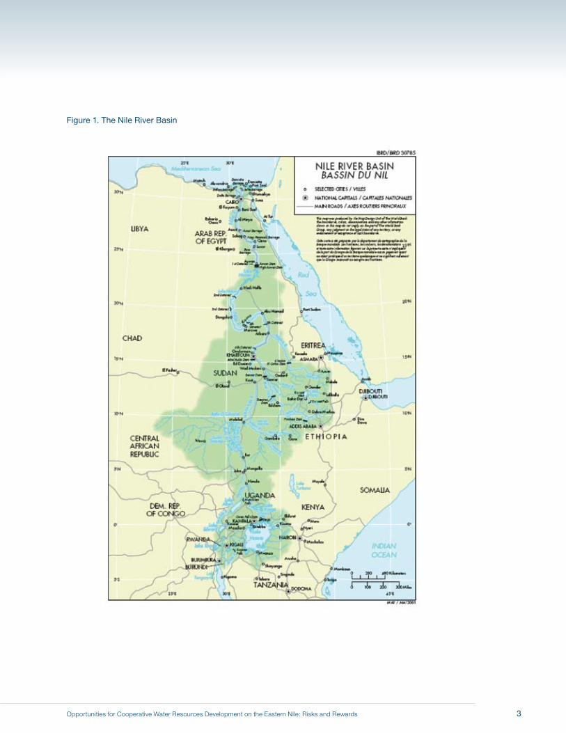
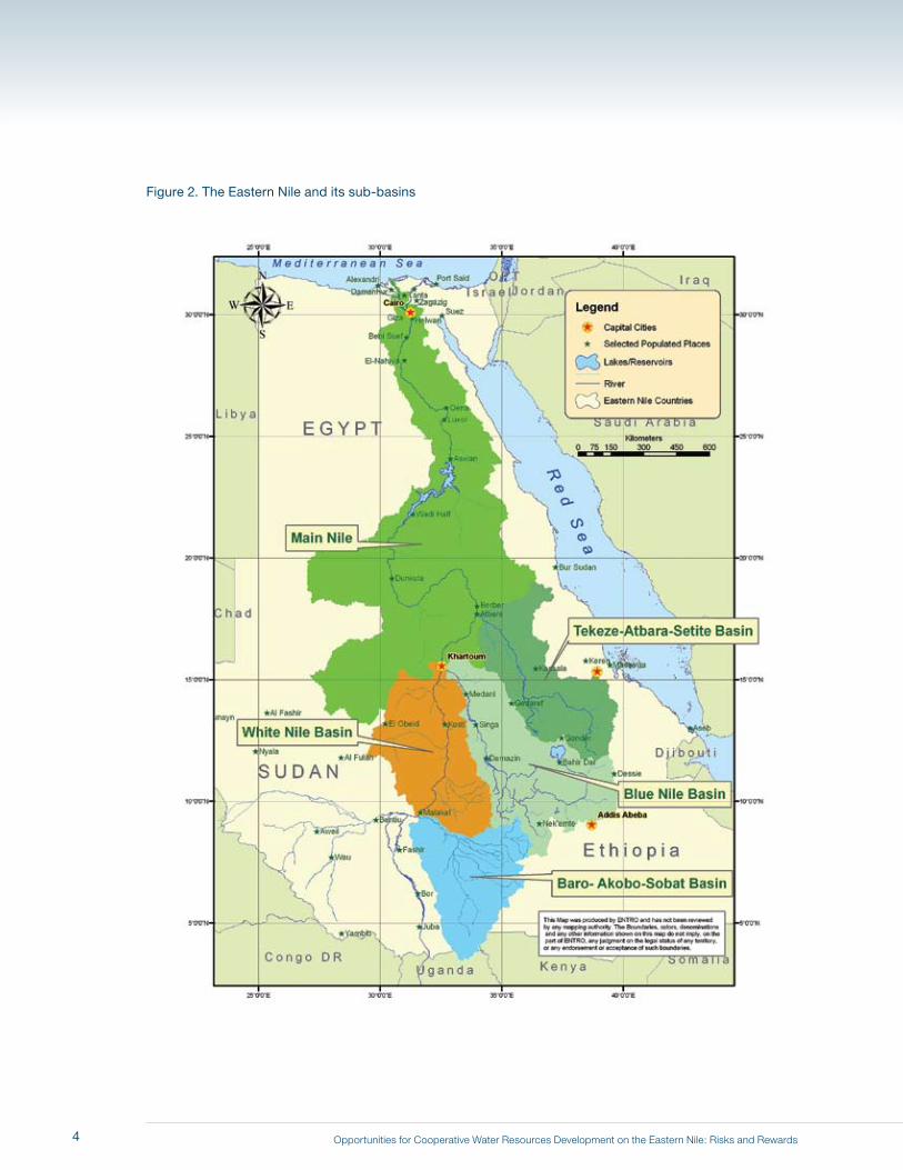
economic integration throughout the basin (see Figure 1 for a map of the Nile basin and Figure 2 for a map of
the Eastern Nile sub-basins). There are three major criteria for JMP investments. First, these investments should
provide benefits to all three participating riparian countries: each should benefit as a result of cooperation.
Second, the investments should be multipurpose: they should yield various types of benefits that can be shared
by all three riparians and that will foster economic integration. Third, the investments should cause “no regrets”:
they should not foreclose desirable investment options in the future or set the participants on a development path
from which serious negative consequences might arise in the long term.
From the outset, the Team worked closely with each Eastern Nile country and with the Eastern Nile Technical
Regional Office (ENTRO) on the preparation of this report. Through ENTRO, the Eastern Nile countries provided
the Team with the most up-to-date data available. For the first time, these countries have worked together to
create shared, “one-system” inventories of basin-wide data on hydrology and water management infrastructure,
as well as social and environmental information.
In November 2005 the Team initiated its work by participating in an ENTRO workshop in Addis Ababa, Ethiopia,
on the development of a new Eastern Nile planning model. The Team subsequently formulated a plan for
the preparation of the Scoping Study analysis and report, which was discussed with ENTRO and country
representatives. In February 2006 the Team briefed the first meeting of a joint Regional Working Group (RWG) of
Egypt, Ethiopia, and Sudan.4 In May 2006 the Team presented its initial results to the second meeting of the RWG
held in Alexandria, Egypt. To obtain in-depth feedback on its preliminary findings, the Team also met separately
with representatives of each participating country.
4 In early 2006 each Eastern Nile country delegated a group of experts and representatives from different sectors and institutions to work with ENTRO to share knowledge about the Nile and their development aspirations. This group included individuals with expertise in water, power, agriculture, environment, social development, economic planning, and finance. The group has become known as the Joint Multipurpose Program (JMP) Regional Working Group.
2
Opportunities for Cooperative Water Resources Development on the Eastern Nile: Risks and Rewards
Figure 1. The Nile River Basin
3
Opportunities for Cooperative Water Resources Development on the Eastern Nile: Risks and Rewards
Figure 2. The Eastern Nile and its sub-basins
4
Opportunities for Cooperative Water Resources Development on the Eastern Nile: Risks and Rewards
In August 2006 the Team again met with representatives of each country to discuss the emerging findings of the
study. These meetings included individuals in addition to members of the RWG, and provided each country an
opportunity to inquire about the analytical approach employed, the assumptions made, the data used, and the
preliminary conclusions reached. In November 2006 the Team made a final presentation of its findings to the third
joint meeting of the RWG of Ethiopia, Sudan, and Egypt in Dakar, Senegal. In April 2007 David Grey (Senior Water
Advisor, World Bank) presented the findings of the Scoping Study Team at the 23rd meeting of ENCOM in Cairo.
In February 2008 the findings were presented at the second joint meeting of the Ministers of Water and Ministers
of Energy in Addis Ababa. In June 2008 the findings were discussed at an informal dialogue of the Ministers of
Water near Oxford, England. In August 2008 the Scoping Study Team held consultations in Cairo with Egyptian
participants and in Addis Ababa with delegations from Ethiopia and Sudan. Representatives of the Eastern
Nile countries and ENTRO have thus participated extensively in the formulation and development of the results
presented at that time and in this report.
The next, second chapter of this report provides a brief overview of the key economic and water resources issues
in the Eastern Nile basin and the emerging challenges that Ethiopia, Sudan, and Egypt are likely to face in their
search for cooperative solutions. Chapter 3 summarizes the analytical approach the Team adopted in its work and
the strengths and limitations of that approach. Chapter 4 presents an assessment of the current situation (status
quo conditions) in the Eastern Nile in terms of consumptive water use, evaporation and conveyance losses, and
water security. Chapter 5 summarizes the unilateral actions currently underway in the basin and discusses the
implications of these developments for future cooperation.
Chapter 6 describes the main types of future investment projects that have been proposed and discussed as a basis
for a JMP in three sub-basins: the Baro–Akobo–Sobat, the Tekeze-Atbara, and the Abbay (Blue Nile) in Ethiopia.5 We
conclude from this review that the Abbay (Blue Nile) sub-basin in Ethiopia offers the best opportunities for an initial set
of JMP investments. In chapter 7 we illustrate the consequences of various degrees of development on the Abbay
for downstream riparians, as well as the opportunities for regional cooperation and economic integration. Chapter 8
summarizes the report’s main messages and presents its conclusions and recommendations.
5 We largely focused our attention on multipurpose storage and hydropower and irrigation projects, many of which have been proposed in the development and master plans of the Eastern Nile countries. The JMP is also expected to include environmental and social development projects.
5

Opportunities for Cooperative Water Resources Development on the Eastern Nile: Risks and Rewards6

Opportunities for Cooperative Water Resources Development on the Eastern Nile: Risks and Rewards
All three Eastern Nile riparians aspire to the goals of economic development, environmental protection,
and poverty alleviation. Ethiopia, Sudan, and Egypt recognize that their economic development is
affected by how they manage their shared resource, the waters of the Nile, and they have committed
themselves to cooperate on river basin management and development issues. All three countries must
ensure that their population and economy have sufficient water supplies for human consumption, food
production, industrial growth, and other uses (World Bank 2003a and c, 2005, 2006). This problem
is technically challenging because the northern portion of the Nile basin is very arid and because the
flows of the Nile are extremely variable, both within a typical year and over long historical periods. In the
southern portion of the Eastern Nile basin soil erosion is severe and agricultural productivity is low.
At the beginning of the 21st century, the Nile poses different risks and opportunities for each of these
three riparian countries. For millennia Egypt was plagued by cycles of floods and droughts, but since the
completion of the Aswan High Dam in 1971 the country has enjoyed a high degree of water security. Given
current water withdrawals upstream, the over-year storage provided by the Dam essentially guarantees
Egypt a secure, reliable supply of water for all but the most severe sequences of low-flow years. Even in
times of extreme drought, Egypt is currently at no risk of being without water for its municipal, industrial,
and most of its agricultural users. As with all downstream riparians, a perennial question for Egypt is how its
current water security will be affected by future upstream water resources development.
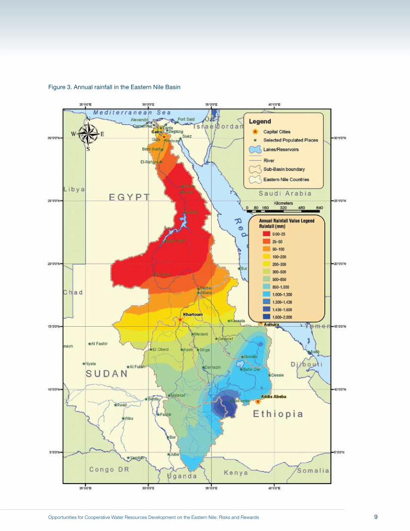
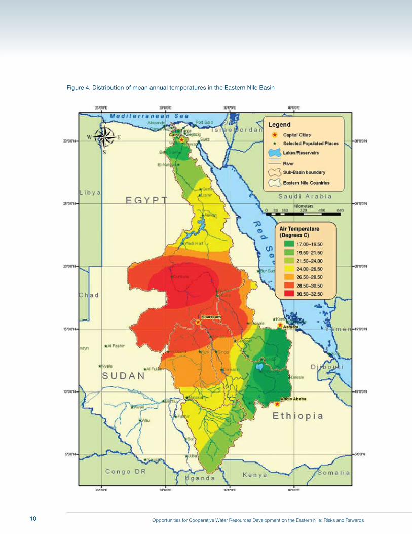
As one moves upstream in the basin, rainfall (Figure 3) and poverty increase; temperature first increases
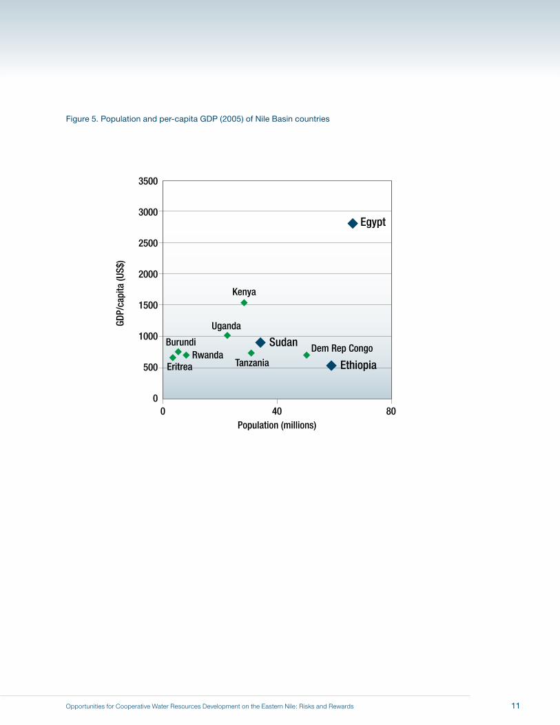
and then decreases (Figure 4).6 The GDP per capita of Sudan is only 33% of Egypt’s, and Ethiopia’s
is only 20% of Egypt’s (Figure 5).7 Sudan still faces three problems that Egypt confronted before the
completion of the Aswan High Dam: lack of sufficient over-year storage to supply water to its irrigation
schemes; damages from floods; and sedimentation of its reservoirs and irrigation system. If more
6 Note that in Figure 4 the average annual temperatures in northern Egypt and southern Ethiopia are in fact similar. This is because Egypt’s winters are cool and its summers are very hot, resulting in a mean that is similar to Ethiopia’s annual mean.
7 It is not, of course, our intention to imply that Ethiopia’s and Sudan’s lower GDP per capita has somehow been caused by, or is the result of, Egyptian actions or policies.
2 Background
7
Opportunities for Cooperative Water Resources Development on the Eastern Nile: Risks and Rewards
reliable water supplies were available, Sudan has vast land resources that could be brought under irrigation. But
Sudan has few good sites for storing Nile water.
Ethiopia remains today, as it has throughout most of recorded history, the poorest of the three Eastern Nile
riparians. Food security and the associated need to improve the livelihoods of rural households are its most
pressing national priorities. Figure 6 shows that daily calorie supply in Egypt is more than twice that in Ethiopia,
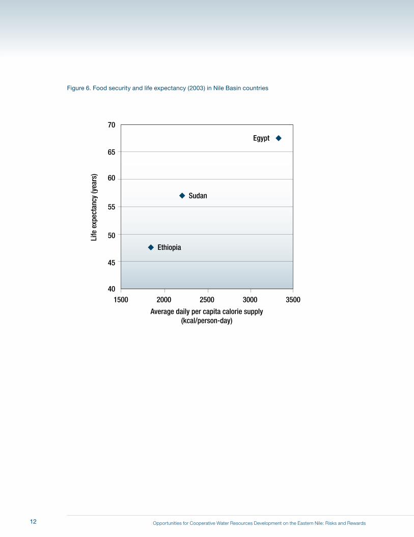
and life expectancy in Egypt is 23 years longer than in Ethiopia. Like Egypt and Sudan, Ethiopia has made a high-
level policy decision to expand its irrigated agriculture sector to improve its precarious food situation. 8 Ethiopia
faces many challenges in this endeavor, including soil erosion and land degradation, lack of access to markets,
waterlogging in some areas from high rainfall, and the high cost of infrastructure development.
In the past, dialogue among the Eastern Nile riparians has generally focused on the issue of water allocations
(Waterbury, 2002; Wu and Whittington, 2006). We do not intend to minimize the significance of this subject, but
Nile water allocation is only one of the challenges that must be confronted. The benefits of regional cooperation
will largely derive from working together to resolve basin-wide water management problems, seizing development
opportunities, and addressing environmental issues.
From our perspective, there are several emerging challenges that pose new, complex risks for the economies of
the Eastern Nile riparians. One such challenge involves issues surrounding climate change. The rapid warming
of the earth’s atmosphere due to greenhouse gases will affect the Nile riparians by: 1) increasing evaporation
rates from reservoirs; 2) increasing crop water requirements; 3) reducing agricultural yields in some places due
to extreme temperature events; 4) changing precipitation patterns; and 5) inducing rises in sea level. Average
temperatures in Egypt and Sudan are forecast to increase 2.5 degrees C by the year 2100 (Elshamy et al., 2006).
This is estimated to increase evaporation rates from storage reservoirs by about 4% and increase crop water
requirements by about 10%. Increased crop water use, carbon dioxide fertilization, and changes in growing
seasons may not translate into increased crop yields if extreme temperatures damage crops (Adams et al., 1998;
Schlenker et al., 2005, 2006).
8 In this report the Team makes no judgments about the economic returns from such investments in irrigation schemes in Ethiopia. Similarly, we do not attempt to assess the economic feasibility of new irrigation by the Toshka Project in the western desert of Egypt, or the ambitious master plans of the Sudanese government to expand irrigated agriculture. Rather, we analyze the likely consequences for the Eastern Nile riparian countries of pursuing these irrigation plans. The reader should not interpret this to mean that we necessarily believe these to be sound investments from an economic or financial perspective.
8
Opportunities for Cooperative Water Resources Development on the Eastern Nile: Risks and Rewards
Figure 3. Annual rainfall in the Eastern Nile Basin
9
Opportunities for Cooperative Water Resources Development on the Eastern Nile: Risks and Rewards
Figure 4. Distribution of mean annual temperatures in the Eastern Nile Basin
10
Opportunities for Cooperative Water Resources Development on the Eastern Nile: Risks and Rewards
Figure 5. Population and per-capita GDP (2005) of Nile Basin countries
Egypt
Ethiopia
Sudan
EritreaRwanda
Burundi
Uganda
Tanzania
Kenya
Dem Rep Congo
3500
3000
2500
2000
1500
1000
500
0
GDP/
capi
ta (U
S$)
Population (millions)0 40 80
11
Opportunities for Cooperative Water Resources Development on the Eastern Nile: Risks and Rewards
Figure 6. Food security and life expectancy (2003) in Nile Basin countries
Egypt
Ethiopia
Sudan
70
65
60
55
50
45
40
Life
exp
ecta
ncy
(yea
rs)
Average daily per capita calorie supply(kcal/person-day)
1500 2000 2500 3000 3500
12
Opportunities for Cooperative Water Resources Development on the Eastern Nile: Risks and Rewards
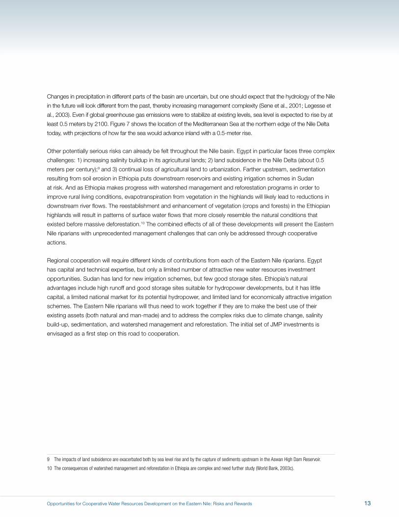
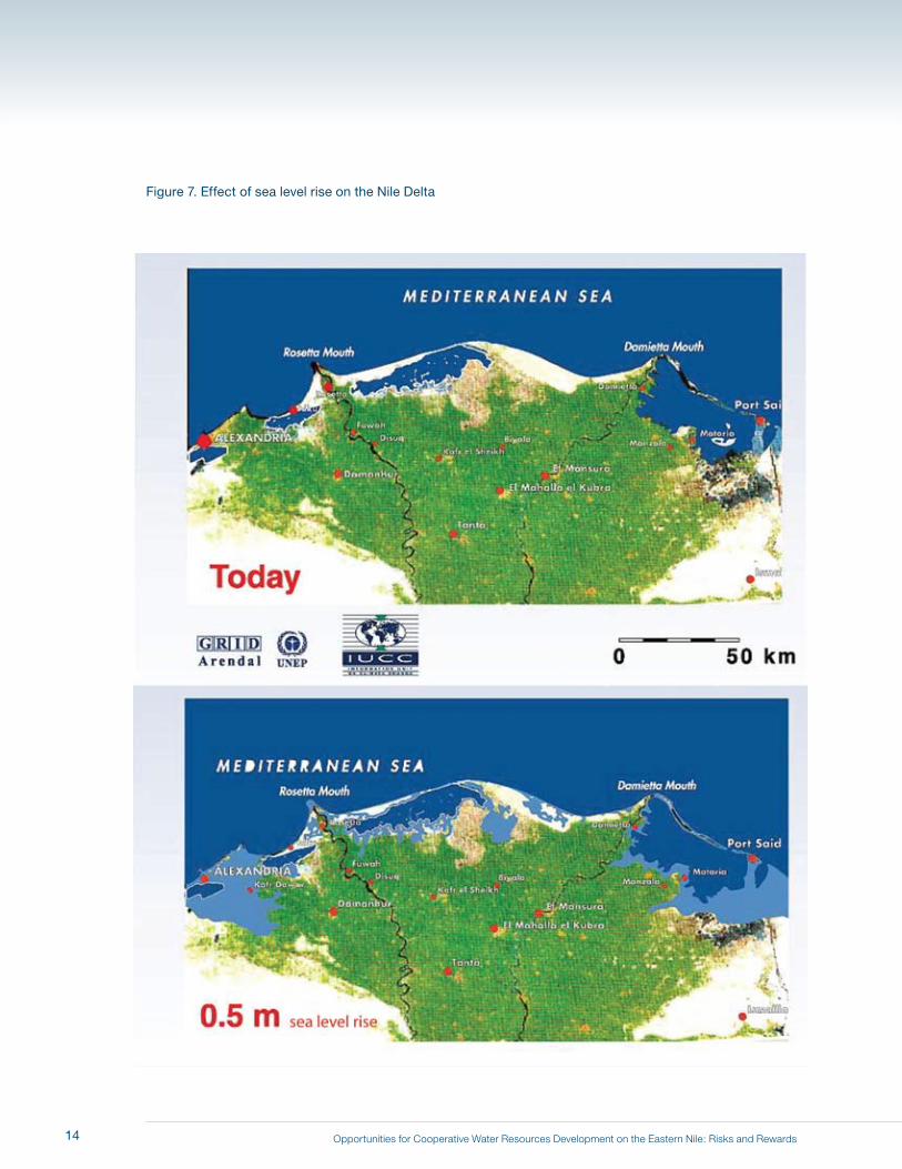
Changes in precipitation in different parts of the basin are uncertain, but one should expect that the hydrology of the Nile
in the future will look different from the past, thereby increasing management complexity (Sene et al., 2001; Legesse et
al., 2003). Even if global greenhouse gas emissions were to stabilize at existing levels, sea level is expected to rise by at
least 0.5 meters by 2100. Figure 7 shows the location of the Mediterranean Sea at the northern edge of the Nile Delta
today, with projections of how far the sea would advance inland with a 0.5-meter rise.
Other potentially serious risks can already be felt throughout the Nile basin. Egypt in particular faces three complex
challenges: 1) increasing salinity buildup in its agricultural lands; 2) land subsidence in the Nile Delta (about 0.5
meters per century);9 and 3) continual loss of agricultural land to urbanization. Farther upstream, sedimentation
resulting from soil erosion in Ethiopia puts downstream reservoirs and existing irrigation schemes in Sudan
at risk. And as Ethiopia makes progress with watershed management and reforestation programs in order to
improve rural living conditions, evapotranspiration from vegetation in the highlands will likely lead to reductions in
downstream river flows. The reestablishment and enhancement of vegetation (crops and forests) in the Ethiopian
highlands will result in patterns of surface water flows that more closely resemble the natural conditions that
existed before massive deforestation.10 The combined effects of all of these developments will present the Eastern
Nile riparians with unprecedented management challenges that can only be addressed through cooperative
actions.
Regional cooperation will require different kinds of contributions from each of the Eastern Nile riparians. Egypt
has capital and technical expertise, but only a limited number of attractive new water resources investment
opportunities. Sudan has land for new irrigation schemes, but few good storage sites. Ethiopia’s natural
advantages include high runoff and good storage sites suitable for hydropower developments, but it has little
capital, a limited national market for its potential hydropower, and limited land for economically attractive irrigation
schemes. The Eastern Nile riparians will thus need to work together if they are to make the best use of their
existing assets (both natural and man-made) and to address the complex risks due to climate change, salinity
build-up, sedimentation, and watershed management and reforestation. The initial set of JMP investments is
envisaged as a first step on this road to cooperation.
9 The impacts of land subsidence are exacerbated both by sea level rise and by the capture of sediments upstream in the Aswan High Dam Reservoir.
10 The consequences of watershed management and reforestation in Ethiopia are complex and need further study (World Bank, 2003c).
13
Opportunities for Cooperative Water Resources Development on the Eastern Nile: Risks and Rewards
Figure 7. Effect of sea level rise on the Nile Delta
14
Opportunities for Cooperative Water Resources Development on the Eastern Nile: Risks and Rewards
The Team was greatly aided in its work by the early efforts of ENTRO to assemble data from the
Eastern Nile riparians; by the Italy/FAO-sponsored Nile basin modeling work undertaken over many
years by Aris Georgakakos, Professor of Civil Engineering at Georgia Tech University, USA; and by
work commissioned for the Team from WaterWatch B.V. (of the Netherlands). The Decision Support
Tool (DST) developed by Professor Georgakakos was of pivotal importance in the Team’s analytical
approach.11
The Team used a modified version of the DST (see Appendix A) to characterize the current conditions
in the Eastern Nile and an “evolving conditions” scenario to describe what is happening presently in
terms of unilateral developments. We then defined a limited number of illustrative scenarios of irrigation
withdrawals and infrastructure development (for example, multipurpose dams) in Ethiopia, Sudan,
and Egypt and used the modified DST to simulate what the consequences would be for hydropower
generation, irrigation deficits, evaporation losses, storage levels, and flood control. A “climate change
scenario” was then similarly modeled and compared with the evolving conditions scenario.
For all of the simulations, we used the 64-year historical hydrological sequence of 10-day Nile flows from January
1913 through December 1976. For analytical purposes we assumed that different water resources projects
(infrastructure) and irrigation schemes (and associated water withdrawals) were in place in the three riparian
countries and then assumed that the 1913–1976 hydrological sequence was repeated in the future.12
11 See Yao and Georgakakos, 2003a, 2003b. The Nile Decision Support Tool was developed under project GCP/INT/752/ITA “Capacity Building for Nile Basin Water Resources Management,” which is the predecessor of the current project GCP/INT/945/IT, “Information Products for Nile Basin Water Resources Management.” Both projects were funded by the Government of Italy and implemented with operational and technical support from the Food and Agriculture Organization (FAO) of the United Nations.
12 In other words, we use the historical data to look forward, not backward, in time. The simulations are not an attempt to replicate past conditions. What actually happened in the historical period from 1965–1975, for example, may not be at all what happens in the model for the same sequence; the hydrological conditions are the same, but the infrastructure and irrigation demands assumed for the model may not be what were in place in historical actuality.
3 Analytical Approach of the Scoping Study Team
15

Opportunities for Cooperative Water Resources Development on the Eastern Nile: Risks and Rewards
Longer hydrological sequences exist for some locations in the Nile system, but we used the 1913–1976 sequence
because it provided the longest period for which flow records were available at most of the stations in the DST
model.13 Because this 64-year sequence includes periods of both droughts and high floods, we could examine
how the Nile system would behave under some extreme hydrological conditions. Of course, future hydrological
conditions might arise that would be outside that 64-year experience; indeed, one would expect new, different
flow sequences to occur as regional and global conditions change over time, most particularly as the global
climate warms. But we believe that the historical 1913–1976 sequence offers a sound basis from which to run
simulations exploring the consequences of future developments.14
Running the DST simulation model over the 1913–1976 historical sequence, with different infrastructure
configurations and varying irrigation withdrawals at various points in the basin, yields several different types of
results or outcome indicators. First, the model calculates the electricity generated from each hydropower facility
that is assumed to be online in the system.15 This enabled us to estimate mean annual gigawatt hours produced
over the 64-year simulation at each facility and in each of the riparian countries.
Second, the model calculates whether there is sufficient water to meet irrigation targets at the irrigation schemes in
the system and also estimates the time series of deficits at each location. The simulations examined generally show
sufficient water to meet the water targets of the upstream irrigation schemes, such that any water shortages would
cumulate in the Aswan High Dam Reservoir and show up as deficits in target releases from the dam. In practice,
it would not be necessary to manage deficits in this way; during a sequence of years with low flows, the upstream
riparians could share any shortfalls from irrigation targets. For present analytical purposes these deficits in the
model simulations are most appropriately interpreted as system-wide shortfalls before any cooperative attempt to
apportion them more equitably (and before any agreement to reduce target releases). In other words, although our
model results show these deficits as reductions in Egyptian target releases from the Aswan High Dam Reservoir,
this is not in practice how shortfalls in withdrawals would be managed if a regional cooperative institutional
arrangement were operational.
Third, the model results can be presented in terms of storage, evaporation, and water levels at reservoirs that
are assumed to be continuously in place over the course of the simulation.16 For example, on this basis it is
possible to simulate what happens to the storage in the Aswan High Dam Reservoir over the 64-year hydrological
sequence when changes are made in irrigation withdrawals and reservoirs upstream. Fourth, the model can be
used to generate hydrographs at different points in the system, which can be used to estimate the risk of floods.
13 We recognize that the 1990s has another sequence of low-flow years, and that if our simulations used a hydrological sequence that incorporated these low 1990s flows, then our model results would show higher system-wide deficits.
14 Synthetic hydrological sequences will certainly prove useful for future planning efforts.
15 The DST also estimates the power requirements for the Toshka pumping station under different scenarios.
16 The evaporation estimates provided by the DST and presented in this report are net evaporation estimates from reservoirs only. They do not include evaporation losses from conveyance, lakes, wetlands, or irrigation areas (which are accounted for separately).
16
Opportunities for Cooperative Water Resources Development on the Eastern Nile: Risks and Rewards
For purposes of illustration, we converted some of these DST results into monetary estimates of economic benefits.
For example, if one assumes that each kilowatt hour of electricity generated from hydropower facilities is worth a
specified amount, a simple multiplication will yield a monetary estimate of the mean annual value of the hydropower
generated. Similarly, if one assumes that a cubic meter of water in irrigation is worth a specified amount, one can
estimate the mean annual economic value of water delivered to irrigation schemes in the basin over the course of
the simulation.
It was beyond the scope of the Team’s work to attempt to estimate with precision the economic value of either
a kilowatt hour (kWh) of electricity or a cubic meter of water delivered to different irrigation schemes along the
Eastern Nile. We simply used some illustrative unit values that we believed were reasonable from international
experiences (USD 0.06 per kWh; USD 0.05 per cubic meter) in order to show the approximate magnitude of the
mean annual economic value of hydropower generation and irrigation water in the Eastern Nile system, and how
changes in infrastructure configurations (such as new dams) could affect these totals.17, 18
We did not examine water resources development options for the White Nile. However, we have incorporated the
historic hydrology of the entire basin into our analytical framework. The impact of future developments on the White
Nile will need to be considered as comprehensive, basin-wide planning efforts proceed.
It is also important to appreciate what the DST cannot do. Because it is difficult to add new projects to the model,
we were only able to include a few such projects that we would have liked to analyze.19 Moreover, the model does
not generate “best” (optimal) selections of infrastructure projects, or groups of projects, for obtaining the most
hydropower or water for irrigation. Analysts themselves decide which projects to put into a given simulation; if
someone includes a project with poor economic returns, the model does not reject it. Rather, the DST simply
assumes that this project exists and simulates the behavior of the system with that project in place. Similarly, in
the version of the DST available to the Team, analysts must decide how to define the operations of dams included
in the simulation; if the operating rules are poorly thought through, the potential benefits of the infrastructure will
not show up accurately in the results of the simulation. And as with all models, the results of the DST can also be
sensitive to assumed values assigned to parameters such as evaporation rates from reservoirs, conveyance losses,
efficiency of hydropower generation facilities, and topology of the reservoir sites.
17 The economic value of USD 0.06 per kWh assumed here could be higher or lower depending on the location of the hydropower generation facility in relation to the load centers and the existence of transmission lines and local grids. Other factors affecting the economic value of hydropower generation include the reliability of the power produced and whether the electricity delivered is firm or peaking power. The assumed unit value of water in irrigation (USD 0.05 per cubic meter) would be reflective of the value of water in historical uses, not the value of water in highly efficient, modernized irrigation schemes.
18 The assumed value of water in irrigation of USD 0.05 per cubic meter corresponds to net returns of about USD 500 per hectare with a water duty of 10,000 cubic meters per hectare. Economic returns to water in irrigated agriculture in the Eastern Nile basin will be higher when irrigation and agricultural systems are modernized.
19 One difficulty in adding new projects to the DST is that good modeling practice requires that the operating rules for any new projects be carefully coordinated with those of existing projects. On a complex river system with multiple control structures, this is typically a nontrivial task.
17
Opportunities for Cooperative Water Resources Development on the Eastern Nile: Risks and Rewards
Perhaps most importantly, we recognize that large infrastructure developments on the Eastern Nile may have many
outcomes beyond the “traditional” benefits of hydropower generation, flood control, and water supply. Cooperative
water resources development could launch the Eastern Nile riparians on a cycle of increasing economic integration,
specialization, and trade, leading to accelerated economic growth, poverty reduction, and reduced military
expenditures. Indeed, this is everyone’s hope.
Large-scale water resources development would also bring social changes, both positive and negative. Water
resources investments have the potential to be transformational in the sense that the economies of countries
and the lives of populations may be changed in fundamental ways. This has in fact happened in Egypt since the
completion of the Aswan High Dam. The population today no longer faces risks of extreme floods and droughts,
and this has changed both the economy and the social fabric of Egypt.
Large-scale water resources investments can also have profound environmental and ecological consequences.
The results of the DST planning model do not include an assessment of lands flooded by new dams or of changes
in geomorphology that could result from changing hydrological regimes. Nor does the DST account for the effects
of such changes on the livelihood of people engaged in recessional agriculture.20 These types of environmental and
social outcomes are outside of the formal modeling context that the Team employed.
We do not thereby intend to minimize the importance of such difficult-to-measure consequences (both costs
and benefits) of large-scale water resources development. Rather, the evidence base and analytical tools at our
disposal simply did not permit us to say anything definitive or conclusive about such matters. We thus decided to
focus on the behavior of the river itself, and to restrict our observations to issues that could be addressed with the
evidence available. This may seem like an overly modest and limited goal, but several key insights emerged from
the resulting analysis that will be important to policy makers as they work toward cooperative arrangements in the
basin. As ideas for projects emerge within the JMP framework, they certainly will be subject to state-of-the-art
environmental, economic, and social assessments and require consultation with civil society.
20 Farmers engaged in recessional agriculture directly use the water from the annual Nile flood, planting their crops on the saturated ground when the flood waters recede. Such recessional agriculture was the prominent form of irrigation until the 19th century and is still practiced in some parts of Sudan and Ethiopia today.
18
Opportunities for Cooperative Water Resources Development on the Eastern Nile: Risks and Rewards
The Eastern Nile riparians share a river that, from a global perspective, is unique in several important
respects. All of the waters of the Nile are now used for some purpose; there is no “free” water left in
the basin. Even the water eventually flowing into the Mediterranean, about 13 billion cubic meters
(bcm) annually, serves an important purpose to the river system, as it exports (carries away) salt, thus
preventing further salinization of agricultural lands (Ministry of Water Resources and Irrigation, Arab
Republic of Egypt, 2005). Not all of the water in the basin is presently allocated to high-value uses, but
any new use of water does involve a tradeoff.
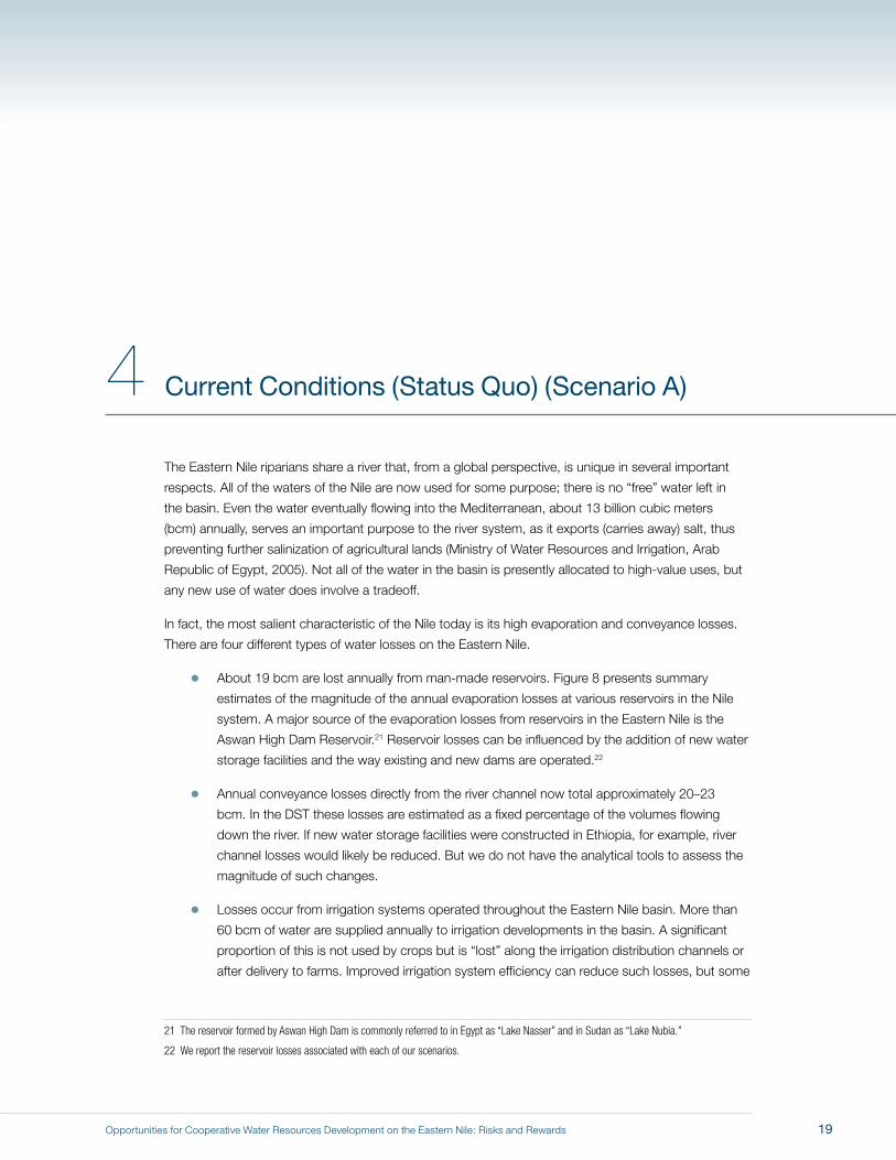
In fact, the most salient characteristic of the Nile today is its high evaporation and conveyance losses.
There are four different types of water losses on the Eastern Nile.
� About 19 bcm are lost annually from man-made reservoirs. Figure 8 presents summary
estimates of the magnitude of the annual evaporation losses at various reservoirs in the Nile
system. A major source of the evaporation losses from reservoirs in the Eastern Nile is the
Aswan High Dam Reservoir.21 Reservoir losses can be influenced by the addition of new water
storage facilities and the way existing and new dams are operated.22
� Annual conveyance losses directly from the river channel now total approximately 20–23
bcm. In the DST these losses are estimated as a fixed percentage of the volumes flowing
down the river. If new water storage facilities were constructed in Ethiopia, for example, river
channel losses would likely be reduced. But we do not have the analytical tools to assess the
magnitude of such changes.
� Losses occur from irrigation systems operated throughout the Eastern Nile basin. More than
60 bcm of water are supplied annually to irrigation developments in the basin. A significant
proportion of this is not used by crops but is “lost” along the irrigation distribution channels or
after delivery to farms. Improved irrigation system efficiency can reduce such losses, but some
21 The reservoir formed by Aswan High Dam is commonly referred to in Egypt as “Lake Nasser” and in Sudan as “Lake Nubia.”
22 We report the reservoir losses associated with each of our scenarios.
4 Current Conditions (Status Quo) (Scenario A)
19
Opportunities for Cooperative Water Resources Development on the Eastern Nile: Risks and Rewards
Figure 8. Inflows, evaporative losses, and total flow of the Nile system at different points in the basin
20

Opportunities for Cooperative Water Resources Development on the Eastern Nile: Risks and Rewards
losses are an unavoidable cost of operating large, complex irrigation schemes. The Team did not have
the analytical tools to assess the water use efficiency of different irrigation schemes existing or planned
in the Eastern Nile countries; this is an important area for future research. Additional water supplies
undoubtedly can be obtained by reducing such losses from on-farm and network distribution channels.
� Water evaporated from floodplains is often referred to as “losses.” However, in many cases, this water
provides important environmental, agricultural, and fishery benefits. The overall Nile system has many
large wetland systems that are directly connected in hydraulic terms with the river. On the Eastern
Nile such wetlands are especially important in the Baro–Akobo–Sobat sub-basin. The management of
wetlands to produce more regulated water to the Nile has been the focus of many investigations over
the past century (e.g., Hurst et al., 1946; Jonglei Investigation Team, 1954; Howell and Allan, 2004). The
Team’s analysis does examine the potential of these wetlands to provide increased flows into Eastern
Nile rivers.
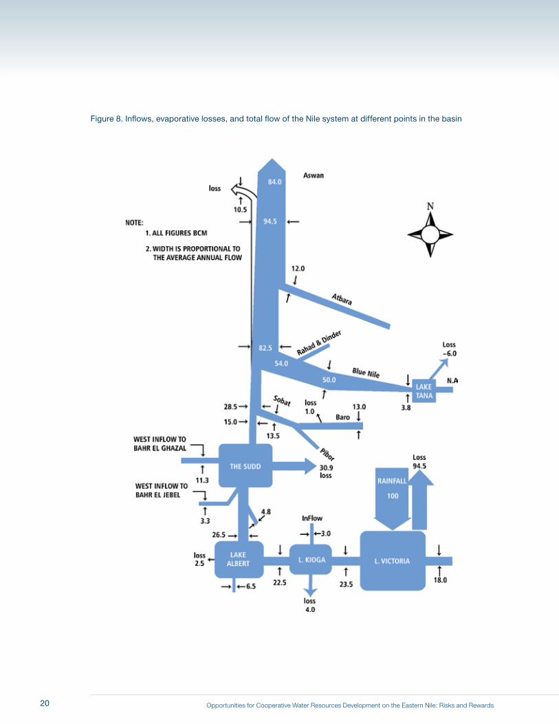
Another notable characteristic is that for a river of its size, the Nile has a relatively modest amount of existing
infrastructure. The Aswan High Dam is the largest, most important existing water infrastructure facility in the Nile
basin, with a live storage capacity of 137 bcm (Table 1).23 Completed in 1971, it provides Egypt with the benefits
of a large over-year storage reservoir in the Saharan desert. From Lake Tana in the highlands of Ethiopia to the
Aswan High Dam Reservoir (a distance of about 3,000 kilometers), the river is subject to little regulation. In Sudan
there are four dams: Sennar and Roseires on the Blue Nile; Khasm El Girba on the Atbara River; and Gebel
Aulia on the White Nile (Table 1, Figure 1). Sennar, Roseires, and Khasm El Girba provide seasonal storage to
supply Sudanese irrigation schemes. The Gebel Aulia Dam was built to supply water to Egypt during the low-flow
summer months, but since the completion of the Aswan High Dam, it is no longer needed for that purpose. Today
irrigation schemes have grown up along the banks of the White Nile that rely on direct pumping from the river,
and the level of the Gebel Aulia Reservoir is maintained to reduce these pumping costs. The only significant water
infrastructure on the Nile in Ethiopia is the regulation of the outlet from Lake Tana.
Current and evolving conditions in the Nile basin cannot be well understood without reference to the 1959
Nile Waters Agreement between Egypt and Sudan. Egypt needed to reach an agreement with Sudan before
construction of the Aswan High Dam could proceed, because the waters of the reservoir upstream of the
proposed dam would encroach on Sudanese territory. Ethiopia was not a party to this agreement and has never
recognized it. The Team takes no position regarding the Agreement, but it is necessary to understand some of its
specific provisions because both Egypt and Sudan have based their development plans on the water allocations
specified in the Agreement.
23 By “live storage” we mean the volume of water in the reservoir than can be controlled by releases from the dam, i.e., the storage that is above the elevation of the discharge points in the dam.
21
Opportunities for Cooperative Water Resources Development on the Eastern Nile: Risks and Rewards
Table 1. Current storage infrastructure on the Eastern Nile
Name RiverYear
completed
Initial live storage (bcm)
Estimated storage
remaining (bcm) Purpose
Installed hydropower
capacity (MW)
Roseires Blue Nile 1996 3.3 1.94a Hydropower, irrigation
400
Sennar Blue Nile 1925 0.9 0.64a Hydropower, irrigation
65
Khasm El Girba Atbara 1964 1.3 0.6a Hydropower, irrigation
10
Gebel Aulia White Nile 1937 2.8 1.75b Hydropower, irrigation
17
Aswan High Dam
Nile 1970 137.3c Almost all Hydropower, irrigation
2100
a Estimates obtained from Ministry of Irrigation and Water Resources, Sudanb Estimates from Water for the Future: National Water Resources Plan 2017 (Ministry of Water Resources, 2005)c Includes flood and surcharge storage (Ministry of Water Resources, 2005)
The central feature of the 1959 Nile Waters Agreement is that, rather than assigning a proportion of the Nile flow
to each country (and thus sharing directly in the risks inherent in an uncertain hydrology), Egypt and Sudan first
agreed to accept an estimate of the annual flow of 84 bcm measured at Aswan (the mean over the years 1900–
1959) and then allocated this amount between themselves. Sudan was allocated 18.5 bcm annually, measured
at Aswan.24 After adjustment was made for mean annual evaporation losses from the Aswan High Dam Reservoir
(estimated in the treaty to be 10 bcm), Egypt was left with an annual allocation of 55.5 bcm for releases from the
Aswan High Dam.
The Agreement requires that key information be exchanged between the two countries: the quantity of water
withdrawn in Sudan, and the releases from the Aswan High Dam. In the years since the Agreement was
negotiated, two notable issues have affected the operations of the dam. First, when Sudan takes less than its
full allocation, the “unused” water flows on to the Aswan High Dam Reservoir and is available for use in Egypt.
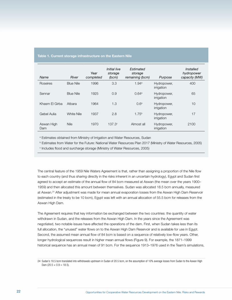
Second, the assumed mean annual flow of 84 bcm is based on a sequence of relatively low-flow years. Other,
longer hydrological sequences result in higher mean annual flows (Figure 9). For example, the 1871–1999
historical sequence has an annual mean of 91 bcm. For the sequence 1913–1976 used in the Team’s simulations,
24 Sudan’s 18.5 bcm translated into withdrawals upstream in Sudan of 20.5 bcm, on the assumption of 10% average losses from Sudan to the Aswan High Dam (20.5 × 0.9 = 18.5).
22
Opportunities for Cooperative Water Resources Development on the Eastern Nile: Risks and Rewards
Figure 9. Historic flows at Aswan
160
140
120
100
80
60
40
Year
ly d
isch
arge
in B
CM
Hydrological Year
1870 1890 1910 1930 1950 1970 1990
91 AVG (1871-1999)84 AVG (1901-1959)88 AVG (1913-1976)
Max = 150
Min = 42
23
Opportunities for Cooperative Water Resources Development on the Eastern Nile: Risks and Rewards
the mean flow is 88 bcm. Future hydrology could have a lower or higher mean than seen in these historical
intervals, due to climate change or other causes.
Each country provided the Team with information about their projected annual withdrawals from the Nile over the
next several years. Egypt gave a figure of 55.5 bcm as their current use. Sudan currently uses 13.5 bcm, and
gave an estimate of projected use of 18.5 bcm (measured at Aswan). These estimates of projected use are the
figures agreed between the two countries. Ethiopia’s current water withdrawals from the Nile are 0.3 bcm annually
(ENTRO, 2006a; Norplan, 2006). Ethiopia seeks to develop about 1 million hectares of irrigated agriculture in the
Tekeze, Abbay and Baro-Akobo sub-basins, in accordance with its completed master plans. Based on these
plans, the Team estimated that Ethiopia’s annual withdrawals would increase to about 5–6 bcm over the planning
horizon of our scenario analysis.
To estimate evaporation losses and hydropower generation in the basin under current conditions (Scenario A), we
used the DST to simulate the Nile system based on three main assumptions:
1. All currently existing infrastructure is in place.
2. The 1913–1976 hydrological sequence is used to simulate present and future conditions.
3. Water withdrawals by Ethiopia, Sudan, and Egypt remain at current levels over the 64-year simulation
(i.e., in this first scenario (A), we assume that Egypt releases 55.5 bcm; we change this assumption in
Scenario F).
The results for the simulation of current conditions (Scenario A) are presented in Table 2.25 Most of the annual
14,600 gigawatt hours (GWh) of hydropower produced in the Nile basin is generated in Egypt (12,100 GWh/yr);
Sudan averages about 1,500 GWh/yr, and Ethiopia about 1,000 GWh/yr. Annual evaporation losses from the four
reservoirs in Sudan are estimated to be about 4.5 bcm. Most of these losses are from the Gebel Aulia Reservoir.26
25 Note that Scenario A is conceptually different from the other scenarios in this report in the sense that it describes a situation that has already been superceded by events. In other words, the Eastern Nile riparians have already made decisions on unilateral developments that will mean that Scenario A is not a possibility in the future.
26 The calculated losses from Gebel Aulia Reservoir reported in the literature vary significantly. The losses reported in Table 2 are higher than some estimates, in part because the DST calculates losses for very long distances upstream from the dam itself.
24

Opportunities for Cooperative Water Resources Development on the Eastern Nile: Risks and Rewards
Table 2. Summary of Scenario A results (existing conditions)
Reservoir evaporation
losses (bcm/yr)Withdrawals
(bcm/yr)
Hydropower generation (GWh/yr)
Average deficit (bcm/yr)
Egypt – Aswan 14.3 55.5 12,080 –
Sudan –
Roseires
Sennar
Gebel Aulia
Khasm El Girba
Total
0.33
0.58
3.45
0.12
4.48
13.8
1,370
105
0
40
1,520
–
Ethiopia – 0.3 950 –
Total 18.8 69.6 14,600 None
Figure 10 shows fluctuations in storage in the Aswan High Dam Reservoir over the course of the 64-year
simulation. In this simulation the Aswan High Dam Reservoir generally operates at very high levels. Egypt does not
experience a deficit from its assumed target release of 55.5 bcm. Indeed, in many years of the simulation, Egypt
enters the summer growing season (when agricultural water use peaks) with almost two years’ supply of water
in the Aswan High Dam Reservoir. This simulation shows that Egypt currently enjoys a much higher level of water
security than was envisaged when the Aswan High Dam was designed.
Because the Aswan High Dam Reservoir runs close to “full” during much of the simulation, the surface area of
the reservoir is extensive and evaporation losses are accordingly high: estimated annual mean losses are 14.3
bcm. Actual evaporation from the Aswan High Dam Reservoir has been significantly less than that amount in the
recent past, for several reasons: 1) Egypt took several years to fill the Aswan High Dam Reservoir; 2) Egypt has
been releasing more than 55.5 bcm from the Aswan High Dam; 27 and 3) Egypt has released water into the Toshka
spillway in order to avoid scouring of the Nile channel and barrages downstream of the Aswan High Dam.28
27 For example, if releases downstream of the Aswan High Dam were 60 bcm per year, estimated mean annual evaporation from the Aswan High Dam Reservoir would be 12.7 bcm. If releases were 65 bcm per year, estimated mean annual evaporation would be 9.4 bcm.
28 The Toshka spillway is an overflow outlet off the western side of the Aswan High Dam Reservoir designed to release excess floodwaters into the desert.
25
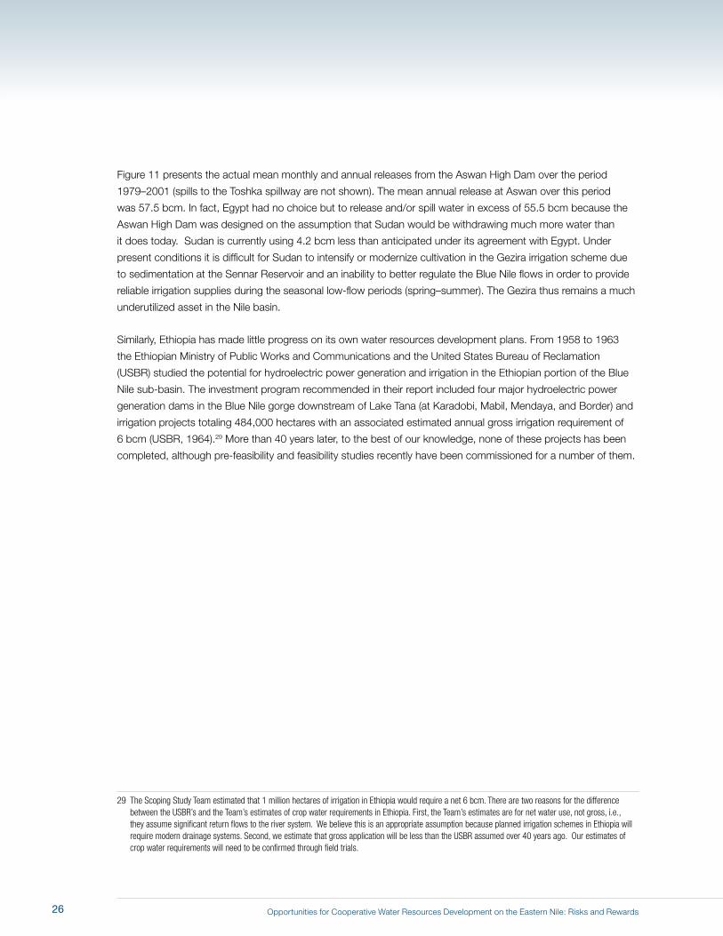
Opportunities for Cooperative Water Resources Development on the Eastern Nile: Risks and Rewards
Figure 11 presents the actual mean monthly and annual releases from the Aswan High Dam over the period
1979–2001 (spills to the Toshka spillway are not shown). The mean annual release at Aswan over this period
was 57.5 bcm. In fact, Egypt had no choice but to release and/or spill water in excess of 55.5 bcm because the
Aswan High Dam was designed on the assumption that Sudan would be withdrawing much more water than
it does today. Sudan is currently using 4.2 bcm less than anticipated under its agreement with Egypt. Under
present conditions it is difficult for Sudan to intensify or modernize cultivation in the Gezira irrigation scheme due
to sedimentation at the Sennar Reservoir and an inability to better regulate the Blue Nile flows in order to provide
reliable irrigation supplies during the seasonal low-flow periods (spring–summer). The Gezira thus remains a much
underutilized asset in the Nile basin.
Similarly, Ethiopia has made little progress on its own water resources development plans. From 1958 to 1963
the Ethiopian Ministry of Public Works and Communications and the United States Bureau of Reclamation
(USBR) studied the potential for hydroelectric power generation and irrigation in the Ethiopian portion of the Blue
Nile sub-basin. The investment program recommended in their report included four major hydroelectric power
generation dams in the Blue Nile gorge downstream of Lake Tana (at Karadobi, Mabil, Mendaya, and Border) and
irrigation projects totaling 484,000 hectares with an associated estimated annual gross irrigation requirement of
6 bcm (USBR, 1964).29 More than 40 years later, to the best of our knowledge, none of these projects has been
completed, although pre-feasibility and feasibility studies recently have been commissioned for a number of them.
29 The Scoping Study Team estimated that 1 million hectares of irrigation in Ethiopia would require a net 6 bcm. There are two reasons for the difference between the USBR’s and the Team’s estimates of crop water requirements in Ethiopia. First, the Team’s estimates are for net water use, not gross, i.e., they assume significant return flows to the river system. We believe this is an appropriate assumption because planned irrigation schemes in Ethiopia will require modern drainage systems. Second, we estimate that gross application will be less than the USBR assumed over 40 years ago. Our estimates of crop water requirements will need to be confirmed through field trials.
26
Opportunities for Cooperative Water Resources Development on the Eastern Nile: Risks and Rewards
Figure 10. Storage in Aswan over the 64-year hydrological sequence in Scenario A, current conditions
130
110
170
150
90
70
50
30
0
Stor
age
at A
swan
(BCM
)
Simulation Year
0 10 20 30 40 50 60
Scenario A
Spill Level
Dead Storage
27
Opportunities for Cooperative Water Resources Development on the Eastern Nile: Risks and Rewards
Figure 11. Monthly releases from the Aswan High Dam (actual), 1979-2001
6000
5000
8000
9000
10000
7000
4000
3000
2000
1000
0
62
60
66
68
70
64
58
56
54
52
50
Mon
thly
rele
ases
(MCM
)
Annu
al re
leas
es (B
CM)
Year
1979 1981 1983 1985 1987 1993 1995 1997 1999 20011989 1991
Monthly ReleaseAnnual Release
28
Opportunities for Cooperative Water Resources Development on the Eastern Nile: Risks and Rewards
5 Evolving Conditions: Implications of Unilateral Developments (Scenario B)
All three Eastern Nile riparians are currently planning and constructing development projects. These
projects have not been developed as part of a basin-wide cooperative investment program. This chapter
describes how existing conditions will change when these currently planned, unilateral developments
are completed. This scenario (B) should be considered the baseline against which the consequences of
other future scenarios can be assessed.30
Sudan is currently building a hydroelectric dam on the Main Nile at Merowe with an installed capacity of
1,250 megawatts (MW).31 The project is expected to cost USD 1.5 billion (including transmission lines to
Khartoum); the dam is now nearly completed and is being filled. The Team assumes that for Scenario B,
Sudan will have the financial resources to expand its irrigated agriculture and withdraw an additional 4.2
bcm from the Nile, bringing the total to the planned 18.5 bcm.
Ethiopia is also now moving forward with a new hydroelectric generation project, as well as irrigation
schemes. Scenario B assumes that two hydropower projects will be completed in Ethiopia: the TK-5 dam
on the Tekeze River (300 MW) and the Tana–Beles link (270 MW).32 The latter involves the diversion of
approximately 2.5 bcm annually from Lake Tana to the Beles River.33 This scenario (B) also assumes that
Ethiopia will move forward with some of the irrigation schemes in its various master plans, withdrawing 2.3
bcm annually for those purposes (an additional 2 bcm over present-day withdrawals of about 0.3 bcm).
30 It would be a mistake to compare other future scenarios to Scenario A because unilateral actions have already been taken that preclude the conditions depicted in Scenario A from continuing into the future.
31 A dam at the Fourth Cataract near Merowe was proposed as part of the Century Storage Scheme (Hurst, 1952). However, at the time the primary purposes of that reservoir were to increase water storage for Egypt, to re-regulate flows from over-year storage upstream, and to provide additional flood control. The Merowe dam now under construction is expected to trap sediment that would have reached Egypt, thus prolonging the economic life of the Aswan High Dam Reservoir.
32 The Team was not able to incorporate TK-5 into the DST model. Its hydropower generation and evaporation thus had to be estimated separately.
33 The Beles joins the Abbay (Blue Nile) upstream of the proposed site for the Border Dam near the border between Ethiopia and Sudan.
29
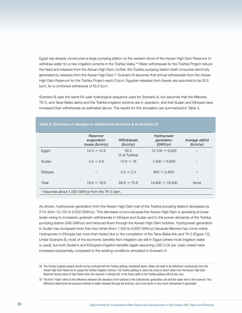
Opportunities for Cooperative Water Resources Development on the Eastern Nile: Risks and Rewards
Egypt has already constructed a large pumping station on the western shore of the Aswan High Dam Reservoir to
withdraw water for a new irrigation scheme in the Toshka Valley.34 Water withdrawals for the Toshka Project reduce
the head and releases from the Aswan High Dam; further, the Toshka pumping station itself consumes electricity
generated by releases from the Aswan High Dam.35 Scenario B assumes that annual withdrawals from the Aswan
High Dam Reservoir for the Toshka Project reach 3 bcm. Egyptian releases from Aswan are assumed to be 52.5
bcm, for a combined withdrawal of 55.5 bcm.
Scenario B uses the same 64-year hydrological sequence used for Scenario A, but assumes that the Merowe,
TK-5, and Tana–Beles dams and the Toshka irrigation scheme are in operation, and that Sudan and Ethiopia have
increased their withdrawals as estimated above. The results for this simulation are summarized in Table 3.
Table 3. Summary of changes in results from Scenario A to Scenario B
Reservoir evaporation
losses (bcm/yr)Withdrawals
(bcm/yr)
Hydropower generation (GWh/yr)
Average deficit (bcm/yr)
Egypt 14.3 10.8 55.5(3 at Toshka)
12,100 9,500 –
Sudan 4.5 5.8 13.8 18 1,500 6,600 –
Ethiopia – 0.3 2.3 950 3,400a –
Total 18.8 16.6 69.6 75.8 14,600 19,500 None
a Assumes about 1,000 GWh/yr from the TK-5 dam.
As shown, hydropower generation from the Aswan High Dam (net of the Toshka pumping station) decreases by
21% (from 12,100 to 9,500 GWh/yr). This decrease occurs because the Aswan High Dam is operating at lower
levels owing to increased upstream withdrawals in Ethiopia and Sudan and to the power demands of the Toshka
pumping station (340 GWh/yr) and reduced flows through the Aswan High Dam turbines. Hydropower generation
in Sudan has increased more than four times (from 1,500 to 6,600 GWh/yr) because Merowe has come online.
Hydropower in Ethiopia has more than tripled due to the completion of the Tana–Beles link and TK-5 (Figure 12).
Under Scenario B, most of the economic benefits from irrigation are still in Egypt (where most irrigation water
is used), but both Sudan’s and Ethiopia’s irrigation benefits (again assuming USD 0.05 per cubic meter) have
increased substantially compared to the existing conditions simulated in Scenario A.
34 The Toshka irrigation project should not be confused with the Toshka spillway mentioned above. Water will need to be withdrawn continuously from the Aswan High Dam Reservoir to supply the Toshka irrigation scheme. The Toshka spillway is used only rarely to divert water from the Aswan High Dam Reservoir during years of high floods when the reservoir is already full. In the future spills to the Toshka spillway will be very rare.
35 The term “head” refers to the difference between the elevation of the turbines in the hydroelectric generation unit and the water level in the reservoir. This difference determines the pressure exerted on water released through the turbines, and is one factor in how much hydropower is generated.
30

Opportunities for Cooperative Water Resources Development on the Eastern Nile: Risks and Rewards
Evaporation losses in Sudan increase in Scenario B because of an estimated 1.3 bcm annual loss from the
Merowe Reservoir. By contrast, evaporation losses from the Aswan High Dam Reservoir decrease by 3.5 bcm
because the reservoir is operating at significantly lower levels, with a corresponding reduction in surface area.
Figure 13 shows the effect of evolving conditions (Scenario B) on storage in the Aswan High Dam Reservoir over
the course of the 64-year simulation. Three points are worth emphasizing about these results.
First, storage in the Aswan High Dam Reservoir is significantly lower on average in Scenario B than in Scenario A,
as annual withdrawals upstream have increased. Under these evolving conditions reservoir managers in Egypt will
thus have a less secure water supply compared to current conditions. The simulation shows that in most years
Egypt will enter the summer agricultural season (before the next flood) with less than one year’s target releases
stored in the Aswan High Dam Reservoir.
Second, even though the Aswan High Dam Reservoir operates at lower levels in Scenario B, Egypt remains able
to release 55.5 bcm annually (52.5 bcm from the Aswan High Dam and 3 bcm to the Toshka Project); there are no
deficits over the course of the 64-year sequence. This does not mean that Egypt will in actuality never experience
deficits under evolving conditions; future hydrology may be different than in the recent past. However, the key
point here is that the Aswan High Dam was designed to handle conditions similar to those assumed in Scenario
B. It was always anticipated that the Aswan High Dam Reservoir would fluctuate over a much wider range and
operate at lower average storage levels than Egypt has in fact experienced since the Aswan High Dam was
completed. This is because when the Aswan High Dam was designed, it was assumed that upstream withdrawals
would be larger than they are today. That Egypt experiences no deficits in the evolving conditions of Scenario B
testifies to how well Egyptian, British, and Russian hydrologists and engineers actually understood the hydrology
of the Nile and how well they designed the Aswan High Dam.
Third, Figure 13 illustrates that the Aswan High Dam Reservoir has a long “memory,” in the sense that the effects
of both upstream withdrawals and downstream releases accumulate over time in its storage. The “memory” in the
storage is only cancelled when the storage fills to capacity and spills. This wipes out the “memory” of past actions
and “resets” the storage. However, this “erasing” of the reservoir’s memory will occur very rarely under the evolving
conditions depicted in Scenario B (it only occurs once in our 64-year simulation). Understanding the behavior of
storage levels at Aswan is important for all the Eastern Nile riparians. Over-year storage in the Aswan High Dam
Reservoir provides an important indicator of what is happening upstream and, thus, shows the bounds within
which increases in withdrawals are possible.36
One important implication of Scenario B for Egypt is that water in excess of 55.5 bcm will no longer be available on a regular
basis. Under these conditions, Egypt will have to pay increased attention to efficient water management and salt export.
36 It is worth reflecting carefully on what it means to say that the Aswan High Dam has a long memory. Appendix B discusses this concept in more detail, using an analogy with storage of money in a bank account.
31
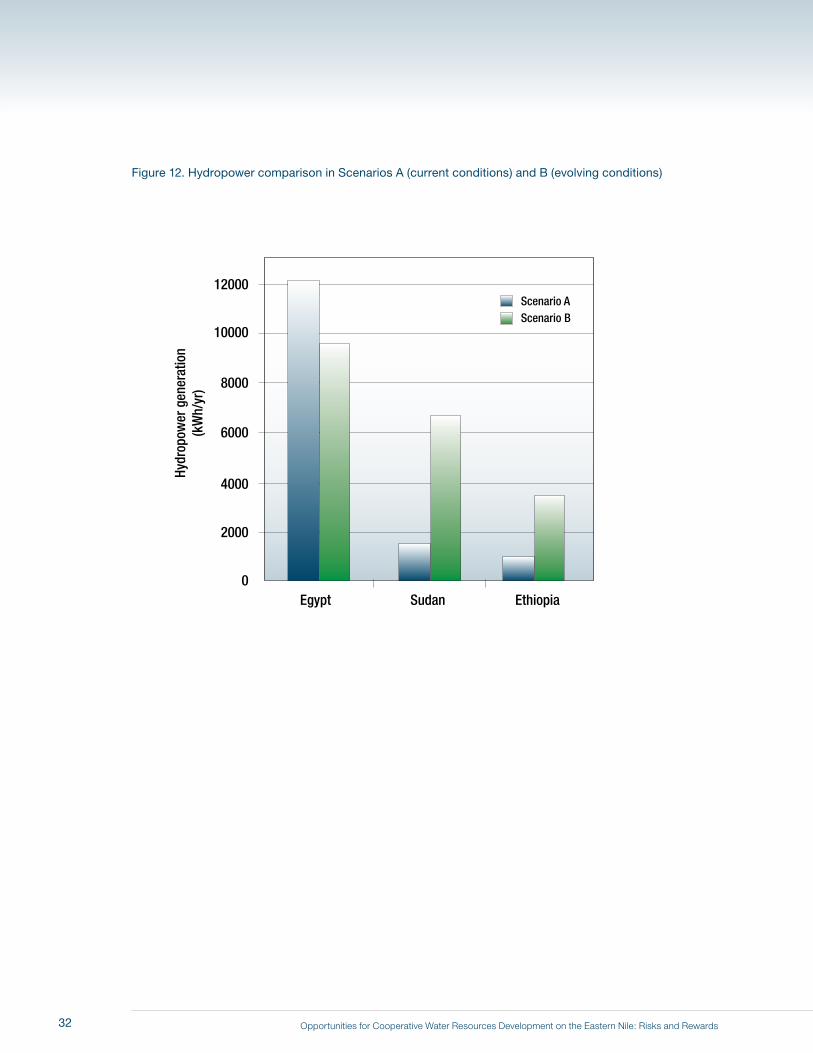
Opportunities for Cooperative Water Resources Development on the Eastern Nile: Risks and Rewards
Figure 12. Hydropower comparison in Scenarios A (current conditions) and B (evolving conditions)
4000
12000
10000
8000
6000
2000
0
Hydr
opow
er g
ener
atio
n(k
Wh/
yr)
Egypt Sudan Ethiopia
Scenario AScenario B
32
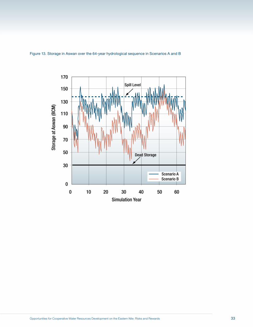
Opportunities for Cooperative Water Resources Development on the Eastern Nile: Risks and Rewards
Figure 13. Storage in Aswan over the 64-year hydrological sequence in Scenarios A and B
130
110
170
150
90
70
50
30
0
Stor
age
at A
swan
(BCM
)
Simulation Year
0 10 20 30 40 50 60
Scenario AScenario B
Spill Level
Dead Storage
33

Opportunities for Cooperative Water Resources Development on the Eastern Nile: Risks and Rewards34
Opportunities for Cooperative Water Resources Development on the Eastern Nile: Risks and Rewards
In the evolving conditions simulated in Scenario B, it is assumed that Sudan increases its annual Nile
water use (withdrawals and evaporation losses) to 20.5 bcm, and Ethiopia expands its Nile water use
to 2.3 bcm, sufficient for about 600,000 hectares of irrigation. At the same time, Egypt remains able to
meet target withdrawals of 55.5 bcm annually over the 64-year simulation. For analytical purposes we
assumed that any JMP investments would be undertaken in addition to these evolving conditions.
This chapter explores the pros and cons of undertaking an initial set of JMP investments in three sub-
basins of the Eastern Nile—the Baro–Akobo–Sobat, the Tekeze, and the Abbay—in terms of the three
broad criteria endorsed by ENCOM. We focused on opportunities in Ethiopia because JMP investments
are intended to provide benefits to all three participating Eastern Nile riparians: anchor investments
downstream of Ethiopia did not meet that criterion.37
Figure 14 provides an overall perspective on the hydrological cycle in these three sub-basins and each
sub-basin’s contribution to the water balance of the entire Eastern Nile basin. As shown, these three
sub-basins all have much more rainfall and surface water outflows than are experienced downstream
in Sudan and Egypt. Very little of Egypt’s water supply comes from rainfall; the vast majority originates
from surface water flows from Sudan. Egypt’s evapotranspiration38 outflows amount to about 57 bcm
annually; another 13 bcm flow into the sea. Southward and upstream, rainfall in the Eastern Nile sub-
basin within Sudan plays a greater role but is still only about 30% of total inflows; evapotranspiration
there is about equal to surface water outflows. In all three of the Ethiopian sub-basins the hydrology
is dominated by rainfall. However, evapotranspiration losses still far exceed surface water outflows.
Of about 580 bcm of rainfall in Ethiopia annually, only 14% (about 80 bcm) makes it to a surface
watercourse that flows to Sudan.
37 For example, one interesting project that Egypt is considering is to build a dam upstream of the Aswan High Dam in what is now the middle of the Aswan High Dam Reservoir, effectively splitting the reservoir in two. This would offer the advantage of two hydropower facilities instead of just one, as well as increased possibilities for regulation and peak power generation. Although intriguing, this proposal does not meet the criteria for an initial set of JMP investments, because benefits would only accrue to Egypt.
38 Evapotranspiration losses include crop water use, evaporation losses from reservoirs, and other system evaporation losses.
6 Prospects for JMP Investments in Selected Sub-basins
35
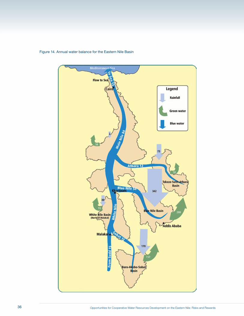
Opportunities for Cooperative Water Resources Development on the Eastern Nile: Risks and Rewards
Figure 14. Annual water balance for the Eastern Nile Basin
36
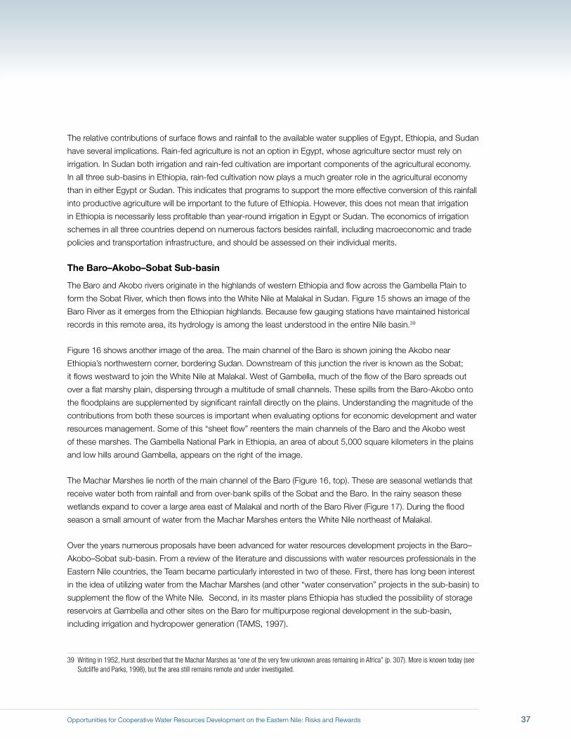
Opportunities for Cooperative Water Resources Development on the Eastern Nile: Risks and Rewards
The relative contributions of surface flows and rainfall to the available water supplies of Egypt, Ethiopia, and Sudan
have several implications. Rain-fed agriculture is not an option in Egypt, whose agriculture sector must rely on
irrigation. In Sudan both irrigation and rain-fed cultivation are important components of the agricultural economy.
In all three sub-basins in Ethiopia, rain-fed cultivation now plays a much greater role in the agricultural economy
than in either Egypt or Sudan. This indicates that programs to support the more effective conversion of this rainfall
into productive agriculture will be important to the future of Ethiopia. However, this does not mean that irrigation
in Ethiopia is necessarily less profitable than year-round irrigation in Egypt or Sudan. The economics of irrigation
schemes in all three countries depend on numerous factors besides rainfall, including macroeconomic and trade
policies and transportation infrastructure, and should be assessed on their individual merits.
The Baro–Akobo–Sobat Sub-basin
The Baro and Akobo rivers originate in the highlands of western Ethiopia and flow across the Gambella Plain to
form the Sobat River, which then flows into the White Nile at Malakal in Sudan. Figure 15 shows an image of the
Baro River as it emerges from the Ethiopian highlands. Because few gauging stations have maintained historical
records in this remote area, its hydrology is among the least understood in the entire Nile basin.39
Figure 16 shows another image of the area. The main channel of the Baro is shown joining the Akobo near
Ethiopia’s northwestern corner, bordering Sudan. Downstream of this junction the river is known as the Sobat;
it flows westward to join the White Nile at Malakal. West of Gambella, much of the flow of the Baro spreads out
over a flat marshy plain, dispersing through a multitude of small channels. These spills from the Baro-Akobo onto
the floodplains are supplemented by significant rainfall directly on the plains. Understanding the magnitude of the
contributions from both these sources is important when evaluating options for economic development and water
resources management. Some of this “sheet flow” reenters the main channels of the Baro and the Akobo west
of these marshes. The Gambella National Park in Ethiopia, an area of about 5,000 square kilometers in the plains
and low hills around Gambella, appears on the right of the image.
The Machar Marshes lie north of the main channel of the Baro (Figure 16, top). These are seasonal wetlands that
receive water both from rainfall and from over-bank spills of the Sobat and the Baro. In the rainy season these
wetlands expand to cover a large area east of Malakal and north of the Baro River (Figure 17). During the flood
season a small amount of water from the Machar Marshes enters the White Nile northeast of Malakal.
Over the years numerous proposals have been advanced for water resources development projects in the Baro–
Akobo–Sobat sub-basin. From a review of the literature and discussions with water resources professionals in the
Eastern Nile countries, the Team became particularly interested in two of these. First, there has long been interest
in the idea of utilizing water from the Machar Marshes (and other “water conservation” projects in the sub-basin) to
supplement the flow of the White Nile. Second, in its master plans Ethiopia has studied the possibility of storage
reservoirs at Gambella and other sites on the Baro for multipurpose regional development in the sub-basin,
including irrigation and hydropower generation (TAMS, 1997).
39 Writing in 1952, Hurst described that the Machar Marshes as “one of the very few unknown areas remaining in Africa” (p. 307). More is known today (see Sutcliffe and Parks, 1998), but the area still remains remote and under investigated.
37
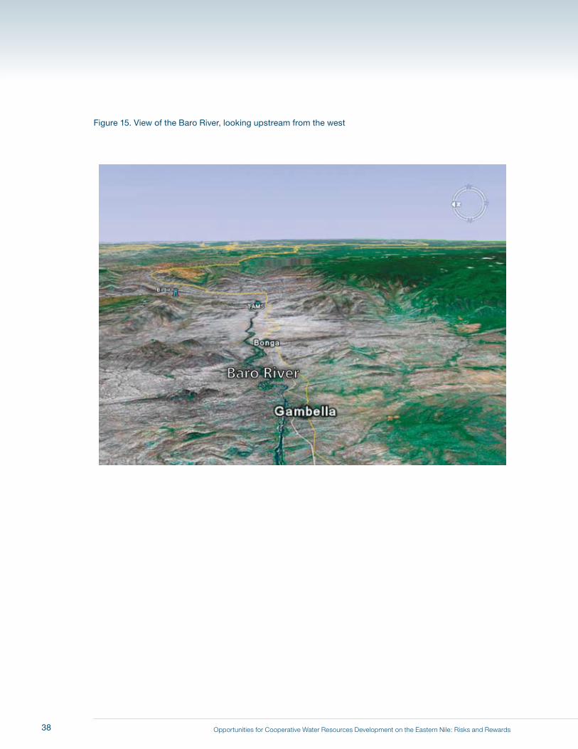
Opportunities for Cooperative Water Resources Development on the Eastern Nile: Risks and Rewards
Figure 15. View of the Baro River, looking upstream from the west
38
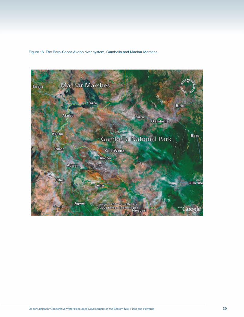
Opportunities for Cooperative Water Resources Development on the Eastern Nile: Risks and Rewards
Figure 16. The Baro-Sobat-Akobo river system, Gambella and Machar Marshes
39
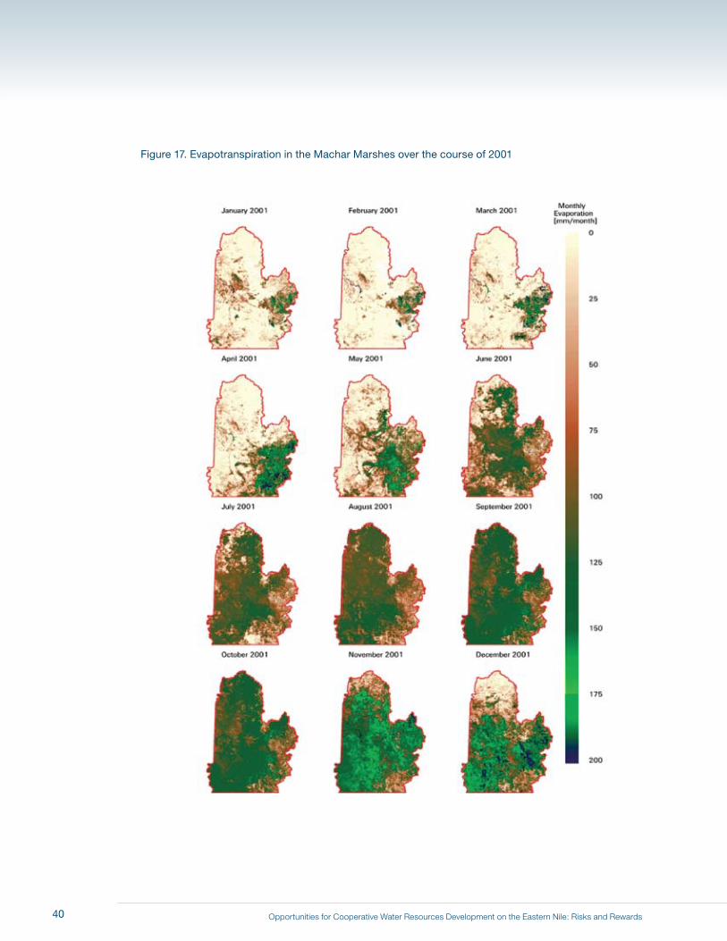
Opportunities for Cooperative Water Resources Development on the Eastern Nile: Risks and Rewards
Figure 17. Evapotranspiration in the Machar Marshes over the course of 2001
40

Opportunities for Cooperative Water Resources Development on the Eastern Nile: Risks and Rewards
Both Egypt and Ethiopia expressed interest in identifying the scale of the potential water conservation and
development opportunities this area might offer. We therefore decided to investigate whether these proposals
were attractive options for the initial set of investments under the JMP for the Eastern Nile riparians. To determine
whether engineering works to drain water from the Machar Marshes are likely to be economically feasible, one
needs to know whether the majority of the water in these wetlands comes from rainfall or from channel spills
from the Baro and Sobat. If most of the water comes from channel spills, engineering works (such as levees,
channel dredging, and upstream reservoirs) could prevent floodwaters from the Baro from spilling into the Machar
Marshes. But if the water in the Machar Marshes comes largely from rainfall, efforts to increase downstream flows
would likely require much more complex engineering works; the wetlands would need to be drained, and water
would have to be pumped from the wetlands into the Sobat and/or White Nile.
To better understand the potential of the Machar Marshes to increase downstream flows, the Team commissioned
WaterWatch B.V. to conduct a remote sensing study of annual evapotranspiration from these wetlands (2006c).
The resulting calculations revealed that the vast majority of the water in these wetlands comes from rainfall, not
over-bank spills. Figure 18 presents our best estimate of the water balance of the Machar Marshes. Spills from the
Baro and Sobat contribute about 1 bcm annually to the water in the Machar Marshes, compared to 11 bcm from
local rainfall on the wetlands.40 Our investigation also revealed that there is little if any elevation gradient from the
Machar Marshes to either the White Nile or the Baro. This means that any engineering works designed to collect
rainfall from the Machar Marshes during the flood season would most likely require extensive pumping. There is no
evidence that such large-scale drainage and pumping projects would be economically, socially, or environmentally
attractive in the near term.
The second group of development projects in this sub-basin is described in Ethiopian master plans
(Selkhozpromexport, 1990; TAMS, 1997). These master plans show that in the western Ethiopian highlands there
are numerous hydroelectric dam sites that could be developed (Figure 19). However, these hydroelectric sites are
typically quite small (<100 MW capacity) and would only produce power seasonally. They would provide little if
any over-year storage and few opportunities for irrigation. These sites may be developed to meet local electricity
needs, but they do not meet the criteria for the first set of JMP investments.
Farther downstream on the Baro a larger dam has been proposed at Gambella (with alternative upstream sites
at Tams and Bonga, and a downstream site at Itang). A number of designs have been proposed. In the Russian
master plan the dam is designed to be 50 meters high, have a large storage capacity of about 10.3 bcm (6.6 bcm
live storage), and have an installed capacity of 250 MW (Selkhozpromexport, 1990). As can be seen from the
topography shown in Figure 15, a reservoir behind a 50-meter dam at Gambella would flood a large area in the
sub-basin, much of which lies within the Gambella National Park.
One objective of this dam at Gambella would be to regulate annual flows of the Baro to prevent over-bank spills
to the Machar Marshes, thus increasing downstream flows into the White Nile. However, as discussed above, we
believe that net overbank spills from the Baro to the Machar Marshes are not more than 1 bcm annually. From
the modeling work done for this report, it appears that the potential regulation benefit to White Nile flows from
40 The WaterWatch analyses also showed that the amount of over-bank spills that can be saved from the entire Baro–Akobo wetland system is probably less than 2 bcm annually.
41
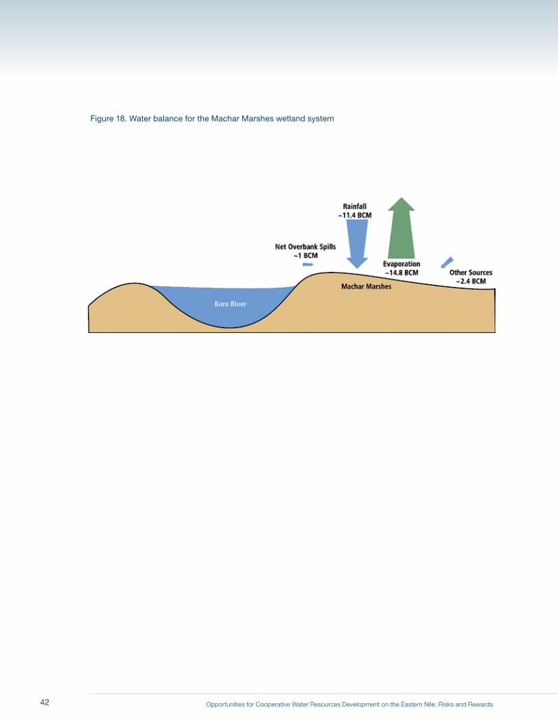
Opportunities for Cooperative Water Resources Development on the Eastern Nile: Risks and Rewards
Figure 18. Water balance for the Machar Marshes wetland system
42
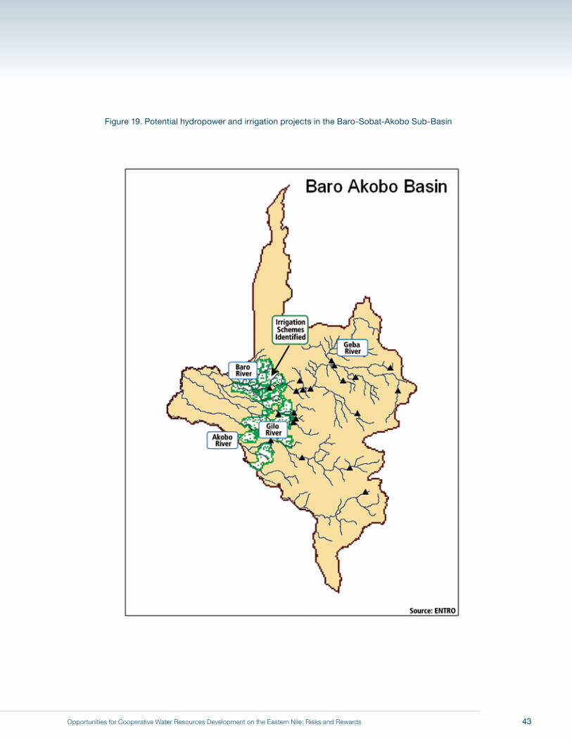
Opportunities for Cooperative Water Resources Development on the Eastern Nile: Risks and Rewards
Figure 19. Potential hydropower and irrigation projects in the Baro-Sobat-Akobo Sub-Basin
43
Opportunities for Cooperative Water Resources Development on the Eastern Nile: Risks and Rewards
storage on the Baro would be no more than 0.5 bcm (assuming no withdrawals for irrigation within Ethiopia itself).
Moreover, it is presently unclear whether the channel capacities of the Baro and Sobat rivers are sufficient to
accomplish even that modest re-regulation benefit, and how much rechannelization work might be needed.
About 600,000 hectares of low-yielding rain-fed agriculture are estimated to be under cultivation in the sub-basin
today.41 The Ethiopian master plans (TAMS, 1997) report that there are 480,000 to 1.1 million hectares in the
sub-basin that could be developed for irrigation. However, the consultants who prepared these plans emphasize
the complex environmental and social ramifications of such irrigation development, and recommend focusing
development efforts on the region’s rain-fed agriculture potential. They estimate that some 800,000 additional
hectares may be suitable for rain-fed cultivation beyond present conditions.
Potentially irrigable land downstream of both the Gambella and the Itang dam sites is prone to flooding, and the
area has high precipitation during the rainy season. Significant engineering works would thus be required for these
lands to be adequately drained and protected from floods if they were to be brought into agricultural production.
This would add significantly to the costs of irrigation infrastructure. (The Team notes, in this context, that the
farther west one goes, the more arid the landscape; because the need for drainage infrastructure is reduced
accordingly, more possibilities are available for irrigated agriculture in that direction.)
Because there are natural levees near the Baro and Akobo rivers, some lands exist near water that are not subject
to flooding. These areas could probably be irrigated quite cheaply by pumping directly from the nearby rivers, as
they would not require upstream reservoirs and other expensive infrastructure. But here again, such small-scale
investments would not meet the criteria for a first set of JMP investments.
Both a dam at Gambella and efforts to drain the Machar Marshes would involve significant resettlement and
social issues. Currently about 2.2 million people live in the Baro–Akobo sub-basin, a population expected to
double by 2030. The area also currently sustains 2 million cattle and 1 million other livestock (excluding poultry)
(TAMS, 1997). A dam at Gambella could have adverse effects on the recessional agriculture currently practiced
in the area. Moreover, any water resources development and irrigation schemes would involve significant public
health issues. Malaria and African trypanosomiases (sleeping sickness) are both endemic in the sub-basin and
pose serious threats to human health. In addition, the sub-basin is far from markets and lacks transportation
infrastructure, such that moving any agricultural or hydroelectric surpluses from the area would be expensive
and difficult.
We see no evidence that cost-effective engineering works can be developed in the near or intermediate term in
the Baro–Akobo–Sobat sub-basin that would be sufficiently large to serve as anchor investments for an initial
JMP. Any future development projects would entail both costs and benefits to the local inhabitants of Ethiopia and
Sudan. Projects of this complexity require long lead times and especially careful planning. Given the history and
41 In their report TAMS concluded: “The improvements to rain-fed agriculture that have been proposed are realistic and [not only can] meet the food demands of the population but also produce a surplus for export. There will be a total increase in food production from an annual production of 514,000 tonnes at present to 3.9 million tonnes in 2035” (Executive Summary, 29).
44
Opportunities for Cooperative Water Resources Development on the Eastern Nile: Risks and Rewards
current situation in the region, the government and people of Sudan will only address these complex issues when
the circumstances are right to do so. As a consequence, developments in this sub-basin do not satisfy the criteria
for a first set of JMP investments.
In summary, evidence from the latest satellite data on the hydrology of the Machar Marshes, together with the
prospect of complex environmental and social issues from any water storage or “water conservation” projects
to increase downstream flows in the White Nile, leads to the conclusion that the Baro–Akobo–Sobat sub-basin
does not offer attractive opportunities for an initial set of JMP investments for the Eastern Nile riparians, but more
studies are warranted so that the Eastern Nile riparians will have the information they need to properly assess
investment opportunities in the Baro–Akobo–Sobat sub-basin in the future.
Tekeze-Atbara Sub-basin
The Tekeze River drains much of Northern Ethiopia. Its flows exhibit great seasonal variation and carry heavy
sediment loads. The Tekeze crosses the Ethiopia–Sudan border near Rumela (Figure 20), after which point it is
known as the Atbara. In Sudan the river flows northwest to join the Main Nile 300 kilometers north of Khartoum.
The Khasm El Girba Reservoir, the only major storage on the Atbara, feeds the New Halfa irrigation scheme
(approximately 113,000 hectares currently under cultivation)42 and generates an average of 43 GWh annually.
The Khasm El Girba Reservoir is subject to high sedimentation; its storage capacity, 1.3 bcm at the time of
construction in 1964, has diminished by more than 50% in the four decades since.
As noted earlier, Ethiopia is currently constructing a hydroelectric power generation dam on the Tekeze at a site
known as TK-5 (Figure 21). The 185-meter dam at TK-5 will have an installed hydroelectric capacity of 300 MW;
completion is expected in 2009. The TK-5 site, in a valley with steep canyon walls, appears to be a favorable
location for hydroelectric power generation.
The Ethiopian master plans show nine other potential hydropower generation sites for the Tekeze sub-basin. Only
one of these sites (TK-7B) has an installed capacity greater than 100 MW. Even though these dam sites have
excellent topographic characteristics, they offer only limited hydroelectric production potential because of low
flows and high seasonal variation.
The Ethiopian master plans also report 121,000 hectares of potentially irrigable land in the Tekeze sub-basin,
mostly on the plains near the Ethiopia–Sudan border (Figure 20). Similar opportunities to utilize water from the
sub-basin for irrigation can be seen in Sudan and Eritrea.
That hydropower generation sites on the Tekeze are relatively small is an advantage from the perspective
of planning additions to the Ethiopian power grid, as small hydroelectric power facilities can be more easily
matched with increases in national power consumption. Small hydropower dams on the Tekeze may thus prove
economically attractive to Ethiopia. However, these projects are not likely to create multipurpose benefits of
42 Based on information from ENTRO’s one-system inventory.
45
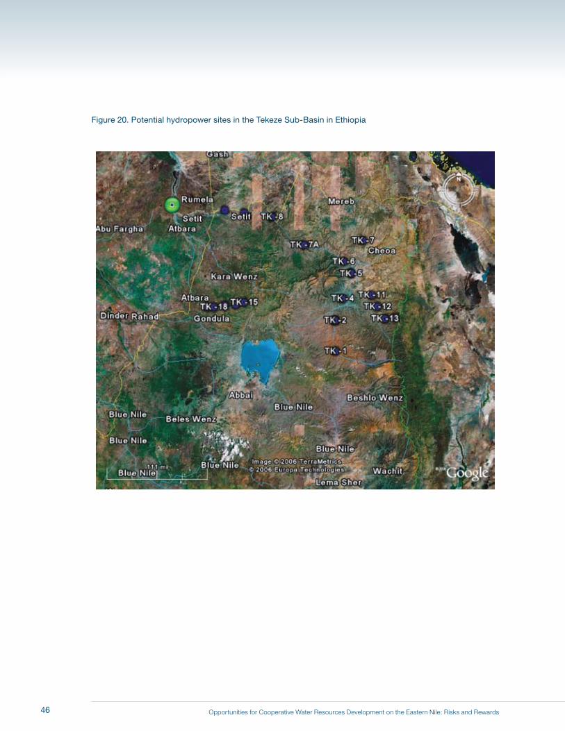
Opportunities for Cooperative Water Resources Development on the Eastern Nile: Risks and Rewards
Figure 20. Potential hydropower sites in the Tekeze Sub-Basin in Ethiopia
46
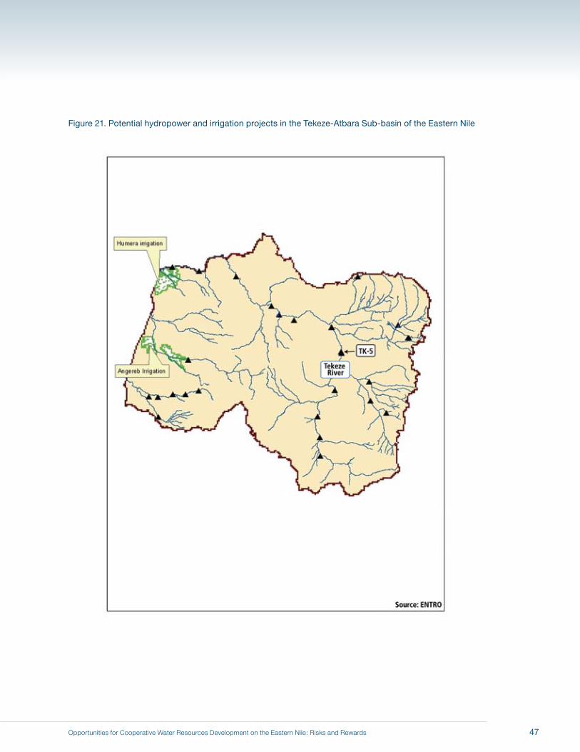
Opportunities for Cooperative Water Resources Development on the Eastern Nile: Risks and Rewards
Figure 21. Potential hydropower and irrigation projects in the Tekeze-Atbara Sub-basin of the Eastern Nile
47
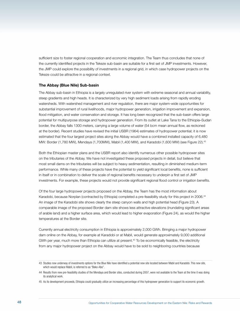
Opportunities for Cooperative Water Resources Development on the Eastern Nile: Risks and Rewards
sufficient size to foster regional cooperation and economic integration. The Team thus concludes that none of
the currently identified projects in the Tekeze sub-basin are suitable for a first set of JMP investments. However,
the JMP could explore the possibility of investments in a regional grid, in which case hydropower projects on the
Tekeze could be attractive in a regional context.
The Abbay (Blue Nile) Sub-basin
The Abbay sub-basin in Ethiopia is a largely unregulated river system with extreme seasonal and annual variability,
steep gradients and high heads. It is characterized by very high sediment loads arising from rapidly eroding
watersheds. With watershed management and river regulation, there are major system-wide opportunities for
substantial improvement of rural livelihoods, major hydropower generation, irrigation improvement and expansion,
flood mitigation, and water conservation and storage. It has long been recognized that the sub-basin offers large
potential for multipurpose storage and hydropower generation. From its outlet at Lake Tana to the Ethiopia–Sudan
border, the Abbay falls 1300 meters, carrying a large volume of water (54 bcm mean annual flow, as reckoned
at the border). Recent studies have revised the initial USBR (1964) estimates of hydropower potential; it is now
estimated that the four largest project sites along the Abbay would have a combined installed capacity of 6,480
MW: Border (1,780 MW), Mendaya (1,700MW), Mabil (1,400 MW), and Karadobi (1,600 MW) (see Figure 22).43
Both the Ethiopian master plans and the USBR report also identify numerous other possible hydropower sites
on the tributaries of the Abbay. We have not investigated these proposed projects in detail, but believe that
most small dams on the tributaries will be subject to heavy sedimentation, resulting in diminished medium-term
performance. While many of these projects have the potential to yield significant local benefits, none is sufficient
in itself or in combination to deliver the scale of regional benefits necessary to underpin a first set of JMP
investments. For example, these projects would not provide significant regional flood control or irrigation benefits.
Of the four large hydropower projects proposed on the Abbay, the Team has the most information about
Karadobi, because Norplan (contracted by Ethiopia) completed a pre-feasibility study for this project in 2006.44
An image of the Karadobi site shows clearly the steep canyon walls and high potential head (Figure 23). A
comparable image of the proposed Border dam site shows less attractive elevations (inundating significant areas
of arable land) and a higher surface area, which would lead to higher evaporation (Figure 24), as would the higher
temperatures at the Border site.
Currently annual electricity consumption in Ethiopia is approximately 2,000 GWh. Bringing a major hydropower
dam online on the Abbay, for example at Karadobi or at Mabil, would generate approximately 9,000 additional
GWh per year, much more than Ethiopia can utilize at present.45 To be economically feasible, the electricity
from any major hydropower project on the Abbay would have to be sold to neighboring countries because
43 Studies now underway of investments options for the Blue Nile have identified a potential new site located between Mabil and Karadobi. This new site, which would replace Mabil, is referred to as “Beko-Abo”.
44 Results from new pre-feasibility studies of the Mendaya and Border sites, conducted during 2007, were not available to the Team at the time it was doing its analytical work.
45 As its development proceeds, Ethiopia could gradually utilize an increasing percentage of this hydropower generation to support its economic growth.
48
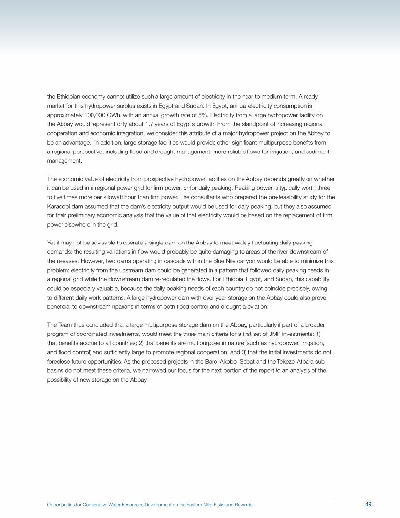
Opportunities for Cooperative Water Resources Development on the Eastern Nile: Risks and Rewards
the Ethiopian economy cannot utilize such a large amount of electricity in the near to medium term. A ready
market for this hydropower surplus exists in Egypt and Sudan. In Egypt, annual electricity consumption is
approximately 100,000 GWh, with an annual growth rate of 5%. Electricity from a large hydropower facility on
the Abbay would represent only about 1.7 years of Egypt’s growth. From the standpoint of increasing regional
cooperation and economic integration, we consider this attribute of a major hydropower project on the Abbay to
be an advantage. In addition, large storage facilities would provide other significant multipurpose benefits from
a regional perspective, including flood and drought management, more reliable flows for irrigation, and sediment
management.
The economic value of electricity from prospective hydropower facilities on the Abbay depends greatly on whether
it can be used in a regional power grid for firm power, or for daily peaking. Peaking power is typically worth three
to five times more per kilowatt hour than firm power. The consultants who prepared the pre-feasibility study for the
Karadobi dam assumed that the dam’s electricity output would be used for daily peaking, but they also assumed
for their preliminary economic analysis that the value of that electricity would be based on the replacement of firm
power elsewhere in the grid.
Yet it may not be advisable to operate a single dam on the Abbay to meet widely fluctuating daily peaking
demands: the resulting variations in flow would probably be quite damaging to areas of the river downstream of
the releases. However, two dams operating in cascade within the Blue Nile canyon would be able to minimize this
problem: electricity from the upstream dam could be generated in a pattern that followed daily peaking needs in
a regional grid while the downstream dam re-regulated the flows. For Ethiopia, Egypt, and Sudan, this capability
could be especially valuable, because the daily peaking needs of each country do not coincide precisely, owing
to different daily work patterns. A large hydropower dam with over-year storage on the Abbay could also prove
beneficial to downstream riparians in terms of both flood control and drought alleviation.
The Team thus concluded that a large multipurpose storage dam on the Abbay, particularly if part of a broader
program of coordinated investments, would meet the three main criteria for a first set of JMP investments: 1)
that benefits accrue to all countries; 2) that benefits are multipurpose in nature (such as hydropower, irrigation,
and flood control) and sufficiently large to promote regional cooperation; and 3) that the initial investments do not
foreclose future opportunities. As the proposed projects in the Baro–Akobo–Sobat and the Tekeze-Atbara sub-
basins do not meet these criteria, we narrowed our focus for the next portion of the report to an analysis of the
possibility of new storage on the Abbay.
49
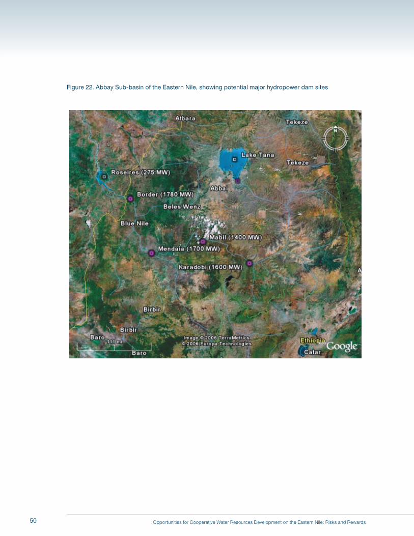
Opportunities for Cooperative Water Resources Development on the Eastern Nile: Risks and Rewards
Figure 22. Abbay Sub-basin of the Eastern Nile, showing potential major hydropower dam sites
50
Opportunities for Cooperative Water Resources Development on the Eastern Nile: Risks and Rewards
Figure 23. Karadobi dam site in the Abbay gorge, from the east
Figure 24. Border dam site along the Abbay, from the west
51

Opportunities for Cooperative Water Resources Development on the Eastern Nile: Risks and Rewards52
Opportunities for Cooperative Water Resources Development on the Eastern Nile: Risks and Rewards
7 Modeling Results Blue Nile Development Scenarios (C, D, E, F) and a Climate Change Scenario (G)
Table 4 summarizes the assumptions made in the construction of the scenarios discussed in this
chapter (as well as Scenarios A and B). As shown,
� Scenario C differs from Scenario B (evolving conditions) only by the addition of one dam on
the Abbay; target withdrawals remain the same.
� Scenario D makes two changes to Scenario C: 1) three more storage facilities are added on
the Abbay, and 2) target withdrawals in Ethiopia are increased by 3 bcm (5.3 bcm total).
� Scenario E leaves the infrastructure assumed in Scenario D in place and increases Ethiopia’s
target withdrawals by an additional 3 bcm (to 8.3 bcm in total).
� Scenario F leaves the Ethiopian target withdrawals the same as in Scenario E (at 8.3 bcm in
total) and reduces Egyptian target withdrawals to 53 bcm (from 55.5 bcm).
� Scenario G makes the same assumptions about infrastructure and target withdrawals as
in Scenario B (evolving conditions), but reduces all model inflows by 5% to illustrate the
sensitivity of these simulations to the possible effects of climate change.
The purpose our scenario analyses is not to suggest the best development path or to forecast what will
happen in the future; it is rather to illustrate what is possible in the Eastern Nile basin given the limited
shared water resources available.
53
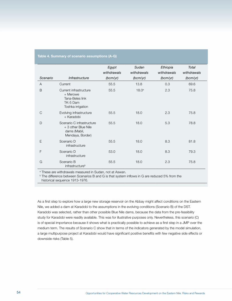
Opportunities for Cooperative Water Resources Development on the Eastern Nile: Risks and Rewards
Table 4. Summary of scenario assumptions (A-G)
Scenario Infrastructure
Egypt
withdrawals
(bcm/yr)
Sudan
withdrawals
(bcm/yr)
Ethiopia
withdrawals
(bcm/yr)
Total
withdrawals
(bcm/yr)
A Current 55.5 13.8 0.3 69.6
B Current infrastructure + Merowe Tana-Beles link TK-5 Dam Toshka irrigation
55.5 18.0a 2.3 75.8
C Evolving infrastructure + Karadobi
55.5 18.0 2.3 75.8
D Scenario C infrastructure + 3 other Blue Nile dams (Mabil, Mendaya, Border)
55.5 18.0 5.3 78.8
E Scenario D infrastructure
55.5 18.0 8.3 81.8
F Scenario D infrastructure
53.0 18.0 8.3 79.3
G Scenario B infrastructureb
55.5 18.0 2.3 75.8
a These are withdrawals measured in Sudan, not at Aswan.b The difference between Scenarios B and G is that system inflows in G are reduced 5% from the historical sequence 1913-1976.
As a first step to explore how a large new storage reservoir on the Abbay might affect conditions on the Eastern
Nile, we added a dam at Karadobi to the assumptions in the evolving conditions (Scenario B) of the DST.
Karadobi was selected, rather than other possible Blue Nile dams, because the data from the pre-feasibility
study for Karadobi were readily available. This was for illustrative purposes only. Nevertheless, this scenario (C)
is of special importance because it shows what is practically possible to achieve as a first step in a JMP over the
medium term. The results of Scenario C show that in terms of the indicators generated by the model simulation,
a large multipurpose project at Karadobi would have significant positive benefits with few negative side effects or
downside risks (Table 5).
54
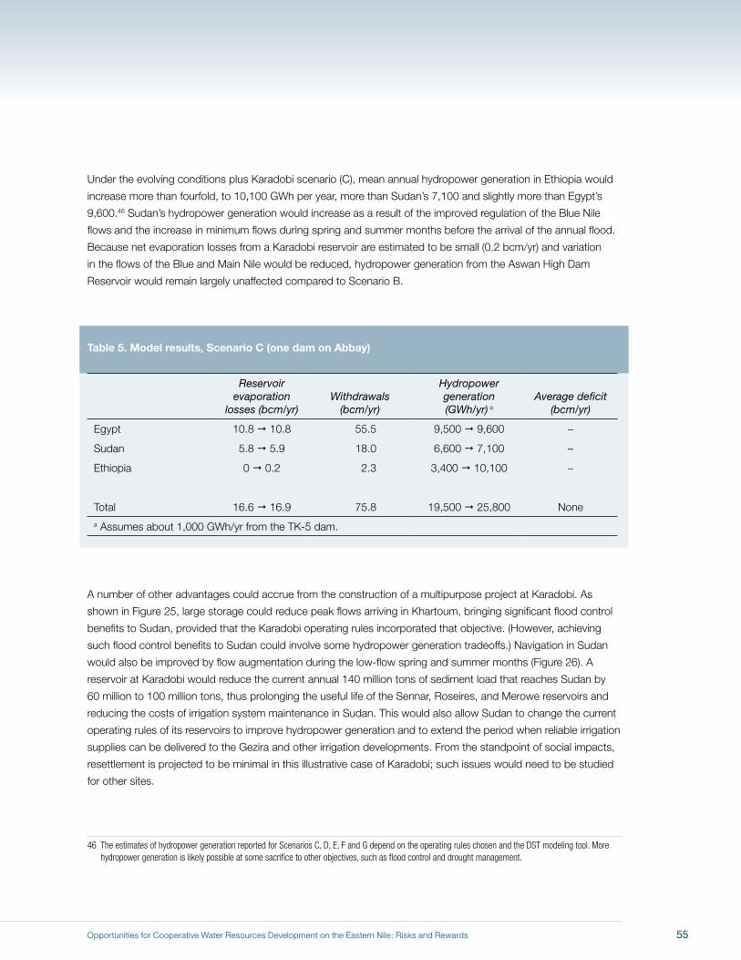
Opportunities for Cooperative Water Resources Development on the Eastern Nile: Risks and Rewards
Under the evolving conditions plus Karadobi scenario (C), mean annual hydropower generation in Ethiopia would
increase more than fourfold, to 10,100 GWh per year, more than Sudan’s 7,100 and slightly more than Egypt’s
9,600.46 Sudan’s hydropower generation would increase as a result of the improved regulation of the Blue Nile
flows and the increase in minimum flows during spring and summer months before the arrival of the annual flood.
Because net evaporation losses from a Karadobi reservoir are estimated to be small (0.2 bcm/yr) and variation
in the flows of the Blue and Main Nile would be reduced, hydropower generation from the Aswan High Dam
Reservoir would remain largely unaffected compared to Scenario B.
Table 5. Model results, Scenario C (one dam on Abbay)
Reservoir evaporation
losses (bcm/yr)Withdrawals
(bcm/yr)
Hydropower generation (GWh/yr) a
Average deficit (bcm/yr)
Egypt 10.8 10.8 55.5 9,500 9,600 –
Sudan 5.8 5.9 18.0 6,600 7,100 –
Ethiopia 0 0.2 2.3 3,400 10,100 –
Total 16.6 16.9 75.8 19,500 25,800 Nonea Assumes about 1,000 GWh/yr from the TK-5 dam.
A number of other advantages could accrue from the construction of a multipurpose project at Karadobi. As
shown in Figure 25, large storage could reduce peak flows arriving in Khartoum, bringing significant flood control
benefits to Sudan, provided that the Karadobi operating rules incorporated that objective. (However, achieving
such flood control benefits to Sudan could involve some hydropower generation tradeoffs.) Navigation in Sudan
would also be improved by flow augmentation during the low-flow spring and summer months (Figure 26). A
reservoir at Karadobi would reduce the current annual 140 million tons of sediment load that reaches Sudan by
60 million to 100 million tons, thus prolonging the useful life of the Sennar, Roseires, and Merowe reservoirs and
reducing the costs of irrigation system maintenance in Sudan. This would also allow Sudan to change the current
operating rules of its reservoirs to improve hydropower generation and to extend the period when reliable irrigation
supplies can be delivered to the Gezira and other irrigation developments. From the standpoint of social impacts,
resettlement is projected to be minimal in this illustrative case of Karadobi; such issues would need to be studied
for other sites.
46 The estimates of hydropower generation reported for Scenarios C, D, E, F and G depend on the operating rules chosen and the DST modeling tool. More hydropower generation is likely possible at some sacrifice to other objectives, such as flood control and drought management.
55

Opportunities for Cooperative Water Resources Development on the Eastern Nile: Risks and Rewards
Figure 25. Hydrograph of Blue Nile flows in Khartoum for an illustrative high flood year (1929)
Figure 26. Hydrograph of Blue Nile flows in Khartoum for an illustrative drought year (1940)
6
5
8
7
4
3
2
1
0
Flow
(BCM
/Per
iod)
10-Day Period
0 10 20 30
Scenario BScenario C
This early peakresults from Sudanreservoirs operatingfor sediment control
10-Day Period
0 10 20 30
3.5
3
4.5
4
2.5
2
1.5
1
0.5
0
Flow
(BCM
/Per
iod)
Scenario BScenario C
This early peakresults from Sudanreservoirs operatingfor sediment control
56
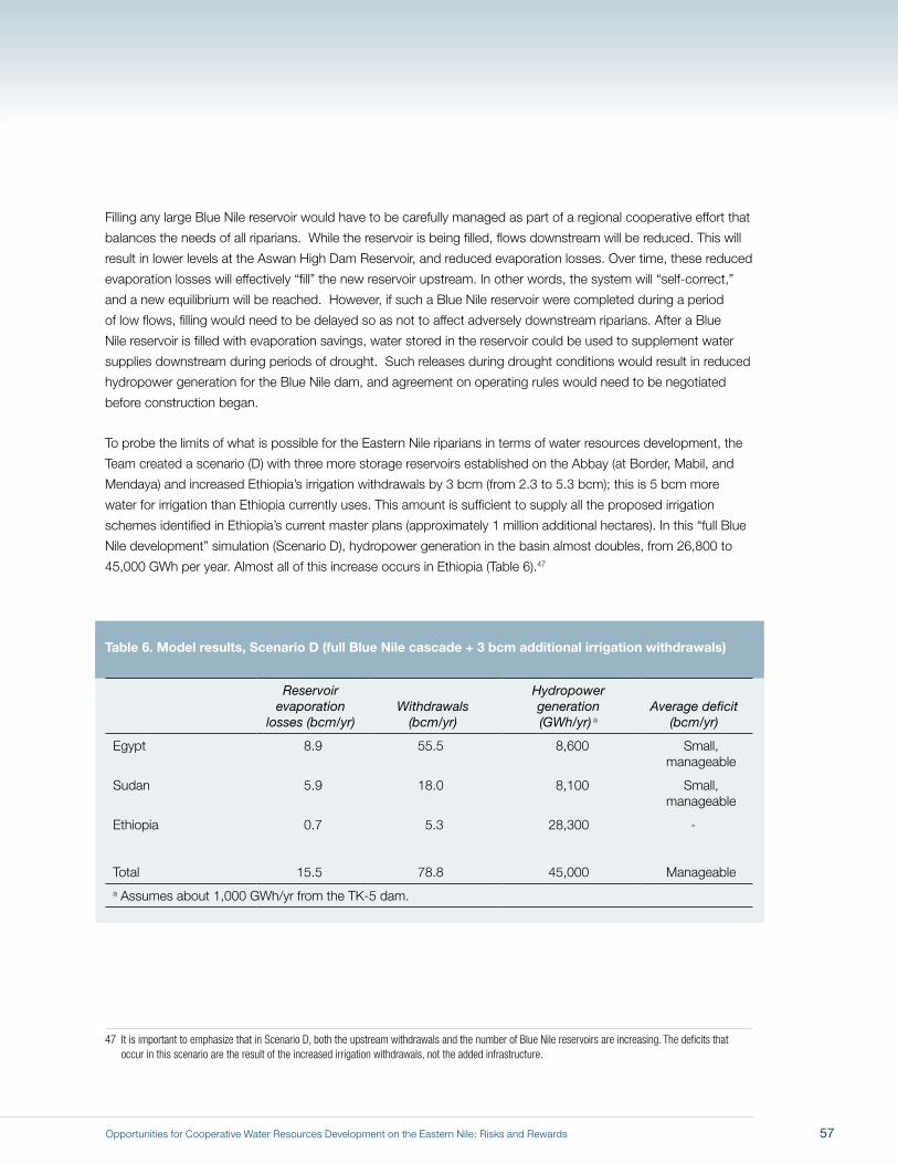
Opportunities for Cooperative Water Resources Development on the Eastern Nile: Risks and Rewards
Filling any large Blue Nile reservoir would have to be carefully managed as part of a regional cooperative effort that
balances the needs of all riparians. While the reservoir is being filled, flows downstream will be reduced. This will
result in lower levels at the Aswan High Dam Reservoir, and reduced evaporation losses. Over time, these reduced
evaporation losses will effectively “fill” the new reservoir upstream. In other words, the system will “self-correct,”
and a new equilibrium will be reached. However, if such a Blue Nile reservoir were completed during a period
of low flows, filling would need to be delayed so as not to affect adversely downstream riparians. After a Blue
Nile reservoir is filled with evaporation savings, water stored in the reservoir could be used to supplement water
supplies downstream during periods of drought. Such releases during drought conditions would result in reduced
hydropower generation for the Blue Nile dam, and agreement on operating rules would need to be negotiated
before construction began.
To probe the limits of what is possible for the Eastern Nile riparians in terms of water resources development, the
Team created a scenario (D) with three more storage reservoirs established on the Abbay (at Border, Mabil, and
Mendaya) and increased Ethiopia’s irrigation withdrawals by 3 bcm (from 2.3 to 5.3 bcm); this is 5 bcm more
water for irrigation than Ethiopia currently uses. This amount is sufficient to supply all the proposed irrigation
schemes identified in Ethiopia’s current master plans (approximately 1 million additional hectares). In this “full Blue
Nile development” simulation (Scenario D), hydropower generation in the basin almost doubles, from 26,800 to
45,000 GWh per year. Almost all of this increase occurs in Ethiopia (Table 6).47
Table 6. Model results, Scenario D (full Blue Nile cascade + 3 bcm additional irrigation withdrawals)
Reservoir evaporation
losses (bcm/yr)Withdrawals
(bcm/yr)
Hydropower generation (GWh/yr) a
Average deficit (bcm/yr)
Egypt 8.9 55.5 8,600 Small, manageable
Sudan 5.9 18.0 8,100 Small, manageable
Ethiopia 0.7 5.3 28,300 -
Total 15.5 78.8 45,000 Manageable a Assumes about 1,000 GWh/yr from the TK-5 dam.
47 It is important to emphasize that in Scenario D, both the upstream withdrawals and the number of Blue Nile reservoirs are increasing. The deficits that occur in this scenario are the result of the increased irrigation withdrawals, not the added infrastructure.
57
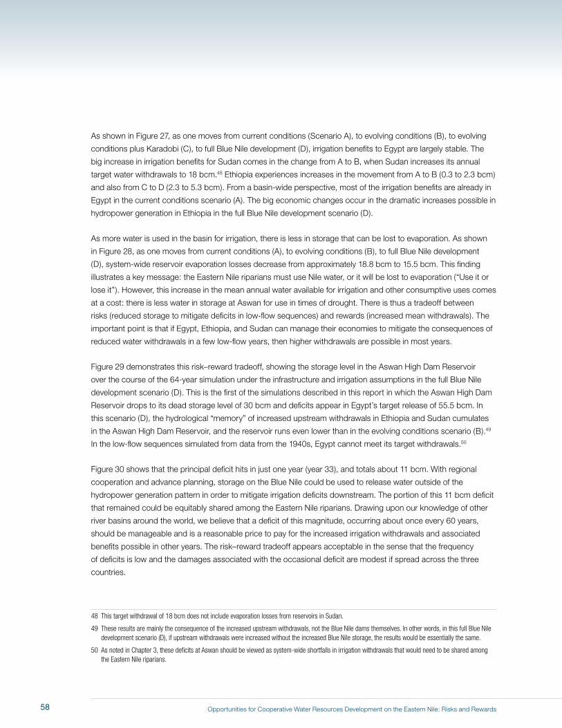
Opportunities for Cooperative Water Resources Development on the Eastern Nile: Risks and Rewards
As shown in Figure 27, as one moves from current conditions (Scenario A), to evolving conditions (B), to evolving
conditions plus Karadobi (C), to full Blue Nile development (D), irrigation benefits to Egypt are largely stable. The
big increase in irrigation benefits for Sudan comes in the change from A to B, when Sudan increases its annual
target water withdrawals to 18 bcm.48 Ethiopia experiences increases in the movement from A to B (0.3 to 2.3 bcm)
and also from C to D (2.3 to 5.3 bcm). From a basin-wide perspective, most of the irrigation benefits are already in
Egypt in the current conditions scenario (A). The big economic changes occur in the dramatic increases possible in
hydropower generation in Ethiopia in the full Blue Nile development scenario (D).
As more water is used in the basin for irrigation, there is less in storage that can be lost to evaporation. As shown
in Figure 28, as one moves from current conditions (A), to evolving conditions (B), to full Blue Nile development
(D), system-wide reservoir evaporation losses decrease from approximately 18.8 bcm to 15.5 bcm. This finding
illustrates a key message: the Eastern Nile riparians must use Nile water, or it will be lost to evaporation (“Use it or
lose it”). However, this increase in the mean annual water available for irrigation and other consumptive uses comes
at a cost: there is less water in storage at Aswan for use in times of drought. There is thus a tradeoff between
risks (reduced storage to mitigate deficits in low-flow sequences) and rewards (increased mean withdrawals). The
important point is that if Egypt, Ethiopia, and Sudan can manage their economies to mitigate the consequences of
reduced water withdrawals in a few low-flow years, then higher withdrawals are possible in most years.
Figure 29 demonstrates this risk–reward tradeoff, showing the storage level in the Aswan High Dam Reservoir
over the course of the 64-year simulation under the infrastructure and irrigation assumptions in the full Blue Nile
development scenario (D). This is the first of the simulations described in this report in which the Aswan High Dam
Reservoir drops to its dead storage level of 30 bcm and deficits appear in Egypt’s target release of 55.5 bcm. In
this scenario (D), the hydrological “memory” of increased upstream withdrawals in Ethiopia and Sudan cumulates
in the Aswan High Dam Reservoir, and the reservoir runs even lower than in the evolving conditions scenario (B).49
In the low-flow sequences simulated from data from the 1940s, Egypt cannot meet its target withdrawals.50
Figure 30 shows that the principal deficit hits in just one year (year 33), and totals about 11 bcm. With regional
cooperation and advance planning, storage on the Blue Nile could be used to release water outside of the
hydropower generation pattern in order to mitigate irrigation deficits downstream. The portion of this 11 bcm deficit
that remained could be equitably shared among the Eastern Nile riparians. Drawing upon our knowledge of other
river basins around the world, we believe that a deficit of this magnitude, occurring about once every 60 years,
should be manageable and is a reasonable price to pay for the increased irrigation withdrawals and associated
benefits possible in other years. The risk–reward tradeoff appears acceptable in the sense that the frequency
of deficits is low and the damages associated with the occasional deficit are modest if spread across the three
countries.
48 This target withdrawal of 18 bcm does not include evaporation losses from reservoirs in Sudan.
49 These results are mainly the consequence of the increased upstream withdrawals, not the Blue Nile dams themselves. In other words, in this full Blue Nile development scenario (D), if upstream withdrawals were increased without the increased Blue Nile storage, the results would be essentially the same.
50 As noted in Chapter 3, these deficits at Aswan should be viewed as system-wide shortfalls in irrigation withdrawals that would need to be shared among the Eastern Nile riparians.
58
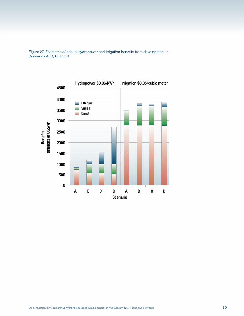
Opportunities for Cooperative Water Resources Development on the Eastern Nile: Risks and Rewards
Figure 27. Estimates of annual hydropower and irrigation benefits from development in Scenarios A, B, C, and D
1500
4000
3500
4500
3000
2500
2000
1000
500
0
Bene
fits
(mill
ions
of U
S$/y
r)
ScenarioA B C D A B C D
EthiopiaSudanEgypt
Hydropower $0.06/kWh Irrigation $0.05/cubic meter
59
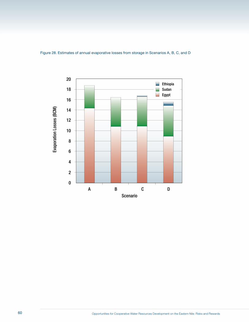
Opportunities for Cooperative Water Resources Development on the Eastern Nile: Risks and Rewards
Figure 28. Estimates of annual evaporative losses from storage in Scenarios A, B, C, and D
10
18
20
16
14
12
8
6
4
2
0
Evap
orat
ion
Loss
es (B
CM)
ScenarioA B C D
EthiopiaSudanEgypt
60
Opportunities for Cooperative Water Resources Development on the Eastern Nile: Risks and Rewards
Figure 29. Storage in Aswan over 64-year hydrological sequence in Scenarios A, B, and D
130
110
170
150
90
70
50
30
0
Stor
age
at A
swan
(BCM
)
Simulation Year
0 10 20 30 40 50 60
Scenario AScenario BScenario D
Spill Level
Dead Storage
61
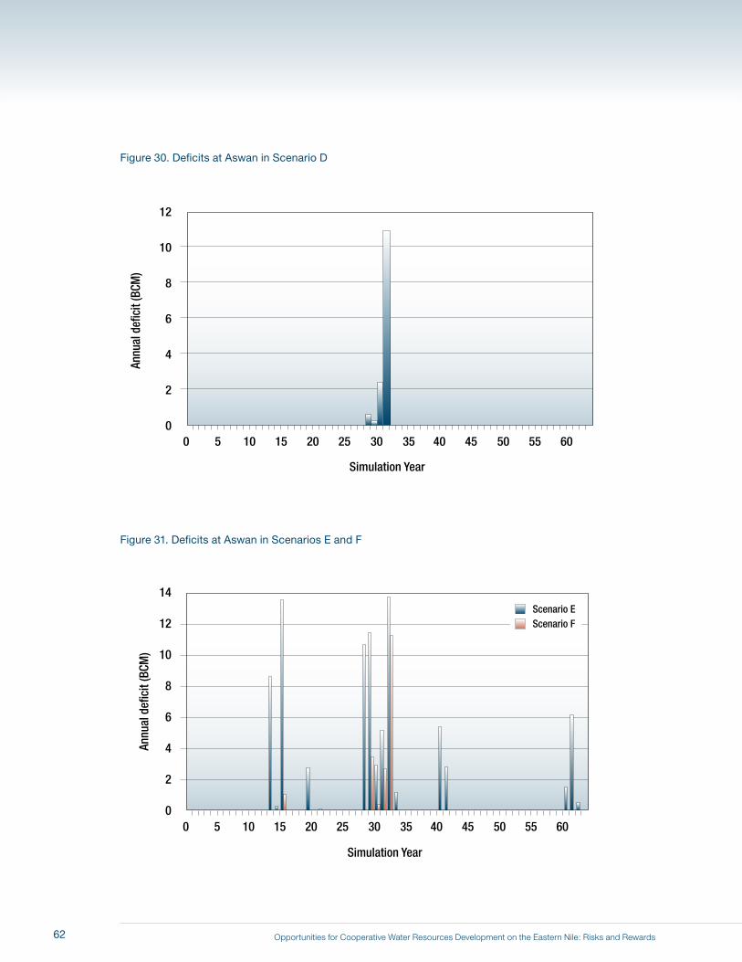
Opportunities for Cooperative Water Resources Development on the Eastern Nile: Risks and Rewards
Figure 30. Deficits at Aswan in Scenario D
Figure 31. Deficits at Aswan in Scenarios E and F
10
12
8
6
4
2
0
Annu
al d
efic
it (B
CM)
Simulation Year
0 5 10 15 20 25 30 35 40 45 50 55 60
10
14
12
8
6
4
2
0
Annu
al d
efic
it (B
CM)
Simulation Year
0 5 10 15 20 25 30 35 40 45 50 55 60
Scenario E Scenario F
62
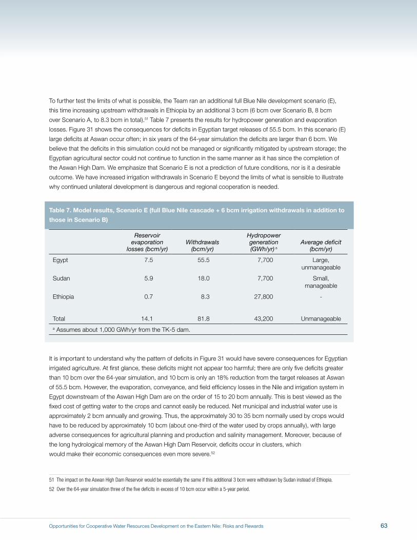
Opportunities for Cooperative Water Resources Development on the Eastern Nile: Risks and Rewards
To further test the limits of what is possible, the Team ran an additional full Blue Nile development scenario (E),
this time increasing upstream withdrawals in Ethiopia by an additional 3 bcm (6 bcm over Scenario B, 8 bcm
over Scenario A, to 8.3 bcm in total).51 Table 7 presents the results for hydropower generation and evaporation
losses. Figure 31 shows the consequences for deficits in Egyptian target releases of 55.5 bcm. In this scenario (E)
large deficits at Aswan occur often; in six years of the 64-year simulation the deficits are larger than 6 bcm. We
believe that the deficits in this simulation could not be managed or significantly mitigated by upstream storage; the
Egyptian agricultural sector could not continue to function in the same manner as it has since the completion of
the Aswan High Dam. We emphasize that Scenario E is not a prediction of future conditions, nor is it a desirable
outcome. We have increased irrigation withdrawals in Scenario E beyond the limits of what is sensible to illustrate
why continued unilateral development is dangerous and regional cooperation is needed.
Table 7. Model results, Scenario E (full Blue Nile cascade + 6 bcm irrigation withdrawals in addition to
those in Scenario B)
Reservoir evaporation
losses (bcm/yr)Withdrawals
(bcm/yr)
Hydropower generation (GWh/yr) a
Average deficit (bcm/yr)
Egypt 7.5 55.5 7,700 Large, unmanageable
Sudan 5.9 18.0 7,700 Small, manageable
Ethiopia 0.7 8.3 27,800 -
Total 14.1 81.8 43,200 Unmanageable a Assumes about 1,000 GWh/yr from the TK-5 dam.
It is important to understand why the pattern of deficits in Figure 31 would have severe consequences for Egyptian
irrigated agriculture. At first glance, these deficits might not appear too harmful; there are only five deficits greater
than 10 bcm over the 64-year simulation, and 10 bcm is only an 18% reduction from the target releases at Aswan
of 55.5 bcm. However, the evaporation, conveyance, and field efficiency losses in the Nile and irrigation system in
Egypt downstream of the Aswan High Dam are on the order of 15 to 20 bcm annually. This is best viewed as the
fixed cost of getting water to the crops and cannot easily be reduced. Net municipal and industrial water use is
approximately 2 bcm annually and growing. Thus, the approximately 30 to 35 bcm normally used by crops would
have to be reduced by approximately 10 bcm (about one-third of the water used by crops annually), with large
adverse consequences for agricultural planning and production and salinity management. Moreover, because of
the long hydrological memory of the Aswan High Dam Reservoir, deficits occur in clusters, which
would make their economic consequences even more severe.52
51 The impact on the Aswan High Dam Reservoir would be essentially the same if this additional 3 bcm were withdrawn by Sudan instead of Ethiopia.
52 Over the 64-year simulation three of the five deficits in excess of 10 bcm occur within a 5-year period.
63
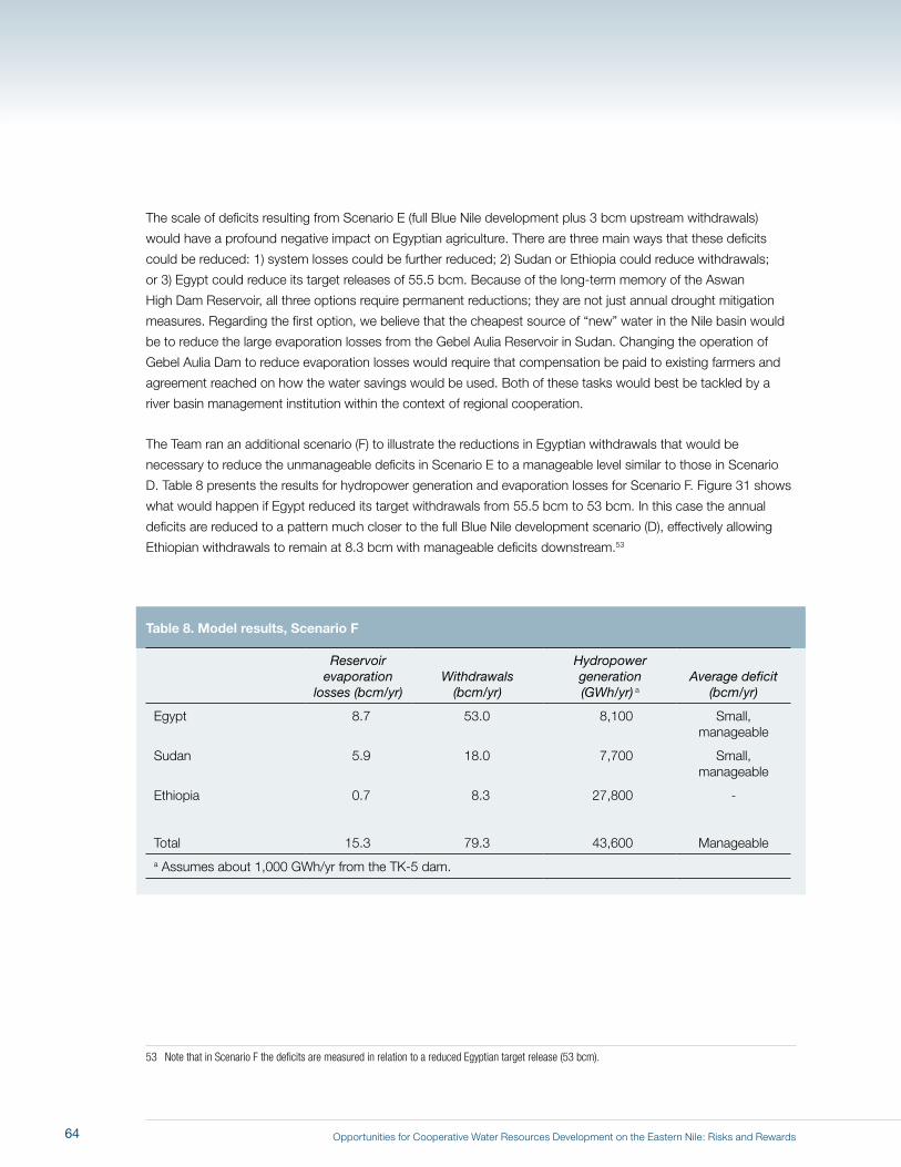
Opportunities for Cooperative Water Resources Development on the Eastern Nile: Risks and Rewards
The scale of deficits resulting from Scenario E (full Blue Nile development plus 3 bcm upstream withdrawals)
would have a profound negative impact on Egyptian agriculture. There are three main ways that these deficits
could be reduced: 1) system losses could be further reduced; 2) Sudan or Ethiopia could reduce withdrawals;
or 3) Egypt could reduce its target releases of 55.5 bcm. Because of the long-term memory of the Aswan
High Dam Reservoir, all three options require permanent reductions; they are not just annual drought mitigation
measures. Regarding the first option, we believe that the cheapest source of “new” water in the Nile basin would
be to reduce the large evaporation losses from the Gebel Aulia Reservoir in Sudan. Changing the operation of
Gebel Aulia Dam to reduce evaporation losses would require that compensation be paid to existing farmers and
agreement reached on how the water savings would be used. Both of these tasks would best be tackled by a
river basin management institution within the context of regional cooperation.
The Team ran an additional scenario (F) to illustrate the reductions in Egyptian withdrawals that would be
necessary to reduce the unmanageable deficits in Scenario E to a manageable level similar to those in Scenario
D. Table 8 presents the results for hydropower generation and evaporation losses for Scenario F. Figure 31 shows
what would happen if Egypt reduced its target withdrawals from 55.5 bcm to 53 bcm. In this case the annual
deficits are reduced to a pattern much closer to the full Blue Nile development scenario (D), effectively allowing
Ethiopian withdrawals to remain at 8.3 bcm with manageable deficits downstream.53
Table 8. Model results, Scenario F
Reservoir evaporation
losses (bcm/yr)Withdrawals
(bcm/yr)
Hydropower generation (GWh/yr) a
Average deficit (bcm/yr)
Egypt 8.7 53.0 8,100 Small, manageable
Sudan 5.9 18.0 7,700 Small, manageable
Ethiopia 0.7 8.3 27,800 -
Total 15.3 79.3 43,600 Manageable a Assumes about 1,000 GWh/yr from the TK-5 dam.
53 Note that in Scenario F the deficits are measured in relation to a reduced Egyptian target release (53 bcm).
64
Opportunities for Cooperative Water Resources Development on the Eastern Nile: Risks and Rewards
Figure 32 presents one way of looking at this tradeoff between risks and rewards. Mean annual economic benefits
over the 64-year simulation are shown on the vertical axis (irrigation plus hydropower, again assuming USD
0.06 per kWh and USD 0.05 per cubic meter of water used in irrigation). The mean annual deficit from target
withdrawals is shown on the horizontal axis. This metric makes the magnitude of deficits appear small, and we
emphasize that these deficits are concentrated in just one or a few years of the simulation. The key messages
are, first, that economic benefits can be increased by approximately 3% to 4% in every year of the simulation if
the Eastern Nile countries are willing to cooperatively manage very modest deficits (annual mean deficits of about
0.5% of target withdrawals). Second, as infrastructure increases, the risks are reduced.
The serious disruption to Egypt’s agricultural economy depicted in Scenario E could also arise from climate
change. To illustrate the uncertainty introduced by climate change, we ran an additional scenario (G) in which
climate change was assumed to reduce the annual inflows at all locations in the DST model by 5%. This reduction
was then imposed on Scenario B (evolving conditions).54 The resulting simulation indicated a reduction in annual
inflows to Aswan of about 8% on average. In other words, if climate change were to reduce system inflows, these
reductions would be magnified downstream.55 As shown in Figure 33, the Aswan High Dam Reservoir operates
at significantly lower levels in Scenario G than in Scenario B. Egypt experiences deficits more frequently over the
course of the 64-year simulation: in seven years rather than one year, and three of these deficits exceed 10 bcm.
Thus a relatively small decrease in system inflows can have effects similar to the upstream withdrawals in Scenario
E, which we judged to create unacceptable risks.
These results in Scenario G illustrate how climate change could affect Eastern Nile riparians and how regional
cooperation could become essential to confronting such challenges. We emphasize again that in the DST
model, although these deficits show up at Aswan in our scenarios, they are best considered as system-wide
shortfalls before any cooperative attempt by the Eastern Nile countries to share them more equitably. Of course,
the converse is also true: if a 5% increase in runoff occurred as a result of climate change, the Aswan High
Dam would not experience any deficits. This illustrates the sensitivity of the Nile system to quite small changes,
reinforcing the Team’s conclusion that a cooperative approach is needed to deal with the uncertain future.
54 For lakes (such as Lake Victoria), the net rainfall (rainfall minus evaporation) was reduced by 5%: that is, if net rainfall was positive, it was reduced by 5%; if net rainfall was negative, it was made more negative by 5%.
55 To see why this magnification would occur, consider a simple example. Suppose the amount of water available in the system was 80 bcm/yr and that demands upstream of Aswan were 20 bcm/yr. There would then be 60 bcm/yr of water arriving at Aswan. Now suppose that the available water were reduced by 5%, to 76 bcm/yr. Because upstream demands remain constant, the amount of water flowing into Aswan would be 56 bcm/yr. Thus, a 5% reduction in inflows leads to a larger reduction (6.7%) at Aswan. Changes in evaporation and conveyance losses would occur as well, leading to an even higher reduction. In terms of the magnitude of river flow, the effects of climate change thus largely fall on Egypt.
65
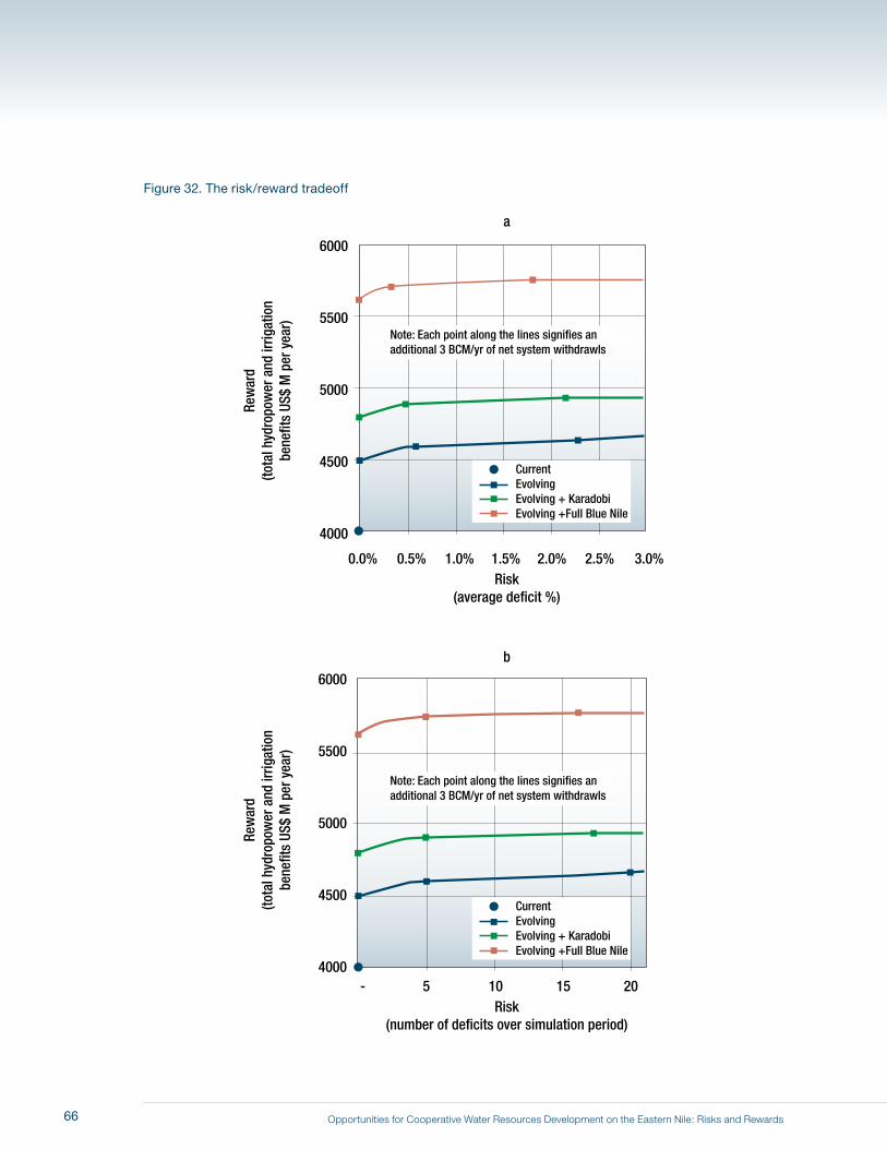
Opportunities for Cooperative Water Resources Development on the Eastern Nile: Risks and Rewards
5500
5000
6000
4500
4000
Rew
ard
(tota
l hyd
ropo
wer
and
irrig
atio
nbe
nefit
s US
$ M
per
yea
r)
5500
5000
6000
4500
4000
Rew
ard
(tota
l hyd
ropo
wer
and
irrig
atio
nbe
nefit
s US
$ M
per
yea
r)
Risk(average deficit %)
0.0% 0.5% 1.0% 1.5% 2.0% 2.5% 3.0%
Risk(number of deficits over simulation period)
a
b
- 5 10 15 20
CurrentEvolvingEvolving + KaradobiEvolving +Full Blue Nile
CurrentEvolvingEvolving + KaradobiEvolving +Full Blue Nile
Note: Each point along the lines signifies anadditional 3 BCM/yr of net system withdrawls
Note: Each point along the lines signifies anadditional 3 BCM/yr of net system withdrawls
Figure 32. The risk/reward tradeoff
66
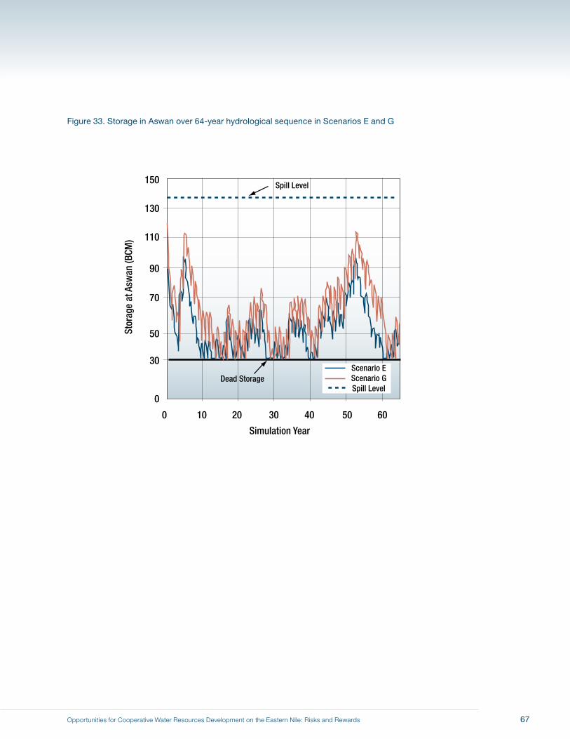
Opportunities for Cooperative Water Resources Development on the Eastern Nile: Risks and Rewards
Figure 33. Storage in Aswan over 64-year hydrological sequence in Scenarios E and G
130
110
150
90
70
50
30
0
Stor
age
at A
swan
(BCM
)
Simulation Year
0 10 20 30 40 50 60
Scenario EScenario GSpill Level
Spill Level
Dead Storage
67

Opportunities for Cooperative Water Resources Development on the Eastern Nile: Risks and Rewards68
Opportunities for Cooperative Water Resources Development on the Eastern Nile: Risks and Rewards
The Scoping Study Team’s analyses have shown that reservoir evaporation and channel losses are
extremely high in the Eastern Nile basin and that a cooperative approach to their management is
needed in order to increase the water available for consumptive use. Without a cooperative approach,
there is little incentive for upstream riparians to invest in the necessary engineering works or to adopt
operation policies to reduce such losses, because it is unclear how the benefits would be shared.
The amount of water evaporated from the many broad floodplains in the Nile system is also extremely
large. However, converting these “losses” into a reliable increase in yield that might be available for
additional consumption downstream would be costly and would have complex environmental and
social consequences. These economic, social, and environmental issues should receive careful
investigation before any such schemes are seriously contemplated. There is little incentive for upstream
riparians to support such schemes until it is clear that a cooperative framework is in place.
The largest volumes of water resources in the Eastern Nile basin are in the Ethiopian highlands.
Currently about 500 bcm of water evaporates annually from the surface of water bodies, from land
surfaces, or through vegetation. Activities that would make better use of this water to produce more
food and fiber, while at the same time reducing sedimentation and enhancing environmental values,
should be a cornerstone of any JMP.
The seven scenarios presented in this report have been designed to illustrate how increasing upstream
development (withdrawals) in Sudan and Ethiopia, selected new infrastructure projects, and climate
change could affect the possibilities for an initial set of JMP investments. For purposes of illustrating
the limits to system-wide withdrawals, in most of these scenarios Egyptian target water withdrawals
are kept at baseline levels approximating current conditions. Most of the changes introduced into the
scenarios occur in the infrastructure projects and in Sudanese and Ethiopian water withdrawals. Total
annual water withdrawals (not including losses to evaporation and conveyances) vary from about 70
bcm to 82 bcm. We show that system-wide withdrawals of 82 bcm will result in unacceptable deficits in
some years.
8 Summary and Conclusions
69
Opportunities for Cooperative Water Resources Development on the Eastern Nile: Risks and Rewards
From the modeling results for these scenarios and from our deliberations, we conclude that it is possible for
the Eastern Nile riparians to undertake an initial set of JMP investments on the Eastern Nile that will meet
all of ENCOM’s criteria: 1) benefits to all participating countries; 2) multipurpose goals; and 3) “no regrets”
commitments that will not forestall future opportunities. The anchor investment of this JMP initiative could be a
large multipurpose and hydropower project on the Blue Nile in Ethiopia (Scenario C). Although detailed economic,
financial, and environmental analyses remain to be done, the information presented in this report shows that a
large new storage project on the Blue Nile would likely provide significant multipurpose benefits to all three Eastern
Nile riparians, particularly if part of a broader coordinated development program.
Ethiopia stands to benefit in financial terms from the sale of large amounts of hydropower to downstream
riparians. Revenues from the sale of the hydropower could repay any loans for dam construction and could
fund efforts to improve living conditions and environmental management, including watershed protection and
reforestation in the highlands. Resettlement and environmental issues appear to be minimal (and could be
mitigated); evaporation losses would be small.
Sudan would benefit in several ways from a large multipurpose storage upstream on the Blue Nile. The flood peak
in Khartoum could be reduced with coordinated reservoir operation. Navigation would be improved in the spring
and summer months before the arrival of the Blue Nile flood. Sediment loads reaching the Sennar and Roseires
reservoirs would be reduced. Increased regulation would improve hydropower generation and also water delivery
to the Gezira scheme, enabling more intensive, profitable year-round cultivation.
Egypt also stands to benefit from upstream storage in important ways. Depending on the outcome of the power
trade negotiation, Egypt would receive an alternative source of reliable, potentially inexpensive electricity. Egypt
could also benefit from coordination of the operating policies of the new upstream storage with the Aswan
High Dam in order to mitigate future drought conditions and the consequences of climate change. There would
be increased opportunities for trade and regional integration with its Nile neighbors. Regional integration and
trade should be especially important to Egypt because market forces will likely highlight Egypt’s comparative
advantages in irrigated agriculture. Moreover, a large multipurpose and hydropower project on the Blue Nile would
“lock in” regional cooperation (Whittington, Wu, and Sadoff, 2005).
Regional cooperation is required to achieve the full benefits of new storage on the Blue Nile, as well as to
better manage risks. The key negotiation in this initial JMP deal would be the electrical power trade between
Ethiopia and downstream riparians. Another important negotiation would be to determine the reservoir operating
arrangements for a Blue Nile dam in order to maximize regional benefits, minimize flood damages, manage
drought risks, and ensure that adverse consequences do not occur from filling the reservoir.
The unilateral developments now under way in the basin (described here in Scenario B, evolving conditions)
clearly will place new stresses on the water resources in the Eastern Nile. The Aswan High Dam Reservoir will run
significantly lower, closer to its design conditions.
70
Opportunities for Cooperative Water Resources Development on the Eastern Nile: Risks and Rewards
There are four reasons why there is sufficient water to meet the increased target withdrawals assumed in
Scenarios B, C, and D. First, the evaporation savings from running the Aswan High Dam Reservoir at much lower
levels would be about 4 bcm. The Eastern Nile riparians would achieve these evaporation savings from the Aswan
High Dam Reservoir because Sudan and Ethiopia would be using (and evaporating) more water upstream. Inflows
to Aswan would be lower, storage would be lower, and evaporation would be reduced. Second, by operating at
lower levels, in Scenario D (full Blue Nile development) the Aswan High Dam Reservoir never spills into the Toshka
spillway over the course of the simulations. Here again, the Team’s key message is “Use it or lose it”— either to
evaporation, or to spills. Third, the hydrology used in the simulation (and the actual hydrology of the century just
past) is higher than that assumed in the 1959 Agreement, allowing for additional water use.
Fourth, most of the consumptive use of water in the Eastern Nile basin is in irrigated agriculture, and there are
significant opportunities to increase water availability by improving water use efficiency in both existing and any
new irrigation schemes. This is particularly the case in government-managed schemes with gravity-fed irrigation
(such as the Gezira in Sudan), and through changes in crop mix in Egypt and Sudan (such as shifting out of
the cultivation of water-intensive crops such as rice and sugar cane). In addition, we believe it is important in all
three countries to ensure that water is used efficiently in any new irrigation schemes. We did not make detailed
calculations of such potential water savings, but are confident that they are sizeable. Given the large amount of
water currently used for irrigation in Egypt and Sudan, and new irrigation projects planned in Ethiopia, policies
and investments designed to improve water use efficiency should be key elements of any JMP, and should focus
on: 1) improvements in the efficiency of existing irrigation delivery infrastructure and on-farm water use; 2) ways to
speed up the adoption of new irrigation technologies; 3) the creation of incentives to improve crop mix decisions;
and 4) farmer training and education.
Although irrigation withdrawals can be increased somewhat over evolving conditions, the Eastern Nile riparians
are approaching the limits of what is possible in terms of conventional surface irrigation with the available water
resources of the Eastern Nile. As described in the scenarios presented in this report, the Eastern Nile riparians
face an increasingly complex set of water management issues. More water can be withdrawn for irrigation
and other uses, and more hydropower generated, but these increased benefits do not come free. There is a
risk–reward tradeoff. In order to increase benefits derived from the Nile, Ethiopia, Sudan, and Egypt must work
together to manage the risks associated with evolving conditions and new investments in water resources
infrastructure.
Regional cooperation on the Eastern Nile is needed for managing this risk–reward tradeoff. We believe that the
basin-wide implications of climate change, salinity management, and watershed management (in the Ethiopian
highlands) pose demanding challenges that can only be addressed through cooperative action. The analyses
presented in this report show not only that mutually beneficial investments are possible, but also that a regional
approach to water management is urgently required.
71

Opportunities for Cooperative Water Resources Development on the Eastern Nile: Risks and Rewards72
Opportunities for Cooperative Water Resources Development on the Eastern Nile: Risks and Rewards
Abou-Zeid, M. 2002. Adopted Measures to Face Major Challenges in the Egyptian Water Sector: From
the Hague World Water Forum 2000 to the Kyoto World Water Forum 2003. Cairo, Egypt:
Ministry of Water Resources and Irrigation, Arab Republic of Egypt.
Adams, R.M., B.H. Hurd, et al. 1998. “Effects of Global Climate Change on Agriculture: an Interpretative
Review.” Climate Research, 11: 19–30.
Brumbelow, K., and A. Georgakakos. 2001. “An Assessment of Irrigation Needs and Crop Yield for the
United States under Potential Climate Changes.” Journal of Geophysical Research, 106(D21):
27383–27406.
Collins, R.O. 1990. The Waters of the Nile: Hydropolitics and the Jonglei Canal: 1900–1988. Oxford,
UK: Oxford University Press.
Collins, R.O. 2002. The Nile. New Haven, CT: Yale University Press.
Elshamy, M.E., H.S. Wheater, et al. 2006. “Evaluation of the Rainfall Component of a Weather Generator
for Climate Impact Studies.” Journal of Hydrology, 326: 1–24.
Eastern Nile Technical Regional Office (ENTRO). 2006a. One-System Inventory Report. Addis Ababa,
Ethiopia.
Eastern Nile Technical Regional Office (ENTRO). 2006b. Social Atlas: Eastern Nile Countries. Addis
Ababa, Ethiopia.
Food and Agriculture Organization of the United Nations (FAO). 2004. Nutrition: Calorie Supply per
Capita, Agriculture and Food Factsheet. Rome, Italy.
Howell, P.P. and J.A. Allan. 2004. The Nile. Cambridge, UK: Cambridge University Press.
Hurst, H.E. 1952. The Nile: A General Account of the River and the Utilization of its Waters. London,
UK: Constable Publishers.
Hurst, H.E., R.P. Black, et al. 1946. The Nile Basin, Volume 7: The Future Conservation of the Nile.
Cairo, Egypt: Ministry of Public Works.
Jonglei Investigation Team. 1954. The Equatorial Nile Project: Report of the Jonglei Investigation Team.
Volumes I–IV. Khartoum, Sudan: Government of Sudan.
References
73

Opportunities for Cooperative Water Resources Development on the Eastern Nile: Risks and Rewards
Legesse, D., C. Vallet-Coulomba, et al. 2003. “Hydrological Response of a Catchment to Climate
and Land Use Changes in Tropical Africa: Case Study, South Central Ethiopia.” Journal of
Hydrology, 275: 67–85.
Ministry of Water Resources, Arab Republic of Egypt. 2005. Water for the Future: National Water
Resources Plan 2017. Cairo, Egypt.
Nile Basin Initiative, Global Environment Facility, United Nations Development Program, World Bank,
May 2001. Nile River Basin - Transboundary Environmental Analysis.
Norplan-Norconsult. 2006. Karadobi Multipurpose Project Pre-Feasibility Study: Draft Final Report.
Ministry of Water Resources, Federal Democratic Republic of Ethiopia.
Sadoff, C., D. Whittington, D. Grey. 2002. Africa’s International Rivers: An Economic Perspective.
Directions in Development. Washington, DC: World Bank.
Schlenker, W., W.M. Hanemann, et al. 2005. “Will U.S. Agriculture Really Benefit from Global Warming?
Accounting for Irrigation in the Hedonic Approach.” American Economic Review, 95(1): 395–
406.
Schlenker, W., W.M. Hanemann, et al. 2006. “The Impact of Global Warming on U.S. Agriculture: An
Econometric Analysis of Optimal Growing Conditions.” Review of Economics and Statistics,
88(1): 113–25.
Selkhozpromexport. 1990. Baro–Akobo Basin Master Plan Study of Water and Land Resources of the
Gambela Plain, Final Report. Addis Ababa, Ethiopia: Soyuzgiprovodkhoz Institute.
Sene, K.J., E.L. Tate, et al. 2001. “Sensitivity Studies of the Impacts of Climate Change on White Nile
Flows.” Climatic Change, 50: 177–208.
Song, J., and D. Whittington. 2004. “Why Have Some Countries on International Rivers been
Successful in Negotiating Treaties? A global perspective.” Water Resources Research, 40
W05S06, doi:10.1029/2003WR002536.
Sutcliffe, J.V., and Y.P. Parks. 1999. The Hydrology of the Nile. Oxfordshire, UK: International
Association of Hydrological Sciences.
TAMS. 1997. Baro–Akobo River Basin Integrated Development Master Plan Study Final Report,
Vol. I: Executive Summary. Submitted to Federal Democratic Republic of Ethiopia, Ministry
of Water Resources.
74
Opportunities for Cooperative Water Resources Development on the Eastern Nile: Risks and Rewards
United Arab Republic and Sudan Agreement (with Annexes) for the Full Utilization of the Nile Waters.
1959. 6519 U.N.T.S. 63: 7.
U.S. Bureau of Reclamation (USBR). 1964. Land and Water Resources of the Blue Nile Basin: Ethiopia,
Main Report and Appendices I–V. Washington, DC: United States Department of Interior; US
Government Printing Office.
Waterbury, J. 1979. Hydropolitics of the Nile Valley. Syracuse, NY: Syracuse University Press.
Waterbury, J. 2002. The Nile Basin: National Determinants of Collective Action. New Haven, CT: Yale
University.
WaterWatch. 2006a. Determination of Water Surface Area and Evaporation Losses from Gebel Aulia
Reservoir. Wageningen, Netherlands, B.V.7.
WaterWatch. 2006b. Understanding the Water Balance of the Baro–Akobo–Sobat Wetlands, the Gebel
Aulia Reservoir and Sudan’s Major Irrigation Schemes. Wageningen, Netherlands.
WaterWatch. 2006c. Wetland Dynamics of the Baro–Akobo Basin. Wageningen, Netherlands, B.V.10.
Whittington, D. 2004. “Visions of Nile Development.” Water Policy, 6(1): 1–24.
Whittington, D., J. Waterbury, and E. McClelland. 1994. “Toward a New Nile Waters Agreement.” Water
Quantity/Quality Management and Conflict Resolution: Institutions, Processes and Economic
Analyses. Edited by A. Dinar and E.T. Loehman, Westport, CT: Praeger.
Whittington, D., X. Wu, and C. Sadoff. 2005. “Water Resources Management in the Nile Basin: The
Economic Value of Cooperation.” Water Policy, 7(3): 227–252.
World Bank. 2003a. Country Assistance Strategy for the Federal Democratic Republic of Ethiopia.
Washington, DC.
World Bank. 2003b. Implementation Completion Report: Loess Plateau Watershed Rehabilitation
Project, p. 42. Report No. 25701. Washington, DC.
World Bank. 2003c. Sudan: Stabilization and Reconstruction, Country Economic Memorandum (in two
volumes). Washington, DC.
World Bank. 2005. Country Assistance Strategy for the Arab Republic of Egypt for the Period FY06–
FY09. Washington, DC.
75
Opportunities for Cooperative Water Resources Development on the Eastern Nile: Risks and Rewards
World Bank. 2006. Ethiopia: Managing Water Resources to Maximize Sustainable Growth, Country
Water Resources Assistance Strategy. Washington, DC.
World Health Organization. 2004. World Health Report 2004. Geneva, Switzerland. (Annex, Table 1:
Basic Indicators for all WHO Member States.)
Wu, X., and D. Whittington. 2006. “Incentive Compatibility and Conflict Resolution in International
River Basins: A Case Study of the Nile Basin.” Water Resources Research, 42 W02417,
doi:10.1029/2005WR004238.
Yao, H., and A. Georgakakos. 2003a. Nile Decision Support Tool: River Simulation and Management.
Atlanta, GA: Georgia Water Resources Institute; Georgia Tech.
Yao, H., and A. Georgakakos. 2003b. Nile DST User Manual: River and Reservoir Simulation. Atlanta,
GA: Georgia Water Resources Institute; Georgia Tech.
Zenawi, H.E.M. 2006. Speech for the Africa Task Force, Brooks World Poverty Institute, Manchester
University, UK.
76
Opportunities for Cooperative Water Resources Development on the Eastern Nile: Risks and Rewards
A good knowledge base and modeling tools are required to study development options on the Eastern
Nile. In the past there has been only limited sharing of data and water resources development plans
among the Eastern Nile riparians. In 2006 ENTRO initiated a data collection effort to build a “one-
system inventory” for the Eastern Nile. ENTRO requested that Egypt, Sudan, and Ethiopia provide
economic, social, environmental, infrastructure, and hydrological data in a standard format in order to
create a common, high-quality database for basin-wide planning purposes. Although the “one-system
inventory” is not yet complete and access to consistent data remains an issue in the basin, data sharing
is improving rapidly. The Team has had access to much information that has not been widely available,
including master plans and other previously confidential documents prepared by individual countries.
Over the next few years (2007–2010) ENTRO plans to build a state-of-the-art Eastern Nile Planning
Model and to use the information from the “one-system inventory” to ensure that this model
accurately characterizes hydrological conditions in the Eastern Nile as well as the economic, social,
and environmental conditions in the riparian countries. The Team believes that until this new ENTRO
planning model is finished, the best available simulation model for the Eastern Nile is the Decision
Support Tool (DST) created by Professor Aris Georgakakos and his colleagues (Yao and Georgakakos,
2003a and 2003b). With funding from the United Nations Food and Agriculture Organization, Professor
Georgakakos has worked with numerous Nile basin countries to create a variety of computer models
for use in the Nile basin. The DST can be used to simulate the Nile under different hydrological and
infrastructural conditions. Many water resources professionals in the Nile basin have been trained in the
use of the DST, and the strengths and weaknesses of this model are well known in the basin.
Overview of DST
The Nile DST River Simulation was developed to assess the impacts of various system constraints
and operation policies by using historical data as a basis for analysis and projections. For any
selected interval in an available historical sequence, the model proceeds by 10-day increments.
The model tracks the actual recorded inflows and releases for all reservoirs for 10-day time steps,
then simulates reservoir elevation, power generation, and withdrawal requirements and deficits
over time. The model can be used to compare various user-specified system configurations, water
withdrawal practices, control policies, and other operational constraints.
Appendix A: The Nile Decision Support Tool (DST) Simulation Model
77
Opportunities for Cooperative Water Resources Development on the Eastern Nile: Risks and Rewards
Model inputs and outputs
The specific simulation model adopted for this report includes 8 existing and 5 potential reservoirs, and
17 other nodes in the river system. Data input for the model include:
Flows (based on 64-year historical data, 1913–1976)�
Reservoir storage limits �
Reservoir downstream minimum constraints �
Water withdrawals �
System configuration (potential projects on/off in selected simulations)�
Reservoir release rules (5 release rule options available for each single reservoir operation; �
coordinated rules are possible):
Elevation vs. discharge functions�
Elevation vs. discharge rule coefficients�
Target elevation and release�
Customized release rule�
Regional coordination release rules (release coordination among Equatorial Lakes, and among �
potential Ethiopian reservoirs on the Blue Nile).
For each reservoir, the following are estimated:
Elevation/storage�
Release�
Inflow�
Energy�
Spillage�
Withdrawal deficit�
Evaporation loss.�
For each river node, the following quantities are estimated:
Inflow�
Withdrawal deficit�
Minimum flow�
River flow.�
The DST model has an interface that allows users to change many of these input parameters and to
customize outputs.
78

Opportunities for Cooperative Water Resources Development on the Eastern Nile: Risks and Rewards
Use of modified DST for this scoping study
The Team worked with Professor Georgakakos and his colleagues to modify the DST planning model in
two ways that would facilitate the scoping process adopted for the present study. One modification was
the addition to the model of three new infrastructure projects that are under construction or planned in
the Eastern Nile countries:
The Toshka pumping station and irrigation project in the desert west of the Aswan High Dam �
Reservoir in Egypt
The Merowe Dam on the Main Nile in Sudan (350 kilometers northwest of Khartoum)�
The Tana–Beles hydropower project in Ethiopia. �
The second modification to the model involved the development of a simple approach for coordinating
the operation of various dams on the Eastern Nile.
Updated information from the Karadobi pre-feasibility study and ENTRO’s one-system inventories
(Norplan, 2006; ENTRO 2006), including updated hydrology for Ethiopia, were also incorporated into
this modified model.
Although many other adjustments and improvements could be made to the DST model to better
support decision making regarding the water resources systems of the Eastern Nile basin, the Team
believes that the modified DST described above captures the physical and hydrological features of the
Eastern Nile and the implications of associated infrastructure with sufficient detail for scoping purposes.
This modified DST is powerful enough to test a number of interesting and relevant scenarios. The most
informative of these scenarios have been included in this report.
79

Opportunities for Cooperative Water Resources Development on the Eastern Nile: Risks and Rewards80
Opportunities for Cooperative Water Resources Development on the Eastern Nile: Risks and Rewards
This assessment used storage in the Aswan High Dam Reservoir as one important indicator of what
is happening in the river system because this reservoir has a long memory. It not only stores water but
also stores information about what has happened in prior years. To better understand this concept that
some reservoirs have a long memory, consider an analogy with an individual’s bank account.
Storage in a reservoir is like the balance in an individual’s bank account. Inflows to the reservoir are like
a regular addition (deposit) of salary to a bank account; reservoir releases are like expenditures (writing
checks) on the bank account. High floods are similar to a salary bonus (deposit): they may come along
occasionally and increase the balance of a bank account, but one does not know when they will occur.
In this hypothetical bank account, the individual starts in year 0 with a balance of USD 10,000 (the Team
started the simulation with an initial storage in the Aswan High Dam Reservoir of 100 bcm). Each year
the individual’s annual salary of USD 1,000 is deposited, and he makes withdrawals of USD 2,000. In
years 5, 10, and 20 he receives a USD 5,000 bonus. As shown in Figure 34 (blue line) the annual year-
end balance slowly drifts downward over the 20-year sequence. Similarly, the quantity of water stored
in the Aswan High Dam Reservoir fluctuates in Figure 13. In these simple financial calculations there are
no additions to the individual’s account for interest, or deductions for bank fees (reservoir evaporation
losses would be like bank fees and reduce the balances in the individual’s account on a regular basis).
Now suppose that the annual salary is reduced from USD 1,000 to USD 800, but the expenditures
and bonuses stay the same. In this case the year-end balances in the account drift lower more quickly
because in the current year the bank account does not start anew, but rather is affected by the fact that
in each prior year the annual salary deposits were also lower (Figure 34, brown line). In a similar manner
the storage level in the Aswan High Dam Reservoir drifts lower in the Team’s simulation because high
floods are not sufficient to compensate for the regular annual increase in upstream withdrawals when
Egypt attempts to release 55.5 bcm every year of the simulation (Figure 13).
In Figure 34 (brown line) the year-end bank balance becomes negative in some years, which simply
means that this individual needs a loan from the bank or must cut expenditures. In Scenarios A and B,
storage in the Aswan High Dam Reservoir never becomes negative. However, as upstream withdrawals
increase further, negative storage balances in some years become inevitable, which means that deficits
from target reservoir releases would occur. However, just as a bank covers a deficit in an individual’s
account (covering a negative balance with a loan), if there were reservoir storage upstream of the
Aswan High Dam Reservoir, upstream riparians could theoretically release additional water to reduce
or eliminate any deficits that might arise. Just as permanent reductions in an individual’s annual salary
would necessitate adjustments to a person’s annual expenditures, the implications of the unilateral
developments currently planned and underway will require Egypt to reduce its spills to the Toshka
spillway and reduce releases at the Aswan High Dam in excess of 55.5 bcm.
Appendix B: The Concept of a Reservoir’s “Memory”
81
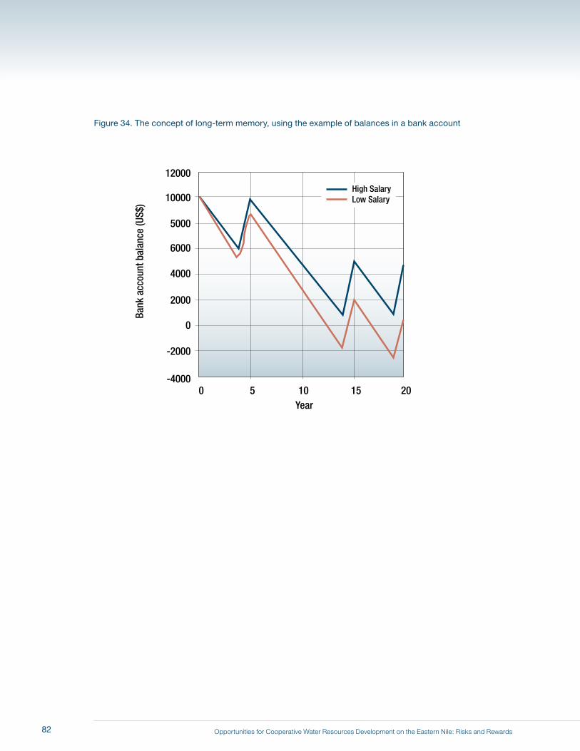
Opportunities for Cooperative Water Resources Development on the Eastern Nile: Risks and Rewards
Figure 34. The concept of long-term memory, using the example of balances in a bank account
0
10000
5000
12000
6000
4000
2000
-2000
-4000
Bank
acc
ount
bal
ance
(US$
)
Year0 5 10 15 20
High SalaryLow Salary
82

Opportunities for Cooperative Water Resources Development on the Eastern Nile: Risks and Rewards
Not all reservoirs have a long memory. If the storage capacity is small relative to the size of the annual inflows,
each year the flood fills the reservoir and spills occur, effectively erasing the information about past conditions
(by “resetting” the storage level). What is unique about the Aswan High Dam Reservoir is its large size relative
to annual flows. This means that it very rarely spills over the course of the simulations in this study’s scenarios.
Thus, its storage level tells a story (contains information) about the past sequence of floods, droughts, upstream
withdrawals, and release patterns at the Aswan High Dam.
83

Opportunities for Cooperative Water Resources Development on the Eastern Nile: Risks and Rewards84