Embed Size (px)
Citation preview
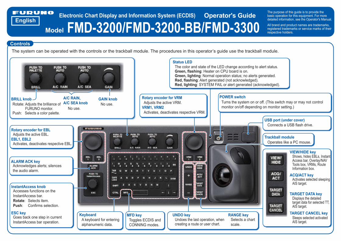
Electronic Chart Display and Information System (ECDIS)
FMD-3200/FMD-3200-BB/FMD-3300Operator's Guide The purpose of this guide is to provide the
basic operation for this equipment. For more detailed information, see the Operator's Manual. All brand and product names are trademarks, registered trademarks or service marks of their respective holders.
English
ControlsThe system can be operated with the controls or the trackball module. The procedures in this operator’s guide use the trackball module.
The color and state of the LED change according to alert status.Green, flashing: Heater on CPU board is on.Green, lighting: Normal operation status; no alerts generated.Red, flashing: Alert generated (not acknowledged).Red, lighting: SYSTEM FAIL or alert generated (acknowledged).
Status LED
Turns the system on or off. (This switch may or may not control monitor on/off depending on monitor setting.)
POWER switchRotary encoder for VRM Adjusts the active VRM.VRM1, VRM2 Activates, deactivates respective VRM.
Connects a USB flash drive.USB port (under cover)
Trackball moduleOperates like a PC mouse.
Shows, hides EBLs, InstantAccess bar, Overlay/NAV Tools box, VRMs, Route Information box.
Activates selected sleeping AIS target.
Displays the detailed target data for selected TT, AIS target.
Sleeps selected activated AIS target.
VIEW/HIDE key
ACQ/ACT key
TARGET DATA key
TARGET CANCEL keyUndoes the last operation, when creating a route or user chart.
UNDO keySelects a chart scale.
RANGE key
Rotary encoder for EBL Adjusts the active EBL.EBL1, EBL2 Activates, deactivates respective EBL.
Accesses functions on the InstantAccess bar.Rotate: Selects item.Push: Confirms selection.
InstantAccess knob
ESC keyGoes back one step in current InstantAccess bar operation.
Rotate: Adjusts the brilliance of FURUNO monitor.
Push: Selects a color palette.No use.
BRILL knob A/C RAIN, A/C SEA knob No use.
GAIN knob
A keyboard for entering alphanumeric data.
KeyboardToggles ECDIS and CONNING modes.
MFD key
Acknowledges alerts; silences the audio alarm.
ALARM ACK key
Model
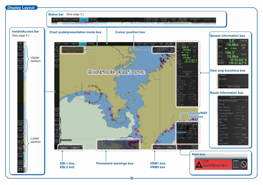
EBL1 box,EBL2 box
VRM1 box,VRM2 box
Permanent warnings box
Chart scale/presentation mode box
Display Layout
Cursor position box
Electronic chart area
Status bar
Sensor information box
Own ship functions box
Route information box
Alert box
(See page 3.)
Overlay/NAV Tools box
Lower section
InstantAccess bar
Upper section
(See page 4.)
2
TC:
TC:
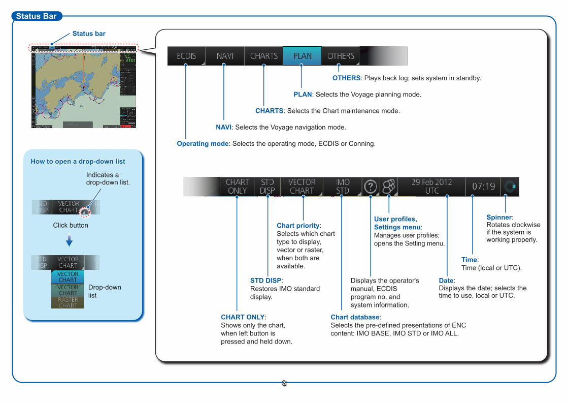
Status Bar
Operating mode: Selects the operating mode, ECDIS or Conning.
NAVI: Selects the Voyage navigation mode.
CHARTS: Selects the Chart maintenance mode.
PLAN: Selects the Voyage planning mode.
OTHERS: Plays back log; sets system in standby.
Spinner:Rotates clockwise if the system is working properly.
CHART ONLY:Shows only the chart, when left button is pressed and held down.
STD DISP:Restores IMO standard display.
Chart priority:Selects which chart type to display, vector or raster, when both are available.
Chart database: Selects the pre-defined presentations of ENC content: IMO BASE, IMO STD or IMO ALL.
Displays the operator's manual, ECDIS program no. and system information.
Date:Displays the date; selects the time to use, local or UTC.
Time:Time (local or UTC).
3
User profiles,Settings menu:Manages user profiles;opens the Setting menu.
Status bar
Drop-down list
Click button
How to open a drop-down list
Indicates a drop-down list.
TC:
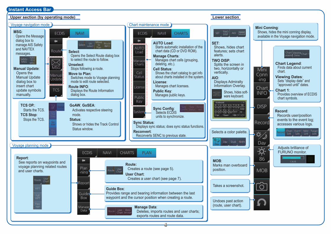
Instant Access BarUpper section (by operating mode) Lower section
Voyage navigation mode Chart maintenance mode
Voyage planning mode
4
Record:Records user/position events to the event log; accesses various logs.
Selects a color palette.
Adjusts brilliance of FURUNO monitor.
MOB:Marks man overboard position.
Takes a screenshot.
Undoes past action (route, user chart).Manage Data:
Deletes, imports routes and user charts; exports routes and route data.
Guide Box:Provides range and bearing information between the last waypoint and the cursor position when creating a route.
Route:Creates a route (see page 5).
User Chart:Creates a user chart (see page 7).
MSG:Opens the Messagedialog box to manage AIS Safety and NAVTEX messages.
Manual Update: Opens the Manual Update dialog box to insert chart update symbols manually.
Select:Opens the Select Route dialog box to select the route to follow.
Unselect:Stops following a route.
Move to Plan:Switches mode to Voyage planning mode to edit route selected.
Route INFO:Displays the Route Information dialog box.
GoAW, GoSEA:Activates respective steering mode.
Status:Shows or hides the Track Control Status window.
TCS OP.:Starts the TCS.
TCS Stop:Stops the TCS.
AUTO Load:Starts automatic installation of the chart data (CD or DVD ROM).
Manage Charts:Manages chart cells (grouping, deleting, etc.).
Cell Status:Shows the chart catalog to get info about charts installed in the system.
License:Manages chart licenses.
Public Key:Manages public keys.
Sync Status:Displays sync status; does sync status functions.
Reconvert:Reconverts SENC to previous state.
Sync Config:Selects ECDIS units to synchronize.
SET:Shows, hides chart features; sets chart alerts.
TWO DISP:Splits the screen in two, horizontally or vertically.
AIO:Displays Admiralty Information Overlay.
Shows, hides soft-ware keyboard.
Mini Conning:Shows, hides the mini conning display, available in the Voyage navigation mode.
Chart Legend:Finds data about current chart.
Viewing Dates:Sets “display date” and “approved until” dates.
Chart 1:Provides overview of ECDIS chart symbols.
Report:See reports on waypoints and
voyage planning related routes and user charts.
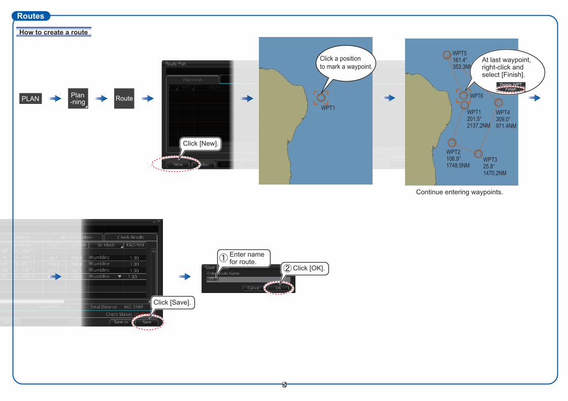
Routes
RoutePLAN
How to create a route
5
Click [Save].
Click [OK].
Enter name for route.
Click [New].
Continue entering waypoints.
WPT1
Click a positionto mark a waypoint.
WPT325.8°1470.2NM
WPT2106.9°1748.5NM
WPT6
WPT5161.4°353.3NM
WPT4309.0°971.4NM
WPT1201.5°2137.2NM
At last waypoint,right-click and select [Finish].
Delete WPTFinish
Plan-ning
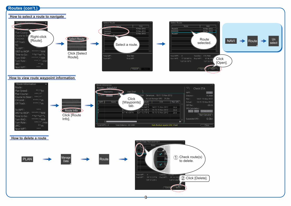
How to select a route to navigate
Routes (con’t.)
Route
RoutePLAN
How to view route waypoint information
How to delete a route
To stop navigating a route:
Manage Data
Check route(s) to delete.
6
Click [Delete].
Right-click [Route]. NAVI
Click [Select Route].
Select RouteUnselect
Move to PlanRoute INFO
Route Unselect
Route32AAAAAARoute67
15 Nov 201215 Nov 201213 Nov 2012
Select a route.
Start WPT :
Route selected.
Route32AAAAAARoute67
15 Nov 201215 Nov 201213 Nov 2012
Click [Open].
Route selected.
Click [Waypoints]
tab.
TC:
Click [Route Info].
Select Route Unselect
Move to PlanRoute Info
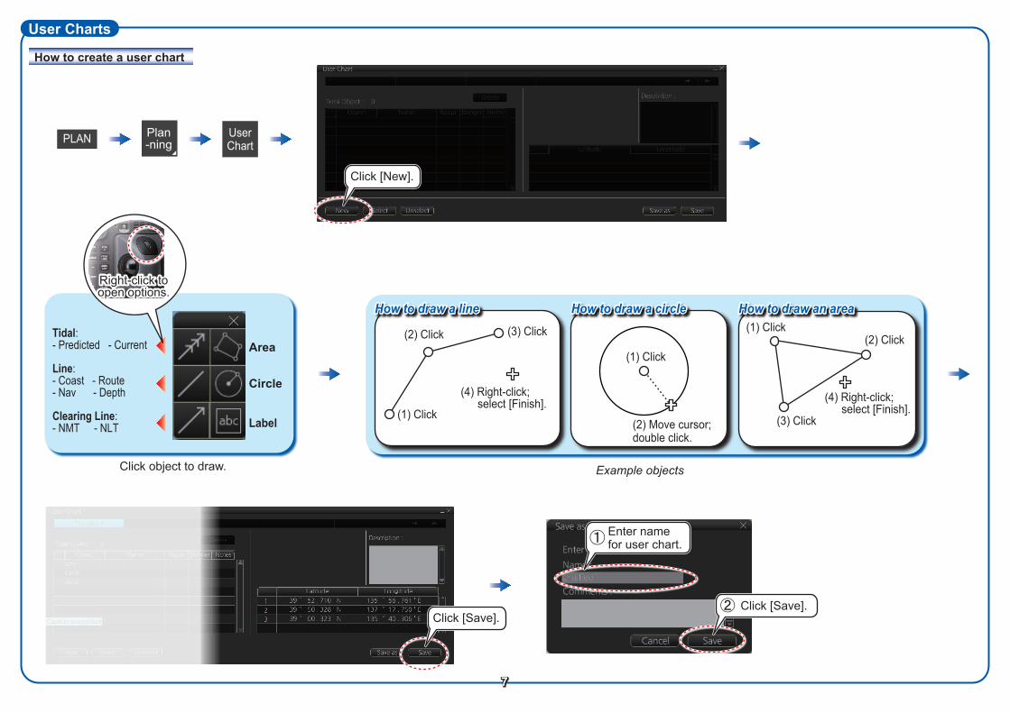
How to create a user chart
User Charts
Click object to draw.
Area
Circle
UserChartPLAN
Label
Right-click to open options.
7
(3) Click(2) Click
(1) Click
(4) Right-click; select [Finish].
How to draw a line How to draw a circle How to draw an area(1) Click
(2) Click
(3) Click
(4) Right-click; select [Finish].
Click [Save].Click [Save].
Click [New].
Enter name for user chart.
Example objects
Plan-ning
(1) Click
(2) Move cursor; double click.
Tidal:- Predicted - Current
Clearing Line:- NMT - NLT
Line:- Coast - Route- Nav - Depth
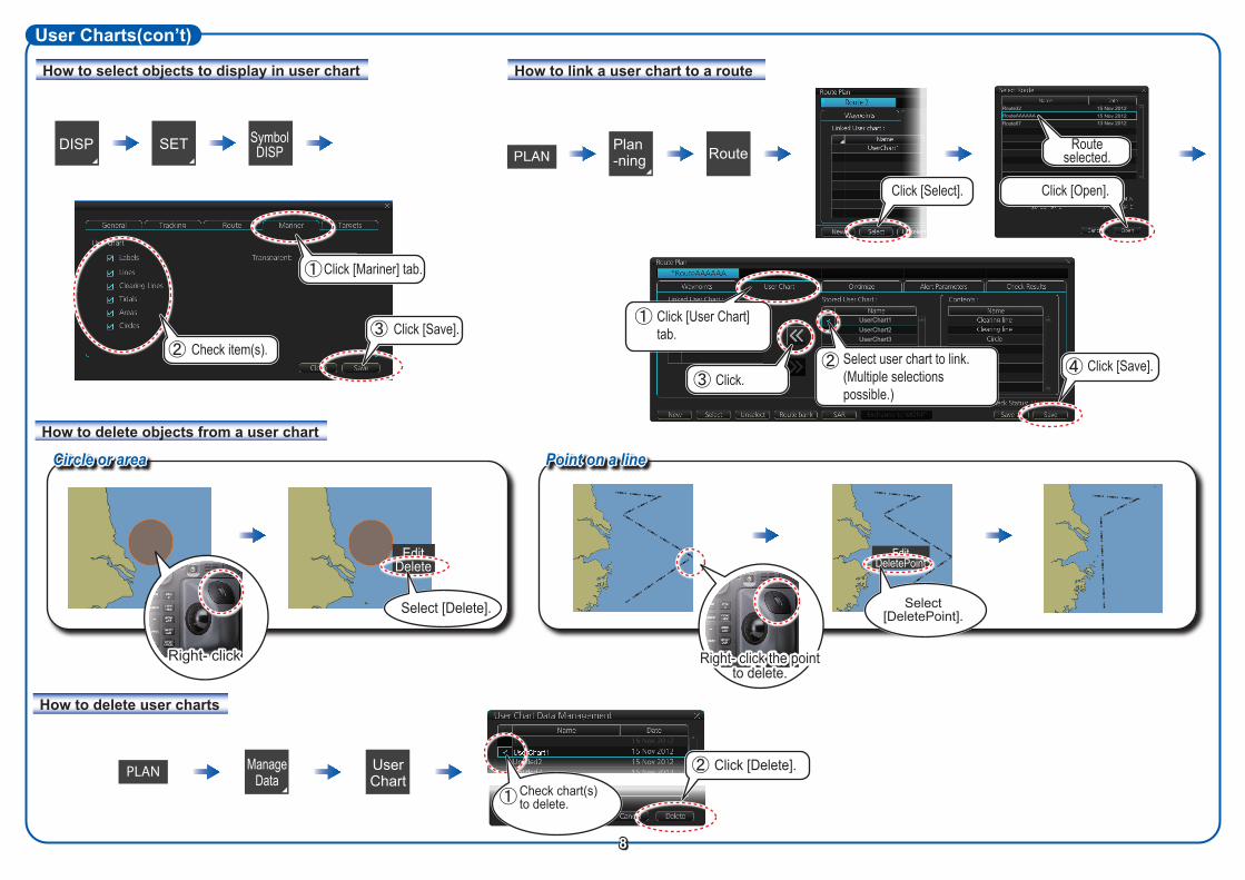
How to select objects to display in user chart
User Charts(con’t)
PLAN
EditDelete
DISP SymbolDISP
How to link a user chart to a route
How to delete objects from a user chart
How to delete user charts
SET RoutePlan-ning
Circle or area Point on a line
EditDeletePoint
Select [Delete]. Select[DeletePoint].
Manage Data
User Chart
Click [Mariner] tab.
Check item(s).
Right- click Right- click the point to delete.
8
Click [Select].
Click [Save].
Route32RouteAAAAAARoute67
15 Nov 201215 Nov 201213 Nov 2012
Routeselected.
Click [Open].
UserChart1
Check chart(s)to delete.
PLAN
UserChart1UserChart2UserChart3
Click [User Chart] tab.
Click.Select user chart to link. (Multiple selections possible.)
Click [Save].
Click [Delete].
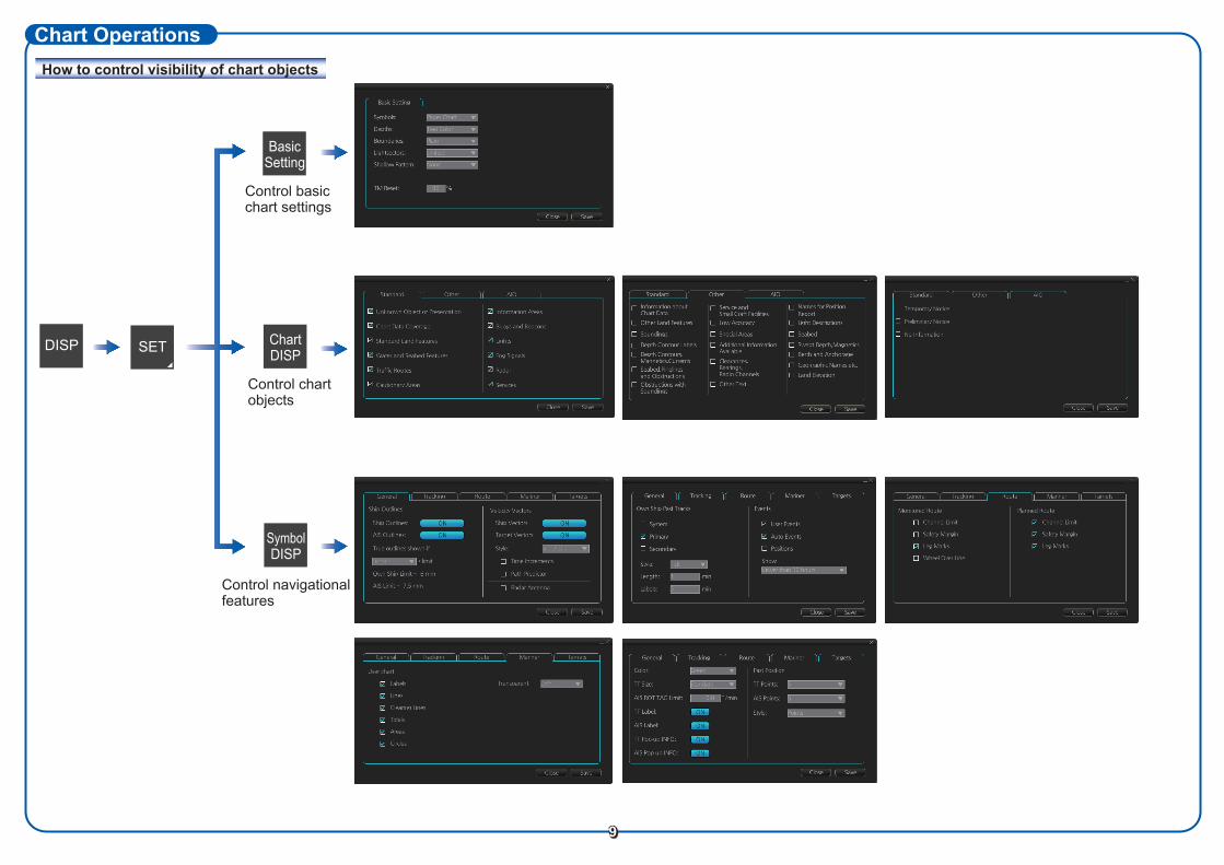
How to control visibility of chart objects
Chart Operations
Control chartobjects
Control navigational features
Control basicchart settings
SET
Basic Setting
DISP Chart DISP
Symbol DISP
9
Tick
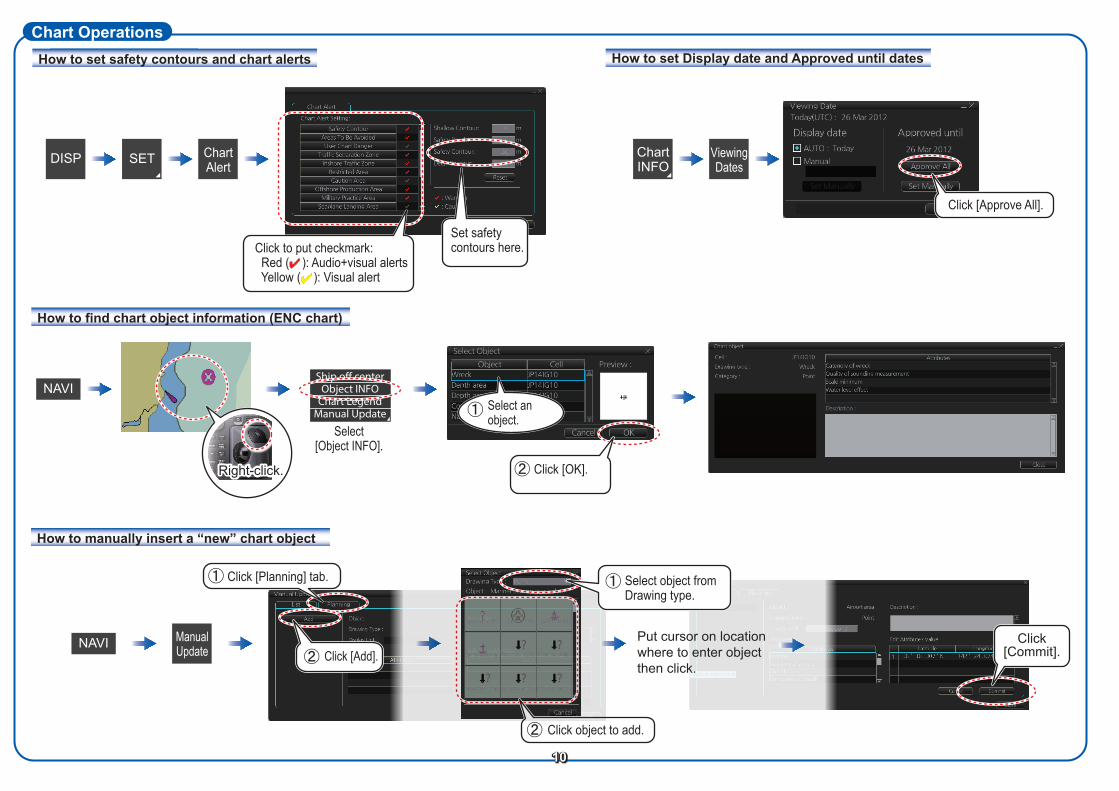
How to set safety contours and chart alerts
Chart OperationsHow to set Display date and Approved until dates
How to find chart object information (ENC chart)
How to manually insert a “new” chart object
Chart INFO
Viewing Dates
NAVI Manual Update
Click object to add.
10
SETDISP Chart Alert
Set safety contours here.Click to put checkmark:
Red ( ): Audio+visual alerts Yellow ( ): Visual alert
Click [Approve All].
Put cursor on locationwhere to enter objectthen click.
Click [Planning] tab.
Click [Commit].
Select object from Drawing type.
Click [Add].
Right-click
Select[Object INFO].
Ship off centerObject INFO
Chart LegendManual Update
NAVISelect anobject.
Click [OK].Right-click.
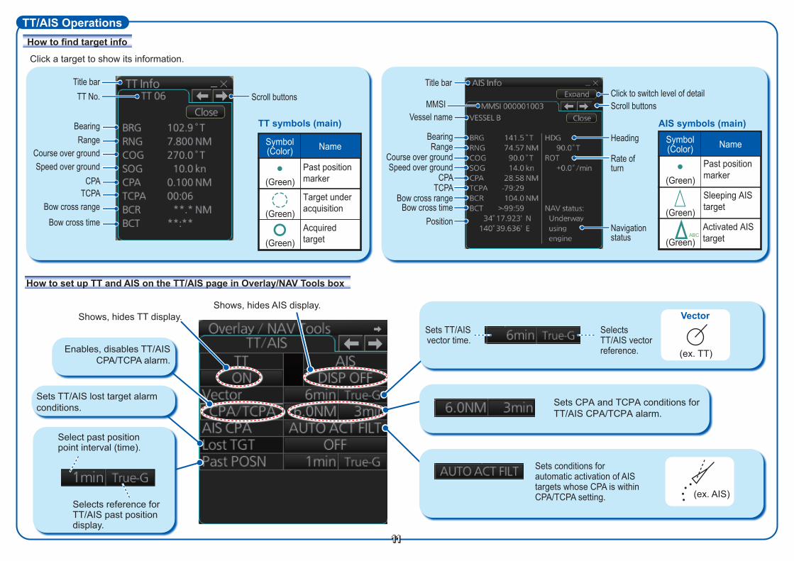
How to find target info
TT/AIS Operations
Click a target to show its information.
AIS symbols (main)TT symbols (main)
Sleeping AIS target
Activated AIS target
Past position marker(Green)
NameSymbol(Color)
(Green)
(Green)
Target under acquisition
Past position marker(Green)
Acquired target
NameSymbol(Color)
(Green)
(Green)
11
How to set up TT and AIS on the TT/AIS page in Overlay/NAV Tools box
Shows, hides TT display.Shows, hides AIS display.
Select past positionpoint interval (time).
Selects reference for TT/AIS past position display.
Vector
(ex. TT)
(ex. AIS)
Sets conditions for automatic activation of AIS targets whose CPA is within CPA/TCPA setting.
Sets TT/AIS vector time.
Selects TT/AIS vector reference.
Sets TT/AIS lost target alarm conditions. Sets CPA and TCPA conditions for
TT/AIS CPA/TCPA alarm.
Enables, disables TT/AIS CPA/TCPA alarm.
Title bar
MMSI
BearingRange
Course over groundSpeed over ground
CPATCPA
Bow cross rangeBow cross time
Position
Scroll buttons
Heading
Navigation status
Rate of turn
Click to switch level of detailTitle barTT No.
BearingRange
Course over groundSpeed over ground
CPATCPA
Bow cross rangeBow cross time
Vessel name
ABC
Scroll buttons

TT/AIS Operations (con’t)
Filters AIS targets by target category.
Filters AIS targets by range, speed.
Sleeps all activated AIS targets.
Sets the conditions to activate an AIS target when its CPA is within the CPA alarm setting.
Sets the conditions for the AIS lost target filter.
Sets the conditions for the TT lost target filter.
Radar echo
Radar Overlay
12PUB. NO. OSE-44730-C(1304, DAMI) FMD-3200/3200-BB/3300
Open the menu, select TT/AIS Setting and then Setting.1 or Setting.2 as appropriate.
Activates, deactivates the radar overlay.
Adjusts the picture gain.Put the cursor on the bar then roll
the scrollwheel.
Sets the degree of transparency for the overlay.
Sets the item to display when a chart object and a radar echo share
the same position.Selects the antenna to feed
the radar echo data.Status of the radar echo data, “OK” or “No Data”.
AIS filter, how to sleep all AIS targets, auto activation of AIS targets by CPA
AIS and TT lost target filters


![Digital Mark Sensor [Amplifier Built-in] LX-100 SERIES · Mark mode Ultra high-speed response This sensing mode automatically selects ... The built-in 12-bit A/D converter enables](https://img.pdfslide.us/doc/110x75/5e95a4f1d9acb24e0213de25/digital-mark-sensor-amplifier-built-in-lx-100-series-mark-mode-ultra-high-speed.jpg)