Embed Size (px)
Citation preview

Newsletter
October 2016
Ipswich City Council has developed an Active Transport Action Plan to guide the planning, delivery and promotion of facilities and programs to encourage more people to walk and cycle for transport purposes in Ipswich.The Action Plan is a key deliverable of the City of Ipswich Transport Plan (iGO) and will assist with providing a sustainable transport future for the city.
City of Ipswich Transport Plan
OPERATIONAL STRATEGIES
NETWORK ACTION PLANS
ActiveTransport
ActiveTransport
FreightPublicTransport
ParkingRoadSafety
Local AreaTra�c Management
DirectionSigns
Resourcing Performanceand Data
RiskManagement City of Ipswich Transport Plan
OPERATIONAL STRATEGIES
NETWORK ACTION PLANS
ActiveTransport
ActiveTransport
Freight
PublicTransport
Parking
RoadSafety
Local AreaTra�c Management
DirectionSigns
ResourcingPerformance
and DataRisk
Management
City of Ipswich Transport Plan
OPERATIONAL STRATEGIES
NETWORK ACTION PLANS
ActiveTransport
ActiveTransport
Freight
PublicTransport
Parking
RoadSafety
Local AreaTra�c Management
DirectionSigns
Resourcing Performanceand Data
RiskManagement
City of Ipswich Transport Plan
OPERATIONAL STRATEGIES
NETWORK ACTION PLANS
ActiveTransport
ActiveTransport
Freight
PublicTransport
Parking
RoadSafety
Local AreaTra�c Management
DirectionSigns
ResourcingPerformance
and DataRisk
Management
City of Ipswich Transport Plan
OPERATIONAL STRATEGIES
NETWORK ACTION PLANS
ActiveTransport
ActiveTransport
Freight
PublicTransport
Parking
RoadSafety
Local AreaTra�c Management
DirectionSigns
Resourcing Performanceand Data
RiskManagement
Active Transportin Ipswich is ...
ConsultationIn order to help shape a realistic action plan, focused community consultation was undertaken via an online survey in early 2016.
The survey asked the community to provide input on whether they were, or were not, currently walking or cycling for transport purposes, their level of comfort with respect to different conditions and what they identified as barriers/enablers for them.
Information obtained from the survey provided valuable insight into pedestrian and cyclist needs in the Ipswich community.
Action Plan Vision
iGO Delivery Structure
2
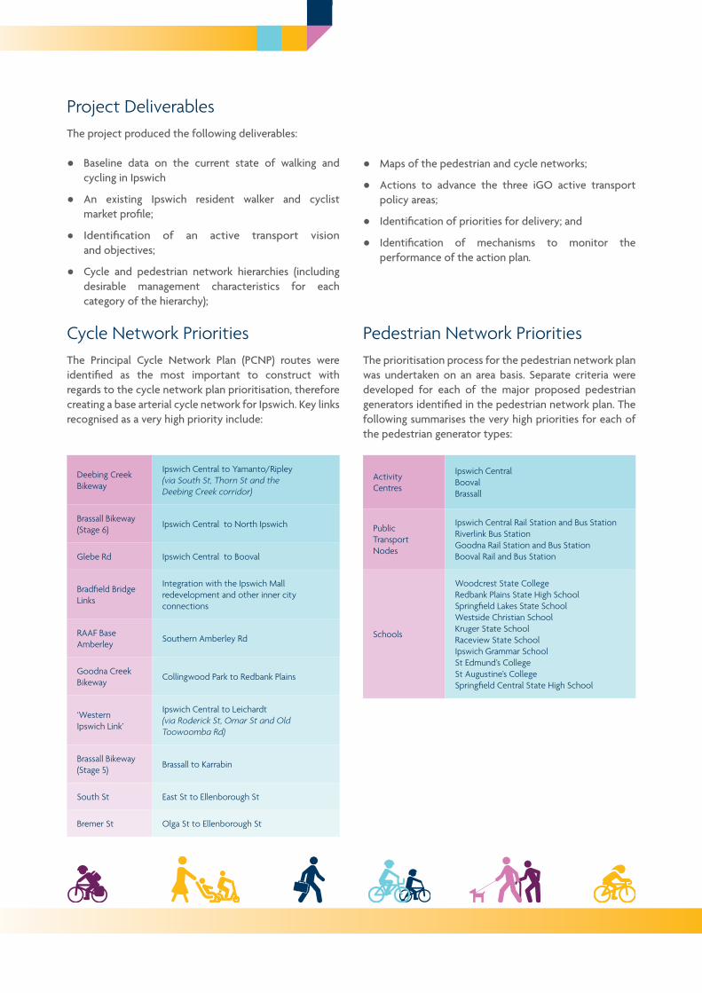
Cycle Network PrioritiesThe Principal Cycle Network Plan (PCNP) routes were identified as the most important to construct with regards to the cycle network plan prioritisation, therefore creating a base arterial cycle network for Ipswich. Key links recognised as a very high priority include:
Pedestrian Network PrioritiesThe prioritisation process for the pedestrian network plan was undertaken on an area basis. Separate criteria were developed for each of the major proposed pedestrian generators identified in the pedestrian network plan. The following summarises the very high priorities for each of the pedestrian generator types:
Deebing Creek Bikeway
Ipswich Central to Yamanto/Ripley (via South St, Thorn St and the Deebing Creek corridor)
Brassall Bikeway (Stage 6) Ipswich Central to North Ipswich
Glebe Rd Ipswich Central to Booval
Bradfield Bridge Links
Integration with the Ipswich Mall redevelopment and other inner city connections
RAAF Base Amberley Southern Amberley Rd
Goodna Creek Bikeway Collingwood Park to Redbank Plains
‘Western Ipswich Link’
Ipswich Central to Leichardt (via Roderick St, Omar St and Old Toowoomba Rd)
Brassall Bikeway (Stage 5)
Brassall to Karrabin
South St East St to Ellenborough St
Bremer St Olga St to Ellenborough St
Activity Centres
Ipswich CentralBoovalBrassall
Public Transport Nodes
Ipswich Central Rail Station and Bus StationRiverlink Bus StationGoodna Rail Station and Bus StationBooval Rail and Bus Station
Schools
Woodcrest State CollegeRedbank Plains State High SchoolSpringfield Lakes State School Westside Christian School Kruger State School Raceview State School Ipswich Grammar School St Edmund’s College St Augustine’s CollegeSpringfield Central State High School
City of Ipswich Transport Plan
Project DeliverablesThe project produced the following deliverables:
● Baseline data on the current state of walking and cycling in Ipswich
● An existing Ipswich resident walker and cyclist market profile;
● Identification of an active transport vision and objectives;
● Cycle and pedestrian network hierarchies (including desirable management characteristics for each category of the hierarchy);
● Maps of the pedestrian and cycle networks;
● Actions to advance the three iGO active transport policy areas;
● Identification of priorities for delivery; and
● Identification of mechanisms to monitor the performance of the action plan.

3
Redbank Plains
Ripley West
Redbank Plains South
Ripley
RedbankGoodna
Brassall
Yamanto
BoovalIPSWICHCENTRAL
Riverview
New Chum
Swanbank
Bundamba
Wulkuraka
Ripley East
SPRINGFIELD
RAAF Base Amberley
Cycle Network Snapshot Map
Redbank Plains
Ripley West
Redbank Plains South
Ripley
RedbankGoodna
Brassall
Yamanto
BoovalIPSWICHCENTRAL
Riverview
New Chum
Swanbank
Bundamba
Wulkuraka
Ripley East
SPRINGFIELD
RAAF Base Amberley
Pedestrian Network Snapshot Map
Cycle Network Snapshot Map
Pedestrian Network Snapshot Map
CYCLE LINKS*
Principal Transport(future)
Principal Transport
Secondary Transport(indicative)
Secondary Transport
SecondaryRecreation
Local Transport(indicative)
Local Transport
Pedestrian ActivityStreet (indicative)
PedestrianAccess Streets(400m Extents)
PedestrianActivity Street
Pedestrian TransportCorridor (indicative)
PedestrianTransport Corridor
LEGEND
EXISTING
Activity Centres
Regional Business& Industry Locality
Schools/TAFE/Universities
Schools/TAFE/Universities
PEDESTRIAN LINKS*FUTURE
Activity Centres
Regional Business& Industry Locality
Ipswich to SpringfieldFuture PublicTransport Corridor
* The routes shown are indicative and exist to guide further planning that will determine the precise routes and design of cycle and pedestrian facilities

4
City of Ipswich Transport Plan
The iGO Active Transport Action Plan can be downloaded from Council’s website at:
www.ipswich.qld.gov.au
If you have any further enquiries with regards to the contents of the action plan, please contact Council at:
Email: [email protected]: (07) 3810 6666
More Information
Signature Projects‘Signature projects’ are the highest priority actions identified within the Active Transport Action Plan and are outlined below (in no particular order).
iGO Policy Focus: Building Quality Active Transport Networks
Actions 1.1-1.4 & 2.1-2.2
Plan, design and construct the identified pedestrian and cycle network priorities mentioned previously.
Action 3.4
Trial and measure ‘Pop up’ pedestrian and cycle infrastructure (e.g. pedestrian squares, protected bike lanes, lunch time street closures in activity centre) and tie with community events to gather feedback and interest.
iGO Policy Focus: Developing Supportive Active Transport Communities
Action 6.1
Develop, advocate and implement a Way Finding Strategy focused around railway stations, other key public transport hubs and activity centres.
Action 6.2
Where possible incorporate non-deciduous shade trees along pedestrian and cycle paths. Coordinate/integrate with other Council activities where possible or develop a Shadeways Program.
iGO Policy Focus: Growing An Active Transport Culture
Action 8.2
Undertake an ‘Active Towns’ style program (involving infrastructure and promotion) in the priority neighbourhoods of:• Brassall/North Ipswich (with the Brassall Bikeway);• Redbank Plains, Collingwood Park and adjacent suburbs (with the
Goodna Creek Bikeway);• Yamanto and other southern suburbs (with the Deebing Creek
Bikeway); and• Ipswich City Centre and surrounding inner suburbs.
Action 8.7
Prepare and implement a Social Media Strategy to promote and inform the community on walking and cycling and to start community conversations on relevant issues.
Action 9.1
Provide information on safe walk and cycle practices and existing walk and cycle maps via local information brochures to be made available at community information locations in the City (e.g. public libraries) and on Council’s website.
Action 9.2
Develop a smartphone and website app that enables users to choose routes to walk and cycle in the city, based on a number of varying factors (e.g. grade, availability of paths, traffic volumes etc.).