Embed Size (px)
Citation preview
Annual World Bank Conference on Land and Poverty
Nigel Edmead
Open Title: a model for low-cost, customizable land administration technology
Washington DC, 18-20 April 2011
1/14
Open Title: a model for low-cost, customizable land administration
technology
Nigel EDMEAD
Key words: OpenTitle, Social Tenure Domain Model, Ghana, ILS, ESRI
SUMMARY
In Ghana, as in many developing nations, there is a strong need to improve processes to
record lands. Working with partners Trimble, Opportunity International, and Sinapi Aba
Trust, International Land Systems (ILS) are developing property folios, a collection of
property information that can eventually be used as a land title. This is important in
establishing a secure sense of ownership. A property folio is also important to micro lending
agencies as property can therefore be collateralized, and people may obtain credit. This
stimulates long-term investor confidence in the economy, the building blocks of a mature
economy. ILS developed „OpenTitle‟ to cost-effectively and efficiently collect and digitze
images, testimonials, videos, and documents related to properties and associated individuals.
We are actively documenting rights and mapping properties. From this information ILS
OpenTitle is used to produce and print comprehensive property folios for households.
ILS OpenTitle is a low cost solution based on proven technology and has an easy to configure
data model to allow more than just land rights to be captured (e.g. health and education). Only
authorized users can access information bringing added security to land records and its client-
server architecture can support a small office environment. ILS OpenTitle adheres to the
Social Tenure Domain Model (STDM) and brings version control for tracking changes in
social tenure relationships.
Annual World Bank Conference on Land and Poverty
Nigel Edmead
Open Title: a model for low-cost, customizable land administration technology
Washington DC, 18-20 April 2011
2/14
1. INTRODUCTION
A GIS-Based pilot Title Registration and Microfinance Project in Ashaiman Ghana sought to
demonstrate the vital role that formalization of land ownership can play in helping the poor
take a crucial first step away from poverty. Focused on the Ashaiman area of Accra, the pilot
leveraged the latest low cost geospatial technologies to create a land titling process and GIS-
based land records system where neither existed in the past. Working with partners Trimble,
Opportunity International, and Sinapi Aba Trust, International Land Systems (ILS) developed
property folios, a collection of property information that can eventually be used as a land title
in the formal registry. ILS provided its low cost OpenTitle product based to capture property
locations and field testimonials as part of the field exercise. ILS OpenTitle is now available
for downloadable as a 30 day trial version from www.landsystems.com/opentitle/.
Despite the benefits formalizing land ownership and the recognition that of land rights that
accrue (and which are articulated in Hernando DeSoto‟s „The Mystery of Capital‟) land titling
and registration are often out of reach for most of the urban poor. The process itself may be
too daunting for governments to implement in poverty-stricken areas where no property
mapping has ever occurred. As a result, the capital remains locked in the land, the local
economy suffers, and the poor have no way out of their poverty. As part of the Ashaiman pilot
tools and procedures have been implemented with the aim of lowering the overall costs of
inventorying and recording land rights, expediting the production of titles and unlocking
capital as part of a micro loan offering to schools in the Ashaiman area.
By moving land ownership/occupation rights from the informal to the formal sector de Soto
believes the marginalized poor are able to take the first step toward alleviating poverty and
achieving economic prosperity. It starts with something as simple as having a mailing address
and ends with the ability to use the land as security or collateral for borrowings – often the
first step toward building an income stream. Microfinance has emerged as a means to jump
start the poor by giving them small loans for short periods of time – typically $100 to $500 for
six months. This is enough capital to buy a sewing machine or basket weaving material or
other elements of an in-home business. This is likely the first capital investment by a family
and the first return on such capital they have experienced.
The pilot addressed the challenges present in the formal registration system, including time
and cost to register land rights, the fact that land rights are not as clear cut in
informal/customary tenure areas and the need for simple low cost technology that is flexible
enough to handle a variety of person-person-land relationships. The stated goal of the pilot
was for ILS to deliver this land titling capability in the form of a fully functional and scalable
GIS-based land recording and registration system that could ultimately be used by the
government to award official titles and follows initiatives by the Global Land Tool Network
(GLTN) to develop pro-poor land management tools to assist those who find themselves
excluded from the formal registry which in many countries only serves a small proportion of
the population.
Annual World Bank Conference on Land and Poverty
Nigel Edmead
Open Title: a model for low-cost, customizable land administration technology
Washington DC, 18-20 April 2011
3/14
Although “legal or formal title” is the standard we are all used to using in the Western world
the truth is that such a designation is really just a means to demonstrate we have proven “de
facto” ownership to a sufficient enough level to justify the “legal” designation. In truth it is
the facts and circumstances surrounding each property and its heritage that make up the
elements of true “legal” ownership.
Even if paperwork does not exist to evidence legal title holdings, often the mere passage of
time works to the benefit of the would-be landowners to establish the bona fides of their
interests (a fact noted by Geoffrey Payne). In most countries, if one openly possesses a piece
of land for enough time title vests in that person. The social value of this principle is that the
land is put to productive use and contributes to the economy as a whole. It is good public
policy to ensure that those who have productively used the land for a sufficient period of time
acquire the ownership based upon this use. This kind of legal determination brings order and
this example is a good way to show how “factual” holdings can become “legal” holdings.
There are other legal theories, such as lost document and un-administered inheritance that also
support findings of legal ownership based upon provable facts.
But often the poor are not equipped to “prove up” these facts since they are unfamiliar with
the process and unlikely to explore their rights given their natural distrust for the government.
And, even if they are ready to take on that challenge, the process of registration is often too
expensive, complicated, and time consuming. Many may want to formalize their interests but
they are afraid to open the discussion for fear they might lose – lose the factual argument, lose
the legal argument, lose their money to taxes imposed, lose their ability to farm or do what
they have historically been doing on the land they occupy unchallenged and to which they
claim ownership.
There is also fear on the government‟s part. Fear that they will have unsolvable problems or
that by making a decision they will be held accountable. Multiple claimants for each property
based on inadequate records or, worse, corruption in prior administrations that has led to
multiple holders of deeds to the same property. But here again, we cannot be hamstrung by
the worst problems, but rather we should be attacking and resolving the majority of cases
which tend to be simpler, i.e. don‟t make the exceptions the reason not to do something. The
more difficult problems will certainly need government action, but there is no reason to hold
off recognition of those property rights that can be established. Progress leads to more
progress and demonstrating that some owners are seeing the benefits of formalized land rights
will suggest to the disputing claimants that a better path might be found in looking for
solutions to their disputes and allowing themselves to be the beneficiaries of some form of
land ownership. Agreeing to a settlement and not trying to gain more than in is reasonable
may be a wise decision when they see others progressing from poverty who have taken this
approach.
As Jaap (2011) notes in designing a pro-poor system that the system should (i) allow for
participatory adjudication or enumeration of the poor and their social land tenures; (ii) be
closer to the ground to improve record correctness of information; (iii) not focus on complete
data coverage and should accept less accurate forms of boundary and rights information
accommodating non-conventional boundary markers; (iv) not be a totally independent
activity, but should be embedded in the larger public administration structure, as well as the
existing registry structure; and (v) should be affordable and the corporate culture associated
Annual World Bank Conference on Land and Poverty
Nigel Edmead
Open Title: a model for low-cost, customizable land administration technology
Washington DC, 18-20 April 2011
4/14
with it needs to be pro poor and based on co-management between the state and the
community to ensure that the records remain current and are useful to the community.
As a provider of international land registration solutions and based on extensive project
experience, ILS recognized the immediate need for a low cost, pro-poor, participatory based
recordation system. ILS‟s vision is that gaining title should be open to all peoples and for all
communities, and that it is not just about systems but procedures and processes to make this a
reality. On the basis of the Ghana pilot ILS and ESRI have worked closely to develop a
product that is quick to deploy, easy to learn and affordable. The goal in developing ILS
OpenTitle was to empower people and communities to efficiently record property rights.
To build this foundation, ILS developed OpenTitle a low cost inventorying tool which
adheres to Social Tenure Domain Model (STDM). ILS OpenTitle can also be deployed in a
client-server environment supporting small office operations. ILS OpenTitle‟s core tools and
databases are proven products that are currently in use of tens of thousands of organizations
worldwide and registered users of ILS OpenTitle are entitled to email and web support
establishing a network of users who are able to share common experiences in land
administration and approaches to the best ways to record and inventory land rights.
ILS OpenTitle includes a variety of tools to perform recordation tasks in a single or multi-user
environment. The intuitive and easy to use ribbon interface delivers a simple workflow which
enables the stages and steps of the data capture process to be sequenced in a logical manner.
ILS OpenTitle allows the capture and storage of attribute/textual information, documents,
photographs and video as part of the recordation process and which represent important
evidence of land rights collected in the field and which ties to a spatial unit/object which may
be a polygon, point or line.
ILS OpenTitle is designed to drive government's appreciation of the economies of scale which
are now possible making land registration truly accessible to the poor by providing a
continuum of systems based common data standards that can accommodate the informal and
formal, the marginalized and the elite, women and men.
STDM compliance means that field data collected using ILS OpenTitle can be fully migrated
to formal registries on the basis of evolving data model standards. ILS LRS, ILS‟s enterprise
registration system for Torrens based land registration systems is LADM compliant and is
designed to support a transactional based land market. Both the systems and procedures in use
in Ghana have been designed with future integration in mind – integration of datasets
captured using ILS OpenTitle and its subsequent incorporation into ILS LRS on the basis of
LADM, as well as the integration of procedures with the existing land registration framework
to ensure the pro-poor community based toolset that has been developed by the project and
which does operate in isolation, can be recognized by a Government as a legitimate and sound
means of recording land rights. This model offers exciting opportunities for countries such as
Uganda, which established a sub-national registry with the promulgation of the Land Act, Cap
227 of 1998 for recordation of customary land rights, by providing a mechanism and process
by which customary tenure can be incorporated into the formal registry even though those
rights are recorded using an alternative low cost technology.
Annual World Bank Conference on Land and Poverty
Nigel Edmead
Open Title: a model for low-cost, customizable land administration technology
Washington DC, 18-20 April 2011
5/14
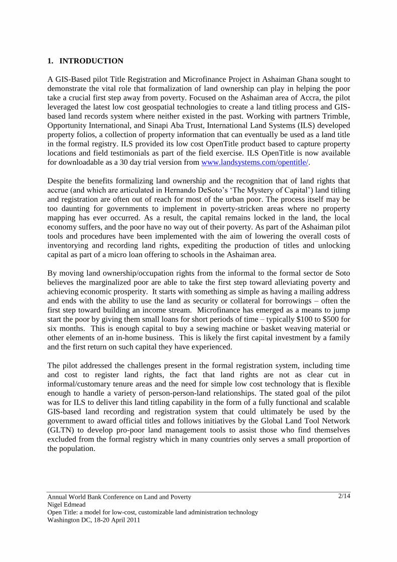
Figure 1: ILS OpenTitle indexing panel
Importantly the Ashaiman pilot was conducted with the approval of the Ministry of Lands in
Ghana, who agreed to ILS performing professional land surveys of the school properties,
given that the survey is a key requirement for receiving an official land title. Having
conducted property registration projects in numerous countries, it was understood that the
quality of the parcel survey would be a make-or-break aspect of overall project success in the
eyes of the government, and the requirement for high accuracy surveys would be both overly
costly and time consuming. Gaining agreement from the Surveyor General for lower accuracy
surveys based on GPS and tape measurement was therefore critical to overcoming this hurdle
and provides a framework to ensure Government‟s understanding and consent to less formal,
though no less rigorous procedures for recording of land rights.
Field sensitization activities and community meetings were held as part of project roll out to
gain acceptance of the field mapping exercise and its objectives, as well as the requirements
on the part of the respondents who would be visited as part of the field investigation exercise.
It was also clear from these meetings there was a high and unmet demand for land titles. Field
teams which included surveyors and a land officer received training in the field investigation
and mapping techniques.
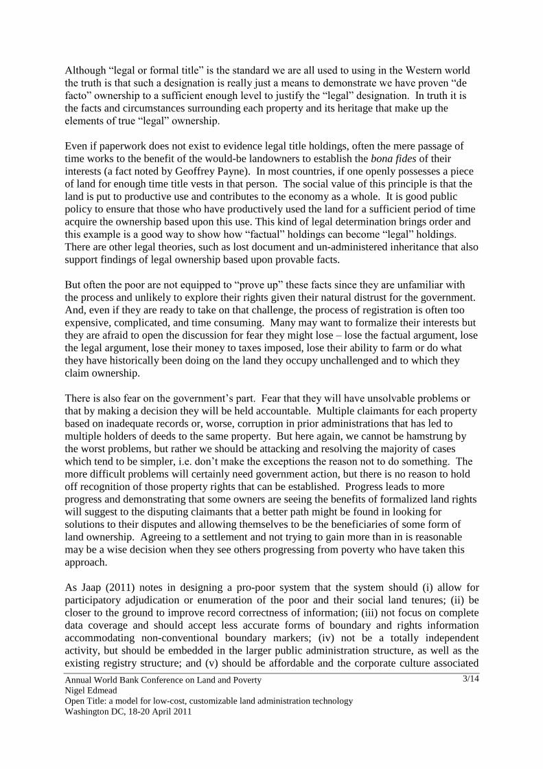
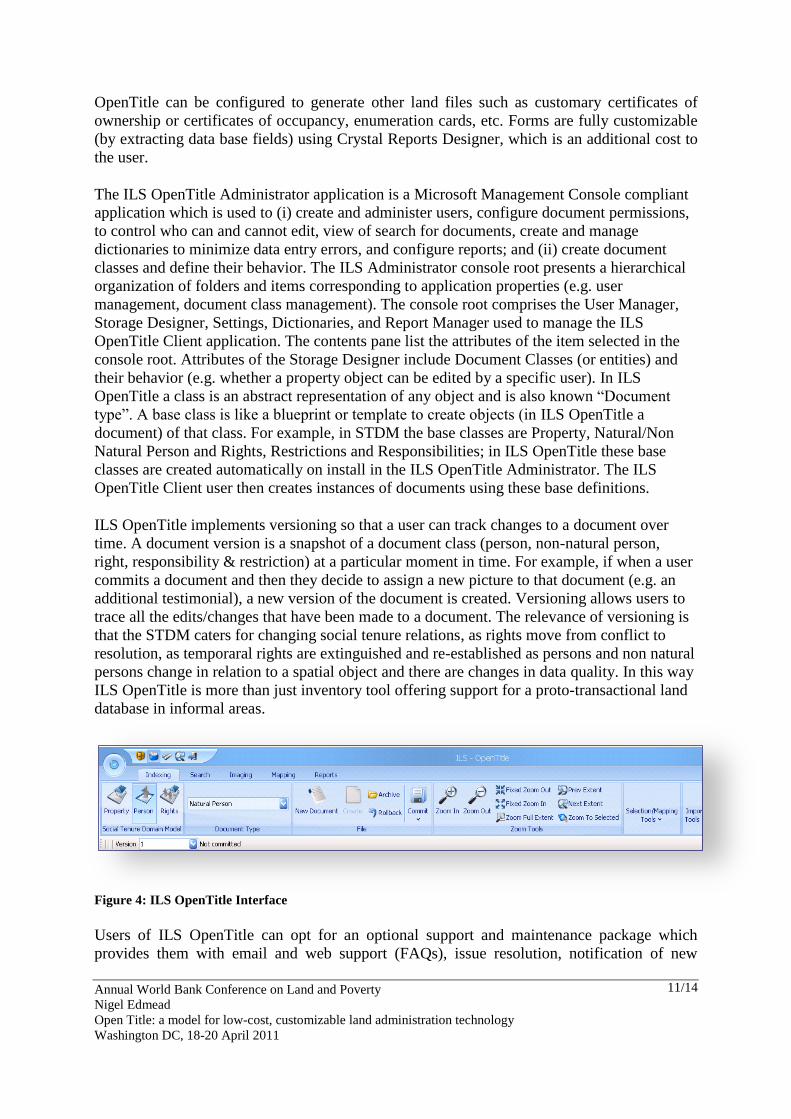
As part of the field work SAMBUS teams used Trimble GeoExplorer ProXH devices for field
work and Trimble Navigation, a key partner in the land title team, provided a range of both
GPS and survey grade equipment for testing in the field. Hand held GPS units were used for
the actual survey to quickly and accurately (within 30 cm), identify the exact coordinates of
the property, GPS readings were also supplemented with tape measurements to measure off
boundaries and subsequently used to create parcel boundaries.
Annual World Bank Conference on Land and Poverty
Nigel Edmead
Open Title: a model for low-cost, customizable land administration technology
Washington DC, 18-20 April 2011
6/14
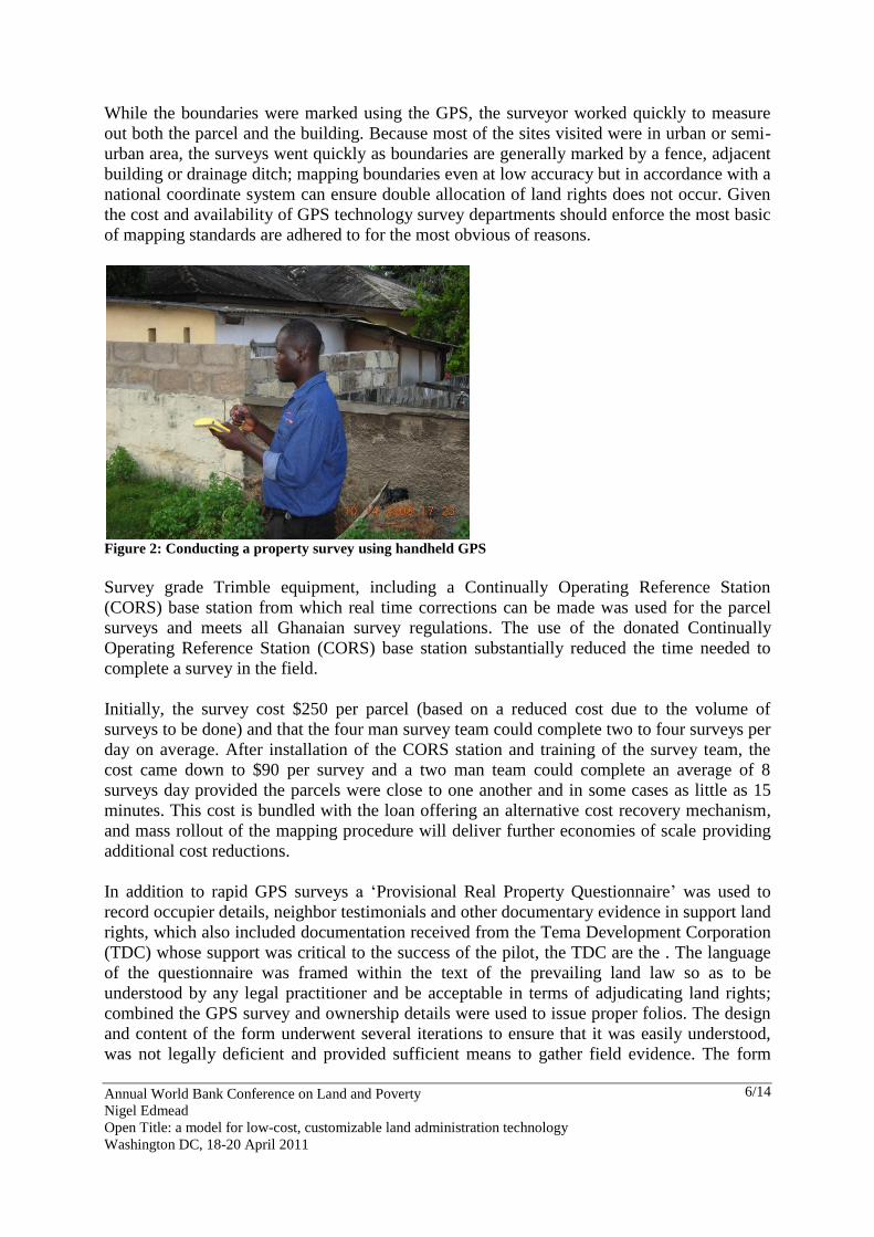
While the boundaries were marked using the GPS, the surveyor worked quickly to measure
out both the parcel and the building. Because most of the sites visited were in urban or semi-
urban area, the surveys went quickly as boundaries are generally marked by a fence, adjacent
building or drainage ditch; mapping boundaries even at low accuracy but in accordance with a
national coordinate system can ensure double allocation of land rights does not occur. Given
the cost and availability of GPS technology survey departments should enforce the most basic
of mapping standards are adhered to for the most obvious of reasons.
Figure 2: Conducting a property survey using handheld GPS
Survey grade Trimble equipment, including a Continually Operating Reference Station
(CORS) base station from which real time corrections can be made was used for the parcel
surveys and meets all Ghanaian survey regulations. The use of the donated Continually
Operating Reference Station (CORS) base station substantially reduced the time needed to
complete a survey in the field.
Initially, the survey cost $250 per parcel (based on a reduced cost due to the volume of
surveys to be done) and that the four man survey team could complete two to four surveys per
day on average. After installation of the CORS station and training of the survey team, the
cost came down to $90 per survey and a two man team could complete an average of 8
surveys day provided the parcels were close to one another and in some cases as little as 15
minutes. This cost is bundled with the loan offering an alternative cost recovery mechanism,
and mass rollout of the mapping procedure will deliver further economies of scale providing
additional cost reductions.
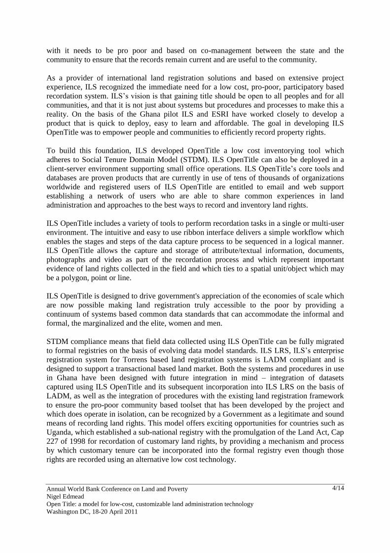
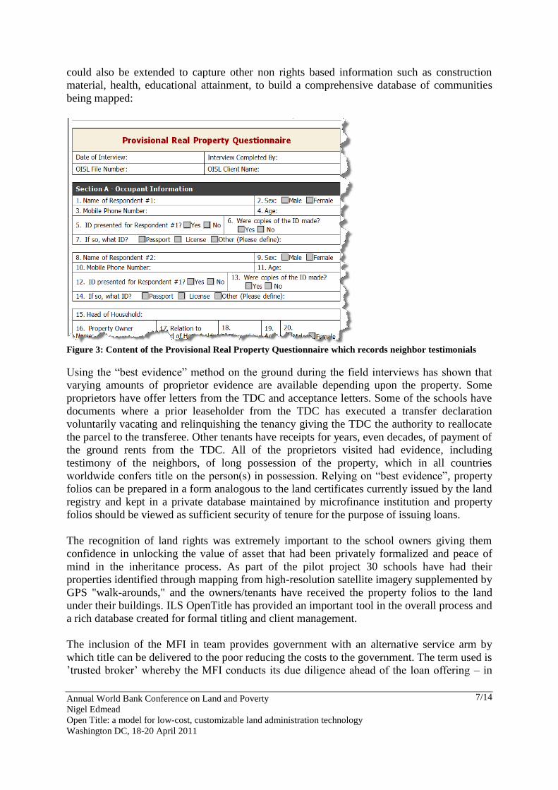
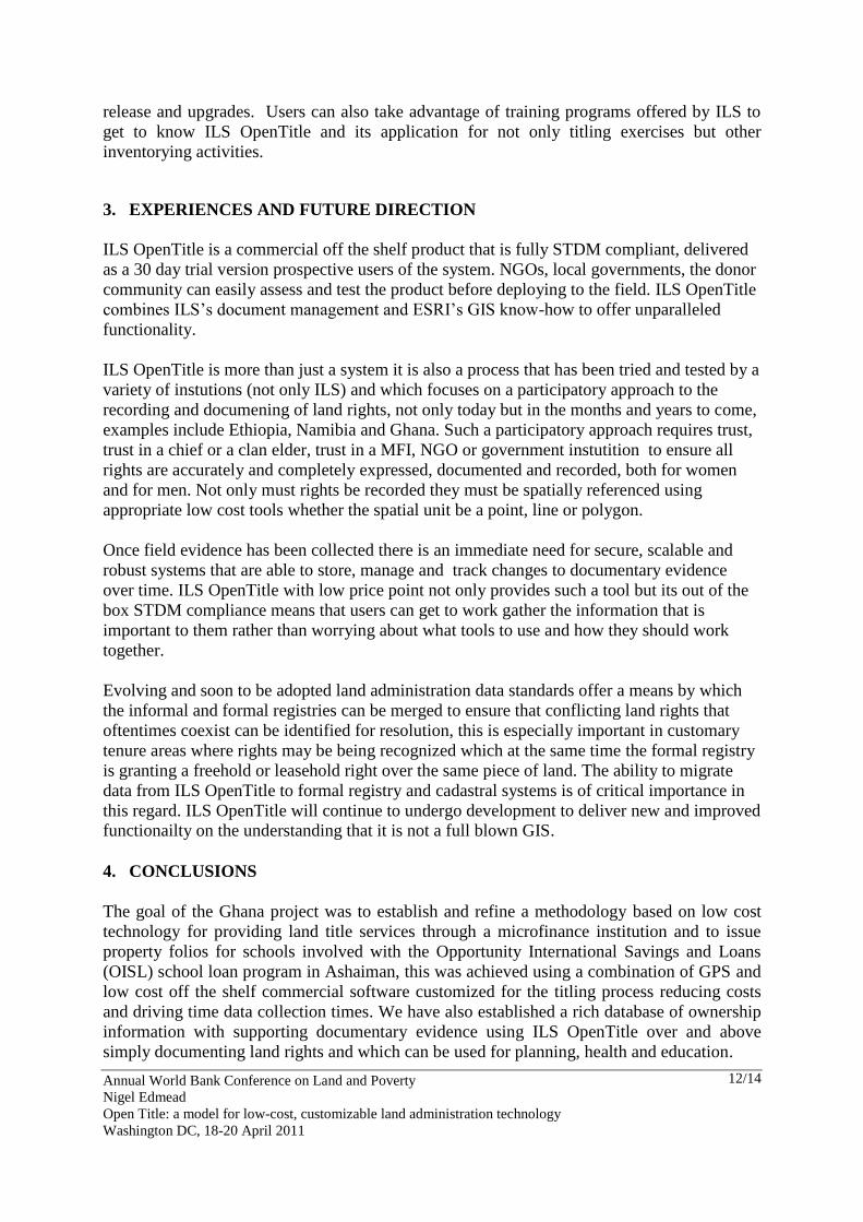
In addition to rapid GPS surveys a „Provisional Real Property Questionnaire‟ was used to
record occupier details, neighbor testimonials and other documentary evidence in support land
rights, which also included documentation received from the Tema Development Corporation
(TDC) whose support was critical to the success of the pilot, the TDC are the . The language
of the questionnaire was framed within the text of the prevailing land law so as to be
understood by any legal practitioner and be acceptable in terms of adjudicating land rights;
combined the GPS survey and ownership details were used to issue proper folios. The design
and content of the form underwent several iterations to ensure that it was easily understood,
was not legally deficient and provided sufficient means to gather field evidence. The form
Annual World Bank Conference on Land and Poverty
Nigel Edmead
Open Title: a model for low-cost, customizable land administration technology
Washington DC, 18-20 April 2011
7/14
could also be extended to capture other non rights based information such as construction
material, health, educational attainment, to build a comprehensive database of communities
being mapped:
Figure 3: Content of the Provisional Real Property Questionnaire which records neighbor testimonials
Using the “best evidence” method on the ground during the field interviews has shown that
varying amounts of proprietor evidence are available depending upon the property. Some
proprietors have offer letters from the TDC and acceptance letters. Some of the schools have
documents where a prior leaseholder from the TDC has executed a transfer declaration
voluntarily vacating and relinquishing the tenancy giving the TDC the authority to reallocate
the parcel to the transferee. Other tenants have receipts for years, even decades, of payment of
the ground rents from the TDC. All of the proprietors visited had evidence, including
testimony of the neighbors, of long possession of the property, which in all countries
worldwide confers title on the person(s) in possession. Relying on “best evidence”, property
folios can be prepared in a form analogous to the land certificates currently issued by the land
registry and kept in a private database maintained by microfinance institution and property
folios should be viewed as sufficient security of tenure for the purpose of issuing loans.
The recognition of land rights was extremely important to the school owners giving them
confidence in unlocking the value of asset that had been privately formalized and peace of
mind in the inheritance process. As part of the pilot project 30 schools have had their
properties identified through mapping from high-resolution satellite imagery supplemented by
GPS "walk-arounds," and the owners/tenants have received the property folios to the land
under their buildings. ILS OpenTitle has provided an important tool in the overall process and
a rich database created for formal titling and client management.
The inclusion of the MFI in team provides government with an alternative service arm by
which title can be delivered to the poor reducing the costs to the government. The term used is
‟trusted broker‟ whereby the MFI conducts its due diligence ahead of the loan offering – in
Annual World Bank Conference on Land and Poverty
Nigel Edmead
Open Title: a model for low-cost, customizable land administration technology
Washington DC, 18-20 April 2011
8/14
terms of affordability and risk – enables government to receive titles for inclusion in the
formal registry, other trusted brokers may include bio-fuel or mining companies who work
with the residents in a cropping or mining area and assist them formalize their land rights.
The legal impact of formal title is, when broken down, really only that third parties recognize
the rights of the land owner in that land. Why can‟t such determinations be done on a
business level by a neutral third party who has a financial interest in making sure the land and
owner are as represented? Like traditional financial institutions around the world,
microfinance lenders must rely on the ability of their borrower to repay the loan. In making
an underwriting decision on that borrower, they must look at all available information to
determine their “creditworthiness.” This includes a look at their assets.
The premise is that if a responsible lending institution is shown evidence of title being
properly in the name of the borrower and they are willing to make an underwriting decision
based on that evidence, the borrower has something of value. Reliance by that financial
institution on the evidence presented, even if that evidence has not been reduced to formal
registration of that land in that borrower‟s name, demonstrates commercial trustworthiness of
the land holding information. This translates into another form of “de facto” title.
The financial institution now vested with its own financial interests in seeing the title
formalized, and acting on behalf of the borrower/landowner, can assist in streamlining formal
registration. Though no direct government action is required until incorporation into the
formal registry, the microfinance institution can act as facilitator and consolidator for
collections of property folios which can be delivered to the government in accordance with a
predetermined plan according to pre-determined procedures.
2. ILS OPENTITLE
ILS OpenTitle is a low cost offering combining ESRI‟s ArcEngine components and ILS DSS
an integrated document management system for the capture and maintenance of land and
property information (e.g. documents, videos, etc). ILS DSS offers robust document storage
and includes version control to track changes to documentary evidence over time. ILS
OpenTitle adheres to STDM and configures the required data model entities (Persons, Non
Natural Persons, Social Tenure Relationships and Spatial Units and Mortgages) during
software installation. ESRI‟s ArcEngine components deliver basic mapping tools and the
ability to digitize new features on an ortho-photo or satellite image background and link
spatial units to documentary evidence on the owner/occupier and their rights. Functionality is
delivered in a modular ribbon based GUI.
ILS OpenTitle comprises: (i) ILS OpenTitle Client: a complete toolset for indexing, image
processing, report generation, and searching database content (ii) ILS OpenTitle
Administrator: used to manage all configurations in OpenTitle, the creation of data models,
users and permissions and (iii) ILS OpenTitle Server core of ILS OpenTitle that provides a
full stock of services, from managing users to accessing information whereby the SQL Server
database can be used by the server.
Installation is straightforward; the ILS OpenTitle Installer will install SQL Express 2008 if no
RDBMS is found and perform integrity checks to ensure all necessary components have been
installed correctly or are compatible (e.g. whether Windows components such as Windows
Annual World Bank Conference on Land and Poverty
Nigel Edmead
Open Title: a model for low-cost, customizable land administration technology
Washington DC, 18-20 April 2011
9/14
Media Player require updating). Once installed a user has to option to create new geographic
information from scratch or use an existing map document. An editable layer representing
polygons, points or lines can be configured to capture spatial units against which rights and
natural persons/non natural persons can be linked.
ILS OpenTitle is able to auto-generate registration documents from content captured during
recordation. ILS OpenTitle delivers the property folio process as a series tasks, these tasks are
fully configurable for other jurisdictions. ILS OpenTitle provides tools for indexing
(recordation), imaging (capturing images and videos), searching and mapping. The
provisional real property questionnaire is the basis against which information is gathered and
by which information is entered into ILS OpenTitle.
One of the primary functions of ILS OpenTitle is to work with documents. Documents can
come in many different forms. For example, they can be certificates of title, survey plans, etc.
In general, a document is any file, either digital or analog, that needs to be stored and indexed
that can subsequently be searched for and viewed. In ILS OpenTitle, documents consist of
images/pages, associated attributes and descriptive information.
Data collection in ILS OpenTitle can be classified into two basic forms: (i) Documentary,
Photographic, & Narrative Information; and (ii) Geographic & Cadastral information. Data
collection is achieved through a participatory approach – sensitization followed by interviews,
document collection and site inspection. The most important data source is a provisional real
property questionnaire that can be used to gather basic information regarding the claimant and
the property/parcel in question. Types of information that can be collected to determine an
ownership claim include:
Existing property records (e.g. a lease agreement)
Receipts and bills of sale pertaining to land rights
Proof of occupancy through utility bills
Tax payment receipts for occupancy of land
Attestations by neighbors regarding right to occupation
Attestations by community leaders (customary leaders, mayors, leaders of religious
organizations, traditional councils, etc.), these attestations reinforce the need for a
participatory approach to documenting land rights as noted by Jaap.
Photographic evidence of occupation (e.g. a photograph of the building and land or
grazing tract and watering hole)
Photographs of claimants with names in the absence of ID cards
Proof of identity (where national ID cards exist)
Videos and voice recordings of interviewer and interviewees, this may be while
conducting field investigation meeting (for example the field investigation minutes of the
Area Land Committees in Uganda)
Videos with neighbor‟s confirmation boundaries, this could include walking the boundary
line or identifying general boundary points such as trees, ditches, etc.
In addition to documentary, photographic and narrative data, geographic data must be
collected (size, location, shape of the spatial unit) to ensure the property can be geo-located.
Gathering basic property information is essential and can be achieved in a variety of different
ways:
Annual World Bank Conference on Land and Poverty
Nigel Edmead
Open Title: a model for low-cost, customizable land administration technology
Washington DC, 18-20 April 2011
10/14
By simply sketching property boundaries on satellite imagery with the aid of the claimant
and their neighbors, this has been found to be particularly useful in Namibia. It may be
done using a hardcopy print out of the image in a collaborative manner or be drawn on the
digital version of the image by means of heads up digitizing sitting with the claimant in
the field
Collect data from a single point, centrally located, on the property using a low-cost GPS
devices or GPS-enabled phone for a point-based survey supplemented by tape
measurements;
Collect accurate geometric dimensions using laser range finders and compasses; and
Survey information collected by licensed surveyors using traditional survey methods
and/or high accuracy GPS.
Import of CAD data
During recordation the person, spatial unit and rights responsibilities and restrictions are
recorded in accordance with STDM requirements using simple to use fields and drop down
lists. Person details include: Person Id, First Name, Last Name, City, Date of Birth, Gender,
Postal Code, Street, Validity Start and Validity End. Property details include:
Property/Building, Address Location, City, District, Land Use Regions, Tax Amount and
UPIN. Rights, Restrictions and Responsibilities details include: Relation Type (e.g. Informal
Tenure, Occupation), Property/Building, Share, Validity Start, Validity End, Natural Person
(or non Natural Person if applicable) and Mortgage. All of these default fields can be
modified according to user requirements. Data model manipulation is achieved using the ILS
OpenTitle Administrator application.
When indexing in ILS OpenTitle a series of icons representing the entities or documents to be
captured are presented to the user under an „Entity Types‟ section of the application GUI.
This sequences documents to be recorded and indicates when information (which may or may
not be mandatory) has been filled in and saved to the ILS OpenTitle database. Sequencing
represents a simple non-linear workflow that allows users to navigate between evidentiary
information (e.g. natural/non natural person) captured on the provisional real property
questionnaire. Entity sequencing can be reordered in ILS OpenTitle Administrator, and
entities can be removed from the sequence if that information is not required.
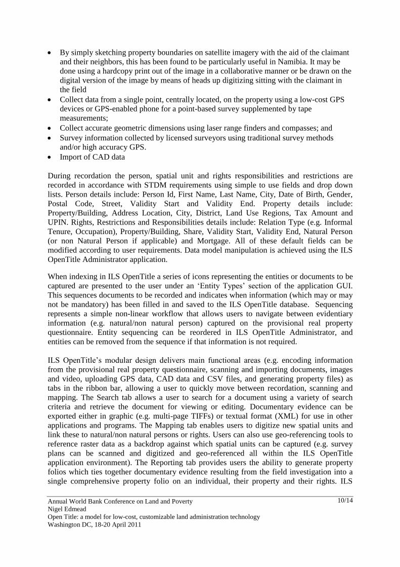
ILS OpenTitle‟s modular design delivers main functional areas (e.g. encoding information
from the provisional real property questionnaire, scanning and importing documents, images
and video, uploading GPS data, CAD data and CSV files, and generating property files) as
tabs in the ribbon bar, allowing a user to quickly move between recordation, scanning and
mapping. The Search tab allows a user to search for a document using a variety of search
criteria and retrieve the document for viewing or editing. Documentary evidence can be
exported either in graphic (e.g. multi-page TIFFs) or textual format (XML) for use in other
applications and programs. The Mapping tab enables users to digitize new spatial units and
link these to natural/non natural persons or rights. Users can also use geo-referencing tools to
reference raster data as a backdrop against which spatial units can be captured (e.g. survey
plans can be scanned and digitized and geo-referenced all within the ILS OpenTitle
application environment). The Reporting tab provides users the ability to generate property
folios which ties together documentary evidence resulting from the field investigation into a
single comprehensive property folio on an individual, their property and their rights. ILS
Annual World Bank Conference on Land and Poverty
Nigel Edmead
Open Title: a model for low-cost, customizable land administration technology
Washington DC, 18-20 April 2011
11/14
OpenTitle can be configured to generate other land files such as customary certificates of
ownership or certificates of occupancy, enumeration cards, etc. Forms are fully customizable
(by extracting data base fields) using Crystal Reports Designer, which is an additional cost to
the user.
The ILS OpenTitle Administrator application is a Microsoft Management Console compliant
application which is used to (i) create and administer users, configure document permissions,
to control who can and cannot edit, view of search for documents, create and manage
dictionaries to minimize data entry errors, and configure reports; and (ii) create document
classes and define their behavior. The ILS Administrator console root presents a hierarchical
organization of folders and items corresponding to application properties (e.g. user
management, document class management). The console root comprises the User Manager,
Storage Designer, Settings, Dictionaries, and Report Manager used to manage the ILS
OpenTitle Client application. The contents pane list the attributes of the item selected in the
console root. Attributes of the Storage Designer include Document Classes (or entities) and
their behavior (e.g. whether a property object can be edited by a specific user). In ILS
OpenTitle a class is an abstract representation of any object and is also known “Document
type”. A base class is like a blueprint or template to create objects (in ILS OpenTitle a
document) of that class. For example, in STDM the base classes are Property, Natural/Non
Natural Person and Rights, Restrictions and Responsibilities; in ILS OpenTitle these base
classes are created automatically on install in the ILS OpenTitle Administrator. The ILS
OpenTitle Client user then creates instances of documents using these base definitions.
ILS OpenTitle implements versioning so that a user can track changes to a document over
time. A document version is a snapshot of a document class (person, non-natural person,
right, responsibility & restriction) at a particular moment in time. For example, if when a user
commits a document and then they decide to assign a new picture to that document (e.g. an
additional testimonial), a new version of the document is created. Versioning allows users to
trace all the edits/changes that have been made to a document. The relevance of versioning is
that the STDM caters for changing social tenure relations, as rights move from conflict to
resolution, as temporaral rights are extinguished and re-established as persons and non natural
persons change in relation to a spatial object and there are changes in data quality. In this way
ILS OpenTitle is more than just inventory tool offering support for a proto-transactional land
database in informal areas.
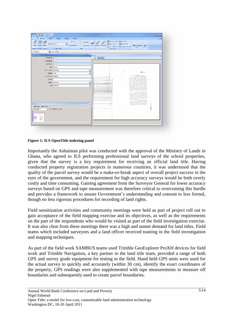
Figure 4: ILS OpenTitle Interface
Users of ILS OpenTitle can opt for an optional support and maintenance package which
provides them with email and web support (FAQs), issue resolution, notification of new
Annual World Bank Conference on Land and Poverty
Nigel Edmead
Open Title: a model for low-cost, customizable land administration technology
Washington DC, 18-20 April 2011
12/14
release and upgrades. Users can also take advantage of training programs offered by ILS to
get to know ILS OpenTitle and its application for not only titling exercises but other
inventorying activities.
3. EXPERIENCES AND FUTURE DIRECTION
ILS OpenTitle is a commercial off the shelf product that is fully STDM compliant, delivered
as a 30 day trial version prospective users of the system. NGOs, local governments, the donor
community can easily assess and test the product before deploying to the field. ILS OpenTitle
combines ILS‟s document management and ESRI‟s GIS know-how to offer unparalleled
functionality.
ILS OpenTitle is more than just a system it is also a process that has been tried and tested by a
variety of instutions (not only ILS) and which focuses on a participatory approach to the
recording and documening of land rights, not only today but in the months and years to come,
examples include Ethiopia, Namibia and Ghana. Such a participatory approach requires trust,
trust in a chief or a clan elder, trust in a MFI, NGO or government instutition to ensure all
rights are accurately and completely expressed, documented and recorded, both for women
and for men. Not only must rights be recorded they must be spatially referenced using
appropriate low cost tools whether the spatial unit be a point, line or polygon.
Once field evidence has been collected there is an immediate need for secure, scalable and
robust systems that are able to store, manage and track changes to documentary evidence
over time. ILS OpenTitle with low price point not only provides such a tool but its out of the
box STDM compliance means that users can get to work gather the information that is
important to them rather than worrying about what tools to use and how they should work
together.
Evolving and soon to be adopted land administration data standards offer a means by which
the informal and formal registries can be merged to ensure that conflicting land rights that
oftentimes coexist can be identified for resolution, this is especially important in customary
tenure areas where rights may be being recognized which at the same time the formal registry
is granting a freehold or leasehold right over the same piece of land. The ability to migrate
data from ILS OpenTitle to formal registry and cadastral systems is of critical importance in
this regard. ILS OpenTitle will continue to undergo development to deliver new and improved
functionailty on the understanding that it is not a full blown GIS.
4. CONCLUSIONS
The goal of the Ghana project was to establish and refine a methodology based on low cost
technology for providing land title services through a microfinance institution and to issue
property folios for schools involved with the Opportunity International Savings and Loans
(OISL) school loan program in Ashaiman, this was achieved using a combination of GPS and
low cost off the shelf commercial software customized for the titling process reducing costs
and driving time data collection times. We have also established a rich database of ownership
information with supporting documentary evidence using ILS OpenTitle over and above
simply documenting land rights and which can be used for planning, health and education.
Annual World Bank Conference on Land and Poverty
Nigel Edmead
Open Title: a model for low-cost, customizable land administration technology
Washington DC, 18-20 April 2011
13/14
In addition, it was important to identify that there was in fact a demand for assistance with
property registration and to test the feasibility of business model in which an organization can
assist the general public with registration. Through our interviews, it because abundantly clear
that there is a demand for assistance with property registration. Citizens are fed up with trying
to register assets under the existing system, citing problems with lost documents, unclear
procedures, delays that stretch to years and prohibitive costs. During our interview, gratitude
to the team for assisting with a seemingly impossible task was expressed profusely. When
interviewing neighbors regarding a parcel, the interview session inevitably ended with a
question from the interviewee: “When can you do my property?” Under the project we were
able to refine a clear and scalable methodology for providing land title services.
The issuance of property folios and its maintenance in a private data system, although
satisfactory for the loan program, is not the end, but only the beginning of the process. The
goal is that these property folios will be upgraded to registered legal title on a streamlined
basis that will be worked out with the local registry officials. Therefore, from the beginning
there will be cooperation with the land registry. Property folios will subsequently be
submitted in bulk to the land registry for formal registration, which will assist the land
registry in the formal registration of the properties. The formal procedures for first
registration are much the same as found in registration procedures world-wide, consisting of
publication requirements, reasonable time periods for objection, and statutes of limitation
upon claims, once a formal certificate of title has been issued.
Annual World Bank Conference on Land and Poverty
Nigel Edmead
Open Title: a model for low-cost, customizable land administration technology
Washington DC, 18-20 April 2011
14/14
REFERENCES
Agustinus, C., Lemmen C., and Van Oosterom P. Social Tenure Domain Model Requirements
from the Perspective of Pro-Poor Land Management, 5th FIG Regional Conference, Accra,
March 8-11, 2006
Edmead, N. Open Title: a Low Cost Tool for Inventorying Property Rights - Experiences from
Ghana, FIG Congress 2010, Sydney, 11-16 April 2010.
Rabley, P. Ghana Project Leverages GIS-Based Title Registration and Microfinance to
Alleviate Poverty, ArcNews, Fall 2008.
Rabley, P. and DeRoy, C. Ghana Project Leverages GIS-Based Title Registration and
Microfinance to Alleviate Poverty—Part 2, ArcNews, Winter 2008/2009.
Rabley, P. and DeRoy, C. GIS Brings Commercial Viability to Recognizing the Land Interests
of the World's Poor Evaluating Ghana Pilot Project Results—Part 3, ArcNews, Summer
2009.
Rabley, P., DeRoy, C., Aboah, S., and Edmead N., A PARADIGM SHIFT: Leveraging
Paralegal Title for the Benefit of the Developing World and the Surveyors Who Map It, FIG
Working Week 2008, Stockholm, 14-19 June 2008.
Zevenbergen, J. Development of a Pro-Poor Land Recordation System, Expert Group
Meeting on Pro-Poor Recordation System, Paris, 15 – 16 March 2011