Embed Size (px)
Citation preview
Introduction 3
Site 1: Clayton Reserve 7
Site 2: Gardiner Reserve 11
Site 3: North Melbourne Primary School 17
Site 4: Bedford Street Reserve 25
Site 5: North Melbourne Railway Station 31
Site 6: Curzon Street Reserve 37
Site 7: Errol Street Reserve 43
Site 8: Eades Place Reserve 49
Site 9: Howard Street Reserve 55
Conclusions & Recommendations 61
References 65
Appendices 67
Table of Contents
1
ABC
Not to Scale
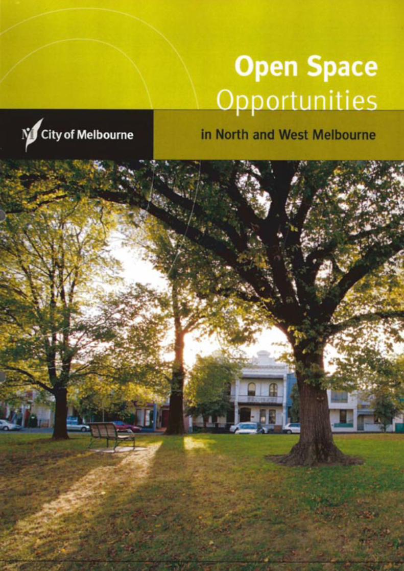
Open Space Opportunities
in North and West Melbourne
Open Spaces Opportunities
In North and West Melbourne
2
Reasons for the StudyAlthough North and West Melbourne possess few largeparks, the local street pattern produces two importantopen space assets. Thoroughfares are wide, and pocketsof open space occur where different street grids intersect.Some of these streets and intersections are intensivelylandscaped. These areas provide green corridors andattractive oases within a dense fabric of residential andmixed-use buildings. However, the potential of many other streets and sites remains unrealised. In their presentform they are too small, too inaccessible or too sparselyplanted to provide valuable recreational amenities.
Council’s North and West Melbourne Greening StrategyDraft Issues Paper already describes a program of streettree planting for the area. Recently, streetscapeimprovements have been completed in Capel Street,Railway Place and Lloyd Street. More planting is plannedfor Chetwynd, O’Connel and Howard Streets. As thestrategy is implemented, broad green medians will replacethe unnecessary expanse of asphalt found in many North and West Melbourne streets.
The North and West Melbourne Open SpaceOpportunities Study is an extension of the GreeningStrategy. It focuses on the irregular “left over” spaces that occur between North and West Melbourne’s skewedstreet grids. The study examines how these accidentalopen spaces can become more significant componentsof the city’s recreational open space system.
Open Space Opportunities helps to achieve severalstrategic directions identified in the North West 2010. This local plan calls for the “development of open spaces”in North and West Melbourne. It also seeks better accessto open space, and improvements to theneighbourhoods’ streetscape (see page 38).
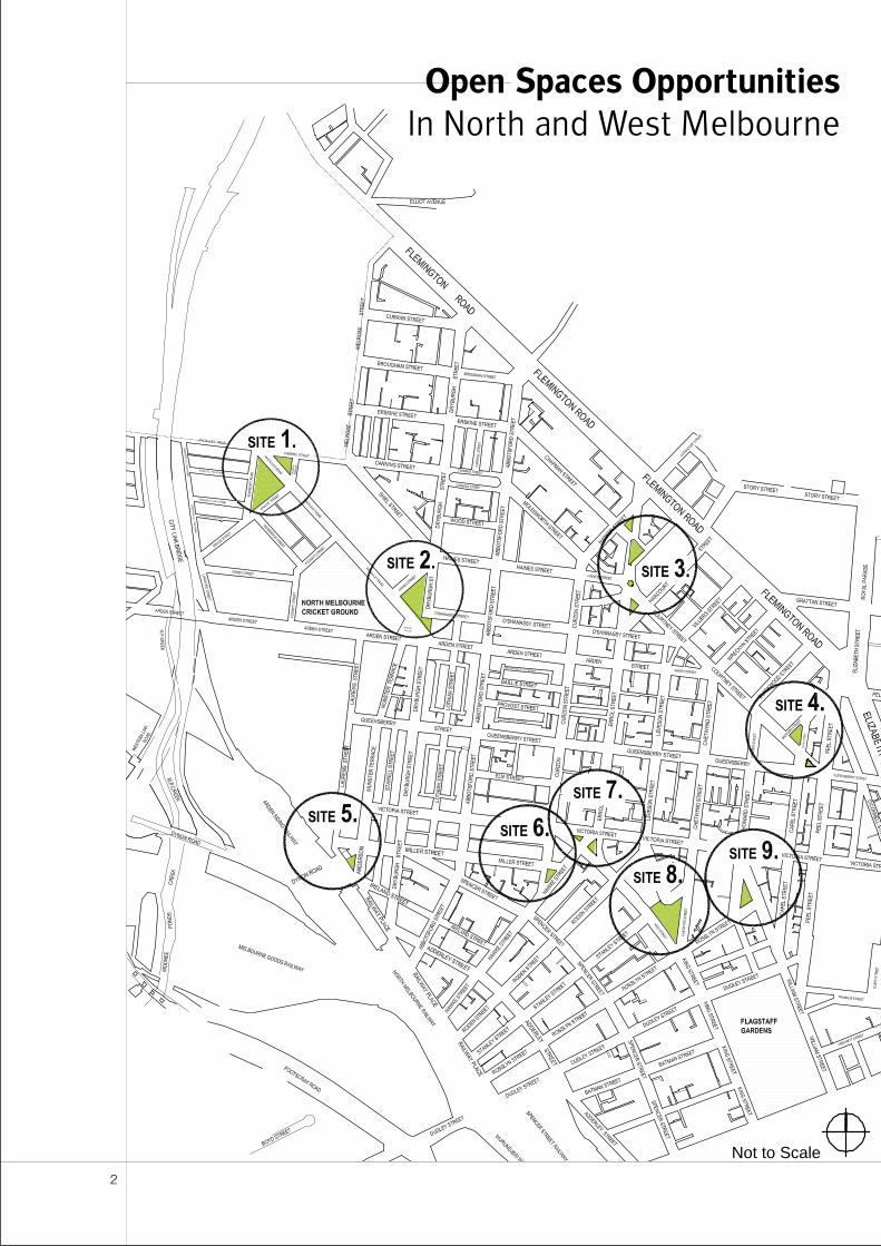
Scope of the ProjectOpen Space Opportunities produces detailed analysesand recommendations for nine of the most promisingresidual sites within North and West Melbourne’s streetgrids. Choices were influenced by the size and location of the spaces and also by Council’s ability to implementchange at each location within a short to medium timeframe. However, before the scope of the study was fixed,a comprehensive survey of the neighbourhoods’ openspace assets was carried out. As a result, a number ofsupplementary sites for landscape improvement havebeen identified. These are listed in Appendix 1.
The boundaries of North and West Melbourne’s pocketparks provide the principal subject for investigation.Sometimes, the existing landscaped areas are no morethan large traffic islands. In such locations, expanding theopen space into the surrounding road reserve may be anattractive option. Elsewhere, open space improvementsdepend on land acquisition. Where this applies, thestudy’s recommendations are subject to agreementsbeing reached with private owners.
Open Space Opportunities is a feasibility study rather than a design exercise. The study indicates how the size, shape and character of the sites might change.However, these scenarios are constructed so that costsand benefits can be assessed, and so that terms ofreference can be identified for a later design brief. Detailed landscape concepts still need to be producedbefore any of the sites can be developed.
To produce a balanced evaluation, the study addresses a wide range of issues. In some cases, extending the area of landscape can improve motorists’ behaviour. By closing or narrowing streets, vehicle speeds arereduced and through-traffic is discouraged (Note: theseoutcomes are also identified as objectives in North West2010 - see page 41). However, some street closuressimply divert traffic through other residential enclaves.Access to private properties can be restricted, and noneof the sites can be significantly improved without losingon-street parking spaces. If kerbs are realigned, heritagefeatures and streetscape character can be compromised.All these negative impacts are considered and, if possible,quantified along with the expense of construction. The costs are compared with the obvious visual andrecreational benefits associated with green open space.
Introduction
3
Creating an open space systemAlthough the study focuses on nine individual sites, themerits of these locations are assessed in terms of theirpotential to contribute towards a network of open spaces.“Views and linkages” are part of the detailed analysis ofevery site. So, Open Space Opportunities do not simplyidentify new recreational opportunities. It develops aseries of key connections within a network of attractivewalking and cycling routes. These routes join theneighbourhoods of North and West Melbourne toimportant municipal and metropolitan assets such asFlagstaff Gardens, Moonee Ponds Creek and Royal Park.
Carrying out the
Feasibility StudyThe Open Space Opportunities feasibility study is theresult of a phased work program that was carried outover a nine month period between October 2000 andJune 2001.
Phase 1: Survey of existing policies and strategiesThe following policies and strategies were surveyed:
• Capel Street Action Plan (City of Melbourne, 1984)
• City Plan 1999 (City of Melbourne, 1999)
• Grids & Greenery (City of Melbourne, 1987)
• Moonee Ponds Creek Proposed Realignment:Landuse, Visual Assessment & Landscape Report(ERM Mitchell McCotter Pty Ltd, 1999)
• Moonee Valley 2010: A Vision for the Future (City of Moonee Valley, 1998)
• North & West Melbourne Greening Strategy Draft Issues Paper (Laycock & Jaquet LandscapeArchitects, 1998)
• North & West Melbourne Neighbourhood Character Study (City of Melbourne, 1996)
• North Central City Corridor Study (Department of Infrastructure, 2001)
• North West 2010, Community Consultation Process(City of Melbourne, 1999)
• North West 2010: Local Plan (City of Melbourne, 1999)
Issues and objectives from these documents areaddressed in detailed analyses of the nine sites.
Phase 2: Site analysisIn the first instance, visual inspections and photographicsurveys were made at each of the open spaces.Underground and overhead services were mapped usinginformation from the City’s Land Information System (LIS)and the Dial-Before-You-Dig service. One of Council’sheritage experts provided detailed information onstreetscape character in the vicinity of the subject sites.The extent of North and West Melbourne’s historicbluestone kerbs was also systematically recorded. At each location, the results of these investigations have been compiled into a single site analysis diagram.
The site survey was followed by a series of sketchdesigns that explored existing and potential relationshipsbetween landscape, circulation and surrounding buildings.In each location, the design exercises produced severaldevelopment options that indicate how the size, shapeand character of the sites might change. They alsoconsidered improvements to landscape features andrecreational facilities. These options enabled costs andbenefits to be assessed and provided the basis for peerreview and stakeholder consultation.
Council’s transport engineering consultants examinedeach of the open space development options. Their comments include an assessment of eachscenario’s impact on traffic patterns, driver behaviour and road safety.
On-street parking spaces were counted at each of thenine sites. Opportunities for additional car parks were also studied. As a result, each development scenariopredicts likely changes to parking availability.
Phase 3: Stakeholder consultationExtensive consultation has occurred both inside and outside the City of Melbourne.
Three rounds of meetings were held with stakeholderswith Council. These meetings were attended byrepresentatives from the following Groups and work areas:
• City Projects
• Community Services
• Engineering Services
• Parks and Recreation
• Strategic Planning
Councillors Martin Brennan and Kevin Chamberlin werebriefed on the project before community consultation began.
The views of key external stakeholders were solicited. Thefollowing groups and individuals provided feedback on thecosts and benefits associated with various open spacedevelopment options:
4
• Bayside Trains Transport House Co-Op
• Lithuanian Community Club
• North & West Melbourne Neighbourhood Centre
• North & West Melbourne Association
• North Melbourne Football Club
• North Melbourne Pool Community Group
• North Melbourne Precinct Environment Group
• North Melbourne Primary School (Errol Street)
• North Melbourne Tenants Union of Victoria
• North Melbourne Traders Association
• Roman Catholic Trusts Association
• Salvation Army
• St Aloysius College
• St Josephs Christian Brothers College
• St Michaels Catholic Primary School
• Vic Roads
• Victoria Hill Precinct
• West Melbourne Baptist Church
• Wurundjeri Council
In most cases, the stakeholders’ input focused on a single relevant location. However, the North and West Melbourne Association supplied feedback on all nine sites.
Public opinion was surveyed. A standard multiple-choicequestionnaire was produced along with information foreach of the nine open space opportunities.Questionnaires and information sheets were distributed to properties adjoining each of the reserves. The materialwas also displayed at four locations within NorthMelbourne: the community centre, the library, the townhall and the swimming pool. The project and the displayswere also advertised in The Melbourne Times and The Melbourne Leader. Over 150 responses to thequestionnaire were received. Results are tabulated in Appendix 2.
On Tuesday 8 May 2001, a public meeting was held in the North Melbourne Town Hall. The meeting wasadvertised in The Age and promoted in the publicquestionnaire. Between 25 and 30 people attended the meeting.
Phase 4: Cost estimateA quantity surveyor was engaged to assess costs foreach of the open space options. Estimates were basedon an indicative landscape specification as well as adiagrammatic site plan.
FormatEach of the nine sites is addressed in a separate chapterof the report. These sections are self-contained. They canbe read individually without reference to the rest of thestudy. However, they all follow a standard format andaddress recurring issues:
• Description of Existing Conditions
• Site Analysis Diagram
• Detailed Site Analysis
• spatial character
• existing landscape
• views and linkages
• heritage
• traffic management
• parking
• services
• community and stakeholder response
• costs and funding
• Design Principles and Objectives
• street layout
• built form
• streetscape
• park landscape
• Development Options
• Conclusions and Recommendations
Overall conclusions and recommendations are given at the end of the report. This section reiterates thepreferred response at each site, and gives priorities forimplementation. Supplementary material is containedwithin the appendices.
5
Where to from hereThe study identifies priorities for open spaceimprovements in North and West Melbourne. At each of the nine sites, a preferred development scenario is defined. The sites are also divided into three groupsaccording to the desirability and feasibility of the changes at each location.
At today’s prices, the estimated cost of all recommendedimprovements is $2 500 000. High and medium-priorityprojects account for $2 000 000 of this amount, and it issuggested that this expenditure is spread over a five-yearperiod ending in 2005/06. These figures exclude the costof land acquisition, which is an option at two of the ninesites (Sites 6 and 9).
All design and documentation of the projects is to bemanaged by, and on behalf of City Projects, through acollaborative process of consultation with EngineeringServices and Parks & Recreation. Construction of thedesigns will be managed by either Engineering Services orParks & Recreation; and will be confirmed at a later time.
As part of the Capital Works Program for 2001/02,funding has already been approved for design anddocumentation at two high-priority locations (Sites 5 and6). This year’s budget also allows for a small amount ofconstruction at the Eades Place reserve (Site 8).
At the remaining locations, funds for design orconstruction must be sought and approved in the normalway as part of Council’s capital projects approval process.Successful proposals for individual sites will become partof Council’s Approved Program of Works.
6
Existing Conditions
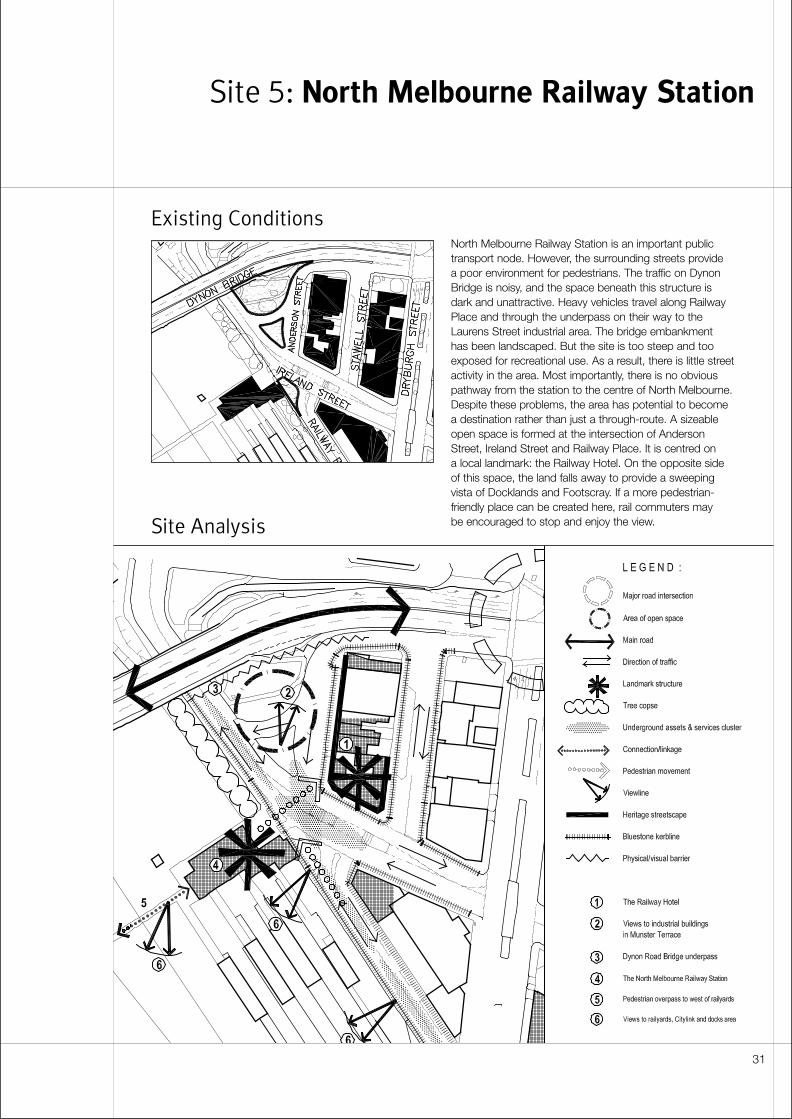
Site Analysis
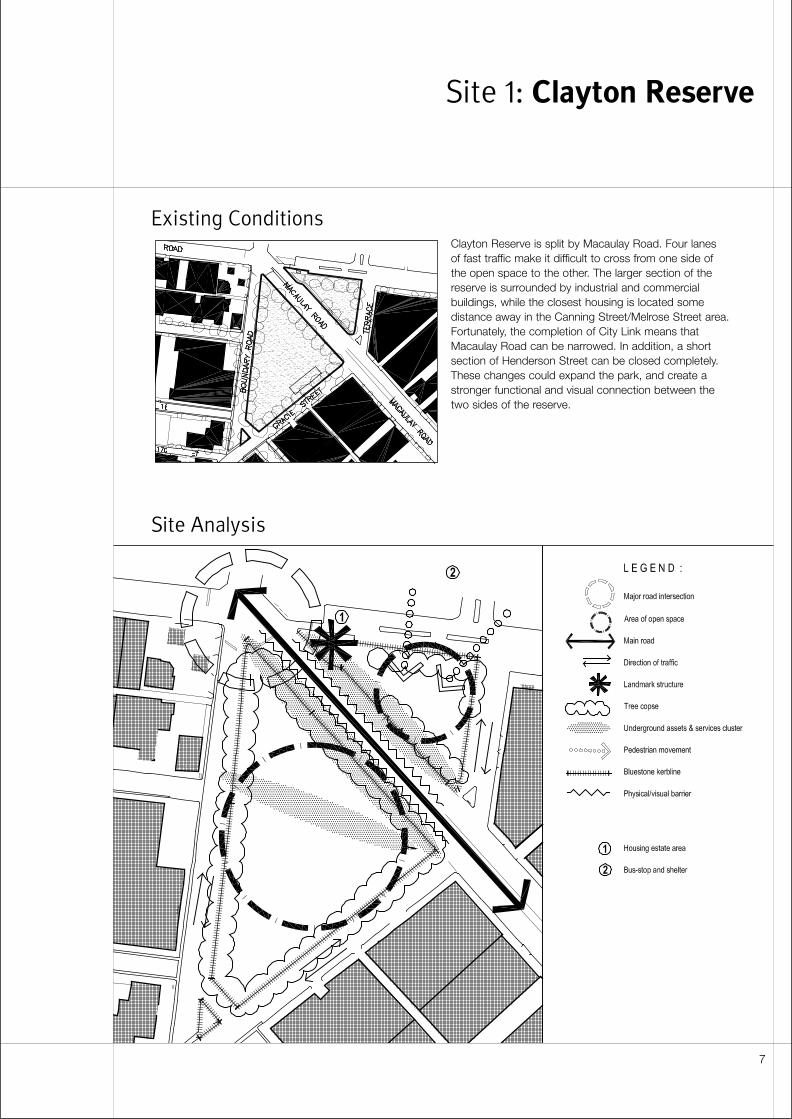
Clayton Reserve is split by Macaulay Road. Four lanes of fast traffic make it difficult to cross from one side of the open space to the other. The larger section of thereserve is surrounded by industrial and commercialbuildings, while the closest housing is located somedistance away in the Canning Street/Melrose Street area.Fortunately, the completion of City Link means thatMacaulay Road can be narrowed. In addition, a shortsection of Henderson Street can be closed completely.These changes could expand the park, and create astronger functional and visual connection between thetwo sides of the reserve.
Site 1: Clayton Reserve
7
Detailed Site Analysis
Spatial character• The reserve contains two triangular open spaces.
• Most of the surrounding frontages are comprised of one and two storey commercial buildings. These provide little visual containment to the park.
• Slab blocks within an adjacent housing estate provide the dominant built form.
Existing landscape• Lines of mature trees frame the two open spaces.
However, there is too much unstructured andunsheltered ground at the centre of the larger triangle.
• Both sides of the reserve are treated as a flat grassplane. The simplicity and continuity of this surfacereinforces visual links between the two triangles. This connection is enhanced by lawn along the median within Macaulay Road.
• Footpaths are absent from much of the perimeter of the reserve. There are no paths crossing either of the open spaces.
• Light poles provide the only furniture within the space.Unsightly overhead lines serve the lanterns. The qualityof night lighting is poor. The edges of the park dependon street lighting, yet trees around the perimeter of thespace block illumination from this source.
• A plaque near the corner of Boundary and Macaulayrecords the origin of Clayton Reserve’s name. This element is inconspicuous and is poorly integratedwith surrounding landscape.
• A bus shelter at the corner of Canning and MacaulayRoad is poorly integrated with the reserve and thesurrounding streetscape.
Views and linkages• Macaulay Road offers a potential “green link” between
Clayton Reserve and Gardiner Reserve.
• Clayton Reserve is only a short walking distance(approximately 250 metres) from Macaulay Station and the Moonee Ponds open space corridor.
• The larger triangle of open space is relatively isolated.It is several hundred metres away from the closestresidential areas.
• Because there is no housing close by, there is littlepassive surveillance of the open space especially after business hours.
Heritage• There is no heritage overlay on this site, and the
surrounding streetscape is ungraded.
• The reserve is bounded by bluestone kerbs andchannels. These should be retained or reinstated.
• The lines of mature trees around the perimeter of the reserve have historic significance, in addition totheir value as landscape.
Traffic management• Following completion of City Link, Macaulay Road no
longer has arterial status. However, the route remains a main road and is under the control of VicRoads.
• The capacity of Macaulay Road can be reduced toone traffic lane and one bike lane in each direction. But there is some potential for through-traffic to bediverted into surrounding residential areas if thisoccurs.
• The intersection of Macaulay and Canning can benarrowed to accommodate two standing lanes fornorthbound vehicles and a single lane for southboundtraffic.
• From a traffic management perspective, it is preferableto have a single streetscape treatment with a uniformmedian for the full length of Macaulay Road (betweenCanning and Arden). Varying the width andconfiguration of the carriageway could reduce safety.
• Presently, there is no pedestrian crossing acrossMacaulay Road linking the adjacent reserves.Pedestrians need to negotiate three sides of theintersection in order to cross safely between the two open spaces.
• The northern end of Henderson Street (betweenBoundary and Gracie) is redundant. It can be closedand absorbed into the reserve, provided adequateturning space is retained for commercial vehicles at the corner of Boundary and Gracie.
• Turning circles for large vehicles also need to beaccommodated on Vaughan Terrace. This requirementlimits the scope for narrowing the street.
Parking• Parking can be removed from the eastern edge
of Macaulay Road in the vicinity of the reserve.Approximately ten spaces would be lost from thislocation if the carriageway is narrowed. These areunrestricted parks, and appear to be well used.
• To compensate, it may be possible to increase thenumber of car parks slightly in Vaughan Terrace byintroducing angle parking. However, the need toaccommodate commercial vehicles and a bus routeseverely limits the street’s potential as a parkingprecinct.
8
Services• Before design occurs, the exact locations of water,
gas, underground stormwater, telephone, and powerservices need to be identified. Special attention shouldbe given to the edges of Macaulay Road and the areawithin the reserve.
Community and stakeholder response• Clayton Reserve prompted less community feedback
than any other site. Support was stronger for ExampleB with a wide median along the full length of MacaulayRoad.
• The community’s principal objective in this location isto reduce vehicle numbers and speeds, rather than toincrease open space. Additional trees and seating areviewed as important improvements to amenities withinthe reserve.
• The North and West Melbourne Association supportsnew amenities and improved pedestrian access to the park. However, the association does not favourextending the reserve into Macaulay Road. The groupsees little benefit in such a small increase in openspace, especially when this is gained at the expense of parking. The association is also concerned aboutany change in traffic patterns that might divert trafficinto residential streets.
• Open space improvements at Clayton Reserve arepopular with internal stakeholders, mainly because City Link has delivered a one-off opportunity to re-configure Macaulay Road. Internal objectives for thisinitiative relate more to traffic calming and streetscapeimprovements than extensions to recreational openspace.
• Sites 1 Clayton Reserve and 2 Gardiner Reserve mightbe considered higher priorities if State Governmentfunding is available for changes to Macaulay Road.
Costs and funding• Cost estimates for improvements at this site vary
from $195 000 to $208 250. Example A is the moreexpensive option. The higher costs result from therelocation of kerbs and channels.
• The capacity of Macaulay Road has been reduced aspart of City Link. For this reason, the Council shouldseek funding from VicRoads for reductions in the widthof the carriageway and intersections. However, theState’s traffic management objectives for MacaulayRoad have already been achieved simply by changingroad markings. Under these circumstances, VicRoadsare likely to object to additional costs for relocating thekerbs and repaving.
Design Principles and Objectives
Street layout• North of Gracie Street, minimise the width of Macaulay
Road by removing the existing median and parking.South of Gracie Street, introduce a wider median andretain parallel parking at the edges of the street.
• Provide a generous gap between these twotreatments. Ensure the interval allows traffic to floweasily and contributes to visual continuity along the street.
• Locate bike paths within the reserve, but provide safe connections to and from the street.
• Alternatively, introduce a uniformly wide median alongthe full length of Macaulay Road (between Canningand Arden).
Streetscape• If a wide median is adopted along the full length of
Macaulay Road, consider planting it with a double rowof trees within the area of the reserve. Use these treesto emphasise the presence of the park and to enhancethe median as a pedestrian refuge. South of GracieStreet, revert to a single line of trees within the median.
• Consider the streetscape treatment at Clayton Reservein relation to possible improvements at GardinerReserve. Ensure that the full length of Macaulay Road(between Canning and Arden) is designed as singlecoherent entity. Reinforce continuity by placingcontinuous lines of street trees along both edges ofthe street.
• Provide a new pedestrian crossing at the intersectionof Canning and Macaulay.
• Reinstate or relocate all bluestone kerbs, channels and pitchers.
Park landscape• Treat the two triangles similarly to emphasise the unity
of the space and increase visual connection acrossMacaulay Road.
• Consider adding trees to the centres of the twotriangles. Use an informal layout that complements the uniform rows of trees at the edges of the park.
• Provide new pathways in response to improvedpedestrian access across Macaulay Road. Follow an “organic” layout, consistent with the new planting pattern.
• Take advantage of the site’s relative isolation. Considerusing the reserve to accommodate noisy or untidyactivities such as temporary out-door events, acommunity garden or a skate park.
9
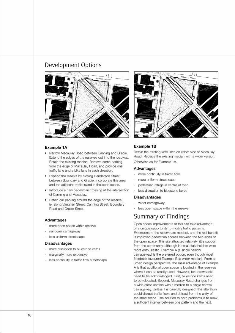
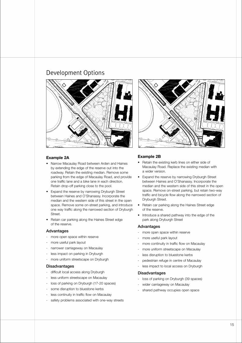
Development Options
Example 1A• Narrow Macaulay Road between Canning and Gracie.
Extend the edges of the reserves out into the roadway.Retain the existing median. Remove some parkingfrom the edge of Macaulay Road, and provide onetraffic lane and a bike lane in each direction.
• Expand the reserve by closing Henderson Streetbetween Boundary and Gracie. Incorporate this areaand the adjacent traffic island in the open space.
• Introduce a new pedestrian crossing at the intersectionof Canning and Macaulay.
• Retain car parking around the edge of the reserve, ie. along Vaughan Street, Canning Street, BoundaryRoad and Gracie Street.
Advantages- more open space within reserve
- narrower carriageway
- less uniform streetscape
Disadvantages- more disruption to bluestone kerbs
- marginally more expensive
- less continuity in traffic flow streetscape
Example 1BRetain the existing kerb lines on either side of MacaulayRoad. Replace the existing median with a wider version.
Otherwise as for Example 1A.
Advantages- more continuity in traffic flow
- more uniform streetscape
- pedestrian refuge in centre of road
- less disruption to bluestone kerbs
Disadvantages- wider carriageway
- less open space within the reserve
Summary of FindingsOpen space improvements at this site take advantage of a unique opportunity to modify traffic patterns.Extensions to the reserve are modest, and the real benefitis improved pedestrian access between the two sides ofthe open space. This site attracted relatively little supportfrom the community, although internal stakeholders weremore enthusiastic. Example A (a single narrowcarriageway) is the preferred option, even though mostfeedback favoured Example B (a wider median). From anurban design perspective, the main advantage of ExampleA is that additional open space is located in the reserveswhere it can be readily used. However, two drawbacksneed to be acknowledged. First, bluestone kerbs need to be relocated. Second, Macaulay Road changes from a wide cross section with a median to a single narrowcarriageway. Unless it is carefully designed, this alterationcould disrupt traffic flows and detract from the unity of the streetscape. The solution to both problems is to allowa sufficient interval between one pattern and the next.
10
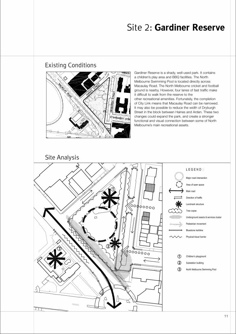
Existing Conditions
Site Analysis
Gardiner Reserve is a shady, well-used park. It contains a children’s play area and BBQ facilities. The NorthMelbourne Swimming Pool is located directly acrossMacaulay Road. The North Melbourne cricket and footballground is nearby. However, four lanes of fast traffic makeit difficult to walk from the reserve to the other recreational amenities. Fortunately, the completionof City Link means that Macaulay Road can be narrowed.It may also be possible to reduce the width of DryburghStreet in the block between Haines and Arden. These twochanges could expand the park, and create a strongerfunctional and visual connection between some of NorthMelbourne’s main recreational assets.
Site 2: Gardiner Reserve
11
Detailed Site Analysis
Spatial character• Multi-unit housing along Dryburgh Street provides the
strongest built edge to this space. Structures rangefrom two to four storeys. This frontage also gainsstature from rising ground levels.
• Single storey commercial buildings along Haines Streetare unattractive, but they are also inconspicuous.
• From vantage points within the reserve, a line of treesprovides a clear delineation of the park’s MacaulayRoad edge.
Existing landscape• The reserve is framed by matures trees. However,
their layout is less formal than that at Clayton Reserve.Some large individual specimens are located wellinside the park’s boundaries. But the centre of theopen space is dominated by a large unstructured area of grass.
• Trees along the eastern side of the park are part of an established streetscape in Dryburgh Street.
• Elms in the Dryburgh median have a life expectancy of 15-20 years. Inter-planting should begin soon sothat replacement trees are well established beforeexisting specimens need to be removed.
• The reserve is fenced along its Haines Street andMacaulay Road boundaries. This has a utilitarianchain-link construction. Some sections of the fencesupport creepers and other plants, and these have the appearance of hedges.
• The fences prevent children from straying, but theyalso limit pedestrian access especially from thedirection of the pool and the Recreation Ground. There is gated entrance at the corner of Haines andMacaulay. However, this is unattractive, and provideslittle invitation to enter the park. If vehicle numbers andspeeds are reduced on Macaulay Road, it may bepossible to remove some or all of these barriers.
• The reserve is open to Dryburgh Street. Park users are most likely to approach from this direction.
• There are no paths across the park. If pedestrianconnections with the pool and the recreation groundare strengthened, east-west circulation routes acrossthe centre of the space will become more important.
• Drainage appears to be poor, especially in the vicinityof the Haines/Macaulay intersection. Ponding ofstormwater has caused damage to the grass.
• Lighting is poor. The edges of the park depend onstreet lighting, yet trees around the perimeter of thespace block illumination from this source.
• The reserve contains an “arts and crafts” stylesubstation. This small “pavilion” is not a listed heritagefeature. However, it enhances the open space and thesurrounding streetscape.
• A children’s play area near the corner of Dryburgh and Haines is about to be upgraded.
Views and linkages• Visual connections to the North Melbourne Pool and
the Recreation Ground are weak. This separationsupports the identity of Clayton Reserve. However, italso inhibits better integration among these amenities.
• The park straddles a natural watercourse. The streamis now buried in an underground culvert. However,low-lying land and a chain of open spaces provide an historical and topographical link to Harris Street and Ievers Reserve.
• From the corner of Dryburgh and Macaulay, the parkoffers a clear view of silos on Munster Terrace.
Heritage• There is no heritage overlay on this site, and the
surrounding streetscape is ungraded.
• The reserve is bounded by bluestone kerbs andchannels. These should be retained or reinstated.
• The lines of mature trees around the perimeter of thereserve have historic significance, in addition to theirvalue as landscape.
Traffic Management• Following completion of City Link, Macaulay Road no
longer has arterial status. However, the route remains a main road and is under the control of VicRoads.
• The capacity of Macaulay Road can be reduced toone traffic lane and one bike lane in each direction. But there is some potential for through-traffic to bediverted into surrounding residential areas if this occurs.
• At the intersection of Macaulay and Arden, two“standing” lanes are required in each direction.However, the left turn lanes from Arden into Macaulayand from Macaulay into Arden can be closed; subjectto a revised arrangement that adequately serves thelocal access and circulation needs.
• From a traffic management perspective, it is preferableto have a single streetscape treatment with a uniformmedian for the full length of Macaulay Road (betweenCanning and Arden). Varying the width andconfiguration of the carriageway could reduce safety.
• One-way traffic is undesirable on Dryburgh Street. It would force additional cars along O’Shanassy andout onto Abbotsford at an uncontrolled intersection.Local one-way streets with low traffic flow also
12
encourage motorists to travel counter to the flow in order to avoid diversions.
• f alterations to Dryburgh Street do go ahead, it isworth conducting a detailed investigation of vehicleaccess to theDryburgh/O’Shanassy/Abbotsford/Haines block.Because this block contains multi-unit housing, vehicleaccess from Haines and O’Shanassy may provide asubstitute for kerb crossings along Dryburgh. If this isthe case, it may be possible to close Dryburgh Streetcompletely between O’Shanassy and Haines.
Parking• The community appears tolerant towards the loss
of parking at this site. However, some Dryburgh Streetresidents would be inconvenienced if this thoroughfareis closed or narrowed and car parks are sacrificed.
• Visitors to the North Melbourne Recreation Groundalso park near the reserve.
• Arden Street provides the only opportunity foradditional parking. However, supplementary spaceswould be some distance from Dryburgh Street wheremost losses will occur. Also, additional trees areplanned for Arden, and these will limit the number of new car parks that can be provided.
• If the cross section of Macaulay Road is altered, a small number of drop-off parking spaces could be provided alongside the swimming pool. However,indenting the kerb to accommodate these parks could detract from the streetscape and inhibitpedestrian access.
Services• Before design occurs, the exact locations of
stormwater, telephone, power and other services needto be identified. Services are concentrated alongMacaulay Road between Haines & Dryburgh and alongDryburgh Street between Macaulay and O’Shannessy.Stormwater drains from the North-MelbourneSwimming Pool cross the reserve, and these shouldbe accurately located.
Community and stakeholder response• Gardiner Reserve functions well in its present form.
Residents perceived it as safe, and they appreciate theease with which it can be accessed from adjacentresidential areas.
• Proposed improvements prompted little support from the community.
• Feedback from the public suggests a preference forExample 2B. This is consistent with the choice madeat Clayton Reserve.
• The community’s principal objective for this location is to increase the area of open space. Reducingvehicle numbers and speeds was rated the secondmost important priority.
• BBQ’s, additional seating and more trees are the mostcommonly suggested improvements to the park’samenities.
• The North and West Melbourne Association do notsupport extending the reserve into either DryburghStreet or Macaulay Road. The association believes thatthe benefits of greater open space are offset by theloss of valuable on-street parking and disruptions tolocal streetscape. The group is also concerned aboutpotential access problems at the Mills Building on thecorner of Arden, Dryburgh and Macaulay.
• Open space improvements at Clayton Reserve arepopular with internal stakeholders, mainly because City Link has delivered a one-off opportunity to re-configure Macaulay Road. Internal objectives for thisinitiative relate more to traffic calming and streetscapeimprovements than extensions to recreational openspace.
• Sites 1 Clayton Reserve and 2 Gardiner Reserve might be considered higher priorities if funding isavailable from the State Government for changes to Macaulay Road.
• Costs and funding
• Cost estimates for improvements at this site vary from$135 000 to $225 000. Example 2C is the leastexpensive option because it leaves Dryburgh Streetsubstantially unaltered. Example 2B is slightly lesscostly than Example 2A because constructing a newmedian in Macaulay Road is cheaper than relocatingthe kerbs at either side of this street.
13
Design Principles and
Objectives
Street layout• Improve pedestrian access between Gardiner Reserve
and the North Melbourne Swimming Pool.
• Minimise the width of Macaulay Road to the south-east of Haines Street by removing the existing median.To the north-west of Haines, introduce a wider medianand retain parallel parking at the edges of the street.
• Provide a generous gap between these twotreatments. Ensure the interval allows traffic to floweasily and contributes to visual continuity along thestreet.
• Locate bike paths within the reserve, but provide safe connections to and from the street.
• Alternatively, introduce a uniformly wide median alongthe full length of Macaulay Road (between Canningand Arden).
Streetscape• Strengthen visual connections between Gardiner
Reserve and the North Melbourne Swimming Pool.
• If a wide median is adopted along the full length ofMacaulay Road, consider planting it with a double rowof trees adjacent to the reserve. Use these trees toemphasise the presence of the park and to enhancethe median as a pedestrian refuge. North of HainesStreet, revert to a single line of trees within the median.
• Consider the streetscape treatment at GardinerReserve in relation to possible improvements atClayton Reserve. Ensure that the full length ofMacaulay Road (between Canning and Arden) isdesigned as single coherent entity. Reinforce continuityby placing continuous lines of street trees along bothedges of the street.
• Reinstate or relocate all bluestone kerbs, channels and pitchers.
Landscape• If part of Dryburgh Street is closed, the linear space
acquired from the road reserve might be used for fixedamenities such as children’s play equipment, BBQ’sand seating. This could enable the rest of the park tobe treated as a large open area suitable for informalsports games and other forms of active recreation.
• Connections between the park and Arden Street arepoorly articulated. The existing edge of DryburghStreet is not cohesive. A strong linear landscapefeature within the present road reserve would help toorganise the buildings and spaces along its length.This benefit would be enhanced if the full width ofDryburgh Street could be landscaped and included inthe park.
• Ensure that landscape along the eastern edge of thereserve remains consistent with the streetscape ofDryburgh Street.
14
Development Options
Example 2A• Narrow Macaulay Road between Arden and Haines
by extending the edge of the reserve out into theroadway. Retain the existing median. Remove someparking from the edge of Macaulay Road, and provideone traffic lane and a bike lane in each direction.Retain drop-off parking close to the pool.
• Expand the reserve by narrowing Dryburgh Streetbetween Haines and O’Shanassy. Incorporate themedian and the western side of this street in the openspace. Remove some on-street parking, and introduceone way traffic along the narrowed section of DryburghStreet.
• Retain car parking along the Haines Street edge of the reserve.
Advantages- more open space within reserve
- more useful park layout
- narrower carriageway on Macaulay
- less impact on parking in Dryburgh
- more uniform streetscape on Dryburgh
Disadvantages- difficult local access along Dryburgh
- less uniform streetscape on Macaulay
- loss of parking on Dryburgh (17-20 spaces)
- some disruption to bluestone kerbs
- less continuity in traffic flow on Macaulay
- safety problems associated with one-way streets
Example 2B• Retain the existing kerb lines on either side of
Macaulay Road. Replace the existing median with a wider version.
• Expand the reserve by narrowing Dryburgh Streetbetween Haines and O’Shanassy. Incorporate themedian and the western side of this street in the openspace. Remove on-street parking, but retain two-waytraffic and bicycle flow along the narrowed section ofDryburgh Street.
• Retain car parking along the Haines Street edge of the reserve.
• Introduce a shared pathway into the edge of the park along Dryburgh Street
Advantages- more open space within reserve
- more useful park layout
- more continuity in traffic flow on Macaulay
- more uniform streetscape on Macaulay
- less disruption to bluestone kerbs
- pedestrian refuge in centre of Macaulay
- less impact to local access on Dryburgh
Disadvantages- loss of parking on Dryburgh (39 spaces)
- wider carriageway on Macaulay
- shared pathway occupies open space
15
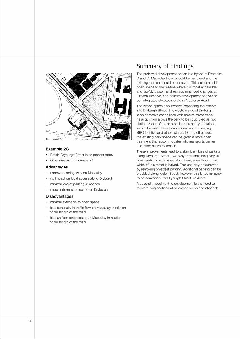
Example 2C• Retain Dryburgh Street in its present form.
• Otherwise as for Example 2A.
Advantages- narrower carriageway on Macaulay
- no impact on local access along Dryburgh
- minimal loss of parking (2 spaces)
- more uniform streetscape on Dryburgh
Disadvantages- minimal extension to open space
- less continuity in traffic flow on Macaulay in relation to full length of the road
- less uniform streetscape on Macaulay in relation to full length of the road
Summary of FindingsThe preferred development option is a hybrid of ExamplesB and C. Macaulay Road should be narrowed and theexisting median should be removed. This solution addsopen space to the reserve where it is most accessibleand useful. It also matches recommended changes atClayton Reserve, and permits development of a variedbut integrated streetscape along Macaulay Road.
The hybrid option also involves expanding the reserve into Dryburgh Street. The western side of Dryburgh is an attractive space lined with mature street trees. Its acquisition allows the park to be structured as twodistinct zones. On one side, land presently containedwithin the road reserve can accommodate seating, BBQ facilities and other fixtures. On the other side, the existing park space can be given a more opentreatment that accommodates informal sports games and other active recreation.
These improvements lead to a significant loss of parkingalong Dryburgh Street. Two-way traffic including bicycleflow needs to be retained along here, even though thewidth of this street is halved. This can only be achievedby removing on-street parking. Additional parking can beprovided along Arden Street, however this is too far awayto be convenient for Dryburgh Street residents.
A second impediment to development is the need torelocate long sections of bluestone kerbs and channels.
16
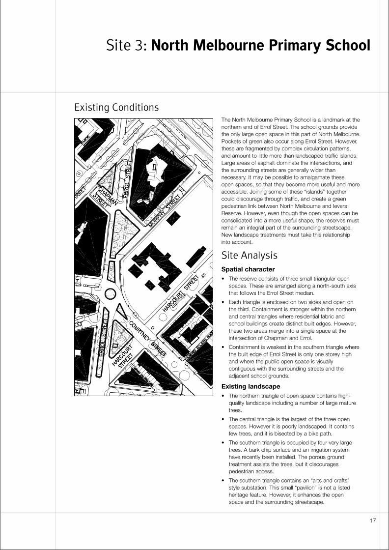
Existing ConditionsThe North Melbourne Primary School is a landmark at thenorthern end of Errol Street. The school grounds providethe only large open space in this part of North Melbourne.Pockets of green also occur along Errol Street. However,these are fragmented by complex circulation patterns,and amount to little more than landscaped traffic islands.Large areas of asphalt dominate the intersections, andthe surrounding streets are generally wider thannecessary. It may be possible to amalgamate these open spaces, so that they become more useful and moreaccessible. Joining some of these “islands” togethercould discourage through traffic, and create a greenpedestrian link between North Melbourne and IeversReserve. However, even though the open spaces can beconsolidated into a more useful shape, the reserves mustremain an integral part of the surrounding streetscape.New landscape treatments must take this relationship into account.
Site Analysis
Spatial character• The reserve consists of three small triangular open
spaces. These are arranged along a north-south axisthat follows the Errol Street median.
• Each triangle is enclosed on two sides and open onthe third. Containment is stronger within the northernand central triangles where residential fabric andschool buildings create distinct built edges. However,these two areas merge into a single space at theintersection of Chapman and Errol.
• Containment is weakest in the southern triangle wherethe built edge of Errol Street is only one storey highand where the public open space is visuallycontiguous with the surrounding streets and theadjacent school grounds.
Existing landscape• The northern triangle of open space contains high-
quality landscape including a number of large maturetrees.
• The central triangle is the largest of the three openspaces. However it is poorly landscaped. It containsfew trees, and it is bisected by a bike path.
• The southern triangle is occupied by four very largetrees. A bark chip surface and an irrigation systemhave recently been installed. The porous groundtreatment assists the trees, but it discouragespedestrian access.
• The southern triangle contains an “arts and crafts”style substation. This small “pavilion” is not a listedheritage feature. However, it enhances the open space and the surrounding streetscape.
Site 3: North Melbourne Primary School
17
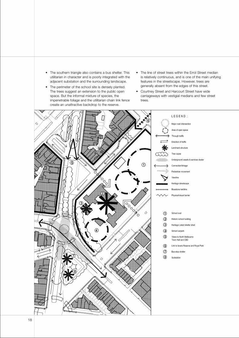
• The southern triangle also contains a bus shelter. Thisutilitarian in character and is poorly integrated with theadjacent substation and the surrounding landscape.
• The perimeter of the school site is densely planted.The trees suggest an extension to the public openspace. But the informal mixture of species, theimpenetrable foliage and the utilitarian chain link fencecreate an unattractive backdrop to the reserve.
• The line of street trees within the Errol Street median is relatively continuous, and is one of the main unifyingfeatures in the streetscape. However, trees aregenerally absent from the edges of this street.
• Courtney Street and Harcourt Street have widecarriageways with vestigial medians and few streettrees.
18
• The Haines Street roundabout is grassed butunlandscaped, and the surrounding intersection isdominated by a wide expanse of asphalt. WithinHaines Street itself, the pattern of street trees needs to be reinforced with infill planting.
• Large areas of redundant asphalt mark the intersectionof Chapman Street and Errol Street.
• North of Harker, street trees are well established alongChapman Street. Median planting continues thispattern south to meet Errol.
Views and linkages• The site benefits from a close association with North
Melbourne Primary School. The school is a locallandmark and a well-known institution. It helps tolocate the reserve and gives the reserve a distinctcharacter.
• Errol Street is North Melbourne’s “main street”. The urban structure of the whole neighbourhood is strengthened if this thoroughfare terminates at a recognisable public open space.
• The site is strategically located at the intersection of several existing and proposed “green links”. Planted medians are found along Haines, Errol and O’Shanassy. Street trees are also planned for nearby Arden Street.
• The site forms part of a potential “green link” thatincludes a pedestrian connection across FlemingtonParade to Ievers Reserve and Royal Park.
• The site falls appreciably between Harker and Haines.From the high ground between Chapman and Errol,there are good views south to the North MelbourneTown Hall and the CBD. Conversely, Flemington Roadand the hospital are visible along the ridge to thenorth. However, some of these landmarks may beconcealed if street trees are added to the side of Errol Street.
• The main building at the North Melbourne PrimarySchool is a potential backdrop to the central andsouthern open space triangles. However, plantingaround the school grounds currently denies thebuilding a strong visual presence.
Heritage• The following locations are graded as Level 2
Streetscapes:
- The corner of Errol and Harcourt
- The northern edge of Chapman, between Errol and Murphy
- The southern side of Murphy Street, betweenHaines and Flemington
- The northern side of Murphy Street, betweenChapman and Flemington
- The area bounded by Haines, Errol, Chapman and Molesworth
• All streets contain bluestone kerbs and channels withthe exception of the northern edge of Harcourt Streetand the traffic islands.
• An unusual double kerb borders the northern openspace triangle. This feature is a response to the site’sgradient, and should be retained.
• One of the “sheds” in front of the main school block is a listed heritage building.
• At their northern end, the school grounds are laid outin a classic “oval”. This feature is not directly affectedby proposed open space improvements. However, theoval introduces a constraint to site planning within theschool as a whole.
Traffic management• Locals need good access to and from the school
without using Flemington Road.
• Through-traffic is a problem in this area. CourtneyStreet, Haines Street and Harcourt Street should carrylocal traffic, but all carry some non-local traffic.Residents would like to see vehicle numbers reducedand speeds cut. To achieve this, Engineering Servicesplan to reduce the Errol/Courtney/Haines roundaboutto single entry, exit and circulation lanes. A moresubstantial median is also proposed for Haines.However, Engineering Services acknowledges thatnarrowing carriageways and closing a section ofCourtney Street (from Harcourt to Errol) could be just as effective.
• The existing configuration of the Harcourt and ErrolStreet intersection is undesirable from a trafficviewpoint and needs to be redesigned.
• Complex traffic management measures are already in place in this part of North Melbourne. If more streetclosures are introduced in the vicinity of Courtney andHarcourt, impacts on traffic flow need to be examinedover a wide area. Conditions at this site also need tobe assessed in relation to possible changes elsewhere.In some cases, there may be useful synergies betweendevelopments. For example, because open spaceimprovements and traffic calming are proposed forboth ends of Courtney Street (at Sites 3 and 4), thereis potential to substantially reduce the amount ofthrough traffic on this route.
• The local streets are wider than necessary. However, itis doubtful whether two-way traffic with dedicated bikepaths will fit onto one side of an existing carriageway.
19
Parking• Residents, teachers, hospital staff, students and others
compete for popular four-hour metered car parksalong Harcourt Street.
• Popular four-hour metered car parks are a source ofrevenue for the City.
• Additional on-street parking spaces can beaccommodated within the southernmost block ofHarcourt Street. These may offset losses elsewhere.
• Parking is provided within the school grounds.Because of after-school activities, some of thesespaces are in use until 6.30 pm. Approximately onethird of the school’s parking is rented to outside users.On-site parking is likely to be reduced as a result ofschool expansion and redevelopment.
• Blackwood, Harcourt, Villiers and Wreckyn streets arereverting to residential use. Developments are requiredto be self-sufficient for car parking. These changes donot alter the need for drop-off parking near the school.However, the new uses should reduce demand forlonger-term on-street parking within theneighbourhood as a whole.
Services• Designers should identify the exact locations of
sewers, gas, stormwater, telephone, electricity andwater. Services are concentrated at the intersection ofCourtney/Errol/ Harcourt/Haines/Harris adjacent to theexisting roundabout and the central medians. Servicesare also buried in the centre of the southboundcarriageway of Errol Street between Courtney Streetand Flemington Road.
Community and stakeholder response• Feedback suggests that Example 3A is the most
popular development option. This layout maximises the area of the reserve. However, the community’sprincipal objective is to reduce vehicle numbers andspeeds, rather than to increase open space. Retentionof on-street parking is the second most importantissue. This is the only site where parking ranks thishighly.
• The North Melbourne Residents Association does not support proposed improvements. The associationsuggests that improving the quality and utility of thereserve is more important than expanding the area of open space. The group is concerned that historicstreetscapes will be compromised with the realignmentof kerbs and traffic lanes. They also believe that someof the proposals could lead to an increase in through-traffic (Example 3A), a loss of on-street parking andrestrictions to street tree planting.
• The North Melbourne Primary School Board is willingto continue feasibility studies into shared use of theopen space. The board has several concerns aboutfunding and managing such a place. The main issuesare supervision, maintenance and security. Staff carparking, liability and community reactions to the planare secondary concerns. At this stage, it is not clearwhether the benefits to the school outweigh the likelycosts. The board is more likely to collaborate if it canbe shown that traffic volumes will be cut and thatvehicle speeds will be reduced around the school.
• The school also needs to feel confident about thedecision-making processes. Each stage ofdevelopment needs to be negotiated with the boardand the State Government. As a first step, they wouldlike a more detailed traffic study to be commissionedby the Council.
• Local residents also have reservations about shareduse of the reserve. They fear that the reserve will be“taken over” by the school, leaving only restricted usefor the public.
• Parks and Recreation support maximum consolidationof open space in this area. Merging medians andislands into a single continuous reserve reduces themaintenance costs associated with edges and over-spraying.
20
Costs and funding• Budget estimates for Site 3 are between $392 000
and $510 000. Cost differences reflect the extent towhich kerbs are relocated and roads realigned.
• Example 3A is the most expensive of the three optionspresented below. This proposal also delivers thelargest area of open space.
• Example 3B is the least expensive option.
Design Principles and
Objectives
Street layout• Refer to specifications and guidelines within VicRoads
Safety around schools document.
• Integrate school crossings with overall street layoutand landscape.
• Maintain a direct north-south pathway through the sitefor pedestrians and cyclists.
Built form• Treat the historic main school building as a backdrop
to a single consolidated open space at the intersectionof Errol, Courtney and Harcourt.
• Consider combining the bus shelter and the substationinto a single structure in the southern open spacetriangle.
Landscape• Retain existing ficus trees, and recognise their
importance as heritage features and local landmarks.
• Incorporate additional seating and trees in the design.Consider including children’s play equipment.
• Introduce new street trees to Courtney Street, ErrolStreet and Harcourt Street. Reinforce existing plantingpatterns along Haines Street.
• Create stronger visual connections among the threetriangular open spaces, and ensure that newlandscape within the reserves is consistent withsurrounding streetscape.
• Negotiate with the North Melbourne Primary School to achieve visual and functional integration betweenthe southern triangle of open space and the schoolgrounds.
21
Development Options
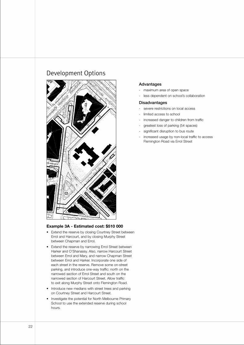
Example 3A - Estimated cost: $510 000• Extend the reserve by closing Courtney Street between
Errol and Harcourt, and by closing Murphy Streetbetween Chapman and Errol.
• Extend the reserve by narrowing Errol Street betweenHarker and O’Shanassy. Also, narrow Harcourt Streetbetween Errol and Mary, and narrow Chapman Streetbetween Errol and Harker. Incorporate one side ofeach street in the reserve. Remove some on-streetparking, and introduce one-way traffic: north on thenarrowed section of Errol Street and south on thenarrowed section of Harcourt Street. Allow traffic to exit along Murphy Street onto Flemington Road.
• Introduce new medians with street trees and parkingon Courtney Street and Harcourt Street.
• Investigate the potential for North Melbourne PrimarySchool to use the extended reserve during schoolhours.
Advantages- maximum area of open space
- less dependent on school’s collaboration
Disadvantages- severe restrictions on local access
- limited access to school
- increased danger to children from traffic
- greatest loss of parking (54 spaces)
- significant disruption to bus route
- increased usage by non-local traffic to accessFlemington Road via Errol Street
22
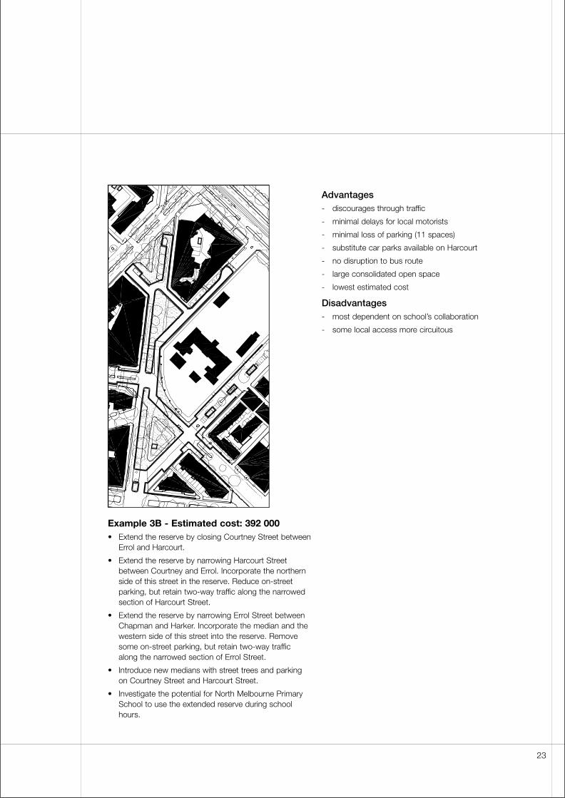
Example 3B - Estimated cost: 392 000• Extend the reserve by closing Courtney Street between
Errol and Harcourt.
• Extend the reserve by narrowing Harcourt Streetbetween Courtney and Errol. Incorporate the northernside of this street in the reserve. Reduce on-streetparking, but retain two-way traffic along the narrowedsection of Harcourt Street.
• Extend the reserve by narrowing Errol Street betweenChapman and Harker. Incorporate the median and thewestern side of this street into the reserve. Removesome on-street parking, but retain two-way trafficalong the narrowed section of Errol Street.
• Introduce new medians with street trees and parkingon Courtney Street and Harcourt Street.
• Investigate the potential for North Melbourne PrimarySchool to use the extended reserve during schoolhours.
Advantages- discourages through traffic
- minimal delays for local motorists
- minimal loss of parking (11 spaces)
- substitute car parks available on Harcourt
- no disruption to bus route
- large consolidated open space
- lowest estimated cost
Disadvantages- most dependent on school’s collaboration
- some local access more circuitous
23
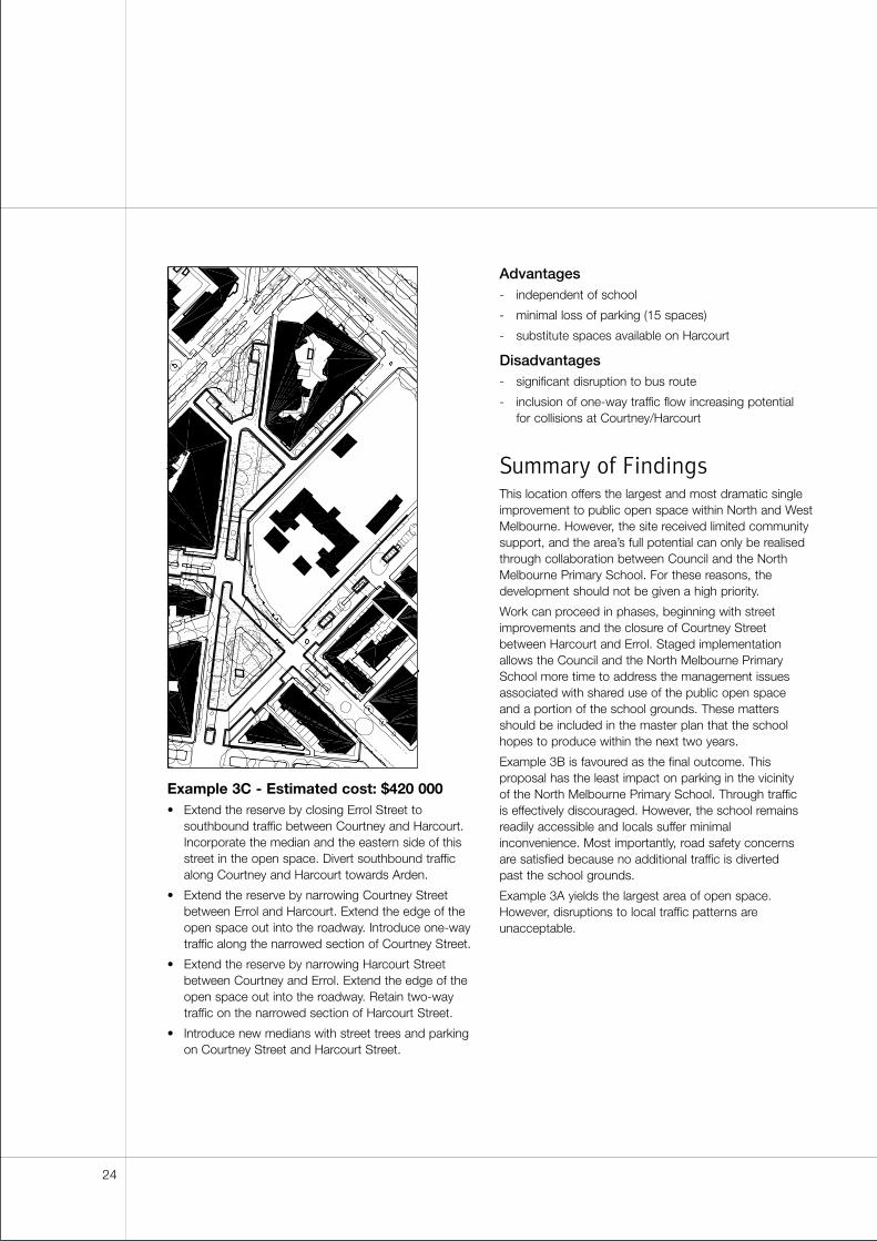
Example 3C - Estimated cost: $420 000• Extend the reserve by closing Errol Street to
southbound traffic between Courtney and Harcourt.Incorporate the median and the eastern side of thisstreet in the open space. Divert southbound trafficalong Courtney and Harcourt towards Arden.
• Extend the reserve by narrowing Courtney Streetbetween Errol and Harcourt. Extend the edge of theopen space out into the roadway. Introduce one-waytraffic along the narrowed section of Courtney Street.
• Extend the reserve by narrowing Harcourt Streetbetween Courtney and Errol. Extend the edge of theopen space out into the roadway. Retain two-waytraffic on the narrowed section of Harcourt Street.
• Introduce new medians with street trees and parkingon Courtney Street and Harcourt Street.
Advantages- independent of school
- minimal loss of parking (15 spaces)
- substitute spaces available on Harcourt
Disadvantages- significant disruption to bus route
- inclusion of one-way traffic flow increasing potential for collisions at Courtney/Harcourt
Summary of FindingsThis location offers the largest and most dramatic singleimprovement to public open space within North and WestMelbourne. However, the site received limited communitysupport, and the area’s full potential can only be realisedthrough collaboration between Council and the NorthMelbourne Primary School. For these reasons, thedevelopment should not be given a high priority.
Work can proceed in phases, beginning with streetimprovements and the closure of Courtney Streetbetween Harcourt and Errol. Staged implementationallows the Council and the North Melbourne PrimarySchool more time to address the management issuesassociated with shared use of the public open space and a portion of the school grounds. These mattersshould be included in the master plan that the schoolhopes to produce within the next two years.
Example 3B is favoured as the final outcome. Thisproposal has the least impact on parking in the vicinity of the North Melbourne Primary School. Through traffic is effectively discouraged. However, the school remainsreadily accessible and locals suffer minimalinconvenience. Most importantly, road safety concerns are satisfied because no additional traffic is diverted past the school grounds.
Example 3A yields the largest area of open space.However, disruptions to local traffic patterns areunacceptable.
24
Existing Conditions
Site Analysis
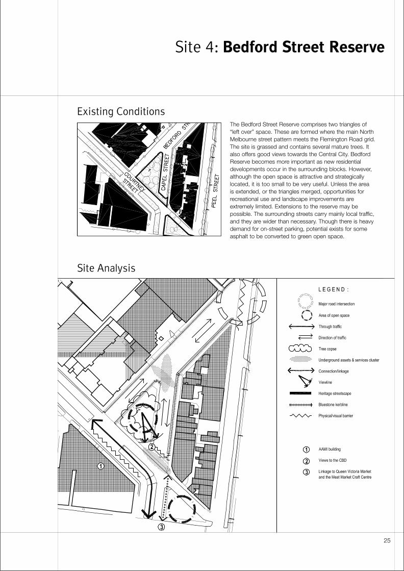
The Bedford Street Reserve comprises two triangles of“left over” space. These are formed where the main NorthMelbourne street pattern meets the Flemington Road grid.The site is grassed and contains several mature trees. Italso offers good views towards the Central City. BedfordReserve becomes more important as new residentialdevelopments occur in the surrounding blocks. However,although the open space is attractive and strategicallylocated, it is too small to be very useful. Unless the area is extended, or the triangles merged, opportunities forrecreational use and landscape improvements areextremely limited. Extensions to the reserve may bepossible. The surrounding streets carry mainly local traffic,and they are wider than necessary. Though there is heavydemand for on-street parking, potential exists for someasphalt to be converted to green open space.
Site 4: Bedford Street Reserve
25
Detailed Sit Analysis
Spatial character• The reserve contains two triangular open spaces.
• The larger northern triangle is enclosed on two sidesby two-storey residential fabric. The built edge ofCourtney Street is similar in scale, but it is dominatedby the long blank wall of the AAMI facility.
• The smaller southern triangle is more open, and isexposed to traffic noise from Peel Street andQueensberry Street.
Existing landscape• The northern triangle contains a collection of mature
specimen trees. However, landscape in the southernspace is less established. This area is grassed andcontains just a few small trees and shrubs.
• The reserve is valuable as a visual amenity. However, it contains a single park bench and does not invite use.
• The northern end of Bedford Street is dominated by a wide expanse of asphalt.
Views and linkages• The reserve is a short walk from the North Melbourne
Meat Market Craft Centre and the Queen VictoriaMarket.
• The reserve offers good views of the Central City skyline.
Heritage• The local streetscape is ungraded.
• The built-up edges of Bedford and Capel Street havebluestone kerbs and channels. Proposed open spaceimprovements have minimal impact on these features.
Traffic Management• Bedford Street should carry local traffic only.
Engineering Services plans to re-configure theintersection of Bedford and Peel to restrict access to and from the arterial. This work could be done inconjunction with streetscape improvements alongBedford, including parking and landscape within a new median.
• Capel Street was closed to prevent its use as athrough route for non-local traffic. For this reason, the community is unlikely to support re-opening thisstreet, even to one-way traffic.
• Capel Street was the subject of a detailed parking and traffic study in 1984. The Capel Street Action Plan should be acknowledged in further designinvestigations.
• Over a short distance, one-way streets do not providesufficient deterrence to through traffic becausemotorists drive counter to the flow, either erroneouslyor deliberately (as a short-cut), creating safetyproblems. For this reason, Engineering Services would not support reopening either Capel Street or Courtney Street.
• Complex traffic management measures are already in place in this part of North Melbourne. If more streetclosures are introduced in the vicinity of BedfordStreet, impacts on traffic flow need to be examinedover a wide area. Conditions at this site also need tobe assessed in relation to possible changes elsewhere.In some cases, there may be useful synergies betweendevelopments. For example, because open spaceimprovements and traffic calming are proposed forboth ends of Courtney Street (at Sites 3 and 4), there is potential to substantially reduce the amount of through traffic on this route.
• Car carriers enter Bedford from Peel to access theAAMI facility on Courtney Street. There is a large gapin the Courtney Street median to accommodate thismanoeuvre.
26
Parking• Parking is in heavy demand because the site is close
to the North Melbourne Meat Market Craft Centre andthe Queen Victoria Market, as well as multi-storeyresidential developments at the corner of Courtney and Bedford Streets.
Services• Designers should identify the exact locations of sewers
and cables for telecommunications or electricity.Adjacent to the reserve, services are concentrated atthe Bedford/Capel intersection. Services are alsoclustered opposite the reserve, at the intersection ofCapel and Courtney.
Community and stakeholder response• Feedback from the public suggests a preference
for Example 4A.
• The community’s principal objective for this location isto reduce vehicle numbers and speeds. Extending theopen space was rated as the second most importantpriority.
• Additional trees, seating and open lawn areas are the most commonly suggested improvements to the park’s amenities.
• The community does not support a buildingdevelopment at this site.
• The North and West Melbourne Association supportsconstruction of new or extended medians in BedfordStreet and Courtney Street. However, the associationrequests that any further changes be the subject of amore detailed traffic study. The group is alsoconcerned about the visual consequences ofproposals to realign kerbs. The group believes thisalteration will have a negative impact on streetscapeand will detract from the area’s traditional character.
Costs and funding• Improvements at Bedford Reserve are cheaper than
those at any other site.
• Costs estimates for these proposals vary from $92 000to $160 000. Example 4C is the least expensive optionbecause few streets are realigned. Example 4B isslightly less costly than Example 4A because thesouthern triangle of open space is left relativelyunchanged.
Design Principles
and Objectives
Street layout• Remove on-street parking from Capel Street and
reduce the width of the carriageway. Compensate by providing new parking spaces within the Bedford Street median.
Landscape• Plant a dense group of trees on the smaller southern
reserve. Use these to distance the main open spacefrom traffic on Peel Street and Queensberry Street.
27
Development Options
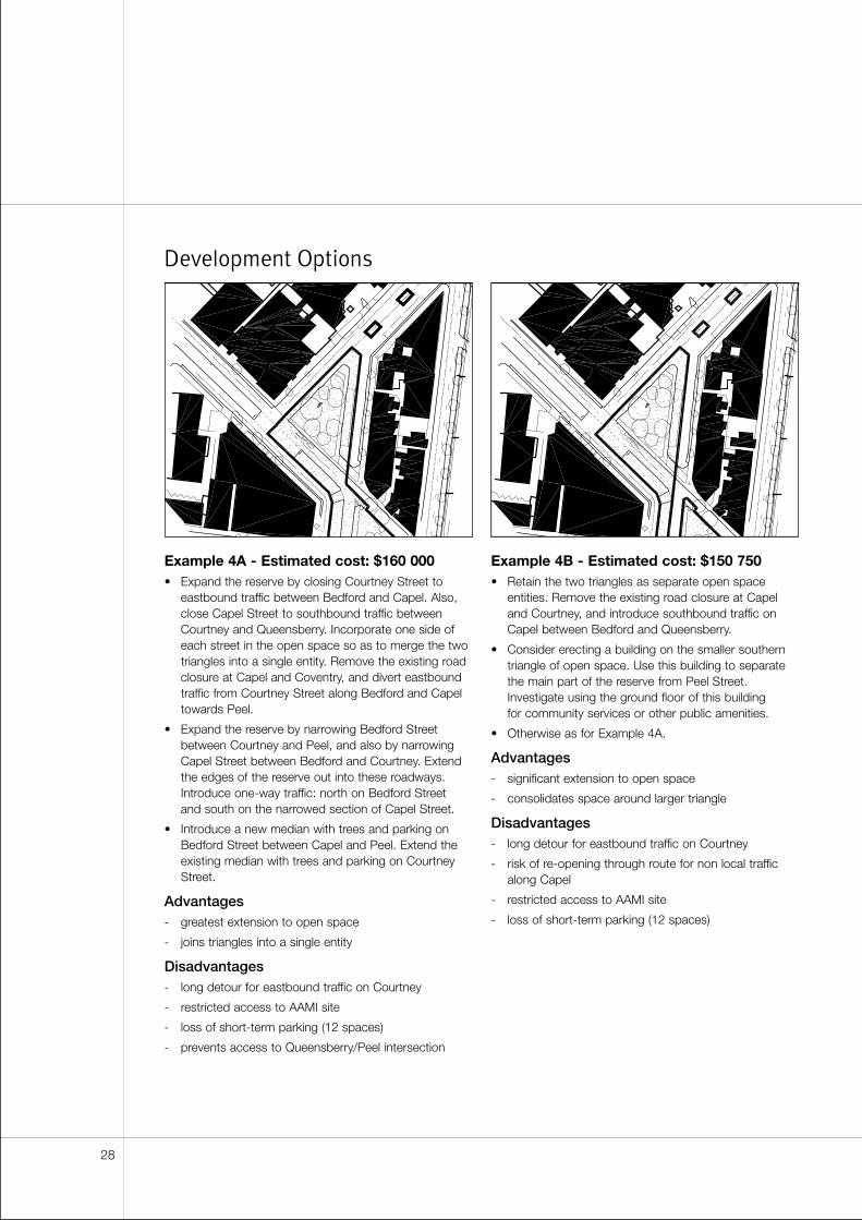
Example 4A - Estimated cost: $160 000• Expand the reserve by closing Courtney Street to
eastbound traffic between Bedford and Capel. Also,close Capel Street to southbound traffic betweenCourtney and Queensberry. Incorporate one side ofeach street in the open space so as to merge the twotriangles into a single entity. Remove the existing roadclosure at Capel and Coventry, and divert eastboundtraffic from Courtney Street along Bedford and Capeltowards Peel.
• Expand the reserve by narrowing Bedford Streetbetween Courtney and Peel, and also by narrowingCapel Street between Bedford and Courtney. Extendthe edges of the reserve out into these roadways.Introduce one-way traffic: north on Bedford Street and south on the narrowed section of Capel Street.
• Introduce a new median with trees and parking onBedford Street between Capel and Peel. Extend theexisting median with trees and parking on CourtneyStreet.
Advantages- greatest extension to open space
- joins triangles into a single entity
Disadvantages- long detour for eastbound traffic on Courtney
- restricted access to AAMI site
- loss of short-term parking (12 spaces)
- prevents access to Queensberry/Peel intersection
Example 4B - Estimated cost: $150 750• Retain the two triangles as separate open space
entities. Remove the existing road closure at Capeland Courtney, and introduce southbound traffic onCapel between Bedford and Queensberry.
• Consider erecting a building on the smaller southerntriangle of open space. Use this building to separatethe main part of the reserve from Peel Street.Investigate using the ground floor of this building for community services or other public amenities.
• Otherwise as for Example 4A.
Advantages- significant extension to open space
- consolidates space around larger triangle
Disadvantages- long detour for eastbound traffic on Courtney
- risk of re-opening through route for non local trafficalong Capel
- restricted access to AAMI site
- loss of short-term parking (12 spaces)
28
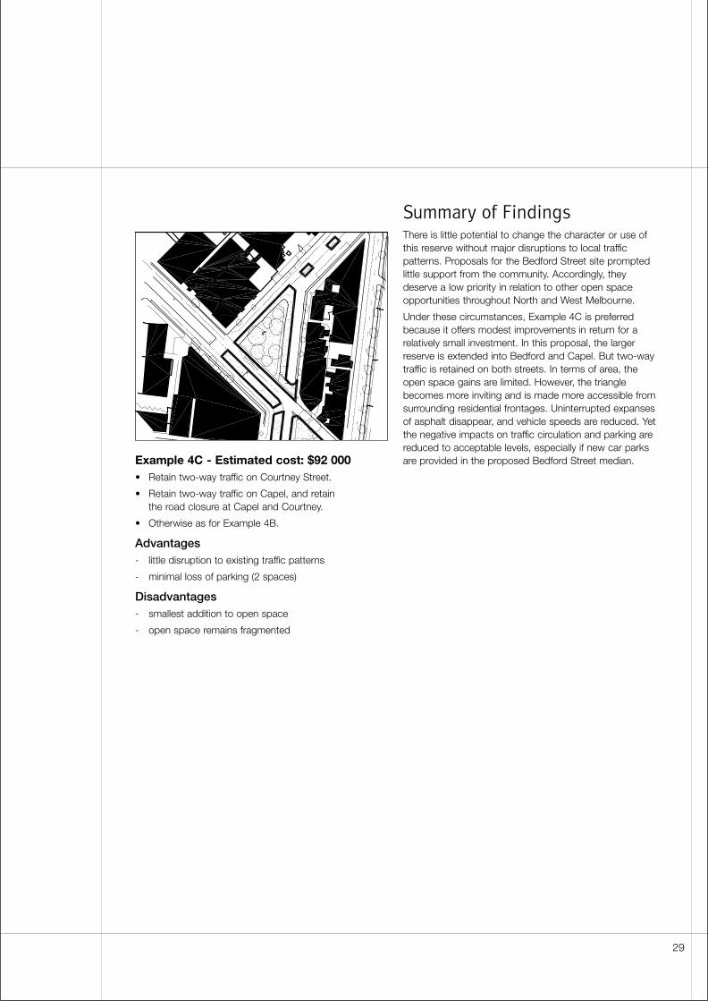
Example 4C - Estimated cost: $92 000• Retain two-way traffic on Courtney Street.
• Retain two-way traffic on Capel, and retain the road closure at Capel and Courtney.
• Otherwise as for Example 4B.
Advantages- little disruption to existing traffic patterns
- minimal loss of parking (2 spaces)
Disadvantages- smallest addition to open space
- open space remains fragmented
Summary of FindingsThere is little potential to change the character or use ofthis reserve without major disruptions to local trafficpatterns. Proposals for the Bedford Street site promptedlittle support from the community. Accordingly, theydeserve a low priority in relation to other open spaceopportunities throughout North and West Melbourne.
Under these circumstances, Example 4C is preferredbecause it offers modest improvements in return for arelatively small investment. In this proposal, the largerreserve is extended into Bedford and Capel. But two-waytraffic is retained on both streets. In terms of area, theopen space gains are limited. However, the trianglebecomes more inviting and is made more accessible fromsurrounding residential frontages. Uninterrupted expansesof asphalt disappear, and vehicle speeds are reduced. Yetthe negative impacts on traffic circulation and parking arereduced to acceptable levels, especially if new car parksare provided in the proposed Bedford Street median.
29

30
Existing Conditions
Site Analysis
North Melbourne Railway Station is an important publictransport node. However, the surrounding streets provide a poor environment for pedestrians. The traffic on DynonBridge is noisy, and the space beneath this structure isdark and unattractive. Heavy vehicles travel along RailwayPlace and through the underpass on their way to theLaurens Street industrial area. The bridge embankment has been landscaped. But the site is too steep and tooexposed for recreational use. As a result, there is little streetactivity in the area. Most importantly, there is no obviouspathway from the station to the centre of North Melbourne.Despite these problems, the area has potential to becomea destination rather than just a through-route. A sizeableopen space is formed at the intersection of AndersonStreet, Ireland Street and Railway Place. It is centred on a local landmark: the Railway Hotel. On the opposite sideof this space, the land falls away to provide a sweepingvista of Docklands and Footscray. If a more pedestrian-friendly place can be created here, rail commuters may be encouraged to stop and enjoy the view.
Site 5: North Melbourne Railway Station
31
Detailed Site Analysis
Spatial character• This site suffers from poor spatial definition. The three-
storey Railway Hotel provides the only strong builtedge to the area. The station has only a diminutivepresence at street level and the two-storey commercialbuilding between Ireland Street and Railway Place hasno active frontages.
• Complex changes in levels also detract from thespace. The ground rises steeply at the bridgeembankment and also falls away sharply whereRailway Avenue passes beneath Dynon Road.
• Opposite sides of the open space present differentkinds of amenity. The “north” side, adjacent to thehotel, offers a more active built-up perimeter. The“south” side is contiguous with the station. It is sunnier,easier to consolidate as a pedestrian area andpotentially it has better views out over the escarpment.
Existing landscape• A very large area of asphalt occurs at the intersection
of Anderson Street, Ireland Street and Railway Place.The existing carriageways here are wider thannecessary.
• The open space is fragmented, and landscaped areas are restricted to traffic islands or small isolatedpockets.
• The existing landscaped area beside the Dynon RoadBridge has little value as open space. It is steep, and it is exposed to traffic noise.
• Railway Place and the railway embankment arepotential recreational assets. There is already oneobservation deck along the edge of this street, butthere is scope to improve the streetscape andenhance the appearance of the escarpment.
• There are no street trees along Railway Avenue.However, the railway embankment is planted with an eclectic collection of trees and shrubs. The overalleffect is untidy and incoherent, but there are somevaluable individual specimens, such as the large ficusthat stands just north of the station building.
• Part of the railway station frontage is occupied by adisused loading dock. The area is currently used asparking for railway staff.
Views and linkages• Pedestrian connections from the railway station to the
rest of North and West Melbourne are very poor. Thereare no direct sightlines between Railway Place and, forexample, Miller Street and there are few way-findingclues for how to get there.
• To the east, there are views along Railway Place andIreland Street. However, neither of these views helps to connect the site with the rest of North Melbourne.
• Beneath the bridge, sightlines continue only a shortdistance before being terminated at the intersection of Laurens Place and Railway Avenue. Because thesestreets meet at an obtuse angle there is a sense ofcontinuity around the corner. But the visual closurecombines with a drop in the ground level and the dark undercroft of the bridge to create an uninvitingbackdrop to the open space.
• Views to the north are blocked by the Dynon RoadBridge, but the upper levels of industrial buildings arevisible above the embankment. Their presence recallsthe fact that Anderson Street once continued north tomeet Munster Terrace.
• This site offers a clear sense of the West Melbourneescarpment, the topographic discontinuity that marksa natural edge to the city. The elevated ground offersexpansive views to the west, taking in an industrialarea that includes rail marshalling yards, City Link and much of the port.
• Within the station, a pedestrian overbridge providesaccess to platforms and to the western side of therailway tracks. At present, the far side of the bridge is an industrial wasteland. But in future, the bridgecould provide a valuable connection with VictoriaHarbour along one of Dockland’s least accessibleedges. This prospect is supported in submissions from the community.
• It is possible to bring “green linkages” into this area by introducing planted medians to Ireland Street,Stawell Street and Miller Street.
Heritage• The Railway Hotel is a local landmark with heritage
significance. Its presence gives identity and characterto surrounding public open space.
• Buildings between Anderson and Stawell streets alsohave heritage value, especially the car repair workshopwith its distinctive roof trusses.
• Existing bluestone kerb and channel pitchers are ingood condition. If streets are realigned, these featuresshould be reinstated.
32
Traffic Management• Heavy vehicles travel through the site on their way to
and from the Laurens Street industrial area. There arealternative routes. However, any reduction of through-traffic on Anderson Street, Ireland Street or RailwayPlace could divert commercial vehicles ontoQueensberry Street where residents would be affected.
• If an acceptable alternative route can be found forheavy traffic, it is possible to close Anderson Street or restrict access to local vehicles.
• The station needs good drop-off facilities. The currentroad layout allows motorists to make u-turns afterleaving or collecting passengers.
• Two-way traffic needs to be maintained on StawellStreet because there is no right turn out onto MillerStreet.
• Introducing a sharper bend into Ireland Street andreducing the width of the carriageway would have thebeneficial effect of discouraging fast through-traffic.
Parking• On-street parking will be lost if Anderson Street is
closed. However, this could be offset by introducingangle parking to Ireland Street.
• There may be scope for some public parking beneatha new building on the bridge embankment. Changes inground level could help to provide vehicle access tothis site.
Services• Designers should identify the exact locations of water
rmains, manholes, stormwater, gas lines and telephoneor electricity cables. Services are concentrated at theintersection of Railway/Ireland/Anderson adjacent tothe station. Services are also buried beneath RailwayPlace between Dryburgh and Laurens.
Community and stakeholder response• Increased open space is the community’s highest
priority here. Reductions in traffic and vehicle speedswere next in importance, followed by provision of on-street parking.
• Bayside Trains, Vic Roads and local residents all havean interest in this site. For this reason, lengthynegotiations will be probably necessary before moredetailed development plans can be finalised.
• Community Development has expressed stronginterest in the bridge embankment as a site for publichousing. The land is in public ownership, and there arefew competing uses. The area is well served by publictransport. A rooming house or an aged care facility inthis location would fit unobtrusively into thesurrounding residential and commercial fabric.
• The North and West Melbourne Residents Associationgives a high priority to open space expansion at thissite. However the association is concerned about thepotential for diversion of heavy traffic, lost access toAnderson Street properties and changes to the historicstreetscape of Stawell Street. The group does notsupport a building on the bridge embankment.Instead, it favours a pedestrian underpass beneath the Dynon Road Bridge approach.
• Building development is not popular with thecommunity at large. Feedback suggests alternativemethods for reducing the negative impact of theDynon Road Bridge such as painting the structure and planting more large trees on the embankment.
Costs and funding• The budget estimates for improvements at Site 5 are
between $600 000 and $750 000. Costs are higherhere than at any other location. This results fromextensive kerb realignments and the large area of hard landscape involved.
• A further sum of approximately $25 000 should beincluded as a contingency to pay for disruptions tooverhead and underground services.
• These estimates do not include costs and revenuesassociated with any building development.
• The DHS has funds available for a social housingdevelopment in North or West Melbourne.
• The Inner City Social Housing Company and theEcumenical Society are potential partners in a socialhousing project.
33
Design Principles
and Objectives
Street layout• Re-configure Ireland Street and Railway Place to
create a larger pedestrian area on the northern side of the street.
Built form• Place a building on the Dynon Road Bridge
embankment.
• Include social housing as a component of thedevelopment.
• Use the new building to improve conditions within the new public open space: block traffic noise, screenviews of the overpass and reduce the presence of thebridge undercroft.
• Use the building to give a coherent shape to the new public open space.
• Establish a sympathetic relationship between the new building and the Railway Hotel.
• Provide active frontages at ground level, especiallyalong the edges of the new public open space.
• Express human inhabitation on the upper levels of the street elevations, and encourage passivesurveillance of the public open space.
• Consider using the housing development as the basisfor a design competition that showcases ESDprinciples on a difficult urban infill site.
• Provide natural light and ventilation to all living spaces.Capture winter sun and minimise summer heat gain.Minimise the intrusion of noise from the overpass andthe rail lines.
• Consider extensions to the station including buildingover the existing loading bay and car park.
• Consider building along parts of the railwayembankment and within the air space above the rail lines.
Landscape• Ensure there is no reduction in the total area
of landscaped public open space.
• Attempt to retain the mature eucalyptus trees on the Dynon Bridge embankment.
• Consider using the railway loading dock area for anextension to the public open space, or as the site foran addition to the station building.
• Consider planting a ficus tree within the new openspace to match the existing specimen on the railwayembankment.
• Improve the streetscape of Railway Place by plantingstreet trees. But do not create a continuous barrier toviews across the escarpment. Consider using widelyspaced groups of tall trees to frame views and makethe change in ground levels more visible.
34
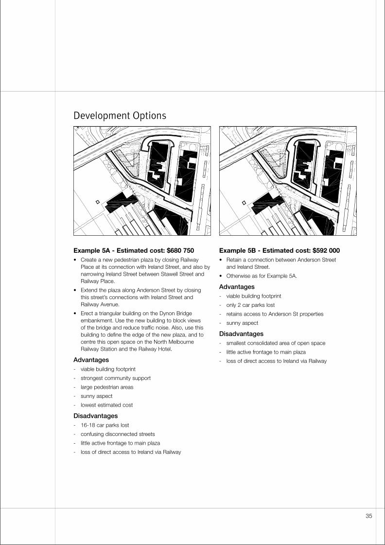
Development Options
Example 5A - Estimated cost: $680 750• Create a new pedestrian plaza by closing Railway
Place at its connection with Ireland Street, and also bynarrowing Ireland Street between Stawell Street andRailway Place.
• Extend the plaza along Anderson Street by closing this street’s connections with Ireland Street andRailway Avenue.
• Erect a triangular building on the Dynon Bridgeembankment. Use the new building to block views of the bridge and reduce traffic noise. Also, use thisbuilding to define the edge of the new plaza, and tocentre this open space on the North MelbourneRailway Station and the Railway Hotel.
Advantages- viable building footprint
- strongest community support
- large pedestrian areas
- sunny aspect
- lowest estimated cost
Disadvantages- 16-18 car parks lost
- confusing disconnected streets
- little active frontage to main plaza
- loss of direct access to Ireland via Railway
Example 5B - Estimated cost: $592 000• Retain a connection between Anderson Street
and Ireland Street.
• Otherwise as for Example 5A.
Advantages- viable building footprint
- only 2 car parks lost
- retains access to Anderson St properties
- sunny aspect
Disadvantages- smallest consolidated area of open space
- little active frontage to main plaza
- loss of direct access to Ireland via Railway
35
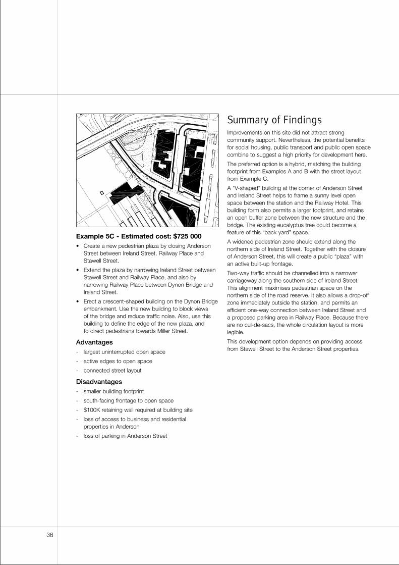
Example 5C - Estimated cost: $725 000• Create a new pedestrian plaza by closing Anderson
Street between Ireland Street, Railway Place andStawell Street.
• Extend the plaza by narrowing Ireland Street betweenStawell Street and Railway Place, and also bynarrowing Railway Place between Dynon Bridge andIreland Street.
• Erect a crescent-shaped building on the Dynon Bridgeembankment. Use the new building to block views of the bridge and reduce traffic noise. Also, use thisbuilding to define the edge of the new plaza, and to direct pedestrians towards Miller Street.
Advantages- largest uninterrupted open space
- active edges to open space
- connected street layout
Disadvantages- smaller building footprint
- south-facing frontage to open space
- $100K retaining wall required at building site
- loss of access to business and residential properties in Anderson
- loss of parking in Anderson Street
Summary of FindingsImprovements on this site did not attract strongcommunity support. Nevertheless, the potential benefitsfor social housing, public transport and public open spacecombine to suggest a high priority for development here.
The preferred option is a hybrid, matching the buildingfootprint from Examples A and B with the street layoutfrom Example C.
A “V-shaped” building at the corner of Anderson Streetand Ireland Street helps to frame a sunny level openspace between the station and the Railway Hotel. Thisbuilding form also permits a larger footprint, and retainsan open buffer zone between the new structure and thebridge. The existing eucalyptus tree could become afeature of this “back yard” space.
A widened pedestrian zone should extend along thenorthern side of Ireland Street. Together with the closureof Anderson Street, this will create a public “plaza” withan active built-up frontage.
Two-way traffic should be channelled into a narrowercarriageway along the southern side of Ireland Street. This alignment maximises pedestrian space on thenorthern side of the road reserve. It also allows a drop-offzone immediately outside the station, and permits anefficient one-way connection between Ireland Street and a proposed parking area in Railway Place. Because thereare no cul-de-sacs, the whole circulation layout is morelegible.
This development option depends on providing accessfrom Stawell Street to the Anderson Street properties.
36
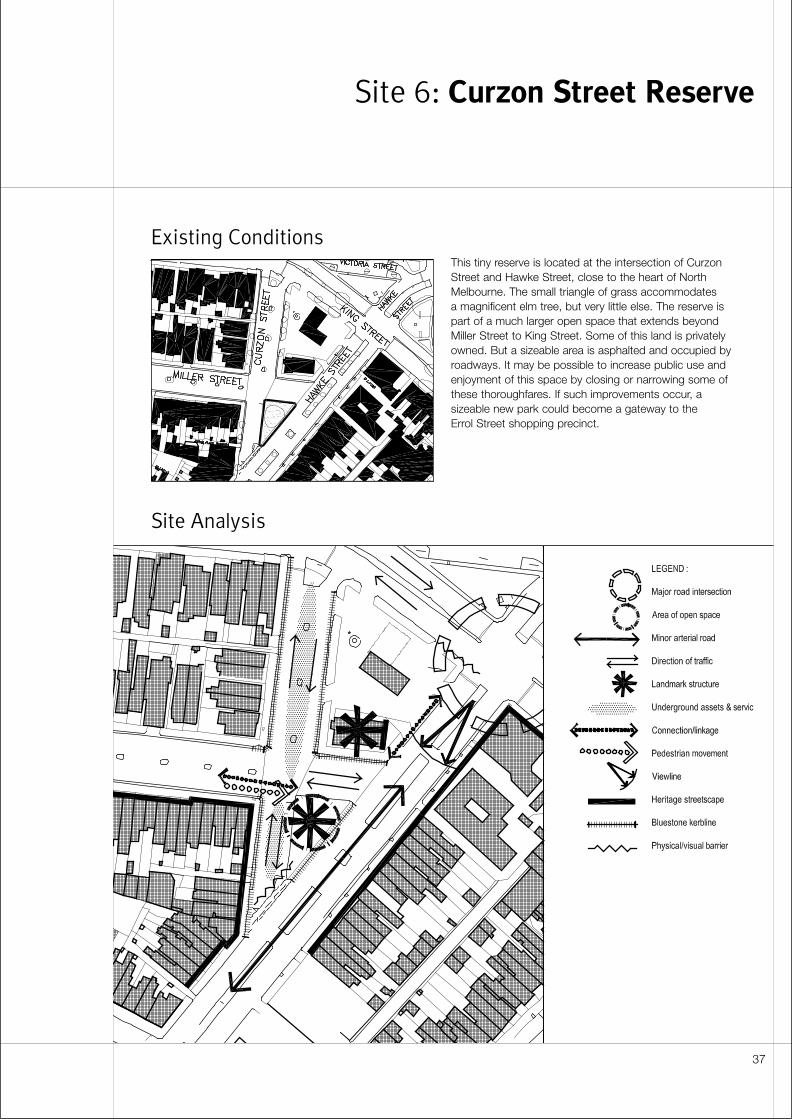
Existing Conditions
Site Analysis
This tiny reserve is located at the intersection of CurzonStreet and Hawke Street, close to the heart of NorthMelbourne. The small triangle of grass accommodates a magnificent elm tree, but very little else. The reserve ispart of a much larger open space that extends beyondMiller Street to King Street. Some of this land is privatelyowned. But a sizeable area is asphalted and occupied byroadways. It may be possible to increase public use andenjoyment of this space by closing or narrowing some ofthese thoroughfares. If such improvements occur, asizeable new park could become a gateway to the Errol Street shopping precinct.
Site 6: Curzon Street Reserve
37
Detailed Site Analysis
Spatial character• Sites 6 and 7 are part of a much larger open space
with ill-defined edges. The two small public reservesare visually contiguous with surrounding streets andintersections. In the centre of this expanse is a servicestation. The diminutive building on this site fails topartition or focus the surrounding area. As a result, it is unclear whether the two reserves are discreteplaces or a single spatial entity.
• Strong built edges are confined to Victoria Street andErrol Street. These are remote from Site 6, though theyprovide effective containment along two sides of Site 7.
• The ground falls appreciably towards the south-west.This slope and the absence of a substantial built edgealong Curzon and Miller mean there is no obviousedge to the open space, especially in views from the direction of Errol and Victoria.
• In this context, the bungalow housing the BaptistChurch and the large elm tree south of Miller Streetappear as prominent free-standing objects.
Views and linkages• Errol Street is the principal focus for community activity
and identity within North and West Melbourne.
• This site could form part of a “green link” between the North Melbourne Railway Station and Errol Street.Miller Street provides the greater part of this route. It is already planted with street trees and has alandscaped median. The Curzon Street reserve couldcomplete the connection with a safe convenientpedestrian pathway.
• Hawke Street provides good views towards Docklands and Moonee Ponds Creek.
• Victoria Street provides views east towards the city.
Landscape• There is a very large elm tree in the small triangle
of open space below Miller. This provides a locallandmark, visible from as far away as the Errol Streetshops.
• South of Roden, King Street contains rows of regularly spaced trees along its edges and its median.These are seen to advantage because of the street’scurvature. However, the pattern breaks down at thenorthern end of King Street where it approachesCurzon and Victoria.
Heritage• Curzon, Hawke and Miller are classified as Level 2
streetscapes.
• Curzon Street has bluestone kerbs and channels.These should be retained or reinstated.
• The front portion of the bungalow on the BaptistChurch property is listed as a heritage feature.
• The Baptist Church has occupied this site for 140years. A bluestone church stood on the site of theservice station. This was constructed in 1862 anddemolished in the 1960’s to make way for roadingimprovements.
Traffic management• King Street is an arterial road as well as a declared
Main Road. It carries four lanes of fast through traffic.Although there are pedestrian crossings at itsintersections with Curzon and Hawke, King Streetinhibits pedestrian access between Sites 6 and 7.
• South of its intersection with Victoria and King, CurzonStreet is very quiet, and is used mainly for local accessand parking. However, this section of Curzon Streetshould continue to carry two-way traffic, as one-way flowwould force local residents to make extensive detours.
• Heavy non-local traffic usage could develop ifsouthbound vehicles on Curzon Street are permitted to cross King and continue directly towards Miller.
• The Baptist Church needs good vehicle access forelderly and disabled members of the congregation.
Parking• Parking is in heavy demand at this site. This is a
particular concern for the local resident and businesscommunity. Errol Street traders and shoppers parkvehicles in Miller Street because it provides the closestarea of four-hour parking.
• Open space improvements could lead to the loss of 22car parks on Curzon Street. However, alternative spacescould be provided within the Hawke Street median.
• If building development occurs on the Baptist Churchproperty, it may be possible to incorporate somepublic parking.
• Parking requirements on this site need to be assessedin relation to the existing Council-owned car parklocated further north on Curzon Street. If the CurzonStreet lot is developed as a multi-level facility, on-streetparking could possibly be reduced in the Miller Streetarea (see also Site 7).
• The Baptist Church needs some easily accessible on-street parking for elderly and disabled members of thecongregation.
38
Services• Designers should identify the exact locations of gas
pipelines and electricity cables. These services areconcentrated along both sides of Curzon Streetbetween Hawke and Victoria.
Community and stakeholder response• Proposals for Curzon Street prompted the largest
community response in the survey. Feedbackdemonstrates overwhelming support for extensions to the present reserve.
• The community would also like to see reductions invehicle numbers and speeds. They did not identifyparking as an important issue.
• There is strong support from the public for a children’splayground in this location.
• The North Melbourne Association supports the closureof Miller Street between Curzon and Hawke. However,the association does not support further restrictions totraffic along Curzon Street. They are concerned thatvaluable parking spaces will be lost here. They alsobelieve that the character of the street will becompromised if kerbs are realigned and if indentedparking bays are introduced.
• The association recommends deferring a decisionabout Curzon Street until the future of the servicestation site is known.
• Errol Street traders support open space extensions at Sites 6 and 7. However, they want the currentnumber of car parks to be maintained.
• The local Baptist Church controls all the land within the Curzon/Miller/Hawke/King block. The Churchoccupies the brick bungalow at the corner of Hawkeand Miller, and leases the remainder of the site to the service station operator.
• The Church favours its current site, not because ofsentimental associations or prominence but because it is strategically located at a distance from otherchurches.
• The Church has recently built a meeting room at therear of the bungalow. Their minister normally occupiesthe house itself. However, church deacons would notrule out moving to a different site if suitableaccommodation could be found or built elsewhere. A second small meeting room would be beneficial.
• The service station lease expires in September 2002.The operator has expressed interest in purchasing the site.
• The Baptist Church is not willing to have a publicdiscussion about the merits of including their land in a future open space. They feel that widespreadknowledge of this proposal could generate pressure on them to sell. This makes it difficult to canvas publicopinion about the merits of acquiring church land toextend the reserve.
• In private discussions, the church left open thepossibility of entering into some kind of deal with theCouncil. A lease is more likely than outright sale, as the church wishes to keep its long-term options open.
• As an alternative to land acquisition, the Council couldnegotiate with the Baptist Church to ensure thatbuilding development produces a favourablerelationship to adjacent public open space.
• Parks and Recreation regard this as an attractive sitefor a park because of its size and proximity to ErrolStreet, and because it offers “blank slate” for a newlandscape design. Nevertheless, they assign a lowpriority to improvements here because of the difficulty and cost associated with acquiring the Baptist Church site.
Costs and funding• The cost estimate for improvements at this site is
$210 000. Most of the expense is associated withrealigning kerbs and introducing new paving.
• The market value of the Baptist Church property has not been assessed.
39
Design Principles and
Objectives
Street layout• Narrow the intersection of Curzon and King to provide
a single lane in each direction. Restrict entry intoCurzon Street to a left turn off King. Avoid increasingnon-local traffic usage by preventing southboundvehicles on Curzon Street from crossing King andcontinuing towards Miller.
• Provide bike lanes on both sides of Curzon Streetbetween King and Miller. If angle parking is introducedto this section of the street, provide a generousseparation between the rear of the parked vehiclesand the cycleway. Alternatively, include a bike pathwithin the reserve.
• Introduce additional two-hour car parks to the HawkeStreet median. Consider converting some Miller Streetparking spaces to short-term use.
Built form• The site is exposed to traffic on two frontages. An
open space along King Street would not be an invitingenvironment for pedestrians, though it would provide a visual amenity for passing motorists. Under thesecircumstances, introducing a built edge to King andHawke may be an appropriate treatment for theBaptist Church site. A building frontage would providebetter spatial definition at the broadKing/Hawke/Victoria intersection. Landscape might be limited to a more sheltered zone at the centre of the block and the along the Curzon Street frontage.
• These objectives need to be assessed in relation tosunlight access. A built edge along King could insulatethe open space from traffic noise, but it could alsoovershadow the reserve and a present a south-facingelevation to public or semi-public areas. Building alongHawke Street provides less effective protection fromtraffic. But it preserves a northern aspect for the centreof the block.
• Site planning also needs to take account of the visualrelationship between Sites 6 and 7. Building alongKing Street will separate the reserves into two distinctplaces. Building along Hawke Street could enable thetwo spaces to appear as a single entity.
• If the church site is acquired, the minister’s house andmeeting room could be retained and would be usefulfor community services accommodation.
Streetscape• Continue “boulevard” style planting north along King
Street to the intersection with Curzon and Victoria.Keep street trees at least 18 metres from streetcorners, or set trees back from the street edge in order to maintain sightlines to traffic lights.
• If the Baptist Church property is acquired and Sites 6and 7 are developed as a single open space, vary thestreetscape to indicate that King Street passes througha reserve. For example, use the street tree pattern asthe basis for formal planting layouts on either side ofthe roadway. Alternatively, treat King Street as a “cut”through parkland. In this case, omit some street treesto allow views into informal landscapes on either sideof the roadway. Use either treatment to unify Sites 6and 7.
Park landscape• Record the existence of the old Baptist Church.
Consider using the demolished church as part of thelandscape theme.
40
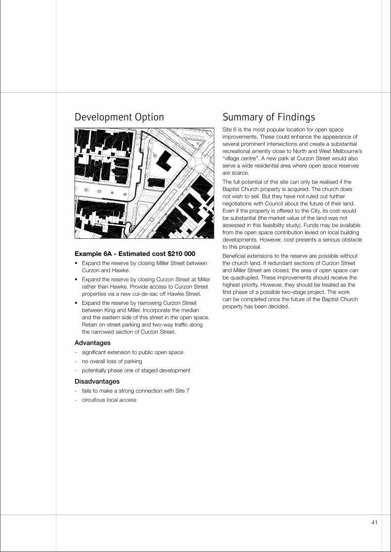
Development Option
Example 6A - Estimated cost $210 000• Expand the reserve by closing Miller Street between
Curzon and Hawke.
• Expand the reserve by closing Curzon Street at Millerrather than Hawke. Provide access to Curzon Streetproperties via a new cul-de-sac off Hawke Street.
• Expand the reserve by narrowing Curzon Streetbetween King and Miller. Incorporate the median and the eastern side of this street in the open space.Retain on-street parking and two-way traffic along the narrowed section of Curzon Street.
Advantages- significant extension to public open space
- no overall loss of parking
- potentially phase one of staged development
Disadvantages- fails to make a strong connection with Site 7
- circuitous local access
Summary of FindingsSite 6 is the most popular location for open spaceimprovements. These could enhance the appearance ofseveral prominent intersections and create a substantialrecreational amenity close to North and West Melbourne’s“village centre”. A new park at Curzon Street would alsoserve a wide residential area where open space reservesare scarce.
The full potential of this site can only be realised if theBaptist Church property is acquired. The church does not wish to sell. But they have not ruled out furthernegotiations with Council about the future of their land.Even if the property is offered to the City, its cost wouldbe substantial (the market value of the land was notassessed in this feasibility study). Funds may be availablefrom the open space contribution levied on local buildingdevelopments. However, cost presents a serious obstacleto this proposal.
Beneficial extensions to the reserve are possible withoutthe church land. If redundant sections of Curzon Streetand Miller Street are closed, the area of open space canbe quadrupled. These improvements should receive thehighest priority. However, they should be treated as thefirst phase of a possible two-stage project. The work can be completed once the future of the Baptist Churchproperty has been decided.
41

42
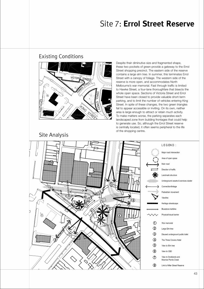
Existing Conditions
Site Analysis
Despite their diminutive size and fragmented shape, these two pockets of green provide a gateway to the ErrolStreet shopping precinct. The eastern side of the reservecontains a large elm tree. In summer, this terminates ErrolStreet with a canopy of foliage. The western side of thereserve is more open, and accommodates NorthMelbourne’s war memorial. Fast through traffic is limitedto Hawke Street, a four-lane thoroughfare that bisects thewhole open space. Sections of Victoria Street and ErrolStreet have been closed to provide valuable short-termparking, and to limit the number of vehicles entering KingStreet. In spite of these changes, the two green trianglesfail to appear accessible or inviting. On its own, neitherarea is large enough to attract or retain much activity. To make matters worse, the parking separates eachlandscaped zone from building frontages that could helpto generate use. So, although the Errol Street reserve is centrally located, it often seems peripheral to the life of the shopping centre.
Site 7: Errol Street Reserve
43
Detailed Site Analysis
Spatial character• Sites 6 and 7 are part of a much larger open space
with ill-defined edges. The two small public reservesare visually contiguous with surrounding streets andintersections. In the centre of this expanse is a servicestation. The diminutive building on this site fails topartition or focus the area. As a result, it is unclearwhether the reserves are two discrete places or asingle spatial entity.
• Strong built edges are confined to Victoria Street andErrol Street. These are remote from Site 6, though theyprovide effective containment along two sides of Site 7.
• The ground falls appreciably towards the south-west.This slope and the absence of a substantial built edgealong Curzon and Miller mean there is no clear edge to the open space when this is viewed from the cornerof Errol and Victoria.
• The Errol Street reserve itself is subdivided into twosmall triangular open spaces. The northern triangle is larger than the southern one.
• Victoria Street is one of Melbourne’s most importantthoroughfares. In the east of the city, as VictoriaParade, the route has the status of a major boulevard.In the west, it provides the most recognisable linkbetween North Melbourne and the CBD.
• However, beyond Errol, Victoria Street has much lesssignificance. Emphasis shifts to Errol Street as a retailstrip and a public transport route. King Street andCurzon Street have more importance as major arterials.
• Historically, the discontinuity was reinforced by thepresence of the North Melbourne Asylum. Thisinstitution terminated the Victoria Street “axis” atCurzon Street. When the building was demolished in the early twentieth century, Victoria Street wascontinued west to meet Abbotsford and Dryburgh.However, the new section has a residential character. It resembles a local street rather than an extension of a major boulevard.
• Victoria Street is closed between Errol and Curzon.This section of the thoroughfare does not belong toeither of the two characters described above. Instead,its parking bays and service lane appear to beappendages to King Street and parts of the largeirregular space that encompasses the King/Hawkeintersection.
• The “redundant” block of Victoria Street could developits own identity as a shopping frontage, if local retailactivity develops further.
Existing landscape• The two triangles of open space are landscaped
differently. As a result, visual connections between the areas are weak.
• The larger northern space is fragmented by serviceaccess and parking. Its layout discourages pedestrianaccess from the direction of Errol Street.
• Both spaces possess important civic artefacts. The northern triangle contains a war memorial. This monument is uncomfortably close to the edge of King Street. It is inaccessible and is poorly integrated with surrounding landscape.
• The southern triangle houses a disused undergroundpublic toilet. Its visible elements include wrought ironrailings and an ornamented brick ventilation shaft.These have architectural and heritage value.
• A local community group has planted part of thesouthern triangle with shrubs. These have grown to theextent that they block sightlines across the space. As alandscape treatment, the shrubs are too dense and toocomplex for such a small area. They are also at oddswith the more formal beds in the northern triangle.
Views and linkages• Errol Street is the principal focus for community activity
and identity within North and West Melbourne.
• This site could form part of a “green link” between theNorth Melbourne Railway Station and Errol Street. MillerStreet provides the greater part of this route. It is alreadyplanted with street trees and has a landscaped median.Along with open space improvements at Curzon Street,the Errol Street reserve could complete the connectionwith a safe convenient pedestrian pathway.
• Hawke Street provides good views towards Docklands.
• Victoria Street provides views east towards the city.
• The Errol Street view shaft terminates at a large elmtree in the southern triangle of open space.
Heritage• The Three Crowns Hotel at the corner of Errol and
Victoria has a Level 1 heritage classification.
• A Level 2 heritage classification applies to streetscapealong the northern side of Victoria Street and alongboth sides of Errol Street.
• Bluestone kerbs and channels occur along ErrolStreet, including the block between King and Victoria.
• The war memorial is a heritage feature. It is the focusof ceremonies on Anzac Day and othercommemorative occasions.
44
Traffic• Hawke Street must retain four traffic lanes. Narrowing its
carriageway is unrealistic, even within the short sectionof roadway that connects Victoria and King. This beingthe case, it is desirable to keep the wide median in thecentre of the street as a pedestrian refuge.
• The closed section of Victoria Street provides parkingand service access to adjacent retail stores and theErrol Street shopping precinct. Vehicles enter and leavethe area from Hawke Street where a median preventsright-hand turns. This arrangement is not ideal.Motorists’ access is restricted, and pedestrians on ErrolStreet are isolated from the main area of open space.
• Victoria Street frontages need direct vehicle access.Some of these properties are not served by rearlaneways. Little Curzon Street provides rear access topremises on the western side of the block, and this laneconnects with Curzon Street. However, it contains aninety-degree turn, and cannot be used by large vehicles.
• Victoria Street properties could be accessed via ashared vehicle/pedestrian zone. However, this kind ofspace is rare in Melbourne and there are concerns forpedestrian safety in such an environment. A detailedinvestigation is required to test its feasibility.
• The southernmost block of Errol Street can be closedto through traffic. However, access to adjoiningproperties must be maintained.
Parking• Parking is heavily used by visitors to the Errol Street
shopping precinct. The parking precinct in VictoriaStreet is particularly valuable because of its proximityto the shops. Although used by traders and patrons of the 3 Crowns Hotel, the smaller parking area at the southern end of Errol Street is generally lessconveniently located. These spaces could be removed,but only if replacement parking is provided elsewhere.
• Parking requirements for the site as a whole need tobe assessed in relation to the existing Council-ownedcar park located on Curzon Street. If the Curzon Streetlot is developed as a multi-level facility, on-streetparking could possibly be reduced in the vicinity ofErrol and Victoria.
• However, this development would require a moredirect pedestrian link between the car park and Errol Street, and the connection is difficult to achieve. It would need to cross the site of the presentCommonwealth Bank building. Alternatively, it wouldresult in the demolition of heritage buildings.
• Regardless of the total amount of parking availablenear Errol Street, Victoria Street businesses wish tohave some spaces directly outside their premises. The warehouse-style buildings here are occupied bylarge-scale retailers selling bulky items. Short-term carparks are essential for this trade.
Services• Designers should identify the exact locations of gas
lines, stormwater pipes and electricity cables. Theseservices are concentrated along Victoria Street,between Curzon and Errol. Services are also clusteredat the intersection of Errol/Hawke/Victoria and at thesouthern end of Errol Street near its junction with King.
Community and stakeholder response• Proposals for the Errol Street reserve prompted
comparatively little response from the community. The public has not expressed a clear preference for any of the three development proposals.
• The North Melbourne Association supports expansion of the reserve. However, they do not regard improvements at this site to be a high priority.The association is opposed to any change in accessto Errol Street between Victoria and King. They notethat vehicle movements in this area have already been examined by Council. They regard the presentcirculation pattern as the safest option.
• The association supports construction of a mixed-usedevelopment on the Curzon Street car park site. Intheir view, this building could contain public parking, if pedestrian access to Errol Street can be provided.
• The local business community objects to any reductionin parking at this location. However, this interest groupaccepts that it is necessary to look at parking as atotality. Retailers would support the development of amulti-storey car park on Curzon Street. However, themanagement of this facility is a critical issue. Traderswould like shoppers to be given free one-hour parkingvoucher with their purchases. Otherwise, the cost ofparking is added to the cost of shopping in Errol Street.
• Parking aside, the business community supportsefforts to provide a better park near Errol Street. They regard open space improvements as asset that will help to attract customers to the area.
• The war memorial is a very sensitive issue for somesectors of the community. Proposals to relocate thismonument should be the subject of furtherconsultation with RSL and other interested parties.
• Streetscape improvements were carried in this area inthe early nineties. For this reason, it could be difficult tojustify further changes.
Costs and funding• Cost estimates for improvements at this site vary
between $200 000 and $220 000. Example A is thecheapest development option, even though it deliversthe largest area of open space. The other proposalsare more expensive because they require longer runsof new kerbs and channels.
45
Design Principles and
Objectives
Street layout• Introduce a shared pedestrian/vehicle zone to the
closed section of Victoria Street. Use this toaccommodate service vehicles and a small amount ofparking. Structure the space so that it is accessible to pedestrians and easily used for street activities.
• Provide vehicle access to this zone directly from KingStreet. Locate this entrance as close as possible to the Curzon Street intersection.
Built form• Consider locating a new public toilet in the reserve.
Streetscape• Continue “boulevard” style planting north along King
Street to the intersection with Curzon and Victoria.Keep street trees at least 18 metres from streetcorners, or set trees back from the street edge in order to maintain sightlines to traffic lights.
• If the Baptist Church property is acquired and Sites 6and 7 are developed as a single open space, vary thestreetscape to indicate that King Street passes througha reserve. For example, use the street tree pattern asthe basis for formal planting layouts on either side ofthe roadway. Alternatively, treat King Street as a “cut”through parkland. In this case, omit some street treesto allow views into informal landscapes on either sideof the roadway. Use either treatment to unify Sites 6and 7.
Park landscape• Devise a single comprehensive landscape treatment
for both triangles. Include the Curzon Street reserve in this concept, and allow for the possible purchase of the Baptist Church site (see also Site 6).
• Consider planting a second elm tree in the reserve, to match the existing specimen in the southern openspace triangle. Use the two trees to create a stronger“gateway” to the southern end of Errol Street.
• Consider emphasising the slope on the larger triangleof open space. Use the falls on the site to help todistance King Street traffic from the retail frontagealong Victoria Street.
• Investigate moving the war memorial away from theedge of King Street. Keep the monument within thenorthern triangle of open space. But, aim to give it amore prominent and accessible location near thecorner of Errol and Victoria. Fully integrate thememorial with the surrounding landscape, and providea hard-paved area suitable for ceremonial gatherings.
• Consider including a fountain that produces “whitenoise” and helps to mask the sound of passing traffic.
46
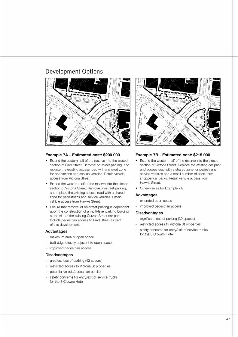
Development Options
Example 7A - Estimated cost: $200 000• Extend the eastern half of the reserve into the closed
section of Errol Street. Remove on-street parking, andreplace the existing access road with a shared zonefor pedestrians and service vehicles. Retain vehicleaccess from Victoria Street.
• Extend the western half of the reserve into the closedsection of Victoria Street. Remove on-street parking,and replace the existing access road with a sharedzone for pedestrians and service vehicles. Retainvehicle access from Hawke Street.
• Ensure that removal of on-street parking is dependantupon the construction of a multi-level parking buildingat the site of the existing Curzon Street car park.Include pedestrian access to Errol Street as part of this development.
Advantages- maximum area of open space
- built edge directly adjacent to open space
- improved pedestrian access
Disadvantages- greatest loss of parking (43 spaces)
- restricted access to Victoria St properties
- potential vehicle/pedestrian conflict
- safety concerns for entry/exit of service trucks for the 3 Crowns Hotel
Example 7B - Estimated cost: $215 000• Extend the western half of the reserve into the closed
section of Victoria Street. Replace the existing car parkand access road with a shared zone for pedestrians,service vehicles and a small number of short-termshopper car parks. Retain vehicle access from Hawke Street.
• Otherwise as for Example 7A.
Advantages- extended open space
- improved pedestrian access
Disadvantages- significant loss of parking (30 spaces)
- restricted access to Victoria St properties
- safety concerns for entry/exit of service trucks for the 3 Crowns Hotel
47
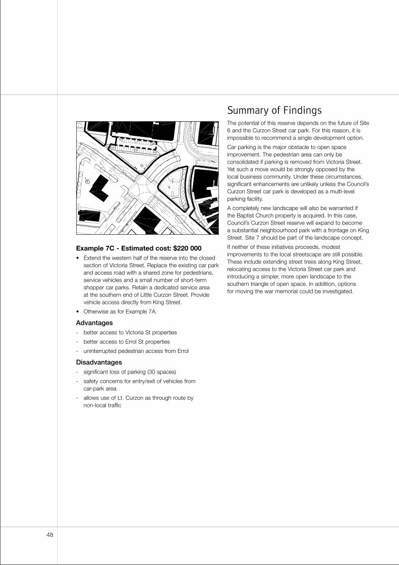
Example 7C - Estimated cost: $220 000• Extend the western half of the reserve into the closed
section of Victoria Street. Replace the existing car parkand access road with a shared zone for pedestrians,service vehicles and a small number of short-termshopper car parks. Retain a dedicated service area at the southern end of Little Curzon Street. Providevehicle access directly from King Street.
• Otherwise as for Example 7A.
Advantages- better access to Victoria St properties
- better access to Errol St properties
- uninterrupted pedestrian access from Errol
Disadvantages- significant loss of parking (30 spaces)
- safety concerns for entry/exit of vehicles from car-park area
- allows use of Lt. Curzon as through route by non-local traffic
Summary of FindingsThe potential of this reserve depends on the future of Site6 and the Curzon Street car park. For this reason, it isimpossible to recommend a single development option.
Car parking is the major obstacle to open spaceimprovement. The pedestrian area can only beconsolidated if parking is removed from Victoria Street.Yet such a move would be strongly opposed by the local business community. Under these circumstances,significant enhancements are unlikely unless the Council’sCurzon Street car park is developed as a multi-levelparking facility.
A completely new landscape will also be warranted if the Baptist Church property is acquired. In this case,Council’s Curzon Street reserve will expand to become a substantial neighbourhood park with a frontage on KingStreet. Site 7 should be part of the landscape concept.
If neither of these initiatives proceeds, modestimprovements to the local streetscape are still possible.These include extending street trees along King Street,relocating access to the Victoria Street car park andintroducing a simpler, more open landscape to thesouthern triangle of open space. In addition, options for moving the war memorial could be investigated.
48
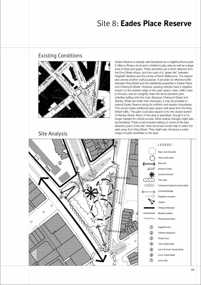
Existing Conditions
Site Analysis
Site 8: Eades Place Reserve
49
Eades Reserve is already well developed as a neighbourhood park.It offers a fitness circuit and a children’s play area as well as a largearea of trees and grass. These amenities are a short distance fromthe Errol Street shops, and form part of a “green link” betweenFlagstaff Gardens and the centre of North Melbourne. The reservealso serves another useful purpose. It provides an effective bufferbetween King Street and the residential properties in Eades Placeand Chetwynd Street. However, passing vehicles have a negativeimpact on the western edge of the open space. Here, traffic noiseis intrusive, and an unsightly chain-link fence prevents parkactivities spilling onto the road. Because Chetwynd Street andStanley Street are wider than necessary, it may be possible toextend Eades Reserve along its northern and eastern boundaries.This would create additional open space well away from the KingStreet traffic. The park could also expand onto the closed sectionof Stanley Street. Much of this area is asphalted, though it is nolonger needed for vehicle access. More radical changes might alsobe beneficial. These could include building on some of the lessattractive parts of the site. New structures would help to orient thepark away from King Street. They might also introduce a widerrange of public amenities to the area.
Detailed Site Analysis
Spatial character• The reserve provides a green buffer between the
houses on Chetwynd Street and the fast traffic on KingStreet. The site falls towards the south-west, and thisgradient also helps to separate the residential fabricand the park from the arterial road. As a result, KingStreet commercial frontages have little impact on theopen space. The strongest built edge occurs alongChetwynd Street where four to five storey office andapartment blocks stand on higher ground.
• The park is more exposed to traffic at its southern end. Here the reserve tapers until it is only a fewmetres across. It merges with the large irregular open space formed by the intersection of Chetwynd,King and Rosslyn.
• The northern end of the park is quieter, but it is still not well contained. Space “leaks” away across thewide expanse of Eades Place. The neighbouringbuildings do little to prevent this. The residential fabricbetween Chetwynd and Eades is diminutive in scale,and the adjoining corner of the Flagstaff Centre site is used as a car park.
Existing landscape• The park’s main “axis” continues the footpath and
the line of street trees from the western side of EadesPlace. This feature splits the open space into twounequal parts, and emphasises the triangular geometryof the reserve. The axis also provides a strong visualand functional connection between Victoria Street and the park.
• Two sides of the reserve are fenced to prevent childrenrunning out onto the adjacent streets. Parks andRecreation plan to remove the barrier along Chetwyndif traffic calming measures reduce vehicle speeds onthis street. However, the King Street boundary of thereserve must remain secured. Presently, both fencesare unsightly chain link constructions and are poorlymaintained.
• A footpath will be introduced to the Chetwynd Streetedge of the reserve, but it will need to be locatedinside the park in order to avoid tree roots.
• Chetwynd Street has a high-quality landscape thatincludes mature trees on either side of the carriageway.However, although it is a broad thoroughfare, there isno median within this section of the street.
Views and linkages• Street tree planting is proposed for Stanley Street
and Chetwynd Street as part of the “green linkages”initiative.
• The footpath along King Street is an importantpedestrian route to the Central City.
• Within the northern end of the park, there are goodsightlines to two local landmarks: St Marys Churchand the North Melbourne Town Hall (the tower isvisible along the laneway between Eades Place and Chetwynd Street).
• Commercial buildings at the corner of Leveson andVictoria close the view along Eades Place. Thesestructures provide a visual clue to the proximity of the Errol Street shops.
• The Bolte Bridge terminates the view shaft alongStanley Street.
• The old West Melbourne Primary School, now part of the Flagstaff Centre, provides a recognisablebackdrop to the park.
• King Street describes a curve through WestMelbourne. Because the reserve is located on theconcave outside edge of this street, the park isconspicuous to passing motorists.
Heritage• A Level 1 classification applies to streetscape along
Eades place and along the north side of Stanley Street(between Chetwynd and Eades).
• Bluestone kerbs and channels occur along King Streetand Eades Place. Disruption to these features shouldbe minimised. Bluestone kerbs in the area ofChetwynd and Stanley have less historical significance,and these could be relocated or recycled if necessary.
50
Traffic management• Stanley Street is closed to through traffic between
Eades Place and King Street. Most of the carriagewayremains in place, but the asphalt is interrupted by anarrow strip of landscape at the junction with EadesPlace. When Stanley was first closed, this arrangementmaintained rear access to the West Melbourne PrimarySchool. Now, the school site is occupied by theFlagstaff Centre. Its vehicle entrance is located onEades Place. As a result, this section of Stanley Streetis completely redundant, and can be fully integratedwith the park.
• Chetwynd Street is a route favoured by non-local traffic by-passing the arterial network betweenFlemington Road and King Street. To discourage fastthrough-traffic, Engineering Services may reduce the“green time” for vehicles on Rosslyn Street, althoughthis may put pressure on other streets. A moreextreme solution is to close Chetwynd Street at its junction with Rosslyn and King.
• As part of improvements to Chetwynd Street,Engineering Services plan to introduce bike lanes o both sides of the carriageway.
• South of Stanley, Chetwynd Street narrows from four lanes to two. Southbound motorists jockey forposition where this constriction occurs. If the width of Chetwynd is further reduced, traffic calmingmeasures (such as a wide median) should also beintroduced north of Stanley. This would avoidexacerbating the safety problems at the pinch point.
• Further reduction in the width of the Chetwynd Streetcarriageway may not be possible. Two-way trafficneeds to be maintained, along with dedicated bikelanes in each direction
Parking• Eades Reserve is a short walk from the Errol Street
and Victoria Street shopping precincts. There is heavydemand for parking in the surrounding streets.
• The Flagstaff Centre provides secure on-site parkingfor its fleet vehicles. However, staff compete for spacesin the surrounding streets.
• Engineering Services is exploring the feasibility ofincreasing on-street parking by adding an intermittentmedian along Chetwynd Street between Stanley and Arden.
Services• Designers should identify the exact locations of sewers
and manholes, water mains, stormwater pipes andtelephone or electricity cables. These services areconcentrated along Stanley Street, between King and Chetwynd, and along Chetwynd Street, betweenVictoria and Rosslyn. Services are also found at theintersection of Chetwynd, King and Rosslyn.
Community and stakeholder response• Proposals for Eades Reserve prompted comparatively
little response from the community, though strongopposition was expressed towards buildingdevelopments in or around the park. Not surprisingly,feedback favoured Example 8A. This option does not include any new buildings.
• The community would like to see reductions in thenumber and speed of vehicles in adjacent streets.They regard this objective as being more importantthan increasing the area of open space.
• A children’s playground and more trees were the mostpopular suggestions for new amenities in the park.
• The community appreciates the park in its presentform, and does not wish to see it reshaped or cut off from the adjacent streets. Some additionalinsulation from King Street traffic is considereddesirable. However, the community would like this to be achieved with landscape rather than buildings.
• Some local residents believe the park is unsafe. Their concerns are heightened by the presence of the Flagstaff Centre which offers emergencyaccommodation to homeless men.
• The North and West Melbourne Association sees no merit in expanding Eades Reserve while there aregreater opportunities for “greening” the surroundingstreets. As an example, it suggests kerb-side treereserves on the eastern side of Eades Place, to matchthose on the western side. Traffic calming in ChetwyndStreet is supported. The association favours fullclosure of Stanley Street between Eades and King,and incorporation of this area in the park. Theassociation is strongly opposed to building in the parkor the adjoining road reserve. It believes landscapeshould be used to improve spatial definition andprovide insulation from passing traffic on King.
• The Salvation Army operates the Flagstaff Centre. They regard the local residents’ fears as unjustified.They argue that the centre’s residents do not frequentthe park because the complex has its own recreationalopen space. However, they concede that some menmay drink there in order to avoid scrutiny.
51
• The Salvation Army supports full closure of StanleyStreet between Eades Place and King Street.However, they do not want dense vegetation along the boundary of their site as this might compromisesecurity.
• Local residents would oppose the introduction offurther community services in or around EadesReserve. Residents would object to any loss of openspace, and would regard such a facility as an“extension” of the Flagstaff Centre.
• The Flagstaff development has soured communityfeelings towards the Council. Locals feel they were not consulted about the project. They believe the siteis inappropriate for emergency housing because it is in a residential area. To a large extent, the project wasa State Government initiative. However, people havedifficulty separating the Government’s role from that of Council.
Costs and funding• The estimated cost for the improvements shown in
Example 8A is $200 000. Most of the expense isassociated with construction of new kerbs and paving.Other costs are relatively modest because fewchanges are required to the existing landscape.Example 8B was not costed because internal andexternal stakeholders expressed strong opposition to building developments on this site.
Design Principles
and Objectives
Streetscape• Introduce planted medians to Eades Place and
Chetwynd Street.
• Relocate bluestone kerbs and channels in ChetwyndStreet and Stanley Street.
• Plant landscaped sections of the Chetwynd Streetmedian with shrubs rather than grass to assistmaintenance.
Park landscape• Ensure the park is clearly visible from surrounding
streets. Avoid concealed enclaves, and place seatingin conspicuous locations.
• Retain clear sightlines along the Stanley Streetboundary of the Flagstaff Centre.
• Consider installing a synthetic surface beneath theexisting children’s play area. Synthetic materials do not conceal syringes and other hazardous objects as readily as bark chips do.
• Provide good lighting along the edges of the park and along all pathways within it.
52
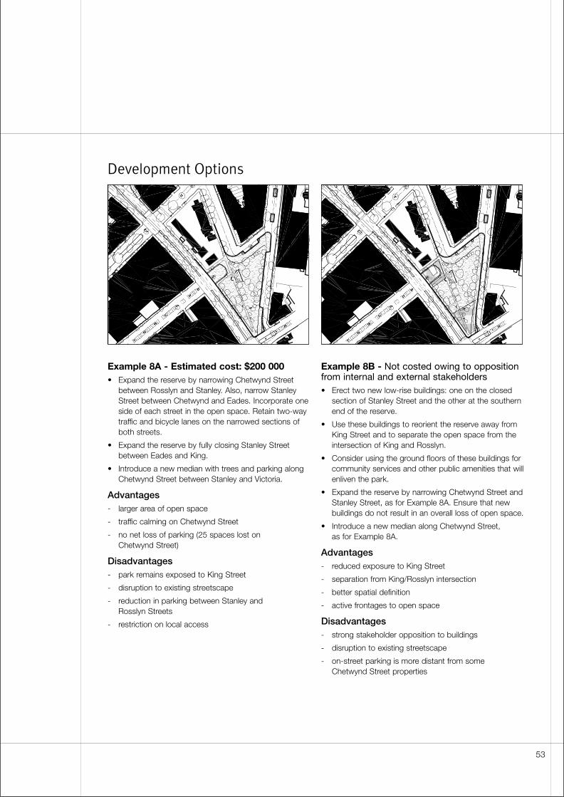
Development Options
Example 8A - Estimated cost: $200 000• Expand the reserve by narrowing Chetwynd Street
between Rosslyn and Stanley. Also, narrow StanleyStreet between Chetwynd and Eades. Incorporate oneside of each street in the open space. Retain two-waytraffic and bicycle lanes on the narrowed sections ofboth streets.
• Expand the reserve by fully closing Stanley Streetbetween Eades and King.
• Introduce a new median with trees and parking alongChetwynd Street between Stanley and Victoria.
Advantages- larger area of open space
- traffic calming on Chetwynd Street
- no net loss of parking (25 spaces lost onChetwynd Street)
Disadvantages- park remains exposed to King Street
- disruption to existing streetscape
- reduction in parking between Stanley and Rosslyn Streets
- restriction on local access
Example 8B - Not costed owing to oppositionfrom internal and external stakeholders• Erect two new low-rise buildings: one on the closed
section of Stanley Street and the other at the southernend of the reserve.
• Use these buildings to reorient the reserve away fromKing Street and to separate the open space from theintersection of King and Rosslyn.
• Consider using the ground floors of these buildings forcommunity services and other public amenities that willenliven the park.
• Expand the reserve by narrowing Chetwynd Street andStanley Street, as for Example 8A. Ensure that newbuildings do not result in an overall loss of open space.
• Introduce a new median along Chetwynd Street, as for Example 8A.
Advantages- reduced exposure to King Street
- separation from King/Rosslyn intersection
- better spatial definition
- active frontages to open space
Disadvantages- strong stakeholder opposition to buildings
- disruption to existing streetscape
- on-street parking is more distant from some Chetwynd Street properties
53
Summary of FindingsUnlike most other open space opportunities in North and West Melbourne, Eades Reserve is already wellestablished as a neighbourhood park. A range ofamenities are provided, and the reserve is already largeenough to accommodate a variety of recreationalactivities. The community values these qualities, and theyhave expressed little support for significant changes tothe existing landscape. Under these circumstances,expensive adjustments to the alignments of ChetwyndStreet and Stanley Street are not justified.
However, two factors reduce the park’s appeal to nearbyresidents. Some people regard the area as unsafe. Therehave been few recorded instances of criminal activity oranti-social behaviour in the reserve. Nevertheless localsfeel threatened, influenced by the proximity of theFlagstaff Centre. Whether these fears are real orperceived, landscape modifications should focus onmaking the park appear safer, rather than on increasingthe area of open space.
Traffic is the second factor that detracts from the park’samenity. The King Street arterial channels a large numberof high-speed vehicles along the western edge of thereserve. Although complete visual separation between the park and the road is undesirable, landscape shouldprovide a more effective and attractive buffer than thepresent chain link fence.
The eastern side of the reserve, along Chetwynd Street, is also exposed to traffic. However, a morecomprehensive solution is available here: the local streetsshould be modified to discourage through-traffic. This canbe achieved by introducing a median to Chetwynd Streetand by reducing the green time for motorists on Rosslyn.
The proposed Chetwynd Street median serves severalpurposes apart from traffic calming. It provides additionalon-street car parks. It also enhances the appearance ofthe street. Streetscape improvements on Chetwyndshould be carried out in conjunction with similar workalong Eades Place.
One small extension to the reserve is warranted. BetweenEades and King, the redundant section of Stanley Streetoffers an immediate opportunity for a cost effectiveimprovement to both the park and the adjoiningstreetscape. Internal and external stakeholders haveexpressed support for this initiative, and it should proceed as soon as possible.
54
Existing Conditions
Site Analysis
This narrow strip of landscape is wedged between twobroad streets. The tiny green triangle is part of a muchlarger open space that includes Howard Street andportions of Rosslyn Street and William Street. Most of thisarea is paved with asphalt. Although local traffic flows donot justify such wide thoroughfares, there is heavydemand for car parks. For this reason, the medians oredges of all three streets are used for metered parking.The whole area contains a single block of private land andjust one small building. Despite the constraints imposedby on-street parking and private ownership, it may bepossible to expand the reserve and improve the area’sappearance. The edges of the open space could beextended out into one or more of the surrounding streets.New streetscape could replace the untidy collection oftraffic islands that presently spoil the junction of HowardStreet and William Street. These improvements shouldprovide a better setting for St. Mary’s church, one ofNorth Melbourne’s principal landmarks.
Site 9: Howard Street Reserve
55
Detailed Site Analysis
Spatial character• The Howard Street reserve sits within a triangular
block bounded by Howard, Rosslyn and William. Thearea of landscape is small, and most of the sense ofopenness here can be attributed to the large expanseof asphalt in the surrounding streets.
• The grounds of St Marys Church and presbyteryprovide further visual extension to the reserve.
• The reserve is framed on two sides by heritage fabric.Institutional and commercial buildings along HowardStreet provide the more substantial frontage. Each ofthe structures here has a singular appearance, adistinct scale and a different setback. However, theyare linked by their common orientation, by the qualityof their architecture and by a low masonry wall thatmarks the front boundary of the church properties. Theterrace houses on William Street are smaller, but theypresent a highly unified edge to the open space.
• Most of the block is private property. The land is in asingle lot, owned by the Catholic Church and occupiedby the Catholic Education Office. It is used mainly forparking, though there is a small two-storey building atthe corner of Howard and Rosslyn. The private carpark is unattractive, but it adds to the spaciousness of the site.
Existing landscape• There are a number of conifers in the reserve. These
are inconsistent with the surrounding streetscape, butthey are valuable as isolated specimen trees.
• William Street has an established streetscape thatincludes trees along both sides of the carriageway.Rosslyn Street has a similar treatment, though treesare more sporadic in the vicinity of the reserve. Neitherstreet has a fully developed median.
• The private car park is unlandscaped, and issurrounded by a utilitarian chain link fence. Theappearance of the building will improve soon, aftermaintenance and upgrading have been carried out.
Views and linkages• There are good sightlines from Victoria Street
to the reserve.
• William Street is a well-known Central City street.Though it is interrupted briefly at Flagstaff Gardens, it provides an implicit connection between NorthMelbourne and the Hoddle Grid.
• William Street and, to a lesser extent, Milton Streetprovide good visual connections from the reserve to Flagstaff Gardens.
• Milton is a quiet residential street with few kerbcrossings. In combination with the Howard Streetreserve, it offers an opportunity for a green pedestrianlink between Victoria Street and Flagstaff Gardens orthe Central City.
• Rosslyn Street provides a green link to Eades Reserve.
• St Marys Church is a major North Melbournelandmark. Its prominent location at the corner ofHoward and Victoria helps to locate the reserve.
Heritage• A Level 2 heritage classification applies to streetscape
along the west side of Howard Street and on the eastside of William Street near its intersection with Victoria.
• luestone kerbs and channels occur around all sides ofthe reserve and along the west side of Howard Street.
Traffic• None of the surrounding streets should carry large
volumes of through traffic. If their carriageways aresubstantially narrowed, ìrat runsî will be discouraged.But one-way flows are undesirable because theywould channel more vehicles past the school entranceon Howard Street.
• The junction of Howard and William needs to berationalised. This area is confusing. It presents anunattractive foreground to the church and reduces the appeal of the reserve for people approaching fromVictoria Street. The present collection of turning lanes,parking bays and traffic islands should be simplified toseparate church vehicles from parking, and to providemore assembly space for congregations after theyleave St Marys.
Parking• Demand for on-street parking is heavy seven days
a week. On weekdays, teachers at St Marys PrimarySchool and workers in nearby mixed-use areas leavetheir vehicles here. On weekends, the area is used bypeople who are visiting Queen Victoria Market orattending church services.
• Much of the local on-street parking is metered. If the number of spaces is reduced, revenue will be lost.
• Additional parking might be accommodated withinnew medians along Rosslyn and William.
• The private car park is used exclusively by the CatholicEducation Office. Although Education Office staff couldpark in adjacent streets, fleet vehicles are left at thesite overnight and need to be secured.
56
Services• Designers should identify the exact locations of water
mains, stormwater pipes and telephone or electricitycables. These services are concentrated along HowardStreet, between Rosslyn and Victoria, and alongRosslyn Street, between Howard and William. Servicesare also clustered along the western edge of WilliamStreet.
Community and stakeholder response• Proposals for the Howard Street reserve prompted
a moderate number of responses from the public,though none of the three development options is aclear preference. The community provides strongsupport for expansion to the open space. But theirfeedback identifies reductions in vehicle numbers and speeds as an equally important objective.
• The most popular requests for new amenities werethose for seating, more trees and more grassed openspace. Children’s play equipment and BBQ facilitiesare secondary priorities.
• The North and West Melbourne Association identifiedthis area as the highest priority for improvement.Location is an important factor in this choice.Expansion to the Howard Street reserve helps satisfy a North West 2010 objective to provide morerecreational open space in Precinct 4. The associationsupports efforts to acquire the Catholic Church siteand, in particular, to close the existing car park. The association suggests that land acquisition couldbe part of a phased programme of work, beginningwith improvements along Howard Street. Theassociation does not favour expansion into RosslynStreet or William Street. It believes that valuableparking will be lost and historically significantstreetscapes will be damaged. The association wouldalso prefer to see angle parking on the west side ofHoward Street rather than indented parking bays alongthe edge of the reserve.
• The Catholic Diocese owns the Catholic EducationOffice site. The Education Office operatesindependently from St Marys and the adjoining school.St Marys Church and presbytery are owned andcontrolled by the local parish.
• In the past, the Church investigated selling theirproperty. However, at present, they have no plans topart with the land. The Catholic Education Office wasrecently given a further ten years on the site, they areabout to commit $30-40 000 on upgrading thebuilding. The church normally likes to hold on to landbecause it may become useful sometime in the future.They may find leasing the property is a more attractiveoption than selling it.
• The Catholic Church would be pleased to collaboratewith Council to investigate landscape options in frontof St Marys. The City of Moreland has landscaped apublicly accessible area in front of a parish church onBrunswick Street. This project provides a precedent forsimilar collaboration at St. Marys.
Costs and funding• Cost estimates for improvements at this site vary
between $155 000 and $210 000. Example C is thecheapest option, though it also delivers the smallestarea of additional open space. The other proposals aremore expensive because they require longer runs ofnew kerbs and channels.
Design Principles
and Objectives
Built form• Negotiate with the Catholic Church and explore
options for purchasing or leasing their property. As part of these discussions, assist the CatholicEducation Office to find alternative accommodation,ideally a Council-owned site or building.
• If the Catholic Education Office site is acquired,consider retaining the existing building and using it to accommodate community services or other park-related amenities. Investigate options for extended the building along Rosslyn Street to create a strongerbuilt edge on the south side of the reserve.
Streetscape• Reinforce the existing pattern of street trees along
Rosslyn and William. Introduce an intermittent medianto both streets, so that planting and parking alternatealong the centres of the carriageways.
Park landscape• Consider phased implementation, beginning with
improvements along Howard Street. Ensure thelandscape design allows for acquisition of the CatholicEducation Office site.
• Develop an informal landscape that is appropriate to the restricted dimensions of the site. Alternatively,integrate planting with the pattern of surrounding street trees.
• If the Catholic Church site cannot be acquired,collaborate with the church to investigate landscapeoptions for the existing car park.
• Extend the landscape of the reserve into the groundsof St Marys so that the two spaces appear as a single entity.
57
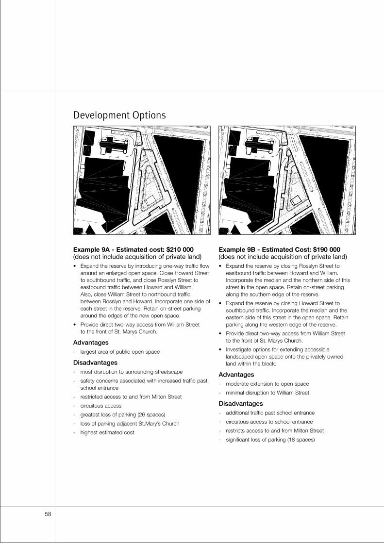
Development Options
Example 9A - Estimated cost: $210 000(does not include acquisition of private land)• Expand the reserve by introducing one-way traffic flow
around an enlarged open space. Close Howard Streetto southbound traffic, and close Rosslyn Street toeastbound traffic between Howard and William. Also, close William Street to northbound trafficbetween Rosslyn and Howard. Incorporate one side ofeach street in the reserve. Retain on-street parkingaround the edges of the new open space.
• Provide direct two-way access from William Street to the front of St. Marys Church.
Advantages- largest area of public open space
Disadvantages- most disruption to surrounding streetscape
- safety concerns associated with increased traffic pastschool entrance
- restricted access to and from Milton Street
- circuitous access
- greatest loss of parking (26 spaces)
- loss of parking adjacent St.Mary’s Church
- highest estimated cost
Example 9B - Estimated Cost: $190 000(does not include acquisition of private land)• Expand the reserve by closing Rosslyn Street to
eastbound traffic between Howard and William.Incorporate the median and the northern side of thisstreet in the open space. Retain on-street parkingalong the southern edge of the reserve.
• Expand the reserve by closing Howard Street tosouthbound traffic. Incorporate the median and theeastern side of this street in the open space. Retainparking along the western edge of the reserve.
• Provide direct two-way access from William Street to the front of St. Marys Church.
• Investigate options for extending accessiblelandscaped open space onto the privately owned land within the block.
Advantages- moderate extension to open space
- minimal disruption to William Street
Disadvantages- additional traffic past school entrance
- circuitous access to school entrance
- restricts access to and from Milton Street
- significant loss of parking (18 spaces)
58
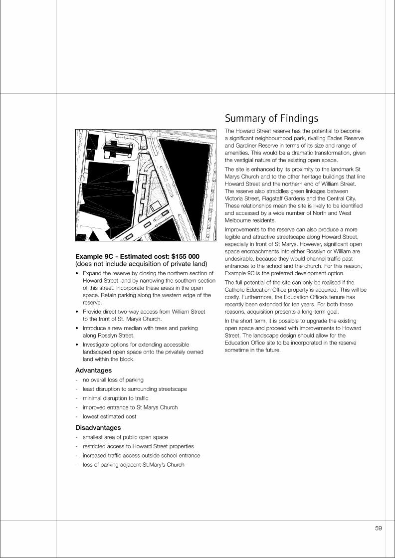
Example 9C - Estimated cost: $155 000(does not include acquisition of private land)• Expand the reserve by closing the northern section of
Howard Street, and by narrowing the southern sectionof this street. Incorporate these areas in the openspace. Retain parking along the western edge of thereserve.
• Provide direct two-way access from William Street to the front of St. Marys Church.
• Introduce a new median with trees and parking along Rosslyn Street.
• Investigate options for extending accessiblelandscaped open space onto the privately owned land within the block.
Advantages- no overall loss of parking
- least disruption to surrounding streetscape
- minimal disruption to traffic
- improved entrance to St Marys Church
- lowest estimated cost
Disadvantages- smallest area of public open space
- restricted access to Howard Street properties
- increased traffic access outside school entrance
- loss of parking adjacent St.Mary’s Church
Summary of FindingsThe Howard Street reserve has the potential to become a significant neighbourhood park, rivalling Eades Reserveand Gardiner Reserve in terms of its size and range ofamenities. This would be a dramatic transformation, giventhe vestigial nature of the existing open space.
The site is enhanced by its proximity to the landmark StMarys Church and to the other heritage buildings that lineHoward Street and the northern end of William Street.The reserve also straddles green linkages betweenVictoria Street, Flagstaff Gardens and the Central City.These relationships mean the site is likely to be identifiedand accessed by a wide number of North and WestMelbourne residents.
Improvements to the reserve can also produce a morelegible and attractive streetscape along Howard Street,especially in front of St Marys. However, significant openspace encroachments into either Rosslyn or William areundesirable, because they would channel traffic pastentrances to the school and the church. For this reason,Example 9C is the preferred development option.
The full potential of the site can only be realised if theCatholic Education Office property is acquired. This will becostly. Furthermore, the Education Office’s tenure hasrecently been extended for ten years. For both thesereasons, acquisition presents a long-term goal.
In the short term, it is possible to upgrade the existingopen space and proceed with improvements to HowardStreet. The landscape design should allow for theEducation Office site to be incorporated in the reservesometime in the future.
59

60
Summary of conclusionsOpen space improvements are viable at all nine sitesidentified in this study. In most cases, the area of thereserves can be extended into the surrounding streets.The accessibility, appearance and recreational value ofthese “left over” open spaces can be enhanced inexchange for modest construction costs and minordisruptions to local traffic and car parking.
The ratio of benefits to costs is more favourable at somesites than at others. As a result, the nine locations can bedivided into three groups based on high, medium and lowpriorities for implementation. These priorities also reflecttime constraints. Improvements at some sites are likely tobe delayed by established land uses. In other locations,development is should be accelerated so as to besynchronised with approved public works.
High priority• Site 5: North Melbourne Railway Station
• Site 6: Curzon Street reserve
• Site 8: Eades Place reserve (Stanley Street closure)
Medium priority• Site 1: Clayton Reserve
• Site 2: Gardiner Reserve
• Site 3: North Melbourne Primary School
• Site 9: Howard Street reserve
Low priority• Site 4: Bedford Street reserve
• Site 7: Errol Street reserve
Collectively, residual open spaces within the street gridamount to a significant resource. They have considerablevisual and recreational value, especially if they aredeveloped in conjunction with greener streets.
However, even if all the high and medium priority sites areimproved, most residents of North and West Melbournewill lack easy access to the type of large multi-purposepark that characterises Melbourne’s other inner-cityneighbourhoods. This is because the subject sites are toosmall to accommodate a broad range of landscapefeatures and recreational uses. At a few locations,expanded open spaces may be large enough to containinformal sports activities. The reserves at CurzonStreet/Errol Street, North Melbourne Primary School andHoward Street all have the potential to become sizeableneighbourhood parks. However, at all three locations, anoptimum outcome depends on the acquisition of privateland and the cooperation of adjoining owners.
For these reasons, the improvements recommended inthis study should not be regarded as a complete answer
to North and West Melbourne’s open space needs.Council should pursue additional open spaceopportunities, particularly those that will deliver largeunencumbered areas for active recreation. A supplementary list of study sites is included in Appendix 1.
At almost every site, buildings are an unnecessary andunpopular option for development. In several locations,new structures could help to define spaces, screen traffic,improve surveillance and support a wider range ofrecreational activity. However, many of these objectivescan be achieved with landscape features instead of builtedges. Given the community’s opposition to buildings,landscape solutions are preferable. The North MelbourneRailway Station site is an exception. Here, someconstruction is essential in order to produce an activecoherent plaza.
Aside from constructions costs and land purchase, the major impediments to improvements are the effectson traffic and parking. In all high-priority locations,expansions to the open space are compatible withestablished traffic-calming objectives. However, none of these reserves can be significantly enhanced withoutreducing on-street car parking. Losses in one locationmay be offset against gains elsewhere. But thecompetition between parks and parking remains afundamental issue within all the scenarios examined in this study.
Heritage considerations impose further constraints.Expanding the reserves can displace old bluestone kerbsand channels. It can also alter the setting of historicbuildings and introduce discontinuity to the localstreetscape. However, even though these changes maybe significant, they can be regarded as part of an ongoingevolutionary process. Most of the existing reserves bearthe imprint of twentieth-century traffic managementinitiatives. Few, if any, of the subject sites have remainedunaltered since Victorian times. As North and WestMelbourne enter a period of redevelopment, it appropriatefor some of these sites to change again in response tothe needs of a new residential population. Though thecharacteristic pattern of wide streets and continuous kerblines is sometimes compromised by open extensions,aberrations occur at irregular intersections where uniqueconditions already exist.
Conclusions & Recommendations
61
Summary of recommendations
High-priority initiativesThe following initiatives have approved funding. In thecase of Curzon Street and North Melbourne RailwayStation, design documentation should be completedbefore the end of the 2001/02 financial year. If funding isapproved, construction may follow in 2002/03.Improvements at the Eades Reserve are fully funded, andthese should be implemented by July 2002.
Site 5: North Melbourne Railway Station
Create a pedestrian plaza within redundant parts of theroad reserve. Close Anderson Street, and create abuilding site at the corner of Anderson and Ireland streets.Channel two-way traffic into a narrower carriageway onthe southern side of Ireland Street. Limit access toRailway Place.
Estimated construction cost: $725 000 (exclusive of the revenue from a building development)
Site 6: Curzon Street reserve
Prepare a phased development plan for streetscape andopen spaces in the Curzon Street/Hawke Street/VictoriaStreet triangle (see Example 6A). Allow for possibleacquisition of the Baptist Church property. Allow for apossible reduction at the Errol Street reserve (seeExample 7C). In the first stage of the work, extend theCurzon Street reserve into closed portions of CurzonStreet and Miller Street.
Estimate construction cost: $140 000
Site 8: Eades Place reserve
Fully close Stanley Street between Eades Place and KingStreet. Incorporate the redundant road reserve within thepark. Retain the rest of the reserve in its present form.
Estimated construction cost: $20 000
Medium-priority initiativesThe following initiatives deliver significant benefits.However, the projects’ viability is compromised by poorcommunity support or the need for land acquisition. Iffunding is approved, work should be commenced beforethe end of the 2005/06 financial year.
Sites 1 & 2: Clayton and Gardiner Reserves
Upgrade the reserves in conjunction with streetscapeimprovements and traffic management measures onMacaulay Road. Extend Gardiner Reserve onto thewestern side of Dryburgh Street but retain two-way trafficon the eastern side of the street (see Example 2B).
Reduce the width of Macaulay Road to a single trafficlane and a cycle lane in each direction. Achieve this byintroducing a wider median between Gracie and Haines.But form a single narrow carriageway adjacent to the tworeserves (see Examples 1A & 2C).
Estimated construction cost: Clayton Reserve $208 050,Gardiner Reserve $225 000
Site 3: North Melbourne Primary School
Prepare a phased development plan for streetscape andopen spaces in the Errol Street/Harcourt Street triangle(see Example 3B). Coordinate this with the NorthMelbourne Primary School master plan. In the first stageof the work, close Courtney Street between Errol andHarcourt, and incorporate the redundant area of road withthe adjacent reserve.
Estimated construction cost: $392 000
Site 9: Howard Street reserve
Expand the reserve by closing the northern section ofHoward Street, and by narrowing the southern section of the street. Provide direct two-way access from WilliamStreet to St. Marys Church. Allow for the CatholicEducation Office property to be included in the reservesome time in the future (see Example 9C).
Estimated construction cost: $155 000 (exclusive of the cost of acquiring land)
Low-priority initiatives
The following initiatives are unlikely to attract fundingwithin the next five years. However, their status may need to be reviewed if conditions change. For example,improvements at the Errol Street reserve become morefeasible and more attractive if a parking building isconstructed nearby and the supply of on-street car parks can be reduced.
Site 4: Bedford Street reserve
Extend the reserve by narrowing Bedford Street betweenCourtney and Capel, and by narrowing Capel Streetbetween Bedford and Courtney (see Example 4C).
Estimated construction cost: $92 000
Site 7: Errol Street reserve
Expand the reserve by reducing the number of car parksand by providing service access to Victoria Streetproperties directly from King (see Example 7C). Treat thereserve as part of a larger landscape concept for theCurzon Street/Hawke Street triangle (see Site 6).
Estimated construction cost: $220 000
62
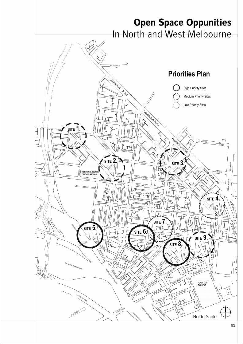
Open Space Oppunities
In North and West Melbourne
63

64
City of Melbourne (1999), City Plan, The City of Melbourne’s Municipal Strategic Statement
City of Melbourne (1999), North West 2010, Local Plan
City of Melbourne (1999), North West 2010, Community Consultation Process (Stage 1) Report
City of Melbourne (1999), Carlton: A Vision to 2010, Integrated Local Area Plan
City of Melbourne (1996), North & West Melbourne Neighbourhood Character Study
Paul Laycock and Florence Jaquet Landscape Architects (1998), North & West Melbourne Greening Strategy Draft Issues Paper
City of Melbourne (1984), Capel Street Action Plan
City of Melbourne (1987), Grids and Greenery : The Character of Inner Melbourne
City of Moonee Valley (1998), Moonee Valley 2010, A Vision for the Future
Department of Infrastructure, State Government of Victoria (2001), North Central City Corridor Study (draft in development)
ERM Mitchell McCotter Pty Ltd (1999), Moonee Ponds Creek Proposed Realignment: Landuse, Visual Assessment & Landscape Report
References
65
Supplementary List of Open
Space OpportunitiesThe following sites and initiatives fall outside the scope ofthis feasibility study. Nevertheless, they provideopportunities for more recreational open space in Northand West Melbourne. In this respect, they are consistentwith the objectives of North West 2010 Local Plan.
Type 1. Open space improvements may result from trafficmanagement and traffic calming measures at thefollowing locations (note - many of theseopportunities arise from the completion of CityLink):
• Arden Street median (see Greening Strategy Draft Issues Paper)
• Abbotsford Street tram median
• Capel Street road closure (see Capel Street Action Plan)
• Chetwynd Street and Leveson Street medians
• the junction of Miller Street and Spencer Street (adjacent to Bristol Paints)
• part closure of Adderley Street between Dudley and Rosslyn
• Pleasance Gardens (street closure at Dryburgh Street)
Type 2. North and West Melbourne have direct access to two large recreational spaces. In bothlocations landscape can be upgraded, andfacilities can be reviewed to take account ofchanging demands and demographics in thesurrounding community:
• Flagstaff Gardens (see Flagstaff Gardens Master Plan)
• North Melbourne Recreation Ground
Type 3. Land acquisition can be used to create newrecreational open spaces in areas of highdemand. New parks can also attract residentialdevelopment to those parts of North and WestMelbourne that would benefit from rehabilitation.The following sites should be considered:
• Latrobe Close
• the former Bulla Cream site, corner Arden and Leveson
• the NCR site, Villiers Street
• the former RMIT School of Design & Printing and the Queensberry Street Primary School, 603-615 Queensberry St
Type 4. Links between North and West Melbourne and surrounding recreational opportunities can be improved. Attention should focus on the following connections:
• pedestrian access to Flagstaff Gardens via William Street
• pedestrian and cycle access across Flemington Rd, especially at Melrose St and opposite Ievers Reserve
• pedestrian and cycle access to Moonee Ponds Creek, especially via Green Street and the adjacent municipal depot
• improved signage at the northern end of Abbotsford Street indicating access to Royal Park and the zoo
66
Appendix 1A
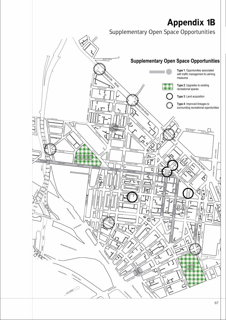
67
Appendix 1BSupplementary Open Space Opportunities

68
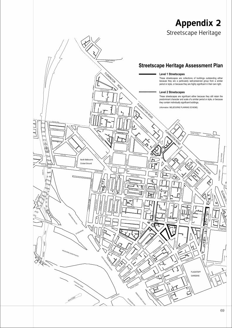
ABC
Appendix 2Streetscape Heritage
69