Embed Size (px)
Citation preview

Open MapOpen Plate 2

STATE GEOLOGICAL AND NATURAL HISTORY SURVEY OF CONNECTICUT
DEPARTMENT OF ENVIRONMENTAL PROTECTION
The Surficial Geology
of the
Willimantic Quadrangle WITH MAP
SHERMAN M. CLEBNIK
Eastern Connecticut State College
1980
QUADRANGLE REPORT NO. 39

STATE GEOLOGICAL AND NATURAL HISTORY SURVEY
OF CONNECTICUT_ DEPARTMENT OF ENVIRONMENTAL PROTECTION
Honorable Ella T. Grasso, Governor of Connecticut
Stanley J. Pac, Commissioner of the Department of Environmental Protection
STATE GEOLOGIST
DIRECTOR, NATURAL RESOURCES CENTER Hugo F. Thomas, Ph.D. Hartford, Connecticut
EDITOR
Lou Williams Page, Ph.D.
For information on ordering this quadrangle report and other publications of the Connecticut Geological and Natural History Survey, consult the List of Publications available from the Survey, Dept. of Environmental Protection, State Office Building, Hartford, Connecticut 06115.
ii

PREFACE
The deposits of ice-contact stratified drift described in the present report are grouped into morphologic sequences. They are envisaged to have formed in a narrow zone of stagnant ice at the edge of the Laurentide ice sheet as it progressively retreated northward, a model of a lateral stagnation-zone retreat which has been commonly used by surficial geologists in New England.
Subsequent to the initial preparation of this report, an 8.lternative model of deglaciation of the Shetucket River basin was proposed by Black (1977, 1979; see also Clebnik and Mulholland, 1979). He believes that the ice-contact deposits are better explained by regional stagnation over the entire basin. His i.nlterpretations of certain glacial features in the Willimantic quadrangle differ from those presented in the present report, which has not been modified to accommodate his contrasting viewpoint. The reader should, however, be aware of them.
Pertinent to the discussion of upper- and lower-till stratigraphy in this report is information on tills recently presented by Newton ( 1978, 1979), who studied tills along a N-S transect in the crystalline uplands of New England. From sections in Connecticut, he recognized a sandy Bakersville Till overlying a clay-rich, compaot Thomaston Till. Based on the chemical analyses of clay minerals and heavy minerals, Newton concluded that an oxidized zone of the Thomaston Till is a weathering profile formed during an interglacial or interstadial period, and that the till probably is early Wisconsin in age. These conclusions are not incorporated into the present report.
Willimantic, Conneoticut
March 1980
iii
Sherman M. Clebnik

TABLE OF CONTENTS
Page Abstract ............... ................................................................ ....................................... 1 Introduction . . . . . . . . . . . . . . . . . . . . . . . . . . . . . . . . . . . . . . . . . . . . . . . . . . . . . . . . . . . . . . . . . . . . . . . . . . . . . . . . . . . . . . . . . . . . . . . . . . . . . . . . . . . . . . . . . . 3 Acknowledgments . . . . . .. . . . . . . .. . . . .. . . . . . . . . . . . . . . . . . . . . . . . . . . . . . . . .. . . . . . . . . .. . . . . .. . . . . . . . . . . . . . . .. .. . .. . . . .. . . . . . . . .. 4 Bedrock geology . . . . . . . . . . . . . . . . . . . . . . . . . . . . . . . . . . . . . . . . . . . . . . . . . . . . . . . . . . . . . . . . . . . . . . . . . . . . . . . . . . . . . . . . . . . . . . . . . . . . . . . . . . 4 Topography . . . . . . . ... . . ... . . .. .. . . .. . . .. . . . . . . . . . . . . . ... . . ..... .. . . . . . . . . . . . ...... ... . .. . . . .. . . .. . . . . . . . ... . .. . . . . . . ...... ... 5 Drainage ...................................................................................................................... 6 Surflcial geology . . . . . . . . . . . . . . . . . . . . . . . . . . . . . . . . . . . . . . . . . . . . . . . . . . . . . . . . . . . . . . . . . . . . . . . . . . . . . . . . . . . . . . . . . . . . . . . . . . . . . . . . . . 8
Direction of ice flow . . . . . . . . . . . . . . . . . . . . . . . . . . . . . . . . . . . . . . . . . . . . . . . . . . . . . . . . . . . . . . . . . . . . . . . . . . . . . . . . . . . . . . . . . . . . . . . . 8 Surflcial deposits . . . . . . . . . . . . . . . . . . . . . . . . . . . . . . . . . . . . . . . . . . . . . . . . . . . . . . . . . . . . . . . . . . . . . . . . . . . . . . . . . . . . . . . . . . . . . . . . . . . . . . 9
Till ........................................................................................................................ 9 Lower till ............. ............................................................................ ................. 10 Upper till . . ... . . . .. . . . ... . . . . . .. . .. . . .. . . . . . . . .. .. ... . .. . . . . . . . ... ... . . . .. . .. . . . . . . . ... . . .. . . ... . . ... . . . . . ...... ... 13 Mineralogical aspects of the two tills . . . . . . . . . . . . . . . . . . . . . . . . . . . . . . . . . . . . . . . . . . . . . . . . . . . . . . . . . . . . 15 Facies of upper till in Lebanon . . . .. . . .. . . . . . . . ... . . .. . . . .. .. . .. . . ... . . ...... .. . .. .. . ... . . .. . . .. 16 Upper till on lower till in Mansfield . . . . . . . . . . ... . . . . . . . . ... . . . . . . . . .. . .................... .. . . .. . 18 Interpretation of the two tills . . . . . . . . . . . . . . . . . . . . . . . . . . . . . . . . . . . . . . . . . . . . . . . . . . . . . . . . . . . . . . . . . . . . . . . . 21 Flowtill . . . . . . . . . . . . . . . . . . . . . . . . . . . . . . . . . . . . . . . . . . . . . . . . . . . . . . . . . . . . . . . . . . . . . . . . . . . . . . . . . . . . . . . . . . . . . . . . . . . . . . . . . . . . 24
Ice-contact stratified drift . .. . . . . . ... . . . .. . . . . . . . .. . . . . . . ... . . . . . . . . . . . . . . . . .. . . . . . .. . .. . . . ... . . .. . ..... ... . 24 Kames ................................................................................................................ 25 Kame ten-aces . . . .. . . . . . . . . .. . . ................. .. .. . . . ... . . .. . .. . . . . .. .. . . . . . . . ... . . .. . . ... . .. . . ...... .. . . ... . . 25 Kame plains . . . . . . . . . . . . . . . . . . . . . . . . . . . . . . . . . . . . . . . . . . . . . . . . . . . . . . . . . . . . . . . . . . . . . . . . . . . . . . . . . . . . . . . . . . . .. . . . . . . . . . 25 Ice-channel fillings . . . . . . . . . . . . . . . . . . . . . . . . . . . . . . . . . . . . . . . . . . . . . . . . . . . . . . . . . . . . . . . . . . . . . . . . . . . . . . . . . . . . . . . . . . 25 Glaciolacustrine deposits . . . . . . . . . . . . . . . . . . . . . . . . . . . . . . . . . . . . . . . . . . . . . . . . . . . . . . . . . . . . . . . . . . . . . . . . . . . . . . . . 26 Undifferentiated sediment . . . . . .. . . . . . . . .. .. . .. .. . .. .. . .. . . ..... .. . .. . .. . . .. . . . .. . . . . .. . .. . . .. . ...... ... 28 Tapered structures . . . . . . . . . . . . . . . . . . . . . . . . . . . . . . . . . . . . . . . . . . . . . . . . . . . . . . . . . . . . . . . . . . . . . . . . . . . . . . . . . . . . . . . . . . 28
Postglacial deposits . . . . . . . . . . . . . . . . . . . . . . . . . . . . . . . . . . . . . . . . . . . . . . . . . . . . . . . . . . . . . . . . . . . . . . . . . . . . . . . . . . . . . . . . . . . . . . 31 Eolian mantle . . . . . . . . . . . . . . . . . . . . . . . . . . . . . . . . . . . . . . . . . . . . . . . . . . . . . . . . . . . . . . . . . . . . . . . . . . . . . . . . . . . . . . . . . . . . . . . . . . 31 Stream-ten-ace alluvium . . . . . . . . . . . . . . . . . . . . . . . . . . . . . . . . . . . . . . . . . . . . . . . . . . . . . . . . . . . . . . . . . . . . . . . . . . . . . . . . . . 32 Alluvium . . . . . . . . . . . . . . . . . . . . . . . . . . . . . . . . . . . . . . . . . . . . . . . . . . . . . . . . . . . . . . . . . . . . . . . . . . . . . . . . . . . . . . . . . . . . . . . . . . . . . . . . . . . . 32 Swamp deposits . . . . . . . . . . . . . . . . . . . . . . . . . . . . . . . . . . . . . . . . . . . . . . . . . . . . . . . . . . . . . . . . . . . . . . . . . . . . . . . . . . . . . . . . . . . . . . . . 32 Artificial fill .......... ............................................................................................ 32
Glacial and Postglacial History . . . . . . . . . . . . . . . . . . . . . . . . . . . . . . . . . . . . . . . . . . . . . . . . . . . . . . . . . . . . . . . . . . . . . . . . . . . . . . . . . 33 General glacial chronology . . . . . . . . . . . . . . . . . . . . . . . . . . . . . . . . . . . . . . . . . . . . . . . . . . . . . . . . . . . . . . . . . . . . . . . . . . . . . . . . . . . . 33 Sequences of stratified drift . . . .. . . . . . . .. . .. . . . . . .. . . . . . .. . . ... . . . ... . .. . . . .. . . .. . .. ... . . ..... .. . . ..... ..... .... 33
Sequences along Susquetonscut and Pease brooks . . . . . . . . . . . . . . . . . . . . . . . . . . . .. . . . . . . . . . . . . . . . 34 Sequences n the eastern half of he quadrangle . . . . . . . . . . . . . . . . . . . . . . . . . . . . . . . . . . . . . . . . . . . . . . . . 35
Sequence Qsh1 ................................................................................................ 35 Sequence Qs~ ..... ... .. ... . . . .. . .. . ... . .. . . . .... ... .. .. . . . . .. . . . . ... . ... . ..... .. . ....... ..... .. . ......... ... . 35 Sequence Qsh3 . . . . . . . . . . . . . . . . . . . . . . . . . . . . . . . . . . . . . . . . . . . . . . . . . . . . . . . . . . . . . . . . . . . . . . . . . . . . . . . . . . . . . . . . . . . . . . . . 38 Sequence Qsh4 . . . . . . . . . . . . . . . . . . . . . . . . . . . . . . . . . . . . . . . . . . . . . . . . . . . . . . . . . . . . . . . . . . . . . . . . . . . . . . . . . . . . . . . . . . . . . . . . 38
Sequences in the northwestern pait of the quadrangle . . . . . . . . . . . . . . . . . . . . . . . . . . . . . . . . . . 39 Postglacial events ·····························································································'······ 40
Economic Geology . . . . . . . .. . . . . . ... .. . . . . .. . .. . . . .. . . . . . . . . . . ... . . .. . .......... ... . .. . .. . . .. . .. . . . . ... . .. . . . ... ...... ... 40 Bedrock .................................................................................................................... 40 Sand and gravel . . . . . . . . . . . . . . . . . . . . . . . . . . . . . . . . . . . . . . . . . . . . . . . . . . . . . . . . . . . . . . . . . . . . . . . . . . . . . . . . . . . . . . . . . . . . . . . . . . . . . . 41 Other deposits . . . . . . . . . . . . . . . . . . . . . . . . . . . . . . . . . . . . . . . . . . . . . . . . . . . . . . . . . . . . . . . . . . . . . . . . . . . . . . . . . . . . . . . . . . . . . . . . . . . . . . . . 41 Ground water .......................................................................................................... 41
References . . . . . . . . . . . . . . . . . . . . . . . . . . . . . . . . . . . . . . . . . . . . . . . . . . . . . . . . . . . . . . . . . . . . . . . . . . . . . . . . . . . . . . . . . . . . . . . . . . . . . . . . . . . . . . . . . . . . 43
iv

ILLUSTRATIONS
Page Plate 1. Map of the surflcial geology of the Willimantic quadrangle ..... (in pocket)
2. Topographic profiles and generalized bedrock-surface profiles .... (in pocket)
Figure 1. Index map of Connecticut showing location of the Willimantic quadrangle and of other published quadrangle maps .. .. .. .. .. .. .. .. .. .. .. .. 2
2. Map of Connecticut showing boundaries of its three natural regions and the location of the Willimantic quadrangle .. .. .. .. .. .. .. .. .. .. .. .. .. .. .. .. .. .. 3
3. Lower till in a pit at Mansfield .. .. .. .. .. .. .. .. .. .. .. .. .. .. .. .. .. .. .. .. .. .. .. .. .. .. .. .. .. .. 11
4. Grain-size distribution curves for till samples .. .. .. .. .. .. .. .. .. .. .. .. .. . . .. .. .. .. . 12
5. Upper till in a pit at Mansfield .......................................... ................... 15
6. Lower facies of upper till in a pit at Lebanon .. .. .. .. .. .. .. .. .. .. .. .. .. .. .. .. .. . 17
7. Till-fabric diagrams for the lower facies of upper till, Lebanon .. .. .. .. 19
8. Sections A and B at a two-till pit in Mansfield .. .. .. .. .. .. .. .. .. .. .. 20
9. Sections C and D at a two-till pit in Mansfield .. .. .. .. .. 22
10. Interlayered sand and gravel in a pit at Windham .. .. .. .. .. .. .. .. .. .. .. .. .. . 27
11. Gravel overlying sand and silt in a pit at Mansfield ............................ 29
12. Tapered structure penetrating interbedded sands and gravels .. .. .. .. .. 30
13. Eolian mantle overlying ice-contact stratified drift . .. .. .. .. .. .. .. .. .. .. .. .. .. . 31
TABLES
Table I. Grain-size distributions of samples of upper till and lower till . 13
2. Statistical parameters for samples of upper till and lower till .. .. .. .. .... .. .. 14
3. Mineralogical analyse5 of 0.25-0.35 mm grains from till samples . .... .. . 16
v

The Surficial Geology of the
Willimantic Quadrangle by
Sherman M. Clebnik
ABSTRACT
The Willimantic quadrangle lies in east-central Connecticut, a region underlain by Paleowic metamorphic and igneous rocks. The valleys of the Willimantic, Natchaug, and Shetucket Rivers cross the quadrangle and are surrounded by bedrock-controlled rolling hills. The uplands are widely covered by till, commonly less than 20 ft thick, with a known maximum of 80 ft. Deposits of ice-contact stratified drift, locally more than 90 ft thick, occur in the major valleys.
The last ice advance is recorded in the terrain by several streamlined hills and common stoss-and-lee topography. These landforms, in conjunction with boulder trains, suggest that the ice flowed SSE.
Three types of till occur in the area: lower till, upper till, and flowtill. The widely exposed upper till is loose to moderately compact, typically olive to grayish, slightly weathered, has conspicuous silt and clay caps on clasts, and contains interbedded sand and gravel. This till is not a uniform mass; stratigraphic complexities were revealed in pits in Mansfield and Lebanon. The lower till is exposed only at the northwestern corner of the quadrangle, where it underlies the upper till. The lower till is dark grayish brown, compact, stained by iron/manganese oxide, and generally breaks into blocks. It contains more silt and clay than does the upper till. Thin beds of olive flowtill were found in stratified drift at two sites. The light and heavy mineral contents of 0.25-0.35-mm grains from the three tills were analyzed.
The ice-contact stratified drift, deposited in a stagnation zone peripheral to the late Wisconsin ice sheet as it retreated northward through the quadrangle about 14,500 years ago, is subdivided into morphological sequences of deposition. Several extensive sequences are delineated in the continuous, generally N-S trending Natchaug-Shetucket Valley and its tributaries. Individual deposits are identified as kames, kame terraces, kame plains, ice-channel fillings, and glaciolacustrine deposits. Vertically oriented, downward tapering structures of uncertain origin were found in stratified drift at four sites.
Eolian mantle, stream-terrace alluvium, alluvium, and swamp deposits formed after the retreat of the ice.
Sand and gravel from the stratified drift are valuable for aggregate, but supplies will be limited by development and by environmental restraints. The till is more suitable for fill than for aggregate. No significant accumulations of clay or peat were found.
1

T T 72° S M A 5 5 13° A . C H U S E ~---1-1
~ ~ ~ [, ki.iii ~ti·.l~[Sl'l1 !~J, 42°'-· I · · · · · · ·· I"- .;- . "'0 .. ~-=i- ::U
' "''°~ ;J"'"' ,.,.~ i'- q'°' ~::c ~--- ,,
~I I
o:! I I
0
>- fj 'I
~v I
q'>- I . ' ~ ~
~~ ~· I f-
~
llJ
Quadrangle
of This Report
_, a;;:. l..i..' ,<.,.Q~;i 0_ 0' 0v : 0 ?.-.-.-' ,~<v"'°~ i
~~.i:~=1 Cl~-- · '1 0
A=-- 3 __ -~.. ; _
"x!it_. ·- f'T1
-"--- o~ -=--~ q_~-=~· 4-¥
~ !~ ;A...0-=:J -
.·"'.cE3 oX==t===:; ·~U>
Surficial Maps ::~ Bedrock Maps 41° ~~ ... d I' i Ml1 •• d j'
N E 73" W Y O R K 12°
Fig. I. Map of Connecticut showing location of the Willimantic quadrangle and oE other published quadrangle maps.

INTRODUCTION
The Willimantic quadrangle ( 72°07'30" -'72°15' W and 41°37'30" -41°45' N) encompasses an area of approximately 56 sq mi. in east-central Connecticut (fig. 1), in the New England Upland section of the New England physiographic province ( Fenneman, 1938, p. 358) or, according to Foye (1949, p. 7), in the Eastern Highland section of Connecticut (fig. 2).
Portions of the towns of Mansfield, Columbia, Windham, Lebanon, and Franklin are included in the quadrangle. The largest population center is the City of Willimantic at the confluence of the Natchaug and Willimantic rivers. Elsewhere in the area, amid a mosaic of farms and woodlands, are the villages of North Windham, Windham, South Windham, Lebanon, and North Franklin. As testified by the stone walls commonly encountered in the woods, much of the land once was open but with declining agricultural use, has become overgrown. In recent years, an increasing part of the rural land has been developed into residential sites.
I I I I I I I I I I I I
~ '
I I I I I I
:-------- - - - - - -1-'r-- ---·--:- ----- -- -- -- --, I : : I
I ) .: :
( ; ! / / l ' 6J I I ,// I l CENTRAL : EA TE N l
i : ! / LOWLAND/ HIGHLAND 1
() /,' : : ~
' ' I : ./ I
\ ~/ I
l, ,..,. ... ""
WESTERN
HIGHLAND
>
Fig. 2. Map of Connecticut showing the boundaries of its three physiographic regions and the location of the Willimantic quadrangle.
3
The surficial geology was mapped mainly during the summers of 1969, 1970, and 1971. The properties of sediments were observed at available exposures and in numerous shovel holes. Additional information was derived from published well and test-hole logs ( C. E. Thomas and others, 1967; Cervione and others, 1968), from Connecticut Bureau of Highway bore-hole logs, and from local well drillers.
Throughout this report, specific locations are defined by the Connecticut 10,000-ft plane-coorilinate system. The coordinates are shown by ticks at the margins of plate 1 (in pocket) . In the text, the coordinates are abbreviated: 305,300 ft is cited as 30.53; N = north, E = east.
ACKNOWLEDGMENTS
Under the guidance of J. H. Hartshorn, an expanded version of this report was prepared as a dissertation at the University of Massachusetts. Preliminary manuscripts benefited from reviews by T. E. Rice (University of Massachusetts), R. F. Black (University of Connecticut), and Rachel Barker (U.S. Geological Survey). A revised manuscript received helpful review by J.P. Schafer (U.S. Geological Survey).
Valuable information concerning the geology of the Willimantic quadrangle was obtained from the Water Resources Division of the U.S. Geological Survey, Hartford, Connecticut, and from G. L. Snyder (U.S. Geological Survey).
Among many helpful residents of the Willimantic quadrangle, Otto Hain is acknowledged in particular for permitting the author and colleagues repeated access to the Hain Brothers, Inc., gravel pits.
BEDROCK GEOLOGY
In much of the Willimantic quadrangle the bedrock (popularly called iedge") is concealed by glacial and postglacial deposits. Locally, however, bedrock outcrops are abundant.
The bedrock consists of pre-Pennsylvanian metaigneous and metasedimentary formations, locally intruded by Permian(?) pegmatites (Snyder, 1964). Some formations on Snyder's 1964 bedrock map of the Willimantic quadrangle were unnamed. Subsequently they were correlated with units in the surrounding area, establishing that the bedrock of the quadrangle consists of the Willimantic Gneiss, ·the Quinebaug Formation, the Tatnic Hill Formation, the Brimfield Schist, the Hebron Formation, the Scotland Schist, the Canterbury Gneiss, and the Lebanon Gabbro (Snyder, 1970, Geological Index Map). The rock types are quite varied and primarily include granitic gneiss, hornblende gneiss, micaceous schists, gabbro, granofels, and calc-silicate rock.
The Willimantic quadrangle is situated near the southern end of the regional structural belt known as the Merrimack synclinorium (Dixon and Lundgren, 1968). The northern part of ·the quadrangle encompasses the southern Bank of the Willimantic dome, where the dip of the bedrock formations varies in direction and angle (Snyder, 1964). In the remainder of the quadrangle the formations strike NE but, due to folding, dip either NW or SE.
4
Although most bedrock outcrops exhibit only minor weathering, greatly deteriorated bedrock, called grus, saprolite, or "rottenstone," has been discovered ,throughout New England. Flint ( 1930, p. 49-51) reported several occurrences in Connecticut and Pease ( 1970) described saprolite exposed in a trench extending NE from the southwestern part of the Spring Hill quadrangle.
In the Willimantic quadrangle, the Lebanon Gabbro and the Hebron Formation occur only locally in a highly weathered state, the former at 30.53 N, 74.66 E, and the latter at 32.25 N, 713.41 E. However, the Willimantic Gneiss commonly appears as grus in the vicinity of Pudding Lane, Mansfield (33.10 N, 74.70 E) in surface outcrops or, as revealed by excavations under till or under duH, the decayed materials of forested soils.
Some of these occurrences of disintegrated bedrock can be explained by postglacial weathering, especially where the rock is exposed or but thinly covered by duH, because volume adjus1ments during the alteration of bidtite and feldspar grains can cause mechanical stresses in a rock. However, postglacial weathering cannot satisfactorily account for grus overlain by fresh till nor for clasts of greatly disintegrated rock enclosed by fresh till, both observed within the quadrangle. These occurrences are best explained by weathering in preglacial time, an explanation also advanced by Schafer ( 1968) for some examples of disintegrated metamorphic bedrock in western Connecticut.
Feininger ( 1971, p. 76-77) has suggested that scattered occurrences of rottenstone in New England are remnants of a widespread, preglacial weathered rock mantle. He proposed that during the Tertiary in eastern North America the mantle, perhaps having an average thickness of more than 100 ft, developed through active chemical weathering in a warm climate. His idea received support from Liebling ( 1973 ), who examined cores drilled in northern Nassau County, Long Island, that penetrated weathered gneissic and schistose bedrock underlying Cretaceous and Pleistocene sediments. He concluded ( p. 1813) : "the great depth of weathering, high proportion of clay consti'tuents, and prevalence of kaolinite in moderately to strongly weathered horizons suggest that the late Mesozoic was a time of higher temperature and rainfall than those of the present."
Differential weathering of rock types is evident at an outcrop in Ayers Gap, Franklin (29.25 N, 76.75 E), where quartz veins stand 2-3 mm higher than the surface of the surrounding Scotland Schist.
TOPOGRAPHY
The landscape around the City of Willimantic is characterized by rolling hills interrupted by several major valleys. The major hills are bedrock controlled. Bedrock is close to the surface in many places and outcrops are common on some hilltops; for example, Owunnegunset Hill and Obwebertuck Hill in Lebanon. In some valleys, prominent landforms arB associated with surficial deposits. Examples are the flat terrain near
5

Windham Airport and around Plains Road, Windham (31.67 N, 75.80 E) and the hummocky topography surrounding Susquehanna Plains, Franklin ( 30.30 N, 76.80 E), which are developed on stratified drift.
The maximum relief in the quadrangle is approximately 530 ft; local relief generally is about 50-250 ft. The lowest elevation, approximately 125 ft, occurs along ithe Shetucket River at the eastern margin of the quadrangle. Hilltop elevations are 355-655 ft approximately; the highest is on Gates Hill, Lebanon ( 31.00 N, 74.64 E).
Several attempts have been made to explain the topographic levels and discontinuities in the New England Upland by stream erosion or marine erosion ( Fenneman, 1938, p. 360-364; Thornbury, 1965, p. 162-165). In discussing Joseph Barrell's concept of marine terraces on Connecticut uplands, Foye ( 1949, p. 19-20 and fig. 10) presented profiles of eastern Connecticut that include summits in the Willimantic quadrangle.
More recently, Flint ( 1963) investigated the relationship between topography and bedrock in Connecticut by analyzing fifteen quadrangle maps, and concluded that both elevation and drainage are adjusted to rock type and structure. An examination of the bedrock geologic map of the Willimantic quadrangle (Snyder, 1964) reveals that the highest hilltops are underlain by Canterbury Gneiss or Lebanon Gabbro, and the lowest by the Quinebaug Formation-a combination of hornblende gneiss, amphibolite, and biotite gneiss or schist. These associations agree with the topographic and lithologic relationships summarized by Flint ( 1963, table 1). However, the Scotland Schist, a rock type that is likely to underlie low areas according to Flint, supports some of the highest hills in the Willimantic quadrangle, specifically Ayers Mountain, Avery Hill, and Pleasure Hill in Franklin.
The shape and trend of hills in the quadrangle are varied. The morphology of some is closely allied to bedrock features. For example, ledges along the hillslope at the northwestern end of Pudding Lane, Mansfield, where ground moraine is thin or absent, reflect the horizontal to nearly horizontal foliation in the Willimantic Gneiss. The distinct NE alignment of several hillsides parallels certain trends in the bedrock, either ( 1 ) the strike of schistosity, foliation, or joints (for example, Gates Hill, Lebanon, and the 355-ft hill east of Trumbull Cemetery, Lebanon) or ( 2) the contact between formations (for example, Avery and Pleasure Hills, Franklin).
The shape of some hills was significantly modified by glaciation. The steeper slopes and abundant outcrops common on the SE-facing sides of certain hills suggest that the flowing glacier ice preferentially deposited till on NW-facing slopes and plucked rock from those facing SE. Several hills with a NW or NNW elongation apparently were streamlined by the passage of the glacier ice.
DRAINAGE
The Willimantic quadrangle contains portions of two drainage basins, the Yantic River basin in the southwestern part, and the Shetucket River
6

basin in the remainder of the quadrangle. Detailed information about the surface and subsurface water in these watersheds has been published ( M. P. Thomas and others, 1967; C. E. Thomas and others, 1968).
Three major rivers flow through the quadrangle. The Willimantic and Natchaug rivers join at Willimantic and continue SE as ·the Shetucket River. These river valleys are flanked by relatively thick deposits of stratified drift. Although bedrock is exposed only in places along the channels of the Shetucket and Natchaug rivers, it crops out extensively along the Willimantic River near the center of Willimantic. Here that river descends 70 ft in slightly more than a mile, a gradient that influenced the location of early mills.
The courses of these rivers exhibit different relationships to bedrock features. The Willimantic River approximately follows the strike of the underlying bedrock unit, as well as the strike of the joints and foliation in that formation (Snyder, 1964), suggesting that this river is controlled by bedrock. The Shetucket and Natchaug rivers, which flow in a direction transverse to the strike of the underlying formations, are generally separated from bedrock by thick glacial deposits, as shown by subsurface data ( M. P. Thomas and others, 1967, pl. B). However, the channel of the Shetucket .River is parallel to the strike of joints measured at two outcrops along the downstream end (Snyder, 1964).
That the larger rivers have been cutting down in postglacial time is indicated by ( 1 ) glacial deposits with sides incised by the rivers ( for example, along the N atchaug River northea5'1: and east of Willimantic), ( 2) discontinuous stream-terrace deposits, and ( 3) the steep-sided, Vshaped valleys of some tributaries that flow directly into the main rivers (for example, Larrabe Brook, Windham, 31.00 N, 76.12 E). Such tributary streams became incised while adjusting <to the lowering level of the major river.
The minor streams flow on both till and stratified drift and, in a few cases, over bedrock. The type and extent of glacial deposits in a stream basin in this part of Connecticut decidedly influence the rate of runoff, primarily because of differences in infiltration capacities (M. P. Thomas and others, 1967, p. 16-17, 24).
A probable case of drainage diversion and the numerous swamps scattered along the minor streams suggest that glaciation has locally disrupted the previously established drainage pattern.
Beaver Brook in Windham appears to be an example of drainage diversion. Flowing <toward the south, Beaver Brook then swings easterly, east of Lake Marie, and continues through a till-lined saddle at an elevation of 250 ft in the Scotland quadrangle. In preglacial time Beaver Brook may have run directly southward through the valley of Frog Brook and entered the preglacial Shetucket River near Susquehanna Plains. A fonner southward-opening valley, now covered by at least 20-30 ft of drift, is depicted by contours of the bedrock surface in the vicinity of Frog Brook (Meade, 1976).
The swamps in the quadrangle, most of them initiated by changes due
7

to glaciation, differ in setting. In the upland, poorly drained tracts, sometimes wet only part of the year, generally are underlain, below the swamp muck, by bedrock or till which impedes percolation. Examples are Pigeon Swamp, Lebanon, the swamp by the NW-SE segment of Mack Road, Lebanon (29.10 N, 73.80 E), and the swamp between Village Hill and Gates Hill, Lebanon. Some swamps, primarily in the larger valleys, lie in lows once occupied by stagnant ice blocks; for example, the area along Beaver Brook, Windham ( 32.20 N, 76.90 E), the swamp along Potash Brook, Windham, and the swamp intersected by Stearns Road, Mansfield, at the northwestern comer of the quadrangle ( 33.40 N, 73.73 E). Some swamps remain where artificial ponds have been drained.
Almost all the lakes and ponds in the Willimantic quadrangle were artificially formed by damming.
SURFICIAL GEOLOGY
Some aspects of the surficial geology of the Willimantic quadrangle were discussed in a comprehensive early bulletin by Flint ( 1930). Surficial deposits of the quadrangle were mapped at a scale of 1:48,000 for regional watershed studies (M. P. Thomas and others, 1967, pl. B). Based on these maps and his own reconnaissance, Vitali ( 1971) published a map of construction-aggregate availability. Lougee and V ander Pyl ( 1951) proposed a pattern of regional deglaciation which includes a hypothetical estuarine glacial-water plane extending through Willimantic, an idea that is not widely embraced.
The present study is the first to integrate all facets of the surficial geology of the Willimantic quadrangle, especially the environments and the chronologic order in which the glacial deposits accumulated.
Direction of ice fiow
The direction of movement of the glacier ice is reconstructed from ·the orientation of abraded and moulded features and from the inferred path of transport of erratic boulders.
The ultimate source of the clasts of red siltstone or sandstone observed at several till cuts throughout the quadrangle is the Triassic-Jurassic bedrock of the Connecticut Valley. Clasts of diabase scattered on the surface of the quadrangle were derived either from the Connecticut Valley or from intrusions in the Eastern Highland. Boulder trains of local rock types are more useful in defining the direction of ice flow. For example, fragments of Lebanon Gabbro are found in till only south of the northern boundary of that formation. Thus, a generally S movement of the ice is inf erred.
Few hilltops in the quadrangle appear to have been notably streamlined. Till-covered hills approaching the ideal drumlin form, a steep stoss side and a gentle lee side, are scarce. However, there are several hills that are definitely streamlined, with long axes oriented NW or NNW (see pl. 1). Bedrock outcrops on Miller Hill, Windham, indicate that the till cover there is not very thick and that the ice merely smoothed the
8

bedrock-controlled form. Where outcrops are lacking, the shape may reflect a thick streamlined deposit of till; examples are Babcock Hill, Lebanon, and the 600-ft hill just west of Sweet Hill, Lebanon ( 30.56 N, 74.10 E).
Some bedrock-controlled hills have an asymmetric profile, known as stoss-and-lee topography. Presumably, as the glacier ice flowed over these hills, it plucked rock fragments from the SE-facing sides, causing those slopes to be steeper. Gates Hill in Lebanon is a clear example.
An ice-abraded bedrock surface occurs all: an outcrop of the Quinebaug Formation at the junction of Route 32 and the access ramp of Route I-84 in Willimantic (32.60 N, 73.80 E). Edges of joint- and foliationcontrolled surfaces at the top of the outcrop have been conspicuously smoothed and rounded. Moreover, a foliation surface and a smoothed pegmall:ite vein within the gneiss both reveal striations trending N 38° E. These striations are the only ones discovered in the Willimantic quadrangle. Weathering has probably obliterated some striations and those on certain rock types are not readily discerned.
The features cited above, in conjunction with data from adjoining quadrangles, suggest that the glacier ice flowed SSE in the Willimantic quadrangle.
Surficial deposits
All surficial deposits observed in the Willimantic quadrangle are either glacial deposits, produced during advance or retreat of an ice sheet (till and stratified drift), or nonglacial deposits, formed after the glacier ice withdrew from the area (eolian mantle, stream-terrace alluvium, floodplain alluvium, and swamp deposits).
Although deposits of different glacial stages have been identified in southern New England (Schafer and Hartshorn, 1965, p. 115-117), the glacial deposits in this quadrangle are thought to have formed during the last stage. No isotopic measurement of the age of the glacial sediments in the Willimantic quadrangle is available, but the accepted glacial chronology for the region (Schafer and Hartshorn, 1965; Flint, 1971, p. 575; Borns, 1973) suggests that the deposits are Wisconsin in age (a ·time span ranging from approximately 70,000 to 10,000 years ago).
Differentiating till and stratified drift is difficult in some places, especially at small exposures. In fact, Flint (1971, p. 148) proposed that these two sediments are end members of a natural gradation. Till was deposited directly from the glacier ice, subglacially or superglacially, and experienced minimal modification by running water. As a whole, it remains unsorted, although it contains some lenses and irregular layers of washed detritus. In contrast, stratified drift, deposited from meltwater, has been sorted, as its name implies.
TILL
Much of the unconsolidated material at the surface or under a veneer of eolian mantle in the Willimantic quadrangle, especially in the uplands,
9
is till (pl. 1). In many places it is probably less than 20-25 ft thick, with a maximum measured thickness of 80 ft, the depth to bedrock in a well at Lebanon School, near Route 207 in an upland till-covered area ( Cervione and others, 1968, Lebanon water well no. 33). Possibly there are greater thicknesses, especially on streamlined hills lacking outcrops (for example, Babcock Hill, Lebanon), as suggested by the thicker till accumulations in eastern Connecticut (Rahn, 1971, p. 15; M. P. Thomas and others, 1967, p. 60). Till undoubtedly underlies some later surficial deposits. Small accumulations of colluvium occur on till but have not been mapped separately.1
Two distinctive superposed tills, the lower till and the upper till, have been recognized in New England.2 For instance, White ( 1947) described a compact, clayey, brown till overlain by a loose, sandy, gray till in the vicinity of StaHord Springs, Connecticut. Although the characteristics of the two tills vary in detail throughout New England, where they are exposed together, the two tills maintain a consistent stratigraphic r~ lationship-the loose till over the compact till.
Except for several exposures of lower till and flowtill, the till observed throughout the quadrangle is the upper one. Perhaps the lower till is widespread but not revealed by the relatively shallow excavations in the area. Rahn ( 1971, p. 16 and pl. 1) commonly encountered lower till in the adjacent Spring Hill quadrangle.
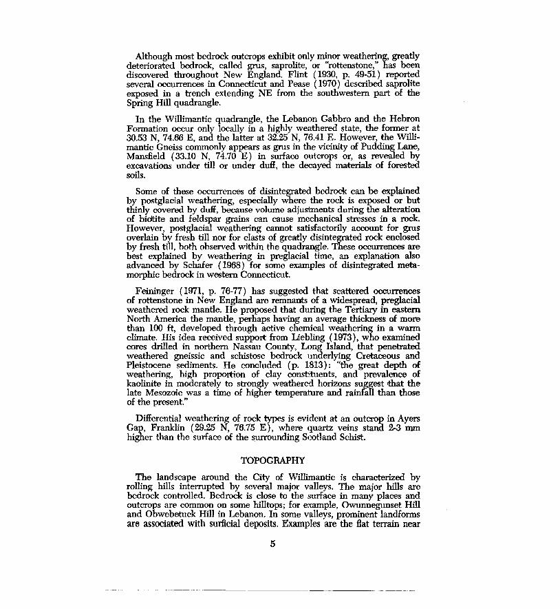
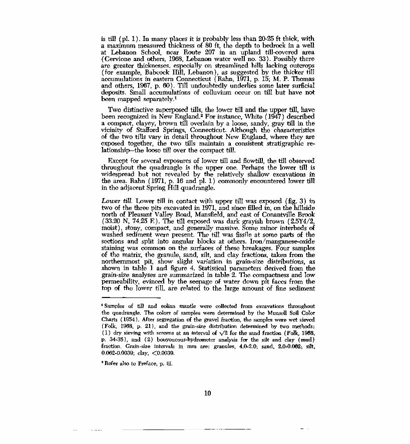
Lower till. Lower till in contact with upper till was exposed (fig. 3) in two of the three pits excavated in 1971, and since filled in, on the hillside north of Pleasant Valley Road, Mansfield, and east of Conantville Brook (33.20 N, 74.25 E). The till exposed was dark grayish brown (2.5Y4/2, moist), stony, compact, and generally massive. Some minor interbeds of washed sediment were present. The till was fissile at some parts of the sections and split into angular blocks at others. Iron/manganes~oxide staining was common on the surfaces of these breakages. Four samples of the matrix, the granule, sand, silt, and clay fractions, taken from the northernmost pit, show slight variation in grain-size distributions, as shown in table 1 and figure 4. Statistical parameters derived from the grain-size analyses are summarized in table 2. The compactness and low permeability, evinced by the seepage of water down pit faces from the top of the lower till, are related to the large amount of fine sediment
1 Samples of till and eolian mantle were collected from excavations throughout the quadrangle. The colors of samples were determined by the Munsell Soil Color Charts ( 1954). After segregation of the gravel fraction, the samples were wet sieved (Folk, 1968, p. 21 ), and the grain-size distribution determined by two methods: ( 1) dry sieving with screens at an interval of v'2 for the sand fraction (Folk, 1968, p. 34-35), and ( 2) bouyoucous-hydrometer analysis for the silt and clay (mud) fraction. Grain-size intervals in mm are: granules, 4.0-2.0; sand, 2.0-0.062; silt, 0.062-0.0039; clay, <0.0039.
• Refer also to Preface, p. iii.
10

in the matrix. The brown color of the till evidently resulted from oxidation; deep cuts into lower till elsewhere in New England have disclosed gray till below the brown.
Mineralogical and stratigraphic aspects of the lower till are treated in subsequent sections.
Fig. 3. Lower till (bottom half of face) formerly exposed in the pit in Mansfield, described in the accompanying text. The material shown in the upper half of the photograph was inaccessible but probably is upper till.
11

+' fii () I. Q)
p...
Q)
> ..... +'
"' ......
~ t.)
99
98
95
90
84
75
50
25
16
10
5
1
0.1 -2 0
2.0 granules I
2
sand
-·-
"'
4 0.062
I
M
Limits of 42 upper-till samples
Limits of 4 lower-till samples
1 flowtill sample
6 8 10 phi 0.0039 mm
silt I clay
Fig. 4. Grain-size distribution curves for till samples from the Willimantic quadrangle.
12

Table 1.-Grain-size distributions of samples of upper till and lower till from the Willimantic quadrangle'
Upper till Lower till
Percentages
Granules 2-15 3-4
Sand 50-81 55-59
Mud 15-47 37-42 Silt 12-36 21-15 Clay 1-14 14-20
Proportion of clay in the mud 6-34 36-47
Ratios
Sand/mud l.1-5.2 1.3-1.6
Silt/clay 2.0-13.7 1.1-1.7
i Based on 42 samples of upper till from 41 sites, and four samples of lower till from one site. Includes two samples representing two facies of upper till from a pit near Oliver Road, Lebanon (29.62 N, 73.70 B). Percentages are rounded to the nearest Integer, and represent the portion of the total sample (except for that of clay in the mud). Wentworth's (1922) grain-size classification Is used.
Upper till. The upper till is stony, loose to moderately compact, and contains interbedded washed sediments (fig. 5). Because of its loose and sandy nature, some exposures could be mistaken for poorly sorted stratified drift. Throughout the quadrangle this till is varied in color, texture, and other physical features.
Samples of fresh, moist upper-till matrix from scattered exposures in the quadrangle have the following colors: olive gray to dark olive gray (5Y4/2-5Y3/2), olive to dark olive (5Y4/3, 4/4, 5/3-5Y3/3, 3/4), olive brown (2.5Y3/4), grayish brown to very dark grayish brown (2.5Y5/2-2/5Y 4/2-2.5Y3/2), and light brownish gray ( 2.5Y6/2). Oxidation has noticeably discolored the uppermost part of most of the till to a yellow or orange hue. The oxidized zone typically extends to a depth of 1.5-3 ft, with a maximum observed thickness of almost 3.5 ft.
A comparison of grain sizes in till samples shows that the lower till contains more fine sediment, especially clay, than does the upper till (fig. 4; tables 1, 2). Although the extent of exposure of the two tills differs significantly in this quadrangle, other studies corroborate the contrasts in till texture reported here ( Pessl and Schafer, 1968).
13

Large excavations in the upper till commonly reveal a textural inconstancy which is not evident in all small holes, with their limited exposures. Within the till are irregular layers of sand and gravel. Also, matrix variations within short distances are reflected in contrasting grainsize distributions. Furthermore, superposed facies of upper till were discovered at two cuts within the quadrangle. Thus, data obtained at any one test hole in the upper till may be a questionable indicaitor of general textural characteristics.
Coarse gravel is common in the upper till. Boulders are prominent on the surface of some till-covered areas; however, others rest on stratified drift. Bedrock foliaition and jointing predetermine the shape of many rock fragments found in the till. For example, till above the Scotland Schist contains numerous tabular clasts, whereas equidimensional clasts are plentiful in till above the Willimantic Gneiss or Lebanon Gabbro.
Stones freed from the upper till are commonly coated, primarily on their upper surfaces, with tightly bound fine sediment, chiefly silt. These "silt caps" were also noted by White (1947, p. 757-758). They probably form as surface water, infiltrating the till, carries fine sediment which
Table 2.-Statistical parameters (averages and ranges) for samples of upper till and lower till from the Willimantic quadrangle'
Parameter
Median
Mean
Sorting
Skewness
Transformed kurtosis
Upper till
.134 mm 2.90 <I>
fine sand fine sand ( 0.250-0.067) ( 2.00-3.90)
0.125 mm 2.99 cI> fine sand fine sand
( 0.269-0.053) ( 1.90-4.25)
2.45 <I> very poorly
sorted ( I. 79-3.18)
0.07 nearly
symmetrical (--0.21-0.32)
0.56 ( 0.48-0.62)
Lower till
.100 mm 3.32 <I> v. fine sd. v. fine sd.
(0.117-0.088) ( 3.10-3.50)
0.054 mm 4.22 <I> coarse silt coarse silt
( 0.064-0.044) ( 3.97-4.50)
3.95 <I> very poorly
sorted (3.77-4.12)
0.42 strongly fine
skewed ( 0.40-0.43)
0.58 ( 0.54-0.61)
1 Statistical parameters defined by Folk (1968, p. 44-48). Both mm values and phi (<J>) values are
presented for the median and mean. Based on 42 samples of upper till from 41 sites and four
samples of lower till from one site. Includes two samples representing two facies of upper till
from a pit near Oliver Road, Lebanon (29.62 N, 73.70 E).
14

accumulates on the upper surfaces of stones in the till. The caps are absent on stones in stratified drift.
Mineralogical aspects of the two till,s. The mineral composition of the ltills was examined because there is a lack of available information on this aspect of southern New England tills. The investigation focused on medium-size sand grains ( 0.25-0.35 mm) in matrix samples from upper and lower till and flowtill. These grains are chiefly light minerals, with quartz predominant (table 3). A few calcite grains, presumably derived from metalimestones in the Tatnic Hill and Hebron formations, were observed but not counted. Garnet and hornblende predominate in the non-opaque heavy-mineral fraction. Other heavy minerals that make up 5 percent or more of some samples are augite, diopside, epidote, kyanite, sillimanite, and staurolite.
The percentages of the minerals counted in the upper-till samples were plotted by location on maps of the underlying bedrock formations. Because the mineral contents of these formations are known, this procedure should reveal any areal variations of till composition related to bedrock types. The only clear correlation is shown by garnet and hornblende. Garnet in the non-opaque heavy-mineral fraction ranges from 23-64 percent in the northern part of the quadrangle but diminishes to much smaller percentages in the southern part. This decrease is explained
Fig. 5. Upper till formerly exposed in a pit in Mansfield, north of Pleasant Valley Road and east of Conantville Brook. Note the boulders and sand lens in the upper central part of the photograph.
15

Table 3.-Mineralogical analyses of 0.2.5-0.35-mm grains from till samples from the Willimantic quadrangle (in percentages) 1
Upper till Lower till Flowtill
Light vs. heavy minerals•
Lights' 94.9 95.5 96 (87-99) (94,97)
Heavies 5.1 4.5 4 ( 1-13) (3,6)
Non-opaque heavy minerals'
Garnet 35.5 28.5 13 (25.5-64) (28,29)
Hornblende 46.0 51.8 73.5 ( 14-93) (49,54.5)
Light minerals •, •
Quartz 82.0 86.2 86.5 ( 50-91) (85.5,87)
Feldspar 20.1 13.8 13.5 (9-49.5) (13,14.5)
1 The average values and the ranges of values (In parentheses) are presented for upper till and lower till. Based on 22 samples of upper till from 20 sites, two samples of lower till from one site, and one sample of ftowtill.
• ISO grains counted per slide. 8 Only quartz and feldspar were counted.
• Percentages of garnet or hornblende in a count of 200 non-opaque heavy minerals per slide.
• 200 grains counted per slide.
by the great influx of hornblende from the Hebron Formation and Lebanon Gabbro. Toward the southern half of the quadrangle, the amount of hornblende increases significantly, to as much as 93 percent of the non-opaque heavy-mineral fraction.
Facies of upper till in Lebanon. In 1969, south of Oliver Road and west of Pease Brook, Lebanon (29.62 N, 73.70 E), a pit was dug about 30 ft westward into a hillside at an elevation of approximately 450 ft; it is now filled in. Two superposed facies of upper till were exposed along the 9-ft-high face at the southern side of the pit. The upper facies narrowed from a maximum thickness of about 4 ft at the eastern end to about 6 in. at the western end. It was nonlayered, loose, very stony
16

(with boulders up to 2 ft long), and pale olive (5Y6/3, dry). A sample of the matrix has the following grain-size distribution (in percent) : granules = 4.2, sand = 80.4, silt = 12.9, and clay = 2.5. A distinct, uneven contact, gradually ascending westerly, separated this upper facies from the lower one.
The lower facies was fissile, slightly compact, stony (but with smaller and fewer clasts than the upper facies), and light gray to light olive gray ( 5Y7 / 2-5Y6/2, dry). Iii: contained lenses and irregular pockets of silt, sand, and gravel. Although the two facies differed in appearance, a sample from the matrix of the lower facies has a grain-size distribution (in percent) similar to that of the upper facies: granules= 4.8, sand= 72.4, silt = 20.2, and clay = 2.5.
The appearance of the lower facies varied in other sides of the pit. Toward the southern end of the western face, where approximately 12 ft of till was exposed vertically, there were alternating thin beds of till and fine sand, commonly deformed and adjusted around stones. At the northern end of the western face (fig. 6) and on the northern face, the till appeared to have a crude layering.
Fig. 6. Crude layering in the lower facies of upper till in a fonner pit in Lebanon, south of Oliver Road and west of Pease Brook. Till mixed with eolian mantle occurs in the upper part of the face.
17

Two till fabrics from the lower facies of the upper till were measured, one at the southern face and the other at the western face (fig. 7). Both fabrics are multimodal, but each has the majority of long-axis trends in the northeastern or southwestern quadrant. If these fabrics are primary and do not include clasts that moved mainly transverse to the ice flow, they imply that the ice was flowing generally SW. However, due to the nature of the till and the setting of the pit, the possibility that they are secondary fabrics cannot be eliminated. Clasts may have become reoriented, as wet till compaoted on the hillside.
Upper till on lower till in Manefield. The largest exposures of till encountered in the Willimantic quadrangle were in the three pits excavated in 1971 north of Pleasant Valley Road, Mansfield, and east of Conantville Brook (33.09 N, 74.15 E). Two pits were dug into the hillside at an elevation of approximately 285 ft, and another at approximately 360 ft. The excavations were later graded.
Upper till revealed in all three pits was quite stony, friable, and grayish. In places it had a crude layering, similar to that observed in the Lebanon pit, and commonly contained irregular and contorted layers of silt, sand, and gravel, plus sporadic small faults. Along a face in the western, lower pit, a boulder of \11/illimantic Gneiss with an exposed area of roughly 12 by 15 ft was suspended in the upper till.
The highest pit on the hillside hest displayed stratigraphic relationships between the lower and upper tills. As excavation progressed northward, new features continually were uncovered along the roughly 200 ft of pit faces. Unfortunately, slumped or unremoved debris masked many portions of the faces, and thus obscured lateral connections between sections. Descriptions of selected sections studied on different dates illustrate the complexity of the stratigraphy within the limited space of this pit.
Section A. At the southern end of the western face, one 7.5-ft high section ( fig. 8) exhibited lower till overlain by upper till of varying charaoter. At the bottom of the face, the lower till was massive, compact, stony (with many rotted clasts of gneiss and schist), dark grayish brown ( 2.5Y 4/2, moist), and broke into blocks commonly showing iron/manganese-oxide staining. Directly overlying the lower till, in sharp contact, was about 2 ft of friable, stony, light-olive-brown ( 2.5Y5/ 4, moist) upper 1till, with conspicuous interbeds of silt and sand. Northward on the face, the till interlensed with sandy gravel. Toward the top of the section was another interval of uppeT till, about 3 ft high, in sharp contact with the underlying units. This till was friable, less stony than the underlying upper till, light grayish brown to light gray ( 2.5Y6/2-2.5Y7 /2, dry), and contained irregular beds of sand.
Grain-size distribution curves for three samples from these till units indicate that the two facies of upper 1till have similar textures but differ markedly from the lower till, which contains more silt and clay.
Section B. This section (fig. 8), approximately 12 ft high, was at the eastern end of the northern face. The lower till, exposed 5-8 ft above the floor, was very compact, stony, dark grayish brown (2.5Y4/2, moist),
18

N
t
A) Western face
Number of Readings
8 4 0 4 8
B) Southern face
-----
s
Fig. 7. Two-dimensional till-fabric diagrams for the lower facies of upper till at the Lebanon pit (see fig. 6). Data is grouped into 10° classes and based on the long axes of 50 elongate clasts. Dashed line indicates the trend of the face.
19

Section A
(south) F.olian mantle and ...._.
till ~ H"
Light-grayish-brown ~ to light- gray upper till ef ~ *
(north)
......-- #" ~
#' ,.,.. .,,.. ~.fl:-;----ll4-~~====~. ~. -:-.--:.:---:--:----:---~~~~.,.--- • . o. 0 •
Lens of gravel - · o . • • Cl 0 C1
0
• .. Light-olive-brown ....._..*'
upper till
Dark-grayish-brown-" lower till ~--~--~-=:;,_-..::::::::=-.._.__. *
Debris at floor of pit
approximately 10 ft
Section B
(west) (east) --Massive grayish- - - :::.. Obscured brown till ~-~ _:,. eC ........_
......... >< >< >< --- -)( )( - '>(
')(. - )C. -
Grayish-brown till )( )( -with many sand and
......_. silt interbeds
')t ;I. )(
.)( )I(. )(.
Grayish-brown till-...._ x >< >< Sharp contact -Dark-grayish-brown ~
.0. lower till
)C,
~Mix zone
+-- approximately 10 ft
Fig. 8. Sections of upper till and lower till in a former pit north of Pleasant Valley Road, Mansfield, and east of Conantville Brook. Section A is a face 7.5 ft high; the face shown in Section B is 12 ft high.
20

and broke into angular chunks. Overlying the lower till, either in sharp contact or, locally, through a mixed zone of fragments of lower till in upper till, was 1-1.5 ft of massive, slightly compact, grayish-brown ( 2.5Y5/2, moist) till speckled with iron/manganese-oxide stains. In the overlying 6 ft, this till became conspicuously interbedded with palegrayish-brown sand and silt. Approximately 3.5 ft above the lower till and within the interbeddec1 sequence, massive beds of till, like those directly above the lower till were interlayered with dark-grayish-brown, fissile till.
Section C. This section (fig. 9) was observed near the middle of the northern face when it was excavated farther northward. The uppermost unit was slightly compaot, silty, stony,. massive, grayish-brown ( 2.5Y5/2, moist) upper till. From -2 ft, 3 in. to -4 ft was a zone of interlayered sands and lower till. The sands were fine-grained, massive, and pale olive (5Y6/3) to light yellowish brown (2.5Y6/4, moist). The thickest sand bed was about 4 in. The lower till was compact, dark grayish brown (2.5Y4/2 moist), and had iron/manganese-oxide stains. The thickest till bed was 9 in. Below the lower till was a 10-in. layer of poorly sorted, sandy, pebble- to cobble-gravel. The lowest unit of the seotion, extending from -4 ft, 10 in. to -6 ft, 6 in. was lower till, which was dark grayish brown ( 2.5Y 4/2, moist), compact, stony, stained with iron/manganese oxide, and broke into blocks.
Section D. This 7-ft section (fig. 9) was seen at the eastern end of a face north of section C. The uppermost unit was a mixture of till and eolian mantle. Upper till occurred from -2 fit, 6 in. to -4 fit, 6 in. It was stony, slightly compact, grayish brown (2.5Y5/2, moist), and contained many lenses and thin layers of light-gray ( 2.5Y7 /2, dry) silt and very fine sand. A layer, 1 ft thick, of lower (?) till lay below the upper till. The lower(?) till was stony, olive brown (2.5Y4/4, moist), compact, and had iron/manganese-oxide stains. The lowermost unit, from -4 ft, 6 in. to - 7 ft, was upper till, like that described above. Locally it was separated from the lower (?) till by a layer of pale-gray sand. About 1 ft below the contact, the upper till contained a lens of sandy pebble- to cobble-gravel. Contacts between the till units were sharp.
Interpretation of the two tills. Because the properties of the two tills in the Willimantic quadrangle axe generally like those of other superposed tills in the vicinity, as reported, for example, by White ( 1947), Pessl ( 1966), Pease ( 1970), and Rahn ( 1971), they can be spatially correlated with these nearby tills. In addition, the Willimantic tills have some of the characteristics of those seen elsewhere in southern New England. However, interpretations of the correlation differ (Drake, 1971). 8
Furthermore, the properties of the two tills have implications concerning their genesis. Interpretations of their manner of deposition differ. As discussed by Schafer and Hartshorn ( 1965, p. 117), Pessl and Schafer ( 1968), and Feininger ( 1971, p. 80), investigators have explained the tills as ( 1) products of two ice advances, ( 2) facies derived from one ice sheet, ( 3) variants caused by differences in local bedrock or degree
• Refer also to Preface, p. iii.
21

Section c (west) (east)
Grayish-brown upper till -#'- ~
~ ~ .. - -Interlayered dark-grayish-~-=-:"'-.--.--.----~-----:------:---:-~ brown lower till ~....:...:......:....:_~.....:--~----------~ - -- - -and .-pale-olive to lightyellowieh-brown sands --....__.... __ ..:...--~--....;...--------~.;._--~
0 .. - - .1111> Sandy gravel --c__ •·o ·• .: ... : · o ·o·o · c,· · o ·
-· - . ·-.. . . 0 . ·-.
Dark-grayish-brown lower till--.. ....A Ao
...,__ approximately 8 rt ---.
Section D
(west) (east)
Eolian mantle and till ~
Grayish-brown upper till ~ * * * containing many interbede~ of sand and silt -'llf'- ~ * ¥-
Grayish-brown compact ~ lower(?) till
Grayish-brown upper till ~
Lene of sandy gravel -------~ . 0 ... •• •• -It"
~
.......__ approximately 8 rt --..
Fig. 9. Sections of upper till and lower till in a former pit north of Pleasant Valley Road, Mansfield, and east of Conantville Brook. Section C is a face 6.5 ft high; the face shown in Section D is 7 ft high.
22
of weathering, and ( 4) weathered rock mantle subsequently flushed by meltwater.
The upper till cannot be regarded a<; a uniform mass because marked lateral and vertical stratigraphic variations were revealed at two locations in the Willimantic quadrangle. These observations amplify the growing but still limited knowledge about facies in the upper till. Facies have been discussed in only a few recent reports, by Pessl and Schafer ( 1968), Pessl ( 1971), Drake ( 1971), and Mulholland ( 1976). Detailed information from locations throughout southern New England are needed in order to understand the stratigraphic complexities.
The facies described at the Lebanon pit closely resemble subdivisions that Pessl ( 1971, p. 100-103) identified at a thick section of upper till in western Connecticut. He differentiated one superglacial and two subglacial facies by a study of sedimentary features and till fabrics. The upper and lower facies at the Lebanon excavation are similar to Pessl's upper and middle units, respeotively.
If the two fabrics measured at the Lebanon pit are indeed primary and are not dominated by clasts that moved transverse to ice flow, they suggest an ice-flow direction from E of N, an inference similar to that made by Pessl, who measured five fabrics and concluded that the flow direction shifted from N, or W of N, in the lower part of the section, to E of N in the upper part.
Pessl ( 1971, p. 103) attributed much significance to the presence of facies, as shown by the following quotation:
The inferred occurrence of both lodgement and ablation facies, or subglacial and superglacial facies, in the upper till supports the two-icesheet explanation of the two-till problem, for it is considered unlikely that a single ice sheet would produce a till in which the subglacial facies would have such different characteristics as are exhibited in the upper and lower tills.
Sharp contacts and mixed-zone contacts (those with chunks of loweT till within upper till) between the two tills, as well as deformed sand layers in the lower till, were revealed in the pits north of Pleasant Valley Road, Mansfield. Pessl and Schafer ( 1968, p. 10-11) cited mixed-zone contaots and truncated upper surfaces of lower till at exposures in western Connecticut as evidence of two ice advances. After deposition, the lower till presumably was overridden and locally eroded and deformed by ice, which then laid down the upper till. Perhaps some till layers that were seemingly out of place at the Mansfield two-till pit, for example, the olive-brown compact till layer shown in section D, fig. 9, were thrust into position.
In summary, although the restricted exposure of lower till in this quadrangle must be taken into account, the features of the upper and lower tills in the Willimantic quadrangle corroborate evidence cited by others, especially by Pessl and Schafer ( 1968), in support of the concept of two ice advances.
23

Flowtill. At scattered localities in New England and elsewhere, a relatively thin layer of till has been found either within or on top of stratified drift. The explanation of these layers by a readvance of ice is generally unsatisfactory. Hartshorn ( 1958) introduced the concept of Howtill to account for them, suggesting that masses of water-saturated till had slid from the ice onto nearby stratified drift, in some cases becoming buried by continued deposition of stratified sediment.
Flowtill was seen aJt two sites in the Willimantic quadrangle, the major occurrence at a pit between Route 207 and Susquetonscut Brook in Lebanon (29.35 N, 75.38 E). The pit is cut into a deposit of icecontact stratified drift of irregular form along the northern valley side. In the middle of the eastern face of the pit, a bed of Howtill, 1.5 ft thick and of undetermined lateral extent, was uncovered. The Howtill is dark olive ( 5Y3/3, moist); a sample of the matrix has the following grain-size distribution in percent (fig. 4): granules = 7, sand = 66, silt = 23, and clay= 4. The color, textural characteristics, and mineralogical properties of the Howtill matrix are similar to those of upper-till samples from surrounding locations.
ICE-CONTACT STRATIFIED DRIFT
The last ice sheet waned northward across New England in a manner known as "stagnation-zone retreat" (Currier, 1941; Koteff, 1974).4 As 1the ice sheet receded across the uneven topography of New England, its thin periphery disintegrated, causing the active ice to be fringed by a narrow zone of stagnant and detached ice. Within this zone, irregular masses of ice occupied valleys, whereas adjacent uplands became ice free. Meltwater Bowed around the ice blocks and through cavities that developed within them, and eventually Bowed beyond the ice. As melting progressed, the shapes of the stagnant-ice masses changed, and the meltwater Bowed along varying routes. In time, sediment accumulated in many ephemeral lakes, ponds, and braided streams.
Because they built up next to glacier ice, deposits of ice-contact stratified drift have some peculiarities. Adjacent beds of greatly contrasting grain size are common, because the meltwaters Bowed around the ice from successively different directions or art fluctuating velocities. Also, Howtill is found within some of the deposits. The ice bounding a sediment eventually melted, causing the original ice-contact slopes and the interior of the deposit to collapse, as shown by disoriented layering, by faults revealed aJt excavations, and by some closed depressions ( "kettle holes") on the surface.
The traditional classification of deposits of ice-contact stratified drift, according to morphology, texture, and stratification, is followed in describing the stratified drift in the Willimantic quadrangle, which consists entirely of ice-contact accumulations. Ice-contact phenomena recognized in this quadrangle are kames, kame terraces, kame plains, icechannel fillings, and glaciolacustrine deposits. Some of these subdivisions, based on shape and sedimentological aspects, are arbitrary because the
' Refer also to Preface, p. iii.
24

accumulations probably fall within a natural continuum (Flint, 1971, p. 208) and many original shapes have been mcxlified by later collapse, erosion, or surrounding deposition.
Karnes. These mounds or short ridges of ice-contact stratified drift are common in the Willimantic quadrangle; some examples are indicated on plate 1. Especially noteworthy is the knoll by Route 2<Y7 and Susquetonscut Brook, Lebanon (29.58 N, 74.92 E), on which Trumbull Cemetery lies. Karnes are conspicuously concentrated near the Shetucket River north and northeast of Williams Crossing.
Excavations inil:o kames that clearly revealed stratification are scarce. Many shovel holes dug into kames reveal poorly sorted sandy gravel, in which clasts commonly are rounded and some are as large as boulder size. Boulders are scattered on the smface of some kames.
Kame terraces. These benchlike landforms were built by deposition from meltwater flowing between a valley side and an ice mass that occupied the central part of the valley. Irregularities along the steep ice-contact slope facing into the valley could be due to protuberances in the former ice margin and to subsequent collapse and erosion. Other types of icecontact deposits commonly occur amid kame terraces.
Kame terraces are well illustrated at the following locations: ( 1) along Route 203, Windham, approximately 1.5-2.5 mi. north of its junction with Route 14, (2) along the valley of Frog Brook, Windham, (3) in the NE-trending valley crossed by·Route 207 in Franklin, at the southeastern comer of the quadrangle, and ( 4) at the western side of Pease Brook, Lebanon, south of Route W7. At these locations, the deposits range from sand to sandy, bouldery gravel. The deposit along Route W3 is, in places, a veneer over bedrock, which crops out locally.
Kame plains. A kame plain is a Hat~topped deposit of stratified drift, whose sides were enil:irely or mostly in contact with ice during the plain's formation. There is a large kame plain at the western edge of the quadrangle, between Tenmile River and Route 6 in Columbia. Layers of silt, sand, and sandy pebble- to boulder-gravel are exposed along the northern side.
Ice-channel fillings. These are elongate deposits of stratified drift laid down by meltwater traveling through passageways in the ice. Although Flint ( 19'28) proposed criteria for differentiating two varieties of icechannel fillings, eskers and crevasse fillings, . they cannot be distinguished in all cases.
The largest ice-channel fillings in the quadrangle, immediately south and west of North Windham center, are aligned with like features in the southern part of the Spring Hill quadrangle (Rahn, 1971, pl. 1). One ridge ( 33.30 N, 76.08 E) extends from an abandoned road north of Route 6, by Mansfield Hollow Dam, S to abandoned railroad embankment.· Sandy gravel, containing clasts several feet long, was exposed in places, and boulders are strewn along the crest south of Route 6. Anoither deposit extends from Jordan Lane ( 32.95 N, 76.11 E; not labeled on pl. 1 ),
25

at an elevation of about 280 ft, E into a bedrock-walled gorge at an elevation of about 400 ft ( 32.83 N, 76.33 E). Boulders are scattered on the surface of the ridge near Jordan Lane and the gorge. Shovel holes near the crest revealed sandy gravel, but a small cut (32.84 N, 76.24 E), at the base of a bifurcation of the ice .. channel filling, displayed interbedded silts and sands. According to Flint's ( 1928) criteria, this deposit is an esker.
Locations of some smaller ice-channel fillings are: ( 1 ) along the valley of Frog Brook, Windham; ( 2) immediately east of South Street, Willimantic, approximately 1,500 ft south of the Willimantic River; ( 3) north of Route 207, Franklin, in the NE-trending valley at the southeastern comer of the quadrangle (29.40 N, 77.05 E); and ( 4) between Potash Brook and Route 203, Windham, about 7,000 ft north of the junction of Tuckie Road and Route 14 ( 32.70 N, 75.88 E). Sandy gravel, locally of boulder size, is a common constituent of these deposits.
Glaciolacustrine deposits. Glaciolacustrine deposits include stratified drift laid down in lakes or ponds in contact with or near glacier ice. Two types are recognized in the Willimantic quadrangle: ( 1) a kame delta, a flattopped deposit formed by progradation of a delta into standing water, and ( 2) lake-bottom deposits, identified by fine-grained texture and horizontal stratification, rather than primarily by morphology. Where exposures were lacking or minimal, a glaciolacustrine environment is inf erred for thick accumulations of fine sand and silt recorded in subsurface data. Exposures of delta foreset bedding are limited in the quadrangle.
A smooth-topped deposit is present at the intersection of South Windham Road and Bush Hill Road ("Rush Hill Road" on the quadrangle map), Windham ( 31.40 N, 75.45 E). Sandy pebble- to bouldergravel overlying sand beds, with minor interlayered silt, and sandy pebble gravel are revealed at the eastern side. The deltaic stratification dips W. At the margins of the exposure, the coarse gravel truncates the underlying layers, evidently as a result of collapse.
Exposures and bore-hole data throughout the Hat-surfaced landform east of the Shetucket River and northwest of the Windham Cemetery on Route 203 demonstrate that interbedded sandy gravel and sand overlie a thick sequence of sand and silt. As illustrated by M. P. Thomas and his associates ( 1967, fig. 37), the maximum thickness of the deposit is over 150 ft. Instructive sections are available in the Hain Brothers, Inc., pits at the southern margin of the landform (31.25 N, 75.85 E).
On the face nearest the railroad is a repetitive sequence, approximately 20 ft high, of ripple-drift cross-laminated fine sands and silts, locally truncated by channels of pebbly sand. Furthermore, a test hole drilled near the face from an elevation of 155 ft penetrated 91 ft of sand; at least 47 ft of it is fine to medium sand ( C. E. Thomas and others, 1967, Willimantic test-hole log no. 3). The cross-laminae indicate that current How had been generally ENE.
Another interesting section is about 75 ft northeast of the previously
26

described face; its base is approximately at the level of the top of that face, about 195 ft in elevation. This section reveals a sequence of rippledrift cross-laminated sands and silts interrupted by a zone of rhythmically bedded clayey silt and clay, lensing gravel, and irregularly layered sand, and contains a boulder that is about 2 x 3 ft.
The uppermost level throughout the pits, above an elevation of approximately 195 ft, contains interbedded sandy pebble- to cobblegravel, gravelly (pebble-to-granule) sand, and sand (fig. 10). In places, •the sand layers display festoon crossbedding. The direction of current How, suggested by crossbeds or imbricated clasts, varied at diHerent faces at this level, but overall ranged from E to S.
The general geometry and stratigraphy of the Plains Road deposit suggest a deltaic environment. The lower part of the deposit probably was built up by meltwater density currents flowing into a glacial lake and introducing much sand and silt, similar to an occurrence described by Jopling and Walker ( 1968, p. 972-973, 983). As the sediment filled and shallowed part of the lake, or as the lake drained, channeling and ponding occurred locally, and led to accumulations of gravel, coarse sand, or clay. The boulder mentioned above probably was rafted on ice
Fig. 10. lnterlayered sand and sandy pebble- to cobble-gravel exposed in the upper level of the Hain Brothers, Inc., pits, northwest of Windham Cemetery (31.25 N, 75.85 E).
27

into the lake. The lacustrine phase evidently was succeeded by the establislunent of braided streams, in which the interbedded sand and gravel was deposited.
Glaciolacustrine sedimentation seems to have been important during the formation of deposits Hanking the Natchaug River. On the eastern side of the river and Willimantic Reservoir, a deposit extends southerly about 2 mi. from Mansfield Hollow Dam to Saint Joseph Cemetery. Bore-hole and well data demonstrate that the depth to bedrock, commonly about 50-100 ft, reaches 191 ft by Route 6 near the Willimantic Country Club ( C.E. Thomas and others, 1967, Willimantic well no. 36). These dimensions indicate that the deposit contains a considerable volume of sediment, not including the portion eroded by the Natchaug River. Numerous exposures (for example, near the Windham Airport) and subsurface logs show that sandy pebble- to cobble-gravel is predominant near the surface, whereas sand and minor silt are more plentiful at depth.
Coarse sediment also overlies fine sediment on the western side of the Natchaug River in the Conantville area of Mansfield. Several small, shallow pits throughout that area expose sandy gravel varying from pebble- to boulder-size in different pits. Deeper cuts made during construction of the Route 1-84 connecting roads between Route 195 and High Street, Mansfield ( 32.70 N, 74.85 E), revealed fine sand and silt.
A pit had been excavated on the western side of a ridge (eradicated by Route 1-84 construction) immediately west of Route 195, approximately 1,900 ft north of the Mansfield/Willimantic boundary ( 32.80 N, 74.97 E). At the top of the pit approximately 10 ft of sandy pebble- to cobble-gravel was channeled into the underlying fine sediment (fig. 11). The contact between the fine sediment and gravel sloped S. The lower 30 ft of this exposure revealed interbedded horizontal layers of silt and clay, displaying soft-sediment deformation in places, and ripple-drift, cross-laminated fine sand and silt, with clay and silt in sinusoidal lamination. The cross-laminae of the fine sand and silt indicated that current How had been generally S 30° W, more or less parallel to the trend of the ridge. As does the deposit northwest of Windham Cemetery, the entire sequence at this pit suggests lacustrine sedimentation followed by Huvial sedimentation.
Undifferentiated sediment. Due to their locations and their lack of distinctive morphology, some tracts of sediment along valley floors next to ice-contact deposits have not been identified as either stratified drift or as a particular sort of postglacial deposit; they probably include both glacial and postglacial accumulations.
Tapered structures. Structures resembling ice-wedge casts were observed in ice-contact stratified drift at four locations in the Willimantic quadrangle: ( 1) at ·the Hain Brothers, Inc., pits northwest of Windham Cemetery (31.25 N, 75.85 E), (2) at exposures a~ the northern side of the Windham Airport, ( 3) in a small pit at the Willimantic Country Club ( 32.56 N, 75.31 E), and ( 4) in a pit between Route 6 and the Natchaug River (northwest of the Kendall Corporation building), Windham ( 32.80 N, 75.28 E).
28

· . . . . 1,· lo• :
Fig. 11. Repetitive sequences of ripple-drift crO'Ss-bedded sand and silt overlain by sandy pebble- to cobble-gravel in a former pit adjacent to Route 195, Mansfield. View is eastward.
Features revealed at all these sites were generally similar; however, the Hain pits had the most extensive exposures ·and the greatest number of tapered structures. In these pits, several vertical, downward-tapering structures were discovered in the upper, coarse-grained part. Along one lengthy face, relatively thin tapers conspicuously cut across the horizontally layered sands and gravels (fig. 12). The pattern of the structures
29

Fig. 12. A tapered structure penetrating interbedded sands and sandy gravels at the Hain Brothers, Inc., pits, Windham. A tree root follows the axis of the structure.
on the topmost horizontal surf ace could not be ascertained. The features typically range from 2-3 ft in width at the top to a foot or less at the bottom. The longest extends downward at least 7 ft. The beds commonly dip toward the sharply defined margins of the structure. The interior of each wedge is composed of sand and gravel, which ordinarily appears as though it had been poured in-that is, clasts are aligned with the trend of the taper. In a few cases, a tree root follows the axis of the taper. At another face in the same locality, a tapered structure extends at least 6 ft through horizontal beds, mainly of sand. The wedge, about 3 ft wide at the top, contains layers that are vertical but are correlative to surrounding horizontal beds.
Features identified as ice-wedge casts have previously been reported from southern New England (Schafer and Hartshorn, 1965, p. 124; Schafer, 1968). If correctly identified, they are significant because they are clues to a climate of the past. They presently form in permafrost, where contraction of the ground allows frost or meltwater to accumulate in cracks and, in time, to build ice wedges.
The genesis of the tapered structures in the Willimantic quadrangle is open to question. Although they possess some characteristics that have been used to recognize ice-wedge casts (Johnsson, 1959), the evidence
30

Fig. 13. Eolian mantle (in which the swallow holes are located) overlying icecontact stratified drift in a pit between Route 207 and Susquetonscut Brook, Lebanon ( 29.35 N, 75.38 E). Note the soil development at the top of the face.
does not entirely rule out other possible origins. Some of the features may have been caused by collapse of sediment over buried blocks of ice. Black (1976, p. 17-18) has proposed that structures revealed in the Hain pits originated by nonthermal tension cracking, possibly as material slid toward the Shetucket River. Flint ( 1971, p. 280) has suggested that tree roots can generate tapered features. Roots are associated with some of the Willimantic quadrangle examples; however, the roots may simply have followed the feature rather than initiated it.
POSTGLACIAL DEPOSITS
Eolian mantle. As the last ice sheet retreated, loose sediment on the land surface was not immediately tied down by vegetation. Wind could readily pick up fine material and deposit it elsewhere. The resulrting eolian mantle evidently was deposited shortly after the ice withdrew; it overlies till and stratified drift (fig. 13) but is absent on nonglacial deposits.
An eolian origin is supported by certain characteristics of the sediment and by its distribution. The mantle is mostly fine sand and silt, with minor amounts of clay, coarse sand, and gravel. The original fine-grained texture presumably has been modi.Bed by downslope transport of debris
31

and by frost heaving. The sediment typically is yellowish brown (2.5Y6/4, IOYR6/4-6/6, dry) and is undoubtedly oxidized. The deposits are spread irregularly throughout the quadrangle without regard to elevation. The accumulations, with a maximum observed thickness of 4. 75 ft, are massive, without bedding.
Because the eolian deposits are distributed discontinuously over. other sediments and are thin, they are not shown on plate 1.
Stream-terrace alluvium. In the Shetucket and Natchaug river valleys, deposits of gravelly sediment, which locally overlie and resemble stratified drift, are mapped (pl. 1) as stream-terrace alluvium. Their surfaces lie at elevations up to about 25 ft higher than adjacent floodplain deposits but are lower than nearby stratified drift. The thickness of the deposits could not be ascertained but is believed to be less than 10 ft. The accumulations are relicts from a postglacial period when the rivers, carrying a decreased load, began to cut downward and, at the same time, move laterally, reworking glacial sediment into deposits now identified as terrace alluvium.
The terrace deposits lie on landforms varying from well defined benches (for example, immediately southwest of the confluence of the Natchaug and Willimantic rivers) to irregular bodies (for example, immediately east of the Natchaug River near Route 6).
Alluvium. Alluvium is the sediment laid down by modern streams in narrow, discontinuous deposits along brooks and as relatively wide floodplains along rivers. Compared to the glacial deposits on which it rests, alluvium is a thin accumulation.
Locally, it resembles its source, stratified drift, which was reworked by modern streams. The texture varies; in SOQ1e places it is gravelly (for example, along the Shetucket River north of Plains Road). In many locations, sand and mud are prevalent (for example, along the Willimantic River near its confluence with Tenmile River).
Swamp deposits. These were sampled sporadically and only at the periphery of large swamps; no coring was undertaken. Peat was found at only one location in the quadrangle, in a level tract between Route 289 and South Street, Willimantic (31.66 N, 74.60 E), not designated by a swamp symbol on the topographic map. The peat was not observed in its undisturbed state; it was being removed during housing construction. Elsewhere, the swamp accumulations are muck, ranging in thickness from a few inches to a few feet where examined. The muck, typically brown, gray, or black, is composed of decayed plant matter mixed with varying proportions of clay, silt, and sand. Because the swamps differ in their settings, the nature of the muck and the underlying material varies. Muck overlies bedrock, till, stratified drift, and alluvium.
Artificial fill. Artificial fill, a manmade deposit, was mapped only where it is at least 5 ft thick and large enough to be shown at the scale of plate 1. Most artificial fill in the quadrangle is composed of till or of sand and gravel from stratified drift. Due to their potential environmental
32

consequences, accumulations that contain a large amount of trash are depicted with a special symbol on plate 1. In an urban area such as downtown Willimantic, the delineation of artificial fill is difficult in some places because the natural surface commonly has been disturbed or covered.
The Mansfield Hollow Dam ( 33.36 N, 75.80 E) is the largest deposit of artificial fill near Willimantic. Riprap adjacent to the gate of the dam, in Mansfield Cenil:er in the Spring Hill quadrangle, was made from local bedrock, and material from local stratified drift was used in the embankments extending away from the gate area, such as that north of Windham Airport. Several occurrences of artificial fill within and adjacent to Ayers Gap and immediately north of Pleasure Hill Road at the southeastern corner of the quadrangle are remnants of a former trolley line connecting Baltic and Willimantic.
GLACIAL AND POSTGLACIAL HISTORY
General glacial chrooology
The reconstruction of the early part of the glacial history of the quadrangle depends on the interpretation of the two-011 problem. As noted in a previous section, some geologists believe that the lower till and the upper till were both derived from a single ice advance; others have favored two advances. Schafer and Hartshorn ( 1965, table 3) and Flinil: ( 1971, p. 580) regard the upper till as late Wisconsin ( W oodfordian) in age, and tentatively assigned the lower till to the early Wisconsin ( Altonian?) .
The late Wisconsin Laurentide ice sheet advanced southward across New England approximately 20,000 years ago. As the ice flowed through the Willimantic quadrangle, it abraded rock surfaces, quarried some hillsides, streamlined others, eroded previously developed regolith, probably deepened valleys oriented more or less N-S, and produced a mantle of ground moraine. If the lower till was deposited by an early Wisconsin advance and glacier ice first moved through southern New England early in the Pleistocene, then 1the landscape was modified by glaciation several times. Nevertheless Flint (1963, p. 683) stated: "except for local deepening of major valleys, glacial erosion appears to have been minor, and little glacial rearrangement of drainage has occurred" throughout Connecticut.
The margin of the Laurentide ice sheet possibly occupied its terminal position across southern New England as late as 15,300 years ago but, according to Borns ( 1973, p. 39-41), retreated north of Rogers Lake on the southeastern coa91: by 14,240+240 years ago. Thus, the ice probably retreated through the Willimantic area about 14,500 years ago, its meltwaters depositing large amounts of stratified drift.
Sequences of stratified drift
The deposits of ice-contact stratified drift in the Willimantic quadrangle have been grouped into morphologic sequences ( Koteff, 197 4),
33

each sequence comprising all stratified drift deposited by meltwater graded to a particular local base level. A sequence is reconstructed by correlating the top surfaces of the presently uneven ice-contact deposits in a profile, declining from an ice-contact head toward the inferred base level.
Multiple sequences result from the unstable environment in the vicinity of the waning ice. The margin of the active ice was shifting northward, and ice masses in the stagnation zone were dwindling. Consequently, meltwater routes and base levels were transitory, new ones developing and old ones being abandoned. In general, sequences are younger toward the north and, in a given portion of a valley, younger sequences occur at lower elevations.
The delineation of sequences in the Willimantic quadrangle is problematical, due to limitations of the investigating procedure and geographic peculiarities. Reconstruction of former surfaces in the sequence is impeded by incomplete or modified records. Segments of a sequence may have collapsed, or been eroded by later meltwater flow or by modem streams, or are masked by subsequent deposition. Discontinuities may exist because meltwater flowed locally over ice or through bedrockor till-lined channels. Only a portion of a long sequence can be encompassed on one quadrangle; mapping of a broader area may be needed for a complete understanding of the history. Meltwater flowed S, toward and through the Shetucket Valley, during much of deglaciation, as indicated by the several major valleys containing ice-contact deposits which J"oin that valley; therefore sequences in the tributaries cannot be treate as independent entities, as some of them join the deposits in the Shetucket Valley.
A calculation of postglacial warping, which would tilt a N-S-trending surface upward toward the north, was not possible from information available in the Willimantic quadrangle alone. However, measurements in the nearby Connecticut Valley (Koteff, 1966) indicate that the change in gradient would probably be only about 4 ft/mi.
Accumulations of stratified drift that have not been incorporated into a sequence are designated on plate 1 as Qx. Most of these are uncorrelated because they are isolated by geography or altitude. Some units in the upland may be the earliest stratified drift, laid down in local cavities when ice still covered the highest hills.
Excellent examples of bedrock that was scoured before the sequences described below were deposited are at elevations above 325 ft in a ravine on the eastern side of Ayers Mountain, Franklin ( 18.98 N, 76.61 E). When ice covered the upland or stood high against it, this ravine served as a conduit for meltwater. Here, incipent to well developed fluted surfaces are conspicuous on the bedrock (Scotland Schist). Some of these scoured areas extend 20 ft or more in the vertical and horizontal directions. At one spot, on the upper surface of a detached block of rock, is a pothole 4 x 3 ft in area and 2 ft deep.
34

SEQUENCES ALONG SUSQUETONSCUT AND PEASE BROOKS
Two valleys, not linked with that of the Shetucket River, where sequences have been mapped, are those of Pease Brook and Susquetonscut Brook in Lebanon. In the latter, the older unit, Qsq1 (pl. 1), occurs near the southern margin of the quadrangle and reaches elevations of approximately 310 ft. No other high-level deposits are identified along the valley to the northwest or south ( Pessl, 1966). Presumably, the meltwater transporting sediment flowed largely across ice, which occupied the valley as unit Qsq1 developed. The deposits labeled Qx (by Hayward's Pond in the valley between Commons Hill and Owunnegunset Hill, and in the valley south of Commons Hill) are at or near 350 ft elevation and are possibly related to unit Qsq1. The lower, more extensive unit in the Susquetonscut Valley is Qsq2, ranging from elevations of approximately 300 ft (northeast of Chappel Road) to approximately 260-270 ft at the southern edge of the quadrangle. This unit is an extension of Qc4, mapped by Pessl ( 1966) in the Fitchville quadrangle. The continuous ice front probably stood near Owunnegunset Hill when unit Qsq2 was deposited.
Along Pease Brook, the older unit, Qpi, extends along the western side of the valley near Oliver Road and Mack Road, reaching an elevation of approximately 420 ft at the northwestern end. The lower, more extensive unit, Qp2, ranges in elevaition from 370-380 ft, north of Oliver Road, to approximately 340 ft near the southern border of the quadrangle. The relationships of these units to deposits along the valley in the Columbia quadrangle, where the surficial geology has not been mapped, and in the Fitchville quadrangle ( Pessl, 1966) are unknown.
SEQUENCES IN THE EASTERN HALF OF THE QUADRANGLE
Sequence Qsh1. Discontinuous, high accumulations south and northeast of Williams Crossing are grouped into the oldest sequence in the Shetucket River valley, Qsh1• The continuous ice front is believed to have stood about 1 mi. north of Williams Crossing, and may have been an extension of the ice margin from which unit Qsq2 developed. The deposits west of Frog Brook and crossed by Jerusalem Road and ·those south of the Shetucket River near Cold Brook, reach elevations of approximately 250-270 ft and probably were deposited by meltwater flowing over and around large ice blocks. The meltwater evidently was graded to an outlet just south of Pleasure Hill School; nearby there are deposits at an elevation of approximately 250-260 ft. An alternative outlet is the bedrock- and till-walled gorge in the southwestern part of ·the Scotland quadrangle, through which the Shetucket River currently passes at an elevation of approximately 100 ft. However, if meltwater of unit Qsh1 did How through the gorge, no high-level deposits were left to record the passage (Dixon and Shaw, 1965). Ice was probably barricading the gorge.
Sequence Qshz. Stratified drift along the valleys of Frog, Ballymahack, and Beaver brooks in Windham, adjacent to unit Qsh1 south of the
35

Shetucket River, and in the valley at the southeastern comer of the quadrangle, have been grouped into one long sequence, Qs~. As shown by evidence presented in this section, when unit Qs~ was developing, the continuous ice front had retreated northward and apparently extended in a NE-SW line across the upland in the northeastern part of the quadrangle. The Pleasure Hill School outlet was abandoned, and meltwater evidently Bowed through the Shetucket River gorge in ·the Scotland quadrangle.
At the northern end of Beaver Brook valley, about 4,000 ft north of Bibbins Pond, the deposits of unit Qsh2 reach an elevation of approximately 390 ft. Although till covers the valley Boor at the northeastern comer of the quadrangle, this branch of the sequence is probably associated with unit Qgb3 at the southwestern comer of the Hampton quadrangle (Dixon and Pessl, 1966), which is at an elevation of about 400 fit.
The head of unit Qgb3 can be inferred by examining the extension of that unit onto the surficial geologic map of the Spring Hill quadrangle (Rahn, 1971, pl. 1), on which sequences are not depicted. There, deposits reaching an elevation of approximately 410 ft occur along Ames Brook, east of Lynch Pond (southeastern comer of the quadrangle), between two till-covered hills. A topographic break separates the 410-ft level from a surface surrounding Lynch Pond at approximately 350-ft elevation. About a mile northward, near Chewink Road, South Chaplin, deposits attaining approximately 450-ft elevation rise above a surface at approximaely 300 ft to the west in the vicinity of South Chaplain Cemetery. Thus, unit 0gb3 apparently headed at an ice front roughly paralleling Routes 6 and 198. The meltwater Bowed southward, as Dixon and Pessl ( 1966) portrayed on the geologic map of the Hampton quadrangle, and continued into the northern end of Beaver Brook valley in the Willimantic quadrangle.
Another part of unit Qs~ includes deposits rising to the head of Ballymahack Brook valley at an elevation of about 380 ft, situated just southeast of a bedrock-walled gorge. One can speculate that the ice front extended from the position in the southeastern comer of the Spring Hill quadrangle to the area of this gorge. As discussed in the section Ice-channel fillings, an esker extends from the vicinity of Route 203 to the northwestern end of the ravine, where the top of the esker is at an elevation of approximately 410 ft. No cross-bedding or other evidence of current direction is evident in the esker, so the direction in which meltwater was travelling cannot be ascertained. However, the fact that the ice sheet was retreating generally from S to N, and that elongaite ice-contact deposits extend from the southern part of the Spring Hill quadrangle to the gorge, at increasing elevations, suggest that meltwater was discharging from an opening in the ice at the northwestern side of the ravine. After Bowing SE through the gorge, the meltwater built the deposits of unit Qs~ in the Ballymahack Brook valley. Conceivably, the high-level deposits labelled Qx at the eastern side of the valley were generated at a previous stage by meltwater from the ice channel.
East of Lake Marie, deposits of unit Qs~ in the valleys of Ballymahack
36

and Beaver brooks merge smoothly at an elevation of approximately 280 ft. The ice-contact features in that region indicate that ice blocks remained in the valley while sediment accumulated. Part of the sequence branches eastward along the course of Beaver Brook, and is continuous with unit Qg in the Scotland quadrangle (Dixon and Shaw, 1965). Unit Og terminates in a valley in the Scotland quadrangle at an elevation slightly above 250 ft but, southward, beyond a till-covered floor about 2,200 ft long, unit Qg2 heads at an elevation of 240 ft. Meltwater evidently flowed from the Willimantic quadrangle into the Scotland quadrangle along the present route of Beaver Brook.
The main portion of sequence Qs~ extends southward along the valley of Frog Brook toward the Shetucket River, where the surface descends to an elevation of approximately 220-210 ft. There is ice-contact stratified drift around Jerusalem Road at the eastern boundary of the Willimantic quadrangle and it continues eastward. This- segment of the sequence apparently drained through the bedrock gorge along the Shetucket River in the Scotland quadrangle, However, stratified drift is not depicted on the geologic map of the Scotland quadrangle (Dixon and Shaw, 1965) at the northern side of the gorge near the western margin of that quadrangle. Thus, the dimensions of the ice-contact deposits along the northern side of the gorge are undetermined.
The continuous ice margin, which extended across the upland in the northeastern part of the Willimantic quadrangle, presumably protruded SE along the Shetucket Valley to the vicinity of South Windham. Ice blocks probably lingered in the valley nol1th and northeast of Williams Crossing. Deposits incorporated into sequence Qs~ developed adjacent to the ice masses; they flank unit Qsh1 and reach elevations of approximately 220-240 ft. For example, Susquehanna Plains slopes from an elevation of approximately 230 ft at the western side to about 210 ft at the eastern end. Near the 230-ft side, several kames and ice-channel fillings parallel Cold Brook. One can envisage meltwater discharging southeastward from a cavity in an ice mass, building up the deposit of Susquehanna Plains as a subaerial fan or delta, and continuing eastward. Like the stratified drift near the eastern edge of the quadrangle at the northern side of the Shetucket River, this area of sequence Qs~ is believed to have drained through the Shetucket River gorge in the Scotland quadrangle at an elevation of 210 ft or slightly less.
Deposits with surfaces at about 180-190 ft in elevation occur in the valley crossed by Route 207 at the southeastern comer of the Willimantic quadrangle, and evidently formed adjacent to ice occupying the center of the valley. These accumulations are included in sequence Qs~, and are contiguous with unit Qv3 in the Norwich quadrangle (Hanshaw and Snyder, 1962), unit Qc4 in the Fitchville quadrangle ( Pessl, 1966), and unit Qg1 in the Scotland quadrangle (Dixon and Shaw, 1965). The surfaces of the deposits can be traced from the Willimantic quadrangle northeastward into the Scotland quadrangle to accumulations reaching elevations of approximately 200-190 ft at the eastern side of the Shetucket River gorge. Thus, meltwater apparently flowed southward along Frog Brook valley and eastward from the vicinity of Susquehanna Plains, traveled through the gorge ait an elevation of nearly 210 ft and,
37

within the Scotland quadrangle, progressed either SE along the route of the Shetucket River, or SW in the valley west of Pautipaug Hill.
Sequence Qsh3• The next sequence, Qsh8 was developing when the con,tinuous ice front stood near the city of Willimantic, from the present Willimantic River northeastward along a line roughly paralleling Route 6. Deposits on the southern side of the river are generally about 10-20 ft higher than those at the northern side ( Qw1 ). South of Windham Airport and east of Catholic Cemetery Road, Windham, is a pronounced topographic break between the higher-level sequence ( Qsh3 ) and the lowerlevel sequence ( Qsl4). Here, the proximity of the former ice margin is further suggested by the occurrence of bouldery stratified drift at elevations of approximately 280-290 ft around three separail:ed till-covered hills. Thus, meltwater derived from that segment of the ice margin along the Willimantic River valley apparently Bowed SE, whereas that in the vicinity of the airport travelled between the till-covered hills and then S, along the route of Potash Brook. The classic ice-contact forms in the vicinity of the brook suggest that fragmented ice lay in the valley while the stratified drift of unit Qsh3 was accumulating.
The landforms in the vicinity of Plains Road, Windham, east of the Shetucket River, merit discussion. Near the eastern side of the river, a deposit included in sequence Qsh3 slopes from approximately 250 ft at the northern end to about 230 ft at the southern end. A depression con'taining a swamp is present at the northwestern side of the deposit and, about 500 ft south of the basin, sandy gravel, including boulder-size clasts reaching 2 ft in length, was exposed in a pit. The boulders suggest that ice was close and, in fact, the swampy depression is interpreted as a kettle hole. Near the eastern end of Plains Road, pronounced scarps separate a surface at approximately 240 ft in elevation (unit Qsha) and one at approximately 220-210 ft (unit Qsh4 ).
A reconstruction that explains these observations follows the deglaciation pattern developed thus far. A protuberance of the continuous ice front, associated with the head of sequence Qsh3, extended SE along the Shetucket Valley, about to the area between Miller Hill and the Willimantic Camp Ground. To the southeast, detached ice probably occupied the valley. Presumably, a mass of ice initially had occupied the space around Plains Road now filled by unit Qsh4, and the scarps separating sequences Qsh3 and Qsh4 originated as ice-contact slopes. The deposit which descends from an elevation of about 250 f.t to one of 230 ft at the western part of Plains Road headed at or near the continuous ice, and probably formed as a subaerial fan or a delta within an opening Hanked by ice.
Stratified drift included in sequence Qsh3 hugs the valley side near South Windham. The melitwater apparently Bowed between the valley wall and the ice masses occupying the valley center and traveled toward the Shetucket River gorge in the Scotland quadrangle. The meltwater probably was graded to a dam of stratified drift and lingering ice fragments situated within or just west of the gorge.
Sequence Qsh4• This unit fonned later than unit Qsh3 and apparently
38

after the sequences in the northwestern corner of the quadrangle ( Qw1 and Qw2 ), described in the next section. The northern end of unit Qsh4 in the Willimantic quadrangle consists of deposits extending from the Mansfield Hollow Dam to Saint Joseph Cemetery. Near the Windham Airport, the top of these deposits is generally at 230-240 ft in elevation, although some knolls exceed 250-260 ft. Deposits with surfaces at elevations of about 200-190 ft comprise the southern end of the sequence in the vicinity of South Windham. The sequence originally spanned the Natchaug and Shetucket valleys; since deglaciation these rivers have eroded portions of it.
When unit Qsh4 was forming, the continuous ice front stood north of the quadrangle; irts exact location is undetermined. No former ice-contact head in the south-central part of the Spring Hill quadrangle is apparent from the morphology of the stratified drift. Near the confluence of the Hope and Natchaug rivers, the tops of the deposits are at approximately 250-260 ft in elevation, and gradually heighten northward through the Fenton and Hope river valleys.
SEQUENCES IN THE NORTHWESTERN PART OF THE QUADRANGLE
Hummocky ice-contact deposits of unit Qw1 head at slightly above 270-ft elevation in Sawmill Brook valley, but decline to approximately 250 ft near Conantville Road, Mansfield. In the vicinity of Eatons Pond and the junction of Mansfield Avenue and Pleasant Valley Road, Mansfield, the stratified drift has a smooth surf ace, largely at an elevation near 250 ft but locally reaching more than 260 ft. These accumulations generally are higher than deposits directly to the east, where the surface of unit Qsh4 is near 225 ft elevation.
In the Willimantic River valley, deposits of unit Qw1 attain elevations of approximately 280 ft at the western edge of the quadrangle and lower ito approximately 260-250 ft, east of the intersection of High Street and Route 6 in the business district of Willimantic. As noted above, the surface of unit Qsh8 on the southern side of the river is generally about 10-20 ft higher than that of unit Qw1• The relatively abrupt decline to an elevation of 240-230 ft near the junction of Jackson Street and Route 6 in downtown Willimantic ( 32.04 N, 74.75 E) possibly resulted from erosion by the Willimantic River in posrtglacial time, when the valley floor was at a higher elevation than it is now.
While sequence Qw1 was forming, the continuous ice front had retreated from its position along the head of unit Qsh8 and, presumably, traversed the upland in Mansfield, near the northern border of the quadrangle. The location of ice-front extension across the Willimantic River is, however, problematical. Sequences proposed in this quadrangle cannot be correlated with those in the adjoining Columbia and South Coventry quadrangles because surficial geologic maps of those quadrangles have not been published. Although the morphology of the stratified drift along the Willimantic River valley can be examined on other maps (C. E. Thomas and others, 1967, pl. B; Vitali, 1971), they do not show obvious evidence of a former ice-contact head near or north of Perkins Comer in Mansfield.
39

A deposit of stratified drift attaining elevations of 380-390 ft is situated at the northwestern comer of the Willimantic quadrangle. This highlevel accumulation extends toward the Willimantic River in the adjoining quadrangles. The northwestern end of the body appears to be at a break between a 350-ft level and a 300-ft level in the South Coventry quadrangle The southeastern end is at •the head of the ravine through which Conantville Brook flows. Evidently, the deposit was built up as meltwater traveled SE through the ravine. The high-level deposit thus seems to be linked with stratified drift at a lower elevation near Pleasant Valley Road, and is included in sequence Qw1•
A surface at approximately 250-ft elevation within the Willimantic River valley, east of its confluence with Hop River, is mapped as sequence Qw2. Detached ice evidently occupied the area of unit Ow2 when sequence Qw1 was developing. Later, when the ice had dwindled, meltwater deposited the sediment of unit Qw2.
Postglacia'l events
As the ice front retreated farther north of ·the Willimantic quadrangle, the landscape began to be modified by postglacial processes. Before a cover of vegetation became widespread, finer sediment was picked up by the wind and redeposited to fonn the eolian mantle. The pattern in which vegetation reestablished in the region is demonstrated by scattered pollen stratigraphies combined with radiocarbon dates (none of them derived from material in the Willimantic quadrangle). Davis (1967) proposed that in southern New England a tundra environment prevailed until approximately 12,000 years ago, an open spruce woodland developed about 10,500 year ago, and then a pine-birch-alder followed by a pine-oak woodland took over.
Nonmeltwater brooks and rivers became reinstituted in the valleys, choked with glacial deposits. Because the rivers carried a decreasing load through postglacial time, they began to cut down. Deposits of stratified drift were incised, as is particularly evident along the N atchaug River. Sporadic stream-terrace deposits also record that period of downcutting.
Also in postglacial time, muck has been accumulating in swamps, some alluvium has been deposited by modem streams, and soil has begun to develop. Human activities currently are creating fill and altering the natural landscape in places.
ECONOMIC GEOLOGY
Bedrock
Rock has been quarried in the past from several bedrock formations in the Willimantic quadrangle; no quarries are presently active. The units exploited are the Willimantic Gneiss, Quinebaug Formation, Canterbury Gneiss, Lebanon Gabbro, and pegmatite (Snyder, 1964; Pearre, 1957; Dale, 1923, p. 402-403).
40

Sand and gravel There are numerous active and abandoned sand-and-gravel pits in
the quadrangle, ranging from small ones exploited only occasionally to commercial operations. Most of these pits have been opened in icecontact stratified drift. Although these deposits, in general, are characterized by textural varia,bility, and their constituents range from silt and fine sand to boulder-size gravel, at some localtions the grain size is fairly uniform over considerable distances. The accumulations of stratified drift commonly consist of sandy gravel near the surface and finer sediment at depth (fig. 11). The sand and gravel is used for aggregate and fill. Vitali ( 1971) has mapped the deposits suitable for aggregate that are available in the Willimantic quadrangle, and Clebnik ( 197 4) has mapped the unconsolidated surface materials.
Several pits have been cut in till. Because the mass of till did not undergo sorting in water, it is not suitable for aggregate, and has been used mainly as fill.
Other deposits No significant deposit of clay was discovered in the quadrangle and
the occurrence of peat seems to be minimal. Some thick deposits of swamp muck and eolian mantle .could possibly be removed and used as garden soil.
Ground water Ground water is derived either from fractures in the bedrock or from
saturated sections of the surficial deposits. The following comments are based largely on the detailed information about water in the Willimantic region reported by C. E. Thomas and others ( 1968) and M. P. Thomas and others ( 1967).
Water can be extracted from the bedrock in most places in the quadrangle. In general, the well yield is relatively small but ordinarily is adequate to supply domestic and farm demands. The magnitude of the yield is affected by certain geologic factors at the well site: topographic situation, type and thickness of overburden, and rock type. Although water obtained from the bedrock generally is of good quality, moderate to excessive concentrations of iron and/ or manganese are common from rusty-weathering muscovite schists, mainly the Scotland Schist in the southeastern comer of the quadrangle.
The amount of water yielded by a well tapping the surficial deposits depends upon the permeability of the material and the thickness of the aquifer. The permeability of a sediment is a function of grain size and the degree of sorting. Because the grains were sorted to some degree during deposition, stratified drift generally is more permeable than till. In many places the till is merely a thin cover on bedrock, whereas much of the stratified drift in the valleys is of considerable thickness. Thus, because of its texture and· setting, stratified drift is more likely to supply large amounts of water than is till. In fact, M. P. Thomas and others
41

( 1967, p. 51) state that stratified drift "is the only aquifer capable of yielding 100 gpm (gallons per minute) or more to individual wells." The quality of water from surficial deposits ordinarily is good.
The physical contrasts between the lower till and the upper till, and the sedimentological variations in the upper till (discussed in the Till sections of this report) are of more than academic interest. As the area around Willimantic is developed, the properties of the tills become significant in land use. For example, a well penetrating the lower till would probably yield less water than one in the upper till, due to the greater compactness and the higher content of fine material in the matrix of the lower till. Water derived from the greatly oxidized portion of the lower till, commonly stained with iron/manganese oxide, can be poor in quality. Furthennore, septic tanks installed in the uplands of the Willimantic quadrangle are likely to be in upper till. A percolation test is ordinarily performed in order to predict the efficiency of the leaching field; however, the textural inconstancy of the upper till, makes the results from any one test hole of questionable significance.
42

REFERENCES
Black, R. F., 1976, Periglacial features indicative of permafrost: ice and soil wedges: Quaternary Research, v. 6, p. 3-26.
-----, 1977, Regional stagnatioo of ice in northeastern Connecticut: an alternative model of deglaciation for part of New England: Geo!. Soc. America Bull., v. 88, p. 1331-1336.
-----, 1979, Reply to discussion of Regional stagnation of ice in northeastern Connecticut: an alternative model of deglaciation for part of New England: Geol. Soc. America Bull., v. 90, pt. I, p. 118-120.
Borns, H. W., Jr. 1973, Late Wisconsin fluctuations of the Laurentide ice sheet in southern and eastern New England in Black, R. F., Goldthwait, }\ P., and Willman, H. B., eds., The Wisconsinan Stage: Geol. Soc. America Mem. 136, p. 37-45.
Cervione, M. A., Jr., Grossman, l.G., and Thomas, C. E., Jr., 1968, Hydrogeologic data for the lower Thames and southeastern coastal river basins, Connecticut: Connecticut Water Resources Bull. 16, 65. p.
Clebnik, S. M., 1974, Unconsolidated materials, Willimantic quadrangle, Connecticut: U.S. GeoL Survey Misc. Field Studies Map MF-586A.
Clebnik, S. M., and Mulholland, J. W., 1979, Discussion of Black, R. F., Regional stagnation of ice in northeastern Connecticut: an alternative model of deglaciation for part of New England: Geol. Soc. America Bull., v. 90, pt. I, p. 117-118.
Currier, L. W., 1941, Disappearance of the last ice sheet in Massachusetts by stagnation-zone retreat (abstract): Geol. Soc. America Bull., v. 52, p. 1895.
Dale, T. N., 1923, The commercial granites of New England: U.S. Geol. Survey Bull. 783, 488 p.
Davis, M. B., 1967, Late-glacial climate in the northern United States: a comparison of New England and the Great Lakes region in Cushing, E. J., and Wright, H. E., Jr., eds., Quaternary paleoecology: New Haven, Conn., Yale Univ. Press, p. 11-44.
Dixon, H. R., and Lundgren, L. W., Jr., 1968, Structure of eastern Connecticut in Zen, E-an, White, W. S., Hadley, J. B., and Thompson, J. B'., Jr., eds., Studies of Appalachian geology: northern and maritime: New York, Interscience, p. 219-229.
Dixon, H. R., and Pessl, Fred, Jr., 1966, Geologic map of the Hampton quadrangle, Windham County, Connecticut: U.S. Geol. Survey. Quad. Map GQ-468.
Dixon, H. R., and Shaw, C. E., Jr., 1965, Geologic map of the Scotland quadrangle, Connecticut: U.S. Geol. Survey Geol. Quad. Map GQ-392.
Drake, L. D., 1971, Evidence for ablation and basal till in east-central New Hampshire in Goldthwait, R. P., ed., Till, a symposium: Columbus, Ohio State Univ. Press, p. 73-91.
Feininger, Tomas, 1971, Chemical weathering and glacial erosion of crystalline rocks and the origin of till: U.S. Geol Survey Prof. Paper 750-C, p. 65-81.
Fenneman, N. M., 1938, Physiography of eastern United States: New York, McGrawHill, 534 p.
43

Flint, R. F., 1928, Eskers and crevasse fillings: Am. Jour. Sci., v. 15, p. 410-416.
-----, 1930, The glacial geology of Connecticut: Connecticut Geol. Nat. History Survey Bull. 47, 234 p.
----, 1963, Altitude, lithology, and the Fall Zone in Connecticut: Jour. Geology, v. 71, p. 683-697.
-----, 1971, Glacial and Quaternary geology: New York, John Wiley and Sons, 892 p.
Folk, R. L., 1968, Petrology of sedimentary rocks: Austin, Texas, Hemphill's Bookstore, 170 p.
Foye, W. G., 1949, The geology of eastern Connecticut: Connecticut Geol. Nat. History Survey Bull. 7 4, 100 p.
Hanshaw, P. M., and Snyder, G. L., 1962, Surfl.cial geology of the Norwich quadrangle, Connecticut: U.S. Geol. Survey Geol. Quad. Map GQ-165.
Hartshorn, J. H., 1958, Flowtill in southeastern Massachusetts: Geol. Soc. America Bull., v. 69, p. 477-481.
Johnsson, Gunnar, 1959, True and false ice-wedges in southern Sweden: Geog. Annaler, v. 41, p. 15-33.
Jopling, A. V., and Walker, R. G., 1968, Morphology and origin of ripple-drift cross-lamination, with examples from the Pleistocene of Massachusetts: Jour. Sed. Petrology, v. 38, p. 971-984.
KoteH, Carl, 1966, P~glacial tilt in southern New England (abstraot): Geol. Soc. America, Program 1966 Ann. Meeting, San Francisco, p. 113-114.
-----, 1974, The morphologic sequence concept and deglaciation of southern New England in Coates, D. R., ed., Glacial geomorphology: State Univ. of N.Y. at Binghamton, Pub. in Geomorphology, p. 121-144.
Liebling, R. S., 1973, Clay minerals of the weathered bedrock underlying coastal New York: Geol. Soc. America Bull., v. 84, p. 1813-1816.
Lougee, R. J., and Vander Pyl, A. W., 1951, Glacial water levels in the ThamesWillimantic River valley: Sci. Monthly, v. 73, p. 275-283.
Meade, D. B., 1976, Contour map of the bedrock surface, Willimantic quadrangle, Connecticut: U.S. Geol. Survey Misc. Field Studies Map MF-586B.
Mulholland, J. W., 1976, Texture of tills, central Massachusetts: Jour. Sed. Petrology, v. 46, p. 778-787.
Munsell Soil Color Charts, 1954: Baltimore, Maryland, Munsell Color Company, Inc.
Newton, R. M., 1978, Stratigraphy and structure of some New England tills: Unpub. Ph.D. dissertation, Amherst, Univ. Massachusetts, 256 p.
-----, 1979, Evidence for a paleosol in New England till and A proposed lithostratigraphy for New England tills: Geol. Soc. America Prog. 1979 N. E. Sect. Mtg., Hershey, Pennsylvania, p. 47.
44

Pearre, N. C., 1957, Mineral deposits and occurrences in Connecticut, exclusive of clay, sand and gravel, and peat: U.S. Geol. Survey Min. Invest. Resource Map MR-7.
Pease, M. H., Jr., 1970, Pleistocene stratigraphy observed in a pipeline trench in east-central Connecticut and its bearing on the two-till problem: U.S. Geol. Survey Prof. Paper 700-D, p. 036-48.
Pessl, Fred, Jr., 1966, Surficial geologic map of the Fitchville quadrangle, New London County, Connecticut: U.S. Geol. Survey Geol. Quad. Map GQ-485.
----, 1971, Till fabrics and till stratigraphy in western Connecticut in Goldthwait, R. P., ed., Till, a symposium: Columbus, Ohio State Univ. Press, p. 92-105.
Pessl, Fred, Jr., and Schafer, J. P., 1968, Two-till problem in Naugatuck-Torrington area, western Connecticut in Guidebook for field trips in Connecticut: New England Intercollegiate Geol. Coof., section B-1, 12 p.
Rahn, P. H., 1971, The surficial geology of the Spring Hill quadrangle: Connecticut Geol. Nat. History Survey Quad. Report 26, 31 p.
Schafer, J. P., 1968, Periglacial features and pre-Wisconsin weathered rock in the Oxford-Waterbury-Thomaston area, western Connecticut in Guidebook for field trips in Connecticut: New England Intercollegiate Geol. Conf., section B-2, 5 p.
Schafer, J. P., and Hartshorn, J. H., 1965, The Quaternary of New England in Wright, H. E., Jr., and Frey, D. G., eds., The Quaternary of the United States: Princeton, New Jersey, Princeton Univ. Press, p. 113-128.
Snyder, G. L., 1964, Bedrock geology oE the Willimantic quadrangle, Connecticut: U.S. Geol. Survey Geol. Quad. Map GQ-335.
---, 1970, Bedrock geologic and magnetic maps of the Marlborough quadrangle, Connecticut: U.S. Geol. Survey Geol. Quad. Map GQ-791.
Thomas, C. E., Jr., Bednar, G. A., Thomas, M. P., and Wilson, W. E., 1967, Hydrogeologic data for the Shetucket River basin, Connecticut: Connecticut Water Resources Bull. 12, 48 p.
Thomas, C. E., Jr., Cervione, M. A., Jr., and Grossman, I. G., 1968, Water resources inventory of Connecticut, part 3: lower Thames and southeastern coastal river basins: Connecticut Water Resources Bull. 15, 105. p.
Thomas, M. P., Bednar, G. A., Thomas, C. E., Jr., and Wilson, W. E., 1967, Water resources inventory of Connecticut, part 2: Shetucket River basin: Connecticut Water Resources Bull. 11, 96 p.
Thornbury, W. D., 1965, Regional gemnorphology of the United States: New York, John Wiley and Sons, 609 p.
Vitali, Rino, 1971, Construction-aggregate availability study, summary report: Highway District II: Connecticut Bur. Highways, Soils and Foundation Div., 48 p.
White, S. E., 1947, Two tills and the development of glacial drainage in the vicinity of Stafford Springs, Connecticut: Am. Jour. Sci., v. 245, p. 754-778.
45