Embed Size (px)
Citation preview

STATE OF WASHINGTON DEPARTMENT OF NATURAL RESOURCES
BRIAN J. BOYLE, Commissioner of Public Lands ART STEARNS, Department Supervisor
DIVISION OF GEOLOGY AND EARTH RESOURCES Raymond Lasmanis, State Geologist
GEOLOGY AND COAL POTENTIAL OF THE TANEUM-MANASTASH AREA,
KITTITAS COUNTY, WASHINGTON
by
Dennis G. Lewellen Charles W. Walker Curtis D. Cushman
Washington Department of Natural Resources Division of Geology and Earth Resources
Olympia, Washington 98504
Open-File Report 83-9
April 1985


TABLE OF CONTENTS
Page
Abstract 1
Introduction 2
Purpose and General Description 2
Regional Geological Setting 5
Previous Work 5
Local Geologic Units 7
Easton Schist 7
Amphibolite 8
Quartz Diorite Gneiss 9
Serpentinites 10
Tectonic Complex 10
Manastash Formation 10
Taneum Andesite 13
Basalt of Frost Mountain 14
Grande Ronde Formation and Interbeds 15
Diabase and Basalt Intrusives 16
Correlation of the Tertiary Units in the Study Area to the Cle Elum-Roslyn Area 16
Structure of the Manastash
General Statement
Folds
Faults
Petrology of the Manastash
General Statement
Sandstone Petrography
Formation
Formation
-i-
18
18
19
20
22
22
24

TABLE OF CONTENTS - Continued
Petrogenesis of the Sandstone
Sandstone Provenance
Depositional Environment
Previous Coal Mining and Related Activity
Manastash Creek Area
Upper Tanuem Area
Lower Taneum Area
Geologic History
Conclusion
References Cited
Appendix A: Point-count data for the Manastash Formation.
Appendix B: Description of sedimentary section of the Manastash Formation, upper Taneum Creek.
Appendix C: Coal data.
Appendix D: Sample descriptions.
-ii-
Page
28
28
33
37
37
38
38
40
45
47
51
56
64
76

ILLUSTRATIONS Page
Figure 1. Map of the State of Washington showing the location of the map area. 4
Figure 2. Generalized stratigraphic column of the study area. 11
Figure 3. Generalized correlation of stratigraphic units in the study area and the Cle Elum-Roslyn area to the north. 17
Figure 4. Sandstone classification ternary diagram. 23
Figure 5. Triangular diagram for the QFL detrital modes of the Manastash Formation. 27
Figure 6. Framework modes for the Manastash Formation. 32
Figure 7. Flow diagram showing the most likely facies transitions from the difference matrix. 36
Figure 8. Stratigraphic sections: Taneum-Manastash area.
Figure 9. Legend for Stratigraphic Sections.(fig. 8).
Plate 1. Sedimentary Body and Sample Location Map, Taneum and Manastash Creek Area, Kittitas County, Washington
Plate 2. Geologic Map of Part of the Taneum and Manastash Creek Area, Kittitas County, Washington
-iii-
65
66
In Pocket
In Pocket

TABLES
Tab1e 1. Pa1eocurrent data gathered from crossbedded rocks in the Manastash Formation.
Tab1e 2. Markov chain ana1ysis of facies transitions probabi1ities for part of the upper Taneum area, Manastash Formation.
-iv-
Page
29
35

ABSTRACT
The Manastash Formation is a lower Eocene formation unconformably
overlying a pre-Tertiary metamorphic complex. The formation has a minimum
thickness of approximately 1000 meters. Sandstone is the dominant litho
logy, but also present are siltstones, mudstones, pebble conglomerates, and
thin beds of coal. Definite compositional differences are seen in sandstones
from different areas. Sandstones in the northern part of the study area
are commonly finer-grained and more feldspar-rich than those in the
southern area of study, which are more quartzose and lithic-rich.
The formation was deposited in a non-marine fluvial/lacustrine environ
ment. Paleocurrent data from crossbeds indicate a southerly paleoslope.
Detrital grains in the sandstones were derived from a mixed provenance
of granitic, gneissic, schistose, metasedimentary, sedimentary, and lesser
volcanic rocks.
Major folds and faults have a northwest trend. Faulting appears
generally to be high-angle dip-slip.
Fold axial planes are vertical with symmetrical and planar limbs. The
folds are open and commonly plunge gently to the southeast. There is local
plunge to the northwest.
The Manastash Formation is overlain unconformably by the Taneum
Andesite. Dips taken on fold limbs readily demonstrate the greater degree
of deformation of the Manastash Formation.
Thin beds of coal are locally abundant throughout the Manastash
Formation, but are more common low in the section. Small scale mining of
several of these coal seams took place intermittently throughout the first
forty years of this century. One hundred thousand tons of coal are
believed to have been mined from the Wilson mine on lower Taneum Creek
-1-

before 1914. Nonetheless, structural deformation and seam discontinuity,
numerous igneous intrusions, and poor quality make these coals unattractive
for mining. However, coal potential has never been fully tested in the
main outcrop of Manastash Formation, and the coals may be a source of
natural gas.
-2-
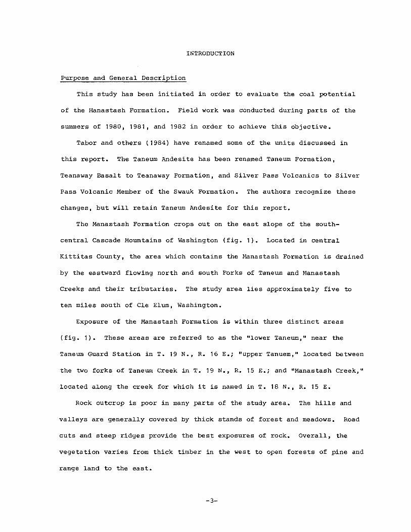
INTRODUCTION
Purpose and General Description
This study has been initiated in order to evaluate the coal potential
of the Manastash Formation. Field work was conducted during parts of the
summers of 1980, 1981, and 1982 in order to achieve this objective.
Tabor and others (1984) have renamed some of the units discussed in
this report. The Taneum Andesite has been renamed Taneum Formation,
Teanaway Basalt to Teanaway Formation, and Silver Pass Volcanics to Silver
Pass Volcanic Member of the Swauk Formation. The authors recognize these
changes, but will retain Taneum Andesite for this report.
The Manastash Formation crops out on the east slope of the south
central Cascade Mountains of Washington (fig. 1). Located in central
Kittitas County, the area which contains the Manastash Formation is drained
by the eastward flowing north and south Forks of Taneum and Manastash
Creeks and their tributaries. The study area lies approximately five to
ten miles south of Cle Elum, Washington.
Exposure of the Manastash Formation is within three distinct areas
(fig. 1). These areas are referred to as the "lower Taneum," near the
Taneum Guard Station in T. 19 N., R. 16 E.; "upper Tanuem," located between
the two forks of Taneum Creek in T. 19 N., R. 15 E.; and "Manastash Creek,"
located along the creek for which it is named in T. 18 N., R. 15 E.
Rock outcrop is poor in many parts of the study area. The hills and
valleys are generally covered by thick stands of forest and meadows. Road
cuts and steep ridges provide the best exposures of rock. Overall, the
vegetation varies from thick timber in the west to open forests of pine and
range land to the east.
-3-

,240 iz:so 122° 121• ,,o• 119• .... 117° ... . .. H A T C 0
PENO
0 K A N 0 G A N OREILLE
K A G T F E R R Y
STEVENS
... ... SNOHOMISH
L A
E F F SPOKANE• 0 0 U
L I N C 0 L N SPOKANE
G RAY S
G R A N T
I T A s .,. .,. I R C E A 0 A M s
,I>, WHITMAN
I BURG THURSTON
LOCATION OF MAP AREA FRANKLIN L E w s
y A K I M A
COWLITZ WALLA ASOTIN
... SKAMANIA BENTON ... K L I C K I T A T
10 0 40 Miles 1----11--------
16 0 65 Km
•24 ----------,2!11 - --- .- -------~--- --------- 12i"'" !ZffW ---------- ·---· ugo - · -- -- 1110 ---------~;70
Figure 1. - Map of the State of Washington showing the location of the map area.

REGIONAL GEOLOGICAL SETTING
The study area lies on the boundary of the Cascade Mountains and the
Columbia Plateau physiographic provinces. As such, an extremely diverse
assemblage of rocks is located within the study area.
Basalt flows of the Yakima Basalt Subgroup are found in the southern
and eastern parts of the study area. The basalt flows form a thick pile of
volcanic rocks belived to have originated from feeder dikes located in
northeastern Oregon and southeastern Washington. Interbedded in the basalt
flows are volcaniclastic rocks of the Ellensburg Formation.
Extensive middle Tertiary volcanic rocks are located several kilometers
to the west of the study area. These volcanic rocks make up the bulk of
the southern Cascade Mountains of Washington. Formations such as the
Naches, Ohanapecosh, Stevens Ridge, and Fifes Peak, to name a few, charac
terize the rock units of the south Cascades. Dominating the scene are the
young composite volcanoes of the Cascade Mountains. Mt. Rainier, Glacier
Peak, and Mt. Adams can be readily seen on a clear day from the higher
localities in the study area.
PREVIOUS WORK
The first geological reconnaissance into the area was undertaken in the
early 1890's by Russel (1893). His various journeys up the ridges leading
toward the Cascade crest from Kittitas Valley skirted the center of the
study area, and he did not see the Eocene section. In the early years of
this century the first detailed geology was undertaken by Smith (1903,
1903a, 1904) and by Smith and Calkins (1906). At this time most of the
rock units in the area were first described and named.
In 1914 Saunders published his exemplary study of the smaller coal
fields of Kittitas County, which included the small mines and prospects
-5-

located along both Taneum and Manastash Creeks. A similar evaluation by
Beikman and others (1961) of the coal fields of Washington again included a
chapter on the Taneum/Manastash area.
In the 1950s and 1960s, Stout mapped the area and produced several
papers (1957, 1959, 1961, 1964). Beginning in 1959, Stout abandoned
Smith's formation nomenclature and included the Manastash Formation in the
Naches Formation and the Taneum Andesite with the Keechelus Andesitic
Series (1964, p. 329). This interpretation has not been adopted by sub
sequent workers.
More recent work has been done by Misch (1966), Goetsch (1978),
Ashleman (1979), Frizzell (1979), Waitt (1979), CUshman (1980), Walker
(1980), Lewellen (1983), Ort and others (1983), and Tabor and others
1982, 1984). Tabor and others in 1977 first described the Basalt of Frost
Mountain as a separate rock unit. Engels and others (1976) have dated
volcanics and Newman (1975, 1977) has done palynologic age dating in the
Manastash and nearby Eocene sedimentary bodies. This work has demonstrated
the correlation of the Manastash Formation with the nearby Swauk Formation.
Aeromagnetic data from Weston Geophysical Research (1978) have been very
useful in showing large structural features.
The Manastash Formation unconformably overlies the southern end of a
discontinous belt of Pre-Tertiary metamorphic rocks that extend into
Canada. Located in the North Cascades and Okanogan Highlands, these
Pre-Tertiary rocks are 1itho1ogica11y very diverse and include a variety of
igneous, metamorphic, and sedimentary rocks.
The Manastash Formation is part of a discontinous group of arkosic
sandstone bodies, which extend northward to the Canadian border. Other
arkosic units in the Cascade Mountains are the Chumstick, Roslyn, Swauk,
-6-

Wenatchee, and Chuckanut Formations, and parts of the Naches Formation.
The units are Eocene to Oligocene in age and represent a period of con
tinental elastic sedimentary deposition in the region.
LOCAL GEOLOGIC UNITS
Easton Schist
The oldest unit in the study area is the Easton Schist. It is composed
of low grade metamorphic rocks and was first mapped and named by Smith
(1903, p. 14). The Easton Schist as defined by Smith is composed of
graphitic phyllite, greenschist, blue amphibole schist, and some gneiss and
amphibolite on South Cle Elum Ridge. Stout (1964, p. 322) restricted the
Easton Schist to the low grade metamorphic rocks.
The Easton Schist located in the study area occupies two belts, a
northern belt located in the north-central part of the study area and a
smaller belt in the south-central part of the .study area. The southern
belt of Easton Schist is poorly exposed and has been mapped primarily from
float and a few outcrops of greenschist. The dominant rocks appear to be
greenschist and phyllite. The phyllite was only seen as float. The exact
nature of the contact between the Manastash Formation and the southern belt
of the Easton Schist is uncertain.
The northern belt is composed of graphitic phyllite, micaceous schist,
greenschist, minor glaucophane schist, and amphibolite. The amphibolite is
a fine-grained rock located in parts of sections 18 and 19, T. 19 N., R. 15
E. and part of section 13, T. 19 N., R. 14 E. The amphibolite is located
in a belt that borders a large outcrop of quartz diorite gneiss in sections
13 and 24, T. 19 N., R. 14 E. Intermixed with the amphibolite are lenses
of epidote greenschist. The greenschist does not appear to be tectonically
-7-

implanted. Either retrograde metamorphism has locally affected the rocks
or metamorphism to the amphibolite facies was incomplete. Overall, the
phyllite and schist were probably derived from marine sediments and basalt.
The northern belt of the Easton Schist is in fault contact with the
Manastash Formation and the Taneum Andesite on the eastern side of the
Upper Taneum area. Other parts of the Manastash Formation in the Upper
Taneum area appear to unconformably overlie the Easton Schist.
The age of the Easton Schist is uncertain, but a Pre-Tertiary age has
usually been assigned to this unit (Smith, 1903). The Shuksan Greenschist
and Darrington Phyllite have been correlated with the Easton Schist
(Ashleman, 1979, p. 16). K-Ar and Rb-Sr dates from the Shuksan Greenschist
and Darrington Phyllite range from 95-220 million years for the age of
metamorphism. A tentative average age of 125 million years is given for
the age of metamorphism (Ashleman, 1979, p. 17).
Amphibolite
Rocks of this unit are dark green and well foliated. The major mineral
components are hornblende, plagioclase, epidote, and quartz. The amphibo
lite is located on the west side of the Taneum Lake Fault in the south
western part of the study area. Possible intrusions of dioritic rocks,
which have been subsequently sheared and recrystallized to diorite gneiss
are also in the amphibolite unit.
These rocks were originally mapped as part of the Hawkins Formation by
Smith and Calkins (1906). Stout (1959, p. 9-18) and Goetsch (1978, p.
7-18) have mapped these rocks as a separate unit of uncertain stratigraphic
position. This unit is exposed west of the Taneum Lake Fault, thus its
stratigraphic position relative to the Easton Schist is uncertain. If it
-8-

is part of the Hawkins Formation as origina11y mapped by Smith and Ca1kins
(1906), it wou1d be younger than the Easton Schist.
A nearby unit of quartz diorite from Quartz Mountain has a radiometric
age of 157 mi11ion years, (Goetsch, 1978, p. 40). If the diorite gneiss
1ocated in the amphibo1ite is corre1ative with the quartz diorite that has
been dated, a minimum Late Jurassic age for the amphibo1ite wou1d be
estab1ished.
Quartz Diorite Gneiss
The quartz diorite gneiss is 1ocated in the northwest corner of the
study area, in parts of section 13 and 24, T. 19 N., R. 14 E. and part of
section 19, T. 19 N., R. 15 E. It has a1so been 1ocated in f1oat in the
NWV4, section 29, T. 19 N., R. 16 E. This unit was first mapped by Smith
and Ca1kins (1906, p. 4) and 1ater by Stout (1959, p. 33-36). The quartz
diorite gneiss appears to have intruded the Easton Schist prior to meta
morphism of the two units. Sma11 dikes and xeno1iths of amphibo1ite or
greenschist in the gneiss can be identified near the contact between the
two units. The effects of therma1 metamorphism may in part account for the
medium-grade amphibo1ite facies rocks a1ong the contact between the Easton
Schist and the quartz diorite gneiss. Smith and Ca1kins (1906, p. 4)
conc1uded that the quartz diorite gneiss intruded the Easton Schist. Stout
(1959, p. 39-40) was unsure of these conc1usions and thought that synkine
matic metamorphism may have caused the present texture and composition of
the rocks. Nonethe1ess, if these interpretations are correct, the quartz
diorite gneiss wou1d be younger than the Easton Schist. The metamorphic
character of the unit suggests a Pre-Tertiary age for the quartz diorite
gneiss.
-9-

The Eocene Manastash Formation and the Taneum Andesite are mapped along
the southern contact of this unit. Exposures along this contact are almost
nonexistent, and the contact was not seen in outcrop.
Serpentinites
Serpentinites are mapped along the trace of the Taneum Lake Fault and
along another fault in the SEV4, section 18, T. 19 N., R. 15 E. The rocks
are composed predominantly of antigorite and opaque minerals. Smith and
Calkins (1906, p. 3) correlated these rocks with the ultramafic rocks of
the Ingalls Tectonic Complex. The generally accepted age for the Ingalls
Complex is Late Jurassic (Tabor and others, 1982, p. 5). This correlation
is very tentative, but a Pre-Tertiary age for this unit does seem likely.
Tectonic Complex
A tectonic complex of diverse lithologic composition is mapped along
most of the west side of the Taneum Lake Fault. Ultramafic and metamorphic
rocks of diverse composition and grade have been tectonically juxtaposed in
this area. Pre-Tertiary units, such as the Easton Schist, Lookout Mountain
unit of Stout (1959), and nearby amphibolites have been postulated as being
tectonic blocks in this unit by Stout (1959) and Goetsch (1978). Other
tectonic blocks in this unit are of unknown parentage. Based upon the com
position of this unit and its relationship to the Pre-Tertiary metamorphic
rocks to the west, Stout (1959, p. 61) has suggested that this unit is a
Pre-Tertiary tectonic-shear complex.
Manastash Formation
The Manastash Formation was originally named by Smith (1904, p. 7) for
the sandstone and finer-grained sedimentary rocks, which are exposed in the
-10-

Grande Ronde Formation
Basalt of Frost Mountain
Taneum Andesite ·
Manastash Formation
Basement rocks (Easton Schist, quartz diorite gneiss)
14-16.5 m.y. basalt flows
47 m.y. basalt flows
52 m.y. intermediate flows and volcaniclastic rocks
Arkosic sandstone
Pre-Tertiary
Intrusive dikes and sills
Figure 2. - Generalized stratigraphic column of the study area. The ages along the right side of the column are in millions of years (m.y.) before present.
-11-

headwaters of Manastash and Taneum Creeks. This unit is composed of arko
sic sandstone, siltstone, mudstone, shale, conglomerate, and coal. The
Manastash Formation, as calculated from the geologic map, is a minimum of
3,117 ft (950 meters) thick in the Upper Taneum area. The base of this
section is in fault contact with the Easton Schist, while the top of the
section is unconformably overlain by the Taneum Andesite. Other areas do
not provide sufficient exposures to permit an accurate estimate of the for
mation's thickness.
The Manastash Formation is the lowest Tertiary unit in the area and
nonconformably overlies the Easton Schist and quartz diorite gneiss (fig.
2). Fossil leaves collected from the Manastash Formation indicate an
Eocene to early Oligocene age in studies by Knowlton (in Smith, 1904, p.
7). Studies by Chaney (in Stout, 1957, p. 39-42) of plant fossils
collected from the Manastash Formation indicate the existenc~ of subtropi
cal, broadleafed, evergreen trees during deposition. This subtropical cli
mate is thought to have existed in Washington during the Paleocene and
Eocene Epochs. Newman (1977, p. 1113) suggests that palynomorph data
collected from the Manastash Formation along Taneum Creek may be equivalent
to the lower Eocene Swauk Formation. Newman included the Manastash
Formation into the Naches Formation following Stout (1964). The original
nomenclature (i.e. Manastash Formation) has subsequently been readopted.
Two fission-track dates of zircons from rhyolite ash-flow tuffs in the
overlying Taneum Andesite have ages of 51.8 and 45.3 million years (Tabor
and others, 1982, p. 10). These fission-track ages indicate an early
Eocene age for the Manastash Formation.
-12-

Taneum Andesite
The Taneum Andesite was originally named by Smith (1904, p. 7) for a
sequence of andesitic rocks exposed along the North and South Forks of
Taneum Creek and in the Frost Mountain area. A recent proposal has been
made to formally rename the Taneum Andesite the Taneum Formation (Tabor and
others, 1984, p. 26).
This unit is composed mostly of volcaniclastic rocks interlayered with
lava flow rocks. The flow rocks are basalt, andesite, and dacite. The
coarse volcaniclastic rocks are generally composed of andesitic and dacitic
clasts. Rhyolite tuffs, volcanic breccias, mudflows, and minor coal
bearing sedimentary units occur as well.
The Taneum Andesite is interpreted to be part of an eroded composite
volcano. Volcanic breccias and mudflows denote a possible vent on Taneum
Ridge in sections 29 and 30, T. 19 N., R. 15 E. The interlayered volcanic
flows and volcaniclastic rocks and the variable rock compositions are
characteristic of a composite volcano.
Basalt flows and minor sedimentary units characterize what has been
mapped as the Taneum Andesite in the area south of Mole Mountain, west of
Frost Mountain, and east of the Taneum Lake Fault. An outcrop of sedimen
tary rocks dipping about 75 degrees to the northwest, in the NWV4, section
7, T. 18 N., R. 15 E. contains over 6 ft (two meters) of coal in two seams.
Another sedimentary unit about 330 ft (100 meters) east of the top of hill
5827 in section 7, T. 18 N., R. 15 E. (see plate 2) is interbedded in
basalt flows. This unit consists of claystone, carbonaceous shale, and
siltstone, dipping 68 degrees to the southwest.
The bedding of the Taneum Andesite generally dips between 20 and 30
degrees, except near the Taneum Lake Fault, where measurements of bedding
-13-

attitudes are nearly vertical. Generally, the deformation of the Taneum
Andesite appears to be considerably less than that of the Manastash
Formation. The average dip of a fold limb in the Manastash Formation is
approximately 40 degrees. An angular unconformity of 10 to 15 degrees bet
ween the Taneum Andesite and the Manastash Formation is clearly seen in the
swV4NWV4 section 33, T. 19 N., R. 15 E. and in section 15, T. 18 N., R. 15 E.
A fission-track age of 51.8 million years (Tabor and others, 1982} from
ash-flow tuffs in the Taneum Andesite document an early Eocene age for this
unit. Another fission-track age of 46.2 million years is probably too
young for the Taneum Andesite according to Tabor and others (1982, table 1).
Basalt of Frost Mountain
Both Smith (1904} and Stout (1964, pl. 1) mapped this unit as Columbia
River Basalt. The unit is composed of a series of basalt flows restricted
to the Frost Mountain and the manner in which it outcrops appear identical
to the nearby flows of the Columbia River Basalt Group. Compositionally,
the basalt of Frost Mountain is similiar to the nearby basalt flows of the
Columbia River Basalt Group except that olivine is present in many samples
from the basalt of Frost Mountain. Olivine is rare in basalt samples from
the nearby flows of the Columbia River Basalt Group (Stout, 1957, p. 91).
Recent whole-rock potassium-argon dates from the basalt of Frost
Mountain range from 47 million years to 33.2 million years (Tabor and
others, 1982, p. 11) with considerable possible error. Therefore, the
basalt of Frost Mountain is an older unit than the Columbia River Basalt
Group.
The contact between the Tanuem Andesite and the basalt of Frost
Mountain is apparently an angular unconformity. This statement is based
-14-

upon the fact that bedding attitudes from the Taneum Andesite near Frost
Mountain have dips ranging from 60 to 75 degrees, while the basalt flows on
Frost Mountain are nearly horizontal.
Grande Ronde Formation and Interbeds
Waitt (1979, p. 1) concluded that the Columbia River Basalt flows
located on the western periphery of Kittitas Valley are part of the Grande
Ronde Formation, which is stratigraphically the lowest unit in the Yakima
Basalt Subgroup. Several volcaniclastic beds of the Ellensburg Formation
are interbedded in the Grande Ronde flows. Together these formations are
the most widespread rocks in the study area.
The Grande Ronde and Ellensburg Formations unconformably overlie many
of the major units in the study area, such as the Easton Schist, Manastash
Formation, and the Tanuem Andesite. An erosional surface of moderate
relief must have been covered by the basalt flows. The Lower Taneum area
is a good example of this ancient erosional surface. Scattered outcrops of
the Manastash Formation and the Easton Schist are unexpectedly found next
to basalt and volcaniclastic rocks. An excellent example can be seen in
the southern half of section 19, T. 19 N., R. 16 E.
The Grande Ronde Formation is dated as late early Miocene. Potassium
argon ages have been measured ranging from 16.5 to 14 million years by
(Baksi and Watkins, 1973; Watkins and Baksi, 1974).
The volcaniclastic rocks of the Ellensburg Formation are generally
composed of light colored, poorly indurated volcanic sandstone, siltstone,
conglomerate, and minor diatomite. The clasts are composed of basaltic and
andesitic to dacitic rocks, pumice, and tuffaeous material. The beds are
generally four meters or less in thickness in the study area.
-15-

Structurally, they are nearly horizontal or dip gently to the east. The
best exposures occur along South Cle Elum Ridge in the lower Taneum area.
Diabase and Basalt Intrusives
A number of northwest-trending dikes and sills of basalt composition
have been mapped in the Manastash Formation and the Taneum Andesite. Only
the larger intrusions are shown on the geologic map.
These intrusive may be in part related to the basalt of Frost Mountain.
Both units follow the same regional trend and at least one of the intrusives
is an olivine basalt (SEV4 section 15, T. 18 N., R. 15 E.). Olivine-rich
diabase has been mapped in the Mt. Clifty area to the west of the study
area. According to Stout (1961, p. 348-349) two intrusions near Mt. Clifty
can be traced almost continuously to basalt flows of the Naches Formation.
This would make the diabase and basalt intrusives in the study area late
Eocene to early Oligocene in age, if they are correlative with the Naches
Formation.
It is improbable that any of these intrusive rocks represent feeder
sources of the Grande Ronde Formation. Flow directions measured from
foreset-bedded lava deltas of various basalt flows show a consistent west
to northwest movement away from the vent source farther to the east or
southeast of the study area (Tabor and others, 1982, p. 13). The best
estimate is that these diabase and basalt intrusives were emplaced sometime
during the late Eocene to earliest Miocene and may represent more than one
intrusive event.
Correlation of the Tertiary Units in the Study Area
to the Cle Elum-Roslyn Area
Correlation of the Tertiary units in the study area with other units in
central Washington is based upon palynomorph assemblages, radiometric ages,
-16-

Taneum-Manastash Area
14 -16.5 m.y.
47 m.y.
52 m.y.
Yakima Basalt
Basalt of Frost Mountain
Taneum Andesite
Manastash Formation
Mafic intrusives
Pre-Tertiary basement rocks
Cle Elum-Roslyn Area
Yakima Basalt
Roslyn Formation
Teanaway Formation
Silver Pass Volcanics Member
Swauk Formation
Felsic intrusives
Mafic intrusives
Pre-Tertiary basement rocks
Figure 3. - Generalized correlation of stratigraphic units in the study area and the Cle Elum-Roslyn area (Walker, 1980) to the north.
-17-

and stratigraphic postion. Accordingly, the Manastash Formation, Taneurn
Andesite and Basalt of Frost Mountain are correlatives of the Swauk
Formation, Silver Pass Volcanic member of the Swauk Formation, and Teanaway
Formation sequence respectively (fig. 3).
The Manastash and Swauk Formations overlie the Pre-Tertiary basement
complex in the region. Palynomorph assemblages from the Swauk are con
sidered to be early to middle Eocene by Newman (1975, p. 158). Fission
track ages from tuffs interbedded in the Swauk have yielded ages of 50.4,
51, 49, and 44 million year before present (Frizzel, 1979, p. 28).
Fission-track ages and stratigraphic position are the bases for corre
lating the Tanuem Andesite and Silver Pass Volcanic member. The Silver
Pass Volcanic member is interbedded in the middle to upper half of the
Swauk Formation and has yielded fission-track ages of 51 and 53 million
years (Frizzel, 1979, p. 28).
Whole-rock potassium-argon ages of around 47 million years are the
basis for correlation of the basalt of Frost Mountain and the Teanaway
Formation. Potassium-argon ages ranging from 39 to 47 million years have
been measured in samples from the Teanaway Formation but 47 million years
is believed to be the most correct age (Tabor and others, 1982, p. 9).
STRUCTURE OF THE MANASTASH FORMATION
General Statement
Exposures are generally poor in many parts of the Manastash Formation.
Therefore, reliable structural data could not be gathered from many locali
ties. It is generally unwise to interpret fold trends between geographi
cally separate parts of the Manastash Formation. Faulting, multiple
-18-

episodes of erosion, igneous intrusions, poor exposures, and numerous minor
folds can lead to spurious conclusions about the structure of the
formation.
A good understanding of the structural characteristics of the Manastash
Formation is not possible without realizing that at least three major ero
sional events are recorded in the formation. The first erosional episode
occurred in the early Eocene. It is represented by the angular unconfor
mity between the Manastash Formation and the overlying Taneum Andesite. A
major unconformity between the Yakima Basalt (Grande Ronde Formation) and
the underlying Tertiary and Pre-Tertiary rocks represents the second ero
sional episode. This second episode of erosion is best seen in the Lower
Taneum area. The latest erosional episode is responsible for the present
outcrop pattern. The present erosional surface is associated with uplift
of the Cascade Mountains during the late Tertiary and Quaternary.
A northwesterly trend to the strike of most of the major structures in
the Manastash Formation is common. This is also a regional trend observed
in the Pre-Miocene units of this part of central Washington (see Stout,
1964, plate 1).
Folds
Folds in the Manastash Formation can generally be described as
northwest-trending. The style of folding is upright, and the limbs are
planar and symmetrical to each other. Interlimb angles generally indicate
open folds. An overall subhorizontal plunge of ten degrees or less to the
southeast best describes the orientation of the fold axes; however,
northwest-plunging fold axes are also present in the Manastash Formation.
-19-

Only one outcrop was located that contains minor folds whose fold axes
could be physically measured in the field using a Brunton compass. A coal
outcrop in the NEV4 section 22, T. 18 N., R. 15 E. contains many sheared,
over-turned and tightly folded layers plunging S2°E-11° along their hinge
lines. Minor folds in the NWV4 section 16, T. 18 N., R. 15 E. indicate
shallowly plunging fold axes to the southeast. A northwest-plunging
anticline is located in parts of section 36, T. 19 N., R. 14 E. and section
31, T. 19 N., R. 15 E. The fold axis of the anticline plunges 10 to 20
degrees N50°W.
Unlike the Manastash Creek area, the Upper Taneum area has some
excellent exposures of southwest-dipping strata in parts of sections 28,
33, and 34, T. 19 N., R. 15 E. Overall, the strata of the Upper Taneum
area are dipping southwest except for a small northwest-trending syncline
in the NEV4 section 19, T. 19 N., R. 15 E. The limbs of this syncline dip
between 20 and 40 degrees.
Exposures of the Manastash Formation are limited in the Lower Taneum
area. However, coal mine information is available on the structure of the
area from the old Wilson Mine located in the SWV4NEV4 section 33, T. 19 N.,
R. 16 E. According to Saunders (1914, p. 138), if the outcrops are in
place, an anticline is indicated for the area.
The small outcrop of the Manastash Formation located near the center of
section 18, T. 18 N., R. 15 E. is composed of conglomerate and coal-bearing
sedimentary rocks. It is postulated that these rocks were tectonically
emplaced by dip-slip movement along the Taneum Lake Fault.
Faults
The major faults in the study area have a northwesterly trend. A pair
of faults with a northeast trend have been mapped in the southern part of
-20-

the Upper Taneum area. Exposures are such that it is not possible to
further define the faults.
The parts of the Manastash Formation in the Upper Taneum and Manastash
Creek areas appear to lie in a stream bounded by the Taneum Lake fault and
another fault, which forms the contact between the Easton Schist and the
Manastash Formation in the Upper Taneum area. This fault will hereafter be
informally referred to as the Frost Creek Fault. The Taneum Lake Fault has
been postulated to have Pre-Tertiary strike-slip movement and dip-slip
reactivation during the Tertiary (Goetsch, 1978). Structural analyses by
Goetsch (1978, p. 49-51) indicate possible left-lateral strike-slip move
ment during the Pre-Tertiary. The Taneum Lake Fault is a high angle
feature whose Tertiary movement seems to be dip-slip (Goetsch, 1978, p.
73).
The Frost Creek Fault is more difficult to define than the Taneum Lake
Fault, because of poor exposures. However, the Frost Creek Fault is
visible wherever good exposures of rock occur along the mapped trend.
Sulfide mineralization and alteration of the rock occur along much of the
fault. Chalcopyrite, malachite, and pyrite have been observed in outcrop.
Propylitic alteration was observed in greenschist in section 20, T. 19 N.,
R. 15 E. Serpentinite has been mapped along the fault in the SEV4 section
18, T. 19 N., R. 15 E. The topographic expression of the Frost Creek Fault
is sinuous and very subdued when compared to the 300 meter cliffs along the
Taneum Lake Fault to the northwest of the mapped area. This may be due in
part to greater weathering of the phyllites and sandstones relative to the
medium-grade metamorphic rocks west of the Taneum Lake Fault.
Fault contacts between the Taneum Andesite and the Manastash Formation
are mapped in section 24, T. 19 N., R. 14 E. and in sections 25 and 36, T.
-21-

19 N., R. 14 E. Another fault mapped in the Taneum Andesite trends into
the Taneum Lake Fault. Pre-Tertiary metamorphic and ultramafic rocks,
diabase, volcaniclastic rocks, and coarse-grained sandstone, thought to be
from the Manastash Formation, occur in the fault zone in the SEV4SWV4 section
7, T. 18 N., R. 15 E. on the north side of the Quartz Mountain Road.
The small faults mapped in the Upper Taneum area are generally high
angle reverse faults or normal faults (see Appendix B, units 46 and 68). A
small high-angle reverse fault trending to the northeast can be seen in a
road cut in the NWV4 section 33, T. 19 N., R. 15 E. A poorly exposed
northeast-trending fault, offsetting the northwest-trending Frost Creek
Fault, is mapped in the NWV4 section 34, T. 19 N., R. 15 E. The strike
separation of the Frost Creek Fault is approximately 790 feet (240 meters)
at this locality. Strike separation may have been caused by strike-slip
movement, erosion of the rocks, or a combination of these factors.
PETROLOGY OF THE MANASTASH FORMATION
General Statement
The Manastash Formation is predominantly composed of arkosic sandstone
of variable mineralogic composition. In order to better understand the
variations in composition of this unit a petrographic study of the
sandstone was undertaken. It was felt such a study might also allow dif
ferentiation of the Manastash Formation into members and/or facies.
Sandstones are classified according to Folk (1980, fig. 4). The modi
fications to Folk's (1980) classification are that chert is included in the
quartz apex rather than the lithic apex, while granite and gneiss fragments
are included in the lithic apex rather than the feldspar apex. The most
-22-

Q Ouartzarenite
Subarkose Su bl itharen ite
Arkose Uthic Arkose Feldspathic Arenite Litharenite
F 25% 50% 25% R
Figure 4. - Sandstone classification ternary diagram (from Folk, 1980).
-23-

important tenet of this classification system is that composition is kept
separate from texture. Basically, sandstone is classified according to the
quantity of detrital quartz, feldspar, and lithic fragments. These grain
types are plotted on a QFL triangular diagram and the rock is named
according to its position. The quartz {Q) apex represents the greatest
stability and includes all catagories of quartz. Feldspars (F) are less
stable grains and consist of single-crystal grains. The lithic (L) apex
contains the most unstable grains in sandstone. Lithic fragments represent
all polycrystalline grains except quartzite and chert.
Other components of sandstone, such as micas, clay matrix, components
less than .03 mm, cements, and heavy minerals are ignored in this classifi
cation system. Heavy minerals and micas have been left out, since the con
centration of these minerals in the rocks are largely determined by the
hydrologic characteristics of the system. Matrix material (components less
than .03 mm) is ignored in this system in order to avoid the ambiguity and
confusion in attempting to distinguish detrital matrix and matrix formed by
diagenesis of the rock. The various cements observed in sandstone are
generally formed penecontemporaneously or after deposition of the
sediments.
Sandstone Petrography
The sandstone of the Manastash Formation can be described as generally
submature, subquartzose, and feldspathic. There are distinct compositional
differences between the sandstone sampled in the Upper Taneum and the
Manastash Creek areas. Comparison of the sandstone composition in Appendix
A and rock descriptions in Appendix Band C clearly demonstrate a number of
compositional and textural differences in the Manastash Formation. A brief
description of each sample is listed in Appendix D.
-24-

The sedimentary rocks in the Upper Taneum area are composed of fine- to
very-fine-grained arkosic sandstone, siltstone, mudstone, carbonaceous
shale, and minor coal. Medium- to coarse-grained sandstone is exposed in
only a few locations. Generally, the sandstone is composed of moderately
sorted and subangular fragments.
Sedimentary rocks in the Manastash Creek area consist of arkose,
subarkose, lithic arkose and other types of lithic-rich sandstone, pebble
conglomerate, and minor coal and shale. The sandstone is generally medium
to coarse-grained, moderately sorted, and subangular. Pebble conglomerate
and pebbles scattered throughout the sandstone are locally abundant.
Petrographic study of the major detrital grain types of the sandstone
(quartz, feldspars, lithic fragments, micas, and heavy minerals) indicate a
number of common characteristics. Quartz is clear and unaltered in all of
the samples studied. Small inclusions are abundant in most quartz grains.
The alkali feldspars are relatively unaltered and appear fresh. A
small amount of clay-like alteration is sometimes observed on the surface
of some alkali feldspar grains. Orthoclase is the most abundant alkali
feldspar. Microcline is rare to locally abundant.
Almost all of the detrital plagioclase observed is altered to some
extent. Clay-like alteration, sericitic alteration, and patches of car
bonate minerals in the plagioclase grains are the most commonly observed
types of alteration.
The most abundant plagioclase mineral in the sandstone is oligoclase.
A number of A-normal measurements of the oligoclase indicate a range of An
20 to An 29 and average An 23. Andesine is the second most abundant pla
gioclase mineral identified, ranging from An 32 to An 47 and averaging An
36. Calcium-rich plagioclase (An>65) is present in a few thin sections.
-25-

The Manastash Formation has a fairly consistent P/F (Plagioclase/Feldspar)
ratio of .84 throughout the formation.
A large variety of lithic types occur in the sandstone of the Manastash
Formation. However, recent work by Cushman (1984) indicates a greater
variability in P/F ratios, notably in the lower Taneum Creek deposits.
These include fragments of Easton Schist, with minor amounts of sedimentary
and volcanic lithic fragments. As a general rule the lithic fragments are
more rounded than the other detrital grain types. Lithic fragments are
generally deformed between rigid quartz and feldspar grains.
Detrital biotite and muscovite are concentrated along bedding planes in
a number of the Upper Taneum samples. In plane-polarized light biotite has
a pale brown pleochroism, which may indicate that some iron has been
leached from the biotite. Some of the detrital biotite has been altered to
chlorite and 9ther grains appear to be oxidized to a hematitic-appearing
material and to clay-like minerals.
Heavy minerals are relatively rare in all of the samples studied and
seldom constitute more than a trace amount in any sample. The most fre
quently identified heavy mineral is detrital epidote, while the less abun
dant heavy minerals are tourmaline, garnet, amphibole, pyroxene, and
apatite. The heavy minerals are generally finer-grained than the more
abundant detrital grain types.
Generally, sandstone samples collected from the entire study area are
uncemented. A carbonate cement, which appears to be replacing plagioclase
is observed in few samples. The best examples of well-cemented sandstone
have been collected at locations M42 and M63 (see sample location map,
plate 2).
A triangular diagram of the QFL (quartz, feldspar, lithic fragments)
detrital modes of the Manastash Formation (fig. 5) clearly demonstrates the
-26-

Q
F 25% 50% 25% R
Figure 5 -- Triangular diagram for the QFR detrital modes of the Manastash Formation.
-27-

compositional differences between the Upper Taneurn area and Manastash Creek
area sandstones. As a general rule the sandstone from the Upper Taneurn is
much more micaceous and feldspar rich than the Manastash Creek area
sandstone. Sandstone from the Manastash Creek area contains greater quan
tities of quartz and lithic fragments than the sandstone from the Upper
Taneurn area.
The variation in composition of the sandstone is further discussed in
Cushman (1984). Briefly, the sandstones found in 19 N., 15 E. sections 18,
19, 20, 28, 29, 33, and 34 are significantly different than those found
elsewhere in the area, being poor in quartz and richer in feldspar.
PETROGENESIS OF THE SANDSTONE
Sandstone Provenance
Sandstone composition is determined in part by the provenance of the
detrital grains, means of transportation to the basin of deposition, and
the nature of the basin. The determination of sandstone provenance is
accomplished through careful study of the mineralogy and texture of the
detrital components and paleocurrent indicators from the primary structures
of the sedimentary rocks.
A table of paleocurrent data from crossbedded rocks indicates a
possible south-directed stream flow. Paleocurrent directions, locations,
and types of crossbeds measured are given in Table 1.
A south-dipping paleoslope can be inferred for the Manastash Formation.
Unfortunately, not enough paleocurrent indicators could be measured to
determine a more precise paleocurrent direction. This information is still
consistent with paleocurrent studies conducted in the Eocene Roslyn
-28-

TABLE 1. - Paleocurrent data gathered from crossbedded rocks in the Manastash Formation
Type of Foreset Paleocurrent Location crossbed attitude azimuth
M-5 tabular N14E, 40SE 104
M-18 tabular N82W, 32SW 192
M-21 trough N22E, 30SE 112
M-22 trough N79E, 32SE 169
M-24 trough N12E, 66SE 102
M-25 trough N14W, 48SW 256
M-34 trough N7E, 58SW 97
NW1/4 sec. 33, tabular N16W, 54NE 254 T. 19N., R. 15E.
M-40 uncertain N59E, 18SE 149
NE1/4 sec. 16, uncertain N72E, 49NW 162 T. 18N., R. 15E.
NE1/4 sec. 16, uncertain N33W, 70NE 237 T. 18N., R. 15E.
Average paleocurrent azimuth of 167 degrees
-29-

Formation. Paleocurrent studies by Walker {1980) and Brent Barnett {1983,
person. commun.) indicate a southwest paleocurrent direction for the Upper
Roslyn. Another study in the Wenatchee Formation demonstrates a west to
southwest paleocurrent direction for this unit {Gresens, 1983, p. 24).
Recent work by Barnett {personal communication, 1984) shows flow direc
tions in the Eocene sedimentary formations in the Eastern Cascades are
in a more westerly direction (with few exceptions).
Petrographic study of samples from the Manastash Formation indicate a
mixed provenance. Volcanic, sedimentary, and metamorphic rock fragments
have been identified. Fine-grained lithic fragments were classified as
microgranular lithic fragments.
Dickinson (1970) and Dickinson and Suczek (1979) have carried this idea
of provenances further by developing a system of provenance types and a
series of triangular diagrams, which they believe can determine the prove
nance type. They state that sandstone composition is determined by the
type of sedimentary provenance, nature of the sedimentary processes
occurring in the basin, and the paths that link provenance to the basin of
deposition. The controlling factor in the process between provenance and
basin is plate tectonics.
Three basic provenance types have been developed by Dickinson (1970)
and Dickinson and Suczek (1979). These are the continental block prove
nance, which consists of quartzose sand-sized grains from a craton interior
and uplifted basement provenances of gneissic and plutonic rocks. Magmatic
arc provenances are volcanic regions, which are further subdivided into
undissected and dissected magmatic arc provenances. The undissected magma
tic arc represents a region composed of uneroded volcanic units. The
dissected magmatic arc consists of a volcanic region, which has been eroded
down to its plutonic roots. Collision orogens, subduction complexes, and
-30-

foreland uplifts are the three types of recycled orogens. Subduction
complexes are composed of deformed oceanic sediments and lavas, foreland
uplifts are associated with foreland fold-thrust belts, while the
collision orogens are formed along crustal sutures between once-separate
continental blocks.
Plotting of framework modes from the Manastash Formation into four
triangular diagrams (QFL, QmFLt, QpLvLs, and QmPK) as shown in Figure 6
denotes a mixed provenance. Detritus from a continental block and a
recycled orogen are indicated. Framework modes denote the continental
block as an uplifted continental basement complex of plagioclase-rich gra
nitic plutons and gneiss. This composition could account for the high
biotite content of the upper Taneum sandstone. It also accounts for the
generally arkosic nature of the sandstone. An average P/F ratio of .84 for
the Manastash Formation requires that the provenance be plagioclase rich
relative to alkali feldspar.
The presence of chert, sedimentary, and metasedimentary lithic
fragments indicates debris from a recycled orogen. Debris from a foreland
uplift and/or a subduction complex provenance may be the source of these
grains. In addition the metamorphic and sedimentary rocks may have partly
covered or been adjacent to the uplifted continental basement rocks.
The source of the volcanic detritus may have been from the remnants of
Mesozoic or lower Tertiary volcanic activity. Radiometric ages tend to
denote extensive volcanic activity in the region during the early Eocene
approximately 50 million years before present. The Taneum Andesite, Silver
Pass Volcanics, and Sanpoil Volcanics yield radiometric ages of 50 million
years before present.
One major source of detrital grains for the Manastash Formation is the
Easton Schist. Conglomerates in the Manastash Formation, which contain
-31-

I w Iv I
F
Lv
0 Om
Magmatic Arc Magmatic Arc
L F
Op Om
• • ®
•
Arc Orogen
Ls p
Figure 6. - Framework modes for the Manastash Formation. Circled points are from the upper Taneum area; uncircled points are from the Manastash Creek area.
Lt
K

phy11ite and quartz grains be1ieved to be from the Easton Schist, are
1ocated in section 18, T. 18 N., R. 15 E. Pebb1es of graphitic phy11ite
and quartz were observed in a pebb1e cong1omerate in the NWV4 section 16,
T. 18 N., R. 15 E. We11-rounded pebb1es of quartz, jasper, vo1canic rock
fragments, hornfe1s, and one granitic 1ithic fragment were observed in this
pebb1e cong1omerate as we11.
Other more distant sources of possib1e detrita1 grains inc1ude the Mt.
Stuart region, North cascade region, and the Okanogan High1ands. These
regions to the north and northeast of the study area contain Pre-Tertiary
granitic and tectonic rocks, which cou1d shed detritus to accumu1ate as an
arkosic unit under the proper environmenta1 conditions. Furthermore, any
south-directed pa1eos1ope for the Manastash Formation wou1d point towards
these regions as possib1e provenances.
Depositiona1 Environment
The Manastash Formation was deposited in a nonmarine f1uvia1/1acustrine
environment. The fossi1 record denotes an environment, which supported
broad1eafed evergreen trees, of a subtropica1 environment (Stout, 1957, p.
40). P1ant fossi1s of broad1eafed trees, pa1m fronds, and ferns have been
observed in the more carbonaceous rocks of the Manastash Formation. No
marine fossi1s of any type have been co11ected from the Manastash
Formation.
Ana1ysis of coa1 samp1es from the Manastash Formation provide usefu1
environmenta1 evidence. U1timate ana1yses (determination of major e1ements
in a coa1 samp1e} in Appendix D of as received (ana1ysis of a coa1 samp1es
containing natura1 bed moisture) have su1fur concentrations of 1ess than
1.5 percent. Overa11 disseminated su1fide minera1s are extreme1y rare in
-33-

occurrence in a11 of the rocks of the Manastash Formation. Low su1fur con
centrations in coa1 deposits and the 1ack of pyrite and other su1fides in
organic-rich sediments connote fresh water environments and/or rapid sedi
mentation and buria1 rates of sediments. Apparent1y, sait water or
brackish water bacteria generate H2S, which combines with iron to form
pyrite in a reducing environment rich in organic debris (Saxena, 1976, p.
64 and p. 70).
A vertica1 sequence of sandstone and finer-grained rocks exposed in the
upper Taneum has a cyc1ic sedimentation pattern (see Appendix B).
A1ternating 1ayers of mudstone/sha1e and sandstone/si1tstone are 1ocated in
approximate1y 1,020 feet (310 meters) of section. This section is composed
of about 50 percent arkosic sandstone, 33 percent mudstone and sha1e, and
18 percent si1tstone.
The Manastash type of cyc1ic sedimentation is strong1y characteristic
of f1uvia1 sediments according to Mia11 (1981, p. 12). In order to sta
tistica11y verify the observed cyc1icity of the rocks, a sing1e dependency,
embedded Markov chain ana1ysis of the 1ithofacies transitions was con
ducted. The statistica1 data are presented in Tab1e 2 in a transition
count matrix, independent tria1s matrix, transition probabi1ity matrix, and
a difference matrix. Methodo1ogy for this statistica1 ana1ysis is out1ined
by Mia11 (1973). The nu11 hypothesis for the chi-square test is that the
sequence is tota11y random.
The nature of the cyc1ic process can be fo11owed in a f1ow diagram
(fig. 7) derived from the positive vaiues of the difference matrix.
Ana1ysis documents a cyc1ic process of fining upwards facies. The coarse
grained facies represents high energy channe1 and bar deposits, whi1e the
finer grained facies represents overbank, backswamp, and iacustrine deposits.
-34-

TABLE 2. Markov chain analysis of facies transitions probabilities for part of the Upper Taneum area, Manastash Formation.
A. Transition Count Matrix 2 3 4
sandstone ( ss) 22 0 2 mudstone (ms) 2 18 5 0 siltstone (sl) 3 0 5 1 shale ( sh) 4 1 0 3
19 27 8 3
B. Independent Trials Matrix
sandstone (ss) mudstone (ms) siltstone ( sl) shale ( sh)
c. Transition
sands tone ( ss) mudstone (ms) siltstone (sl) shale ( sh)
D. Difference
sandstone (ss) mudstone (ms) siltstone (sl) shale ( sh)
1 2 3 4
.82 0 .09 2 .56 .24 0 3 0 .53 .06 4 .36 0 .15
Probability Matrix
2 3 4
Matrix
2 3 4
1 2 3 4
.92 0 .08 .78 .22 0 0 .83 .17 .25 0 .75
1 2 3 4
+.10 0 -.01 +.22 -.02 0
0 +.30 +.11 -.11 0 +.60
x2=14.28 d.o.f.=4
-35-
24 23
6 4
57

ss ---->MS ---->SL-· ~>SH
Figure 7. - Flow diagram showing the most likely facies transitions from the difference matrix. Transitions with positive values greater than +.21 are shown with a heavy arrow, while transitions greater than +.09, but less than +.22 are shown by thin arrows (SS = sandstone, MS= mudstone, SL= siltstone, and SH = shale).
-36-

An interesting aspect of this flow diagram is the cyclicity between
sandstone and mudstone, siltstone and shale transitions, while mudstone
acts as a unidirectional transition to the siltstone facies. Other tran
sitions recorded, but not shown on the flow diagram may represent the
occurrence of non-cyclic or random changes in the depositional environment.
An example would be the five transitions recorded between the siltstone and
mudstone facies.
PREVIOUS COAL MINING AND RELATED ACTIVITY
Manastash Creek Area
Prospecting for coal in the Manastash Formation began around 1871 or
1872 by Isiah Buchanan (Saunders, 1914, p. 119). Most of his prospecting
was concentrated in sections 15, 16, 21, and 22 of T. 18 N., R. 15 E. In
the northeast quarter of section 21 a number of short adits were opened on
the hillside by Buchanan. Another outcrop of sheared and folded coal
prospected by Buchanan is exposed in the northeast quarter of section 22 on
the south side of the South Fork of Manastash Creek.
Two other significant prospects are located in sections 10 and 14 of T.
18 N., R. 15 E. These prospects were in operation sometime during the
1920 1 s and 1930 1 s. Mining operations in the NWV4 section 14 consisted of at
least three tunnels. The prospect in section 10 consisted of at least two
tunnels. Both of these prospects appear to have ended after intercepting
diabase intrusions. This appears to be the curse of the coal prospects in
the Manastash Creek area, as many of the tailings piles located in the area
are topped off by diabase.
-37-

Upper Taneum Area
The only significant prospect in the Upper Taneum area is located along
the South Fork of Tanuem Creek in the NWV4 section 34, T. 19 N., R. 15 E.
According to Saunders (1914, p. 139), the Carothers brothers in 1899
prospected beds which crop out in this are.a along the south bank of the
stream. One tunnel and a large tailings pile is still present in the area.
A few carbonaceous layers of shale and lenses of coal have been located
along the south bank of the North Fork of Taneum Creek. Apparently, some
prospecting was done in the area by a Mr. Hooper (Saunders, 1914, p.
143-144), but no evidence of tunnels or prospect pits was observed.
Lower Taneum Area
The only coal mine which produced any significant quantities of coal in
the Manastash Formation was the Wilson Mine. Mr. Joseph Wilson discovered
several coal seams on his homestead in the northeast quarter of section 33,
T. 19 N., R. 16 E., on the steep slope along the south bank of Taneum
Creek.
The Wilson Mine was located along the hinge line of a northwest
trending anticline. Mine operations were hindered by faulting and rolls of
the coal beds. Coal quantity and quality was also variable. Nonetheless,
we estimate that up to 100,000 tons of coal have been removed by various
operators of the Wilson Mine. An excellent account of the Wilson Mine and
other prospects in the Manastash Formation is given by Saunders (1914).
Coal data are presented in Appendix c. Samples (120) 32-80, (122)
34-80, (124) 36-80, and (132) 44-80 are considered unreliable because of
high oxygen content due to oxidation and because of high ash content.
Samples (121) 33-80 is high volatile A, and samples (123) 34-80 and (133)
45-80, while high is ash, rank as high volatile A based on vitrinite reflectance.
-38-

High ash sample (125) 37-80 is bituminous, while sample (131) 43-80, a
moist oxidized sample, is ranked as high volatile A by vitrinite reflec
tance. Vitrinite reflectance rankings are based on techniques and
specifications of ASTM and McCartny and Teichmuller (1972).
Samples taken by Saunders in 1911 and Lloyd in 1916 were analysed by
the U.S. Bureau of Mines (Fieldner, Cooper, and Osgood, 1931). They were
ranked as high volatile C and B. A high ash sample from upper Tanuem Creek
analysed 12,932 BTU on a moist, mineral-matter-free basis (Fieldner,
Cooper, and Osgood, 1931).
The coal is low in sulfur (commonly <.5 percent S). High ash content
is unfortunately common, with many samples exceeding 25 percent ash on an
as-received basis. Known thicknesses of coal seams range from 3 to 7.5
feet with bone common (Osgood, 1931). Continuity of any given seam is
questionable. In the Wilson Mine on Taneum Creek the worked seam appears
to be stratigraphically continuous but heavily faulted. No continuity of
outcrop is known elsewhere in the area, and many of the seams appear to
have been truncated (and possibly thermally upgraded[?]) by diabase
intrusives.
It was not possible to make a determination of the coal reserves pre
sent in the Manastash Formation. None of the sections measured in the
Manastash Formation could be correlated with other sections. A lack of
detailed mine information and of drill hole data further hindered the chances
of determining the coal reserves. Nonetheless, it is the belief of the
authors that a reserve estimate of 41 million tons (31 million tons
inferred, 10 million tons measured and indicated) determined by Beikman and
others (1961, p. 33) is far too high. The coal seams lack the inferred
-39-

continuity. At the time these estimates were made detailed knowledge of
the structure and the extent of igneous intrusions into the Manastash
Formation were not available.
In addition, the rank of the coal appears to be upgraded in the pre
sence of diabase intrusives, and may indeed be an aid to mapping of
subcropping intrusives.
GEOLOGIC HISTORY
Deposition of the Manastash Formation sediments upon eroded
pre-Tertiary metamorphic and igneous rocks took place during the lower
Eocene. Deposition of more than 3,000 feet (915 meters) of arkosic sedi
ments took place within a fault-bounded block. Block faulting in the
region has been documented by Gresens (1983) and Tabor and others (1984).
Topography at time of deposition was essentially subdued, with some
variable, nearby relief present. Distance from the Eocene coast was pro
bably on the order of 100 to 200 kilometers. Sometime prior to the erup
tion of the Taneum Andesite volcanics a pause in subsidence or possibly
some uplift of the depositional basin permitted erosion of the upper parts
of the Manastash Formation.
Evidence for folding of the Manastash Formation after deposition, but
prior to the deposition of the Taneum Andesite, is indicated by the greater
deformation of the Manastash Formation relative to the overlying Taneum
Andesite. The pre-Tertiary Taneum Lake Fault was apparently reactivated
sometime during the Eocene Epoch. Extensional forces activated northwest
trending high-angle faults, which down-faulted the upper Taneum and
Manastash Creek areas, but did not visibly affect the lower Taneum area.
-40-

The net effect of these extensionai forces was to produce a graben, which
preserved a reiativeiy thick sequence of iower Eocene arkosic and voicanic
rocks. Extensive erosion of the Manastash Formation prior to extrusion of
the Miocene f1ood basait had 1eft oniy sma11 remnants of the Manastash
Formation in the iower Taneum area. The southeast trend of the unit
beneath the thick sequence of Miocene f1ood basait indicates a possib1e
continuance of the entire unit to the east or southeast.
It is 1ike1y the Manastash Formation and the Swauk Formation were depo
sited in the same tectonic environment during the Eocene. Petrographic
differences between the two formations indicate separate f1uvia1 systems
and somewhat different provenances for the two formations (see Frizzeii,
1979 and Cushman, 1984). Possib1y a iow drainage divide existed between
the two stream systems.
No major structures separating the two formations during the time of
deposition are known. The Easton Ridge Fauit, iocated to the north of the
mapped area ( see Wa1ker, 1980) , appears, however, to have up1ifted the
Manastash Formation reiative to the Swauk Formation. Smaii outcrops of the
Manastash Formation are found immediate1y to the south of the Easton Ridge
Fauit, on the re1ative up side of the fauit. The Teanaway Formation, which
unconformab1y over1ies the Swauk Formation, is restricted to the north side
of the faui t.
Recent work by Frizze11 (1977), Leweiien (1983), Tabor and others
(1984), and Cushman (1984) have pointed to a comp1ex regionai setting which
possib1y invoives numerous juxtaposed b1ocks "sp1aying" off of the strike
s1ip Straight Creek Fauit a1ong fauits more or iess para11e1 to the
01ympic-Wa11owa Lineament. This mu1ti-b1ock picture, indicates that
through the Eocene, depositionai sources, direction of stream f1ow, basin
-41-

geometry, and erosional processes were highly variant, and possibly very
restricted geographically. This complexity is revealed in the complex
variations seen in the sandstones (Frizzell, 1977, Lewellen, 1983, and
Cushman, 1984).
The source stream for the sediments possibly flowed to the south,
although the flow structures used to determine this are from the Taneum
Creek area, and these may not be representative of the Manastash Formation
as a whole. The provenance for the sediments was an uplifted continental
block of mixed lithologies. The large amounts of polygonal quartz appear
to be derived from Easton-like rocks, but other granitic/gneissic source
rocks provided sediments for the deposits, notably in the area of upper
Taneum Creek. There are also lesser amounts of metasedimentary, sedimen
tary, volcanic, and other lithic clasts from an older, recycled orogen,
derived, at least in part, from oceanic crust. There is also a possibility
that some detrital material was derived from lower Tertiary volcanic units.
The generally altered condition of the plagioclase in the arkose indi
cates a humid climate in which the source rock underwent extensive chemical
weathering. Relatively short transport distances are indicated by the
arkosic composition and subangular form of the detrital grains.
The presence of coal deposits in the unit denotes a fluvial system
stable enough to permit the development of peat in adjacent backswamp and
lacustrine environments. Plant fossils of broadleafed evergreen trees
show that broadleafed evergreen trees were present and would have provided
an excellent source of peat.
Two hypotheses might explain the compositional differences between the
sandstones of the upper Taneum and Manastash Creek areas. One is that the
two areas are coeval and that differences in composition are caused by
-42-

facies changes in the rocks as they are observed laterally. The second
hypothesis is that the upper Taneum and the Manastash Creek areas represent
two separate members of the Manastash. A combination of the two is quite
possible as well. Recent work (Cushman, 1984) indicates the variance from
the norm of the sandstones in the upper Taneum Creek area from the overall
Manastash/Taneum area is sufficiently great that the former may possibly be
a sedimentary body distinct from the Manastash Formation.
The facies change hypothesis would account for variations in sandstone
composition through changes in subenvironment. Essentially, the medium- to
coarse-sandstone of the Manastash Creek area would represent a high energy
environment, while the fine-grained arkosic rocks of the upper Taneum area
would be a lower energy environment.
A number of explanations can be given for the variations in grain types
seen in the sandstone using the facies-change hypothesis. Micas can be
concentrated in certain parts of a unit due to the hydrologic charac
teristics of the system. Micas tend to be concentrated in the finer
grained portions of a sedimentary unit. This generally does apply to what
is seen in the Manastash Formation. The fine-grained sediments of the
upper Taneum area contain three to 20 percent micas, whereas the medium- to
coarse-grained sandstone of the Manastash Creek area contains zero to seven
percent micas.
Differences in the total quartz and feldspar contents in the Manastash
Formation can be attributed to the chemical composition and crustal struc
tures of the minerals forming the detrital grains and the energy of the
system. Quartz is harder (H=7) and more chemically stable than feldspar
(H=6) under surface environmental conditions. Most of the feldspars
studied in the sandstone were altered. Feldspars have a well-developed
-43-
cleavage in two directions, while quartz has a conchoidal fracture. A
relatively high energy environment would tend to break the physically
softer and altered feldspars along cleavage planes more readily than the
more resistant quartz grains. The effect of this would be to concentrate
the feldspar in the finer sediments of the lower energy parts of the
system. The harder and more chemically resistant quartz would be con
centrated in the higher energy parts of the system.
The variations seen in the polycrystalline quartz content can be attri
buted to the differences in average grain size in the Manastash Creek area
and the upper Taneu.m area. It is possible that due to mechanical
weathering most of the polycrystalline quartz and lithic fragments have
been reduced to their crystal constituents in the coarse silt and very
fine- to fine-grained sand-sized detrital grains of the upper Taneum area.
The polycrystalline quartz and lithic.fragments would still tend to be in
crystal aggregates in the medium- to coarse-grained sandstone of the
Manastash Formation. Cushman (1984) proposes an Easton Schist source for
much of the polygonal quartz, with possible source change accounting for
the variation in amounts present.
A number of problems exist with the facies change hypothesis. It
ignores the overall subhorizontal southeastward plunge of the unit, which
would tend to expose the youngest rocks in the southern part of the study
area (Manastash Creek area). It also ignores the obvious cyclicity of the
high energy channel and bar deposits and the lower energy overbank,
backswamp, and lacustrine deposits of the upper Taneum. Furthermore, the
outcrop exposures of the upper Taneu.m and Manastash Creek areas are less
than 6,560 feet (two kilometers) apart in places. No subarkosic or lithic
rich sandstone channel or bar sands have been located in the upper Taneu.m
-44-

area. The medium- to coarse-grained sandstone that does occur in the upper
Taneum is arkosic and is compositional similar to the fine-grained
sandstone. Any channel sandstones cutting coals or fine-grained sedimen
tary rocks in the Manastash Creek area are medium- to coarse-grained quartz
and lithic-rich sandstone.
The second hypothesis would require that the upper Taneum and the
Manastash Creek occurrences represent two separate members. The upper
Taneum area would likely be the stratigraphica11y lower member. It is
uncertain as to where the lower Taneum area would fit into this stra
tigraphic sequence.
Separation of the upper Taneum and Manastash Creek areas into separate
members readily explains the compositional differences of the sandstone.
It would also imply that the Manastash Formation coarsens upward.
For a discussion of the relationship of the various sedimentary bodies,
see Cushman (1984).
CONCLUSION
The Manastash Formation represents f1uvia1 deposits from various
sources deposited during the Eocene Epoch, a time of intensive regional
tectonism. During a relatively short :period of time thick deposits were
laid down within an area most likely characterised by relative movement of
several crustal blocks. Appropriate conditions existed in terms of local
subsidence, reducing environment, infill of organic matter, and subsequent
burial and coalification to yield the present-day coal occurrences.
The strike continuity of the coals is unknown: some appear podiform,
others are continuous but interrupted by small faults, and diabase intrusives
-45-

truncate yet others. The commoniy high ash content discourages
exp1oitation. It is to be noted, however, that most sampies are from the
margins of the sedimentary bodies; no known dri11ing has taken p1ace weii
within the iarger sedimentary deposits. A possib1e test for coais iess
affected by diabase and near-surface oxidation wouid be in section 9, T. 18
N., R. 15 E., in the iargest of the sedimentary bodies forming the
Manastash Formation.
Whereas many of the coais have proximate anaiyses discouraging to coai
production per se, virtrinite refiectance showing high-voiatiie bituminous
varieties indicate that Manastash Formation coais may not be unfavorabie
sources of naturai gas according to T.J. waish of the Washington Division
of Geoiogy and Earth Resources who has been studying the thermai maturity
of the coais of Washington State (personai communication, 1984). The
sandstones are high1y permeabie and porous; gas may be found in potentiaiiy
economicai amounts, specificaiiy where Manastash Formation sandstones are
truncated by over1ying Co1umbia River Basaits.
In a matter of more academic interest, this study and more recent work
(Cushman, 1984) have noted differences between some of the sedimentary
bodies in the area. As some conciusions concerning the Manastash Formation
(notabiy pa1yno1ogic age-dating) have been based on an assumption of homo
geneity of the formation, it may be necessary to take these differences
into account in order to refine further our understanding of the area.
-46-

REFERENCES CITED
Ashleman, J. c., 1979, The geology of the western part of the Kachess Lake quadrangle, Washington: University of Washington Master of Science thesis, 85 p.
Baksi, A. K.; Watkins, N. D., 1973, Volcanic production rates - comparison of oceanic ridges, islands, and the Columbia Plateau basalts: Science, v. 180, no. 4085, p. 493-496.
Beikman, H. M.; Washington:
Gower, H. D.; Dana, T. A. M., 1961, Coal reserves of Washington Division of Mines and Geology, 115 p.
Cushman, c. D., 1980, Summary of 1980 field season Manastash-Taneum area Kittitas County, Washington: Washington Division of Geology and Earth Resources, 17 p.
Cushman, C. D., 1984, Geology and sedimentary petrology of the Taneum/Manastash Creeks area, Kittitas County, Washington: Eastern Washington University Master of Science thesis, 132 p.
Dickinson, w. R., 1970, Interpreting detrital modes of graywacke and arkose: Journal of Sedimentary Petrology, v. 40, no. 2, p. 695-707.
Dickinson, w. R.; Suczek, c. A., 1979, Plate tectonics and sandstone compositions: American Association Petroleum Geologists Bulletin, v. 63, p. 2164-2182 .•
Engels, J. c.; Tabor, R. w.; Miller, F. K.; Obradovich, J. D., 1976, Summary of K-Ar, Rb-Sr, U-Pb, and fission-track ages of rocks from Washington State prior to 1975 (exclusive of Columbia Plateau Basalts): U.S. Geological Survey Misc. Field Studies, Map MF-710.
Fieldner, A. c.; Cooper, H. M.; Osgood, F. D., 1931, Analyses of mine samples,.!£. Analyses of Washington coals: U.S. Bureau of Mines Technical Paper 491, p. 56-99.
Folk, R. L., 1980, Petrology of sedimentary rocks: Austin, Texas, Hemphi11's, 184 p.
Frizzell, v. A., Jr., 1979, Petrology and stratigraphy of paleogene nonmarine sandstones, cascade Range, Washington: U.S. Geological Survey Open-File Report 79-1149, 151 p.
Goetsch, s. A., 1978, The metamorphic and structural history of the Quartz Mountain-Lookout Mountain, Kittitas County, central Cascades, Washington: University of Washington Master of Science thesis, 85 p.
Gresens, R. L., 1983, Geology of the Wenatchee and Monitor quadrangles, Chelan and Douglas Counties, Washington: Washington Division of Geology and Earth Resources Bulletin 75, 75 p.
-47-

Lewellen, D. G., 1983, The structure and depositional environment of the Manastash Formation, Kittitas County, Washington: Eastern Washington University Master of Science thesis, 108 p.
McCartney, J. T.; Teichmuller, M., 1972, Classification of coals according to degree of coalification by reflectance of the vitrinite component: Fuel, v. 51, p. 64-68.
Miall, A. K., 1973, Markov chain analysis applied to an ancient alluvial plain succession: Sedimentology, v. 20, p. 347-364.
Miall, A. K., 1981, Analysis of fluvial depositional systems: American Association of Petroleum Geologists, Education Course Note Series 20, 75 p.
Misch, Peter, 1966, Tectonic evolution of the northern Cascades of Washington State -- A west Cordilleran case history, in Symposium on the tectonic history, mineral deposits of the western Cordillera in British Columbia and in neighboring parts of the U.S.A.: Canadian Institute of Mining and Metallurgy Special Volume 8, p. 101-148.
Newman, K. R., 1975, Palynomorph sequence in the early Tertiary Swauk and Roslyn Formations, central Washington: Geoscience and Man, v. 11, 158 p.
Newman, K. R., 1977, Palynologic biostratigraphy of some early Tertiary nonmarine formations in central and western Washington: Geological Society of America Abstracts with Programs, v. 9, no. 7, 1113 p.
Ort, K. M.; Tabor, R. W.; Frizzell, v. A., Jr., 1983, Chemical analysis of selected Tertiary and Quaternary volcanic rocks, cascade Range, Washington: U.S. Geological Survey Open-File Report 83-1, 14 p.
Osgood, F. D., 1931, Description of mine samples In Analyses of Washington coals: U.S. Bureau of Mines Technical Paper 491, p. 102-198.
Pettijohn, F. J.; Potter, P. E., 1977, Paleocurrents and basin analysis: New York, Academic Press, 2 ed., 425 p.
Ragan, D. M., 1973, Structural geology an introduction to geometrical techniques: New York, John Wiley and Sons, 2 ed., 207 p.
Russel, I. c., 1893, A geological reconnaissance in central Washington: u.s. Geological Survey Bulletin 108, 108 p.
Saunders, E. J., 1914, The coal fields of Kittitas County (Washington): Washington Geological Survey Bulletin 9, 204 p.
Saxena, R. s. (ed), 1976, Sedimentary environments and hydrocarbons: Short course sponsored by AAPG and NOGS, 78 p.
Smith, G. o., 1903, Ellensburg Folio: U.S. Geological Survey, Geological Atlas, Folio 86, 7 p.
-48-
Smith, G. o., 1903a, Contributions to geology of Washington, the geology and physiography of central Washington: U.S. Geological Survey Professional Paper 19, p. 9-39.
Smith, G. o., 1904, Description of the Mount Stuart quadrangle: U.S. Geological Survey, Geological Atlas, Folio 106, 10 p.
Smith, G. o.; Calkins, F. c., 1906, Description of the Snoqualmie quadrangle: U.S. Geological Survey, Geological Atlas, Folio 139, 14 p.
Stout, M. L., 1957, Geology of the southwestern portion of the Mt. Stuart quadrangle, Washington: University of Washington Master of Science thesis, 115 p.
Stout, M. L., 1959, Geology of part of the south-central Cascade Mountains of Washington: University of Washington Ph.D. Dissertation, 183 p.
Stout, M. L., 1961, Diabasic and gabbroic intrusions in the Frost Mountain area, south-central Cascade Mountains, Washington: American Journal of Science, v. 259, p. 348-352.
Stout, M. L., 1964, Geology of a part of the south-central Cascade Mountains, Washington: Geological Society of America Bulletin, v. 75, p. 317-334.
Tabor, R. W.; Waitt, R. B.; Frizzell, V. A.; Swanson, D. A.; Byerly, G. R.; Bentley, R. D., 1982, Geologic map of the Wenatchee 1:100,000 quadrangle, central Washington: U.S. Geological· Survey Misc. Investigations Series Map I-1311, 26 p.
Tabor, R. W.; Frizzel, V. A.; Vance, J. A.; Naeser, c. w., 1984, Ages and stratigraphy of lower and middle Tertiary sedimentary and volcanic rocks of the central Cascades, Washington -- Application to the tectonic history of the Straight Creek fault: Geological Society of America Bulletin, v. 95, p. 26-44.
Waitt, R. B., 1979, Late Cenozoic deposits, landforms, stratigraphy, and tectonism of Kittitas Valley, Washington: U.S. Geological Survey Professional Paper 1127, 18 p.
Walker, c. w., 1980, Geology and energy resources of the Roslyn-Cle Elum area, Kittitas County, Washington: Washington Division of Geology and Earth Resources Open-File Report 80-1, 59 p.
Watkins, N. D.; Baksi, A. K., 1974, Magnetostratigraphy and oroclinal folding of the Columbia River, Steens, and Owyhee basalts in Oregon, Washington and Idaho: American Journal of Science, v. 274, no. 2, p. 148-149.
Weston Geophysical Research Inc., 1978, Qualitative aeromagnetic evaluation of structures in the Columbia Plateau and adjacent Cascade Mountain area: Report prepared for WPPSS and United Engineers and Construction Inc., 32 p.
-49-


APPENDICES
-50-


APPENDIX A: Point-count data for the Manastash Formation.
-51-

Key to the composition of the Manastash Formation in the Upper Taneum and Taneum Ridge areas
(from Lewellen, 1983). Due to rounding, not all percentages equal 100%.
1 • Location (see map #1) and sample number (No.)
2. Number of points counted (TC)
3. Monocrystalline quartz (Qm)
4. Polycrystalline quartz (Qp)
5. Plagioclase (P)
6. Alkali feldspar (K)
7. Sedimentary lithics (Ls)
8. Volcanic lithics (Lv)
9. Metamorphic lithics (Lm)
10. Microgranular lithics (fine-grained fragments indistiguishable from two or more grain types) (ML)
11. Matrix (clay, chlorite, and any other particles less than .03rrim) (Mat)
12. Biotite and muscovite (Mic)
13. Miscellaneous (heavy minerals, opague grains, cements, and unknown grains) (Misc)
= 5/(5+6) P/F C/Q Lv/L =
= 4/(3+4) 8/(7+8+9+10)
calculated after Dickinson (1970)
QFL = 3+4, 5+6, 7+8+9+10 QmFLt = 3, 5+6, 4+7+8+9+10 QmPK = 3, 5, 6 QpLvLs = 4, 8, 7+9 QmQpL = 3, 4, 7+8+9+10
Q=3+4 F=5+6 L=7+8+9+10
Qm=3 Lt=4+7+8+9+10 P=5
-52-
K=6 Qp=4 Lv=8
Ls=7+9

1 • samp1e 1ocation and number M-2 M-4 M-6 M-8 M-10 M-13 M-14
82-12D 82-14D 82-17D 82-19D 82-21D 82-24D 82-25D
2. number of points counted 802 800 863 823 816 821 836
3. monocrysta11ine quartz 39 34 25 19 28 38 40
4. po1ycrysta11ine quartz 0 0 8 0 1 7
5. p1agioc1ase 39 50 57 54 52 34 49
6. a1ka1i fe1dspar 2 4 11 12 12 4
7. sedimentary 1ithic 0 0 0 0 0 1 0
8. vo1canic 1ithic 0 0 0 0 0 0 0
9. metamorphic 1ithic 1 1 6 0 0 2 0
10. microgranu1ar 1ithic 0 0 0 0 1
11 • matrix 2 2 0 1 2 1 0
12. biotite and muscovite 16 7 2 15 3 5 5 I
(V)
13. misce11aneous 0 2 0 0 1 0 l{)
I
14. P/F .95 .93 .98 .83 .82 .74 .92
15. C/Q .01 .oo .32 .oo .o 1 .15 .04
16. Lv/L .10 .13 .07 .oo .07 .oo .oo
17. Q, F, L1 49,50, 1 39,60,1 33,60,6 23,77,0 31,67,2 48,49,4 43, 56, 1
18. Qm, F, Lt 48,50,2 39,60,1 25, 60, 15 23,77,0 30,67,3 40,49,11 42,56,3
19. Qm, P, K 49,48,2 39,56,5 30,69,1 23,64, 13 31,57,13 45 ,41, 14 43,53,5
20. Qp, Lv, Ls 25,8,67 11 , 11 , 78 55,3,41 o,o,o 46,8,46 71,0,29 80,0,20
21. Qm, Qp, L 98,0,2 97,0,3 64,20,16 100,0,0 92,2,6 79, 14, 7 94,3,2
Items 17 through 21 are the norma1ized modes, in percent, for triangu1ar diagrams of each samp1e for various grain types.

1 • M-16 M-17 M-23 M-27 M-29 M-33 M-34 M-35 M-36 M-37 82-27D 82-29D 82-35D 82-39D 82-41D 82-45D 82-46D 82-62D 82-63D 82-64D
2. 638 823 833 813 807 811 838 818 817 806
3. 28 31 28 31 33 32 32 59 59 41
4. 7 0 1 0 1 0 9 22 23 9
5. 31 39 41 58 38 48 28 8 10 25
6. 10 11 4 0 6 8 11 0 1 0
7. 0 0 0 0 0 0 1 2 2 7
8. 4 0 0 0 0 0 0 0 0
9. 4 0 0 0 2 0 3 1 0 8
10. 1 0 1 0 0 0 1 4 4 4 I
.:::t
11 • 10 5 4 14 6 4 3 U"\ I
12. 5 12 20 6 13 10 6 0 0
13. 2 2 0 6 0 3 0 0
14. • 76 .78 .92 .95 .87 .86 • 72 .94 .93 1.00
15. .20 .oo .04 .02 .03 .01 .21 .27 .28 .18
16. .44 .oo .oo .oo .oo .20 .oo .12 .oo .03
17. 41 , 48, 11 39,61,0 38,59,3 34,66,0 42,54,4 37,63,0 48,46,6 84,9,7 83, 11 , 6 53,27,20
18. 33, 48, 19 39, 61, 0 37,59,4 33.67,1 41,54,5 36,63,1 38, 46, 16 61,9,30 59,11,30 43,27,30
19. 41,45, 14 39 ,48, 13 38,57,5 33,63,3 43,50,8 37,55,9 45 ,40, 15 88,12,1 85, 14, 1 62,38,0
20. 44,26,30 50,0,50 71,0,29 100,0,0 30,0,70 75,25,0 72,0,28 87,3,9 92,0,8 38,2,60
21 • 64, 16 ,21 100,0,0 90,4,6 98,2,0 90,3,7 97,1,2 71,19,10 67,25,8 67,26,7 59,13,28
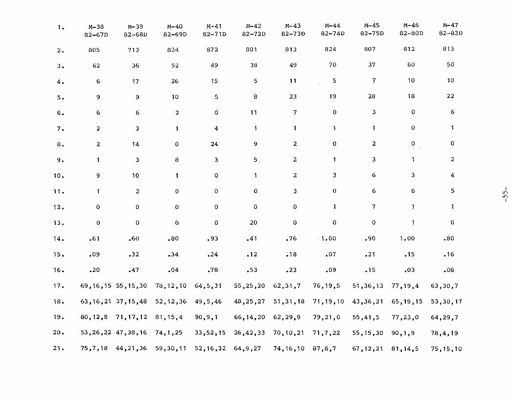
1 • M-38 M-39 M-40 M-41 M-42 M-43 M-44 M-45 M-46 M-47
82-67D 82-68D 82-69D 82-710 82-72D 82-73D 82-74D 82-75D 82-80D 82-83D
2. 805 713 824 872 801 813 824 807 812 813
3. 62 36 52 49 38 49 70 37 60 50
4. 6 17 26 15 5 11 5 7 10 10
5. 9 9 10 5 8 23 19 28 18 22
6. 6 6 2 0 11 7 0 3 0 6
7. 2 3 4 1 1 0
8. 2 14 0 24 9 2 0 2 0 0
9. 1 3 8 3 5 2 3 1 2
10. 9 10 1 0 2 3 6 3 4
11 • 1 2 0 0 0 3 0 6 6 5 I I.I"\ I.I"\
I
12. 0 0 0 0 0 0 1 7
13. 0 0 0 0 20 0 0 0 1 0
14. .61 .60 .80 .93 .41 • 76 1.00 .90 1.00 .80
15. .09 .32 .34 .24 • 12 ; 18 .07 .21 • 15 .16
16. .20 .47 .04 • 78 .53 .23 .09 .15 .03 .08
17. 69, 16, 15 55,15,30 78,12,10 64,5,31 55,25,20 62,31,7 76, 19,5 51,36,13 77, 19 ,4 63,30,7
18. 63, 16, 21 37, 15, 48 52,12,36 49,5,46 48,25,27 51,31,18 71,19,10 43,36,21 65, 19, 15 53,30, 17
19. 80, 12, 8 71,17,12 81,15,4 90, 9, 1 66, 14, 20 62,29,9 79,21,0 55,41,5 77,23,0 64,29,7
20. 53,26,22 47,38,16 74,1,25 33,52,15 26,42,33 70,10,21 71,7,22 55,15,30 90, 1, 9 78, 4, 19
21. 75,7,18 44,21,36 59,30,11 52,16,32 64,9,27 74,16,10 87,6,7 67, 12,21 81,14,5 75, 15, 10


APPENDIX B: Description of sedimentary section of the Manastash Formation, upper Taneum Creek.
-56-

Appendix B. A measured section of the Manastash Formation.
The top of the section begins at the base of the Taneum Andesite, the contact is an angular unconformity.
85. Sandy siltstone, pale-yellowish-brown (10YR 6/2); course silt-sized grains and approximately 5% very fine sand intermingled, poorly sorted, subangular, convoluted bedding; composed of 30% quartz, 52% feldspars, 15% biotite, and 3% muscovite; numerous plant fossils, layers are about two millimeters to one centimeter thick; sample #82-11D, location M-1.
84. Siltstone
83. Covered section.
82. Arkose, light-olive-gray (SY 6/1); very fine grained, well sorted, subangular, crossbedded; major components are 41% quartz, 41% feldspar, 1% lithics, 15% biotite, and 2% muscovite; sample #82-12D, M-2.
81. Silty shale, coal fragments scattered throughtout the unit.
80. Arkose, same as unit 82.
79. Mudstone, gray; friable.
78. Mudstone, very-pale-orange (10YR 8/2); convoluted bedding.
77. Basalt sill.
76. Arkose, light-gray (N-7); very fine grained, well sorted, angular, and crossbeds; major components are 33% quartz, 55% feldspar, 1% lithics, 5% biotite, 3% muscovite, and 1% matrix; sample #82-14D, location M-4.
75. Mudstone, carbonaceous.
74. Arkose; same as unit 76.
72. Arkose, medium-light-gray (N16); very fine grained, moderately sorted, angular, crossbedded; major components are 30% quartz, 56% feldspar, 1% lithics, 12% biotite, and 1% muscovite; a small dike of andesitic rock, pyrite occurs in the bake zone; sample #82-15D, location M-5.
-57-
Thickness meters feet
.6
.6
1 .4
2.9
.2
2.4
1.6
3.4
2.4
2.4
.3
1.4
3.6
1.8
2.0
4.5
9.6
.8
7.8
5.2
11 .o
8.0
7.9
.9
4.6
11.8

71. Arkose, yellowish-gray (SY 7/2); fine grained, moderately sorted, subangular to angular; major components are 33% quartz, 59% feldspar, 6% lithics, and 2% mica; same dike as in unit 72 occurs; sample #82-17D, location M-6.
70. Mudstone and random coal layers <2 inches thick.
69. Muddy arkose, light-brownish-gray (SY 6/1); fine grained and a clay-sized matrix, poorly sorted, subangular, crossbedded, sand sized fraction consists of 35% quartz, 60% feldspar, 3% biotite and 2% muscovite; sample #82-18D, location M-7.
68. Mudstone; small channel filled with sandstone in this unit, small high-angle reverse fault, six inches of displacement.
67. Arkose, light-gray (N7); very fine sand, well sorted, angular, crossbedded; major components are 20% quartz, 66% feldspar, 12% biotite, and 2% muscovite; sample #82-19D, location M-8.
66. Mudstone.
65. Siltstone, yellowish-gray (SY 7/2); coarse silt, moderately sorted, subangular; major components are 31% quartz, 60% feldspars, 8% biotite, and 1% muscovite; unit forms a large channel; sample #82-20D, location M-9.
64. Mudstone, carbonaceous material at the top of the unit.
63. Arkose, very-pale-orange (10YR 8/2); fine grained, moderately sorted, crossbedded; major components are 31% quartz, 67% feldspars, 2% lithics, and 2% biotite, unit forms a large channel; sample #82-21D, location M-10.
62. Mudstone
61. Arkose, pinkish-gray (5YR 8/1); fine grained, well sorted, subangular, crossbedded; major components are 36% quartz, 57% feldspar, 3% lithics, and 4% biotite; unit contains coal fragments and forms a channel; sample #82-22D, location M-11.
-58-
Thickness meters feet
2.3
1 • 1
2.2
2.5
4.2
1.6
1.3
1.5
4.9
1.2
1.5
7.5
3.6
7. 1
8.3
13.6
5.3
4.3
4.8
16.0
4.0
4.9

60. Covered section
59. Arkose, very-pa1e-orange (10YR 8/2); fine grained, poor1y sorted, angu1ar; major components are 30% quartz, 66% fe1dspar, 3% biotite, and 1% muscovite; unit contains sma11 pods of mudstone; sample #82-23D, 1ocation M-12.
58. Arkose, very-pale-orange (10YR 8/2); coarse grained, moderately sorted, angu1ar; major components are 45% quartz, 46% feldspar, 4% lithics, and 5% biotite; sample #82-34D, location M-13.
57. Arkose, pinkish-gray (5YR 8/1); fine to medium grained, poorly sorted, subangular, crossbedded; major components are 41% quartz, 54% feldspar, 15% lithics, and 5% biotite; samp1e #82-25D, location M-14.
56. Mudstone.
55. Arkose, same as unit 57.
54. Mudstone.
53. Arkose, same as unit 57.
52. Mudstone.
51. Arkose, very-pale-orange (10YR 8/2); fine to very fine grained, poor1y sorted, angular, laminated; major components are 30% quartz, 61% feldspar, 3% lithics, 5% biotite, and 1% muscovite; sample #82-26D, location M-15.
50. Mudstone.
49. Lithic arkose, 1ight-brownish-gray (5YR 6/1); fine grained, poorly sorted, angular, major components are 35% quartz, 41% feldspar, 9% lithics, 3% biotite, 2% muscovite, and 10% matrix; rare concretion up to four inches in diameter; sample #82-27D, location M-16.
48. Covered section.
47. Lithic arkose, same as unit 49.
46. Mudstone; unit contains a channel fi11ed with sandstone; normal fault that has six feet of displacement.
-59-
Thickness meters feet
39.2
1.8
2.5
2.0
.2
3.0
.2
1. 3
• 1
2.0
7.6
6.1
1.5
3 .1
3. 1
128.6
5.8
8. 1
6.4
.7
9.7
.8
4.3
.4
6.7
25.0
20.0
5.0
10.0
10.0

45. Arkose, grayish-orange-pink (SYR 7/2}; very fine grained, well sorted, subangular; major components are 34% quartz, 54% feldspar, 9% biotite, and 3% muscovite; coal lenses occur in this unit; sample #82-29D, location M-17.
44. carbonaceous shale.
43. Siltstone, olive-gray (SY 3/2}; silt grains, moderately sorted, angular, crossbedded; major components are 35% quartz, 40% feldspar, 20% biotite, and 5% muscovite; mud chip conglomerate at the base of the unit; sample #82-30D, location M-18.
42. Covered section.
41. Carbonaceous shale.
40. Sandy siltstone, medium-light-gray (N6); coarse silt and very fine sand, poorly sorted, subangular, contorted bedding; major components are 35% quartz, 60% feldspar, 3% biotite, and 2% muscovite; very carbonaceous and numerous plant fossils; sample #82-31D,
Thickness meters feet
4.6
.a
3.3
19 .1
.2
15.0
2.5
10 .a
62.5
.s
location M-19. 4.6 15.0
39. Covered section.
39. Siltstone, pale-yellowish-brown (10YR 6/2); coarse silt, poorly sorted, angular, thinly laminated; major components are 40% quartz, 48% feldspar, 10% biotite, and 2% muscovite; sample #82-32D, location M-20.
37. Shale.
36. Siltstone, olive-gray (SY 3/2); silt grains, poorly sorted, angular, crossbedded; major components are 35% quartz, 40% feldspar, 20% biotite, and 5% muscovite; sample #82-33D, location M-21.
35. Covered section.
34. Arkose, very-pale-orange (10YR 8/2); very fine grained, well sorted, angular, crossbedded; major components are 30% quartz, 61% feldspar, 8% biotite, and 1% muscovite; sample #82-34D, location M-22.
33. Mudstone.
-60-
43.1
3.4
.a
3.4
21.0
.a
.3
141.4
11 • 0
2.5
11 .2
69.0
2.5
1.0

32. Covered section.
31. Arkose, yellowish-gray (5Y 5/2); very fine grained, moderately sorted, subangular, crossbedded; major components are 29% quartz, 45% feldspar, 2% lithics, 21% micas, and 3% matrix; sample #82-35D, location M-23.
30. Mudstone; channels composed of sandstone are in this unit.
29. Covered section.
28. Mudstone.
27. Siltstone, pale-yellowish-brown (10YR 6/2); coarse silt, moderately sorted, angular, contorted bedding and crossbeds; major components are 40% quartz, 48% feldspar, 10% biotite, and 2% muscovite; unit contains small lenses of mudstone; sample #82-36D, location M-24.
26. Mudstone.
25. Arkose, very-pale-orange (10YR 8/2); very fine grained, moderately sorted, angular, crossbedded; major components are 31% quartz, 60% feldspar, 7% biotite, and 2% muscovite; sample #82-37D, location M-25.
24. Mudstone.
23. Siltstone, yellowish-gray (5Y 7/2); coarse silt grains and about 2% very fine sand, poorly sorted, subangular, crossbedded; major components are 35% quartz, 56% feldspar 8% biotite, and 1% muscovite; sample #82-38D, location M-26.
22. Mudstone.
21. Arkose, light-olive-gray (5Y 6/1); very fine grained, well sorted, subangular, thinly laminated, interlayered by sandy siltstone; major components are 32% quartz, 62% feldspar, 5% biotite, and 1% muscovite; sample #82-39D, location M-27.
20. Mudstone.
-61-
Thickness meters feet
12. 1
.4
2.5
6.7
1 • 1
4.1
1.1
2.0
3.3
1.5
1.0
.9
1.4
39.6
1.4
8.2
22.0
3.6
13.5
3.6
6.0
10.8
4.8
3.2
3.0
4.5

19. Sandy siltstone, paly-yellowish-brown {10YR 6/2); very fine sand and coarse silt, poorly sorted, subangular; major components are 35% quartz, 50% feldspar, 12% biotite, and 3% muscovite; sample #82-40D, location M-28.
18. Mudstone; contact between unit 19 and 18 is gradational.
17. Covered section.
16. Arkose, light-gray (N-7); fine grained, well sorted, angular, carbonate cement; major components are 34% quartz, 44% feldspar, 3% lithics, 11% biotite, 2% muscovite, and 6% carbonate; sample #82-41D, location M-29.
15. Mudstone.
14. Arkose, pale-yellowish-brown (10YR 6/2); fine grained, moderately sorted, angular, laminated; major components are 27% quartz, 60% feldspar, 2% lithics, 8% biotite, and 3% muscovite; sample #82-42D, location M-30.
13. Mudstone.
12. Arkose, pinkish-gray (5YR 8/1); fine grained, well sorted subangular, crossbedded; major components are 33% quartz, 57% feldspar, and 9% biotite; sample #82-43D, location M-31.
11. Mudstone.
10. Arkose, same as unit 12.
9. Mudstone.
8. Sandy siltstone, pale-yellowish-brown {10YR 6/2); very fine sand and silt, poorly sorted, angular, major components are 30% quartz, 56% feldspar, 15% biotite, and 1% muscovite; sample #82-44D, location M-32D.
7. Mudstone.
6. Sandstone channel cutting through the mudstone.
5. Mudstone.
4. Covered section.
-62-
Thickness meters
.8
1. 1
8.6
.7
.4
2.0
1.0
1.7
.2
.6
.3
3. 1
1.3
.4
.6
6. 1
feet
2.5
3.5
28.3
2.3
1. 3
6.7
3.4
5.6
.5
2.0
1.0
10.0
4.3
1.2
2.0
20.0

3. Arkose, grayish-orange (10YR 7/4); very fine grained, moderate1y sorted, subangu1ar; major components are 35% quartz, 53% fe1dspar, 2% 1ithics, 8% biotite, and 2% muscovite; samp1e #82-45D, 1ocation M-33.
2. Mudstone.
1. Arkose, pinkish-gray (5YR 8/1); medium grained, moderate1y sorted, angu1ar, crossbedded; major components are 41% quartz, 40% fe1dspar, 5% 1ithics, 6% biotite, 3% carbonate, and 6% matrix; samp1e #82-46D, 1ocation M-34.
Tota1 thickness of the section.
The 1ocation of this measured section is on P1ate 2.
-63-
Thickness meters feet
4.6
4.6
15.0
15.0
6.5 21.2
311.0 1020.3

APPENDIX C: Coal data.
-64-

10 Feet
5
0
Sec.14 (18-15E)
(124) 36-80 (125) 37-80
. .. . ... : . . . . . . . . . . . . : . . . . . . . . .. . . . . . . . . . . . . . .. . . . ...
*
* *
(125)
(124)
*
Sec. 21 (18-15E)
(132) 44-80
Sec. 33 (19-16E)
(120) 32-80
Sec. 10 (18·15E)
(123) 35-80
Sec. 34 ( 19-15E)A
--·--· ·--. --· -· --·--·--·--· --·---·-·--·--·--·--·--·----·--· --·--·--·---·--· --·----·---· ·-·--· ---·--·-· ·-·-·-·--·--· ·--·--·--· - ----·---·---· ·--·--·----·---· --·--·--·
---- ------- -
Sec. 34 (19-15E)B :·. ·.:. ·· ......... ·:
: ~ \\.:. :?./_/\.:: ... ·. :·:: . . . . . . . . . . ·. ·.: :.:·-:-:: .. : ... :::·: --- -- --- -- -- --- ---- -- --- ----
Figure 8. - Stratigraphic sections: Taneum-Manastash area. Sample analysis results follow. Refer to Sedimentary Body and Sample Location Map (Plate 2).
-65-

sandstone
siltstone
shale
carbonaceous shale
. a impure coal
coal
~ claystone
~ covered interval
~
* jagged lines indicate limit of exposure
coal/impure coal unit sampled for analysis
interval of measured stratigraphic section containing sampled coal units combined together into a single coal sample
Figure 9. - Legend for Stratigraphic Sections (Figure 8).
-66-

County: Kittitas
Sample Number: (120) 32-80
Mine Name: Wilson Coal Area: Taneum Sample site elevation (ft): 2350
Geologic Formation: Manastash Age: Eocene
Exposure type: Portal Sample type: Channel Sample condition: Weathered
Overburden thickness (ft): 2 Sample collector: Walker (DGER)
Laboratory: Doe-Pittsburg
CoaJ. Air dry loss: 16.0 (AR)
Proximate anaJ.ysis Moisture 26.0 Volatile matter 24.9 Fixed carbon 15.2 Ash 33.9
Ultimate analysis Hydrogen 4.9 Carbon 25.6 Nitrogen 0.7 Sulfur 0.3 Oxygen ( IND) 34.6
Heating vaJ.ue (BTU/LB) 3996
Ash - Initial deformation 2260 Softening temp. 2360 Fluid temp. 2470
Sulfur forms Sulfate N Pyritic N Organic N
F F F
Coal Name: Wilson Seam
Quarter Section: N/A Section: 33 Township: 19N Range: 16E Quadrangle: Cle Elum 15
Strike: N55E Dip: 20SE Major joints in coal: N/A
Total section measured (ft): 7.7 Coal thickness (ft): 3.4 Sample thickness (ft): 3.4
Date of sampJ.ing: Date of analysis:
06-03-80 09-23-80
Lab. Number: L03825
Coal Coal (MMMF) (DMMF)
41.1 N/A 39.3 66.8 24.0 40.7
N/A N/A
5.3 5.3 40.4 68.7
1.0 1.8 N/A N/A
54.7 30.7
6297 10695
Miscellaneous comments: Co~l seam had 1.3 ft of shale parting. Coal sampled from 2.8 ft above and 0.6 ft below this parting. Samples were mixed together for analysis.
-67-

County: Kittitas
Sample Number: (121) 33-80
Mine Name: None Coal Area: Manastash Sample site elevation (ft): 4560
Geologic Formation: Manastash Age: Eocene
Exposure type: Tailings Sample type: Grab Sample condition: Weathered
Overburden thickness (ft): N Sample collector: Walker (DGER)
Laboratory: Doe-Pittsburg
Air dry loss: 1.0
Proximate analysis Moisture Volatile matter Fixed carbon Ash
Ultimate analysis Hydrogen Carbon Nitrogen Sulfur Oxygen ( IND)
Heating value (BTU/LB)
Ash - Initial deformation Softening temp. Fluid temp.
Sulfur forms Sulfate Pyritic Organic
Coal (AR)
4.2 37 .6 32.4 25.8
4.0 60.4
1.5 0.8 7.6
10267
2490 F 2600 F 2710 F
N
N N
Coal Name: Unnamed
Quarter Section: N/A Section: 10 Township: 18N Range: 15E Quadrangle: Cle Elum 15
Strike: N/A Dip: N/A Major joints in coal: N/A
Total section measured (ft): N Coal thickness (ft): N Sample thickness (ft): N
Date of sampling: 06-17-80 Date of analysis: 09-23-80
Lab. Number: L03826
Coal Coal (MMMF) (DMMF)
5.7 N/A 52.3 55.5 45.0 47 .8
N/A N/A
5. 1 5. 1 84.1 89.3
1.9 2.0 N/A N/A
10.4 5.6
14264 15152
Miscellaneous comments: Tailings from unnamed abandoned mine. High graded for this sample. Sample (122) 34-80 is random sample.
-68-

County: Kittitas
Sample Number: (122) 34-80
Mine Name: Unknown Coal Area: Manastash Sample site elevation (ft): 4560
Geologic Formation: Manastash Age: Eocene
Exposure type: Tailings Sample type: Grab Sample condition: Weathered
Overburden thickness (ft): 0 Sample collector: Walker (OGER)
Laboratory: Doe-Pittsburg
Air dry loss: 3.0
Proximate analysis
Coal (AR)
Moisture 6.6 Volatile matter 33.6 Fixed carbon 0.0 Ash 72.0
Ultimate analysis Hydrogen 2.3 Carbon 15.1 Nitrogen 0.5 Sulfur 0.2 Oxygen (IND) 9.8
Heating value (BTU/LB) 2229
Ash - Initial deformation 2440 F Softening temp. 2520 F Fluid temp. 2640 F
Sulfur forms Sulfate N Pyritic N Organic N
Coal Name: Unnamed
Quarter Section: N/A Section: 10 Township: 18N Range: 15E Quadrangle: Cle Elum 15
Strike: N/A Dip: N/A Major joints in coal: N/A
Total section measured (ft): N Coal thickness (ft): N Sample thickness (ft): N
Date of sampling: 06-04-80 Date of analysis: 09-23-80
Lab. Number: L03827
Coal Coal (MMMF) (DMMF)
29.7 N/A 152 216
-0.1 -0.2 WA N/A
9.9 9.9 68.1 97.0
2.1 3.0 N/A N/A
44.1 25.1
10027 14288
Miscellaneous comments: Random sample of tailings from abandoned mine.
-69-

County: Kittitas
Sample Number: (123) 35-80
Mine Name: Coal Area:
None Manastash
Sample site elevation (ft): 4600
Geologic Formation: Manastash Age: Eocene
Exposure type: Roadcut Sample type: Channel Sample condition: Fresh
Overburden thickness (ft): 6 Sample collector: Walker (DGER)
Laboratory: Doe-Pittsburg
Air dry loss: 6.0
Proximate analysis Moisture Volatile matter Fixed carbon Ash
Ultimate analysis Hydrogen Carbon Nitrogen Sulfur Oxygen (IND)
Heating value (BTU/LB)
Ash - Initial deformation Softening temp. Fluid temp.
Sulfur forms Sulfate Pyritic Organic
Coal (AR)
12.8 14.0 9.7
63.5
2.5 15.7 0.4 0.2
17.7
2210
2040 F 2170 F 2290 F
N N N
Coal Name: Unnamed
Quarter Section: N/A Section: 10 Township: 18N Range: 15E Quadrangle: Cle Elum 15
Strike: N90E Dip: 40S Major joints in coal: N/A
Total section measured (ft): 4.4 Coal thickness (ft): 3.9 Sample thickness (ft): 3.9
Date of sampling: 06-17-80 Date of analysis: 09-23-80
Lab. Number: L03828
Coal Coal (MMMF) (DMMF)
40.8 N/A 44.6 75.5 30.9 52.2
N/A N/A
5.7 5.7 50.0 84.7
1.2 2.0 N/A N/A
56.4 34.0
7027 11885
Miscellaneous comments: Coal from area of possible tectonic activity dip-strike unlike good measured section nearby. Bottom of coal zone not reached.
-70-

County: Kittitas
Sample Number: (124) 36-80
Mine Name: Coal Area:
Unknown Manastash
Sample site elevation (ft): 4480
Geologic Formation: Manastash Age: Eocene
Exposure type: Portal Sample type: Channel Sample condition: Weathered
Overburden thickness (ft): N Sample collector: Walker (DGER)
Laboratory: Doe-Pittsburg
Air dry loss: N
Proximate analysis Moisture Volatile matter Fixed carbon Ash
Ultimate analysis Hydrogen Carbon Nitrogen Sulfur Oxygen (IND)
Heating value (BTU/LB)
Ash - Initial deformation Softening temp. Fluid temp.
Sulfur forms Sulfate Pyritic Organic
Coal (AR)
20.3 24.0 26.6 29. 1
4.6 35.7 0.9 0.3
29.4
5789
2230 F 2320 F 2390 F
N
N
N
Coal Name: Unnamed
Quarter Section: N/A Section: 14 Township: 18N Range: 15E Quadrangle: Cle Elum 15
Strike: N70W Dip: 46SW Major joints in coal: N/A
Total section measured (ft): 20.7 Coal thickness (ft): 5.7 Sample thickness (ft): 5.7
Date of sampling: 06-18-80 Date of analysis: 09-23-80
Lab. Number: L03829
Coal Coal (MMMF) (DMMF)
29.6 N/A 35.6 49.8 38.8 55.2
N/A N/A
4.8 4.8 52.1 74.1
1.2 1.8 N/A N/A
42.9 23.5
8441 12002
Miscellaneous comments: Sample from northernmost of three drifts in unnamed, abandoned coal field. Sample (125) 37-80 from impure coal immediately above this sample.
-71-

County: Kittitas
Sample Number: (125) 37-80
Mine Name: Unknown Coal Area: Manastash Sample site elevation (ft): 4480
Geologic Formation: Manastash Age: Eocene
Exposure type: Portal Sample type: Channel Sample condition: Weathered
Overburden thickness (ft): N Sample collector: Walker (DGER)
Laboratory: Doe-Pittsburg
Air dry loss: 5.0
Proximate analysis Moisture Volatile matter Fixed carbon Ash
Ultimate analysis Hydrogen Carbon Nitrogen Sulfur Oxygen (IND)
Heating value (BTU/LB)
Ash - Initial deformation Softening temp. Fluid temp.
Sulfur forms Sulfate Pyritic Organic
Coal (AR)
8.9 11 .8 o.o
79.6
2.0 5.2 0.3 0.1
12.8
693
2430 F 2520 F 2620 F
N
N
N
Coal Name: Unnamed
Quarter Section: N/A Section: 14 Township: 18N Range: 15E Quadrangle: Cle Elum 15
Strike: N70W Dip: 46SW Major joints in coal: N/A
Total section measured (ft): 20.7 Coal thickness (ft): 1.8 Sample thickness (ft): 1.8
Date of sampling: 06-18-80 Date of analysis: 09-24-80
Lab. Number: L03830
Coal Coal (MMMF) (DMMF)
63.6 N/A 84.3 232 -0.1 -0.3
N/A N/A
19.6 19.6 37 .1 102
2.0 5.6 N/A N/A
91.5 96.0
4922 13551
Miscellaneous comments: Impure coal exposed in northernmost of three drifts in unnamed abandoned coal field. Sample immediately above sample (124) 36-80.
-72-

County: Kittitas
Sample Number: (131) 43-80
Mine Name: None Coal Area: Mana stash Sample site elevation (ft): N
Geologic Formation: Manastash Age: Eocene
Exposure type: Roadcut Sample type: Grab Sample condition: Weathered
Overburden thickness (ft): 0 Sample collector: Cushman (DGER)
Laboratory: Doe-Pittsburg
Air dry loss: 14 .o
Proximate analysis Moisture Volatile matter Fixed carbon Ash
Ultimate analysis Hydrogen Carbon Nitrogen Sulfur Oxygen ( IND)
Heating value (BTU/LB)
Ash - Initial deformation Softening temp. Fluid temp.
Sulfur forms Sulfate Pyritic Organic
Coal (AR)
26.7 25.2 23.8 24.3
5. 1 33.5
1 .o 0.3
35.9
5416
2190 F 2270 F 2360 F
N
N
N
Coal Name: Unnamed
Quarter Section: N/A Section: 17 Township: 18N Range: 15E Quadrangle: Cle Elum 15
Strike: Horz Dip: 0 Major joints in coal: N/A
Total section measured (ft): N Coal thickness (ft): N Sample thickness (ft): N
Date of sampling: 07-18-80 Date of analysis: 09-23-80
Lab. Number: L03831
Coal Coal (MM.MF) (DMMF)
36.2 N/A 34.2 53.6 32.3 50.7
N/A N/A
4.5 4.5 45.5 71.3
1. 3 2.0 N/A N/A
48.7 25.9
7339 11518
-73-

County: Kittitas
Sample Number: (132) 44-80
Mine Name: Unnamed Coal Area: Manastash Sample site elevation (ft): N
Geologic Formation: Manastash Age: Eocene
Exposure type: Prospect Sample type: Grab Sample condition: Weathered
Overburden thickness (ft): 0 Sample collector: Cushman (DGER)
Laboratory: Doe-Pittsburg
Air dry loss: 9.0
Proximate analysis Moisture Volatile matter Fixed carbon Ash
Ultimate analysis Hydrogen Carbon Nitrogen Sulfur Oxygen ( IND)
Heating value (BTU/LB)
Ash - Initial deformation Softening temp. Fluid temp.
Sulfur forms Sulfate Pyritic Organic
Coal (AR)
12.7 9.6 0.2
77.5
2.4 4.3 0. 1 0. 1
15.7
479
2680 2760 2800
N N N
F F F
Coal Name: Unnamed
Quarter Section: NE Section: 21 Township: 18N Range: 15E Quadrangle: Cle Elum 15
Strike: N/A Dip: N/A Major joints in coal: N/A
Total section measured (ft): 8.5 Coal thickness (ft): 3.5 Sample thickness (ft): 3.5
Date of sampling: 07-18-80 Date of analysis: 09-23-80
Lab. Number: L03832
Coal Coal (MMMF) (DMMF)
78 .1 N/A 59.0 270
1 • 1 5.2 N/A N/A
27.5 27.5 26.4 121 0.5 2.4 N/A N/A
96.6 124
2918 13371
Miscellaneous comments: Because strike and dip of coal not known, sample was of "best" coal visible in seam. Complete coal section not exposed at prospect.
-74-

County: Kittitas
Sample Number: (133) 45-80
Mine Name: Unnamed Coal Area: Manastash Sample site elevation (ft): N
Geologic Formation: Manastash Age: Eocene
Exposure type: Tipple Sample type: Grab Sample condition: Weathered
Overburden thickness (ft): 0 Sample collector: Cushman (DGER)
Laboratory: Doe-Pittsburg
Coal Air dry loss: 9.0 (AR)
Proximate analysis Moisture 14.9 Volatile matter 13. 1 Fixed carbon 13.2 Ash 58.8
Ultimate analysis Hydrogen 3. 1 Carbon 18.3 Nitrogen 0.3 Sulfur 0. 1 Oxygen ( IND) 19.4
Heating value (BTU/LB) 2755
Ash - Initial deformation 2800 Softening temp. 2800 Fluid temp. 2800
Sulfur forms Sulfate N Pyritic N Organic N
F F F
Coal Name: Unnamed
Quarter Section: NE Section: 21 Township: 18N Range: 15E Quadrangle: Cle Elum 15
Strike: N/A Dip: N/A Major joints in coal: N/A
Total section measured (ft): N Coal thickness (ft): N Sample thickness (ft): N
Date of sampling: 07-18-80 Date of analysis: 09-23-80
Lab. Number: L03833
Coal Coal (MMMF) (DMMF)
40.8 N/A 35.9 60.7 36.2 61.2
N/A N/A
6.6 6.6 50.2 84.9 . 0.8 1.3
N/A N/A 53.2 28.5
7546 12766
-75-

APPENDIX D: Sample descriptions.
-76-

Sample descriptions.
Sample 82-62D, location M-3S; subarkose, grayish-pink (SYR 8/1); course sand, moderately sorted, angular; 81% quartz, 8% feldspar, 8% lithics, and 4% matrix.
Sample 82-63D, location M-36; subarkose, pinkish-gray (SYR 8/1); coarse sand, moderately sorted, angular; 82% quartz, 11% feldspar, 6% lithics, and 1% matrix.
Sample 82-64D, location M-37; lithic arkose, light-gray (N7); fine sand, moderately sorted, angular; SO% quartz, 2S% feldspar, 19% lithics, 3% matrix, 1% micas, and 1% miscellaneous.
Sample 82-67D, location M-38; subarkose, grayish-pink (SR 8/2); coarse sand, well sorted, subangular; 68% quartz, 1S% feldspar, 14% lithics, and 1% matrix.
Sample 82-68D, location M-39; feldspathic litharenite, light-gray (N7); medium sand, moderately sorted, subangular; S3% quartz, 1S% feldspar, 30% lithics, and 2% matrix.
Sample 82-69D, location M-40; subarkose, pale-yellowish-brown (10YR 6/2); coarse sand, moderately sorted, angular; 78% quartz, 12% feldspar, and 10% lithics.
Sample 82-71D, location M-41; litharenite, pale-red (SR 6/2); coarse sand, moderately sorted, angular; 64% quartz, S% feldspar, and 31% lithics.
Sample 82-72D, location M-42; lithic arkose, grayish-orange-pink (10R 8/2); coarse sand, moderately sorted, subangular, carbonate cement; 43% quartz, 19% feldspar, 16% lithics, and 20% miscellaneous.
Sample 82-73D, location M-43; arkose, pale-red (10R 6/2); medium to coarse sand, poorly sorted, angular; 60% quartz, 30% feldspar, 7% lithics and 3% matrix.
Sample 83-74D, location M-44; subarkose, grayish-orange (SYR 7/2); coarse sand, moderately sorted, angular; 7S% quartz, 19% feldspar, S% lithics, and 1% micas.
Sample 82-7SD, location M-4S; lithic arkose, pale-red (SR 7/2); fine to medium sand, moderately sorted, subangular, laminated bedding; 44% quartz, 31% feldspar, 12% lithics, 6% matrix, and 7% micas.
Sample 82-80D, location M-46; subarkose, grayish-orange-pink (SYR 7/2); medium to coarse sand, poorly sorted, angular; 70% quartz, 18% feldspar, 4% lithics, 6% matrix, 1% micas, and 1% miscellaneous.
Sample 82-83D, location M-47; arkose, grayish-pink-orange (SYR 7/2); coarse sand, moderately sorted, angular; 60% quartz, 28% feldspar, 7% lithics, S% matrix, and 1% micas.
-77-

Sample 82-47D, location M-48; arkose, pale yellowish-brown (10YR 6/2); very fine sand, moderately sorted, angular, 40% quartz, 43% feldspar, and 17% micas.
Sample CC-2A, location M-49; litharenite; coarse sand, subangular to subrounded; 68% quartz, 4% feldspar, and 28% lithics.
Sample CC-2B, location M-50; sublitharenite; coarse sand, moderately sorted, subangular to subrounded; 79% quartz, 3% feldspar, and 18% lithics.
Sample CC-6, location M-49; litharenite; medium to coarse sand, moderately well sorted, subangular to subrounded; 73% quartz, 22% lithics, 4.5% feldspar, and .5% mica.
Sample CC-13(1), location M-51; litharenite; medium grained, poorly sorted, subangular to subrounded; 69% quartz, 7% feldspar, 23% lithics, 1% micas.
Sample CC-13(2), location M-51; litharenite; medium to coarse grained, poorly sorted, subangular to subrounded; 75% quartz, 7% feldspar, 18% lithics, and a trace of biotite.
Sample CC-16, location M-52; pebble conglomerate; sand sized matrix of moderately sorted, subangular to subrounded grains; 61% quartz, 3% feldspar, 36% lithics, and trace amounts of biotite and epidote.
Sample CC-24, location M-53; sublitharenite; medium grained, poorly sorted, subangular to subrounded; 79% quartz, 19% lithics, 2% micas and a trace of feldspar.
Sample CC-25, location M-54; sublitharenite; medium to fine-grained, poorly sorted, subangular to subrounded; 81% quartz, 1% feldspar, 16% lithics, and 2% biotite.
Sample CC-26, location M-54; pebble conglomerate; poorly sorted, subangular; 59% quartz, 39% lithics, 2% biotite, and traces of epidotie, muscovite and opaque minerals.
Sample CC-45, location M-55; sublitharenite; medium-grained, moderartely sorted, angular to subangular; 78% quartz, 7% feldspar, 15% lithics, and trace amounts of micas and epidote.
Sample CC-46, location M-56; pebble conglomerate; 54% quartz, 4% feldspar, 42% lithics, and traces of biotite.
Sample CC-50, location M-57; feldspathic litharenite; medium-grained, poorly sorted, subangular to subrounded; 62% quartz, 16% feldspar, 21% lithics, and 1% mica.
Sample CC-52, location M-58; feldspathic litharenite; medium-grained, moderately well sorted, subangular to subrounded; 71% quartz, 9% feldspar, 19% lithics, 1% biotite, and trace amounts of epidote.
-78-

Sample CC-53, location M-59; litharenite; medium to fine-grained, poorly sorted, subangular to subrounded; 69% quartz, 7% feldspar, 23% lithics, and 1% epidote and micas.
Sample CC-54, location M-60; litharenite fine-grained, poorly sorted, subangular; 68% quartz, 9% feldspar, 23% lithics, and trace amounts of mica, epidote and sphene.
Sample CC-55, location M-61; feldspathic litharenite; medium-grained, poorly sorted, subangular to subrounded; 62% quartz, 26% lithics, 11% feldspar, and 1% biotite and epidote.
Sample CC-57, location M-62; feldspathic litharenite; medium-grained, moderately sorted; 58% quartz, 12% feldspar, 30% lithics, and trace amounts of micas and epidote.
Sample CC-98, location M-63; lithic arkose; medium-grained, poorly sorted, subangular to subrounded; 55% quartz, 20% feldspar, 19% lithics, 1% biotite, and 5% carbonate cement.
Sample CC-16, location M-64; feldspathic litharenite; 67% quartz, 12% feldspar, 20% lithics, and 1% micas.
Sample CC-117, location M-65; feldspathic litharenite; coarse-grained, moderately sorted, subangular; 64% quartz, 9% feldspar, 26% lithics, and 1% micas.
Sample CC-22, location M-66; lithic arkose; very fine- to coarsegrained, poorly sorted, subangular; 54% quartz, 25% feldspar, 18% lithics, and 3% micas.
-79-