Embed Size (px)
Citation preview
________________________________________________________________________________
________________________________________________________________________________
________________________________________________________________________________
________________________________________________________________________________
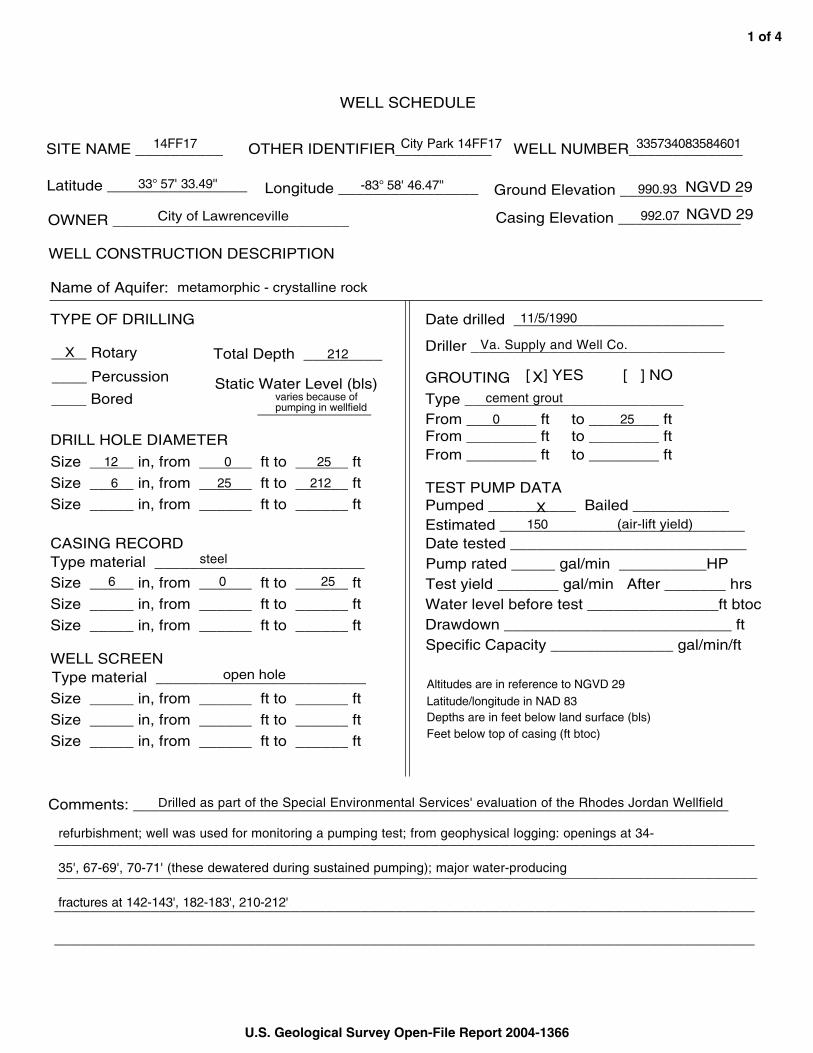
WELL SCHEDULE
SITE NAME __________ OTHER IDENTIFIER___________ 33573408358460114FF17 City Park 14FF17 WELL NUMBER_____________
33° 57' 33.49'' Latitude ________________ -83° 58' 46.47'' Longitude ________________ 990.93Ground Elevation ______________NGVD 29
OWNER ___________________________City of Lawrenceville 992.07Casing Elevation ______________NGVD 29
WELL CONSTRUCTION DESCRIPTION
Name of Aquifer: metamorphic - crystalline rock
TYPE OF DRILLING
X 212____ Rotary Total Depth _________
____ Percussion Static Water Level (bls) varies because of____ Bored pumping in wellfield _____________
DRILL HOLE DIAMETER
12 0 25Size _____ in, from ______ ft to ______ ft 6 25 212Size _____ in, from ______ ft to ______ ft
Size _____ in, from ______ ft to ______ ft
CASING RECORD steelType material ________________________
6 0 25Size _____ in, from ______ ft to ______ ft
Size _____ in, from ______ ft to ______ ft
Size _____ in, from ______ ft to ______ ft
WELL SCREEN open holeType material ________________________
Size _____ in, from ______ ft to ______ ft
Size _____ in, from ______ ft to ______ ft
Size _____ in, from ______ ft to ______ ft
11/5/1990Date drilled ________________________
Va. Supply and Well Co.Driller _____________________________
GROUTING [ X] YES [ ] NO
cement groutType _________________________ 0From ________ ft 25to ________ ft
From ________ ft to ________ ft From ________ ft to ________ ft
TEST PUMP DATA Pumped __________ Bailed ___________X
150 (air-lift yield)Estimated ____________________________ Date tested ___________________________ Pump rated _____ gal/min __________HP Test yield _______ gal/min After _______ hrs Water level before test _______________ft btoc Drawdown __________________________ ft Specific Capacity ______________ gal/min/ft
Altitudes are in reference to NGVD 29 Latitude/longitude in NAD 83 Depths are in feet below land surface (bls) Feet below top of casing (ft btoc)
Drilled as part of the Special Environmental Services' evaluation of the Rhodes Jordan WellfieldComments: ____________________________________________________________________
refurbishment; well was used for monitoring a pumping test; from geophysical logging: openings at 34
35', 67-69', 70-71' (these dewatered during sustained pumping); major water-producing
fractures at 142-143', 182-183', 210-212'
U.S. Geological Survey Open-File Report 2004-1366
1 of 4
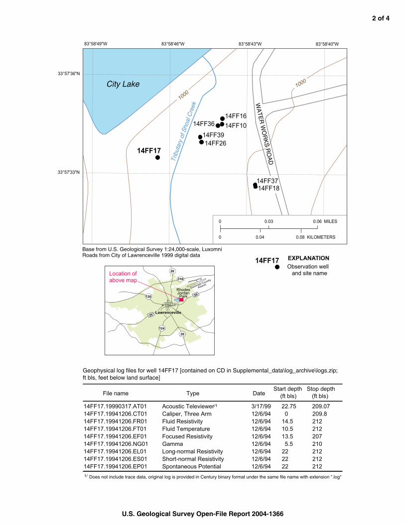
83°58'49"W 83°58'46"W 83°58'43"W 83°58'40"W
33°57'36"N
0 0.03
0 0.04
14FF39
14FF36
14FF17 14FF26
14FF10 14FF16
1000 1000City Lake
Trib
utar
y of
Sho
al C
reek
WA
TE
R W
OR
KS
RO
AD
14FF37 14FF18
0.06 MILES
0.08 KILOMETERS
33°57'33"N
Base from U.S. Geological Survey 1:24,000-scale, Luxomni Roads from City of Lawrenceville 1999 digital data
14FF17 EXPLANATION
Lawrenceville
29
AirportGwinnett County
Rhodes Jordan Park
29
124
120
316
20
20Location of above map
Observation well and site name
Geophysical log files for well 14FF17 [contained on CD in Supplemental_data\log_archive\logs.zip; ft bls, feet below land surface]
File name Type Date Start depth
(ft bls) Stop depth
(ft bls)
14FF17.19990317.AT01 Acoustic Televiewer/1 3/17/99 22.75 209.07 14FF17.19941206.CT01 Caliper, Three Arm 12/6/94 0 209.8 14FF17.19941206.FR01 Fluid Resistivity 12/6/94 14.5 212 14FF17.19941206.FT01 Fluid Temperature 12/6/94 10.5 212 14FF17.19941206.EF01 Focused Resistivity 12/6/94 13.5 207 14FF17.19941206.NG01 Gamma 12/6/94 5.5 210 14FF17.19941206.EL01 Long-normal Resistivity 12/6/94 22 212 14FF17.19941206.ES01 Short-normal Resistivity 12/6/94 22 212 14FF17.19941206.EP01 Spontaneous Potential 12/6/94 22 212 1/ Does not include trace data, original log is provided in Century binary format under the same file name with extension ".log"
U.S. Geological Survey Open-File Report 2004-1366
2 of 4
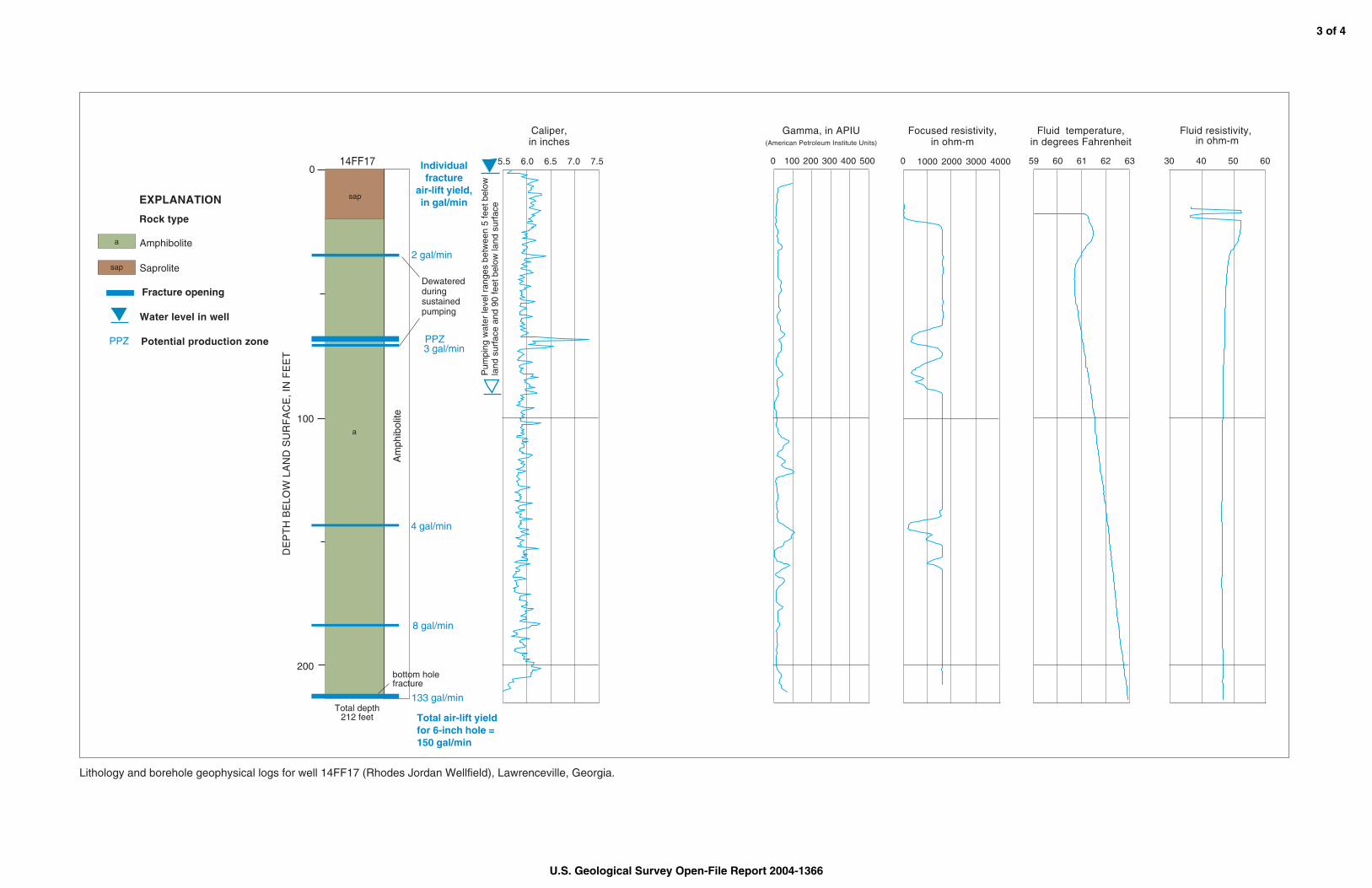
0 0 60 61 62 6359
Caliper, in inches
Gamma, in APIU (American Petroleum Institute Units)
Focused resistivity, in ohm-m
Fluid temperature, in degrees Fahrenheit
Fluid resistivity, in ohm-m
40 50 60305.5 6.0 6.5 7.57.0
Am
phib
olite
Individual fracture
air-lift yield, in gal/min
Total depth 212 feet
Rock type
EXPLANATION
0
100
200
DE
PT
H B
ELO
W L
AN
D S
UR
FA
CE
, IN
FE
ET
14FF17
Water level in well
Total air-lift yield for 6-inch hole = 150 gal/min
Amphibolitea
Saprolitesap
Fracture opening
sap
a
133 gal/min
8 gal/min
4 gal/min
3 gal/min
2 gal/min
PPZPPZ Potential production zone
Pum
ping
wat
er le
vel r
ange
s be
twee
n 5
feet
bel
owla
nd s
urfa
ce a
nd 9
0 fe
et b
elow
land
sur
face
Dewatered during sustained pumping
bottom hole fracture
100 200 300 400 500 1000 2000 3000 4000
Lithology and borehole geophysical logs for well 14FF17 (Rhodes Jordan Wellfield), Lawrenceville, Georgia.
U.S. Geological Survey Open-File Report 2004-1366
3 of 4
Am
phib
olite
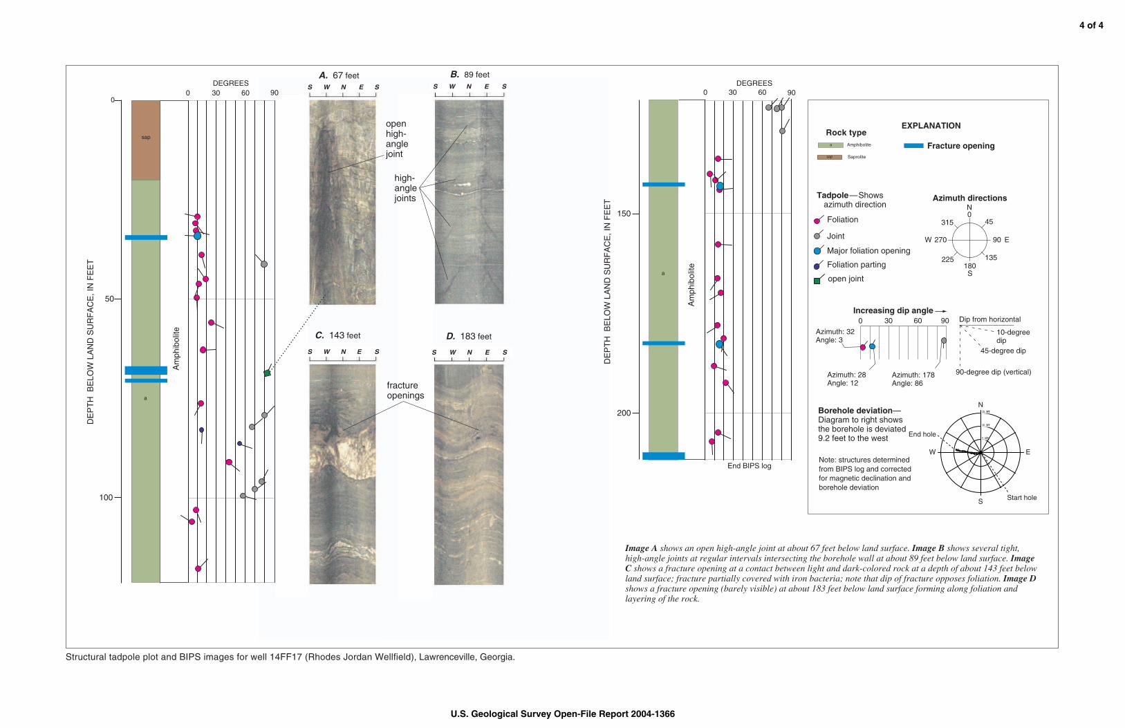
0 30 60 DEGREES
90
End BIPS log
Am
phib
olite
DE
PT
H B
ELO
W L
AN
D S
UR
FA
CE
, IN
FE
ET
50
100
0
sap
a
a
0 30 60 90
Azimuth: 32 Angle: 3
Azimuth: 28 Angle: 12
Azimuth: 178 Angle: 86
Note: structures determined from BIPS log and corrected for magnetic declination and borehole deviation
Borehole deviation— Diagram to right shows the borehole is deviated 9.2 feet to the west
0 45315
90270
135225 180
N
EW
S
Azimuth directions
Increasing dip angle Dip from horizontal
10-degree dip
45-degree dip
90-degree dip (vertical)
EXPLANATION Rock type
Amphibolitea
sap Saprolite
15.0FT
10.0FT
5.0FTEnd hole
N
S
EW
Start hole
Foliation
Joint
Major foliation opening
—Shows � azimuth direction
Foliation parting
open joint
S W N E S S W N E S
S W N E S S W N E S
C. 143 feet
A. 67 feet B. 89 feet
D. 183 feet
shows an open high-angle joint at about 67 feet below land surface. shows several tight, high-angle joints at regular intervals intersecting the borehole wall at about 89 feet below land surface. Image C shows a fracture opening at a contact between light and dark-colored rock at a depth of about 143 feet below land surface; fracture partially covered with iron bacteria; note that dip of fracture opposes foliation. Image D shows a fracture opening (barely visible) at about 183 feet below land surface forming along foliation and layering of the rock.
high-angle joints
open high-angle joint
fracture openings
150
200
Fracture opening
0 30 60 90 DEGREES
DE
PT
H B
ELO
W L
AN
D S
UR
FA
CE
, IN
FE
ET
Tadpole
Image A Image B
Structural tadpole plot and BIPS images for well 14FF17 (Rhodes Jordan Wellfield), Lawrenceville, Georgia.
U.S. Geological Survey Open-File Report 2004-1366
4 of 4