Embed Size (px)
Citation preview


OPEN-FILE REPORT 0-92-13 PRELIMINARY GEOLOGIC MAP OF THE
SACRAMENTO BUTTE QUADRANGLE MALHEUR COUNTY, OREGON
By M. L. Ferns Oregon Department of Geology and Mineral Industries
This unpublished Open-File Report has not been reviewed and may not meet all Oregon Department of Geology and Mineral
Industries' standards.
Field work conducted in 1991 Map Scale: 1:24,000
Funding Statement: Funded jointly by the Oregon Department of Geology and Mineral Industries, the Oregon State Lottery, and the U. S. Geological Survey COGEOMAP Program as part of a cooperative effort to map the west half of the lo by 2O
Boise sheet, eastern Oregon.

Sacramento Butte
The distinctive porphyritic rhyolite exposed at Sacramento Butte makes up the oldest rock unit (Ttip) exposed in the Sacramento Butte Quadrangle. The rhyolite contains about 15% phenocrysts of sanidine, plagioclase, and quartz as large as 8 mm in diameter. The rhyolite is peralkaline in composition and petrographically and chemically similar to the uppermost rhyolite flow exposed at Iron Point. Evans ( 1 9 9 1 ) considers the Iron Point rhyolite to be a crystal-rich ashflow tuff.
The basalt and ferroandesite flows of unit Tbvc lie stratigraphically above unit Ttip and are in turn overlain by sediments and tuffs of unit Tscb. A thin light gray, vitric, welded ash-flow tuff exposed in the upper part of unit Tscb is petrographically and chemically identical to the Devine Canyon Tuff. The ashflow is peralkaline, with sanidine, quartz, and green, pleochroic clinopyroxene phenocrysts. Trace element patterns, including distinctive high Zr abundances, suggest that the Tscb ashflow is the thin, distal edge of the Devine Canyon Tuff, which erupted from a large caldera complex in the Burns region at about 9.2 M a .
Thin basalt and basaltic andesite flows locally appear within the Tscb section, which is overlain by the thick section of heavily weathered olivine-basalt flows that make up unit Tbwb. Individual flows are locally separated by palagonite breccias. The unit includes quartz tholeiites.

S:hC#WEYIENTO BUTTE
Alluvial f a n d e p u e t g (Quatmrnary) Mginly u m o n s ~ l i d a ~ e d amd poorly tirrrted a~cumula-tions a f coarse gravel &@posited atrtrrg the f lank o f Cedar Mountain.
I Lacustrine ~edinsnta iaueternary 1 Mainly uncan&alida+ed Iaeus.ltrino depasi&s s f l i g h t co lo red Tine sand and silt, h a y include misparite depeaits.
Lacuok.riram and eolian daposits (materrrary) Mginly 0 unconeal idcrted ircustr inss depos1 t 5 o f pale brown Tine to m e d i u m sand -osibad along the saut~h and east sides , o f Barren Valley. Includes raum,ded gravels along ancient shoyelines and dava cut terraces. Rlso includes high&- efgvation deposits o f wand-blown sand margln$P +a t h e share1 ine. -- Olivine basal* (PZiprenr?) Bray sad grayish-black dfkty8axltit o l i v i n e ba~alt f l a w with well preserved f l a w Caps, C~cally heavily mantled by wiMbXemlclrn silk. Xti~I~udes holctcryo+al line besalts w 4 # i 3ess t h a m 2% dlivihk @ h e m - r r ~ s t ~ a% large as 3mm in diame*er in a >qraundlma.ss of knterlockirrg p , l e ~ i o c l a s e la'ehes and subaphikic cline-pyraxe6e- In,cludass h3gb alymina bas.al%s tArr+lysss 1, Table 1 , MusBerng F$utte quadran~le~l. kquivallent tb un5t Qb o f Wa1kCrS 1877.
1
I Unconsolidated fluvial and lacusittin& depcdite - (Pliot&ne?) Unmnsol idaded aCcumulation~ o f sand,
silt, .and gfave l eeparrting BTb f r a m underlying Tbwh ?lami. Upper part ef sectian contains caliche d ~ p o * S i k ~ -
I D l i v i r r e basalt f lows. u f Wrangle Butte tPliocene and - Lafa Miocene?) Blulsh and grayish#-black, ollvihe
basalt f lows m d 3nBcrb~dded pAllaganht ic breccl as. 'Znrludes hyalophftic pillow basalt5 with 2 mm d5amefer olivine &hd p l a q i t r c l a s e phenocrysks w i t h q p h i t i , ~ and subophltir clinopyro-x@ne, Chemically, in:lud.e% quartz thaloii ttm (Sample, Table 1, Wrangle Butte quqdrangle). ~~Givalent to part o f mit Tb o f Evans (9991 1 amd BTb o f h 2 k e r t 19771.
TuffPceous sand anti siltstbnao CPliucwe and Late qr Miacensj Mainly yeltewish whits to yelf~wirh brown
tuffacqus silt and Sand*tbMysI tn.cludes r w o r k e d l a p f l l i tuff3 and btrltonlbic claystones. E q u i p l e n t to upper park o f und k T? o f Evans ( 1991 1 .
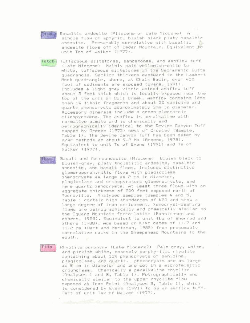
5.A basal ti^ andegite (Pliocene or L a t e Miocene) fl C s i n g l e f l ow o f aphyric , bluish black p l a t y basaltic andesite. Presumably correlative uith basaltic 8. andesite Tlat+s o f f a f Cedar Mountain. Equivalent,* unit i o b af Malker (19771.
Tuffacenus siltet~nes, sandstwnes, and ashflow tuff
white, tuffarmus siltstones In the 8srrsmentu Butte quac+rs,ngle. Serti~n thickens eas~krd in the Lsmbert Rack quadrangle, where* a t Chalk .Basin, over 4-50 feet o f sediments are exposed (Evans, 1p1) . Includes a light gray v i t r i c welded i ishb~ow tu f f about 3 f e t t h i c k which is loca>$$y exposed neat the top o f t h e unit on Bull Creakd AstT+law contains less than 1% lit hi^ fragments and about 3% sanidine and quartz phenorrys*~ gpproximately 3mm in diameter. &rCe.Ss@ry mineral& Include a green pleoChraic cPirmpyroxane. Thr &sRi.fX~w i s p ~ r a l - k a f l n a ~ 5 t h normative acrnike and is chemically and pehrog+@hi#gally identicel ka the Qav'ine Canyon T u f f mapp& by &eerie (197.3) west of Crowley (Smple, Table 1 ) . The Devine Canyon T u f f has been dated by K / A r me$hods a t aboyt 9-2 Ma (Greene, 1 9 7 8 ) . Equivalent to uni* Ts o f Eva- (3991) and Ts o f Walker ( 19773 . Raaalt and f~rraandesite [Miactnel Bluish-black to friufsh-gray, p l a t y tholeiitfc andcsite,' basaltic andesita, and ba-it f lows. Includes distinctive gloaeroparphyrikic flows with plagioclase p h w c r y s t s as lasrge as Z c m in diameter, plagioclasc and orthmpyroxsw g!omerocrysts, and rare quartz xenocry~~ts. A t least three flays with an agfjreg6at.e thitkness of 200 feet exposed north o f Manrwll le . Rnalyzecl sampl-es (Samples 4 and 5 , table 1 conta in h iqh abundantsr o f K2U and show a large degree of iroh antichment. Xenocryst-bearing flaws are petrographically and chemically similar t a t h e Square Mountain ferrn-lakite (Bonnichsen and others, 19B8) . Equivalent to u n i S Tba a f Sherrod and others [1?881. Age based on #/fir dates OF 11.7 and 11.Z Ma (Mart and Mertzmen, 18821 f r o m presumably carrelative rock= in the Sheepeheed Mountains to the w"th: 1,
. , ~ h y o l i t e porphyry 1Late Miocene?) Pale qray, white, and pinkish white, coarsely porphyritic rhyolite containing ahout 15% pheaocrysts of sanidine, p lag loc las~r , and quavtt. phenocrysts are a5 larg@ as 8 ms %n diameter ahd are ti& in a microfelsjtic gr~undmass. Chemically a peralkaline rhyolite (Analyses 1 and 2, Table 1 ) . Petrographically and chemically similar t o the upper rhyoli*c flow evposed at Iran Point (Analyses 3, T a b l e I ) , which is considered by Evans (19911 to be an ashflow t u f f . Part o f unit Tsv o f Walker (1977).


AZB-107 S a r r a a ~ n t o Butte SW #b 19 28 40 Rhrnl i te Trip 75.8 11.0 0.12 i . 3 3 0.03 0.71 0.23 4.87 3.89 C.64 6 .93 -10 g: :: 7.7 $ 9 , 242 :: I&: 257 91 133 49.4
AZB-198 !iirare~to Butte NW f4U 1 28 40 R h y o l ~ t e :r:o 76'4 11.2 0.13 1.54 0 . ~ 3 0.39 0.3 4.86 3.?: 0.04 (1.85 -;o ( 5 ~~5 I ? .+ 112, 223 23 ic: 255 343 2 3 . :

i ;-i V? '-7 (7 -- ;" 1 ". : .I .i W.:?. 1 f.:: er , G . W . .i. .7 ... .i , ..: L$...I .. !...I Q i <:' ;? -! i;:! CI 'f' !::)i.- erj ~3 1-{ e .s, E; ?; ~i .f:' ,. :. .... 5;- !; . . ('.i f i j <-J r.- c-1 i3 1 ::: . . . . . >-. ... - . 1 3. - 1 : . :: .,,, .,,. ,,. ,- ...!t.! i' v c !; I"! j, .%. .C E: 1. j. .;$. y-1 2 Cl :,.A .:I.
. . 1 t-.i ., ,, ,=, c: . j, - , , 1, :I - . [ - 5. i !&.. .zSi* , 1, e j, : 5 i:::: (1 j , :.::) i j (i
g a 1 1:: e k- , ' j = 2 , - < j 4; I - - - 8.: - !3 :: A ; , (3 :> .!> 1:;; $2 <: <:; :,-t .;*. j. .;3 .::. :s. .! 7 <; 5; ... :' ,;3 ' ... 1, cl - lz j, iz 3:' :::! ....... . - J.. , I... .- , - I . . - J . . "y j .... >... : I ... i '. . . .... . . . . . . . . . ,.. ; . . . I . . i :..I i -- 1 ! i::!, j, i I-! ! 1". : ; f.:. .-! 1-1 i I ?-. : ..., .:! z : i.::' ..:' - .... -1 j - , $ 1 . . 3 : -, 1 , - , , - j , . ; . - , j ...... : ;"; ..- -.. . . . . . . . . . . . . . . :. ...... .:.> : ..! +.: : ' j ; , :..: . j - ::,i :. '7 -. :I
,. . - --.-'.I T , .... .. 3, ;... .... j-1 , - i , , , 1, : 1 . j . ! . . ... - :: ; ,f .<.i .;:: 3 .:. -t j. c;j ,;.. 1:; 1, r:! i": i; : i .....
.: :-.,,.z.-, ....... i. 1:: -"'I ......... 'I . . . . " .,.-I ' , 8 .:.!. > !:::r ;: r:: .... I<,.: : ..)! ....... *:

Sacramento Butte Quadrangle
MAP SYMBOLS
Contact -- approximately located L , - -- ,- Fault contact -- dashed where approximately
located, dotted where concealed. Ball and bar on
down throw side
Strike and dip of beds
Location of whole rock sample analyzed in
Table 1