Embed Size (px)
Citation preview

Oklahoma Oklahoma Statewide Intelligent Statewide Intelligent
Transportation Systems (ITS) Transportation Systems (ITS) Strategic PlanStrategic Plan
Oklahoma Oklahoma Department of Department of TransportationTransportation
In Coordination With:In Coordination With:
April 2005
U.S. Department of U.S. Department of TransportationTransportation

Oklahoma Statewide ITS Strategic Plan
Oklahoma Statewide Intelligent Transportation Systems Strategic Plan April 2005 Submitted to:
Oklahoma Department of Transportation 200 N.E. 21st Street Oklahoma City, OK 73105
Submitted by:
PB Farradyne, A Division of PBQ&D 2777 Stemmons Freeway, Suite 1333 Dallas, Texas 75207
In Coordination With:
Traffic Engineering Consultants University of Oklahoma Parker Young
____________________________________________________________________________________________________________ i

Oklahoma Statewide ITS Strategic Plan
TABLE OF CONTENTS 1.0 OKLAHOMA STATEWIDE ITS STRATEGIC PLAN EXECUTIVE SUMMARY .....1 2.0 OKLAHOMA STATEWIDE ITS VISION............................................................4
2.1 Statewide ITS Goals.....................................................................................4 2.2 Statewide ITS Vision ....................................................................................4
2.2.1 Incident Management ............................................................................4 2.2.2 Work Zone Traffic Management / Monitoring.........................................5
2.3 Oklahoma ITS Perspectives.........................................................................6 2.3.1 Oklahoma DOT Perspective ..................................................................6 2.3.2 Oklahoma Highway Patrol / Department of Public Safety Perspective ..7 2.3.3 MPO Perspective ...................................................................................8 2.3.4 Local City Perspective ...........................................................................8 2.3.5 Transit Agency Perspective ...................................................................8 2.3.6 Other Users of the System.....................................................................8 2.3.6 Summary................................................................................................9
3.0 OKLAHOMA STATEWIDE ITS CONCEPT OF OPERATIONS ..........................10 3.1 Introduction................................................................................................10 3.2 Stakeholder Involvement ...........................................................................10 3.3 Definition of the Region..............................................................................11 3.5 Statewide Transportation Information Center.............................................12 3.6 Regional Transportation Management Centers .........................................13 3.7 Local Transportation Operation Centers....................................................15 3.8 Information Service Providers ....................................................................16 3.9 Commercial Vehicle Operations (CVO) .....................................................16
3.9.1 Effective ITS / CVO Institutional Framework.........................................17 3.9.2 Automated Credentials Capabilities ....................................................17 3.9.3 Electronic Information Exchange .........................................................17 3.9.4 Electronically Access Information from the Roadside .........................18 3.9.5 Electronically Screen Vehicles at Mainline Speeds .............................19
3.10 Other Oklahoma Stakeholders.................................................................19 3.10.1 Oklahoma Transportation Authority ...................................................19 3.10.2 Oklahoma Department of Civil Emergency Management..................20 3.10.3 Transit Agencies ................................................................................20 3.10.4 Airports ..............................................................................................21 3.10.5 Oklahoma Inland Waterway System ..................................................21
4.0 INVENTORY OF EXISTING ITS SYSTEMS....................................................22 4.1 Agencies....................................................................................................22
4.1.1 Oklahoma Department of Transportation.............................................22 4.1.2 Department of Public Safety ................................................................26 4.1.3 Oklahoma Transportation Authority .....................................................26
4.2 Deployed Equipment .................................................................................26 4.2.1 Central Traffic Signal Control Systems.................................................26 4.2.2 Video Detection ...................................................................................29 4.2.3 Emergency Pre-Emption ......................................................................29
____________________________________________________________________________________________________________ ii

Oklahoma Statewide ITS Strategic Plan
4.2.4 Emergency Management.....................................................................29 4.2.5 Transit Management ............................................................................32
5.0 TELECOMMUNICATIONS ASSESSMENT .......................................................34 5.1 Introduction................................................................................................34 5.2 Current Telecommunications Assets – Statewide......................................34
5.2.1 Fiber Optic Cable ................................................................................34 5.2.2 Statewide Radio Network.....................................................................35
5.3 ITS Assets ..................................................................................................35 5.3.1 Current ITS Assets – Oklahoma City....................................................35 5.3.2 In-Work Assets – Oklahoma City..........................................................35 5.3.3 In-Work Assets – Tulsa.........................................................................36 5.3.4 Proposed Assets – Oklahoma City ......................................................36 5.3.5 Proposed Assets – Moore / Norman Area............................................39 5.3.6 Proposed Assets –Tulsa Metropolitan Area .........................................41 5.3.7 Proposed Assets – Lawton ..................................................................41 5.3.8 Proposed Assets – Rural......................................................................41
5.4 Capability Assessment ..............................................................................42 5.4.1 Ten-Year Horizon .................................................................................42 5.4.2 Twenty-Year Horizon............................................................................42
LIST OF FIGURES AND TABLES Figure 2.1 ITS Vision Key Areas............................................................................5 Figure 4.1 Oklahoma City Dynamic Message Sign Locations ............................24 Figure 4.2 Statewide Fiber Backbone.................................................................25 Table 4.1 Statewide Signal System Summary ....................................................27 Table 4.2 Video Detection Summary ..................................................................29 Table 4.3 Police Department Inventory...............................................................31 Table 4.4 Fire, Rescue And EMS Inventory ........................................................31 Table 4.5 Transit Inventory .................................................................................32 Figure 5.1 In-Work ITS Assets in the Tulsa metropolitan Area ............................37 Figure 5.2 Proposed ITS Assets for Oklahoma City............................................38 Figure 5.3 Proposed ITS Assets for the Moore / Norman Area ...........................40 Appendix A Summary of Stakeholder Interviews and Surveys ...........................44 Appendix B State-Owned Fiber Inventory ..........................................................62 Appendix C Detail State-Owned Fiber Map .......................................................88 Appendix D Planned Urban ITS Assets & Bandwidth Calculations....................91 Appendix E Planned Rural ITS Assets & Bandwidth Calculations...................101
____________________________________________________________________________________________________________ iii

Oklahoma Statewide ITS Strategic Plan
1.0 OKLAHOMA STATEWIDE ITS STRATEGIC PLAN EXECUTIVE
SUMMARY The Oklahoma Statewide ITS Plan identifies how intelligent transportation systems will advance the goal of the Oklahoma Department of Transportation and the other ITS stakeholders. The ITS Strategic Plan presents the ITS vision and concept of operation for Oklahoma. An assessment of the existing ITS inventory and communications was made to establish a baseline for moving forward with the plan. The three primary goals of the Oklahoma Statewide ITS System are based on the key transportation needs of the state as defined by the ITS stakeholders. The ITS Vision goals are as follows: 1) Improve Safety And Mobility. Manage traffic during times of congestion, roadway incidents, construction activity, weather events, and emergencies to reduce the number and severity of crashes, improve the travel time on the surface transportation network, and reduce delay to travelers. 2) Enhance Security. The Oklahoma surface transportation system represents strategic infrastructure both to the nation and the state. Monitor critical infrastructure to prevent incidents from occurring and greatly assist in the response and recovery when incidents do occur. 3) Increase Agency Efficiency. All agencies are challenged to be more productive with constrained resources. ITS systems should assist staff in all Oklahoma transportation agencies to be more efficient in completing their job duties. Efficiency may be gained by being able to do existing task in less time or allowing individual staff to do more in less time. To meet the goals of the Oklahoma Statewide ITS System, ITS infrastructure (i.e., cameras, dynamic message signs, detectors, weather sensors, and telecommunication as well as the structural support hardware and cabinets) will be deployed throughout the state. The infrastructure will gather data, process the data to create useful information, and disseminate the information to operators, responders, managers, and users of the system. The ITS Vision revolves around the seven key ITS themes: incident management, work zone traffic management, weather monitoring, commercial vehicle operations, critical infrastructure monitoring, and traveler information, and transit operations. 1) Incident Management. Incident detection and verification information will be seamlessly shared with all response agencies. Information on incident location, incident type, emergency vehicle location, and response routes will aid
____________________________________________________________________________________________________________ 1

Oklahoma Statewide ITS Strategic Plan
dispatchers and responders in getting to the scene of an incident and clearing the incident from the roadway. 2) Work Zone Traffic Management/Monitoring. Traffic volume, speed, and queue information will be communicated back to operators monitoring the traffic conditions in construction work zones. Cameras will allow for real-time video and images to be shared with division staff and managers to monitor, inspect, and supervise construction activities. The same visual information will be available at ODOT headquarters for senior management to monitor the state highway system. 3) Weather Information Systems. Weather and pavement sensors installed along the roadside will measure ambient air temperature, wind speed, and relative humidity. The same sensors installed in the pavement will measure the pavement temperature and help monitor the amount of ice-fighting chemicals needed on the road surface or activate automatic anti-icing systems. In addition, sharing of information through partnerships with weather agencies (i.e., National Weather Service) will improve weather related information for transportation management and traveler information. 4) Critical Infrastructure Monitoring. Critical transportation infrastructure such as airports, water ports, highway interchanges, and bridges will be monitored for early detection of emergencies and/or failures. 5) Commercial Vehicle Operations. Commercial vehicle operations will be made paperless as ODOT, Department of Public Safety (DPS), Tax Commission, and other supporting agencies install advanced internal systems. 6) Traveler Information. This information gathered by ITS systems ultimately should benefit the traveling public. When provided with accurate, real-time information, individuals can make informed decisions about travel mode, travel routes, and travel times. The information should be made available through multiple media outlets including, television, radio, telephone, Internet, and personnel handheld devices. 7) Transit Operations. Transit agencies across the state will become more efficient with the use of technology for tracking vehicles, scheduling trips and improving operations. The agencies will be able to share information and therefore link trips for long distance passenger trips. The Statewide ITS Strategic Plan builds on a hierarchy of transportation management and operation. This report highlights how different agencies will use and gain from a state and regional ITS systems. Local municipal governments and ODOT divisions outside the urban areas may develop transportation operations centers. The urban areas will develop regional
____________________________________________________________________________________________________________ 2

Oklahoma Statewide ITS Strategic Plan
transportation management centers. The great majority of the management and operation will be done by these centers. The local and regional centers will communicate real-time data (i.e., camera images, traffic speed and volumes, incident information, construction information, weather information, etc.) to the statewide transportation information center. The statewide center will serve as an information clearinghouse to allow all transportation agencies in the state to operate the system more effectively and efficiently. The statewide center will also be developed with redundancy to support the regional and local centers in their operation. This document is the first in a series that provides for development of intelligent transportation systems in Oklahoma. The other documents that follow this document are:
• Oklahoma Statewide ITS Architecture • Oklahoma Statewide ITS Implementation Plan • OCARTS ITS Architecture (published by ACOG) • OCARTS ITS Implementation Plan • Tulsa ITS Plan and Architecture • Tulsa ITS Implementation Plan • Commercial Vehicle Operation (CVO) Business Plan • Commercial Vehicle Information System Network Design
____________________________________________________________________________________________________________ 3

Oklahoma Statewide ITS Strategic Plan
2.0 OKLAHOMA STATEWIDE ITS VISION This report documents the first steps in the development of an ITS Plan and Architecture for the State of Oklahoma. Stakeholder meetings were held with the various agencies interested or affected by ITS. The ITS needs identified in these stakeholder meetings are outlined, and a Statewide ITS Vision is described from each of the major stakeholder’s perspective. 2.1 Statewide ITS Goals The goals of the Oklahoma Statewide ITS System are based on the key transportation needs of the state. The three primary goals are as follows: 1) Improve Safety And Mobility. Manage traffic during times of congestion, roadway incidents, construction activity, weather events, and emergencies to reduce the number and severity of crashes, improve the travel time on the surface transportation network, and reduce delay to travelers. 2) Enhance Security. The Oklahoma surface transportation system represents strategic infrastructure both to the nation and the state. Monitor critical infrastructure to prevent incidents from occurring and greatly assist in the response and recovery when incidents do occur. 3) Increase Agency Efficiency. All agencies are challenged to be more productive with constrained resources. ITS systems should assist staff in all Oklahoma transportation agencies to be more efficient in completing their job duties. Efficiency may be gained by being able to do existing task in less time or allowing individual staff to do more in less time. The goals for the Oklahoma ITS System support the national ITS goals identified by the US DOT. 2.2 Statewide ITS Vision To meet the goals of the Oklahoma Statewide ITS System, ITS infrastructure will be deployed throughout the state. The infrastructure will gather data, process the data to create useful information, and disseminate the information to operators, responders, managers, and users of the system. The ITS Vision revolves around the needs of key areas as shown in Figure 2.1. 2.2.1 Incident Management Incident detection and verification information will be seamlessly shared with all response agencies. Information on incident location, incident type, emergency vehicle location, and response routes will aid dispatchers and responders in getting to the scene of an incident and clearing the incident from the roadway. The same information will allow state and local agencies responsible for traffic control to support the response and clearance of incidents and inform motorists
____________________________________________________________________________________________________________ 4
Oklahoma Statewide ITS Strategic Plan
through dynamic message signs on the roadway system. Incident information will be shared with media and disseminated to the public via television, radio, Internet, and personal devices to inform motorists of incidents for more effective travel planning.
ITS
Commercial Vehicle
Operations
Weather Monitoring Systems
Incident ManagementIncident Management
Monitor Critical Monitor Critical InfrastructureInfrastructure
Traveler Traveler InformationInformation
Work Zone Traffic Management
Transit Transit OperationsOperations ITS
Commercial Vehicle
Operations
Weather Monitoring Systems
Incident ManagementIncident Management
Monitor Critical Monitor Critical InfrastructureInfrastructure
Traveler Traveler InformationInformation
Work Zone Traffic Management
Transit Transit OperationsOperations
Figure 2.1 ITS Vision Key Areas
2.2.2 Work Zone Traffic Management / Monitoring Traffic volume, speed, and queue information will be communicated back to operators monitoring the traffic conditions in construction work zones. Cameras will allow for real-time video and images to be shared with Division staff and managers to monitor, inspect, and supervise construction activities. The same visual information will be available at ODOT headquarters for senior management to monitor the state highway system. The camera images will also be shared with other agencies and the media to assist those agencies and the traveling public. 2.2.3 Weather Information SystemsWeather and pavement sensors installed along the roadside will measure ambient air temperature, wind speed, and relative humidity. Sensors installed in the pavement will measure the pavement temperature and help monitor the amount of ice-fighting chemicals needed on the road surface. Improved weather information will be achieved by sharing of weather data between regional Division staff. This helps the planning of equipment and materials needed to address a particular storm event. Reliable, up-to-the minute weather and road conditions information will be disseminated to the public and media for better travel planning.
____________________________________________________________________________________________________________ 5

Oklahoma Statewide ITS Strategic Plan
2.2.4 Critical Infrastructure Monitoring Critical transportation infrastructure such as airports, water ports, highway interchanges, and bridges will be monitored for early detection of emergencies and/or failures. Strategic monitoring will assist in detection of and response to problems, ultimately reducing the impacts to the stakeholders in Oklahoma. 2.2.5 Commercial Vehicle Operations Commercial vehicle operations will be made paperless as ODOT, DPS, Tax Commission, and other supporting agencies install advanced internal systems. The ports of entry and weigh stations will support this paperless operation and will be upgraded and instrumented to allow trucks to process paperwork and be weighed without stopping. In addition, handheld computers will enable staff to perform more safety inspections, and to gather historical safety information on commercial vehicles. 2.2.6 Traveler Information. This information gathered by ITS systems ultimately should benefit the traveling public. When provided with accurate, real-time information, individuals can make informed decisions about travel mode, travel routes, and travel times. The information should be made available through multiple media outlets including, television, radio, telephone, Internet, and personnel handheld devices. 2.2.7 Transit Operations. Transit agencies across the state will become more efficient with the ability to share scheduling information and real-time vehicle location data. Deployment of automatic vehicle location (AVL) technology and advanced scheduling systems will also assist in improving transit operations by accommodating passenger trips between agencies. This will in turn reduce the length of trips being provided by a single transit agency and reduce the vehicle operating cost. In addition to this, ITS will be used for electronic fare payment, vehicle maintenance tracking and coordination for emergency disaster relief and evacuation 2.3 Oklahoma ITS Perspectives Oklahoma will have a comprehensive and coordinated approach to managing the statewide transportation network. The following perspectives illustrate what the ITS system will look like to the following agencies. 2.3.1 Oklahoma DOT Perspective Traffic engineering and maintenance staff in the Regional Divisions responsible for the day-to-day operation of the highway system will be able to log onto a workstation and get the real-time conditions for the roadways in their area. The type of information will include traffic conditions, incident data, weather data, construction activities, and status of field device. Field devices will include:
• Cameras for surveillance of traffic conditions, incidents, weather, and construction activities
____________________________________________________________________________________________________________ 6

Oklahoma Statewide ITS Strategic Plan
• Dynamic message signs to post real-time traveler information • Roadway weather systems to detect environmental conditions • Roadway detectors to collect speed, volume, and occupancy data
This information will allow staff to plan, operate, and maintain the State’s Highway System more effectively. Construction staff will be able to monitor and inspect highway construction sites where cameras are installed as part of the ITS system. Greater use of video teleconferencing operating on the telecommunication system installed as part of the ITS system will reduce staff’s need to travel for activities such as inter-department meetings, construction letting/bid conferences, and training sessions. This capability will also allow quick incident management and emergency management conferences. ODOT Planning staff will be able to access a database of archived traffic data collected by the ITS system. These data will help automate state and federal data reporting requirements. The data will be linked to graphic information systems to further report information about the state’s transportation system. Senior management will be able to view the operation and status of key elements of the transportation network from their offices at ODOT headquarters. ODOT will also be able to share information with other key stakeholders such as
• Oklahoma Department of Civil Emergency Management • Oklahoma Transportation Authority • Traffic, police, and fire departments of local cities • Airport Authorities • Port Authorities • Transit Agencies
Real-time traffic and roadway conditions collected by detectors and cameras can be shared to assist coordinated, regional transportation management. ODOT will be able to use the dynamic message signs to inform travelers of conditions near or at airports, ports, and tollways. 2.3.2 Oklahoma Highway Patrol / Department of Public Safety Perspective In addition to E-911 calls, an OHP dispatcher will get a notification about an event from the ITS system. The dispatcher will be able to verify the traffic-related incident via the camera images being brought from the field. The dispatcher will have accurate location information of the incident location as well as real-time locations of emergency response vehicles in the field. The dispatcher will be assess the severity of an incident and be able to dispatch the incident information to the officer in the field along with the “quickest” response
____________________________________________________________________________________________________________ 7

Oklahoma Statewide ITS Strategic Plan
route information. The responding office will be in coordination with ODOT and local agencies on what traffic control is needed to improve safety and mobility through and around the incident scene. 2.3.3 MPO Perspective The ITS system will be able to archive transportation data for use in transportation planning, regional traffic and air quality modeling, as well as mobility and congestion system management. Vehicle detection systems will collect hourly and daily traffic count information. Toll tag reader systems will sample travel time and origin-destination data. Automatic passenger counter systems on transit vehicles will provide public transportation data. The incident management data will be logged to provide crash and incident trends by section of roadway. Weigh-in-motion stations installed for commercial vehicle operations will record the truck volume and weight data on many roadway segments. All of this data will be continually archived in order to produce historical trends over several years. 2.3.4 Local City Perspective Local city fire and police are many times the primary responding agencies to incidents. Fire and police agencies will have access to shared video and real-time traffic data to assist in incident and emergency response. The traffic departments of these same local agencies will also be informed of traffic conditions and incidents on the State Highway System to help improve operation on their local system. If an incident occurs on a state highway, for example, the city can proactively manage traffic demand by adjusting signal timing on approved alternate routes. At the same time, the city can inform the state to warn of conditions on those streets. While working at a city workstation, a city operator will be able to get traffic conditions, status of equipment, incident information, and camera images on other parts of the transportation network. The local agency staff will have greater interaction with the regional ITS system, but still have access to information on the statewide system. 2.3.5 Transit Agency Perspective The transit vehicles across the state will be equipped with AVL technology that will allow each agency to track the position of vehicles real-time. This information will allow the agency to link long distance trips that cross over multiple jurisdictions. Transit information will be available on a statewide basis through a central database. Other technologies will be used to increase the efficiency of transit operations such as automated fleet management, fare payment systems, passenger counters and ride match systems. 2.3.6 Other Users of the System The state highway system supports the mobility and economic vitality in Oklahoma. Better incident management and availability of real-time traffic and
____________________________________________________________________________________________________________ 8

Oklahoma Statewide ITS Strategic Plan
weather information will provide users, such as the general public and commercial vehicle operators, with tools to better use the highway system. In addition, development of ITS in Oklahoma will provide real-time traffic information to the media outlets that provide transportation information to these other uses. Television and radio stations will be able to provide more up-to-date and accurate information to users that will in turn allow better travel decisions. 2.3.6 Summary The ITS Vision describes what can be achieved by the Oklahoma ITS stakeholders over the next 20 years. Cooperative ITS planning, design, deployment, and operation of individual systems will create an integrated statewide ITS system to improve safety, mobility, security, and efficiency for Oklahoma.
____________________________________________________________________________________________________________ 9

Oklahoma Statewide ITS Strategic Plan
3.0 OKLAHOMA STATEWIDE ITS CONCEPT OF OPERATIONS 3.1 Introduction This Concept of Operations defines the role of the Oklahoma Statewide ITS System and how it will operate. This document also outlines the plan for a Statewide Transportation Information Center (STIC), Regional Transportation Management Centers (RTMCs), local Traffic Operations Centers (TOCs), Emergency Operations Centers (EOCs), as well as how each of the agencies working together (through operating agreements) will be able to share information necessary to create a seamless transportation management system.
The key concept for a statewide Intelligent Transportation System (ITS) is to share vital transportation information between the state’s transportation agencies to manage and operate the transportation system more effectively. This will be accomplished through establishing the STIC with a communications infrastructure for real-time traffic information processing, dissemination and display. This Concept of Operations envisions a STIC operated by the Oklahoma Department of Transportation (ODOT). The STIC will share information on critical statewide transportation infrastructure. This information will be gathered through communication with the RTMCs, local TOCs, emergency operations centers, rural transit systems, Oklahoma Transportation Authority, Oklahoma airports, and Inland Waterway facilities. The information will be made available to agencies and the public through real-time data and video displays over the state’s communications network. The following represents the goals that the state is trying to achieve:
• Improve the safety and mobility on the State’s Transportation System • Enhance security of the transportation network • Increase agency efficiency
These goals can be achieved through the effective use and deployment of ITS technologies. The Concept of Operations outlines what information should be shared, what systems are needed, and what systems need to interface. This concept will serve as the basis for developing the statewide ITS architecture as defined by the Federal Highway Administration. 3.2 Stakeholder Involvement The Oklahoma Statewide ITS Vision and Concept of Operations are based on a series of stakeholder meetings, interviews and surveys. The following agencies were interviewed to determine their interests in ITS and their role in deploying a statewide ITS:
• Oklahoma DOT (Planning and Research Division, Traffic Engineering Division, Division 4 Maintenance, Division 8 Traffic, Division 8 Maintenance, Division 3, Transit Programs Division)
• Oklahoma Transportation Authority (OTA) • Oklahoma Highway Patrol / Department of Public Safety (DPS)
____________________________________________________________________________________________________________ 10

Oklahoma Statewide ITS Strategic Plan
• City of Oklahoma City • City of Tulsa • Association of Central Oklahoma Governments (ACOG) • Indian Nations Council of Governments (INCOG) • University of Oklahoma • Oklahoma Department of Civil Emergency Management • Transit Service Providers
The summaries of stakeholder interviews and tables of survey information are shown in Appendix A. 3.3 Definition of the Region The definition of the region for the Statewide ITS Plan is the area encompassed by the Oklahoma state boundaries. Included within this area are the Indian Nation Reservations. There are several regions external to the State of Oklahoma developing ITS systems. Traffic demand, construction, and incidents in these regions have an impact on transportation within the state of Oklahoma. These regions are:
• Amarillo, Texas • Dallas/Fort Worth, Texas • Wichita Falls, Texas • Little Rock, Arkansas • Fort Smith, Arkansas • Springfield, Missouri • Wichita, Kansas
These regions are defined as external interfaces with high potential for sharing information with Oklahoma. 3.4 Existing ITS Related Systems ODOT working with fellow stakeholders have built a foundation to support the future deployment of the state’s ITS system. ODOT currently has over 900 miles of fiber optic backbone already in place for ITS deployment initiatives.
Because Oklahoma is just beginning it’s ITS program, there are relatively few ITS deployments that constitute existing or legacy systems. The key systems that ODOT has deployed are CCTV and DMS signs in the Oklahoma City and Tulsa regions. There is also a deployment of an automated de-icing system on the I-35/I-40 interchange (i.e., Fort Smith Interchange). Telecommunication systems may also impact future ITS deployments. ODOT currently operates a 155.2 Mhz radio system statewide. This system is for voice only, and will not have to interface with any of the initial deployment projects.
____________________________________________________________________________________________________________ 11

Oklahoma Statewide ITS Strategic Plan
Future ITS projects needing radio communication will need to evaluate this system for its ability to handle project requirements. The ITS systems of interest owned or deployed by other key stakeholders are as follows:
• DPS - *55 call-in system • DPS – 800 Mhz radio system • OTA – fiber telecommunication system • OTA – PikePass System • OTA – video detection at toll plazas • OTA – toll plaza de-icing systems • City of OKC – two central traffic signal control systems (both systems are
the same vendor) • Cities of Oklahoma City, Tulsa, Edmond, Norman, Chickasha, Midwest
City, Enid, and El Reno all have some video detection for their traffic signal actuation.
• Cities of Oklahoma City, Edmond, and Norman have emergency pre-emption on their traffic signal system.
3.5 Statewide Transportation Information Center The Statewide Transportation Information Center (STIC) will be responsible for coordination of ITS information throughout the state of Oklahoma. The STIC will be the central location for ODOT to share data and information collected by regional and local transportation management centers among the ITS stakeholders throughout the state. The STIC will focus on collecting and disseminating transportation information critical to statewide safety, incident management, travel, security, transit and emergency management. These facilities include:
• Interstate highway system • Oklahoma state highways on the National Highway System • OTA Turnpike system • Oklahoma airports • Oklahoma Inland Waterway system • Oklahoma Transit Agencies
The STIC will be located in Oklahoma City, but may not be located with the regional Oklahoma City Area Regional Transportation Study (OCARTS) ITS System. Space requirements for housing the STIC will be minimal because the primary operation and management will take place at the regional transportation management centers. The STIC will likely consist of a few computer servers and monitors to access and view data; it will not need significant space for work stations or video displays. Operating staff requirements will also be minimal.
____________________________________________________________________________________________________________ 12

Oklahoma Statewide ITS Strategic Plan
A key aspect of the STIC is to provide a network for the sharing of video and data. This ITS network should be a separate network from ODOT or other agencies to maintain the integrity of the system. Appropriate fire wall applications should be in place for sharing of data across the ITS network and other agency networks. Functions of the Statewide Transportation Information Center should include:
• Sharing of real-time video on Interstate, turnpike, and National Highway System (NHS)
• Sharing of camera control for CCTV on Interstates, turnpikes, and NHS • Sharing of incident information on Interstate, state turnpikes, and NHS • Statewide traffic data archive and data management / warehousing
capability • Sharing of statewide construction information dissemination • Sharing of statewide maintenance activities • Real-time communication to commercial vehicle operations (CVO) weigh
stations • Support data and video sharing through statewide communications
system • Transit information from agencies across the state • Facilitate center-to-center communications via software • ITS maintenance and information tools • Limited back-up operations for regional and local transportation
management centers The STIC will receive considerable information from the Regional Transportation Management Centers. The functions of the STIC should be integrated as the regional ITS systems mature. The initial functions should focus on video sharing, incident information sharing, and construction activity sharing. 3.6 Regional Transportation Management Centers The Regional Transportation Management Centers (RTMCs) are the foundation for transportation management and operation in Oklahoma. These centers will be responsible for the daily operation of the majority of the state’s transportation infrastructure. These centers will coordinate incident management response, coordinate corridor management, lead information sharing, and communicate with local traffic operations centers (TOCs). An RTMC essentially gathers information about the transportation network and other operations centers, processes and fuses this information with other operational and control data, and provides information to partner agencies and travelers. This information is then used to monitor incidents and the operations of the transportation network and implement traveler information and real-time control strategies to improve safety and efficiency. By having multiple agencies present in the RTMC or coordinating through real-time communications via a
____________________________________________________________________________________________________________ 13

Oklahoma Statewide ITS Strategic Plan
virtual center, local traffic, emergency and local transit agencies can improve their operations, and form relationships among the participating agencies by sharing resources and information previously unknown to each other. The RTMC can also be a focal point for drawing the positive attention of the public, elected officials and the media towards transportation management.
Functions of a Regional Transportation Management Center may include: • Incident detection on freeways • Incident management coordination • Development and implementation of freeway control strategies (i.e., what
DMS messages, traffic control, traveler information will be implemented for different freeway conditions)
• Surveillance on freeways and major arterials (in coordination with local agencies)
• Real time video display • Real time video control (based on a camera control hierarchy for multiple
users) • Traffic data archive and data management/warehousing capabilities • Traffic, incident and construction information dissemination capability,
including DMS, HAR, Internet web site • Operations of dynamic message signs and CCTV on freeways under
emergency evacuation procedures (i.e. – tornados, floods, hazardous materials incidents, etc.)
• Real time communications to local TOCs and local transit centers • Real time communications to information service providers and media • Real time communications to interactive traveler information network
(kiosks and web site) • Real time regional data sharing capability • Road weather detection • Dispatch for service patrol vehicles • Incident log for service patrol operators • Vehicle tracking for service patrol vehicles • Integration that enables integration among all participating agencies • ITS maintenance management and information tools • Maintenance vehicle tracking (ODOT or maintenance contractor vehicles) • Winter maintenance • Roadway maintenance and construction • Work zone management • Maintenance and construction activity coordination
Operating agreements among the local agencies are required to specifically define agency roles in the management of a RTMC. The operating agreements should include negotiations on capital, operating and maintenance costs, a
____________________________________________________________________________________________________________ 14

Oklahoma Statewide ITS Strategic Plan
commitment to provide sufficient staff and maintenance resources, hierarchy of system control and use of traffic and video data and information. 3.7 Local Transportation Operation Centers Local transportation operation centers (TOCs) may be city, county, transit or ODOT division offices not associated with a RTMC. Local city public works departments will continue to operate and maintain surface street signal control in their jurisdictions. Coordination with the RTMC and other local TOCs will be conducted by use of real time surveillance and detection, data sharing, and sharing information on operating plans. The TOCs may have all management functions available in the transportation management center except for freeway control (except for ODOT Divisions). A TOC may choose to implement only a few of the functions listed below and delay the implementation of some functions until later phases.
Functions of the local TOCs may include: • Traffic signal control • Signal preemption for emergency vehicles • Signal preemption for buses • Highway/rail intersection controls • Real time communications to the RTMC, other local TOCs, emergency
operation centers (EOCs) and transit centers • Real time regional data sharing capability • Incident management coordination • Road weather detection • Parking management (City of Tulsa and Tulsa International Airport) • Traffic data archive capability • Real time video display • Real time video control (based on control hierarchy) • Traffic, incident and construction information dissemination capability,
including VMS, highway advisory radio (HAR), Internet web site • Real time communications to information service providers, media and
public facilities • Operations of signals, DMS and CCTV under emergency evacuation
procedures • Maintenance and construction activity coordination • Real time vehicle tracking • Transit scheduling
The local TOCs will share information with the RTMCs, which will in turn, share the information with the statewide transportation information center. Operating agreements between the RTMC Board and local agencies are required to specifically define agency roles. An operating agreement should include negotiations on capital, operating and maintenance costs, a commitment to
____________________________________________________________________________________________________________ 15

Oklahoma Statewide ITS Strategic Plan
provide sufficient staff and maintenance resources, hierarchy of system control and use of traffic and video data and information. 3.8 Information Service Providers An information service provider (ISP) is an entity that receives data and information from the traffic management, transit management and emergency operation centers and distributes information to the traveling public. The information can be disseminated by wide area broadcast (radio or television) or through interactive services (telephone, pager, personal computer or kiosk). The service provider can be a public agency such as ODOT or a city. Private (for profit) companies can also acquire public data, add value and resell it to the public through subscriptions or by broadcast with advertising. The services to be provided include broadcast and interactive traveler services.
Typically, a government agency supplies basic traveler information to a web site, local agencies, the public, the media and private vendors through various communications media, such as dynamic message signs, highway advisory radio, kiosks and linked data communications. These roles and responsibilities must be defined in a partnering agreement. Initially, ODOT will provide the role of ISP for the statewide system.
Private vendors may receive and add value to traveler information received from the freeway management, traffic management and transit centers. Information dissemination may be by a variety of means such as radio and television broadcast, telephone/cellular service, Internet and pager. Private vendors will use compatible hardware/software for communications with the RTMC. The local agencies may contract directly with a private ISP by agreement with the RTMC Board in order to disseminate locally specific traveler information to the traveling public. 3.9 Commercial Vehicle Operations (CVO) The mission for Oklahoma’s CVO element is to use cost-effective methods and technology to improve the efficiency and effectiveness of Oklahoma’s state regulatory, enforcement, and motor carrier practices, while increasing safety, security and productivity for state agencies, motor carriers and general traffic. The overall objective is to improve commercial vehicle safety, security and productivity, while lowering the costs of doing business for both motor carriers and the state of Oklahoma. To successfully meet this charge, the state is seeking to enable enforcement officers to focus their efforts on potentially higher risk carriers, drivers and vehicles; and to enable safe and legal motor carriers to apply for, pay for and receive their credentials electronically. This implies capabilities to:
• Develop an effective ITS / CVO institutional framework; • Provide for electronic filing of credentials applications and fuel tax
payments; electronic verification of applications and supporting
____________________________________________________________________________________________________________ 16

Oklahoma Statewide ITS Strategic Plan
information; electronic payment; and electronic processing / issuance capabilities;
• Electronically exchange information among agencies and other states; • Electronically access credential and safety status information (snapshots)
from the roadside; • Electronically screen carriers and vehicles for safety and credential
compliance at mainline speeds.
The development and deployment of the CVO Program will require CVO system enhancements, new interfaces, new systems development, communications upgrades and new linkages, business process revisions and a coordinated structure for decision-making among the affected stakeholders.
3.9.1 Effective ITS / CVO Institutional Framework Oklahoma has developed a Commercial Vehicle Information Systems and Networks (CVISN) Team, which serves as the day-to-day planning and coordinating mechanism for development and deployment of the state’s ITS/CVO program. The Oklahoma Department of Transportation (ODOT) is the lead agency. Team members include the Oklahoma Tax Commission (OTC), Oklahoma Corporation Commission (OCC), Department of Public Safety (DPS), Oklahoma Trucking Association (OTA) and the state offices of the FHWA and Federal Motor Carrier Safety Administration (FMCSA). An Executive Committee, including the Secretaries, Administrators or Commissioners of each agency, and a Steering Committee, including the managers of each of the affected functional areas, have been established to support program deployment.
3.9.2 Automated Credentials Capabilities The OTC, OCC and DPS will modify their credentialing and permitting systems to provide for web-based application, verification, processing, payment and issuance of motor carrier and vehicle credentials and permits. Web-based filing and payment for quarterly fuel taxes will also be provided. Because Oklahoma credentials a number of large carriers with very large fleets, the OTC will develop a module for the International Registration Plan (IRP) web-based system, used for interstate vehicle registrations, which will enable carriers to download application data directly from their fleet management systems to the web-based application. Carriers will thus have two options for IRP filings – data entering application information to the web-based system (which will suit the needs of smaller carriers), or downloading from carrier records to the web-based system (to meet the needs of larger carriers).
3.9.3 Electronic Information Exchange Oklahoma will undertake a variety of information exchange activities to support both enforcement and credentialing activities. Results of compliance reviews and driver and vehicle inspections are already captured electronically at the
____________________________________________________________________________________________________________ 17

Oklahoma Statewide ITS Strategic Plan
source using aspen field units. Inspection results are currently uploaded to the national Safety and Fitness Electronic Record (SAFER) at the end of shift.
A state Commercial Vehicle Information Exchange Window (CVIEW) will be developed. The CVIEW is a database management system which will house safety and credential status information on both interstate and intrastate motor carriers and vehicles. Oklahoma has installed xCVIEW, a CVIEW developed by the state of Washington, and will modify the xCVIEW database as required to meet state needs. OTC, OCC and DPS credentialing and permitting legacy systems will be interfaced to the Oklahoma CVIEW, using interface standards developed by the national SAFER Options Working Group (SOWG).
The Oklahoma CVIEW will routinely transmit interstate credential status information to SAFER system to enable enforcement officers in other states to access these data. The Oklahoma CVIEW will routinely receive downloads from the national SAFER database, ensuring that Oklahoma agencies have access to the most recent credential and safety status information for all interstate commercial motor carriers and vehicles, regardless of their base state.
The Oklahoma CVIEW will accommodate manual and automated queries. Officers at fixed scales (and mobile sites) will be able to query the CVIEW to assist in safety and compliance inspection selection decisions. The OTC will modify its IRP legacy system to query the CVIEW for carrier safety status prior to issuing a commercial vehicle registration.
3.9.4 Electronically Access Information from the Roadside Communications systems at Oklahoma’s fixed scales will be upgraded to enable scale officers to tie into the appropriate state networks to access CVIEW and other central databases. The Oklahoma Highway Patrol, Troop S, is pilot testing a satellite system which will enable officers to upload inspection results to the national SAFER system from mobile units, to query SAFER and other national databases, and to query CVIEW and other state databases from the roadside. The possibility of expanding satellite communications capabilities to mobile units operated by other CVO agencies with compliance verification responsibilities (OTC and OCC) will be explored.
Oklahoma is evaluating the potential to target mobile enforcement efforts on potentially higher risk carriers and vehicles, using upstream closed circuit TV (CCTV) cameras and satellite communications to capture and transmit tag and / or DOT numbers to officers involved in mobile screening operations. The tag / DOT number would then be run against the Oklahoma CVIEW to assist the officer in safety and compliance inspection selection decisions.
____________________________________________________________________________________________________________ 18

Oklahoma Statewide ITS Strategic Plan
3.9.5 Electronically Screen Vehicles at Mainline Speeds Oklahoma has installed HELP, Inc.’s PrePass system at seven interstate scale sites. Under the PrePass program, HELP, Inc. issues transponders and assigns a unique transponder ID number to enrolled vehicles. Only carriers who meet specific compliance and safety requirements are eligible for enrollment. Vehicles equipped with PrePass transponders can legally bypass PrePass-equipped scales.
Oklahoma is planning to install weigh-in-motion (WIM) scales, CCTV and dynamic message signs (DMS) at one interstate scale location. The DMS would be used to notify mainline traffic of scale closings to prevent peak period back-up. The DMS could also be used for peak-period weight-only screening to reduce total volumes into the weigh station when back-up is a possibility. WIM scales would be integrated with the PrePass clearance system. Cameras would be used to assist scale house staff in manual query/sorting capabilities. Operational effects of these installations will be evaluated to determine the desirability of implementing similar improvements at other scales.
Oklahoma is evaluating mechanisms to expand PrePass functionality, including a PrePass host server / SAFER interface to increase the frequency with which the PrePass database is updated; and an interface between the Oklahoma CVIEW and the PrePass host server to accommodate intrastate information, potentially expanding PrePass enrollment to intrastate vehicles. 3.10 Other Oklahoma Stakeholders There are four other strategic stakeholders 3.10.1 Oklahoma Transportation Authority The Oklahoma Transportation Authority (OTA) owns, maintains, and operates Oklahoma’s Turnpike System. OTA is beginning to deploy field devices (i.e., closed circuit television (CCTV) cameras, dynamic message signs, etc.) to help monitor and manage traffic on the state’s turnpikes. Because of the importance of the turnpike system to interstate and intrastate travel, the OTA transportation management system should share information directly with the STIC. The type of information shared should include:
• Traffic conditions (including travel time information) • Incident information • Roadway conditions (e.g., ice and snow conditions) • Construction information • Lane closures
This seamless information would be valuable to Oklahoma travelers. Turnpike information available at the STIC would be in turn made available to the RTMCs.
____________________________________________________________________________________________________________ 19

Oklahoma Statewide ITS Strategic Plan
As part of the revenue collection system, OTA maintains the PikePass system consisting of transponders (i.e., toll tags) issued to individuals and tag readers deployed at the turnpike toll plazas. This system of electronic toll collection is an efficient means of collecting tolls and providing a high level-of-service to the OTA customers. In addition to toll collection, the tags provide data on origin and destination of trips as well as travel time. Tag readers installed on the state highway system could benefit from this type of data. The tag population is already sufficient to generate meaningful information on real-time travel conditions. Additional tag readers would need to be installed on non-turnpike facilities to monitor traffic conditions beyond the turnpikes. A memorandum of understanding would be needed between OTA and ODOT to share data on the tags while maintaining privacy on individuals, vehicles, and OTA payment accounts.
3.10.2 Oklahoma Department of Civil Emergency Management The Oklahoma Department of Civil Emergency Management agency will benefit from deployment of ITS in the Oklahoma City area as well as access to statewide transportation data. The Oklahoma Department of Civil Emergency Management is activated for emergencies ranging from natural disasters to homeland security threats. The system of cameras monitoring the transportation infrastructure will provide real-time surveillance on these corridors. Real-time traffic data will also provide information on conditions of routes needed to respond to emergencies. The Department of Civil Emergency Management should have a workstation available to access both statewide and regional information from the Oklahoma ITS systems. 3.10.3 Transit Agencies There are over 20 transit agencies that operate in the State of Oklahoma. Two larger transit agencies serve Oklahoma City and Tulsa. The majority of the state’s transit agencies serve rural transit users. These agencies were designed to provide public transportation for rural areas and communities with a population of less than 50,000. No restrictions regarding age or physical disability are placed on those who may want to use the service offered. They provide mostly demand response transportation service to communities. In addition, these programs provide transportation for the elderly to nutrition centers and nursing homes and gives rides to children to and from schools. Transit agencies with real-time vehicle tracking capabilities would have the ability to link trips between agencies in the rural and urban areas. An electronic fare payment system will benefit the end user by allowing a seamless way to pay for a trip that might be handled by multiple agencies. ITS can also be used for vehicle maintenance tracking and coordination for emergency disaster relief and evacuation.
____________________________________________________________________________________________________________ 20

Oklahoma Statewide ITS Strategic Plan
3.10.4 Airports The major commercial airports in Oklahoma are Will Rodgers World Airport in Oklahoma City and the Tulsa International airport. In addition there are several other commercial, general aviation, and military airports that impact transportation in Oklahoma. An airport will interface with the RTMC. The data of interest to the airport is real-time traffic conditions and incident data as well as access to the video cameras, especially on the roadways leading to the airport. The airport should receive a RTMC remote workstation that will allow video display for any camera on the network and current roadway condition status. The airports have information that would be of interest to state and regional travelers. This information consists of flight data from the airport’s flight information display system (FIDS) and parking information for the on-airport parking garages and lots. In addition, if there is an incident at an airport that will delay flight operations, this information should be shared with the RTMC. This information will be in turn shared with the STIC. An operating agreement will be required to specifically define the role of the airport and the other participating agencies. The operating agreement will include negotiations on capital, operating and maintenance costs, a commitment to provide sufficient staff and maintenance resources, hierarchy of system control and use of traffic and video data and information. 3.10.5 Oklahoma Inland Waterway System The Oklahoma Inland Waterway system is considered strategic transportation infrastructure to the state. The users of the port facilities throughout the state would benefit from participation in the statewide ITS system and in turn receiving information on port operations will assist with commercial vehicle operations and rail operation with the ports. This information should be shared between the port authorities and the regional transportation management systems. Any port facility not associated with a RTMC should share data directly with the statewide ITS system. At the same time, traffic management and security will benefit from the ports sharing incident information with the RTMCs or STIC. If an incident occurs at a port that affects port operations, that information can be disseminated to users (i.e., commercial vehicles and rail operators) and agencies responsible for traffic control. Travelers can be alerted to alternate routes, access closures, and/or delays associated with any waterway incident. An operating agreement will be required to specifically define the role of each port facility and the other participating agencies. The operating agreement will include negotiations on capital, operating and maintenance costs, a commitment to provide sufficient staff and maintenance resources, hierarchy of system control and use of traffic and video data and information.
____________________________________________________________________________________________________________ 21

Oklahoma Statewide ITS Strategic Plan
4.0 INVENTORY OF EXISTING ITS SYSTEMS 4.1 Agencies There are several agencies involved in ITS currently within the State of Oklahoma. The two largest cities, Tulsa and Oklahoma City, have a variety of ITS systems in the field. Many smaller cities, mostly within the larger metropolitan areas, also have one or more ITS systems. At the statewide level, three agencies have deployed ITS systems. These are the Oklahoma Department of Transportation (ODOT), the Department of Public Safety (DPS) and Oklahoma Transportation Authority (OTA). For purposes of documenting the existing ITS systems, each of the three agencies are listed with a summary of deployed systems. This is then followed by a listing of specific ITS systems and the cities which have deployment. 1
4.1.1 Oklahoma Department of Transportation The Oklahoma Department of Transportation (ODOT) has taken the lead on ITS deployment. The major areas of emphasis are to provide motorist information for non-reoccurring incidents (with the exception of the fiber backbone) and to help provide traffic control in construction and maintenance zones. All deployment to date has been in the Oklahoma City metropolitan area. Division 4 of ODOT has responsibility for most of the metropolitan area of Oklahoma City. ODOT has installed dynamic message signs on the major freeway segments in Oklahoma City. Figure 4.1 shows the locations. These signs are controlled by dial-up from a P.C. located at the Division 4 annex. The signs are designed to accept monitoring cameras. The signs are placed strategically to divert incoming interstate traffic.
ODOT has approximately seven acres of land at the Division 4 annex reserved for a future Traffic Management Center. This would most likely serve as the regional transportation management center. The land is located close to the I-35/I-235/I-40 interchange in Oklahoma City. ODOT through a cooperative agreement with the University of Oklahoma (OU) has a research lab on the North Base Campus of OU. Software interfaces are being developed and tested in the lab to control DMS and camera locations. ODOT has deployed ice control system on two bridges with good results. The bridges are the Fort Smith Junction (located at the I-40/I-35 interchange) and the Belle Island bridges. The ice control system is controlled by weather sensors in the pavement. 1 The Federal Highway Administration (FHWA) conducted a survey of ITS deployment within the State of Oklahoma in 2000. FHWA is in the process of updating the survey. The 2000 results are summarized on a web at www.itsdeployment.gov/its2000/.
____________________________________________________________________________________________________________ 22

Oklahoma Statewide ITS Strategic Plan
ODOT and OTA own an extensive fiber backbone network as part of an agreement with the installing Telco Companies. Figure 4.2 shows the network and ownership. Generally, the fiber along the turnpike system is owned by OTA. The fiber along the non-toll interstate is owned by ODOT. Divisions 1, 4 & 8 will have the initial connections to the fiber network. To date, none of the fiber is lit for ODOT. ODOT is in the process of purchasing equipment that is needed to light the fiber. ODOT has a 155.25 MHz radio system with statewide coverage. It consists of four unique licenses. It is a voice only system, and OTA also uses this system.
____________________________________________________________________________________________________________ 23

Oklahoma Statewide ITS Strategic Plan
K i l p a t r i c k T u r n p k
Sar
a R
d
Cou
ncil
7 4
6 0
N . W . 1 0 t h A v e
R e n o A v e
N . W . 5 0 t h S t
43
4
44
235
1 5 2
Mer
idia
n A
ve 2 9 t h S t
77
62
240
35
5 9 t h S t
2 7 t h S t
4 4 t h S t
W i l s h i r e
H e f n e r
3 3 r d S t
Eas
tern
2 3 r d S t
48
th A
ve
Soo
ner
Rd
Mid
wes
t B
lvd
Po
st R
d
Ch
oct
aw R
d
L e g e n d
E x i s t i n g D M S 3 7
35
44
44
40
44
40
35
40
Figure 4.1 Oklahoma City Dynamic Message Sign Locations
___________________________________________________________________________________________________________________________ _ 24

Oklahoma Statewide ITS Strategic Plan
Figure 4.2 Statewide Fiber Backbone
___________________________________________________________________________________________________________________________ _ 25
Oklahoma Statewide ITS Strategic Plan
4.1.2 Department of Public Safety The Department of Public Safety (DPS) is the statewide roadway enforcement agency. DPS has 13 troops or divisions statewide. One troop is dedicated solely to the statewide turnpike system. The DPS currently has an 800 MHz radio system. They are seeking funding to upgrade the system to a trunked digital system that would be capable of voice and data transmission. There would be available capacity on the system for other agencies. The system would also be capable of vehicle tracking. DPS has a *55 call system statewide for motorists. It is a direct link system for cell phone users to DPS dispatch centers. 4.1.3 Oklahoma Transportation Authority As stated above, the Oklahoma Turnpike Authority (OTA) owns the part of the fiber backbone system along the turnpike system. The fiber network is part of the statewide system. OTA operates an extensive electronic toll collector system. The “Pikepass” system uses a 2-way transponder. Every toll gate in Oklahoma is equipped with readers and most have bypass lanes. There are over 500,000 Pikepass holders using the system. The system is currently a stand alone system. Toll collection enforcement is conducted through a video detection system. Currently, there are 65 cameras in place. There are additional cameras in place at toll plazas for security purposes. Many of the newer toll plaza facilities have built-in automatic de-icing equipment. The equipment is operated by pavement and weather sensors. 4.2 Deployed Equipment There are several types of ITS equipment being used by multiple agencies. For each type of equipment a list of the agencies that utilize it with a brief description is presented below. 4.2.1 Central Traffic Signal Control Systems The City of Tulsa recently replaced a UTS signal system with a Bitrans system that controls 95 intersections in the downtown area. The system is controlled from a computer located in City Hall. Tulsa also has three closed loop systems. The City of Oklahoma City maintains two central control systems. Both are Multisonics VMS systems. One controls 143 signals in the downtown and medical center area. It is controlled by a computer at the Transportation Division. The second system controls 36 signals along the Northwest Highway and 39th Street. The computer is housed at a dedicated control center building
26

Oklahoma Statewide ITS Strategic Plan
located at N.W. 63rd and the N.W. Highway. The City of Oklahoma City also has ten closed loop systems. The total number of signalized intersections in Oklahoma City is approximately 600. The total number within a system is 290 signals. Table 4.1 is a summary of all known traffic signal systems within the State of Oklahoma. It contains both central control systems as well as closed loop systems. Table 4.1 Statewide Signal System Summary
CITY LOCATION TYPE OF SYSTEM NUMBER OF SIGNALS UNDER
CONTROL
Ada Main Street Closed Loop System 7
Altus U.S. 283 Closed Loop System 6
Ardmore Downtown/U.S. 77 Closed Loop System 15
Bartlesville S.H. 60 Closed Loop System 8
Claremore S.H. 66 Closed Loop System 6
Duncan Downtown/U.S. 81 Closed Loop System 4
Edmond 2nd St/Bdwy Closed Loop System 19
S. Blvd. Closed Loop System 7
Danforth Closed Loop System 11
Kelley Ave. Closed Loop System 7
Bryant Ave. Closed Loop System 9
Midwest City 29th Street Closed Loop System 8
Reno Closed Loop System 8
Air Depot Closed Loop System 9
Moore 12th Street Closed Loop System 4
19th Street Closed Loop System
Muskogee Main Street Closed Loop System 6
Norman S.H. 9 Closed Loop System 10
Gray Closed Loop System 6
Robinson Ave Closed Loop System 13
Main Street Closed Loop System 16
Lindsey Closed Loop System 16
27

Oklahoma Statewide ITS Strategic Plan
Oklahoma City
Downtown & Med. Ctr. Central Control - VMS 143
N.W. Hwy, 39th, Penn Central Control - VMS 36
Memorial & Western Closed Loop System 2
S. Meridian Closed Loop System 3
N. May Closed Loop System 17
N. Penn & Reno Closed Loop System 19
N. Walker Closed Loop System 12
MLK Closed Loop System 14
Shields Blvd. Closed Loop System 11
S. Penn Closed Loop System 12
S. Walker Closed Loop System 11
S. Western Closed Loop System 10
Ponca City City Wide Closed Loop System 36
Tahlequah U.S. 82 Closed Loop System 5
Tulsa Downtown Central Control - Bitrans 95
N. Memorial Closed Loop System 24
S. Yale Closed Loop System 4
Stillwater S.H. 51/Main Closed Loop System 16
Warr Acres MacArthur Closed Loop System 7
Yukon S.H. 94 Closed Loop System 5
28
Oklahoma Statewide ITS Strategic Plan
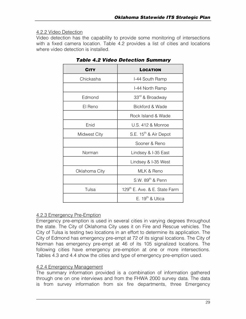
4.2.2 Video Detection Video detection has the capability to provide some monitoring of intersections with a fixed camera location. Table 4.2 provides a list of cities and locations where video detection is installed.
Table 4.2 Video Detection Summary
CITY
LOCATION
Chickasha
I-44 South Ramp
I-44 North Ramp
Edmond
33rd & Broadway
El Reno
Bickford & Wade
Rock Island & Wade
Enid
U.S. 412 & Monroe
Midwest City
S.E. 15th & Air Depot
Sooner & Reno
Norman
Lindsey & I-35 East
Lindsey & I-35 West
Oklahoma City
MLK & Reno
S.W. 89th & Penn
Tulsa
129th E. Ave. & E. State Farm
E. 19th & Utica
4.2.3 Emergency Pre-Emption Emergency pre-emption is used in several cities in varying degrees throughout the state. The City of Oklahoma City uses it on Fire and Rescue vehicles. The City of Tulsa is testing two locations in an effort to determine its application. The City of Edmond has emergency pre-empt at 72 of its signal locations. The City of Norman has emergency pre-empt at 46 of its 105 signalized locations. The following cities have emergency pre-emption at one or more intersections. Tables 4.3 and 4.4 show the cities and type of emergency pre-emption used. 4.2.4 Emergency Management The summary information provided is a combination of information gathered through one on one interviews and from the FHWA 2000 survey data. The data is from survey information from six fire departments, three Emergency
29

Oklahoma Statewide ITS Strategic Plan
Management Services, six police departments and three county sheriff departments. All departments are within the Tulsa and Oklahoma City metropolitan areas. Table 4.3 summarizes the data from the police and sheriff departments. Table 4.4 is a summary of data from the fire, rescue and EMS agencies. For the reporting police and sheriff departments, there are a total of 1875 police vehicles in service. There is expected to be an increase of 17% in vehicles by 2005. Eighty one percent of the vehicles are dispatched with a CAD system. Two communities, Edmond and Broken Arrow, allow police vehicles to pre-empt traffic signals. For the reporting fire and EMS departments, there are a total of 247 vehicles in service. The fleet is expected to increase 11% by 2005. There are 17 vehicles currently with an on-board navigation system within the Oklahoma City Fire Department. The Norman Fire Department, Tulsa EMS, and Norman EMS plan on installing on-board navigation systems on a limited number of vehicles by 2005. Sixty-six percent of the vehicles are dispatched using a CAD system. This is expected to increase to 93% of the fleet by 2005. All of the reporting fire departments have signal pre-empt capability. None of the EMS agencies have it. Thirty-four percent of the total fleet will have pre-empt capabilities by 2005. The Midwest City EMS expects to have some pre-empt capabilities. The overall fleet capability to pre-empt traffic signals is expected to increase to 63% by 2005.
30

Oklahoma Statewide ITS Strategic Plan
Table 4.3 Police Department Inventory NO. OF
VEHICLES ON-BOARD
NAV. CAD
DISPATCH PRE-EMPT
CAPABILITIES
CITY 2000
2005
2000
2005
2000
2005
2000
2005
Broken Arrow PD 77 120 0 0 0 120 70 120
Canadian County Sheriff
32 38 0 0 0 0 0 0
Edmond PD 75 85 0 0 0 85 9 12
Midwest City PD 77 82 0 0 77 82 0 0
Norman PD 86 105 0 0 86 105 0 0
Oklahoma City PD 620 620 0 0 571 571 0 0
Oklahoma County Sheriff
180 300 0 0 60 300 0 0
Tulsa County Sheriff
128 150 0 0 128 150 0 0
Tulsa PD 600 700 0 250 600 700 0 0
Totals 1875 2200 0 250 1522 2113 79 132
Table 4.4 Fire, Rescue And EMS Inventory NO. OF
VEHICLES ON-BOARD
NAV. CAD
DISPATCH PRE-EMPT
CAPABILITIES
CITY 2000
2005
2000
2005
2000
2005
2000
2005
Tulsa FD 54 NA 0 0 54 NA 8 NA
Broken Arrow FD 21 24 0 0 0 24 21 24
Oklahoma City FD 91 95 17 NA 91 95 25 50
Edmond FD 10 12 0 0 0 12 10 12
Midwest City FD 21 27 0 8 8 10 12 14
Norman FD 26 29 0 8 0 12
9 12
Tulsa EMS 5 5 0 1 5 5 0 0
Midwest City EMS 14 16 0 8 0 16 0 10
Norman EMS 5 6 0 0 5 6 0 0
Totals 247 214 17 25 163 180 85 122
31

Oklahoma Statewide ITS Strategic Plan
4.2.5 Transit Management There are two agencies which manage large transit fleets in Oklahoma; the Metropolitan Tulsa Transit Authority (MTTA) in Tulsa and Central Oklahoma Transit and Parking Authority (COTPA) in Oklahoma City. There are over twenty transit agencies that serve the rural areas of the state. A summary of the existing (E) and planned (X) ITS functions for each agency are shown in Table 4.5. Table 4.5 Transit Inventory
AGENCY
DE
MA
ND
RE
SP
ON
SIV
E V
EH
ICL
ES
VE
HIC
LE
S E
QU
IPP
ED
WIT
H
AU
TO
MA
TE
D V
EH
ICL
E L
OC
AT
OR
S
SC
HE
DU
LIN
G S
OF
TW
AR
E /
CO
NN
EC
TIO
N T
O O
TH
ER
PR
OV
IDE
RS
HA
ND-H
EL
D D
AT
A C
OL
LE
CT
ION
DE
VIC
ES
VE
HIC
LE
MA
INT
EN
AN
CE
MO
NIT
OR
ING
SY
ST
EM
S
FIN
AN
CIA
L A
ND
BIL
LIN
G S
YS
TE
M
INT
ER
NE
T B
AS
ED
D
OC
UM
EN
TA
TIO
N S
OF
TW
AR
E
CA
ME
RA
S O
N V
EH
ICL
E W
ITH
TA
PE
AR
CH
IVE
RE
AL
TIM
E A
DV
AN
CE
D T
RA
VE
LE
R
INF
OR
MA
TIO
N S
YS
TE
MS
AU
TO
MA
TE
D P
AY
ME
NT
AN
D
PA
SS
EN
GE
R C
OU
NT
ING
S
YS
TE
MS
RA
DIO
SY
ST
EM
Beaver Transit E E
Call-A-Ride Public Transit
E X X X X X E
Central Oklahoma Transit
E X E
Cherokee Strip Transit E X
Cimarron Public Transit E X X X X X X X E
Delta Public Transit E X X X X X E
First Capital Transit E X X X X X X X X E
JAMM Transit E E KiBois Area Transit E X X X E X X X X X E
Lawton Area Transit E X X X X X X X X E
32

Oklahoma Statewide ITS Strategic Plan
Little Dixie Transit E X X X X X X X X X E
Muskogee County Transit
E E
Oklahoma City Metro E X E X E E
OSU / The Bus E X X X X X X X X E
Pelivan Transit E E Red River Transportation Service
E X E
The Ride E X X X E
Southern Oklahoma Rural Transportation
E X X X X E
Southwest Transit E E
The Transit E X X X X X X X E
Tulsa MTTA E X E X E
Washita Valley Transit E X X X X X X E
33

Oklahoma Statewide ITS Strategic Plan
5.0 TELECOMMUNICATIONS ASSESSMENT 5.1 Introduction Telecommunications infrastructure is a vital part of any ITS deployment and can play a significant role in affecting the overall cost of implementation. A thorough assessment of existing telecommunications resources is important for ensuring that these resources can be maximally leveraged in strategic ITS planning. In this chapter, currently existing statewide telecommunications assets are identified for the State of Oklahoma. The data throughput, or bandwidth, requirements of existing plus proposed ITS assets are estimated. These requirements are then compared against the capacity of existing telecommunications assets to determine how much additional telecommunications infrastructure will be required to support statewide ITS implementation. 5.2 Current Telecommunications Assets – Statewide Existing state-owned telecommunications assets available to support statewide ITS implementation fall into two categories: fiber optic cable and radio infrastructure. The following discussions identify assets in each category. In order to assess current and future bandwidth requirements, it will also be necessary in this chapter to examine planned deployments of field equipment including web cameras, pan-tilt- zoom full motion video cameras, weather sensing stations, dynamic message signs (DMS – both portable and fixed), and radio frequency traffic detectors. 5.2.1 Fiber Optic Cable ODOT is fortunate to have under its control a significant amount of fiber optic infrastructure in both the Oklahoma City and Tulsa metropolitan areas. Figure 4.2 shows all of the state-owned fiber optic cable currently deployed in Oklahoma. Fiber cable exists along the entire length of both I-35 and I-44 in Oklahoma. The fiber is predominantly carrier-grade single- mode, capable of supporting high data rates over relatively long spans. Most of this fiber is dark (unused) at the present time. Lighting the fiber to make it usable for ITS requires the procurement and installation of fiber optic multiplexers and switches that enable information to be transmitted and received through the fiber cables. It should be noted in Figure 4.2 that there is an absence of fiber optic cable along I-40. Appendix B enumerates and details all of the state-owned fiber optic cable currently available in Oklahoma. A detailed map showing state-owned fiber links appears in Appendix C. Some of these fiber optic cables belong to other state agencies; in some of those cases a memorandum of understanding (MOU) is already in place to make the cables available to ODOT for ITS use while in other cases MOU’s would need to be negotiated in the future.
34

Oklahoma Statewide ITS Strategic Plan
5.2.2 Statewide Radio Network ODOT presently owns a radio network that provides total coverage of the state. The network is predominantly used for two-way voice communications regarding roadway maintenance. The low bandwidth links provide little opportunity to support bandwidth intensive ITS applications. However, a small number of low bandwidth rural ITS applications (e.g., remote weather stations, RTMS sensors located at rural work zones) may be supportable by this radio network. This network provides full coverage of the entire state. 5.3 ITS Assets In the following subsections, current, in- work, and proposed ITS assets for statewide ITS implementation are examined. Enumerating these assets and their communications requirements is important for estimating the expected bandwidth requirements needed to deploy ITS in the State. This chapter considers only those assets that are specifically designated for ITS use. It should be noted that other assets including RTMS microwave traffic sensors, weather stations, weigh- in- motion sensors, etc., have been deployed in the state for, e.g., planning but not ITS. Such assets are not considered here. 5.3.1 Current ITS Assets – Oklahoma City To date, deployed ITS assets in Oklahoma are limited to the Oklahoma City metropolitan area. Eleven (11) Dynamic Message Signs (DMS) are installed and operational at strategic points along interstate highways, as shown in previously Figure 4.1. Existing DMS are shown in green while in-work DMS are shown in red. Data communications to and from these DMS’s is currently via leased- line dialup telephony service. Future plans call for all fixed-location DMS’s in metropolitan areas in the State to eventually be connected to an ITS private network via fiber optic cables. In addition, the ITS Lab at the University of Oklahoma maintains an array of ITS assets for the purpose of investigating and ensuring seamless hardware integration and also for supporting ITS software development efforts. Communications infrastructure connecting the lab to the outside world is currently limited to Internet connectivity. 5.3.2 In-Work Assets – Oklahoma City A first- year ITS deployment project is presently underway in Oklahoma City where I-40 skirts the northern boundary of Tinker AFB. This segment of roadway has been the site of many crashes and truck-rollovers in the past. In addition, when Tinker AFB heightens security alert status, traffic attempting to enter the northern gates of the base can back up onto I-40. To provide ODOT and Tinker personnel a more effective means of monitoring incidents and traffic conditions, two DMS, four Closed-Circuit Television (CCTV) cameras, and 14 Internet Protocol (IP) based web cameras will be installed in 2003. The CCTV cameras will provide full-motion video images with pan-tilt-zoom (PTZ) camera control.
35

Oklahoma Statewide ITS Strategic Plan
A 24-strand dedicated fiber optic cable will be installed to support the I-40 Tinker AFB project. Each fiber in the cable will be used for either analog video or for packet switched IP data communications. This cable will connect all four full-motion PTZ CCTV cameras, all 14 web cameras, and associated communications equipment to an ITS operator control console that will be located on Tinker AFB. For the near term, communications to and from the two DMS’s will be via leased- line telephony connections. Initially, this equipment will comprise a standalone system without external communication capabilities. On the 24-month future horizon, it is envisioned that a fiber optic cable will connect this system with a broadband ODOT communication backbone available at the Reno Avenue Division IV regional annex. 5.3.3 In-Work Assets – Tulsa A first-year ITS deployment project is presently underway in Tulsa, where an array of ITS assets will be deployed at strategic locations across the metropolitan area. This early ITS deployment will give ODOT and the Department of Public Safety (DPS) personnel a base-level capability to monitor incidents and traffic conditions. In addition to providing ODOT and DPS with a small-scale Traffic Management Center (TMC) capability, the following ITS assets will be deployed in 2003: seven DMS’s, seven CCTV cameras, and 16 web cameras. The locations of these assets are shown in Figure 5.4. All of the backbone communications for this project will be IP-based, including video communications. The network will be implemented over fiber optic cables some of which are owned by the Oklahoma Transportation Authority (OTA) and some of which are owned by ODOT. A MOU currently in place between ODOT and OTA stipulates that, for the OTA owned fiber links, 300 Mbps of bandwidth will be available for ITS use. Video from the analog CCTV cameras will be digitally encoded for transmission over the IP network. The green rectangles are DMS’s, circles with green fill and central black dot are CCTV cameras, and pentagons with green fill are web cameras. 5.3.4 Proposed Assets – Oklahoma City Appendix D tabulates bandwidth requirements necessary to support ITS equipment that is expected to be deployed in the Oklahoma City metropolitan area on the ten-year horizon. This equipment includes:
• 74 full-motion CCTV Cameras with PTZ • 20 fixed-location DMS’s • 296 IP-based Web Cameras • 37 vehicle detectors, which may be of various types
36

Oklahoma Statewide ITS Strategic Plan
Edi s on S t
41s t S t
49th
W S
t
33rd
W S
t
Uni
on A
ve
Elw
ood
Ave
7 1 s t S t
A pache S t
Har
vard
Ave
51
412
Cin
cinn
ati
Ave
1 1 t h S t S
97
21 th S t S
31 th
51 th S t S
71 th S t S
91 th S t S
Lew
is A
ve
C r e ek T u r np i ke
64
169
64
101 t h S t S
61 th S t S
Peo
ria
Ave
Yal
e A
ve
Mem
oria
l D
r
Gar
net
Rd
129th
Ave
145th
Ave
1 1
P ine S t
36 th S t
66 th S t
44
244 44
75
44
244
161s
t A
ve
169
Ex i s t iDMS
ng
P l annedDMS
Legend
C losed C i r cu i t Camer a
Ex i s t i ng F ibe rOp t i c C ab l e
P l anned F ibe rOp t i c C ab l e
Figure 5.1 In-Work ITS Assets in the Tulsa metropolitan Area
37

Oklahoma Statewide ITS Strategic Plan
K i l p a t r i c k T u r n p k
Sar
a R
d
Cou
nci
l
N . W . 1 0 t h A v e
R e n o A v e
N . W . 5 0 t h S t
43
4
44
235
1 5 2
Mer
idia
n A
ve 2 9 t h S t
77
62
240
35
5 9 t h S t
2 7 t h S t
4 4 t h S t
W i l s h i r e
H e f n e r
3 3 r d S t
Eas
tern
2 3 r d S t
48
th A
ve
So
on
er R
d
Mid
wes
t B
lvd
Po
st R
d
Ch
oct
aw R
d
L e g e n d
E x i s t i n g D M SP l a n n e d D M S
3 7
35
44
4440
35
40
7 4
C l o s e d C i r c u i t C a m e r a
60
F i b e r O p t i c C a b l e
Figure 5.2 Proposed ITS Assets for Oklahoma City
38
Oklahoma Statewide ITS Strategic Plan
None of the expected types requires bandwidth in excess of 19.2 kbps; this figure was therefore used in the bandwidth calculations. The expected locations for deployment of these assets are shown in Figure 5.5 below. As shown in Appendix D, the total bandwidth required for these expected deployments is 875 Mbps. 5.3.5 Proposed Assets – Moore / Norman Area Appendix D tabulates bandwidth requirements necessary to support ITS equipment that is expected to be deployed in the Moore / Norman area on the ten- year horizon. This equipment includes
• 12 full-motion CCTV Cameras with PTZ • 3 fixed-location DMS’s • 48 IP-based Web Cameras • 8 vehicle detectors, which may be of various types.
None of the expected types requires bandwidth in excess of 19.2 kbps; this figure was therefore used in the bandwidth calculations.
The expected locations for deployment of these assets are shown in Figure 5.6 below. As shown in Appendix D, the total bandwidth required for these expected deployments is 125 Mbps.
39

Oklahoma Statewide ITS Strategic Plan
44
35
44 240
40
R o b i n s on S t
F r a n k l i n S t
77
E 1
2th A
ve
L i nd s ey S t
Bry
ant
Ave 3 4 t h S t
2 7 t h S t
37
Wes
tern
Ave
May
Ave
Mac
Art
hur
Ave
Mid
wes
t A
ve
Pos
t A
ve
Hiw
asse
e A
ve
Cho
ctaw
Ave8 9 t h S t
5 9 t h S t
E x i s t i n gD M S
P l an ne dD MS
Legend
C l o s ed C i r c u i t C a me r a
E x i s t i n g F i be rO p t i c C a b l e
P l a nn e d F i b e rO p t i c C a b l e
Figure 5.3 Proposed ITS Assets for the Moore / Norman Area
40

Oklahoma Statewide ITS Strategic Plan
5.3.6 Proposed Assets –Tulsa Metropolitan Area Appendix D tabulates bandwidth requirements necessary to support ITS equipment that is expected to be deployed in the Tulsa metropolitan area on the ten-year horizon. This equipment includes:
• 63 full-motion CCTV Cameras with PTZ • 20 fixed-location DMS’s • 252 IP-based Web Cameras • 35 vehicle detectors, which may be of various types
None of the expected types requires bandwidth in excess of 19.2 kbps; this figure was therefore used in the bandwidth calculations. The expected locations for CCTV and DMS deployment were shown in Figure 5.4. As shown in Appendix D, the total bandwidth required for these expected deployments is 775 Mbps. 5.3.7 Proposed Assets – Lawton Appendix D tabulates bandwidth requirements necessary to support ITS equipment that is expected to be deployed in the Lawton area on the ten- year horizon. This equipment includes:
• 2 full-motion CCTV Cameras with PTZ • 0 fixed-location DMS’s • 16 IP-based Web Cameras • 2 vehicle detectors, which may be of various types
None of the expected types requires bandwidth in excess of 19.2 kbps; this figure was therefore used in the bandwidth calculations. The locations for deployment of these assets have not yet been established. As shown in Appendix D, the total bandwidth required for these expected deployments is 50 Mbps.
5.3.8 Proposed Assets – Rural Appendix E tabulates bandwidth requirements necessary to support ITS equipment that is expected to be deployed on a twenty-year horizon in areas other than those treated in Sections 5.3.1 through 5.3.7 above. This equipment includes:
• 350 IP-based Web cameras with opposite- facing pairs placed at ten- mile intervals, and
• 175 Weather Remote Processing Units placed at ten- mile intervals coincident with the Web camera deployments.
The locations for deployment of these assets have not yet been established. As shown in Appendix E, the total bandwidth required for these expected deployments is 550 Mbps. It is envisioned that future fiber optic cable
41

Oklahoma Statewide ITS Strategic Plan
deployments (discussed below in Section 5.4.2) will enable all of this equipment to communicate with the STIC. 5.4 Capability Assessment 5.4.1 Ten-Year Horizon Currently deployed optical fiber assets are not sufficient to support the metropolitan area ITS deployments enumerated above in Sections 5.3.1 through 5.3.7 above. The following additional optical fiber deployments are recommended:
• I-40 from the Texas border to Webber’s Falls, • US 69 from I-44 to the Texas border, • US 412 from I-35 to Enid, • I-240 from I-44 to I-40, and • I-35 from SH 9 West to I-40.
The accompanying switching equipment should support link bandwidths of 100 Mbps for rural links and 1 Gbps for urban links. While these figures are higher than the bandwidth requirements calculated in the Appendices, they will provide growth capability to accommodate unforeseen future sensor types and communications needs. The proposed routes of new fiber optic cable support statewide ITS implementation, both urban and rural. With the addition of these optical fiber links, all of the planned metropolitan area deployments described in Sections 5.3.1 through 5.3.7 can be supported. In Tulsa, where bandwidth on the OTA-owned packet switched network is a concern, it should be noted that the bandwidth figure of 775 Mbps shown in Section 5.3.6 above represents the total bandwidth requirement. This total bandwidth for the network can be accommodated without exceeding the limit of 300 Mbps on any individual fiber optic link, as imposed by the current MOU between ODOT and OTA. Although rural ITS deployments are not planned on the ten- year horizon, the currently deployed communications infrastructure could support low-bandwidth ITS services in rural areas by utilizing ODOT’s statewide radio network. While full motion video would not be possible over this network, reduced rate video, snapshot images from web cameras, and most types of traffic and weather sensor data could be transmitted. Thus, it would be feasible to bring some ITS services to rural areas on the ten- year horizon if this were deemed advantageous. 5.4.2 Twenty-Year Horizon To support the deployment of the rural ITS assets enumerated in Section 5.3.8, additional fiber is needed. These needed fiber links are shown in blue in Figure 5.8 above. Specifically, they are along:
42

Oklahoma Statewide ITS Strategic Plan
• US 412 from Enid to the New Mexico border, • US 81 from IH-40 (west of Oklahoma City) to Enid, and • US 75 from the Kansas border to the Texas border.
It may also be desirable to consider deploying a grid of radio frequency transponders to support enhanced ITS capabilities along major roadways, both rural and urban. For example, such a network could provide the capability for DPS officers and ODOT maintenance personnel including, e.g., snowplow operators, to obtain video, weather, and other ITS system data directly in their vehicles. A comparative cost study of the possible equipment tradeoffs would need to be undertaken to design such a radio network. High power, licensed radio transponders could easily provide sufficient bandwidth coverage omni-directionally with a radio spacing of 10 miles. Note that broadband communications infrastructure is already proposed to be available at ten- mile intervals to support the web cameras and Weather Remote Processing Units discussed in Section 5.3.8 above. Design alternatives to establish a radio network of this type using a more dense grid of lower power unlicensed transponders should also be investigated.
43

Oklahoma Statewide ITS Strategic Plan Appendix
Appendix A Summary of Stakeholder Interviews and Surveys Interview: 12/19/01, 10:30AM Location: Association of Central Oklahoma Governments (ACOG) Office In Attendance: Linda Koenig Doug Rex Steve Hofener
Erin Ehlinger Vickie Morris Existing: They have set up an ITS Steering committee. This committee is split into three sub-committees: incident management, traveler information, technology and operations. The incident management sub-committee is currently meeting regularly and has been working towards getting quick clearance legislation passed. Training has been held at the ACOG offices involving incident management and ITS architecture. They are currently finishing up the ITS architecture for the region. Future Needs/Wants: They have considered being the data warehouse for the region. This was mentioned in the ITS architecture meetings. If they are not the ultimate data warehouse, they want a direct line to the data. They could host a website with information concerning construction and maintenance closures with information from all regional agencies. It was mentioned that Tim Callahan at ODOT is already creating a map with this information for ODOT. In the incident management meetings, the possibility of Pike Pass being used for congestion monitoring has been mentioned. This information will benefit all agencies. Issues:
o Trouble getting some important stakeholders to steering committee meetings.
o Need for better records of accident locations, clearance times, etc. o There is very little support for ITS from the middle to high level
management. They think this is the major stumbling block for ITS. o One key for selling ITS is to convince the rural commissioners that it is not
just beneficial to urban areas. o There is an overall perception that they do not have a traffic congestion
problem in the area.
44

Oklahoma Statewide ITS Strategic Plan Appendix
Interview: 12/18/01, 2:00PM Location: ODOT Division III Office In Attendance: Jessie Fullingim Rick Bond Gary Chaffin Ralph Nguyen Steve Hofener Erin Ehlinger
Vickie Morris Background: Division III has been involved with the new maintenance contract with VMS, and Cleveland county in their district is covered in the contract. They have attended ACOG ITS meetings regularly They have sent representatives on the trip to Seattle and Portland to view what others are doing in ITS. Existing: Hand held sensors for measuring pavement surface temperature Radios are currently Kenwood 155.25 MHz. This is the statewide ODOT system and supports voice only. They also have cell phones to supplement the radio system. The currently cannot communicate directly with Highway patrol until they are on the scene. There is one high accident rail crossing location that they are interested in trying new technology to improve. They have the DTN weather service, and 2 NOAA radios in the District (one in Norman, one at Mc Alister). Six portable DMS (Winkomatic brand) Future Needs/Wants: More NOAA Weather Radios, connection to the weather system at OU, or any system that will provide better weather information. RWIS on bridges, and other locations to support improved snow and ice response. They would like to eliminate the use of “watch for ice on bridge” signs. These signs are currently mandatory according to their state MUTCD. They are interested in becoming more involved in the I40 coalition. Trucking is a big issue in their division.
45

Oklahoma Statewide ITS Strategic Plan Appendix
Service patrol of some type may be useful. Perhaps one of the employees could be trained in traffic control at incidents and provided with a special rig. They hope to have a speed detection system installed soon. Issues:
o Alternative routing around incidents and HAZMAT spills is a big issue in the division. This is in part due to the fact that they are not allowed to route traffic onto any roads except designated State Highways. If they do, the county asks for money to pay for road wear and damages. Coordination with counties for rerouting purposes is challenging as the Counties are always concerned about the damage to their roads. Also, re-routing signing can take hours to set up which is not feasible for short-term detours.
o They do not have good communication with the Oklahoma Highway patrol in that area. They typically are not contacted about incidents, unless the officer needs their equipment.
o It is hard to justify the use of ITS, when they do not even have shoulders on some of their roads.
46

Oklahoma Statewide ITS Strategic Plan Appendix
Interview: 12/18/01, 9:00AM Location: ODOT Reno Annex In Attendance: Ron Curb Brett McIntyre Randy Lee Rick Lowry Christopher Poe Steve Hofener
Erin Ehlinger Vickie Morris Background: Recurrent congestion is not a huge issue in Oklahoma City at this time. Non-recurrent congestion is an issue. Peak periods have the most incidents, but these tend to be smaller incidents. Nighttime periods have the most severe incidents that can take several hours to clear. There are limited routes for diversion during freeway incidents. Approximately 4 years ago ODOT became interested in dynamic message signs as a result of it taking so long to dispatch portable signs to incidents. This was the first interest in ITS. Most permanent DMS now installed are focused on traffic entering the region. Construction projects have pushed ITS. First, there had been a history of incidents due to construction, such as during the I-40/Choctaw project. Second, DMS could be procured that supported construction traffic management which could be used post-construction for regional traffic management. Upper management did not see the benefit of ITS, except in the areas of incident management. They feel that the needs of the many out weigh the few and that ITS focuses too much on urban areas. For ITS to work, it must show benefit in rural areas too. Existing: Automated sprayers on one bridge for ice control. Approximately seven acres of land has been purchased near the Reno Annex for a future TMC site. There are several DMS signs currently in place in the region. The signs are placed to divert primarily inbound Interstate traffic to other Interstates in the event of an incident. All are dial-up, and can be accessed from essentially anywhere using a PC with the sign software. These signs will remain dark unless pertinent accident information is available. They will not provide weather information. However, ODOT Division IV would like to gather weather data at the signs including pavement temperatures.
47
Oklahoma Statewide ITS Strategic Plan Appendix
Incident management is handled by the contracted maintenance, VMS, Inc. VMS must respond with traffic control in place within 45 minutes during peak hours. VMS must respond with traffic control in place within 75 minutes during off-peak hours. VMS must contact ODOT Division when incident is expected to last over 1 hour. ODOT Division retains operation of the DMS. Coordinating the use of DMS during incident management could be improved. HAZMAT is controlled by the Fire department. HAZMAT typically causes lengthy delays. Working with the I-40 coalition (TX, NM, AZ, others) to develop means to post advanced information for truckers before they enter or leave each state. Future Needs/Wants: Real-time map of region (possibly state) posted on the internet that provides the user with near real-time construction and maintenance information. A color-coded congestion map posted on the Internet. If there is a way to post this map on a colored DMS, there may be interest to do so. More freeway management functions and devices and telecommunications need to be implemented to create this map and to use the DMS more effectively for incident management. There is a need to develop an operator’s manual for the DMS. Service patrol would be a good idea, but not sure how it would work with the current maintenance contract with VMS. They want RWIS, including sensors for pavement temperatures for maintenance purposes, and telecommunications to the devices. Roadway weather information system would aid in asset management during inclement weather. Would like to consider modifying the current VMS contract. A hybrid maintenance contract in the future that splits operating responsibility between ODOT and contracted maintenance. It would also define functions of incident management and ITS in more detail. Truck rollover detection is needed at several locations. (Portsmouth Jct., perhaps the EB exit to Morgan road, although the reconstruction appears to have corrected this issue). Over height detection is also needed, especially at the 63rd Street Bridge at the Broadway exit. It’s been hit 3 times already this year. Would like to have a Division TMC, with the potential to co-locate with DPS. Peer to Peer visits with similar states Ramp metering should be put in the plan for the long-term future.
48

Oklahoma Statewide ITS Strategic Plan Appendix
Would like more information on “zipper” lanes, like in DC. These might be useful in the region on I-44. There are no Highway-Rail intersection issues in the District. Issues: Privatization of maintenance started this year in the Oklahoma City region and surrounding counties. The contract is for “routine” maintenance. ODOT Division still retains operation of the DMS signs. This contract is renewed annually with a total of 5 years. There is a need to separate out operations from maintenance duties for contracted maintenance. Another strategy is to have performance based goals for operation and maintenance. This strategy will help monitor how private contractor is performing. Divided Crash Investigation responsibilities with the City of Oklahoma City Police Department on major freeway routes and seemingly different goals about clearing the incident. The City Police do not have the same training on handling incidents on high-speed facilities, such as the OSP do. This can cause problems and long delays on city-owned facilities when there are incidents. These delays affect ODOT’s facilities as well. Total Stations might be useful to the City to help speed incident clearance.
49

Oklahoma Statewide ITS Strategic Plan Appendix
Interview: 12/19/01, 2:00PM Location: Department of Public Safety In Attendance: Gene Thaxton Vickie Morris Ron Curb
Steve Hofener Erin Ehlinger Background: Gene Thaxton serves as the manager of communications for the DPS statewide. This includes computer systems, software, dispatch, radio, etc. He is also the chair of the Oklahoma Traffic Records committee. Existing: There are thirteen troops in the state and each has it’s own communications center. One troop is dedicated to the turnpikes specifically. The currently have a low band (+/-145) radio system that is being converted to an 800mHz system. Currently, both systems are in operation. The current 800MHz system is now analog. It will be upgraded to trunked digital. The DPS uses their radio system only for voice, not for data. Currently, they plan to use satellite communications for data. This system is currently under test in Oklahoma and several other rural states. They have no association with 911. They have a *55 call-in systems for emergencies. The have a good wrecker rotation system currently in place. The current budget includes funding for 900 Mobile Data Terminals (MDTs) – essentially the entire DPS fleet. Future Needs/Wants: They are taking the lead on testing out the use of satellite for statewide data communications. The system can pull up records on a tag within 10 seconds. It can also be used for trucking permits, accident records, officer location, etc. They are willing to share satellite communications system with other agencies to assist in coordination. They are hoping that other police agencies will piggyback onto this system. They are working with OTA and ODOT on the implementation of 8 dynamic message signs. hey would like the use of cameras for 24/7 monitoring at each dispatch center, as cameras are added to ODOT’s system. Incident clearance would be expedited by providing better communications with the responding ambulance. (e.g. Providing information on the best route to the scene)
50
Oklahoma Statewide ITS Strategic Plan Appendix
Issues:
o Officers have expressed reluctance to use the satellite system for tracking DPS vehicles. This should be resolved by implementing a switch that the officers can use to turn the tracking portion of the system on or off.
o DPS would be willing to discuss sharing filtered CAD data with ODOT to help in incident management.
o The use of outside contractors (maintenance) has been an issue. The relationships have not been built between outside contractors that were already established between DPS and ODOT.
o He is not aware of anyone in his agency that is looking into the use of total stations or other technology for accident investigation. They have a special team that handles accident investigation.
51

Oklahoma Statewide ITS Strategic Plan Appendix
Interview: 12/18/01, 11:00AM Location: City of Oklahoma City In Attendance: Sheila Dees Stuart Chai (unable to attend)
Ron Curb Christopher Poe Steve Hofener Erin Ehlinger Vickie Morris
Existing: The city operates approximately 600 signals. They have nine closed loop systems with phone drops, and two closed loop systems that are directly wired into the central office. In addition there are two Multisonic VMS systems controlling all downtown signals and approximately 23 signals along N.W. Expressway and 39th Street. They have video detection cameras at two locations. The locations are MLK and Reno and S.W. 89th and Penn. The set of cameras at MLK and Reno comes back to the central office. Heavy involvement in incident management for area disasters such as tornadoes. For freeway incidents they usually get a call once the signals are already congested. They are regularly in contact with VMS (contracted maintenance for the state) concerning incidents. They provide barricades, and portable DMS and other resources for traffic control. Six portable changeable message signs, no permanent locations. Agreements with other cities for control of their signals They have regular communication with COTPA concerning road closures and construction. COTPA will alert the city of to roadway issues that hinder their bus routes. The city has a website that contains static information Future Needs/Wants: Cameras for interstate routing onto city streets that are used for alternate routes. Better communication between agencies concerning incident management, specifically ODOT Sharing of camera images, not necessarily control, to and from other agencies Interconnects on all arterials running parallel to the interstates. When ODOT develops the regional TMC, it may be useful to have a city employee located at the center.
52

Oklahoma Statewide ITS Strategic Plan Appendix
Need to have railroad pre-emption at signals. Need to settle on how to respond to incidents. Everyone does things differently and this causes conflicts and problems. Would like to be able to change signal timing to respond to detours and incidents. Issues:
o Staffing shortage o Alternate route decisions need to be made, but the City is not likely to
designate alternate routes without some resources to apply to those roads.
o Ramp metering would be difficult at some locations because there is not enough queueing distance on some ramps.
o No consistency between agencies of how they handle emergency or incident management.
53

Oklahoma Statewide ITS Strategic Plan Appendix
Interview: 12/19/01, 9:00AM Location: Oklahoma Transportation Authority Office In Attendance: Gary Brown Ron Curb Steve Hofener Erin Ehlinger Vickie Morris Background: OTA/ODOT owns the majority of fiber in Oklahoma. They are working on a partnership with Southwestern Bell for usage of the fiber they own across the state. Existing: The Pike Pass is an active (2-way) transponder. They have prototypes of smaller (credit card size) transponders. They have between 8 to 124 strands on most of the interstates in Oklahoma. OTA has management responsibilities and are leasing to ODOT. This contract is currently under negotiation. The majority of the information they send on the fiber is toll revenue related. Over 65 cameras in place for violation processing as well as road loops for toll classification. These cameras are currently not used for incident management. They have 8 portable Variable Message Signs. They have a maintenance contract with VMS. This is the same contractor that ODOT is using in some counties. It is only for a small portion of the urban turnpike (Kilpatrick Turnpike) in Oklahoma City from approximately Macarthur Boulevard to I-40. They looked into weather systems 3 or 4 years ago and did not find them cost effective. They have automated de-icing at toll plazas. Website in operation, which does not contain road information. Future Needs/Wants: They are in the process of partnering with ODOT to implement 8 dynamic message signs. These signs will be operated by DPS. These will be shoulder-mount (ADDCO Brick). They will deploy 2 near Oklahoma City, 2 near Stroud, 2 near Tulsa, and 2 elsewhere. The locations in Oklahoma City and Tulsa are at the ends of the Turner Turnpike and also at Stroud ( the half way interchange).
54

Oklahoma Statewide ITS Strategic Plan Appendix
They would like to install an over height warning system at toll plazas. They are interested in providing traveler information via kiosks/internet at rest areas and truck stops. Issues:
o They have studied HAR, and do not believe it to be effective. o There was some concern about ODOT using the Pike Pass for congestion
detection. Their concern is possible battery deterioration. However, this is a possibility.
o They have tried to work with other states on sharing transponder information. This has been unsuccessful.
55
Oklahoma Statewide ITS Strategic Plan Appendix
Oklahoma Rural Transit Providers The following is a list of the agencies providing public transportation in the nonurbanized areas of Oklahoma: AGENCY NAME
FUTURE NEEDS/ISSUES
Bartlesville CityRide 401 South Johnstone Bartlesville, OK 74003 Director: Lisa Beeman Applicant: City of Bartlesville
Will be operated by United Community Action Program Inc.//Cimarron Public Transit System starting October 1, 2005
Beaver City Transit P.O. Box 698 30 West 2nd
Beaver, Oklahoma 73932 Director: Joyce Clark Applicant: Town of Beaver
None planned.
Call-A-Ride Public Transit 15425 County Road 3540 Ada, OK 74820 Director: Danna Laxton Applicant: Pontotoc County Public Transit Authority
o Initiate internet based software and hardware with
GPS capabilities at each system and in each vehicle for routing, tracking, coordinating and reporting purposes: - Must be able to support financial and statistical data
currently required by ODOT and its MYLE program with capability to adapt to future needs.
- Must be able to visually watch and identify vehicles move in real time and record same up to 24 hours for review if warranted. (Identified by system or ‘labeled’ if you will, on the screen)
o Utilize the ITS for the ultimate efficiency: - within each system - system to system (neighboring systems and ones on the
other side of the state) - for disaster relief and evacuation efforts within each
system’s area, system to system and in coordination efforts with state emergency agencies i.e. Civil Defense, FEMA, etc.
o Offer public internet access to all systems’ schedules of origins and destinations with estimated departure and arrival times without giving access to individual rider information. - this could be used by systems for coordination of rides,
fuel, vehicle and driver time economy and for public for traveling information.
o This could also be the way to coordinate for emergency disaster relief and evacuation with CD and FEMA’s.
56
Oklahoma Statewide ITS Strategic Plan Appendix
Central Oklahoma Transit System P. O. Box 486 Shawnee, OK 74802 Director: Amber Davis Applicant: Central Oklahoma Community Action Agency
Route match program Handheld radios
Cherokee Strip Transit 2901 North Van Buren Enid, OK 73703 Director: Rita Kroll Applicant: Northern Oklahoma Development Authority
No specific plans.
Cimarron Public Transit System 501 Sixth Street Pawnee, OK 74058-2542 Director: David Ellison Applicant: United Community Action Program, Inc.
o Modify the current MYLES program to internet/web based platform.
o Dispatcher scheduling and tracking. o Generate tentative driver schedule. o Establish groundwork for future technology, GPS
etc. o Establish connection between rural programs.
Delta Public Transit 225 West McClure Avenue Pauls Valley, OK 73075-3823 Director: Faith Evans Applicant: Delta Community Action Foundation, Inc.
No plans at this time
The Transit 1502 West Poplar Enid, OK 73703-3344 Director: Leslie Jager Applicant: Enid Public Transportation Authority
GPS Tracking system for all of our buses integrated with computerized dispatching.
First Capital Trolley P. O. Box 1512 Guthrie, OK 73044-1512 Director: Melissa Fesler Applicant: Logan County Historical Society, Inc.
Monitoring systems on all vehicles.
The Ride 219 West 4th
Guymon, OK 73942-4709 Director: Dianna Brown
GPS hardware and software.
57

Oklahoma Statewide ITS Strategic Plan Appendix
Applicant: City of Guymon JAMM Transit 201 South Capital Avenue Tishomingo, OK 73460-1622 Director: LaQuita Thornley Applicant: INCA Community Services
No response
KiBois Area Transit System P. O. Box 727 Stigler, OK 74462-0727 Director: Charla Sloan Applicant: KiBois Area Community Action Foundation, Inc.
o Dispatching software with GPS and connection to
other rural providers. o Monitoring cameras
Lawton Area Transit System P. O. Box 286 Lawton, OK 73502 Director: Steve Sherrer Applicant: City Transit Trust, City of Lawton
See list on last page
Little Dixie Transit 502 West Duke Hugo, OK 74743-3299 Director: Jeannie McMillin Applicant: Little Dixie Community Action Agency, Inc.
We need more help in the areas of tracking mileages. I liked the option of having small systems aboard the vehicle that allowed the driver to enter data from the vehicle. This might curtail the problem we have with inaccurate mileage recordings, etc. Also, tracking vehicle maintenance
Muskogee County Transit 1320 North Mill Street, Room 126 Muskogee, OK 74401-2078 Director: Norma Wilbourn Applicant: Board of County Commissioners, Muskogee County
No response
The Bus Oklahoma State University 104 USDA Building Stillwater, OK 74078 Director: Hugh Kierig Applicant: Oklahoma State University Department of Parking &Transit Services
Dispatching software for demand response/paratransit. o Need a means to schedule riders information into a
database with daily printout of schedules for drivers. Relational database - Driver assignment software
o Database to maintain fixed route driver schedules by vehicle and by driver. - Means of distinguishing types of riders (student, JARC,
Stillwater citizen, etc) o Proximity passes
- Mobile Data Terminal or Palmtop Electronic Manifest
58

Oklahoma Statewide ITS Strategic Plan Appendix
Device - hand-held data collection devices.
o Use for electronic bus pre-drive checks, and passenger statistics with data sent to a common database at end of day.
o Download driver schedules to devices. - Connectivity between OSU Motor pool vehicle
maintenance software and transit office for real-time status/reports/analysis (probably more of an issue with motor pool than ODOT).
- Automatic Vehicle Location (AVL) system - GPS connectivity between buses and transit dispatcher.
- Traveller Information Systems - Traffic/parking notification at entrances to Stillwater. (“X minutes til next bus” marquees at stops)
- CCTV with OSU channel on buses. Pelivan Transit Drawer B Big Cabin, OK 74332-0502 Director: Billie Bowen Applicant: Grand Gateway Economic Development Association, Inc.
No response
Red River Transportation Service P. O. Box 989 Frederick, OK 73542-0989 Director: Brent Morey Applicant: Community Action Development Corporation
Red River Transportation Service would benefit from the development of trip scheduling software that could be used throughout our system. I would also like to see us develop the technology for a state-wide web site that would detail inter-city trips that the public and other social service agencies could access in booking their clients on these trips. If we could get DHS, VA, and other state-wide organizations involved we could provide additional services to persons across the state.
Southern Oklahoma Rural Transportation System P. O. Box 1577 Durant, OK 74702-1577 Director: Allen Leaird Applicant: Big Five Community Services, Inc.
Would like to see a program that covers all the current required reporting to FTA and ODOT along with the following. 1. Adaptability: Program can be altered/added to or changed to meet some individual needs of each system. 2. Program could calculate fuel usage, maintenance and repairs with the ability to alert user to spikes. 3. The ability to track vehicles state wide and accessible via Internet. 4. User would be able to pull up only portions needed at any time from any location.
Southwest Transit
No response
59
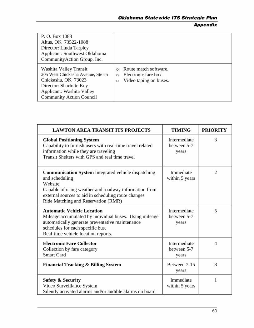
Oklahoma Statewide ITS Strategic Plan Appendix
P. O. Box 1088 Altus, OK 73522-1088 Director: Linda Tarpley Applicant: Southwest Oklahoma CommunityAction Group, Inc. Washita Valley Transit 205 West Chickasha Avenue, Ste #5 Chickasha, OK 73023 Director: Sharlotte Key Applicant: Washita Valley Community Action Council
o Route match software. o Electronic fare box. o Video taping on buses.
LAWTON AREA TRANSIT ITS PROJECTS
TIMING
PRIORITY
Global Positioning System Capability to furnish users with real-time travel related information while they are traveling Transit Shelters with GPS and real time travel
Intermediate between 5-7
years
3
Communication System Integrated vehicle dispatching and scheduling Website Capable of using weather and roadway information from external sources to aid in scheduling route changes Ride Matching and Reservation (RMR)
Immediate
within 5 years
2
Automatic Vehicle Location Mileage accumulated by individual buses. Using mileage automatically generate preventative maintenance schedules for each specific bus. Real-time vehicle location reports.
Intermediate between 5-7
years
5
Electronic Fare Collector Collection by fare category Smart Card
Intermediate between 5-7
years
4
Financial Tracking & Billing System
Between 7-15
years
8
Safety & Security Video Surveillance System Silently activated alarms and/or audible alarms on board
Immediate
within 5 years
1
60

Oklahoma Statewide ITS Strategic Plan Appendix
public transit vehicles which are capable of activation by the operator, monitored by central dispatch or local police Installation of smart shelters at designated locations. Features to include items such as but not limited to: Emergency button (in case of danger/emergency, passenger presses button and security/surveillance camera is activated to gauge if situation is real or a prank), Occupancy flashing beacon (alerts the approaching bus that a passenger is waiting inside the shelter,Map of approaching bus (graphic display on the monitor of where the bus is on the route)
Automatic Passenger Counters Vehicle passenger loading by bus stop and trip segment.
Between 7-15
years
6
Archived Data Management Archive data in format that is retrievable by Transit and LMPO
Between 7-15
years
9
Vehicle Fleet Management Automatically track and validate the number of work hours performed by each individual vehicle operator. Assign tasks to individual employee Vehicle life-cycle management and reporting Preventative and predicted maintenance: scheduling, tracking, management, and reporting Inventory management: part level optimization, usage, tracking, and reporting Time keeping and personnel management: by shop and vehicle Vehicle life cycle and history: management and reporting Warranty recovery management: notification, claims, payments, and reporting Fuel management: secured dispensing, usage, tracking, and reporting
Between 7-15
years
7
61

Oklahoma Statewide ITS Strategic Plan Appendix
Appendix B State-Owned Fiber Inventory
Contract Description Location Description Highway
Who's it is
Control Section
Begin Mileage
Ending Mileage
ODOT Total
Mileage OTA Total Mileage # of Strands
a) OTA FIBERS 41.68 159.08 12
I-44 and Missouri State Line to Craig County Line and I-44
Will Rogers TPK OTA 44-58-01 0 31.34 0 31.34 12
I-44 and Ottawa County Line to I-44 and Mayes County
Will Rogers TPK OTA 44-18-01 0 20.43 0 20.43 12
I-44 and Craig County Line to I-44 and Rogers county line
Will Rogers TPK OTA 44-49-41 0 13 0 13 12
Mayes County Line and I-44 to I-44 and US 412
Will Rogers TPK OTA 44-66-30 0 23.41 0 23.41 12
I-44 and US 412 to I-44 and Tulsa County Line I-44 ODOT 44-66-36 0 3.76 3.76 0 12
I44 and Rogers County Line to I-244 and I-44 I-44 ODOT 44-72-78 0 14.47 14.47 0 12
I-44 and I-244 to I-44 and Creek County Line I-44 ODOT 44-72-08 0 1.1 1.1 0 12
I-44 and Tulsa County Line to I-44 and Lincoln County Line
Will Rogers TPK OTA 44-19-37 0 39.35 0 39.35 12
I-44 and Creek County Line to I-44 and Oklahoma County Line
Will Rogers TPK OTA 44-41-34 0 30.55 0 30.55 12
_________________________________________________________________________________________________________________________________ 62

Oklahoma Statewide ITS Strategic Plan Appendix
Contract Description Location Description Highway
Who's it is
Control Section
Begin Mileage
Ending Mileage
ODOT Total
Mileage OTA Total Mileage # of Strands
I-44 and Lincoln County Line to I-44 and I-35 I-44 ODOT 44-55-76 0 16.45 16.45 0 12
I-35 and I-44 to I-35 and NE 36 st. I-35 ODOT 35-55-09 0 2.36 2.36 0 12
I-35 and NE 36 Street to OTA HDQTS. City Street OTHER City Street 0 1 0.5 0.5 12
I-35 and NE 36 st. to I-35 and 4th st. I-35 ODOT 35-55-15 7.64 10.18 2.54 0 12
l-35 and 4th st. to IXC Junction Site City Street OTHER City Street 0 1 0.5 0.5 12
b) ODOT
System
I-35 and 4th to Oklahoma-Texas State Line 130.65 0 12
I-35 and 4th st. to I-35 and Cleveland County Line I-35 ODOT 35-55-15 0 9.84 9.84 0 12
I-35 and Oklahoma County Line to I-35 and McClain County Line I-35 ODOT 35-14-06 0 13.4 13.4 0 12
I-35 and Cleveland County Line to I-35 and Garvin County Line I-35 ODOT 35-44-05 0 25.73 25.73 0 12
I-35 and McClain Count Line to I-35 and Murray County Line I-35 ODOT 35-25-46 0 25.89 25.89 0 12
I-35 and Garvin Count Line to I-35 and Carter County Line I-35 ODOT 35-50-32 0 9.89 9.89 0 12
I-35 and Murray Count Line to I-35 ODOT 35-10-36 0 21.43 21.43 0 12
_________________________________________________________________________________________________________________________________ 63

Oklahoma Statewide ITS Strategic Plan Appendix
Contract Description Location Description Highway
Who's it is
Control Section
Begin Mileage
Ending Mileage
ODOT Total
Mileage OTA Total Mileage # of Strands
I-35 and Love County Line
I-35 and Carter Count Line to I-35 and Texas State Line I-35 ODOT 35-43-17 0 24.47 24.47 0 12
c) OTA OSF GRANT
From the fiber optics telecommunications equipment room, Vinita, Oklahoma Turnpike maintenance building to a location ending at the OTA fiber access hand hole, Miami, Oklahoma Turnpike exit.
0.75 25.29 2
Fiber optics Telecommunications equipment room to SH-69 and I-44 City Street OTHER City Street 0 1.5 0.75 0.75 2
From SH-69 and I-44 to Ottawa County Line
Will Rogers TPK OTA 44-18-01 11.48 20.4 0 8.92 2
Ottawa Count Line and I-44 to SH10 and I-44
Will Rogers TPK OTA 44-58-01 0 15.62 0 15.62 2
TOTAL 173.08 184.37 TOTAL TOGETHER 357.45
_________________________________________________________________________________________________________________________________ 64

Oklahoma Statewide ITS Strategic Plan Appendix
Location Description HighwayWho’s it
is Control Section
Begin Mileage
Ending Mileage
Contract Description
ODOT Total Mileage
OTA Total Mileage # of Strands
a) OTA-Cimarron
Fibers
From the Oklahoma State University, Stillwater, Oklahoma to the University Center at Tulsa 30.5 48.7 4
Campus to US-177 City Street OTHERCity
Street 0 3.5 1.75 1.75 4
City Street & US-177 Jct. To OTA Ent. US-177 ODOT
177-60-31 5.01 6.01 1 0 4
OTA Ent. To Jct. US-412Cimarron
OTA OTA TR-60-35 0 7.8 0 7.8 4
TR & US-412 Jct. To Pawnee Co. Line
US-412 OTA OTA
412-60-34 2 9.01 0 7.01 4
Pawnee & Payne Co. Line To E. End of OTA
US-412 OTA OTA
412-59-31 0 24.01 0 24.01 4
Cimarron OTA End To Tulsa Co. Line US-64 ODOT
064-59-06 14.3 22.15 7.85 0 4
Tulsa Co. Line To Jct. I-244 US-64 ODOT
064-72-86 0 15.35 15.35 0 4
I-244 & US-64 Jct. To Elgin Ave. I-244 ODOT
244-72-09 5.69 6.57 0.88 0 4
Elgin Exit To OSU Tele City Street OTHERCity
Street 0 0.5 0.25 0.25 4
TR & US-412 Jct. To US-412 & US-64 Jct.
US-412 OTA OTA
412-52-39 6.84 2.9 0 3.94 4
US-412 & US-64 Jct. To Morrison US-64 ODOT
064-52-04 16.66 14.95 1.71 0 4
Morrison To US-412 & US-64 Jct. US-64 ODOT
064-52-04 14.95 16.66 1.71 0 4
US-412 & US-64 Jct. To TR & US-412 Jct.
US-412 OTA OTA
412-52-39 2.9 6.84 0 3.94 4
_________________________________________________________________________________________________________________________________ 65

Oklahoma Statewide ITS Strategic Plan Appendix
Contract Description Location Description Highway
Who’s it is
Control Section
Begin Mileage
Ending Mileage
ODOT Total Mileage
OTA Total Mileage # of Strands
b) OSF-Cimarron
Fibers
From the Oklahoma State University, Stillwater, Oklahoma to the University Center at Tulsa 30.5 48.7 4
Campus to US-177 City Street OTHERCity
Street 0 3.5 1.75 1.75 4
City Street & US-177 Jct. To OTA Ent. US-177 ODOT
177-60-31 5.01 6.01 1 0 4
OTA Ent. To Jct. US-412Cimarron
OTA OTA TR-60-35 0 7.8 0 7.8 4
TR & US-412 Jct. To Pawnee Co. Line
US-412 OTA OTA
412-60-34 2 9.01 0 7.01 4
Pawnee & Payne Co. Line To E. End of OTA
US-412 OTA OTA
412-59-31 0 24.01 0 24.01 4
Cimarron OTA End To Tulsa Co. Line US-64 ODOT
064-59-06 14.3 22.15 7.85 0 4
Tulsa Co. Line To Jct. I-244 US-64 ODOT
064-72-86 0 15.35 15.35 0 4
I-244 & US-64 Jct. To Elgin Ave. I-244 ODOT
244-72-09 5.69 6.57 0.88 0 4
Elgin Exit To OSU Tele City Street OTHERCity
Street 0 0.5 0.25 0.25 4
TR & US-412 Jct. To US-412 & US-64 Jct.
US-412 OTA OTA
412-52-39 6.84 2.9 0 3.94 4
US-412 & US-64 Jct. To Morrison US-64 ODOT
064-52-04 16.66 14.95 1.71 0 4
Morrison To US-412 & US-64 Jct. US-64 ODOT
064-52-04 14.95 16.66 1.71 0 4
US-412 & US-64 Jct. To TR & US-412 Jct.
US-412 OTA OTA
412-52-39 2.9 6.84 0 3.94 4
_________________________________________________________________________________________________________________________________ 66
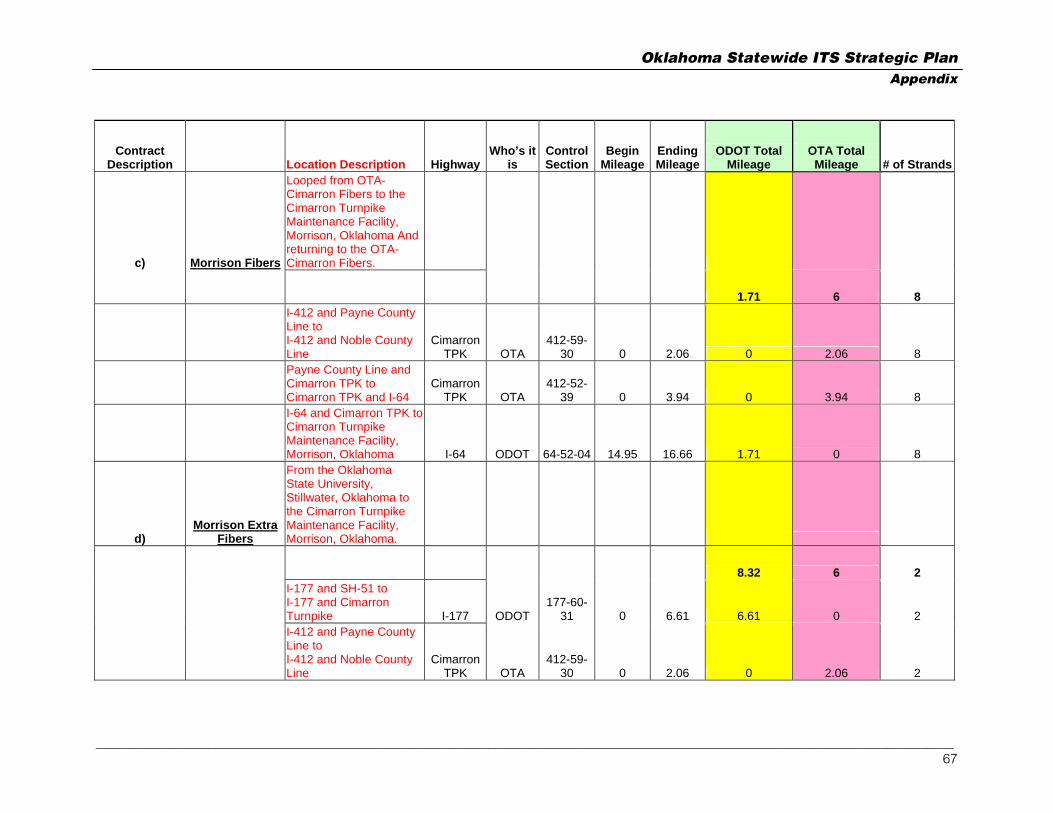
Oklahoma Statewide ITS Strategic Plan Appendix
Contract Description Location Description Highway
Who’s it is
Control Section
Begin Mileage
Ending Mileage
ODOT Total Mileage
OTA Total Mileage # of Strands
c) Morrison Fibers
Looped from OTA-Cimarron Fibers to the Cimarron Turnpike Maintenance Facility, Morrison, Oklahoma And returning to the OTA-Cimarron Fibers.
1.71 6 8
I-412 and Payne County Line to I-412 and Noble County Line
Cimarron TPK OTA
412-59-30 0 2.06 0 2.06 8
Payne County Line and Cimarron TPK to Cimarron TPK and I-64
Cimarron TPK OTA
412-52-39 0 3.94 0 3.94 8
I-64 and Cimarron TPK to Cimarron Turnpike Maintenance Facility, Morrison, Oklahoma I-64 ODOT 64-52-04 14.95 16.66 1.71 0 8
d) Morrison Extra
Fibers
From the Oklahoma State University, Stillwater, Oklahoma to the Cimarron Turnpike Maintenance Facility, Morrison, Oklahoma.
8.32 6 2
I-177 and SH-51 to I-177 and Cimarron Turnpike I-177 ODOT
177-60-31 0 6.61 6.61 0 2
I-412 and Payne County Line to I-412 and Noble County Line
Cimarron TPK OTA
412-59-30 0 2.06 0 2.06 2
_________________________________________________________________________________________________________________________________ 67

Oklahoma Statewide ITS Strategic Plan Appendix
Contract Description Location Description Highway
Who’s it is
Control Section
Begin Mileage
Ending Mileage
ODOT Total Mileage
OTA Total Mileage # of Strands
Payne County Line and Cimarron TPK to Cimarron TPK and I-64
Cimarron TPK OTA
412-52-39 0 3.94 0 3.94 2
I-64 and Cimarron TPK to Cimarron Turnpike Maintenance Facility, Morrison, Oklahoma I-64 ODOT 64-52-04 14.95 16.66 1.71 0 2
e) OTA-Muskogee
Fibers
From the University Center at Tulsa, Oklahoma to Conners State College, Muskogee, Oklahoma (located at the Highway 62 exit in Muskogee) via the Muskogee Turnpike.
17.52 33.98 4
OSU Tele To Elgin int. at I-244 City Street OTHER
City Street 0 0.5 0.25 0.25 4
Elgin & I-244 To I-244 & I-444 Jct. I-244 ODOT
244-72-09 6.57 6.85 0.28 0 4
I-444 & I-244 Jct. To SH-51 & I-444 Jct. I-444 ODOT
444-72-92 1.19 0 1.19 0 4
SH-51 & I-444 Jct. To Wagoner Co. Line SH-51 ODOT
051-72-80 0 14.44 14.44 0 4
Wagoner / Tulsa Co. Line To Muskogee TPK. Ent. SH-51 ODOT
051-73-12 0 0.36 0.36 0 4
Muskogee TPK Ent. To TPK. & US-69 Jct.
Muskogee TPK. OTA TR-73-29 0 26.38 0 26.38 4
Muskogee TPK & US-69 Jct. TO Muskogee Co. Line
Muskogee TPK. OTA TR-73-33 4.99 0 0 4.99 4
_________________________________________________________________________________________________________________________________ 68
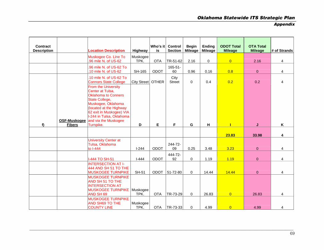
Oklahoma Statewide ITS Strategic Plan Appendix
Contract Description Location Description Highway
Who’s it is
Control Section
Begin Mileage
Ending Mileage
ODOT Total Mileage
OTA Total Mileage # of Strands
Muskogee Co. Line To .96 mile N. of US-62
Muskogee TPK. OTA TR-51-62 2.16 0 0 2.16 4
.96 mile N. of US-62 To .10 mile N. of US-62 SH-165 ODOT
165-51-60 0.96 0.16 0.8 0 4
.10 mile N. of US-62 To Connors State College City Street OTHER
City Street 0 0.4 0.2 0.2 4
f) OSF-Muskogee
Fibers
From the University Center at Tulsa, Oklahoma to Conners State College, Muskogee, Oklahoma (located at the Highway 62 exit in Muskogee) VIA I-244 in Tulsa, Oklahoma and via the Muskogee Turnpike. D E F G H I J K
23.83 33.98 4
University Center at Tulsa, Oklahoma to I-444 I-244 ODOT
244-72-09 0.25 3.48 3.23 0 4
I-444 TO SH-51 I-444 ODOT 444-72-
92 0 1.19 1.19 0 4
INTERSECTION AT I-444 AND SH 51 TO THE MUSKOGEE TURNPIKE SH-51 ODOT 51-72-80 0 14.44 14.44 0 4
MUSKOGEE TURNPIKE AND SH 51 TO THE INTERSECTION AT MUSKOGEE TURNPIKE AND SH 69
Muskogee TPK. OTA TR-73-29 0 26.83 0 26.83 4
MUSKOGEE TURNPIKE AND SH69 TO THE COUNTY LINE
Muskogee TPK. OTA TR-73-33 0 4.99 0 4.99 4
_________________________________________________________________________________________________________________________________ 69

Oklahoma Statewide ITS Strategic Plan Appendix
Contract Description Location Description Highway
Who’s it is
Control Section
Begin Mileage
Ending Mileage
ODOT Total Mileage
OTA Total Mileage # of Strands
MUSKOGEE COUNTY LINE TO SH 165
Muskogee TPK. OTA TR-51-62 0 2.16 0 2.16 4
SH-165 TO SH 62 SH165 ODOT165-51-
60 0 0.96 0.96 0 4
INTERSECTION AT SH-165 AND SH 62 TO SH62 AND SH 16 SH 62 ODOT 62-51-06 0 1.49 1.49 0 4
INTERSECTION AT SH 62 AND SH 16 TO SH 62 AND SH 62B SH 62 ODOT 62-51-47 0 1.01 1.01 0 4
INTERSECTION AT SH 62 AND SH 62B TO COURT STREET SH 62 ODOT
62B-51-51 0 1.51 1.51 0 4
g) Creek Fibers
Loop
From the OTA-Muskogee Fibers located along Broken Arrow Expressway, Tulsa, Oklahoma to U.S. highway 75, Tulsa, Oklahoma and returning to the OTA-Muskogee Fibers.
18.2 14.84 8
From the intersection of Broken Arrow Exp. and HWY 169 to the Creek Turnpike. US 169 ODOT
169-72-83 0 9.1 9.1 0 8
US 169 and Creek Turnpike to US 75
Creek TPK. OTA TR-72-98 0 7.42 0 7.42 8
US 75 to US 169 and Creek Turnpike
Creek TPK. OTA TR-72-98 0 7.42 0 7.42 8
From the Creek Turnpike to the intersection of US 169 ODOT
169-72-83 0 9.1 9.1 0 8
_________________________________________________________________________________________________________________________________ 70

Oklahoma Statewide ITS Strategic Plan Appendix
Contract Description Location Description Highway
Who’s it is
Control Section
Begin Mileage
Ending Mileage
ODOT Total Mileage
OTA Total Mileage # of Strands
Broken Arrow Exp. and HWY 169
h)
Norman Transmission
Capacity
From the regents for Higher Education Headquarters Building Oklahoma City, Oklahoma to the Telecommunications Center in the University of Oklahoma, Norman, Oklahoma.
19.15 1.25 4
13 th and Phillips to I-235 City Street OTHERCity
Street 0 1 0.5 0.5 4
13th and I-235 to I-235 and I-35 I-235 ODOT
235-55-42 0 1.84 1.84 0 4
I-35 and I-235 to County Line I-35 ODOT 35-55-15 0 6.01 6.01 0 4
I-35 and the County Line to I-35 and Robinson St. Norman OK. I-35 ODOT 35-14-06 0 10.05 10.05 0 4
I-35 and Robinson to the Telecommunications Center in the University of Oklahoma, Norman, Oklahoma. City Street OTHER
City Street 0 1.5 0.75 0.75 4
I) Highway 75
Fibers
From U.S. Highway 75, and Creek Turnpike to Highway 412 and U.S. Highway 75,Tulsa Oklahoma 11.78 0 4
_________________________________________________________________________________________________________________________________ 71

Oklahoma Statewide ITS Strategic Plan Appendix
Contract Description Location Description Highway
Who’s it is
Control Section
Begin Mileage
Ending Mileage
ODOT Total Mileage
OTA Total Mileage # of Strands
US 75 and Creek Turnpike to US 75 and I-244 US 75 ODOT 75-72-18 0 7.34 7.34 0 4
US 75 and I-244 to I-244 and US 412 I-244 ODOT
244-72-09 2.31 6.75 4.44 0 4
J MBO-Muskogee I-40 Extension
OTA-Muskogee-
South Fibers
From Muskogee, Oklahoma to the Muskogee TPK/Interstate40 Intersection via the Muskogee TPK 0 19.57 12
From Muskogee, Oklahoma to the Muskogee TPK/Interstate 40 Intersection via the Muskogee TPK
Muskogee TPK OTA TR-51-63 0 19.57 0 19.57 12
k) ODOT-I40 Fibers
From Muskogee Turnpike/Interstate 40 intersection east to the Arkansas State Line via Interstate 40. 44.2 0 12
I-40 and Muskogee Turnpike to Sequoyah County Line I-40 ODOT 40-51-15 10.2 13.76 3.56 0 12
Muskogee County Line and I-40 to I-40 and US-59 I-40 ODOT 40-68-22 0 17.62 17.62 0 12
I-40 and US-59 to the Arkansas State Line I-40 ODOT 40-68-23 0 23.02 23.02 0 12
l)
ODOT-Tulsa-Division Fibers
Looped
From OTA-Muskogee Fibers located at the nearest handhold to the
_________________________________________________________________________________________________________________________________ 72

Oklahoma Statewide ITS Strategic Plan Appendix
Contract Description Location Description Highway
Who’s it is
Control Section
Begin Mileage
Ending Mileage
ODOT Total Mileage
OTA Total Mileage # of Strands
ODOT Division 8 Headquarters, 4002 North Mingo Valley Expressway, Tulsa Oklahoma, and returning to the OTA-Muskogee Fibers.
7.76 0.25 16
SH-51 & US-169 To I-44 & US-169 US-169 ODOT
169-72-83 6.25 9.1 2.85 0 16
I-44 & US-169 To 36th St. N. US-169 ODOT
169-72-81 0 4.66 4.66 0 16
36th St. N. To Div. 8 head. City Street OTHER
City Street 0 0.5 0.25 0.25 16
m)
ODOT-Muskogee-
Division Fibers Looped
From OTA-Muskogee Fibers located at the nearest hand hole to the ODOT Division 1 Headquarters, 2800 South 32nd Street, Muskogee, Oklahoma, and returning to the OTA-Muskogee Fibers.
0.5 0.5 8
From 2800 S. 32nd st. to OTA-Muskogee Fibers City Street OTHER
City Street 0 1 0.5 0.5 8
n)
ODOT-Sallisaw-Residency
Fibers
From ODOT-I-40 Fibers to the ODOT Residency Office, Sallisaw, Oklahoma, and returning to the ODOT-I-40 Fibers.
_________________________________________________________________________________________________________________________________ 73

Oklahoma Statewide ITS Strategic Plan Appendix
Contract Description Location Description Highway
Who’s it is
Control Section
Begin Mileage
Ending Mileage
ODOT Total Mileage
OTA Total Mileage # of Strands
3.56 0 8
I-40 and Muskogee TPK to I-40 and Sequoyah County Line I-40 ODOT 40-51-15 10.2 13.76 3.56 0 8
TOTAL 217.53 213.77
TOTAL TOGETHER 431.3
_________________________________________________________________________________________________________________________________ 74

Oklahoma Statewide ITS Strategic Plan Appendix
Contract Description Location Description Highway
Who's it is
Control Section
Begin Mileage
Ending Mileage
ODOT Total Mileage
OTA Total Mileage # of Strands
ARTICLE 3 SECTION 3.1 D E F G H I J K
a)
OTA-OKC CHICKASHA
FIBERS
13th and Phillips, down I-235 to I-40, east to I-44 & I-40 Interchange, south on I-44 to OTA - H.E. Bailey Turnpike Entrance. 19.13 0.5 12
13th & Phillip To I-235 City Street OTHERCity
Street 0 1 0.5 0.5 12
I-235 & 4th St. To I-235 & I-40 I-235 ODOT
235-55-42 0.84 0 0.84 0 12
I-40 & I-235 To I-40 & I-44 I-40 ODOT
040-55-69 10.45 5.34 5.11 0 12
I-44 & I-40 To I-44 & I-240 I-44 ODOT
044-55-05 4.88 0 4.88 0 12
I-44 & I-240 To Cleveland Co. Line I-44 ODOT
044-55-70 1.35 0 1.35 0 12
Cleveland Co. Line To McClain Co. Line I-44 ODOT
044-14-34 5.01 0 5.01 0 12
McClain Co. Line To OTA Ent. I-44 ODOT
044-44-03 1.44 0 1.44 0 12
b)
OTA-CHICKASHA-
LAWTON FIBERS
OTA-CHICKASHA-LAWTON (CHICKASHA GATE TO LAWTON) 0 61.04 12
OTA Ent. To Grady Co. Line I-44 OTA
044-44-54 5.14 0 0 5.14 12
Grady Co. Line To Caddo Co. Line I-44 OTA
044-26-42 34.62 0 0 34.62 12
?? Part of Lawton and Chickasha is ODOT R/W
Caddo Co. Line To Comanche Co. Line I-44 OTA
044-08-53 4.69 0 0 4.69 12
Comanche Co. Line To I-44 OTA 044-16- 16.59 0 0 16.59 12
_________________________________________________________________________________________________________________________________ 75

Oklahoma Statewide ITS Strategic Plan Appendix
Contract Description Location Description Highway
Who's it is
Control Section
Begin Mileage
Ending Mileage
ODOT Total Mileage
OTA Total Mileage # of Strands
Jct. I-44 & US-62 24
c) OTA-LAWTON-TEXAS FIBERS
OTA-LAWTON-TEXAS (LAWTON TO TEXAS STATE LINE) 21.54 24.38 12
Jct. I-44 & US-62 To OTA Ent. I-44 ODOT
044-16-49 15.89 0 15.89 0 12
OTA Ent. To Cotton Co. Line I-44 OTA
044-16-50 4.04 0 0 4.04 12
Cotton Co. Line To Jct. US-70 I-44 OTA
044-17-37 20.34 0 0 20.34 12
Jct. US-70 To Texas State Line I-44 ODOT
044-17-06 5.65 0 5.65 0 12
d) OTA-JKT Fibers
OTA-JKT (KILPATRICK TURNPIKE FROM STATE HWY 74 JCT TO I-35 JCT) 0 8.99 16
SH-74 and John Kilpatrick Turnpike to I-35 and John Kilpatrick Turnpike
Kilpatrick OTA OTA TR-55-86 8.99 0 0 8.99 16
e) OTA-NEW-JKT
Fibers
New John Kilpatrick Turnpike from SH-74 and JKT west and south to SW 15th Street 0 15.98 24
New JKT from SH-74 and JKT west to the Canadian County line and County line rd
Kilpatrick OTA OTA
TR-55-86P 4.98 0 0 4.98 24
New JKT from JKT and County Line Rd (Canadain County Line) going south to JKT and SW 15th Street
Kilpatrick OTA OTA
TR-55-87P 11 0 0 11 24
f) ODOT-ETN-NE4
FIBERS
EducationTelevision Network Building 13th and Philips to NE 4th 0.53 0.53 24
_________________________________________________________________________________________________________________________________ 76

Oklahoma Statewide ITS Strategic Plan Appendix
Contract Description Location Description Highway
Who's it is
Control Section
Begin Mileage
Ending Mileage
ODOT Total Mileage
OTA Total Mileage # of Strands
and I-235
EducationTelevision Network Building 13th and Philips to NE 4th and I-236 City Street OTHER
City Street 0 1.05 0.53 0.53 24
g) ODOT-NE4-
RenoHub Fibers
NE 4th St. and I-235 to ODOT Reno Hub Site along I-235 1.25 0 120
NE 4th St. and I-235 to ODOT Reno Hub Site along I-235 I-235 ODOT ODOT 0 1.25 1.25 0 120
h) ODOT-RenoHub-
I40 Fibers
.3 miles West of I-40 and I-235 to I-40 and I-44 along I-40 4.88 0 48
.3 miles West of I-40 and I-235 to I-40 and I-44 along I-40 I-40 ODOT
044-55-69 5.34 10.22 4.88 0 48
i)
ODOT-I40-MacArthur
Fibers
ODOT I-40 MAC (I-40 FROM MACARTHUR TO I-44 JCT 4.88 0 24
ODOT I-40 MAC (I-40 FROM MACARTHUR TO I-44 JCT I-40 ODOT
044-55-69 5.34 10.22 4.88 0 24
j)
ODOT-MACARTHUR-
Sara Fibers
ODOT SARA-MAC (I-40 FROM SARA RD TO MACARTHUR 4.93 0 12
Sara Rd. To Okla. Co. Line I-40 ODOT
040-09-05 35.37 37.35 1.98 0 12
Okla. Co. Line To MACARTHUR I-40 ODOT
040-55-69 0 2.95 2.95 0 12
k) ODOT-I40-I240
FibersI-44 FROM I-40 JCT TO I-240 JCT 4.88 0 24
I-44 FROM I-40 JCT TO I-40 ODOT 044-55- 5.34 10.22 4.88 0 24
_________________________________________________________________________________________________________________________________ 77

Oklahoma Statewide ITS Strategic Plan Appendix
Contract Description Location Description Highway
Who's it is
Control Section
Begin Mileage
Ending Mileage
ODOT Total Mileage
OTA Total Mileage # of Strands
I-240 JCT 69
l) ODOT-I240-SW89 Fibers
I-44 and I-240 TO SW 89TH ST and I-44 1.35 0 12
I-44 and I-240 TO SW 89TH ST and I-44 I-44 ODOT
044-55-70 1.35 0 1.35 0 12
m) ODOT-I40-SH66
FibersI-40 and I-44 to SH-66 and I-44 along I-44 3.45 0 24
I-40 and I-44 to SH-66 and I-44 along I-44 I-44 ODOT
044-55-07 0 3.45 3.45 0 24
n) ODOT-SH74
Fibers
SH-74 and SH-66 to SH-74 and Kilpatrick Turnpike along SH-74 7.72 0 12
SH-74 and SH-66 to SH-74 and Kilpatrick Turnpike along SH-74 SH-74 ODOT
074-55-63 0 7.72 7.72 0 12
o) ODOT-Stillwater
Fibers
I-35 FROM KIL OTA JCT TO SH-51 JCT; THEN SH-51 TO OSU 51.68 0.25 12
OTA Jct. To Logan Co. Line I-35 ODOT
035-55-09 4.8 13.37 8.57 0 12
Okla. & Logan Co. Line To Payne Co. Line I-35 ODOT
035-42-30 0 18.93 18.93 0 12
Logan & Payne Co. Line To SH-51 Jct. I-35 ODOT
035-60-29 0 8.97 8.97 0 12
SH-51 & I-35 Jct.To Western Ave. SH-51 ODOT
051-60-18 0.49 15.45 14.96 0 12
SH-51 & Western Ave. To OSU City Street OTHER
Western Ave. 0 0.5 0.25 0.25 12
TOTAL 126.22 111.67 TOTAL TOGETHER 237.88
_________________________________________________________________________________________________________________________________ 78
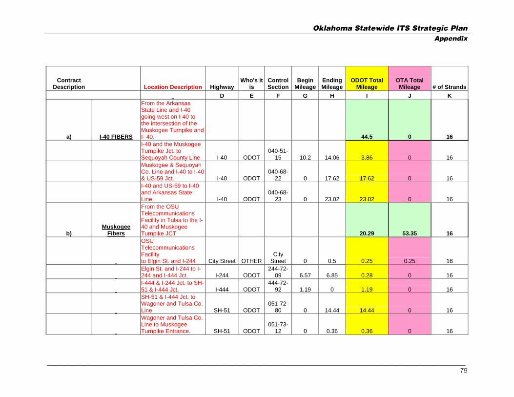
Oklahoma Statewide ITS Strategic Plan Appendix
Contract Description Location Description Highway
Who's it is
Control Section
Begin Mileage
Ending Mileage
ODOT Total Mileage
OTA Total Mileage # of Strands
D E F G H I J K
a) I-40 FIBERS
From the Arkansas State Line and I-40 going west on I-40 to the intersection of the Muskogee Turnpike and I- 40. 44.5 0 16
I-40 and the Muskogee Turnpike Jct. to Sequoyah County Line I-40 ODOT
040-51-15 10.2 14.06 3.86 0 16
Muskogee & Sequoyah Co. Line and I-40 to I-40 & US-59 Jct. I-40 ODOT
040-68-22 0 17.62 17.62 0 16
I-40 and US-59 to I-40 and Arkansas State Line I-40 ODOT
040-68-23 0 23.02 23.02 0 16
b) Muskogee
Fibers
From the OSU Telecommunications Facility in Tulsa to the I-40 and Muskogee Turnpike JCT 20.29 53.35 16
OSU Telecommunications Facility to Elgin St. and I-244 City Street OTHER
City Street 0 0.5 0.25 0.25 16
Elgin St. and I-244 to I-244 and I-444 Jct. I-244 ODOT
244-72-09 6.57 6.85 0.28 0 16
I-444 & I-244 Jct. to SH-51 & I-444 Jct. I-444 ODOT
444-72-92 1.19 0 1.19 0 16
SH-51 & I-444 Jct. to Wagoner and Tulsa Co. Line SH-51 ODOT
051-72-80 0 14.44 14.44 0 16
Wagoner and Tulsa Co. Line to Muskogee Turnpike Entrance. SH-51 ODOT
051-73-12 0 0.36 0.36 0 16
_________________________________________________________________________________________________________________________________ 79

Oklahoma Statewide ITS Strategic Plan Appendix
Contract Description Location Description Highway
Who's it is
Control Section
Begin Mileage
Ending Mileage
ODOT Total Mileage
OTA Total Mileage # of Strands
Muskogee Turnpike Entrance to Muskogee Turnpike and US-69 Jct.
Muskogee OTA OTA TR-73-29 0 26.38 0 26.38 16
Muskogee Turnpike and US-69 Jct. to Wagoner and Muskogee Co. Line
Muskogee OTA OTA TR-73-33 4.99 0 0 4.99 16
Muskogee Co. Line and Muskogee Turnpike to 0.96 mile N. of Muskogee Turnpike and US-62
Muskogee OTA OTA TR-51-61 2.16 0 0 2.16 16
0.96 mile North of US-62 and Muskogee Turnpike to Jct. US-62 and Muskogee Turnpike SH-165 ODOT
165-51-60 0.96 0 0.96 0 16
Jct. US-62 and SH-165 to Jct. SH-165 and Muskogee Turnpike SH-165 ODOT
165-51-64 2.81 0 2.81 0 16
Jct. SH-165 and Muskogee Turnpike to Jct. Muskogee Turnpike and I-40
Muskogee OTA OTA TR-51-63 19.57 0 0 19.57 16
c) BA-Expwy
Fibers
From the intersection of Broken Arrow Expressway and Highway 169 to the intersection of Highway 75 and Denver Ave. 8.39 0 36
SH-51 & US-169 Jct. to SH-51 & I-444 Jct. SH-51 ODOT
051-72-80 7.86 0 7.86 0 36
I-444 & SH-51 Jct. to Denver Ave. and US-75 I-444 ODOT
444-72-94 1.32 0.79 0.53 0 36
d) H75-I244 Fibers
US-75 and the Broken Arrow Expressway to the intersection of 2.08 0 54
_________________________________________________________________________________________________________________________________ 80

Oklahoma Statewide ITS Strategic Plan Appendix
Contract Description Location Description Highway
Who's it is
Control Section
Begin Mileage
Ending Mileage
ODOT Total Mileage
OTA Total Mileage # of Strands
Interstate 244 and Highway 64
I-444 and the Broken Arrow Expressway Jct. to I-444 and I-244 Jct. I-444 ODOT
444-72-94 1.32 0 1.32 0 54
I-244 & I-444 Jct. to I-244 & US-64 Jct. I-244 ODOT
244-72-09 4.99 5.75 0.76 0 54
e) H412 Fibers
From the Oklahoma State University telecommunications facility in Tulsa to the east end of the Cimarron Turnpike at mile marker 59.31 24.33 0.25 24
Cimarron Turnpike east end at mile marker 59.31 to the Tulsa Co. Line US-64 ODOT
064-59-06 14.3 22.15 7.85 0 24
Tulsa County Line and the Cimarron Turnpike to the Jct. I-244 and the Cimarron Turnpike US-64 ODOT
064-72-86 0 15.35 15.35 0 24
I-244 and US-64 Jct. to Elgin Ave. and I-244 I-244 ODOT
244-72-09 5.69 6.57 0.88 0 24
Elgin Exit to OSU Tele City Street OTHERCity
Street 0 0.5 0.25 0.25 24
f) Cimarron Fibers
From the east end of the Cimarron Turnpike at mile marker 59.31 to the Oklahoma State University telecommunications facility in Stillwater 7.59 40.57 24
Campus to US-177 City Street OTHERCity
Street 0 3.5 1.75 1.75 24
_________________________________________________________________________________________________________________________________ 81

Oklahoma Statewide ITS Strategic Plan Appendix
Contract Description Location Description Highway
Who's it is
Control Section
Begin Mileage
Ending Mileage
ODOT Total Mileage
OTA Total Mileage # of Strands
Hall Of Fame Ave. and US-177 Jct. to Cimarron Turnpike Entrance and US-177 US-177 ODOT
177-60-31 0.77 6.61 5.84 0 24
Cimarron Turnpike Entrance and US-177 to US-412 and the Cimarron Turnpike
Cimarron Turnpike OTA TR-60-35 0 7.8 0 7.8 24
Cimarron Turnpike and US-412 Jct. to the Pawnee Co. Line US-412 OTA
412-60-34 2 9.01 0 7.01 24
Pawnee and Payne County Line and US-412 to US-412 and US-64 US-412 OTA
412-59-31 0 24.01 0 24.01 24
TOTAL 107.18 94.17 TOTAL TOGETHER 201.35
_________________________________________________________________________________________________________________________________ 82

Oklahoma Statewide ITS Strategic Plan Appendix
Contract Description Location Description Highway
Who's it is
Control Section
Begin Mileage
Ending Mileage
ODOT Total Mileage
OTA Total Mileage # of Strands
3.1 ODOT Fibers
Oklahoma-Kansas Border and I-35 to I-40 and E.K. Gaylord Avenue to the Reno Regenerator Site.
3.1.1 ODOT-SH300
Fibers
Oklahoma-Kansas border going south on 44th Street to State Line Rd 300, then west on State Line Rd 300 to the intersection of State Road 300 and Interstate 35 ("ODOT-SH300") 1.5 1.5 24
Oklahoma-Kansas border going south on 44th Street to State Line Rd 300, then west on State Line Rd 300 to the intersection of State Road 300 and Interstate 35 ("ODOT-SH300") City Street OTHER
City Street 0 3 1.5 1.5 24
3.1.2 ODOT-I-35
FIBERS
Along ODOT-I-35 in its entirety from the Oklahoma-Kansas border to I-35 and John Kilpatrick Turnpike 102.61 0 16
I-35 and Oklahoma-Kansas border to Tonkawa Repeater Hut I-35 ODOT 35-36-25 28.05 0 28.05 0 16
I-35 and Noble County Line to Payne County Line I-35 ODOT 35-52-33 30.15 0 30.15 0 16
I-35 and Payne County Line to I-35 and Logan County Line I-35 ODOT 35-60-29 12.11 0 12.11 0 16
_________________________________________________________________________________________________________________________________ 83
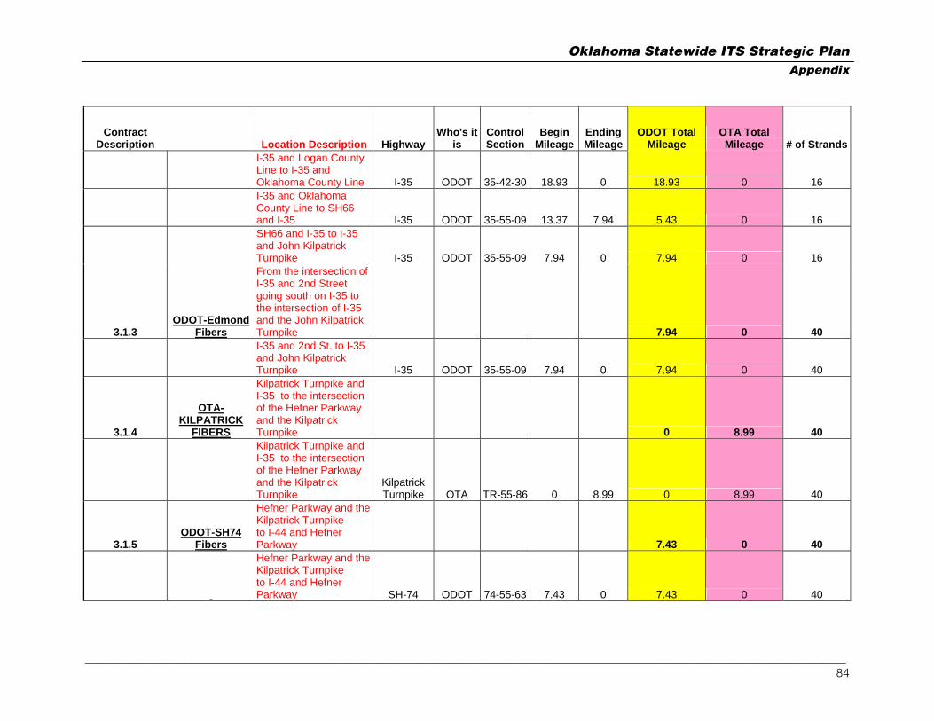
Oklahoma Statewide ITS Strategic Plan Appendix
Contract Description Location Description Highway
Who's it is
Control Section
Begin Mileage
Ending Mileage
ODOT Total Mileage
OTA Total Mileage # of Strands
I-35 and Logan County Line to I-35 and Oklahoma County Line I-35 ODOT 35-42-30 18.93 0 18.93 0 16
I-35 and Oklahoma County Line to SH66 and I-35 I-35 ODOT 35-55-09 13.37 7.94 5.43 0 16
SH66 and I-35 to I-35 and John Kilpatrick Turnpike I-35 ODOT 35-55-09 7.94 0 7.94 0 16
3.1.3 ODOT-Edmond
Fibers
From the intersection of I-35 and 2nd Street going south on I-35 to the intersection of I-35 and the John Kilpatrick Turnpike 7.94 0 40
I-35 and 2nd St. to I-35 and John Kilpatrick Turnpike I-35 ODOT 35-55-09 7.94 0 7.94 0 40
3.1.4
OTA-KILPATRICK
FIBERS
Kilpatrick Turnpike and I-35 to the intersection of the Hefner Parkway and the Kilpatrick Turnpike 0 8.99 40
Kilpatrick Turnpike and I-35 to the intersection of the Hefner Parkway and the Kilpatrick Turnpike
Kilpatrick Turnpike OTA TR-55-86 0 8.99 0 8.99 40
3.1.5 ODOT-SH74
Fibers
Hefner Parkway and the Kilpatrick Turnpike to I-44 and Hefner Parkway 7.43 0 40
Hefner Parkway and the Kilpatrick Turnpike to I-44 and Hefner Parkway SH-74 ODOT 74-55-63 7.43 0 7.43 0 40
_________________________________________________________________________________________________________________________________ 84

Oklahoma Statewide ITS Strategic Plan Appendix
Contract Description Location Description Highway
Who's it is
Control Section
Begin Mileage
Ending Mileage
ODOT Total Mileage
OTA Total Mileage # of Strands
3.1.6 ODOT-144
Fibers
I-44 and Hefner Parkway to I-44 and I-40 3.73 0 40
I-44 and Hefner Parkway to I-44 and I-40 I-44 ODOT 44-55-07 3.73 0 3.73 0 40
3.1.7 Odot-I40 Fibers
Along ODOT-I40 in its entirety to I-40, I-235, and Reno Ave. Regeneration Hut 13.2 1.75 40
I-40 and I-44 to I-40, I-235, and Reno Ave. Regeneration Hut I-40 ODOT 40-55-69 0 11.45 11.45 0 40
I-40, I-235, and Reno Ave. Regeneration Hut to 201 Robert S. Kerr Bank of Oklahoma Plaza City Street OTHER
City Street 0 1.75 0.88 0.88 8
I-40, I-235, and Reno Ave. Regeneration Building east to ODOT Reno Annex Building on Reno Ave. City Street OTHER
City Street 0 0.25 0.13 0.13 36
I-40, I-235, and Reno Ave. Regeneration Building east to IXC Regeneration Building near Martin Luther King and Reno Ave. City Street OTHER
City Street 0 1.5 0.75 0.75 24
TOTAL 136.41 12.24
TOTAL TOGETHER 148.65
_________________________________________________________________________________________________________________________________ 85

Oklahoma Statewide ITS Strategic Plan Appendix
Contract Description Location Description Highway
Who's it is
Control Section
Begin Mileage
Ending Mileage
ODOT Total Mileage
OTA Total Mileage # of Strands
D E F G H I J K
INF AGREEMENT #2 ARTICLE 3 62.97 0 12
3.1 ODOT I-35 FIBERS
I-35 and the Kansas Oklahoma State Line to I-35 and Noble, Kay County Line I-35 ODOT 35-36-25 28.05 0 28.05 0 12
I-35 and Noble Kay County Line to I-35 and Payne County Line I-35 ODOT 35-52-33 30.15 0 30.15 0 12
I-35 and Payne County Line to I-35 and SH-51 I-35 ODOT 35-60-29 12.11 8.87 3.24 0 12
3.2 ODOT Perry Fibers
SH-77 & I-35 TO ODOT DIVISION OFFICE, PERRY SH-77 ODOT 77-52-06 9.95 11.48 1.53 0 12
TOTAL 62.97 0 TOTAL TOGETHER 62.97
_________________________________________________________________________________________________________________________________ 86

Oklahoma Statewide ITS Strategic Plan Appendix
Contract Description Location Description Highway
Who's it is
Control Section
Begin Mileage
Ending Mileage
EQUIPMENT IN BUILDING
EQUIPMENT IN BUILDING $
VALUE
# of Strands ENTERING BUILDING
NEWPORT AND NW 38th ST. I-44 DTI 44-55-07
I-35 AND HWY 60 I-35 INF 35-36-25
I-35 AND MEMORAL RD. I-35 INF 35-55-09
I-40 AND I-44 I40 ODOT 40-55-69
I-35 AND COLLEGE STREET I-35 DTI 35-42-30
I-35 AND COUNTY ROAD E0270 I-35 DTI 35-55-15
RENO AND I-235 I-235 DTI 35-55-15
ODOT Total
Mileage OTA Total Mileage # Fiber TOTAL 823.39 616.22
TOTAL TOGETHER 1439.6
_________________________________________________________________________________________________________________________________ 87

Oklahoma Statewide ITS Strategic Plan Appendix
Appendix C Detail State-Owned Fiber Map
_________________________________________________________________________________________________________________________________ 88

Oklahoma Statewide ITS Strategic Plan Appendix
Oklahoma City View
_________________________________________________________________________________________________________________________________ 89

Oklahoma Statewide ITS Strategic Plan Appendix
Tulsa View
_________________________________________________________________________________________________________________________________ 90

Oklahoma Statewide ITS Strategic Plan Appendix
Appendix D Planned Urban ITS Assets & Bandwidth Calculations
Location CCTV CCTV BW DMS
DMSBW
Vehicle Detectors
DetectorBW Webcams
WebcamBW
Existing Urban ITS Equipment Oklahoma City I-40 & Meridian 1 I-40 & Sooner Rd. 1 I-40 & Choctaw Rd. 1 I-44 & SW 59th 1 I-44 & S. of NW 10th 1 I-35 N. of Wilshire 1 Moore / Norman I-35 & Robinson St. - Norman 1 1 3 I-35 & 12th St. - Moore 1 7 3
Proposed Urban ITS Equipment
Oklahoma City I-240 West to East
I-240 I-240 & I-44 1 6 0 1 0.02 4 6 I-240 & Penn. Ave 1 6 0 1 0.02 4 6 I-240 & Western 1 6 0 0 4 6 I-240 & Santa Fe 1 6 0 1 0.02 4 6 I-240 & I-35 1 6 0 1 0.02 4 6 I-240 & Eastern 1 6 1 0.02 1 0.02 4 6
_________________________________________________________________________________________________________________________________ 91

Oklahoma Statewide ITS Strategic Plan Appendix
Location CCTV CCTV BW DMS
DMSBW
Vehicle Detectors
DetectorBW Webcams
WebcamBW
I-240 & Sooner Rd. 1 6 0 1 0.02 4 6 I-240 & Douglas Blvd. 1 6 0 1 0.02 4 6 I-240 just W. of I-40 0 0 1 0.02 0 8 48 1 0.02 8 0.16 32 48 96.18
I-40 West to TMC I-40 & Meridian 1 6 1 0.02 4 6 I-40 & May Ave. 1 6 1 0.02 1 0.02 4 6 I-40 & Penn. Ave. 1 6 1 0.02 4 6 I-40 & Western 1 6 1 0.02 4 6 I-40 & Walker 1 6 1 0.02 1 0.02 4 6 I-40 & Shields 1 6 1 0.02 4 6 I-40 & Shields (New alignment) 1 6 1 0.02 1 0.02 4 6 I-40 & I-35 Dallas Junction 1 6 1 0.02 4 6 8 48 3 0.06 8 0.16 32 48 96.22
TMC to I-40 East I-40 & Eastern 1 6 1 0.02 1 0.02 4 6 I-40 & I-35 Ft. Smith Junction 1 6 0 4 6 I-40 & Bryant 1 6 1 0.02 4 6 I-40 & Sunnylane 1 6 0 4 6 I-40 & Tinker AFB Approaches 4 24 0 16 24 I-40 & Sooner Rd. 1 6 1 0.02 1 0.02 4 6 I-40 & Air Depot 1 6 0 4 6 I-40 & Douglas Blvd. 1 6 1 0.02 4 6 I-40 & Post Rd. 0 1 0.02 0 0 I-40 & Choctaw Rd. 1 6 1 0.02 4 6
_________________________________________________________________________________________________________________________________ 92

Oklahoma Statewide ITS Strategic Plan Appendix
Location CCTV CCTV BW DMS
DMSBW
Vehicle Detectors
DetectorBW Webcams
WebcamBW
12 72 3 0.06 5 0.1 48 72 144.16
I-44 Between I-240 & I-40 I-44 & Airport Rd. 1 6 4 6 Airport Rd. & Meridian 1 6 4 6 I-44 & SW 44th 1 6 1 0.02 4 6 I-44 & SW 59th 1 6 1 0.02 4 6 I-44 & I-40 1 6 4 6 5 30 0 0 2 0.04 20 30 60.04 I-44 Between I-40 & HW66
I-44 & Reno 1 6 4 6 I-44 & S. of NW 10th 1 6 1 0.02 4 6 I-44 & S. of NW 23rd 1 6 1 0.02 1 0.02 4 6 I-44 & NW 23rd 1 6 4 6 I-44 & NW 36th 1 6 4 6 5 30 1 0.02 2 0.04 20 30 60.06 I-44 Between HW66 & I-235 I-44 & HW66 1 6 1 0.02 4 6 I-44 & May Ave. 1 6 1 0.02 4 6 I-44 & Penn. Ave. 1 6 4 6 I-44 & NW Expressway 1 6 1 0.02 4 6 4 24 0 0 3 0.06 16 24 48.06
I-44 Between I-235 & I-35 I-44 & Kelley 1 6 1 0.02 4 6 I-44 & M. L. King, Jr. 1 6 4 6
_________________________________________________________________________________________________________________________________ 93

Oklahoma Statewide ITS Strategic Plan Appendix
Location CCTV CCTV BW DMS
DMSBW
Vehicle Detectors
DetectorBW Webcams
WebcamBW
I-44 & I-35 1 6 1 0.02 4 6 3 18 0 0 5 0.1 12 18 36.1
Hefner Parkway Hefner & NW 50th 1 6 1 0.02 4 6 Hefner & NW Expressway 1 6 1 0.02 4 6 Hefner & Wilshire 1 6 4 6 Hefner & Britton Rd. 1 6 1 0.02 1 0.02 4 6 Hefner & Hefner Rd. 1 6 4 6 Hefner & 122nd 1 6 1 0.02 4 6 Hefner & Kilpatrick Tpk. 1 6 1 0.02 4 0.08 4 6 7 42 2 0.04 6 0.12 28 42 84.16
I-235 I-235 & Sheridan 1 6 4 6 I-235 & N 10th 1 6 1 0.02 1 0.02 4 6 I-235 & N 36th 1 6 1 0.02 1 0.02 4 6 I-235 & N 50th 1 6 4 6 4 24 2 0.04 2 0.04 16 24 48.08
Broadway Extension Broadway & I-44 1 6 4 6 Broadway & N 63rd 1 6 1 0.02 1 0.02 4 6 Broadway & Britton Rd. 1 6 1 0.02 4 6 Broadway & Hefner Rd. 1 6 4 6 Broadway & N 122nd 1 6 1 0.02 4 6 5 30 1 0.02 3 0.06 20 30 60.08
_________________________________________________________________________________________________________________________________ 94

Oklahoma Statewide ITS Strategic Plan Appendix
Location CCTV CCTV BW DMS
DMSBW
Vehicle Detectors
DetectorBW Webcams
WebcamBW
I-35 Between I-240 & I-40 I-35 & SE 59th 1 6 1 0.02 4 6 I-35 & SE 44th 1 6 4 6 I-35 N. of SE 29th 1 6 1 0.02 1 0.02 4 6 I-35 & SE 15th 1 6 1 0.02 4 6 4 24 1 0.02 3 0.06 16 24 48.08
I-35 N. of I-40 I-35 & NE 23rd 1 6 1 0.02 1 0.02 4 6 I-35 & NE 36th 4 24 1 0.02 4 6 I-35 & NE 50th 1 6 4 6 I-35 N. of Wilshire 1 6 1 0.02 4 6 I-35 & Hefner Rd. 1 6 1 0.02 4 6 I-35 & NE 122nd 1 6 4 6 9 54 1 0.02 4 0.08 24 36 90.1 Moore / Norman HW77 & Robinson St. - Norman 1 6 4 6 I-35 & Main St. - Norman 1 6 4 6 I-35 & 12th St. - Moore 1 6 1 0.02 4 6 I-35 & Shields - Moore 1 6 4 6 I-35 & N. 27th St. - Moore (S. OKC) 1 6 1 0.02 1 0.02 4 6 I-44 & SW 89th - Moore (S. OKC) 1 6 1 0.02 1 0.02 4 6 6 36 2 0.04 3 0.06 24 36 72.1
_________________________________________________________________________________________________________________________________ 95

Oklahoma Statewide ITS Strategic Plan Appendix
Location CCTV CCTV BW DMS
DMSBW
Vehicle Detectors
DetectorBW Webcams
WebcamBW
Tulsa I-44 West to East
I-44 & S. 61st 1 6 1 0.02 1 0.02 4 6 I-44 / I-244 Western Junction 1 6 4 6 I-44 & W. 33rd Ave. 1 6 1 0.02 4 6 I-44 & Union Ave. 1 6 4 6 I-44 & HW75 1 6 4 6 I-44 W. of Peoria 1 6 1 0.02 1 0.02 4 6 I-44 E. of Peoria 1 6 1 0.02 1 0.02 4 6 I-44 E. of Lewis 1 6 1 0.02 4 6 I-44 & Harvard 1 6 1 0.02 4 6 I-44 & Yale 1 6 1 0.02 4 6 I-44 W. of S. 41st 1 6 1 0.02 1 0.02 4 6 I-44 & S. 31st 1 6 4 6 I-44 between S. 31st & S. 21st 1 6 1 0.02 1 0.02 4 6 I-44 & S. 21st 1 6 4 6 I-44 between S. 21st & S. 11th 1 6 1 0.02 4 6 I-44 & S. 11th 1 6 4 6 I-44 E. of E. 129th Ave. 1 6 1 0.02 4 6 I-44 / I-244 Eastern Junction 1 6 4 6 I-44 W. of E. 161st Ave. 1 6 1 0.02 1 0.02 4 6 I-44 E. of E. 193rd Ave. 1 6 1 0.02 4 6 20 120 6 0.12 13 0.26 80 120 240.38
I-244 West to East I-244 & Union Ave. 1 6 1 0.02 4 6 I-244 W. of S. 21st 1 6 1 0.02 1 0.02 4 6
_________________________________________________________________________________________________________________________________ 96

Oklahoma Statewide ITS Strategic Plan Appendix
Location CCTV CCTV BW DMS
DMSBW
Vehicle Detectors
DetectorBW Webcams
WebcamBW
I-244 & HW51 1 6 4 6 I-244 & 2nd St. 1 6 1 0.02 4 6 1-244 N. of 2nd St. 1 6 4 6 I-244 & Denver 1 6 4 6 I-244 & Cincinnati 1 6 1 0.02 4 6 I-244 & HW75 1 6 4 6 I-244 W. of Lewis 1 6 4 6 I-244 E. of Lewis 1 6 1 0.02 1 0.02 4 6 I-244 E. of Harvard 1 6 1 0.02 4 6 I-244 E. of Yale 1 6 1 0.02 1 0.02 4 6 I-244 & Sheridan 1 6 1 0.02 4 6 I-244 & Memorial 1 6 4 6 I-244 & HW169 1 6 4 6 I-244 W. of E. 129th Ave. 1 6 1 0.02 4 6 16 96 3 0.06 9 0.18 64 96 192.24
HW51 West to East HW51 W. of I-244 1 6 1 0.02 1 0.02 4 6 HW51 & Denver 1 6 1 0.02 4 6 HW51 & S. 11th 1 6 4 6 HW51 & Cincinnati 1 6 4 6 HW51 & HW75 Junction 1 6 4 6 HW51 W. of Lewis 1 6 1 0.02 4 6 HW51 & Lewis 1 6 1 0.02 1 0.02 4 6 HW51 & S. 21st 1 6 4 6 HW51 & Harvard 1 6 1 0.02 4 6 HW51 & Yale 1 6 1 0.02 4 6 HW51 E. of Yale 1 6 4 6
_________________________________________________________________________________________________________________________________ 97

Oklahoma Statewide ITS Strategic Plan Appendix
Location CCTV CCTV BW DMS
DMSBW
Vehicle Detectors
DetectorBW Webcams
WebcamBW
HW51 & Sheridan 1 6 1 0.02 4 6 HW51 & Memorial 1 6 1 0.02 4 6 HW51 & S. 41st 1 6 4 6 HW51 & Mingo 1 6 4 6 HW51 & HW159 Junction 1 6 1 0.02 4 6 HW51 E. of E. 129th Ave. 1 6 1 0.02 1 0.02 4 6 17 102 3 0.06 10 0.2 68 102 204.26
HW75 South to North HW75 S. of S. 61st 1 6 1 0.02 1 0.02 4 6 HW75 & S. 11th 1 6 4 6 HW75 & 7th 1 6 4 6 HW75 & 2nd 1 6 1 0.02 4 6 HW75 S. of Apache St. 1 6 1 0.02 1 0.02 4 6 5 30 2 0.04 3 0.06 20 30 60.1
HW169 South to North HW169 & S. 81st 1 6 1 0.02 4 6 HW169 N. of S. 61st 1 6 1 0.02 1 0.02 4 6 HW169 & S. 31st 1 6 1 0.02 4 6 HW169 & Apache St. 1 6 1 0.02 1 0.02 4 6 4 24 2 0.04 4 0.08 16 24 48.12 Memorial N. of I -244 1 6 1 0.02 1 0.02 4 6 1 6 1 0.02 1 0.02 4 6 12.04 Lawton I-44 and two gates at Fort 2 12 8 12
_________________________________________________________________________________________________________________________________ 98

Oklahoma Statewide ITS Strategic Plan Appendix
Location CCTV CCTV BW DMS
DMSBW
Vehicle Detectors
DetectorBW Webcams
WebcamBW
Sill 2 12 0 0 0 0 8 12 24
140 840 33 0.7 92 1.84 548 822
Grand Total 1725
CCTV CCTV BW DMS
DMS BW
VehicleDetectors
DetectorBW Webcams
WebcamBW
Oklahoma City 8 48 1 0.02 8 0.16 32 48 96.18 8 48 3 0.06 8 0.16 32 48 96.22 12 72 3 0.06 5 0.1 48 72 144.16 5 30 0 0 2 0.04 20 30 60.04 5 30 1 0.02 2 0.04 20 30 60.06 4 24 0 0 3 0.06 16 24 48.06 3 18 0 0 5 0.1 12 18 36.1 7 42 2 0.04 6 0.12 28 42 84.16 4 24 2 0.04 2 0.04 16 24 48.08 5 30 1 0.02 3 0.06 20 30 60.08 4 24 1 0.02 3 0.06 16 24 48.08 9 54 1 0.02 4 0.08 24 36 90.1 74 444 15 0.3 51 1.02 284 426 871.32
Moore/Norman
6 36 2 0.04 3 0.06 24 36 72.1
_________________________________________________________________________________________________________________________________ 99
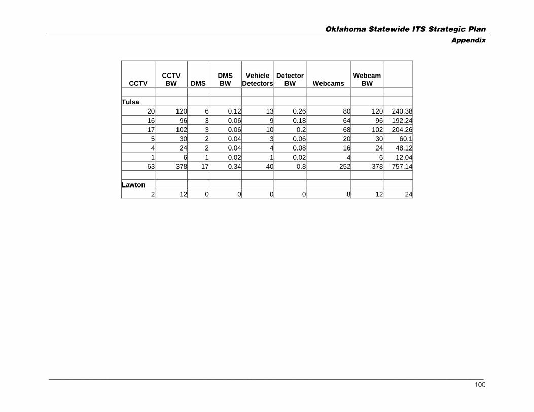
Oklahoma Statewide ITS Strategic Plan Appendix
CCTV CCTV BW DMS
DMS BW
VehicleDetectors
DetectorBW Webcams
WebcamBW
Tulsa
20 120 6 0.12 13 0.26 80 120 240.3816 96 3 0.06 9 0.18 64 96 192.2417 102 3 0.06 10 0.2 68 102 204.26
5 30 2 0.04 3 0.06 20 30 60.14 24 2 0.04 4 0.08 16 24 48.121 6 1 0.02 1 0.02 4 6 12.04
63 378 17 0.34 40 0.8 252 378 757.14 Lawton
2 12 0 0 0 0 8 12 24
_________________________________________________________________________________________________________________________________ 100

Oklahoma Statewide ITS Strategic Plan Appendix
Appendix E Planned Rural ITS Assets & Bandwidth Calculations
Web Camera Location
Weather Station
Number of Web Cams
Band Width per Web Cam
(Mb)
Total Web Cam Band Width (Mb)
Weather Station Band Width (Mb)
Total Band Width for Location
(Mb) I-35 South 1 Yes 2 1.5 3 0.02 3.02 I-35 South 2 Yes 2 1.5 3 0.02 3.02 I-35 South 3 Yes 2 1.5 3 0.02 3.02 I-35 South 4 Yes 2 1.5 3 0.02 3.02 I-35 South 5 Yes 2 1.5 3 0.02 3.02 I-35 South 6 Yes 2 1.5 3 0.02 3.02 I-35 South 7 Yes 2 1.5 3 0.02 3.02 I-35 South 8 Yes 2 1.5 3 0.02 3.02 I-35 South 9 Yes 2 1.5 3 0.02 3.02 I-35 South 10 Yes 2 1.5 3 0.02 3.02 I-35 South 11 Yes 2 1.5 3 0.02 3.02 I-35 South 12 Yes 2 1.5 3 0.02 3.02 I-35 South 13 Yes 2 1.5 3 0.02 3.02 I-35 South 14 Yes 2 1.5 3 0.02 3.02 I-35 South 15 Yes 2 1.5 3 0.02 3.02 Total 45.3 I-35 North 1 Yes 2 1.5 3 0.02 3.02 I-35 North 2 Yes 2 1.5 3 0.02 3.02 I-35 North 3 Yes 2 1.5 3 0.02 3.02 I-35 North 4 Yes 2 1.5 3 0.02 3.02 I-35 North 5 Yes 2 1.5 3 0.02 3.02 I-35 North 6 Yes 2 1.5 3 0.02 3.02 I-35 North 7 Yes 2 1.5 3 0.02 3.02 I-35 North 8 Yes 2 1.5 3 0.02 3.02
_________________________________________________________________________________________________________________________________ 101

Oklahoma Statewide ITS Strategic Plan Appendix
Web Camera Location
Weather Station
Number of Web Cams
Band Width per Web Cam
(Mb)
Total Web Cam Band Width (Mb)
Weather Station Band Width (Mb)
Total Band Width for Location
(Mb) I-35 North 9 Yes 2 1.5 3 0.02 3.02 I-35 North 10 Yes 2 1.5 3 0.02 3.02 I-35 North 11 Yes 2 1.5 3 0.02 3.02 Total 33.22 I-44 South West 1 Yes 2 1.5 3 0.02 3.02 I-44 South West 2 Yes 2 1.5 3 0.02 3.02 I-44 South West 3 Yes 2 1.5 3 0.02 3.02 I-44 South West 4 Yes 2 1.5 3 0.02 3.02 I-44 South West 5 Yes 2 1.5 3 0.02 3.02 I-44 South West 6 Yes 2 1.5 3 0.02 3.02 I-44 South West 7 Yes 2 1.5 3 0.02 3.02 I-44 South West 8 Yes 2 1.5 3 0.02 3.02 I-44 South West 9 Yes 2 1.5 3 0.02 3.02 I-44 South West 10 Yes 2 1.5 3 0.02 3.02 I-44 South West 11 Yes 2 1.5 3 0.02 3.02 I-44 South West 12 Yes 2 1.5 3 0.02 3.02 I-44 South West 13 Yes 2 1.5 3 0.02 3.02 I-44 South West 14 Yes 2 1.5 3 0.02 3.02 Total 42.28 I-44 North East 1 Yes 2 1.5 3 0.02 3.02 I-44 North East 2 Yes 2 1.5 3 0.02 3.02 I-44 North East 3 Yes 2 1.5 3 0.02 3.02 I-44 North East 4 Yes 2 1.5 3 0.02 3.02 I-44 North East 5 Yes 2 1.5 3 0.02 3.02 I-44 North East 6 Yes 2 1.5 3 0.02 3.02
_________________________________________________________________________________________________________________________________ 102
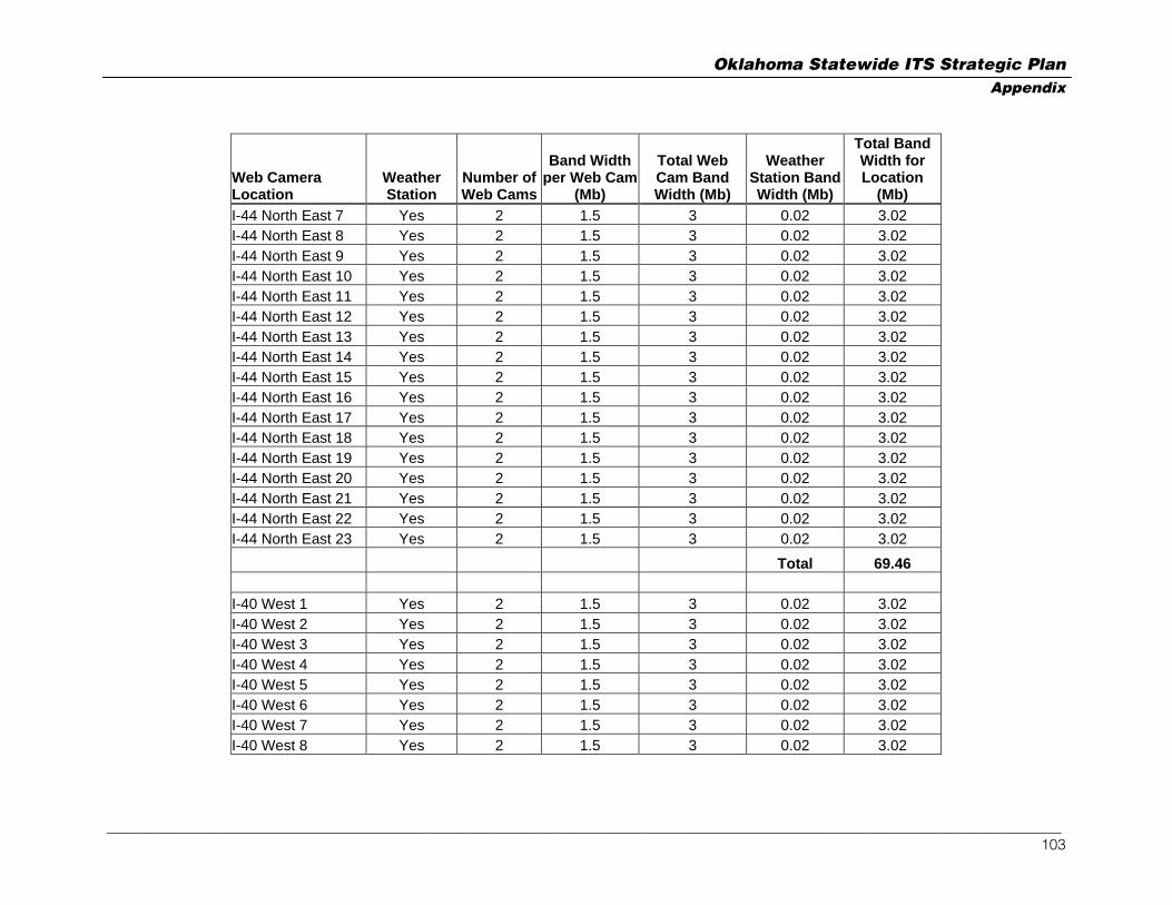
Oklahoma Statewide ITS Strategic Plan Appendix
Web Camera Location
Weather Station
Number of Web Cams
Band Width per Web Cam
(Mb)
Total Web Cam Band Width (Mb)
Weather Station Band Width (Mb)
Total Band Width for Location
(Mb) I-44 North East 7 Yes 2 1.5 3 0.02 3.02 I-44 North East 8 Yes 2 1.5 3 0.02 3.02 I-44 North East 9 Yes 2 1.5 3 0.02 3.02 I-44 North East 10 Yes 2 1.5 3 0.02 3.02 I-44 North East 11 Yes 2 1.5 3 0.02 3.02 I-44 North East 12 Yes 2 1.5 3 0.02 3.02 I-44 North East 13 Yes 2 1.5 3 0.02 3.02 I-44 North East 14 Yes 2 1.5 3 0.02 3.02 I-44 North East 15 Yes 2 1.5 3 0.02 3.02 I-44 North East 16 Yes 2 1.5 3 0.02 3.02 I-44 North East 17 Yes 2 1.5 3 0.02 3.02 I-44 North East 18 Yes 2 1.5 3 0.02 3.02 I-44 North East 19 Yes 2 1.5 3 0.02 3.02 I-44 North East 20 Yes 2 1.5 3 0.02 3.02 I-44 North East 21 Yes 2 1.5 3 0.02 3.02 I-44 North East 22 Yes 2 1.5 3 0.02 3.02 I-44 North East 23 Yes 2 1.5 3 0.02 3.02 Total 69.46 I-40 West 1 Yes 2 1.5 3 0.02 3.02 I-40 West 2 Yes 2 1.5 3 0.02 3.02 I-40 West 3 Yes 2 1.5 3 0.02 3.02 I-40 West 4 Yes 2 1.5 3 0.02 3.02 I-40 West 5 Yes 2 1.5 3 0.02 3.02 I-40 West 6 Yes 2 1.5 3 0.02 3.02 I-40 West 7 Yes 2 1.5 3 0.02 3.02 I-40 West 8 Yes 2 1.5 3 0.02 3.02
_________________________________________________________________________________________________________________________________ 103

Oklahoma Statewide ITS Strategic Plan Appendix
Web Camera Location
Weather Station
Number of Web Cams
Band Width per Web Cam
(Mb)
Total Web Cam Band Width (Mb)
Weather Station Band Width (Mb)
Total Band Width for Location
(Mb) I-40 West 9 Yes 2 1.5 3 0.02 3.02 I-40 West 10 Yes 2 1.5 3 0.02 3.02 I-40 West 11 Yes 2 1.5 3 0.02 3.02 I-40 West 12 Yes 2 1.5 3 0.02 3.02 I-40 West 13 Yes 2 1.5 3 0.02 3.02 I-40 West 14 Yes 2 1.5 3 0.02 3.02 I-40 West 15 Yes 2 1.5 3 0.02 3.02 I-40 West 16 Yes 2 1.5 3 0.02 3.02
Total 48.32 I-40 East 1 Yes 2 1.5 3 0.02 3.02 I-40 East 2 Yes 2 1.5 3 0.02 3.02 I-40 East 3 Yes 2 1.5 3 0.02 3.02 I-40 East 4 Yes 2 1.5 3 0.02 3.02 I-40 East 5 Yes 2 1.5 3 0.02 3.02 I-40 East 6 Yes 2 1.5 3 0.02 3.02 I-40 East 7 Yes 2 1.5 3 0.02 3.02 I-40 East 8 Yes 2 1.5 3 0.02 3.02 I-40 East 9 Yes 2 1.5 3 0.02 3.02 I-40 East 10 Yes 2 1.5 3 0.02 3.02 I-40 East 11 Yes 2 1.5 3 0.02 3.02 I-40 East 12 Yes 2 1.5 3 0.02 3.02 I-40 East 13 Yes 2 1.5 3 0.02 3.02 I-40 East 14 Yes 2 1.5 3 0.02 3.02 I-40 East 15 Yes 2 1.5 3 0.02 3.02 I-40 East 16 Yes 2 1.5 3 0.02 3.02 I-40 East 17 Yes 2 1.5 3 0.02 3.02
_________________________________________________________________________________________________________________________________ 104

Oklahoma Statewide ITS Strategic Plan Appendix
Web Camera Location
Weather Station
Number of Web Cams
Band Width per Web Cam
(Mb)
Total Web Cam Band Width (Mb)
Weather Station Band Width (Mb)
Total Band Width for Location
(Mb) I-40 East 18 Yes 2 1.5 3 0.02 3.02 I-40 East 19 Yes 2 1.5 3 0.02 3.02 I-40 East 20 Yes 2 1.5 3 0.02 3.02 I-40 East 21 Yes 2 1.5 3 0.02 3.02 I-40 East 22 Yes 2 1.5 3 0.02 3.02 I-40 East 23 Yes 2 1.5 3 0.02 3.02
Total 69.46 SH 69 1 Yes 2 1.5 3 0.02 3.02 SH 69 2 Yes 2 1.5 3 0.02 3.02 SH 69 3 Yes 2 1.5 3 0.02 3.02 SH 69 4 Yes 2 1.5 3 0.02 3.02 SH 69 5 Yes 2 1.5 3 0.02 3.02 SH 69 6 Yes 2 1.5 3 0.02 3.02 SH 69 7 Yes 2 1.5 3 0.02 3.02 SH 69 8 Yes 2 1.5 3 0.02 3.02 SH 69 9 Yes 2 1.5 3 0.02 3.02 SH 69 10 Yes 2 1.5 3 0.02 3.02 SH 69 11 Yes 2 1.5 3 0.02 3.02 SH 69 12 Yes 2 1.5 3 0.02 3.02 SH 69 13 Yes 2 1.5 3 0.02 3.02 SH 69 14 Yes 2 1.5 3 0.02 3.02 SH 69 15 Yes 2 1.5 3 0.02 3.02 SH 69 16 Yes 2 1.5 3 0.02 3.02 SH 69 17 Yes 2 1.5 3 0.02 3.02 SH 69 18 Yes 2 1.5 3 0.02 3.02 SH 69 19 Yes 2 1.5 3 0.02 3.02
_________________________________________________________________________________________________________________________________ 105

Oklahoma Statewide ITS Strategic Plan Appendix
Web Camera Location
Weather Station
Number of Web Cams
Band Width per Web Cam
(Mb)
Total Web Cam Band Width (Mb)
Weather Station Band Width (Mb)
Total Band Width for Location
(Mb) SH 69 20 Yes 2 1.5 3 0.02 3.02 SH 69 21 Yes 2 1.5 3 0.02 3.02
Total 63.42 INTP 1 Yes 2 1.5 3 0.02 3.02 INTP 2 Yes 2 1.5 3 0.02 3.02 INTP 3 Yes 2 1.5 3 0.02 3.02 INTP 4 Yes 2 1.5 3 0.02 3.02 INTP 5 Yes 2 1.5 3 0.02 3.02 INTP 6 Yes 2 1.5 3 0.02 3.02 INTP 7 Yes 2 1.5 3 0.02 3.02 INTP 8 Yes 2 1.5 3 0.02 3.02 INTP 9 Yes 2 1.5 3 0.02 3.02 INTP 10 Yes 2 1.5 3 0.02 3.02 INTP 11 Yes 2 1.5 3 0.02 3.02 INTP 12 Yes 2 1.5 3 0.02 3.02
Total 36.24 MTP 1 Yes 2 1.5 3 0.02 3.02 MTP 2 Yes 2 1.5 3 0.02 3.02 MTP 3 Yes 2 1.5 3 0.02 3.02 MTP 4 Yes 2 1.5 3 0.02 3.02 MTP 5 Yes 2 1.5 3 0.02 3.02 MTP 6 Yes 2 1.5 3 0.02 3.02 MTP 7 Yes 2 1.5 3 0.02 3.02 Total 21.14
_________________________________________________________________________________________________________________________________ 106

Oklahoma Statewide ITS Strategic Plan Appendix
Web Camera Location
Weather Station
Number of Web Cams
Band Width per Web Cam
(Mb)
Total Web Cam Band Width (Mb)
Weather Station Band Width (Mb)
Total Band Width for Location
(Mb) SH 412 1 Yes 2 1.5 3 0.02 3.02 SH 412 2 Yes 2 1.5 3 0.02 3.02 SH 412 3 Yes 2 1.5 3 0.02 3.02 SH 412 4 Yes 2 1.5 3 0.02 3.02 SH 412 5 Yes 2 1.5 3 0.02 3.02 SH 412 6 Yes 2 1.5 3 0.02 3.02 SH 412 7 Yes 2 1.5 3 0.02 3.02 SH 412 8 Yes 2 1.5 3 0.02 3.02 SH 412 9 Yes 2 1.5 3 0.02 3.02 SH 412 10 Yes 2 1.5 3 0.02 3.02 SH 412 11 Yes 2 1.5 3 0.02 3.02 SH 412 12 Yes 2 1.5 3 0.02 3.02 SH 412 13 Yes 2 1.5 3 0.02 3.02 SH 412 14 Yes 2 1.5 3 0.02 3.02
Total 42.28
312 Grand Total 471.12
_________________________________________________________________________________________________________________________________ 107


![I-ntelligent dynamic buffer system LOGISTICA AWARD 2012 [RBS]](https://img.pdfslide.us/doc/110x75/5516e89a550346f5558b4829/i-ntelligent-dynamic-buffer-system-logistica-award-2012-rbs.jpg)