Embed Size (px)
Citation preview

Ontario Power Generation’s Proposed L&ILW Deep Geologic Repository: An Overview of Geoscientific Studies Mark Jensen, Tom Lam, Dylan Luhowy, Jim McLay, Branko Semec and Robin Frizzell Nuclear Waste Management Organization, Toronto, Ontario, Canada ABSTRACT The Nuclear Waste Management Organization (NWMO) is conducting geoscientific studies on behalf of Ontario Power Generation (OPG) to verify the suitability of the Bruce Nuclear site, near Tiverton, Ontario, to host a Deep Geologic Repository (DGR) for OPG’s Low and Intermediate Level Nuclear Waste (L&ILW). Interim results indicate that the middle-upper Ordovician formations proposed to host and enclose the DGR comprise a stable, saline (TDS>250 g l-1) and extremely low permeability (≤10-13 msec-1) groundwater regime. This paper provides an overview of coordinated site-specific and regional studies to characterize the Bruce site and support the DGR safety case. RÉSUMÉ La société de gestion des déchets nucléaires (SGDN) à été mandatée par Ontario Power Generation (OPG) pour mener des études geoscientifiques afin de vérifier l’aptitude du site nucléaire de Bruce prés de Tiverton en Ontario à accueillir un dépôt géologique en profondeur pour les déchets à faible et moyenne activité d’OPG. Les résultats préliminaires indiquent que la formation Ordovicienne proposée pour accueillir le dépôt se caractérise par un régime d’écoulements souterrains stable avec de très faibles perméabilités et un haut niveau de salinité (>250 g l-1). Cette article donne une vue d’ensemble des études in-situ et régionales qui sont en cours pour supporter la caractérisation du site et les évaluations de sureté. 1 INTRODUCTION The Nuclear Waste Management Organization (NWMO) on behalf of Ontario Power Generation (OPG) is conducting multi-disciplinary geoscientific studies at the Bruce site to confirm the suitability of the underlying Paleozoic sequence for development of a proposed Deep Geologic Repository (DGR) for Low and Intermediate Level Radioactive Waste (L&ILW) from OPG owned nuclear generating facilities (Figure 1). An Environmental Assessment for the proposed DGR is currently underway in accordance with the Canadian Environmental Assessment Act. Bruce site, situated 225 km northwest of Toronto on the eastern shore of Lake Huron, is underlain by an 850 m thick sedimentary sequence of Cambrian to Devonian age near horizontally bedded, weakly deformed shales, carbonates and evaporites of the Michigan Basin. Within this sedimentary pile, the proposed DGR would be excavated within the low permeability argillaceous limestone Cobourg Formation at depth of 680 m, which is overlain by 200 m of upper Ordovician shale formations.
A key aspect of the DGR Safety Case is the integrity and long-term stability of the sedimentary sequence to contain and isolate L&ILW at timeframes on the order of 1Ma. Early in the project, geoscientific studies that considered regional and site-specific public domain data sets indicated favourable geologic conditions for implementation of the DGR concept (Golder, 2003; Mazurek, 2004). In 2006, site-specific investigations were initiated following the development of a Geoscientific Site Characterisation Plan (GSCP) (Intera 2006; 2008).
Figure 1. Artist Rendering of Proposed Ontario Power Generation Deep Geologic Repository at the Bruce site, Tiverton, Ontario. The GSCP represents a stepwise 4-year, multi-phase program of geoscientific investigations that describes site-specific field and laboratory investigations to further develop and test the existing geoscientific knowledge of sub-surface conditions as they relate to understanding geosphere stability and evolution, engineered repository systems design, and long-term DGR safety.
1339
GeoHalifax2009/GéoHalifax2009
This paper provides an overview of the DGR project and the on-going implementation of the GSCP scheduled for completion in late 2010.
2 BACKGROUND – DGR PROJECT
Ontario Power Generation’s Western Waste Management Facility (WWMF) at the Bruce site has received L&ILW from the Pickering, Bruce and Darlington nuclear stations for over 30 years. The waste is stored in engineered above and below ground storage structures depending on the physical and radiological characteristics of the waste. At present there is approximately 75,000 m3 of L&ILW stored at the WWMF with annual waste arisings of between 2,000 m3 to 3,000 m3 following volume reduction (5,000 m3 to 7,000 m3 before volume reduction).
The WWMF storage structures have a minimum design life of 50 years and are suitable for the interim storage of L&ILW. Although current storage practices are safe, these wastes will eventually need to be transferred to a long-term management facility as some of the wastes remain hazardous for thousands of years.
Since the mid-1980s, OPG has reviewed a wide range of options for the long-term management of L&ILW, including above- and below-ground repository concepts considered by the Municipality of Kincardine and OPG through an Independent Assessment Study completed in March 2004. The outcome of this Independent Assessment Study was that all L&ILW repository concepts were considered technically feasible. Due to margins of safety, the municipality in spring 2004 selected the DGR concept, which then became the preferred option for long-term L&ILW management.
In October 2004, the Municipality of Kincardine and OPG signed a Hosting Agreement to site a DGR on the Bruce site. This agreement explicitly excludes used nuclear fuel from the DGR. The agreement required a formal survey of community support, which was completed in January 2005. Results of the survey indicated a clear majority supporting the DGR project and a Kincardine Municipal council decision to continue with the DGR Hosting Agreement was affirmed on February 16, 2005.
As envisioned, the DGR would involve the excavation of waste emplacement rooms within the Ordovician age argillaceous limestone Cobourg Formation at a depth of 680 m beneath Bruce site (Figure 1). The repository, accessed via two vertical shafts, would require the excavation of nearly 890,000 m3 of rock to accommodate an emplaced L&ILW volume of 200,000 m3 within an approximate 28 Ha repository footprint. Support buildings would be located on ground surface above the underground workings. The current repository concept would consist of a series of emplacement rooms arranged in parallel rows on either side of central access tunnels. A concrete floor will be poured to provide a stable base for stacking of the L&ILW packages.
In July 2005, OPG initiated a process that culminated in the preparation of a Phase I GSCP for the proposed DGR (Intera, 2006). The GSCP provides a comprehensive and internationally peer-reviewed basis
for DGR-related geoscientific studies. In this capacity, the GSCP describes surface and sub-surface site characterisation activities necessary to: • assess and reaffirm the technical suitability of the
proposed DGR concept;
• provide evidence on the geoscientific basis for repository safety at timeframes of 1Ma (i.e. stable rock formations; diffusion dominant transport regime);
• yield information to support development of a site-specific engineered repository design;
• provide a geoscientific basis for the post-closure safety assessment; and
• contribute to the development of an integrated DGR Safety Case describing the expected long-term safety and potential impacts of the DGR.
The activities described in the GSCP are intended to support two key deliverables: • a Descriptive Geosphere Site Model, which is an
integrated, multi-disciplinary, geoscientific description and explanation of the undisturbed subsurface environ as it relates to site-specific geologic, hydrogeologic and geomechanical characteristics and attributes; and
• a Geosynthesis, which is a geoscientific explanation of the overall understanding of site characteristics, attributes and evolution (past and future) as they relate to demonstrating long-term DGR performance and safety.
Upon completion of Phase I investigations in Fall 2008, acquired site knowledge was used to test and revise, as necessary, the GSCP to ensure adequacy for Phase IIab activities (Intera, 2008). Completion of Phase IIab activities is scheduled for late 2010 and pending EA approval, a provisory schedule would seek regulatory approval for DGR construction in 2012 and operation in 2017.
3 SITE CHARACTERIZATION STUDIES
3.1 Site Specific investigations 3.1.1 Overview Site-specific investigations at the Bruce site involve a coordinated sequence of field and laboratory studies. Key amongst these has been completion of a 2-D seismic reflection survey and a deep borehole drilling program. In the fall of 2006, a 20 line km 2-D seismic reflection survey was shot along 9 transects. This survey was designed to focus on the imaging of the Ordovician sediments and in so doing provide a basis to assess the lateral continuity of the underlying bedrock formations and the presence of regional or local scale sub-vertical structural discontinuities beneath the 10 km2 Bruce site.
1340
GeoHalifax2009/GéoHalifax2009

Figure 2. Bruce Site base plan showing location of WWMF, proposed DGR layout, DGR Drill sites, DGR(deep) – and US(shallow) – series boreholes and Core Storage Facility
The seismic reflection survey is complemented by a deep drilling program that includes the eventual drilling, coring and testing of 6 deep boreholes at 4 drill sites as shown in Figure 2. The first of these deep boreholes (DGR-1 and DGR-2) were completed in the Fall of 2007. These initial boreholes (152 mm dia.) intersected the
entire 850 m thick sedimentary sequence and were purposely designed to provide isolated access to the Silurian and Ordovician sediments as shown in Figure 3. In 2008, an additional two deep boreholes DGR-3 and DGR-4 (143 mm dia.) were drilled to establish a triangular pattern enclosing the DGR footprint. The bedrock stratigraphy as determined from rock core logging from these boreholes is depicted in Figure 3. Additional inclined boreholes, DGR-5 and DGR-6, will be completed in 2009.
The drilling program and borehole design were devised to minimize risk of borehole failure during in-situ testing and to provide assurance that intra-borehole flow and head re-distribution did not compromise data integrity. Under the DGR Project Quality Plan specific procedures have been prescribed for the logging, sampling and
storage of the rock core. This includes the preservation of core samples necessary for pore fluid/noble gas characterisation (University of Ottawa; University of Bern), estimation of effective diffusion coefficients (University of New Brunswick) and geomechanical testing (University of Western Ontario; CANMET). All core (76 mm Φ) is stored
at the Bruce site core storage facility that is designed to accept core from the entire work program (≈ 4.5 km).
Upon completion of coring, a program of geophysical logging and hydraulic testing is performed within the open bores to obtain estimates of rock mass permeability. A suite of geophysical logs were completed to assist with formational contact interpretation and initial identification of permeable horizons within the sedimentary sequence. The geophysical logs included conventional and nuclear logs, acoustic televiewer log, borehole video and Fluid Electrical Conductivity logging. Borehole hydraulic testing involved straddle packer drill stem, pulse and slug testing (30 m test interval) dependent of the formation permeability. This latter hydraulic testing program applied in-situ borehole techniques and analysis methods developed at the Waste Isolation Pilot Plant in New
1341
GeoHalifax2009/GéoHalifax2009
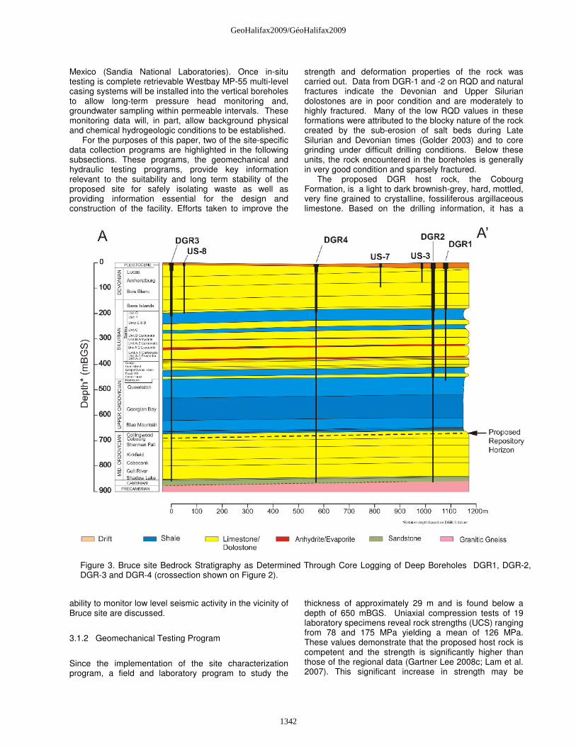
Figure 3. Bruce site Bedrock Stratigraphy as Determined Through Core Logging of Deep Boreholes DGR1, DGR-2, DGR-3 and DGR-4 (crossection shown on Figure 2).
Mexico (Sandia National Laboratories). Once in-situ testing is complete retrievable Westbay MP-55 multi-level casing systems will be installed into the vertical boreholes to allow long-term pressure head monitoring and, groundwater sampling within permeable intervals. These monitoring data will, in part, allow background physical and chemical hydrogeologic conditions to be established.
For the purposes of this paper, two of the site-specific data collection programs are highlighted in the following subsections. These programs, the geomechanical and hydraulic testing programs, provide key information relevant to the suitability and long term stability of the proposed site for safely isolating waste as well as providing information essential for the design and construction of the facility. Efforts taken to improve the
ability to monitor low level seismic activity in the vicinity of Bruce site are discussed.
3.1.2 Geomechanical Testing Program
Since the implementation of the site characterization program, a field and laboratory program to study the
strength and deformation properties of the rock was carried out. Data from DGR-1 and -2 on RQD and natural fractures indicate the Devonian and Upper Silurian dolostones are in poor condition and are moderately to highly fractured. Many of the low RQD values in these formations were attributed to the blocky nature of the rock created by the sub-erosion of salt beds during Late Silurian and Devonian times (Golder 2003) and to core grinding under difficult drilling conditions. Below these units, the rock encountered in the boreholes is generally in very good condition and sparsely fractured.
The proposed DGR host rock, the Cobourg Formation, is a light to dark brownish-grey, hard, mottled, very fine grained to crystalline, fossiliferous argillaceous limestone. Based on the drilling information, it has a
thickness of approximately 29 m and is found below a depth of 650 mBGS. Uniaxial compression tests of 19 laboratory specimens reveal rock strengths (UCS) ranging from 78 and 175 MPa yielding a mean of 126 MPa. These values demonstrate that the proposed host rock is competent and the strength is significantly higher than those of the regional data (Gartner Lee 2008c; Lam et al. 2007). This significant increase in strength may be
1342
GeoHalifax2009/GéoHalifax2009

attributed in part to factors such as the rigorous quality control procedure to minimize disturbance during handling of core samples in the laboratory and at the DGR site, the size effect of test samples, the difference in burial depths and the mineralogical difference due to different depositional environments within the region. The higher strength of the Cobourg limestone is visible in Figure 4 when the UCS is compared with those of sedimentary formations studied internationally in the framework of waste disposal.
Figure 4. Comparison of uniaxial compressive parameters (Mazurek, 2004)
3.1.3 Seismic Monitoring
Efforts have been taken to improve the ability to monitor low-level seismic activity in the vicinity of Bruce site. While located in an area of low seismic hazard, an improved understanding of micro-seismicity as it relates to the regional earthquake distributions and interpretation of regional scale faulting is important in assessing DGR performance. To this end, a new borehole seismograph network has been installed. The seismographs (3) are positioned in cased bedrock wells 27 to 55 m deep, within 50 km of Bruce site. The detection threshold magnitude is M ≥ 1. The monitoring of the seismograph network, including the processing of data streams from Polaris and Geologic Survey of Canada (GSC) hubs, is performed by the Canadian Hazard Information Service (GSC).
The lack of earthquakes (>1.0M) detected by the new microseismic array around Bruce site is consistent with the region’s low seismicity rate. Since the station installation, there has been one earthquake larger than 1.0M recorded within 50 km of the site. This was a 1.2 M event located about 34 km off the shore of Lake Huron in 2008. Another 1.9 M event was located at 68 km from the site in December 2007. Figure 5 shows the historical seismicity of the Bruce region, including data up to December 2008. 3.1.4 Hydraulic Testing Program Pulse, slug, and drill-stem hydraulic testing using a custom-built straddle packer testing tool has been used to quantify horizontal rock mass hydraulic conductivities. The tests were completed in DGR-1 and 2 in 2007 and DGR-3 and DGR-4 in 2008. Pulse tests using straddle lengths of 30 metres were completed in boreholes DGR-2 to DGR-4
to provide complete coverage of the Ordovician limestones and shales that would host and enclose the proposed repository. Figure 6 shows the preliminary results of testing in borehole DGR-3, which was the first single complete borehole to be tested from near the top of the Silurian to near bottom of the Ordovician shales (Targeted tests were completed in DGR-1, and DGR-2 was cased to the top of the Queenston Formation shale). Each test typically required several days to complete, and testing of DGR-3 was completed between September and November 2008 (Avis et al., 2009). Straddle packer test results were analysed using the Sandia National Laboratories numerical hydraulic-test simulator – nSIGHTS. Measured horizontal hydraulic conductivities from DGR-3 are typically below 10-13 m/s at and surrounding the proposed repository elevation.
Figure 5. Historical seismicity around Bruce site (to December 2008)
Following the completion of straddle packer testing, three US-series boreholes and boreholes DGR-1 and DGR-2 were equipped with Westbay multiport groundwater monitoring systems. Environmental water heads calculated from formation pressures and the porewater/groundwater fluid density profile range from 140 m above ground surface (325 mASL) for the Cambrian sandstone to less than 265 m below ground surface (-80 mASL) in the Blue Mountain shale. Processes and mechanisms contributing to the observed over- and under-pressures and their longevity are currently under investigation. Regardless, the occurrence of significant under-pressures implies extremely low rock mass permeabilities at formation scale. Installation of similar Westbay systems in DGR-3 and DGR-4 in 2009 will provide information on the 3-dimensional distribution of the observed pressures surrounding the proposed DGR site.
These field measurement programs are complemented by an array of laboratory measurements taken from collected samples including petrophysical
1343
GeoHalifax2009/GéoHalifax2009

Figure 6: Results of Phase 1 head and density measurements at DGR-1 and -2 and preliminary horizontal hydraulic conductivity measurements at DGR-3.
testing, diffusion testing (Xiang et al., 2009), and porewater characterization. Figure 6 includes a plot of data on groundwater and porewater density, which reflects the presence of significant concentrations of dissolved solids in the waters analyzed from the Ordovician sediments.
3.2 Geosynthesis 3.2.1 Overview The Geosynthesis task of the SCP provides the overall integration of all project data and the development of a Descriptive Geosphere Model(s) consistent with all the acquired data and information necessary for preparation of the DGR Environmental Assessment and regulatory site preparation/construction license application. The Geosynthesis for the GSCP is intended to develop and present the overall geoscientific understanding of the site, the host rock and the geological barrier system, its present state and future evolution, as well as the geoscientific data base for Safety Assessment and
Repository Engineering. Geosynthesis is an essential component in the development of a basis to understand the long-term performance of the DGR concept. It is an activity that is conducted throughout the entire site
characterization work program and involves the coordinated and collaborative efforts of specialists from all relevant disciplines.
As part of Phase I Geosynthesis (Gartner Lee, 2008a) activities, a series of technical reference documents have been prepared, in part, to establish a regional context for the DGR program. These technical reports include: i) Regional Geology (Gartner Lee, 2008b); ii) Regional Geomechanics (Gartner Lee, 2008c); iii) Regional Hydrogeochemistry (Hobbs et al., 2008); iv) Long-term Climate Change – Glaciation (Peltier, 2008); v) Regional Hydrogeology (Sykes, et al,. 2008 and vi) Long-term Cavern Stability (Damjanac, 2008). These reports are publicly available at www.nwmo.ca. 3.2.2 Regional Geology The DGR site is located at the eastern margin of the paleo-Michigan Basin. Figure 7 illustrates the general Michigan Basin geology, showing the position of the DGR-2 borehole, which is immediately adjacent to the proposed DGR site, and also showing the boundary in
crossection of a detailed regional three-dimensional geological framework model (3DGF). The 3DGF model covers an area of approximately 35,000-km2 around the DGR site and was developed to capture and present the
1344
GeoHalifax2009/GéoHalifax2009

current geological understanding of the Paleozoic sedimentary formations and their stratigraphy. This understanding was required to provide context to the geology at the DGR site and was used as the basis to establish the hydrostratigraphy for the regional hydrogeological modelling.
The basal Cambrian sediments were deposited directly over the Precambrian basement, and although these deposits extend from the Appalachian Basin to the Michigan Basin, they have largely been eroded over most of southern Ontario. The lithology of the Cambrian units ranges from dolostone, to sandy dolostone, to argillaceous dolostone to quartzose sandstone, and are often described as porous and permeable.
Figure 7. Geological Cross-Section through Michigan Basin (Gartner Lee 2008b). The boundary of the Three-Dimensional Geological Framework (3DGF) model is shown on the eastern margin of the Michigan Basin. Overlying the Cambrian deposits, or the Precambrian basement, in the subsurface of southern Ontario are the Middle Ordovician Carbonates. These rocks include the Shadow Lake, Gull River, and Coboconk Formations of the Black River Group and the Kirkfield, Sherman Fall, and Cobourg Formations (DGR host rock) of the Trenton Group. These rocks are generally characterized as limestones to argillaceous limestones and have a uniform and extensive distribution from the Appalachian Basin in New York, into the Michigan Basin of Ontario and Michigan. Capping the Ordovician limestones are the extensive Upper Ordovician shale sequences of the Blue Mountain, Georgian Bay and Queenston Formations. These tight shale units are generally composed of non-calcareous to calcareous shales with minor siltstone and carbonate interbeds.
The Lower and Middle Silurian rocks at the DGR site consist of the Manitoulin Formation dolostones, Cabot Head Formation shales and the dolostones of the Fossil Hill, Lions Head, Gasport, Goat Island and Guelph Formations. The Upper Silurian Formations are comprised of the Salina Group and the Bass Islands Formations.
The youngest rocks in the regional study area include the lower Devonian Bois Blanc Formation dolostones, which are disconformably overlain by Middle Devonian mixed limestones and dolostones of the Detroit River
Group (Amherstburg and Lucas Formations). The Lucas Formation subcrops beneath the overburden at the DGR Bruce and outcrops along the shoreline.
The geology encountered in site borehole drilling (Raven et al., 2009) is consistent with the regional geology as described in the DGR Regional Geology Reporting and presented in the 3DGF model (Gartner Lee 2008b). The Paleozoic bedrock formations below the Bruce site have predictable range of lithologies, depth, thickness, and orientation over distances of kilometres. Raven et al. (2009) further note that the uniformity of formation depths, thicknesses and orientations from DGR site drilling infers limited evidence for the presence of vertical offsetting faults in the vicinity of the proposed DGR. 3.2.3 Hydrogeologic Modelling A key aspect of the DGR concept is the role of multiple geosphere barriers in providing long-term isolation and containment of the L&ILW. Efforts beyond the field and laboratory have involved the integration of field data at local and regional scale into 3-dimensional numerical simulations of the regional and site-specific groundwater system (Sykes et al., 2009). While interim in nature these simulations, performed with the code FRAC3DVS-OPG, have explored uncertainty in bedrock hydrostratigraphy and boundary conditions, the influence of the variable salinity of near-surface fresh compared to deep seated brine waters and the effect of glacial events on groundwater hydrodynamics and mass transport (Figure 8). Illustrative numerical simulations of the groundwater system predict a sluggish deep seated groundwater system resilient to glacial perturbations and one in which mass transport is dominantly governed by diffusive processes. Computed Mean Life Expectancies (time to system discharge) that incorporate advective, dispersive and diffusive transport processes, for solute at the repository horizon are 8 million years or greater.
Figure 8: Numerical Simulation of Regional (18,000 km2) Groundwater System with FRAC3DVS-OPG within Paleozoic Sediments in Vicinity of the Proposed DGR. The numerical simulations further examined long-term field observations of non-hydrostatic or abnormal
1345
GeoHalifax2009/GéoHalifax2009

hydraulic head conditions within the sediments as observed in a multi-level Westbay (MP-55) monitoring system. Particularly of note are the aforementioned depressed environmental heads in the Ordovician sediments that while still equilibrating after more than a year of monitoring are currently ca. 265 m below ground surface (Figure 6). These sediments lie unconformably above a thin (17 m), laterally extensive, permeable (K≈10-7 m sec-1), and low storage (Ss≈10-6 m-1) Cambrian sandstone within an abnormal over-pressure of 140 m above ground surface (Figure 6). The resultant vertical hydraulic gradients sustained across the sediments are high, on the order of 2 and appear convergent on the repository horizon. Studies examining the origin and longevity of the abnormal heads are continuing with respect to understanding Ordovician properties and barrier function time and space scales relevant to repository safety. Interim model results imply that formation hydraulic conductivities must be of the order of 10-14 m sec-1 or less to preserve the observed hydraulic heads.
3.2.4 Regional Hydrogeochemistry Hydrogeochemical evidence from the Paleozoic sediments of southern Ontario provides evidence that deep groundwaters have remained undisturbed despite multiple perturbations on geologic time scales (Hobbs et al., 2008). Multiple lines of evidence include formation distinct chemical compositions, extremely high salinities (TDS 200 – 350 g l-1) and isotopic signatures consistent with long-residence – rock/water interaction times. As part of this work program a comprehensive geochemical database of elemental and isotopic analyses on groundwater within the Paleozoic sediments of south-western Ontario was assembled (University of Waterloo). These data have been assessed with respect to: i) depth of penetration of glacial waters; ii) cross formational solute migration with specific emphasize on the role of regional scale structural discontinuities; iii) inter-formational groundwater mixing within the sedimentary sequence; and iv) the spatial variability in formational groundwater composition throughout south western Ontario.
The maximum depths at which waters with isotopic signatures indicative of a meteoric origin have been observed in Ontario are 130 m in shallow bedrock aquifers and 125 m below ground surface in the till deposits of the Alliston aquifer. The stable isotopic signatures from formations of different ages and lithologies are observed to cluster in distinct ranges. The persistence of these distinct isotopic signatures at a regional scale suggests that the waters and associated hydrocarbons have remained isolated from one another over geologic time frames (Gartner Lee 2008a).
Data from site characterization studies show site conditions consistent with the regional understanding. In the Ordovician shales and limestones, porosities ≤ 0.08 are measured with TDS in the range of 250 – 350 g L-1.
3.2.5 Long-term Climate Change
Within the northern latitudes climate change and, in particular, glaciation events are likely to influence the long-term performance of the DGR. Prolonged and cyclic periods of glacial and peri-glacial conditions have existed in these regions on numerous occasions in recent geologic history. During the latter half of the Pleistocene, long-term climate change has resulted in 9 glacial events with a typical 115 ka cycle. Ice-sheet thickness at glacial maximum would have exceeded ≈2.5 km over southern Ontario. Transient temperature, hydraulic and mechanical boundary conditions resulting from glacial conditions may, on a site-specific basis, materially affect groundwater flow system dynamics, fracture network interconnectivity, fracture rejuvenation/propagation, post-glacial lake formation, groundwater redox front migration and geomechanical stability of repository access tunnels and emplacement rooms. Demonstrating a knowledge and awareness of the time history and magnitude of these effects is an important aspect in the development of a repository safety case.
In order to explore the range of surface boundary conditions that could develop at Bruce site, the University of Toronto Glacial Systems Model was subject to a Bayesian calibration and employed to construct a suite of equally plausible models of the glaciation-deglaciation process (Peltier, 2008). These boundary conditions, on normal stress, surface temperature, permafrost depth and meltwater production, are highly time dependent and vary substantially across the suite of models that are able to satisfy the observational constraints. These constraints are taken to be those appropriate to the most recent cycle of glaciation that began following the Eemian interglacial that was initiated 116,000 years before present and that ended approximately 10,000 years ago.
4 GEOSCIENCE REVIEW GROUP
As part of the overall site characterisation work program an independent Geoscience Review Group (GRG) has been assembled by the NWMO to provide an advisory and oversight role on geoscientific site characterization activities at Bruce site. GRG activities have focused on guidance and expertise related to the following: i) implementation of field and laboratory measurement techniques/methods; ii) interpretation and synthesis of field and laboratory data given measurement/geosphere uncertainty; iii) international practice for geoscientific investigations in sedimentary sequences for radioactive waste management purposes; iv) review and direction of strategies for Descriptive Geosphere Model development; and v) review and direction of strategies for Geosynthesis development. In this role the GRG is positioned to independently assess the adequacy of all aspects of the Bruce site investigations with findings reported directly to NWMO Management. A key benefit of the GRG has been the direct involvement and access to international geoscience work programs, in particular, those of ANDRA (France) and NAGRA (Switzerland), which has been of significant advantage to the DGR program.
1346
GeoHalifax2009/GéoHalifax2009

SUMMARY
Geoscientific site characterisation activities to verify the suitability of the Paleozoic sedimentary sequence beneath the Bruce Nuclear site for implementation of a Deep Geologic Repository for long-term management of Low and Intermediate Level Radioactive Waste generated at Ontario Power Generation facilities are entering the final phase. As envisioned the DGR would be excavated at a depth of 680 m in the argillaceous limestone Cobourg Formation beneath 200 m of upper Ordovician shales. The focus for the geoscientific investigations has been on gathering data to develop and test an understanding of the evolution and stability of the geologic, hydrogeologic, hydrogeochemical and geomechanical environ as it relates to demonstrating repository safety. Initiated in 2006, interim results from the investigations are providing evidence of a predictable geosphere with a deep seated (≥400 m), low permeability (K ≤ 10-13 m sec-1), low porosity (0.01-0.08), saline (TDS ≥ 250 g L-1) groundwater regime that is ancient and resilient to external perturbations (e.g. glaciation). These site specific data, in addition to regional and site-scale hydrogeologic modelling of the sedimentary sequence, that among other aspects is examining groundwater system evolution through an understanding of observed abnormally elevated and depressed formation pore pressures, are to be integrated as part of a Geosynthesis document for the project supporting a DGR Safety Case. The work program is scheduled for completion in late 2010 in support of the submittal of an Environmental Impact Statement and regulatory site Preparation/Construction License application in early 2011.
ACKNOWLEDGEMENTS
Numerous individuals and organizations have contributed to the DGR project since initiated in 2002. Early work by Golder Associates Ltd. and Martin Mazurek (University of Bern) established the geoscientific basis and precedent to understand the suitability of the Paleozoic sequence for long-term radioactive waste management purposes. The Geoscience Review Group comprised of Dr. Andreas Gautschi (NAGRA), Jacques Delay (ANDRA), Dr. Joe Pearson and Dr. Derek Martin (UofA) has provided valuable access to international experience and expertise.
REFERENCES Avis, J., Roberts, R., Chace, D., Toll, N. and Beauheim,
R. 2009. Hydraulic testing to characterize low permeability sedimentary formations – proposed Deep Geologic Repository, Bruce County, Ontario. GeoHalifax 2009. CGS-IAH(CNC), Halifax, NS, Canada.
Damjanac, B., 2008, Phase I Long-term Cavern Stability, OPG Report, OPG 00216-REP-01300-00005-R00.
Gartner Lee. 2008a. Phase I Geosynthesis, OPG Report OPG 00216-REP-01300-000010-R00.
Gartner Lee. 2008b. Phase I Regional Geology, Southern Ontario, OPG Report OPG 00216-REP-01300-00007-R00.
Gartner Lee. 2008c. Phase I Regional Geomechanics Southern Ontario, OPG Report OPG 00216-REP-01300-00008-R00.
Geological Survey of Canada, 2007. DGR Supporting Technical Report, Seismic Monitoring Annual Report 2007, OPG 00216-REP-01300-00011-R00.
Golder Associates Ltd. 2003. LLW Geotechnical Feasibility Study Western Waste Management Facility Bruce site Tiverton, Ontario. Report submitted to municipality of Kincardine and Ontario Power Generation. Report No. 021-1570.
Hobbs, M.Y., S.K. Frape, O. Shouaker-Stash and L. Kennell, 2008, Phase I Regional Hydrogeochemistry Southern Ontario, OPG Report OPG 00216-REP-01300-00006-R00.
Intera Engineering Ltd. 2006. Geoscientific Site Characterisation Plan Deep Geologic Repository Bruce Nuclear site. OPG Report No. 002160-REP-03902- 00002-R00, April 2006.
Intera Engineering Ltd. 2008. Phase 2 Geoscientific Site Characterisation Plan Repository Bruce Nuclear site. OPG Report No. 002160-REP-03902-00006-R00, April 2008.
Lam, T., Martin, C.D. & McCreath, D. 2007. Deep geologic repository for low and intermediate level waste regional geomechanical property and in-situ stress database. Canadian Geotechnical Society Conference, CGS, Ottawa, ON, Canada.
Mazurek, M. 2004. Long-Term Used Nuclear Fuel Waste Management – Geoscientific Review of the Sedimentary Sequence in Southern Ontario. Technical Report TR 04-01, prepared for Ontario Power Generation, University of Bern, Switzerland, July 2004.
Peltier, W.R., 2008, Phase I Long-term Climate Change Study, OPG Report OPG 00216-REP-01300-00004-R00.
Raven, K., Sterling, S., Gaines, S., Wigston, A. and Frizzell, R. 2009. Regional and site geological frameworks – proposed Deep Geologic Repository, Bruce County, Ontario. GeoHalifax 2009. CGS-IAH(CNC), Halifax, NS, Canada.
Sykes, J.F., E.A. Sykes, S.D. Normani, Y. Yin and Y.-J. Park, 2008, Phase I Hydrogeologic Modelling, OPG Report OPG 00216-REP-01300-00009-R00.
Sykes, J., Normani, S., Yin, Y., Sykes, E. and Jensen, M.R. 2009. Hydrogeologic Modelling in Support of a Proposed Deep Geologic Repository in Canada for Low and Intermediate Level Radioactive Waste. GeoHalifax 2009. CGS-IAH(CNC), Halifax, NS, Canada.
Xiang, Y., Cavé, L., Loomer, D. and Al, T. 2009. Diffusive anisotropy in low-permeability Ordovician sedimentary rocks from the Michigan basin in southwest Ontario. GeoHalifax 2009. CGS-IAH(CNC), Halifax, NS, Canada.
1347
GeoHalifax2009/GéoHalifax2009