Embed Size (px)
Citation preview
OnshOre shale gas in australia and the nOrthern territOry
6
6.1 Australian unconventional gas supplies and total energy use6.2 Exploration for and development of unconventional gas in Australia6.3 Shale gas potential of the NT6.4 Likely areas of shale gas development in the NT6.5 Possible development scenarios in the NT
SCIENTIFIC INQUIRY INTO HYDRAULIC FRACTURING IN THE NORTHERN TERRITORY - FINAL REPORT84
6.1 Australian unconventional gas supplies and total energy use From an international perspective, Australia is considered to have substantial resources of onshore unconventional gas, including CSG, shale gas and tight gas. While the development of CSG reserves has been under way for almost two decades in Queensland, the onshore shale gas industry in Australia is still largely in the exploration phase.
Although there are some potential oil and/or condensate resources in the NT (see Section 6.3 below), the Panel focussed its assessment on onshore shale gas, and not other forms of petroleum that could derive from shale, such as shale liquids (oil) and condensate. The reason for this is, first, because the Terms of Reference (see Appendix 1) limit the scope of the Inquiry to onshore shale gas only, and second, because, to date, exploration has produced only dry (liquid free) gas in the Beetaloo Sub-basin (Section 6.3.3). While there is known potential for liquids to be associated with a number of shale formations in the NT, to date the only declared contingent shale petroleum resource has been for dry gas from the Velkerri formation in the Beetaloo Sub-basin All other potential liquids resources remain insufficiently explored and/or unlikely to be economically feasible as an oil development.1 Therefore, if there was shale liquids production it is likely to be primarily as a shale gas play with a small volumetric percentage of liquids also produced. If this occurred, in the Panel’s view, this would not materially affect the mitigated risk assessments contained in this Report.
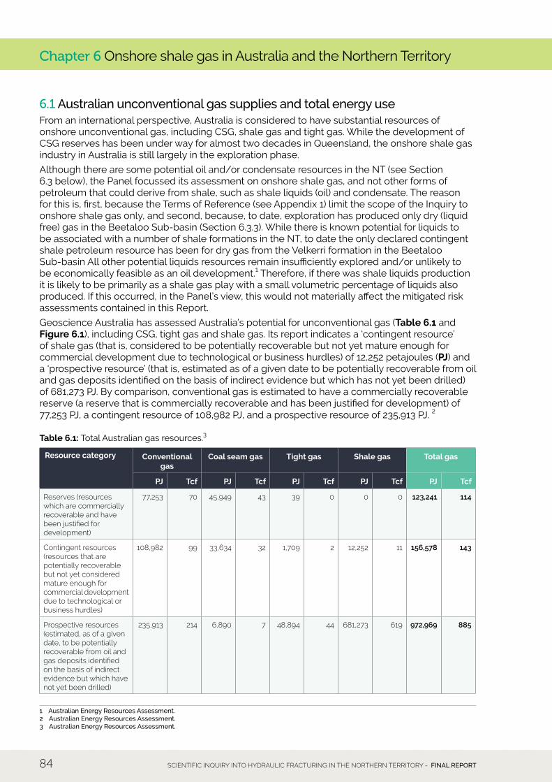
Geoscience Australia has assessed Australia’s potential for unconventional gas (Table 6.1 and Figure 6.1), including CSG, tight gas and shale gas. Its report indicates a ‘contingent resource’ of shale gas (that is, considered to be potentially recoverable but not yet mature enough for commercial development due to technological or business hurdles) of 12,252 petajoules (PJ) and a ‘prospective resource’ (that is, estimated as of a given date to be potentially recoverable from oil and gas deposits identified on the basis of indirect evidence but which has not yet been drilled) of 681,273 PJ. By comparison, conventional gas is estimated to have a commercially recoverable reserve (a reserve that is commercially recoverable and has been justified for development) of 77,253 PJ, a contingent resource of 108,982 PJ, and a prospective resource of 235,913 PJ. 2
Table 6.1: Total Australian gas resources.3
1 Australian Energy Resources Assessment.2 Australian Energy Resources Assessment. 3 Australian Energy Resources Assessment.
Chapter 6 Onshore shale gas in Australia and the Northern Territory
Resource category Conventional gas
Coal seam gas Tight gas Shale gas Total gas
PJ Tcf PJ Tcf PJ Tcf PJ Tcf PJ Tcf
Reserves (resources which are commercially recoverable and have been justified for development)
77,253 70 45,949 43 39 0 0 0 123,241 114
Contingent resources (resources that are potentially recoverable but not yet considered mature enough for commercial development due to technological or business hurdles)
108,982 99 33,634 32 1,709 2 12,252 11 156,578 143
Prospective resources (estimated, as of a given date, to be potentially recoverable from oil and gas deposits identified on the basis of indirect evidence but which have not yet been drilled)
235,913 214 6,890 7 48,894 44 681,273 619 972,969 885
6. OnShORe ShAle GAS In AuSTRAlIA And The nORTheRn TeRRITORy 85
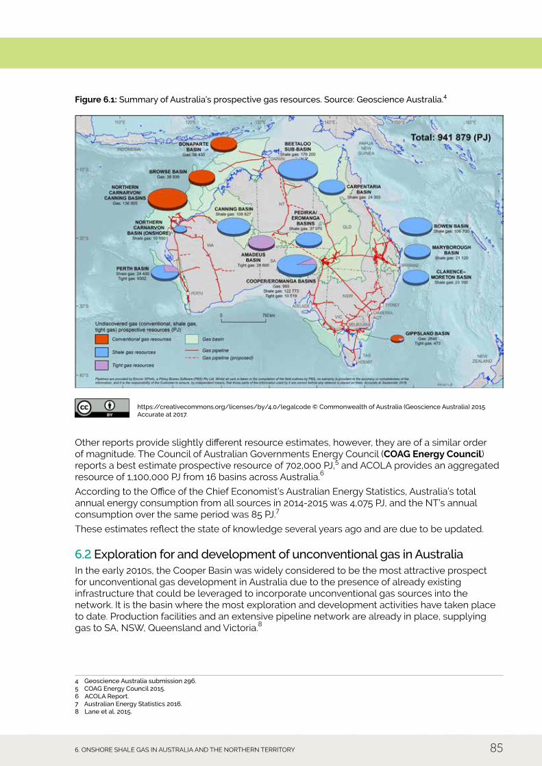
Figure 6.1: Summary of Australia’s prospective gas resources. Source: Geoscience Australia.4
https://creativecommons.org/licenses/by/4.0/legalcode © Commonwealth of Australia (Geoscience Australia) 2015 Accurate at 2017.
Other reports provide slightly different resource estimates, however, they are of a similar order of magnitude. The Council of Australian Governments energy Council (COAG Energy Council) reports a best estimate prospective resource of 702,000 PJ,5 and ACOlA provides an aggregated resource of 1,100,000 PJ from 16 basins across Australia.6
According to the Office of the Chief economist’s Australian energy Statistics, Australia’s total annual energy consumption from all sources in 2014-2015 was 4,075 PJ, and the nT’s annual consumption over the same period was 85 PJ.7
These estimates reflect the state of knowledge several years ago and are due to be updated.
6.2 Exploration for and development of unconventional gas in Australia In the early 2010s, the Cooper Basin was widely considered to be the most attractive prospect for unconventional gas development in Australia due to the presence of already existing infrastructure that could be leveraged to incorporate unconventional gas sources into the network. It is the basin where the most exploration and development activities have taken place to date. Production facilities and an extensive pipeline network are already in place, supplying gas to SA, NSW, Queensland and Victoria.8
4 Geoscience Australia submission 296.5 COAG Energy Council 2015.6 ACOLA Report.7 Australian Energy Statistics 2016.8 Lane et al. 2015.
Chapter 6 Onshore shale gas in Australia and the Northern Territory
SCIENTIFIC INQUIRY INTO HYDRAULIC FRACTURING IN THE NORTHERN TERRITORY - FINAL REPORT86
however, recent exploration activities and the announced discovery by Origin in 2016 confirming a contingent commercial shale gas resource in the relatively unexplored Beetaloo Sub-basin of the McArthur Basin in the nT is significant for Australian (and the nT’s) shale gas exploration.
The Senate Select Committee on Unconventional Gas Mining Interim Report, Chaired by Senator Glenn lazarus in 2016 (Lazarus Report), provides a comprehensive account of Australia’s unconventional gas reservoirs and where exploration and development activity is currently under way. This indicates that:
• unconventional gas production, specifically CSG production, is currently operational in Queensland (since 1996) and nSW (since 2001);
• there is currently no commercial production of shale gas in Australia; and
• exploration is currently under way in Queensland, SA, WA and the NT, all of which have shale gas prospects.9
Since the publication of the lazarus Report, there has been a moratorium on hydraulic fracturing in the NT, NSW, and WA and a legislative ban in Victoria.
6.3 Shale gas potential of the Northern Territory According to Geoscience Australia,10 total prospective shale gas resources in the NT are estimated to be 257,276 PJ. Importantly, almost 70% of this (178,200 PJ) is estimated to occur in the Beetaloo Sub-basin of the McArthur Basin. This prospective resource is larger than any one of the north West Shelf conventional gas resources, the Cooper/ eromanga basins, or the Canning Basin shale gas resources. It suggests that the Beetaloo Sub-basin is a world-class resource comparable to several of the uS shale gas basins.11
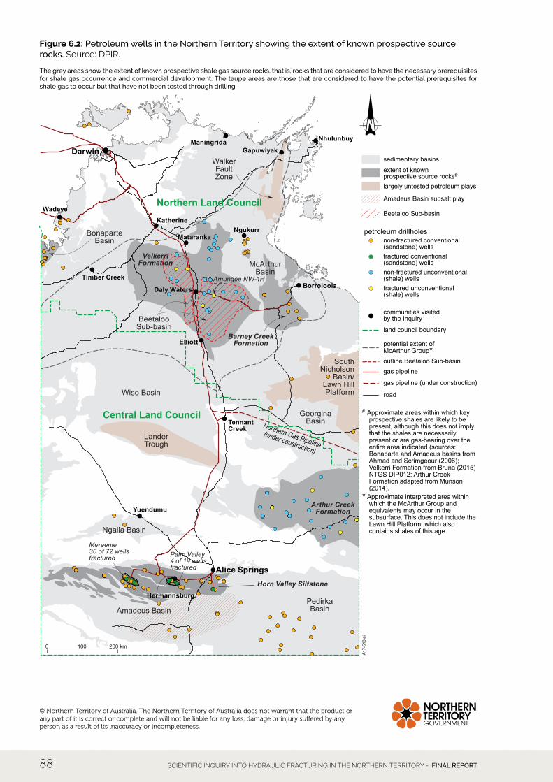
Geologically, the Northern Territory is underlain by thick sedimentary rock sequences deposited in a number of geological basins. The understanding of these subsurface sequences has been largely developed indirectly through inspection of rocks where they outcrop, geophysical surveys of the subsurface, and interpretation of other indirect indications of the nature of the subsurface such as groundwater chemistry. direct evidence of the nature of the subsurface geology has been gained where drilling has been undertaken. However, by Australian and global standards, the nT’s petroleum-bearing basins are relatively underexplored, and as a result, the level of geological knowledge of the basins is incomplete and highly variable.
Current understanding of the locations and extent of potential shale gas-bearing geological basins is shown in Figure 6.2 and is discussed below. The basins that are currently considered to have prospective rocks with the necessary prerequisites for shale gas occurrence, and that have had some confirmation of this interpretation through exploration drilling, are the Amadeus Basin and the Beetaloo Sub-basin.12
A number of other potential basins are present that have not been extensively or successfully tested to date. These are also considered to have the potential to bear shale gas and are discussed below. While the broader NT is still relatively unexplored, current geological knowledge suggests that shale gas is unlikely to occur outside the areas referred to here.
The nature of the geo-mechanical stress regime present in a shale formation is a key factor determining whether fracturing of the formation is likely to occur in the most effective and economic way to liberate the gas.13
It was suggested to the Panel that the stress regime in Australian shale formations may be different to that in the large American shale plays, and therefore, that American deposits are not a good analogue for Australia.14 In particular, it was noted that the occurrence of a reverse stress regime could substantially reduce the effectiveness of hydraulic fracturing. Such a situation could result in a greatly increased numbers of wells (compared to the uS) to produce the required volumes of gas.
9 Lazarus Report.10 Australian Energy Resources Assessment.11 Scrimgeour 2016.12 Confirmed in Geoscience Australia submission 414.13 Origin submission 153, pp 198-205.14 Australian-German Climate and Energy College, University of Melbourne, submission 543, pp 4-5.
6. OnShORe ShAle GAS In AuSTRAlIA And The nORTheRn TeRRITORy 87
All of the available information about the Beetaloo Sub-basin, one of the nT’s most prospective of the shale gas basins, indicates that the Velkerri shale formation has a normal stress regime, and that the Marcellus and Barnett basins in the uS are therefore good comparisons for the likely effectiveness of any hydraulic fracturing process for onshore shale gas in the nT.15
6.3.1 Amadeus Basin The Amadeus Basin, south of Alice Springs, has had the highest levels of exploration in the NT and more than 30 years of continuous oil and gas production sourced from conventional and tight gas reservoirs. The Basin is large (170,000 km2) and up to 14 km in thick, which contains numerous petroleum systems, and is the only producing conventional petroleum fields in the onshore nT (Mereenie oil and gas and Palm Valley and dingo gasfields), with an additional field (Surprise oil) that is currently not in production. Its thick sedimentary succession is prospective for petroleum at numerous stratigraphic levels, although most exploration and production in the Basin to date has focussed on conventional and tight gas petroleum systems. While this basin has rocks such as the Horn Valley Siltstone that are prospective for unconventional gas, exploration and development in the region are considered likely to continue to focus on conventional and tight gas plays.
15 Close et al. 2017, pp 93-94.
SCIENTIFIC INQUIRY INTO HYDRAULIC FRACTURING IN THE NORTHERN TERRITORY - FINAL REPORT88
Figure 6.2: Petroleum wells in the Northern Territory showing the extent of known prospective source rocks. Source: dPIR.
The grey areas show the extent of known prospective shale gas source rocks, that is, rocks that are considered to have the necessary prerequisites for shale gas occurrence and commercial development. The taupe areas are those that are considered to have the potential prerequisites for shale gas to occur but that have not been tested through drilling.
Northern Gas Pipeline(under construction)
Wiso Basin
Ngalia Basin
McArthurBasin
GeorginaBasin
SouthNicholson
Basin/Lawn HillPlatform
LanderTrough
BeetalooSub-basin
PedirkaBasin
BonaparteBasin
Amadeus Basin
WalkerFaultZone
Amungee NW-1H
Mereenie30 of 72 wellsfractured Palm Valley
4 of 19 wellsfractured
Elliott
ManingridaGapuwiyak
Nhulunbuy
Borroloola
Yuendumu
Hermannsburg
NgukurrMataranka
Wadeye
Timber Creek
Daly Waters
Katherine
Alice Springs
TennantCreek
Darwin
Northern Land Council
Central Land Council
Petroleum wells in the Northern Territory
Barney CreekFormation
Arthur CreekFormation
Horn Valley Siltstone
VelkerriFormation
200 km1000
A17
-513
.ai
# Approximate areas within which key prospective shales are likely to be present, although this does not imply that the shales are necessarily present or are gas-bearing over the entire area indicated (sources: Bonaparte and Amadeus basins from Ahmad and Scrimgeour (2006); Velkerri Formation from Bruna (2015) NTGS DIP012; Arthur Creek Formation adapted from Munson (2014).
* Approximate interpreted area within which the McArthur Group and equivalents may occur in the subsurface. This does not include the Lawn Hill Platform, which also contains shales of this age.
fractured unconventional(shale) wells
non-fractured unconventional(shale) wells
fractured conventional(sandstone) wells
non-fractured conventional(sandstone) wells
petroleum drillholes
communities visitedby the Inquiry
potential extent of McArthur Group*
gas pipeline
sedimentary basinsextent of known prospective source rocks#
largely untested petroleum plays
Amadeus Basin subsalt play
Beetaloo Sub-basin
gas pipeline (under construction)
road
land council boundary
outline Beetaloo Sub-basin
© Northern Territory of Australia. The Northern Territory of Australia does not warrant that the product or any part of it is correct or complete and will not be liable for any loss, damage or injury suffered by any person as a result of its inaccuracy or incompleteness.
6. OnShORe ShAle GAS In AuSTRAlIA And The nORTheRn TeRRITORy 89
6.3.2 McArthur Basin The McArthur Basin underlies much of the north-eastern NT and contains a succession of sedimentary and minor volcanic rocks that are up to 15 km deep. Petroleum systems in the McArthur Basin include demonstrated conventional and unconventional petroleum systems in the McArthur Group, and a less well understood petroleum system in the underlying Tawallah Group. The Batten Fault Zone within the McArthur Basin, west of Borroloola, has attracted serious attention since 2010 as a potential gas province. The most important potential source rock and shale gas play within this part of the broader McArthur Basin is the Barney Creek Formation. Overall, however, while the shales of the McArthur Group are considered to be prospective, they are regarded as a higher exploration risk than the Beetaloo Sub-basin due to the variability of their thickness and organic content and they are considered to contain a much smaller potential resource than for the Beetaloo Sub-basin16.
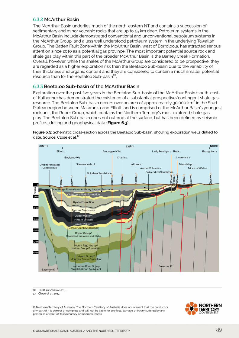
6.3.3 Beetaloo Sub-basin of the McArthur Basin exploration over the past five years in the Beetaloo Sub-basin of the McArthur Basin (south-east of Katherine) has demonstrated the existence of a substantial prospective/contingent shale gas resource. The Beetaloo Sub-basin occurs over an area of approximately 30,000 km2 in the Sturt Plateau region between Mataranka and elliott, and is comprised of the McArthur Basin’s youngest rock unit, the Roper Group, which contains the northern Territory’s most explored shale gas play. The Beetaloo Sub-basin does not outcrop at the surface, but has been defined by seismic profiles, drilling and geophysical data (Figure 6.3).
Figure 6.3: Schematic cross-section across the Beetaloo Sub-basin, showing exploration wells drilled to date. Source: Close et al.17
Katherine River GroupTawalah Group Equivalent
Basement?25km
Basement?
Vizard Group?McArthur Group Equivalent
Mount Rigg Group?Nathan Group Equivalent
Roper Group?Corcoran Formation and Older
Bessie Creek Sandstone
Moroak Sandstone
UndifferentiatedCretaceous
Kyalla Formation
Elliott 1
SOUTH
DE
PT
H
NORTH
Amungee NW1
335km
Broughton 1
Beetaloo W1 Chanin 1
Shenandoah 1A Altree 2 Friendship 1
Prince of Wales 1
Lady Penrhyn 1 Shea 1
Lawrence 1
Gum Ridge Formation + Anthony Lagoon Formation
Lower Velkerri
Middle Velkerri
Upper Velkerri
Chambers River Formation
6km
5km
4km
3km
2km
1km
0
Antrim Volcanics
Bukalara Sandstone Bukalorkmi Sandstone
16 DPIR submission 281.17 Close et al. 2017.
© Northern Territory of Australia. The Northern Territory of Australia does not warrant that the product or any part of it is correct or complete and will not be liable for any loss, damage or injury suffered by any person as a result of its inaccuracy or incompleteness.
SCIENTIFIC INQUIRY INTO HYDRAULIC FRACTURING IN THE NORTHERN TERRITORY - FINAL REPORT90
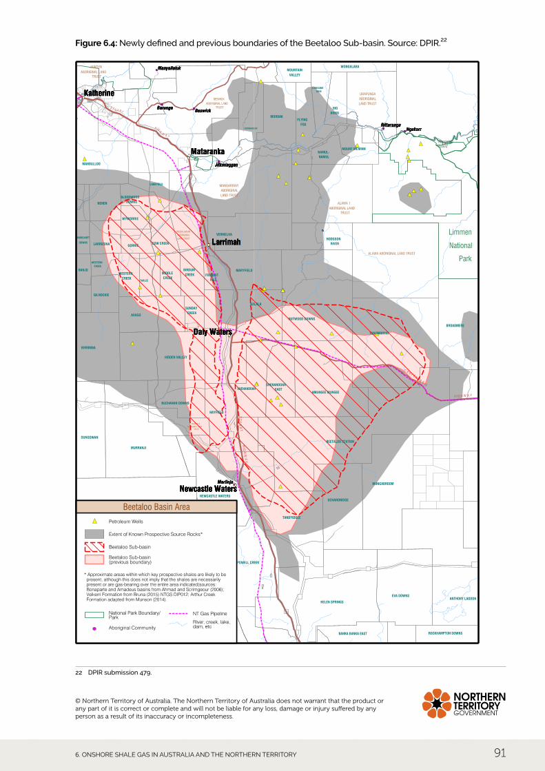
When the boundary of the Beetaloo Sub-basin was initially provided by dPIR to the Panel for use in the Interim Report, it was accompanied by a caveat that the boundary was poorly defined because it was a sub-surface transitional boundary that represents the approximate boundary where the sub-basin deepens and where it was likely to have high gas and oil potential. It noted that the Northern Territory Geological Survey may, in the future, further revise the boundary of the eastern part of the sub-basin as seismic data is incorporated into the 3d model.
Subsequent to the publication of the Interim Report, the boundaries of the Beetaloo Sub-basin were revised by dPIR based on assessment of additional data, with the margins of the Sub-basin being defined by the top of the Kyalla Formation at a depth of 400 m below the surface. This has had the effect of functionally splitting the Sub-basin into eastern and western domains separated by a faulted and uplifted zone (the daly Waters Fault Zone) between larrimah and elliott.18 Both the newly defined and previous boundaries of the Beetaloo Sub-basin are shown for comparison in Figure 6.4.
The Roper Group consists of a thick sequence of quartz sandstones, siltstones and mudstones, deposited in a variety of shallow-marine, nearshore to shelf environments.19 The Roper Group sediments are essentially continuous and flat-lying, and range from thicknesses of 1,500 m over most areas to greater than 3,000 m. The Roper Group includes the prospective shales of the gas saturated, quartz-rich Velkerri and Kyalla formations, which have a well-demonstrated and potentially productive shale gas resource.
A more detailed description of the geology of the Beetaloo Sub-basin is provided by Fulton and Knapton, Ghd, Scrimgeour, Close et al., and in the submissions from Origin20 and Santos.21
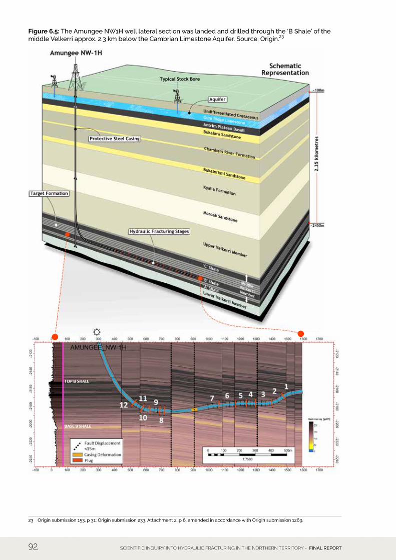
A geological cross section schematic showing the construction and orientation of Origin’s Amungee nW-1h well, its relationship to the Cambrian limestone Aquifer (ClA), and the location of the horizontal section in the Velkerri shale formation, is shown in Figure 6.5. This figure provides a primary reference point for subsequent discussion in Chapter 7 of the potential for sub-surface impacts on water quality. details about the construction, drilling and hydraulic fracturing of the Amungee well are contained in Section 5.4.5.
18 Department of Primary Industry and Resources, submission 479 (DPIR submission 479). 19 Munson 2016 and references therein; Scrimgeour 2016. 20 Origin submission 153, p 31; Origin submission 233, Attachment 2; Origin submission 1269.21 Santos submission 168.
6. OnShORe ShAle GAS In AuSTRAlIA And The nORTheRn TeRRITORy 91
Figure 6.4: Newly defined and previous boundaries of the Beetaloo Sub-basin. Source: DPIR.22
22 DPIR submission 479.
© Northern Territory of Australia. The Northern Territory of Australia does not warrant that the product or any part of it is correct or complete and will not be liable for any loss, damage or injury suffered by any person as a result of its inaccuracy or incompleteness.
SCIENTIFIC INQUIRY INTO HYDRAULIC FRACTURING IN THE NORTHERN TERRITORY - FINAL REPORT92
Figure 6.5: The Amungee NW1H well lateral section was landed and drilled through the ‘B Shale’ of the middle Velkerri approx. 2.3 km below the Cambrian Limestone Aquifer. Source: Origin.23
23 Origin submission 153, p 31; Origin submission 233, Attachment 2, p 6, amended in accordance with Origin submission 1269.
6. OnShORe ShAle GAS In AuSTRAlIA And The nORTheRn TeRRITORy 93
6.3.4 Bonaparte Basin The Bonaparte Basin is a large, predominantly offshore, sedimentary basin, extending from onshore coastal areas along the northern Territory/WA border northward into the Timor Sea. The offshore portion of the Basin is a well-established oil and gas province, with proven resources and a number of currently producing fields (for example, the Blacktip gas field). The onshore basin in the northern Territory contains the Weaber gas field. Oil and gas shows have also been recorded from a number of onshore wells, and multiple conventional petroleum systems have been defined in onshore areas. There is also considered to be significant unconventional petroleum potential, including tight gas plays in sandstone and limestone reservoirs. However, there has been no on-ground exploration since 2014.
6.3.5 Georgina Basin The Georgina Basin is comprised of the sedimentary Kiana Group, basalts of the Kalkarindji Province and the marine sedimentary succession of the Barkly Group. The latter includes a thick limestone sequence that forms the ClA, a regionally significant water supply aquifer. The Georgina Basin is capped by Cretaceous mudstone and sandstone and recent alluvial and laterite deposits. The southern part of the Georgina Basin is considered to be among the most prospective onshore areas in the NT for oil and gas potential and to have world-class shale source rocks, but the Basin is under explored. estimates of potential resources are considered to be poorly constrained, and after unsuccessful well testing in 2014, there have been no active explorations. There is, however, still considered to be potential for both conventional and unconventional discoveries.
6.3.6 Pedirka Basin The Pedirka Basin occurs in the south-eastern corner of the Northern Territory in the Simpson desert and also extends over areas of adjoining Queensland and SA. This largely subsurface basin overlies the Amadeus and Warburton basins, and is overlain by the eromanga Basin. It contains a diverse succession of fluvioglacial, fluvial, lacustrine and coal swamp, and continental red bed deposits up to 1.5 km thick. It has an area of about 100,000 km2, and much of the basin reaches depths of greater than 400 m. Maximum depths are in excess of 3,000 m at its deepest points in the east. No commercial petroleum has been discovered in the Pedirka Basin, and only non-commercial conventional hydrocarbon accumulations have been found to date in basal sandstones of the overlying eromanga Basin.
6.3.7 Other basins with possible shale gas potential Other basins in the Northern Territory have possible shale gas potential but limited geological information.
The level of geological knowledge in the Wiso Basin is low, as the basin is poorly exposed and there have been no petroleum or deep stratigraphic wells drilled anywhere in it. As a result, the Wiso Basin is effectively unexplored for petroleum, although minor hydrocarbon shows have been noted in two of several drill holes. The most prospective area is considered to be the main depocentre of the basin, the lander Trough in the south of the Basin, with a modelled depth of 2,000–3,000 m down to a maximum of 4,500 m.
There is also limited geological information about the South nicholson Basin and lawn hill Platform in the east of the NT. These contain interpreted stratigraphic correlatives of the McArthur Basin, and are considered to have potential for both conventional and unconventional hydrocarbons. Their correlations with basins with known petroleum systems, plus the lack of exploration to date, suggests that these basins could be important frontier exploration targets in the future.
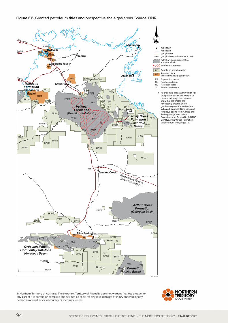
6.4 Likely areas of shale gas development in the NT Figure 6.6 shows the current extent of granted petroleum titles in the NT as well as areas with shale gas potential, indicating that there is current exploration attention focussed on all of the shale gas-bearing basins, with the exception of the northern part of the Georgina Basin. In recent years, exploration has focussed predominantly on the Beetaloo Sub-basin, which has received around 50% of the total $505 million of exploration investment since 2010.
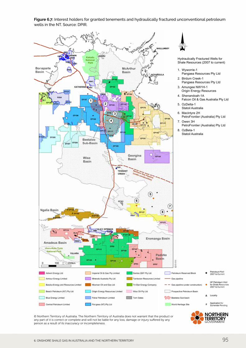
Figure 6.7 shows the interest holders for each of the granted petroleum exploration permits as well as the locations of hydraulically fractured unconventional wells. These have been focussed on the Beetaloo Sub-basin and the Georgina Basin. Not all have indicated the presence of shale gas reservoirs.
SCIENTIFIC INQUIRY INTO HYDRAULIC FRACTURING IN THE NORTHERN TERRITORY - FINAL REPORT94
Figure 6.6: Granted petroleum titles and prospective shale gas areas. Source: DPIR.
Ichthys
Blacktip
Bayu-Undan
Northern Gas Pipeline(under construction)
Borroloola
Tennant Creek
Nhulunbuy
Alyangula
Alice Springs
Katherine
Adelaide River
Jabiru
DARWIN
Yulara
RL1EP126
EP191
EP98EP168
EP198
EP117
EP189
OL3
EP164
OL4OL5 EP106
EP156
EP301
EP190
EP309
L6
EP105 EP107EP112
EP115
EP125
EP127
EP134
EP13
6EP143
EP144
EP145
EP153
EP154
EP161
EP162
EP165EP166
EP167
EP169
EP171EP174
EP176
EP184
EP187
EP192
EP200
EP205EP207
EP222
EP231
EP232EP234
EP237
EP305 EP76
EP82
EP93 EP97
L7
RL3RL4
Purni Formation(Pedirka Basin)
Arthur CreekFormation
(Georgina Basin)
VelkerriFormation
(Beetaloo Sub-basin)
MilligansFormation(Bonaparte
Basin)
Ordovician incl.Horn Valley Siltstone
(Amadeus Basin)
Barney CreekFormation(McArthur
Basin)
RB51
RB53
RB67
RB55
RB54RB56
RB60
RB66
RB68
RB5
RB2RB2
RB69
RB6
RB57
RB4
Approximate areas within which key prospective shales are likely to be present, although this does not imply that the shales are necessarily present or are gas-bearing over the entire area indicated (sources: Bonaparte and Amadeus basins from Ahmad and Scrimgeour (2006); Velkerri Formation from Bruna (2015) NTGS DIP012; Arthur Creek Formation adapted from Munson (2014).
RB
EP
Exploration permit
main town
A17-514.ai
Petroleum permit granted
extent of known prospectivesource rocks #Beetaloo Sub-basin
gas pipeline (under construction)gas pipelinemain road
EPOLRLL Production licence
Retention leaseProduction lease
Reserve block(where no activity can occur)
#
200 km0
© Northern Territory of Australia. The Northern Territory of Australia does not warrant that the product or any part of it is correct or complete and will not be liable for any loss, damage or injury suffered by any person as a result of its inaccuracy or incompleteness.
6. OnShORe ShAle GAS In AuSTRAlIA And The nORTheRn TeRRITORy 95
Figure 6.7: Interest holders for granted tenements and hydraulically fractured unconventional petroleum wells in the NT. Source: DPIR.
Hydraulically Fractured Wells for Shale Resources (2007 to current)
1. Wyworrie-1 Pangaea Resources Pty Ltd
2. Birdum Creek-1 Pangaea Resources Pty Ltd
3. Amungee NW1H-1 Origin Energy Resources
4. Shenandoah-1A Falcon Oil & Gas Australia Pty Ltd
5. OzDelta-1 Statoil Australia
6. Macintyre 2H PetroFrontier (Australia) Pty Ltd
7. Owen 3H PetroFrontier (Australia) Pty Ltd
8. OzBeta-1 Statoil Australia
© Northern Territory of Australia. The Northern Territory of Australia does not warrant that the product or any part of it is correct or complete and will not be liable for any loss, damage or injury suffered by any person as a result of its inaccuracy or incompleteness.
SCIENTIFIC INQUIRY INTO HYDRAULIC FRACTURING IN THE NORTHERN TERRITORY - FINAL REPORT96
In response to specific information requested by the Inquiry regarding the likelihood and timeframe for development of each basin, Geoscience Australia has noted that the Amadeus Basin is the only onshore basin in the nT with identified reserves and existing petroleum production infrastructure. Any new petroleum discovery made in this basin has the potential to take advantage of pre-existing infrastructure to provide a quick path to commercialisation. As seen with discoveries in areas such as the Cooper Basin, any new gas discoveries could technically be brought on stream within 12 months (not taking into account any regulatory matters to be resolved).
The potential of the Beetaloo Sub-basin has been highlighted by Origin declaring a contingent resource, signifying that the resource is not currently commercial and that more assessment of the resource is required prior to it being made a reserve, or that some other barriers to commercialisation need to be overcome. Given the current moratorium on hydraulic fracturing, this is enough of a barrier to commercialisation to prevent the resource being declared a reserve, let alone other potential factors. If the moratorium on hydraulic fracturing was removed, the resource would still require additional work prior to being reclassified as a reserve. This work would include additional drilling and reservoir modelling to understand the extent and nature of the resource, and would require at least another 12 months’ work, possibly more. The decision to move to production in a region without pre-existing infrastructure is a well-understood assessment process involving significant investment decisions and regulatory compliance hurdles. It is therefore unlikely that there will be any shale gas production in the Beetaloo Sub-basin in fewer than three years.
Petroleum was first noted in the Georgina Basin in 1910 when petroliferous odours were recorded during the drilling of water bores. More than 70 wells (petroleum and stratigraphic) have been drilled in the Basin, but no resources have been identified. There remains a great deal of uncertainty about the ability of the rocks within the basin to generate and host significant volumes of hydrocarbons. In this respect, the Georgina Basin lags behind the Beetaloo Sub-basin, so any discovery made today would almost certainly be more than three years from commercialisation and potentially more than a decade.
All other basins in the NT would be in a similar situation to the Georgina Basin.
Noting the long lead time from exploration to development of shale gas resources, this suggests that the most likely area for shale gas development in the foreseeable future (5-10 years) would be the Beetaloo Sub-basin.
6. OnShORe ShAle GAS In AuSTRAlIA And The nORTheRn TeRRITORy 97
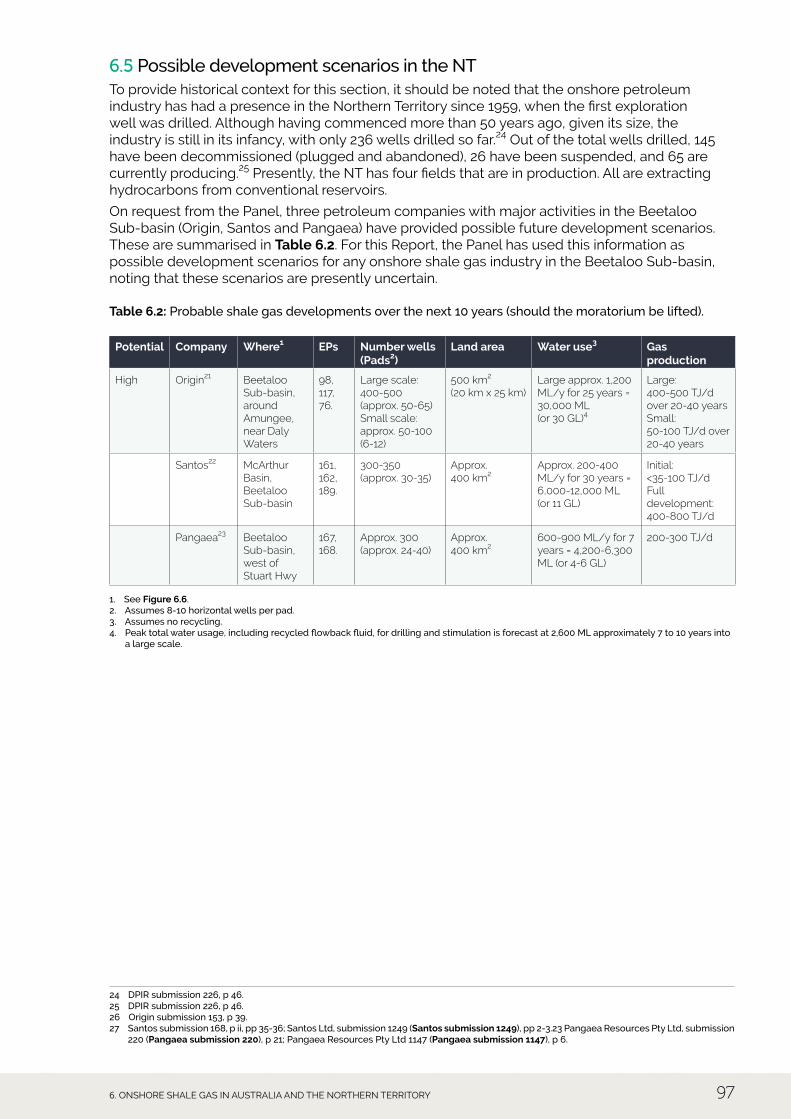
6.5 Possible development scenarios in the NT To provide historical context for this section, it should be noted that the onshore petroleum industry has had a presence in the northern Territory since 1959, when the first exploration well was drilled. Although having commenced more than 50 years ago, given its size, the industry is still in its infancy, with only 236 wells drilled so far.24 Out of the total wells drilled, 145 have been decommissioned (plugged and abandoned), 26 have been suspended, and 65 are currently producing.25 Presently, the nT has four fields that are in production. All are extracting hydrocarbons from conventional reservoirs.
On request from the Panel, three petroleum companies with major activities in the Beetaloo Sub-basin (Origin, Santos and Pangaea) have provided possible future development scenarios. These are summarised in Table 6.2. For this Report, the Panel has used this information as possible development scenarios for any onshore shale gas industry in the Beetaloo Sub-basin, noting that these scenarios are presently uncertain.
Table 6.2: Probable shale gas developments over the next 10 years (should the moratorium be lifted).
Potential Company Where1 EPs Number wells (Pads2)
Land area Water use3 Gas production
High Origin21 Beetaloo Sub-basin, around Amungee, near Daly Waters
98, 117, 76.
Large scale: 400-500 (approx. 50-65)Small scale: approx. 50-100 (6-12)
500 km2 (20 km x 25 km)
Large approx. 1,200 ML/y for 25 years = 30,000 ML (or 30 GL)4
Large: 400-500 TJ/d over 20-40 yearsSmall: 50-100 TJ/d over 20-40 years
Santos22 McArthur Basin, Beetaloo Sub-basin
161, 162, 189.
300-350 (approx. 30-35)
Approx. 400 km2
Approx. 200-400 ML/y for 30 years = 6,000-12,000 ML (or 11 GL)
Initial: <35-100 TJ/dFull development: 400-800 TJ/d
Pangaea23 Beetaloo Sub-basin, west of Stuart Hwy
167, 168.
Approx. 300 (approx. 24-40)
Approx. 400 km2
600-900 ML/y for 7 years = 4,200-6,300 ML (or 4-6 GL)
200-300 TJ/d
1. See Figure 6.6. 2. Assumes 8-10 horizontal wells per pad. 3. Assumes no recycling. 4. Peak total water usage, including recycled flowback fluid, for drilling and stimulation is forecast at 2,600 ML approximately 7 to 10 years into
a large scale.
24 DPIR submission 226, p 46.25 DPIR submission 226, p 46.26 Origin submission 153, p 39. 27 Santos submission 168, p ii, pp 35-36; Santos Ltd, submission 1249 (Santos submission 1249), pp 2-3.23 Pangaea Resources Pty Ltd, submission
220 (Pangaea submission 220), p 21; Pangaea Resources Pty Ltd 1147 (Pangaea submission 1147), p 6.
SCIENTIFIC INQUIRY INTO HYDRAULIC FRACTURING IN THE NORTHERN TERRITORY - FINAL REPORT98
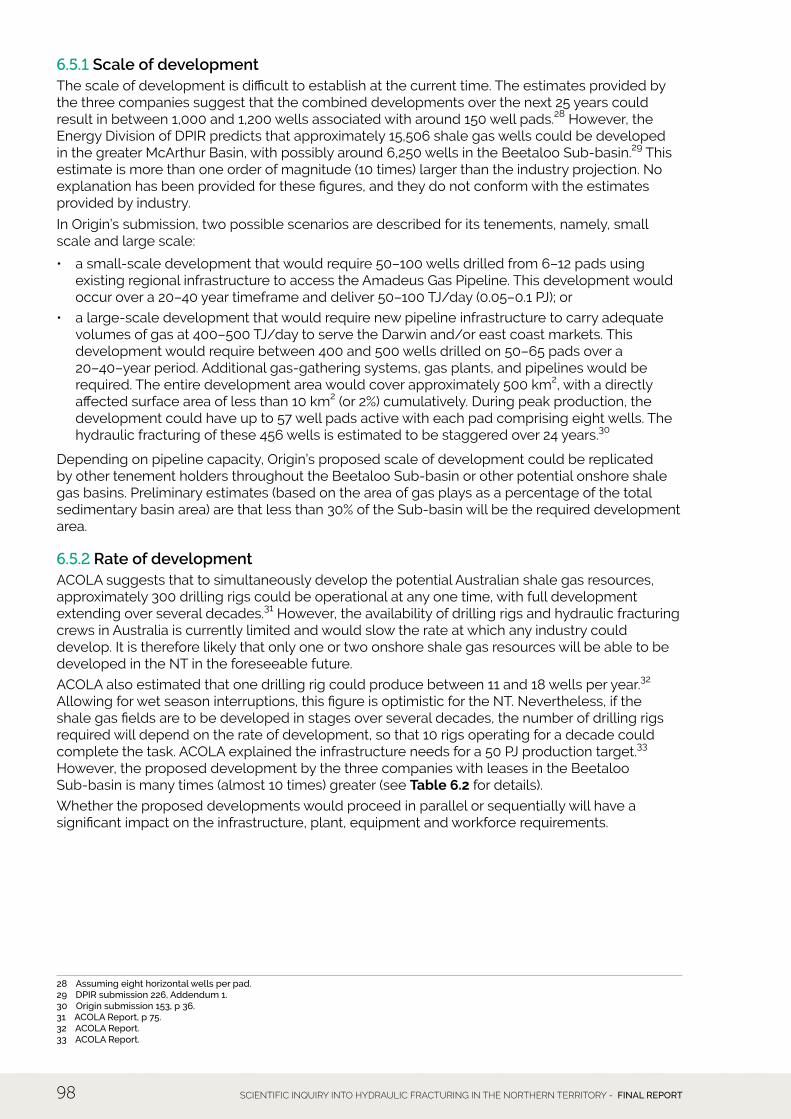
6.5.1 Scale of development The scale of development is difficult to establish at the current time. The estimates provided by the three companies suggest that the combined developments over the next 25 years could result in between 1,000 and 1,200 wells associated with around 150 well pads.28 However, the energy division of dPIR predicts that approximately 15,506 shale gas wells could be developed in the greater McArthur Basin, with possibly around 6,250 wells in the Beetaloo Sub-basin.29 This estimate is more than one order of magnitude (10 times) larger than the industry projection. no explanation has been provided for these figures, and they do not conform with the estimates provided by industry.
In Origin’s submission, two possible scenarios are described for its tenements, namely, small scale and large scale:
• a small-scale development that would require 50–100 wells drilled from 6–12 pads using existing regional infrastructure to access the Amadeus Gas Pipeline. This development would occur over a 20–40 year timeframe and deliver 50–100 TJ/day (0.05–0.1 PJ); or
• a large-scale development that would require new pipeline infrastructure to carry adequate volumes of gas at 400–500 TJ/day to serve the darwin and/or east coast markets. This development would require between 400 and 500 wells drilled on 50–65 pads over a 20–40–year period. Additional gas-gathering systems, gas plants, and pipelines would be required. The entire development area would cover approximately 500 km2, with a directly affected surface area of less than 10 km2 (or 2%) cumulatively. during peak production, the development could have up to 57 well pads active with each pad comprising eight wells. The hydraulic fracturing of these 456 wells is estimated to be staggered over 24 years.30
depending on pipeline capacity, Origin’s proposed scale of development could be replicated by other tenement holders throughout the Beetaloo Sub-basin or other potential onshore shale gas basins. Preliminary estimates (based on the area of gas plays as a percentage of the total sedimentary basin area) are that less than 30% of the Sub-basin will be the required development area.
6.5.2 Rate of development ACOlA suggests that to simultaneously develop the potential Australian shale gas resources, approximately 300 drilling rigs could be operational at any one time, with full development extending over several decades.31 However, the availability of drilling rigs and hydraulic fracturing crews in Australia is currently limited and would slow the rate at which any industry could develop. It is therefore likely that only one or two onshore shale gas resources will be able to be developed in the NT in the foreseeable future.
ACOlA also estimated that one drilling rig could produce between 11 and 18 wells per year.32 Allowing for wet season interruptions, this figure is optimistic for the nT. nevertheless, if the shale gas fields are to be developed in stages over several decades, the number of drilling rigs required will depend on the rate of development, so that 10 rigs operating for a decade could complete the task. ACOlA explained the infrastructure needs for a 50 PJ production target.33 However, the proposed development by the three companies with leases in the Beetaloo Sub-basin is many times (almost 10 times) greater (see Table 6.2 for details).
Whether the proposed developments would proceed in parallel or sequentially will have a significant impact on the infrastructure, plant, equipment and workforce requirements.
28 Assuming eight horizontal wells per pad.29 DPIR submission 226, Addendum 1.30 Origin submission 153, p 36.31 ACOLA Report, p 75.32 ACOLA Report.33 ACOLA Report.
6. OnShORe ShAle GAS In AuSTRAlIA And The nORTheRn TeRRITORy 99
6.5.3 Infrastructure needs establishment of a full-scale shale gas industry in the nT will require the drilling of thousands of wells, the construction of thousands of kilometres of roads and access tracks, the clearing of vegetation from well pads, accommodation facilities, production facilities, and pipelines for transporting the gas (see Chapter 8). This level of construction will have flow-on impacts to regional populations, towns and darwin itself (see Chapter 12). There will be demands for heavy vehicles, plant and equipment, drilling rigs, hydraulic fracturing units and temporary accommodation, as is the case with any major construction.
Information provided to the Panel regarding the infrastructure needs of the possible development scenario in the Beetaloo Sub-basin suggests that 200 drilling pads and more than 1,000 wells could be required. Access to the well sites would require several hundred roads in the first instance, and the installation of connecting pipelines to treatment/production facilities.
There would also be a significant surface infrastructure requirement to develop the potential shale gas resources both in the initial drilling and hydraulic fracturing stages, and in the development of gas pipelines feeding the gas to processing plants and then feeding the cleaned natural gas to the gas distribution pipeline network for ultimate consumption. Gas pipeline infrastructure in the NT is currently inadequate to handle the potential magnitude of new discoveries in the McArthur Basin, of which the Beetaloo Sub-basin is a part. Accordingly, trucking, or possibly rail, may be the most practicable initial options to transport the gas.34
The actual infrastructure requirements (in particular, the numbers and ultimate density of well pads through time) will require careful scrutiny in the event the moratorium is lifted and a commercial supply of gas is developed. experience in the uS has shown that production from individual wells, and ultimately from a whole field, declines over time, requiring additional wells to be commissioned, or re-fracturing of existing ones, to meet demand. For example, the disparity between the forward estimates reported for the uS shale gas plays used in projecting future production of shale gas plays and the real situation is analysed the uS energy Information Administration Drilling Deeper Report.35 These production declines can have significant (initially unexpected) implications for the future spatial extent of a gasfield development as well as for increasing the original density of wells to maintain production within an initially defined footprint area. There is currently insufficient information available for any of the onshore shale gas basins in the NT to inform this long-term planning issue.
34 ACOLA Report, p 80.35 Hughes 2016.

SCIENTIFIC INQUIRY INTO HYDRAULIC FRACTURING IN THE NORTHERN TERRITORY - FINAL REPORT100
6.5.4 ConclusionFrom the above discussion, it is apparent that there still remains considerable uncertainty about the likely scale and rate of development of any onshore shale gas industry in the NT. Having said this, the most likely region for development in the foreseeable future is the Beetaloo Sub-basin of the McArthur Basin.
However, the scale and rate of any such development depends on external economic considerations (including international gas and other commodity prices. See Chapter 13), practical constraints to the rate of development and the production success of drilling (which can only be inferred from the limited number of exploration wells in existence). These factors suggest that (leaving aside, for present purposes, any regulatory amendments (see Chapter 14), even if the moratorium on hydraulic fracturing were lifted by the Government immediately, full scale development in the Beetaloo Sub-basin would take at least 5–10 years to achieve.