Embed Size (px)
Citation preview
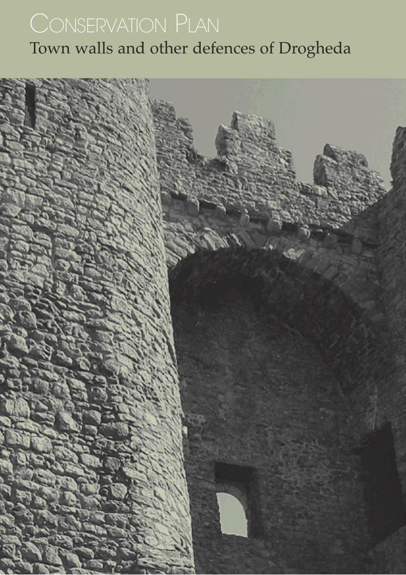
CONSERVATION PLANTown walls and other defences of Drogheda


The Integrated Conservation Group and John Cronin & Associates, Planning Consultants
MANAGING EDITORMargaret Gowen COMPILED BYKeay Burridge
CONTRIBUTING AUTHORSMargaret Gowen, Margaret Gowen & Co. LtdKeay Burridge, Margaret Gowen & Co. LtdLisa Edden, Consulting Structural EngineerÚna Ní Mhearáin, Consarc Conservation ArchitectsSharon Greene, Carrig Conservation InternationalPaddy Mathews, John Cronin & AssociatesJohn Bradley, NUI Maynooth
FORDrogheda Borough Council and The Heritage Council
Adopted by the elected members of Drogheda Borough Council on 2 October 2006
This Conservation Plan was developed under the action plan of the Irish Walled Town’s Network, an initiative ot The Heritage Council
DESIGNChristopher Jennings at Design Joint, Drogheda www.designjoint.com
PRINTINGNorth East Printers, Drogheda
Plate 3: Detail View of Drogheda from Millmount, by Gabriele Ricciardelli c.1753(after Bradley 1997)
CONSERVATION PLANTown walls and other defencesof Drogheda


Contents1. Introduction 1.1 Background and Summary1.2 Conservation Plan Methodology1.3 Objectives
2. Understanding the Site2.1 The history and archaeology of Drogheda’s 2.2 Town Walls and Defences2.3 Survival and Presentation2.4 Structural Composition2.5 Material Condition
3. CULTURAL SIGNIFICANCE
AND VULNERABILITY3.1 Introduction3.2 The Vulnerability of the Cultural 3.3 Significance of the Town Walls3.4 Summary
4. ISSUES AFFECTING DROGHEDA’S TOWN WALLS4.1 Lack of ‘Vision’ 4.2 Conservation and Management4.3 Development Control4.4 Legal Status, Ownership and Duty of Care4.5 Streetscape Presentation/Architectural Presentation of Standing Remains4.6 The Material Condition of Standing and Accessible Below Ground Remains
5. OPPORTUNITIES5.1 Suggested Opportunities for Improved Presentation and Urban Integration: Streetscape/Public Presentation / Development and Improved Cohesion5.2 Use of Materials5.3 Marking the Wall Alignment in the pavement5.4 Marking the Gateways into medieval Drogheda5.5 Creating an Identity/Brand5.6 Site Specific Information
6. POLICIES6.1 Policy Aims6.2 Policies • Protection and retention of the historical integrity of the Medieval Town Wall • Conservation, Maintenance and Repair of the standing and exhibited below ground structural remains • Information, Recording and Research • Legibility, Access and Presentation • Implementation, Management and Review6.3 Specific Suggestions for Consideration and Action
7. GAZETTEER OF SPECIFIC OBSERVATIONS AND OPPORTUNITIES IDENTIFIED FOR THE ENHANCEMENT, DEVELOPMENT AND MANAGEMENT OF 32 INDIVIDUAL
LOCATIONS ALONG THE CIRCUIT OF THE WALLS BIBLIOGRAPHY
APPENDIX 1: Specific Recommendations in relation to Care, Maintenance and Conservation of the Fabric of the Standing Walls Above and Below Ground
APPENDIX 2: Specific recommendations in relation to care, maintenance and Conservation of the fabric of the town walls remaining at ground level.
APPENDIX 3: Planning Report
APPENDIX 4: Protected Structures listed in the Drogheda Borough Council Development Plan 2005-2011: All Structures Relating to the Town Walls and Defences
5
C O N S E R V A T I O N P L A N : T O W N W A L L S A N D O T H E R D E F E N C E S O F D R O G H E D A

6
C O N S E R V A T I O N P L A N : T O W N W A L L S A N D O T H E R D E F E N C E S O F D R O G H E D A
Illustrations
FIGURES
Figure 1 Location of Drogheda-in-Louth town walls & defencesFigure 2 Location of Drogheda-in-Meath town walls & defencesFigure 3 Barnaby Goche, 1574Figure 4 Robert Newcomen, 1657Figure 5 Down Survey, 1657Figure 6 Joseph Ravell, 1749Figure 7 Wren, 1766Figure 8 Taylor & Skinner, 1778Figure 9 First edition Ordnance Survey map, 1835 (Scale 1:10,560)Figure 10 Impression of a potential street treat- ment between West Gate and Fair GateFigure 11 Potential treatment to mark the line of the wall along King Street and Palace StreetFigure 12 Possible improvements to link St Laurence’s Gate to the town wallFigure 13 Impression of potential hard landscap ing improvements to Featherbed LaneFigure 14 Possible improvements to landscaping of Curry’s HillFigure 15 Possible improvements to landscaping of the MolliesFigure 16 Zoning map for Drogheda Borough with town walls circuit indicated (Bradley 1995)
PLATESPlate 1 Drogheda c.1718, by Van der Hagen (after Bradley 1997)Plate 2 View of Drogheda from Ball’s Grove, by Gabriele Ricciardelli c.1753 (after Bradley 1997)Plate 3 View of Drogheda from Millmount, by Gabriele Ricciardelli c.1753 (after Bradley 1997)Plate 4 Bridge of Peace and town wall at Murdock’s Yard car parkPlate 5 Graffiti, brick and concrete blockwork at Murdock’s Yard car parkPlate 6 Remains of wall-walk and arch at Murdock’s Yard car park
Plate 7 Line of wall-walk at Murdock’s Yard car park. Note also timber inclusions and cement eaves of former lean-to buildingsPlate 8 Line of town wall looking north, from West Gate to Fair GatePlate 9 Town wall profile in façade, 39 Fair StreetPlate 10 Wall in rear garden, 39 Fair StreetPlate 11 Collapsed wall or tower fragment in rear garden, 100 George’s StreetPlate 12 Rear boundary wall, 98 George’s Street. Note the curve in the town wall, reduced ground level and new devel opment close to town wallPlate 13 Aerial photo of Fair Street c. 1940’s. The town wall can be seen in the boundary walls of Fair Street and George’s Street. Note also the ground level of the green space at Patrick Street (left) (after Department of Defence, Air Corps HQ Baldonnel, Co. Dublin)Plate 14 Line of town wall to Patrick Street. Site of Bolton’s GatePlate 15 Line of town wall along Patrick Street, looking eastPlate 16 Site of Sunday’s GatePlate 17 Sketch of Sunday’s Gate, c. 1698 by Francis Place (after Bradley 1997)Plate 18 Line of town wall in front gardens of cottages on Magdalene Street, looking eastPlate 19 Line of town wall on east side of King Street and Palace StreetPlate 20 Unusual stone work on King Street. Base of plinth is possible line of town wallPlate 21 Possible town wall remains at King Street site for redevelopmentPlate 22 St Laurence’s Gate, c. 1900 (after Louth County Archives Service)Plate 23 St Laurence’s Gate, looking eastPlate 24 Vegetation on the outer face of the town wall, Featherbed LanePlate 25 Featherbed Lane, with St Laurence’s Gate in the backgroundPlate 26 Inappropriate repairs at doorway and corroding metal lintel Featherbed Lane

7
C O N S E R V A T I O N P L A N : T O W N W A L L S A N D O T H E R D E F E N C E S O F D R O G H E D A
Plate 27 Algae at Featherbed LanePlate 28 East face of Featherbed Lane. Vegetation grows at the top of the bat ter and in line with ground level on the western side of the wall.Plate 29 Steps from Featherbed Lane to Blind GatePlate 30 Site of Blind GatePlate 31 North quays board walk should conti- nue along the riverPlate 32 South quay walls at Scotch HallPlate 33 Paving to mark tower location at Scotch HallPlate 34 Site of St James’s GatePlate 35 Curry’s Hill stepsPlate 36 Aerial photo of the Mollies c. 1940’s. Note where the town wall turns out from eastern wall of St Mary’sPlate 37 East wall of St Mary’s church is sup ported by gabion baskets at the Mollies, looking north. The concrete steps cross the line of the town wallPlate 38 Looking north, the line of town wall follows edge of scarp at the MolliesPlate 39 Exposed face of town wall in under growth at the MolliesPlate 40 Sulphurisation of mortar at the MolliesPlate 41 South wall at St Mary’s churchyardPlate 42 Mature trees near south wall of St Mary’s churchyardPlate 43 Open joints, deteriorated coping and vegetation at St Mary’s “blind” gate. Note gaps in stonework are Putlog holes used for scaffolding the wall when first builtPlate 44 St Mary’s “blind” gate, from Rockville Road. Note built up ground levelPlate 45 Possible location of Cromwell’s breach in the south wall at St Mary’s. Note the missing wall-walkPlate 46 Metal ties, vegetation and poor point- ing at St Mary’sPlate 47 Cementicious pointing “buttered” on to stones at St Mary’sPlate 48 Outer wall of St Mary’s in the rear gar den of St Patrick’s Cottages. Possible tower site (far right)
Plate 49 Outer wall of St Mary’s in the rear gar den of St Patrick’s Cottages. This sec tion of the wall contains numerous his toric inclusionsPlate 50 Detail of historic metal fixings in south wall at St Mary’s. Note also original lime mortarPlate 51 Ground level remains of wall, 25 Duleek Street, looking eastPlate 52 Town wall under ivy between 24 and 25 Duleek Street, looking west. Note the alignment of the chimneysPlate 53 Arch in lean-to shed at 25 Duleek StreetPlate 54 Example of red lichen, 24 Duleek StreetPlate 55 Sarah Gibney’s Lane. Note the lime stone boundary wall (right)Plate 56 Possible town wall or tower fragment in right corner of property boundary at Sarah Gibney’s LanePlate 57 Fragment of town wall secured in cement at the corner of Sarah Gibney’s Lane and Mount St OliverPlate 58 Town wall at MillmountPlate 59 “Blind” gate from outside Millmount complexPlate 60 Town wall extending from Millmount complexPlate 61 Construction join west of MillmountPlate 62 Unravelling end of town wall, west of MillmountPlate 63 Construction join west of Millmount. Note the two different mortars usedPlate 64 Aerial photo of Drogheda, Butter Gate c. 1940sPlate 65 Butter Gate c. 1900 (Photo from Laurence Collection)Plate 66 Butter Gate, looking westPlate 67 Join of town wall to Butter Gate on south facePlate 68 Metal inclusions, inappropriate repoint- ing and vegetation at Butter GatePlate 69 Possible fragment of town wall below Butter GatePlate 70 Site of St John’s GatePlate 71 Laurence’s Gate, 2006 looking west from Cord Rd. (Photo courtesy of Christopher Jennings) Plate 72 Laurence’s Gate, looking east Etching from P.D. Hardy Newspaper No. 81. Vol. II. dated January 18, 1834 (Courtesy of Sean Collins)
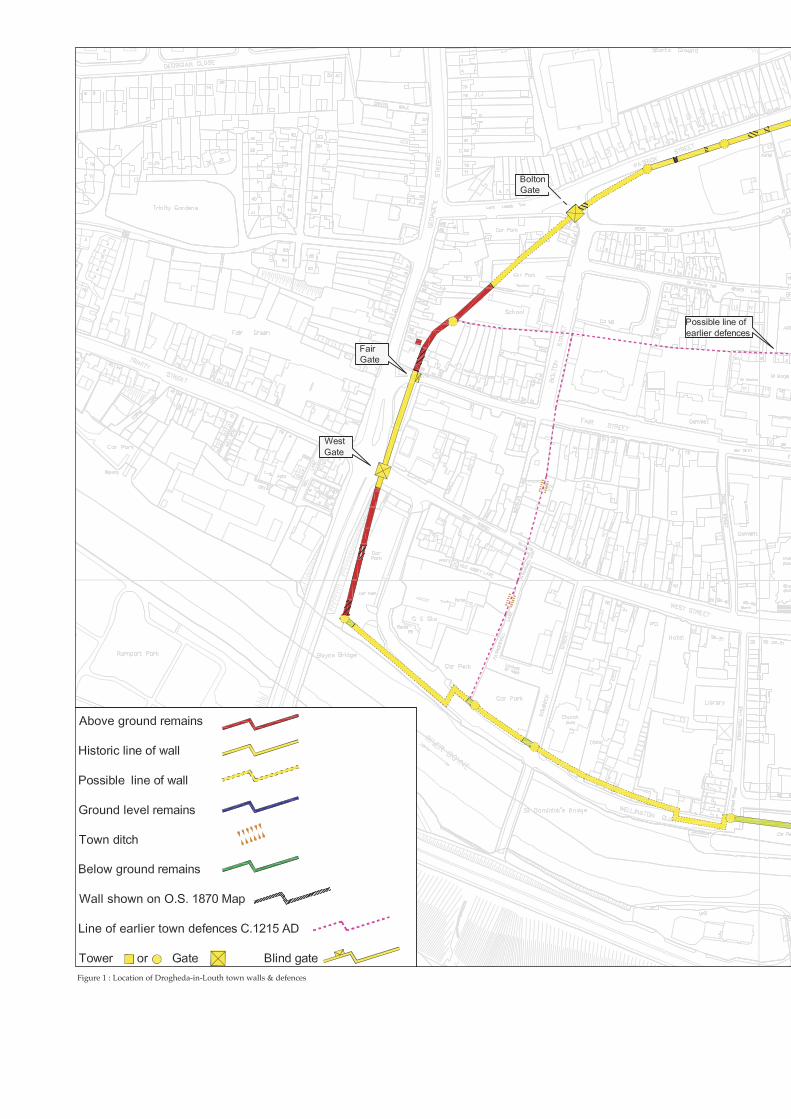
Figure 1 : Location of Drogheda-in-Louth town walls & defences


Figure 2: Location of Drogheda-in-Meath town walls & defences


C O N S E R V A T I O N P L A N : T O W N W A L L S A N D O T H E R D E F E N C E S O F D R O G H E D A
1. Introduction
1.1 BACKGROUND AND SUMMARY
In November 2005 Drogheda Borough Council in partnership with The Heritage Council com-missioned The Integrated Conservation Group and John Cronin & Associates to undertake a Conservation Plan for the Drogheda town walls and defences. The team was led by Margaret Gowen & Co. Ltd, archaeological consultants; with contributions from John Cronin & Associates, planning consultants; Lisa Edden, consult-ing structural engineer; Carrig Conservation International, stone and materials conservation specialists; Consarc Conservation, conservation architects; and John Bradley, NUI Maynooth. Additional historical research has been provided by Dr. Seán Duffy, Dept. of Medieval History, Trinity College Dublin.
The Plan was commissioned to:
• inform and support the identity of the medieval town and its walled circuit • suggest methods of presentation of the town walls that can assist in promoting and underpinning the significance of the town’s very considerable history and medieval identity as part of its now confident mix of commercial and civic activity. • address a range of concerns in respect of the preservation, conservation and presen- tation of both the above ground and below ground remains of the town’s most impor- tant, spatially-defining historic monument; • identify opportunities for enhancing the surviving elements of the circuit of the walls, together with the monuments and the unique urban grain within the walls, as a means of supporting the identity of the ‘old town’ precinct within the modern town;
The circuit of the walls on both sides of the River Boyne no longer survives intact above ground (Fig. 1). What does survive above ground is frag-mentary and in very poor condition generally, apart from St Laurence’s Gate. The circuit has lost its cohesion as a former enclosure and is no longer easy to ‘read’.
Successful civic presentation has been limited to St Laurence’s Gate and part of Featherbed Lane on the northern side of the river and to Millmount, which lies inside the walled circuit on the south side of the river.
Standing portions have been neglected, largely as a consequence of a lack of an objective in rela-tion to presentation, and perhaps also a failure on
13
Plate 71: Laurence’s Gate, 2006 looking west from Cord Rd.(Photo appears courtesy of Christopher Jennings)
Plate 25: Featherbed Lane, with St Laurence’s Gate in the background

C O N S E R V A T I O N P L A N : T O W N W A L L S A N D O T H E R D E F E N C E S O F D R O G H E D A
the part of the civic authorities to understand the significance and value of the wall alignment as a defining influence on the overall development of the town and a symbol of its rich and varied his-tory.
Some below-ground portions have had their alignments neglected and removed in areas of recent development, but these are not so great in number that the impact has removed all sense of the enclosure or of the sense of place within the ‘old town’.
Until recently, the plan form of the medieval town with its narrow streets and its dense mix of archi-tecture in rather narrow property plots and blocks were regarded primarily as constraints to the understandably urgent economic redevelopment objectives of the town and its associated traffic management requirements.
Where the medieval town walls survive below ground, alterations to street alignments, together with road widening and confident urban renewal has resulted in a loss of parts of the original plan form of the walled town circuit. With that loss has been a loss of the some of what was, until the 1970s, a quite robust identity of ‘old town’ within the modern town as represented by the medieval precincts on either side of the river. Nonetheless, the formerly enclosed ‘old town’ areas are topographically interesting, diverse and potentially immensely attractive. On both sides the town and its ‘sights’ are easily accessed on foot and the views from within the former walled areas on both sides of the river, are stunning. All this, coupled with the density of the street and property layouts within these areas still reflect the plan form on both sides to a considerable degree and can support an approach that seeks to enhance these areas.
1.2 CONSERVATION PLAN METHODOLOGY
The methodology of a Conservation Plan is sin-gularly well suited to the study of complex and composite monuments in dynamic and changing environments. The Conservation Plan involves a process that “seeks to guide the future develop-ment of a (monument or) place through an under-standing of its significance” (Kerr 1999: 9) and the objective of a Conservation Plan is to evolve and articulate ‘policies’ that are both feasible and com-
patible with both the conservation and develop-ment aspirations for a place.
It is a pro-active process that defines: • the location, physical composition and current presentation of a monument or place; • why that monument or place is culturally or materially significant; • how that significance may be vulnerable.
From that understanding, it devises:
• policies that advocate the appropriate • terms of reference for protection and man- agement of a monument or place now and in the future.
Fundamental to the process of assembling a Conservation Plan is understanding how to: • assess the source of the issues faced by a monument or place; • evaluate the potential impact of change and development on or close to a monu- ment or place; and • advise and manage that change in order to conserve by adding value.
The Plan methodology applied to Drogheda’s town walls and other defences will assist in:
• analysing the issues raised by the current disjointed and fractured presentation of the walled circuit; • identifying issues for development con- trol and for future development along the circuit; • identifying and analysing the areas of most vulnerability; • identifying a range of opportunities for improved public presentation, legibility, civic amenity and urban regeneration together with identifying the potential divi- dends for the town’s historic core; and pre- senting a range of simply articulated poli- cies to assist agencies and stakeholder groups in developing a beneficial planning, development control and management framework for the composite monument.
14

C O N S E R V A T I O N P L A N : T O W N W A L L S A N D O T H E R D E F E N C E S O F D R O G H E D A
A completed Conservation Plan is not an Action Plan. In the case of Drogheda’s town walls and defences it provides a basis for the formulation of strategies for the improved identity and public presentation of the monument and its setting in the long term.
It will also assist in the preparation of a strategic planning framework to develop greater defini-tion for the precinct of the ‘old town’ within the complex, multi-period fabric and plan form of the modern town.
The active involvement and advice of the Steering Group will be critical, and central, to the proc-ess of the Plan development. Also important are meetings and discussions with stakeholders, prop-erty owners and policy makers.
The Steering Group includes: Brendan McSherry, Heritage Officer, Louth Local Authorities Jill Chadwick, Conservation Officer, Louth Local Authorities Councillor Paul Bell, Drogheda Borough Council Colin McBride, Executive Planner, Drogheda Borough Council Ian Doyle, Archaeological Officer, The Heritage Council Auriel Robinson, Regional Archaeologist, National Monuments Section, Department of the Environment,
Heritage and Local Government Victor Buckley, Senior Archaeologist, National Monuments Section, Department of the Environment, Heritage and Local Government * Tom Reilly, Drogheda Monuments Preservation Committee Nick Reilly, Nick Reilly Project Management * Replacement for Auriel Robinson (on leave of absence)
1.3 OBJECTIVES
The Plan is prepared with a view to forming the focus of long-term, strategic planning for the his-toric core of the town; to protecting the coherence and plan form of the circuit of the town walls and defences on both sides of the river; and to mak-ing the circuit an essential part of the ‘old town’s’ identity.
The Plan:
• outlines the historical and cultural signifi- cance of the Drogheda town walls and defences, and identifies it as one of the most important civic monuments in the town; • suggests ways to promote the recognition of the position and circuit of the town walls and defences in the multi-period mix of the town’s fabric and identity; • accepts that, with much of the remains below ground, modern development will have a role to play in supporting the identity of the circuit and the identity of the historic core of the town; • sets out policies for the protection, conserva- tion, repair, and management of the fabric of the walls and defences; • sets out guiding principles for the protection and presentation of the setting of the standing portions of the wall; • suggests ways of improving access to exist- ing upstanding portions of the walls; • sets out guiding principles for future plan- ning strategies for particularly vulnerable ele- ments of the circuit where support for the retention of the alignment is advocated.
15
Figure 16: Zoning map for Drogheda Borough with town walls circuit indicated (Bradley 1995)


C O N S E R V A T I O N P L A N : T O W N W A L L S A N D O T H E R D E F E N C E S O F D R O G H E D A
Drogheda was one of the largest and most suc-cessful port towns in medieval Ireland. The latter half of the twelfth century to the early fourteenth century was a period of large-scale urban devel-opment throughout Europe, and Drogheda was one of many towns founded during this period (Bradley 1997).
There is little archaeological evidence for earlier settlement in the area, so Drogheda “began life as a town” (Reilly 1995: 3). “A-lmost all the towns built in Ireland between 1180 and 1300 were Norman creations” (Bradley 1997: 7). Drogheda’s defensive walls enclosed an area of 113 acres (45 hectares), which was larger than Limerick, Cork or Waterford, but similar in size to Dublin, Kilkenny and New Ross. Medieval Drogheda “was compa-rable in size with Bristol, Oxford and Chichester” in England (Bradley 1997: 11)
Drogheda’s trading connections, attested by
archaeological evidence, were predominantly with English ports but also extended much further to Flanders and Gascoigne, to France, northern Spain and Portugal with evidence of contact even as far afield as Iceland (Bradley 1997).
For a town of this size and with this scale of eco-nomic activity the enclosing town walls facilitated the collection of taxes through its entry gates, and their defences were to a great extent an expression of the town’s civic success and independence.The Irish name, Droichead Átha, which means “the bridge of the ford”, was the name given to the lowest bridging point of the River Boyne. The original fording site is located around two kilo-metres west of Drogheda, but the town was estab-lished further downstream to provide a transport route inland and between north and south, with a harbour to accommodate seaborne trade.
Drogheda was officially founded by Hugh de Lacy when the land of Meath was granted to him by Richard FitzGilbert de Clare (Strongbow). The exact date is not known but it was obviously prior to de Lacy’s death in 1186. The town was founded as two distinct boroughs on either side of the river. De Lacy seems to have been instrumental in
17
Figure 3: Barnaby Goche, 1574
Figure 4: Robert Newcomen, 1657
2. Understanding the Site2.1 THE HISTORY AND ARCHAEOLOGY OF DROGHEDA’S TOWN WALLS AND DEFENCES
2.1.1 INTRODUCTION

C O N S E R V A T I O N P L A N : T O W N W A L L S A N D O T H E R D E F E N C E S O F D R O G H E D A
setting up two parishes in the medieval town, each with its own church: St Peter’s on the north side of the river (diocese of Armagh) and St Mary’s on the south side (diocese of Meath) (Bradley 1984). These parishes were granted to the Augustinian canons of Llanthony Prima in Monmouthshire and Llanthony Secunda in Gloucestershire, respectively (Bradley 1997). The two parishes, formed so that the town could be settled on both sides of the river, ultimately gave rise to two towns, one in Meath and one in Louth (Uriel). Hugh De Lacy’s “connection with both churches is important because it shows him to be the founder of the town on both sides of the Boyne and not just on the south side, as had been previously thought” (Bradley 1997: 10). A bridge across the Boyne, with gates at either end, provided a physical link between the two towns (Thomas 1992). Each borough had its own char-ters “with independent privileges and corpora-tions”, until 1412, when the two boroughs merged to form one town (Bradley 1997:10; Thomas 1992).
Dalton believes the two boroughs were combined primarily because tolls were applied to Drogheda-in-Louth, but not Drogheda-in-Meath, in par-ticular a tax (pontage) towards the maintenance of the bridge was paid only on the North Quay. This meant that in the thirteenth and fourteenth centuries the principal market was located on the Meath side, near Millmount, where vessels obvi-ously preferred to anchor in order to avoid the pontage levied on the Louth side; Dalton adds: ‘the inhabitants of the former had, consequently, the monopoly of the merchandize imported’, and he claims that this was the principal reason for the decision made in 1412 to combine the two trans-pontine boroughs into one (Dalton 1844, i, 170; Duffy 1999).
In the thirteenth century the process of building
defensive walls around the town began. Murage grants issued to the corporation between 1234 and 1424 provided funding by which the two towns’ defences could be constructed. Details of the items taxed and the dates of each murage grant relating to the construction or repair of the town walls are described by Bradley (1984), Thomas (1992) and Reilly (1995). Combined with the doc-umentary evidence, the form and composition of the wall indicate that it was largely constructed in the 13th century. Two years after the first murage grant to fund construction of the wall Drogheda was “asked to attend to enclosing their towns which suggests that work may have temporarily been suspended” (Bradley 1984: 84). Evidence for multiple phases of town wall building can be seen in construction joins and the use of different mor-tars. A fine example of this is still visible today to the west of Millmount (Plate 61). Later murage grants indicate that additions and repairs were required in the 14th and 15th centuries (Bradley 1997).
2.1.2 THE SOURCES FOR THE TOWN WALL
Drogheda is fortunate to have a number of avail-able sources that describe or illustrate the town wall, although many of them post-date the construction of the town’s defences by several hundred years. The earliest of these is “The Plott of the Towne of Tredagh (Drogheda)” drawn by Barnaby Goche in 1574 (Fig. 3). Capt. Robert
18
Plate 61: Construction join west of Millmount
Figure 5: Down Survey, 1657

C O N S E R V A T I O N P L A N : T O W N W A L L S A N D O T H E R D E F E N C E S O F D R O G H E D A
19
Figure 6: Joseph Ravell, 1749

C O N S E R V A T I O N P L A N : T O W N W A L L S A N D O T H E R D E F E N C E S O F D R O G H E D A
20
Figure 9: First edition Ordnance Survey map, 1835 (Scale 1:10,560)

C O N S E R V A T I O N P L A N : T O W N W A L L S A N D O T H E R D E F E N C E S O F D R O G H E D A
Newcomen’s map of Drogheda from 1657 was commissioned as part of the Down Survey and illustrates in great detail the town’s walls, gates and towers (Fig. 4). A naïve sketch of Drogheda’s walled town also features on the Down Survey of 1657 in the Barony of Ferrard (Fig. 5). These maps were drawn up as an inventory of Irish landhold-ings for distribution to English gentry colonising Ireland after Cromwell’s invasion. In 1749 Joseph Ravell produced a map of Drogheda that depicts the circuit cartographically (Fig. 6). There are discrepancies between Goche, Newcomen and Ravell as to the number of towers and gates along the circuit, and the depiction of town wall along the quays. The wall is also depicted, to varying degrees of accuracy in Wren (1766, Fig. 7) and Taylor and Skinner (1778, Fig. 8). Since the first edition Ordnance Survey (O.S.) map (1835, Fig. 9) upstanding sections of the town wall diminished with each successive O.S. map, as the town devel-oped. The 1870 O.S. map (scale 1:500) includes previously upstanding sections of the wall which have been used to trace the wall alignment accu-rately in Figures 1 and 2.
Descriptions of the wall, its construction and repair can be found in a number of sources. The records of Drogheda Corporation contain the details of the numerous murage grants of Drogheda, land survey and property title docu-ments, all of which refer, in part, to the defences of the town (Gogarty 1915a). Cromwell’s let-ters regarding the siege of the town in 1649 also provide historians with information about Drogheda’s fortifications.
Illustrations and paintings of Drogheda provided valuable detail about the town wall and in partic-ular, the number, location, and form of the gates. The painting of Drogheda by Van der Hagen c. 1718 (after Bradley 1997) clearly shows walls and towers along the northern quay, although there was some debate between the cartographers over the existence of defensive quay walls. This paint-ing also illustrates what a prominent feature of the skyline the defensive towers of the wall circuit once were (Plate 1). Two paintings by Gabriele
21
Plate 1: Drogheda c.1718, by Van der Hagen (after Bradley 1997)
Figure 7: Wren, 1766
Figure 8: Taylor & Skinner, 1778

C O N S E R V A T I O N P L A N : T O W N W A L L S A N D O T H E R D E F E N C E S O F D R O G H E D A
Ricciardelli c. 1753 (Plates 2 and 3; after Bradley 1997) show Drogheda from different viewpoints. Several towers and gates are visible, and both paintings clearly highlight the form of the wall between Butter Gate and St John’s Gate. The quay walls are relatively low and vary between indi-vidual properties. The drawings of Francis Place c. 1698 have also assisted in establishing the loca-tion of the wall and defensive towers, and par-ticularly the details of their form, like his sketch of Sunday’s Gate, which shows the town ditch under the barbican of the gate (Plate 17).
2.1.3 THE EARLIEST EARTHEN DEFENCES
OF DROGHEDA
Evidence for the earliest town defences in Drogheda is fragmentary and based largely on documentary records and limited archaeologi-cal excavation along the circuit of the wall. The archaeological evidence that survives is generally of ditch fortifications, suggesting the very first town defences may have been deep ditches with internal earthen banks and wooden palisades (Bradley 1997).
During excavation of the priory of St Mary d’Urso an earthen bank fortification was found at the eastern end of the site towards Patrickswell Lane. Outside the bank is a large ditch approximately 6-7m wide orientated north-south. Patrickswell
Lane appears to follow the alignment of the town ditch (Halpin 1990). Borehole testing 80m north of this site produced similar deposits to those found in the ditch at Patrickswell Lane (Campbell 1995). In 1997 “excavations at The Mall were carried out in the area of the medieval Franciscan Friary. A very substantial wall, demolished during the thir-teenth century, was discovered. It may represent an earlier line of the town defences as it is on the same line as the early defences at Curry’s Hill on the south side of the river” (Garry 1998: 211).
South of the River Boyne the town wall does not appear to have changed much from its original alignment. The two streams running into the river from the south have cut into the bedrock over time, providing natural defences that were augmented by man-made fortifications. A sub-stantial “rock-cut ditch, 7m wide and 2.5m deep, with a revetting wall around the top edge” was found close to the Curry’s Hill walkway during a 1981 archaeological excavation, suggesting that the original town fosse ran from the top of the hill straight down to the River Boyne (Campbell; 1987; 55).
2.1.4 THE EXTENSION OF THE TOWN WALL C. 1215
The early thirteenth century saw massive reforti-fication works on the northern side of the River
22
Plate 2: View of Drogheda from Ball’s Grove, by Gabriele Ricciardelli c.1753 (after Bradley 1997)
C O N S E R V A T I O N P L A N : T O W N W A L L S A N D O T H E R D E F E N C E S O F D R O G H E D A
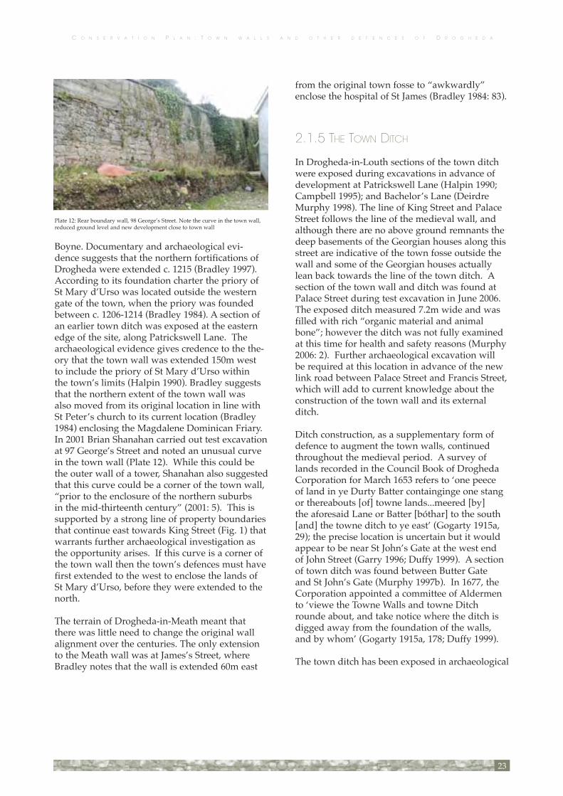
Boyne. Documentary and archaeological evi-dence suggests that the northern fortifications of Drogheda were extended c. 1215 (Bradley 1997). According to its foundation charter the priory of St Mary d’Urso was located outside the western gate of the town, when the priory was founded between c. 1206-1214 (Bradley 1984). A section of an earlier town ditch was exposed at the eastern edge of the site, along Patrickswell Lane. The archaeological evidence gives credence to the the-ory that the town wall was extended 150m west to include the priory of St Mary d’Urso within the town’s limits (Halpin 1990). Bradley suggests that the northern extent of the town wall was also moved from its original location in line with St Peter’s church to its current location (Bradley 1984) enclosing the Magdalene Dominican Friary. In 2001 Brian Shanahan carried out test excavation at 97 George’s Street and noted an unusual curve in the town wall (Plate 12). While this could be the outer wall of a tower, Shanahan also suggested that this curve could be a corner of the town wall, “prior to the enclosure of the northern suburbs in the mid-thirteenth century” (2001: 5). This is supported by a strong line of property boundaries that continue east towards King Street (Fig. 1) that warrants further archaeological investigation as the opportunity arises. If this curve is a corner of the town wall then the town’s defences must have first extended to the west to enclose the lands of St Mary d’Urso, before they were extended to the north.
The terrain of Drogheda-in-Meath meant that there was little need to change the original wall alignment over the centuries. The only extension to the Meath wall was at James’s Street, where Bradley notes that the wall is extended 60m east
from the original town fosse to “awkwardly” enclose the hospital of St James (Bradley 1984: 83).
2.1.5 THE TOWN DITCH
In Drogheda-in-Louth sections of the town ditch were exposed during excavations in advance of development at Patrickswell Lane (Halpin 1990; Campbell 1995); and Bachelor’s Lane (Deirdre Murphy 1998). The line of King Street and Palace Street follows the line of the medieval wall, and although there are no above ground remnants the deep basements of the Georgian houses along this street are indicative of the town fosse outside the wall and some of the Georgian houses actually lean back towards the line of the town ditch. A section of the town wall and ditch was found at Palace Street during test excavation in June 2006. The exposed ditch measured 7.2m wide and was filled with rich “organic material and animal bone”; however the ditch was not fully examined at this time for health and safety reasons (Murphy 2006: 2). Further archaeological excavation will be required at this location in advance of the new link road between Palace Street and Francis Street, which will add to current knowledge about the construction of the town wall and its external ditch.
Ditch construction, as a supplementary form of defence to augment the town walls, continued throughout the medieval period. A survey of lands recorded in the Council Book of Drogheda Corporation for March 1653 refers to ‘one peece of land in ye Durty Batter containginge one stang or thereabouts [of] towne lands...meered [by] the aforesaid Lane or Batter [bóthar] to the south [and] the towne ditch to ye east’ (Gogarty 1915a, 29); the precise location is uncertain but it would appear to be near St John’s Gate at the west end of John Street (Garry 1996; Duffy 1999). A section of town ditch was found between Butter Gate and St John’s Gate (Murphy 1997b). In 1677, the Corporation appointed a committee of Aldermen to ‘viewe the Towne Walls and towne Ditch rounde about, and take notice where the ditch is digged away from the foundation of the walls, and by whom’ (Gogarty 1915a, 178; Duffy 1999).
The town ditch has been exposed in archaeological
23
Plate 12: Rear boundary wall, 98 George’s Street. Note the curve in the town wall, reduced ground level and new development close to town wall

C O N S E R V A T I O N P L A N : T O W N W A L L S A N D O T H E R D E F E N C E S O F D R O G H E D A
excavations in Drogheda-in-Meath at John Street (Ó Floinn 1976); James’s Street (Campbell 1987); between Butter Gate and St John’s Gate (Murphy 1997b); and Sarah Gibney’s Lane (O’Carroll 2001), usually in association with a section of the town wall. The earliest of these ditches is the section exposed at James’s Street. Excavation at Duleek Street (Swan 1989, 1992 & 1996) located a ditch inside the supposed line of the town wall.
2.1.6 THE QUAY WALLS
Cartographic evidence for the quay walls suggests that the quay walls were not continuous, which supports Drogheda’s status as a major medieval port. There is some debate over whether the quay walls constitute part of the town defences. Recent research suggests that the quay walls, while they differ in form to the town walls, did make up part of the town’s defences (Bradley pers. comm.; Murphy). It is possible that the staggered align-ment of the quays, as seen in the paintings of Van der Hagen (Plate 1) and Ricciardelli (Plates 2 and 3), is indicative of individual property boundaries, which may have been joined over time to form a defensive feature. To date, the most extensive archaeological investigations of the quay walls was undertaken during the Drogheda Main Drainage and Waste Water Disposal Scheme, between 1996 and 1997. Substantial medieval quay walls were exposed by Archaeological Consultancy Services Ltd along North Quay, Patrickswell Lane, Haymarket, Dominick Street, Murdock’s Yard car park (Murphy 1997b; 1998), and by Margaret Gowen & Co. Ltd in 1989 at the Haymarket (O’Donovan 2000). The most visible section of the medieval quay walls survives on the southern bank at Scotch Hall.
Goche’s map of 1574 (Fig. 2) shows the town wall running along the river only on the Louth side between Mary’s Bridge and Murdock’s Yard car park, which agrees with Newcomen’s 1657 map (Fig. 3). Goche shows five evenly spaced tow-ers on the northern quay wall west of St Mary’s Bridge. Their precise location is not known but Newcomen depicts two of the towers lying at the end of major lanes leading off West Street. Bradley’s reconstruction of Drogheda’s medieval
topography suggest that one tower was located at the end of Dominick Street, and the other in the south-western corner of the Haymarket, at the end of the junction of Stockwell Lane and Dyer Street (Bradley 1978). The existing records do not preserve the names of any of the riverside towers (Duffy 1999).
East of St Mary’s Bridge was the most likely loca-tion for ships and boats to unload their cargo and both Goche and Newcomen illustrate their maps with large ships on the River Boyne, all of which are concentrated between St Mary’s Bridge and St Catherine’s Gate. None of the historic maps (Goche, Newcomen or Ravell) depict quay walls between the bridge and St Catherine’s Gate, although Newcomen does show a number build-ings and a tower on this side of the river.
Goche (1574) shows continuous buildings on the Meath side riverbank, whereas Newcomen (1657) has a wall running upstream of St Mary’s Bridge on this bank. Avril Thomas suggests that some reclamation had taken place in the interval, though earlier leases of property in John Street have the plots running all the way to the river, making it unlikely that houses ever fronted on to the river here in the way that they did elsewhere in the town (Thomas 1975; Duffy 1999). In 1697 when the Corporation asked the mayor to write to a Mr Hill, it was so that he would ‘take care to repaire his garden wall [as] it is dayly falling into the river, and is very prejudiciall to it (Gogarty 1915a, 259); the precise location is not known, but it is most likely to have been on the south bank.
24
Plate 32: South quay walls at Scotch Hall

C O N S E R V A T I O N P L A N : T O W N W A L L S A N D O T H E R D E F E N C E S O F D R O G H E D A
Thomas is certainly correct to envisage some rec-lamation taking place along the shore, though the evidence points to this occurring initially on the Louth side. In 1699, the Corporation provided an allowance to a Mr John Shepherd ‘towards altering the common shoare at his holding at the south end of the Shop Street, and carrying it into the River of Boyne, above the ground’, and several townsmen were appointed as ‘overse-ers of the mending [of] the said common shoare’ (Gogarty 1915a, 265). However, historic evidence for work on the south bank did not appear in the Corporation records until 1722 when the Corporation ordered that ‘a wall of Stone and Lime be immediately built from the South end of the Bridge to William Morgan’s Garden Wall’; it is not certain if this lay east or west of the bridge, but the instruction continues:
...that a shore likewise be built with an arch from the end of John Street, down to the river, and the said shore to be three foot wide in the clear, and four foot high, and that the rubbige (sic) be taken out of the river on the South side as much as can be conveniently [done] (Gogarty 1915a, 360).
This ‘three foot wide’ shore looks very like the thin structure marked very clearly on Joseph Ravell’s map (Fig. 6; Duffy 1999).
Where the walls surrounding the town on the Meath side meet the river, Newcomen’s map indicates the existence of river towers, apparently
circular, traces of which were still intact when the first O.S. plans were prepared in the nineteenth century (Bradley 1978). The superimposition onto a modern map of the line of the town wall in the John Street area should reveal the position of the western river tower, assuming it follows this line, and that it lies, as Newcomen indicates, at its northern extremity. No name, however, has ever been recorded for either tower (Duffy 1999).
2.1.7 REFORTIFICATION OF THE TOWN DEFENCES
Despite numerous attacks and invasions through-out County Louth, Drogheda remained relatively unchallenged, probably in large part because of the town’s fortifications. The threat of attack prompted new murage grants for rebuilding and repair, particularly after the Bruce invasion of Louth in 1315-1318 (Bradley 1984).
The quays and town defences were repeatedly strengthened, and royal assistance was obtained for this. When Edward III’s son Lionel of Clarence was campaigning in Ireland in 1363 he granted Drogheda-in-Louth extensive rights of tolls and customs on articles coming into the town for sale, to last for twenty years, provided that the income be spent on repairing ‘the towers, quay, and bridge’ (Dalton 1844, i, 162). A parliament meet-ing in Drogheda in 1461 provided expenses to
25
Plate 45: Possible location of Cromwell’s breach in the south wall at St Mary’s. Note the missing wall-walk
C O N S E R V A T I O N P L A N : T O W N W A L L S A N D O T H E R D E F E N C E S O F D R O G H E D A
‘the mayor, sheriffs, and commonalty of said town in maintenance, repair and fortification of walls, towers, and pavements, and the bridge and quay’ (Mac Iomhair 1961, 91; Duffy 1999).
The town’s defences were tested three times in the seventeenth century. In 1641-2 Drogheda was unsuccessfully besieged by a 20,000 strong army, the attack prompting the town walls to be strengthened.
Only a few years later the greatest challenge for Drogheda’s defences came in 1649 when Oliver Cromwell attacked the town. In his reports of the siege, Cromwell states that the town was “breeched on the east and south walls” on 11 September 1649 (Reilly 1995; Bradley 1995). Reilly has identified the possible location of the southern breach in St Mary’s churchyard (Plate 45; Reilly, pers. comm.). “After the capture of Drogheda, Cromwell executed the garrison that had sur-rendered unconditionally (since they were virtu-ally all English soldiers they expected a fellow Englishman to deal with them kindly - not so, alas), as well as anyone in the town found bear-ing arms and those Catholic clergy who could be identified. This amounted to a total of perhaps 3,000 to 3,500. There may have been incidental killings but there is no evidence for a massacre of ‘thousands of women and children’” (Bradley, pers. comm.)
Between 1689 and 1690 there was a programme of strengthening and rebuilding the town walls in anticipation of a siege during the war between the Williamites and Jacobites. However the third siege of Drogheda never eventuated. The town surrendered without a fight the day after the Battle of the Boyne, which took place just to the west of the town, so the bolstered defences were never tested (Reilly 1995). Bradley believes that construction of earthen defences was the primary method of refortification at this time (Bradley, pers. comm.)
2.1.8 THE DEFENDED TOWN IN THE POST-MEDIEVAL PERIOD
Up to the 1800s the walls and defences of Drogheda were one of the town’s most striking features. “Throughout the eighteenth century
Drogheda became an important centre for linen and grain trade. This period of sustained growth peaked in the years 1785-1808, when Drogheda became the fourth largest town in Ireland after Dublin, Cork and Waterford” (Quinn 2001: 11).By the late 18th century the walls were viewed as an anachronism and no longer necessary for defence in a more prosperous time, which left them prone to decay. As a consequence many sections of the walls were demolished during property development at this time. Speculators saw the town wall and ditch as potentially good places on which to build (Bradley, pers. comm.). The gates were also removed to widen the streets and ease the passage of increased coach traf-fic, as was the case on 30th June 1795 when the Corporation ordered that the stones and material from Sunday’s Gate be auctioned off so that “the avenue on which same stands be widened to fifty feet” (Gogarty 1915b).
Duleek Gate was the first defensive structure that the Corporation ordered to be pulled down, in 1780 (Swan 1992). Shortly afterwards the Corporation approved the removal of the Blind Gate, on 13th July 1787, and its stone was used to repair the roads down to the quays (Gogarty 1915b). Many more gates and sections of the town wall were quarried for their stone over the next 200 years, with some considerable destruction of the walls and gates ordered by the Corporation in the late 18th century. Even within the space
of two years the Corporation records show the level of damage to the enclosing medieval circuit when town wall materials “on the north side of West Gate” were sold at auction (2 May 1794), and similarly at Sunday’s Gate, in June 1795 (Gogarty 1915b). On the 9th May 1796 permission was
26
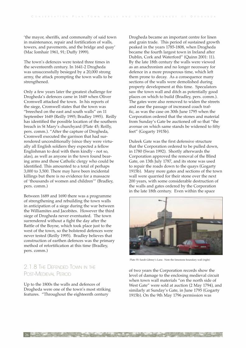
Plate 55: Sarah Gibney’s Lane. Note the limestone boundary wall (right)

C O N S E R V A T I O N P L A N : T O W N W A L L S A N D O T H E R D E F E N C E S O F D R O G H E D A
granted to use “such parts of the town walls as may be necessary” to build the Cornmarket that now forms part of the Borough Council Offices (Gogarty 1915b). Re-use of the town wall fabric is also evident in the post-medieval walls located near the town wall alignment, which appear to be made up of medieval materials. Examples are located on Sarah Gibney’s Lane (Plate 55) and Curry’s Hill.
The remains of Butter Gate still survive despite significant loss of its full original structure. Extensive quarrying in the eighteenth and nine-teenth century nearby, may account for the severe drop in ground level surrounding Butter Gate (Plate 64), though it might also reflect a natural fall in rock in this location. Even within the last century its full height has been sadly reduced (Plate 66), as a result of decay and demolition by the Corporation in 1958 (Reilly pers. comm.).
2.2 SURVIVAL AND PRESENTATION
In the past, Drogheda’s identity has been linked
to its medieval history and, in particular, the Cromwellian sacking of the town during the 17th century. The erosion of the physical cohesion of the medi-eval town did not commence until the late 18th century at which point the need for defensive fortification waned and the town began to experi-ence economic renewal and a period of Georgian redevelopment. Thereafter, portions of the wall fell into disrepair, as the use of the gates for the collection of taxes became obsolete and the cir-cuit was both breached by new development and ‘quarried’ to provide materials.
The town ditch became infilled and built over quite rapidly, but in spite of the demolition of gates and sections of the wall, the medieval defences did not become seriously fractured until the late-20th-century when the exigencies of traffic management required the widening of streets and the creation of major traffic routes both around and through the town.
The survival of the walls into the 18th century is well demonstrated in the paintings of Van der
27
Plate 64: Aerial photo of Drogheda, Butter Gate c. 1940s

C O N S E R V A T I O N P L A N : T O W N W A L L S A N D O T H E R D E F E N C E S O F D R O G H E D A
Hagen (1718, Plate 1) and Ricciardelli’s views of the town painted c. 1753 when the current St Peter’s Church was built (Plates 2 and 3). By the end of the late 18th century the Corporation regarded the stone of the town walls as a source of stone to be quarried for new development. Corporation records show that within a two year period substantial town wall gates were removed to make repairs (Blind Gate)or widen roads (Sunday’s Gate). The medieval town walls were also sold to supply stone to both civic and a sec-tion of wall between West Gate and Fair Gate was auctioned off for re-use in private developments (Gogarty 1915b).
The town wall now survives in a fragmentary, and in places, a neglected and structurally vulnerable state. Some elements of the surviving portions are very well presented, notably St Laurence’s Gate, Featherbed Lane and Millmount. However there are numerous portions surviving to a considerable height and length which are unmanaged and are now poorly presented.
Modern development has eroded the plan form layout and urban grain of the medieval town to some extent, but not to an extent that prejudices the opportunity to enhance its identity and the identity of its walled circuit.
2.2.1 SURVIVING SECTIONS OF THE WALL There are fewer surviving sections of the town wall on the north side of Drogheda than on the southern side, but the most distinctive is the outer barbican of St Laurence’s Gate and a 21m section of wall at Featherbed Lane, which were conserved
by the Office of Public Works in 1981 and refur-bished again in 2002 (Plates 23 and 25).
The largest extant section of the medieval defenc-es is at the Bridge of Peace (Plate 4). From the water’s edge north to Westgate House there is a 70m stretch of surviving wall, currently located in Murdock’s Yard car park that stands 2.8m above present ground level.
Sections of the wall at Fair Street (Plate 10) and George’s Street (Plate 12), and on Featherbed Lane (Plate 25) have all survived because they were incorporated into property boundaries. The town wall is incorporated into the building of No. 39 Fair Street and continues out from the building to form the rear boundary wall that faces onto the properties on George’s Street (Plates 10 and 12). The line of the wall and composition of stone and mortar are all evidence that this is in fact a section of the town wall (Reilly 1995). In the rear garden of 100 George’s Street there is a small outcrop of stone that was originally believed to be the town wall; however its alignment suggests that it may be a fragment of a tower or a collapsed section of the town wall (Plate 11; Reilly 1995). The line of the town wall follows the rear property bounda-ries of Nos. 97-100 George’s Street. At Featherbed Lane there is a well preserved section of the medieval town wall, approximately 21m in length (Plate 24).
28
Plate 4: Bridge of Peace and town wall at Murdock’s Yard car park
Plate 11: Collapsed wall or tower fragment in rear garden, 100 George’s Street

C O N S E R V A T I O N P L A N : T O W N W A L L S A N D O T H E R D E F E N C E S O F D R O G H E D A
South of the River Boyne, sections at St Mary’s Church and Duleek Street still exist today because they form privately-owned property boundaries. The town wall at St Mary’s is the longest surviving section of the wall, being over 90m long and 6m high (Plate 41). The remnants of the boundary wall between Nos. 24 and 25 Duleek Street contains evidence of a collapsed arch and, inside a lean-to attached to the wall, there is another arch (Plate 53; Reilly 1995). Where sections of the bound-ary wall have collapsed the face of the town wall can still clearly be seen at ground level (Plate 51). The chimney alignment between the two terraced houses suggests that the town wall has been incor-porated into the building fabric of No. 24 Duleek Street (Plate 52).
At Millmount there are the remains of a tower and the surviving town wall curves around Millmount Square and turns sharply west (Plate 58). The town wall forms the rear boundary wall of a residence on Mount St Oliver and extends into a yard area (Plates 59-61). The outer wall of the Millmount complex continues to curve around to the north. This wall ‘reads’ as town wall, but it does not link to the town wall as it approaches the Butter Gate. It is possible that this wall defines the defensive line of a bailey attached to the original motte of Millmount.The remains of the Butter Gate have survived because it is not located on a main thoroughfare (Plate 66). The condition of the Butter Gate is not stable and photographs taken in the early 1900’s show how much was removed from the structure by the Corporation in 1958 (Plate 65; Reilly pers. comm.).
2.2.2 THE EXCAVATED SECTIONS OF THE WALL
Several sections of the town wall have been found during archaeological excavations along the line of the circuit. North of the River Boyne excava-tions in advance of the Drogheda Main Drainage and Wastewater Disposal Scheme in 1996 and 1997 revealed sections of the town and quay walls. Along The Mall two walls of St Catherine’s Gate were exposed; the earlier town ditch was identi-fied at Patrickswell Lane; quay walls were found at North Quay, Wellington Quay; and Murdock’s Yard car park (Bridge of Peace) presented the first evidence that the town wall followed the line of the river and did enclose some of the quays (Murphy 1997b; 1998). Earlier testing at the Bridge of Peace in 1994 also proved that up to 3m of the town wall is buried, and it therefore survives to its full height at this location (Campbell 1995).
In 2001 test excavation in advance of develop-ment took place at 97 Georges Street. The fabric of the town wall was not investigated, but one of the trenches was extended to the edge of the wall. There was no evidence of the town ditch, but this was probably because the original ground level sloped away from the town wall, dropping by at least 0.6m (Shanahan 2001).
In 2006 a site on Palace Street was archaeologi-cally tested in advance of a road to link William Street and Francis Street. A 1.7m wide section of the town wall was found with an associated ditch located approximately 10m east of the wall (Murphy 2006)
Construction of a commercial development that was to incorporate a section of the town wall gave rise to archaeological testing at Bachelors Lane in 1997. A black layer containing archaeological material was exposed approximately 3m east of the town wall, which may be the infill of the town ditch (Deirdre Murphy 1997).
A north quay wall was excavated by David Sweetman under St Mary’s Bridge in 1981 where several oak timber uprights dendrodated to 1185 AD were found, but there was no definite evidence of quay walls (Sweetman 1984).
Probably the largest investigation of the town wall on the Meath side occurred at James Street and
29
Plate 60: Town wall extending from Millmount complex

C O N S E R V A T I O N P L A N : T O W N W A L L S A N D O T H E R D E F E N C E S O F D R O G H E D A
Curry’s Hill in advance of the dual carriageway extension between 1981 and 1985. A 15m section of the town wall with three stone wall-walk sup-ports was found. Within the town wall a stone-revetted bank atop a 2.5m deep defensive ditch cut into bedrock, provided strong evidence for defences that pre-date the town wall (Campbell 1987). Nearby test excavation at Marsh Road and South Quay in 2000, 2001 and 2002, identified por-tions of the town wall in four trenches, varying in size from 0.78m to 1.8m wide with a battered base (Quinn 2002; 2003; 2004).
Several phases of testing were carried out an advance of construction for a petrol station at 90-93 Duleek Street in 1989, 1992 and 1995. The property is adjacent to the site of the Duleek Gate; however no evidence for the gate or the town wall were found. A ditch, 2m wide and 0.9m deep, was found during two phases of testing. The ditch was located inside the line of the town wall (Swan 1995).
Investigations at the rear of 103 and 104 Duleek Street uncovered a loose stone alignment that has been interpreted as the possible rubble core of the town wall (O’Carroll 2001).
Testing between Butter Gate and John Street for the Drogheda Main Drainage and Wastewater Disposal Scheme found the town wall built into a bank of natural boulder clay and faced on its east-ern side (Murphy 1997b). The western face of the wall was removed during construction of a later wall (Murphy; pers. comm.).
In 1976 road widening at John Street provided the opportunity to excavate the site of St John’s Gate. Sections of the gate, and the adjoining town walls were exposed, with a substantial ditch outside the defences (Ó Floinn, 1977).
2.3 STRUCTURAL COMPOSITION 2.3.1 CONSTRUCTION FABRIC
Drogheda is situated on the band of Palaeozoic Carboniferous limestone rock that forms the bed-rock to the central plain of Ireland. The particulartype of rock in the Drogheda region is the Middle Carboniferous Limestone, often referred to as
“Calp”. The town walls are virtually entirely con-structed of this stone. Other stone types, bricks and blocks are all later additions. The lime in the mortar used to bed the stones was also most likely to have been formed by burning small lumps of the Calp with turf or charcoal.
2.3.2 THE COMPOSITE STRUCTURES
The composite structures that make up the Drogheda’s walls and defences include:The primary Anglo-Norman enclosing wall and its external ditch and a citadel (motte and bailey) at the site of the Millmount. The later medieval wall which enlarged the enclosure on the north of the river and enclosed the southern side of the town.
2.3.3 SURVIVING SECTIONS OF THE WALL
(Fig. 1) The upstanding sections of the town defences are located at:
• Murdock’s Yard car park/Bridge of Peace • Georges Street and Fair Street • St Laurence’s Gate • Featherbed Lane • The Mollies • St Mary’s Church • Duleek Street • Millmount • Butter Gate
30
Plate 9: Town wall profile in façade, 39 Fair Street
C O N S E R V A T I O N P L A N : T O W N W A L L S A N D O T H E R D E F E N C E S O F D R O G H E D A
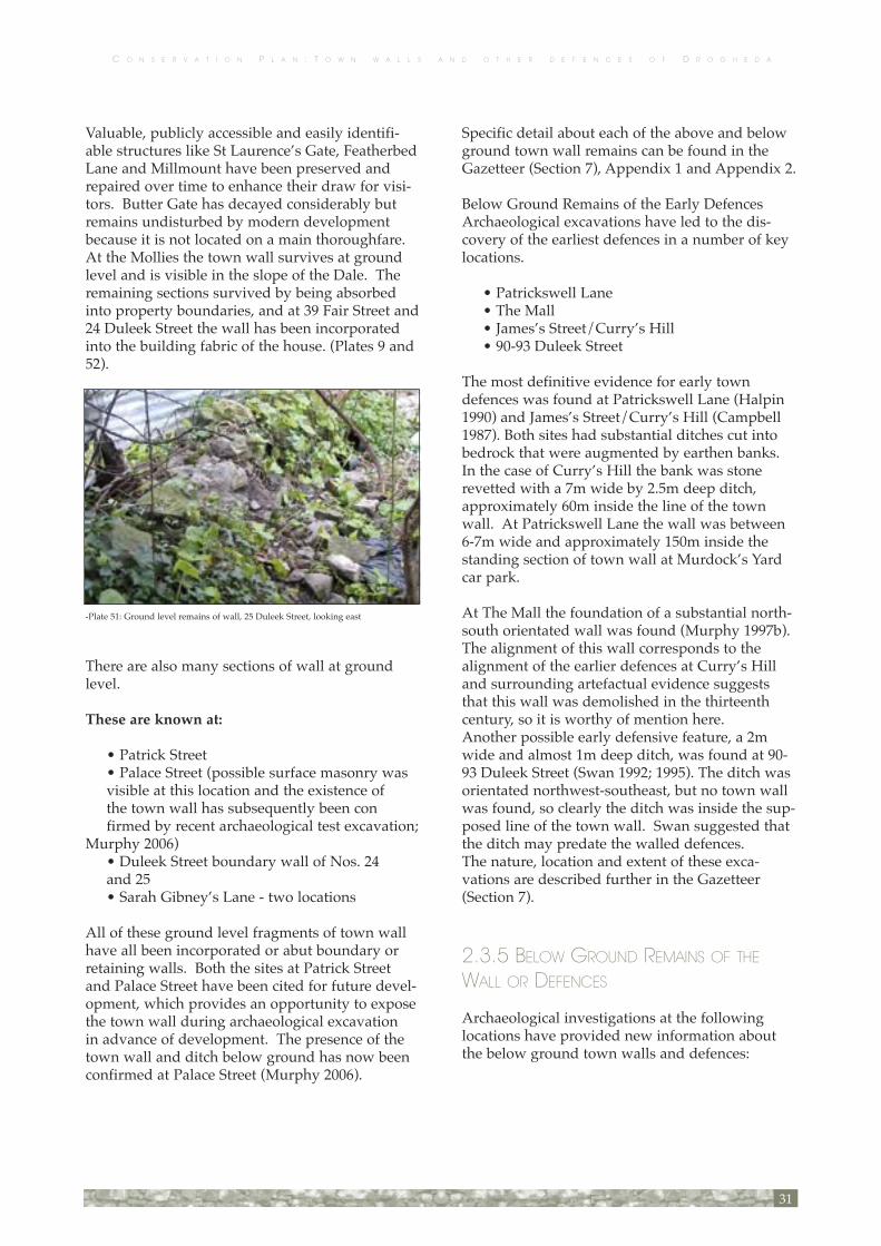
Valuable, publicly accessible and easily identifi-able structures like St Laurence’s Gate, Featherbed Lane and Millmount have been preserved and repaired over time to enhance their draw for visi-tors. Butter Gate has decayed considerably but remains undisturbed by modern development because it is not located on a main thoroughfare. At the Mollies the town wall survives at ground level and is visible in the slope of the Dale. The remaining sections survived by being absorbed into property boundaries, and at 39 Fair Street and 24 Duleek Street the wall has been incorporated into the building fabric of the house. (Plates 9 and 52).
There are also many sections of wall at ground level.
These are known at:
• Patrick Street • Palace Street (possible surface masonry was visible at this location and the existence of the town wall has subsequently been con firmed by recent archaeological test excavation; Murphy 2006) • Duleek Street boundary wall of Nos. 24 and 25 • Sarah Gibney’s Lane - two locations
All of these ground level fragments of town wall have all been incorporated or abut boundary or retaining walls. Both the sites at Patrick Street and Palace Street have been cited for future devel-opment, which provides an opportunity to expose the town wall during archaeological excavation in advance of development. The presence of the town wall and ditch below ground has now been confirmed at Palace Street (Murphy 2006).
Specific detail about each of the above and below ground town wall remains can be found in the Gazetteer (Section 7), Appendix 1 and Appendix 2.
Below Ground Remains of the Early Defences Archaeological excavations have led to the dis-covery of the earliest defences in a number of key locations.
• Patrickswell Lane • The Mall • James’s Street/Curry’s Hill • 90-93 Duleek Street
The most definitive evidence for early town defences was found at Patrickswell Lane (Halpin 1990) and James’s Street/Curry’s Hill (Campbell 1987). Both sites had substantial ditches cut into bedrock that were augmented by earthen banks. In the case of Curry’s Hill the bank was stone revetted with a 7m wide by 2.5m deep ditch, approximately 60m inside the line of the town wall. At Patrickswell Lane the wall was between 6-7m wide and approximately 150m inside the standing section of town wall at Murdock’s Yard car park.
At The Mall the foundation of a substantial north-south orientated wall was found (Murphy 1997b). The alignment of this wall corresponds to the alignment of the earlier defences at Curry’s Hill and surrounding artefactual evidence suggests that this wall was demolished in the thirteenth century, so it is worthy of mention here. Another possible early defensive feature, a 2m wide and almost 1m deep ditch, was found at 90-93 Duleek Street (Swan 1992; 1995). The ditch was orientated northwest-southeast, but no town wall was found, so clearly the ditch was inside the sup-posed line of the town wall. Swan suggested that the ditch may predate the walled defences.The nature, location and extent of these exca-vations are described further in the Gazetteer (Section 7).
2.3.5 BELOW GROUND REMAINS OF THE WALL OR DEFENCES
Archaeological investigations at the following locations have provided new information about the below ground town walls and defences:
31
-Plate 51: Ground level remains of wall, 25 Duleek Street, looking east

C O N S E R V A T I O N P L A N : T O W N W A L L S A N D O T H E R D E F E N C E S O F D R O G H E D A
• Palace Street • Bachelor’s Lane (ditch only) • The Mall (St Catherine’s Gate) • Scotch Hall • Marsh Road/South Quay • James’s Street • Duleek Street (ditch only) • Sarah Gibney’s Lane (ditch only) • John Street • John Street (St John’s Gate)
The findings of each of these archaeological exca-vations are summarised in Section 2.1.9 and in the Gazetteer (Section 7).
Below Ground Archaeological Settlement RemainsThe town walls enclose the area of intensive and continuous settlement in the town dating from the Anglo-Norman period onwards. This has given rise to the accumulation and survival over time of significant archaeological deposits and features that now lie below ground. The earliest deposits in the sequence are remarkably well preserved in anaerobic, waterlogged conditions.
Associated with these, the town ditch, where it survives, is a singularly important chronological repository of archaeological material, artefacts and ecofacts dating from the Anglo-Norman period.
The deposit sequence of settlement is not chrono-logically complete, however. Waves of post-medieval and modern development in the town, linked to the ebb and flow of economic growth and decline, most notably the construction of Georgian, Victorian and modern basemented buildings, have eroded and removed much of these deposits where these buildings have been constructed.
The importance of the remaining, surviving archaeological resource within the circuit requires an equivalent level of rigorous protection, conser-vation and management as the circuit itself. In line with published government policy (1999) all planning mediation should be guided by a policy presumption in favour of the preservation in situ of archaeological remains. This means that base-mented development within the enclosed medi-eval town should be actively discouraged and low-impact foundation structures advised.
Where impact is so severe that mitigation in the form of archaeological excavation is required the removal of important archaeological deposit sequences on development sites should only be conducted in the context of an accepted research framework.
2.4 MATERIAL CONDITION
The wall circuit was inspected and surveyed for the purposes of this Plan during November 2005
and again in February and March 2006. The condi-tion of the standing and surviving sections of the walls were examined individually. The findings are summarised in the Gazetteer (Section 7) and discussed in further detail in Appendix 1 and
32
Plate 28: East face of Featherbed Lane. Vegetation grows at the top of the batter and in line with ground level on the western side of the wall.

C O N S E R V A T I O N P L A N : T O W N W A L L S A N D O T H E R D E F E N C E S O F D R O G H E D A
Appendix 2, with representative photographs of the conditions found.
2.4.1 OVERVIEW
The defensive walls of Drogheda are in an unfor-tunate state. Much has been lost with the passing of time, waves of development and under-appre-ciation of the wall as a continuous circuit. The remaining standing walls and gates form inter-spersed sections.
Some elements, notably St Laurence’s Gate and Millmount have however been recently restored and successfully set up as visitor attractions. Elsewhere lack of clear definition of ownership and duty of care has resulted in inadequate fund-ing provision for the upkeep, management and presentation of the wall. Apart from historians, archaeologists, conservation-focused individuals and local politicians, its demise has not been a subject of particular civic concern until now.
Persistent lack of maintenance will result in the dilapidation of secure sections of the wall with other sections becoming dangerously unstable. Standing sections of wall that give the most urgent concern are identified in Appendix 1.
Three categories will be assigned to highlight areas requiring attention:
CATEGORY 1 – STRUCTURALLY UNSTABLESections of the wall categorised under this section are structurally unstable and require immediate stabilising works as well as a condition and struc-tural survey.
CATEGORY 2 – STRUCTURALLY STABLESections of the wall in Category 2 are structurally stable but require a condition survey to identify remedial works necessary to repair and maintain the wall in a good condition
CATEGORY 3 – REQUIRES MAINTENANCE PLAN IMPLEMENTATIONSections of the wall that are stable but require a maintenance plan to be devised and implemented to sustain the condition
2.4.2 CONSERVATION PHILOSOPHY
The significance of the Drogheda town walls makes it essential to adhere to the Conservation Guidelines issued by the Department of the Environment, Heritage and Local Government and to follow the philosophies of conservation outlined in the International Charters agreed upon in Venice and Burra.
These charters stipulate that works should not be carried out unless they are necessary to conserve the structure, and should aim to repair rather than replace existing fabric to ensure the maximum retention of historic material. A complete record of alterations should be kept, noting the exact extent of restoration work undertaken.
If plans involve the removal of later interven-tions, they should only take away those parts that interfere with the integrity of the monument - con-servation work does not necessarily require the removal of all later additions, but recognises the validity of later elements in terms of the ongoing history of the structure.
33
Plate 62: Unravelling end of town wall, west of Millmount


C O N S E R V A T I O N P L A N : T O W N W A L L S A N D O T H E R D E F E N C E S O F D R O G H E D A
Drogheda was one of the foremost port towns of medieval Ireland. Its walls and defences are a composite group of structures created to define and protect the medieval town and became an expression of the town’s economic vigour and its independence. Their origins are linked to the earliest phases of medieval European urbanisa-tion and they belong to a group of no fewer than 54 towns and cities in Ireland that were enclosed by walls during the medieval period. They have a cultural significance of national and international importance.
The town walls should be regarded as the town’s foremost defining ‘civic’ historic monu- ment, defining the civic heart of the town and its particular mix of commercial activity.
The circuit physically defines the primary source of the order, direction and form of the town’s spatial and economic organisation and development over centuries. The remains of the medieval wall and defences
continue to identify the historic core of the town as a repository of material archaeological remains and also have a significant function as an historical and archaeological research resource. Many European walled cities and towns acknowl-edge that their ancient defensive walls describe a circuit around a singularly historically important sector of the town that should be clearly identified for its citizens, thereby underpinning their sense of the great weight of its historical past. In this context the walled circuit is regarded as a defining resource to be identified, protected, admired and cherished.
Irish walled towns are also discovering the impor-tance of their medieval identity linked to their walled circuits. Dublin, Kilkenny, Waterford, Cork and Athlone have successfully used studies of this nature to develop and support significant urban regeneration and promotion, linked to historical identity.
35
Plate 65: Butter Gate c. 1900 (Photo from Laurence Collection)
3. Cultural Significance and Vulnerability
3.1 INTRODUCTION

C O N S E R V A T I O N P L A N : T O W N W A L L S A N D O T H E R D E F E N C E S O F D R O G H E D A
Current urban planning philosophy can now sup-port the view, that the particular character and texture of this element of Drogheda’s urban form still has the capacity to provide the town with an important and identifiable core area, and that this can contribute a sense of foundation for the town’s now richly layered identity.
The cultural and commercial identity of the town is logically linked to its historical identity, its past commercial and political history, and to its devel-opment from the time of its origins. This can be enriched by the identity of later historic events and changes that shaped the fabric of the town.
3.2 THE VULNERABILITY OF THE CULTURAL SIGNIFICANCE OF THE TOWN WALL
The loss of the identity of the enclosed historic core area is an accident of history. It has been linked to periods of economic decline in the his-toric core area and to development and expansion in other sectors of the town over centuries. In recent decades, principles of traffic management and urban renewal applied to urban regeneration, on the basis of acknowledged thinking, did not espouse a weighting in favour of the preserva-tion of the town’s tightly knit street patterns and the grain of its earliest buildings. As a result the layout of the historic circuit and the texture of its street plan have become eroded and vulnerable.
In particular, reference to the significance of the town wall in the streetscape has declined to a point where it was no longer recognised.
Over time, during historic and more recent devel-
opment the alignment of the wall, the location of its gates and its enclosed tight network of narrow winding streets and lanes have been regarded as constraints which have had to be broken through for urban development and traffic management purposes.
The vulnerability, in historic terms, was linked to a lack of perception of the cultural significance of the circuit and the plan form and layout of the area enclosed.
The vulnerability, now, is linked to an increasing lack of visibility and, more precisely to the lack of an integrated weighting for considerations of conservation and public presentation. Knowledge and a perception at present that is largely focused on material issues and problems at particular locations have led to a lack of profile for the cir-cuit and its remains in recent planning decisions. Many of the issues are of different derivation but some are development led.
Individual responses, therefore, are being made without the benefit of accurate (plan form) knowl-edge and the lack of an overall strategic planning framework linked to what survives of the circuit. Individual responses that appear to have ignored the walled circuit, understandably, do not inspire confidence that sufficient weight is being given to the significance of the circuit as a defining, historic civic entity. The relatively high turnover of staff that is characteristic of the planning profession, in general, is also a threat to the degree to which consistent decisions will be made relating to the conservation and presentation of the medieval walled circuit. To date, planning decisions have
36
Plate 34: Site of St James’s Gate
Plate 70: Site of St John’s Gate

C O N S E R V A T I O N P L A N : T O W N W A L L S A N D O T H E R D E F E N C E S O F D R O G H E D A
been largely reliant on the personal knowledge of planning staff and interventions by local histori-ans and archaeologists.
The vulnerability therefore lies in the lack of an agreed strategy for development and/or develop-ment control in the long term, linked to a ‘vision’ for the identity and preservation/presentation of the monument and the ‘old town’ as a precinct in its own right.
The vulnerability also lies in a difficulty for all concerned to envisage the potential dividends of preservation and presentation, when issues are being dealt with reactively in the realm of devel-opment control where the presence of the wall in many instances is simply viewed as constraint.
The losses have been extensive. The circuit is diffi-cult to trace in its fractured state, though the work of this Plan suggests that it still has the capacity to create a significant sense of precinct in the ‘old town’.
The value of layered identities and the need for reference to the historic origins and protection of the historic fabric of cities is clearly articulated in international charters and European conventions.
These are: the Granada Convention on Architectural Heritage, ratified by Ireland in 1996; the Valletta Convention 1992 on the protection of the Archaeological Heritage; the UNESCO-sponsored ICOMOS Washington Charter for the Conservation of Historic Towns and Urban Areas (1989); and the Burra Charter for the Conservation of Places of Cultural Significance (1988 – 1999).
3.3 SUMMARY
In summary, the circuit of the town walls and defences must be regarded as a significant cultural resource for the following reasons:
The circuit can define a sense of place for the old-est part of the modern town (but it will require a vision and a long-term Strategic Plan to achieve this).
The wall survives in a number of locations where access can be improved and significantly enhanced with attention to cohesive development
proposals and a focus on the integration of the monument and the identity of the areas presented.The complex, multi-period monument is a docu-ment in its own right, with its own particular his-tory that informs the understanding of the pattern of the town’s development.
The town’s oldest core area possesses the town’s most visible and foremost monuments and build-ings.
The area enclosed by the walled circuit is already utilised by tourists, many of whom have the Boyne Valley as a focus of their visit. A focus on retaining these visitors for even one to two ‘bed nights’ could have a significant commercial spin-off for the town. However, the old town centre is heavily trafficked at present and currently lacks a clear identity and set of directions for potential visitors. The directions for walks that do exist make no reference to the town wall circuit.
37
Plate 30: Site of Blind Gate

C O N S E R V A T I O N P L A N : T O W N W A L L S A N D O T H E R D E F E N C E S O F D R O G H E D A
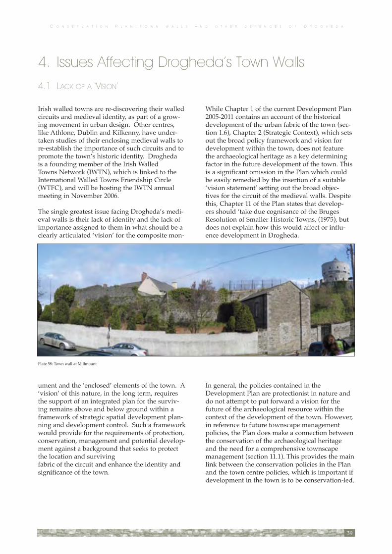
Irish walled towns are re-discovering their walled circuits and medieval identity, as part of a grow-ing movement in urban design. Other centres, like Athlone, Dublin and Kilkenny, have under-taken studies of their enclosing medieval walls to re-establish the importance of such circuits and to promote the town’s historic identity. Drogheda is a founding member of the Irish Walled Towns Network (IWTN), which is linked to the International Walled Towns Friendship Circle (WTFC), and will be hosting the IWTN annual meeting in November 2006.
The single greatest issue facing Drogheda’s medi-eval walls is their lack of identity and the lack of importance assigned to them in what should be a clearly articulated ‘vision’ for the composite mon-
ument and the ‘enclosed’ elements of the town. A ‘vision’ of this nature, in the long term, requires the support of an integrated plan for the surviv-ing remains above and below ground within a framework of strategic spatial development plan-ning and development control. Such a framework would provide for the requirements of protection, conservation, management and potential develop-ment against a background that seeks to protect the location and surviving fabric of the circuit and enhance the identity and significance of the town.
While Chapter 1 of the current Development Plan 2005-2011 contains an account of the historical development of the urban fabric of the town (sec-tion 1.6), Chapter 2 (Strategic Context), which sets out the broad policy framework and vision for development within the town, does not feature the archaeological heritage as a key determining factor in the future development of the town. This is a significant omission in the Plan which could be easily remedied by the insertion of a suitable ‘vision statement’ setting out the broad objec-tives for the circuit of the medieval walls. Despite this, Chapter 11 of the Plan states that develop-ers should ‘take due cognisance of the Bruges Resolution of Smaller Historic Towns, (1975), but does not explain how this would affect or influ-ence development in Drogheda.
In general, the policies contained in the Development Plan are protectionist in nature and do not attempt to put forward a vision for the future of the archaeological resource within the context of the development of the town. However, in reference to future townscape management policies, the Plan does make a connection between the conservation of the archaeological heritage and the need for a comprehensive townscape management (section 11.1). This provides the main link between the conservation policies in the Plan and the town centre policies, which is important if development in the town is to be conservation-led.
39
Plate 58: Town wall at Millmount
4. Issues Affecting Drogheda’s Town Walls
4.1 LACK OF A ‘VISION’

C O N S E R V A T I O N P L A N : T O W N W A L L S A N D O T H E R D E F E N C E S O F D R O G H E D A
4.2 CONSERVATION AND MANAGEMENT
There are fifteen separate zoning objectives con-tained in the Development Plan (section 14.2). There is currently no single overarching zoning objective defined for either the town wall circuit or the enclosed medieval town. The circuit and its enclosed area are associated with seven separate zoning objectives (Fig. 19) as follows:
RE Residential existing: To protect and/or improve the amenity of developed residen- tial communities.TC Town Centre: To protect and enhance the special physical and social character of the existing town centre and to provide for new and improved town centre facilities and uses.IQDA Inner Quays Development Area: To pro- vide for major new town centre activities in accordance with an approved local area plan and subject to the provision of neces- sary physical infrastructure.CCI Civic Community & Institutional: To pro- vide and protect necessary community, recreational and educational facilities.NC Neighbourhood Centres: To protect, pro- vide for and improve Local Shopping Facilities in order to create and retain a vibrant and sustainable Neighbourhood Centre to serve Primarily Local Needs.LPS Local Primary Shops: To protect, provide for and improve local shopping facilities in order to provide facilities for a residential neighbourhood.OS Open Space and Recreational Area (Public/Private): To provide for and / or improve open space and recreational amenities.
The predominant zoning objectives within the northern circuit of the wall are Town Centre (TC), with Residential Existing (RE) and Open Space and Recreational Area (OS) within the northern one third. The predominant zoning objectives within the southern circuit of the wall are Residential Existing (RE), with Town Centre (TC) along the quays to the north, Open Space and Recreational Area (OS) to the west and Civic Community and Institutional (CCI) within the Millmount complex. The medieval walled circuit is not indicated on the zoning map contained in the Plan.
In general, the policies governing the Town Centre zoning display a high level of cross-compliance with the Built Heritage policies and include a number of policy statements which are designed to ensure that future development respects the existing character and distinctiveness of the town-scape and streetscapes of Drogheda.
However, the policies governing the Residential (RE) and Open Space (OS) zonings do not display the same degree of cross compliance with the Built Heritage policies. They do not contain any caveats to ensure that the town wall circuit and the char-acter of its enclosing space will be respected in the implementation of its zoning objectives.
This means that the protection and conservation of the historic morphology and built character of the primarily residential areas to the north of the northern circuit and within all of the south-ern with the exception of the quays and the Millmount complex, are at risk from the lack of a strategic vision governing the future development of the morphology and grain of the urban fabric.
It is suggested that in any review of the Development Plan, that all zoning objectives located within the town wall circuit should con-tain specific policy statements relating to the maintenance and enhancement of the physical characteristics of the historic town within the walled circuit, as manifested in the morphology and grain of the historic built environment. It is recommended that in any review of the plan that consideration be given to changing the title of the ‘Town Centre’ zoning to ‘Mixed Use’ (or equiva-lent) and the introduction of a second tier of zon-ing for the area within and including the circuit of the town walls which could be called ‘Historic Town Centre’. While it is acknowledged that this is already achieved in part by the designation of the Zone of Archaeological Potential, it is consid-ered that additional policies could be grouped together under such a zoning objective which would include the manner in which the morphol-ogy and grain of the urban area, together with the townscape and streetscape would be dealt with.
The Development Plan maps do not make refer-ence to the medieval enclosures.
40

C O N S E R V A T I O N P L A N : T O W N W A L L S A N D O T H E R D E F E N C E S O F D R O G H E D A
4.3 DEVELOPMENT CONTROL
Drogheda, like most provincial towns of its size, has been the subject of intense urban develop-ment over the past ten to fifteen years. Within the town centre, this has manifested itself primarily in the form of the infilling of vacant sites and the rehabilitation of disused industrial buildings. A number of recent developments are notable due to their proximity to the town wall and the manner in which they have addressed the town wall.
In general, development control in the vicinity of the surviving portions of the wall has been reac-tive, location-specific and has not been sensitive. In this context it has been difficult to argue the case for suitable protection and retention of the wall alignment and even more difficult to argue the case for appropriate presentation.
Appropriately weighted adjudication of proposed development and ensuring effective development control cannot be easily achieved, unless it is undertaken in the context of a larger picture.
Foremost among these examples is the Scotch Hall mixed-use development at the South Mall / Marsh Road, which included a new bridge con-necting the development to the North Mall. The main building mass of disproportionate scale straddles the eastern perimeter of the medieval wall circuit at its important gateway location, the identity of which is now totally lost. This site was previously occupied by an intensive industrial use and there were no traces of the town wall above ground; however a significant opportunity to re-establish and identify this important location was not pursued though it is understood that meas-ures of this nature were discussed at planning stage. While the development itself, through the positioning of windows, affords some fine and hitherto unappreciated perspectives of the town, the building’s dominance in this location is so great that the task of identifying either the gate-way location or the alignment of the town wall is now insurmountable. The response to an obliga-tion to identify the position of a former important river front tower and the wall approaching that location is wholly inadequate, neither the plan form or treatment of different paving stone can be interpreted by any other than those familiar with the unpublished and unpublicised results of exca-
vation undertaken prior to development (Plate 33). The paving is not accompanied by any on-site interpretation to explain what the marking repre-sents, which is a very significant omission in its own right and demonstrates a lack of regard for undertakings apparently made prior to develop-ment. In significant contrast the development did involve the conservation of part of the quayside wall along the south bank of the river. The new bridge connecting Scotch Hall to the North Mall does not, however, integrate well with the existing quay wall. No attempt has been made to match materials and insertion of the mass concrete base of the bridge alongside the existing stone quay wall results in an uneasy juxtaposition which is clearly visible from the North Mall (Plate 32).
Individual attempts at preservation and interpre-tation can be of limited value (especially if they are as poorly undertaken as in the case of Scotch Hall) without the existence of an overall vision for the treatment of these sites. Without that larger picture, a mechanism for linkage between remains, the alignment of the town wall, and the surviving remains does not exist. In effect, appro-priate protection and presentation with appropri-ate support for the significance of the enclosed medieval core of the town will be very difficult to achieve successfully on a development applica-tion-by-application basis, without a strong and secure ‘vision’ for the long term context within which these applications are being made.
41
Plate 33: Paving to mark tower location at Scotch Hall

C O N S E R V A T I O N P L A N : T O W N W A L L S A N D O T H E R D E F E N C E S O F D R O G H E D A
4.4 LEGAL STATUS, OWNERSHIP ANDDUTY OF CARE
LEGAL FRAMEWORK
4.4.1 NATIONAL MONUMENTS ACTS AND AMENDMENT ACTS 1930, 1954, 1987, 1994, 2004
The town walls should now be regarded as a sin-gle, composite ‘National Monument’ under the terms of reference of the National Monuments Acts (1930) and Amendment Acts (1954, 1987, 1994, 2004). While it is not a National Monument in State care the provisions attaching to it in terms of development control and management now rest in the context of Ministerial Directions.
Drogheda’s town walls do not have a separate designation in the Records of Monuments and Places, as established under Section 12 of the National Monuments (Amendment) Act 1994, but all sections of the town’s walls and defences are included in the Zone of Archaeological Potential for the medieval town (LH024:041).
4.4.2 PLANNING AND DEVELOPMENT ACT 2000
The current Development Plan for the Borough of Drogheda is the Drogheda Borough Council Development Plan 2005-2011, which was adopted in 2005. The Plan contains a strategy for devel-opment over a six-year period, together with development policies and zoning objectives which constitute material considerations in deciding on individual applications for planning permission.
4.4.3 INTERFACE BETWEEN DEVELOPMENT PLAN AND DEVELOPMENT CONTROL – FINANCIAL CONTRIBUTIONS
There is no direct levy or specific fund applica-ble to 'historic structures' such as the town wall. Nevertheless, a direct levy or fund might be valid-
ly applied in certain development circumstances adjacent to standing or below ground portions of the circuit.
Section 48 of the Planning and Development 2000 Act states that planning conditions seeking devel-opment contributions in respect of, "public infra-structure and facilities" may be attached to a grant of permission. In these circumstances the basis for determination for any such contribution shall be set out in a Contribution Scheme.
4.4.4 OWNERSHIP
The composite monument is not ‘owned’ by Drogheda Borough Council. There are a number of locations, however, where the standing wall above and below ground is actively cared for and managed by the Borough Council.
The Department of the Environment, Heritage and Local Government requires Ministerial Consent for all development in proximity to the town wall, with a precedent for Ministerial Consent set at Murdock’s Yard car park. The application must come from the Borough Council as the guardian of the monument, not the “owner” of the property.
Standing remains have become incorporated into the street frontages and elsewhere, over time, the wall has become a ‘party’ wall between privately owned properties.
In many areas below ground remains underlie standing structures on privately owned property.
All those that own portions of the wall listed as protected structures in the Development Plan have an equal duty of care for the structure, as outlined under Section 15(1) of the Planning and Development Act 2000. These locations are identi-fied in Appendix 4.
4.5 STREETSCAPE PRESENTATION / ARCHITECTURAL PRESENTATION OF STANDING REMAINS
At present there is no physical sense that the town
42

C O N S E R V A T I O N P L A N : T O W N W A L L S A N D O T H E R D E F E N C E S O F D R O G H E D A
was once an enclosed, walled and gated medieval town except at St Laurence’s Gate, and the use of St Laurence’s Gate in promotional tourist litera-ture. The outline of the medieval wall is no longer legible even at Butter Gate and Millmount and is currently not easily read even where it survives in what is substantially an 18th–19th century street-scape. The extant standing remains are isolated, with no link between each other.
At present, apart from St Laurence’s Gate, there is no sense of entry into the formerly enclosed sector of the town and no identification of the gateway sites through which entry was gained.
Opportunities for presentation of the stand-ing remains are presented fully in Appendix 1. Appendix 2 suggests possible treatment of below ground remains on the line of the circuit.
4.6 THE MATERIAL CONDITION OF STANDING AND ACCESSIBLE BELOW GROUND REMAINS
An examination of the extant wall was carried out to establish the particular issues relating to its con-
dition and structure in both the short and longer term.
Apart from the length of town wall in Murdock’s Yard car park, other surviving sections of the town wall circuit are not likely to be affected by devel-opment proposals in the near future; however, two private properties adjacent to the wall have recently been sold. Some sections are in danger of collapse as a consequence of natural forces or the normal process of decay. A whole range of issues were identified however, that all require attention of some kind.
These include:
• Detritus build up • Open joints in masonry • Missing stones/fabric • Atmospheric staining • Sulphation of mortars • Proximity of mature stands of trees • Biological growth (mosses, lichens, and other vegetation) • Metal fixings • Inappropriate pointing and finishing with cementicious mortars • Graffiti
The surviving above ground fragments of town wall at Fair Street/George’s Street; St Mary’s; west of Millmount; and the quay walls; are cur-rently structurally unstable and require immedi-ate attention and consolidation. Sections of wall at Murdock’s Yard car park; Featherbed Lane to Bachelor’s Lane; Nos. 24 and 25 Duleek Street; Millmount; and Butter Gate are all structurally stable, requiring repair in places and maintenance (Appendix 1).
43
Plate 69: Possible fragment of town wall below Butter Gate
Plate 5: Graffitti, brick and concretre blockwork at Murdock’s Yard car park


C O N S E R V A T I O N P L A N : T O W N W A L L S A N D O T H E R D E F E N C E S O F D R O G H E D A
5. Opportunities
The circuit provides a number of opportunities to improve the presentation of Drogheda’s town walls; to reinforce the identity of the medieval town; and to enhance the civic spaces previously enclosed by the wall.
The identity of the ‘old town’ precinct is already very strongly underpinned by the medieval street layout, which is bounded on its western side by the Bridge of Peace (‘enclosing’ the sur-viving stretch of the wall at Murdock’s Yard car park) and George’s Street; on its eastern side by St Laurence’s Gate; on its northern side with the Magdalene Tower surviving close to its original alignment; and on the south side of the river by St Mary’s, Millmount and the remains of Butter Gate. Even along James’s Street and John Street where all trace of the alignment has vanished there is still a sense of entry at the traffic junctions where each gate once stood.
Together these can support the particular ‘vision’ for an identifiable, formerly enclosed historic town centre and the strategically placed Millmount as part of the town’s historic defences. The actions that support such a ‘vision’ do not have to be undertaken as a single project, but can be formu-lated and used as a backdrop for strategic plan-ning purposes over a 5–10 year or even a 20–year time span.
5.1 SUGGESTED OPPORTUNITIES FOR IMPROVED PRESENTATION AND URBAN INTEGRATION: STREETSCAPE / PUBLIC PRESENTATION, DEVELOPMENT AND
IMPROVED COHESION
Several opportunities for the enhancement of the historic town and its identity have been identified on the basis of three investigations of the circuit.
There are plans for the development of the Murdock’s Yard car park, located to the south of Narrow West Street and immediately east of the Bridge of Peace, which contains a major upstand
ing section of town wall. The site is currently used as a car park. Any redevelopment of this site would have to respect the extant portion of town wall, ensuring that the immediate setting of the wall was not negatively impacted upon. It is important that the opportunity to create an accessible public space and present the town wall be taken at this site, preferably on both sides of the wall, subject to consideration of such issues as practicality, safety and access. This might be achieved by managing the areas of public access, so that they are closed off after-hours to prevent anti-social behaviour. Access to both sides of the wall might be opened up from Mill Lane (near Donaghy’s Mill), passing underneath the Bridge of Peace.
An opportunity exists between West Street and Fair Street, just north of the Bridge of Peace, which is currently used for car parking (for approxi-mately eight cars), for the creation of a landscaped civic space. This would mark the entrance to the medieval town from the west (at West Gate) and would provide a place of respite from the heavy traffic volumes that use this road, introducing a pedestrian-friendly element to the streetscape.
The proposed plan to turn the green space at Patrick Street into a civic car park does not appear
45
Figure 10: Impression of a potential street treatment between West Gate and Fair Gate

C O N S E R V A T I O N P L A N : T O W N W A L L S A N D O T H E R D E F E N C E S O F D R O G H E D A
to have the full support of local residents. The line of the town wall follows the alignment of the retaining wall along Patrick Street and historical evidence suggests the foundations of two tow-ers could be located on this site. Any proposal to develop this area would require an appropriate archaeological investigation to establish the loca-tion and extent of the town wall remains, and should give consideration to incorporating an ele-ment of green space into the design.
A number of developments are currently being discussed or planned and would need to take into consideration the implications for the line of the town wall. There is an opportunity to raise aware-ness about the town wall with the development of a new access road linking the Palace Street entrance of the new retail development (fronting onto William Street) on a site to the south of St Oliver’s VEC School on King Street. This access road will cut across the line of the town wall along the eastern side of Palace Street and provides an opportunity to mark the line of the town wall in the new road surface. The remains of the wall and an external defensive ditch have recently been dis-covered in archaeological test excavation (Murphy 2006). A suitable method of marking the align-ment of the wall requires discussion, but a traffic calming surface treatment could be appropriate in this instance, supported by signage.
The barbican of St Laurence’s Gate and Featherbed Lane are the two best preserved frag-ments of town wall and yet there is currently nothing to identify that these two sections were once linked. The line of the wall and the inner wall gate could easily be marked in the paving, with a different paving to identify the bridge over the town ditch, which linked the inner gate to the barbican. Interpretative panels at this loca-tion would be needed to explain the paving pat-terns (Fig. 12). Plans for traffic calming through St Laurence’s Gate are already in place, with the creation of the new link road to Francis Street fur-ther north.
A potential residential and office development on an infill site on Mary Street, near the junction with James Street / Dublin Road, also offers an oppor-tunity to mark the line of the wall in any new pav-ing on the site.
An opportunity exists for the preparation of a landscape plan at the Mollies, to the east of St Mary’s church. Suggested hard landscaping treatments for this location are discussed in the Gazetteer (Section 7) and Appendix 2.
The section of the town wall that forms the south-ern boundary wall of the Millmount complex is fronted by an empty private residence with gar-
46
Figure 11: Potential treatment to mark the line of the wall along King Street and Palace Street
Figure 12: Possible improvements to link St Laurence’s Gate to the town wall.

C O N S E R V A T I O N P L A N : T O W N W A L L S A N D O T H E R D E F E N C E S O F D R O G H E D A
den on Mount St Oliver, which has recently been purchased. There is an opportunity to redevelop this site into a coach parking area for Millmount and to re-open the “blind” gate at this location would allow this section of the town wall to be fully displayed.
There is also the possibility of developing a green-way linking John Street (on the eastern side of Donore Road across from the bus station) with the Butter Gate and on up to Millmount. The route of the greenway linking John Street to the Butter Gate should follow the line of the former wall (previously identified in archaeological excavation by ACS Ltd; Murphy 1997b).
The remains of the Butter Gate provide a singular opportunity for presentation of the gate within a managed public space. Any proposal to improve the public domain in this context would have to incorporate a requirement for detailed condi-tion survey of the structure and an archaeologi-cal assessment of the remains above and below ground.
5.2 USE OF MATERIALS (FIGS. 10-15)
The use of materials is important and would help to create an atmosphere and identity for the old town centre. The landscaping should be hard with an emphasis on natural stone and textures.
Featherbed Lane (Fig. 13) and the section of town wall within the Millmount complex are the only examples of hard landscaping along the circuit, but both need improving. In spite of the limited examples of good hard landscaping treatment there are several opportunities where this could be improved (Featherbed Lane, Millmount, Curry’s Hill (Fig. 14)) or introduced like the Mollies (Fig. 15), Murdock’s Yard car park, and the line of the wall between West Gate and Fair Gate (Fig. 10).
At the Mollies, where the town wall survives at ground level and above ground in the face of the slope there is an opportunity to create a sense of entry by using hard landscaping (paving or gravel, low seating and lighting) to mark the area inside the town wall, while maintaining the green space of the Dale to mark outside the wall (Fig. 15). A similar treatment could be carried out at
Murdock’s Yard car park to improve the “dead” area between the wall and the Bridge of Peace.
47
Figure 13 : Impression of potential hard landscaping improvements toFeatherbed Lane
Figure 14: Possible improvements to landscaping of Curry’s Hill

C O N S E R V A T I O N P L A N : T O W N W A L L S A N D O T H E R D E F E N C E S O F D R O G H E D A
5.3 MARKING THE WALL ALIGNMENT IN THE PAVEMENT (FIGS. 10-12)
Where the alignment of the wall can accurately mark the below ground remains, the material used should be local Calp limestone and the distinctive random rubble pattern seen in extant sections of the wall should be replicated. Additional informa-tion panels would also be needed at intervals to assist in the public interpretation.
The paving on the east side of Palace Street and King Street provides an excellent opportunity to mark the line of the town wall (Fig. 11). This paving could be continued all the way down to Featherbed Lane. Other sections of the wall that could be improved by using this paving treatment include the Mollies (Fig. 15) and the obvious wall alignment between West Street and Fair Street (Fig. 10).
48
Figure 15: Possible improvements to landscaping of the Mollies

C O N S E R V A T I O N P L A N : T O W N W A L L S A N D O T H E R D E F E N C E S O F D R O G H E D A
5.4 MARKING THE GATEWAYS INTO MEDIEVAL DROGHEDA
Apart from St Laurence’s Gate there are a number of sites of gates located in prominent positions on the main thoroughfares into the town, including West Gate, Bolton Gate (Plate 14), Sunday’s Gate (Plate 16), James’s Gate (Plate 34), Duleek Gate and John’s Gate (Plate 70)
Marking these gateway locations would help to identify the historic town centre. The design of the gateway locations would need to be site-specific, but it could be undertaken with an identifiable, unifying theme. The approach should be contem-porary, and the subject of a design competition.
5.5 CREATING AN IDENTITY / BRAND
Currently there are no markers that identify the line of the wall. The creation of a logo, as used in Dublin to mark the position of its wall, would capture in essence the footprint of the medieval town. Dublin uses the outline of the circuit as a brand; however without additional detail the out-line has proved too subtle for both residents and tourists.
Drogheda has the advantage of having a ready-made identity in the shape of St Laurence’s Gate that should be used on all town wall markers or information panels.
The identity could be further enhanced to include other information in printed form, such as a design link to signage and the literature relating to the guided walks of the walled circuit. It could also be used to help the reader link the extant remains, which currently stand physically and visually isolated from each other.
Consideration could be given to creating markers in the pavements to assist walkers and visitors to follow a circuit. Bronze inserts in the ground could work extremely well in this regard (Fig. 14).
5.6 SITE-SPECIFIC INFORMATION
(FIGS. 10, 14 AND 15)
Each site with standing remains needs support from surface treatment, lighting and landscaping to enhance the immediate surroundings and dis-courage anti-social behaviour after dark.
Information panels – in the ground, on nearby walls, or free standing would aid the visitor/reader in understanding the position, context and significance of the location.
49
Plate 22: St Laurence’s Gate, c. 1900 (after Louth County Archives Service)
Plate 10: Wall in rear garden, 39 Fair Street


C O N S E R V A T I O N P L A N : T O W N W A L L S A N D O T H E R D E F E N C E S O F D R O G H E D A
6 Policies6.1 POLICY AIMS
The policies outlined in the Plan aim to support the historical significance of Drogheda’s medieval town walls and defences while advocating princi-ples for the improved understanding, protection, conservation, and maintenance of the structures that survive.
The policies also focus on improving public awareness of the composite monument and the identity of the enclosed elements of the medieval town.
The policies recommend actions for supporting and enhancing the integrity and plan form of the medieval town and the setting of the surviving walls around its circuit.
6.2 POLICIES
Policy 1
Protection and Retention of the Historic Integrity of the Medieval Town Wall
Acknowledge the status and integrity of the walled circuit as a single, composite entity that is worthy of protection and enhancement.
Place the identity, significance and protection of the medieval town wall and the areas enclosed by it at the heart of future planning and development for the town. Create a ‘vision’ for the future of the formerly enclosed elements of the town.
Protection and setting of surviving structural and archaeological remains of the town walls that once enclosed it, providing them both with a strong and consistent identity.
Ensure that Drogheda Borough Council assumes the overall guardianship and care of the surviv-ing and presented portions of the monument, as a defining civic entity of centrally important cultur
al and historic significance to the town.
Ensure that Drogheda Borough Council actively seeks to continue to protect and record the associ-ated archaeological resource.
Acknowledge the town walls as contributing to defining the historic status of the town, as a civic resource for its citizens, for visitors and for the historical and archaeological record of the town’s development.
Formulate an over-arching development-focused Strategic Plan for enhancing the physical and visual identity of the enclosed historic town as a separate and recognisable precinct within the modern town, with a realistic, phased, long-term view to implementation.
In any review of the Development Plan, replace the existing ‘Town Centre’ zoning with ‘Mixed Use’ (or equivalent) and introduce a second tier of zoning for the area within and including the circuit of the town walls which could be called ‘Historic Town Centre’.
Modify the text of all zoning objectives located within the town wall circuit to contain specific policy statements relating to the maintenance and enhancement of the physical characteristics and urban grain of the historic town within the walled circuit including its street layout and property boundaries.
Designate Areas of Special Planning Control (or similar) as the appropriate planning mechanism for determining the urban context and future change to the environs of the wall at particular locations.
Consider the preparation of Area Action Plans or similar strategic planning studies for locations where urgent or particular action is required in relation to the protection and physical integrity of the wall and its setting and for any development issues.
51

C O N S E R V A T I O N P L A N : T O W N W A L L S A N D O T H E R D E F E N C E S O F D R O G H E D A
Support and develop existing development con-trol policy in relation to planning decisions that involve elements of the composite monument having regard to the significance of the monument and its setting.
Strengthen the identity of the circuit by seeking opportunities to link the extant sites.
POLICY 2.CONSERVATION, MAINTENANCE AND REPAIR OF THE STANDING AND EXHIBITED BELOW GROUND STRUCTURAL REMAINS
Undertake any proposed conservation and repair with reference to the principles outlined in the ICOMOS Venice and Burra Charters, adopting an approach of minimum intervention rather than restoration.
Develop location-specific programmes for struc-tural maintenance and repair with particular attention to urgently required actions.
Ensure that all works undertaken are informed by a clear understanding of the monument and are preceded by appropriate investigations.
Ensure that any works undertaken are carried out by suitably experienced personnel under the supervision of an archaeologist, where necessary, or a suitably qualified conservation specialist.
Develop a programme for the effective cyclical monitoring of all locations, but especially vulner-able locations, such as St Mary’s, The Mollies, Butter Gate, Murdock’s Yard car park and Featherbed Lane (for instance, specific monitoring of the five mature trees adjacent to the wall in St Mary’s is advocated).
Policy for protection of the town wall in privately owned property, especially where the fabric has been integrated into the later structure. A specific planning guidance document should be prepared and agreed.
Ensure that all works are carried out in compli-ance with statutory requirements for the protec-
52
Plate 13: Aerial photo of Fair Street c. 1940’s. The town wall can be seen in the boundary walls of Fair Street and George’s Street. Note also the ground level of the green space at Patrick Street (left) (after Department of Defence, Air Corps HQ Baldonnel, Co. Dublin)

C O N S E R V A T I O N P L A N : T O W N W A L L S A N D O T H E R D E F E N C E S O F D R O G H E D A
tion of the monument and associated archaeologi-cal remains.
Retain historical interventions and additions to fabric, where appropriate, where these do not diminish the integrity of the structure.
Ensure that any proposed works to integrate Butter Gate and the wall that links it to Millmount into a publicly managed park space is not under-taken without appropriate scaled survey, condi-tion survey, and appropriate archaeological inves-tigation.
POLICY 3.INFORMATION, RECORDING AND RESEARCH
Create a specific archive, linked to the Borough Council’s map records, for all existing and future survey records related to the circuit of the walls and the alignment of earlier defences, including copies of reports on relevant archaeological exca-vations and all existing and future records of con-servation interventions.
Encourage historical and archaeological research and analysis of the walled historic core of the town and its circuit and support the existing efforts of the Old Drogheda Society and County Louth Historical and Archaeological Society in the promotion of public presentations of the results through publication, lectures and display.
Create a research framework for future archaeo-logical, architectural and historical research and investigation of a targeted nature and for consid-eration when opportunities arise in the context of development.
POLICY 4.LEGIBILITY, ACCESS AND PRESENTATION
Create a supportable brand identity for the walled portions of the town using a consistent graphic design to create linkages between signage, infor-mation panels, publications, leaflets and maps.
Create a medieval town ‘wall walk’ taking in the direction of the circuit on both sides of the River Boyne and supporting the identity of the ‘old
town’ with other items of historical or architectur-al interest (including those already forming part of the existing Drogheda Tourist Trail, which cur-rently makes no reference to the town wall circuit as a unit).
Establish a set of urban design frameworks and guidelines for civic works (especially hard land-scaping and street furniture), traffic calming and the treatment of new development in the enclosed medieval town areas.
Seek opportunities to mark the gateway sites at the entrance to the enclosed areas especially at key locations such as West Street, Duleek Street, James’s Street, John Street, Bolton Gate and Sunday’s Gate.
Seek every opportunity to mark the line of the town wall in public roads or pavements where the location of below ground remains has been established by archaeological investigation. Opportunities that present themselves at the time of publication include Patrick Street and Palace Street.
Develop site-specific information panels at loca-tions with publicly presented remains.
Seek ways to improve public access to the surviv-ing stretches.
53
Plate 8: Line of town wall looking north, from West Gate to Fair Gate

C O N S E R V A T I O N P L A N : T O W N W A L L S A N D O T H E R D E F E N C E S O F D R O G H E D A
POLICY 5.IMPLEMENTATION, MANAGEMENT AND REVIEW
Promote and publicise Drogheda Borough Council’s commitment to the medieval identity of the town and to the preservation and conservation of the surviving town wall and the archaeological resource contained by, and associated with, the circuit.
Seek the integration of the policies outlined in this Plan with those of the forthcoming Development Plans.
Seek partnership funding for policy development and the preparation of Area Action Plans arising from this Conservation Plan and with a link to the existing Heritage Plan for the town and its herit-age policy provisions.
Promote active liaison with local interest groups, the County Louth Historical and Archaeological Society, the Old Drogheda Society, the Office of Public Works, the Department of the Environment, Heritage and Local Government, the National Museum of Ireland, and the international Walled Towns Friendship Circle.Seek to adopt a phased and flexible approach to implementation.
Create a framework for cyclical review and for the continuation of any necessary surveys and condition assessments in line with surveys already completed.
Assume co-ordination and overall management responsibility for the policies by the Borough Council through the existing office of the Heritage Officer and Conservation Officer.
Create a series of design competitions - poten-tially for:
The development of a new identity and brand for the historic town centre and the circuit of the town walls and Millmount.
The design of hard landscaping and street treat-ment of the gateway locations.
An urban renewal proposal for the West Gate area.
Create an ongoing Steering Group to assist in overseeing the implementation of the Plan’s poli-cies through a phased programme of planning and actions with a short-term, medium-term and long-term focus.
6.3 SPECIFIC SUGGESTIONS FOR CONSIDERATION AND ACTION
The surviving masonry quay walls have an iden-tity and integrity that is worthy of considera-tion, therefore all future quay-side developments should encourage repair of the quay walls. The full length of north quays could be linked over a number of years to provide good pedestrian access and amenity. Any redevelopment of the properties along the north quays will provide this opportunity.
Suggestion advocating the reduction of ground level on either side of the wall at Murdock’s Yard car park to expose and reinstate the original wall elevation and original wall height, subject to con-sideration of such issues as practicality, safety and access.
Management of graffiti could possibly be encour-aged along the foundations at the Bridge of Peace, in order to protect the wall and the area between the town wall and the bridge needs to be lit. The historic defences at car park could be connected to any future Oldbridge-Brú na Bóinne-Navan walkway. A link from the Bridge of Peace down to the town wall could be opened up by creating steps down from the bridge, subject to considera-tion of such issues as practicality, safety and cur-
54
Plate 6: Remains of wall-walk and arch at Murdock’s Yard car park

C O N S E R V A T I O N P L A N : T O W N W A L L S A N D O T H E R D E F E N C E S O F D R O G H E D A
rent standards of Universal Access. This is an area that could be well served by a Feasibility Study and/or Action Plan.
A stone-by-stone condition survey should be undertaken at the Butter Gate and associated standing remains as a matter of urgency, to ensure that no more of the structure is lost and further deterioration can be monitored. This survey should guide the terms of reference for any repair work or any plans for future public presentation of the remains.
Suggestion that if there is a solid proposal for a car park at Patrick Street that consideration be given to a design for a semi-subterranean structure that could retain a roof-top green space for local resi-dents. Any proposed development would require appropriate archaeological investigations. Any town wall that was exposed at this location in the eighteenth and nineteenth centuries could then be publicly presented.
Consideration should be given to potential oppor-tunities to archaeologically excavate and identify the former presence of the wall in areas where no above ground expression of the wall exists, such as at Palace Street (construction of a link road between William Street and Francis Street) and Patrick Street (possible car park redevelopment)
Suggestion to use hard landscaping and differ-ent paving treatments to identify the location of the inner wall gate and Featherbed Lane, and using a different paving treatment to represent the bridge linking the town wall to the barbican of St Laurence’s Gate.
Suggestion to create an information panel adjacent to the unidentified paving that marks the tower and town wall at the Scotch Hall Shopping Centre.
Suggestion to improve the landscaping at the Mollies to create a sense of entry into the medieval town. Hard landscaping like paving, seated areas, lighting, and information panels could be used to mark the area inside the town wall, while retain-ing the softer, green landscaping of the Dale “out-side” the town wall. The face of the wall in the slope of the Dale should be exposed under quali-fied archaeological and structural supervision, and appropriate stabilising repairs made where neces-sary.
Specific suggestions for similar hard landscaping treatment of areas where the town wall survives at ground level are referred to in Appendix 2.
The acquisition by Drogheda Borough Council of key properties adjacent to the town wall.
The route described follows in a clockwise direc-tion from the Bridge of Peace. There are fewer surviving sections of the town wall on the north side of Drogheda.
55
Plate 38: Looking north, the line of town wall follows edge of scarp at the Mollies
Plate 39: Exposed face of town wall in under growth at the Mollies
Plate 40: Sulphurisation of mortar at the Mollies


C O N S E R V A T I O N P L A N : T O W N W A L L S A N D O T H E R D E F E N C E S O F D R O G H E D A
7.1 FROM THE BRIDGE OF PEACE TO WEST GATE (PLATES 4-7)
At the Bridge of Peace a 70m section of the town wall stands 2.8m above present ground level, but the wall is somewhat dwarfed by an embankment for the bridge and widened George’s Street, so it appears insubstantial when viewed from the street and bridge. When viewed from the east side it is easy to see defensive loops in the wall remains, metal and timber inclusions and the cementi-cious eaves of former structures that inform the construction history and re-use of the town wall (Plate 6). Numerous arrow slits and the remains of the wall-walk are also evident on the wall’s eastern (internal) face. The wall appears to be in a stable condition overall but is much lacking in maintenance and requires re-pointing, and local rebuilding to provide a weather cap. The space between the bridge embankment and the wall is a dead area, encouraging anti-social behaviour and needs to be used in some way (Plate 4). Possible redevelopment of the site could and should pro-vide an opportunity to repair the wall and to enhance and manage public access to both sides, subject to consideration of such issues as practical-ity, safety and access.
Test pits were excavated for the Drogheda Main Drainage Scheme on either side of the town wall in 1994 by Kieran Campbell. The “outer or west-ern face of the wall revealed that the wall is faced to a depth of at least 3m and therefore survives intact almost to its full height of 5.5m – 6m” (Campbell 1995: 63).
Further excavation was also carried out at the Bridge of Peace by Archaeological Consultancy
Services (ACS) Ltd in 1996, for the Drogheda Main Drainage and Wastewater Disposal Scheme. The town wall appeared to be “built on a foundation of loose boulders and is almost 2m at the base. It originally stood to a height of over 7m (22 ft) here and had a batter at the base on the outside” (Murphy 1997b: 76-77). Two phases of construc-tion were identified when the wall height was increased and evidence for a second wall-walk and arrow slits were found at present ground level. Artefactual evidence indicated that the ground level was built up in the 14th and 15th centuries, and was at least 1.5m lower than it is today.
A trench was opened in Murdock’s Yard car park on the north bank of the river by ACS Ltd in 1996 to test the line of the town wall, but no medieval foundations were found (Murphy 1997b).
7.2 WEST GATE
The West Gate was located at the junction of West Street and George’s Street, and there is great potential to describe a gate at this site. This is the
57
7. Gazetteer of Specific Observations and Opportunities Identified for the Enhancement, Development and Management of Individual Locations along the Circuit of the Walls
DROGHEDA-IN-LOUTH
Plate 7: Line of wall-walk at Murdock’s Yard car park. Note also timber inclusions and cement eaves of former lean-to buildings

C O N S E R V A T I O N P L A N : T O W N W A L L S A N D O T H E R D E F E N C E S O F D R O G H E D A
main west entrance to the town and links with the substantial edifice of St Laurence’s Gate on the east side of town. This building has been identi-fied by the National Inventory of Architectural Heritage as being of regional importance and any proposal for re-development will have to take this into consideration. An inspection of the basement of West Gate House has revealed that the town wall is incorporated into the fabric of the build-ing (Reilly pers. comm.).. Both Francis Place and Gabriele Ricciardelli included West Gate in their illustrations.
7.3 FROM WEST GATE TO FAIR GATE
(PLATE 8)
The line of the wall between West Gate and Fair Gate passes through a commercial car park and loading bay and is easily aligned between West Gate House and 39 Fair Street. There is an oppor-tunity here to locate and identify the line of the wall in the street by using contrasting paving or a low wall (Fig. 10).
7.4 FAIR GATE
Fair Gate was a “blind” gate located at the junc-tion of Fair Street and George’s Street. This gate is a post-medieval addition to the wall. Built in 1771 to relieve pressure on West Gate during market days, its function was relatively short-lived as it was demolished by Drogheda Corporation in 1806 (Reilly 1995). There is a possible opportunity for a modern gate here to mark the entrance into the medieval town.
7.5 FROM FAIR GATE TO BOLTON GATE (PLATES 9-13)
The town wall is evident in the façade of No. 39 Fair Street (Plate 9) and has been incorporated into the building’s fabric. The line and composition of the garden wall of 39 Fair Street that forms the boundary with properties on George’s Street are evidence that this is town wall (Reilly 1995). The ground level has been considerably built up on
the “inside” of the town wall, in the rear garden of 39 Fair Street. Recently a section of this wall has collapsed and the internal structure is now exposed to water ingress.
In the rear garden of 100 George’s Street there is a small outcrop of stone that was originally believed to be the town wall; however its alignment sug-gests that it is most likely a fragment of a tower (Plate 11; Reilly 1995). The line of the town wall follows the rear property boundaries of Nos. 97-100 George’s Street.
A portion of the rear garden at 97 George’s Street was tested in 2001 in advance of a building exten-sion to the property. One of the test trenches abutted the town wall, but the construction of the wall itself was not investigated. Testing showed that although there was no evidence of the town ditch the subsoil outside the town wall naturally dropped by approximately 0.6m (Shanahan 2001). This section of wall also has an unusual curve to it (Plate 12), which Shanahan suggests could be a tower or corner where the wall turns. The ground level has been reduced by 1.2m across the property for the new building extension, which at its closest point is only 0.4m from the town wall. From 97 George’s Street the wall heads northeast to Bolton Gate
58
Plate 14: Line of town wall to Patrick Street. Site of Bolton’s Gate
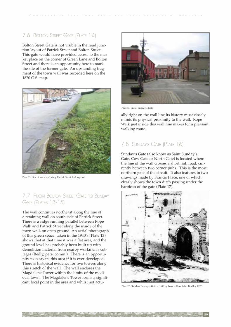
C O N S E R V A T I O N P L A N : T O W N W A L L S A N D O T H E R D E F E N C E S O F D R O G H E D A
7.6 BOLTON STREET GATE (PLATE 14)
Bolton Street Gate is not visible in the road junc-tion layout of Patrick Street and Bolton Street. This gate would have provided access to the mar-ket place on the corner of Green Lane and Bolton Street and there is an opportunity here to mark the site of the former gate. An upstanding frag-ment of the town wall was recorded here on the 1870 O.S. map.
7.7 FROM BOLTON STREET GATE TO SUNDAY GATE (PLATES 13-15)
The wall continues northeast along the line of a retaining wall on south side of Patrick Street. There is a ridge running parallel between Rope Walk and Patrick Street along the inside of the town wall, on open ground. An aerial photograph of this green space, taken in the 1940’s (Plate 13) shows that at that time it was a flat area, and the ground level has probably been built up with demolition material from nearby workmen’s cot-tages (Reilly, pers. comm.). There is an opportu-nity to excavate this area if it is ever developed. There is historical evidence for two towers along this stretch of the wall. The wall encloses the Magdalene Tower within the limits of the medi-eval town. The Magdalene Tower forms a signifi-cant focal point in the area and whilst not actu-
ally right on the wall line its history must closely mimic its physical proximity to the wall. Rope Walk just inside this wall line makes for a pleasant walking route.
7.8 SUNDAY’S GATE (PLATE 16)
Sunday’s Gate (also know as Saint Sunday’s Gate, Cow Gate or North Gate) is located where the line of the wall crosses a short link road, cur-rently between two corner pubs. This is the most northern gate of the circuit. It also features in two drawings made by Francis Place, one of which clearly shows the town ditch passing under the barbican of the gate (Plate 17).
59
Plate 17: Sketch of Sunday’s Gate, c. 1698 by Francis Place (after Bradley 1997)
Plate 15: Line of town wall along Patrick Street, looking east
Plate 16: Site of Sunday’s Gate

C O N S E R V A T I O N P L A N : T O W N W A L L S A N D O T H E R D E F E N C E S O F D R O G H E D A
There is a possible relationship between Sunday’s Gate and the Magdalene Dominican Friary and its associated hospital. There is no visible sign of Sunday’s Gate; however this presents an opportu-nity to describe this gate in a modern way.
7.9 FROM SUNDAY’S GATE TO TOOTING TOWER (PLATE 18)
This wall line has been completely lost within a modern building block. The 1870 O.S. map showed fragments of the town wall in the front gardens of Magdalene Street before reaching Tooting (or Shooting) Tower.
7.10 TOOTING TOWER
Tooting Tower is located at the junction of King Street and Rope Walk Upper, but is not visible at all above ground level. There is a large expanse of road junction here, which is the perfect space or opportunity for a modern description of town entrance.
7.11 KING STREET AND PALACE STREET (PLATES 19-21)
From Tooting Tower the wall turns south along the east side of King Street and Palace Street. This area is very suburban and the identity of the town wall is lost. The sites of the former Taylor’s Hall Tower and Pigeon Tower are both located along this stretch of the wall circuit. To the east of the town wall line there is a drop in the ground level of approximately 2-3m, which creates the sense of inside and outside the medieval town.
The Technical College, although in some disre-pair, is of architectural significance including its fine railings along the wall line. The site just to the south of the Technical College has a substan-tial block-work boundary wall, again describing the town wall line, but something could be done to enhance the look of this wall. These walls are important reminders of the original town wall.
King Street and Palace Street have a very attrac-tive street vista, looking north-south. The line of the wall can be clearly read up King Street even though it is not existent above ground. There are no surviving remnants of the town wall above ground, but the deep basements of the Georgian houses along this street are suggestive of the town ditch outside the wall and the redbrick terrace to the lower end of Palace Street shows a significant tilt backwards into the town ditch. There are clear signs of the drop of the embankment in open sites up the street. What appear to be the remains of the wall can be seen “outcropping” in an empty site halfway up the street opposite Albany Terrace (Plate 19). The foundation stones of the boundary wall plinth also have an unusual alignment (Plate 20). This site has planning permission for a new link road to Francis Street and archaeological test-ing on this site in June 2006 revealed a section of the town wall and ditch (Murphy 2006). The town wall exposed was 1.7m wide, and was used as a
60
Plate 18: Line of town wall in front gardens of cottages on Magdalene Street, looking east
Plate 20: Unusual stone work on King Street. Base of plinth is possible line of town wall
Plate 21: Possible town wall remains at King Street sitefor redevelopment
Plate 19: Line of town wall on east side of King Streetand Palace Street

C O N S E R V A T I O N P L A N : T O W N W A L L S A N D O T H E R D E F E N C E S O F D R O G H E D A
foundation for a later building. Approximately 10m east of the medieval wall a 7.2m wide ditch containing organic material and animal bone was found that could not be fully investigated at the time because of health and safety concerns. Further archaeological investigation at this site will be required in advance of the construction of the link road so there is a significant opportunity at this location to mark the line of the town wall in the new road and to provide information panels to alert the public to the presence of the town wall and associated ditch.
7.12 ST LAURENCE’S GATE (PLATES 22-23)
St Laurence’s Gate was located at the junction between Laurence Street and Palace Street. The original outer barbican still survives and appears well maintained since it was refurbished in 2002 by the Office of Public Works (OPW). Some crack-ing is noted to both inner walls over the doorways to each tower. This is not a major structural issue and as the cracks are located under the first arch they are not in danger of letting water into the wall fabric. It is suggested that long term moni-toring of the cracks is required. The barbican was connected to an inner gate on the town wall cir-cuit by a bridge over the town ditch (Reilly pers. comm.).
7.13 FROM FEATHERBED LANE TO BLIND GATE (PLATES 24-29)
A 21m section of the circuit between Laurence’s Gate and Blind Gate is mostly existent, and very well preserved along Featherbed Lane. The two arches at Featherbed Lane were also stabilised by the OPW, but the rest of this wall is not so stable with under-cut stones and the inclusion of an inappropriate modern gate. The wall is very over-grown and needs to have vegetation removed and a lot of repair work and re-pointing. It is currently
61
Plate 23: St Laurence’s Gate, looking east
Plate 26: Inappropriate repairs at doorway and corroding metal lintel Featherbed Lane
Plate 24: Vegetation on the outer face of the town wall, Featherbed Lane

C O N S E R V A T I O N P L A N : T O W N W A L L S A N D O T H E R D E F E N C E S O F D R O G H E D A
unconnected to the barbican. This means that the barbican of St Laurence’s Gate stands alone as an island and doesn’t have reference to the wall for which it was a gateway. Connecting it to the adjacent wall by demarking paving could help and as the paving in the immediate area is in poor
condition this could be an early action (Fig. 12). The line of the wall to the north also needs some marker to explain how St Laurence’s barbican relates to the circuit of the town wall.
The use or purpose of later brick arches at low level to the outer face immediately adjacent to Blind Gate is unclear. The wall near Blind Gate is over 6m high and probably being propped by the modern building and staircase built against the outer face. In 1997 archaeological testing was carried out in advance of the new development. Approximately 3m east of the town wall was a black layer that may be the remains of the town ditch (Deirdre Murphy 1998).
7.14 BLIND GATE (PLATE 30)
Where the line of the wall crosses Bachelor’s Lane the Blind Gate was located. A plaque set into a stone wall marks the location of the gate. This wall is in need of re-pointing works and removal of vegetation. Blind Gate was the first gate to be demolished and quarried for its stones, which were used to pave a way down to the river. The streetscape looking into town from Blind Gate has a medieval feel that could be enhanced.
7.15 FROM BLIND GATE TO ST CATHERINE’S GATE
This section of the medieval wall circuit has been lost within more recent building developments.
7.16 ST CATHERINE’S GATE
The town wall continues south towards the River Boyne, where St Catherine’s Gate, Drogheda-in-Louth’s most eastern defence, was located. The gate would originally have been spectacular, as the first view of Drogheda when approaching from the sea, but it requires vivid imagination to picture it now. There is no sense of the location of St Catherine’s Gate above ground, but the area has plenty of potential and could be “tidied up”, par-ticularly of car parking.
Testing by ACS Ltd in 1996 for the Drogheda Main Drainage and Wastewater Disposal Scheme at The Mall produced the remains of an extensive wall that appears to have been demolished in the 13th century. It is suggested that this may be the line of the earlier town defences, because it aligns to the early defences on the south side of the river at Curry’s Hill. Further east the later town wall defences and the east and west walls of a tower at St Catherine’s Gate were exposed. Archaeological evidence suggests that the gate was demolished in the 16th century (Murphy 1997b; 1998c).
62
Plate 29: Steps from Featherbed Lane to Blind Gate
Plate 27: Algae at Featherbed Lane

C O N S E R V A T I O N P L A N : T O W N W A L L S A N D O T H E R D E F E N C E S O F D R O G H E D A
7.17 NORTH QUAYS (PLATE 31)
The quay-side route is not accessible for its full length, but could be made so over a number of years providing good pedestrian access and amen-ity. Redevelopment of the remaining sites along the route will provide this opportunity. On the northern banks of the River Liffey in Dublin this was done to good effect by adding cantilevered board walks along the quays.
Early maps and drawings of the town showed the town wall with up to seven towers along the line of the river. There were also gates at either end of St Mary’s Bridge, the original link between Drogheda-in-Louth and Drogheda-in-Meath. In 1996 and 1997 testing of the Drogheda Main Drainage and Wastewater Disposal Scheme was undertaken by ACS Ltd at a number of locations along the north bank of the River Boyne. While a number of substantial quay walls were exposed the only tower or gate foundations uncovered were those of St Catherine’s Gate. In Murdock’s Yard car park a large section of wall was found, approximately 10m in from the current river’s edge. This wall was over 1m wide and Donald Murphy suggests that this is the first evidence for the existence of town wall along the river wall (Murphy 1997b; n.d). Murphy also believes that the extensive testing along the quays for the Drogheda Main Drainage Scheme proves that any defensive river wall would be located further north, under the buildings of Wellington Quay and the south side of Dyer Street (Murphy 1997a)
7.18 INNER C.1215 WALL
Evidence for the earliest town fortifications occur in James Street (south of the river) and Patrickswell Lane in Drogheda-in-Louth, approxi-mately 150m east of the current line of the town wall at Murdock’s Yard car park. An earthen bank with an outer ditch, measuring 6-7.5m wide, fol-lows the line of Patrickswell Lane (Halpin 1990). Testing in advance of excavation for the Garda Station development at the site of the former St Mary d’Urso priory uncovered a “rock-cut fosse or ditch” to the east of the site. The fill of the ditch was made up of rich organic material and followed the north-south line of Patrickswell Lane, which is the suggested location of the c.1215 town wall. Deposits overlying the bedrock included medieval pottery and 2 graves, dating this deposit to the 13th or 14th century. Halpin suggests “most likely by the end of the 13th century, the line of the town boundary was moved some 150m to the west of its present position, immediately to the east of the “Peace” Bridge. Thus the line of the old and new town boundaries to the east and west respectively created the limits of the abbey pre-cinct” (Halpin 1990: 41). However, this excavation found no evidence for a town wall.
A borehole near Patrickswell Lane, taken in 1994 as part of the Drogheda Main Drainage Scheme revealed similar deposits to those found 80m north by E. Halpin in 1989 and it has been sug-gested that this might be a continuation of the town ditch (Campbell 1995)
63
Plate 31: North quays board walk should continue along the river

C O N S E R V A T I O N P L A N : T O W N W A L L S A N D O T H E R D E F E N C E S O F D R O G H E D A
In 2001 test excavation was undertaken at 97 George’s Street. The boundary wall of the prop-erty has an unusual curve in the wall (Plate 12). This could be the remains of a tower, but it has also been suggested that it is a corner of the town wall, “prior to the enclosure of the northern sub-urbs in the mid-thirteenth century” (Shanahan 2001: 5). This is supported by a strong line of property boundaries north of Fair Street that con-tinue east towards King Street (Fig. 1). Further archaeological investigation along this alignment is warranted as the opportunity allows. This would suggest that the town walls were extended in two phases - firstly to the west to enclose the lands of St Mary d’Urso, and later the town’s defences enclosed the northern suburbs.
Drogheda in Meath
This section of the town walls circuit was walked in a clockwise direction from Scotch Hall.
7.19 SCOTCH HALL (PLATE 33)
Directly opposite St Catherine’s Gate, on the southern bank of the river was a tower. Depicted in the 1835 O.S. map, the tower is estimated to be 5m in diameter. The site was excavated by Thaddeus Breen in advance of development for the Scotch Hall shopping centre (Breen, pers. comm.). The location of a circular tower and a section of the town wall leading off from the tower was identified, and was marked during development by a not particularly well executed (or explained) contrasted paving to the northeast corner of the shopping complex. The general circular shape of the paved area, and the size con-cur with the estimate of the 1835 O.S. map, how-ever the meandering outline gives the paving an “amoeba-like” appearance. At Scotch Hall there
64
Plate 36 Aerial photo of the Mollies c. 1940’s. Note where the town wall turns out from eastern wall of St Mary’s

C O N S E R V A T I O N P L A N : T O W N W A L L S A N D O T H E R D E F E N C E S O F D R O G H E D A
is also a surviving section of medieval quay walls that is in need of assessment and repair (Plate 32).
7.20 FROM SCOTCH HALL TO ST JAMES GATE
From the tower at Scotch Hall the route heads south to James Street. A substantial portion of this wall was still extant on the 1870 O.S. map. In 2000 testing at Marsh Road and South Quay exposed a section of the town wall, confirming that it extend-ed from the north of James Street to the edge of the River Boyne (Quinn 2001). Further testing at another site on Marsh Road in 2001 revealed the foundation of a north-south orientated wall. The 7.4m long section of wall was constructed using squared limestone blocks (Quinn 2002). Four additional test trenches were opened in 2002, three of which contained sections of a multi-phased medieval wall. The earliest phase of the wall was identified as the town wall, approximately 0.78m wide and 0.3m deep. ‘The wall was constructed of roughly hewn, uncoursed stone bonded with a yellow/white, gritty mortar’ (Quinn 2004: 367). In Trench 2 the town wall was 1.8m wide and exposed to a depth of 0.75m and in Trench 4 the wall was 1.55m wide at the top and battered at the base. All of the sections of wall, identified as part of Drogheda’s medieval defences, were similar in style, orientation and construction quality (Quinn 2004). The alignments of both the later town wall and the earlier c.1215 defences have been lost within the Scotch Hall shopping centre.
7.21 ST JAMES GATE (PLATE 34)
St James Gate (also known as Dublin Gate) is approximately located at the junction of James Street and Mary Street. The location of St James Gate could perhaps be marked in some way to alert people to the fact that they are entering or exiting medieval Drogheda. In 1981 Kieran Campbell carried out an excavation, funded by the Royal Irish Academy. Near the entrance to Curry’s Hill a stone revetted bank, at the top of a 2.5m deep defensive ditch cut into bedrock, was found (Campbell 1987). Further east a 12m length of town wall was uncovered in advance of the
dual carriageway development. The wall was approximately 5.5m high and included three sup-ports for the wall-walk that ran along the interior of the wall. Also excavated was a lime kiln (pre-sumably for the construction of lime mortar), and a large two-roomed stone building that was der-elict by the 13th century. It is suggested that this building was the hospital of St James, and that the later town wall was possibly extended to the east to enclose the hospital (Campbell 1987).
7.22 FROM CURRY’S HILL TO THE MOLLIES (PLATES 35-40)
The line of the town wall is lost between St James’s Gate and the Mollies. It most likely fol-lows the line of the steep scarp of Curry’s Hill, before turning and cutting across Mary Street. Curry’s Hill is already a very pleasant walking route but still has room for significant improve-ments. The ascent up from the quays has a great feel to it although the finishes and step/ramp arrangements could be greatly improved (Fig. 14). The wall line is on the east side of this path and the steepness of the embankment can clearly be appreciated under the trees in the woodland to the east. There is a definite feel of being secure inside the town wall here although the wall here is undoubtedly not town wall. There is also a won-derful visual connection down to the quays.
A large number of stones at the top of Curry’s Hill suggest a possible location for the tower on this section of the wall (Reilly, pers. comm.). This section of the wall runs along the edge of a very
65
Plate 35: Curry’s Hill steps

C O N S E R V A T I O N P L A N : T O W N W A L L S A N D O T H E R D E F E N C E S O F D R O G H E D A
steep slope. The line of the wall turns south south-west and there is a level change by a drop to Mary Street. If a wall walk is developed a pedestrian crossing at Mary Street would be essential, linking with the steps rising approx 5m up onto Curry’s Hill. These steps appreciate the height of the town wall and climbing to cross the approximate wall line here gives a great sense of the scale of the edi-fice. A large portion of the town wall was removed to build Mary Street in the 1800s. Newcomen’s map shows the line of the wall running adjacent to Mary Street.
A new housing development of 5 two-bedroom apartments on Mary Street cuts across the wall alignment but the line of the wall was not evident during construction. The Mollies is currently a dead area that has great potential for develop-ment in the short-term. The town wall still exists at ground level and the outer face of the wall is still present in the slope down to the Dale. The concrete steps mark a corner where the town wall turns (Plate 37), so this area presents an opportu-nity to mark the line of the wall and create a sense of entering the medieval town by using hard land-scaping within the walled area, and maintaining the soft landscaping of the Dale (Fig. 15).
7.23 ST MARY’S CHURCH (PLATES 41-50)
The town wall bounds St Mary’s church and abbey (Church of Ireland) on its east and south sides and is the largest surviving section of the wall. On the internal southern wall there are seven stone sup-ports for the wall-walk (Plate 42). Arching but-tresses appear to have been a feature of the entire circuit.
The town wall presents exceptionally well within the church grounds. There is a long substantial stretch of the wall to the entire south boundary of the church and there is a lot of detail in this wall, including an additional “blind” gate. The abbey of St Nicholas was constructed against the eastern stretch of wall. The condition of the wall as seen from within the church grounds is poor. Although overall relatively stable there appears to be a constant loss of stones and an overgrowth of vegetation in and on the wall. There are also some large conifers close to the wall and, whilst two of these appear to be Scots Pines and are close to their mature size, two trees are of a non-native species and appear to have much more growing to do. These trees need to be properly assessed and their long term impact on the wall considered (Plate 42).
66
Plate 37: East wall of St Mary’s church is supported by gabion baskets at the Mollies, looking north. The concrete steps cross the line of the town wall
Plate 41: South wall at St Mary’s churchyard
Plate 42: Mature trees near south wall of St Mary’s churchyard

C O N S E R V A T I O N P L A N : T O W N W A L L S A N D O T H E R D E F E N C E S O F D R O G H E D A
The wall to the east side of the Church grounds appears relatively insig-nificant from within the grounds but in actual fact is very substantial and protects a large drop to the east face into the Dale. The wall here, being a substantial
retaining wall, has suffered from some movements and has been stabilized in recent times by the use of gabion baskets of stones to its outer base and rebuilt for much of its upper sections of bound-ary wall to the Church. There are still sections of this wall which lean significantly both into the church grounds and outwards. The long term sta-bility of these sections of wall is questionable and will need to be assessed and rectified in the near future.
There is evidence for the remains of a Tower at the southeast corner of St Mary’s, as it was mentioned by Cromwell in his letters about the siege where the town was “breeched on the east and south walls” on 11 September 1649. The wall also has a batter at the southeast corner, which supports the location of a tower here, however the remains of the wall today suggest that the tower wasn’t integrated into the original town wall construc-tion and may have been a later edition (Plate 48). A possible location for the southern breach has been identified at St Mary’s, where a section of the internal wall-walk no longer exists and appears to have been rebuilt in the past (Plate 45; Reilly, pers. comm.). As a part of the wall’s history it is acceptable to leave breach locations unfilled or filled with a protective fence only. The walls at St Mary’s have probably survived and been maintained because it is in the ownership of the church.
The outer face of the southern section of the wall is in the rear gardens of St Patrick’s Cottages. Since the town wall was built this outer face appears to have had a number of structures abutting it, as evidenced by a small lean-to, and numerous metal inclusions, including picture hooks (Plates 49 and 50). These additions are his-toric and should not be removed from the wall. The wall at this location is so thick that one previ-ous resident built their garden shed into the town wall.
The town wall is accessible at the green space at the end of the Rockville Estate. The other side of the “blind” gate of St Mary’s is visible, but clearly shows how much the ground level has been built up on this side of the wall (Plate 44). Any planned development or landscaping of this area would require an archaeological investigation.
67
Plate 44: St Mary’s “blind” gate, from Rockville Road. Note built up ground level
Plate 43: Open joints, deteriorated coping and vegetation at St Mary’s “blind” gate. Note gaps in stonework are Putlog holes used for scaffolding the wall when first built
Plate 46: Metal ties, vegetation and poor point-ing at St Mary’s
Plate 47: Cementicious pointing “buttered” on to stones at St Mary’s

C O N S E R V A T I O N P L A N : T O W N W A L L S A N D O T H E R D E F E N C E S O F D R O G H E D A
7.24 FROM ST MARY’S CHURCH TO DULEEK GATE (PLATES 51-54)
From St Mary’s church towards Duleek Street the line of the town wall is preserved in the prop-erty boundaries of Nos. 24 and 25 Duleek Street. One section of this boundary wall survives to full height, although it is completely overgrown
with vegetation on one side. Other sections of the boundary wall either survive at ground level or below ground level (Plate 51). The town wall appears to have been incorporated into the fabric of No. 24 Duleek Street (as noted by the unusual alignment of chimneys between these two ter-raced houses), and any future development of the property should take this into consideration (Plate 52). The boundary wall contains evidence of a collapsed arch and inside a lean-to shed attached to the wall at No. 25 there is another arch (Plate 53).
7.25 DULEEK GATE
Duleek Gate is first mentioned in the fourteenth century (Mills and McEnery 1916), but was demol-ished in 1780 by the Corporation, so the gate and walls no longer survive above ground (Swan 1992). Duleek Gate has been described as a “rec-tangular gate tower with an outside barbican, and that may have been a connecting structure span-ning a water-filled ditch or moat” (Swan 1992: 1). The petrol station has a detrimental visual impact on the area and the streetscape could well do with a revamp. Any rejuvenation may include the opportunity to present a new “gate”.
In 1989, 1992 and 1995 test excavation was under-taken by Leo Swan in advance of the petrol station development. One of the trenches “diagonally intersected a trench or ditch about 2m wide and over 0.9m in depth, with gently sloping sides and a shallow, U-shaped bottom” (Swan 1992). On the “outer edge” of the ditch were remnants of three possible timber stakes. Swan recorded that the fill was layered, mostly with “saturated organic mate-rial” and a lot of charcoal. Artefacts retrieved sug-gest that the ditch was open in the 14th century.
In 1995 an additional 10m section of the north-south aligned ditch, uncovered in 1989 (see above), was revealed. The ditch is approximately 8m inside the line of the wall that had been iden-tified on the Drogheda Urban Archaeological Survey (Bradley 1984). This section of the ditch terminated 9.5m inside the southern boundary of the site. The property boundary supposedly marks the line of the town wall and the ditch was located inside the town wall. Swan believes that Newcomen’s map shows an open water-filled ditch inside the town wall at this location (Swan 1992). D.L. Swan proposed that the ditch “may
68
Plate 48: Outer wall of St Mary’s in the rear garden of St Patrick’s Cottages. Possible tower site (far right)
Plate 49: Outer wall of St Mary’s in the rear garden of St Patrick’s Cottages. This section of the wall contains numerous historic inclusions
Plate 50: Detail of historic metal fixings in south wall at St Mary’s. Note also original lime mortar

C O N S E R V A T I O N P L A N : T O W N W A L L S A N D O T H E R D E F E N C E S O F D R O G H E D A
be as early as or perhaps even earlier than the town wall” (Swan 1995). The town wall itself was not found, which suggests that it may be aligned slightly further west, down the centre of Sarah Gibney’s Lane.
7.26 FROM DULEEK GATE TO MILLMOUNT (SARAH GIBNEY’S LANE; PLATES 55-57)
The eastern property boundaries of Sarah Gibney’s Lane have always been supposed as the line of the town wall, but excavation by Leo Swan at 90-93 Duleek Street suggests a slightly different alignment (see above). Two limestone boundary walls on the east side of the lane could possibly have been made from re-used town wall (Plate 55). Historically there is evidence for a tower location along this lane, and the 1870 O.S. map shows a distinct turn in the town wall. This area is very sparsely developed. A small fragment of town wall, or possibly a fragment of a tower, is located in the corner of a driveway (Reilly, pers. comm.; Plate 56)
During testing by CRDS Ltd in 1999 at 103 and 104 Duleek Street a number of irregular, loose stones were found at the rear boundary of No. 103 sitting directly on the subsoil, which has been interpreted as the possible rubble core of the town wall. West of the line of stones was a cut into the subsoil that could possibly be the town ditch but it was outside the development area and therefore not investigated. The rear boundary of No. 104 is a block wall, but the medieval wall either lies beneath or beside this modern wall (O’Carroll 2001). In the 1835 O.S. map the line of the town wall does not extend past No. 104 Duleek Street,
so it was presumably demolished to make way for the creation of Mount St Oliver. Mount St Oliver was only constructed when Millmount was remodelled during the Napoleonic “threat” (O’Carroll, 1999).
At the end of the laneway connecting Sarah Gibney’s Lane with Mount St Oliver a small frag-
69
Plate 53: Arch in lean-to shed at 25 Duleek Street Plate 54: Example of red lichen, 24 Duleek StreetPlate 52 Town wall under ivy between 24 and 25 Duleek Street, looking west. Note the alignment of the chimneys
Plate 56: Possible town wall or tower fragment in right corner of property boundary at Sarah Gibney’s Lane
Plate 57: Fragment of town wall secured in cement at the corner of Sarah Gibney’s Lane and Mount St Oliver

C O N S E R V A T I O N P L A N : T O W N W A L L S A N D O T H E R D E F E N C E S O F D R O G H E D A
ment of town wall survives at ground level, but is heavily cemented, and at first glance appears to be modern (Plate 57).
7.27 MILLMOUNT (PLATES 58-59)
The town walls that form the south boundary walls to the Millmount complex are highly evi-dent and present well, or have the near immediate potential to do so. A walk to the inside face of the town wall could be re-established very easily by making an opening in the cross wall to the rear of the Millmount complex buildings and clearing all the vegetation away. Establishing a wall walk in this area is highly desirable and compatible with the current museum use of the complex. The wall walk and the area immediately around the Millmount afford spectacular views of the town of Drogheda and surrounding countryside. There is also an additional “blind” gate that is not located on the preliminary maps (Plate 59). It seems like a small gate and could possibly have been formed later as service entrance to Millmount Barracks. The town wall around the Millmount area appears to be reasonably stable although in need of re-pointing, particularly the arch over the blocked gateway.
The wall viewed from the south side (outside the wall) also presents very well and can clearly be seen rising up behind the private garden of a house on Mount St Oliver. This property occu-pies a significant stretch along this outside face of the wall has recently been sold. There could be a
chance to redevelop this site as coach parking area for the Millmount (and re-open the old gateway) with an opportunity to fully display this section of the wall. The Borough Council should consider purchasing this property if the opportunity arises in the future.
A section of the Millmount wall continues to curve around the complex, but does not attach to the town wall and may form part of the defensive line of the original bailey.
7.28 WEST OF MILLMOUNT (PLATES 59-63)
There is a surviving section of the wall extending west from the curved Millmount wall. This wall can be seen from the rear access areas to the back of houses on Mount St Oliver. The wall end is exposed and unravelling and appears to be lean-ing somewhat. It is highly vulnerable to stone falls and attrition within the yard area in which it now stands. It is a particularly interesting sec-tion of wall because is shows two distinct phases of construction with an obvious construction join and different mortars (Plates 61 and 63). It is suggested that repairs to this end of the wall are required urgently to stabilise it. The solution may be to build a short stretch of return section in sig-nificantly different materials to demark the new. The original corner is close by, so it may be appro-priate to re-build on the actual corner point, there-fore an archaeological excavation at this location may be necessary. A little further eastwards and adjoining the Millmount complex the wall con-tains some curious long projecting lintel stones. The use or reason for these stones is not clear. These stones and the wall appear fragile and are in need of repair and weather capping. The town wall route then turns north towards Butter Gate.
70
Plate 59: “Blind” gate from outside Millmount complex
Plate 63 Construction join west of Millmount. Note the two different mortars used.

C O N S E R V A T I O N P L A N : T O W N W A L L S A N D O T H E R D E F E N C E S O F D R O G H E D A
7.29 BUTTER GATE (PLATES 64-68)
Butter Gate is also known as Buttress Gate and Bubeck Gate. Bradley (1997) thinks that the name Bubeck relates to the town that the gate led to. However, it was not a major road, more a path, so the reason for building such a large gate is unclear. There may be a possible associa-tion with St John’s Priory, but this has not been confirmed. One interesting theory suggests that burgage plots from the south quays cut off access to St John’s Gate in the late twelfth century and that the Butter Gate was created to provide direct access from Drogheda Castle (Millmount) out of the medieval town (Corcoran, 2002). The pres-ence of the burgage plots was confirmed during testing of the Drogheda Main Drainage Scheme in 1997 (Murphy 1998). The contours of the 1908 Ordnance Survey map suggest that the adjacent quarry, operating in the eighteenth and nineteenth centuries, was extended towards the Butter Gate and may account for the steep drop in bedrock surrounding the gate.
The lower level of Butter Gate remains but the town walls on either side are not surviving above ground. Fragments of the join between the town wall and gate are still evident on both the north and south (Plate 67) sides of the gate. There is no development currently on this land, but there are potential plans for future development. It is suggested that the line of the town wall be identified and retained as physical entity in any proposed works, be they park land or building development. Until recently the Butter Gate is heavily covered in vegetation, which has been
cut back, however the fabric of the gate is not currently stable. Inappropriate metal inclusions, cementicious repointing and graffiti are all present (Plates 66 and 68). Within the last 50 years the height of the Butter Gate has been almost halved when the stone was intentionally removed by the Corporation. A stone-by-stone condition survey should be undertaken as a matter of urgency, to ensure that no more of the gate is lost.
7.30 FROM BUTTER GATE TO ST JOHNS GATE (PLATE 69)
The town wall alignment was tested between Butter Gate and the John Street Dual Carriageway by ACS Ltd in 1996 during Drogheda Main Drainage and Wastewater Disposal Scheme. A section of the wall, approximately 1m wide, was revealed between Butter Gate to St John’s Gate. The wall was built into a bank of natural boul-der clay, so it was only faced on its eastern side (Murphy 1997b). The western face of the wall was removed during construction of a later wall
71
Plate 66: Butter Gate, looking west
Plate 67: Join of town wall to Butter Gate on south face
Plate 68: Metal inclusions, inappropriate repointing and vegetation at Butter Gate

C O N S E R V A T I O N P L A N : T O W N W A L L S A N D O T H E R D E F E N C E S O F D R O G H E D A
(Murphy; pers. comm.). There was also evidence for a ditch to the west of the wall (Murphy 1997b).
The wall that currently extends north from the Butter Gate is a later addition that removed the western face of the town wall and therefore is not considered to be town wall. An unusual outcrop at the base of this wall might be a fragment of the medieval defences (Plate 69)
7.31 ST JOHN’S GATE (PLATE 70)
St John’s Gate is non-existent above ground and its location lost in the tarmac of the dual car-riageway (Plate 70). Excavation in advance of the road widening exposed the gate, a section of the town wall and an outer ditch (Ó Floinn, 1977). Ricciardelli’s paintings suggest that St John’s Gate was a prominent rectangular structure (Plate 3).
7.32 FROM ST JOHN’S GATE TO SOUTH QUAYS
The line of the wall continues north to the edge of the River Boyne, but no visible remains of the wall survive above ground or in the line of boundary walls. Three phases of test trenching were carried out at Haymarket in 1998 by Margaret Gowen & Co. Ltd. as part of the Drogheda Town Centre Bridge development. The entire site was cut by a medieval quay wall that was approximately 15m inside the present quay wall. On the 1835 O.S. map the position of the town wall was intact at John Street. A large tannery was built on this site in the mid 19th century and the line of the wall was still evident within the tannery on the 1870 O.S. map. The tannery and any surviving sec-tions of the town wall were removed during con-struction of the dual carriageway. During Phase 1 of the testing a limestone wall, bonded with mortar was found along the line of the town wall (O’Donovan 2000). More masonry walls and a possible stone platform were discovered in Phase 2 of the testing. One of the walls was 1.2m wide and orientated north-south. It was constructed “from large limestone blocks and was bonded with a sandy, crumbly mortar” (Conway, 2001). A circular structure was located in one of the trench-es and is interpreted as the defensive tower where the town wall terminates at its junction with the
river. There was no clear evidence for a ditch or moat to the west of the line of the town wall.
Further excavation carried out in 1999 during Phase 4 of the project, determined that none of the masonry identified in the earlier phases of testing were of a medieval date. The wall within the tan-nery building that was orientated along the town wall was an internal division wall, although it is possible that it was built on the foundations of the medieval town wall (Conway, 2001).
7.32 SOUTH QUAYS (PLATE 32)
Newcomen shows southern quay walls on his map but there are no walls shown along the quays 100 years later in Ravell’s map. The only known towers on the southern quays are located where each length of the wall reached the River Boyne (Fig. 2). David Sweetman excavated up to the supposed line of the quay wall under St Mary’s Bridge, where he found several oak timber uprights that had been felled in 1185, but there was no definite evidence of defensive quay walls found (Sweetman 1984).
East of St Mary’s Bridge the south quays are read-ily pedestrian accessible and have become a good public amenity as part of the Scotch Hall shop-ping complex and the construction of the De Lacy Bridge. However closer inspection of the quay wall base, as visible at low tide, shows bad ero-sion of the stone work and mortar. It seems a pity that repairs of these quay walls were not made a requirement of the new development. All future quay-side developments should encourage repair of the quay walls. Further west there is little access to the quay-side. It may be less desirable to link these sites in the way that the north quays should be linked.
72

C O N S E R V A T I O N P L A N : T O W N W A L L S A N D O T H E R D E F E N C E S O F D R O G H E D A
BibliographyAllen, W.P., 1943, ‘Some old fortifications of Drogheda’, J Co Louth Archaeol Hist Soc, 10, 233-44Bradley, J., 1978, ‘The topography and layout of medieval Drogheda’, J Co Louth Archaeol Hist Soc, 19, 98-127Bradley, J., 1984, Urban Archaeology Survey; County Louth. Unpublished report: OPW, Dublin Bradley, J., 1995, Walled Towns in Ireland, DublinBradley, J., 1997, Drogheda: Its Topography and Medieval Layout. Old Drogheda Society, DroghedaSt John Brooks, E., 1936, Register of the Hospital of S. John the Baptist. DublinBrady, C., 2003. The medieval town walls of Drogheda, Heritage Guide No. 23 Bray: Wordwell LtdBuckley, V.M. 1986 The Archaeological Inventory of County Louth. The Office of Public Works, DublinBuckley, V. M., & Sweetman, P. D. 1991 The Archaeological Survey of County Louth. The Stationery Office, Dublin.Buvinda Historical Publications, n.d. Drogheda: A Walk in the Past. Drogheda: Buvinda Historical PublicationsCampbell, K., 1987, ‘The Archaeology of Medieval Drogheda’, Archaeology Ireland, 1(2). Bray: Wordwell Ltd.Campbell, K., 1995, ‘Drogheda Town, Co. Louth’, in Bennett, I. (ed.), Excavations 1994. Bray: Wordwell Ltd.Conway, M., 1999, Archaeological Assessment at 40 John Street, Drogheda, Co. Louth. Unpublished excavation report, Margaret Gowen & Co. LtdConway, M., 2000 ‘John Street, Drogheda’, in Bennett, I. (ed.), Excavations 1999. Bray: Wordwell Ltd.Conway, M., 2001, Archaeological Assessment at John Street, Drogheda, Co. Louth (01E1176). Unpublished excavation report, ACS Ltd.Corcoran, E. 2002, Archaeological Monitoring at John Street, Drogheda, Co. Louth (01E1176). Unpublished excavation report, ACS Ltd.Corcoran, M., n.d. Drogheda Tourist Trail: A sug-gested walking tour of Drogheda. Midlands & East Regional Tourism Authority
Dalton, J., 1844, History of Drogheda; with its Environs. 2 vols. DublinDrogheda Borough Council, 2005, Drogheda Borough Council Development Plan 2005-2011.Duffy, S., 1999, A History of Drogheda. Unpublished report, Margaret Gowen & Co. Ltd Garry, J., 1996, The Streets and Lanes of Drogheda. Drogheda.Garry, J. 1998, ‘Townland Survey of County Louth: Moneymore’, J Co Louth Archaeol Hist Soc, 24, 196-221Gogarty, T., 1915a, Council Book of the Corporation of Drogheda, vol. 1, 1649 to 1734. Drogheda (Reprinted 1988)Gogarty, T, 1915b, Council Book of the Corporation of Drogheda 1734-1809. Unpublished manuscript, Drogheda Public LibraryHalpin, E. 1990, ‘St Mary d’Urso, Drogheda, Co. Louth’, in Bennett, I. (ed.), Excavations 1989. Bray: Wordwell Ltd.Johnson, A.C., 1826, The History of DroghedaKerr, J. S., 1999 “Opening Address: The Conservation Plan” in K. Clarke (ed.) Conservation Plans in Action, Proceedings of the Oxford Conference English Heritage, LondonMac Iomhair, D., 1961, ‘Two old Drogheda chroni-cles’, J Co Louth Archaeol Hist Soc, 15, 88-95Mac Niocaill, G., 1964, Na Buirgéisí XII-XV Aois. 2 vols. DublinMaher, J., 1934 ‘Francis Place in Drogheda, Kilkenny and Waterford, Journal of the Royal Society of Antiquaries of Ireland.Mills, J. & McEnery, M.J., 1916, Calendar of the Gormanstown Register. DublinMurphy, Deirdre, 1997, Archaeological Assessment of a Proposed Commercial Development at Bachelor’s Lane, Drogheda, Co. Louth (97E0072; Planning Ref. 96/247). Unpublished excavation report, ACS Ltd.Murphy, Donald, 1996, Drogheda Main Drainage and Interceptor Sewer Project: Archaeological Investigation Interim Report, September 1996 (96E0160). Unpublished excavation report, ACS LtdMurphy, Donald, 1997a, Drogheda Main Drainage Interceptor Sewer and Waste Water Disposal Scheme: Archaeological Testing of Proposed Interceptor Sewer, March 1997 (96E0160). Unpublished excavation report, ACS Ltd
73

C O N S E R V A T I O N P L A N : T O W N W A L L S A N D O T H E R D E F E N C E S O F D R O G H E D A
Murphy, Donald, 1997b, ‘Moneymore, Drogheda, Co. Louth’, in Bennett, I. (ed.), Excavations 1996. Bray: Wordwell Ltd.Murphy, Donald, n.d., Drogheda Main Drainage and Waste Water Disposal Scheme Contract 2 North Bank and South Bank Interceptor Scheme: Assessment of Archaeological Post-Excavation work carried out on the Drogheda Main Drainage Scheme (96E0160). Unpublished excavation report, ACS LtdMurphy, Donald, 1998, ‘Moneymore, Drogheda, Co. Louth’, in Bennett, I. (ed.), Excavations 1997. Bray: Wordwell Ltd.Murphy, Donald, 2006, Archaeological Assessment, Palace Street/Francis Street Link Road, Drogheda. Unpublished excavation report, ACS Ltd O’Carroll, F., 2001, Archaeological Assessment of Proposed Development at 103/104 Duleek Street, Drogheda, Co. Louth (99E0399; Planning Ref. 99102). Unpublished excavation report, CRDS Ltd.O’Donovan, E., 2000, ‘Haymarket/John Street, Drogheda. Co. Louth’, in Bennett, I. (ed.), Excavations 1998. Bray: Wordwell Ltd.Ó Floinn, R., 1977, ‘John Street, Drogheda Town’, in T.G. Delany (ed) Excavations 1975-76. Belfast.Pavia, S & Bolton, J. 2000 Stone Brick & Mortar. Bray: Wordwell Ltd.Quinn, B., 2001, Report on the Archaeological Testing of a site at the South Quay/Marsh Road, Drogheda, Co. Louth (00E0729). Unpublished excavation report, Moore Ltd.Quinn, B., 2002, Report on Further Archaeological Testing of a site at the South Quay/Marsh Road, Drogheda (00E0729 ext.), Co. Louth. Unpublished excavation report, Moore Ltd.Reilly, T., 1995, Tracing Drogheda’s Medieval Walls. Drogheda Monuments Preservation Committee, DroghedaShanahan, B., 2001, Archaeological Assessment in Advance of Proposed Development at 97 George’s Street, Drogheda, Co. Louth (01E0558). Unpublished excavation report, CRDS Ltd.Swan, D.L., 1992, Report on Archaeological Excavations at Duleek Gate, Lagavoreen, Drogheda, Co. Louth (E000444; Planning Ref. 94/154). Unpublished excavation report, Archtech LtdSwan, D.L., 1995, Report on Archaeological Testing at 90-93 Duleek Street, Drogheda, Co. Louth (92E0016). Unpublished excavation report, Archtech Ltd.
Sweetman, P.D. ‘Archaeological Excavations at Shop Street, Drogheda, Co. Louth’, in Proc. Roy. Irish Acad. 84c, 171-224The Heritage Council, 2006 HYPERLINK "http://www.heritagecouncil.ie/walled_towns" http://www.heritagecouncil.ie/walled_towns, websiteThomas, A., 1975, ‘Drogheda, 1574’, J Co Louth Archaeol Hist Soc, 18, 179-86Thomas, A., 1992, The Walled Towns of Ireland. 2 vols. Dublin White, Newport B., 1943, Extents of Irish monastic possessions, 1540-1541. Dublin
74

C O N S E R V A T I O N P L A N : T O W N W A L L S A N D O T H E R D E F E N C E S O F D R O G H E D A
Appendix 1:
Specific recommendations in relation to care, maintenance and conservation of the fabric of the standing walls above ground and below ground (Fig. 1)
OVERVIEW The overall condition of each area of wall is described in this section. There are three main cat-egories to describe the overall condition:
CATEGORY 1: STRUCTURALLY UNSTABLESections of the wall categorised under this section are structurally unstable and require immediate stabilising works as well as a condition and struc-tural survey.
CATEGORY 2: STRUCTURALLY STABLESections of the wall in category 2 are structurally stable but require a condition survey to identify remedial works necessary to repair and maintain the wall in a good condition.
CATEGORY 3: REQUIRES MAINTENANCE PLAN IMPLEMENTATIONSections of the wall that are stable but require maintenance plan to be devised and implemented to sustain the condition.
Specific conditions found and best practice recom-mendations are examined in more detail below.
It is not the intention to rebuild or restore sec-tions of the wall, only to repair what is standing and secure structurally unstable areas. Works are only to be carried out where necessary. No works will be recommended for sound areas of the wall. Repointing of stones should only be carried out where evidence is provided that the stone is locat-ed in its historically correct location.
Later additions should be considered initially as having validity and a certain level of historical importance. Only elements that are seen to be damaging the stone structures should be recom-mended for removal.
All significant new work is to be recorded and be visually identifiable as such.
MURDOCK’S YARD CAR PARK
(BRIDGE OF PEACE) CATEGORY 2This section of wall slopes up hill away from the Boyne River bank beside the Bridge of Peace. The ground is much built up both sides of the wall however the line of the wall-walk and the defen-sive loops are very visible. The wall suffers from open joints, missing stones, poor brick and block-work repairs, atmospheric pollution, extensive graffiti and substantial plant life including a large tree. Attempts have been made previously to cap the wall in places with brick and tile and stone masonry copings but other areas have no coping. A suitable, consistent hard coping treatment is rec-ommended for this section of the wall. The lack of coping to the skyward surface of the wall is allow-ing water ingress to occur which is detrimental to the wall condition over the long term as it washes out pointing and encourages plant life which can cause structural instability in the wall. The patchy inconsistent repairs and extensive graffiti detract from the understanding and visual appreciation of this highly visible section of town wall.
FAIR STREET / GEORGE’S STREET CATEGORY 1There is one part of this wall that can be seen jut-ting between two buildings on Fair Street, other-wise this section of standing wall can only be seen within the buildings and rear gardens of the prop-erties on Fair Street and George’s Street. The parts within buildings are relatively well secured and are only likely to become vulnerable when rede-velopment of the attached buildings take place. The wall forming garden boundaries however is highly vulnerable and in one location at least has tumbled and in others has been put at risk by the close proximity of ground excavation for building extensions. The standing wall suffers from plant life, open joints, missing stones and lack of cop-ing. Repairs to fallen sections, protection of the wall top, control of ivy and other plant growth are required urgently. Stabilisation of excavations are also required to protect the wall from longer term erosion at the base.
ST LAURENCE’S GATE CATEGORY 3St Laurence’s Gate was restored by the Office of Public Works in 2002. It is found today in good condition however there are a number of elements which should be attended to before they dete-riorate any further. There are some small cracks
75

C O N S E R V A T I O N P L A N : T O W N W A L L S A N D O T H E R D E F E N C E S O F D R O G H E D A
on the reveals of the tower vehicle entrance. Because of their location there is little chance of water ingress nonetheless these cracks should be re-pointed and monitored over the long term. Gypsum crust has formed close to where vehicle exhausts emit carbon fumes as they are driven through the entrance.
FEATHERBED LANE TO BACHELORS LANE CATEGORY 2The section of town wall to the east side of Featherbed Lane is stable structurally but has numerous areas of open-joints, areas of cementi-cious pointing and inappropriate repairs. There is substantial plant life and its subsequent root damage is largely evident. There are also areas of heavy atmospheric staining and corroding metal elements including an ugly pipe at the entrance to the lane and a corroding lintel over the doorway through the wall. Damp can be seen penetrating the wall on the west side of the stepped walk and plant growth is particularly prolific to the east side coincidental with the ground level on the west side. The open joints to the base of the wall in the lane are likely to be as a result of surface water running down the lane. This erosion could be eradicated by locally relaying the road surface with slope away from the wall.
The wall drops dramatically down towards Bachelors Lane but does not diminish in height as it follows the dramatic change in ground level in this part of the town. The wall appears stable but in sections retains a significant height of ground at the south end of Featherbed Lane. The build-ing and staircase to the outer east face more than likely helps provide lateral stability to the wall. There are five brick arches to the lower part of the outer face added at a later date, the purpose of which is unclear. The stretch of wall above these arches adjoining the stairs has many brick infills, embedded timbers and cementicious pointing. The wall is capped with a modern in situ concrete coping. These conditions have resulted in a very disjointed and unappealing appearance. Another distraction is the unattractive concrete blockwork to the top of the wall facing onto Bachelors Lane immediately abutting this section of town wall.
QUAY WALLS CATEGORY 1The existing quay walls whilst not actually the medieval town wall, still consist of many sections of historic stone masonry which in places are very close to the alignment of the medieval quay walls. These walls are exposed to extreme levels of weathering from the seawater tides flowing up and down the river. Much of this masonry is badly eroded, particularly below the high water line. The washing out of the mortar has lead to stones becoming loosened thus allowing the tides to pluck stones from the walls. These walls are highly vulnerable to collapse if left un-maintained.
The most obvious section of masonry quay wall is that to the south quay at the new development of Scotch Hall. This wall appears in stark contrast to the modern development particularly at low tide when its poor condition becomes so visible. This wall appears to be the waterfront wall of a previ-ous quayside building. There is evidence of an arched opening and various drain outlets. There are substantial open joints, missing stones, bio-logical growth, atmospheric staining and gypsum crust. The cementicious coping, most of the mod-ern repairs and brick infill are historically incor-rect and aesthetically inappropriate.
ST MARY’S CATEGORY 1The south wall and approximately half the east wall bounding the curtilage of St Mary’s church and abbey is the town wall. As such it is the longest remaining standing section of town wall. The wall to the east side of the church grounds appears relatively insignificant from within the grounds but in actual fact is very substantial and protects a large drop to the east face into the Dale valley. The wall has suffered from some move-ments and has been stabilized in recent times by the use of gabion baskets of stones to its outer base and rebuilt for much of its upper sections of boundary wall to the Church. There are still sec-tions of this wall which lean significantly both into the church grounds and outwards. The long term stability of this wall is questionable and will require long term monitoring. The condition of the wall could be enhanced by ensuring that ground levels within the churchyard are not raised and
76

C O N S E R V A T I O N P L A N : T O W N W A L L S A N D O T H E R D E F E N C E S O F D R O G H E D A
that the lower medieval section is re-pointed using a lime based mortar.
The wall to the southeast corner and south of St Mary’s churchyard is extensively intact. There has been attrition to the wall top and there is one area in the middle of the south section which appears to have been rebuilt. This in-filled area is suspect-ed of being the south breach made by Cromwell. There are 7 piers or “Cannon Buttresses” with remains of segmental headed arches that were added to strengthen the wall against cannon use. These buttresses are not bonded into the wall and in places are becoming detached and are structur-ally unstable. There are five large trees within the grounds of the church, all within 3m of the wall. These trees should be assessed by a suitably quali-fied expert for an estimate of their lifespan and potential to fall. The solution may be to remove some of the trees and to reduce the canopy of oth-ers. The ground levels differ on either side of the wall by up to 2m. The ground levels should be managed to ensure that they do not become any greater and where possible the difference should be reduced. The wall has many open joints and missing stones. It lacks a coping to the skyward surface and suffers from overgrowth of vegeta-tion, especially ivy. Soft coping would be recom-mended for this section of the town walls. On the south elevation there many metal fixings and cementicious remains of outbuildings that were once attached to the wall. This section of wall is one of the most intact and structurally informative areas of remaining the town wall. A stone accurate condition and structural survey should be carried out when vegetation has been carefully clipped back.
DULEEK STREET - NOS. 24 AND 25 CATEGORY 2This greater than 20m length of standing wall is in private ownership and forms the boundary between houses number 24 and 25 Duleek Street. From what can be seen of the construction of No. 24, it would appear that the wall forms the south gable wall of the original house and the rear extension. The wall continues into the garden but is completely covered with ivy.
As with the wall at Fair / George’s Street the parts within buildings are relatively well secured and are only likely to become vulnerable when rede-
velopment of the attached building takes place. However the wall forming the garden boundary is highly vulnerable and as it continues eastwards towards St Mary’s has already been reduced to ground level
MILLMOUNT CATEGORY 2Much of the wall surrounding the south side of the Millmount complex is town wall, includ-ing a “blind” gate. By virtue of the fact that the wall formed part of this barracked area and is now a visitor’s centre it has not been completely neglected. However there are areas of open joints, cracked and dislodged stones, inappropriate in-fills of brick and blockwork, remains of cement fillers to previous lean-to buildings and a cement rendered in-fill to the “blind” gate. There is also cementicious pointing, atmospheric staining, detritus build and much overgrowth of vegeta-tion. There is no coping to the skyward surface and the garden landscaping to the outer south elevation is inappropriate in places, particularly at the “blind” gate. The jutting out stones at the southwest point of the complex may have been the supports for a timber sentry post. They now appear precarious and need investigation. This whole section of the wall requires clipping back of vegetation before a stone accurate condition survey is carried out to determine the full require-ments for conservation and repair.
WEST OF MILLMOUNT CATEGORY 1The wall is existent from the Millmount complex westwards to a point just short of the original southwest corner of the south loop of town wall. This wall can be seen in the rear yard to the back of houses on Mount St Oliver. The wall end is exposed and unravelling and leans somewhat. This wall exhibits an original construction joint in clear detail and its present condition is largely as a result of the erosion of the poorer quality earlier segment from under the later section that was built with a better quality mortar. This wall also appears to have a tapering wall top detail which may be close to the original wall top detail. The wall is much covered in vegetation towards Millmount and the condition is hard to discern here but it would appear that a large section has fallen where it immediately abuts the Millmount
77

C O N S E R V A T I O N P L A N : T O W N W A L L S A N D O T H E R D E F E N C E S O F D R O G H E D A
complex. This wall is highly vulnerable to stone falls and attrition and at high risk of a fatal vehic-ular knock within the yard area in which it now stands. Repairs are required urgently. The solution to stabilize might entail building a new section up to and around the original corner point to form a buttress. An archaeological dig would be neces-sary before this solution was adopted. Any repair works must also be preceded by clipping back of all vegetation to allow a full condition survey to be carried out. The detail of the construction joint and the differing mortars either side of the joint must be observed in any repair works.
BUTTER GATE
CATEGORY 2This gate was, sadly, much reduced in magnifi-cence in the last century because of concerns over falling masonry. The single storey part plan that remains is still of great interest. However the structure is much covered with vegetation, there is significant detritus build-up within the gate. There is corroding metalwork embedded in the masonry, cementicious pointing and graffiti along with exposed wall tops.
SPECIFIC CONDITIONS AND RECOMMENDATIONSEach recommendation for each standing sec-tion of the town wall has been considered in the light of the policies set out by the Conservation Plan, which are in line with the Burra and Venice Charters. These policies highlight the importance of respecting interventions of different periods. For example, the dismantling of elements may be considered, where they are structurally unsafe and may possibly jeopardise the stability of other sig-nificant elements.
DETRITUS BUILD UP (PLATES 42 AND 66)A build up of detritus, of leaves, general organic matter and rubbish, was noted to the walls par-ticularly at St Mary’s churchyard and Butter Gate. Some debris has become lodged in open-joints and cavities. Although mainly unsightly the presence of waste or litter in areas of the wall can encour-age animals to burrow looking for warmth or food which can further exacerbate the condition. All build up of detritus in the area of the wall should be cleaned out under the supervision of an archaeologist. A general maintenance plan should be put in place to keep the areas of the wall clean and free from rubbish.
OPEN-JOINTS (PLATES 7, 27 AND 61)Open-joints are evident to all sections of the town wall excepting St Laurence’s Gate. Open-joints between stonework occur when the mortar binder dissolves and the aggregate becomes detached, eventually falling away. The continued action of rainwater on exposed skyward surfaces such as buttresses, wall-walks and wall tops causes dis-solution of mortar. Open-joints are a breeding ground for plant life and allow water ingress into the substrate, causing erosion of mortar which results in stones becoming dislodged and the wall unstable. Open joints should be raked out using hand tools. The joints should be raked out to a suitable depth and repointed using a lime based pointing mor-tar. The joints should be hand finished slightly recessed with the stone surface and any excess removed. It is recommended that a contractor experienced in such work be employed to carry out the above.
POINTING (PLATES 47 AND 68)Lime mortars were in universal use up to the late eighteenth and early nineteenth centuries when experiments resulted in the development of cements for mortars and rendering. The popular-ity of cement mortars grew, due to their reduced working time compared with lime. With this new widespread use, cement products unfortunately began to be employed incorrectly on traditional and historic structures. These inappropriate mor-tars can be seen in many locations throughout the standing remains of the wall, notably at the Murdock’s Yard car park, adjacent to Bachelors Lane, the east wall of St Mary’s and Butter Gate.
Traditionally the lime mortar, which is softer than the stone, acted as a sacrificial framework, allowing moisture to escape easily and efficiently through the pointing. Cement based mortars with a high cement content can often be harder and more impenetrable to moisture than the stone. In these cases, water movement through the masonry increases. “As a consequence, salt dissolved in water can also travel through the masonry, increasing risk of salt attack. Also when masonry remains wet for long periods, pollutants easily adhere to and accumulate on the stone surface. Another damaging effect of combining permeable masonry with impermeable mortars is the wetting drying episodes in the masonry, which lead to an increase in mineral alteration and frost damage” (Pavia & Bolton, 2000: 127).
78

C O N S E R V A T I O N P L A N : T O W N W A L L S A N D O T H E R D E F E N C E S O F D R O G H E D A
Therefore these high volumes of moisture forced into the stone gradually break down the internal bond, eroding it away over time, while the point-ing remains intact and standing proud.
As the removal of cementicious pointing can dam-age the stone it is securely attached to, it is recom-mended that only areas of pointing that are loose or that are already failing should be raked out and repointed using an appropriate lime mortar and to an appropriate finish. It should be noted here that these areas of repointing will appear visually dif-ferent from surrounding areas of existing pointing and although this may not be aesthetically attrac-tive in the short term, the long-term benefits to the stone should take precedence.
Inappropriate pointing in the form of “buttered” pointing was noted to the east wall at St Mary’s and Butter Gate in particular (Plate 47). Traditional pointing is finished flush or slightly recessed from the surface of the stone but modern methods of pointing leave the edge of the mortar finished proud of the stone face. This type of raised point-ing is aesthetically disruptive and, more seriously, it allows water to lodge on top of any ledges thus setting up decay in the masonry.
Missing Stones and inappropriate In-fills (Plate 5)A number of areas of missing stones were noted along the town walls, particularly at the Murdock’s Yard car park, St Mary’s churchyard and Millmount. Missing stones create cavities in which moisture can penetrate and enter into the substrate. These cavities also provide ideal loca-tions for plant life to take hold. The plant life may then cause further damage and result in other adjacent stones becoming dislodged.Missing stones should be replaced in order to arrest any chance of water ingress to the inner substrate. Loose stones found close to the foot of the wall should be considered as replacement stones. A stonemason or bricklayer with conserva-tion expertise should carry out any replacement work.
In some areas missing stones have already been replaced but with bricks or concrete blocks, for instance at Murdock’s Yard car park and Millmount. Whilst if set in the appropriate mortar the use of clay or concrete items is not necessarily harmful to the wall, the work is visually unattrac-tive.
COPINGThere are many sections of the wall where the coping has been damaged or the wall top has been reduced in height and left without a coping. These areas require immediate repair, as prolonged moisture ingress will cause the rate of various decay mechanisms to increase.
Where inappropriate copings have been installed such as the cementicious coping at Bachelors Lane the detail should be revised as part of a long term plan (Plates 29-30).
There are many forms of coping and the treatment of each area needs to be considered individually, however a “joined up” treatment concept for sta-bilising and capping of the entire circuit should also be part of any decision regarding coping.
The original wall top may have had a tapered finishing out of the masonry as can be seen to the west of Millmount. The originality of the detail should be investigated, a detail as close to the original as possible should be reapplied rather than the development of a modern alterna-tive. There are some areas such as Featherbed to Bachelors Lane where abutting buildings may dictate an alternative detail such as a Slate cop-ing laid to a fall to direct the water away from the buildings. Where the current wall top is significantly reduced from the original height a “Soft Top” type coping may be the solution. This requires the consolidation of the top of the wall as found using a lime mortar then the introduction of sod seeded with native local grasses and wild-flowers. This sod absorbs and releases the rainwa-ter slowly and prevents concentrated amounts of water entering the wall tops. The wall will need to be inspected at regular maintenance intervals and the more vigorous plant types such as buddleia and ivy removed.
ATMOSPHERIC STAINING (PLATE 23)A concentration of black atmospheric staining arises at St Laurence’s Gate. Emissions such as sulphur dioxide, black smoke, lead and nitrogen oxides, are the common causes of atmospheric staining. These strongly influence the amount of soiling and subsequent decay of building materi-als. The concentration of this black atmospheric staining arises mainly along the medieval stone wall where a build up has occurred over the last
79

C O N S E R V A T I O N P L A N : T O W N W A L L S A N D O T H E R D E F E N C E S O F D R O G H E D A
few centuries. Carbon staining may also be the result of coal fires backed onto the wall during the time houses abutted sections of wall.
Atmospheric staining can be removed using a system and product, to be specified only after trial panels have been tested. Test panels help deter-mine the effectiveness of the cleaning method and the condition of the stone post application. Trials should be carried out in a visually unobtrusive location of the gate.
GYPSUM CRUSTGypsum crusts appear as protruding black deposits with irregular rough surfaces showing abundant folds and pores. They are formed when sulphuric acid, produced when fossil fuels such as coal, oil and gas are burned, reacting with the calcite in sandstone and mortar to form gypsum. Gypsum crusts exert an internal stress on the original material brought about by the crystal-lisation of gypsum and will over time replace the stone cements and mortar. Areas of gypsum crusts are noted to various locations but are especially noticeable on the inner walls of St Laurence’s Gate where there is a heavy presence of CO2 from the car exhausts.
A cleaner, to be specified after appropriate trials have been carried out, should be applied to areas of heavy gypsum crusts in order to remove them. If the crusts are not removed in this process, they should be removed mechanically. Again trial pan-els will determine which method is most suitable. Care must be taken not to unduly damage the sur-face of the stone or brick.
SULPHATION OF MORTARS (PLATE 40)Efflorescence occurs when mortar material is saturated with water in which there is substan-tial amount of soluble salts. The most common salts found in efflorescence are compounds of sulphates. As evaporation proceeds, the concentra-tion of salts increases at the surface of the material and the formation of growth crystals will often appear on the surface. Efflorescence itself does not physically damage the material because it is merely a deposition on the surface. Its presence does, however, compromise the aesthetic integrity of the fabric and signal the potential for damaging salt formation below the surface.
Where sulphation of mortars has occurred, like on the eastern elevation at St Mary’s church, the level
of moisture in the wall is high. Therefore areas close to mortar sulphation should be inspected for open-joints and poor coping. The crystal growth should be carefully brushed away with a bronze phosphorus brush and the joints raked out and repointed.
BIOLOGICAL GROWTHMosses and algae are commonly found on stone surfaces in Ireland. They occur on sheltered loca-tions with little direct sunlight. Mosses and algae can damage stone through penetration of their roots, by increasing the amount and duration of moisture held on the stone surface. The mosses can provide the nutrients for higher-order plants and facilitating possible mineral alteration of the stone surface. Concentrations of green moss and algae growth are found along weathering surfaces, coping, on ledges and in areas sheltered from the sun, particularly at Featherbed Lane (Plates 24 and 27).
Lichen is a form of biological growth that is typi-cally red, mustard, yellow or brilliant white in colour and thrives on airborne pollutants. Lichen feed on acidic rainwater and minerals contained within the stone. The lichen slowly breaks down the internal structure of the masonry, which weak-ens it for other forms of weathering. Material damage can also result from the repeated expan-sion and contraction of the lichens, which contain a high proportion of gelatinous material and can hold up to 300% of their dry weight in water. This retention of water may also increase absorption of atmospheric pollutants and water-induced decay processes.
Lichen can be found throughout the wall. The north elevations, which are normally more mois-tened than south elevations, not benefiting from the thermal radiation of the sun, show a higher concentration of lichen (Plate 54).
Moss, algae and lichen deposits must be removed mechanically in order to allow the surfaces of the stone to dry out. Any loose moss is to be brushed away. The colonisation of the algae, moss and lichen can then be treated with an appropriate bio-cide, which must be applied to the affected areas. The biocide will kill the growth penetrating to the roots, releasing any bond the biological growth has on the stone. As part of a sustained mainte-nance programme any accumulation of organic matter should not be allowed to remain.
80

C O N S E R V A T I O N P L A N : T O W N W A L L S A N D O T H E R D E F E N C E S O F D R O G H E D A
Vegetation is made possible by the continued availability of moisture and nutrients available in the surrounding building materials. Advanced plant life also requires a certain amount of shelter to develop. Plants can damage stone and brick walls by growing tendrils through the mortar joints of masonry, which dislodges the material and allows water penetration to the substrate. There are a number of areas of the wall where plant life is prolific. They occur in open-joints and on badly eroded weathering surfaces such as tops of wall and buttresses and can be found at George’s Street, Featherbed Lane, St Mary’s, Duleek Street, Millmount and Butter Gate (Plates 28, 46 and 66).
Vegetation should be clipped back only until such time as repair works are going to be carried out. Forced removal of the green plant life could result in increased plant growth and even the dislodge-ment of the stonework. When repair works are planned the vegetation can be treated with a bio-cide to kill the growth and the roots before careful removal.
All areas where plant life was treated with a biocide and removed should be checked for re-growth. If any re-growth is found a biocide should be reapplied in order to kill the growth and the roots before mechanical removal.
METAL FIXINGS (PLATES 46, 50 AND 68)Metal fixings can be seen embedded in the Town Walls at many locations including Featherbed Lane, St Mary’s, Millmount and Butter Gate. These ferrous fixings will deteriorate in time and the increase in volume as they corrode will caus-ing any adjoining masonry to spall and crack. As well as the resulting holes in the stone facilitating the penetration of moisture into the interior of the substrate corrosion of metal may discolour the stone with rust staining.
All redundant and corroded metal fixings should be investigated in order to determine their use and source. Generally metal fixings should be carefully removed from the stonework and the holes made good using a suitable mortar repair mixture. However there will be some areas, in particular to the south face of St Mary’s, where the metal fixings have a historic importance and should be retained (Plate 50).
GRAFFITI (PLATES 4 AND 5)There is only one area of the town walls where graffiti appears to be a significant problem and that is at the Wall adjacent to the Murdock’s Yard car park. Small amounts of graffiti were also noticed at the Dale elevation at St Mary’s and Butter Gate. Graffiti is not detrimental to the stonework in the walls, it is however aesthetically distracting.
Following any plant removal and cleaning for atmospheric staining a further inspection of graf-fiti should be carried out to determine whether or not a further cleaning method would be necessary. If it is still necessary trials should be carried out before any chemical cleaning agent is specified.
TIMBER (PLATE 7)Bonding timbers were noted in the wall at Featherbed Lane and Murdock’s Yard car park. These timbers have a historical significance relat-ing to an earlier use of the wall when it formed an internal face of a building. Timbers have become sodden and suffer from wet rot. Once a timber becomes friable the masonry above can suffer from lack of support. However unlike ferrous metal fixings the erosion process is not likely to cause cracking of the wall fabric.
Only the rotten bonding timbers present in the wall should be removed. As they have a historical significance relating to an earlier use of the wall it is suggested that all rotten timbers are replaced with slate in lime mortar to mark the historic “eaves lines”.
There are sections of wall at ground level, these occur at:
• Patrick Street • King Street (surface masonry found at this location) • Duleek Street boundary wall of nos. 24/25 • Sarah Gibney’s Lane - two locations
In all these locations the wall has been reduced in height and left uncapped. The mortar holding the stones in place has been and continues to be erod-ed and in some locations has been “cemented” together with concrete.
81

C O N S E R V A T I O N P L A N : T O W N W A L L S A N D O T H E R D E F E N C E S O F D R O G H E D A
These sections of the town wall need to be con-solidated and protected. The option to bury them should not be ignored but the accessibility and understanding would be better achieved by stabil-ising and protecting in a visually cohesive manner. This would promote recognition of and interest in the town walls.
Consolidating and protecting the “at ground level” wall should be carried out by experienced stone masons and archaeologists. The works will require a method statement detailing how the wall will be stripped of vegetation, detritus and loose mortar. The method of marking stones, removing and placing in the work area ready for reassembly also needs to be carefully thought through. The facing stones should be clearly marked with face and surface as found and reused in as close a posi-tion as possible. Core stones may possibly follow a less rigorous procedure. The stones should be re-bedded in a lime mortar and the wall built back to an even height using all the existing stones.
The detail prior to capping may then require addi-tional build to bring to agreed level. This should use Calp limestone from the Drogheda area of similar form to the original wall stones. A marker barrier such as a layer of geotextile fab-ric should be inserted between existent and newly acquired stone whether that be wall stone or the capping detail. All new stones and capping stones should also be set in lime mortar.
The capping stones should be large stones that are difficult to remove or knock out of place. They should preferably be of the local limestone and detailed and set to reduce any concentrations of water arriving at the wall face. These stones could be finished in such a way to reflect or even call up “town wall” in the tooling.
82
Appendix 2:
SPECIFIC RECOMMENDATIONS IN RELATION TO CARE, MAINTENANCE AND CONSERVATION OF THE FABRIC OF THE TOWN WALLS REMAINING AT GROUND LEVEL.

C O N S E R V A T I O N P L A N : T O W N W A L L S A N D O T H E R D E F E N C E S O F D R O G H E D A
This report contains a series of observations on the planning context for the protection, conservation, enhancement and promotion of the town walls and defences in Drogheda.
THE DEVELOPMENT PLANThe current Development Plan for the Borough of Drogheda is the Drogheda Borough Council Development Plan 2005-2011, which was adopted by Drogheda Town Council in 2005. This plan contains a strategy for the development over a six-year period together with development policies and zoning objectives which constitute material considerations in deciding on individual applica-tions for planning permission.
STRATEGIC POLICY CONTEXT FOR THE PROTECTION OF ARCHAEOLOGICAL HERITAGEChapter 1 of the Development Plan (Introduction and Overview) contains an account of the his-torical development of the urban fabric of the town (Section 1.6). This deals with the physical development of the town and includes a map of the medieval town, including the suggested line of the town wall. This account also lists the principal archaeological remains and upstanding monuments associated with the town’s defenc-es. However, Chapter 2 of the plan (Strategic Context), which sets out the broad policy frame-work for the remainder of the plan, does not fea-ture the archaeological heritage as a key determin-ing factor in the future development of the town. The emphasis that was placed on the archaeologi-cal heritage in Chapter 1 is, therefore, not fol-lowed through to Chapter 2. Chapter 2 contains references to a number of international, national and local policy documents and statistical trends that have been used to inform and guide the for-mulation of policy in the plan. It omits, however, a strategic context for the protection of the archaeo-logical heritage. Such a context can be found at a national level in the National Heritage Plan and at an international level in agreements such as the Valetta Convention (Council of Europe, 1992). The absence of a mention of these documents in Chapter 2 does not mean, however, that the plan
is completely devoid of a broader strategic vision for the archaeological heritage of the town. Section 11.9 in the Built Heritage chapter (Chapter 11) states that developers should ‘take due cognisance of the Bruges Resolution on the Conservation of Smaller Historic Towns, (1975). However, the absence of strategic framework for the archaeo-logical heritage in Chapter 2 is a weakness in the plan that could be remedied in future plans with the insertion of a section in Chapter 2 which sets out the strategic policy context for the protection of the archaeological heritage. This section could include references to the European Convention for the Protection of the Archaeological Heritage, Valetta, 1992, (Valetta Convention) [this is referred to in Section 11.6 (p.149) for the purpose of pro-viding a definition for the archaeological herit-age], the Granada Convention and Venice Charter which relate to the protection of the architectural heritage, the Bruges Resolution (1975) and the National Heritage Plan. Reference should also be made to the Louth County Heritage Plan and to the Town Walls Conservation Plan once these pol-icy documents have been prepared. In addition, the conservation of the cultural heritage should also be mentioned in the section on sustainable development (Section 2.7).
VISION FOR THE ARCHAEOLOGICAL HERITAGEThe policies relating to the archaeological herit-age are generally protectionist in nature and do not attempt to put forward a vision for the future of the archaeological resource within the con-text of the development of the town. However, the enhancement of the setting of archaeological monuments is mentioned in General Policy (Bullet Point 1, p.149): “to protect and enhance archaeo-logical monuments and their settings including town walls, towers, town embankments and ditch-es, town gates, bastions or ancillary fortifications”. The plan makes a strong connection between the conservation of the archaeological heritage and the need for a comprehensive townscape manage-ment (section 11.1). This provides the main link between the conservation policies in the plan and the town centre policies, which is important if development in the town is to be conservation-led.
83
Appendix 3: Planning Report

C O N S E R V A T I O N P L A N : T O W N W A L L S A N D O T H E R D E F E N C E S O F D R O G H E D A
POLICY CONTENT
ARCHAEOLOGICAL HERITAGE
(CHAPTER 11: THE BUILT HERITAGE)The Drogheda Borough Council Development Plan 2005-2011, contains a number of policies relating specifically to the protection of the town walls of Drogheda. These policies are generally robust and comprehensive in their scope, provid-ing a high level of protection for the archaeologi-cal resource. In particular, the Plan states that:
“it will be the general policy of the Drogheda Borough Council to apply the following principles to the archaeological heritage:
To protect and enhance archaeological monuments and their settings including town walls, towers, town embankments and ditches, town gates, bas-tions or ancillary fortifications ” (Bullet Point 1, p.149).
The Plan also includes an Archaeological and Natural Heritage Map at Appendix 3 which indi-cates 77 recorded monuments and areas of archae-ological potential within the Borough. The follow-ing policies relate to these sites and monuments:
Any proposed development, that may due to the location, size or nature, have implications for the archaeological heritage, will be referred to the Department of the Environment, Heritage and Local Government for comment. This applies to National Monuments in the care of the Minister, archaeological and architectural monuments and sites in the Record of Monuments and Places and Zones of Archaeological Potential.It is the duty of the Planning Authorities to oppose on archaeological grounds any works that are considered to be harmful to recorded monu-ments or the integrity of their settings.
The value and significance of this archaeological heritage is acknowledged by Drogheda Borough Council and through their policies they seek to ensure the effective protection, conservation and enhancement of archaeological sites, monuments and their settings.” (p.150).
TOWN CENTRE (CHAPTER 10)The Town Centre (TC) zoning objective com-prises approximately the southern two-thirds
of the northern circuit and the northern edge of the southern circuit. The use of the term ‘Town Centre’ to describe a zoning objective may be seen as slightly misleading in this context, as it refers predominately to a mixed-use zoning objective within the commercial centre of the town, rather than zoning objectives that relate specifically to the geographical centre of the town. That aside, the main shopping area is stated in the plan as having:
“traditionally been concentrated on West Street and its environs to the south and east, including Laurence’s Street, Peter Street, Shop Street and Dyer Street. In the recent past the town centre also operated to the south of the river in the area around The Bullring and James Street……The role of the southern portion of the Town Centre will become increasingly important during the life of the Plan as significant new retail development are completed in the South Quay / Marsh Road area”(p.130).
It is noted that the Scotch Hall retail development was completed towards the end of 2005.
The town centre policies, in general, pay due regard to the need to protect the archaeological resource and the character, quality and distinctive-ness of the historic core of the town. In particular, the Town Centre policies nos. 4, 5, 8 & 10 encour-age the consideration of the archaeological herit-age in the redevelopment of the town centre (pp. 138-140).
TOURISM (CHAPTER 12)Chapter 12 contains the tourism policies in the Development Plan. St Laurence’s Gate and the remains of the town walls are, inter alia, acknowl-edged as key features of the tourism product of the town. However, apart from St Laurence’s Gate and Millmount, the remains of the walls and their associated features are not in themselves a signifi-cant tourist attraction. That said, the importance of the town wall circuit in establishing an identifi-able historic core of the town, which contains a distinct street pattern, and the contribution this can make to the historical understanding of the town’s development, cannot be overestimated and should be capitalised upon in any future tourism promotion initiatives for the town. In this sense, both the upstanding remains of the walls and the line of the circuit can contribute positively to cre-
84

C O N S E R V A T I O N P L A N : T O W N W A L L S A N D O T H E R D E F E N C E S O F D R O G H E D A
ating a distinct visual entity for the historic core of the town. The current lack of clarity and legibility of the town wall circuit should be acknowledged as a weakness in the tourism product of the town in any review of this chapter of the Development Plan.
It is stated in the plan that “whilst detailed plans and strategies for tourism are not within the mandate of the Development Plan, the Council will, nevertheless, contribute to tourism develop-ment”. Given that, the five tourism objectives in the plan (TOU1 – TOU5) are quite general and could be strengthened by referring to a number of the individual tourism products listed on page 158, including Millmount, St Laurence’s Gate and the remains of the town walls. Furthermore, the content of these five objectives does not follow on sequentially from the specific issues identified in the discussion section of this chapter.
As mentioned earlier, apart from Millmount and St Laurence’s Gate, the town walls are unlikely to constitute a significant tourist attraction in their own right. In tourism terms, therefore, the upstanding remains of the walls and the line of the circuit should play a supporting role to these more significant upstanding monuments, provid-ing them with an historical context and providing the medieval town with greater definition.
CROSS COMPLIANCEDespite the absence of a strong statement of strat-egy relating to the cultural heritage in Chapter 2 of the Plan, the Plan displays a high level of cross compliance between the policies relating to the protection of the archaeological heritage and those relating to the development of the town centre. In particular, the Town Centre policies nos. 4, 5, 8 & 10 encourage the consideration of the archaeologi-cal heritage in the redevelopment of the town cen-tre (pp. 138-140). There is less policy convergence between the policies governing housing and those governing the protection of the archaeological heritage, with a need for qualification of the hous-ing policies to ensure that their implementation does not compromise the integrity or setting of the town’s former defences.
URBAN REGENERATIONThe plan designates two Urban Opportunity Areas, both of which are identified as suffering from dereliction and urban decay but ‘have the potential to act as catalysts for area wide redevel-
opment and regeneration’ (10.12). It is the objec-tive of the Council to promote the regeneration of these areas in partnership with the private sector. The two areas are Old Abbey Lane and the Backlanes. The Old Abbey Lane area is bounded by and inclusive of Narrow West Street to the north, Patrickswell Lane to the East, the Garda Station boundary to the south and the existing perimeter wall to the West. The Backlanes area is bounded by and inclusive of the southern side of St Laurence’s Street, the eastern side of Shop Street, the western side of Constitution Hill and North Quay / The Mall to the south. The Backlanes area in particular, is dissected by the line of the town wall approximately 20m from and parallel to Constitution Hill and the southern perimeter of the northern circuit is also within this Opportunity Area, running along North Quay / The Mall.
ZONING OBJECTIVESThere are fifteen separate zoning objectives con-tained in the Development Plan (14.2). The circuit of the town walls and its enclosed area is associ-ated with seven separate zoning objectives as fol-lows:
RE Residential existing: To protect and/or improve the amenity of developed residential communities.TC Town Centre: To protect and enhance the special physical and social character of the exist-ing town centre and to provide for new and improved town centre facilities and uses.IQDA Inner Quays Development Area: To provide for major new town centre activities in accordance with an approved local area plan and subject to the provision of necessary physical infrastructure.CCI Civic Community & Institutional: To pro-vide and protect necessary community, recreation-al and educational facilities.NC Neighbourhood Centres: To protect, pro-vide for and improve Local Shopping Facilities in order to create and retain a vibrant and sustain-able Neighbourhood Centre to serve Primarily Local Needs.LPS Local Primary Shops: To protect, provide for and improve local shopping facilities in order to provide facilities for a residential neighbour-hood.OS Open Space and Recreational Area (Public/Private): To provide for and / or improve open space and recreational amenities.
85

C O N S E R V A T I O N P L A N : T O W N W A L L S A N D O T H E R D E F E N C E S O F D R O G H E D A
The predominant zoning objectives within the northern circuit of the wall are Town Centre (TC), with Residential Existing (RE) and Open Space and Recreational Area (OS) within the northern one third. The predominant zoning objectives within the southern circuit of the wall are Residential Existing (RE), with Town Centre (TC) along the quays to the north, Open Space and Recreational Area (OS) to the west and Civic Community and Institutional (CCI) within the Millmount complex. These zoning objectives as they relate to the circuit of the town wall are illus-trated at Appendix One.
As stated earlier, the policies governing the Town Centre zoning display a high level of cross-compliance with the Built Heritage policies and include a number of policy statements which are designed to ensure that future development respects the existing character and distinctiveness of the townscape and streetscapes of Drogheda:
TC5: To ensure that refurbishment and redevel-opment proposals contribute to the environmental quality, and have regard to the character of the Town Centre, and do not result in damage to the town’s archaeological or architectural heritage.
TC6: To retain and enhance the existing street pattern, to encourage the retention and refurbish-ment of existing buildings of character, and to continue to upgrade the physical environment of the Town Centre’s streets and urban / civic spac-es.
TC10: To maintain and enhance the environmen-tal quality and physical appearance of the town centre, in terms of the built environment, urban spaces, streets and laneways, in order to create an attractive and user friendly environment.
However, the policies governing the Residential (RE) and Open Space (OS) zonings do not display the same degree of cross compliance with the Built Heritage policies. They do not contain any caveats to ensure that the town wall circuit and the char-acter of its enclosing space will be respected in the implementation of its zoning objectives.
This means that the protection and conservation of the historic morphology and built character of the primarily residential areas to the north of the northern circuit and within all of the south-ern with the exception of the quays and the
Millmount complex, are at risk from the lack of a strategic vision governing the future development of the morphology and grain of the urban fabric.
It is suggested that in any review of the Development Plan, that all zoning objectives located within the town wall circuit should con-tain specific policy statements relating to the maintenance and enhancement of the physical characteristics of the historic town within the walled circuit, as manifested in the morphology and grain of the historic built environment. It is recommended that in any review of the plan that consideration be given to changing the title of the ‘Town Centre’ zoning to ‘Mixed Use’ (or equiva-lent) and the introduction of a second tier of zon-ing for the area within and including the circuit of the town walls which could be called ‘Historic Town Centre’. While it is acknowledged that this is already achieved in part by the designation of the Zone of Archaeological Potential, it is consid-ered that additional policies could be grouped together under such a zoning objective which would include the manner in which the morphol-ogy and grain of the urban area, together with the townscape and streetscape would be dealt with.
HIGHLIGHTING THE LINE OF THE WALLThere is no policy contained in the Plan, nor has any attempt been made to date, to mark the line of the wall on the paving around the town. This is a feature that has been used to good effect in Dublin and Waterford and has the effect of drawing atten-tion to the former line of the town wall. This is an opportunity that could be taken whenever any municipal paving works are being carried out or such a provision could be attached as a condition to a grant of planning permission in respect of pri-vate developments.DEVELOPMENT CONTROL
RECENT DEVELOPMENTSDrogheda, like most provincial towns of its size, has been the subject of intense urban development over the past ten years in particular. Within the town centre, this has manifested itself primarily in the form of the infilling of vacant sites and the rehabilitation of disused industrial buildings. A number of recent developments are notable due to their proximity to the town wall and the manner in which they have addressed the town wall.
Foremost among these is the Scotch Hall mixed-use development at the South Mall / Marsh Road,
86

C O N S E R V A T I O N P L A N : T O W N W A L L S A N D O T H E R D E F E N C E S O F D R O G H E D A
which also included a new bridge connecting the development to the North Mall. The main build-ing mass straddles the eastern perimeter of the southern circuit. As this site had been previously occupied by an intensive industrial use, there were no traces of the town wall above ground. While the development itself, through the positioning of windows, affords some fine and hitherto unseen perspectives of the town, the opportunity was not taken to raise awareness of the fact that the building is bisected by the line of the town wall. However, the development involved the conserva-tion of part of the quayside wall along the south bank. The new bridge connecting Scotch Hall to the North Mall does not, however, integrate well with the existing quay wall. No attempt has been made to match materials and insertion of the mass concrete base of the bridge alongside the existing stone quay wall results in an uneasy juxtaposition which is clearly visible from the North Mall.
An opportunity also exists for the preparation of a landscape plan north of the Dublin Road and to the west of the buildings fronting onto Mary Street.
A potential residential and office development on an infill site on Mary Street, near the junction with James Street / Dublin Road, also offers an oppor-tunity to mark the line of the wall in any new pav-ing on the site.
There is also the possibility of developing a Greenway linking James Street (on the eastern side of Donore Road across from the bus station) with the Buttergate and on up to Millmount. There is a portion of the town wall extant close to James Street which could be incorporated into the Greenway and allowing the route to follow the line of the former wall.
A sample of other notable planning applications which have been lodged within the past five years are as follows:
Planning application Reg. Ref. 05/232Applicant: Vincent and John McDonald, 9A-11 Magdalene Street, Drogheda.Site: Corner of Magdalene Street and Green LaneThis site was occupied by the recently demol-ished Brannigan’s Pub. The site is now clear and is awaiting a decision on the planning application which is at Further Information stage.
Brannigan’s Public House and two adjacent dwell-ings to the south were demolished and the pro-posed development involves the construction of a three-storey structure with recessed penthouse level, four-storeys over part basement mixed use development with two-storey recessed arcade and projecting window to and four pedestrian access points from Magdalene St (overall develop-ment circa 2180m2) consisting of a basement with stores/toilets for public house and restaurant, public house with associated kitchen (512m2 over two floors) ground floor with a rear semi-covered outdoor terrace (98m2), restaurant and associ-ated services at 1st level (472m2 over two floors), second floor office space (430m2), third floor office space with recessed balcony overlooking Magdalene St and raised roof level to rear at north west corner overlooking adjacent rear courtyard both top floors forming a central external court-yard (409m2) roof access stairwell roof screens roof top plant/services and equipment and all associated site works.This site is bounded by the possible line of the earlier town wall c. 1215 and an opportunity may exist to mark the line of the former wall in the new paving.
Planning application Reg. Ref. 01/227 Applicant: Thomas Doyle, Mount St Oliver, Millmount.Site: Immediately south of Millmount.Planning permission granted for three dwellings. These three dwellings have been constructed and are located immediately south of Millmount and backing onto the western perimeter of the former town wall.
Planning application Reg. Ref. 04/91 Applicant: Robert TaylorSite: No. 27 Mary StreetThis development, which has been granted plan-ning permission and constructed, involved the demolition of a house and construction of five apartments. An archaeological excavation was undertaken but the town wall was not directly impacted upon.
Planning Application Reg. Ref. 01/151 & 03/263Applicant: Pat NevilleSite: Old Mart Site, bounded by Magdalene Street and Green Lane.This is a mixed-use development (residential, office and retail) which is presently under con-
87

C O N S E R V A T I O N P L A N : T O W N W A L L S A N D O T H E R D E F E N C E S O F D R O G H E D A
struction. The site is bounded by the possible line of the earlier town wall c. 1215.
SIGNIFICANT FORTHCOMING DEVELOPMENTSSeveral developments that are currently being discussed or planned and would need to take into consideration the implications for the line of the town wall. Two of these sites offer opportuni-ties for raising awareness about the town wall. One is a new access road linking the King Street entrance of the new retail development (fronting onto William Street) with the site to the south of St Oliver’s VEC School on King Street. This access road would cut across the line of the town wall along the eastern side of King Street and would provide an opportunity to mark the line of the town wall in the new ground surface, following appropriate archaeological excavation.
The second possible development is located to the south of Narrow West Street and immedi-ately east of the Bridge of Peace, and contains an upstanding section of town wall. The site, known as Murdock’s Yard, is currently used as a car park. Any redevelopment of this site would have to respect the extant portion of town wall ensuring that the immediate setting of the wall was not negatively impacted upon and that both sides of the wall are made accessible to the public. In the interest of security this public space would need to be managed.
88
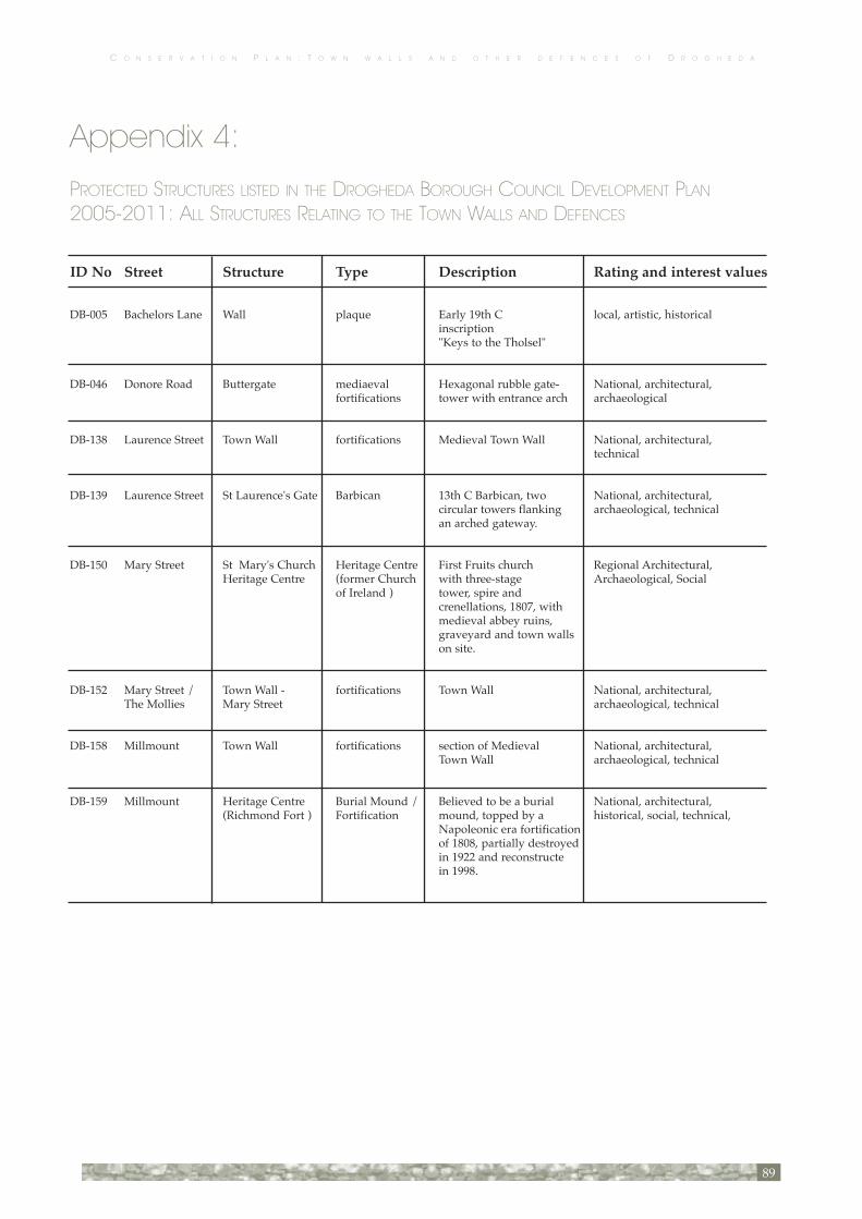
C O N S E R V A T I O N P L A N : T O W N W A L L S A N D O T H E R D E F E N C E S O F D R O G H E D A
89
Appendix 4:
PROTECTED STRUCTURES LISTED IN THE DROGHEDA BOROUGH COUNCIL DEVELOPMENT PLAN 2005-2011: ALL STRUCTURES RELATING TO THE TOWN WALLS AND DEFENCES
ID No Street Structure Type Description Rating and interest values
DB-005 Bachelors Lane Wall plaque Early 19th C local, artistic, historical inscription "Keys to the Tholsel"
DB-046 Donore Road Buttergate mediaeval Hexagonal rubble gate- National, architectural, fortifications tower with entrance arch archaeological
DB-138 Laurence Street Town Wall fortifications Medieval Town Wall National, architectural, technical
DB-139 Laurence Street St Laurence's Gate Barbican 13th C Barbican, two National, architectural, circular towers flanking archaeological, technical an arched gateway.
DB-150 Mary Street St Mary's Church Heritage Centre First Fruits church Regional Architectural, Heritage Centre (former Church with three-stage Archaeological, Social of Ireland ) tower, spire and crenellations, 1807, with medieval abbey ruins, graveyard and town walls on site.
DB-152 Mary Street / Town Wall - fortifications Town Wall National, architectural, The Mollies Mary Street archaeological, technical
DB-158 Millmount Town Wall fortifications section of Medieval National, architectural, Town Wall archaeological, technical
DB-159 Millmount Heritage Centre Burial Mound / Believed to be a burial National, architectural, (Richmond Fort ) Fortification mound, topped by a historical, social, technical, Napoleonic era fortification of 1808, partially destroyed in 1922 and reconstructe in 1998.


Drogheda Borough Council gratefully acknowledge the support of The Heritage Councilin developing this conservation plan and for its publication.
Plate 72: Laurence’s Gate, looking east. Etching from P.D. Hardy Newspaper No. 81. Vol. II. dated January 18, 1834 (Courtesy of Sean Collins)