Embed Size (px)
DESCRIPTION
On the Dynamical Predictability of Summer Monsoon Depressions over South Asia. Yi-Chi Wang and Wen-wen Tung Earth and Atmospheric Sciences Purdue University West Lafayette, Indiana, USA ([email protected]; [email protected]) - PowerPoint PPT Presentation
Citation preview

On the Dynamical Predictability of Summer Monsoon Depressions over South Asia
--- The Impact of Cloud-System-Resolving Modeling
Yi-Chi Wang and Wen-wen TungEarth and Atmospheric Sciences
Purdue UniversityWest Lafayette, Indiana, USA
([email protected]; [email protected])
Acknowledgements: Hsin-I Chang, J. B. Gao, Jui-Lin Li, Dev Niyogi
Purdue Rosen Center for Advanced Computing, WRF-HelpNSF CMMI-0826119
Outline• South Asian Summer Monsoon Depressions
– Case study (August 1-7, 2006) in observations• Hindcasts utilizing Advance Research WRF (ARW)
– Control Hindcast with 10-km horizontal resolution– Ensemble Experiment– Cloud-System-Resolving Hindcast with 3.33-km
resolution • Core Structure in Cloud-System-Resolving
Hindcast• Summary and Discussions
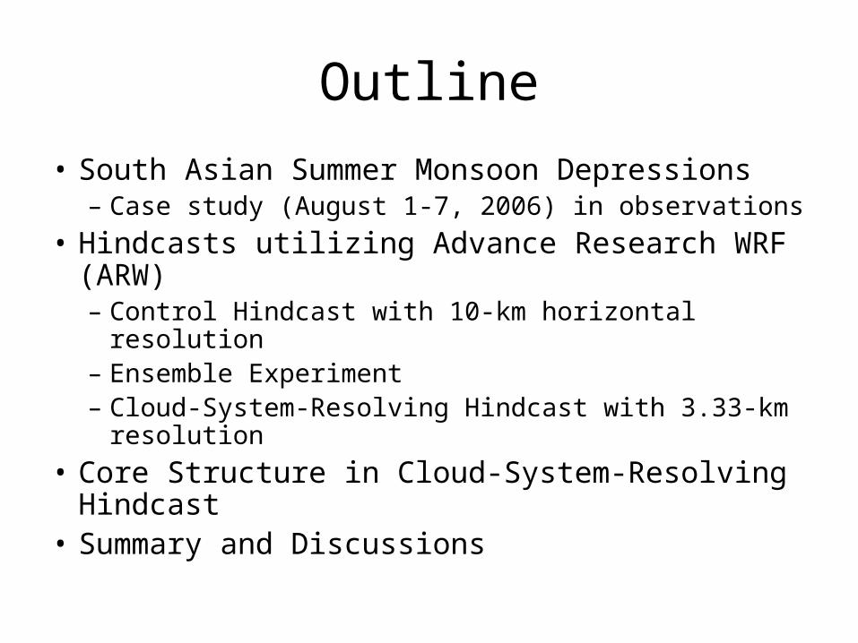
South Asian Summer Monsoon Depressions• Genesis
– During Indian summer monsoon season; on average two depressions occur each month. Majority forms over the Bay of Bengal; Gross horizontal scale several thousand km
• Propagation– Depressions occurring over the Bay of Bengal commonly move
westward towards Indian Subcontinent. After landfall, they may turn to northward or keep westward and eventually merge to the Pakistan seasonal low.
• Intensity– Accumulated rain can reach up to 20cm in 24hours. Most rainfall
occurs at the southwest quadrant of the depression.• Observational and theoretical studies
– Before Summer MONEX 1979: Sikka(1977), Krishnamurti et al. (1975), Godbole(1977)
– After Summer MONEX 1979: Nitta and Masuda(1981), Saha and Chang(1983), Sanders(1984), Douglas (1992 ab)
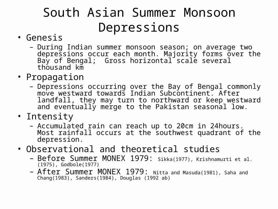
Case Study: A deep depression during August 02-05, 2006Meteorological Office, Pune, India. Mausam, 58 (2007)
08/01: well-marked low area08/02 0300 UTC :Depression08/02 0900 UTC: Deep Depression08/03 0300 UTC: Deep Depression08/04 0300 UTC: Deep Depression08/04 1200 UTC: Depression08/05 0300 UTC: Depression08/05 PM: well-marked lowIt continued to move west- northwest-ward and eventually merged with the heat low in southeast Rajasthan during 08/12-14.
Loss of life: 251North coastal Andhra Pradesh: 62Orissa: 45 Madhya Pradesh: 55Vidarbha: 13 Marathwada: 76
Motivation• Great societal and economic significance of the
rainfall brought by Monsoon Depressions which call for accurate track and intensity forecasts.
• What could possibly improve the forecasts of monsoon depressions?– Ensemble predictions– Raise model resolution to cloud-system-resolving
resolution. Cloud-system-resolving modeling have been shown to be promising in hindcasting multiscale tropical convective systems (e.g. Miura et al. 2007, Science).

Datasets• TRMM (Tropical Rainfall Measuring Mission)
– 3B42, 3-hrly, 0.25ox0.25o gridded rain rate data– Multi-satellite merged TRMM real-time passive microwave (HQ) and
geostationary IR-estimated precipitation.• NCEP/NCAR Reanalysis
– 6-hrly, 17 pressure levels, 2.5ox2.5o gridded data– Including dynamic and thermodynamic fields
• QuickScat– Level 3, daily, 0.25o x 0.25o, gridded – ocean wind vectors from satellite scatterometer.
• Indian Meteorological Office observations– Observations on the depression center during Aug 2 to Aug 5 2006– Precipitation of major cities are documented
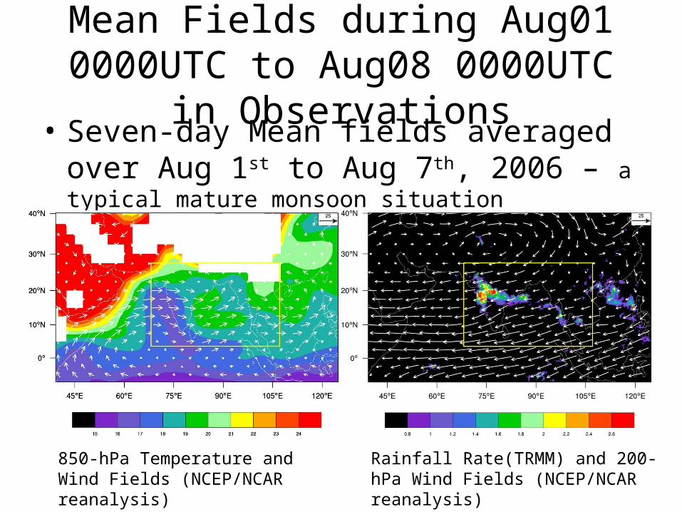
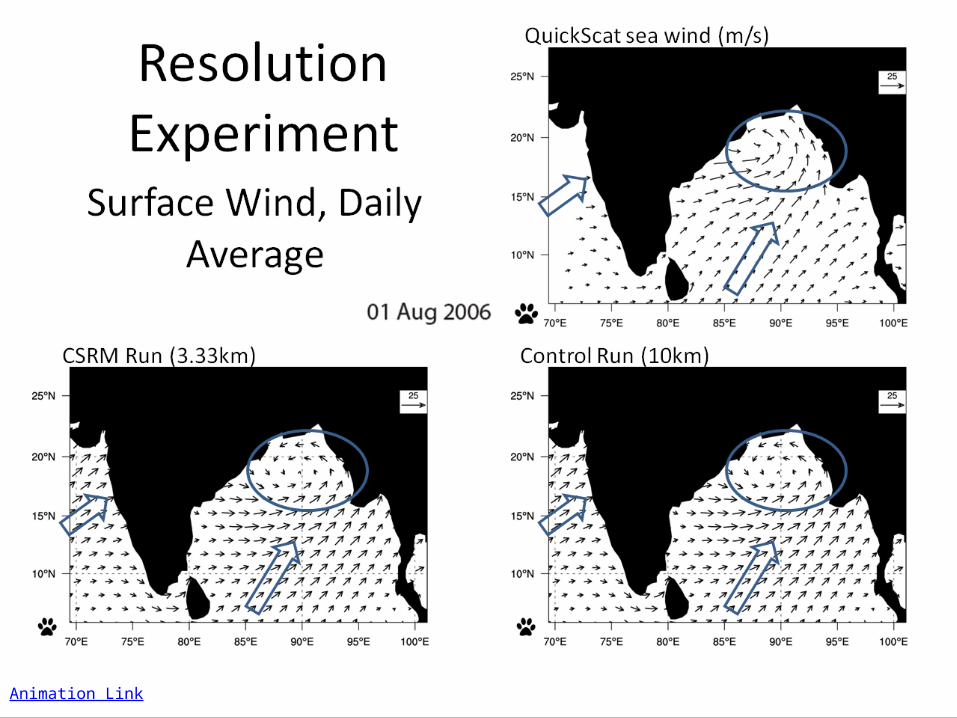
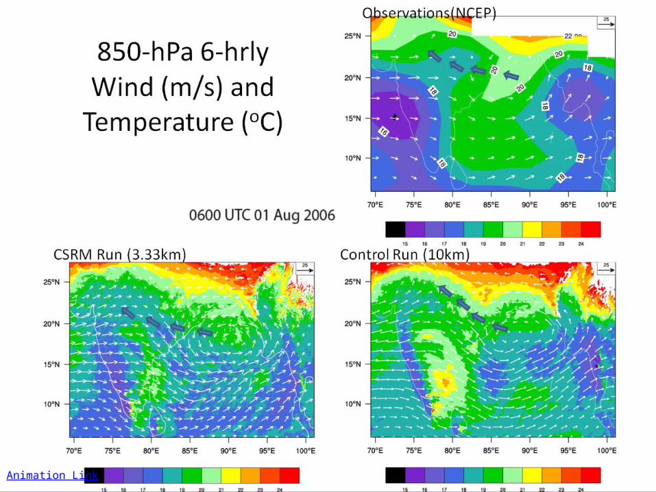
Mean Fields during Aug01 0000UTC to Aug08 0000UTC in Observations
• Seven-day Mean fields averaged over Aug 1st to Aug 7th, 2006 – a typical mature monsoon situation
850-hPa Temperature and Wind Fields (NCEP/NCAR reanalysis)
Rainfall Rate(TRMM) and 200-hPa Wind Fields (NCEP/NCAR reanalysis)
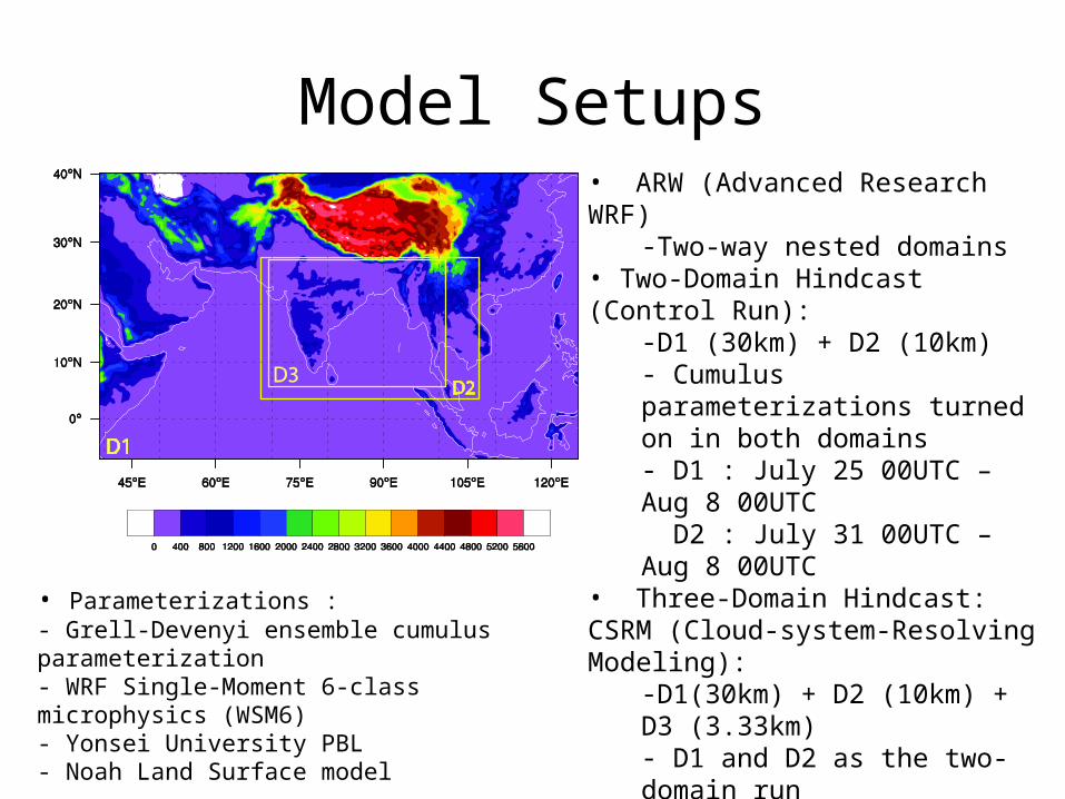
Model Setups
• Parameterizations :- Grell-Devenyi ensemble cumulus parameterization - WRF Single-Moment 6-class microphysics (WSM6)- Yonsei University PBL - Noah Land Surface model
• ARW (Advanced Research WRF)-Two-way nested domains
• Two-Domain Hindcast (Control Run):-D1 (30km) + D2 (10km)- Cumulus parameterizations turned on in both domains- D1 : July 25 00UTC – Aug 8 00UTC D2 : July 31 00UTC – Aug 8 00UTC
• Three-Domain Hindcast: CSRM (Cloud-system-Resolving Modeling):
-D1(30km) + D2 (10km) + D3 (3.33km)- D1 and D2 as the two-domain run- D3 : July 31 00UTC – Aug 8 00UTC Cumulus parameterization turned off leaving explicit scheme
• Lateral and Initial Boundary Conditions-FNL analysis- NCEP RTG Sea Surface Temp
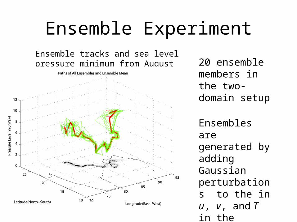
Ensemble Experiment
20 ensemble members in the two-domain setup
Ensembles are generated by adding Gaussian perturbations to the in u, v, and T in the control run at 0000UTC on Aug 01, 2006.
Ensemble tracks and sea level pressure minimum from August 01 to 05, 2006
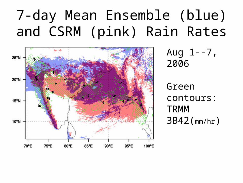
7-day Mean Ensemble (blue) and CSRM (pink) Rain Rates
Aug 1--7, 2006
Green contours: TRMM 3B42(mm/hr)
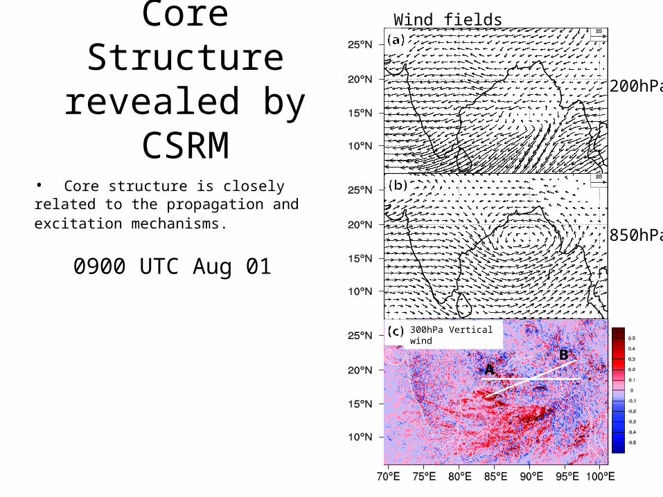
Core Structure revealed by CSRM
0900 UTC Aug 01
200hPa
850hPa
Wind fields
• Core structure is closely related to the propagation and excitation mechanisms.
300hPa Vertical wind
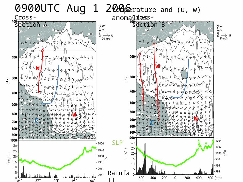
0900UTC Aug 1 2006Cross-section A Cross-section B
W
W
W
W
temperature and (u, w) anomalies
SLP
Rainfall
C C
Summary and Conclusions• The 10-km D02 ARW hindcast captures the genesis & overall propagation of
the depression during Aug. 01-07, 2006. However,
– The south bend of the track is missing.– The precipitation is underestimated and misplaced over the
northern India rather than the central India after 36-60 hours.
• The preliminary ensemble experiment does not fix the track and intensity problems. The hindcast may not be very sensitive to the perturbations of the initial conditions.– The hindcast is however sensitive to the choices of physics such as
cumulus and PBL parameterizations, as well as, in one study, soil moisture feedback (e.g., Chang et al., 2008)
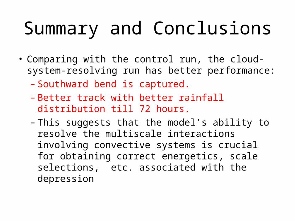
Summary and Conclusions
• Comparing with the control run, the cloud-system-resolving run has better performance:– Southward bend is captured.– Better track with better rainfall distribution till 72
hours.– This suggests that the model’s ability to resolve the
multiscale interactions involving convective systems is crucial for obtaining correct energetics, scale selections, etc. associated with the depression

-END-