Embed Size (px)
Citation preview
Merit Research Journal of Agricultural Science and Soil Sciences (ISSN: 2350-2274) Vol. 3(5) pp. 070-081, May, 2015 Available online http://meritresearchjournals.org/asss/index.htm Copyright © 2015 Merit Research Journals
Original Research Article
On People Narrow With Agriculture Sewage Water in Closed Oases in Arid Environment, Siwa Oasis, Egypt
as a Case Study
El Sayed Ahmed El Gammal
Abstract
National Authority for Remote Sensing and Space Sciences, Cairo, Egypt
E-Mail:
The Siwa oasis sits in a closed structural eroded depression; in North West Egypt with altitude 18 m below sea level, surrounded by limestone plateau with altitude to300 m above sea level. This article postulates the disaster of geo-environmental problem in both the food and economic delineating the human activities and the landscape ravine. Aim to rescue Siwa from sinking under agriculture sewage waters for long life. Hence, deliverance the continental Nubia sandstone water aquifer under Siwa from contamination by agriculture sewage and water table rise. Using of remote sensing and spatial three dimensions models integrating with geomorphological situation for sewage water boarding. The current study found that; in case of moving and extracting the sewage water to the north or the west, the water will run downward through the limestone fractures again to Siwa Oasis; the water table in the depression will be raise again with high calcium carbonate content. In case of moving and extracting the sewage water to the east where altitude range from -2 to -6 inside the depression, we will lose a good flat terrain have old cultivated soil, sabkhas, water bodies, springs, and mixed soil near to water table ready for agricultural reclamation. The selected extracting for sewage water is to the south, in dry valleys and the reservoirs has N-S trend in flat slope substratum in between the sand dunes in Great Sand Sea and not covered by sands. The water movement to the south fixed the movement-sands laying in zero contours which represent natural hazards. Keywords: Agriculture sewage, Landsat ETM images, landforms and Siwa
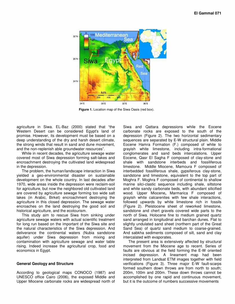
INTRODUCTION The Siwa oasis sits in a closed structural eroded depression, which today is frequently referred to as the Siwa depression in 82 kilometers long and between 9 and 28 kilometers wide (Figure 1). The depression altitude is 18 m below sea level (-18 m), it is closed depression bordered by zero contour line and surrounded by Ed Defa Miocene limestone plateau which altitudes from 100 m to300 m above sea level. The depression floor overlies Eocene limestone while, in the western part overlies the Cretaceous Nubia sandstone. The Nubia sandstone aquifer provided Egyptian oases with
underground water. Siwa oasis is 10 km long by 6–8 km wide. The southern parts of the oasis have succumbed to dunes from the Great Sand Sea, which extends over 500 kilometers to south and 60 to 80 kilometers east to west.
Siwa provided old civilizations with foods, at Pharaoh-Roman times and now supported us with more than 200 water wells and springs. During the Ptolemaid period of Egypt, its ancient Egyptian named “Field of Trees”, Greek settlers at Cyrene made contact with the oasis (around the 7
th century BC). Alexander the
Great lived in the oasis. Consequently, Egypt had good
El Gammal 071
Figure 1. Location map of the Siwa Oasis (red box).
agriculture in Siwa. EL-Baz (2000) stated that “the Western Desert can be considered Egypt's land of promise. However, its development must be based on a deep understanding of the dry and harsh desert climate, the strong winds that result in sand and dune movement, and the non-replenish able groundwater resources”.
While in recent decades, the agriculture sewage water covered most of Siwa depression forming salt-lakes and encroachment destroying the cultivated land widespread in the depression.
The problem, the human/landscape interaction in Siwa yielded a geo-environmental disaster on sustainable development on the whole country. In last decades after 1970, wide areas inside the depression were reclaim-soil for agriculture, but now the neighbored old cultivated land are covered by agriculture sewage forming too wide salt lakes (in Arabic, Birket) encroachment destroying the agriculture in this closed depression. The sewage water encroaches on the land destroying the good soil and historical agriculture, and the ecotourism.
This study aim to rescue Siwa from sinking under agriculture sewage waters with actual scientific treatment for long run based on the important of the Siwa site and the natural characteristics of the Siwa depression. And deliverance the continental waters (Nubia sandstone aquifer) under Siwa depression from mixing and contamination with agriculture sewage and water table rising. Indeed increase the agricultural crop, food and economics in Egypt. General Geology and Structure According to geological maps CONOCO (1987) and UNESCO office Cairo (2006), the exposed Middle and Upper Miocene carbonate rocks are widespread north of
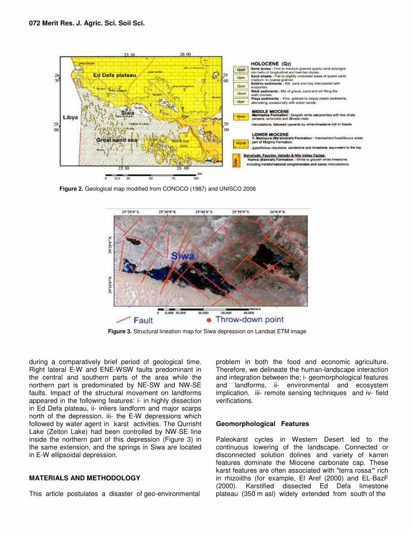
Siwa and Qattara depressions while the Eocene carbonate rocks are exposed to the south of the depression (Figure 2). The two horizontal sedimentary sequences are separated by E-W structural plain. Middle Eocene Hamra Formation (F.) composed of white to grayish white limestone, including intra-formational conglomerates and sand beds intercalations. Upper Eocene, Qasr El Sagha F composed of clay-stone and shale with sandstone interbeds and fossiliferous limestone. Middle Miocene, Mamoura F composed of interbedded fossiliferous shale, gypsiferous clay-stone, sandstone and limestone, equivalent to the top part of Moghra F. Moghra F composed of continental to shallow marine silci-clastic sequence including shale, siltstone and white sandy carbonate beds, with abundant silicified wood. Upper Miocene, Marmarica F composed of grayish white calcarenites with few shale interactions, followed upwards by white limestone rich in fossils (Figure 2). Pleistocene sheet of reworked limestone, sandstone and chert gravels covered wide parts to the north of Siwa. Holocene fine to medium grained quartz sand arranged in longitudinal and barchan dunes. Flat to slightly undulated sand sheet (northern part of the Great Sand Sea) of quartz sand medium to coarse-grained. And sabkha sediments composed of silt, sand and clay intercalated with evaporates.
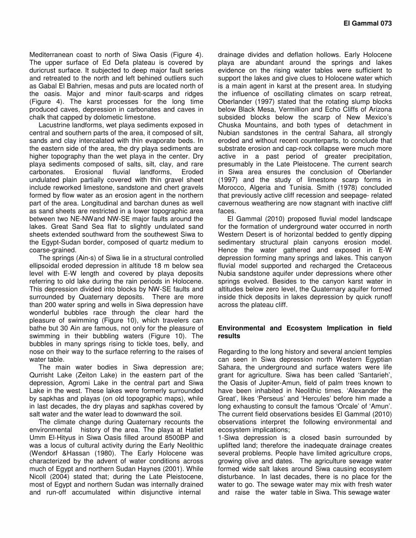
The present area is extensively affected by structural movement from the Miocene age to recent. Series of faults are obvious at the field forming the E-W oriented incised depression. A lineament map had been interpreted from Landsat ETM images together with field verifications (Figure 3). Three major E-W fault-scarps formed southern down throws are from north to south; 200m, 100m and 200m. These down throws cannot be accomplished by one rapid and continuous movement, but it is the outcome of numbers successive movements
072 Merit Res. J. Agric. Sci. Soil Sci.
Figure 2. Geological map modified from CONOCO (1987) and UNISCO 2006
Figure 3. Structural lineation map for Siwa depression on Landsat ETM image
during a comparatively brief period of geological time. Right lateral E-W and ENE-WSW faults predominant in the central and southern parts of the area while the northern part is predominated by NE-SW and NW-SE faults. Impact of the structural movement on landforms appeared in the following features: i- in highly dissection in Ed Defa plateau, ii- inliers landform and major scarps north of the depression. iii- the E-W depressions which followed by water agent in karst activities. The Qurrisht Lake (Zeiton Lake) had been controlled by NW-SE line inside the northern part of this depression (Figure 3) in the same extension, and the springs in Siwa are located in E-W ellipsoidal depression. MATERIALS AND METHODOLOGY This article postulates a disaster of geo-environmental
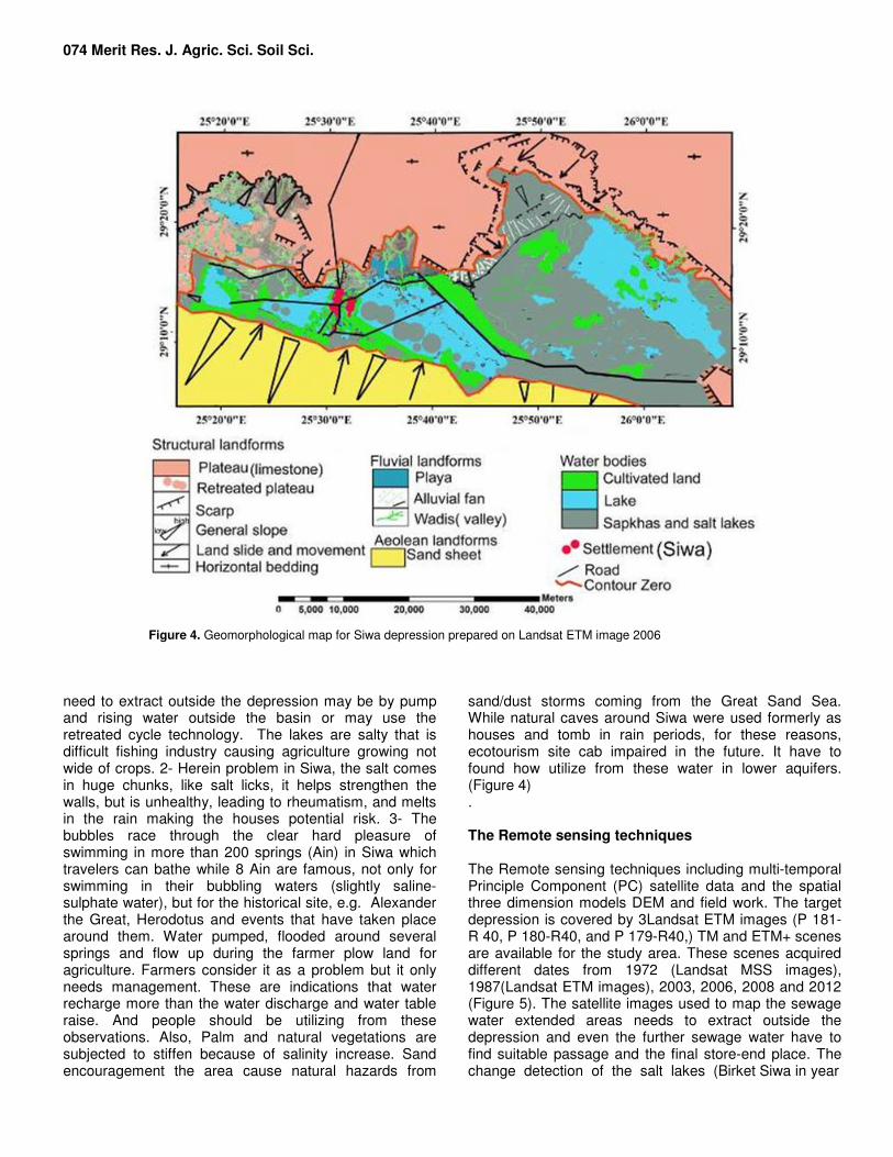
problem in both the food and economic agriculture. Therefore, we delineate the human-landscape interaction and integration between the; i- geomorphological features and landforms, ii- environmental and ecosystem implication. iii- remote sensing techniques and iv- field verifications. Geomorphological Features Paleokarst cycles in Western Desert led to the continuous lowering of the landscape. Connected or disconnected solution dolines and variety of karren features dominate the Miocene carbonate cap. These karst features are often associated with "terra rossa'" rich in rhizoiiths (for example, El Aref (2000) and EL-BazF (2000). Karstified dissected Ed Defa limestone plateau (350 m asl) widely extended from south of the
Mediterranean coast to north of Siwa Oasis (Figure 4). The upper surface of Ed Defa plateau is covered by duricrust surface. It subjected to deep major fault series and retreated to the north and left behined outliers such as Gabal El Bahrien, mesas and puts are located north of the oasis. Major and minor fault-scarps and ridges (Figure 4). The karst processes for the long time produced caves, depression in carbonates and caves in chalk that capped by dolometic limestone.
Lacustrine landforms, wet playa sediments exposed in central and southern parts of the area, it composed of silt, sands and clay intercalated with thin evaporate beds. In the eastern side of the area, the dry playa sediments are higher topography than the wet playa in the center. Dry playa sediments composed of salts, silt, clay, and rare carbonates. Erosional fluvial landforms, Eroded undulated plain partially covered with thin gravel sheet include reworked limestone, sandstone and chert gravels formed by flow water as an erosion agent in the northern part of the area. Longitudinal and barchan dunes as well as sand sheets are restricted in a lower topographic area between two NE-NWand NW-SE major faults around the lakes. Great Sand Sea flat to slightly undulated sand sheets extended southward from the southewest Siwa to the Egypt-Sudan border, composed of quartz medium to coarse-grained.
The springs (Ain-s) of Siwa lie in a structural controlled ellipsoidal eroded depression in altitude 18 m below sea level with E-W length and covered by playa deposits referring to old lake during the rain periods in Holocene. This depression divided into blocks by NW-SE faults and surrounded by Quaternary deposits. There are more than 200 water spring and wells in Siwa depression have wonderful bubbles race through the clear hard the pleasure of swimming (Figure 10), which travelers can bathe but 30 Ain are famous, not only for the pleasure of swimming in their bubbling waters (Figure 10). The bubbles in many springs rising to tickle toes, belly, and nose on their way to the surface referring to the raises of water table.
The main water bodies in Siwa depression are; Qurrisht Lake (Zeiton Lake) in the eastern part of the depression, Agromi Lake in the central part and Siwa Lake in the west. These lakes were formerly surrounded by sapkhas and playas (on old topographic maps), while in last decades, the dry playas and sapkhas covered by salt water and the water lead to downward the soil.
The climate change during Quaternary recounts the environmental history of the area. The playa at Hatiet Umm El-Hityus in Siwa Oasis filled around 8500BP and was a locus of cultural activity during the Early Neolithic (Wendorf &Hassan (1980). The Early Holocene was characterized by the advent of water conditions across much of Egypt and northern Sudan Haynes (2001). While Nicoll (2004) stated that; during the Late Pleistocene, most of Egypt and northern Sudan was internally drained and run-off accumulated within disjunctive internal
El Gammal 073 drainage divides and deflation hollows. Early Holocene playa are abundant around the springs and lakes evidence on the rising water tables were sufficient to support the lakes and give clues to Holocene water which is a main agent in karst at the present area. In studying the influence of oscillating climates on scarp retreat, Oberlander (1997) stated that the rotating slump blocks below Black Mesa, Vermillion and Echo Cliffs of Arizona subsided blocks below the scarp of New Mexico’s Chuska Mountains, and both types of detachment in Nubian sandstones in the central Sahara, all strongly eroded and without recent counterparts, to conclude that substrate erosion and cap-rock collapse were much more active in a past period of greater precipitation, presumably in the Late Pleistocene. The current search in Siwa area ensures the conclusion of Oberlander (1997) and the study of limestone scarp forms in Morocco, Algeria and Tunisia. Smith (1978) concluded that previously active cliff recession and seepage- related cavernous weathering are now stagnant with inactive cliff faces.
El Gammal (2010) proposed fluvial model landscape for the formation of underground water occurred in north Western Desert is of horizontal bedded to gently dipping sedimentary structural plain canyons erosion model. Hence the water gathered and exposed in E-W depression forming many springs and lakes. This canyon fluvial model supported and recharged the Cretaceous Nubia sandstone aquifer under depressions where other springs evolved. Besides to the canyon karst water in altitudes below zero level, the Quaternary aquifer formed inside thick deposits in lakes depression by quick runoff across the plateau cliff. Environmental and Ecosystem Implication in field results Regarding to the long history and several ancient temples can seen in Siwa depression north Western Egyptian Sahara, the underground and surface waters were life grant for agriculture. Siwa has been called ‘Santarieh’, the Oasis of Jupiter-Amun, field of palm trees known to have been inhabited in Neolithic times. ‘Alexander the Great’, likes ‘Perseus’ and ‘Hercules’ before him made a long exhausting to consult the famous ‘Orcale’ of ‘Amun’. The current field observations besides El Gammal (2010) observations interpret the following environmental and ecosystem implications; 1-Siwa depression is a closed basin surrounded by uplifted land; therefore the inadequate drainage creates several problems. People have limited agriculture crops, growing olive and dates. The agriculture sewage water formed wide salt lakes around Siwa causing ecosystem disturbance. In last decades, there is no place for the water to go. The sewage water may mix with fresh water and raise the water table in Siwa. This sewage water
074 Merit Res. J. Agric. Sci. Soil Sci.
Figure 4. Geomorphological map for Siwa depression prepared on Landsat ETM image 2006
need to extract outside the depression may be by pump and rising water outside the basin or may use the retreated cycle technology. The lakes are salty that is difficult fishing industry causing agriculture growing not wide of crops. 2- Herein problem in Siwa, the salt comes in huge chunks, like salt licks, it helps strengthen the walls, but is unhealthy, leading to rheumatism, and melts in the rain making the houses potential risk. 3- The bubbles race through the clear hard pleasure of swimming in more than 200 springs (Ain) in Siwa which travelers can bathe while 8 Ain are famous, not only for swimming in their bubbling waters (slightly saline-sulphate water), but for the historical site, e.g. Alexander the Great, Herodotus and events that have taken place around them. Water pumped, flooded around several springs and flow up during the farmer plow land for agriculture. Farmers consider it as a problem but it only needs management. These are indications that water recharge more than the water discharge and water table raise. And people should be utilizing from these observations. Also, Palm and natural vegetations are subjected to stiffen because of salinity increase. Sand encouragement the area cause natural hazards from
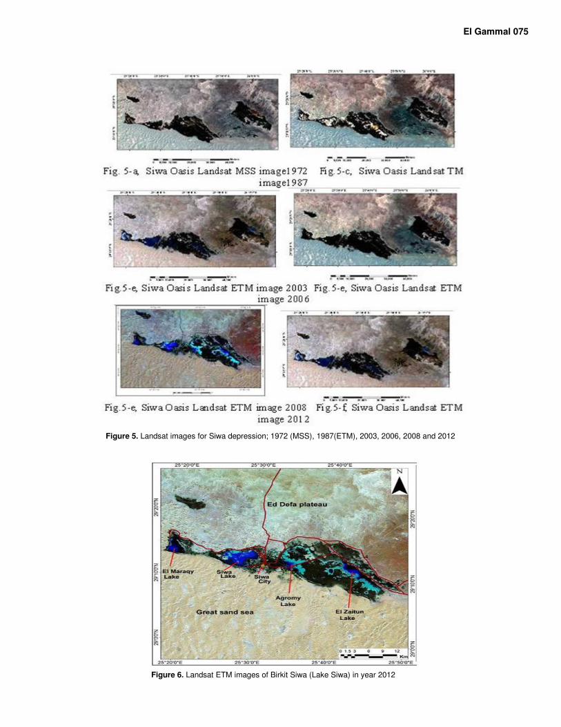
sand/dust storms coming from the Great Sand Sea. While natural caves around Siwa were used formerly as houses and tomb in rain periods, for these reasons, ecotourism site cab impaired in the future. It have to found how utilize from these water in lower aquifers. (Figure 4) . The Remote sensing techniques The Remote sensing techniques including multi-temporal Principle Component (PC) satellite data and the spatial three dimension models DEM and field work. The target depression is covered by 3Landsat ETM images (P 181-R 40, P 180-R40, and P 179-R40,) TM and ETM+ scenes are available for the study area. These scenes acquired different dates from 1972 (Landsat MSS images), 1987(Landsat ETM images), 2003, 2006, 2008 and 2012 (Figure 5). The satellite images used to map the sewage water extended areas needs to extract outside the depression and even the further sewage water have to find suitable passage and the final store-end place. The change detection of the salt lakes (Birket Siwa in year
El Gammal 075
Figure 5. Landsat images for Siwa depression; 1972 (MSS), 1987(ETM), 2003, 2006, 2008 and 2012
Figure 6. Landsat ETM images of Birkit Siwa (Lake Siwa) in year 2012
076 Merit Res. J. Agric. Sci. Soil Sci.
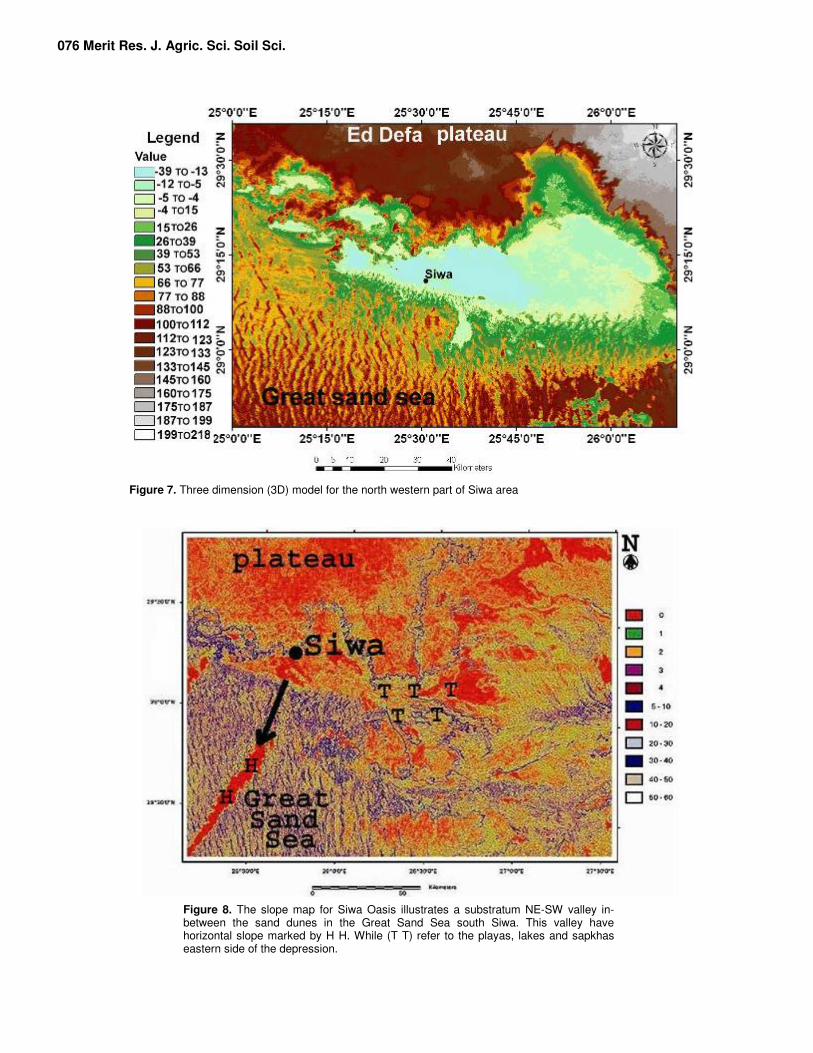
Figure 7. Three dimension (3D) model for the north western part of Siwa area
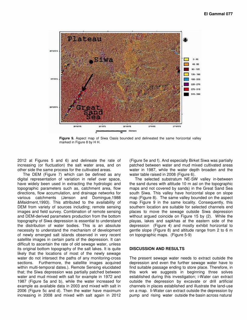
Figure 8. The slope map for Siwa Oasis illustrates a substratum NE-SW valley in-between the sand dunes in the Great Sand Sea south Siwa. This valley have horizontal slope marked by H H. While (T T) refer to the playas, lakes and sapkhas eastern side of the depression.
El Gammal 077
Figure 9. Aspect map of Siwa Oasis bounded and delineated the same horizontal valley marked in Figure 8 by H H.
2012 at Figures 5 and 6) and delineate the rate of increasing (or fluctuation) the salt water area, and on other side the same process for the cultivated areas.
The DEM (Figure 7) which can be defined as any digital representation of variation in relief over space, have widely been used in extracting the hydrologic and topographic parameters such as, catchment area, flow directions, flow accumulation, and drainage networks for various catchments (Jenson and Domingue,1988 &Maidment,1993). This attributed to the availability of DEM from variety of sources including; remote sensing images and field survey. Combination of remote sensing and DEM-derived parameters production from the bottom topography of Siwa depression is essential to understand the distribution of water bodies. This is an absolute necessity to understand the mechanism of development of newly emerged salt islands observed in very recent satellite images in certain parts of the depression. It can difficult to ascertain the rate of old sewage water, unless its original bottom topography of the salt lakes. It is quite likely that the locations of most of the newly sewage water do not intersect the paths of any monitoring-cross sections. Furthermore, the satellite images acquired within multi-temporal dates.). Remote Sensing elucidated that; the Siwa depression was partially patched between water and mud mixed with salt for example in 1972 and 1987 (Figure 5a and b), while the water increased for example as available data in 2003 and mixed with salt in 2006 (Figure 5c and d). Then the water have maximum increasing in 2008 and mixed with salt again in 2012
(Figure 5e and f). And especially Birket Siwa was partially patched between water and mud mixed cultivated areas water in 1987, while the water depth broaden and the water table raised in 2008 (Figure 6).
The selected substratum NE-SW valley in-between the sand dunes with altitude 10 m asl on the topographic maps and not covered by sands) in the Great Sand Sea south Siwa. This valley have horizontal slope on slope map (Figure 8). The same valley bounded on the aspect map Figure 9 in the same locality. Consequently, this southern location are suitable for selected channels end places to move the sewage outside Siwa depression without argued coincide on Figure 15 by (2). While the playas, lakes and sapkhas at the eastern side of the depression (Figure 4) and mostly exhibit horizontal to gentle slope (Figure 8) and altitude range from 2 to 6 m on topographic maps. (Figure 5-9) DISCUSSION AND RESULTS The present sewage water needs to extract outside the depression and even the further sewage water have to find suitable passage ending to store place. Therefore, in this work we suggests in beginning three solves established during this investigation; i-Water can extract outside the depression by excavate or drill artificial channels in places established and illustrate the land-use on a map. Ii-Water can extract outside the depression by pump and rising water outside the basin across natural
078 Merit Res. J. Agric. Sci. Soil Sci.
Figure 10. Photographs (2013) show; a- old road covered by water, b- old house covered by water, c-&d- the mosst depression attacked by sewage water, e- (2013) shows water table rose in Siwa springs (Ain Abo Shroof) due to excess of sewage water. And f- (2013) shows sewage water broadens in west Siwa.
streams. iii- after the water extract outside the depression, can use the water as “Desalinated Water” can be used for agriculture and building purposes in retreated cycle technology(out of this study). Unfortunately, the sewage waters are restricted inside the depression which surrounded by high topographic terrain around Siwa, while the deposits covering the depression floor can infiltrate these waters due to the high porosity and permeability of loose sands and gravels that covered cracked bed rocks. The sewage water has to mix with fresh water and contaminates it raising the water table in Siwa. This raising yielded water-evolve and
more water-pumping in several springs producing a problem for Siwa farmer (Figures 10-e). The present disaster can stretched to the northern part of western desert affecting on the Nubia sandstone water aquifer that provided Egyptian oases with underground water. The already founded treatment The founded already treatment for the problem in Siwa is a transitory treatment, the people raise and move the
El Gammal 079
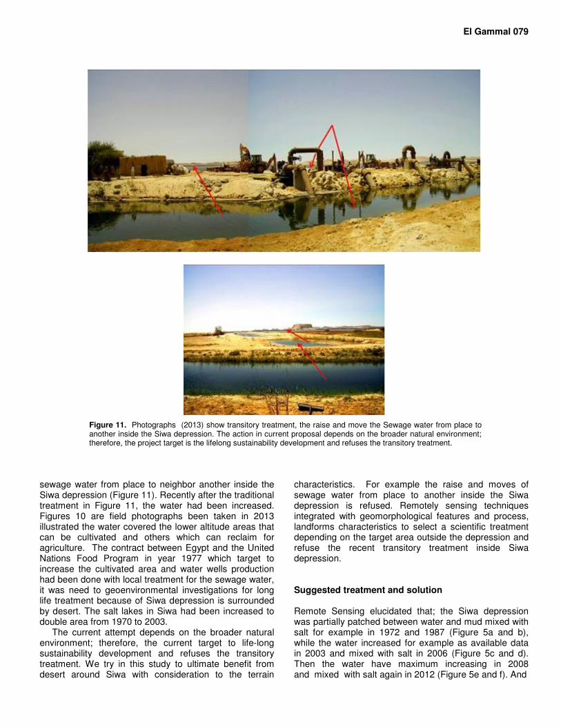
Figure 11. Photographs (2013) show transitory treatment, the raise and move the Sewage water from place to another inside the Siwa depression. The action in current proposal depends on the broader natural environment; therefore, the project target is the lifelong sustainability development and refuses the transitory treatment.
sewage water from place to neighbor another inside the Siwa depression (Figure 11). Recently after the traditional treatment in Figure 11, the water had been increased. Figures 10 are field photographs been taken in 2013 illustrated the water covered the lower altitude areas that can be cultivated and others which can reclaim for agriculture. The contract between Egypt and the United Nations Food Program in year 1977 which target to increase the cultivated area and water wells production had been done with local treatment for the sewage water, it was need to geoenvironmental investigations for long life treatment because of Siwa depression is surrounded by desert. The salt lakes in Siwa had been increased to double area from 1970 to 2003.
The current attempt depends on the broader natural environment; therefore, the current target to life-long sustainability development and refuses the transitory treatment. We try in this study to ultimate benefit from desert around Siwa with consideration to the terrain
characteristics. For example the raise and moves of sewage water from place to another inside the Siwa depression is refused. Remotely sensing techniques integrated with geomorphological features and process, landforms characteristics to select a scientific treatment depending on the target area outside the depression and refuse the recent transitory treatment inside Siwa depression. Suggested treatment and solution Remote Sensing elucidated that; the Siwa depression was partially patched between water and mud mixed with salt for example in 1972 and 1987 (Figure 5a and b), while the water increased for example as available data in 2003 and mixed with salt in 2006 (Figure 5c and d). Then the water have maximum increasing in 2008 and mixed with salt again in 2012 (Figure 5e and f). And
080 Merit Res. J. Agric. Sci. Soil Sci.
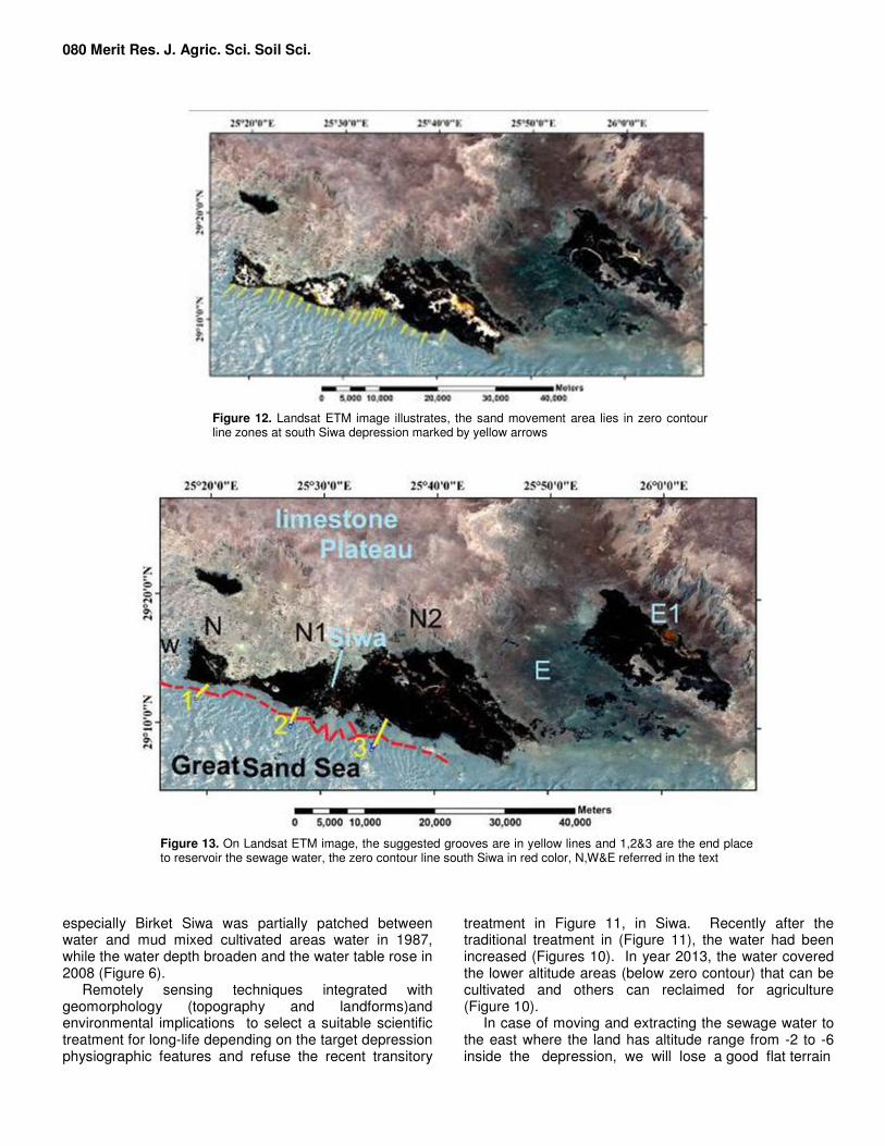
Figure 12. Landsat ETM image illustrates, the sand movement area lies in zero contour line zones at south Siwa depression marked by yellow arrows
Figure 13. On Landsat ETM image, the suggested grooves are in yellow lines and 1,2&3 are the end place to reservoir the sewage water, the zero contour line south Siwa in red color, N,W&E referred in the text
especially Birket Siwa was partially patched between water and mud mixed cultivated areas water in 1987, while the water depth broaden and the water table rose in 2008 (Figure 6).
Remotely sensing techniques integrated with geomorphology (topography and landforms)and environmental implications to select a suitable scientific treatment for long-life depending on the target depression physiographic features and refuse the recent transitory
treatment in Figure 11, in Siwa. Recently after the traditional treatment in (Figure 11), the water had been increased (Figures 10). In year 2013, the water covered the lower altitude areas (below zero contour) that can be cultivated and others can reclaimed for agriculture (Figure 10).
In case of moving and extracting the sewage water to the east where the land has altitude range from -2 to -6 inside the depression, we will lose a good flat terrain
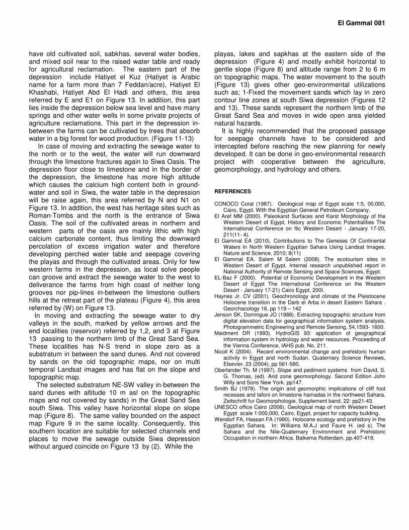
have old cultivated soil, sabkhas, several water bodies, and mixed soil near to the raised water table and ready for agricultural reclamation. The eastern part of the depression include Hatiyet el Kuz (Hatiyet is Arabic name for a farm more than 7 Feddan/acre), Hatiyet El Khashabi, Hatiyet Abd El Hadi and others, this area referred by E and E1 on Figure 13. In addition, this part lies inside the depression below sea level and have many springs and other water wells in some private projects of agriculture reclamations. This part in the depression in-between the farms can be cultivated by trees that absorb water in a big forest for wood production. (Figure 11-13)
In case of moving and extracting the sewage water to the north or to the west, the water will run downward through the limestone fractures again to Siwa Oasis. The depression floor close to limestone and in the border of the depression, the limestone has more high altitude which causes the calcium high content both in ground-water and soil in Siwa, the water table in the depression will be raise again, this area referred by N and N1 on Figure 13. In addition, the west has heritage sites such as Roman-Tombs and the north is the entrance of Siwa Oasis. The soil of the cultivated areas in northern and western parts of the oasis are mainly lithic with high calcium carbonate content, thus limiting the downward percolation of excess irrigation water and therefore developing perched water table and seepage covering the playas and through the cultivated areas. Only for few western farms in the depression, as local solve people can groove and extract the sewage water to the west to deliverance the farms from high coast of neither long grooves nor pip-lines in-between the limestone outliers hills at the retreat part of the plateau (Figure 4), this area referred by (W) on Figure 13. In moving and extracting the sewage water to dry valleys in the south, marked by yellow arrows and the end localities (reservoir) referred by 1,2, and 3 at Figure 13 passing to the northern limb of the Great Sand Sea. These localities has N-S trend in slope zero as a substratum in between the sand dunes. And not covered by sands on the old topographic maps, nor on multi temporal Landsat images and has flat on the slope and topographic map. The selected substratum NE-SW valley in-between the sand dunes with altitude 10 m asl on the topographic maps and not covered by sands) in the Great Sand Sea south Siwa. This valley have horizontal slope on slope map (Figure 8). The same valley bounded on the aspect map Figure 9 in the same locality. Consequently, this southern location are suitable for selected channels end places to move the sewage outside Siwa depression without argued coincide on Figure 13 by (2). While the
El Gammal 081 playas, lakes and sapkhas at the eastern side of the depression (Figure 4) and mostly exhibit horizontal to gentle slope (Figure 8) and altitude range from 2 to 6 m on topographic maps. The water movement to the south (Figure 13) gives other geo-environmental utilizations such as; 1-Fixed the movement sands which lay in zero contour line zones at south Siwa depression (Figures 12 and 13). These sands represent the northern limb of the Great Sand Sea and moves in wide open area yielded natural hazards. It is highly recommended that the proposed passage for seepage channels have to be considered and intercepted before reaching the new planning for newly developed. It can be done in geo-environmental research project with cooperative between the agriculture, geomorphology, and hydrology and others. REFERENCES CONOCO Coral (1987). Geological map of Egypt scale 1:5, 00,000,
Cairo, Egypt. With the Egyptian General Petroleum Company, El Aref MM (2000). Paleokarst Surfaces and Karst Morphology of the
Western Desert of Egypt, History and Economic Potentialities The International Conference on flic Western Desert - January 17-20, 211(11- 4).
El Gammal EA (2010). Contributions to The Geneses Of Continental Waters In North Western Egyptian Sahara Using Landsat Images. Nature and Science, 2010; 8(11)
El Gammal EA. Salem M Salem (2008). The ecotourism sites in Western Desert of Egypt. Internal research unpublished report in National Authority of Remote Sensing and Space Sciences, Egypt.
EL-Baz F (2000). Potential of Economic Development in the Western Desert of Egypt The International Conference on the Western Desert - January 17-21) Cairo Egypt, 200I.
Haynes Jr. CV (2001). Geochronology and climate of the Pleistocene Holocene transition in the Darb el Arba in desert Eastern Sahara . Georchacology 16, pp 119 – 142
Jenson SK, Domingue JO (1988). Extracting topographic structure from digital elevation data for geographical information system analysis. Photogrammetric Engineering and Remote Sensing, 54,1593- 1600.
Maidment DR (1993). HydroGIS 93: application of geographical information system in hydrology and water resources. Proceeding of the Vienna Conference, IAHS pub. No. 211.
Nicoll K (2004). Recent environmental change and prehistoric human activity in Egypt and north Sudan. Quaternary Science Reviews, Elsevier. 23 (2004), pp 561-580,
Oberlander Th. M (1997). Slope and pediment systems from David, S. G. Thomas, (ed). Arid zone geomorphology. Second Edition John Willy and Sons New York. pp147.
Smith BJ (1978). The origin and geomorphic implications of cliff foot recesses and tafoni on limestone hamadas in the northwest Sahara. Zeitschrift fur Geomorphologie, Supplement band, 22: pp21-43.
UNESCO office Cairo (2006). Geological map of north Western Desert Egypt scale 1:000,000, Cairo, Egypt, project for capacity building.
Wendorf FA, Hassan FA (1980). Holocene ecology and prehistory in the Egyptian Sahara. In: Williams M.A.J and Faure H. (ed s). The Sahara and the Nile-Quaternary Environment and Prehistoric Occupation in northern Africa. Balkema Rotterdam, pp.407-419.