Embed Size (px)
Citation preview


2
On July 25, 1980, the Governments of the Socialist Republic of the Union of Burma and the Kingdom of Thailand signed an agreement delimiting their maritime boundary in the Andaman Sea. Upon the exchange of instruments of ratification on April 12, 1982, the agreement entered into force. The full text of the accord is as follows:
AGREEMENT BETWEEN THE GOVERNMENT OF THE SOCIALIST REPUBLIC OF
THE UNION OF BURMA AND THE GOVERNMENT OF THE KINGDOM OF THAILAND
ON THE DELIMITATION OF THE MARITIME BOUNDARY BETWEEN THE TWO COUNTRIES IN THE ANDAMAN SEA
The Government of the Socialist Republic of the Union of Burma and the Government of the Kingdom of Thailand,
Desiring to strengthen the existing historical bonds of friendship between the two countries, and
Desiring to establish the maritime boundary between the two countries in the Andaman Sea, and to settle permanently the limits of the areas within which the respective Governments shall exercise sovereignty and sovereign rights,
Have agreed as follows:
ARTICLE 1
1. The maritime boundary between Burma and Thailand in the Andaman Sea is an equidistance line formed by a series of straight lines connecting the nine points specified hereunder in the sequence so specified:
Point No. Latitude Longitude
1. 9°32'15" 97°56'20" 2. 9°34'29" 97°52'10" 3. 9°34'54" 97°51'12" 4. 9°35'39" 97°45'29" 5. 9°36'02" 97°43'29" 6. 9°37'24" 97°37'36" 7. 9°40'35" 97°26'36" 8. 9°45'30" 96°29'35" 9. 9°38'00" 95°35'25"
2. That segment of the maritime boundary specified in paragraph 1 of this Agreement extending from Point No. 1 through Points Nos. 2, 3 and 4 to Point No. 5 shall constitute the

3
boundary between the territorial sea of Burma and the territorial sea of Thailand.
3. That segment of the maritime boundary specified in paragraph 1 of this Article extending from Point No. 5 through Points Nos. 6, 7 and 8 to Point No. 9 shall constitute the boundary between the continental shelf of Burma and the continental shelf of Thailand and, in the event that Thailand establishes her exclusive economic zone, this same line shall also constitute the boundary between the exclusive economic zone of Burma and the exclusive economic zone of Thailand.
4. The extension of the boundary in the direction of and up to the maritime boundary trijunction point between Burma, Thailand and India will be the subject of a subsequent agreement.
ARTICLE 2
1. The geographical co-ordinates of Points Nos. 1 to 6 specified in Article 1 are derived from the 1948 edition of British Admiralty Chart No. 3052, re-published in 1975, and those of Points Nos. 7 to 9 from the 1975 edition of British Admiralty Chart No. 830 published on 3rd January 1975. The lines connecting said points are indicated on British Admiralty Chart No. 830, published on 3rd January 1975, attached as an Annex to this Agreement.
2. The actual location of these points at sea and of the lines connecting them shall be determined by a method to be mutually agreed upon by the hydrographic experts authorized for this purpose by the two Governments.
ARTICLE 3
Any dispute between the two Governments relating to the interpretation or implementation of this Agreement shall be settled peacefully by consultation or negotiation.
ARTICLE 4
This Agreement shall be ratified in accordance with the constitutional requirements of each country. It shall enter into force on the date of the exchange of the Instruments of Ratification which will take place at Bangkok as soon as possible.
In witness whereof the undersigned, being duly authorized thereto by their respective Governments, have signed this Agreement.
Done in duplicate at Rangoon, on the twenty-fifth day of July, One thousand Nine hundred and Eighty, in the English language.

2
4
For the Government of the For the Government of the Socialist Republic of the Kingdom of Thailand Union of Burma
Sd/- Sd/-(U Lay Maung) (Air Chief Marshal Siddhi Minister for Foreign Affairs Savetsila)
Minister for Foreign Affairs
ANALYSIS
Nature of the Boundary
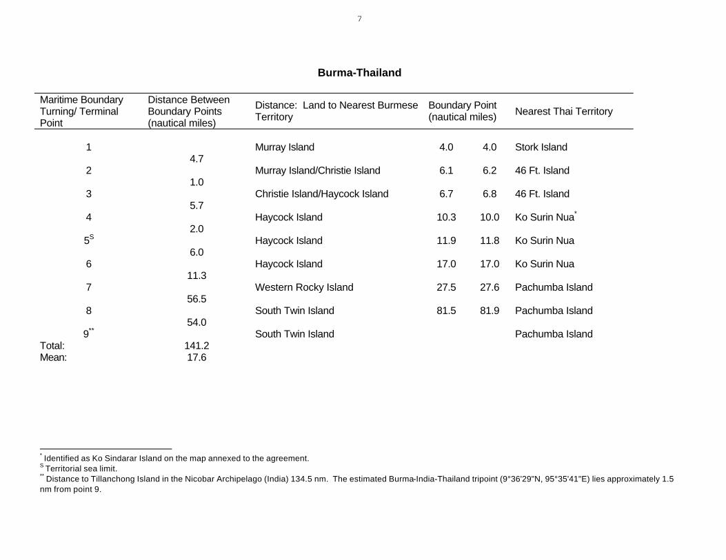
Article 1 of the 1980 agreement characterizes the maritime boundary as an equidistant line consisting of eight segments connecting the nine designated points of latitude and longitude. It tends in a westerly course for 141.2 nautical miles (nm). The average length of the boundary segments is 17.6 nm. The designated turning points would appear to be equidistant from the respective coasts, including islands (see table, p. 8).1 The course of the agreed boundary appears to have been governed by discrete coastal points, listed in the table, that were indicated on the map accompanying the agreement.2
The first part of the boundary to point 5 divides the 12-nm territorial seas of Burma and Thailand. Seaward from point 1 it appears to modify earlier depictions of the territorial sea.3 Point 5 is not a turning point of the boundary but appears to have been listed only because it marks the territorial sea limit.
The remainder of the maritime boundary serves as the dividing line for continental shelf jurisdiction and, inasmuch as Burma and Thailand both claim an exclusive economic zone (EEZ), for EEZ jurisdiction as well.4 This appears to be the first EEZ boundary negotiated in Southeast Asia.
1 Because a reference geodetic system is not given in the agreement--article 2, paragraph 2 apparently calls for this to be established at a later date--positions and distances cited in this study may vary from other computations. Cf. US Department of State, Office of The Geographer, Limits in the Seas No. 14, "Straight Baselines:
Burma," March 14, 1970. 3 Three small islets--Ko Lam, Ko Khan, and an unnamed rock--near the mouth of the Pakchan River are not shown on the maps accompanying the 1868 Convention between India and Siam which depicted the territorial sea boundary. There appears to be disagreement as to sovereignty over the islets. Current Burmese maps show the islets as Burmese; they are depicted as Thai on maps produced by that country. British Admiralty Chart 3052, "St. Matthew's Island to Similan Islands," 1:200,000 at latitude 10°40'N published July 9, 1948 (corrected through 1956), was used as the basis for the depiction of the territorial sea line on the attached map. This chart is cited in the 1980 agreement. See also US Defense Mapping Agency chart no. 63440, 3rd ed., May 7, 1977. 4 Proclamation Establishing the Exclusive Economic Zone of the Kingdom of Thailand, February 23, 1981. See also The Working People's Daily, Rangoon, March 11, 1981.

5
The agreement makes no provision for transboundary hydrocarbon deposits, such as is found in other regional continental shelf boundary agreements.5 Any question arising from shared resources presumably would be handled through consultation or negotiation under article 3.
The agreement between Burma and Thailand specifically holds in abeyance the extension of their maritime boundary to the tripoint with India (Andaman Islands). India and Thailand signed a continental shelf agreement in 1975 which entered into force in 1978.6 Point 9 of the Burma-Thailand agreement lies 1.5 nm from an estimated tripoint with India and 20.7 nm from the northernmost point specified in the India-Thailand agreement.7
Depiction of the Boundary
Article 2 of the agreement deals with the derivation and depiction of the Burma-Thailand maritime boundary. British Admiralty charts 830 and 3052 were used to determine the turning points (depicted on chart 830, which was annexed to the agreement). The Burma-Thailand maritime boundary is illustrated on the attached map, based on DMAHTC chart 63025. The boundary line segments are shown using straight lines, which on this Mercator projection are rhumb lines (loxodromes).
The text of the agreement refers to "a series of straight lines" in article 1, paragraph 1. Paragraph 1 of article 2 states that the "lines connecting the said points are indicated" on the annexed map (emphasis added). The second paragraph of this article states that the "actual location of these points at sea and of the lines connecting them shall be determined...."
Although the straight lines on the annexed map would also be rhumb lines because the British Admiralty chart is a Mercator projection, the nature of the connecting line segments is left unclear by the agreement's use of the term "indicated." They could be rhumb lines, arcs of great circles, or geodesics.8 The exact nature of these connecting lines may be elucidated by the hydrographic experts mentioned in article 2, paragraph 2.
The precise location of the turning points also remains to be determined. Unambiguous designation would require that the coordinates be given with reference to a geodetic system. There are several standard geodetic systems that relate geographic coordinates of points on the surface of the earth to mathematical models of the shape of the earth.
5 See, for example US Department of State, Office of The Geographer, Limits in the Seas No. 81, "Maritime Boundaries: Indonesia-Malaysia-Thailand," December 27, 1978, or Limits in the Seas No. 93, "Continental Shelf Boundaries: India-Indonesia-Thailand," August 17, 1981. 6 Limits in the Seas No. 93. On March 13, 1984, Burma and India reportedly initialed a maritime boundary agreement delimiting their
EEZs in the Bay of Bengal and the Andaman Sea (The Hindu, Madras, march 14, 1984). 8 For a discussion of the properties of these types of lines, see Robert D. Hodgson and E. John Cooper, "The Technical Delimitation of a Modern Equidistant Boundary," Ocean Development and International Law Journal vol. 3, 1976, pp. 378-380.
7

6
Because the provisions of the agreement explicitly state that the "actual locations" will be determined by hydrographic experts, the implication is that the geodetic system will be specified at a later date.9
9 Differences resulting from geodetic systems and the type of line used are not significant for purposes of this study. Such differences will be important to future questions as to the exact location of the boundary--especially with respect to offshore oil or gas exploration.
7
Burma-Thailand
Maritime Boundary Turning/ Terminal Point
Distance Between Boundary Points (nautical miles)
Distance: Land to Nearest BurmesTerritory
e Boundary Point (nautical miles) Nearest Thai Territory
1 4.7
Murray Island 4.0 4.0 Stork Island
2 1.0
Murray Island/Christie Island 6.1 6.2 46 Ft. Island
3 5.7
Christie Island/Haycock Island 6.7 6.8 46 Ft. Island
4 2.0
Haycock Island 10.3 10.0 Ko Surin Nua*
5S
6.0 Haycock Island 11.9 11.8 Ko Surin Nua
6 11.3
Haycock Island 17.0 17.0 Ko Surin Nua
7 56.5
Western Rocky Island 27.5 27.6 Pachumba Island
8 54.0
South Twin Island 81.5 81.9 Pachumba Island
9** South Twin Island Pachumba Island Total: Mean:
141.2 17.6
* Identified as Ko Sindarar Island on the map annexed to the agreement. S Territorial sea limit. ** Distance to Tillanchong Island in the Nicobar Archipelago (India) 134.5 nm. The estimated Burma-India-Thailand tripoint (9°36'29"N, 95°35'41"E) lies approximately 1.5 nm from point 9.