Embed Size (px)
Citation preview

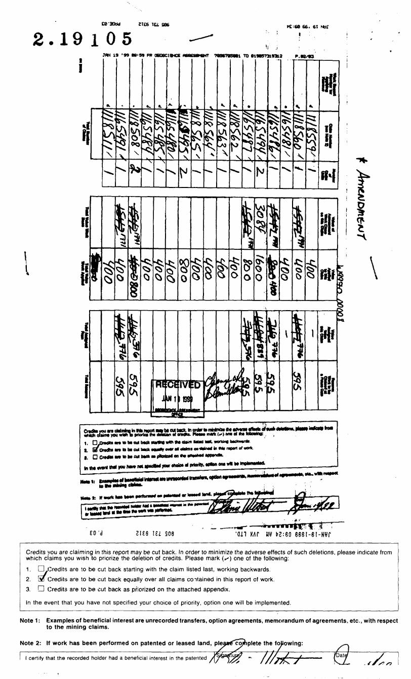
31M04SW2019 2.19105
r , j:STRATHY
•r.' i '.i010
LOGISTICAL and INTERPRETIVE
REPORTON
DEEP SPECTRAL IP/RESISTIVITY
SURVEYS
CONDUCTED ON THE
WEBSTER PROPERTY
STRATHY TOWNSHIP
TEMAGAMI AREA

LOGISTICAL and INTERPRETIVE
REPORT
ON
DEEP SPECTRAL IP/RESISTIVITY
SURVEYS
CONDUCTED ON THE
WEBSTER PROPERTY
STRATHY TOWNSHIP, TEMAGAMI AREA
NE ONTARIO
By:27 Blue Spruce Lane Thornhill, Ontario L3T 3W8
Tel: (905)731-9367 Fax: (905)731-7312
Attention: Slaine Webster
31M04SW2019 2.19105 STRATHY 010C
TABLE OF CONTENTS
1. INTRODUCTION 1
2. SURVEY SPECIFICATIONS AND PRODUCTION SUMMARY 2
3. PERSONNEL 3
4. FIELD INSTRUMENTATION AND POLE-DIPOLE ARRAY 4
4.1 IP Transmitter 4
4.2 IP Receiver 4
4.3 The Deep Gradient Array 4
5. DATA PROCESSING 4
5.1 IP AND RESISTIVITY 5
6. INTERPRETATION METHODOLOGY 6
6.1 IP AND RESISTIVITY 6
7. DISCUSSION OF RESULTS AND RECOMMENDATIONS 8
"J'

LIST OF FIGURES
Figure l : Location Map Figure 2: Grid/Claim Map
LIST OF TABLES
Table l: Specifications for the IP/Resistivity Survey Table 2: Spectral IP/Resistivity Production Summary
LIST OF APPENDICES
Appendix A: Instrument Specification Sheets andGradient-Array Geometry
Appendix B: Plates
LIST OF PLATES
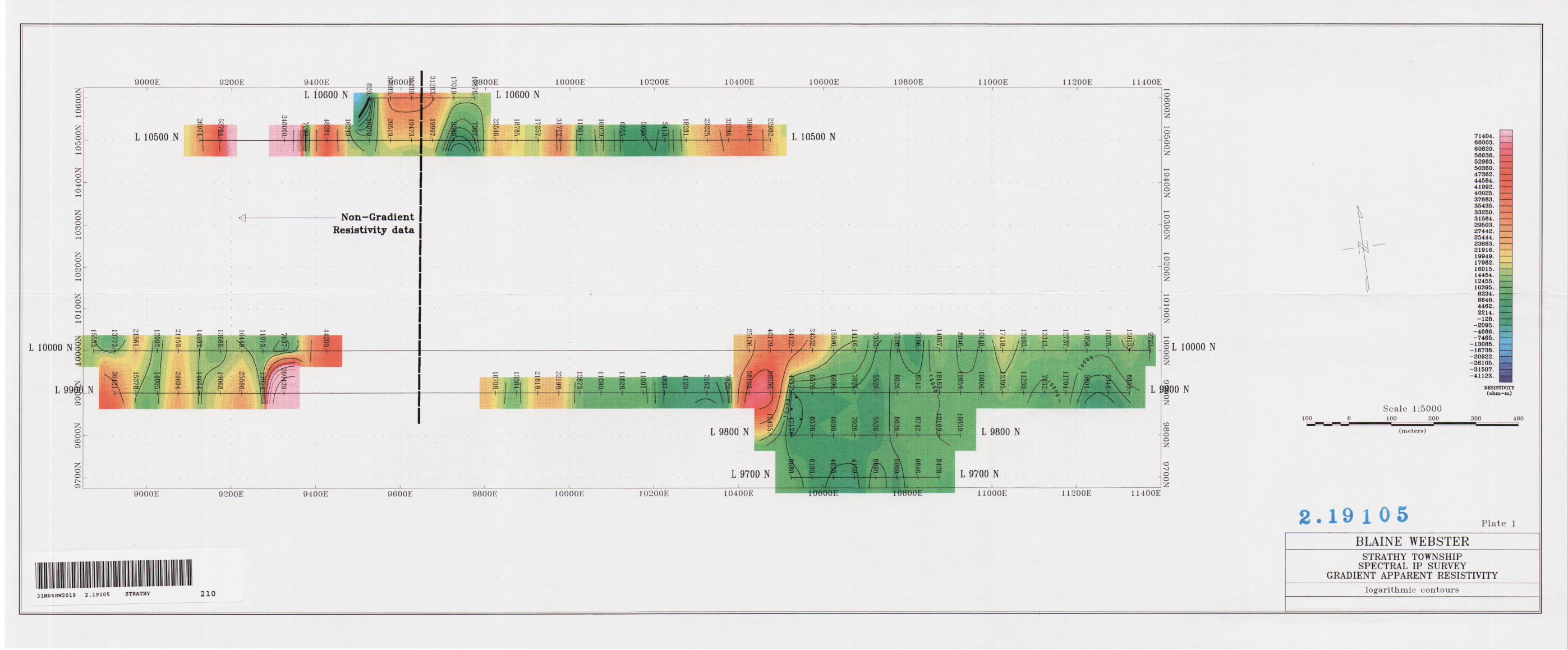
Plate l: Deep Gradient IP Chargeability Plan Map, l :5000 Plate 2: Deep Gradient Apparent Resistivity Plan Map, l:5000

1. INTRODUCTION
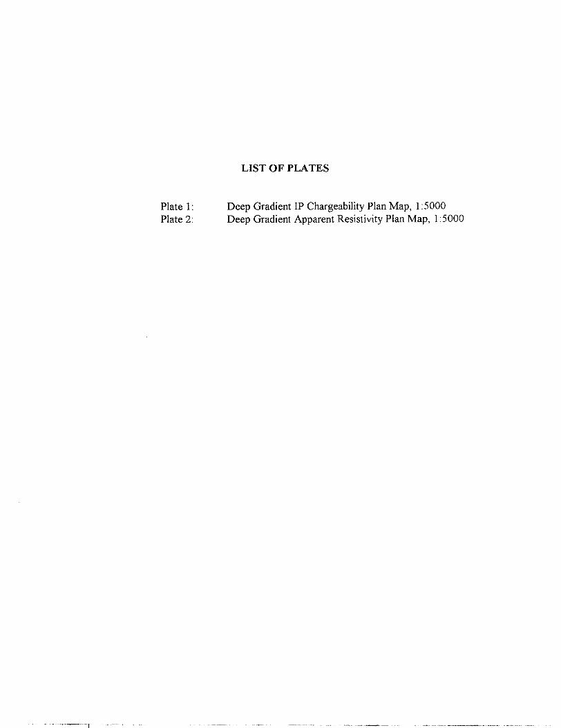
Blaine Webster re-established a survey grid and conducted Deep Time-Domain Spectral Induced Polarization (IP)7Resistivity surveys from January 4 through January 12, 1999 on behalf of Blaine Webster. The work was positioned on the Webster Property, Strathy Township, Northern Ontario. The survey location is shown in Figure l and the survey grid is shown in Figure 2.
The purpose of this survey was to locate areas of sulphides that could be related to economic mineralization.
The Webster. Property covers the following claims:
111856211185651165481116548311185101165479116548411654861118559
111856311654951165482116547611654911118511116548511654941118560
11185641165474116547511654771165478111850811654801165487
PROPERTY LOCATION
ALGONQUIh
PROVINCIAL
PARK
LOCATION MAP BLAINE WEBSTER TEMAGAMI AREA
Strathy Twp., NE Ontario N.T.S. 31 M/4
GROUND GEOPHYSICAL SURVEY
Scale: l : 1,600,000
Figure l
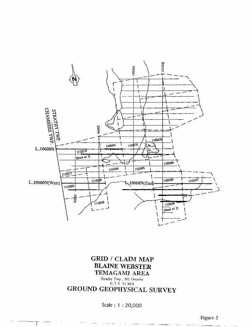
L.10600N
L.10000N(West)
GRID l CLAIM MAP BLAINE WEBSTER TEMAGAMI AREA
Strathy Twp.. NE Ontario N.T.S. 31 M/4
GROUND GEOPHYSICAL SURVEY
Scale : l : 20,000
TFigure 2

2. SURVEY SPECIFICATIONS and PRODUCTION SUMMARY
IP/Resistivity
Transmitter
Receiver
Array Type
Transmit Cycle Time
Receive Cycle Time
Electrode Spacing
Current Electrode "CI"
Current Electrode "C2"
Number of Lines Surveyed
Survey Coverage
Scintrex IPC-7/2.5 kW
Scintrex IPR-12
Deep Gradient
2 sec
2 sec
50 metres
10200N/11700E
10200N/9350E
6
5900m
Table 1: Specifications for the IP/Resistivity Survey
The production summaries are listed in the following tables:
Line
97+OON98+OON99+OON100+OON105+OON106+OON
Total
From Station
105+OOE104+50E89+OOE88+50E91+OOE95+OOE
To Station109+OOE109+50E113+50E114+OOE105+OOE98+OOE
#of Readings
8104031266
121
Distance (m)400500
(excl. gap) 1900(excl. gap) 1500
1300300
5900
Table 2: Survey Summary for IP/Resistivity Survey
3. PERSONNEL
Slaine Webster (Geophysicist)Mr. Webster supervised the crew on site and assisted in the survey.
Fred Moher (Geophysical Technician. Party Chief)Mr. Moher read the IPR-12 and carried out the IP survey. He was also responsible fordata quality and all members of the crew.
Vaso Lymberis (Draftsperson):Ms. Lymberis carried out the drafting on the figures/plates. She also assembled thisreport.
Joe Mihelcic (Geophysicist):Mr. Mihelcic processed and plotted the edited data, prepared this report and isresponsible for data storage.

4. FIELD INSTRUMENTATION and POLE-DIPOLE ARRAY
The instruments employed in the survey are described below.
4.1 IP Transmitter
The Scintrex IPC-7/2.5 k\V Time Domain Transmitter powered by an eight- horsepower motor generator. The transmitter generates square wave current output with a period of 4, 8, or 16 seconds. A digital multimeter in series with the transmitter is used to measure the magnitude of the current output.
4.2 IP Receiver
The Scintrex IPR-12 Time Domain Receiver was used. This unit samples the voltage decay curve as measured by the potential electrodes at different points in time. Readings are repeated until they converge to within a tolerance level, and the data are stored in solid-state memory. Spectral parameters Tau and MIP are also calculated and recorded automatically
4.3 The Deep Gradient Array
The "Deep Gradient Array" survey configuration was used. Typically, it is made up of two permanently placed current electrodes Ci and Ci located relatively far apart. Potential electrodes are used to take measurements at regular intervals between the current electrodes. The deep-penetration is achieved because the current is allowed to flow over a large area of ground.
5. DATA PROCESSING
After being transferred to a field computer at the end of each survey day, the data were examined, corrected, and organized by the instrument operator. The results were plotted on a
* STAR NX-80 colour dot-matrix printer
These plots were used to monitor progress and data quality, and to make an initial interpretation. Thus survey parameters and design were altered when necessary.
5.1 IP AND RESISTIVITY
The data were sent by courier to Thornhill, Ontario, where they were processed and the results plotted on the following printers as was appropriate:
- HEWLETT PACKARD DESIGNJET 750C 36 inch colour plotter . HEWLETT PACKARD 5L Laser printer
The processing procedure is outlined below:
1) Software was used to spatially reference the time-domain data. Spectral tau and M-IP were calculated - in addition to chargeability and apparent resistivity. The spectral parameters describe the shape of the IP decay curve, giving information about:
* the grain size (indicated by the parameter tau),* the magnitude of the chargeable source (indicated by M-IP),* the variability of grain size (indicated by c).
The spectral parameters were calculated internally in the IPR-12 and with Softll (Scintrex). Softll software works on IP R-11 format data and it also varies the spectral value c, whereas the IPR-12 uses a fixed value for c. This provides more reliable interpretative results. Software was used to convert the time slices from IPR-12 windows to IPR-11 windows. The MO slice was extrapolated based on the approximate straight-line appearance of the Log-Lin decay curve. This estimation proved satisfactory for our purposes based on sensitivity analyses. The spectral data are not presented in this report.
2) The GEOSOFT IP Package was used to generate colour and black and white pseudosections of chargeability and resistivity data.
3) Plan maps of both chargeability and resistivity data were produced using the GEOSOFT Mapping Package. Additional drafting on these maps was done through AutoCAD.
Step l, was performed both in the field and in the Toronto office. Steps 2 and 3 were performed in Thornhill.

6. INTERPRETATION METHODOLOGY
Mr. Webster relies on his many years of experience in geophysical interpretation to extract the most accurate information from the data. The procedures involved are simplified for the sake of clarity.
6.1 IP AND RESISTIVITY
The IP and resistivity data are interpreted using the following procedure:
l) Chargeability anomalies are picked and classified using the following scheme as a guide:
Very Strong ^ 30 mV/V) and well defined
Strong (20 to 30 mV/V) and well defined
Moderate (10 to 20 mV/V) and well defined
- - - Weak (5 to 10 mV/V) and well defined
Very Weak (3 to 5 mV/V) and poorly defined
x x x x Extremely Weak ^3 mV/V) and very poorly defined
2) The spectral characteristics of the anomalies are examined (spectral data are not presented in this report). The peak value of M-IP is noted, and tau is classified according to the following scheme:
IPR-12/SoftII Scheme:
L Long CM O s)
M Medium (l s to 10s)
S Short ^ l s)

3) Resistivity anomalies are picked on the pseudosections and classified using the following scheme as a guide:
no symbol VH(n) Very High ^ 25 000 ohm m) highly silicified
no symbol H(n) High ^ l O 000 ohm m) probably silicified
no symbol WH(n) Weak High (^ l O 000 ohm m) relative increase compared to surrounding material
SL(n) Strong Low — strong decrease in resistivity
Mi,(n)Medium Low — medium decrease in resistivity
WL(n) Weak Low — weak resistivity decrease relative to surrounding material, where n is the dipole number at which the anomaly peak is located.
4) The anomalies from steps l to 3 are marked on the Compilation Map (not prepared/necessary for this report).
5) Zones of high chargeability are interpreted based on resistivity and geometric information.
6) The anomalies are rated according to criteria developed through Mr. Webster's long association with evaluating similar data.
7. DISCUSSION OF RESULTS and RECOMMENDATIONS
The IP results from the present survey were examined and interpreted in conjunction with results presented in a previous geophysical report (September, 1995 "A Report on Line-cutting and Magnetometer Surveys at the Webster Property".
The Chargeability data are presented in Plate l. In general, the eastern part of the surveyed area consists of several anomalies. The main zone extends between stn.lOS+OOE and the eastern survey boundary on L98+OON, L99+OON and L100+OON. The zone may also extend north to L106+OON where its western limit is located at
stn.l02*OOE.
These areas of high chargeability appear to be bounded in the west by the magnetic high zone identified in the earlier report (ref. 9526). This zone appears to run north- south with a slight inflection at L9800N where a possible alteration zone was interpreted.
Based solely on the magnetics data, the earlier report recommended further work at, and east of, this magnetic high zone (roughly located at stn. 105+OOE in the middle, stn.lOS+SOE in the north end, and at stn.lOe+OOE on L9800N). The IP results appear to reinforce this interpretation by indicating that chargeable sulphides are present in these target areas.
Apparent resistivity results (Plate 2) indicate that the chargeable areas coincide predominanly resistive rock. Values greater than ten thousand ohms can be caused by silicified rock.
NOTE: The western current electrode was positioned at 9350E. Apparent resistivity data located west of ~~9600E should not be viewed as "gradient-data" and are therefore not post-processed/interpreted in this report. The chargeability data are also "non-gradient" but are interpreted here because no post-processing is required (e.g., no k-factor calculations required; data approaches a pole-dipole appearance).

The geophysical data show that the area warrants further investigation. A pole-dipole survey had been previously surveyed. The deep IP data indicate a deeper source and a new source further to the east (9900E/ 11200E) which was not covered by the pole- dipole data. Anomalies that are detected by the pole-dipole configuration can be compared to the deep-gradient results. Anomalies that are detected with the deep- gradient array and not the pole-dipole array are likely quite deep. Anomalies that are detected with both methods are likely relatively shallow.
If there are questions with regard to the survey or its interpretation please call the undersigned.
Respectfully submitt
Slaine Webster Geophysicist

APPENDIX A
~r
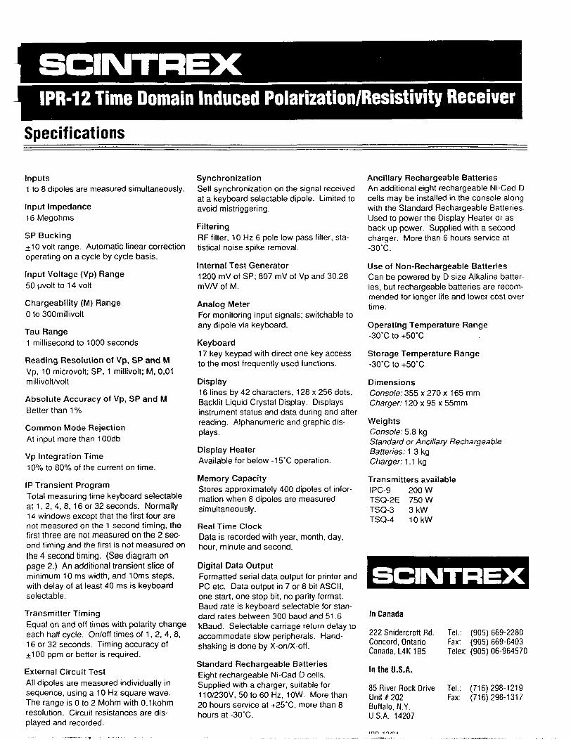
l PR-12 Time Domain Induced Polarization/Resistivity Receiver
Specifications
Inputs1 to 8 dipoles are measured simultaneously.
Input Impedance16 Megohms
SP Bucking+10 volt range. Automatic linear correction operating on a cycle by cycle basis.
Input Voltage (Vp) Range50uvoltto 14 volt
Chargeability (M) RangeO to SOOmillivolt
Tau Range1 millisecond to 1000 seconds
Reading Resolution of Vp, SP and MVp, 10 microvolt; SP, 1 millivolt; M, 0.01millivolt/volt
Absolute Accuracy of Vp, SP and MBetter than 1 "/o
Common Mode Rejection At input more than 100db
Vp Integration Time1007o to 8007o of the current on time.
IP Transient Program Total measuring time keyboard selectable at 1, 2, 4. 8, 16 or 32 seconds. Normally 14 windows except that the first four are not measured on the 1 second timing, the first three are not measured on the 2 sec ond timing and the first is not measured on the 4 second timing. (See diagram on page 2.) An additional transient slice of minimum 10 ms width, and 10ms steps, with delay of at least 40 ms is keyboard selectable.
Transmitter TimingEqual on and off times with polarity change each half cycle. On/off times of 1, 2, 4, 8, 16 or 32 seconds. Timing accuracy of 100 ppm or better is required.
External Circuit Test All dipoles are measured individually in sequence, using a 10 Hz square wave. The range is O to 2 Mohm with O.lkohm resolution. Circuit resistances are dis played and recorded.
SynchronizationSelf synchronization on the signal received at a keyboard selectable dipole. Limited to avoid mistriggering.
FilteringRF filter, 10 Hz 6 pole low pass filter, sta tistical noise spike removal.
Internal Test Generator1200 mV of SP; 807 mV of Vp and 30.28 mV/V of M.
Analog MeterFor monitoring input signals; switchable to any dipole via keyboard.
Keyboard17 key keypad with direct one key access to the most frequently used functions.
Display16 lines by 42 characters, 128 x 256 dots, Backlit Liquid Crystal Display. Displays instrument status and data during and after reading. Alphanumeric and graphic dis plays.
Display HeaterAvailable for below -15'C operation.
Memory CapacityStores approximately 400 dipoles of infor mation when 8 dipoles are measured simultaneously.
Real Time ClockData is recorded with year, month, day,hour, minute and second.
Digital Data OutputFormatted serial data output for printer and PC etc. Data output in 7 or 8 bit ASCII, one start, one stop bit, no parity format. Baud rate is keyboard selectable for stan dard rates between 300 baud and 51.6 kBaud. Selectable carriage return delay to accommodate slow peripherals. Hand shaking is done by X-on/X-off.
Standard Rechargeable BatteriesEight rechargeable Ni-Cad D cells. Supplied with a charger, suitable for 110/230V, 50 to 60 Hz, 10W. More than 20 hours service at -i-25'C, more than 8 hours at -30"C.
Ancillary Rechargeable BatteriesAn additional eight rechargeable Ni-Cad D cells may be installed in the console along with the Standard Rechargeable Batteries. Used to power the Display Heater or as back up power. Supplied with a second charger. More than 6 hours service at-30'C.
Use of Non-Rechargeable BatteriesCan be powered by D size Alkaline batter ies, but rechargeable batteries are recom mended for longer life and lower cost over time.
Operating Temperature Range-30'C to *50'C
Storage Temperature Range-30'C to -t-50'C
DimensionsConsole: 355 x 270 x 165 mm Charger: 120 x 95 x 55mm
WeightsConsole: 5.8 kgStandard or Ancillary RechargeableBatteries: 1.3 kgCharger: 1.1 kg
Transmitters availableIPC-9 200 W TSQ-2E 750 W TSQ-3 3 kW TSQ-4 10kW
In Canada
222 Snidercroft Rd. Concord, Ontario Canada, L4K 165
In the U.S.A.
85 River Rock Drive Unit # 202 Buffalo, N.Y. U.S.A. 14207
Tel.: (905) 669-2280 Fax: (905) 669-6403 Telex: (905) 06-964570
Tel.: Fax:
(716)298-1219 (716)298-1317
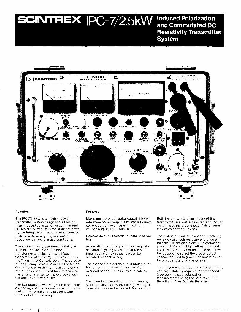
IPC-7/2. Induced Polarization and Commutated DC Resistivity Transmitter System
FAN BXHAUST START GROUNDRESISTAIVCE
Function
J"he IPC-7/2.5 kW is a medium power transmitter system designed for time do main induced polarization or commutated DC resistivity work. It is the standard power transmitting system used on most surveys under a wide variety of geophysical, topographical and climatic conditions.
The system consists of three modules: A Transmitter Console containing a transformer and electronics, a Motor Generator and a Dummy Load mounted in the Transmitter Console cover. The purpose of the Dummy Load is to accept the Motor Generator output during those parts of the cycle when current is not transmitted into the ground, in order to improve power out put and prolong engine life.
The favourable power-weight ratio and com pact design of this system make it portable and highly versatile for use with a wide variety of electrode arrays-
Features
Maximum motor generator output, 2.5 kW; maximum power output, 1.85 kW; maximum current output, 10 amperes; maximum voltage output, 1210 volts DC.
Removable circuit boards for ease in servic ing.
Automatic on-off and polarity cycling with selectable cycling rates so that the op timum pulse time (frequency) can be selected for each survey.
The overload protection circuit protects the instrument from damage in case of an overload or short in the current dipole cir cuit.
The open loop circuit protects workers by automatically cutting off the high voltage in case of a break in the current dipole circuit.
Both the primary and secondary of the transformer are switch selectable for power matching to the ground load. This ensures maximum power efficiency.
The built-in ohmmeter is used for checking the external circuit resistance to ensure that the current dipole circuit is grounded properly before the high voltage is turned on. This is a safety feature and also allows the operator to select the proper output voltage required to give an adequate current for a proper signal at the receiver.
The programmer is crystal controlled for the very high stability required for broadband (spectral) induced polarization measurements using the Scintrex IPR-11 Broadband Time Domain Receiver.

Technical Description of IPC-7/2.5 kW Transmitter System
Complete 2.5kW induced polarization system including motor-generator, reels with wire, tool kit. porous pots, simulator circuit, copper sulphate /PR-8 receiver, dummy load, transmitter, electrodes and clips.
IPC 7 /2.5kW transmitter console with lid and dummy load
T T
T T T T
Time Domain Waveform
Transmitter Console
Maximum Output Power
Output Current
Output Voltage
1.85 kW maximum, defined as VI when cur rent is on, into a resistive load
10 amperes maximum
Switch selectable up to 1210 volts DC
Automatic Cycle Timing T:T:T:T; on:off:on:off
Automatic Polarity Change
Pulse Durations
Each 2T
Standard: T s 2,4 or 8 seconds, switchselectableOptional: T = 1,2,4 or 8 seconds, switchselectableOptional: T - 8,16,32 or 64 seconds, switchselectable
Voltage Meter
Current Meter
1500 volts full scale logarithmic
Standard: 10.0 A full scale logarithmic Optional: 0.3, 1.0, 3.0 or 10.0 A full scale linear, switch selectable
Period Time Stability Crystal controlled to better than .01 "/o
Operating Temperature Range -30"C to
Overload Protection Automatic shut-off at output current above 10.0 A
Open Loop Protection
Undervoltage Protection
Automatic shut-off at current below 100 mA
Automatic shut-off at output voltage less than 95 V
Dimensions
Weight
280 mm x 460 mm x 310 mm
30kg
Shipping Weight 41 kg includes reusable wooden crate
MoJor Generator
Maximum Output Power 2.5 kVA, single phase
Output Voltage 110 VAC
Output Frequency
Motor
400 Hz
4 stroke, 8 HP Briggs S Stratton
Weight 59kg
Shipping Weight 90 kg includes reusable wooden crate
222 Smdercroft Road Concord Ontario Canada L4K 1B5
Telephone: (416) 669-2280 Cable: Geoscint Toronto Telex: 06-964570
Geophysical and Geochemical Instrumentation and Services

APPENDIX B
, .Ministry of Northern Development and Mines
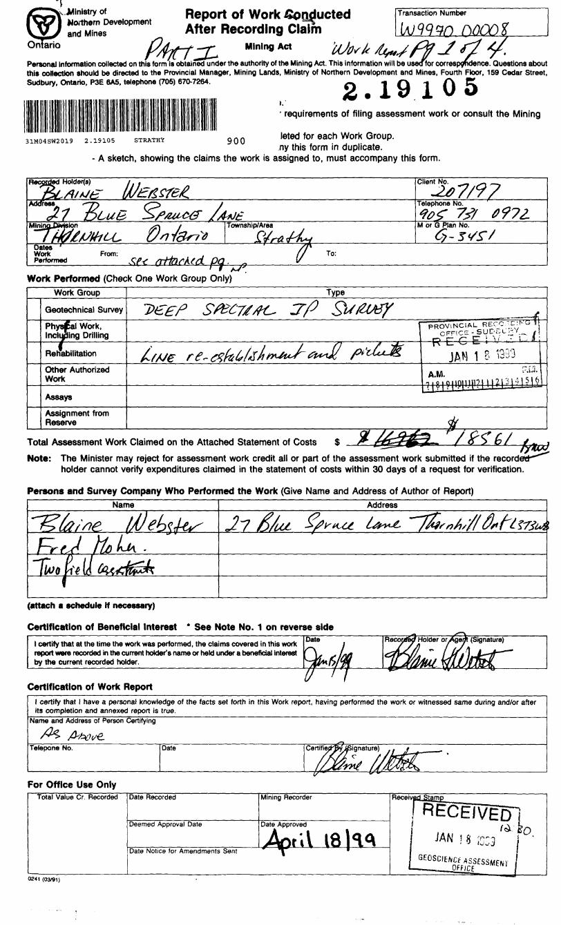
Report ofAfter Recording Claim
Mining Act
Transaction Number
Personal information collected on this form is obtained under the authority of the Mining Act. This information will be useofor correspondence. Questions about this collection should be directed to the Provincial Manager, Mining Lands, Ministry of Northern Development and Mines, Fourth Floor, 159 Cedar Street, Sudbury, Ontario, P3E 6A5, telephone (705) 670-7264. -^ 1 f\ 1 A CL2 . iy i w o
p requirements of filing assessment work or consult the Mining
31M04SW2019 2.19105 STRATHY 900 leted for each Work Group, ny this form in duplicate.
- A sketch, showing the claims the work is assigned to, must accompany this form.
Holders) Client No.. ^- -, ^,
-107/97Telephone No.
Mini Township/Area M or Q Plan No.
Oates Wortt Performed
From: -Ph To;Work Performed (Check One Work Group Only)
Work Group Type
Geotechnical Survey
Phytal Work, Including Drilling
^54-i - i ^J n ',
Rehabilitation
Other Authorized Work
Assays
Assignment from Reserve
Total Assessment Work Claimed on the Attached Statement of Costs $ P" {4Z~f1SF?* * f ^^ ®' if ••^^*Note: The Minister may reject for assessment work credit all or part of the assessment work submitted if the recorded-*^
holder cannot verify expenditures claimed in the statement of costs within 30 days of a request for verification.
Persons and Survey Company Who Performed the Work (Give Name and Address of Author of Report)Name Address
J 7
(attach a schedule If necessary)
Certification of Beneficial Interest * See Note No. 1 on reverse sideDate (Signature)l certify that at the time the work was performed, the claims covered in this work
report were recorded in the current holder's name or held under a beneficial interest by the current recorded holder.
Holder or
m^Certification of Work Report
l certify that l have a personal knowledge of the facts set forth in this Work report, having performed the work or witnessed same during and/or after its completion and annexed report is true.
Name and Address of Person Certifying
Telepone No. Date
For Office Use OnlyTotal Value Gr. Recorded Date Recorded
Deemed Approval Date
Mining Recorder
Date Approved
Av.V 18 K ADate Notice for Amendments Sent " "V *
Receiv
i
/ad Stamp
RECEIVED!/^ ko
JAN 1 8 jc:3 j 'GEOSCIE^3SESSMENr j
0241 (03/91)
zics TU see
2.19105:6B 66. 6T NW
lIJtN 19 -99 08-99 FI) CBQBCIBCC
ii\•a ^
11 TO B19B573H312 P.K/flO
^ 'fc
-A45^•o \
SN
\S?
B!
*l
EO'dXAT HV bZ:60 6681-61-NWf
Credits you are claiming in this report may be cut back. In order to minimize the adverse effects of such deletions, please indicate from which claims you wish to priorize the deletion of credits. Please mark (^) one of the following:
1. D.Credits are to be cut back starting with the claim listed last, working backwards.
2. Se Credits are to be cut back equally over all claims contained in this report of work.
3. D Credits are to be cut back as pfiorized on the attached appendix.
In the event that you have not specified your choice of priority, option one will be implemented.
Note 1: Examples of beneficial interest are unrecorded transfers, option agreements, memorandum of agreements, etc., with respect to the mining claims.
Note 2: If work has been performed on patented or leased land, ple^8e"cc^hplete the following:
T ,l certify that the recorded holder had a beneficial interest in the patented

J rtft- l 3- l 333 M fi JVA Lil). 9Ub /3) 9312 F. 02
2,19105X* l*'** Midi C* OEOKIENCB TO 119057319312 P.83/83
1 '^f
\ ka
"?- f
^;NJ
\
^
•*w'
r^
^?
--. '
i vft.1^n5i\ x
\i\
•*
V
1\
•^N.
irv
•^^
mjKfi
lg f*
S&SSP
Sg
fi&r
\
i. Dt,rft d
')eo*orM M b* ei* tm* Mrfeifl -* M Mta Mted luL working bwtamd*.
^•uyb*a(*9u*|ro*w*ld*iuooTtoin*hW.™pgngfwgA.k* MMMt w frMiM en tr* tfMtMd i
M** W i** "* *tf*N ywr (Met d priori*
JflN 19 '99 09:33** TOTPL PfCE.tS
905 731 9312 PPGE.02
Credits you are claiming in this report may be cut back. In order to minimize the adverse effects of such deletions, please indicate from which cl'aims you wish to priorize the deletion of credits. Please mark (^) one of the following:
1. n Credits are to be cut back starting with the claim listed last, working backwards.
2. Jfl Credits are to be cut back equally over all claims contained in this report of work.
3. D Credits are to be cut back as priorized on the attached appendix.
In the event that you have not specified your choice of priority, option one will be implemented.
Note 1: Examples of beneficial interest are unrecorded transfers, option agreements, memorandum of agreements, etc., with respect to the mining claims.
Note 2: If work has been performed on patented or leased land, please complete the following:
l certify that the recorded holder had a beneficial interest in the patented or leased land at the time the work was performed.
OntarioMinistry ofNorthern Developmentand Mines
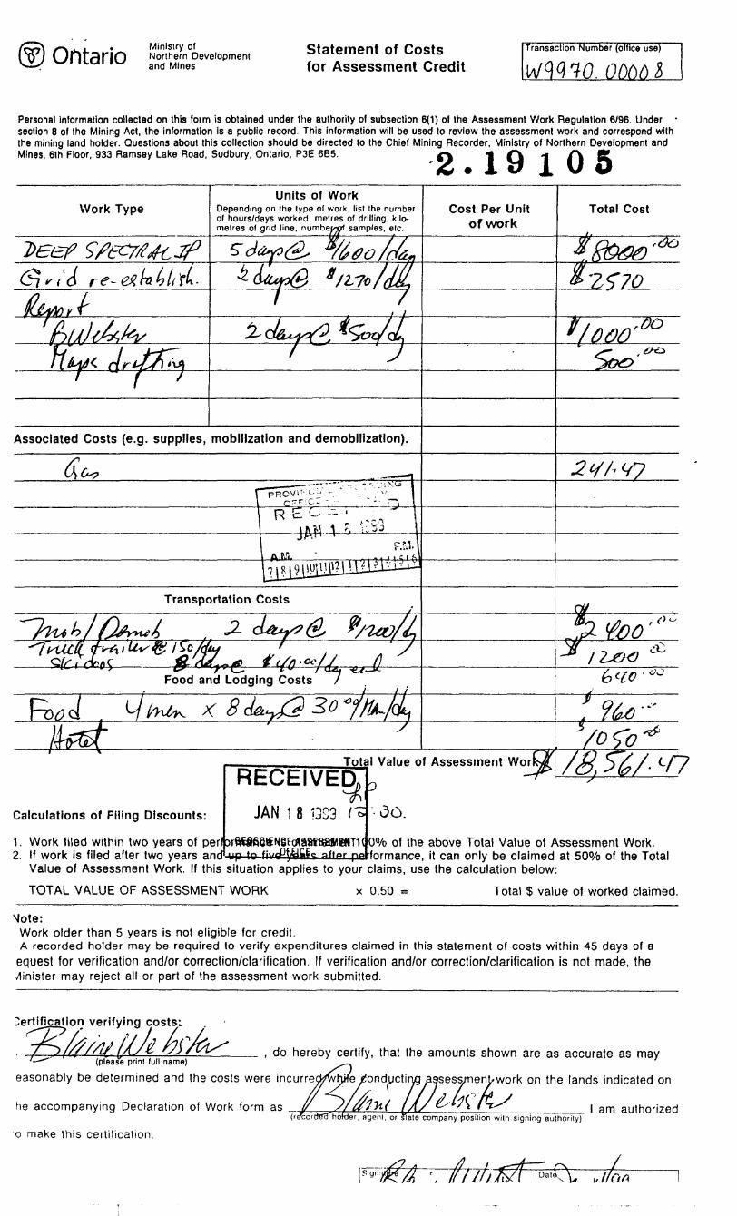
Statement of Costs for Assessment Credit
Transaction Number (ellice use)
Personal information collected on this form is obtained under the authority of subsection 6(1) of the Assessment Work Regulation 6/96. Under - section 8 of the Mining Act, the information is a public record. This information will be used lo review the assessment work and correspond with the mining land holder. Questions about this collection should be directed lo the Chief Mining Recorder, Ministry of Northern Development and Mines, 6lh Floor. 933 Ramsey Lake Road, Sudbury, Ontario, P3E 685. ~2.19105
Work TypeUnits of Work
Depending on the type of work, list the number of hours/days worked, metres of drilling, kilo metres of grid line, numbef samples, etc.
Cost Per Unit of work
Total Cost
Associated Costs (e.g. supplies, mobilization and demobilization).
Transportation Costs
Food and Lodging Costs
Calculations of Filing Discounts:
1. Work filed within two years of perf xftffifieSNeFeflaafaaWHITK2. If work is filed after two years and
RECEIVETotal Value of Asspssment Wor
JAN 1 8 (323 t
*f*-
7K ac.
00Xo of the above Total Value of Assessment Work, formance, it can only be claimed at 5007o of the Total
Value of Assessment Work. If this situation applies to your claims, use the calculation below:
TOTAL VALUE OF ASSESSMENT WORK x 0.50 ~ Total S value of worked claimed.
Mote:Work older than 5 years is not eligible for credit.A recorded holder may be required to verify expenditures claimed in this statement of costs within 45 days of a equest for verification and/or correction/clarification. If verification and/or correction/clarification is not made, the Minister may reject all or part of the assessment work submitted.
n verifying costs;
, do hereby certify, that the amounts shown are as accurate as may
jss/nent-wor
henL s 'ty\ /'-f^
(please print full name)
easonably be determined and the costs were incurredTwh/e rfonductirvg^gsess/nen^work on the lands indicated on
//^/^he accompanying Declaration of Work form as ________
agenl. or State i company position with signing authority)l am authorized
o make this certification.
,, I/a fi

Ministry of Ministers duNorthern Development Developpement du Nordand Mines et des Mines Ontario
Geoscience Assessment Office 933 Ramsey Lake Road
April 16, 1999 6th FloorSudbury, Ontario
SLAINE RICHARD WEBSTER P3E 6B527 BLUE SPRUCE LANETHORNHILL, Ontario Telephone: (888) 415-9846L3T-3W8 Fax: (877)670-1555
Visit our website at: www.gov.on.ca/MNDM/MINES/LANDS/mlsmnpge.htm
Dear Sir or Madam: Submission Number: 2.19105
Status Subject: Transaction Number(s): W9970.00008 Approval
We have reviewed your Assessment Work submission with the above noted Transaction Number(s). The attached summary page(s) indicate the results of the review. WE RECOMMEND YOU READ THIS SUMMARY FOR THE DETAILS PERTAINING TO YOUR ASSESSMENT WORK.
If the status for a transaction is a 45 Day Notice, the summary will outline the reasons for the notice, and any steps you can take to remedy deficiencies. The 90-day deemed approval provision, subsection 6(7) of the Assessment Work Regulation, will no longer be in effect for assessment work which has received a 45 Day Notice. Allowable changes to your credit distribution can be made by contacting the Geoscience Assessment Office within this 45 Day period, otherwise assessment credit will be cut back and distributed as outlined in Section #6 of the Declaration of Assessment work form.
Please note any revisions must be submitted in DUPLICATE to the Geoscience Assessment Office, by the response date on the summary.
If you have any questions regarding this correspondence, please contact Lucille Jerome by e-mail at [email protected] or by telephone at (705) 670-5858.
Yours sincerely,
ORIGINAL SIGNED BYBlair KiteSupervisor, Geoscience Assessment OfficeMining Lands Section
Correspondence ID: 13641
Copy for: Assessment Library

Work Report Assessment Results
Submission Number: 2.19105
Date Correspondence Sent: April 16, 1999 Assessor: Lucille Jerome
Transaction First ClaimNumber Number Township(s) / Area(s)W9970.00008 1165494 STRATHY
Section:14 Geophysical IP
StatusApproval
Approval Date
April 16, 1999
Assessment work credit has been approved as outlined on the attached Distribution of Assessment Work Credit sheet to reflect the location of the work.
Correspondence to:Resident Geologist Sudbury, ON
Assessment Files Library Sudbury, ON
Recorded Holder(s) and/or Agent(s):SLAINE RICHARD WEBSTER THORNHILL, Ontario
Page: 1
Correspondence ID: 13641

Distribution of Assessment Work Credit
The following credit distribution reflects the value of assessment work performed on the mining land(s).
Date: April 16, 1999
Submission Number: 2.19105
Transaction Number: W9970.00008
Claim Number Value Of Work Performed
1118508 1,771.001118510 3,084.001118560 1,771.001165478 1,767.001165479 1,771.001165486 1,771.00
1165487 1,771.00
1165491 1,771.001165494 3,084.00
Total: S 18,561.00
Page: l
Correspondence ID: 13641

ZONE 1779=46'
595pOOmE
(225055
L - -" ^" : ' '
11 l 8,4.7
5 1223394
1212099
, X ..TR/T
l l
ff-e .L!4^vt;f\ ...-- ^ i*T 5X464 V
ZONE 17 87 09
'Ministry of Natural Resources
Ministry ofNorthern Developmentand Mines
OntarioPUT INTO SERVICE MARCH 23 1994,,
INDEX TO LAND DISPOSITION^
PLAN
G-3451TOWNSHIP
STRATHY
M.N.R. ADMINISTRATIVE DISTRICT
TEMAGAMIMINING DIVISION
SUDBURYLAND TITLES/REGISTRY DIVISION
NIPISSING
THE INFORMATION THAT APPEARS ON THIS MAP HAS BEEN COMPILE.D FROM VARIOUS SOURCES AND ACCURACY IS NOT GUARANTEED THOSE WISHING TO STAKE WIN ING CLAfMS SHOULD CON SULT WITH THE MINING RECORDFR. MINISTRY OF NORTHERN DEVELOP MENT AND MINES. FOR AD DITIONAL INFORMATION ON THE STATUS OF THE LANDS SHOWN HEREON
Scale 1:20 000
1000 10OOMttrtl
2000
1000 DF**t M l-l MM M l—
1000 2000 3000 4000 5000 6000 7000 8000 9000 10000
Contour Interval 10 M*tret
VrV
AREAS WITHDRAWN FROM DISPOSITIONMRO - Mining Rights Only
SRO- Surface Rights Only
M H- S - Mining and Surface Rights
SYMBOLS Description
36(o)R.S.O.I9SO
Order No.
OC 2022/66
Dltl Oitpocltlon
SRO.
File
3996
Boundary
Township, Meridian, Baseline.
Road allowance; surveyed... . .. ....
shoreline
Lot/Concession; surveyed,
unsurveyed
Parcel; surveyed ...... ....... ...... .
unsurveyed . .
Right-of-way, road .... .... . .
railway . , ......
utility...... .... ..
Reservation ......... ... .... .... ....
Cliff, Pit, Pile ........... .. ........ .....
Contour . ... .. .
Interpolated ...... .... . .. .. . .
Approximate .... .. ....
Depression..... . .. . .
Control point (horizontal)
Flooded land... .. ....
Mine head frame .... ........
Pipeline (above ground) . .. ... .
Railway; single track.
double track
abandoned......
Road; highway, county, township
access ..............
trail, bush ........... ... ....
Shoreline (original).... .... ... ...........
Transmission line .............
Wooded area, . ........ . ....................
^and Usi* Hermit .................
^-OI/ffl/ONT
3EC.36/80 *-3-oe/* HER
5.R.O,
M4 S
LAND ROLL
PENDING OWOamoN UNDER THE PUBLIC LANDS ACT
LAND NOT OPEN FOR STAKING SUB-SECTION 30(B) OF THE
MINING ACT RJ.O, 1990
MOTKE RECEIVED 9EAMN/06
SEC.35/90 0-3-18/93 AUfi.il/9S MAS 193130
SEC.35/90 O-S-31/94 AUG.II/94 MAS 195150
St.C.35/90 WrS-32/95 JUNri..'9S MSS 195150iV-S-77 /9S 09 f' 1 '*E
MSS 195150
Pending Disposition MNR Not Opan For Staking
Pending Disposition MNR Not Open For Staking,3 EC. 35/90 *-S-60.'9jg O9/I3/96 MSS 195150
~
DISPOSITION OF CROWN LANDSPatent
Surface S Mining Rights ..... ...
Surface Rights Only
Mining Rights Only
Lease
Surface 4 Mining Rights ..... .... .......... . .
Surface Rights Only............... ... ..... ........
Mining Rights Only ....... ......... ....
Licence of Occupation . ............. ........ ...
Order-in-Councii....... .
Cancelled .... .... .. ....
Reservation.......
Sand A Gravel.
NOTICKWORK I'F.KMITS KOK MIM'KAI KM'I OK VIKIN \( IIMM
KITH l !\ Y. .Si|Hniiliii IS 1 " fox
' he .K .1 shiiun j.- SK'i LIM KKSKR\ K .UK! (he kind emeied h\ Hie W.JUTX nl I.AKK. l KMAC.VMl mi ilus imp \\ill lv siihieei lo
l 111 pending on the type Jiul 11111111*4 of \om e\plniaU"i- 'i k vim iiiuy icLjiiirc .1 \\ .'rk iV'tnii! l 1 ." t;i:iln.'i inloi'Dun.'. plL'j^i 'HI,K! (.jciluul .\U".ci. Ri.'^ioiul RL-sidcnt t K oiuuM .a \~\^\ .-'tr-5J4J .n
i y-. -- -SHCTICIJ l o; THE M(NIN(i ACT
- SEC 55/90 W-S-55/98 NOV.27/98 MSS 195150.
r'l KASKNOIK: I'HK ISLAM) O\ l \KK IKMA(,A\IIA1O \\rilli)KA\\N AM) \MI.I.
\()l OI'KN TO I'KOSI'KCI IN(. AM) SJAKIM.OI J
NOTES
ISLAND 27 BELONGS WITH STRATHCONA TWP.
ISLANDS in l^AKE TEMAGAMI - NOT OPEN FOR STAKING SI-C3S/90 " i *^5* C*WJ4V** M t 5 IS5ISO
OS'U'SS
...B
...B
...T
oc
..(D
SKYLINE RESERVL
(RI 4 yNOTIC E
i Scv lion . ; ^. ni ilk-Miniii'j .ALL K S () I'j'in ih L - MIMM, AM) SI K!-A(. l: RK il l l S nlrlic .i.vj slmu ,, ^ L-K\ LINK RKSKk\'K and th-,- bnJ c.'\cicd by the u:iieis ni i AKI- l K.MA(;AMI as nulicaicdfui this map mil lu- KK-OI'KNKI) TO PKOSPKCTIM; AM) STAKI\(. Ol | Mils Older comes into el'leet on October 27. |')4S ut l':0l) j. m . I'.a.stein Staiidaul l mie. \\hieli ih equivalent io ()-')n j ni lo^jl nnif l heie Ijiul'; \\ill he suhjeci Co OMMIIO Keyiilaiion ~?ti ')s m.u | L- indei tlie Mmnvj V.-t ALI ( I AIM S [ \ K l M , AC ll\ | \\ |\
1 IILS AKI A K vuhjeu M (his new. rciiulaimn .MAJORA M H N DM K MS TO NORMAL ST A KIM i PRACI K KS HA\ K BKKN IMFI.KMKM K[) l OR I JUS ARKA. C oiiMilt .did iiinlersiiiiKl ihesc anicnjiik'n
to ejimni; mil .in\ siakm- in ilns d L-ML;ii.ited aiea. l ..i lm nil,.-11 MI ion please coniaei li K- I'nu UK 1.11 Keein tiers ( )iike
Jim liclaiid. Regional Muiuisjei all" 1 ) 2.^-1 d l J
Map base and land disposition drafting by Surveys and Mapping Branch, Ministry of Natural Resources.
The disposition of land, location of lot fabric and parcel boundaries on this index was compiled for administrative purposes only.
CD i
CM -^en
COH
m
O
CO
ol
en
31H04SW2019 2.19105 STRATHY 200
9000E 9200E 10000E 10200E 10400E
o o
o o
L 10000 Noo
L 10500 N
- Non-Gradient Resistivity data
Z oO
10600E 10800E 11000E 11200E 11400E
L 10500 N
roCO
CoOSroCO
too
L 10000 N
N
100Scale 1:5000
100 aoo
(meters)
9000E 9200E 9400E 9600E 9800E 10000E 10200E 10400E 10600E 10800E 11000E 11200E 11400E
2.19 l 05
71404. 66003. 60820. 56836. 52983. 50360. 47362. 44584. 41992. 40025. 37683. 35435. 33250. 31564. 29503. 27442. 25444. 23803. 21916. 19949. 17982. 16015. 14454. 12455. 10395.8334.6648.4462.2214.-128.
-2095.-4686.-7465.-13085.-1673B.-20922.-26105.-31507.-41123.
RESISTIVITY (ohm-m)
300 400
Plate l
31M04SW2019 2.19105 STRATHY 210
BLAINE WEBSTERSTRATHY TOWNSHIP
SPECTRAL IP SURVEYGRADIENT APPARENT RESISTIVITY
logarithmic contours

9000E 9200E 9400E
oo w o
L 10000 N oo
9600E~C3——l——CT 9ROOE 10000E 10ZOOE 10400E 10600E 10800E 11000E 11200E 11400E
L 10500 N
O 03O O SZJ
g L 10000 No
100
Scale 1:5000100 200
(meters)
11000E 11200K 11400E
2.19 l
9.3 8.9 8.6 8.4 8.1 8.0 7.8 7.6 7.5 7.3 7.2 7.1 6.9 6.8 6.7 6.6 6.5 6.4 6.2 6.1 6.0 5.9 5.8 5.7 5.5 5.4 5.3 5.2 5.1 4.9 4.8 4.6 4.5 4.1 3.9 3.6 3.3 3.0 2.4
CHARGEABILITY (mVA)
300 400
Plate 2
31M04SW2019 2.19105 STRATHY 220
BLAINE WEBSTERSTRATHY TOWNSHIP
SPECTRAL IP SURVEYGRADIENT APPARENT RESISTIVITY
Contours: ImV/V, 5 mV/V MX: 690 ms - 1050 ms