Embed Size (px)
Citation preview

BIO_SOS - GA N. 263435Biodiversity Multi-Source Monitoring System:
From Space To Species.
www.biosos.eu
On behalf of BIO_SOS consortium
Palma Blonda, CNR-ISSIA, Bari-Italy
FP7-SPACE, 3rd call
Area 9.1.1. Pre-operational validation of GMES services and products:
BIODIVERSITY Start Date 1/12/2010 End Date 1/12/2013
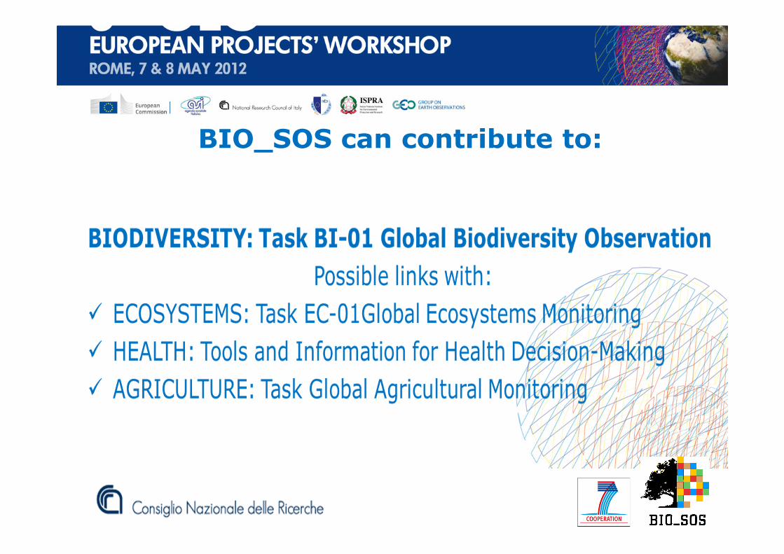
BIO_SOS can contribute to:


User Requirements
•Monitoring and understanding of the impacts that human
induced pressures (e.g., such as urbanization, road
construction, agriculture expansion, logging) on Biodiversity
•Mapping at scale 1:5000 or finer. (How much is there? Is it
changing? ). Land cover/use (LC/LU) change maps at VHR.
•Users require scientific support to evaluate the extension of
the buffer area around Natura 2000 sites where different
policies should be defined
BIO_SOS objective
Development of a pre-operational multi-modular ecological
modelling system suitable for effective multi-annual
monitoring of NATURA 2000 sites and their surrounding in
Mediterranean areas exposed to combined pressures.
• Natura 2000 sites in 3 Mediterranean and 2 Western Europe Countries• Additional areas are being considered in two tropical countries

BIO_SOS working objectives
• The development of pre-operational automatic HR and VHR EO
data processing and understanding techniques for LC/LU and LCC
maps production as an improvement of GMES core services.
• The development of an ecological modelling framework at both
habitat and landscape level to combine EO and in-situ data for:
�Habitat and Habitat change mapping (GHC and Annex I)
�Biodiversity indicator extraction.
�Scenario analysis to evaluate the impact that human
pressures may have on soil, water and vegetation.
as an extension of GMES downstream–services
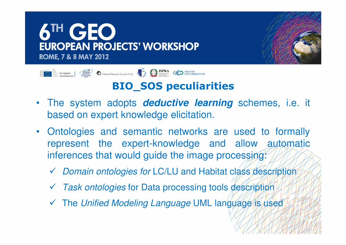
BIO_SOS peculiarities
• The system adopts deductive learning schemes, i.e. it
based on expert knowledge elicitation.
• Ontologies and semantic networks are used to formally
represent the expert-knowledge and allow automatic
inferences that would guide the image processing:
� Domain ontologies for LC/LU and Habitat class description
� Task ontologies for Data processing tools description
� The Unified Modeling Language UML language is used

BIO_SOS objective
Development of a pre-operational multi-modular ecological
modelling system suitable for effective and timely multi-
annual monitoring of NATURA 2000 sites and their surrounding
in Mediterranean areas exposed to combined pressures.
Its input data sources are VHR EO data and in-situ data
The system is based on deductive learning techniques, i.e. it is an expert knowledge based system for LCLU and Habitat mapping
Semantic net for olive grove:
• Nodes are objects
• Edges represent:temporal, spatial (e.g. adjacency, close to) and non-spatial (e.g. is a, part of) relations
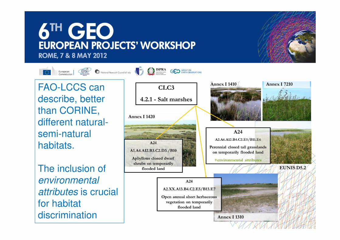
FAO-LCCS can
describe, better
than CORINE,
different natural-
semi-natural
habitats.
The inclusion of
environmental
attributes is crucial
for habitat
discrimination
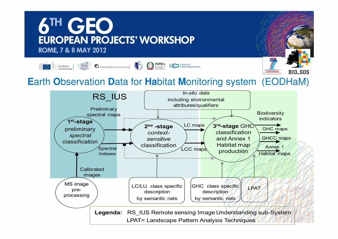
Earth Observation Data for Habitat Monitoring system (EODHaM)

Expert knowledge in the EODHaM 1st-stage: class spectral signatures

Expert knowledge in the EODHaM 2nd-stage: class description

BIO_SOS objective
Development of a pre-operational multi-modular ecological
modelling system suitable for effective and timely multi-
annual monitoring of NATURA 2000 sites and their surrounding
in Mediterranean areas exposed to combined pressures.
Its input data sources are VHR EO data and in-situ data
The system is based on deductive learning techniques, i.e. it is an expert knowledge based system for LCLU and Habitat mapping
Expert Knowledge in the EODHaM
3rd -stage: LCCS to GHC mapping disambiguation

BIO_SOS contribution to GEO Task BI-01
• Continuity with EBONE for biodiversity monitoring at regional level: it
can provide VHR habitat maps as GHC and Annex I maps from SPACE
• FAO-LCCS taxonomy and the elicitation of expert knowledge trough
ontologies and semantic networks are used as brokering tools to
combine different domains: possible link to “Infrastructure”:
• Development of a systematic mapping framework from LCLU to GHC.
• The output products will be made available for policy decision
making and to follow up impact of existing policies.

Collaboration to implement GEOTask BI-01
VHR data are collected by tasking (i.e., not available everywhere)
• Long-term collection/validation of both in-situ and contemporary
multi-scale EO data for sites monitored within GEO related FP7
projects (as hotspots or supersites) for indicator extraction and
trend evaluation:
� Habitat fragmentation evaluation is based on VHR imagery
� Species richness is based on multi-scale measurements;
• The frequency of data collection should be model (e.g. phenology)
driven for resource optimization.
Therefore, there is a need for:

Collaboration to implement GEOTask BI-01
• With data collection priority for:
� Mediterranean areas that typically lack long-term baseline data
for assessing changes and for indicator trends evaluation;
� Some threatened vegetation types of great ecological
importance do not correspond to any habitat type in the sense
of Directive 92/43/EEC.

Collaboration to implement GEOTask BI-01
• “Expert knowledge” sharing for both LC/LU and habitat class
description and ecological modelling. Link with Ms.Monina
project, but also possible link to the new EU_BON project.
� Expert knowledge to fill the gap between EO domain and
biological, ecological and cultural information needed for
biodiversity monitoring;
� Ontologies and semantic net. as tools for operational systems
development.
� The proposed monitoring technique can be extended to other
ecosystems, e.g. marine and agro ecosystems.

Le Cesine-Italy, LU MAPQuickBird: June, 2005

3rd stage EODHaM :Le Cesine-Italy, GHC MAP
QuickBird: July, 2005

GHC map
MS Worldview-2: Oct, 2010
GHC map
MS QuickBird: July, 2005

3nd stage EODHaM :
Le Cesine-Italy, Annex I and Eunis habitats
QuickBird: July, 2005
LCCS Env. attributes were used and GHC for masking URB, CUL, SPV


• More details in public deliverables at www.biosos.eu• Papers already submitted:� Kosmidou V., Mairota P., Petrou M., 2011. Landscape connectivity measures: A review.
Sub. to Landscape Ecology on October 3rd, 2011.
� Mairota P., Cafarelli B., Boccaccio L., Leronni V., Labadessa R., Kosmidou V., Nagendra
H., 2012. The use of landscape structure to develop quantitative baseline definitions for an
early warning system to use for habitat monitoring and change detection in protected areas.
Sub. to Ecological Indicators on April 3rd 2012.
� Nagendra H., Lucas R.M., Honrado J.P., Jongman, R.H.G., Mairota, P., Tarantino C., Adamo
M., 2012. Remote sensing for protected area assessment: monitoring habitat area,
condition,biodiversity and threats. Sub. to Ecological Indicators on January 13th ,2012.
� V. Kosmidou , Z. Petrou, R.G.H. Bunce, C. A. Mücher, R. Lucas, V. Tomaselli, P. Blonda, R. Jongman, M.M.B. Bogers, M. Petrou, Harmonization of the Land Cover Classification
System (LCCS) with the General Habitat Categories (GHC) classification system: linkage
between remote sensing and ecology, Sub. to Landscape Ecology on May, 2012.