Embed Size (px)
Citation preview
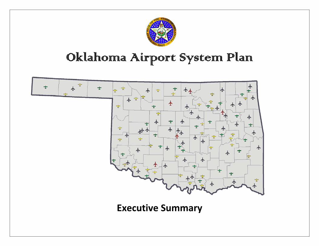
Oklahoma Airport System Plan
Executive Summary
System Planning Process
System Planning ProcessThe airport system planning process consists of seven primaryactivities:
maintaining inventories of airport facilities, services andactivities;forecasting aviation activity;classifying airports with respect to their service level, role,design standard and functional classification;conducting a public-participation program;identifying the capital improvements needed at each systemplan airport and the associated costs;preparing the annual capital improvement program; andconducting special studies such as the economic impact ofcivil aviation activity, preparing action plans for specificsystem plan airports, preparing airport layout plans andconducting an airport-pavement evaluation and managementprogram.
Airport inventories are maintained through an annual airportinspection program and recorded using the Federal AviationAdministration (FAA) Form 5010-1, Airport Inspection Program.This information becomes a part of the national database and isreported in aeronautical publications such as the Airport/FacilityDirectory and the Oklahoma Aeronautics Commission AirportDirectory.
The various classifications used for airports included in theOklahoma Airport System Plan (OASP) are explained in detail inthe section on airport system plan classifications.
Regional Planning MeetingsThe Oklahoma Aeronautics Commission (Commission) hasconducted an extensive public participation process annually sincethe summer of 1995. At these meetings, information is providedon the system planning process, the classifications used in thesystem plan, the airport classifications and the associated capitalimprovements identified in the system plan for each airport andthe capital improvement program.
Airport sponsors are asked to provide information oneconomic activity such as business locations and expansions,travel and tourism, agriculture, oil and gas activity, industrialdevelopment, sales tax revenue trends, and more. The economicactivity of a community and the classification of the airport areclosely linked.
These meetings provide the Commission staff with a formalopportunity to better understand the economic dynamics of thecommunity. This economic activity in turn impacts the system planairport classification appropriate for the community’s airport.Airport sponsors are also asked to provide information on theamount of aviation activity and type of aircraft that are using theirairport. Comments are requested on the information shown onthe airport development worksheet and the priorities for theidentified development.
Following each meeting, summaries are prepared and the airportdevelopment worksheets are updated. These meetings provide astructured process for updating the OASP on a continuous basis.
1
Commercial Service Airport
Regional Business Airport
District Airport
Community Airport
Oklahoma Airport System Plan Airports
2
System Plan Classifications
One of the primary functions of airport system planning is theappropriate classification of OASP airports by time period. OASPairports are classified into four categories: airport service level,airport design standard, airport reference code and airportclassification. The first three classifications are Federal AviationAdministration (FAA)-developed classifications used in theNational Plan of Integrated Airport Systems (NPIAS). The fourth,the airport functional classification, was developed for the OASPto further clarify the function of each airport. The definitions forthese classifications are provided in this section.
Service LevelThe airport service level reflects the type of service providedby the airport to the community. There are four airport servicelevels: general aviation airport (GA), reliever airport (RL),non-primary commercial service (CM) and primary commercialservice (PR). The following is a description of the service levelcategories used to classify airports.
General Aviation Airport (GA)General aviation airports provide access to the population andeconomic activity centers of the state. An objective of theOASP is to provide access to population and mineral resourcecenters for business jet aircraft and to agricultural resourcecenters for piston-powered aircraft within a reasonable surfaceaccess time. Reasonable surface access time is defined as 30minutes or less ground travel time (FAA Order 5090.3B, FieldFormulation of the National Plan of Integrated AirportSystems, September 1985). For the OASP, a 25-statute mile
radius is used to estimate an average ground travel time of 30minutes.
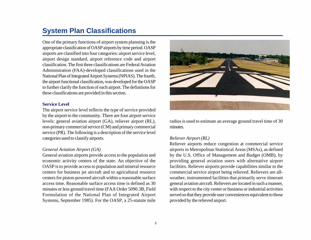
Reliever Airport (RL)Reliever airports reduce congestion at commercial serviceairports in Metropolitan Statistical Areas (MSAs), as definedby the U.S. Office of Management and Budget (OMB), byproviding general aviation users with alternative airportfacilities. Reliever airports provide capabilities similar to thecommercial service airport being relieved. Relievers are all-weather, instrumented facilities that primarily serve itinerantgeneral aviation aircraft. Relievers are located in such a manner,with respect to the city center or business or industrial activitiesserved so that they provide user conveniences equivalent to thoseprovided by the relieved airport.
3
The OASP includes three reliever airports. Wiley Post Airportin Oklahoma City and the University of Oklahoma WestheimerAirport in Norman are relievers to Will Rogers World Airport.Richard L. Jones, Jr. Airport in Tulsa is a reliever to TulsaInternational Airport.
The FAA makes reliever airport designations. At one time,relievers competed for specifically designated AirportImprovement Plan (AIP) reliever funding on a national basis.This is no longer the case, there is no more reliever set-a-sidefunding. However, the designation has been retained torecognize the critical role that reliever airports play withinmetropolitan areas.
Non-Primary Commercial Service (CM)A non-primary commercial service airport is an airport thatreceives scheduled passenger service and enplanes at least 2,500,but less than 10,000 passengers annually, as reported by the FAA.There are two non-primary commercial service airports in theOASP: Enid Woodring Regional in Enid and Ponca City Regionalin Ponca City.
Primary Commercial Service (PR)A primary commercial service airport is an airport that receivesscheduled passenger service and enplanes 10,000 or morepassengers annually, as reported by the FAA. There are threecommercial service airports in the OASP: Lawton-Fort SillRegional in Lawton, Will Rogers World in Oklahoma City andTulsa International in Tulsa.
Although there is strong interest by some communities inattracting scheduled air passenger service, no assessment orevaluation of the feasibility or potential for additional scheduled
passenger service has been done as a part of the airport systemplanning process.
Airport RoleThe role of the airport influences its design and determines thetype of aircraft the airport can accommodate. In the case ofcommercial service airports (PR and CM), the role also influencesthe nonstop routes and markets the airport serves. There are threeairport roles associated with commercial service, reliever andgeneral aviation airports. These roles are basic utility, general utilityand transport.
Closely associated with the role of the airport is the designstandard for the airport. The design standards associated withthe basic utility role are Basic Utility I and Basic Utility II.The design standards associated with the general utility roleare General Utility I and General Utility II. The designstandard associated with the transport role is the Transport designstandard. These definitions are clarified below.
Basic Utility: Basic Utility airports are small airports designedprimarily for single-engine and some light twin-engine aircraft.Precision approaches are not anticipated.
General Utility: General Utility airports are designed for abroader spectrum of general aviation aircraft than are basicutility airports. The airports can accommodate air-taxi andscheduled commuter services. General Utility airports willaccommodate most air-taxi and commuter aircraft with 20seats or less and some business jet aircraft with low approachspeeds. General Utility airports can serve as reliever airportswhen substantial use by jet or large corporate aircraft is not
4
anticipated. Precision instrument approaches may beanticipated at some General Utility airports.
Transport: Transport airports are designed for use by aircraftthat cannot be accommodated by a General Utility airport.Commercial service airports are designed as Transportairports. Transport airports also serve large corporate aircraftand business jet aircraft with higher approach speeds.Precision approaches are provided at Transport airportsdesignated as commercial service level and at some Transportairports with a Reliever or General Aviation service level.
Design StandardThe airport roles of Basic Utility, General Utility and Transportare refined further into runway design standards. The designstandards are defined as follows.
Basic Utility Stage I. This type of runway serves 75 percentof the small (12,500 pounds or less) single-engine and twin-engine aircraft in Aircraft Approach Categories A and B usedfor personal and business purposes. Precision approachoperations are not anticipated. This runway type is designedfor aircraft in Airport Reference Code A-1.
Basic Utility Stage II. This type of runway serves 95 percentof the small (12,500 pounds or less) single-engine and twin-engine aircraft in Approach Categories A and B. This includesall aircraft served by Basic Utility Stage I runways, plussome small business and air-taxi twin-engine aircraft.Precision approach operations are not anticipated. This typeof runway is designed for aircraft in Airport Reference CodeB-1.
General Utility Stage I. This type of runway serves 100percent of the small (12,500 pounds or less) single-engineand twin-engine aircraft in Aircraft Approach Categories Aand B. Precision approach operations are not anticipated.This type of runway is designed for aircraft in AirportReference Code B-II.
General Utility Stage II. This type of runway serves all aircraftincluded in General Utility Stage I, plus most of the largeaircraft (60,000 pounds or less) in Aircraft ApproachCategories A and B. The runway may have the capability forprecision-approach operations. This type of runway isnormally designed for aircraft in Airport Reference Code B-II.
Transport. This type of runway serves all the aircraftaccommodated by Basic and General Utility runways, plusgeneral aviation aircraft in Aircraft Approach Categories Cand D. This type of runway is normally designed for aircraftin Airport Reference Code C-II.
Airport Reference Code (ARC)The airport reference code is a coding system used to relateairport design criteria to the operational and physicalcharacteristics of the aircraft intended to operate at the airport.The airport reference code has two components pertaining to theairport design aircraft. The first component, depicted by a letter,is the aircraft approach category and relates to the aircraftapproach speed, an operational characteristic. The secondcomponent, depicted by a roman numeral, is the aircraft designgroup and relates to the aircraft wingspan, a physical characteristic.
5
Generally, runway standards are related to aircraft approachspeed, aircraft wingspan and the approach visibility minimums.Taxiway and taxilane standards are related to aircraft design group.
As part of the system planning process, information on the typesof aircraft using each system plan airport is collected, typically,during the regional planning meetings, but also from other sources.Information is also collected on any aircraft users desiring to use aparticular airport, but who are unable to do so because of airportdesign limitations. This information is one of the criteria that theCommission staff use to develop the recommended airportreference code by time period for each system plan airport.
Most system plan airports with a general aviation service levelhave aircraft approach category designations of A, B or C and anaircraft design group designation of I or II (See followingdefinitions). Airports with a commercial service service level mayhave aircraft approach category designations of D or E and aircraftdesign group designations of III, IV, V or VI.
Aircraft Approach Category. A grouping of aircraft based on1.3 times their stall speed in their landing configurations at theirmaximum certificated landing weight. The categories are:
Category A: Speed less than 91 knots; Category B: Speed 91 knots or more, but less than 121
knots; Category C: Speed 121 knots or more, but less than 141
knots; and Category D: Speed 141 knots or more, but less than 166
knots.
Aircraft Design Group. A grouping of aircraft based onwingspan. The groups are:
Group I: Up to, but not including 49 feet;Group II: 49 feet up to, but not including 79 feet;Group III: 79 feet up to, but not including 118 feet;Group IV: 118 feet up to, but not including 171 feet;Group V: 171 feet up to, but not including 214 feet; andGroup VI: 214 feet up to , but not including 262 feet.
6
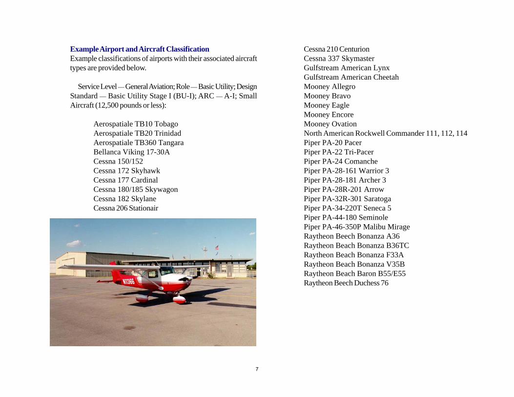
Example Airport and Aircraft ClassificationExample classifications of airports with their associated aircrafttypes are provided below.
Service Level — General Aviation; Role — Basic Utility; DesignStandard — Basic Utility Stage I (BU-I); ARC — A-I; SmallAircraft (12,500 pounds or less):
Aerospatiale TB10 TobagoAerospatiale TB20 TrinidadAerospatiale TB360 TangaraBellanca Viking 17-30ACessna 150/152Cessna 172 SkyhawkCessna 177 CardinalCessna 180/185 SkywagonCessna 182 SkylaneCessna 206 Stationair
Cessna 210 CenturionCessna 337 SkymasterGulfstream American LynxGulfstream American CheetahMooney AllegroMooney BravoMooney EagleMooney EncoreMooney OvationNorth American Rockwell Commander 111, 112, 114Piper PA-20 PacerPiper PA-22 Tri-PacerPiper PA-24 ComanchePiper PA-28-161 Warrior 3Piper PA-28-181 Archer 3Piper PA-28R-201 ArrowPiper PA-32R-301 SaratogaPiper PA-34-220T Seneca 5Piper PA-44-180 SeminolePiper PA-46-350P Malibu MirageRaytheon Beech Bonanza A36Raytheon Beach Bonanza B36TCRaytheon Beach Bonanza F33ARaytheon Beach Bonanza V35BRaytheon Beach Baron B55/E55Raytheon Beech Duchess 76
7
Service Level — General Aviation; Role — Basic Utility; DesignStandard — Basic Utility Stage II (BU-II); ARC — B-I; SmallAircraft (12,500 pounds or less):
Cessna 402Cessna 404 TitanCessna 414 ChancellorCessna 421 Golden EagleEmbraer 121 XinguGulfstream Cougar GA-7Piper Cheyenne III-APiper 400LS CheyennePiper 31-310 NavahoPiper 60-602P AerostarRaytheon Beach Baron 58, 58P, 58TCRaytheon Beech Duke B60
Service Level — General Aviation or Reliever; Role — GeneralUtility; Design Standard — General Utility Stage I (GU-I);ARC — B-I or B-II; Small Aircraft with less than 10 passengerseats:
Cessna 441 ConquestCessna 206B Super Cargo MasterCessna CitationJetCommander 560Fairchild Merlin IIIRaytheon Beech E18SRaytheon Beech King Air C90BRaytheon Beech King Air B200
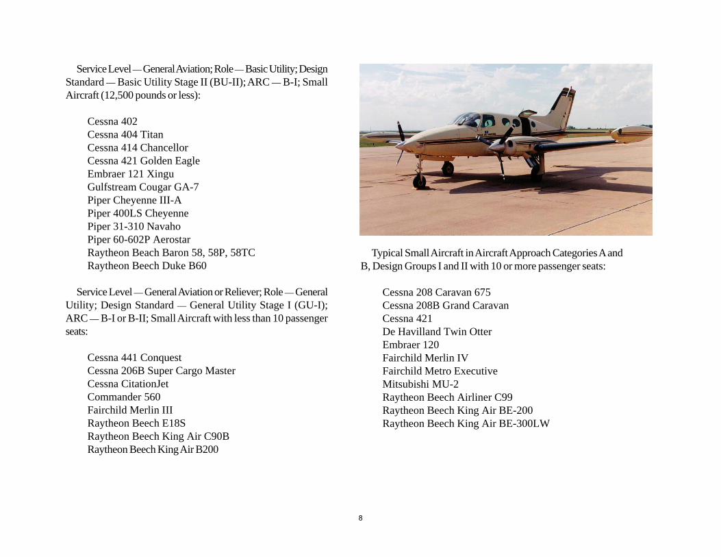
Typical Small Aircraft in Aircraft Approach Categories A andB, Design Groups I and II with 10 or more passenger seats:
Cessna 208 Caravan 675Cessna 208B Grand CaravanCessna 421De Havilland Twin OtterEmbraer 120Fairchild Merlin IVFairchild Metro ExecutiveMitsubishi MU-2Raytheon Beech Airliner C99Raytheon Beech King Air BE-200Raytheon Beech King Air BE-300LW
8
Service Level — General Aviation or Reliever; Role — GeneralUtility; Design Standard — General Utility Stage II; ARC — B-II;Large Aircraft (greater than 12,500 pounds and less than 30,000pounds):
Bombardier Learjet 28Bombardier Learjet 29Bombardier Learjet 31ABritish Aerospace Jetstream 31Cessna Citation 7Cessna BravoCessna ExcelCessna UltraDassault Aviation Falcon 10Embraer-110 BandeiranteFairchild Aerospace Merlin 4CIsrael Aircraft Industries Astra SP, SPXMitsubishi Diamond MU-300Piaggio PD-808Raytheon Beech 1900D AirlinerRaytheon Beech Jet BE 400 ARaytheon Beech King Air 350Raytheon Beech Starship BE 2000Raytheon Aircraft Co. Hawker 800XPSabreliner Corp. Sabreliner 40, 60, 65Shorts 330Shorts 360
Service Level — General Aviation or Reliever; Role — GeneralUtility; Design Standard — General Utility Stage II; ARC — B-II;Large Aircraft (greater than 30,000 pounds and less than 60,000pounds):
Bombardier (de Havilland) Dash 8Q-200, Dash 8Q-300Cessna Citation 10Dassault Aviation Falcon 20, 50Dassault Falcon 200Dassault Aviation Falcon 900C, 900EXDassault Aviation Falcon 2000Fokker F-27-500
Service Level — General Aviation or Reliever;Role — Transport; Design Standard — Transport; ARC — C-II;Large Aircraft (greater than 12,500 pounds and less than 60,000pounds):
Bombardier Canadair SEBombardier Challenger 600W, 601-IA, 601-3A, 601-3R,
604Bombardier Corporate JetlinerBombardier Learjet 35A, 45, 60Dassault Aviation Falcon 50EXDassault Aviation Falcon 900BFairchild Aerospace Envoy 3Fokker F-28-3000, F28-4000Israel Aircraft Industries GalaxyRaytheon Aircraft Co. Beechjet 400ARaytheon Aircraft Co. Hawker HorizonSabreliner Corp. Sabreliner 80
9
Functional ClassificationThe OASP airports are further classified by the functionalclassifications of Regional Business Airport, District Airport andCommunity Airport. These functional classifications weredeveloped to more accurately define the purpose of each airportwithin the system. The logic for these classifications is similar inconcept to the classifications of rural principal arterial, rural minorarterial, rural collector and rural local road used to functionallyclassify the rural highway system.
The airport classifications previously described (servicelevel, role, design standard and airport reference code) focusprimarily on the types of aircraft the airport is designed toaccommodate. These classifications are not sufficient tounderstand how individual airports function in a system orhow they relate to each other. For example, the function of arural interstate highway (functionally classified as a ruralprincipal arterial) is to carry high volumes of all types ofhighway vehicles traveling long distances. The function of aregional business airport is to accommodate high volumes ofall types of general aviation aircraft under all weather conditions.Interstate highways are spaced considerable distances apart, forexample, there are 27 east-west and 32 north-south interstatehighways crossing the U.S. Due to demand and cost, it iseconomically feasible to provide only a limited number of thesehigh-order facilities. Similarly, due to demand and cost, it iseconomically feasible to provide only a limited number of RegionalBusiness Airports.
The functional classification is important as it will affect the roleand the design standard for participation by the state and federalgovernment with regard to a particular airport. It affects the capitalitems that are eligible for programming in the Capital ImprovementProgram (CIP), and it also affects the priorities used to preparethe CIP.
Why A Functional Classification System?There are a number of reasons for the functional classificationsystem. Over the past two decades, the cost of personal flyinghas increased, and the amount of personal flying has declined.At the same time, the amount of business flying has increased.The number of new general aviation aircraft delivered and thetotal number of general aviation aircraft has declined since 1983.However, the value of the aircraft delivered has increased steadilythrough the entire time period. This implies that the aircraft beingsold are the expensive aircraft, the $1 million plus aircraft and theseveral million dollar aircraft. These are the aircraft being used bybusinesses and corporations.
The cost of owning and operating aircraft has increased, whileat the same time the cost of alternative transportation, particularlycommercial passenger transportation, has decreased, primarilybecause of airline deregulation. The quality of surfacetransportation, the highway system, has shown dramaticimprovement since 1983, as has the quality of personal use vehicles,automobiles, sports utility vehicles and pick-up trucks used forintercity transportation.
The overall structural condition of the airports included in theOASP has declined for a number of years. The functional integrityof these airports, the condition of the runway, taxiway, apronpavements and lighting systems was not as good in 1999 as it wasin 1995 or 1990. This decline is a result of insufficient capital tomaintain the amount of infrastructure that has been built. Neitherthe federal government nor the state government has proportionallybeen able to provide the funds that they were able to providewhen these airports were built. Local governments have beenunable to provide, from local funds, sufficient capital to make upfor the decline in state and federal funding for general aviationairports. Many local governments have difficulty finding sufficientlocal revenue to properly maintain and operate their airport. More
10
recently, since implementation of the federal Non-PrimaryEntitlement (NPE) program in fiscal year 2001, the structuralcondition of these airports eligible for NPE funding has improved,and, as a result, the overall condition of the airports in the systemhas improved.
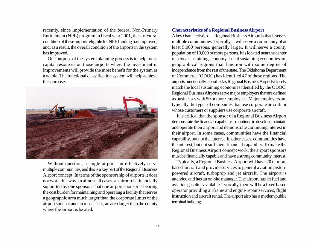
One purpose of the system planning process is to help focuscapital resources on those airports where the investment inimprovements will provide the most benefit for the system asa whole. The functional classification system will help achievethis purpose.
Characteristics of a Regional Business AirportA key characteristic of a Regional Business Airport is that it servesmultiple communities. Typically, it will serve a community of atleast 5,000 persons, generally larger. It will serve a countypopulation of 10,000 or more persons. It is located near the centerof a local sustaining economy. Local sustaining economies aregeographical regions that function with some degree ofindependence from the rest of the state. The Oklahoma Departmentof Commerce (ODOC) has identified 47 of these regions. Theairports functionally classified as Regional Business Airports closelymatch the local sustaining economies identified by the ODOC.Regional Business Airports serve major employers that are definedas businesses with 50 or more employees. Major employers aretypically the types of companies that use corporate aircraft orwhose customers or suppliers use corporate aircraft.
It is critical that the sponsor of a Regional Business Airportdemonstrate the financial capability to continue to develop, maintainand operate their airport and demonstrate continuing interest intheir airport. In some cases, communities have the financialcapability, but not the interest. In other cases, communities havethe interest, but not sufficient financial capability. To make theRegional Business Airport concept work, the airport sponsorsmust be financially capable and have a strong community interest.
Typically, a Regional Business Airport will have 20 or morebased aircraft and provide services to general aviation piston-powered aircraft, turboprop and jet aircraft. The airport isattended and has an on-site manager. The airport has jet fuel andaviation gasoline available. Typically, there will be a fixed basedoperator providing airframe and engine repair services, flightinstruction and aircraft rental. The airport also has a modern publicterminal building.
Without question, a single airport can effectively servemultiple communities, and this is a key part of the Regional BusinessAirport concept. In terms of the sponsorship of airports it doesnot work this way. In almost all cases, an airport is financiallysupported by one sponsor. That one airport sponsor is bearingthe cost burden for maintaining and operating a facility that servesa geographic area much larger than the corporate limits of theairport sponsor and, in most cases, an area larger than the countywhere the airport is located.
11
A Regional Business Airport is already, or can be developedinto, a General Utility Stage Two (GU-II) or Transport (T) airportdesign standard. A Regional Business Airport also has a non-precision instrument approach. In the future, with the improvingglobal positioning system (GPS) technology, many of the RegionalBusiness Airports will have the capability of approach minimumsas low as three-quarters of a mile visibility and 300 feet ceilingheight, and many will have vertical approach guidance. Terminalweather reporting is essential for achieving an all-weather capabilityat a Regional Business Airport. Many of the Regional BusinessAirports now have weather observation equipment on the airport,and additional systems are being installed. These systems allowpilots to obtain, prior to takeoff and during flight, the weatherconditions at the destination airport.
Characteristics of a District AirportThe District Airport is the second functional classification. Typically,these airports are providing access to a part of the state that is notwell served by a Regional Business Airport. They are also airportswhose sponsor has demonstrated a financial capability and
continuing interest in the airport. Normally, there will be about fiveor more based aircraft at these airports or an equivalent numberof annual itinerant operations. The airports are attended, aviationgasoline is available and there is a public terminal building.
Characteristics of a Community AirportThe Community Airport is the third functional classification. Theseare entry-level airports. These airports routinely serve smallcommunities. In almost all cases, the city population is less than5,000, and for many, the population is less than 2,000. Usually,they are not attended, many have no services available, and thesponsor has limited financial capability to fund capital improvementwork on the airport.
12
System Plan Overview
The Oklahoma airport system has developed over many yearsthrough close cooperation among federal, state and local agencies.Historically, the FAA has taken an active role in guiding the planningand development of the nation’s airport system. The FAA’splanning guidance significantly influences the preparation of statesystem plans and individual airport master plans. Its comprehensivelibrary of advisory circulars guides the planning, construction,maintenance and operations of all publicly owned civil airports.
FAA’s system planning guidance has been followed in thepreparation of the OASP. As the nation’s airport systemmatured, FAA’s role in general aviation airports has shiftedfrom being an active participant in the planning, funding andconstruction of new general aviation airports to one ofproviding guidance, oversight and funding to state aviation agencies.The state aviation agencies have taken the lead in continuing todevelop and maintain a general aviation airport system that is nowlargely in place. The FAA continues to be active in the planning,development and funding of the airport system’s CommercialService and Reliever airports.
Relationship of the OASP to the NPIASThe guiding principles used to develop the nation’s airportsystem during the past 50 years have remained largely unchanged.These principles, as shown in the NPIAS, 2005-2009, datedSeptember 2004, include the following.
Airports should be safe and efficient, be located at optimumsites, and developed and maintained to appropriate standards.Airports should be operated efficiently for both users and thegovernment, relying primarily on user fees and placing mini-
mal burden on the general revenues of the local, state andFederal governments.Airports should be flexible and expandable, able to meet in-creased demand, accommodate new aircraft types and pro-vide opportunities for competitive service.Airports should be permanent, with assurance that they willremain open for aeronautical use over the long term.Airports should be compatible with surrounding communi-ties, maintaining a balance between the needs of aviation andthe requirements of residents in neighboring areas.Airports should be developed in concert with improvementsto the air traffic control system.The airport system should support national objectives for de-fense, emergency readiness and postal delivery.The airport system should be extensive, providing as manypeople as possible with convenient access to air transporta-tion, typically not more than 20 miles of travel to the nearestNPIAS airport.The airport system should help air transportation contributeto a productive national economy and international competi-tiveness.
The OASPThe above principles have guided the development of the OASP.The OASP has focused particularly on the principles that airportsshould be safe and efficient; located at optimum sites; developedand maintained to standards; affordable to federal, state and localgovernments; be extensive and contribute to economiccompetitiveness. In addition, the OASP has focused on the needto carefully identify the function of each airpport included in the
13
system to ensure that limited federal, state and local governmentfinancial resources can be optimally allocated to achieve thegreatest system benefit. This functional classification system isexplained in detail below.
Early in the planning process, a decision was made to includealmost all the state’s publicly owned general aviation airports inthe system regardless of their level of aviation activity, their physicalcondition, or the financial ability or interest of the airport sponsor.
In 2004, this initial decision was re-visited and after staffevaluation and input during public meetings, staff made arecommendation to the Commission to delete seven publiclyowned general aviation airports from the OASP. On February10, 2005, the Commission voted to delete Crazy Horse Municipal(Davis), Haddock Field (Erick), Freedom Municipal, NowataMunicipal, Seiling, Stilwell/Cherokee Nation and the ViciMunicipal airports. A variety of factors, including limited aviationdemand, poor pavement condition, proximity to other systemairports, and the financial capability of the airport sponsor, led tothis decision.
Although some system airports are used little at present, suchairports may become vital assets in the future due to changingaircraft technology and costs or changing demographic patterns.Once an airport is lost due to closing or neglect, re-opening theairport at a later date can be very difficult, if not impossible.
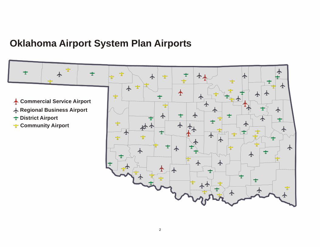
The OASP consists of 114 airports. The airports in the planare classified according to service level, role, design standard,airport reference code and functional classification. By servicelevel, there are three primary commercial service airports, twonon-primary commercial service airports, three reliever airportsand 106 general aviation airports.
Commercial Service AirportsIn addition to providing scheduled passenger service, the fivecommercial service airports function as Regional Business Airportsand provide all-weather access for all types of general aviationaircraft. The Commission is not involved with the planning, capitaldevelopment or funding of Will Rogers World Airport or TulsaInternational Airport. The Commission has participated in capitalprojects at the Lawton-Fort Sill Regional Airport and participatesin the planning, capital development and funding for Enid WoodringRegional and Ponca City Regional airports.
Primary commercial service airports receive funding from thefederal Airport Improvement Program based on the number ofenplaned passengers and tons of cargo enplaned. These airportsmay also elect to use Passenger Facility Charges as a source ofcapital funding. Several Oklahoma cities have a strong interest inattracting scheduled passenger service. However, no studies onthe economic feasibility of scheduled passenger service at newlocations were performed as a part of this system plan update.
14
Reliever AirportsReliever airports perform a special role within the airport system.The relievers identified in the OASP are located within the state’stwo largest metropolitan areas and provide alternative facilitiesfor general aviation aircraft users who might otherwise use theWill Rogers World or Tulsa International airports. There are tworeliever airports in the Oklahoma City metropolitan area and onein the Tulsa metropolitan area. The reliever airports also functionas Regional Business Airports providing all-weather access formost types of general aviation aircraft. All of the reliever airportsare currently developed to a transport design standard. At onetime, the U.S. Congress provided separate funding within theAirport Improvement Program for reliever airports. This is nolonger the case. Reliever airports now compete for the same fundingas general aviation airports.
General Aviation AirportsGeneral aviation consists of all flying that isnot scheduled commercial service or military.These airports provide air access tocommunities throughout the state andobviously make up the majority of the state’sairport system. Every community, with anysignificant population, can be reached by airthrough one of these airports. The runwaycapabilities and services provided at theseairports vary widely. To better understandthe contribution of each general aviationairport in the system, the airports are furtherclassified by function, role, design standardand airport reference code.
New System AirportsA new replacement airport is planned for the community of Atokathat will also serve the community of Coalgate and Atoka County.
Functional ClassificationsThe airport functional classification was developed to further clarifythe contribution of each airport in the OASP. In order ofimportance, the functional classifications are Regional BusinessAirport, District Airport and Community Airport. Functionalclassification criteria were developed for each classification. TheCommission staff applied the criteria and made the initialdesignations. Subsequently public meetings were held throughoutthe state to explain the criteria and to receive public comment.Changes in the initial functional classification designations weremade on the basis of new information provided at the public
15
meetings. The designations shown here are based on applicationof the criteria using the most accurate information available throughresearch, the public meetings and staff judgement.
Regional Business Airport Criteria
System Planning CriteriaDoes the airport serve multiple communities of greater than2,500 persons? (Y or N)Is the number of highway miles from the airport to the centerof the local sustaining economy less than 25 miles? (Y or N)Is the number of highway miles to the nearest GU-II or Tairport greater than 25 miles? (Y or N)Is the airport location needed to provide air access to a partof the state that would not otherwise be served? (Y or N)Is the city population served greater than 5,000 persons? (Yor N)Is the county population served greater than 10,000 persons?(Y or N)Are annual retail sales greater than 0.2 percent of the state’sretail sales? (Y or N)Is the county’s income greater than 0.2 percent of the state’sincome? (Y or N)Is the county’s farm and ranch income greater than 0.4percent of the state’s farm and ranch income? (Y or N)Is the county’s mineral income greater than 0.4 percent ofthe state’s mineral income? (Y or N)Is the county’s employment greater than 0.2 percent of thestate’s employment? (Y or N)Is the number of private corporations with more than 50employees greater than 10? (Y or N)Is there a private employer with 150 employees or more?(Y or N)
Is there a significant on-airport industry requiring a GU-II orT runway? (Y or N)Is there a demonstrated ability of the community to promotebusiness and local job formation? (Y or N)
Sponsor CriteriaHas the sponsor demonstrated the financial capability tooperate and maintain the airport? (Y or N)Has the sponsor consistently demonstrated an interest in theairport? (Y or N)
Demand CriteriaIs the number of active based aircraft greater than 20? (Y orN)Is the number of based turboprop aircraft greater than 2? (Yor N)Are there any based jets? (Y or N)
Services CriteriaIs the airport attended? (Y or N)Is there an airport manager on the airport? (Y or N)Are fixed base operator or repair services available? (Y orN)Is aviation gasoline available? (Y or N)Is Jet A fuel available? (Y or N)Is there a public terminal? (Y or N)
Airport Planning CriteriaIs the current OASP role GU-II or T? (Y or N)Does the airport have an approved Airport Layout Plan (ALP)that meets current FAA requirements? (Y or N)
16
Does the airport have an Airport Master Plan (AMP) orAirport Action Plan (AAP) that the sponsor is using to guidedevelopment of the airport? (Y or N)Is the surrounding land use compatible with a GU-II or Trole? (Y or N)Does the airport have an adopted height hazard zoningordinance? (Y or N)
Airfield Geometric CriteriaWill it cost less than $2 million to extend the runway to 5,000feet corrected for altitude? (Y or N)Is the runway width 75 feet or greater? (Y or N)Does the runway have a full parallel taxiway, or is a full paralleltaxiway economically feasible? (Y or N)Is the taxiway width 35 feet or greater? (Y or N)Are the runway protection zones (RPZs) for the currentpublished approach owned fee simple or controlled througheasements? (Y or N)
Does the airport have a 34:1 approach slope to one runwayend, and does the airport sponsor own fee simple or haveeasements for the runway protection zone for that approach?(Y or N)Does the airport runway safety area meet the criteria for anARC B-II runway with lower than 3/4 statute mile approachvisibility minimum, 300 feet wide and 500 feet beyond runwayend? (Y or N)Does the airport meet Federal Aviation Regulations (FAR)Part 77 criteria? (Y or N)Does the airport have a non-precision approach to onerunway end? (Y or N)Does the airport have a rotating beacon? (Y or N)Does the airport have a lighted wind indicator? (Y or N)Does the airport have medium intensity runway lights? (Y orN)
17
Regional Business Airports
1. Ada Ada Municipal2. Altus Altus Quartz Mountain Regional3. Alva Alva Regional4. Ardmore Ardmore Downtown Executive5. Ardmore Ardmore Municipal (industrial
airport)6. Bartlesville Bartlesville Municipal7. Blackwell Blackwell-Tonkawa Municipal8. Chickasha Chickasha Municipal9. Claremore Claremore Regional10. Clinton Clinton Municipal11. Clinton Clinton-Sherman (industrial airport)12. Cushing Cushing Municipal13. Duncan Halliburton Field14. Durant Eaker Field15. Elk City Elk City Municipal16. El Reno El Reno Municipal17. Enid Enid Woodring Regional18. Frederick Frederick Municipal19. Grove Grove Municipal20. Guthrie Guthrie-Edmond Regional21. Guymon Guymon Municipal22. Hobart Hobart Municipal23. Hugo Stan Stamper Municipal24. Idabel McCurtain County Regional25. Lawton Lawton-Fort Sill Regional Airport26. McAlester McAlester Regional
27. Miami Miami Municipal28. Muskogee Davis Field29. Norman University of Oklahoma
Max Westheimer30. Oklahoma City Clarence E. Page31. Oklahoma City Wiley Post32. Oklahoma City Will Rogers World33. Okmulgee Okmulgee Regional34. Pauls Valley Pauls Valley Municipal35. Perry Perry Municipal36. Ponca City Ponca City Regional37. Poteau Robert S. Kerr38. Pryor Creek Mid-America Industrial (industrial
airport)39. Sallisaw Sallisaw Municipal (not to 5,000
feet)40. Sand Springs William R. Pogue Municipal41. Seminole Seminole Municipal42. Shawnee Shawnee Regional43. Stillwater Stillwater Regional44. Tahlequah Tahlequah Municipal45. Tulsa Tulsa International46. Tulsa Richard L. Jones, Jr.47. Watonga Watonga Municipal48. Weatherford Thomas P. Stafford (not to 5,000
feet)49. Woodward West Woodward
18
Commercial Service Airport
Regional Business Airport
Commercial Service and Regional Business AirportsArea of Coverage
19
District Airport Criteria
Airport System Planning CriteriaIs the airport location needed to provide air access to a partof the state not served by a regional business airport? (Y orN)
Sponsor CriteriaHas the sponsor demonstrated support for the airport overa significant period of time? (Y or N)Has the sponsor demonstrated the financial capability tooperate and maintain the airport? (Y or N)Does the sponsor have an effective airport pavementmanagement program? (Y or N)
Demand CriteriaIs the number of active based aircraft greater than 5, or isthere an equivalent number of annual itinerant operations,about 1,000 operations per year, which is about 10 arrivalsper week? (Y or N)
Services CriteriaIs the airport attended? (Y or N)
Is aviation gasoline available? (Y or N)Is there a public terminal? (Y or N)
Airport Planning CriteriaDoes the airport have an approved ALP? (Y or N)Is the surrounding land use compatible with a BU-II or GU-I design standard? (Y or N)Does the airport have an adopted height hazard zoningordinance? (Y or N)
Airfield Geometric CriteriaAre the runway protection zones (RPZs) for the currentlypublished approach (visual or non-precision) owned feesimple or controlled through easements? (Y or N)Does the airport have a 20:1 approach slope to each runwayend? (Y or N)Does the airport runway safety area meet the criteria for anARC B-II runway with visual runways and runways withnot lower than 3/4 statute mile approach visibility minimums,150 feet wide and 300 feet beyond runway end? (Y or N)Does the airport meet FAR Part 77 criteria? (Y or N)
20
District Airports
1. Afton Grand Lake Regional2. Anadarko Anadarko Municipal3. Antlers Antlers Municipal4. Atoka Atoka Municipal (new airport on
existing site)5. Beaver Beaver Municipal6. Boise City Boise City Municipal7. Bristow Jones Memorial8. Chandler Chandler Municipal9. Cleveland Cleveland Municipal10. Cookson Tenkiller Lake Airpark11. Fairview Fairview Municipal12. Goldsby David Jay Perry13. Grandfield Grandfield Municipal14. Henryetta Henryetta Municipal
15. Hinton Hinton Municipal16. Hollis Hollis Municipal17. Kingfisher Kingfisher (new airport on existing site)18. Madill Madill Municipal19. Mangum Scott Field20. Medford Medford Municipal21. Purcell Purcell Municipal22. Skiatook Skiatook Municipal23. Stigler Stigler Municipal24. Sulphur Sulphur Municipal25. Thomas Thomas Municipal26. Vinita Vinita Municipal27. Wagoner Hefner/Easley28. Wilburton Wilburton Municipal
21
District Airport
District Airports
Grand LakeRegional
VinitaMunicipal
SkiatookMunicipal
Hefner/Easley
ClevelandMunicipal
Tenkiller LakeAirparkHenryetta
MunicipalStigler
Municipal
WilburtonMunicipal
JonesMemoiral
ChandlerMunicipal
AntlersMunicipal
AtokaMunicipal
(New)
MadillMunicipal
SulphurMunicipal
GrandfieldMunicipal
PurcellMunicipal
David JayPerry
AnadarkoMunicipal
HintonMunicipal
ThomasMunicipal
Kingfisher(New)
FairviewMunicipal
MedfordMunicipal
ScottField
BeaverMunicipal
Boise CityMunicipal
HollisMunicipal
22
Community Airport Criteria
Airport System Planning CriteriaIs the airport owned by a municipality? (Y or N)
Sponsor CriteriaNone.
Demand CriteriaNone.
Services CriteriaNone.
Airport Planning CriteriaDoes the airport have an approved Airport Layout Drawing?(Y or N)
Is the surrounding land use compatible with a BU-I designstandard? (Y or N)Does the airport have an adopted height hazard zoningordinance? (Y or N)
Airfield Geometric CriteriaAre the RPZs for the currently published approach (visualor non-precision) owned fee simple or controlled througheasements? (Y or N)Does the airport have a 20:1 approach slope to each runwayend? (Y or N)Does the airport runway safety area meet the criteria for anARC B-I runway, 120-feet wide and 240 feet beyondrunway’s end? (Y or N)Does the airport meet FAR Part 77 criteria? (Y or N)
23
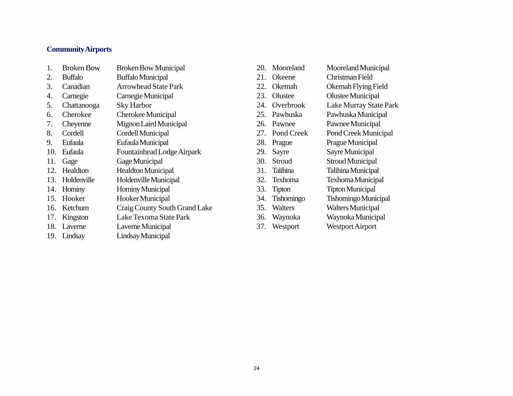
Community Airports
1. Broken Bow Broken Bow Municipal2. Buffalo Buffalo Municipal3. Canadian Arrowhead State Park4. Carnegie Carnegie Municipal5. Chattanooga Sky Harbor6. Cherokee Cherokee Municipal7. Cheyenne Mignon Laird Municipal8. Cordell Cordell Municipal9. Eufaula Eufaula Municipal10. Eufaula Fountainhead Lodge Airpark11. Gage Gage Municipal12. Healdton Healdton Municipal13. Holdenville Holdenville Municipal14. Hominy Hominy Municipal15. Hooker Hooker Municipal16. Ketchum Craig County South Grand Lake17. Kingston Lake Texoma State Park18. Laverne Laverne Municipal19. Lindsay Lindsay Municipal
20. Mooreland Mooreland Municipal21. Okeene Christman Field22. Okemah Okemah Flying Field23. Olustee Olustee Municipal24. Overbrook Lake Murray State Park25. Pawhuska Pawhuska Municipal26. Pawnee Pawnee Municipal27. Pond Creek Pond Creek Municipal28. Prague Prague Municipal29. Sayre Sayre Municipal30. Stroud Stroud Municipal31. Talihina Talihina Municipal32. Texhoma Texhoma Municipal33. Tipton Tipton Municipal34. Tishomingo Tishomingo Municipal35. Walters Walters Municipal36. Waynoka Waynoka Municipal37. Westport Westport Airport
24
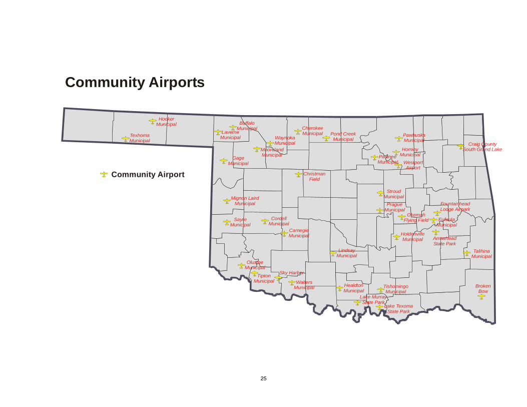
Community Airport
Community Airports
Craig CountySouth Grand Lake
PawhuskaMunicipal
HominyMunicipal
WestportAirport
PawneeMunicipal
StroudMunicipal
OkemahFlying Field
FountainheadLodge Airpark
EufaulaMunicipal
ArrowheadState Park
Lake TexomaState Park
TishomingoMunicipal
Lake MurrayState Park
HealdtonMunicipal
LindsayMunicipal
WaltersMunicipal
Sky Harbor
CarnegieMunicipal
TiptonMunicipal
OlusteeMunicipal
Mignon LairdMunicipal
GageMunicipal
ChristmanField
Pond CreekMunicipal
BuffaloMunicipal
LaverneMunicipal
HookerMunicipal
TexhomaMunicipal
CordellMunicipal
SayreMunicipal
CherokeeMunicipal
WaynokaMunicipal
MoorelandMunicipal
HoldenvilleMunicipal
TalihinaMunicipal
BrokenBow
PragueMunicipal
25
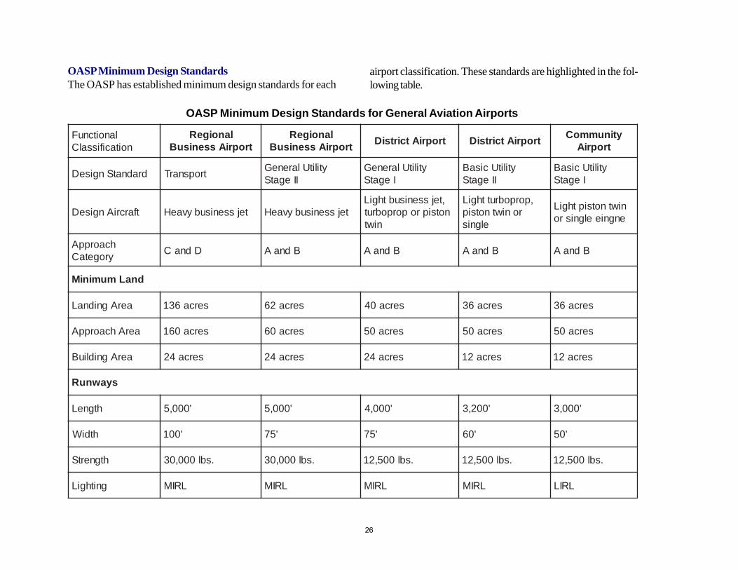
OASP Minimum Design StandardsThe OASP has established minimum design standards for each
OASP Minimum Design Standards for General Aviation Airports
airport classification. These standards are highlighted in the fol-lowing table.
lanoitcnuFnoitacifissalC
lanoigeRtropriAssenisuB
lanoigeRtropriAssenisuB
tropriAtcirtsiD tropriAtcirtsiDytinummoC
tropriA
dradnatSngiseD tropsnarT ytilitUlareneGIIegatS
ytilitUlareneGIegatS
ytilitUcisaBIIegatS
ytilitUcisaBIegatS
tfarcriAngiseD tejssenisubyvaeH tejssenisubyvaeH,tejssenisubthgiLnotsiproporpobrut
niwt
,porpobrutthgiLroniwtnotsip
elgnis
niwtnotsipthgiLengnieelgnisro
hcaorppAyrogetaC DdnaC BdnaA BdnaA BdnaA BdnaA
dnaLmuminiM
aerAgnidnaL serca631 serca26 serca04 serca63 serca63
aerAhcaorppA serca061 serca06 serca05 serca05 serca05
aerAgnidliuB serca42 serca42 serca42 serca21 serca21
syawnuR
htgneL '000,5 '000,5 '000,4 '002,3 '000,3
htdiW '001 '57 '57 '06 '05
htgnertS .sbl000,03 .sbl000,03 .sbl005,21 .sbl005,21 .sbl005,21
gnithgiL LRIM LRIM LRIM LRIM LRIL
26
System Plan Performance Measures
Performance measures evaluate how well any particular systemor part of a system of airports meets a particular set of criteria. Inthis section, the performance of the airports designated as RegionalBusiness Airports is illustrated using some of the criteria used tofunctionally classify the airports selected for inclusion in the OASP.
The 49 airports classified as Regional Business Airports, whenfully developed, will meet most of the goals established for theOASP. The airports comprising this part of the system can provideall-weather jet access to most communities in Oklahoma. Theinclusion of the District Airports provides significant additionalcoverage to support the mineral and agriculture sectors of theeconomy. The measures described are based on the airports asthey existed on May 1, 2005. As improvements are made to theRegional Business Airports, some of the described measures willimprove.
Airport System Planning CriteriaCommunities With More Than 2,500 Population. Thepercent of communities with populations of more than 2,500within the service area of a designated Regional BusinessAirport is 98.4 percent. Oklahoma has 125 communitieswith populations of more than 2,500, of which 123 are withinthe service area of one or more of the 49 designated RegionalBusiness Airports. The two communities with populations ofmore than 2,500 that are not within the service area of adesignated Regional Business Airport are Atoka and Fairview.There are nine airports designated as Regional BusinessAirports that do not yet have runways of at least 5,000 feet.Until these runways are extended, several communities withpopulations greater than 2,500 are not yet served to thedesired level of service. These communities are Alva, servedby Alva Regional; Antlers and Hugo served by Stan StamperMunicipal; Heavener, Pocola and Poteau served by RobertS. Kerr; Muldrow, Roland, Sallisaw and Stigler served bySallisaw Municipal; Stilwell served by Tahlequah Municipal;Watonga served by Watonga Municipal and Weatherfordserved by Thomas P. Stafford.
Population. The percent of the state’s population within theservice area of a designated Regional Business Airport is96.7 percent. The estimated 2004 population of Oklahomais 3,523,553 of which 116,277 do not live within the servicearea of one or more of the 49 designated Regional BusinessAirports. Until these runways area extended, approximately195,000 persons are not yet served to the desired level.
27
Economic Indicators. The percent of the state’s retail salesand civilian labor force served by the Regional BusinessAirport system tracks very closely with the the percent ofthe population served by the Regional Business Airportsystem.
In 1997 there were 14,353 retail establishments in Oklahomawith retail sales of $27,065,555,000, an annual payroll of$2,406,936,000, and 161,613 paid employees. (RetailTrade - Geographic Area Series, U.S. Census Bureau, 1997Economic Census, December 3, 1999).
In March 2005 the Oklahoma civilian labor force was1,719,700 (ODOC April 25, 2005).
Agriculture. The percent of the state’s agricultural incomeserved by regional business airports is 81.5 percent. Totalstate agricultural cash receipts in 1996 were $4,042,852,000.Cash receipts outside the service area are estimated to be$752,484,500. Two important agriculture counties, Beaverand Cimarron, are outside the service area of a RegionalBusiness Airport but are served by the District Airports —Beaver Municipal and Boise City Municipal.
Oil and Gas. The percent of the state’s oil and gas incomeserved by Regional Business Airports is 75.2 percent. Totaloil and gas production taxes in 1998 were $387,851,900.Oil and gas production taxes within the service area areestimated to be $291,671,240. Two important oil and gascounties, Beaver and Cimarron, are outside the service areaof a Regional Business Airport, but are served by the DistrictAirports — Beaver Municipal and Boise City Municipal.
Employers. The percent of private corporations with greaterthan 50 employees served by Regional Business Airports is96.8 percent. This measure used estimates from the countycommunity profile data prepared for all counties by theODOC. This estimate is low because data from Oklahomaand Tulsa Counties only included private corporations withmore than 100 employees.
Gaps in the Regional Business Airport system exist in Beaverand Cimarron counties, a 15-mile radius around Atoka, andthe northern half of Pushmataha and McCurtain countieswhere they meet with Latimer and Le Flore counties.
Oklahoma covers 68,686 square miles. The 25-mile serviceareas of Regional Business Airports encompass 52,203square miles, or 76 percent of Oklahoma’s land area.
Sponsor CriteriaThe percentage of airports in the Regional Business Airportsystem that have sponsors who have demonstrated financialcapability is 98 percent.
The percentage of airports in the Regional Business Airportsystem whose sponsors have an effective pavementmaintenance program is 88 percent. The Commission hasinitiated with the state’s airport sponsors an airport pavementmanagement program. As this program matures, this measurewill improve.
28
Demand CriteriaThe percentage of the state’s publicly based aircraft locatedat the 49 Regional Business Airports is 85.1 percent.Regional Business and District Airports together account for96.9 percent of the aircraft based at publicly owned airportsin Oklahoma. There are 92 based aircraft at the 36community airports which comprise 3.0 percent of the state’saircraft based at publicly owned airports. There are 948aircraft based at 215 private airports in Oklahoma. The top15 privately owned airports comprise 638 or 68 percent ofthe 948 aircraft based on privately owned airports.
The percentage of the state’s jet aircraft that are based withinthe service area of a Regional Business Airport is 100 percent.There is one jet aircraft based at Chandler Municipal, aDistrict Airport.
Services CriteriaThe percentage of Regional Business Airports that areattended is 100 percent.
The percentage of Regional Business Airports with an on-site airport manager is 100 percent.
The percentage of Regional Business Airports with a fixedbase operator (FBO) and repair services available is 87.8percent. There are 36 of the Regional Business Airports withmajor airframe and powerplant repair, six with both minorairframe and powerplant repair, and one with minorpowerplant repairs only, for a total of 43.
The percentage of Regional Business Airports with aviationgasoline available is 100 percent.
The percentage of Regional Business Airports with Jet Afuel is 85.7 percent.
All but one Regional Business Airport has a public terminal.
Airport Planning CriteriaThe percentage of Regional Business Airports in the systemthat are currently a General Utility Stage II or a Transportdesign standard is 82 percent. A total of nine airports do notcurrently meet these design criteria. They are Alva,Blackwell-Tonkawa, Clinton Municipal, Stan Stamper -Hugo, Poteau, Sallisaw, Tahlequah, Watonga, and ThomasStafford-Weatherford. The runway length deficiencies atthese nine airports are the most critical system shortcoming.
The percentage of Regional Business Airports in the systemwith adopted height zoning ordinances is 92 percent.
Airfield Geometric CriteriaThe percentage of Regional Business Airports with a fullparallel taxiway or where a full parallel taxiway is financiallyfeasible is 90 percent.
The percentage of Regional Business Airports with RunwayProtections Zones for current published approaches that areowned fee simple or controlled through easements is 96percent.
The percentage of Regional Business Airports with a straightin non-precision approach to one runway end is 96 percent.The Mid-America Industrial Airpark in Pryor Creek and theMcCurtain County Regional Airport do not have non-precision instrument approaches.
29
The percentage of Regional Business Airports with a precisionapproach is 24 percent. With the advances in GPS technology,additional precision approaches should be possible in thefuture.
The percentage of Regional Business Airports with a terminalweather system is 90 percent. The installation of systems atfive additional airports is critical to the goal of providing allweather capability at all Regional Business Airports.Blackwell-Tonkawa Municipal, Miami Municipal, ClarenceE. Page, Perry Municipal and the Mid-America IndustrialAirpark need a terminal weather system.
The percentage of Regional Business Airports that have a34:1 approach slope to one runway end, and the airportsponsor/owner owns fee simple or has easements for theRunway Protection Zone for that approach is 91.5 percent.
30
System Plan Implementation
The planning process described previously resulted in the selectionof the airports and their respective classifications required to meetthe OASP goals and objectives. Also, as a part of the continuousplanning process, the capital improvements and associated costsneeded at each system airport are identified.
Airport Development WorksheetThe airport development worksheet is the primary documentused for system planning. An airport development worksheetis prepared for each system airport. The worksheet for any systemairport is available on the Commission Internet site.
The worksheet for a particular airport is jointly developed bythe airport sponsor and the Commission staff. The worksheet foran airport is updated whenever the airport classification changes;the physical conditions of runways, taxiways, aprons, or lightingchanges indicating the need for a capital project; a capital projectis completed; or other new information becomes available.
The airport development worksheet shows the airport name,airport sponsor, NPIAS status, the ARC, functional classification,the projects that need to be accomplished and the project cost,construction type, objective code, airport component and projectstatus.
The Commission staff maintains a project history file for eachairport showing the capital projects completed at the airport since1970 that were funded with state or federal dollars. Besidesproviding a historical record, the project histories are used to helpevaluate pavement life cycles and to help predict the timing forfuture pavement rehabilitation projects.
Project DescriptionThe project description is a brief explanation of a projectthat needs to be accomplished on one component of theairport. For example: “Extend RW 17/35, 1000' x 75',30,000#, 35 end.” This is the notation for showing that theproject will extend the runway 1,000 feet long and 75 feetwide to the south and will have a pavement strength designedto support a 30,000-pound aircraft.
Project CostsThe project costs developed at this stage of the process areplanning, not engineering, costs. Project costs are based onrecent construction experience. When the project is readyfor programming, engineering costs will be prepared.
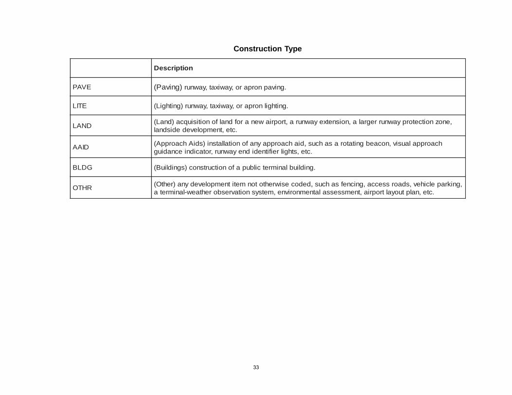
Construction TypeEach project is coded with a construction type code.Construction type codes are used for runway, taxiway orapron paving; runway or taxiway lighting; land acquisition;installation of visual approach aids such as a rotating beacon,lighted wind cone; construction of structures such as a terminalbuilding and an other category that includes items such asfencing, access roads, or vehicle parking.
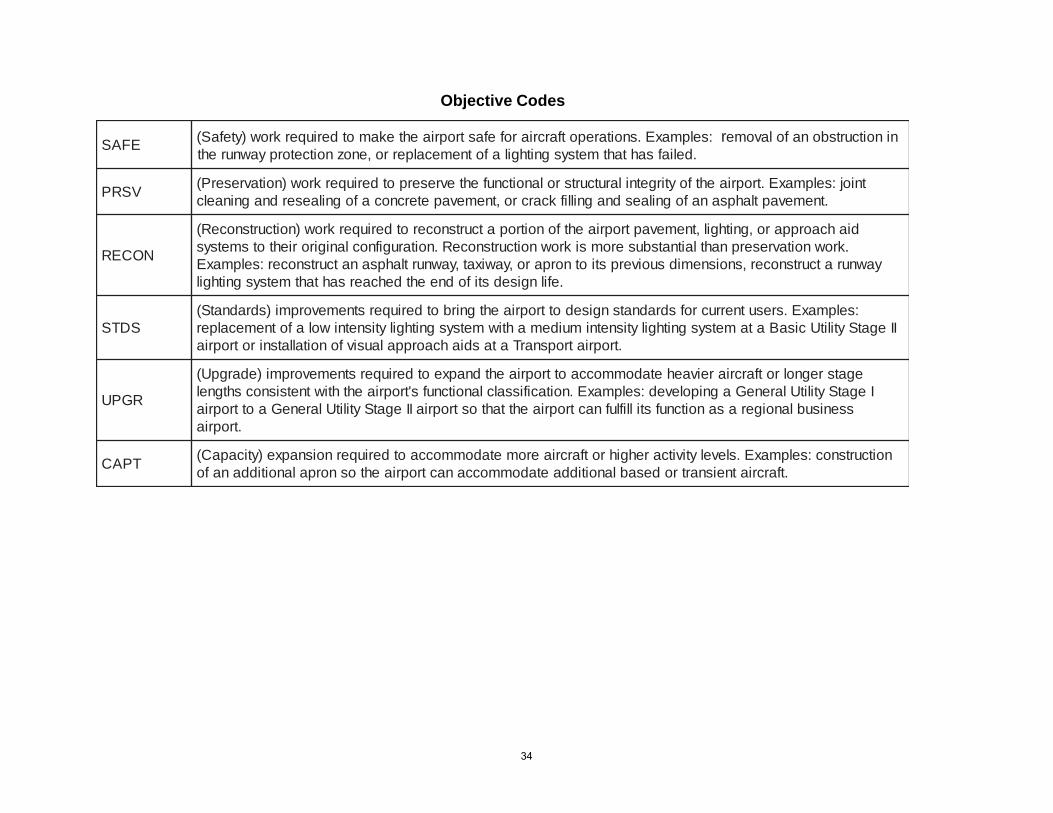
Objective CodesEach project is coded with an objective code. Objectivecodes are: safety/special — reserved for projects with animmediate safety impact such as a lighting system that has
31
failed; preservation — used for projects to preserve existingpavements or lighting systems; reconstruction — used forprojects where the existing pavement needs to be rebuiltfrom the base up; standards — used for projects to correctan existing deficiency for an airport’s current classification,for example installing lights on an airport that does not havelights; upgrade — a project that will result in a change to theairports design standard or the type of aircraft the airportcan accommodate; capacity — a project to increase thecapacity of an airport component such as to expand the sizeof the apron; and new airport access — a project to providea new airport where air access does not currently exist.
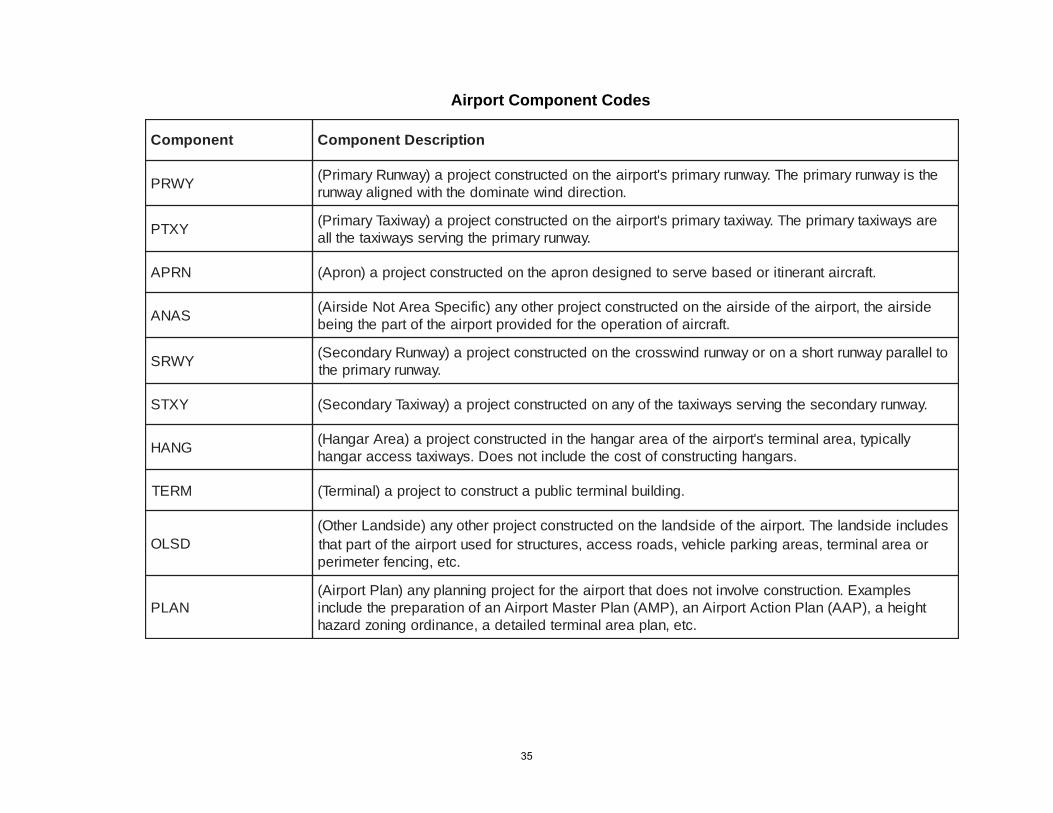
Airport ComponentEach project is coded with a component code. Componentcodes are primary runway, primary taxiway, secondaryrunway, secondary taxiway, apron, hangar area, terminal,other landside, and planning.
The codes are used to categorize the types of developmentneeded for the system as a whole or for specific parts of thesystem, and for setting project priorities that are used in theprogramming process. For example, a project to reconstruct aprimary runway will have a higher priority than will a project toreconstruct a secondary runway. A project to construct a hangaraccess taxiway will have a lower priority than a project to expandan apron.
32
Construction Type
noitpircseD
EVAP )gnivaP( .gnivapnorparo,yawixat,yawnur
ETIL .gnithgilnorparo,yawixat,yawnur)gnithgiL(
DNAL ,enoznoitcetorpyawnurregrala,noisnetxeyawnura,tropriawenarofdnalfonoitisiuqca)dnaL(.cte,tnempolevededisdnal
DIAA diahcaorppaynafonoitallatsni)sdiAhcaorppA( , hcaorppalausiv,nocaebgnitatorasahcus.cte,sthgilreifitnedidneyawnur,rotacidniecnadiug
GDLB .gnidliublanimretcilbupafonoitcurtsnoc)sgnidliuB(
RHTO dedocesiwrehtotonmetitnempolevedyna)rehtO( , ,gnikrapelcihev,sdaorssecca,gnicnefsahcus.cte,nalptuoyaltropria,tnemssessalatnemnorivne,metsysnoitavresborehtaew-lanimreta
33
Objective Codes
EFAS :selpmaxE.snoitarepotfarcriarofefastropriaehtekamotderiuqerkrow)ytefaS( r ninoitcurtsbonafolavome.deliafsahtahtmetsysgnithgilafotnemecalperro,enoznoitcetorpyawnureht
VSRP tnioj:selpmaxE.tropriaehtfoytirgetnilarutcurtsrolanoitcnufehtevreserpotderiuqerkrow)noitavreserP(.tnemevaptlahpsanafognilaesdnagnillifkcarcro,tnemevapetercnocafognilaeserdnagninaelc
NOCER
diahcaorpparo,gnithgil,tnemevaptropriaehtfonoitropatcurtsnocerotderiuqerkrow)noitcurtsnoceR(.krownoitavreserpnahtlaitnatsbuseromsikrownoitcurtsnoceR.noitarugifnoclanigiroriehtotsmetsys
yawnuratcurtsnocer,snoisnemidsuoiverpstiotnorparo,yawixat,yawnurtlahpsanatcurtsnocer:selpmaxE.efilngisedstifodneehtdehcaersahtahtmetsysgnithgil
SDTS:selpmaxE.sresutnerrucrofsdradnatsngisedottropriaehtgnirbotderiuqerstnemevorpmi)sdradnatS(
IIegatSytilitUcisaBatametsysgnithgilytisnetnimuidemahtiwmetsysgnithgilytisnetniwolafotnemecalper.tropriatropsnarTatasdiahcaorppalausivfonoitallatsnirotropria
RGPU
egatsregnolrotfarcriareivaehetadommoccaottropriaehtdnapxeotderiuqerstnemevorpmi)edargpU(IegatSytilitUlareneGagnipoleved:selpmaxE.noitacifissalclanoitcnufs'tropriaehthtiwtnetsisnocshtgnel
ssenisublanoigerasanoitcnufstilliflufnactropriaehttahtostropriaIIegatSytilitUlareneGaottropria.tropria
TPAC noitcurtsnoc:selpmaxE.slevelytivitcarehgihrotfarcriaerometadommoccaotderiuqernoisnapxe)yticapaC(.tfarcriatneisnartrodesablanoitiddaetadommoccanactropriaehtosnorpalanoitiddanafo
34
Airport Component Codes
tnenopmoC noitpircseDtnenopmoC
YWRP ehtsiyawnuryramirpehT.yawnuryramirps'tropriaehtnodetcurtsnoctcejorpa)yawnuRyramirP(.noitceriddniwetanimodehthtiwdengilayawnur
YXTP erasyawixatyramirpehT.yawixatyramirps'tropriaehtnodetcurtsnoctcejorpa)yawixaTyramirP(.yawnuryramirpehtgnivressyawixatehtlla
NRPA .tfarcriatnarenitirodesabevresotdengisednorpaehtnodetcurtsnoctcejorpa)norpA(
SANA edisriaeht,tropriaehtfoedisriaehtnodetcurtsnoctcejorprehtoyna)cificepSaerAtoNedisriA(.tfarcriafonoitarepoehtrofdedivorptropriaehtfotrapehtgnieb
YWRS otlellarapyawnurtrohsanoroyawnurdniwssorcehtnodetcurtsnoctcejorpa)yawnuRyradnoceS(.yawnuryramirpeht
YXTS .yawnuryradnocesehtgnivressyawixatehtfoynanodetcurtsnoctcejorpa)yawixaTyradnoceS(
GNAH yllacipyt,aeralanimrets'tropriaehtfoaeraragnahehtnidetcurtsnoctcejorpa)aerAragnaH(.sragnahgnitcurtsnocfotsocehtedulcnitonseoD.syawixatsseccaragnah
MRET .gnidliublanimretcilbupatcurtsnocottcejorpa)lanimreT(
DSLOsedulcniedisdnalehT.tropriaehtfoedisdnalehtnodetcurtsnoctcejorprehtoyna)edisdnaLrehtO(
sdaorssecca,serutcurtsrofdesutropriaehtfotraptaht , roaeralanimret,saeragnikrapelcihev.cte,gnicnefretemirep
NALPselpmaxE.noitcurtsnocevlovnitonseodtahttropriaehtroftcejorpgninnalpyna)nalPtropriA(
thgieha,)PAA(nalPnoitcAtropriAna,)PMA(nalPretsaMtropriAnafonoitaraperpehtedulcni.cte,nalpaeralanimretdeliateda,ecnanidrogninozdrazah
35
Relationship Between Planning and ProgrammingThe relationship between airport system planning and projectprogramming is really quite simple. The system planningprocess involves all the steps described previously:maintaining inventories, classifying airports, forecastingaviation activity, conducting a public participation program,identifying the capital improvements needed at each systemairport, and conducting special studies. The capital projectsidentified in system planning are not constrained by the dollarsof revenue that the funding agencies are expected to haveavailable during any particular time period. Programming isthe process of deciding, based on established system priorities,which projects will be funded in which time period with thedollars that are expected to be available in that time period.Programming is constrained by dollars. The Commission’sprogramming process is detailed in the Oklahoma AeronauticsCommission 3-Year Capital Improvement Plan, updated andadopted annually by the Commission.
36
System Plan Airport Classifications
37
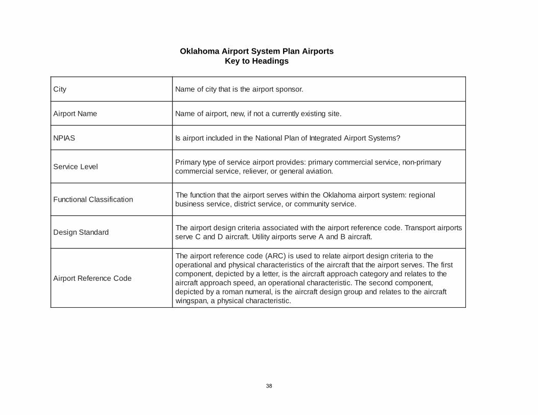
Oklahoma Airport System Plan AirportsKey to Headings
ytiC .rosnopstropriaehtsitahtyticfoemaN
emaNtropriA .etisgnitsixeyltnerrucatonfi,wen,tropriafoemaN
SAIPN ?smetsyStropriAdetargetnIfonalPlanoitaNehtnidedulcnitropriasI
leveLecivreS yramirp-non,ecivreslaicremmocyramirp:sedivorptropriaecivresfoepytyramirP.noitaivalarenegro,reveiler,ecivreslaicremmoc
noitacifissalClanoitcnuF lanoiger:metsystropriaamohalkOehtnihtiwsevrestropriaehttahtnoitcnufehT.ecivresytinummocro,ecivrestcirtsid,ecivresssenisub
dradnatSngiseD stropriatropsnarT.edocecnerefertropriaehthtiwdetaicossaairetircngisedtropriaehT.tfarcriaBdnaAevresstropriaytilitU.tfarcriaDdnaCevres
edoCecnerefeRtropriA
ehtotairetircngisedtropriaetalerotdesusi)CRA(edocecnerefertropriaehTtsrifehT.sevrestropriaehttahttfarcriaehtfoscitsiretcarahclacisyhpdnalanoitarepo
ehtotsetalerdnayrogetachcaorppatfarcriaehtsi,rettelaybdetciped,tnenopmoc,tnenopmocdnocesehT.citsiretcarahclanoitarepona,deepshcaorppatfarcria
tfarcriaehtotsetalerdnapuorgngisedtfarcriaehtsi,laremunnamoraybdetciped.citsiretcarahclacisyhpa,napsgniw
38
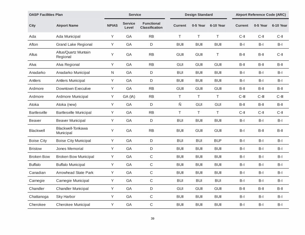
nalPseitilicaFPSAO ecivreS dradnatSngiseD )CRA(edoCecnerefeRtropriA
ytiC emaNtropriA SAIPNecivreSleveL
lanoitcnuFnoitacifissalC
tnerruC raeY5-0 raeY01-6 tnerruC raeY5-0 raeY01-6
adA lapicinuMadA Y AG BR T T T II-C II-C II-C
notfA lanoigeRekaLdnarG Y AG D IIUB IIUB IIUB I-B I-B I-B
sutlA niatnuMztrauQ/sutlAlanoigeR Y AG BR IIUG IIUG T II-B II-B II-C
avlA lanoigeRavlA Y AG BR IUG IIUG IIUG II-B II-B II-B
okradanA lapicinuMokradanA N AG D IUB IIUB IIUB I-B I-B I-B
sreltnA lapicinuMsreltnA Y AG D IIUB IIUB IIUB I-B I-B I-B
eromdrA evitucexEnwotnwoD Y AG BR IIUG IIUG IIUG II-B II-B II-B
eromdrA lapicinuMeromdrA Y )AI(AG BR T T T III-C III-C III-C
akotA )wen(akotA Y AG D Ñ IUG IUG II-B II-B II-B
ellivseltraB lapicinuMellivseltraB Y AG BR T T T II-C II-C II-C
revaeB lapicinuMrevaeB Y AG D IUB IIUB IIUB I-B I-B I-B
llewkcalB awaknoT-llewkcalBlapicinuM Y AG BR IIUB IIUG IIUG I-B II-B II-B
ytiCesioB lapicinuMytiCesioB Y AG D IUB IUB *IUB I-B I-B I-B
wotsirB lairomeMsenoJ Y AG D IIUB IIUB IIUB I-B I-B I-B
woBnekorB lapicinuMwoBnekorB Y AG C IIUB IIUB IIUB I-B I-B I-B
olaffuB lapicinuMolaffuB Y AG C IIUB IIUB IIUB I-B I-B I-B
naidanaC kraPetatSdaehworrA Y AG C IIUB IIUB IIUB I-B I-B I-B
eigenraC lapicinuMeigenraC Y AG C IUB IUB IUB I-B I-B I-B
reldnahC lapicinuMreldnahC Y AG D IUG IIUG IIUG II-B II-B II-B
agonattahC robraHykS Y AG C IIUB IIUB IIUB I-B I-B I-B
eekorehC lapicinuMeekorehC Y AG C IIUB IIUB IIUB I-B I-B I-B
39
nalPseitilicaFPSAO ecivreS dradnatSngiseD )CRA(edoCecnerefeRtropriA
ytiC emaNtropriA SAIPNecivreSleveL
lanoitcnuFnoitacifissalC
tnerruC raeY5-0 raeY01-6 tnerruC raeY5-0 raeY01-6
enneyehC lapicinuMdriaLnongiM Y AG C IIUB IIUB IIUB I-B I-B I-B
ahsakcihC lapicinuMahsakcihC Y AG BR T T T II-C II-C II-C
eromeralC lanoigeReromeralC Y AG BR IUG IIUG IIUG II-B II-B II-B
dnalevelC lapicinuMdnalevelC Y AG D IIUB IIUB IIUB I-B I-B I-B
notnilC lapicinuMnotnilC Y AG BR IUG IIUG IIUG II-B II-B II-B
notnilC namrehS-notnilC Y )AI(AG BR T T T IV-D IV-D IV-D
noskooC krapriAekaLrellikneT N AG D IUB IUB *IUB I-B I-B I-B
lledroC lapicinuMlledroC Y AG C IIUB IIUB IIUB I-B I-B I-B
gnihsuC lapicinuMgnihsuC Y AG BR IIUG IIUG IIUG II-B II-B II-B
nacnuD dleiFnotrubillaH Y AG BR T T T II-C II-C II-C
tnaruD dleiFrekaE Y AG BR T T T II-C II-C II-C
ytiCklE lapicinuMytiCklE Y AG BR IUG IIUG IIUG II-B II-B II-B
oneRlE krapriAlapicinuMoneRlE Y AG BR IIUG IIUG IIUG II-B II-B II-B
dinE lanoigeRgnirdooWdinE Y MC BR T T T III-C III-C III-C
aluafuE lapicinuMaluafuE Y AG C IUB IUB IUB I-B I-B I-B
aluafuE egdoLdaehniatnuoFkrapriA Y AG C IUB IUB IUB I-B I-B I-B
weivriaF lapicinuMweivriaF Y AG D IIUB IUG IUG I-B II-B II-B
kcirederF lapicinuMkcirederF Y AG BR T T T II-B II-B II-B
egaG lapicinuMegaG Y AG C IIUB IIUB IIUB I-B I-B I-B
ybsdloG yrrePyaJdivaD Y AG D IUB IIUB IIUB I-B I-B I-B
dleifdnarG lapicinuMdleifdnarG Y AG D IUB IUB IUB I-B I-B I-B
evorG lapicinuMevorG Y AG BR IUG IIUG IIUG II-B II-B II-B
40
nalPseitilicaFPSAO ecivreS dradnatSngiseD )CRA(edoCecnerefeRtropriA
ytiC emaNtropriA SAIPNecivreSleveL
lanoitcnuFnoitacifissalC
tnerruC raeY5-0 raeY01-6 tnerruC raeY5-0 raeY01-6
eirhtuG lanoigeRdnomdE-eirhtuG Y AG BR IUG IUG IUG II-B II-B II-B
nomyuG lapicinuMnomyuG Y AG BR IIUG IIUG IIUG II-B II-B II-B
notdlaeH lapicinuMnotdlaeH Y AG C IUB IUB IUB I-B I-B I-B
atteyrneH lapicinuMatteyrneH Y AG D IIUB IIUB IIUB I-B I-B I-B
notniH lapicinuMnotniH Y AG D IUB IIUB IIUB I-B I-B I-B
traboH lapicinuMtraboH Y AG BR T T T II-C II-C II-C
ellivnedloH lapicinuMellivnedloH Y AG C IIUB IIUB IIUB I-B I-B I-B
silloH lapicinuMsilloH Y AG D IUB IUB IUB I-B I-B I-B
ynimoH lapicinuMynimoH Y AG C IIUB IIUB IIUB I-B I-B I-B
rekooH lapicinuMrekooH Y AG C IUB IUB IUB I-B I-B I-B
oguH lapicinuMrepmatSnatS Y AG BR IIUB IIUG IIUG I-B II-B II-B
lebadI lanoigeRytnuoCniatruCcM Y AG BR IIUG IIUG IIUG II-B II-B II-B
muhcteK dnarGhtuoSytnuoCgiarCekaL N AG C IUB IUB IUB I-B I-B I-B
rehsifgniK lapicinuMrehsifgniK N AG D IUB IIUB IIUB I-B I-B I-B
notsgniK kraPetatSamoxeTekaL Y AG C IUB IUB IUB I-B I-B I-B
enrevaL lapicinuMenrevaL N AG C IIUB IIUB IIUB I-B I-B I-B
notwaL lanoigeRlliStroF-notwaL Y RP BR T T T III-C III-C III-C
yasdniL lapicinuMyasdniL Y AG C IUB IUB IUB I-B I-B I-B
llidaM lapicinuMllidaM Y AG D IUB IUB IUB I-B I-B I-B
mugnaM dleiFttocS Y AG D IIUB IIUB IIUB I-B I-B I-B
41

nalPseitilicaFPSAO ecivreS dradnatSngiseD )CRA(edoCecnerefeRtropriA
ytiC emaNtropriA SAIPNecivreSleveL
lanoitcnuFnoitacifissalC
tnerruC raeY5-0 raeY01-6 tnerruC raeY5-0 raeY01-6
retselAcM lanoigeRretselAcM Y AG BR IIUG IIUG IIUG II-B II-B II-B
drofdeM lapicinuMdrofdeM Y AG D IUB IIUB IIUB I-B I-B I-B
imaiM lapicinuMimaiM Y AG BR IIUG IIUG IIUG II-B II-B II-B
dnalerooM lapicinuMdnalerooM Y AG C IUB IIUB IIUB I-B I-B I-B
eegoksuM dleiFsivaD Y AG BR T T T III-C III-C III-C
namroN xaMKOfoytisrevinUremiehtseW Y LR BR T T T II-C II-C II-C
eneekO dleiFnamtsirhC Y AG C IIUB IIUB IIUB I-B I-B I-B
hamekO dleiFgniylFhamekO Y AG C IUB IUB IUB I-B I-B I-B
amohalkOytiC
egaP.EecneralClapicinuM Y LR BR T T T II-C II-C II-C
amohalkOytiC tsoPyeliW Y LR BR T T T III-C III-C III-C
amohalkOytiC dlroWsregoRlliW Y RP BR T T T V-D V-D V-D
eeglumkO lanoigeReeglumkO Y LR BR T T T II-C II-C II-C
eetsulO lapicinuMeetsulO N AG C IIUB IIUB IIUB I-B I-B I-B
koorbrevO kraPetatSyarruMekaL Y AG C IUB IUB IUB I-B I-B I-B
yellaVsluaP lapicinuMyellaVsluaP Y AG BR IUG T T II-B II-C II-C
aksuhwaP lapicinuMaksuhwaP N AG C IUB IUB IUB I-B I-B I-B
eenwaP lapicinuMeenwaP Y AG C IUB IUB IUB I-B I-B I-B
yrreP lapicinuMyrreP Y AG BR IIUG IIUG IIUG II-B II-B II-B
ytiCacnoP lanoigeRytiCacnoP Y MC BR T T T II-C II-C II-C
42
nalPseitilicaFPSAO ecivreS dradnatSngiseD )CRA(edoCecnerefeRtropriA
ytiC emaNtropriA SAIPNecivreSleveL
lanoitcnuFnoitacifissalC
tnerruC raeY5-0 raeY01-6 tnerruC raeY5-0 raeY01-6
keerCdnoP lapicinuMkeerCdnoP N AG C IUB IUB IUB I-B I-B I-B
uaetoP rreK.StreboR Y AG BR IUG IIUG IIUG II-B II-B II-B
eugarP lapicinuMeugarP Y AG C IUB IIUB IIUB I-B I-B I-B
keerCroyrP lairtsudnIaciremA-diM Y )AI(AG BR IIUG IIUG IIUG II-B II-B II-B
llecruP lapicinuMllecruP Y AG D IUB IIUB IIUB I-B I-B I-B
wasillaS lapicinuMwasillaS Y AG BR IUG IUG IUG II-B II-B II-B
sgnirpSdnaS eugoP.RmailliWlapicinuM Y LR BR IIUG IIUG IIUG II-B II-B II-B
eryaS lapicinuMeryaS Y AG C IIUB IIUB IIUB I-B I-B I-B
elonimeS lapicinuMelonimeS Y AG BR IIUG IIUG IIUG II-B II-B II-B
eenwahS lanoigeReenwahS Y AG BR IIUG IIUG IIUG II-B II-B II-B
kootaikS lapicinuMkootaikS Y AG D IUB IUB IUB I-B I-B I-B
relgitS lapicinuMrelgitS Y AG D IIUB IIUB IIUB I-B I-B I-B
retawllitS lanoigeRretawllitS Y AG BR T T T III-C III-C III-C
duortS lapicinuMduortS Y AG C IUB IUB IUB I-B I-B I-B
ruhpluS lapicinuMruhpluS Y AG D IIUB IIUB IIUB I-B I-B I-B
hauqelhaT lapicinuMhauqelhaT Y AG BR IUG IIUG IIUG II-B II-B II-B
anihilaT lapicinuManihilaT Y AG C IIUB IIUB IIUB I-B I-B I-B
amohxeT lapicinuMamohxeT N AG C IUB IUB IUB I-B I-B I-B
samohT lapicinuMsamohT Y AG D IUB IUG IUG I-B II-B II-B
notpiT lapicinuMnotpiT N AG C IUB IUB IUB I-B I-B I-B
ognimohsiT lapicinuMognimohsiT Y AG C IUB IUB IUB I-B I-B I-B
43
nalPseitilicaFPSAO ecivreS dradnatSngiseD )CRA(edoCecnerefeRtropriA
ytiC emaNtropriA SAIPNecivreSleveL
lanoitcnuFnoitacifissalC
tnerruC raeY5-0 raeY01-6 tnerruC raeY5-0 raeY01-6
asluT lanoitanretnIasluT Y RP BR T T T V-D V-D V-D
asluT .rJsenoJ.LdrahciR Y LR BR T T T II-C II-C II-C
atiniV lapicinuMatiniV Y AG D IUB IUG IUG I-B II-B II-B
renogaW yelsaE/renfeH Y AG D IIUB IIUB IIUB I-B I-B I-B
sretlaW lapicinuMsretlaW Y AG C IUB IUB IUB I-B I-B I-B
agnotaW lapicinuMagnotaW Y AG BR IIUB IIUG IIUG I-B II-B II-B
akonyaW lapicinuMakonyaW Y AG C IIUB IIUB IIUB I-B I-B I-B
drofrehtaeW droffatS.PsamohT Y AG BR IUG IIUG IIUG II-B II-B II-B
troptseW tropriAtroptseW N AG C IUB IUB IUB I-B I-B I-B
notrubliW lapicinuMnotrubliW Y AG D IUB IIUB IIUB I-B I-B I-B
drawdooW drawdooWtseW Y AG BR T T T II-C II-C II-C
Service Level: Functional Classification: Design Standard:CM - Non-Primary Commercial Service C - Community BUI - Basic Utility Stage 1GA - General Aviation D - District BUII - Basic Utility State 2PR - Primary Commercial Service RB - Regional Business GUI - General Utility Stage 1RL - Reliever GUII - General Utility Stage 2(IA) - Industrial Airport T - Transport
NPIAS - National Plan of Integrated Airport Systems
44