Embed Size (px)
Citation preview
OCS Report MMS 2003-039
Outer Continental Shelf Oil Spill During Hurricane Lili, Ship Shoal Block 119: Responses, Fate, and Effects
U.S. Department of the InteriorMinerals Management Service Gulf of Mexico OCS Region

U.S. Department of the InteriorMinerals Management Service Gulf of Mexico OCS Region
OCS Report MMS 2003-039
Outer Continental Shelf Oil Spill During Hurricane Lili, Ship Shoal Block 119: Responses, Fate, and Effects Prepared by Margaret Metcalf Harold Wright Elizabeth Peuler Nicholas Wetzel Michael Gravois Published by
New OrleansJuly 2003
i
TABLE OF CONTENTS Page
Introduction..................................................................................................................................... 1 Discussion ....................................................................................................................................... 2 Conclusion ...................................................................................................................................... 3 References ....................................................................................................................................... 3
TABLES
Table 1 Spill Chronology........................................................................................................... 5 Table 2 Oil Analysis .................................................................................................................. 5
FIGURES
Figure 1 Ship Shoal Block 119 Location and Offshore Path of Hurricane Lili .......................... 6 Figure 2 Overview Map .............................................................................................................. 7 Figure 3 Engineering Diagram of the Well ................................................................................. 8 Figure 4 Photograph of Well No. 14 ........................................................................................... 9 Figure 5 Photograph of Oil Slick ................................................................................................ 9 Figure 6 Routes Taken to Ship Shoal Block 119 by Response Vessels.................................... 10 Figure 7 Overview Map Showing Oil Pockets.......................................................................... 11
ATTACHMENTS
Attachment 1 Hotline Report from Steve Thumm, October 4, 2002 ....................................... 13 Attachment 2 Update and Final Report from Steve Thumm, October 8, 2002........................ 14 Attachment 3 Trajectory Report from Glenn Watabayashi, October 4, 2002.......................... 15
1
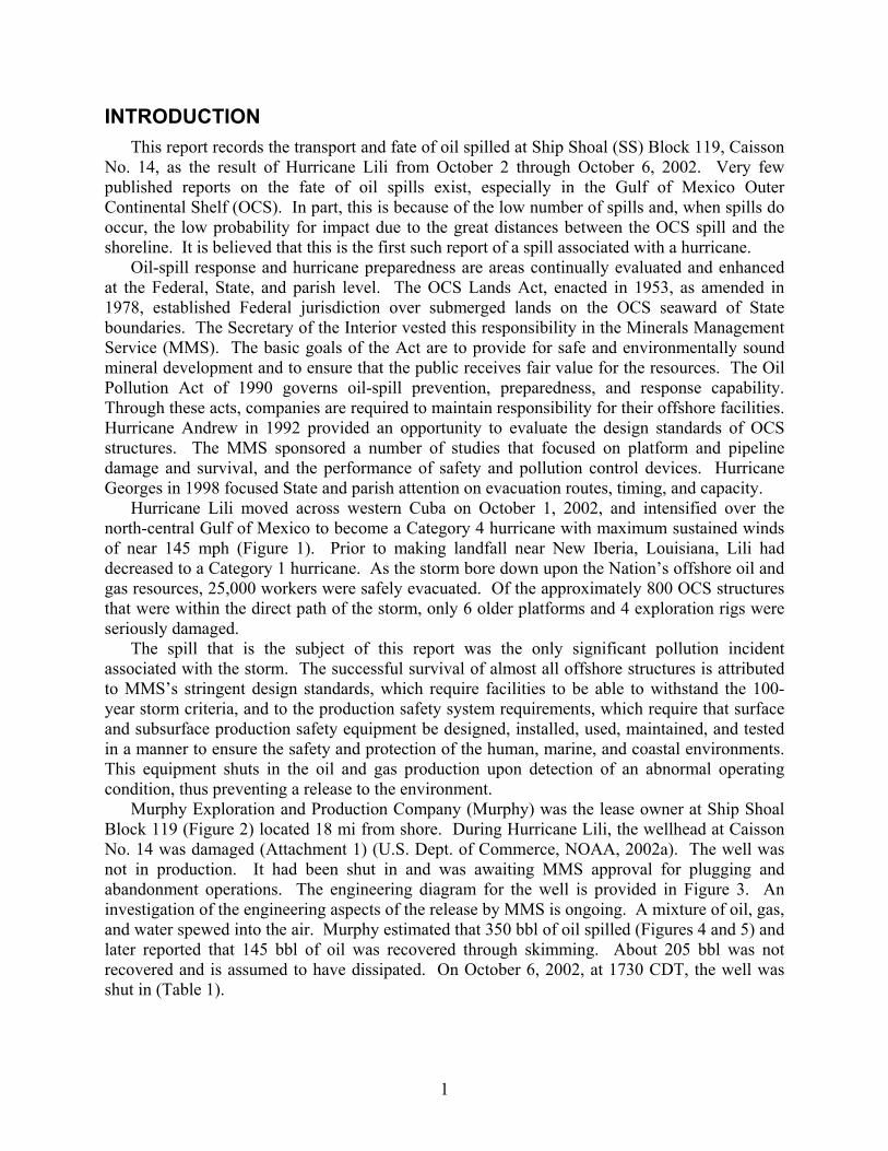
INTRODUCTION This report records the transport and fate of oil spilled at Ship Shoal (SS) Block 119, Caisson
No. 14, as the result of Hurricane Lili from October 2 through October 6, 2002. Very few published reports on the fate of oil spills exist, especially in the Gulf of Mexico Outer Continental Shelf (OCS). In part, this is because of the low number of spills and, when spills do occur, the low probability for impact due to the great distances between the OCS spill and the shoreline. It is believed that this is the first such report of a spill associated with a hurricane.
Oil-spill response and hurricane preparedness are areas continually evaluated and enhanced at the Federal, State, and parish level. The OCS Lands Act, enacted in 1953, as amended in 1978, established Federal jurisdiction over submerged lands on the OCS seaward of State boundaries. The Secretary of the Interior vested this responsibility in the Minerals Management Service (MMS). The basic goals of the Act are to provide for safe and environmentally sound mineral development and to ensure that the public receives fair value for the resources. The Oil Pollution Act of 1990 governs oil-spill prevention, preparedness, and response capability. Through these acts, companies are required to maintain responsibility for their offshore facilities. Hurricane Andrew in 1992 provided an opportunity to evaluate the design standards of OCS structures. The MMS sponsored a number of studies that focused on platform and pipeline damage and survival, and the performance of safety and pollution control devices. Hurricane Georges in 1998 focused State and parish attention on evacuation routes, timing, and capacity.
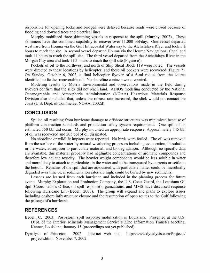
Hurricane Lili moved across western Cuba on October 1, 2002, and intensified over the north-central Gulf of Mexico to become a Category 4 hurricane with maximum sustained winds of near 145 mph (Figure 1). Prior to making landfall near New Iberia, Louisiana, Lili had decreased to a Category 1 hurricane. As the storm bore down upon the Nation’s offshore oil and gas resources, 25,000 workers were safely evacuated. Of the approximately 800 OCS structures that were within the direct path of the storm, only 6 older platforms and 4 exploration rigs were seriously damaged.
The spill that is the subject of this report was the only significant pollution incident associated with the storm. The successful survival of almost all offshore structures is attributed to MMS’s stringent design standards, which require facilities to be able to withstand the 100-year storm criteria, and to the production safety system requirements, which require that surface and subsurface production safety equipment be designed, installed, used, maintained, and tested in a manner to ensure the safety and protection of the human, marine, and coastal environments. This equipment shuts in the oil and gas production upon detection of an abnormal operating condition, thus preventing a release to the environment.
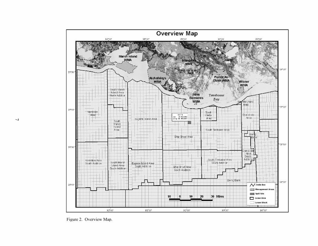
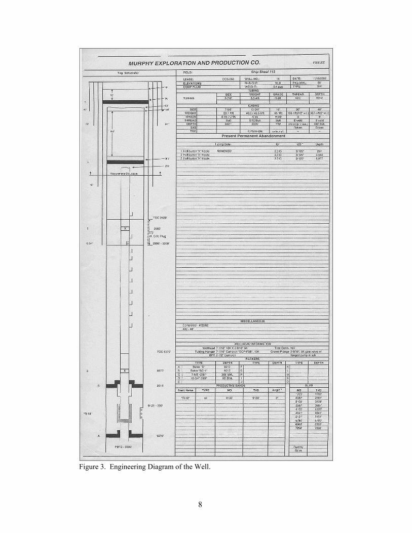
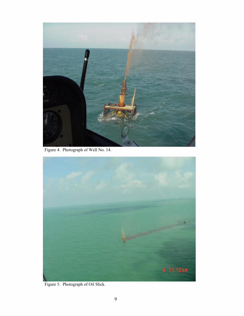
Murphy Exploration and Production Company (Murphy) was the lease owner at Ship Shoal Block 119 (Figure 2) located 18 mi from shore. During Hurricane Lili, the wellhead at Caisson No. 14 was damaged (Attachment 1) (U.S. Dept. of Commerce, NOAA, 2002a). The well was not in production. It had been shut in and was awaiting MMS approval for plugging and abandonment operations. The engineering diagram for the well is provided in Figure 3. An investigation of the engineering aspects of the release by MMS is ongoing. A mixture of oil, gas, and water spewed into the air. Murphy estimated that 350 bbl of oil spilled (Figures 4 and 5) and later reported that 145 bbl of oil was recovered through skimming. About 205 bbl was not recovered and is assumed to have dissipated. On October 6, 2002, at 1730 CDT, the well was shut in (Table 1).

2
DISCUSSION Maximum wind speeds of 29 m/sec (65 mph) with gusts up to 35 m/sec (78 mph) occurred
on October 2, 2002, from 2100 to 2300 hours. These data were recorded 5 m above sea level at the National Data Buoy Center (NDBC) Station 42041, located approximately 100 mi to the southeast of Ship Shoal Block 119 and about 20 mi from the eye of the hurricane (U.S. Dept. of Commerce, NOAA, 2002b). Hurricane Lili passed on the west side of the NDBC buoy and Ship Shoal Block 119 (Figure 1).
It is assumed that the oil that spilled for about the first 5-10 hours was completely dispersed in mist or droplet form by the hurricane winds. Weathering may have been accelerated as any volatile components were likely stripped from the oil into the air as the spill showered into the air.
The oil and water mixture continued to spew until the well was shut in on October 6, 2002, at 1730 CDT (Attachment 2) (U.S. Dept. of Commerce, NOAA, 2002c). During this post-hurricane period, winds and currents returned to more normal conditions and a slick formed. Winds of 5-10 mph from the northeast, southeast, and south were recorded on October 4, 5, and 6, respectively. The changes in wind direction throughout the event resulted in oil observed to the east, north, and northwest of the caisson.
Current data during Hurricane Lili are not available for the Ship Shoal area. However, hurricanes increase surface current speeds to 100-150 cm/sec over the continental shelves (Nowlin et al., 1998; U.S. Dept. of the Interior, MMS, 2002a). As the storm passes, the current direction is likely to change in response. Images of prior hurricanes were produced through a Gulf of Mexico hurricane hindcast effort and can be viewed on the Internet (Dynalysis of Princeton, 2002). The current conditions and high sea state would be expected to accelerate weathering and dispersion of the oil.
The current was measured at 0.3 kn west-northwest on October 4 and 0.3 kn northeast October 5 through 7.
Approximately 5 in of rain were reported in Iberia Parish, the land area nearest to the spill site, on October 3, 2002 (Louisiana Agriclimatic Information, 2002). The heavy rainfall and storm surge runoff into the nearshore coastal zone created a freshwater barrier that would have hindered onshore movement of any spilled oiled (Attachment 3) (U.S. Dept. of Commerce, October 4, NOAA, 2002d).
A sample of the weathered oil had an API gravity of 13.29° and a density of 0.9763 g/ml (Table 2). It was a relatively dense material, with a paraffin wax content of 0.942 percent by weight. According to Murphy personnel familiar with the well, it is possible that a greater amount of paraffinic material was released at the beginning of the spill and that the percentage of water increased over time.
Overflights were conducted throughout the response. The first report of the spill to the National Response Center was made at 0838 CST on October 4 by Tidewater Marine. Murphy employees describe the spill observed on that day as being dark with no sheen and having windrows at the end farthest from the source. A later flyover noted an orange slick.
Onshore conditions caused by the hurricane impacted Murphy’s ability to respond to the spill offshore (U.S. Dept. of the Interior, MMS, October 3, 2002b). Response was delayed because vessels that had been moved to safe harbor were blocked behind locks that had been closed and bridges that had been left in the down position. In some cases, water-sensitive parts had even been removed to safety and needed to be reinstalled. Parish and State employees who were
3
responsible for opening locks and bridges were delayed because roads were closed because of flooding and downed trees and electrical lines.
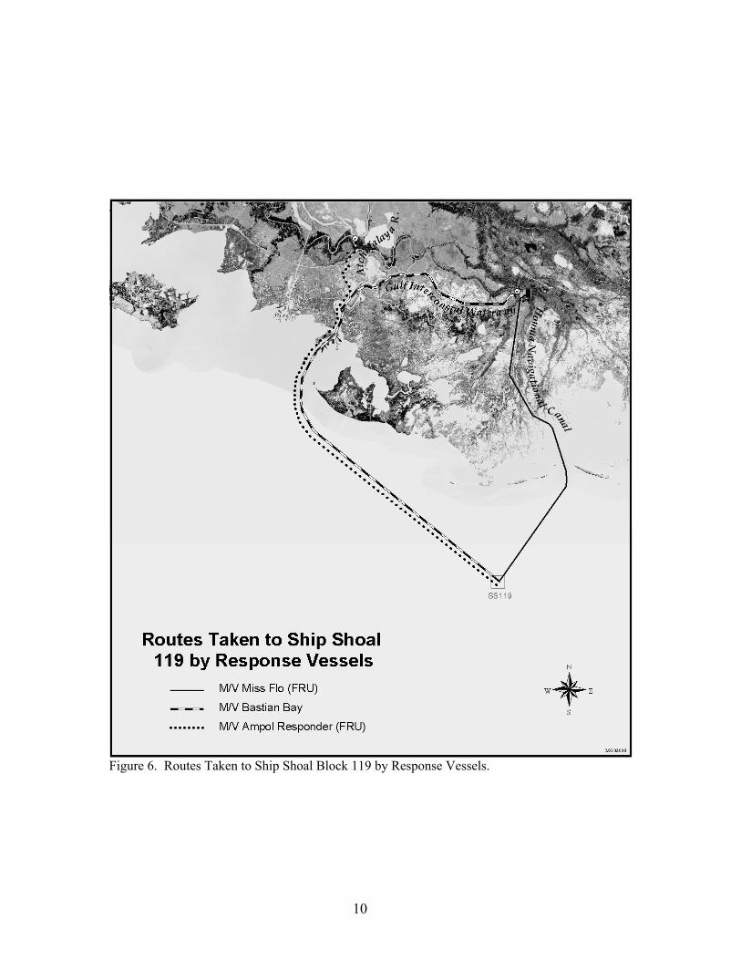
Murphy mobilized three skimming vessels in response to the spill (Murphy, 2002). These skimmers have the combined capability to recover over 11,000 bbl/day. One vessel departed westward from Houma via the Gulf Intracoastal Waterway to the Atchafalaya River and took 5½ hours to reach the site. A second vessel departed Houma via the Houma Navigational Canal and took 11 hours to reach the spill site. The third vessel departed from the Atchafalaya River in the Morgan City area and took 11.5 hours to reach the spill site (Figure 6).
Pockets of oil to the northwest and north of Ship Shoal Block 119 were noted. The vessels were directed to these locations by helicopter, and these oil pockets were recovered (Figure 7). On Sunday, October 6, 2002, a final helicopter flyover of a 6-mi radius from the source identified no further recoverable oil. No shoreline contacts were reported.
Modeling results by Morris Environmental and observations made in the field during flyovers confirm that the slick did not reach land. ADIOS modeling conducted by the National Oceanographic and Atmospheric Administration (NOAA) Hazardous Materials Response Division also concluded that, unless the release rate increased, the slick would not contact the coast (U.S. Dept. of Commerce, NOAA, 2002d).
CONCLUSION Spilled oil resulting from hurricane damage to offshore structures was minimized because of
platform construction standards and production safety system requirements. One spill of an estimated 350 bbl did occur. Murphy mounted an appropriate response. Approximately 145 bbl of oil was recovered and 205 bbl of oil dissipated.
No shoreline or wildlife impacts were reported. No birds were fouled. The oil was removed from the surface of the water by natural weathering processes including evaporation, dissolution in the water, adsorption to particulate material, and biodegradation. Although no specific data are available, this material probably had negligible concentrations of aromatic compounds and therefore low aquatic toxicity. The heavier weight components would be less soluble in water and more likely to attach to particulates in the water and to be transported by currents or settle to the bottom. Remains of the spill that are associated with particulate matter could be microbially degraded over time or, if sedimentation rates are high, could be buried by new sediments.
Lessons are learned from each hurricane and included in the planning process for future events. Murphy Exploration and Production Company, the U.S. Coast Guard, the Louisiana Oil Spill Coordinator’s Office, oil-spill-response organizations, and MMS have discussed response following Hurricane Lili (Bedell, 2003). The group will expand and plans to explore issues including onshore infrastructure closure and the resumption of open routes to the Gulf following the passage of a hurricane.
REFERENCES Bedell, C. 2003. Post-storm spill response mobilization in Louisiana. Presented at the U.S.
Dept. of the Interior, Minerals Management Service’s 22nd Information Transfer Meeting, Kenner, Louisiana, January 15 (proceedings not yet published).
Dynalysis of Princeton. 2002. Internet web site: http://www.dynalysis.com/Projects/ projects.html. November 7, 2002.
4
Louisiana Agriclimatic Information. Louisiana State University, Department of Biological and Agricultural Engineering. 2002. Internet web site: http://www.agctr.lsu.edu/weather. October 29, 2002.
Murphy Exploration and Production Inc. (Murphy). 2002. Various internal reports (October 4-7, 2002).
Nowlin, W.D. Jr., A.E. Jochens, R.O. Reid, and S.F. DiMarco. 1998. Texas-Louisiana shelf circulation and transport processes study: Synthesis report. Volume II: Appendices. U.S. Dept. of the Interior, Minerals Management Service, Gulf of Mexico OCS Region, New Orleans, LA. OCS Study MMS 98-0036.
SPL. 2002. Houston Laboratory, Certificate of Analysis Number 1030-2002100130-001A, October 15.
U.S. Dept. of Commerce. National Oceanic and Atmospheric Administration (NOAA), Hazardous Materials Response Division, Office of Response and Restoration, National Ocean Service. 2002a. Hotline Report for Platform 19, Ship Shoal Block 119, Offshore LA, Initial Report. 10/04/02 Email from Steve Thumm (Attachment 1).
U.S. Dept. of Commerce. National Oceanographic and Atmospheric Administration (NOAA), National Data Buoy Center. 2002b. (web site accessed 10/22/02) http://www.ndbc.noaa.gov/station_page.phtml?$station=42041.
U.S. Dept. of Commerce. National Oceanic and Atmospheric Administration (NOAA). 2002c. Hotline Report for Platform 19, Ship Shoal Block 119, Offshore LA: Update and final. October 8, 2002, e-mail from Steve Thumm (Attachment 2) U.S. Dept. of Commerce, National Oceanic and Atmospheric Administration, Hazardous Materials Response Division, Office of Response and Restoration, National Ocean Service.
U.S. Dept. of Commerce. National Oceanic and Atmospheric Administration (NOAA). 2002d. Hotline Report for Platform 19, Ship Shoal Block 119, Offshore LA. October 4, 2002, e-mail from Glen Watabayashi (Attachment 3). U.S. Dept. of Commerce, National Oceanic and Atmospheric Administration, Hazardous Materials Response Division, Office of Response and Restoration, National Ocean Service.
U.S. Dept. of the Interior. Minerals Management Service (MMS). 2002a. Gulf of Mexico OCS oil and gas lease sales: 2003-2007; Central Planning Area Sales 185, 190, 194, 198, and 201, and Western Planning Area Sales 187, 192, 196, and 200 – final environmental impact statement. U.S. Dept. of the Interior, Minerals Management Service, Gulf of Mexico OCS Region, New Orleans, LA. OCS EIS/EA MMS 2002-052.
U.S. Dept. of the Interior. Minerals Management Service. 2002b. Offshore incident report, October 3, 2002. U.S. Dept. of the Interior, Minerals Management Service, Gulf of Mexico OCS Region, New Orleans, LA.
5
Table 1
Spill Chronology
Date Time Reported by Location Observation 10/02/02 2200 NDBC web site 27.50° N.
90.50° W. Maximum wind speed recorded at buoy 100 mi to the southeast
10/04/02 0715 Tidewater Marine (Hotline Report)
28°48′6″ N. 91°11′32″ W.
Unknown material
10/04/02 0830 Murphy (Hotline Report)
SS 119 Wellhead spewing crude oil 1 mi x 20 yd slick
10/04/02 1335 PHI Helicopter (Hotline Report)
28°40′ N. 90°55′ W.
Spewing oil
10/04/02 1400 Murphy (ICS 201-2 Summary of Current Actions)
SS 119 Spill moving east
10/04/02 1700 Murphy (ICS 201-2 Summary of Current Actions)
SS 119 Spill movement east-southeast, independent sections noted, spill extends out 10 mi from wellhead
10/05/02 1000 Aquatica (Hotline Report)
28°50′0″ N. 90°59′1″ W.
Unknown reddish sheen on water, 1 mi x 300 ft
10/05/02 1630 ChevronTexaco (Hotline Report)
28°58′59″ N. 91°11′32″ W.
Crude in water
10/05/02 1800 ERA Aviation (Hotline Report)
SS Spewing oil
10/06/02 1530 Murphy SS 119 Well shut in NDBC – National Data Buoy Center. ICS – Incident Command System.
Table 2
Oil Analysis
Sulfur Content (wt %) 0.281 Paraffin Wax Content (wt %) 0.942 API Gravity (at 60º F) 13.29 Density (60º F) 0.9763 Specific Gravity (60/60º F) 0.9772
Source: SPL, 2002.
6
Figure 1. Ship Shoal Block 119 Location and Offshore Path of Hurricane Lili.
7
Figure 2. Overview Map.
8
Figure 3. Engineering Diagram of the Well.
9
Figure 4. Photograph of Well No. 14.
Figure 5. Photograph of Oil Slick.
10
Figure 6. Routes Taken to Ship Shoal Block 119 by Response Vessels.

11
Figure 7. Overview Map Showing Oil Pockets.
12
ATTACHMENTS
Attachment 1 Hotline Report from Steve Thumm, October 4, 2002. U.S. Department of Commerce,
National Oceanic and Atmospheric Administration (NOAA), Hazardous Materials Response Division, Office of Response and Restoration, National Ocean Service.
Attachment 2 Update and Final Report from Steve Thumm, October 8, 2002. U.S. Department of Commerce, National Oceanic and Atmospheric Administration (NOAA), Hazardous Materials Response Division, Office of Response and Restoration, National Ocean Service.
Attachment 3 Trajectory Report from Glenn Watabayashi, October 4, 2002. U.S. Department of
Commerce, National Oceanic and Atmospheric Administration (NOAA), Hazardous Materials Response Division, Office of Response and Restoration, National Ocean Service.
Note: Initial reports identified Caisson or Platform No. 19 as the spill source. A later correction
identified the No. 14 structure as the source. The following three attachments were left in their original form and refer to damage at No. 19, while the text in the preceding report used the corrected identification – No. 14.
13
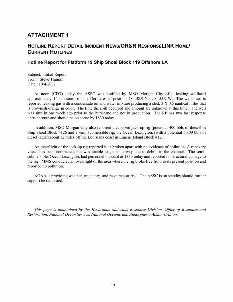
ATTACHMENT 1
HOTLINE REPORT DETAIL INCIDENT NEWS/OR&R RESPONSELINK HOME/ CURRENT HOTLINES
Hotline Report for Platform 19 Ship Shoal Block 119 Offshore LA
Subject: Initial Report From: Steve Thumm Date: 10/4/2002
At noon (CDT) today the ASSC was notified by MSO Morgan City of a leaking wellhead approximately 14 nm south of Isle Dernieres in position 28° 48.9’N 090° 55.9’W. The well head is reported leaking gas with a condensate oil and water mixture producing a slick 3 X 0.5 nautical miles that is brownish orange in color. The time the spill occurred and amount are unknown at this time. The well was shut in one week ago prior to the hurricane and not in production. The RP has two fast response units enroute and should be on scene by 1830 today.
In addition, MSO Morgan City also reported a capsized jack-up rig (potential 400 bbls of diesel) in
Ship Shoal Block #126 and a semi submersible rig, the Ocean Lexington, (with a potential 6,800 bbls of diesel) adrift about 12 miles off the Louisiana coast in Eugene Island Block #123.
An overflight of the jack-up rig reported it as broken apart with no evidence of pollution. A recovery
vessel has been contracted, but was unable to get underway due to debris in the channel. The semi-submersible, Ocean Lexington, had personnel onboard at 1330 today and reported no structural damage to the rig. MMS conducted an overflight of the area where the rig broke free from to its present position and reported no pollution.
NOAA is providing weather, trajectory, and resources at risk. The ASSC is on standby should further
support be requested. This page is maintained by the Hazardous Materials Response Division, Office of Response and
Restoration, National Ocean Service, National Oceanic and Atmospheric Administration.

14
ATTACHMENT 2
HOTLINE REPORT DETAIL INCIDENT NEWS/OR&R RESPONSELINK HOME/ CURRENT HOTLINES
Hotline Report for Platform 19 Ship Shoal Block 119 Offshore LA
Subject: Update and Final From: Steve Thumm Date: 10/8/2002
Platform #19, Ship Shoal Block 119: The source was secured on Sunday, 6 October at 1730 CDT.
The oil is reported to be a natural gas condensate with a high paraffin content. Skimmers were on scene and reported 25 bbls recovered by Monday morning. A USCG overflight of the area reported no shoreline impact. Prior to the hurricane the well was shut in and in the process of being plugged and abandoned. The total amount of oil released is unknown.
Capsized Jack-up Rig, Dolphin 105, Ship Shoal Block 126: Company personnel arrived on scene this
weekend and reported no pollution. The USCG is awaiting an update on the salvage plan. Semi-Submersible, Ocean Lexington, Eugene Island Block 123: The rig is being towed back to its
original location in Ship Shoal Block 300. The mooring lines were found to be fouled around the legs of the rig without the anchors attached.
Shell is conducting a survey of the estimated track the rig took during the storm to investigate any
possible damage to underwater pipelines. This constitutes the end of our support and the final incident report. This page is maintained by the Hazardous Materials Response Division, Office of Response and
Restoration, National Ocean Service, National Oceanic and Atmospheric Administration.

15
ATTACHMENT 3
HOTLINE REPORT DETAIL INCIDENT NEWS/OR&R RESPONSELINK HOME/ CURRENT HOTLINES
Hotline Report for Platform 19 Ship Shoal Block 119 Offshore LA Subject: Trajectory From: Glen Watabayashi Date: 10/4/2002 Date: 1230 CDT Oct 4, 2002 To: NOAA SSC Steve Thumm FROM: NOAA/Hazardous Materials Response Division Modeling and Simulation Studies Seattle, WA 98115 SUBJECT: Hurricane Lili aftermath Platform #19 Murphy Oil Co. Jackup Rig Capsized Semi Submersible Rig, Ocean Lexington, adrift FOR ADDITIONAL INFORMATION, PLEASE CONTACT Glen Watabayashi, MODELING AND SIMULATION STUDIES, NOAA, SEATTLE, WA 98115 or PHONE (206) 526-4911.
We have looked at the trajectory implications of spilled oil from the three listed situations above.
These notes are based on the following information: Platform #19 in Shipshoal Block, about 14 nm offshore of Louisiana (approximately 28° 54' N by 90°
59'W) is reported leaking oil. An overflight this morning documented a 1 mile by 20 yard dark sheen originating from the hurricane damaged platform. The platform was shutdown prior to the hurricane and was not in production. A later overflight reported a 3 mile by 1/2 mile orange slick that was coming from a subsurface source. The water depth is reported to be between 50 and 55 feet. Company representatives indicate it is probably a gas condensate from the well that was shutdown.
A capsized jackup rig in Shipshoal Block #126, about 20 nm offshore of Louisiana (approximately
28° 51'N by 91° 15'W) is not leaking any oil but has a potential of about 400 bbl (1700 gallons)of diesel . A semi submersible rig, the Ocean Lexington, is adrift about 12 miles off the Louisiana coast in
Eugene I. Block #123, at approximately (28° 49'N by 90° 56'W). An overflight indicated no spill. It has a reported 6,800 bbl (280,000 gal) of diesel fuel.
If any of this initial information is incorrect, please let us know ASAP as it would affect any
trajectory implications.
16
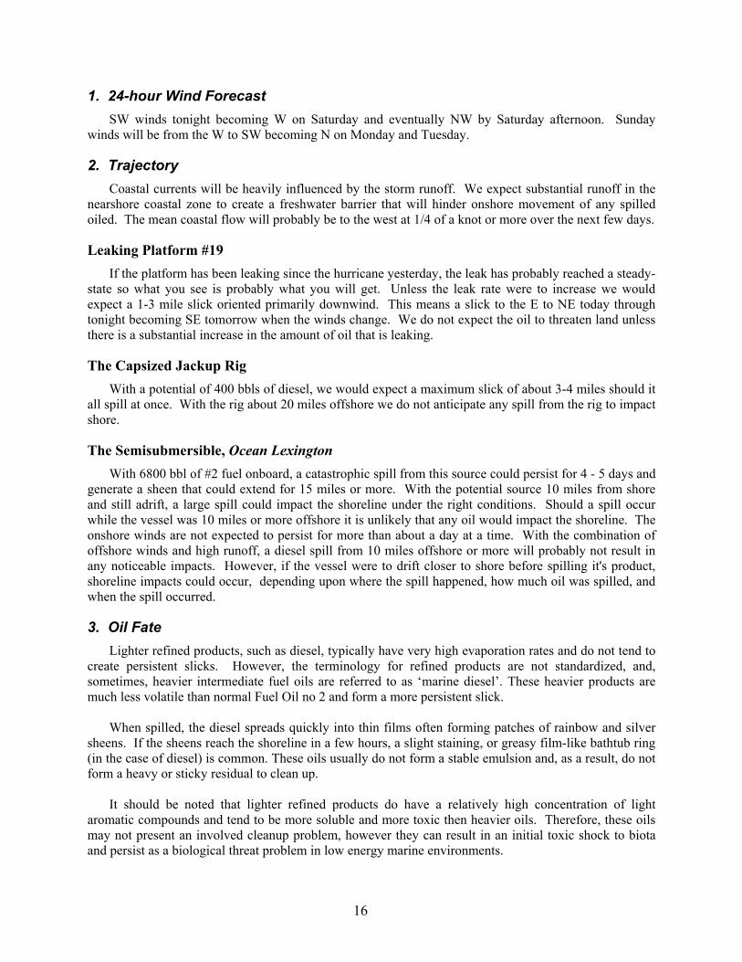
1. 24-hour Wind Forecast SW winds tonight becoming W on Saturday and eventually NW by Saturday afternoon. Sunday
winds will be from the W to SW becoming N on Monday and Tuesday.
2. Trajectory Coastal currents will be heavily influenced by the storm runoff. We expect substantial runoff in the
nearshore coastal zone to create a freshwater barrier that will hinder onshore movement of any spilled oiled. The mean coastal flow will probably be to the west at 1/4 of a knot or more over the next few days.
Leaking Platform #19 If the platform has been leaking since the hurricane yesterday, the leak has probably reached a steady-
state so what you see is probably what you will get. Unless the leak rate were to increase we would expect a 1-3 mile slick oriented primarily downwind. This means a slick to the E to NE today through tonight becoming SE tomorrow when the winds change. We do not expect the oil to threaten land unless there is a substantial increase in the amount of oil that is leaking.
The Capsized Jackup Rig With a potential of 400 bbls of diesel, we would expect a maximum slick of about 3-4 miles should it
all spill at once. With the rig about 20 miles offshore we do not anticipate any spill from the rig to impact shore.
The Semisubmersible, Ocean Lexington With 6800 bbl of #2 fuel onboard, a catastrophic spill from this source could persist for 4 - 5 days and
generate a sheen that could extend for 15 miles or more. With the potential source 10 miles from shore and still adrift, a large spill could impact the shoreline under the right conditions. Should a spill occur while the vessel was 10 miles or more offshore it is unlikely that any oil would impact the shoreline. The onshore winds are not expected to persist for more than about a day at a time. With the combination of offshore winds and high runoff, a diesel spill from 10 miles offshore or more will probably not result in any noticeable impacts. However, if the vessel were to drift closer to shore before spilling it's product, shoreline impacts could occur, depending upon where the spill happened, how much oil was spilled, and when the spill occurred.
3. Oil Fate Lighter refined products, such as diesel, typically have very high evaporation rates and do not tend to
create persistent slicks. However, the terminology for refined products are not standardized, and, sometimes, heavier intermediate fuel oils are referred to as ‘marine diesel’. These heavier products are much less volatile than normal Fuel Oil no 2 and form a more persistent slick.
When spilled, the diesel spreads quickly into thin films often forming patches of rainbow and silver
sheens. If the sheens reach the shoreline in a few hours, a slight staining, or greasy film-like bathtub ring (in the case of diesel) is common. These oils usually do not form a stable emulsion and, as a result, do not form a heavy or sticky residual to clean up.
It should be noted that lighter refined products do have a relatively high concentration of light
aromatic compounds and tend to be more soluble and more toxic then heavier oils. Therefore, these oils may not present an involved cleanup problem, however they can result in an initial toxic shock to biota and persist as a biological threat problem in low energy marine environments.
17
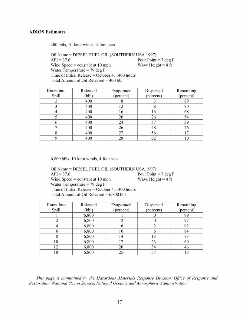
ADIOS Estimates
400 bbls, 10-knot winds, 4-foot seas Oil Name = DIESEL FUEL OIL (SOUTHERN USA 1997) API = 37.6 Pour Point = 7 deg F Wind Speed = constant at 10 mph Wave Height = 4 ft Water Temperature = 79 deg F Time of Initial Release = October 4, 1400 hours Total Amount of Oil Released = 400 bbl
Hours into
Spill Released
(bbl) Evaporated (percent)
Dispersed (percent)
Remaining (percent)
2 400 8 3 89 3 400 12 8 80 4 400 16 16 68 5 400 20 26 54 6 400 24 37 39 7 400 26 48 26 8 400 27 56 17 9 400 28 62 10
6,800 bbls, 10-knot winds, 4-foot seas Oil Name = DIESEL FUEL OIL (SOUTHERN USA 1997) API = 37.6 Pour Point = 7 deg F Wind Speed = constant at 10 mph Wave Height = 4 ft Water Temperature = 79 deg F Time of Initial Release = October 4, 1400 hours Total Amount of Oil Released = 6,800 bbl
Hours Into
Spill Released
(bbl) Evaporated (percent)
Dispersed (percent)
Remaining (percent)
1 6,800 1 0 99 2 6,800 2 0 97 4 6,800 6 2 92 6 6,800 10 6 84 8 6,800 14 13 73 10 6,800 17 23 60 12 6,800 20 34 46 18 6,800 25 57 18
This page is maintained by the Hazardous Materials Response Division, Office of Response and
Restoration, National Ocean Service, National Oceanic and Atmospheric Administration.
The Department of the Interior Mission As the Nation's principal conservation agency, the Department of the Interior has responsibility for most of our nationally owned public lands and natural resources. This includes fostering sound use of our land and water resources; protecting our fish, wildlife, and biological diversity; preserving the environmental and cultural values of our national parks and historical places; and providing for the enjoyment of life through outdoor recreation. The Department assesses our energy and mineral resources and works to ensure that their development is in the best interests of all our people by encouraging stewardship and citizen participation in their care. The Department also has a major responsibility for American Indian reservation communities and for people who live in island territories under U.S. administration. The Minerals Management Service Mission As a bureau of the Department of the Interior, the Minerals Management Service's (MMS) primary responsibilities are to manage the mineral resources located on the Nation's Outer Continental Shelf (OCS), collect revenue from the Federal OCS and onshore Federal and Indian lands, and distribute those revenues. Moreover, in working to meet its responsibilities, the Offshore Minerals Management Program administers the OCS competitive leasing program and oversees the safe and environmentally sound exploration and production of our Nation's offshore natural gas, oil and other mineral resources. The MMS Minerals Revenue Management meets its responsibilities by ensuring the efficient, timely and accurate collection and disbursement of revenue from mineral leasing and production due to Indian tribes and allottees, States and the U.S. Treasury. The MMS strives to fulfill its responsibilities through the general guiding principles of: (1) being responsive to the public's concerns and interests by maintaining a dialogue with all potentially affected parties and (2) carrying out its programs with an emphasis on working to enhance the quality of life for all Americans by lending MMS assistance and expertise to economic development and environmental protection.