Embed Size (px)
Citation preview
Weather Climate Where in the world am I? Oh we do like to be beside
the seaside
Stu
dy G
uid
e -
Geo
gra
ph
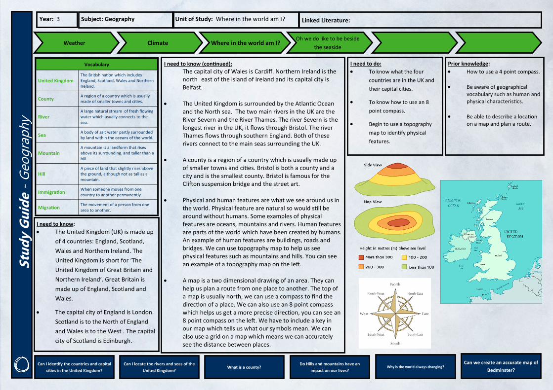
y Year: 3 Subject: Geography Unit of Study: Where in the world am I? Linked Literature:
Vocabulary
United Kingdom The British nation which includes England, Scotland, Wales and Northern Ireland.
County A region of a country which is usually made of smaller towns and cities.
River A large natural stream of fresh flowing water which usually connects to the sea.
Sea A body of salt water partly surrounded by land within the oceans of the world.
Mountain A mountain is a landform that rises above its surrounding. and taller than a hill.
Hill A piece of land that slightly rises above the ground, although not as tall as a mountain.
Immigration When someone moves from one country to another permanently.
Migration The movement of a person from one area to another.
I need to know (continued):
The capital city of Wales is Cardiff. Northern Ireland is the north east of the island of Ireland and its capital city is Belfast.
The United Kingdom is surrounded by the Atlantic Ocean and the North sea. The two main rivers in the UK are the River Severn and the River Thames. The river Severn is the longest river in the UK, it flows through Bristol. The river Thames flows through southern England. Both of these rivers connect to the main seas surrounding the UK.
A county is a region of a country which is usually made up of smaller towns and cities. Bristol is both a county and a city and is the smallest county. Bristol is famous for the Clifton suspension bridge and the street art.
Physical and human features are what we see around us in the world. Physical feature are natural so would still be around without humans. Some examples of physical features are oceans, mountains and rivers. Human features are parts of the world which have been created by humans. An example of human features are buildings, roads and bridges. We can use topography map to help us see physical features such as mountains and hills. You can see an example of a topography map on the left.
A map is a two dimensional drawing of an area. They can help us plan a route from one place to another. The top of a map is usually north, we can use a compass to find the direction of a place. We can also use an 8 point compass which helps us get a more precise direction, you can see an 8 point compass on the left. We have to include a key in our map which tells us what our symbols mean. We can also use a grid on a map which means we can accurately see the distance between places.
I need to do:
To know what the four
countries are in the UK and
their capital cities.
To know how to use an 8
point compass.
Begin to use a topography
map to identify physical
features.
Prior knowledge:
How to use a 4 point compass.
Be aware of geographical vocabulary such as human and physical characteristics.
Be able to describe a location on a map and plan a route.
Can I identify the countries and capital
cities in the United Kingdom?
Can I locate the rivers and seas of the
United Kingdom? What is a county?
Do Hills and mountains have an
impact on our lives? Why is the world always changing?
Can we create an accurate map of
Bedminster?
I need to know: The United Kingdom (UK) is made up
of 4 countries: England, Scotland,
Wales and Northern Ireland. The
United Kingdom is short for ‘The
United Kingdom of Great Britain and
Northern Ireland’. Great Britain is
made up of England, Scotland and
Wales.
The capital city of England is London.
Scotland is to the North of England
and Wales is to the West . The capital
city of Scotland is Edinburgh.

![CBTis 122 English I · PREPOSITION OF PLACE/MOVEMENT. between / along / beside / across from. PLACE/MOVEMENT [ beside] My bedroom is beside the badroom. The park is beside the church](https://img.pdfslide.us/doc/110x75/5e82b924c1ca966fad4769d6/cbtis-122-english-i-preposition-of-placemovement-between-along-beside-across.jpg)