Embed Size (px)
Citation preview
1
OGR2OSMA powerful tool for converting geodata to .osm formatSOTM-US 2012
2
About What ogr2osm can do for you How ogr2osm works A case study of a data conversion Why care about converting?
3
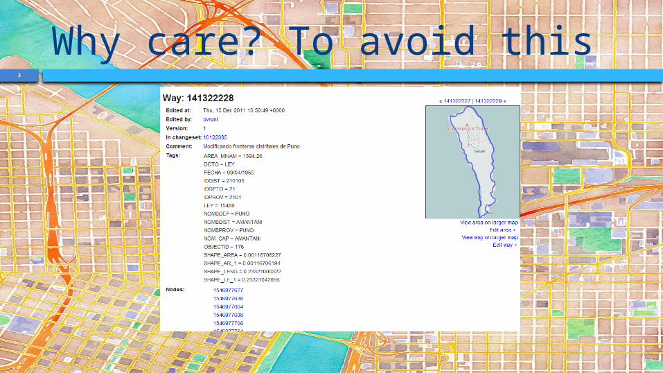
Why care? To avoid this
4
History Written in 2009 by Iván Sánchez Ortega Rewritten 2012 by Andrew Guertin for
UVM buildings I now maintain it
5
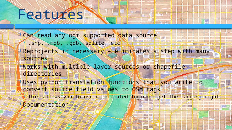
Features Can read any ogr supported data source
.shp, .mdb, .gdb, sqlite, etc Reprojects if necessary – eliminates a step with many
sources Works with multiple layer sources or shapefile directories Uses python translation functions that you write to
convert source field values to OSM tags This allows you to use complicated logic to get the tagging right
Documentation
6
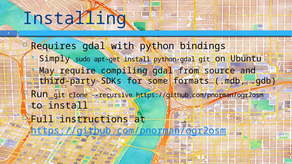
Installing Requires gdal with python bindings
Simply sudo apt-get install python-gdal git on Ubuntu May require compiling gdal from source and third-
party SDKs for some formats (.mdb, .gdb) Run git clone --recursive
https://github.com/pnorman/ogr2osm to install Full instructions at
https://github.com/pnorman/ogr2osm
7
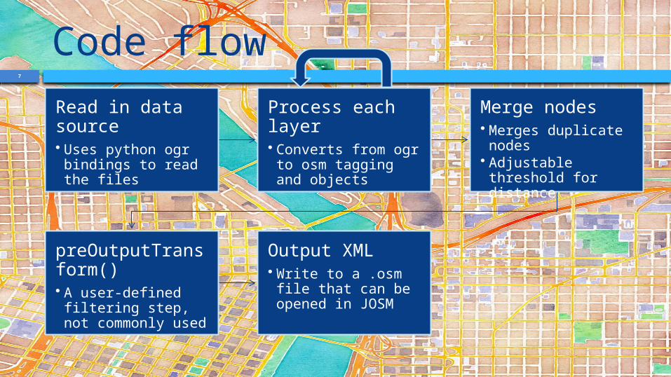
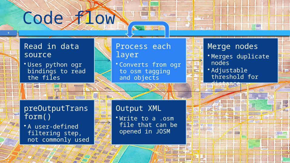
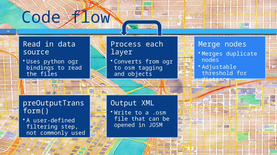
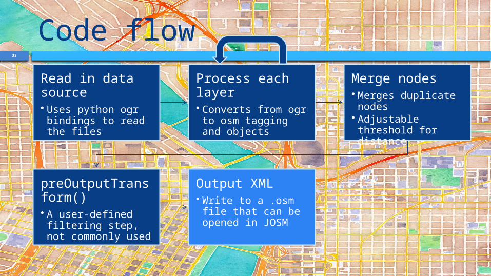
Code flowRead in data source• Uses python ogr bindings to read the files
Process each layer• Converts from ogr to osm tagging and objects
Merge nodes• Merges duplicate nodes
• Adjustable threshold for distance
preOutputTransform()• A user-defined filtering step, not commonly used
Output XML• Write to a .osm file that can be opened in JOSM
8
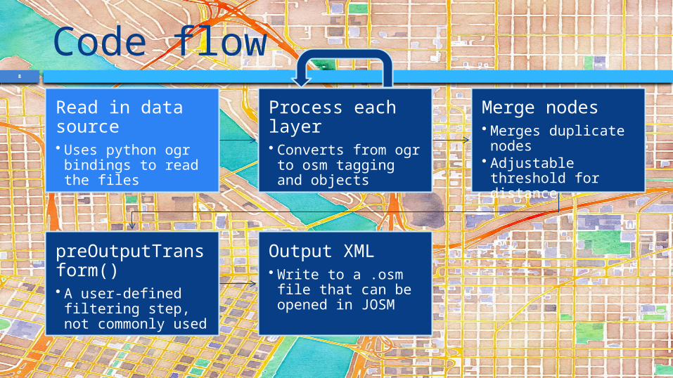
Code flowRead in data source• Uses python ogr bindings to read the files
Process each layer• Converts from ogr to osm tagging and objects
Merge nodes• Merges duplicate nodes
• Adjustable threshold for distance
preOutputTransform()• A user-defined filtering step, not commonly used
Output XML• Write to a .osm file that can be opened in JOSM
9
Code flowRead in data source• Uses python ogr bindings to read the files
Process each layer• Converts from ogr to osm tagging and objects
Merge nodes• Merges duplicate nodes
• Adjustable threshold for distance
preOutputTransform()• A user-defined filtering step, not commonly used
Output XML• Write to a .osm file that can be opened in JOSM
10
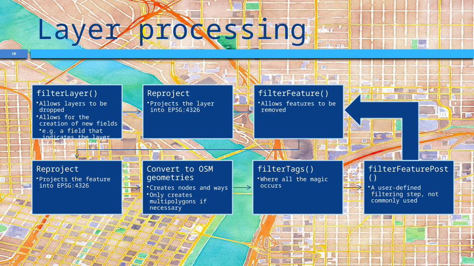
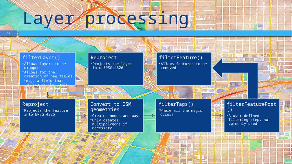
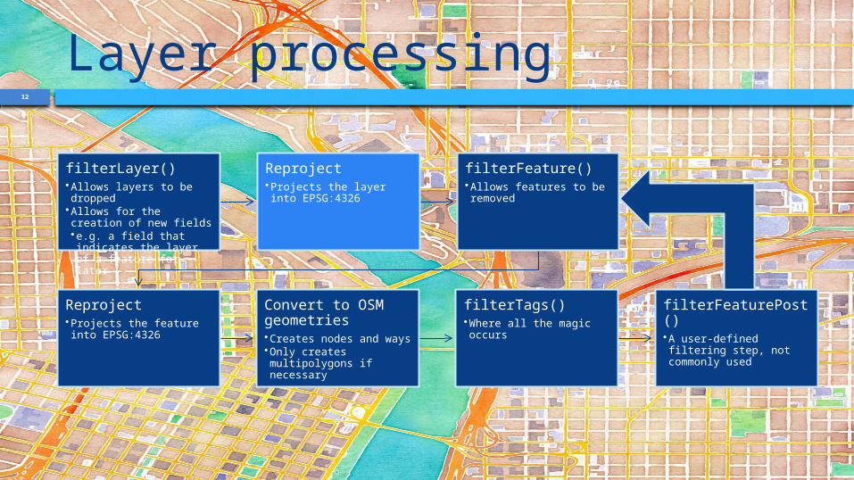
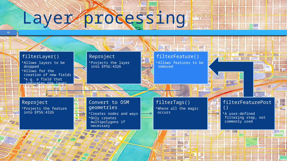
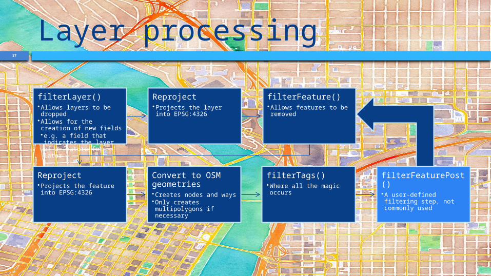
Layer processing
filterLayer()•Allows layers to be dropped
•Allows for the creation of new fields•e.g. a field that indicates the layer of a feature for later
Reproject•Projects the layer into EPSG:4326
filterFeature()•Allows features to be removed
Reproject•Projects the feature into EPSG:4326
Convert to OSM geometries•Creates nodes and ways•Only creates multipolygons if necessary
filterTags()•Where all the magic occurs
filterFeaturePost()•A user-defined filtering step, not commonly used
11
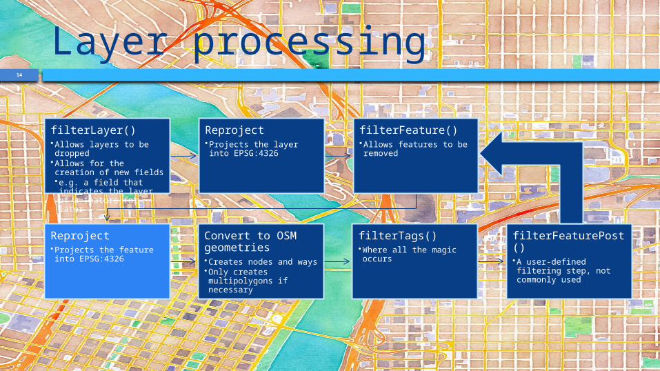
Layer processing
filterLayer()•Allows layers to be dropped
•Allows for the creation of new fields•e.g. a field that indicates the layer of a feature for later
Reproject•Projects the layer into EPSG:4326
filterFeature()•Allows features to be removed
Reproject•Projects the feature into EPSG:4326
Convert to OSM geometries•Creates nodes and ways•Only creates multipolygons if necessary
filterTags()•Where all the magic occurs
filterFeaturePost()•A user-defined filtering step, not commonly used
12
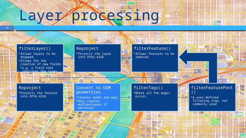
Layer processing
filterLayer()•Allows layers to be dropped
•Allows for the creation of new fields•e.g. a field that indicates the layer of a feature for later
Reproject•Projects the layer into EPSG:4326
filterFeature()•Allows features to be removed
Reproject•Projects the feature into EPSG:4326
Convert to OSM geometries•Creates nodes and ways•Only creates multipolygons if necessary
filterTags()•Where all the magic occurs
filterFeaturePost()•A user-defined filtering step, not commonly used
13
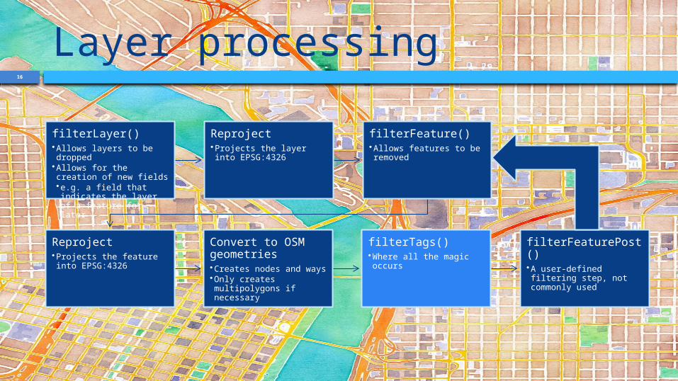
Layer processing
filterLayer()•Allows layers to be dropped
•Allows for the creation of new fields•e.g. a field that indicates the layer of a feature for later
Reproject•Projects the layer into EPSG:4326
filterFeature()•Allows features to be removed
Reproject•Projects the feature into EPSG:4326
Convert to OSM geometries•Creates nodes and ways•Only creates multipolygons if necessary
filterTags()•Where all the magic occurs
filterFeaturePost()•A user-defined filtering step, not commonly used
14
Layer processing
filterLayer()•Allows layers to be dropped
•Allows for the creation of new fields•e.g. a field that indicates the layer of a feature for later
Reproject•Projects the layer into EPSG:4326
filterFeature()•Allows features to be removed
Reproject•Projects the feature into EPSG:4326
Convert to OSM geometries•Creates nodes and ways•Only creates multipolygons if necessary
filterTags()•Where all the magic occurs
filterFeaturePost()•A user-defined filtering step, not commonly used
15
Layer processing
filterLayer()•Allows layers to be dropped
•Allows for the creation of new fields•e.g. a field that indicates the layer of a feature for later
Reproject•Projects the layer into EPSG:4326
filterFeature()•Allows features to be removed
Reproject•Projects the feature into EPSG:4326
Convert to OSM geometries•Creates nodes and ways•Only creates multipolygons if necessary
filterTags()•Where all the magic occurs
filterFeaturePost()•A user-defined filtering step, not commonly used
16
Layer processing
filterLayer()•Allows layers to be dropped
•Allows for the creation of new fields•e.g. a field that indicates the layer of a feature for later
Reproject•Projects the layer into EPSG:4326
filterFeature()•Allows features to be removed
Reproject•Projects the feature into EPSG:4326
Convert to OSM geometries•Creates nodes and ways•Only creates multipolygons if necessary
filterTags()•Where all the magic occurs
filterFeaturePost()•A user-defined filtering step, not commonly used
17
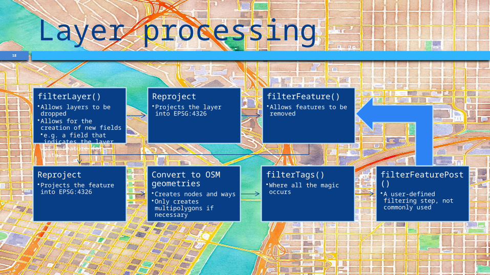
Layer processing
filterLayer()•Allows layers to be dropped
•Allows for the creation of new fields•e.g. a field that indicates the layer of a feature for later
Reproject•Projects the layer into EPSG:4326
filterFeature()•Allows features to be removed
Reproject•Projects the feature into EPSG:4326
Convert to OSM geometries•Creates nodes and ways•Only creates multipolygons if necessary
filterTags()•Where all the magic occurs
filterFeaturePost()•A user-defined filtering step, not commonly used
18
Layer processing
filterLayer()•Allows layers to be dropped
•Allows for the creation of new fields•e.g. a field that indicates the layer of a feature for later
Reproject•Projects the layer into EPSG:4326
filterFeature()•Allows features to be removed
Reproject•Projects the feature into EPSG:4326
Convert to OSM geometries•Creates nodes and ways•Only creates multipolygons if necessary
filterTags()•Where all the magic occurs
filterFeaturePost()•A user-defined filtering step, not commonly used
19
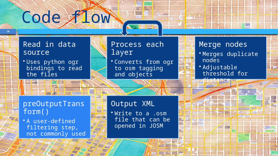
Code flowRead in data source• Uses python ogr bindings to read the files
Process each layer• Converts from ogr to osm tagging and objects
Merge nodes• Merges duplicate nodes
• Adjustable threshold for distance
preOutputTransform()• A user-defined filtering step, not commonly used
Output XML• Write to a .osm file that can be opened in JOSM
20
Code flowRead in data source• Uses python ogr bindings to read the files
Process each layer• Converts from ogr to osm tagging and objects
Merge nodes• Merges duplicate nodes
• Adjustable threshold for distance
preOutputTransform()• A user-defined filtering step, not commonly used
Output XML• Write to a .osm file that can be opened in JOSM
21
Code flowRead in data source• Uses python ogr bindings to read the files
Process each layer• Converts from ogr to osm tagging and objects
Merge nodes• Merges duplicate nodes
• Adjustable threshold for distance
preOutputTransform()• A user-defined filtering step, not commonly used
Output XML• Write to a .osm file that can be opened in JOSM
22
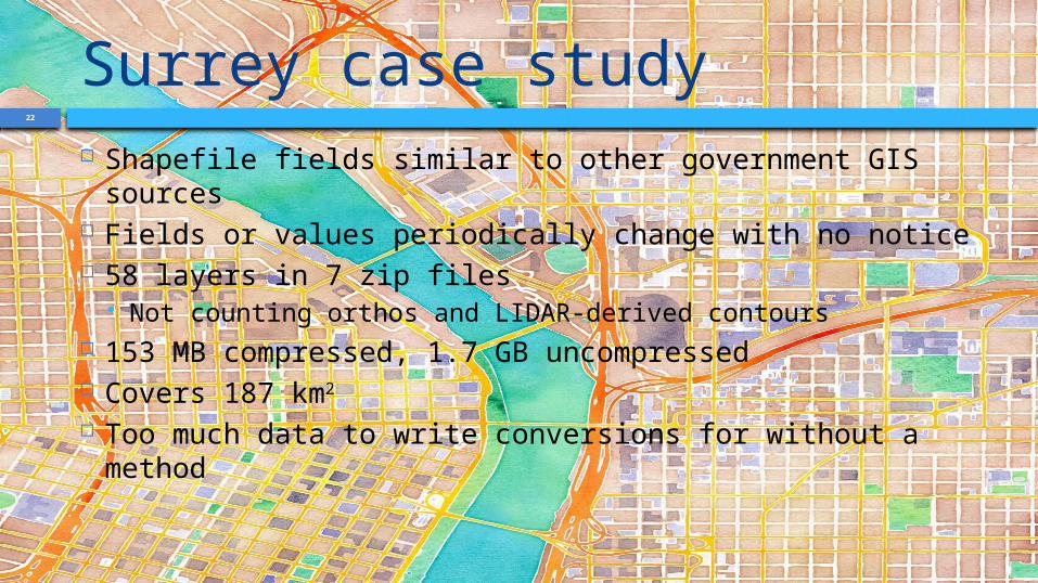
Surrey case study Shapefile fields similar to other government GIS
sources Fields or values periodically change with no notice 58 layers in 7 zip files
Not counting orthos and LIDAR-derived contours 153 MB compressed, 1.7 GB uncompressed Covers 187 km2
Too much data to write conversions for without a method
24
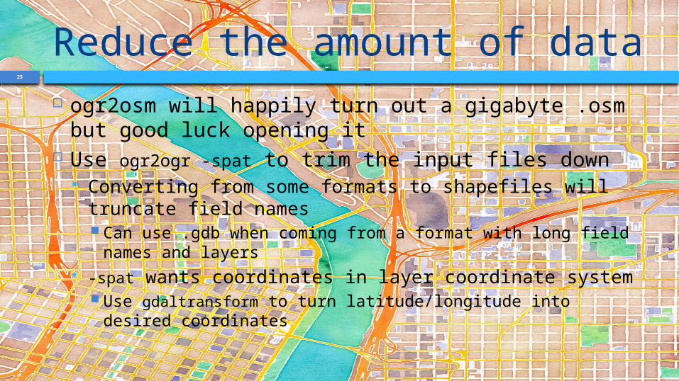
25
Reduce the amount of data ogr2osm will happily turn out a gigabyte .osm but
good luck opening it Use ogr2ogr -spat to trim the input files down
Converting from some formats to shapefiles will truncate field names Can use .gdb when coming from a format with long field
names and layers -spat wants coordinates in layer coordinate system
Use gdaltransform to turn latitude/longitude into desired coordinates
26
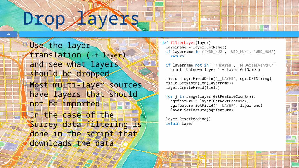
Drop layers Use the layer translation
(-t layer) and see what layers should be dropped
Most multi-layer sources have layers that should not be imported
In the case of the Surrey data filtering is done in the script that downloads the data
def filterLayer(layer): layername = layer.GetName() if layername in ('WBD_HU2', 'WBD_HU4', 'WBD_HU6'): return
if layername not in ('NHDArea', 'NHDAreaEventFC'): print 'Unknown layer ' + layer.GetName()
field = ogr.FieldDefn('__LAYER', ogr.OFTString) field.SetWidth(len(layername)) layer.CreateField(field)
for j in range(layer.GetFeatureCount()): ogrfeature = layer.GetNextFeature() ogrfeature.SetField('__LAYER', layername) layer.SetFeature(ogrfeature)
layer.ResetReading() return layer
27
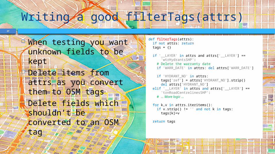
Writing a good filterTags(attrs) When testing you want
unknown fields to be kept
Delete items from attrs as you convert them to OSM tags
Delete fields which shouldn’t be converted to an OSM tag
def filterTags(attrs): if not attrs: return tags = {}
if '__LAYER' in attrs and attrs['__LAYER'] == 'wtrHydrantsSHP': # Delete the warranty date if 'WARR_DATE' in attrs: del attrs['WARR_DATE']
if 'HYDRANT_NO' in attrs: tags['ref'] = attrs['HYDRANT_NO'].strip() del attrs['HYDRANT_NO'] elif '__LAYER' in attrs and attrs['__LAYER'] == 'trnRoadCentrelinesSHP': # ... More logic ...
for k,v in attrs.iteritems(): if v.strip() != '' and not k in tags: tags[k]=v
return tags
28
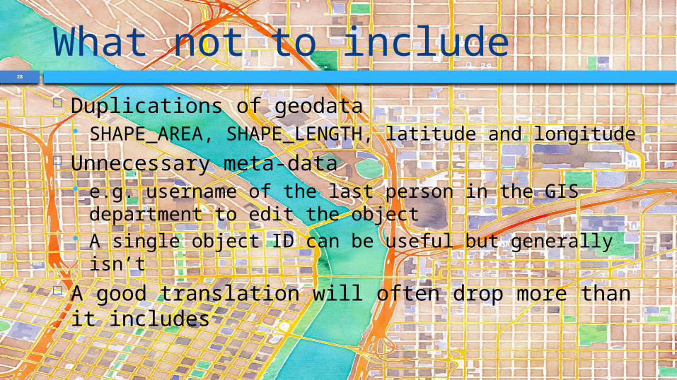
What not to include Duplications of geodata
SHAPE_AREA, SHAPE_LENGTH, latitude and longitude Unnecessary meta-data
e.g. username of the last person in the GIS department to edit the object
A single object ID can be useful but generally isn’t A good translation will often drop more than it
includes
29
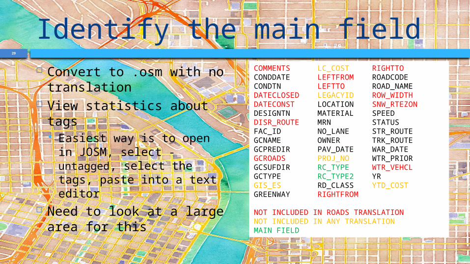
Identify the main field Convert to .osm with no
translation View statistics about
tags Easiest way is to open in
JOSM, select ‐untagged, select the tags, paste into a text editor
Need to look at a large area for this
COMMENTS LC_COST RIGHTTOCONDDATE LEFTFROM ROADCODECONDTN LEFTTO ROAD_NAMEDATECLOSED LEGACYID ROW_WIDTHDATECONST LOCATION SNW_RTEZONDESIGNTN MATERIAL SPEEDDISR_ROUTE MRN STATUSFAC_ID NO_LANE STR_ROUTEGCNAME OWNER TRK_ROUTEGCPREDIR PAV_DATE WAR_DATEGCROADS PROJ_NO WTR_PRIORGCSUFDIR RC_TYPE WTR_VEHCLGCTYPE RC_TYPE2 YRGIS_ES RD_CLASS YTD_COSTGREENWAY RIGHTFROM
NOT INCLUDED IN ROADS TRANSLATIONNOT INCLUDED IN ANY TRANSLATIONMAIN FIELD
30
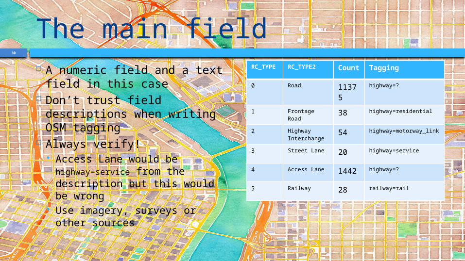
The main field A numeric field and a text
field in this case Don’t trust field descriptions
when writing OSM tagging Always verify!
Access Lane would be highway=service from the description but this would be wrong
Use imagery, surveys or other sources
RC_TYPE RC_TYPE2 Count
Tagging
0 Road 11375
highway=?
1 Frontage Road
38 highway=residential
2 Highway Interchange
54 highway=motorway_link
3 Street Lane 20 highway=service
4 Access Lane 1442 highway=?
5 Railway 28 railway=rail
31
Looking at a value in more detail
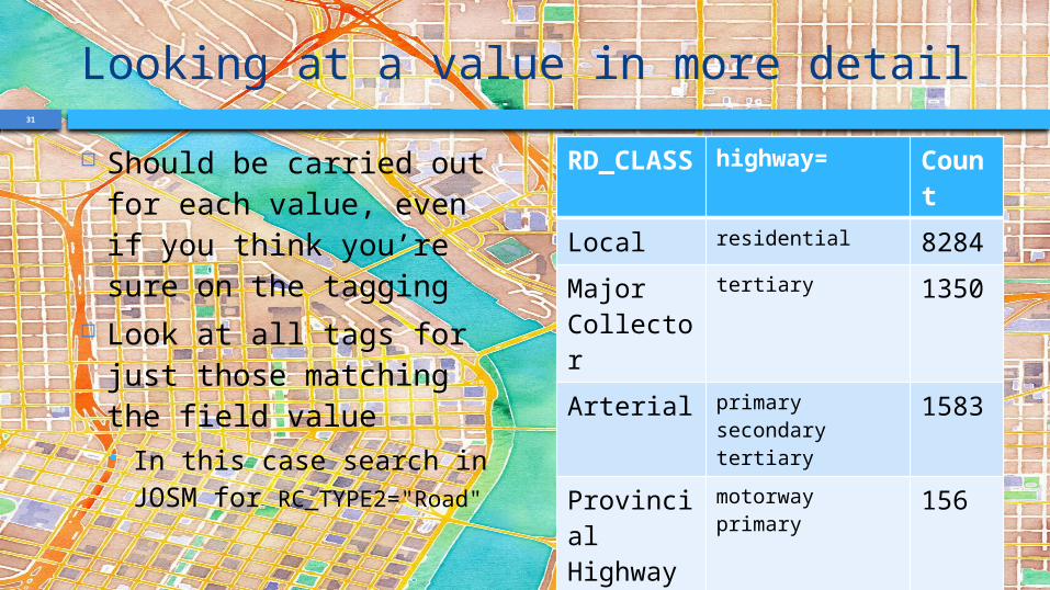
Should be carried out for each value, even if you think you’re sure on the tagging
Look at all tags for just those matching the field value In this case search in
JOSM for RC_TYPE2="Road"
RD_CLASS
highway= Count
Local residential 8284
Major Collector
tertiary 1350
Arterial primarysecondarytertiary
1583
Provincial Highway
motorwayprimary
156
Translink unclassified 1
32
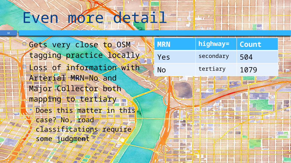
Even more detail Gets very close to OSM
tagging practice locally Loss of information with
Arterial MRN=No and Major Collector both mapping to tertiary Does this matter in this
case? No, road classifications require some judgment
MRN highway= Count
Yes secondary 504
No tertiary 1079

33
Dropping objects You may come across
objects that you shouldn’t add to OSM
In this case there are “paper roads” in the data
Use filterFeature() to remove these
def filterFeature(ogrfeature, fieldNames, reproject): if not ogrfeature: return
index = ogrfeature.GetFieldIndex('STATUS') if index >= 0 and ogrfeature.GetField(index) in ('History', 'For Construction', 'Proposed'): return None
return ogrfeature
34
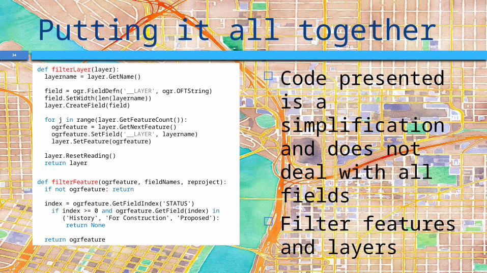
Putting it all togetherdef filterLayer(layer): layername = layer.GetName()
field = ogr.FieldDefn('__LAYER', ogr.OFTString) field.SetWidth(len(layername)) layer.CreateField(field)
for j in range(layer.GetFeatureCount()): ogrfeature = layer.GetNextFeature() ogrfeature.SetField('__LAYER', layername) layer.SetFeature(ogrfeature)
layer.ResetReading() return layer
def filterFeature(ogrfeature, fieldNames, reproject): if not ogrfeature: return
index = ogrfeature.GetFieldIndex('STATUS') if index >= 0 and ogrfeature.GetField(index) in ('History', 'For Construction', 'Proposed'): return None
return ogrfeature
Code presented is a simplification and does not deal with all fields
Filter features and layers
35
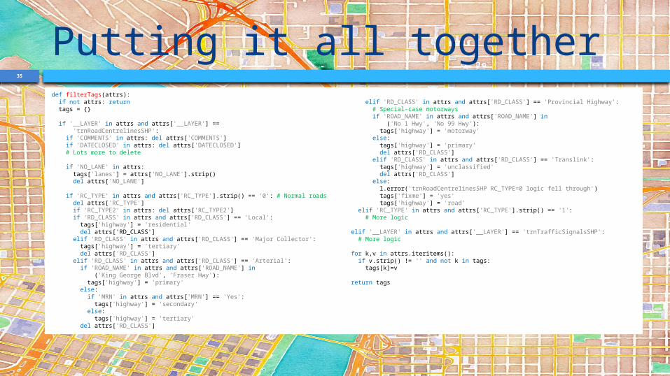
Putting it all togetherdef filterTags(attrs): if not attrs: return tags = {}
if '__LAYER' in attrs and attrs['__LAYER'] == 'trnRoadCentrelinesSHP': if 'COMMENTS' in attrs: del attrs['COMMENTS'] if 'DATECLOSED' in attrs: del attrs['DATECLOSED'] # Lots more to delete
if 'NO_LANE' in attrs: tags['lanes'] = attrs['NO_LANE'].strip() del attrs['NO_LANE']
if 'RC_TYPE' in attrs and attrs['RC_TYPE'].strip() == '0': # Normal roads del attrs['RC_TYPE'] if 'RC_TYPE2' in attrs: del attrs['RC_TYPE2'] if 'RD_CLASS' in attrs and attrs['RD_CLASS'] == 'Local': tags['highway'] = 'residential' del attrs['RD_CLASS'] elif 'RD_CLASS' in attrs and attrs['RD_CLASS'] == 'Major Collector': tags['highway'] = 'tertiary' del attrs['RD_CLASS'] elif 'RD_CLASS' in attrs and attrs['RD_CLASS'] == 'Arterial': if 'ROAD_NAME' in attrs and attrs['ROAD_NAME'] in ('King George Blvd', 'Fraser Hwy'): tags['highway'] = 'primary' else: if 'MRN' in attrs and attrs['MRN'] == 'Yes': tags['highway'] = 'secondary' else: tags['highway'] = 'tertiary' del attrs['RD_CLASS']
elif 'RD_CLASS' in attrs and attrs['RD_CLASS'] == 'Provincial Highway': # Special-case motorways if 'ROAD_NAME' in attrs and attrs['ROAD_NAME'] in ('No 1 Hwy', 'No 99 Hwy'): tags['highway'] = 'motorway' else: tags['highway'] = 'primary' del attrs['RD_CLASS'] elif 'RD_CLASS' in attrs and attrs['RD_CLASS'] == 'Translink': tags['highway'] = 'unclassified' del attrs['RD_CLASS'] else: l.error('trnRoadCentrelinesSHP RC_TYPE=0 logic fell through') tags['fixme'] = 'yes' tags['highway'] = 'road' elif 'RC_TYPE' in attrs and attrs['RC_TYPE'].strip() == '1': # More logic
elif '__LAYER' in attrs and attrs['__LAYER'] == 'trnTrafficSignalsSHP': # More logic
for k,v in attrs.iteritems(): if v.strip() != '' and not k in tags: tags[k]=v
return tags
36
Any questions?
37
Credits Background by Stamen Design under CC
BY 3.0 Surrey Data © 2012 City of Surrey under
PDDL 1.0