Embed Size (px)
Citation preview
OFFSHORE URUGUAY:
Geology and Prospectivity
E&P – ANCAP
2020

2/25
CONTENTS
1. General information about Uruguay .................................................................................... 3
2. Regional Geology .................................................................................................................. 4
3. Tectonic setting .................................................................................................................... 6
4. Offshore basins ..................................................................................................................... 9
Punta del Este Basin ................................................................................................................... 9
Pelotas Basin ............................................................................................................................. 11
Oriental del Plata Basin ............................................................................................................ 12
5. Prospectivity ....................................................................................................................... 13
Source rocks .............................................................................................................................. 13 Maturation ............................................................................................................................... 13
Reservoir rocks .......................................................................................................................... 17
Seal rocks .................................................................................................................................. 18
Migration pathways ................................................................................................................ 18
Exploratory situations .............................................................................................................. 18
6. Hydrocarbon evidences ...................................................................................................... 20
Fluid inclusions .......................................................................................................................... 20
Identification of gas chimneys, AVO anomalies and Velocity anomalies ................................. 20
Bottom simulating reflections .................................................................................................. 21
7. Remarks .............................................................................................................................. 21
8. References .......................................................................................................................... 23
3/25
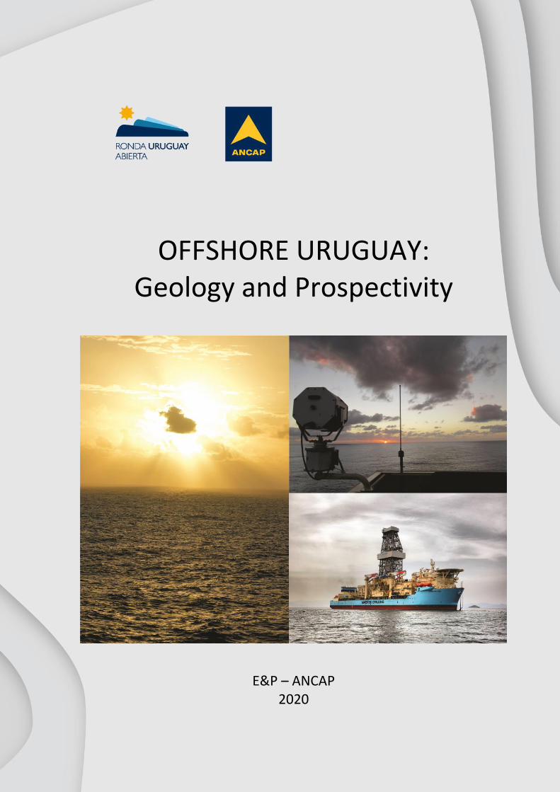
1. General information about Uruguay Uruguay is located in South America between Brazil and Argentina with coasts on the Atlantic Ocean,
(Fig. 1). It is the second smallest nation in South America, with a land surface area of 176,215 Km2
and a total area of 318,413 Km2, considering rivers and territorial waters. The population is slightly
higher than 3.285 million inhabitants, of which 40% live in Montevideo, the capital city. There are no
remarkable topographic features; most of the country’s landscape consists of rolling plains and low
hills with fertile coastal lowland. The country has 660 Km of coastline with beautiful beaches. Its
weather and topographic features make Uruguay especially suitable for agriculture, forest and
livestock production, which represent the main sources of gross domestic product (GDP) within the
country. Uruguay has long standing traditions of democracy and legal and social stability, and a solid
financial and legal framework, which makes it attractive to foreign investors looking for business
ventures in the region.
Fig. 1 – Left: Location of Uruguay in South America (in yellow). Satelital image from NASA (2016).
Right: Pictures of Uruguay.

4/25
2. Regional Geology Six sedimentary basins are recognized in Uruguay. Three of them are located offshore: Punta del
Este, Pelotas and Oriental del Plata basins (Ucha et al., 2004; De Santa Ana et al., 2009). The other
three basins are located onshore: Norte, Santa Lucía and Laguna Merín basins (Fig. 2).
Fig. 2 – Uruguayan offshore and onshore basins and main structures.
The genesis of the offshore sedimentary basins of Uruguay is related to the breakup of Gondwana
and later opening of the South Atlantic Ocean in the Late Jurassic-Early Cretaceous (Fig. 3). They have
a total extent of more than 125,000 Km2, considering the outer boundary of 200 nautical miles, and a
sedimentary infill that, in some areas, reaches more than 7,000 m (based on seismic data). The
maximum drilled thickness is 3,631 m from Gaviotín well, drilled in very shallow waters in a proximal
location and over a structural high. Water depth in the continental margin of Uruguay ranges from
less than 20 m to more than 4,000 m near the 200-nautical-mile limit. The Uruguayan offshore basins
share a genesis in common with Orange and Walvis basins of the offshore margin of South Africa and
Namibia.
5/25
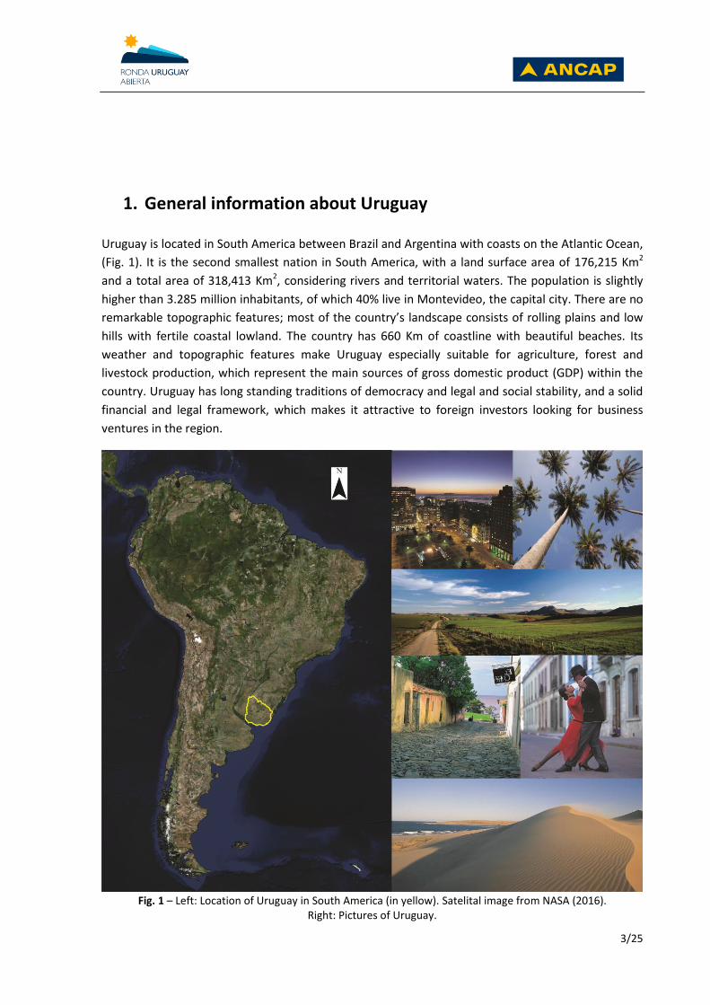
Fig. 3 – Gondwana evolution and generation of Atlantic basins. The red star shows location of Uruguay.
Modified from Scotese, C.R. (2014).
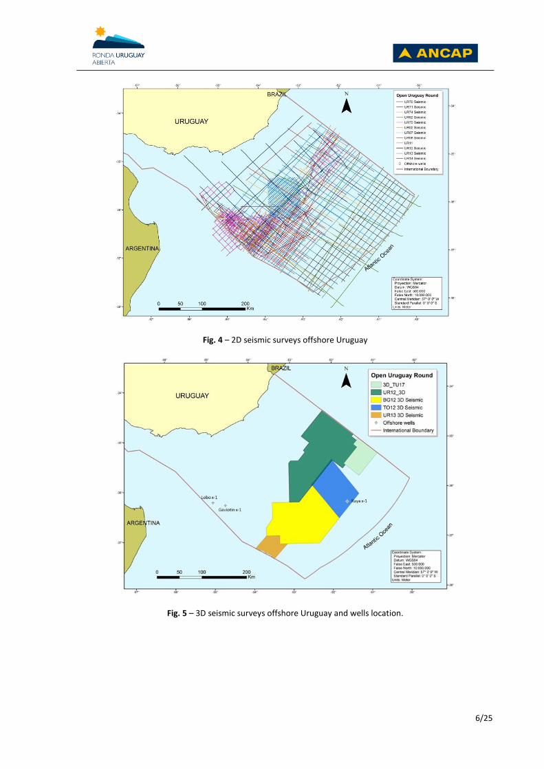
Although oil and gas accumulations have yet to be identified, the offshore basins of Uruguay are still
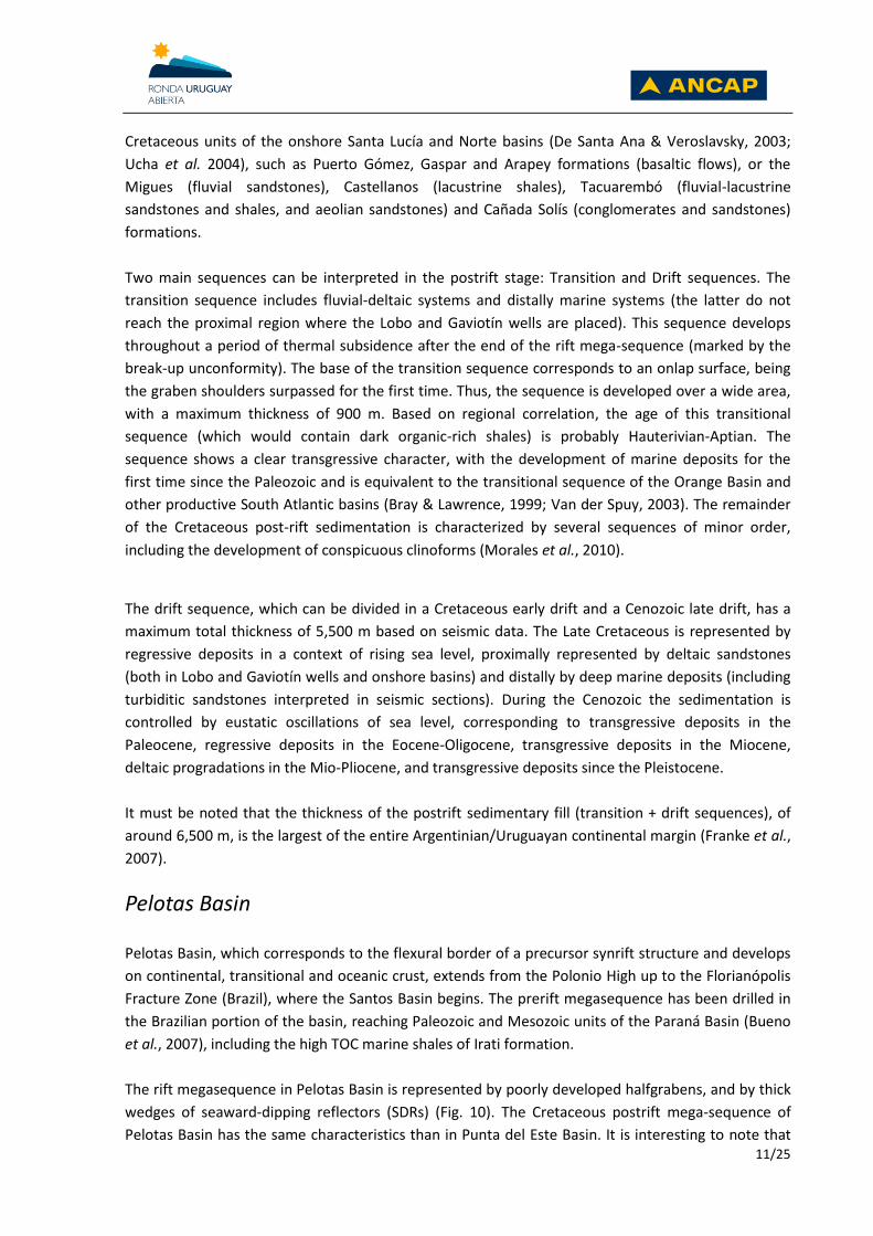
underexplored. Despite the fact that significant 2D and 3D seismic data (Figs. 4 and 5) have been
acquired offshore Uruguay (41,000 km of 2D and 43,500 km2 of 3D seismic), only three exploratory
wells were drilled in the area. Two of them are located in Punta del Este Basin and the other is
located in Pelotas Basin (Fig. 5). The exploratory wells of Punta del Este Basin, drilled in 1976 by
Chevron, were located in shallow waters (40 – 50 meters) close to each other. They were targeting
anticlines structures, defined with 2D seismic, and associated with horsts of the synrift section.
Gaviotín X-1 had a total depth of 3,631 m while Lobo X-1 had a total depth of 2,713 m. None of the
wells reached basement, with Gaviotín founding a prerift sandy section in the last 139 meters and
Lobo a volcanic sequence in the last 513 meters. Both were declared dry wells, and did not found
significant source rock levels because they were placed in basement highs, and close to the basin
depositional and erosional limit (Stoakes et al., 1991). However, it is important to notice that
Gaviotín found some thin levels of gas bearing sandstones that are evidenced by the crossing of the
density and neutron logs. At the time, these levels were not tested due to the low price of gas. A
recent study made in cuttings of both wells found fluid inclusions of gas and low, moderate and high
gravity oil (FIT 2011) in Jurassic, Cretaceous and Tertiary levels. The Jurassic and Cretaceous sections
show much more abundance of oil and gas inclusions than the Cenozoic sequence (Fig. 9). These
results confirm the presence of an active petroleum system in the area and also indicate the
effectiveness of the Late Maastritchtian-Paleocene transgression as a regional seal.
In 2016, a new exploratory well was drilled offshore Uruguay after 40 years. The ultra-deep Raya X-1,
operated by TOTAL, was located in Pelotas Basin in a bathymetry of 3,404 meters. The target was an
Oligocene basin floor fan delimited with 3D seismic. The true vertical depth (TVDBML) was 2,452,
ending in Oligocene marine shales. The objective was reached a few tens of meters above, being
composed by a 135 meters thick turbidite sand body, with a 24% average porosity, although no
hydrocarbons were found (ANCAP, 2016). The lack of major faults that connect the main source rocks
(Aptian, Cenomanian-Turonian) with the Oligocene reservoir, together with the thick and widespread
Cenozoic marine shales acting as seals, may explain why this sand body was not charged.
6/25
Fig. 4 – 2D seismic surveys offshore Uruguay
Fig. 5 – 3D seismic surveys offshore Uruguay and wells location.

7/25
3. Tectonic setting
Two main structural trends can be recognized in Uruguayan offshore basins (Fig. 6). One of them,
observed in the proximal segment of Punta del Este basin, has a NW orientation that indicates an
extensional stress normal to the continental margin, as in several Argentinian South Atlantic basins
(e.g. Salado, Colorado, and Golfo de San Jorge basins). These structures are attributed to an initial
rifting stage which started in the upper Jurassic and were subsequently aborted. On the other hand,
the NE trend located in the distal segment of Punta del Este and Pelotas basin has the same
orientation of most of the Brazilian South Atlantic basins, reflecting a second rifting stage of the Early
Cretaceous age.
Fig. 6 – Top basement structural TWT map showing two main tectonic trends: NW – SE and NE – SW (purple
lines) and the distribution of extensive efforts (blue arrows) that affected the Continental Crust (Polonio High). CC: Continental Crust, TC: Transitional Crust, OC: Oceanic Crust.
In response to different basin styles, subsidence history, sedimentary inputs and the dynamics of the
Polonio High (Fig. 6) which probably was a positive area from Jurassic until the end of the Cretaceous,
Punta del Este and Pelotas basins had a different evolution until the Late Maastrichtian. The tectonic
and stratigraphic evolution of both basins are represented by large depositional sequences as shown
in the stratigraphic charts of Fig. 7.

8/25
Fig. 7 – Stratigraphic and tectonic framework of Punta del Este Basin (left) and Pelotas Basin (right).

9/25
4. Offshore basins
Punta del Este Basin Punta del Este Basin is a funnel-shaped aulacogen that is separated from the Salado Basin (Argentina)
to the west by the Martín García/Plata High and from Pelotas Basin to the east by the Polonio High.
Three main tectonic-stratigraphic stages are recognized in the evolution of Punta del Este Basin:
prerift (Devonian-Permian), synrift (Late Jurassic – Early Cretaceous) and postrift (Aptian – Present),
see Fig. 8.
Fig. 8 - Punta del Este basin and Lobo x-1 and Gaviotín x-1 wells location.
The prerift mega-sequence is represented at least in the Punta del Este Basin by Permian
sedimentary rocks drilled by the Gaviotín well between 3,492 and 3,631 m, which are correlated with
Permian units that develop onshore in Norte Basin (Paraná Basin). The distribution of the prerift
sequence is spatially coincident with the Juro-Cretaceous halfgrabens, being partially eroded on the
highs.

10/25
Fig. 9 – Lobo and Gaviotin wells stratigraphy. The tracks on the right represent methane inclusions.
The synrift mega-sequence includes alluvial-fluvial and lacustrine deposits interbedded with volcanic
and volcaniclastic rocks filling a series of deep asymmetric halfgrabens and, more rarely, grabens.
Halfgrabens generally show fanning geometry on fault borders, thinning and onlapping on flexural
margins, as well as compaction synclines over basement footwall cut-off points. The Jurassic-
Neocomian synrift sedimentary fill, with a thickness up to 3,000 meters, comprises a lower package
dominated by volcanic flows (synrift I, being thicker in the Lobo well), and alluvial-fluvial systems
with lacustrine base levels (synrift II). The synrift I and II sequences correlate with Jurassic and/or
11/25
Cretaceous units of the onshore Santa Lucía and Norte basins (De Santa Ana & Veroslavsky, 2003;
Ucha et al. 2004), such as Puerto Gómez, Gaspar and Arapey formations (basaltic flows), or the
Migues (fluvial sandstones), Castellanos (lacustrine shales), Tacuarembó (fluvial-lacustrine
sandstones and shales, and aeolian sandstones) and Cañada Solís (conglomerates and sandstones)
formations.
Two main sequences can be interpreted in the postrift stage: Transition and Drift sequences. The
transition sequence includes fluvial-deltaic systems and distally marine systems (the latter do not
reach the proximal region where the Lobo and Gaviotín wells are placed). This sequence develops
throughout a period of thermal subsidence after the end of the rift mega-sequence (marked by the
break-up unconformity). The base of the transition sequence corresponds to an onlap surface, being
the graben shoulders surpassed for the first time. Thus, the sequence is developed over a wide area,
with a maximum thickness of 900 m. Based on regional correlation, the age of this transitional
sequence (which would contain dark organic-rich shales) is probably Hauterivian-Aptian. The
sequence shows a clear transgressive character, with the development of marine deposits for the
first time since the Paleozoic and is equivalent to the transitional sequence of the Orange Basin and
other productive South Atlantic basins (Bray & Lawrence, 1999; Van der Spuy, 2003). The remainder
of the Cretaceous post-rift sedimentation is characterized by several sequences of minor order,
including the development of conspicuous clinoforms (Morales et al., 2010).
The drift sequence, which can be divided in a Cretaceous early drift and a Cenozoic late drift, has a
maximum total thickness of 5,500 m based on seismic data. The Late Cretaceous is represented by
regressive deposits in a context of rising sea level, proximally represented by deltaic sandstones
(both in Lobo and Gaviotín wells and onshore basins) and distally by deep marine deposits (including
turbiditic sandstones interpreted in seismic sections). During the Cenozoic the sedimentation is
controlled by eustatic oscillations of sea level, corresponding to transgressive deposits in the
Paleocene, regressive deposits in the Eocene-Oligocene, transgressive deposits in the Miocene,
deltaic progradations in the Mio-Pliocene, and transgressive deposits since the Pleistocene.
It must be noted that the thickness of the postrift sedimentary fill (transition + drift sequences), of
around 6,500 m, is the largest of the entire Argentinian/Uruguayan continental margin (Franke et al.,
2007).
Pelotas Basin Pelotas Basin, which corresponds to the flexural border of a precursor synrift structure and develops
on continental, transitional and oceanic crust, extends from the Polonio High up to the Florianópolis
Fracture Zone (Brazil), where the Santos Basin begins. The prerift megasequence has been drilled in
the Brazilian portion of the basin, reaching Paleozoic and Mesozoic units of the Paraná Basin (Bueno
et al., 2007), including the high TOC marine shales of Irati formation.
The rift megasequence in Pelotas Basin is represented by poorly developed halfgrabens, and by thick
wedges of seaward-dipping reflectors (SDRs) (Fig. 10). The Cretaceous postrift mega-sequence of
Pelotas Basin has the same characteristics than in Punta del Este Basin. It is interesting to note that

12/25
the marine sequences developed during the Cretaceous postrift sedimentation in both Punta del Este
and Pelotas basins are not recorded in the neighboring Salado and Colorado basins of Argentina, due
to the presence of a conspicuous external high (which precluded marine incursions until the
Maastrichtian). This external high is only present with a subtle expression in the southernmost tip of
Punta del Este Basin, disappearing towards the NE.
Late Maastrichtian sedimentation surpassed, for the first time, the internal and external highs
(Polonio and Martin García respectively), and a single offshore sedimentary province was generated.
The Cenozoic sedimentation is represented by a series of events induced by eustatic oscillations,
corresponding to regressive and transgressive deposits in the Paleocene, fluvial-deltaic regressive
sediments in the Eocene-Oligocene, transgressive deposits in the Miocene, deltaic progradations in
the Mio-Pliocene and transgressive deposits in the Pleistocene. In the northern region of the margin
the Cenozoic package reaches a thickness of 6,000 m.
Fig. 10 – Dip seismic line showing Pelotas and Raya x-1 well location.
Oriental del Plata Basin The ultra-deep water Oriental del Plata Basin is in part equivalent to the Argentina Basin of the
Argentinian margin (which is also known as Patagonia Oriental Basin or Ameghino Basin). Its
sedimentary fill reaches 5,000 m and comprises Cretaceous and Cenozoic marine sequences. Its limit
with Punta del Este Basin is the landward limit of the SDR sequence. Consequently, the Oriental del
Plata Basin develops over both transitional and oceanic crusts (while Punta del Este Basin develops
only over continental crust).

13/25
5. Prospectivity
Source rocks The potential source rocks of the offshore basins developed in the prerift, synrift and postrift
sequences (Fig. 11). The distribution of the different source rocks is shown in Fig. 12.
Fig. 11 – Petroleum systems of Uruguayan offshore basins
Prerift
As was mentioned before, Permian sandstones corresponding to a prerift sequence were
encountered in the last 139 meters of Gaviotín X-1 well (Fig. 9) of Punta del Este Basin. Although the
lithologies encountered did not have source rock potential (mostly sandstones), this finding was
essential to define a Paleozoic prerift sequence that developed offshore Uruguay. These Permian
units were correlated with lithologies that outcrop in the onshore Paleozoic Norte Basin (part of the
larger intracratonic Paraná Basin). In Norte Basin, these rocks are overlying good quality source rocks
that include Devonian marine shales of Cordobes Formation, with TOC up to 4% (De Santa Ana &
Ucha, 1994), and Artinskian (Early Permian) marine oil shales of Mangrullo Formation, with TOC up to
13.5% (De Santa Ana & Gutiérrez, 2000). A Permian source rock has already been proven offshore in
the Argentinian Colorado Basin (Fryklund et al., 1996), and in the Brazilian side of Pelotas Basin
(Bueno et al., 2007). These potential source rocks develop offshore, in the proximal segment over

14/25
continental crust (Fig. 12A). Recently acquired 3D seismic data in the shallow segment of Pelotas
Basin shows preservation of a thick prerift depocenter in which the mentioned source rocks are
potentially preserved (Fig. 14A).
Synrift
The deep halfgraben structures developed mostly in Punta del Este Basin and to a lesser extent in
Pelotas Basin, were not drilled offshore Uruguay (Fig. 13B). Seismic data show that, in most of the
cases, the infill of the halfgrabens is in great part constituted by thick lacustrine shales (Fig. 14B) that
could represent significant source rocks as was proven in the conjugate margin by the AJ-1 well in
Orange Basin offshore South Africa (Jungslager, 1999).
Postrift
The seismic interpretation of the postrift allows identifying at least four important maximum flooding
surfaces that are associated with significant marine transgressions (Aptian-Albian, Cenomanian-
Turonian, Paleocene and Miocene). The geological model shows that at least two of these
transgressions are associated with the deposition of significant source rocks (Aptian and Turonian). It
is important to notice that both Aptian and Turonian sequences are world class source rocks that
have contributed to 29% of the global oil and gas reserves (Fig. 12). A clear transgressive sequence
develops at the base of the postrift that is constituted by Aptian-Albian marine shales, representing
the first marine ingression of the basin. This sequence develops in the offshore distal segment (Fig.
13C) and has a thickness that reaches more than 2 kilometers in some areas (Fig. 14C). This time
interval corresponds to the first important oceanic anoxic event of the Cretaceous, represented in
several productive South Atlantic basins by black organic-rich shales, also encountered by the Deep
Sea Drilling Program (e.g. Bolli et al., 1978; Bray et al., 1998; Jungslager, 1999; van der Spuy, 2003). A
second marine transgressive sequence took place during the Cenomanian-Turonian (Fig. 14C). This
time interval corresponds to the second oceanic anoxic event of the Cretaceous and consequently
represents an important source rock for the Atlantic basins. The Turonian sequence develops also in
the offshore distal segment (Fig. 13D). The marine Paleocene transgression is considered mainly as
regional seal and not as a good quality source rock.

15/25
Fig. 12 – Main world source rocks and oil and gas world reserves they contribute with (Ulmishek & Klemme,
1990).
Fig. 13 – Distribution of the prerift (A), synrift (B), Aptian (C) and Turonian (D) source rocks.

16/25
Fig. 14 – Seismic sections showing the Paleozoic prerift source rock (A), lacustrine synrift source rock (B) and
Aptian and Turonian marine shales (C).
Maturation A 2D present-day thermal model was developed for the Pelotas Basin using data of Lobo and
Gaviotín wells for calibration. The model shows that the central segment of the basin reached the
highest temperatures associated with the thickest sedimentary section (Fig. 15). Taking this data into
consideration, it is expected that the Aptian source rock generated gas and oil, while the younger
potential source rocks are mostly in the oil window (Turonian and Paleocene).

17/25
Fig. 15 – 2D maturation model offshore Uruguay (Pelotas Basin).
Reservoir rocks Proven high-quality reservoir rocks have been encountered in the sedimentary record of the
Uruguayan offshore basins (Lobo and Gaviotín wells), with porosity values between 18 and 25%,
which could be increased by the presence of fractures and dissolution processes. The most important
ones are related to the alluvial-fluvial systems of the synrift sequence, the fluvial-deltaic sandstones
of the early drift sequence, and the lowstand deposits of the early and late drift sequences.
The late synrift deposits drilled offshore Uruguay comprise coarse to fine-grained sandstones,
constituted by quartz and feldespar, interbedded with pelites, claystones and conglomeratic levels.
They are interpreted as alluvial-fluvial deposits. There are evidences of local diagenetic or
hydrothermal processes; however, petrographic analysis of cutting samples and petrophysical
studies show good porosity values.
The early drift deposits include medium to coarse-grained sandstones, interbedded with pelitic and
conglomeratic levels. They are interpreted as deltaic deposits, which according to the seismic data
evolve distally to marine deposits. Petrographic and petrophysical studies show good to very good
porosity and permeability values.
The late drift deposits comprise fan-channel complexes, reworked and redeposited sediments due to
the action of strong currents, and the presence of turbiditic deposits in different stratigraphic
positions, with important exploratory potential. Proximally they are represented by sandstones such
as those drilled by the Lobo and Gaviotín wells. Raya well reached a good-quality reservoir (Tertiary),
constituted by a high-porosity sand body (24% average), with a thickness of 135 meters.

18/25
Seal rocks
Several stratigraphic levels are identified as potential local and regional seal rocks. Among the former
are synrift lacustrine shales as well as early drift distal marine deposits, and among the latter, marine
deposits of the Paleocene transgression, also recorded in Argentinian basins, known in Uruguay as
Gaviotín Formation (Ucha et al., 2003; Daners & Guerstein, 2004).
Gaviotín Formation comprises green and grey siltstones, claystones and very fine sandstones with a
wide distribution in the continental margin of Uruguay, exceeding the Mesozoic depositional limits.
Applying seismic trace inversion technique, this unit shows very low values of acoustic impedance,
which matches with the gamma ray response. The fluid inclusion study performed in Lobo and
Gaviotín wells evidences abundant oil and gas inclusions throughout the Cretaceous sequence. This
study also shows a significant decrease of inclusions in the Cenozoic sequence, probably associated
to the marine shales of the Paleocene, acting as an effective regional seal.
Migration pathways
The most important tectonic activity in the basin occurred in the Mesozoic, especially during the Late
Jurassic and Early Cretaceous rifting stage. During this period of crustal fragmentation, normal faults
generated the halfgrabens structures. For this reason, the most significant faults identified in the
basin are associated to the synrift sequence. However, the seismic data allows the identification of
normal faults that affected particularly the Cretaceous postrift sequence. These faults are of great
importance because they are connecting potential source and reservoirs rocks (Fig. 16). Other faults
coincide with probable gas chimneys and actual canyons, supporting a vertical migration pathway.
Other mechanisms of hydrocarbon migration include diffuse vertical migration through low
permeability layers, and horizontal migration through carrier beds in contact with source rocks.
Exploratory situations
Taking into consideration the distribution of the main source rocks of the basins, the presence of
migration pathways, the development of significant reservoir rocks and the presence of a regional
seal (Paleocene), the Cretaceous sequences appear to be the most prospective sequence (Fig. 16).
Different structural, stratigraphic and combined leads and prospects are recognized in the Uruguayan
offshore basins in variable water depths, from shallow to ultra-deep waters.
The preserved, deep depocenters of the Paleozoic prerift identified in seismic, which in some areas
reach a thickness of more than 5,000 meters, have an intense deformation that generates several
structures. Plays in the prerift sequence include significant anticline structures (Fig. 17A) and rotated
blocks.

19/25
Fig. 16 – Exploratory model offshore Uruguay
Plays in the synrift sequences include lacustrine fans, rotated blocks, compaction synclines,
truncation of synrift deposits by the breakup unconformity, and pinch-outs against basement highs
and graben shoulders (Fig. 17B).
Fig. 17 – Seismic line showing plays and prospects offshore Uruguay. A: anticline with four-way closure in
prerift sequences. B: pinch-outs against basement high developed between two halfgrabens (synrift sequence).
C: potential carbonate build-up in basement high. D: basin floor fan at the top of the Cretaceous sequence,
covered by marine shales of the Paleocene transgression.

20/25
At the base of the postrift sequence (transition), isolated carbonate deposits associated with
basement highs were identified through seismic, both for Punta del Este and for Pelotas basins (Fig.
17C).
The most extended plays for the postrift sequence include pinch-outs, channel complexes, turbiditic
and basin floor fan systems. Several turbidites and basin floors fans are identified in the Cretaceous
postrift sequence (Fig. 17D) and Cenozoic postrift sequence. Numerous prospects and leads in
agreement with these play models were identified through integrated seismic, stratigraphic and
structural studies. Some of them are very similar to field reservoirs of productive basins, despite
differences with Brazilian basins in reservoir lithology (pre-salt) and structuration by salt domes
(supra-salt), for instance: i) aeolian intertraps preserved by subaerially extruded basalts in the SDR
sequence (Kudu Field in Orange Basin; Bray & Lawrence, 1999); ii) basement highs (Badejo High in
Campos Basin and Tupi High in Santos Basin; Karner, 2000); iii) compaction synclines (Santos, Orange
and North Falkland basins; López-Gamundi & Barragán, 2008; López-Gamundi et al., 2010;
Jungslager, 1999; RPS, 2010); iv) deepwater turbidites, slope fans and basin floor fans (Orange Basin
and Marlim Field in Campos Basin; Milani & de Araújo, 2003).
21/25
6. Hydrocarbon evidences There are several direct and indirect evidences of the occurrence of hydrocarbons, which confirm
hydrocarbon generation and the presence of an active petroleum system. Some of these include fluid
inclusions of oil and gas, gas chimneys and velocity anomalies.
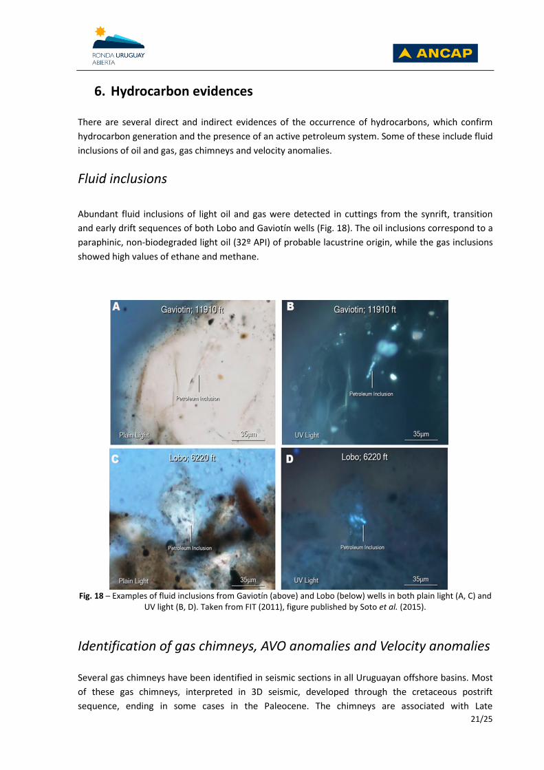
Fluid inclusions
Abundant fluid inclusions of light oil and gas were detected in cuttings from the synrift, transition
and early drift sequences of both Lobo and Gaviotín wells (Fig. 18). The oil inclusions correspond to a
paraphinic, non-biodegraded light oil (32º API) of probable lacustrine origin, while the gas inclusions
showed high values of ethane and methane.
Fig. 18 – Examples of fluid inclusions from Gaviotín (above) and Lobo (below) wells in both plain light (A, C) and
UV light (B, D). Taken from FIT (2011), figure published by Soto et al. (2015).
Identification of gas chimneys, AVO anomalies and Velocity anomalies
Several gas chimneys have been identified in seismic sections in all Uruguayan offshore basins. Most
of these gas chimneys, interpreted in 3D seismic, developed through the cretaceous postrift
sequence, ending in some cases in the Paleocene. The chimneys are associated with Late

22/25
Cretaceous/Early Paleocene reactivated faults related with halfgrabens structures. They feed
cretaceous sandstones that show high amplitudes, AVO anomalies and gas flags (Fig. 19). They also
indicate the effectiveness of the Late Maastritchtian-Paleocene transgression as a regional seal.
Significant amplitude and AVO anomalies associated with stratigraphic and combined plays have also
been identified, according to the predicted occurrence from the seismic-stratigraphic analysis.
Velocity anomalies have been detected in Jurassic-Eocretaceous halfgrabens of Punta del Este Basin.
These velocity anomalies may be associated either with the presence of gas-saturated porous and
permeable zones, or with the presence of overpressured shales.
Fig. 19 – Potential gas chimney associated with fault that generates gas flags.
Bottom simulating reflections
Seismic evidence for the occurrence of gas hydrates has been identified offshore Uruguay, based on
the presence of Bottom Simulating Reflections (BSRs) in 2D and 3D seismic sections. Offshore
Uruguay, the BSR extends over an area of approximately 22,000 Km2 (Tomasini et al., 2011). The
presence of increased amplitudes below the BSR suggests the existence of free gas below the GHSZ
(Gas Hydrate Stability Zone), associated with sub-hydrates prospects.
7. Remarks Uruguayan continental margin is still underexplored with only 3 exploratory wells drilled. The
offshore basins had different tectonic and stratigraphic histories, which diversify the exploratory
opportunities. The interesting geology and the analogies with other South Atlantic basins increase
their exploratory potential. A number of structural, stratigraphic and combined exploratory
situations have been identified. Several direct and indirect hydrocarbon evidences do exist, such as
fluid inclusions of light oil and gas, oil seeps, gas chimneys, amplitude anomalies, AVO anomalies,
velocity anomalies, and bottom simulating reflectors.

23/25
8. References ANCAP (Administración Nacional de Combustibles Alcohol y Portland) 2016. Press release: Culmination of exploratory well Raya X-1 on Area 14 offshore Uruguay. http://www.rondauruguay.gub.uy/LinkClick.aspx?fileticket=rIctbj30FrE%3d&tabid=474
August (accessed 01.02.17). Bray, R., Lawrence, S., 1999. Nearby finds brighten outlook. The Leading Edge 18(5), 608-614. Contreras, J., Zühlke, R., Bowman, S., Bechstädt, T. 2010. Seismic stratigraphy and
subsidence analysis of the southern Brazilian margin (Campos, Santos and Pelotas basins). Marine and Petroleum Geology 27, 1952-1980.
Daners, G., Guerstein G.R. 2004. Dinoflagelados del Maastrichtiense-Paleógeno en la
Formación Gaviotín, cuenca Punta del Este. Pp. 37-62 in Veroslavsky, G., Ubilla, M., Martínez, S. (eds.), Cuencas Sedimentarias de Uruguay: Geología, Paleontología y recursos naturales – Cenozoico. DIRAC, Facultad de Ciencias, Montevideo.
Davison, I. 2007. Hydrocarbon Potential of Offshore Argentina and Uruguay: S. Scotian Fold
and Thrust belt, the South Atlantic Margin and the Internal Rifts. South Atlantic Petroleum Systems, 4-6.
De Santa Ana H & Ucha N. 1994. Exploration perspectives and hydrocarbon potential of the
Uruguayan sedimentary basin. División Investigación y Desarrollo, ANCAP. Montevideo. Informe interno, 98 pp.
De Santa Ana, H., Gutiérrez, L. 2000. Formación Mangrullo (Cuenca Norte), Uruguay:
estratigrafía y recursos minerales asociados. Revista de la Sociedad Uruguaya de Geología III(7):2-14.
De Santa Ana, H., Veroslavsky, G., Morales, E. 2009. Potencial exploratorio del offshore de
Uruguay. Revista de la Industria Petrolera, Cuarta Época, 12:48-59. Fluid Inclusion Technologies Inc. 2011. A Stratigraphic Reconstruction of Bulk Volatile
Chemestry from Fluid Inclusion in: Gaviotin. Franke, D., Neben, S., Ladage, S., Schreckenberger, B., Hinz, K. 2007. Margin segmentation
and volcano-tectonic architecture along the volcanic margin off Argentina/Uruguay, South Atlantic. Marine Geology 244(1-4), 46-67.
Fryklund, B., Marshall, A., Stevens, J. 1996. Cuenca del Colorado. Pp. 135-158 in Ramos, V.A.,
Turic, M.A. (eds.), Geología y recursos naturales de la Plataforma Continental Argentina. Relatorio del XIII Congreso Geológico Argentino y III Congreso de Exploración de Hidrocarburos, Buenos Aires.

24/25
Grassman, S., Franke, D., Neben, S., Schnabel, M., Damm, V. 2011. Zeitschrift der Deutschen Gesellschaft für Geowissenschaften, 162(1), 79-89.
Jungslager, E. H. A. 1999. Petroleum habitats of the South Atlantic margin. Pp. 153-168 in
Cameron, N. R., Bate, R. H., Clure, V. S. (eds), The Oil and Gas Habitats of the South Atlantic. Geological Society of London, Special Publications 153.
Karner, G. 2000. Rifts of the Campos and Santos basins, southeastern Brazil: distribution and
timing. Pp. 301-315 in Mello, M.R., Katz, B. (eds.), Petroleum Systems of South Atlantic Margins. American Association of Petroleum Geologist Memoir 73.
López-Gamundi, O.R., Barragán, R. 2008. Rift architecture and its control from pre-salt plays
inthe South Atlantic: Lessons from offshore Brazil. AAPG International Conference and Exhibition, Cape Town. Search and Discovery Article #90082.
Mohriak, W.U., Rosendahl, B.R., Turner, J.P., Valente, S.C. 2003. Crustal architecture of South
Atlantic volcanic margins. In: Menzies, M.A., Klemperer, S.L., Ebinger, C.J., Baker, J. (Eds.), Volcanic rifted margins. Geological Society of America, p. 159-202. Special Paper 362.
Morales, E., de Santa Ana, H., Chang, H.-K., Corrêa, F.S., Veroslavsky, G. 2010. Migración de
depocentros en las cuencas Punta del Este y Pelotas (offshore de Uruguay). VI Congreso Uruguayo de Geología, 125. [CD-ROM].
Robertson. 2015. Petroleum Geological Evaluation of Uruguay: Uruguay Report. Scotese, C.R. 2014. Animation: Paleogeography (750 Ma – Present-dat), PALEOMAP Project,
Evanston IL. http://youtu.be/t0bhGzHH2aw Soto, M., Morales, E., Veroslavsky, G., de Santa Ana, H., Ucha, N., Rodríguez, P. 2011. The
continental margin of Uruguay: Crustal architecture and segmentation. Marine and Petroleum Geology.
Soto, M., Conti, B., Gristo, P. & de Santa Ana, H. 2016. Direct Oil and Gas Evidences from
Punta del Este Basin, Offshore Uruguay: New Data From Fluid Inclusions. AAPG/SEG International Conference and Exhibition, Melbourne – Australia.
Spectrum, 2015. Uruguay: Raya-1 first offshore, record-breaking deep water well to be
drilled. More to come? http://www.spectrumgeo.com/press-release/exxon-and-total-join-forces-to-drilluruguays-1st-offshore-record-breaking-deep-water-well. November, 2015. (accessed 01.02.17).
Stoakes, F. A., Campbell, C. V., Cass, R., Ucha, N. 1991. Seismic stratigraphic analysis of the
Punta del Este Basin, offshore Uruguay, South America. Bulletin of the American Association of Petroleum Geologists 75(2), 219-240.
Tomasini, J., de Santa Ana, H., Conti, B., Ferro, S., Gristo, P., Marmisolle, J., Morales, E.,
Rodríguez, P., Soto, M. & Veroslavsky, G. 2011. In press. Assessment of marine gas

25/25
hydrates and associated free gas distribution offshore Uruguay. Journal of Geological Research.
Ucha, N., de Santa Ana, H., Veroslavsky, G. 2004. La Cuenca Punta del Este: geología y
potencial hidrocarburífero. Pp. 173-192 in Veroslavsky, G., Ubilla, M., Martínez, S. (eds.), Cuencas Sedimentarias de Uruguay: Geología, Paleontología y recursos naturales – Mesozoico. DIRAC, Montevideo.
Ulmishek, G.F. & Klemme, H.D. 1990. Depositional Controls, Distribution, and Effectivness of
World’s Petroleum Source Rocks. U.S. Geological Survey Bulletin 1931, Pp. 1-59. Van der Spuy, D., N.A. Jikelo, T. Ziegler, and M. Bowyer. 2003. Deepwater 2D data reveal
Orange Basin objectives off western South Africa: Oil and Gas Journal, v. 101/14, p. 44-49. USEFUL WEBSITES:
ENTITY WEBSITE SITE INFO
ANCAP http://www.ancap.com.uy/ National Oil Company of Uruguay (Institutional website)
E&P - ANCAP http://exploracionyproduccion.ancap.com.uy/ G&G, exploration opportunities, database, data licensing, legal framework.
Uruguay XXI http://www.uruguayxxi.gub.uy/invest/ Investment and Export Promotion Institute
ANCAP is not responsible for the decisions that companies might take based on
the information contained in this document.