Embed Size (px)
Citation preview
HSEHealth & Safety
Executive
Weather-sensitive offshoreoperations and Metocean data
Prepared by PAFA Consulting Engineersfor the Health and Safety Executive
OFFSHORE TECHNOLOGY REPORT
2001/022
HSEHealth & Safety
Executive
Weather-sensitive offshoreoperations and Metocean data
PAFA Consulting EngineersHofer House
185 Uxbridge RoadHampton
MiddlesexTW12 1BN
United Kingdom
HSE BOOKS

© Crown copyright 2001Applications for reproduction should be made in writing to:Copyright Unit, Her Majesty’s Stationery Office,St Clements House, 2-16 Colegate, Norwich NR3 1BQ
First published 2001
ISBN 0 7176 2130 8
All rights reserved. No part of this publication may bereproduced, stored in a retrieval system, or transmittedin any form or by any means (electronic, mechanical,photocopying, recording or otherwise) without the priorwritten permission of the copyright owner.
This report is made available by the Health and SafetyExecutive as part of a series of reports of work which hasbeen supported by funds provided by the Executive.Neither the Executive, nor the contractors concernedassume any liability for the reports nor do theynecessarily reflect the views or policy of the Executive.
ii
iii
CONTENTS
EXECUTIVE SUMMARY v
1. INTRODUCTION 11.1 Background1.2 Scope of work1.3 Coverage of survey and report
2. ASSOCIATED LIMITS AND RESTRICTIONS 32.1 General2.2 Helicopters2.3 Small monohulls2.4 Shuttle tankers2.5 Support operations2.6 Topside and maintenance operationsTable 2.1Table 2.2
3. VIEWS AND OPINIONS 153.1 Operators3.2 Helicopter pilots/operators3.3 Masters of small monohull support craft and supply logistics companies3.4 Shuttle tanker masters/operators3.5 Engineering consultants and contractors3.6 Metocean information sources and contractorsTable 3.1Table 3.2Table 3.3Figure 3.1Figure 3.2
4. REVIEW OF MANDATORY OCCURRENCE REPORTS 294.1 General4.2 CAA reports regarding helicopter operations4.3 HSE reports regarding operations on the UKCS4.4 Shuttle tanker operations
5. FLOATING AND FIXED INSTALLATIONS 335.1 General5.2 Helicopter operations5.3 Small monohull support vessels5.4 Cranage5.5 Shuttle tanker operations5.6 On board operations and maintenance activities
6. REGIONAL VARIATIONS (SNS, CNS, NNS, IS & NWA) 376.1 General6.2 Helicopters6.3 Small monohulls6.4 Semi-submersible and jack-up support
7. NORWEGIAN EXPERIENCE 417.1 General7.2 Helicopter operations7.3 Supply boat operations7.4 Tanker/floater operations7.5 Semi-submersible and jack-up support operations7.6 Topside operations and maintenance7.7 Mandatory occurrence reportsTable 7.1Figure 7.1Figure 7.2
8. DISCUSSION 498.1 General8.2 Helicopter operations8.3 Supply boat operations8.4 Tanker/floater operations8.5 Other operations
9. SUMMARY AND CONCLUSIONS 55Table 9.1Table 9.2Table 9.3
REFERENCES 61
iv
v
EXECUTIVE SUMMARY
Monitoring of weather, meteorological, oceanographic (METOCEAN) and motion responseparameters is important for the safe implementation of many offshore operations. Crane andmechanical handling operations; supply voyages, loading and back-loading; helicopter flights;over-side and diver maintenance operations; emergency rescue and recovery; FPSO shuttleloading operations; support from large semi-submersibles and jack-up drilling rigs, to name afew, are limited by equipment performance that deteriorates in poor weather conditions. Indetail, each has a different requirement for monitoring instruments and forecast data to allowappropriate operational decisions to be taken. A wide variety of companies take part in suchweather-sensitive operations.
The North Sea is a mature offshore oil province with a mixture of historic legacy equipment andnew facilities. There have been staff and ownership changes, and many offshore facilities haveseen substantial modification to their topside process and utility layouts that will have hadeffects on their weather monitoring sensors.
Metocean monitoring instruments and weather forecasting services have continued to developand there are many more possibilities for providing accurate data than were available when theUnited Kingdom Continental Shelf (UKCS) was developed initially.
Companies in the offshore industry who participate in weather-sensitive offshore operationshave been approached for their observations and asked to comment specifically on whether thesafety of these operations might be improved if they had at their disposal, a better range of site-specific meteorological, oceanographic and weather forecast data. Mandatory occurrencereports (submitted to formally record incidents that have or may have led to a dangerousincident) have also been examined and interviews have been extended to a small number of keyplayers in the Norwegian offshore industry.
The consultation progress has been broad-brush extending over as wide a range of operations aspossible. The scope of the study was wide rather than deep so there has not been an opportunityto follow-up any issues in detail.
The objective of this study was to identify whether the industry might make better use of newservices to improve the safety of weather-sensitive operations and to allow the Health andSafety Executive to consider whether it should take a more proactive roll in the adoption ofthese systems.
Since this has not been an in-depth investigation of any particular issue, it was not feltappropriate to formulate detailed recommendations. Instead the conclusions are summarisedand presented in Chapter 9 as a range of observations. These observations offer the industry thewidest scope to implement a more detailed examination to see if they indicate a need to learnparticular lessons, improve operational procedures or identify an opportunity to improve safety.
One general observation is that for the North Sea viewed as a whole, metocean measurementand forecasting services are disjointed. There would appear to be multiple redundancy butvariable, uncontrolled quality. It is suggested that the offshore industry would obtain muchbetter value and higher quality for a lower overall cost if companies were to invest in a sharedactivity rather than operate independently. An effective, high-quality shared service wouldbring benefits to a wide range of people who earn their livelihoods on the UK continental shelfand even possibly extend to safety improvements for other industries.

Printed and published by the Health and Safety ExecutiveC30 1/98
vi
1
1 INTRODUCTION
1.1 BACKGROUND
Health and Safety Executive (HSE) have asked P A F A Consulting Engineers to carry out areview within the offshore industry to establish whether or not safety of offshore operationscould be improved by the provision of installation-specific weather data.
Installation-specific data might comprise:1) Better use of existing instrumentation on each platform (with improvements, updates,
maintenance and calibration if necessary).2) Better integration of and access to weather monitoring instrumentation from surrounding
platforms.3) Upgrading data collection and recovery from a select few platforms to provide high
quality information from a representative chain of platforms across the United KingdomContinental Shelf (UKCS).
4) Site-specific weather forecasts whether in the present-day format or with more specificreference to particular weather parameters (atmosphere, wind, waves, swell, currents) orincluding predictions of response.
HSE wished this issue to be tackled by the collection of information on wind/weather-sensitiveoperations for installations on the UK continental shelf and the reflection of the experience ofthose who use current weather instrumentation and forecasts to plan offshore operations.
1.2 SCOPE OF WORK
Initially, a representative sample of operators was interviewed to assess, in a systematic manner,the number and variety of weather-sensitive operations that are conducted offshore. Theobjective of this phase of the work was to establish the precise nature of relevant operatingrestrictions, for example: Do simple combinations of wind speed and/or direction cause mostrestrictions? Which are governed by platform orientation? Does wind turbulence or flowaround large obstructions, which are an integral part of the topside configuration, imposesignificant restrictions? Do other aspects of metocean conditions or platform operations play asignificant part?
A number of service providers (helicopter companies, supply boat operators, shuttle tankeroperators, weather forecasters and specialist contractors for offshore inspection andmaintenance activities) were then interviewed to elucidate their requirements for supportingmeteorological data when planning weather-sensitive operations.
An attempt was made to assess which aspects of site specific metocean data (wind speed,direction, turbulence and angle of approach relative to the platform or its major componentsubstructures) might improve safety of weather-sensitive operations. Could information that isnormally available today (from weather forecasts, for example) be significantly improved by awider availability of live raw or processed data from a number of existing North Seainstallations?
The findings of this part of the study are reported in Chapter 2.
1.3 COVERAGE OF SURVEY AND REPORT
Initially, two major oil companies (Shell and BP-Amoco) who operate facilities throughout thegeographic area of interest were approached for extensive consultation. Contact wasestablished, not only with engineering departments but also with operational staff to ensure thatproper recognition was given to day-to-day operational difficulties.
2
Several smaller companies and the individuals responsible for planning the implementation ofweather-sensitive operations and/or devising operational procedures that govern the conduct ofsuch tasks were also approached. Operators of both fixed and floating production facilities wereinterviewed.
Discussions focused on determining specific details of wind, wave and visibility that limitedoperations and on assessing which major factors have been found most relevant to their safe andsuccessful completion.
Helicopter operators, supply boat companies, supply boat logistic planners, diving supportvessel owners, representatives of emergency response and rescue vessel operators andrepresentatives of the shuttle tanker operators were contacted for their views as were severalmembers of the regulatory authorities (CAA, HSE, NPD). Chapter 3 sets out the findings ofthis aspect of the work.
Two significant extensions were made to the study when it became evident that they werenecessary.
1. It was difficult to identify and focus on specific areas of operational difficulty. Manyopinions were received about critical aspects of offshore operations. However, as a resultof early North Sea experience, many safety-critical aspects have been identified and havebeen the subject of close scrutiny in the design phases of more recent developments. It isdifficult to be certain whether these critical areas remain sources of operational danger orwhether other, more subtle aspects have replaced them. It was decided to examine recentmandatory occurrence reports (MORs) which incorporated a mention of meteorologicalconditions or weather forecasting to find if these gave any clues. The outcome of thisreview is presented in Chapter 4.
2. One or two interviewees pointed out that it would be wise to extend the study to coverevents in the adjacent Norwegian sector of the North Sea. Since many of the systemsused, particularly for shuttle tanker loading, originate from Norwegian bases, it may beimportant to understand the approach to safety which has been adopted in the NorwegianSector. One helicopter pilot also pointed out that the Norwegian approach to helicopteroperations is quite different from that in UK waters and that he was able to gleanimportant safety information from the Norwegian installations that are close to theboundary line. With this in mind it was decided to approach the Norwegian PetroleumDirectorate (NPD) to obtain an overview of relevant Norwegian experience. This aspectof the study is reported in Chapter 7.
In Chapter 5, special considerations that affect floating (compared with fixed) productionfacilities are discussed.
Throughout the study, it was borne in mind that needs might vary significantly across thedifferent geographical areas of the UKCS: Southern North Sea/Irish Sea/Liverpool Bay; CentralNorth Sea; Northern North Sea; and North Western Approaches. Factors contributing to thesedifferences are collected Chapter 6.
Chapter 8 draws together the different aspects of the study and suggests a few alternatives thathave been considered as a way forward for each of the major classes of operation. Finally, themain findings, observations and conclusions are summarised in Chapter 9.
3
2 ASSOCIATED LIMITS AND RESTRICTIONS
2.1 GENERAL
There is considerable variability in the detail of companies’ approaches to the planning andimplementation of weather-sensitive operations. In general, each company has a weather alertprocedure for each installation and will provide some guidance concerning when weather-sensitive operations may or may not proceed - but there the similarity ends. The detail, thelevels of prescription, the general approaches to responsibility and the level of specification ofassociated measuring instruments vary considerably.
Legally, the requirements for measuring and recording meteorological, oceanographic andinformation relating to the movement of the offshore installation are set out in The OffshoreInstallations and Pipeline Works (Management and Administration) Regulations 1995 (MAR)(1995/738), Regulation 14, “Operational information,” which is quoted as follows:
“The duty holder shall make arrangements for the collection and keeping of –
(a) such meteorological and oceanographic information; and
(b) such information relating to the motions of the offshore installation,
as is necessary for securing, so far as is reasonably practicable, the safe operation ofthe installation and the safety of persons on or near it.
81 Environmental conditions may affect the safety of activities carried out on oraround the offshore installation (eg loading or unloading and, in particular, helicopteroperations). They may affect the ability to implement emergency plans. Monitoring ofenvironmental conditions is therefore vital offshore. The regulation requires the dutyholder to collect information on these conditions. Information needs should bedetermined in the light of reasonably foreseeable operating conditions (eg based on theoperating limits set out in the safety case) and arrangements made to collect and, ifnecessary, to keep the relevant information. Information to be collected might need toinclude:
(a) wind speed and direction;
(b) the sea state;
(c) air temperature;
(d) barometric pressure;
(e) visibility, cloud base and cover;
and in respect of floating installations (including mobile units and floating productioninstallations):
(f) the roll, pitch, heave, yaw and heading of the installation.
82 Some information (eg visibility) can be collected visually. If equipment is used itcould be based on the offshore installation itself or nearby (eg on a vessel, or covering agroup of installations, particularly installations with no person on board), if the natureof the information needing to be collected allows. Some information such as roll, pitchetc can only be collected on the offshore installation. Much information will be
4
collected for immediate use only. It need be recorded and kept only if necessary forlater use.”
In line with the goal setting environment in which the legislation was framed, this regulation isnon-prescriptive and allows the duty holder considerable leeway to measure and record thesedata to achieve safe operation of the installation, ‘so far as is reasonably practical.’ The dutyholder is expected to set and achieve his own standards. From the comments received, it seemsthat the standards being applied across the installations on the United Kingdom ContinentalShelf are highly variable.
In discussion with a number of service providers, one particular operator was seen as having the“most advanced”, “best funded” and “most enlightened policy” in this area. It has adopted ahighly detailed and prescriptive approach both to management and implementation of adverseweather procedures, backed up by clear recommendations and a large investment in access tomeasured data. Others put more emphasis on review of procedures and documentation preparedby external contractors, held together by some company-specific general guidance or strategy.Hence, one company’s adverse weather advice is a document with sixty-three pages of textrelating, in detail, to metocean conditions at particular facilities and procedures to be followedwhen thresholds for each weather-sensitive operation are exceeded. Another’s has only sevenpages of general advice (some of which quote ‘standard design’ information, not specificallyrelevant to any particular operation).
For operations of supply boats and other ‘small’ monohulls, one large operator provides closelyargued discussion with trigger values for environmental conditions at which managementreviews and/or actions are required and decision trees for captains, supervisors and managerswho need to contribute to decisions. The corresponding procedure for another major operatormakes reference to an industry-standard document prepared by the UK Offshore OperatorsAssociation that puts more onus on the master of the vessel to make an ‘appropriate assessmentof risk.’
One operator, with a large number of operating facilities in the North Sea, has made aconsiderable investment in meteorological measurement stations on each manned andunmanned platform. It has sought to tie all of these systems together in a way that makes thedata available to anyone planning an operation on any one of their platforms. Severalcompanies maintain high quality instrumentation on their platforms in support of the UK MetOffice’s data gathering service while a group of companies provides similar types of data to asystem operated by Muir Matheson Ltd which is relayed to helicopter operators. Others, ifanecdotal evidence is to be believed, rely on their (hopefully) near-by emergency rescue andrecovery vessel (ERRV), to provide them with the readings of wind speed and direction whichthey are required to provide to an approaching helicopter!
Some companies subscribe to a 24-hour weather forecasting and advice service for their staffand subcontractors, while others rely on their service providers to make provision for their ownneeds.
2.2 HELICOPTERS
Many of the risks inherent in helicopter flight are managed by careful attention to design detailsand strict implementation of operating procedures. Provided these restrictions are observed,helicopter operations need be no more dangerous than many other employment activities. Inthis respect it is important to distinguish between safety requirements and those of efficiency. Ifa helicopter has to turn back to base or progress to a designated, alternative landing-site becauseit cannot land at its intended destination, this is an inefficiency for the client and his personnel.If the flight has been made in accordance with existing limits and regulations, however, itshould not represent a threat to the safety of the pilot and passengers.
5
On the other hand, a multi-leg helicopter flight, which would require the pilot to make difficultlandings on a succession of oil platforms or floaters, might be regarded as pushing normaloperational requirements too far. This is particularly the case if the later landings would imposea severe burden on the pilot who might already be suffering from fatigue.
In short, helicopter safety requires not only regulations, procedures and limits, but also goodprofessional judgement from all concerned. Whether a flight should take place or not willdepend on input from several individuals, at a minimum, the helicopter landing officer (HLO)on the installation, the helicopter captain, the offshore installation manager (OIM) and themaster of the attendant standby vessel. Unless all of these individuals participate effectively inthe decision-making process, there will be increased risk to the success of the mission andperhaps, in case of extreme mishap, even to those on the helicopter or the oil installation.
Weather forecasting and readings from meteorological monitoring instruments impinge onhelicopter operations at several levels. In preparing for a flight, the helicopter captain must takeinto account:• Current weather at take-off• Current/forecast weather for the flight• Reported and forecast conditions for his landing approach• Prescribed or anticipated restrictions for the specified landing site(s)• Forecast conditions for his onward flight and landing at a designated alternate location.
In reaching his decisions regarding flight preparation, he will have at his disposal:• Terminal Approach Forecasts (TAFs) and trends for any designated airfield close to his
route• Read-outs from arrays of metocean monitoring instrumentation on some platforms along
this route• Weather forecasts for conditions along the route• Reported meteorological and motion parameters (for a floater) for his destination• TAFs or similar information for the designated alternate landing sites.
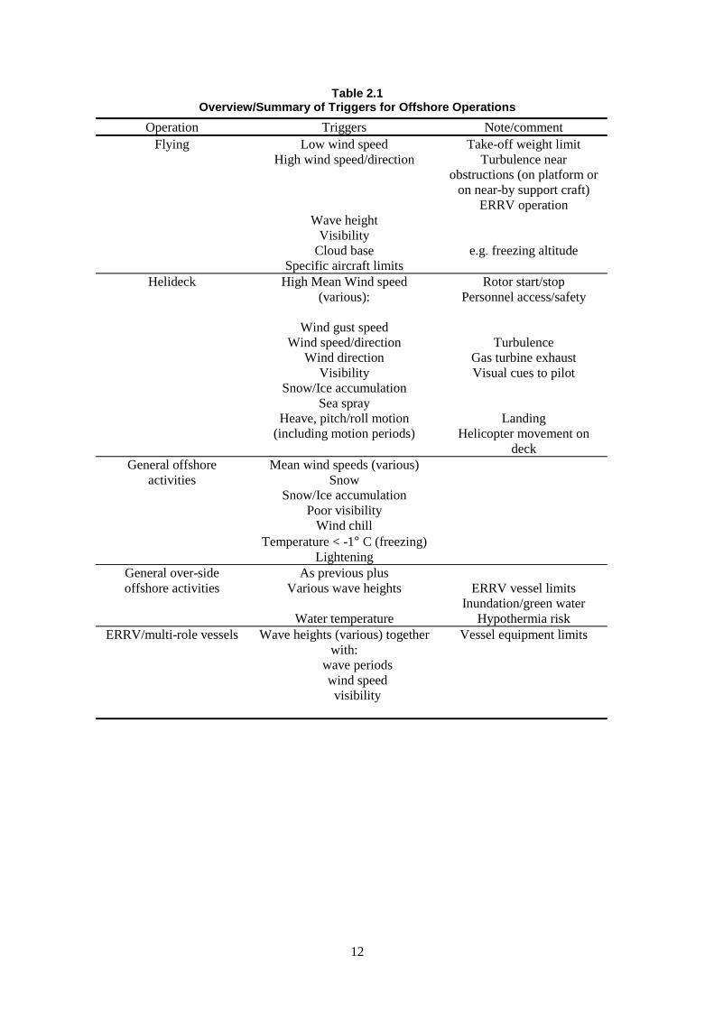
As the helicopter approaches its destination, the pilot needs to take account of the detailedmeteorological data radioed ahead by the helicopter landing officer (HLO) on the platform.Table 2.1 summarises the types of meteorological triggers that apply to offshore helicopteroperations. Provided the platform-based instrumentation is functioning correctly, is correctlylocated and is within calibration, this should remove any dependence of the critical approachand landing phase on forecast values.
The platform should also be equipped with a brightly coloured windsock to alert the captain ifthere is a serious discrepancy between the data he has been advised and the conditions near tothe helideck. However, it is important to safe operations that the evidence of the windsockshould not be relied upon as the sole input to the pilot. There are many factors that affect thehandling of a helicopter as it comes in to land and the associated risks can only be properlymanaged if the pilot is provided with accurate data. The minimum instrumentation that isrequired to provide a pilot with these data is described in CAP437 (Ref. 5). This may besummarised in brief as:
“…means of ascertaining and reporting at any time:a) The wind speed and direction;b) The air temperature;c) The barometer pressure;d) The visibility, cloud base and cover; ande) The sea state ”
“An indication of wind speed and direction will be provided visually to the pilot by theprovision of a wind sock coloured so as to give maximum contrast with the background.”
6
“Measuring instruments used to provide the data listed….should be periodicallycalibrated in accordance with the manufacturers’ recommendations.”
“…the movement of the helideck in pitch, roll, heave and heading…to be recorded on thevessel prior to and during all helicopter movements.”
Some instrumentation readings may be more important than others in particular circumstances(a day time approach in high wind, for example), see Chapter 3, but in other circumstances otherreadings might be more critical (flights at night in fog or freezing conditions, say). It may bepossible to consider reductions in the CAP 437 requirements for particular circumstances (eguse of automatic weather readings), but it would seem unlikely that general reductions could beaccepted unless they had been thoroughly investigated through an extensive consultationprocess.
Note the occurrence of sea state as a reporting requirement. This follows from the generalrequirement that there should be a reasonable chance of recovering someone from the watershould the helicopter ditch. Hence a range of wave height triggers apply to all flying operationsand there is a general discouragement/prohibition of flying for all but emergency purposes insea states with wave height greater than 7m significant (even though the associated wind speedwould cause no particular problems for many aircraft).
2.3 SMALL MONOHULLS
2.3.1 General
In general terms, masters of vessels and offshore installation managers (OIMs) have legalresponsibilities for the safety of their respective crews and facilities, legal obligations tocommunicate with each other to ensure safety of any joint operations and the authority to decidewhether operations affecting their vessels should proceed or terminate. They should alsoquestion any instructions that might create a hazard.
Not withstanding these general legal requirements, a variety of guidance concerning safety ofweather-sensitive offshore operations is available from several sources.
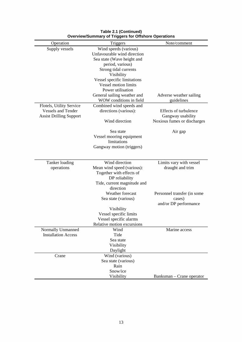
Both sheets of Table 2.1 contain summary information relating to the general weather-relatedtriggers that apply to the operations of such vessels. The limitations that apply in the field areconsidered at the beginning of this section. The decision whether or not to sail from port isdiscussed towards the end.
All vessels are required to stay beyond 500m from an oil installation unless they havepermission from the OIM and have made arrangements with the OIM or his nominee toapproach closer.
2.3.2 Supply Boats and Diving Support Vessels
The guidelines for the safe management and operation of offshore support vessels, Reference 7,which is the document referred to by most operators, focuses heavily and in general terms onthe responsibilities and experience of the master of the vessel. It gives few specific triggers foractions based on weather conditions. For example, the following is the guidance given forapproaching an installation:
“When the vessel approaches the installation to commence work, the Master should make hisapproach in a safe and seamanlike manner taking into account wind, wave and tidal conditions.”
It describes procedures that should be followed during the final approach to an offshoreinstallation. These may ‘only’ be common sense and/or good seamanship but they allow theperformance of a vessel positioning system to be checked against the prevailing weather
7
conditions as the vessel is moved onto station in close proximity to an offshore installation(fixed or floating). Thus even if there has been a misreading or erroneous reporting of someweather parameter, this should be spotted or compensated for in an inherently safe manner whenthe approach procedures are implemented properly.
Later, Reference 7 goes to some length to layout thirteen factors that the Master of a vesselshould consider in making his risk assessment before engaging in weather-side working. Thisfocuses, correctly, on many issues other than weather. However, it makes few specificrecommendations about weather limits or triggers which should apply other than a passingreference to “any specific weather policy which the Charterer or Installation may have.”
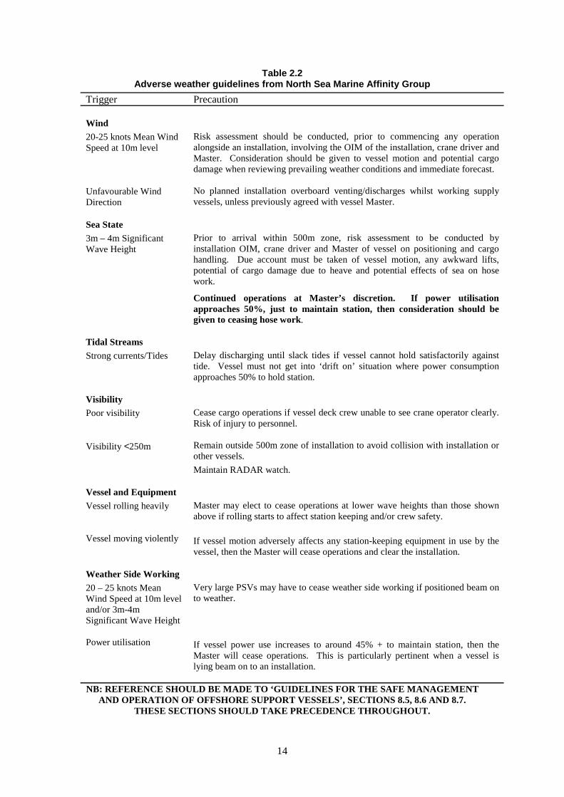
Reference 7 reinforces the Master’s responsibility, and guides him to all the aspects that heshould consider when making his judgements but, in failing to provide specific guidance, itseems to increase the load on the master’s shoulders without giving him support. There is onenotable exception. It states that a master must stop any weather-side working when the powerconsumption of his dynamic positioning system exceeds 45% of the total available. The NorthSea Marine Affinity Group has prepared an adverse weather working guideline (Table 2.2).While giving precedence to the recommendations of Reference 7, this adverse weather guidelinepresents a set of trigger values for metocean parameters and the associated precautions thatshould be taken when these are exceeded.
By contrast Shell, reference 6, detail many triggers for the working of standby vessels, multi-role vessels, supply vessels and diving support vessels adjacent to a fixed or floating productionfacility. While acknowledging the master’s responsibility for the safety of his vessel, Shell alsodetail multiple wave height and wave period conditions, visibility limits, wind speed/directionlimits and tidal currents which all require the master or OIM to reconsider the operation inwhich they are engaged. Several triggers also refer to other vessel systems, for example theexceedence of specific motion criteria and the power utilisation by the station keeping system.It may be difficult to specify uniquely limiting combinations of wind speed, wave height andcurrent which apply to any given draught and trim values. However, the power consumption ofthe DP system is a good guide to the magnitude of the forces which are being resisted. If thepower consumption begins to climb towards 50% of the total available (taking intoconsideration any power generation capacity that may not be available on the day), this is astrong indicator that the master should be disengaging from the operation at hand.
As might be expected, the triggers for weather-side working are more strict than those for lee-side working.
Crane operations will be discussed more fully in Section 2.6 below, but it is important to notethat several individuals need to participate in decisions about whether such operations shouldproceed/continue. The master of the supply vessel, the OIM (or his representative) and thebanksman all need to participate in safety-critical decisions which are influenced by the currentweather conditions.
In addition to the instantaneous meteorological and tidal conditions, the master of a supplyvessel must consider how circumstances might change throughout the duration of a givenoperation. Offloading of one or two specific items may only take an hour but, generally,unloading a whole range of supplies may take a day or more particularly if it involves transferof large quantities of bulks in fluid form. Cherry picking particular items from a shipload isgenerally discouraged. The duration of an offloading operation may be extended if the relevantcrane is needed for other duties or if crane movement is not allowed because of a helicopteroperation. The master needs to be informed of any forecast changes in weather, in particular, achange in wind direction which might fundamentally change his position from lee-side working(inherently safe in most instances) to weather-side working (inherently risky). Depending onthe geographical area, similar changes may be caused by tides or currents.
8
The time required to move off ‘in an orderly fashion’ depends on the nature of the task at hand.If a simple lift is being made, only a few minutes may be required. If a fluid transfer is takingplace then to get crane assistance, disconnect the hoses and move off may take up to 30 minutes.If a DSV has a team deployed and working underwater, then if might take several hours tobring a team on board safely and move off. The DSV may also be more restricted in itsavailable manoeuvring footprint while it has a team of divers or an ROV deployed.
A master also needs to be aware of any changing conditions that might be experienced as hemoves location around an offshore facility. To this end he needs the best information available.Unfortunately, a supply boat working in the lee of a fixed structure is not always in the bestlocation to measure or detect incipient changes.
In weather conditions identified as ‘subject to small intense squalls’ a master may be able to seeapproaching squall incidents on his radar and take action accordingly. Otherwise much of thedata which a supply ship needs to ensure safe operation, such as wave heights, wind speeds,wind direction and current speed/direction, could most easily be obtained from instrumentsmounted on a fixed structure. In fact, to follow Shell’s approach and impose restrictions whichdepend on 0.5 m increments of wave height and assessment of associated wave periods,platform based instrumentation would seem to be essential. However, care is required inmaintaining instruments in a serviceable accurate condition and in interpreting the data that ismost relevant to a vessel at sea level. These data are of limited use to other fixed platformoperations. Further, it is by no means certain or even likely that there will be anyone on boardmany fixed platforms with the necessary marine experience to interpret data in a way which isacceptable to a supply boat captain.
There is also reluctance among supply boat captains to accept too much data from a platform.Already, masters feel peer pressure to operate in marginal conditions because another master didso previously. They are wary about putting too much data in the hands of those with littlemarine experience in case additional unwarranted pressure is also applied. Generally, only themaster of a vessel knows enough about the load condition and performance of his vessel and hiscrew to make valid judgements in marginal weather conditions.
Forecasting should have a strong influence on the decision for a supply vessel to set sail.Commercial pressures on a production operation may lead an OIM to request that a supplyvessel sets sail so that it is available in the field with an essential item “whenever there is abreak in the weather.” However, if a prolonged spell of bad weather occurs this simply leads toa tired boat crew attempting a supply operation in marginal weather conditions with all itsassociated dangers. Partly because of such pressures, there is now a tendency to give the finaldecision on sailing to a marine controller since he is the only person in the chain with a fullappreciation of both offshore requirements and up-to-date weather forecasts.
The North Sea Marine Affinity Group provides an adverse weather sailing guideline in theformat of a decision flow chart (See Table 2.2). Similarly, Shell provides guidelines for sailingdecisions for both the Central North Sea and the Northern North Sea areas. These take intoaccount the different lengths of voyage and, in some cases, the need to sail for the shelteredwaters around Shetland so that it is possible for the supply boats to make use of short breaks inpersistent poor weather, which can affect the Northern North Sea.
Likewise, BP Amoco is in the process of developing a working procedure that takes intoconsideration the conditions experienced West of Shetland.
Smaller companies may or may not have the marine experience to develop their own policiesand they may rely on their suppliers to provide the necessary guidance. However, it is stillpossible for undue pressure to be brought to bear on supply boat owners to sail when this wouldnot be the recommended safe option.
9
2.3.3 Emergency Rescue and Recovery Vessels (ERRVs)
The United Kingdom Offshore Operators Association has published a set of guidelines for thesafe operation of vessels standing by offshore installations, Reference 8.
There are somewhat in excess of 100 ERRVs serving the oil installations on the UKCS. Manyof these vessels carry daughter craft, fast rescue vessels (FRV), which are deployed to recoveranyone from the sea. The ERRVs may be assigned uniquely to one facility or located in somecentral position from whence a FRV will provide coverage of operations on each platform.Typically, the FRV may work up to 10 miles from the ERRV although trials are taking place tosee whether this distance could be extended to 15 miles. The FRVs may have top speeds inideal conditions in the region of 30 kt but in marginal conditions and unfavourable weather, thespeed over the ground can easily drop to 15 kt. For someone wearing the correct protectiveclothing and buoyancy aids, a commonly accepted upper limit for recovery from the sea to aplace of safety where they can receive treatment is two hours – perhaps one hour in the sea andone in transit. This guideline upper limit may need to be revised downwards in the face ofemerging experimental data. For people without the appropriate kit, recovery from the waterwould need to be significantly shorter.
Generally, successful operations of ERRVs and the FRVs are difficult in high, steep, shortperiod seas but are not too seriously affected by long period swells. Hence any definition of anoperational limit will be a complex specification of wave heights, periods and other parameters.ERRV operations may be carried on safely in high seas West of Shetland if the swell is thedominant component but may have to be curtailed in lower waves in the Southern North Seas ifthe wind direction changes to one which induces steeper short-period seas. In some areas, tidalcurrent or increased current velocities over underwater sandbanks can cause operationaldifficulties.
2.4 SHUTTLE TANKERS
Table 2.1 indicates a typical range for the different types of operational restrictions andenvironmental triggers that are used in the safe management of shuttle loading operations.Almost all loading facilities are different in some respect (see Reference 2):• There have been and continue to be developments in loading hardware (mooring
arrangements, buoys, turrets, loading arms/hoses, floating storage units (FSUs), FPSOs);• Dynamic positioning systems for shuttle tankers have developed in many respects and• The layout of loading systems relative to other platforms in the field imposes restrictions on
tanker manoeuvres as they approach or leave the loading facility.
This is reflected in operational restrictions and environmental triggers for application when ashuttle tanker should approach, when it should begin to make preparations to leave, when itshould leave, and any associated contingency planning for “emergency departure”. Theserestrictions tend to be set uniquely for each different loading facility.
There is also recognition within the literature (operation guidance manuals, adverse weatherpolicies and the like) that there are too many interacting influences on the behaviour of a tankerat a buoy or tied to another floating vessel for any restrictions to be totally prescriptive.Consequently over-riding guidance is often included along the lines of “the master of the off-take vessel and the OIM have the authority to suspend cargo loading if they consider theoperation to be at risk from bad or deteriorating weather”.
Some of the restrictions on shuttle tanker operations (particularly for older facilities) arise fromthe performance of secondary support equipment and the need for manned access to make anattachment or recover items from the sea. In all cases there will be environmental restrictionsarising from the design phase of the project. Thus, depending on vessel draught and trim, theremay be wind speed, current speed or wave height restrictions arising from limiting loads in a
10
hawser or expected maximum relative motions between two points of two floating vessels.These restrictions may need to be observed even when they are not self-evidently necessaryfrom the vessel motions and responses on the day. (It is unreasonable to expect operatingpersonnel to make an in-field assessment and anticipate extreme motions or loads fromobserved significant wave heights or wind speed/gust conditions. Occasionally, operators willinstall extra monitoring equipment such that extreme loads arising during field operations canbe studied with a view to identifying more realistic operational boundaries.)
Restrictions in visibility, wind-direction and current speed and direction (tidal or otherwise)may arise from safety considerations of field layout. This will be particularly important if theseparation between the loading facility and a fixed platform or other obstruction is small. Theconsequences of a collision between a tanker and a fixed structure are potentially so severe fordanger to life and/or the environment that many precautionary measures are taken to minimisethe possibility.
Operational restrictions may also arise from specific aspects of an FPSO configuration oroperational requirement. Some FPSOs use laterally mounted fixed flare towers towards thestern of the vessel. These obstruct potential escape routes for a shuttle tanker should the needarise to make an unexpected or emergency break-away. With at least a quarter of his escaperoutes blocked, the shuttle tanker captain may prefer to give himself a margin by maintaining aspecific heading relative to the prevailing weather. Whether he has the thruster capacity to do sowill depend upon wind, current, sea-state and the draught/trim of his vessel. The relativelocation or orientation of the associated FPSO may also affect the wind, current and wave forcesexperienced by his vessel.
2.5 SUPPORT OPERATIONS
Long term support operations by a larger vessel such as a flotel, a utility service or tender assistvessel (semi-submersibles) or jack-up will generally be subject to specific study and preparationof a safety case. Part of this safety case will involve the specification of limits and proceduresfor adverse weather working. Just as with the smaller vessels, a range of different weatherconditions may trigger some operational response with particular attention needed if the vesselis relying on some level of thruster assistance to hold station. Unlike with smaller vessels,however, the limiting wave heights will be higher and wave periods will be longer. Thusoperating restrictions requiring a semi-submersible to take up a stand-by location or to move tosurvival draught will tend to be accompanied by a moderately severe storm and the build up ofthese weather conditions will normally have been spotted by available weather forecasts.
Both semi-submersible and jack-up operations will attract restrictions relating to relative motionbetween the unit and the production facility although the scale of motion and the capability totake corrective action is very different in the two cases. The semi-submersible will be subject torestrictions imposed by the gangway and any other connections (free-hanging risers or powersupply cables, for example). Typically, the gangway will be instrumented to give warningsbefore it reaches the limits of its operating envelope and use of the gangway can be curtailedbefore it becomes strictly necessary to disconnect it. At about the same time (i.e. in similarweather conditions), depending on the weather forecast, preparation may be made to pull awayto a standby location and, if really severe weather is expected, the draught of the vessel may bechanged to the survival condition. All of these conditions and the associated preparatoryoperations will have been considered in advance and/or further developed from operationalexperience.
Particular care is necessary if the impending storm is in such a direction as to carry a floatingvessel towards a fixed platform. Extensive studies will have been performed into the effects ofthe dragging of an anchor and/or the breaking of an anchor line but in the face of a really severestorm, extra precautions may be necessary before the worst of the weather is imminent.
11
Depending on the nature of the support being provided, much preparatory work may benecessary to close down and make safe dependent systems. To this extent, it is common tooperate an adverse weather warning alert (with associated operational procedures) so thatsensitive operations are not initiated in the face of a poor weather forecast even if the storm isnot expected for a day or two.
Other interactions occur between adjacent large structures, each with its own operating system.Hence careful consideration needs to be given to the location of the helideck and any winddirections which could lead to turbulence. Likewise, vents and discharge systems should alsohave been considered to ensure that they do not interfere with each other or with a site wherepersonnel are expected to work.
2.6 TOPSIDE AND MAINTENANCE OPERATIONS
Topside-based operations on a fixed platform are generally restricted by wind speed. Craneswill be subject to limits laid down by the manufacturer or due to the effect of wind on the loadbeing lifted. Generally, platform topsides are in exposed locations and similar restrictions mayapply to general maintenance and mechanical handling work unless it is taking place in asheltered position on the platform. Typical wind speed limits, which will lead to workingrestrictions, are 30 to 35 knots but lower speeds may cause restrictions if the direction of thewind is such as to carry noxious fumes or discharges onto the work site. Even at lower wind-speeds, care will be required when moving around the platform in case a strong gust isexperienced when moving into an unsheltered area. Depending on the detail of the adverseweather operating procedure, use of tag lines attached to the lifting loads may also have beenspecified for consideration. As wind speed increases beyond the values indicated by these tags,work will generally be restricted to that required to make the work place safe against higherwinds. (By convention, wind-speed limits are quoted in terms of the 10-minute mean value atan elevation of 10 m above mean sea level - though this should be clearly stated in any officialdocumentation.)
Visibility, heavy rain and lightening may also restrict general out-door topside operations and, ifover-side working is required, it will also be subject to restrictions associated with the capabilityof the recovery vessel to retrieve someone from the water. Typically 5.5m significant waveheight is quoted as a value above which serious injury may be expected by someone attemptingto use these recovery devices. However, there seems to be some scepticism about whether thisis a sensible upper limit particularly if the fast recovery craft may be required to work close to afixed structure. Shell lay down more stringent conditions that also depend on the dominantwave periods present in the sea. If the dominant periods are less than seven seconds, then theFRV is expected to move more severely and lower wave heights apply.
The International Rope Access Trade Association (IRATA) has a code which covers all aspectsof over-side working by rope. This lays down appropriate levels of personnel training andweather limits that should apply to teams engaged in over-side working. Typically there will belimits on wind speed (less than 30 knots) and wave/swell height dependent on the elevationabove mean sea level. Another factor relates to any general discomfort due to weather that mayarise in cold and stormy conditions.
Generally, a forecast will be obtained before initiating an operation and appropriate weatherlimits will be specified as part of the permit to work. A key requirement relates to the ERRVand its ability to launch a FRV to recover anyone who falls into the water.
12
Table 2.1Overview/Summary of Triggers for Offshore Operations
Operation Triggers Note/commentFlying Low wind speed
High wind speed/direction
Wave heightVisibility
Cloud baseSpecific aircraft limits
Take-off weight limitTurbulence near
obstructions (on platform oron near-by support craft)
ERRV operation
e.g. freezing altitude
Helideck High Mean Wind speed(various):
Wind gust speedWind speed/direction
Wind directionVisibility
Snow/Ice accumulationSea spray
Heave, pitch/roll motion(including motion periods)
Rotor start/stopPersonnel access/safety
TurbulenceGas turbine exhaustVisual cues to pilot
LandingHelicopter movement on
deckGeneral offshore
activitiesMean wind speeds (various)
SnowSnow/Ice accumulation
Poor visibilityWind chill
Temperature < -1° C (freezing)Lightening
General over-sideoffshore activities
As previous plusVarious wave heights
Water temperature
ERRV vessel limitsInundation/green water
Hypothermia riskERRV/multi-role vessels Wave heights (various) together
with: wave periods wind speed visibility
Vessel equipment limits
13
Table 2.1 (Continued)Overview/Summary of Triggers for Offshore Operations
Operation Triggers Note/commentSupply vessels Wind speeds (various)
Unfavourable wind directionSea state (Wave height and
period, various)Strong tidal currents
VisibilityVessel specific limitations
Vessel motion limitsPower utilisation
General sailing weather andWOW conditions in field
Adverse weather sailingguidelines
Flotels, Utility ServiceVessels and Tender
Assist Drilling Support
Combined wind speeds anddirections (various):
Wind direction
Sea stateVessel mooring equipment
limitationsGangway motion (triggers)
Effects of turbulenceGangway usability
Noxious fumes or discharges
Air gap
Tanker loadingoperations
Wind directionMean wind speed (various):
Together with effects ofDP reliability
Tide, current magnitude anddirection
Weather forecastSea state (various)
VisibilityVessel specific limitsVessel specific alarms
Relative motion excursions
Limits vary with vesseldraught and trim
Personnel transfer (in somecases)
and/or DP performance
Normally UnmannedInstallation Access
WindTide
Sea stateVisibilityDaylight
Marine access
Crane Wind (various)Sea state (various)
RainSnow/iceVisibility Banksman – Crane operator
14
Table 2.2Adverse weather guidelines from North Sea Marine Affinity Group
Trigger Precaution
Wind
20-25 knots Mean WindSpeed at 10m level
Unfavourable WindDirection
Risk assessment should be conducted, prior to commencing any operationalongside an installation, involving the OIM of the installation, crane driver andMaster. Consideration should be given to vessel motion and potential cargodamage when reviewing prevailing weather conditions and immediate forecast.
No planned installation overboard venting/discharges whilst working supplyvessels, unless previously agreed with vessel Master.
Sea State
3m – 4m SignificantWave Height
Prior to arrival within 500m zone, risk assessment to be conducted byinstallation OIM, crane driver and Master of vessel on positioning and cargohandling. Due account must be taken of vessel motion, any awkward lifts,potential of cargo damage due to heave and potential effects of sea on hosework.
Continued operations at Master’s discretion. If power utilisationapproaches 50%, just to maintain station, then consideration should begiven to ceasing hose work.
Tidal Streams
Strong currents/Tides Delay discharging until slack tides if vessel cannot hold satisfactorily againsttide. Vessel must not get into ‘drift on’ situation where power consumptionapproaches 50% to hold station.
Visibility
Poor visibility
Visibility <250m
Cease cargo operations if vessel deck crew unable to see crane operator clearly.Risk of injury to personnel.
Remain outside 500m zone of installation to avoid collision with installation orother vessels.
Maintain RADAR watch.
Vessel and Equipment
Vessel rolling heavily
Vessel moving violently
Master may elect to cease operations at lower wave heights than those shownabove if rolling starts to affect station keeping and/or crew safety.
If vessel motion adversely affects any station-keeping equipment in use by thevessel, then the Master will cease operations and clear the installation.
Weather Side Working
20 – 25 knots MeanWind Speed at 10m leveland/or 3m-4mSignificant Wave Height
Power utilisation
Very large PSVs may have to cease weather side working if positioned beam onto weather.
If vessel power use increases to around 45% + to maintain station, then theMaster will cease operations. This is particularly pertinent when a vessel islying beam on to an installation.
NB: REFERENCE SHOULD BE MADE TO ‘GUIDELINES FOR THE SAFE MANAGEMENTAND OPERATION OF OFFSHORE SUPPORT VESSELS’, SECTIONS 8.5, 8.6 AND 8.7.
THESE SECTIONS SHOULD TAKE PRECEDENCE THROUGHOUT.
15
3 VIEWS AND OPINIONS
3.1 OPERATORS
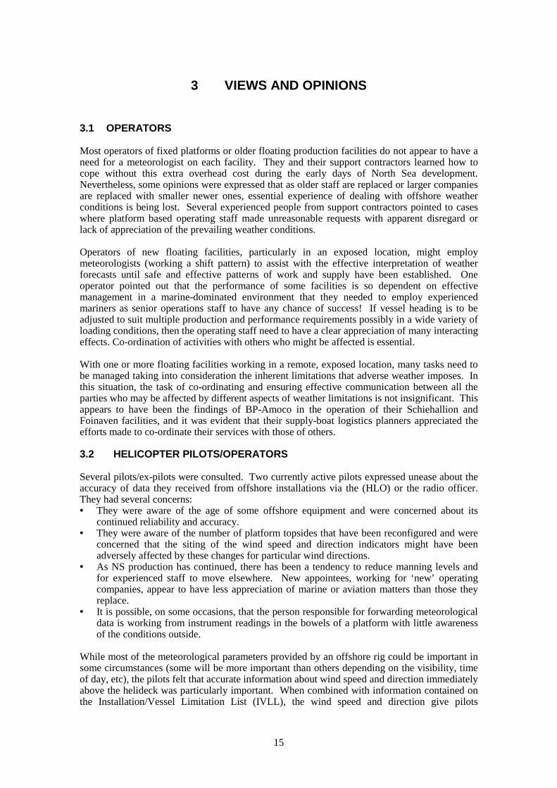
Most operators of fixed platforms or older floating production facilities do not appear to have aneed for a meteorologist on each facility. They and their support contractors learned how tocope without this extra overhead cost during the early days of North Sea development.Nevertheless, some opinions were expressed that as older staff are replaced or larger companiesare replaced with smaller newer ones, essential experience of dealing with offshore weatherconditions is being lost. Several experienced people from support contractors pointed to caseswhere platform based operating staff made unreasonable requests with apparent disregard orlack of appreciation of the prevailing weather conditions.
Operators of new floating facilities, particularly in an exposed location, might employmeteorologists (working a shift pattern) to assist with the effective interpretation of weatherforecasts until safe and effective patterns of work and supply have been established. Oneoperator pointed out that the performance of some facilities is so dependent on effectivemanagement in a marine-dominated environment that they needed to employ experiencedmariners as senior operations staff to have any chance of success! If vessel heading is to beadjusted to suit multiple production and performance requirements possibly in a wide variety ofloading conditions, then the operating staff need to have a clear appreciation of many interactingeffects. Co-ordination of activities with others who might be affected is essential.
With one or more floating facilities working in a remote, exposed location, many tasks need tobe managed taking into consideration the inherent limitations that adverse weather imposes. Inthis situation, the task of co-ordinating and ensuring effective communication between all theparties who may be affected by different aspects of weather limitations is not insignificant. Thisappears to have been the findings of BP-Amoco in the operation of their Schiehallion andFoinaven facilities, and it was evident that their supply-boat logistics planners appreciated theefforts made to co-ordinate their services with those of others.
3.2 HELICOPTER PILOTS/OPERATORS
Several pilots/ex-pilots were consulted. Two currently active pilots expressed unease about theaccuracy of data they received from offshore installations via the (HLO) or the radio officer.They had several concerns:• They were aware of the age of some offshore equipment and were concerned about its
continued reliability and accuracy.• They were aware of the number of platform topsides that have been reconfigured and were
concerned that the siting of the wind speed and direction indicators might have beenadversely affected by these changes for particular wind directions.
• As NS production has continued, there has been a tendency to reduce manning levels andfor experienced staff to move elsewhere. New appointees, working for ‘new’ operatingcompanies, appear to have less appreciation of marine or aviation matters than those theyreplace.
• It is possible, on some occasions, that the person responsible for forwarding meteorologicaldata is working from instrument readings in the bowels of a platform with little awarenessof the conditions outside.
While most of the meteorological parameters provided by an offshore rig could be important insome circumstances (some will be more important than others depending on the visibility, timeof day, etc), the pilots felt that accurate information about wind speed and direction immediatelyabove the helideck was particularly important. When combined with information contained onthe Installation/Vessel Limitation List (IVLL), the wind speed and direction give pilots
16
important information about routes into and away from platforms that will avoid areas ofexcessive turbulence. A pilot’s workload is high as he approaches or leaves a landing site andunexpected turbulence is particularly unwanted and potentially dangerous at this time.
An accurate reading of atmospheric pressure is also fairly important since it allows the pilot toset his altimeter to assist with his landing on a helideck. Other equipment on the helicopter canbe used for the same purpose but this has a fairly long response time and will tend not toprovide the desired accuracy during the approach.
In cold weather, it is important for a pilot to be aware of surface temperature and theapproximate elevation of freezing level. North Sea helicopters are not generally fitted with fullyfunctional de-icing equipment so it important for a pilot to know that he can use particularelevations to reduce any build-up of ice.
As a matter of regulation, Norwegian offshore installations are designated as airfields while UKinstallations are not. Being designated an airfield carries with it fairly onerous requirements formeteorological monitoring equipment (see Tables 3.1 and 7.1) and the issuance of regularweather forecasts (TAFs and trends). Aviators can routinely access these data. As a result, apilot may consult the data issued by the Norwegian platform which is near to his route todetermine what sort of weather he may expect to encounter. This may also warn him in advanceif there is a marked discrepancy with data being reported from a nearby UK rig.
CAP 437 (Ref. 5), Chapter 6 “Helicopter Landing Areas – Miscellaneous OperationalStandards,” covers - 6.2, “Wind Direction (Vessels)”; 6.3, “Helideck Movement” and 6.4,“Aircraft Operational Data - Reporting and Recording” describing the correspondingrequirements for meteorological and movement monitoring for helicopter operations to ahelideck on the UKCS. The salient points of these are outlined in Table 3.2.
There is an on-going discussion in the helicopter operating community about the effect oflightning. Some claim that helicopters attract lightning and are uneasy about the threat which itposes while others maintain that lightening poses no threat to a properly maintained helicopter.In any event, it appears that a helicopter that is struck by lightning must be subject to anexpensive maintenance check afterwards. The meteorological office claims that newforecasting models can predict lightning, detect it remotely and so could issue warnings. Thismay not be adequate if the presence of the helicopter increases the chance of lightening. Somehelicopters carry equipment that can detect whether there is a risk of lightening strike, but theefficacy of this equipment is in dispute. If lightning strike is a serious hazard, there would seemto be a strong case for implementing combined evaluations of forecasts and detectionequipment.
In general, high wind speed in itself, is not a bar to helicopter flight. However high wavesaccompany high winds and high waves would cause danger to a rescue craft trying to recoversomeone from the sea. High winds would also pose a serious risk to someone trying tonegotiate an exposed helideck to get on or off a helicopter. It is for these reasons that there arestrict limits to all normal offshore commercial flying activities.
3.3 MASTERS OF SMALL MONOHULL SUPPORT CRAFT AND LOGISTICSPLANNING COMPANIES
3.3.1 Supply-boat Masters and Supply Logistics Companies
Several people expressed unease about the commercial pressure which supply boat captains canbe put under to approach and deliver to offshore facilities in weather conditions which are toosevere to guarantee safety. BP-Amoco actively discourages this practice and encourages supplyboat captains to report any instances when they experience it. Where an operator has a marineoperations department, there appears to be a general appreciation of the inherent dangers andsupport for Captains to stick by their best judgement. However, several vessel masters and
17
operations co-ordinators believed that the problem still exists. They pointed out that it is verydifficult to prove that such pressure is being applied since it may not become evident until thenext supply contract is offered to another company.
Several people pointed to the lack of “marine awareness” of many current personnel on fixedNorth Sea structures. Reference 7 describes how a supply vessel should take some time(typically 10 to 20 minute) to ensure its positioning system is functioning properly and copingwith the environmental forces as it comes on station alongside a fixed structure. One supplyboat co-ordinator noted how it had received a complaint from one platform that it was losing 15minutes every time a supply boat approached because it was following the recommendedprocedure. BP-Amoco expressed unease that good data on wave heights, for example, might beused by inexperienced personnel to apply even greater pressure to marine crews – “the last boatloaded in 4 m wave heights so why aren’t you!” – for example.
In the case of floating production facilities the problem of inexperienced staff is not soprominent. Generally, a floating facility will have several members of staff with marineexperience and so they appreciate the point of view of the master of an approaching vessel.This is doubly true where the floating facility has a lively response and requires an experiencedmarine crew to coax an effective production operation from it. In all such cases, however, it isimportant to realise that the overall performance of a floating facility may depend on themanagement and control of its heading. A captain of a supply vessel needs to be aware of thecurrent operating regime for such an FPSO since it will need to be taken into considerationwhen he plans his approach for an offloading operation. The heading may be less than ideal fora particular approach route (due to the effects of thruster out-wash, for example), or it may bedetrimental to the operation of a particular crane. Good communication and a willingness toaddress unexpected operational problems would seem an essential prerequisite for thedevelopment of appropriate adverse weather policies at such facilities. It may take someconsiderable time before an efficient operating procedure can be devised which takes intoconsideration all of the competing requirements and inherent variability in metocean conditions.
Discussions with marine personnel indicated an unwillingness to devolve any responsibilityaway from the master of the vessel. At the same time they were aware of the heavy burden ofresponsibility which had to be borne by masters, whether they were “new and untested” or “oldsea dogs”. It is evident to everyone that the supply boat is not always in the best position tomake a judgement about a weather condition, particularly when the supply boat is in a shelteredposition and when the weather may be changing rapidly. However, few seemed willing toidentify any platform-based instrumentation that might assist the master in making betterjudgements. A fixed platform would be an ideal place to establish many measuring instrumentsbut only if these were monitored, maintained and interpreted by staff with appropriateexperience.
In the case of a floater such as an FPSO, the situation is less clear. The performance of wind,wave and current sensors on an FPSO may be strongly affected by the operation in hand, and bythe response and heading of the vessel. Hence there may be an inherent difficulty indetermining when trigger values of metocean parameters are in danger of being exceeded. Thiscould be accepted by the industry as inevitable and be the reason that experienced marine creware required on both FPSOs and their attendant supply vessels. However, experience of shuttle-tanker operations indicates that trigger values of key variables need to be identified so thatcrews know when the danger from continued operation is increasing and can make preparationsto withdraw in the face of further deterioration.
The comments of one senior captain are precised as follows:• Wind speed and direction data gathered in support of helicopter operations is a good
indicator (even though it is strictly applicable to a higher elevation).• A barograph is useful in trained hands since it indicates trends.
18
• Wave heights and directions associated with sea and swells are difficult to estimate andpredict. Ideally each field should have a wave rider buoy so that information is availablelocally and can be sent to the Met Office.
• Tide and current data should also be available locally. Current meters should be installed ateach location in the Southern North Sea, if necessary on the standby vessel.
• The final decision about whether or not to proceed with an operation must still rest with theMaster. Providing him with better more accurate data and forecasts can only be beneficial.
West of Shetland, BP-Amoco have a resident meteorologist permanently on duty. They use theexperience of these personnel to detect and confirm reasonable prospects (forecasts) of spells ofless severe weather and plan shuttle-tanker and supply boat movements to take advantage ofthem. The meteorologists are aware of the limitations of on-board weather sensors and theweather forecasts that apply to the area and use their own observations and experience to makeappropriate corrections and allowances. The difficulties of operating in this area throughout thewinter months are making BP-Amoco consider major modifications to the mountings of theirwind instruments and the possible installation of a wave buoy.
In less severe environmental conditions and/or in less remote areas, a resident meteorologistmay seem an over-expensive solution to what may only be an occasional problem. However, itwould seem inappropriate to rely solely on “marine experience” where there are clearly manydifficult decisions to be made in the face of considerable commercial pressures.
The presence of more than one floating vessel in the proximity of a production facility cancomplicate operations considerably. In these circumstances, it is essential that all involvedcommunicate and make each other aware of their intended movements well in advance sincethese may impinge on intended “emergency escape corridors” or interfere with other essentialtasks. This would be especially true in the face of a rising or changing weather condition whenextra time may be needed to effect a safe retreat. It would appear logical for some one to co-ordinate such operations and vessel movements, but since it is unlikely that there would beanyone on the fixed platform with sufficient marine experience, this may not be feasible.
3.3.2 Emergency Rescue and Recovery Vessels
As for many other marine operations, there is a reaction against anything which might lead torestriction on the freedom of a master to exercise his best judgement. A typical, representativequote was as follows:
“We should never take away the role of the Master in deciding from his long experienceat sea and his knowledge of the motion characteristics of his vessel when it is safe or notto offer a good prospect of recovery. There are too many variables. If from a study suchas this, some ‘person’ decides to put finite limitations on operations they will not applyequally to all vessels and crews. Similarly the Master is given some leeway in hisdecision if estimations are used. Often rig personnel would argue a point if they havewave-riders…. It is a retrograde step to have automation.”
It is important to acknowledge this type of feeling in implementing any recommendation fromthis study.
An experienced master will make a complex judgement based not only on the weather butperhaps based on his knowledge of local conditions or some aspect of the state of maintenanceof his vessel or the experience (or lack of experience) of the coxswain of his FRV. In reachinghis final judgement he is most likely to be affected by his judgement and anticipation of whetherthe weather is liable to deteriorate over the forthcoming period. If better instrumentation orweather forecasting is to assist him in this task, it must be accurate over the relevant period andalso take account of any specific local peculiarities (e.g. tidal current or wave generation over ashallow water area). According to the information set out in Chapter 2, this period is liable tobe approximately between 1.5 and 2.5 hours. To be of help, it should offer reliable advice based
19
on the current (perhaps marginal) conditions and how the weather pattern is liable to changeover that period.
To some extent masters are content with their present lot. If there is a real emergency, they mayeffect a rescue in conditions that might exceed any normal recommendation of a safe limit.However, if better reliable weather forecasting were available to both the OIM and the Masterof the ERRV, it might prevent extreme rescue situations arising.
3.4 SHUTTLE TANKER MASTERS/OPERATORS
The Oil Companies International Marine Forum, OCIMF, has issued a document (Reference 1)that provides an overview and excellent guidance to offshore loading in harsh weather zones.Tanker loading is recognised as a difficult and potentially dangerous operation and a broad yetdetailed approach is recognised as being essential to managing the associated risk. Althoughweather limitations are important, there are many other factors that need to be addressed for safeoperation and these are broadly recognised in the main chapter headings of the cited publication,namely: health, safety and the environment; risk management; legislation and shippingstandards; joint operations manual; preliminary assessment of off-take vessel; communications;pre-arrival safety procedures; equipment; operations and emergency and contingency planning.The need for a holistic approach is also emphasised in Reference 2 where various hardware andpeople concerns are expounded.
Several comments were received after a presentation to an assembled group of shuttle tankercaptains:• Successful offshore loading operations depend on good assessment and forecasting of
metocean conditions.• There is some scepticism about reliability of weather forecasts particularly when different
but equally valid sources appear to provide significantly different predictions.• Wind and wave measurements from FSUs and FPSOs are not renown for their accuracy.
Wind-speed readings can be distorted by obstructions on the topside and weather-vaning ofthe hull leads to problems in assessing absolute wind and current directions. Accuratemeasurements of significant wave height are difficult from a floating platform with variablemass and inertial properties.
• When no reliable measurements are available, the master of the vessel has to rely on hisexperience of wave observation, but he would prefer that he had not to rely on this inmarginal conditions.
• Captains are particularly anxious that they are not caught out by sudden, unexpectedchanges in wind direction. Wind changes are usually caused by movement of weatherfronts and should normally be anticipated by weather forecasts, at least in the North Seaarea.If the weather forecast were inaccurate, there would be an extra risk to the loading operationparticularly if the switch took place in hours of darkness when the surrounding sea surfacecould not be observed by the captain from the bridge.
• If wind speed and direction readings were available in some suitable format from nearbyplatforms, this might alert a Master to changes that were occurring quicker than forecast.
• Some areas of the world are affected by small intense weather systems that can be missedby large scale forecasts. Occasionally, but seldomly, northerly areas of the North Sea maybe subject to “polar lows” propagating south from Arctic regions. These are usually weakby the time they reach UK latitudes but the Norwegian Petroleum Directorate is assemblingmore data about these features in support of their more northerly operations
• Changes in current direction can also be troublesome. In Norwegian waters, large scalevortices can cause rapid changes in current direction, but these features are believed to beless important on the UKCS.
• Due to the proximity of some loading facilities to other platforms or vessels, it is necessaryfor the shuttle tanker captain to be vigilant and make the broadest use of his marine trainingin assessing whether or not to proceed.
20
3.5 ENGINEERING CONSULTANTS AND CONTRACTORS
Platform based maintenance and repair operations will generally require a risk assessment andthe granting of a permit to work. Both these activities require an assessment of anywind/weather conditions that might prevent the operation being completed satisfactorily. It wasnoted that this assessment is highly dependent on wind direction since many operations can becompleted if part of the topside structure provides a windshield.
One of the major engineering contractors who would traditionally deal with large scale topsidemodifications commented:
“Our logistics people say that we do not experience problems with the quality of forecastsand, considering local variability within the North Sea, the data are sufficiently accuratefor our purposes.”
One operator drew attention to one of the effects of the CRINE initiative; namely that someproduction facilities are equipped with only one crane. Consequently it may only be possible toaccess a platform from one side and this will frequently be the weather-side. This is viewed as aretrograde step in operational safety.
According to comments received from those involved in over-side working:“Quality/quantity of safety/weather limitations vary from installation to installation(within International Rope Access Trade Association requirements) very much dependingupon the competence/personality of the key personnel. Some are very strict and work topredetermined limits, others less safety conscious. The best talk to all parties and take allopinions on-board. Accidents/near misses that have occurred are very rarely due to poorweather – mostly are due to lax control by personnel, i.e. human factors.”
Once an over-side activity has begun the ERRV will make periodic reports including notableweather readings. These will probably be made on the support vessel rather than the platform.If the weather is getting bad or near the specified limits then the technician in charge of theoperation will radio the control room and arrange to bring-in the inspection team.
3.6 METOCEAN INFORMATION SOURCES AND CONTRACTORS
One government agency and several commercial contractors measure, collect, interpret, analyse,issue and forecast weather data for the offshore industry. Three were contacted:• The Met Office• Oceanroutes• Muir Matheson.
Talking to these three organisations has provided a good overview of the types of metoceanservices on offer.
In the case of the Met Office it is important to distinguish two roles:• Data gathering in support of the UK meteorological forecasting model.• All other meteorological services.
There is one Met Office employee in Aberdeen who fulfils the first role (his salary comes fromthe UK taxman). He solicits support from the offshore industry on a purely voluntary basis. Heprovides, maintains/calibrates and generally controls the quality of instruments for companieswhich volunteer to provide regular meteorological readings as input to the meteorologicalmodel. If he suspects an instrument is not functioning correctly or is out of calibration, heintervenes to prevent these data being fed into the model while he makes contact with theassociated operator or vessel owner to negotiate access for essential maintenance. Table 3.3provides an overview of the input to the UK forecasting model from offshore installations and
21
Figure 3.1 shows where all these units are located. Generally, there is a policy of freeavailability of raw data, so anyone who needs access to this information can, in principle, get it.
It can be seen that a reasonable coverage of the oil producing areas of the UKCS is availablefrom these sources. The accuracy of the UK weather forecasting model will depend on a widevariety of geographically diverse sources, with very many more inputs other than those from theoffshore locations. However, if any subsequent detailed forecast or interpretation of the outputdepends upon correlation against actual current readings, there would appear to be a reasonablebase of readings on which to make an accurate interpretation.
The other part of the Met Office in Aberdeen and Oceanroutes appear very similar in the rangeof services they offer the industry although there are differences in detail, style, presentation andquality of service as you might expect to see in any commercially competitive area. Typically,these organisations offer detailed interpretation of the output from a range of weatherforecasting computer models in a form that supports their client’s needs.
The extent and presentation of the metocean data are areas in which significant advances arecurrently being made. The Met Office says that there have been significant improvements inforecast models in recent years, with many more output parameters available on a routine basis.The follow-up software development to deliver these forecast parameters to the offshoreindustry are only just beginning to emerge, but the Met Office expects to see greater availabilityof, for example, lightning risk forecasts, visibility forecasts and sea state prediction. Some ofthese services were first made available commercially late in 2000 and an wider customer baseis currently developing. The means of delivering these data may also be expected to take aquantum leap with the development of web-based technology. It is difficult to predict theimpact these items might have on offshore safety. It would seem important to keep abreast ofthe developments and perhaps hold a seminar or two to inform the industry about basicavailability of new services and to monitor the experience of those who have tried to use themto improve operational efficiency.
Some operators prefer the form of presentation of one commercial company to that of another,and one company rather than another may be better established to provide specific data for oneparticular type of operation (e.g. helicopter operations, supply boat logistical planning or shuttletanker loading). It seems this is a normal feature of a commercially active market.
Both the Met Office and Oceanroutes provide experienced qualified meteorological staff inteams to support the planning of high-value weather-limited operations or individually foroffshore secondment. There continues to be a strong interest in these services for offshoreinstallation activities, but routine availability of platform-based weathermen is much reduced bycomparison with the early days of North Sea development.
Some interesting comments were received from one of the meteorologists who had beenseconded to an offshore floating production facility. He pointed out that:• Wind measurement on a weather-vaning vessel can be extremely problematic. The
superstructure of an FPSO affects the airflow towards the instrument in different waysdepending on whether the vessel is allowed to weather vane freely or whether its heading iscontrolled for some other purpose.
• It is very difficult to measure waves from a floating vessel which has a variable loadcondition.
• Rain can influence automatic recording of cloud cover to such an extent that humanjudgement is the only way of ensuring an accurate assessment.
• Where there is no meteorologist on board specifically assigned to providing regularreadings, this task is undertaken by someone else without a steady workload, for example,the medic (whether or not he has the necessary background and experience).
• He finds his advice is sought primarily to co-ordinate supply boat and shuttle tankeroperations.
22
• He thought that routinely available swell forecasts seemed poor and he felt that he improvedthese predictions significantly by careful attention to interpretation of details in availablesource information.
• Although he is in an ideal situation to provide actual and forecast data to the helicopter-landing officer on his current vessel, he is never asked! This is a strange situationparticularly if his comments about the difficulty of interpreting wind data are correct. Theimplication is that the HLO may be providing data, as required by statute, without takingadvantage of the best available data sources. Is this an instance of demarcation or poor co-ordination? If there have been no complaints from the helicopter operators, then this isstrongly suggestive that site specific forecasting would be a waste of time for support ofhelicopter operations.
Muir Matheson, with their collaborators Meteo Consult, might also provide generalmeteorological services but it would appear that they have one particularly strong niche. Theyprovide instrumentation for automatic measurement and reporting of meteorological data andhave strong links to the helicopter operators who make use of the data in planning their day today operations. They have established a “Helimet” system for provision of appropriately codedand quality controlled weather reports to helicopter operators. The locations of theseinstruments (which may double as input to the Met Office) are shown in Figure 3.2.
Their view is that the reporting of meteorological parameters from offshore platforms is verymixed: some good, others terrible! They have encountered situations where the report of windconditions on a helideck (insisted on by CAA) is achieved by asking a stand-by vessel severalkilometres distant and much closer to the sea surface. For some wind conditions and directions,this could be so poor as to be dangerous.
Use of instrumentation helps standardise the estimation of metocean parameters, therebyreducing the effects of subjective interpretation by an observer.
Muir Matheson pointed out that many of the instrumentation readings specified for offshoreoperations are required only as a matter of guidance and there is little required by way ofregulation. As a result, offshore instruments may be poorly maintained and out of calibration.This also leads to a situation in which no single individual is in effective control of a platform’sability to report the measurements. With a few notable exceptions, Muir Matheson experiencegreat difficulty in identifying the individual within an oil company who has responsibility forthe upkeep of offshore measurement instruments.
Muir Matheson report that there is some difficulty in getting automatic meteorological dataaccepted as input to weather forecasting models and generally a trained observer is required tovouch for such data before it is accepted. They feel that for a limited set of parameters, whichcould be very helpful for planning miscellaneous offshore operations, automatic data issufficiently accurate. Such automatic data could be acceptable without vetting by a humanobserver or, at worst, the training required to vouch for this limited set of data would be muchless than is required to make a full set of meteorological readings.
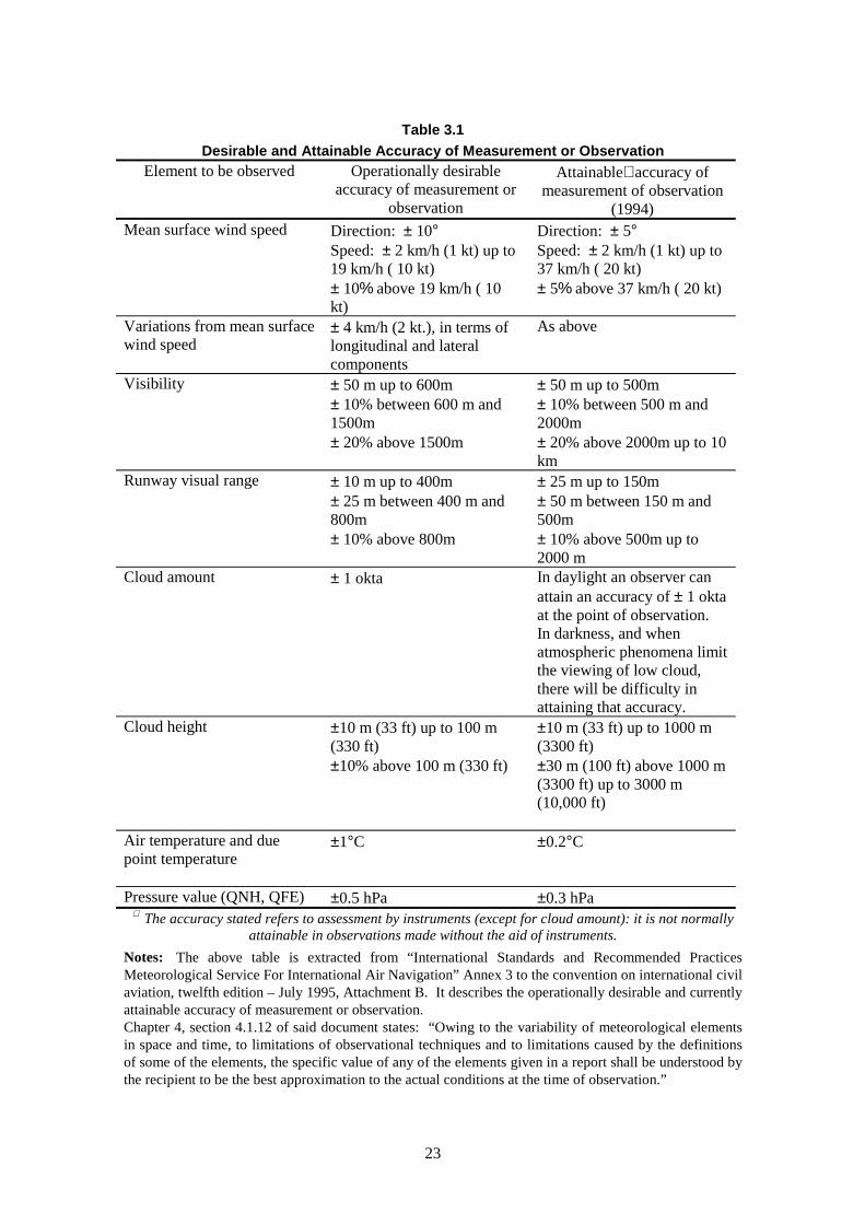
23
Table 3.1
Desirable and Attainable Accuracy of Measurement or Observation
Element to be observed Operationally desirableaccuracy of measurement or
observation
Attainable∗ accuracy ofmeasurement of observation
(1994)Mean surface wind speed Direction: ± 10°
Speed: ± 2 km/h (1 kt) up to19 km/h ( 10 kt)± 10% above 19 km/h ( 10kt)
Direction: ± 5°Speed: ± 2 km/h (1 kt) up to37 km/h ( 20 kt)± 5% above 37 km/h ( 20 kt)
Variations from mean surfacewind speed
± 4 km/h (2 kt.), in terms oflongitudinal and lateralcomponents
As above
Visibility ± 50 m up to 600m± 10% between 600 m and1500m± 20% above 1500m
± 50 m up to 500m± 10% between 500 m and2000m± 20% above 2000m up to 10km
Runway visual range ± 10 m up to 400m± 25 m between 400 m and800m± 10% above 800m
± 25 m up to 150m± 50 m between 150 m and500m± 10% above 500m up to2000 m
Cloud amount ± 1 okta In daylight an observer canattain an accuracy of ± 1 oktaat the point of observation.In darkness, and whenatmospheric phenomena limitthe viewing of low cloud,there will be difficulty inattaining that accuracy.
Cloud height ±10 m (33 ft) up to 100 m(330 ft)±10% above 100 m (330 ft)
±10 m (33 ft) up to 1000 m(3300 ft)±30 m (100 ft) above 1000 m(3300 ft) up to 3000 m(10,000 ft)
Air temperature and duepoint temperature
±1°C ±0.2°C
Pressure value (QNH, QFE) ±0.5 hPa ±0.3 hPa∗ The accuracy stated refers to assessment by instruments (except for cloud amount): it is not normally
attainable in observations made without the aid of instruments.
Notes: The above table is extracted from “International Standards and Recommended PracticesMeteorological Service For International Air Navigation” Annex 3 to the convention on international civilaviation, twelfth edition – July 1995, Attachment B. It describes the operationally desirable and currentlyattainable accuracy of measurement or observation.Chapter 4, section 4.1.12 of said document states: “Owing to the variability of meteorological elementsin space and time, to limitations of observational techniques and to limitations caused by the definitionsof some of the elements, the specific value of any of the elements given in a report shall be understood bythe recipient to be the best approximation to the actual conditions at the time of observation.”
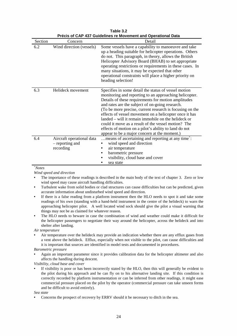
24
Table 3.2Précis of CAP 437 Guidelines re Movement and Operational Data
Section Concern Detail6.2 Wind direction (vessels) Some vessels have a capability to manoeuvre and take
up a heading suitable for helicopter operations. Othersdo not. This paragraph, in theory, allows the BritishHelicopter Advisory Board (BHAB) to set appropriateoperating restrictions or requirements in these cases. Inmany situations, it may be expected that otheroperational constraints will place a higher priority onheading selection!
6.3 Helideck movement Specifies in some detail the status of vessel motionmonitoring and reporting to an approaching helicopter.Details of these requirements for motion amplitudesand rates are the subject of on-going research.(To be more precise, current research is focusing on theeffects of vessel movement on a helicopter once it haslanded – will it remain immobile on the helideck orcould it move as a result of the vessel motion? Theeffects of motion on a pilot’s ability to land do notappear to be a major concern at the moment.)
6.4 Aircraft operational data– reporting andrecording
…means of ascertaining and reporting at any time+:• wind speed and direction• air temperature• barometric pressure• visibility, cloud base and cover• sea state
+NotesWind speed and direction• The importance of these readings is described in the main body of the text of chapter 3. Zero or low
wind speed may cause aircraft handling difficulties.• Turbulent wake from solid bodies or clad structures can cause difficulties but can be predicted, given
accurate information about undisturbed wind speed and direction.• If there is a false reading from a platform instrument then the HLO needs to spot it and take some
readings of his own (standing with a hand-held instrument in the centre of the helideck) to warn theapproaching helicopter pilot. A well located wind sock should give the pilot a visual warning thatthings may not be as claimed for whatever reason.
• The HLO needs to beware in case the combination of wind and weather could make it difficult forthe helicopter passengers to negotiate their way around the helicopter, across the helideck and intoshelter after landing.
Air temperature• Air temperature over the helideck may provide an indication whether there are any efflux gases from
a vent above the helideck. Efflux, especially when not visible to the pilot, can cause difficulties andit is important that sources are identified in model tests and documented in procedures.
Barometric pressure• Again an important parameter since it provides calibration data for the helicopter altimeter and also
affects the handling during descent.Visibility, cloud base and cover• If visibility is poor or has been incorrectly stated by the HLO, then this will generally be evident to
the pilot during his approach and he can fly on to his alternative landing site. If this condition iscorrectly recorded by platform instrumentation or can be inferred from other readings, it might easecommercial pressure placed on the pilot by the operator (commercial pressure can take unseen formsand be difficult to avoid entirely).
Sea state• Concerns the prospect of recovery by ERRV should it be necessary to ditch in the sea.

25
Table 3.3Weather Elements available from Offshore Platforms/Installations
Offshore platform/installation
Weather element: AH
001
Ana
suri
a
Auk
"A
" A
WS
Bea
tric
e "A
"
Ber
ge H
ugin
FP
SO
Ber
yl "
A"(
man
ual)
Ber
yl "
B"
Bra
e "A
" A
WS
Bre
nt "
A"
AW
S
Bre
nt "
B"
AW
S
Buc
han
"A"
Cap
tain
WP
P "
A"
Cli
pper
AW
S
Cor
mor
ant "
A"
AW
S
Dou
glas
pla
tfor
m
Dun
lin
"A"
AW
S
Ful
mar
"A
" A
WS
Gan
net
AW
S
Gry
phon
"A
"
Hew
ett
Arp
et "
A"
Jani
ce "
A"
Kit
tiw
ake
AW
S
Lem
an (
She
ll)
AW
S
Mau
reen
"A
"
Mor
ecam
be A
P1
Mor
ecam
be A
P1
AW
S
Nor
th A
lwyn
"A
"
Nor
th C
orm
oran
t AW
S
Nor
ther
Pro
duce
r
Rav
ensp
urn
Nor
th
Sea
n P
AW
S
Tar
tan
"A"
Ter
n "A
" A
WS
Tif
fany
Pla
tfor
m
Vik
ing
"B"
MSL pressure Y Y Y Y Y Y Y Y Y Y Y Y Y Y Y Y Y Y Y Y Y Y Y Y Y Y Y Y Y Y Y
Pressure tendency Y Y Y Y Y Y Y Y Y Y Y Y Y Y Y Y Y Y Y Y Y Y Y
Air Temperature Y Y Y Y Y Y Y Y Y Y Y Y Y Y Y Y Y Y Y Y Y Y Y Y Y Y Y Y Y Y Y
Dew-point Y Y Y Y Y Y Y Y Y Y Y Y Y Y Y Y Y
Wet-bulb temperature Y Y Y Y Y Y Y Y Y Y Y Y Y Y
Sea temperature Y Y Y Y
Wind speed direction Y Y Y Y Y Y Y Y Y Y Y Y Y Y Y Y Y Y Y Y Y Y Y Y Y Y Y Y Y Y Y
Present weather Y Y Y Y Y Y Y Y Y Y Y Y Y Y Y Y Y Y Y
Past weather Y Y Y Y Y Y Y Y Y Y Y Y Y Y Y Y Y
Measured visibility Y Y Y Y Y
Estimated visibility Y Y Y Y Y Y Y Y Y Y Y Y Y Y Y Y Y Y
Total cloud amount Y Y Y Y Y Y Y Y Y Y Y Y Y Y Y Y Y Y
Measured cloud height Y Y Y Y Y Y Y
Estimated cloud height Y Y Y Y Y Y Y Y Y Y Y Y Y Y Y Y
Cloud types Y Y Y Y Y Y Y Y Y Y Y
Measured waves Y Y Y Y Y Y Y Y Y Y Y Y
Estimated waves Y Y Y Y Y Y Y Y Y Y Y Y Y Y
Note : AWS is automatic weather station
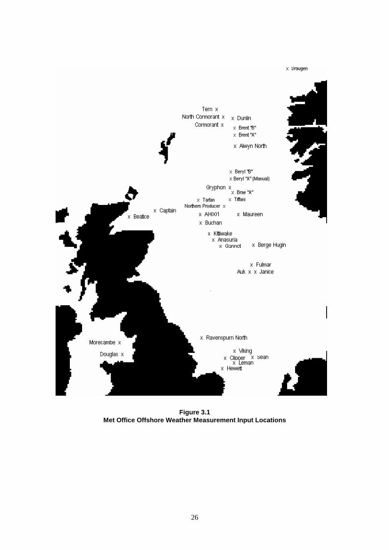
26
Figure 3.1Met Office Offshore Weather Measurement Input Locations
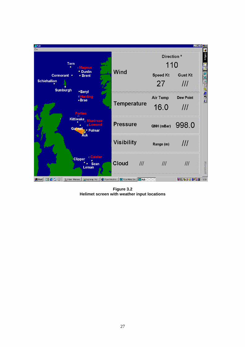
27
Figure 3.2Helimet screen with weather input locations

28
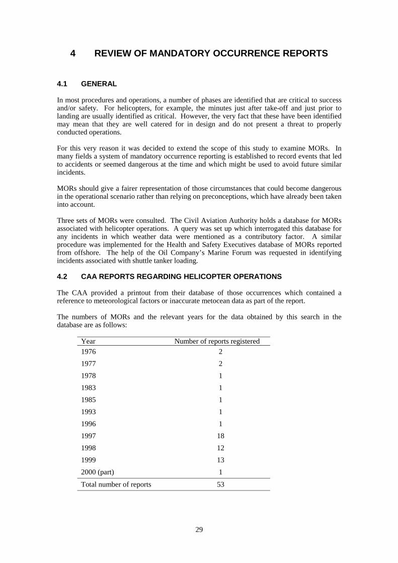
29
4 REVIEW OF MANDATORY OCCURRENCE REPORTS
4.1 GENERAL
In most procedures and operations, a number of phases are identified that are critical to successand/or safety. For helicopters, for example, the minutes just after take-off and just prior tolanding are usually identified as critical. However, the very fact that these have been identifiedmay mean that they are well catered for in design and do not present a threat to properlyconducted operations.
For this very reason it was decided to extend the scope of this study to examine MORs. Inmany fields a system of mandatory occurrence reporting is established to record events that ledto accidents or seemed dangerous at the time and which might be used to avoid future similarincidents.
MORs should give a fairer representation of those circumstances that could become dangerousin the operational scenario rather than relying on preconceptions, which have already been takeninto account.
Three sets of MORs were consulted. The Civil Aviation Authority holds a database for MORsassociated with helicopter operations. A query was set up which interrogated this database forany incidents in which weather data were mentioned as a contributory factor. A similarprocedure was implemented for the Health and Safety Executives database of MORs reportedfrom offshore. The help of the Oil Company’s Marine Forum was requested in identifyingincidents associated with shuttle tanker loading.
4.2 CAA REPORTS REGARDING HELICOPTER OPERATIONS
The CAA provided a printout from their database of those occurrences which contained areference to meteorological factors or inaccurate metocean data as part of the report.
The numbers of MORs and the relevant years for the data obtained by this search in thedatabase are as follows:
Year Number of reports registered
1976 2
1977 2
1978 1
1983 1
1985 1
1993 1
1996 1
1997 18
1998 12
1999 13
2000 (part) 1
Total number of reports 53
30
Most of the earlier reports, pre 1985, refer to errors in meteorological data reported by oilplatforms to approaching helicopters. The majority of the more recent reports, 1997 and later,refer to “alleged errors” in terminal approach forecasts (TAFs) associated with helicoptermovements. Some reports claim that the TAFs provided were “out-of-date.” A substantialnumber of the more recent reports also refer to “inaccurate forecasts for a North Sea sector.”Unlike the early reports, most of these problems are ascribed to inaccuracies in informationsupplied by shore-based airfield-based meteorological stations. Only two refer to inaccuraciesin data coming from North Sea platforms. A further two refer to inaccurate data in relation tomotion of a floater on which a helicopter had landed.
The problems created by these measurement and forecasting errors are attributed predominantlyto the cruise phases of missions but a few are also reported as causing problems duringapproach phases of a flight. Sometimes the problem does not arise in respect of an intendedlanding sight but with the nominated alternative landing site. In these cases the problem may bemore hypothetical than real for the flight registering the report but since the inherent safety ofhelicopter operations is based around the availability of alternative landing sites, it is importantthat notice is taken of these potential problems.
Most of the reports refer either to the “TAF” or the “weather” and are no more specific aboutwhich aspect of these affected the helicopter operation that logged the report. However, it isevident from those which did give details, that wind speed, wind direction, visibility and cloud-base are each likely to be in error on some occasions.
4.3 HSE REPORTS REGARDING OPERATIONS ON THE UKCS
The database of mandatory occurrence reports was interrogated for incidents between 1996 and2000 which reported weather conditions as a contributory factor. A total of 88 category 1,2,3and 4 incidents were found.
Of these the majority related to incidents caused by wind. Thirty-two MORs related to itemsbeing dislodged by wind and falling to the deck or into the sea. Doors being caught in wind,trapping fingers, causing a shoulder dislocation or knocking someone over caused eight. Sevenarose from wind gusts either moving a load or causing someone to over-balance.
Sixteen related to wave damage, whether green water damage (on an FPSO and a TLP), damageto boat bumpers or under-deck damage caused by a large wave and a further five were causedby vessel movement in waves.
Six incidents of mooring line breakage and/or anchor dragging were found but these all relatedto mobile drilling units and are therefore not of prime interest to the present study.
There were seven incidents relating to crane or mechanical handling operations which wentwrong. Those relevant to this study are detailed below:• A crane could not be replaced in its rest because wind speed was too high and subsequently
caused damage.• There were four incidents in which supply boat operations were influenced by high wind
and/or re-contact between load and deck of supply boat.
None of these reports is supported with any evidence about the wind or wave conditions at thetime. It is difficult to know whether recommended operating limits were being exceeded or not.
Of the remaining seven miscellaneous incidents, those relevant to this study can be identified as:• A gangway disconnect occurred even though the weather had not been sufficiently severe as
to activate the disconnect alarms• An incident occurred in which blocks of ice fell from the structure of a drilling derrick onto
those working below• A drum was released from its lashings during motion of an FPSO
31
• A shuttle tanker responding to wave excitation parted the hawser at the Kittiwake loadingbuoy. The shuttle tanker was preparing to depart at the time.
4.4 SHUTTLE TANKER OPERATIONS
There have been several instances of shuttle tanker incidents at loading buoys (Reference 4).There are many causes for these incidents (Reference 3) but some are due to operations takingplace in marginal weather conditions. Initially, having talked to a tanker Captain at OCIMF, theimpression was gained that there had been sufficiently large improvements in dynamicpositioning technology that these incidents should be reducing. However, the NPD commentedthat despite the technological improvements, they seemed to receive just as many incidentreports as previously. During a visit to Navion, reports were reviewed on three incidents andreference was given to a further three in UK waters. Of the three examined in detail, one wasclearly due to attempts to work in marginal weather conditions that were not fully recognisedbecause of poor wave measurement readings from the FPSO.

32
33
5 FLOATING AND FIXED INSTALLATIONS
5.1 GENERAL
Insofar as the differences that have emerged between provisions for weather-sensitiveoperations for fixed and floating production systems, the comments are collected and discussedin this chapter.
5.2 HELICOPTER OPERATIONS
There are several factors which distinguish between helicopter operations to floating and fixedstructures:1) motion of the helideck2) location of the helideck3) vessel heading4) measurement of meteorological data.
Motion of the helideck causes problems for landing and also for static stability of the helicopterafter it has set down. According to information received, once in receipt of advancedinformation that helideck motion is within specified norms, pilots do not appear to find it toodifficult to make a landing on a moving helideck (at least in hours of daylight). A pilot canusually approach to a suitable point alongside and monitor the movement of the helideck beforechoosing his time to move in to land when he is satisfied that he can do so safely.
There appears to be a problem in assessing whether a helicopter will continue to sit at rest on amoving helideck and the CAA are having this aspect assessed in an on-going research project.Pilots themselves also question whether present-day motion measurement parameters aresufficient for making a land/no-land decision. Hence heave motion of plus or minus 2 m mayallow a landing when the associated wave period is long (greater than 20 seconds, say). Therewould appear to be scope for providing an HLO with better instrumentation and a better modelagainst which he can evaluate landing clearance and on-deck-stability for an approachinghelicopter. The model might be complex in some circumstances since it should take intoaccount the combined effects of ship heading and wind direction together with real-time valuesof helideck motions. The HSE have implemented a pilot study to determine whether it ispossible to provide forecasts of vessel responses which might be useful in this context.
Location of the helideck is liable to affect not only the airflow over the helideck, but also thepilot's view of the ship and helideck during his approach. In extreme conditions, the pilot maybe deprived of good visual cues during his landing manoeuvres. However, the BritishHelicopter Advisory Board (BHAB) are aware of these problems and might be expected toprovide excellent guidance on the design and outfitting of the helideck area to avoid them(provided they are consulted/made aware of the specific design in good time).
In theory, a vessel heading could be changed to allow more beneficial conditions for helicopteroperations to be established and thereby reduce the pilot’s work load during landing and take-off. Unfortunately, there are many other priorities for selecting vessel heading such as separatorperformance, reduction of roll motion, dispersal of noxious effluxes, supply boat operation, etc.,and it is unlikely that the pilot will be able to count on this type of intervention on his behalfexcept in very special or emergency circumstances.
It has been pointed out that the measurement of wind direction from a weather-vaning floaterand wave height from any monohull is difficult. More effort should be assigned during thedesign stages to ensure that wind measuring equipment is sited and properly supported in areas
34
where it can provide accurate data, no matter what the wind direction or how the heading of thevessel is controlled. If wave height, rather than vessel motion, is an important parameter forsetting operational limits, then more research is required to establish how these data can best beobtained.
5.3 SMALL MONOHULL SUPPORT VESSELS
5.3.1 Supply Ships and Diver Support Vessels
There is little in published guidelines to distinguish between supply boat operations at fixed andfloating facilities. An FPSO makes an excellent wind shield so it is possible in many instances,for the supply boat to work in a relatively sheltered location. This assumes that the FPSO has afunctional crane with adequate reach and lift capacity on both sides. If not, the supply boat maybe forced to operate on the weather side and this will only be undertaken under more restrictiveweather conditions.
A floater will also be subject to slow motion oscillations as it moves on its moorings and thiswill demand more vigilance by the master of a dynamically-positioned supply boat as he tries tomaintain himself in a good position relative to the crane or hoses.
Clearly, if the heading of an FPSO were being maintained by thruster action, then the visitingsupply boat skipper would need to be aware of the potential disturbances that might be causedby propeller out-wash. Further, if the FPSO were subject to excessive motions, then this mightaffect the safety of an intended loading or back loading.
If vessel movement is a common feature of the FPSO (whether an inherent characteristic or dueto weather), it would seem essential to provide some rational estimate of the motion and therelative motion between it and a supply boat for the purposes of planning and ensuring safesupply operations. These calculations would need to take into consideration the vulnerabilitiesof FPSO and supply boat in the event that something went wrong and a ‘representative’ impactoccurred. It seems unreasonable to expect anyone to make a balanced judgement about the riskof extreme relative motion and consequential impact damage in a situation in which commercialpressures may be intense. Operational limits need to be set against some rationally considereddesign scenario and observed by the field operatives.
5.3.2 Emergency Rescue and Recovery and Fast Rescue Vessels
The operators of ERRVs and their daughter FRVs did not acknowledge any appreciabledifferences in their operations around fixed and floating structures other than might be due tothe different weather conditions associated with the areas in which they were located. Floatingvessels tend to operate in moderately deep water remote from shore where short steep waves(which cause problems for smaller boats) may be less common.
5.4 CRANAGE
There are few essential differences between weather limits for crane operations from floatersand those from fixed platforms. In some cases, the floater supporting the crane may be movingtoo much in response to the weather but, in these conditions, the ship or barge from which anobject is being lifted would also be moving and this would tend to restrict the crane operationsmore severely. The process and operation decks on FPSOs are lower than those on fixedstructures, semi-submersibles and tension leg platforms and so tend to be less exposed to highwinds.
5.5 SHUTTLE TANKER OPERATIONS
Generally, offshore shuttle tanker operations take place at floating facilities (buoys, or turretmoored floating vessels). Fixed platforms, semi-submersibles and tension leg platforms are
35
seldom approached by shuttle tankers because of the risks inherent in such manoeuvres. It is ageneral requirement for a tanker to avoid encroaching on a platform exclusion zone that mightcause access difficulties or weather directional restrictions at a nearby loading buoy.
By contrast, shuttle tanker offloading from an FPSO or FSU is commonplace. However tandemloading is recognised as a difficult and potentially hazardous operation. This leads to the needfor the elaborate system of training and risk management referred to previously.
5.6 ON BOARD OPERATIONS AND MAINTENANCE ACTIVITIES
Operations on-board or over the side of tension leg platforms suffer similar restrictions to thoseon a fixed structure. A semi-submersible working at operational draught will be similar withthe exception that it will be necessary to maintain awareness of other conditions that couldrequire the vessel to relocate on its moorings and/or go to survival draught in the face of asevere storm.
Since the process and operational decks of an FPSO are so much closer to the water surface, itmay be necessary to suspend some operations and for the crew to vacate lower decks or seekshelter under certain wave conditions. These difficulties are not specifically identified in any ofthe documentation obtained during the conduct of this study and this raises the question as towhether the green-water events have been properly recognised in existing adverse weatherpolicy documents.
A floating vessel may take up non-zero trim and heel angles from time to time, and these maymake some maintenance operations more difficult. However, the planning of on-boardoperations and the permit-to-work system should take these factors into account.

36
37
6 REGIONAL VARIATIONS (SNS, CNS, NNS, IS & NWA)
6.1 GENERAL
This section considers where significant differences exist in the application of metoceanmeasurements and meteorological forecasting according to region of the UKCS.
6.2 HELICOPTERS
There are significant differences in how meteorological observation and forecasting interactwith helicopter operations across the various areas of the UK continental shelf. The followinglist attempts to set out in a succinct manner what the contributory differences are:
1) West of Shetland / North West Approaches
• Most/all production facilities and support vessels are floaters.
• There is a greater chance (50% greater by one estimate) that helicopter operations may becurtailed by deck motion limitations than in the Central or Northern North Sea.
• There is also a greater likelihood that helicopter operations may be curtailed by severe waveconditions, which would make recovery of personnel from the water more difficult.
• The sites in this area are exposed to potentially severe weather from different directions.
• Strong currents may prevent weather-vaning vessels from responding to prevailingconditions in the anticipated manner.
• There may be limited capacity to control ship’s heading by using thrusters.
• Helicopter flights are similar in length to those to the Northern North Sea, but significantlylonger than those to other areas.
• Alternate offshore landing sites will, most likely, be affected by the same weather as theintended destination and therefore there must be greater reliance on continuing the flight forsome considerable distance to a shore-based airfield.
2) Northern North Sea
• Helicopter flights to these fields are long.
• The helicopter pilot may be reliant on weather information from shore-based facilitieswhich are significant distances from his direct route.
• The area is exposed to severe weather from the North West.
• There are significant chances of severe weather in which Emergency Response and RescueCraft would find it difficult to operate.
3) Central North Sea
• Single flights are shorter but there may be requests to combine multiple hops into oneoperation.
38
• Although weather may not be as severe as in the NNS or W of S it may still be sufficientlybad as to curtail helicopter operations for many of the reasons already cited.
4) Southern North Sea and Irish Sea
• Offshore wave heights are seldom so high as to prevent the ERRV from operating.However, wind directions may change and cause steeper, shorter period waves fromparticular directions. These may make operations of ERRV and their daughter craft moredifficult. Hence information about storm directions are more important.
• Tidal currents may limit ERRV operations. Underwater sandbanks may cause particularlystrong local currents. These can restrict the operation of ERRVs and their daughter craft.
• Flights over the sea are much shorter than in other areas and therefore less dependent onforecast conditions.
• There are many more “Normally Unattended Installations” (NUI) for which additionalguidelines apply (reference UK Offshore Operators Association report on “Guidelines forHelicopter Operations to Normally Unattended Installations” Issue 2, March 1997).
• For most NUI satellite platforms, no weather measuring equipment is required but, as aresult, some organisation or nearby facility should be nominated to monitor the weather inorder that the personnel may be recovered before the onset of a deterioration which wouldsubsequently prevent this.”
• Guidelines for NUIs distinguish ‘remote’ installations, which are more than 40 nauticalmiles from the nearest installation or airport/heliport.
Taking into account comments received and the findings of the MOR reviews, the followingwould seem to be the most relevant observations pertinent to the present study.
1) West of Shetland
• The on-going study of Motion Reference Index being supervised by the CAA would stillappear highly relevant.
• Consideration should be given to reviewing the performance of all meteorologicalparameter sensors on FPSOs to ensure that the HLO has the best information available toadvise an approaching pilot. This is particularly important for the wind sensors, which maybe adversely affected by turbulence depending on the vessel heading.
2) W of S, NNS and CNS
• It is surprising to see how often helicopter pilots are reporting allegedly inaccurate TAFsfrom share-based airports and how often they appear to encounter significantly worseweather than forecast. This would point to a need for a significant tightening of currentprocedures and the possible introduction of some extra airfields at key locations eitheronshore or offshore.
• To ensure that pilots are provided with accurate data about wind speed and direction, twoactions should be considered:
Review of the performance and calibration of platform-based wind monitoringequipment, particularly after a major topside re-configuration,
Designation of a small number of offshore facilities as airfields to ensure the collectionof accurate, wind data at more specific locations throughout the Central and Northern
39
North Sea. This would not necessarily help with cloud base and visibility data for allfacilities because this information may be very localised, but it should be possible togive pilots a better view of the current wind conditions throughout this area of the NorthSea which is based on ‘reliable’ data.
It is unclear, at present, whether emerging forecast technology will give the ability to presentmore reliable data regarding waves and currents. It would seem appropriate to initiate a pilottrial of this technology over a representative number of offshore installations.
3) SNS and IS
• Southern North Sea practices should be monitored to ensure that appropriate notice is takenof weather conditions for new platforms that are further from shore.
6.3 SMALL MONOHULLS
6.3.1 Supply Ships
Significant regional variations exist in supply boat operations on account of the relative severityof tidal effects, currents, wind and wave characteristics (ranges of heights, periods andsteepnesses) and length of voyage.
In the Southern North Sea and Irish Sea, the weather is not so severe but the tidal currents canbe so extreme as to prevent a supply boat taking up a heading which is required for someplatform approach. Tidal currents are relatively predictable, however, and the skipper of avessel can plan his operations with this in mind.
In some areas, wave details (length and steepness) may also change significantly depending onthe water depth throughout the fetch and this may affect the response of a smaller ship.
Some operators (for example, Shell) lay down very stringent restrictions on conditions formarine access to normally unmanned platforms. These restrictions apply to visibility; daylighthours and duration of visit; wave height; tide; weather effects (wave, swell, wind, current -generally less than Beaufort 4 or 5); temperature (wind chill) and forecast conditions.
In the Central North Sea, weather conditions may be such as to prevent meaningful operations.If the weather en route is such that it might cause damage or severe discomfort to the crew andthere is a likelihood that the vessel will spend a significant period waiting-on-weather (WOW)once it gets there, then the vessel should not leave port.
Similar restrictions apply to the Northern North Sea and West of the Shetlands, although insome cases a voyage to the sheltered waters around Orkney or Shetlands might be justified sothat the operation can be completed relatively quickly when the weather abates.
In deeper waters, which justify the use of a floater, other considerations may apply as describedin Chapter 5.
6.3.2 Emergency Rescue and Recovery and Fast Rescue Vessels
The variations in operational restrictions with location associated with these craft are similar tothose for any other small monohull support ships as described above. Around underwatersandbanks, induced currents can be so strong as to make it more practical to take a course whichavoids the area rather than attempt a direct traverse.
40
6.4 SEMI-SUBMERSIBLE AND JACK-UP SUPPORT
These two groups of operations tend to take place in different water depths, semi-submersiblesupport in deeper water (greater than 80m, say) and jack-up support in shallower water (lessthan 90m). Hence jack-up operations on the UK continental shelf are limited to the SouthernNorth Sea, the Irish Sea/Liverpool Bay and some shallow water pockets in the Central NorthSea. Semi-submersible support operations tend to be in the other deeper water areas.
Jack-up movement and positioning may be limited by sea state, but once on location it must staythroughout the weather associated with that area at the requisite time of year. Nevertheless,there will be a relative motion between a jack-up and the fixed platform it is supporting and anumber of operations may have to be suspended in storm conditions. Weather forecasting maybe critical if it takes a protracted period to make an operation safe.
Semi-submersible support such as flotel operation, tender assistance or utilities support will notbe sensitive to moderate sea states. They will require good forecasting of severe weather so thatoperations can be suspended in good order and made safe against the approaching storm. Inboth cases the main concern is that severe weather is correctly identified and forecast. Providedthese forecasts can be made reliably throughout the UKCS, then there will be little difference inthe operational requirements.
41
7 NORWEGIAN EXPERIENCE
7.1 GENERAL
When OCIMF were contacted for information about shuttle tanker operations, they pointed outthat the majority of such vessels were Norwegian-based. They considered that this study shouldextend to shuttle tanker experience in Norwegian Waters. It was therefore decided to extend thestudy to a review of practices in Norwegian waters. To this end meetings were set up with theNorwegian Petroleum Directorate (NPD) to obtain an overview and with Navion ASA, toexamine the shuttle tanker issues in more detail. Subsequently, telephone contact and e-mailcontacts were made with NPD, the Norwegian Civil Aviation Authority (NCAA) and theNorwegian Meteorological Institute. This chapter describes the results of these contacts.
The regulatory requirements for the collection of environmental data from Norwegian oilfacilities is set out in NPD Regulations (Acts, Regulations and Provisions for the PetroleumActivity, Volume 2, Updated 1/1/94).
The purpose of the regulations is to obtain:• background data for use in planning and design• environmental data in real time (for operations)• forecast data
and to provide for suitable supervision. NPD supervises compliance with the regulations andmay require the operator to collect, store, process and report environmental data such as:• meteorology• oceanography• seismology• biologyfor a number of different ‘end-users’.
All Norwegian platforms which support helicopter operations are designated ‘airfields’ withinthe terms of civil aviation authority definitions and consequently they are required to measureand record data in accordance with the International Standards and Recommended Practices forthe Meteorological Service for International Air Navigation. Since satisfactory instrumentationfor the measurement/identification of cloud cover has yet to be developed/tested/proved, thisregulation has the effect that each platform must have meteorologically trained observers tomake the necessary regular reports. The regulations also require that ‘any malfunction ordamage that might occur shall be rectified without delay.’
In addition to the instrumentation needed for helicopter operations, NPD have identified ninespecific platforms for more extensive measurement of meteorological and oceanographicparameters. These are listed below and the locations of those close to UK waters may bedetermined from Figure 7.1.
Det Norske Meteorologisk Institutt (DNMI) and NPD are interested to understand theopportunities for automatic collection of meteorological data and to this end a trial set ofautomatic environmental sensors and recorders has been mounted on the Troll B platform inaddition to the standard manual instruments.
Where an operator seeks a licence to explore and develop new areas, such as in the Barents Sea,then the NPD can require more extensive environmental measurements so that an appreciationof the key features of these areas can be built up before any development for oil production isinitiated.
42
7.2 HELICOPTER OPERATIONS
The Norwegian Civil Aviation Authority (NCAA) controls helicopter operations to Norway’soffshore oil fields. Since each production facility is designated an airfield, it is assigned a fourletter identifier. Meteorological data, terminal approach forecasts and trends are providedregularly and can be accessed by any pilot who is planning a flight.
Meteorology, as referred to in the regulations, is taken to mean, inter alia:• wind• waves• weather at the time of observation• weather since the last observation• clouds; altitude, types and amounts• range of vision (visibility)• air temperature• atmospheric humidity• precipitation• atmospheric pressure, value and tendency• sea temperature in surface layers• ice accretion• sea ice, type and concentration, thickness and the ice border
The range and accuracy of instrumentation associated with these measurements are contained inTable 7.1. However, trained observers are needed to make some of these measurements sincesuitable accredited instruments have yet to be devised.
Separate regulations apply to helicopter decks on offshore platforms, and these stipulateadditional instrumentation to enable altimeter settings to be adjusted and to monitor vesselmotions (when the helideck is on a floater).
DNMI recognise a range of difficulties in making correct meteorological readings, particularlyfrom a floating monohull. These will be discussed more extensively in Section 7.4 where theyare possibly more important.
UK helicopter pilots view the status of the organisation of the meteorological reading andforecast on Norwegian platforms with envy and frequently access data from the nearestavailable Norwegian site to back-up data they are provided from platforms in UK waters.
However, a spokesman for the NCAA admitted to being less than happy with the current stateof offshore helicopter operations as a whole. They have asked SINTEF to undertake twostudies to review all aspects of flight and helideck operations. This work is in hand. The firststudy which deals with legislation and organisational issues is scheduled to produce a firstreport in June 2001 while the second will examine more detailed technical concerns and isexpected to report in the Spring of 2002. A brief description of the remit for the studies hasbeen provided by Fure Dagheid from the Norwegian Civil Aviation Authority and is reproducedin the following two paragraphs.
“Norway’s Civil Aviation Authority has the Secretariat for a Committee for the Review ofHelicopter Safety on the Norwegian Continental Shelf. The Committee is appointed by theMinistry of Transport and Communications in Norway and is looking into helicopteroperations/activities in connection with the petroleum business on the Norwegian ContinentalShelf. The Committee consists of 11 members representing the public authorities, the industryand unions. The Chairman is Vice President, Research, Tor Ulleberg at SINTEF IndustrialManagement.
43
The Committee's review consists of two parts where the first part (which we are currentlyworking on) will consider in particular how the public authorities' involvement on thecontinental shelf is organised. As part of the review the Committee's tasks is to obtain anoverview of what public authorities/agencies are responsible regarding helicopter safety on thecontinental shelf, what their roles/tasks are, what laws and regulations govern this area and whatis not clear when it comes to responsibilities, regulations etc. It's also part of the review toobtain an overview of British/Danish/Dutch laws, regulations etc. regulating the helicopteroperations on the continental shelf, how these operations are regulated and organised, inaddition to how the supervision with the operations is carried out. Finally, the Committeeshould propose how to improve the organising and regulating of this area. The review's deadlineis 01.06.01. The second part of the review will propose realistic goals for helicopter safety andconsider specific safety measures. Deadline is 01.04.02.”
7.3 SUPPLY BOAT OPERATIONS
NPD have seen many collisions between supply boats and platforms, some of which were dueto weather. They felt that some of these incidents arose from the rapid change in direction ofenvironmental forces. They pointed out that the six hour period between ‘standard weatherforecasts’ is too long to spot the types of rapid changes which could affect a supply operation.When a supply boat is operating close to a platform, the master of the vessel is not in the bestposition to spot some rapidly changing situations. Either the platform or a standby vessel maybe better placed to make these observations and it is important that the captain of the supplyboat is informed in time for him to take appropriate action.
7.4 TANKER/FLOATER OPERATIONS
NPD pointed to an incident which had occurred with the Balder FPSO. This vessel relies tosome extent on DP technology to enable it to turn head into severe weather. Unfortunately, onone occasion, the DP system had been unable to react quickly enough to a rapid change in thedirection of a storm and, as a result, it came broadside to the weather. It was unable to recoverfrom this situation and had to remain broadside to the weather until the storm abated. Clearlythis could have been a very serious incident had the storm developed further.
NPD commented that they seemed to be receiving a number of reports relating to damagecaused by the operation of DP shuttle tankers. This is in spite of the great improvements indynamic positioning technology.
Navion (one of the major operators of high specification shuttle tankers) made some incidentreports available for review, relating to incidents in the Norwegian sector. They also referred toother incidents that had happened on the UKCS, but referred to the operators if more extensiveinformation is needed. Specifically, incidents involving shuttle tankers at the FPSOs on BP’sScheihallion field, Texaco’s Captain field and Kerr McGee’s Gryphon field were mentioned.
Of the three reports of incidents in the Norwegian sector, one appeared to be due to problemswith the defaults built in to the operation of the DP system and was not weather related. Asecond arose from a problem with the position referencing system (again not due to weather).The third was a clear case of a DP operation that was being conducted in marginal weatherconditions. A clear inference from that report was that even experienced masters cannotenvisage all the extreme dynamic positioning and load conditions that might arise during aloading operation. Hence it is incumbent on the designer/operator to specify limiting sea statesand for the operators and master to observe these. It is also evident that there are considerabledifficulties in obtaining accurate data about significant wave heights from instruments that aresituated on an FPSO vessel. Nevertheless such data is important for the proper management ofloading operations.
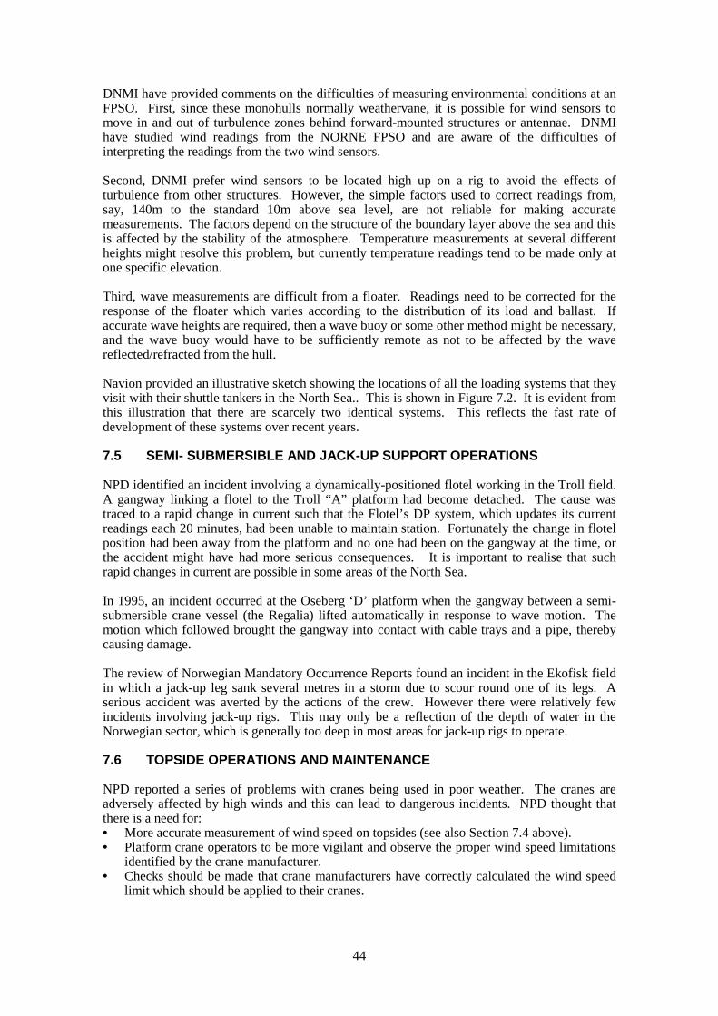
44
DNMI have provided comments on the difficulties of measuring environmental conditions at anFPSO. First, since these monohulls normally weathervane, it is possible for wind sensors tomove in and out of turbulence zones behind forward-mounted structures or antennae. DNMIhave studied wind readings from the NORNE FPSO and are aware of the difficulties ofinterpreting the readings from the two wind sensors.
Second, DNMI prefer wind sensors to be located high up on a rig to avoid the effects ofturbulence from other structures. However, the simple factors used to correct readings from,say, 140m to the standard 10m above sea level, are not reliable for making accuratemeasurements. The factors depend on the structure of the boundary layer above the sea and thisis affected by the stability of the atmosphere. Temperature measurements at several differentheights might resolve this problem, but currently temperature readings tend to be made only atone specific elevation.
Third, wave measurements are difficult from a floater. Readings need to be corrected for theresponse of the floater which varies according to the distribution of its load and ballast. Ifaccurate wave heights are required, then a wave buoy or some other method might be necessary,and the wave buoy would have to be sufficiently remote as not to be affected by the wavereflected/refracted from the hull.
Navion provided an illustrative sketch showing the locations of all the loading systems that theyvisit with their shuttle tankers in the North Sea.. This is shown in Figure 7.2. It is evident fromthis illustration that there are scarcely two identical systems. This reflects the fast rate ofdevelopment of these systems over recent years.
7.5 SEMI- SUBMERSIBLE AND JACK-UP SUPPORT OPERATIONS
NPD identified an incident involving a dynamically-positioned flotel working in the Troll field.A gangway linking a flotel to the Troll “A” platform had become detached. The cause wastraced to a rapid change in current such that the Flotel’s DP system, which updates its currentreadings each 20 minutes, had been unable to maintain station. Fortunately the change in flotelposition had been away from the platform and no one had been on the gangway at the time, orthe accident might have had more serious consequences. It is important to realise that suchrapid changes in current are possible in some areas of the North Sea.
In 1995, an incident occurred at the Oseberg ‘D’ platform when the gangway between a semi-submersible crane vessel (the Regalia) lifted automatically in response to wave motion. Themotion which followed brought the gangway into contact with cable trays and a pipe, therebycausing damage.
The review of Norwegian Mandatory Occurrence Reports found an incident in the Ekofisk fieldin which a jack-up leg sank several metres in a storm due to scour round one of its legs. Aserious accident was averted by the actions of the crew. However there were relatively fewincidents involving jack-up rigs. This may only be a reflection of the depth of water in theNorwegian sector, which is generally too deep in most areas for jack-up rigs to operate.
7.6 TOPSIDE OPERATIONS AND MAINTENANCE
NPD reported a series of problems with cranes being used in poor weather. The cranes areadversely affected by high winds and this can lead to dangerous incidents. NPD thought thatthere is a need for:• More accurate measurement of wind speed on topsides (see also Section 7.4 above).• Platform crane operators to be more vigilant and observe the proper wind speed limitations
identified by the crane manufacturer.• Checks should be made that crane manufacturers have correctly calculated the wind speed
limit which should be applied to their cranes.
45
The UK MORs seem to identify problems with the opening of doors in exposed locationsleading to injury. NPD checked their records but found that relatively few such incidents hadbeen reported in their system.
High winds had caused damage due to unexpected movement of an entire drilling rig on theSleipner platform. It was found that the rig had not been sufficiently well tied down.
7.7 MANDATORY OCCURRENCE REPORTS
The MORs provided by Norway that are most relevant (to this study) have been describedabove. However there were a large number of reports which indicated some error in a designcalculation such as an underestimate of a wind force or a required air-gap. Further, the query ofthe database was commented as only being partially successful and the comment was made that“there were more than likely, more relevant occurrences” which might have been retrievedgiven a longer time to make the search. If these are perceived as important issues, then furtherinspection of the recorded data be recommended.
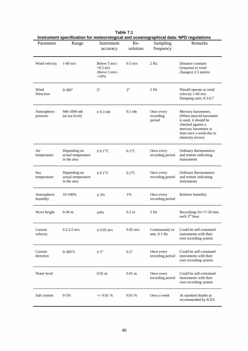
46
Table 7.1Instrument specification for meteorological and oceanographical data: NPD regulations
Parameter Range Instrumentaccuracy
Re-solution
Samplingfrequency
Remarks
Wind velocity 1-60 m/s Below 5 m/s:-+0.5 m/sAbove 5 m/s:-+10%
0.5 m/s 2 Hz Distance constant(response to windchanges) 2-5 metres
WindDirection
0-360° 5° 2° 2 Hz Should operate at windvelocity 1-60 m/s.Damping ratio: 0.3-0.7
Atmosphericpressure
940-1060 mb(at sea level)
± 0.3 mb 0.1 mb Once everyrecordingperiod
Mercury barometers.(When aneroid barometeris used, it should bechecked against amercury barometer atleast once a week due toelasticity errors).
Airtemperature
Depending onactual temperaturein the area
± 0.1°C 0.1°C Once everyrecording period
Ordinary thermometersand remote indicatinginstruments
Seatemperature
Depending onactual temperaturein the area
± 0.1°C 0.1°C Once everyrecording period
Ordinary thermometersand remote indicatinginstruments
Atmospherichumidity
10-100% ± 3% 1% Once everyrecording period
Relative humidity
Wave height 0-30 m ±4% 0.2 m 2 Hz Recordings for 17-20 min.each 3rd hour
Currentvelocity
0.2-2.5 m/s ± 0.05 m/s 0.02 m/s Continuously ormin. 0.1 Hz
Could be self-containedinstruments with theirown recording system
Currentdirection
0-360°C ± 5° 0.2° Once everyrecording period
Could be self-containedinstruments with theirown recording system
Water level 0.02 m 0.01 m Once everyrecording period
Could be self-containedinstruments with theirown recording system
Salt content 0-5% +/- 0.01 % 0.01 % Once a week At standard depths asrecommended by ICES
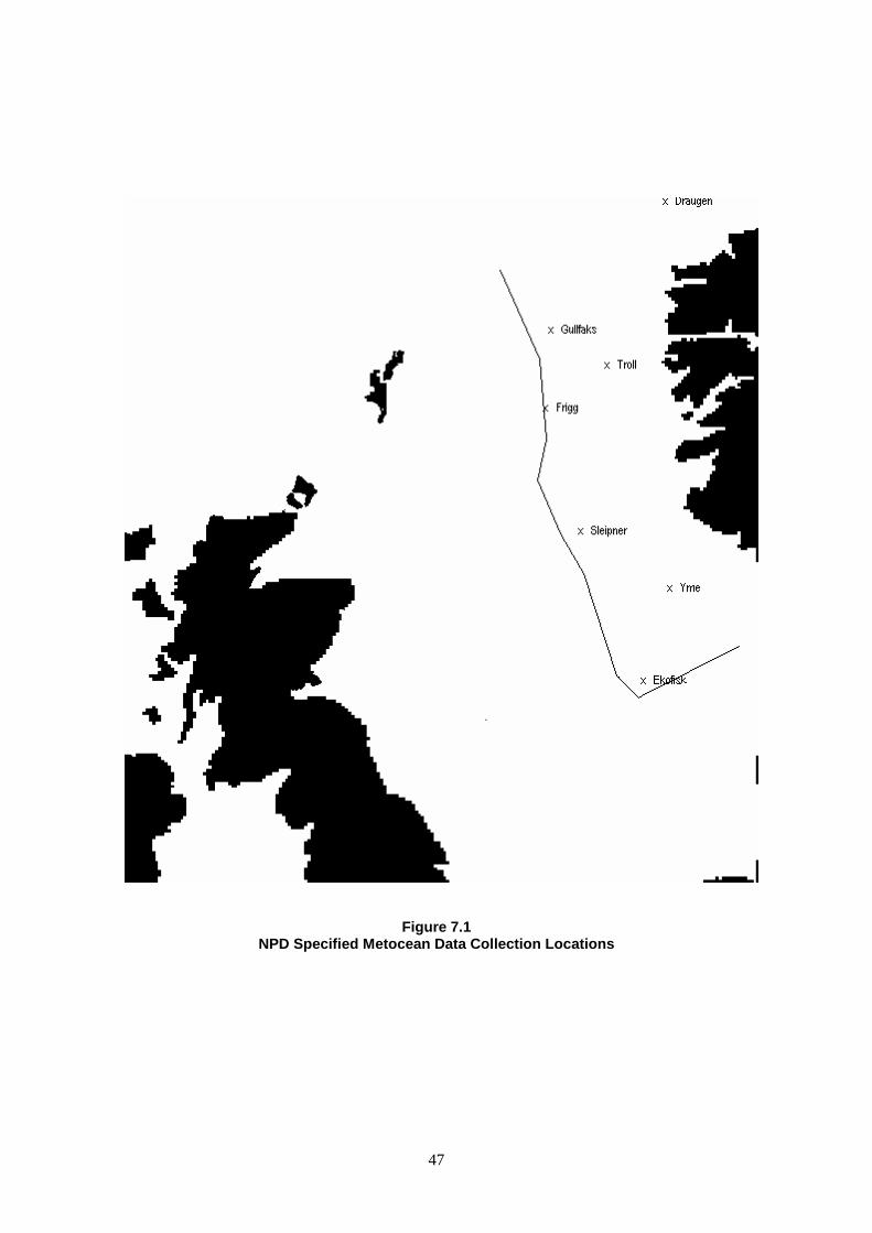
47
Figure 7.1NPD Specified Metocean Data Collection Locations
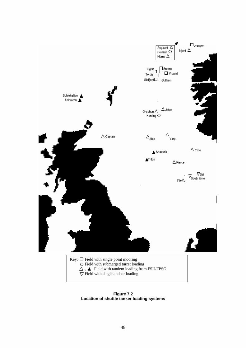
48
Figure 7.2Location of shuttle tanker loading systems
Key: Field with single point mooringField with submerged turret loading, Field with tandem loading from FSU/FPSOField with single anchor loading
49
8 DISCUSSION
8.1 GENERAL
Improvements are taking place in the types, level, detail and delivery of weather forecastinginformation that could be available in the foreseeable future. In addition to conventionalforecasts, wind and swell models are being developed and pilot trials are being held ofresponse-based forecasting. Before many of these schemes are introduced to the offshorecommunity at large, it would be helpful if some general degree of verification and validationhad been achieved by comparison with measured data. It would be a retrograde step tointroduce for these schemes without assessing the reliability of the information for those whomit is meant to help. Wide spread validation and assessment throughout the North Sea (or UKCS)would be helped if there was in existence, a network of reliable data measurement stationsamong the existing platforms with the readings available from several onshore and offshorelocations.
8.2 HELICOPTER OPERATIONS
It seems appropriate to begin the discussion with those items identified from MORs. Themajority of MORs refer to meteorological data supplied for the planning of flights rather than toplatform-based measurements used for the landing on offshore helidecks. This would seem toindicate inadequacy or slackness-in-application of normal airfield operating procedures ormeteorological forecasting since the majority of these reports refer to data received from land-based airfields and not from any particular set of data provided by any offshore platform orgroup of platforms. On the other hand, given the relatively short journey times and theavailability of “heli-met” data from all the sites shown in Figure 3.2, there must be a suspicionthat pilots are not making best use of the data available to them. Figure 3.2 indicates theavailability of valid ‘heli-met’ data for most sectors of the North Sea, so a brief review of thesedata would likely reveal any gross inadequacy in the assessment of weather for the followinghour or so. It would seem that a review is needed to find out how the presentation ofmeteorological data to helicopter pilots is working and how it can be improved.
Helicopter operations to moving helidecks would seem to cause some problems. The current,about-to-be-completed CAA research, into the stability of a helicopter on a moving helideckshould be closely examined to find if it indicates where any more general improvements can bemade. No one indicated that pilots had any particular difficulties in effecting a safe landing on amoving helideck, but pilots seem to think that the present motion indicators are too simplisticsince they do not distinguish rapid wave induced motions from slower, less troublesome swellmovements. Note should also be taken of the comments received about the difficulty of makingsatisfactory measurements of wind speed/direction and wave height from an FPSO. Theheading changes caused by weather-vaning or deliberate heading control, ensure that most windsensors will find themselves in the turbulent wake of a structural element on some occasionsand this could lead to inaccuracy in determining wind speed and direction. For an isolatedFPSO, careful study and wind tunnel tests may be required to identify the best location for oneor more sensors. When the FPSO is close to other fixed platforms, then provision should bemade for additional data to be made available to the HLO and approaching pilot, such asreadings of wind speed and direction from near-by facilities. Similarly, wave information, if notavailable from a suitably calibrated wave buoy should also be obtained from surroundingplatforms.
The following points did not arise from the MORs but from specific comments received duringthe study:
• Platform-based instruments need careful monitoring to ensure that they remain serviceableand within calibration. This was felt important given the age of some North Sea structures.
50
BHAB should ensure that these aspects are adequately reviewed during their inspectionvisits.
• Access to corresponding information from surrounding platforms may alert an operator to afailure of his own equipment. The HLO or other responsible individual(s) should becharged with regular checking of wind sensor readings against those from surroundingplatforms. This task could be made more productive if a network of platforms wasmaintained with known accurate calibrated sensors and each such platform was given theresponsibility for issuing wind data to near-by platforms which was adjusted for any knowndifferences in instrument height or location.
• All metocean equipment must be reassessed for adequacy and location after any substantialtopside modifications, particularly when changes are made in the location and/or function ofgas vents and exhaust ducts. Operators must be encouraged to register all such changes.
• Consideration should be given to requiring operators to identify an individual who isresponsible for all aspects of heli-met equipment. It seems difficult to track down all theindividuals who have a contribution to make (HLO, radio operator, instrument/electricaltechnician, OIM, helicopter pilots, BHAB, equipment suppliers) so an individual should bemade a point of contact for all internal and external communications.
• Where Norwegian operational requirements would imply that a trained meteorologicalobserver should always be on duty, this seems too onerous for the requirements ofproviding the data that is necessary to support helicopter operations. Consideration shouldbe given to a minimum level of training necessary to provide these data and vouch for theadequacy of readings from automatic measuring instruments. The voluntary service of datacollection which is provided to the Met Office may be satisfactory for general weatherforecasting but does not seem appropriate to safety-critical operations.
Finally, the subject of lightning and helicopter flights came up in discussion with severalcontacts. One opinion arising from within the CAA was that lightning strike is not a safetyissue for a properly serviced helicopter. Others were less certain but advised that there is asignificant cost implication for helicopter maintenance when a helicopter sustains a lightningstrike. (Does it become a safety issue if a lightning strike goes undetected or unreported?)Further research is required to establish the true nature of this situation. If lightning is a safetyissue, then there are certainly things that can be done. Already, meteorologists can assess andforecast likelihood of lightning, weather radar can spot it and various instruments are availablewhich would allow pilots to detect when they are approaching areas of high static charge.However, lightning is a complex phenomenon and a significant program of research would benecessary to establish whether the combination of these forecasts, monitoring and measuringinstruments could provide a meaningful contribution to helicopter safety.
8.3 SUPPLY BOAT OPERATIONS
Before commenting on specific aspects or references to measuring instruments, it is importantto acknowledge that the responsibility for making decisions about the performance of a ship andits crew must remain with the master. The overall circumstances that contribute to the responseand performance of such vessels are too complex to be judged on the basis of a small number ofinstrument readings and the master is the only person in the loop with the necessary knowledgeand experience to make that judgement. This is liable to remain the case for the foreseeablefuture.
However, it should be borne in mind that similar statements might have been made aboutlanding an aircraft several years ago. Now, however, it is possible for an aircraft to make aninstrument-only blind landing which would be foolhardy for a human pilot to attempt. It wouldbe foolish to ignore the potential for advance in vessel control.
Several MORs relate to dangerous incidents that occurred during crane lifts from supplyvessels. It is significant that none of these incident reports is backed up by weather data. Henceit is not possible to make a judgement about whether or not the conditions were too severe forthe operation that was being attempted. The same mistakes could be made repeatedly until
51
someone is seriously injured and more drastic measures are forced on the master, the operatingcompany and all concerned.
As several contributors to this study have pointed out, it would be very useful for a captain if heknew, more precisely, the circumstances that he was facing. Hence reliable measurements ofwind speed and direction (at a height relevant above mean sea level and for an appropriateaveraging period), wave heights and periods and currents speed/directions can be of assistanceto the master in reaching a good judgement about the performance of his vessel.
More importantly perhaps, the condition of the vessel’s dynamic positioning system and theassociated power consumption should also be available since it gives an ‘average’ indication ofthe station-keeping capacity in-hand at any particular time.
Perhaps some aspects of crane operation also need to be instrumented and recorded.
If the captain of a supply boat logs the weather conditions that prevail as he comes on station,there is a prospect of spotting changes that might put the vessel in a more hazardous situation.
Some thought needs given to the best location of instruments to provide the best input to themaster. It would seem that a location high up on a fixed platform would give the bestopportunity to measure wind speed and direction. However, the wind speed that is mostrelevant to a supply boat is much closer to the water surface and there is not a uniquerelationship governing ratio of wind speeds at different elevations. Hence, further supportingmeasurements would be necessary (an atmospheric temperature profile, for example) to get areliable estimate of wind speed at, say, ten metres above sea level. Many supply vessels willcarry their own anemometer and these readings should also be recorded although in manyinstances these will be affected by the presence of the platform near-by. Emergency rescue andrecovery vessels will also carry anemometers and since these boats will tend to stand-off fromthe platform, their readings may be a more reliable indication of the free-stream conditions atthe appropriate elevation. Wind-driven wave measurements would be most easily achievedfrom a fixed platform. The problems of wave measurement from an FPSO have already beenmentioned and some other method may need to be adopted in these cases. If long-period swellis important, then it might be necessary to deploy other instruments to obtain thesemeasurements. Detailed consideration should be given to the cost and feasibility of establishingand maintaining a suitable chain of calibrated measurements throughout the North Sea (ratherthan specific measurements at each platform). Current speed might best be measured eitherfrom the fixed platform or from the ERRV.
Effective supply boat operation, particularly in frontier and/or remote locations, calls for a greatdeal of communication among many interested parties. BP Amoco have established workshopsto allow all those contributing to the supply operation West of Shetland to air their views andappreciate the problems others may be experiencing. This approach is to be welcomed. Themeteorological measurement or forecast provider has an important part to play in thesediscussions. To some extent the marine logistics companies have an opportunity to ensureadequate communication in the more mature areas of the North Sea and they should beencouraged to take on that role, particularly when there are several vessels working in closeproximity to a specific platform. This might lead to more logical decisions being taken aboutwhen and if to send out a supply boat, but only if the meteorological information aboutconditions en route and in the field can be trusted and can be interpreted correctly. To thisextent, the type of information made available to helicopter pilots might be adapted and mademore specific for marine supply operations. To a large extent this is already happening with thecompanies who have a track record in the North Sea. Every encouragement should be given tothe newer, small operating companies to take part in these developments. It would beunacceptable for new companies to obtain their own new marine experience at the cost of morerisky operations and repetition of old accident scenarios.
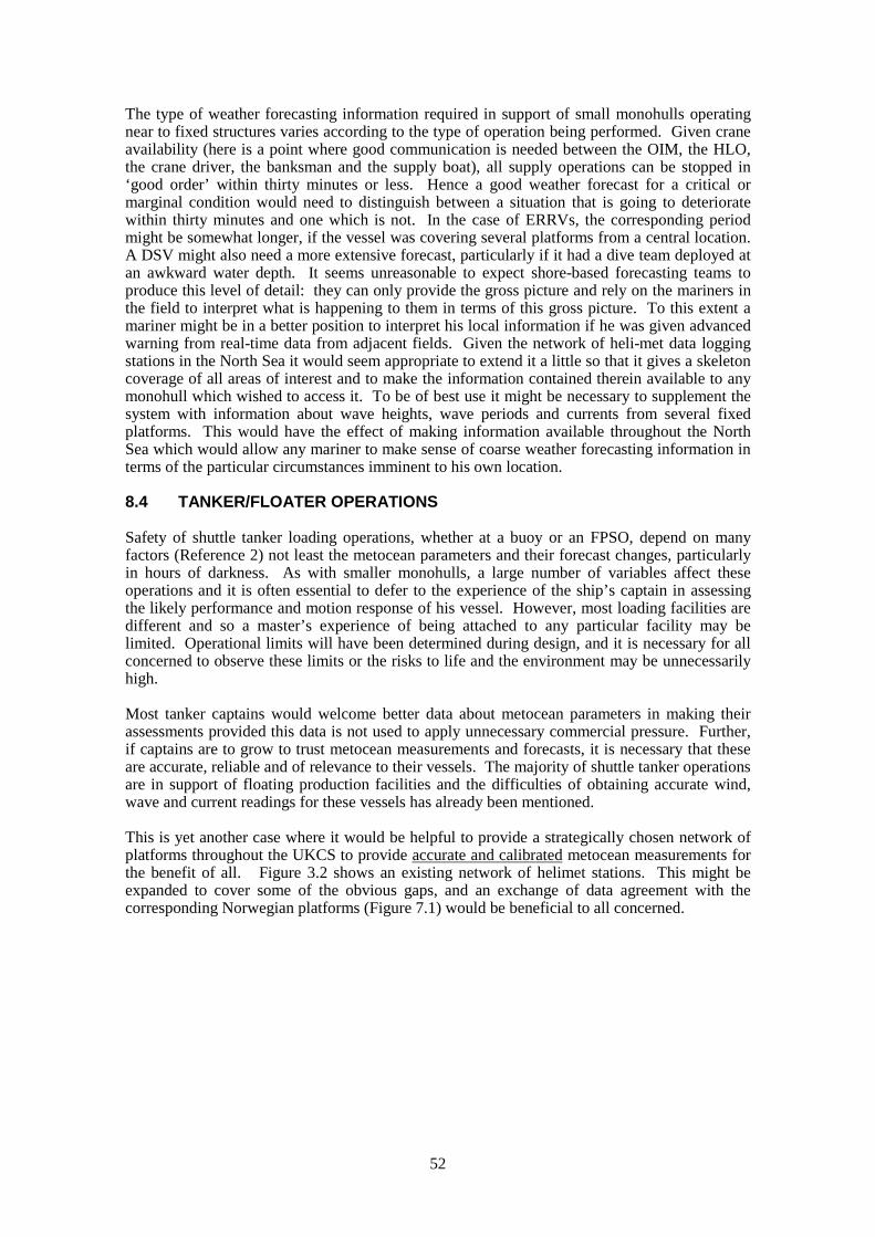
52
The type of weather forecasting information required in support of small monohulls operatingnear to fixed structures varies according to the type of operation being performed. Given craneavailability (here is a point where good communication is needed between the OIM, the HLO,the crane driver, the banksman and the supply boat), all supply operations can be stopped in‘good order’ within thirty minutes or less. Hence a good weather forecast for a critical ormarginal condition would need to distinguish between a situation that is going to deterioratewithin thirty minutes and one which is not. In the case of ERRVs, the corresponding periodmight be somewhat longer, if the vessel was covering several platforms from a central location.A DSV might also need a more extensive forecast, particularly if it had a dive team deployed atan awkward water depth. It seems unreasonable to expect shore-based forecasting teams toproduce this level of detail: they can only provide the gross picture and rely on the mariners inthe field to interpret what is happening to them in terms of this gross picture. To this extent amariner might be in a better position to interpret his local information if he was given advancedwarning from real-time data from adjacent fields. Given the network of heli-met data loggingstations in the North Sea it would seem appropriate to extend it a little so that it gives a skeletoncoverage of all areas of interest and to make the information contained therein available to anymonohull which wished to access it. To be of best use it might be necessary to supplement thesystem with information about wave heights, wave periods and currents from several fixedplatforms. This would have the effect of making information available throughout the NorthSea which would allow any mariner to make sense of coarse weather forecasting information interms of the particular circumstances imminent to his own location.
8.4 TANKER/FLOATER OPERATIONS
Safety of shuttle tanker loading operations, whether at a buoy or an FPSO, depend on manyfactors (Reference 2) not least the metocean parameters and their forecast changes, particularlyin hours of darkness. As with smaller monohulls, a large number of variables affect theseoperations and it is often essential to defer to the experience of the ship’s captain in assessingthe likely performance and motion response of his vessel. However, most loading facilities aredifferent and so a master’s experience of being attached to any particular facility may belimited. Operational limits will have been determined during design, and it is necessary for allconcerned to observe these limits or the risks to life and the environment may be unnecessarilyhigh.
Most tanker captains would welcome better data about metocean parameters in making theirassessments provided this data is not used to apply unnecessary commercial pressure. Further,if captains are to grow to trust metocean measurements and forecasts, it is necessary that theseare accurate, reliable and of relevance to their vessels. The majority of shuttle tanker operationsare in support of floating production facilities and the difficulties of obtaining accurate wind,wave and current readings for these vessels has already been mentioned.
This is yet another case where it would be helpful to provide a strategically chosen network ofplatforms throughout the UKCS to provide accurate and calibrated metocean measurements forthe benefit of all. Figure 3.2 shows an existing network of helimet stations. This might beexpanded to cover some of the obvious gaps, and an exchange of data agreement with thecorresponding Norwegian platforms (Figure 7.1) would be beneficial to all concerned.
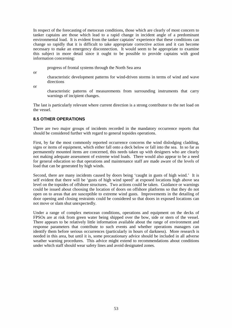
53
In respect of the forecasting of metocean conditions, those which are clearly of most concern totanker captains are those which lead to a rapid change in incident angle of a predominantenvironmental load. It is evident from the tanker captains’ experience that these conditions canchange so rapidly that it is difficult to take appropriate corrective action and it can becomenecessary to make an emergency disconnection. It would seem to be appropriate to examinethis subject in more detail since it ought to be possible to provide captains with goodinformation concerning:
progress of frontal systems through the North Sea areaor
characteristic development patterns for wind-driven storms in terms of wind and wavedirections
orcharacteristic patterns of measurements from surrounding instruments that carrywarnings of incipient changes.
The last is particularly relevant where current direction is a strong contributor to the net load onthe vessel.
8.5 OTHER OPERATIONS
There are two major groups of incidents recorded in the mandatory occurrence reports thatshould be considered further with regard to general topsides operations.
First, by far the most commonly reported occurrence concerns the wind dislodging cladding,signs or items of equipment, which either fall onto a deck below or fall into the sea. In so far aspermanently mounted items are concerned, this needs taken up with designers who are clearlynot making adequate assessment of extreme wind loads. There would also appear to be a needfor general education so that operations and maintenance staff are made aware of the levels ofload that can be generated by high winds.
Second, there are many incidents caused by doors being ‘caught in gusts of high wind.’ It isself evident that there will be ‘gusts of high wind speed’ at exposed locations high above sealevel on the topsides of offshore structures. Two actions could be taken. Guidance or warningscould be issued about choosing the location of doors on offshore platforms so that they do notopen on to areas that are susceptible to extreme wind gusts. Improvements in the detailing ofdoor opening and closing restraints could be considered so that doors in exposed locations cannot move or slam shut unexpectedly.
Under a range of complex metocean conditions, operations and equipment on the decks ofFPSOs are at risk from green water being shipped over the bow, side or stern of the vessel.There appears to be relatively little information available about the range of environment andresponse parameters that contribute to such events and whether operations managers canidentify them before serious occurrences (particularly in hours of darkness). More research isneeded in this area, but until it is, some precautionary advice should be included in all adverseweather warning procedures. This advice might extend to recommendations about conditionsunder which staff should wear safety lines and avoid designated zones.

54
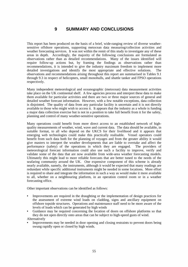
55
9 SUMMARY AND CONCLUSIONS
This report has been produced on the basis of a brief, wide-ranging review of diverse weather-sensitive offshore operations, supporting metocean data measuring/collection activities andweather forecasting services. It was not within the remit of this study to investigate any of theseareas in depth. Accordingly, the majority of the following conclusions are formulated asobservations rather than as detailed recommendations. Many of the issues identified willrequire follow-up actions but, by framing the findings as observations rather thanrecommendations, it is intended to give the industry maximum freedom to implement moredetailed investigations and identify the most appropriate and effective solutions. Theobservations and recommendations arising throughout this report are summarised in Tables 9.1through 9.3 in respect of helicopters, small monohulls, and shuttle tanker and FPSO operationsrespectively.
Many independent meteorological and oceanographic (metocean) data measurement activitiestake place on the UK continental shelf. A few agencies process and interpret these data to makethem available for particular activities and there are two or three major sources of general anddetailed weather forecast information. However, with a few notable exceptions, data collectionis disjointed. The quality of data from any particular facility is uncertain and it is not directlyavailable to those who might wish to access it. It appears that the industry as a whole is fundinga major data collection exercise but is not in a position to take full benefit from it for the safety,planning and control of many weather-sensitive operations.
Many operations could benefit from more direct access to an established network of high-quality measurements of weather, wind, wave and current data. The data should be available, insuitable format, to all who depend on the UKCS for their livelihood and it appears thatemerging web technologies could make this practically realisable. Vessel operators couldbenefit from such data both for the planning of voyages and from the greater ability it wouldgive masters to interpret the weather developments that are liable to overtake and affect theperformance (safety) of the operations in which they are engaged. The providers ofmeteorological forecast information could also use such a facility to improve, verify andvalidate some of the data that are now available from wide-area weather forecasting models.Ultimately this might lead to more reliable forecasts that are better tuned to the needs of theseafaring community around the UK. One expensive component of this scheme is alreadynearly available, namely, the instruments, although it would be expected that many readings areredundant while specific additional instruments might be needed in some locations. More effortis required to share and integrate the information in such a way as would make it more availableto all, whether on a neighbouring platform, in an operation control room or in a weatherforecasting office.
Other important observations can be identified as follows:
• Improvements are required in the draughting or the implementation of design practices forthe assessment of extreme wind loads on cladding, signs and ancillary equipment onoffshore topside structures. Operations and maintenance staff need to be more aware of thelevels of loads which can be generated by high winds
• Guidance may be required concerning the location of doors on offshore platforms so thatthey do not open directly onto areas that can be subject to high-speed gusts of wind.
Alternatively• Improvements may be needed in door opening and closing restraints to prevent doors being
swung rapidly open or closed by high winds.

56
It is observed that further work may be required in the following areas:• Review of findings of CAA study into a motion evaluation index for helicopters operating
on floating vessels. These findings may be more widely applicable.• Review of instrument locations and Installation/Vessel Limitation Lists (IVLLs) for
helicopter operations. How frequently are instruments calibrated, and do these systemskeep pace with the effects caused by topside refurbishment and developments?
• More explicit guidance concerning the siting of metocean sensors, particularly for FPSOand shuttle loading operations.
• Evaluation of risks to FPSO topsides operations posed by green water events and thepossibilities of forecasting potentially dangerous sea conditions.
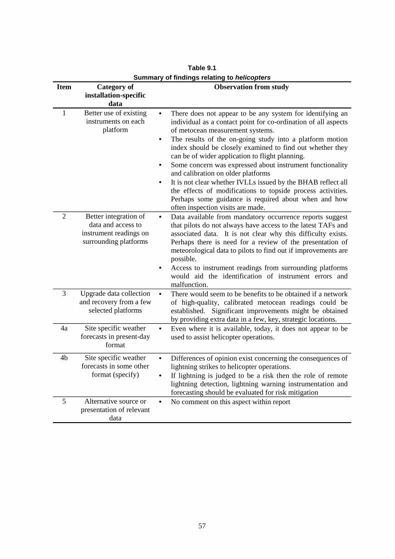
57
Table 9.1
Summary of findings relating to helicopters
Item Category ofinstallation-specific
data
Observation from study
1 Better use of existinginstruments on each
platform
• There does not appear to be any system for identifying anindividual as a contact point for co-ordination of all aspectsof metocean measurement systems.
• The results of the on-going study into a platform motionindex should be closely examined to find out whether theycan be of wider application to flight planning.
• Some concern was expressed about instrument functionalityand calibration on older platforms
• It is not clear whether IVLLs issued by the BHAB reflect allthe effects of modifications to topside process activities.Perhaps some guidance is required about when and howoften inspection visits are made.
2 Better integration ofdata and access to
instrument readings onsurrounding platforms
• Data available from mandatory occurrence reports suggestthat pilots do not always have access to the latest TAFs andassociated data. It is not clear why this difficulty exists.Perhaps there is need for a review of the presentation ofmeteorological data to pilots to find out if improvements arepossible.
• Access to instrument readings from surrounding platformswould aid the identification of instrument errors andmalfunction.
3 Upgrade data collectionand recovery from a few
selected platforms
• There would seem to be benefits to be obtained if a networkof high-quality, calibrated metocean readings could beestablished. Significant improvements might be obtainedby providing extra data in a few, key, strategic locations.
4a Site specific weatherforecasts in present-day
format
• Even where it is available, today, it does not appear to beused to assist helicopter operations.
4b Site specific weatherforecasts in some other
format (specify)
• Differences of opinion exist concerning the consequences oflightning strikes to helicopter operations.
• If lightning is judged to be a risk then the role of remotelightning detection, lightning warning instrumentation andforecasting should be evaluated for risk mitigation
5 Alternative source orpresentation of relevant
data
• No comment on this aspect within report
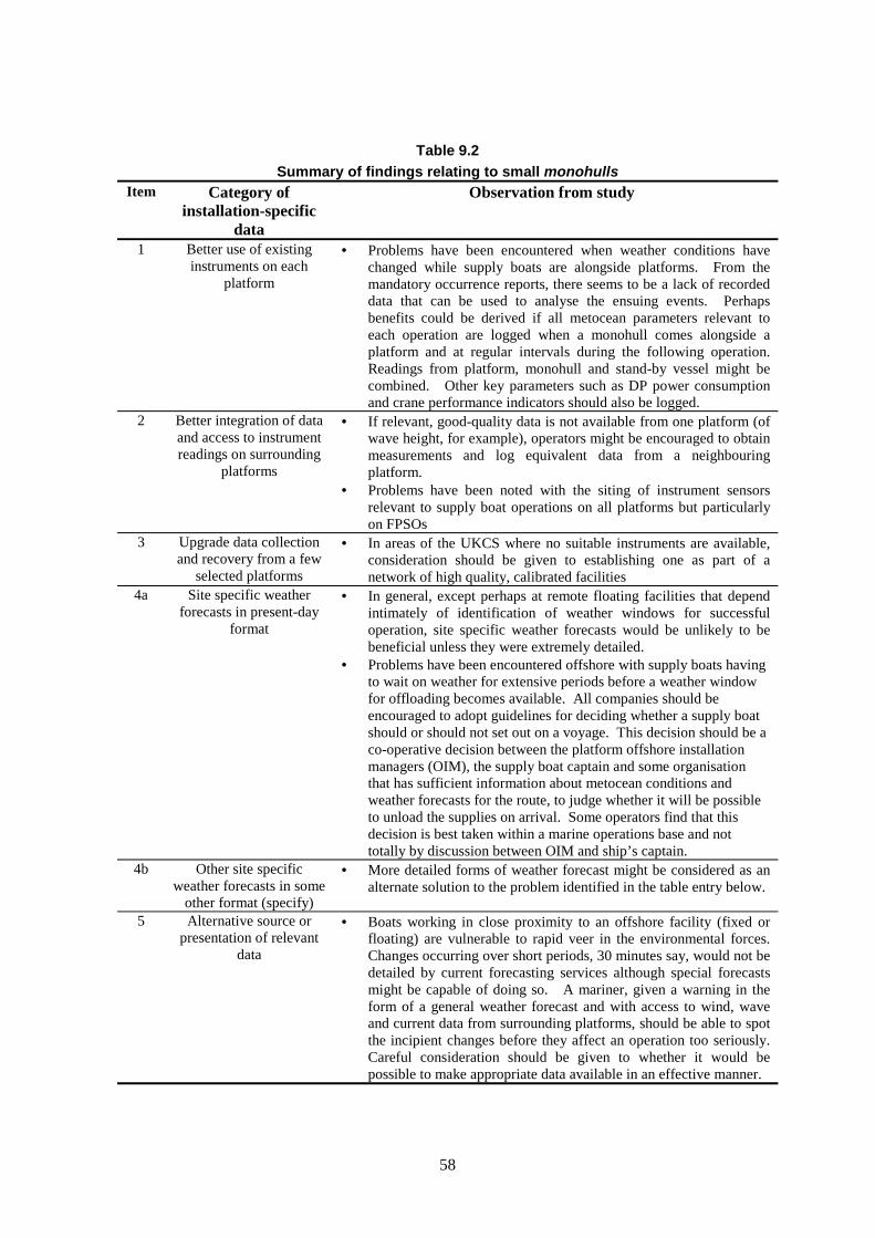
58
Table 9.2
Summary of findings relating to small monohullsItem Category of
installation-specificdata
Observation from study
1 Better use of existinginstruments on each
platform
• Problems have been encountered when weather conditions havechanged while supply boats are alongside platforms. From themandatory occurrence reports, there seems to be a lack of recordeddata that can be used to analyse the ensuing events. Perhapsbenefits could be derived if all metocean parameters relevant toeach operation are logged when a monohull comes alongside aplatform and at regular intervals during the following operation.Readings from platform, monohull and stand-by vessel might becombined. Other key parameters such as DP power consumptionand crane performance indicators should also be logged.
2 Better integration of dataand access to instrumentreadings on surrounding
platforms
• If relevant, good-quality data is not available from one platform (ofwave height, for example), operators might be encouraged to obtainmeasurements and log equivalent data from a neighbouringplatform.
• Problems have been noted with the siting of instrument sensorsrelevant to supply boat operations on all platforms but particularlyon FPSOs
3 Upgrade data collectionand recovery from a few
selected platforms
• In areas of the UKCS where no suitable instruments are available,consideration should be given to establishing one as part of anetwork of high quality, calibrated facilities
4a Site specific weatherforecasts in present-day
format
• In general, except perhaps at remote floating facilities that dependintimately of identification of weather windows for successfuloperation, site specific weather forecasts would be unlikely to bebeneficial unless they were extremely detailed.
• Problems have been encountered offshore with supply boats havingto wait on weather for extensive periods before a weather windowfor offloading becomes available. All companies should beencouraged to adopt guidelines for deciding whether a supply boatshould or should not set out on a voyage. This decision should be aco-operative decision between the platform offshore installationmanagers (OIM), the supply boat captain and some organisationthat has sufficient information about metocean conditions andweather forecasts for the route, to judge whether it will be possibleto unload the supplies on arrival. Some operators find that thisdecision is best taken within a marine operations base and nottotally by discussion between OIM and ship’s captain.
4b Other site specificweather forecasts in some
other format (specify)
• More detailed forms of weather forecast might be considered as analternate solution to the problem identified in the table entry below.
5 Alternative source orpresentation of relevant
data
• Boats working in close proximity to an offshore facility (fixed orfloating) are vulnerable to rapid veer in the environmental forces.Changes occurring over short periods, 30 minutes say, would not bedetailed by current forecasting services although special forecastsmight be capable of doing so. A mariner, given a warning in theform of a general weather forecast and with access to wind, waveand current data from surrounding platforms, should be able to spotthe incipient changes before they affect an operation too seriously.Careful consideration should be given to whether it would bepossible to make appropriate data available in an effective manner.
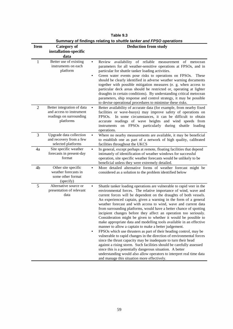
59
Table 9.3
Summary of findings relating to shuttle tanker and FPSO operations
Item Category ofinstallation-specific
data
Deduction from study
1 Better use of existinginstruments on each
platform
• Review availability of reliable measurement of metoceanparameters for all weather-sensitive operations at FPSOs, and inparticular for shuttle tanker loading activities.
• Green water events pose risks to operations on FPSOs. Theseshould be clearly identified in adverse weather warning documentstogether with possible mitigation measures (e. g. when access toparticular deck areas should be restricted or, operating at lighterdraughts in certain conditions). By understanding critical metoceanparameters, ship response and control strategy, it may be possibleto devise operational procedures to minimise these risks.
2 Better integration of dataand access to instrumentreadings on surrounding
platforms
• Better availability of accurate data (for example, from nearby fixedfacilities or wave-buoys) may improve safety of operations onFPSOs. In some circumstances, it can be difficult to obtainaccurate readings of wave heights and wind speeds frominstruments on FPSOs particularly during shuttle loadingoperations.
3 Upgrade data collectionand recovery from a few
selected platforms
• Where no nearby measurements are available, it may be beneficialto establish one as part of a network of high quality, calibratedfacilities throughout the UKCS
4a Site specific weatherforecasts in present-day
format
• In general, except perhaps at remote, floating facilities that dependintimately of identification of weather windows for successfuloperation, site specific weather forecasts would be unlikely to bebeneficial unless they were extremely detailed.
4b Other site specificweather forecasts insome other format
(specify)
• More detailed alternative forms of weather forecast might beconsidered as a solution to the problem identified below
5 Alternative source orpresentation of relevant
data
• Shuttle tanker loading operations are vulnerable to rapid veer in theenvironmental forces. The relative importance of wind, wave andcurrent forces will be dependent on the draughts of both vessels.An experienced captain, given a warning in the form of a generalweather forecast and with access to wind, wave and current datafrom surrounding platforms, would have a better chance of spottingincipient changes before they affect an operation too seriously.Consideration might be given to whether it would be possible tomake appropriate data and modelling tools available in an effectivemanner to allow a captain to make a better judgement.
• FPSOs which use thrusters as part of their heading control, may bevulnerable to rapid changes in the direction of environmental forcessince the thrust capacity may be inadequate to turn their headagainst a rising storm. Such facilities should be carefully assessedsince this is a potentially dangerous situation. A betterunderstanding would also allow operators to interpret real time dataand manage this situation more effectively.

60
61
LIST OF REFERENCES
1. OIL COMPANIES INTERNATIONAL MARINE FORUMOffshore loading safety guidelines – with special relevance to harsh weather zonesOCIMF, 1999. ISBN 1 85609 148 1. Printed and published by Witherby & Co Ltd,London, England.
2. HEALTH AND SAFETY EXECUTIVE (OFFSHORE SAFETY DIVISION)Shuttle tanker and offloading operations at FPSO/FSU’sOffshore technology report – OTO 98 172 - HSE January 1999.
3. HEALTH AND SAFETY EXECUTIVE (OFFSHORE SAFETY DIVISION)Close Proximity StudyOffshore technology report – OTO 97 055 - HSE October 1997.
4. HEALTH AND SAFETY EXECUTIVE (OFFSHORE SAFETY DIVISION)Ship/platform collision incident database (1997)Offshore technology report – OTO 99 080 - HSE January 1999.
5. CIVIL AVIATION AUTHORITY, LONDONCAP 437 Offshore helicopter landing areas – guidance on standardsCAA, 1998. ISBN 0 86039 741 6 Printed and published by Westward Digital Limited,Cheltenham, England.
6. SHELL U K EXPLORATION AND PRODUCTIONAdverse weather working policyShell U K Exploration and Production, Aberdeen, 1999
7. UKOOA / CHAMBER OF SHIPPINGGuidelines for the safe management and operation of offshore support vesselsIssue 2 July 1998
8. UKOOAGuidelines for the safe operation of vessels standing by offshore installationsIssue 1, August 1999

Printed and published by the Health and Safety ExecutiveC0.50 10/01

OTO 2001/022
£15.00 9 780717 621309
ISBN 0-7176-2130-8