Embed Size (px)
Citation preview
.
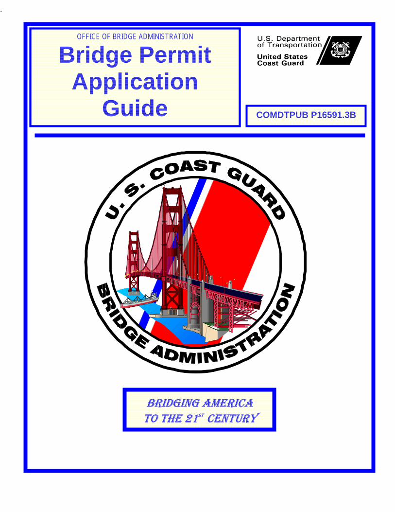
OFFICE OF BRIDGE ADMINISTRATION
Bridge Permit Application
Guide COMDTPUB P16591.3B
BRIDGING AMERICA TO THE 21ST CENTURY


BLANK PAG


BLANK PAGE


i
TABLE OF CONTENTS
PREFACE ..................................................................................................................................1 CHAPTER 1 INTRODUCTION TO THE BRIDGE ADMINISTRATION PROGRAM ..................2
A. REQUIREMENTS AND LAWS..................................................................................................2 B. WHO MUST APPLY FOR A BRIDGE PERMIT ............................................................................2 C. HOW THE COAST GUARD CAN HELP ....................................................................................2 D. AUTHORITY AND PERTINENT LAWS.......................................................................................3 E. LEGISLATION PERTAINING TO BRIDGES.................................................................................3 F. BRIDGE ADMINISTRATION PROGRAM POLICY.........................................................................4 G. NAVIGABLE WATERS...........................................................................................................5 H. BRIDGE CONSTRUCTION WORK WHICH DOES NOT REQUIRE A PERMIT...................................6 I. LOCAL NOTICE TO MARINERS ..............................................................................................7 J. TRANSFER OF PERMITS.......................................................................................................7 K. MAINTENANCE....................................................................................................................8 L. BRIDGE NAVIGATIONAL LIGHTING.........................................................................................8 M. BRIDGE LIGHTING FEATURES...............................................................................................8
CHAPTER 2 PERMITTING PROCESS....................................................................................10 A. THE APPLICATION PACKAGE..............................................................................................10 B. DISTRICT COMMANDER'S INVESTIGATION............................................................................14 C. HEADQUARTERS' REVIEW .................................................................................................15 D. TEMPORARY BRIDGES ......................................................................................................16 E. TIME LIMITS FOR CONSTRUCTION ......................................................................................16 F. APPLICATIONS FOR EXTENSIONS OF TIME...........................................................................16 G. REQUIRED UPDATED ENVIRONMENTAL DOCUMENTATION.....................................................17 H. BRIDGE FENDER SYSTEMS................................................................................................17 I. CLEARANCE GAUGES........................................................................................................18 J. APPROVAL OF FALSEWORK AND CONSTRUCTION PROCEDURES ...........................................20 K. PRE-CONSTRUCTION CONFERENCE...................................................................................21
CHAPTER 3 ENVIRONMENTAL PROCEDURE ....................................................................22 A. COAST GUARD POLICY .....................................................................................................22 B. POLICY............................................................................................................................22 C. REQUIREMENTS ...............................................................................................................22 D. INFORMATION FOR ENVIRONMENTAL INVESTIGATION............................................................23
a. Alternatives...............................................................................................................23 b. Section 4(f) ...............................................................................................................23 c. Coastal Zone Management Plan ..............................................................................24 d. Wetlands ..................................................................................................................24 e. Floodplain .................................................................................................................25 f. Water Quality Certification........................................................................................26 g. Threatened and Endangered Species ......................................................................26 h. Essential Fish Habitat ...............................................................................................26 i. Wild and Scenic Rivers.............................................................................................26 j. Prime and Unique Farmland.....................................................................................27
ii
k. Clean Air .................................................................................................................. 27 l. Noise Levels ............................................................................................................ 28 m. Residential or Business Displacement..................................................................... 29
APPENDIX A: GLOSSARY................................................................................................A- 1 APPENDIX B: COAST GUARD DISTRICT MAP ...............................................................B- 1 APPENDIX C: COAST GUARD DISTRICT BRIDGE ADMINISTRATION OFFICES.........C- 1 APPENDIX D: SAMPLE LETTER OF APPLICATION FOR A PERMIT.............................D- 1 APPENDIX E: BRIDGE PERMIT APPLICATION CHECKLISTS.......................................E- 1 APPENDIX F: BRIDGE PERMIT PROCESSING PROCEDURES..................................... F- 1 APPENDIX G: SAMPLE PLANS SUBMITTED FOR APPROVAL.....................................G- 1
NOTE: THE OFFICE OF MANAGEMENT AND BUDGET (OMB) HAS APPROVED THE INFORMATION COLLECTION REQUIREMENTS CONTAINED IN THIS PUBLICATION UNDER THE PAPERWORK REDUCTION ACT OF 1980 (44 U.S.C. 3501). THE CURRENT OMB CONTROL NUMBER APPROVING THIS COLLECTION OF INFORMATION IS 2115-0050.
1
PREFACE
This Bridge Permit Application Guide is designed to:
• Introduce you to the Coast Guard Bridge Administration Program.
• Provide information about Coast Guard policy, regulations, and responsibilities in administering the Bridge Administration permit process.
• Describe the bridge permit application process through which you and the Coast Guard can work together.
• Describe the environmental procedures required in the bridge permit application process.
This document should be used in conjunction with materials and information supplied by your local Coast Guard District Office.
2
CHAPTER 1 INTRODUCTION TO THE BRIDGE ADMINISTRATION PROGRAM
A. Requirements and Laws
1. A bridge permit is the written approval of the location and plans of the bridge or causeway to be constructed or modified. The purpose of this handbook is to assist you, the applicant, in applying for a Coast Guard bridge permit to:
a. Construct a new bridge or causeway, or
b. Reconstruct or modify an existing bridge or causeway across navigable waters of the United States.
2. Federal law prohibits the construction of these structures unless the Coast Guard first authorizes them. By following the procedures in this handbook, you can help the Coast Guard efficiently process your application.
B. Who Must Apply for a Bridge Permit
1. Any individual, partnership, corporation, or local, state, or federal legislative body, agency, or authority planning to construct or modify a bridge or causeway across a navigable waterway of the United States must apply for a Coast Guard bridge permit. This includes all temporary bridges used for construction access or traffic detour.
2. For bridges constructed by the state or municipal agencies, primary authority to apply for a permit for the construction of a bridge project will be presumed without proof.
3. If state law does not require a license, primary authority may be granted in the charter of a corporation or the authority inherent in ownership of the land where the structure will be placed. In these cases, an extract from the charter and evidence of sufficient real estate interest to allow construction of the bridge should be submitted with the application.
4. Failure to obtain a bridge permit before commencing bridge construction or modification work is a federal offense, punishable by civil and criminal penalties.
C. How the Coast Guard Can Help
1. Your local Coast Guard District office is one of your best sources of information for your project. You should direct all project-related questions, concerns, comments, and requests to the bridge administration staff in the Coast Guard District where your project is located.
3
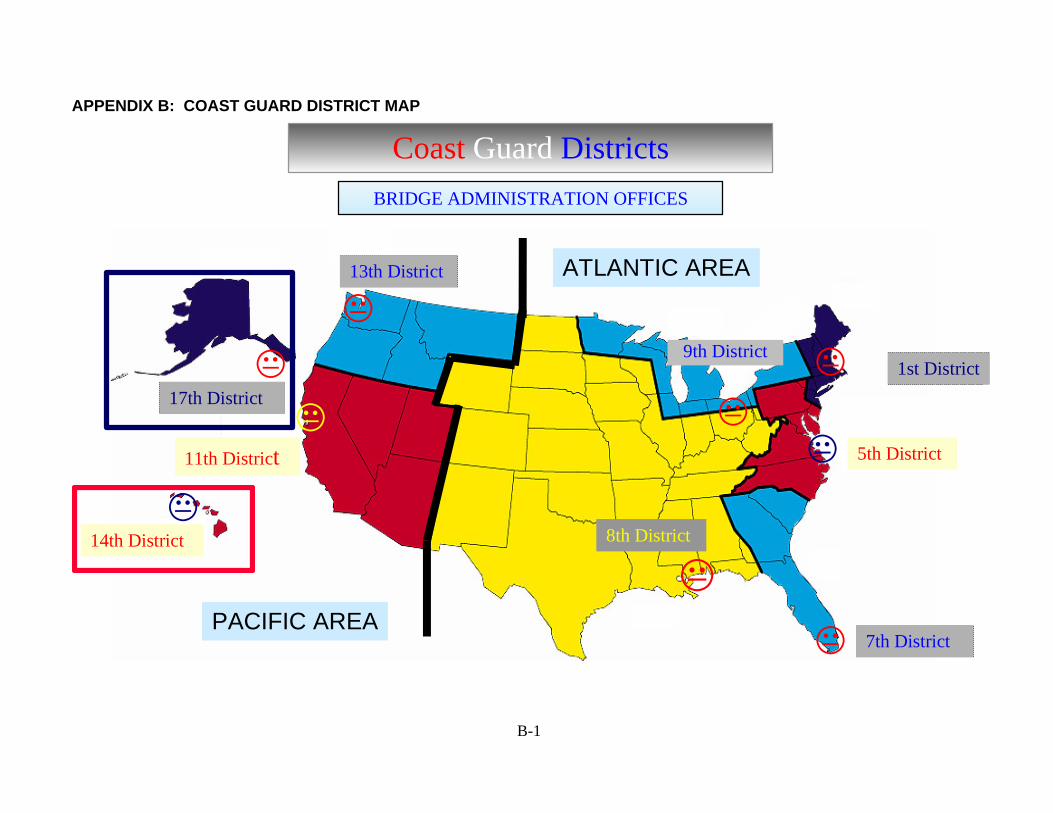
2. Appendix B provides a map of the district boundaries so that you may locate the Coast Guard District in your project area.
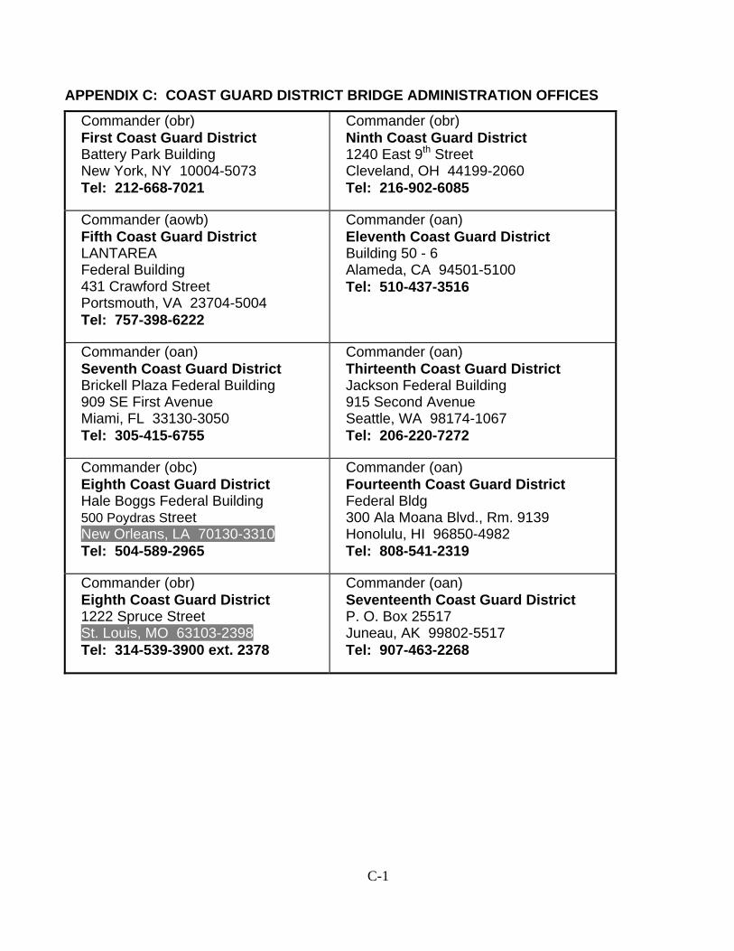
3. Appendix C provides a list of the mailing addresses and telephone numbers of the Coast Guard District Bridge Administration Branches/Sections. The responsibility for processing all bridge permit applications is at this District Commander organizational level.
4. The glossary in Appendix A explains many of the key terms involved in obtaining a bridge permit.
D. Authority and Pertinent Laws
1. In 1967, the Coast Guard was transferred to the Department of Transportation. One of the Coast Guard’s newly assigned duties was to issue bridge permits.
2. The Coast Guard approves bridge location and plans under the authority of several Acts pertaining to bridges.
E. Legislation Pertaining to Bridges
1. These Acts include Section 9 of the Rivers and Harbors Act of 1899 and the General Bridge Act of 1946.
2. The purpose of these Acts is to preserve the public right of navigation and to prevent interference with interstate and foreign commerce. The General Bridge Act of 1946, as amended, the Rivers and Harbors Act of 1899, as amended, and the Act of March 23, 1906, as amended, all require that the location and plans of bridges and causeways across the navigable waters of the United States be submitted to and approved by the Secretary of Transportation prior to construction. The General Bridge Act of 1946 is cited as the legislative authority for bridge construction in most cases.
3. The Secretary of Transportation delegated this authority to the Commandant, U. S. Coast Guard, by Department of Transportation Order 1100.1 dated 31 March 1967 (49 CFR 1.46(c)).
4. These Acts placed the navigable waters of the United States under the exclusive control of the U. S. Coast Guard to prevent any interference with their navigability by bridges or other obstructions except by express permission of the United States Government.
4
F. Bridge Administration Program Policy
1. Under the previously mentioned Acts, the Coast Guard's mission is to administer the Bridge Administration Program. The Coast Guard approves the location and plans of bridges and causeways and imposes any necessary conditions relating to the construction, maintenance, and operation of these bridges in the interest of public navigation.
2. The Coast Guard is also required by law to ensure that environmental considerations are given careful attention and importance in each bridge permitting decision.
3. As explained further in Chapter 3, relevant environmental statutes and executive orders for bridge project compliance include:
a. National Environmental Policy Act (NEPA) of 1969, (42 U.S.C. 4321)
b. Department of Transportation Act of 1966, Section 4(f) (49 U.S.C. 303)
c. Coastal Zone Management Act (CZM) of 1972 (16 U.S.C. 1451)
d. Coastal Barrier Resources Act of 1982 (16 U.S.C. 3501)
e. Protection of Wetlands (E.O. 11990)
f. Floodplain Management and Protection (E.O. 11988)
g. Endangered Species Act of 1973 (16 U.S.C. 1531)
h. Fish and Wildlife Coordination Act of 1956 (16 U.S.C. 661)
i. Magnuson-Stevens Fishery Conservation and Management Act (16 U.S.C. 1855)
j. Clean Water Act of 1977 (33 U.S.C. 1251)
k. National Historic Preservation Act of 1966, Section 106 (16 U.S.C. 470)
l. Protection and Enhancement of the Cultural Environment (E.O. 11593)
m. Wild and Scenic Rivers Act of 1968 (16 U.S.C. 1271)
n. Farmlands Protection Policy Act of 1981 (7 U.S.C. 4201)
o. Clean Air Act of 1990 (42 U.S.C. 7401)
p. Noise Control Act of 1972 (42 U.S.C. 4331)
5
q. Uniform Relocation Assistance and Real Property Acquisitions Act of 1970 (42 U.S.C. 4601)
r. Federal Actions to Address Environmental Justice in Minority Populations and Low-Income Populations (E.O. 12898)
s. Native American Graves Protection and Repatriation Act of 1990 (23 U.S.C. 3001)
4. The Coast Guard is obligated to consult with and obtain comments from any federal agency with legal jurisdiction or special expertise concerning any environmental or navigational impact involved. Such comments are generally obtained through direct coordination with affected agencies, responses to the public notice, and the Local Notice to Mariners (LNM).
5. The established policy of the Coast Guard Bridge Administration Program mission is to protect the freedom of navigation and the quality of the environment by taking a balanced approach to total transportation systems, both land and water modes, in all program actions.
6. The bridge statutes and subsequent court interpretations require that bridges provide for the reasonable needs of navigation, not for all the needs of navigation. The reasonable needs of land traffic (highway and rail) must also be met. The construction of essential land transportation projects must not be unreasonably delayed while navigational impacts are under consideration.
7. Therefore, Coast Guard bridge permit actions consider the overall goals of the U.S. Department of Transportation in a balanced manner to accommodate the needs of all modes of transportation.
8. Rules and regulations governing the U. S. Coast Guard bridge permit program are listed in Parts 114 and 115 of Title 33, Code of Federal Regulations (CFR). A copy may be found in your local library or purchased from the Superintendent of Documents, U.S. Government Printing Office, Washington, DC 20402.
G. Navigable Waters
1. For Coast Guard bridge permitting purposes, a navigable waterway is defined as follows (unless specifically declared otherwise by Congress), as found at 33 CFR, Subpart 2.05-25:
a. Any waterway which is subject to the ebb and flow of the tide; or
b. Any waterway which is presently used and/or is susceptible to use in its natural condition, or by reasonable improvement, as a means to transport interstate or foreign commerce.
2. Bridges are considered legal structures which were built over a waterway that at the time of construction was not considered navigable waters of the United States.
6
3. If you are uncertain whether or not a waterway is susceptible to improvement for navigation, is tidal, or is considered navigable, contact the Coast Guard to obtain information regarding a navigability determination.
4. Construction in these waters continues to be subject to other Coast Guard authorities, such as the approval of navigation lights and signals and timely notice to local mariners of construction in the waterway.
5. The classification of certain waterways or portions of waterways as navigable occasionally changes. Therefore, the information required for applicants also changes with the particular situation.
6. For these reasons, if you are planning to construct a new bridge or causeway or modify an existing bridge or causeway over a canal, channel, stream, river, lake, bay, other body of water or waterway, contact your local Coast Guard District before submitting a formal permit application.
7. Due to the different characteristics of the waterways and navigation in each District, needed information varies from one District to another. The intended use of this guide is to supplement data and information from your local Coast Guard District.
H. Bridge Construction Work Which Does Not Require a Permit
1. Coast Guard permits are not required for the following projects:
a. Construction of bridges crossing non-tidal waters NOT presently used as or susceptible to use as a means of transporting interstate or foreign commerce.
NOTE: Contact your local Coast Guard District for this information. If you are uncertain whether your project requires a permit and it is FHWA-funded, contact the FHWA administrator in your project’s geographic area.
b. Removal of an existing bridge that will not be replaced by another bridge.
NOTE: If you plan to remove or modify any part of a bridge so that it loses its capacity to transport people or physical matter, you must first notify your local Coast Guard District office. They will determine if your removal operations will affect navigation. As appropriate, the Coast Guard will then issue an LNM notifying waterway users of the removal or modification and clearance work. See Section F.
c. If you plan to retain the entire bridge or designated sections for purposes other than transporting people or physical matter across a navigable waterway (i.e., fishing pier), you must notify the U. S. Army Corps of Engineers (USACE) District office with jurisdiction over the bridge’s geographic area. The USACE will either approve or deny your request.
d. If you receive USACE approval, you must adhere to USACE permit requirements, because the Coast Guard no longer has jurisdiction over the
7
bridge. If the USACE denies your request, the Coast Guard retains jurisdiction to prescribe removal conditions to protect navigation.
e. Repair or replacement of worn or obsolete parts on an existing bridge.
NOTE: Replacement of bridge parts includes replacing steel with wood, steel with concrete, guard rails with solid material, changing pavement type, or adding or replacing pipelines within the bridge structure. However, you must NOT: alter the structural configuration or navigational clearances; significantly modify any substructure or superstructure components; or violate any navigational conditions of the original permit.
f. You MUST also obtain Coast Guard approval if you are changing the wood surface to steel on a fender.
g. If you have any questions about bridge permit requirements, contact the Chief of the Coast Guard Bridge Administration District with jurisdiction over your bridge’s geographic area.
I. Local Notice to Mariners
1. The Coast Guard publishes LNMs to inform waterway users of work in progress that may affect navigation. You must promptly notify the Coast Guard of the start of construction, any events affecting navigation during construction, and the completion of major phases of construction.
J. Transfer of Permits
1. Although a permit is issued to a specific party, the approval granted for a bridge permit is not restricted to construction, operation, or maintenance of the bridge by that party.
2. The permit passes with the title when it is transferred to an assignee or purchaser of the bridge. The new owner or assignee must strictly comply with the terms and conditions of the permit.
8
K. Maintenance
1. Bridges constructed under a Coast Guard permit must be maintained according to the permit conditions and approved plans. No further authorization is required for routine maintenance. The Coast Guard District must be provided advance notification regarding any maintenance that will affect navigation to allow timely issuance of a LNM.
2. However, the Coast Guard must authorize a major renovation or a change in the size or type of structure that deviates from the approved plans.
L. Bridge Navigational Lighting
1. Bridges across waterways which support nighttime navigation are required to display navigational lights in accordance with Part 118 of Title 33, CFR.
2. Approval of navigational lights and other required signals must be obtained, prior to construction, from the Coast Guard District Commander with jurisdiction over the bridge project area.
3. As the permittee, you are responsible to maintain proper temporary navigational lighting and other such markings, as prescribed, on bridges during construction. Permanent lighting must be maintained on the bridges after the completion of construction.
4. The District Commander may exempt bridges over minor streams where there is no traffic or very little nighttime traffic from the requirement to display navigational lights.
M. Bridge Lighting Features
1. The following bridge lighting information can assist you in selecting the proper equipment to maintain marine navigational lighting on bridges. For the best service and ease of maintenance, lighting installations should incorporate the recommended features outlined below:
a. Fresnel lanterns should be used and installed in a duplex arrangement of a service lamp and a standby lamp. Each duplex lantern or fixture should be controlled by a lightout relay to exhibit the standby lamp on burnout of the service lamp. Fresnel equipment with dual lenses in one lantern is available. Lightout relays are also available.
b. Lamps for Fresnel equipment should be 60 watt, 120 volt, A-21, medium screw base, traffic signal lamp, or equivalent. All lamps should be properly focused in Fresnel lenses.
9
c. Any equipment used for the general illumination of the bridge should be designed so that the distribution pattern will not permit high intensity light to spill over and blind or interfere with the marine navigation. Various types of streetlights are manufactured which control the light distribution by lenses, ray collectors, hoods, or shields.
d. All lights required or authorized by the District Commander must be securely attached to the superstructure and of sufficient candlepower as to be visible against the background lighting at a distance of at least 2,000 yards 90 percent of the nights of the year.
2. If you consider bridge lighting during the bridge design phase, you can avoid future difficulties.
3. Since the bridge lighting requirements in 33 CFR 118 are specified as performance standards, you should ensure that the lighting equipment proposed for a specific bridge project meets these standards by contacting your Coast Guard District.
4. Any person obstructing or interfering with any lights or signals that are maintained in accordance with 33 CFR 118 is subject to a fine (civil penalty) not exceeding $500 for each offense.
10
CHAPTER 2 PERMITTING PROCESS
The Coast Guard bridge permitting process is directed by several laws, policies, professional standards, and other requirements. During the processing of a permit application, the Coast Guard uses this guidance in deciding to either issue or deny the bridge permit. The remainder of this chapter describes the bridge permitting process and provides guidance on the information required in the bridge permit application package. Additional information may be found at 33 CFR, Parts 114 and 115.
A. The Application Package
1. Processing a bridge permit application results in a Coast Guard decision either to issue or to deny a permit. Appendix F provides an outline of the Coast Guard bridge permitting process.
2. When you apply for a bridge permit, you must submit an application package to the Coast Guard. You should send your bridge application to the Coast Guard District office with jurisdiction in the vicinity of the proposed bridge site. (See Appendices B and C for information concerning your local Coast Guard District.) Remember to include any approvals or other permits that you have already received.
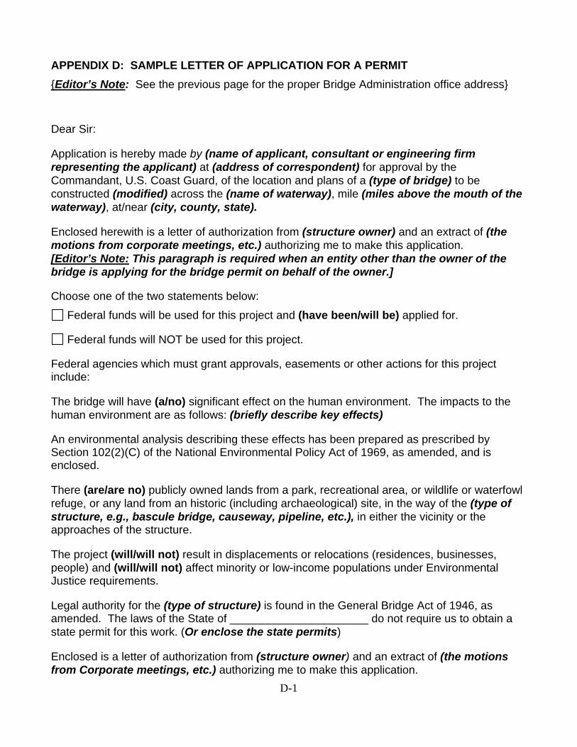
3. The application may be in letter format. (See Appendices D, E, F, and G for further application information.) Your application should cite or include the following information:
a. Applicant information:
1) Name
2) Address
3) Telephone number
b. Consultant information (if employed):
1) Name
2) Address
3) Telephone number
4) Written authorization for the consultant to act on the applicant’s behalf
c. Project information:
1) Location
11
2) Name of the waterway that the bridge crosses
3) Number of miles and kilometers above the mouth of the waterway where the bridge is located
4) City(ies) or town(s), county, and state where the bridge is located at, near, or between
5) Description
6) Purpose
d. Authority information:
1) The primary authority for the construction of the bridge and under what legislative authority the bridge is being built
NOTE: This is a state permit, charter, or statement of ownership of lands.
2) The legislative authority for the existing bridge if it is to be replaced
3) If you do not own the existing bridge which is being replaced or modified, include a signed statement from the bridge owner authorizing the removal or modification work.
e. International bridges (if applicable):
1) The International Bridge Act of 1972, or a copy of the Special Act of Congress if constructed prior to 1972, should be cited as the legislative authority for international bridge construction
2) Presidential approval should be obtained from the State Department prior to issuing a Coast Guard bridge permit under the International Bridge Act of 1972
NOTE: A copy of State Department approval for international bridges must be included in your application package for a Coast Guard permit.
f. Proposed Clearances and Elevations:
1) Horizontal and vertical clearances, in the navigation span(s) measured at mean high water, 2% flowline, or other appropriate datum
NOTE: State clearances in both U.S. and metric units.
2) Elevation of mean high water, the 2% flowline, or other appropriate datum
3) Depth and width of the waterway at the appropriate elevation
12
g. Existing bridge structure at the bridge site:
1) Owner of the bridge
2) Type of bridge, i.e., Drawbridge, Fixed, etc.
3) Mile point and navigational clearances, in linear and metric equivalents
h. Removal of a bridge(s) (if applicable):
1) Extent of removal
2) Time needed for removal
NOTE: The safety of navigation is of paramount importance; therefore, the Coast Guard makes the final decision concerning the extent of bridge removal.
i. Construction Activity:
1) Scheduled construction commencement date
2) Summary of maintenance of traffic during construction activities
3) Anticipated completion date
4) Type and source of project funding
j. Environmental Effects:
1) Significant effect(s) on the environment
2) Environmental documentation, including all applicable information requested in Chapter 3
NOTE: Consider the construction phase of the bridge project also.
k. Required Authorizations:
1) State authorizations
2) Local authorizations
NOTE: You may contact the Coast Guard District staff to receive information on local and state regulatory programs, if such information is available. However, you should obtain local and state approvals before applying to the Coast Guard, so that your application is accepted and processed without a delay.
13
3) You must obtain water quality certification and coastal zone management consistency certification, if applicable, before a bridge permit may be issued
l. Other federal agencies with jurisdiction over the proposed project:
1) Agency
2) Permits or type of approvals required for the project
m. Fill (if applicable):
1) General composition of fill
2) Amount of fill above and below Mean High Water (MHW) or Ordinary High Water (OHW) in cubic yards
3) Acreage of wetlands impacted and types of vegetation affected
NOTE: For proposed bridge construction which may require dredging or filling in the navigable waters of the United States, the U. S. Army Corps of Engineers may require the applicant to obtain a Section 404 permit. It is your responsibility to obtain this permit.
n. Adjacent property owners within ½ mile radius:
1) Names
2) Addresses
o. Underlying studies, reports, and other information:
1) Estimated cost of proposed project
2) Estimated total value of yearly commercial shipping on the waterway affected by the bridge
p. Drawings of your proposed project with your permit application. You must submit one reproducible original and three copies of the location and plan sheets. (Do not submit mylar originals.) All drawings must be drawn to scale and include the following information:
1) Scale(s) of the drawing(s) indicated by a bar graphic(s)
2) Arrow indicating true North
3) Title block located in the lower right corner of each sheet identifying:
(a) Applicant/Agent and Owner
14
(b) Waterway
(c) Bridge location milepoint on the waterway, in miles and metric equivalent in kilometers
(d) City, County, and State
(e) Date of plans
(f) Sheet number of the total number of sheets in the set
4. The checklists in Appendix E refer to the specific required items that must be included on the location map, plan view, and elevation view of your bridge drawing set. Your bridge plan set must conform to the requirements in Appendix E and generally follow the format of the sample drawings included in Appendix G. (Sheet size should be no larger than 8½" x 11".) Be sure that your plans show navigational clearances above the appropriate water surface elevations, and the 100-year flood elevation. The bridge navigational clearances should be specified in both the U. S. unit of measure and metric equivalent.
B. District Commander's Investigation
1. Your request for a bridge permit is investigated by the Coast Guard District bridge administration staff to ensure that:
a. The proposed bridge is under Coast Guard jurisdiction (i.e., across navigable waters of the United States).
b. The application includes all of the necessary information, including four sets of plans and adequate environmental and other supporting documentation. (As part of an initial review, a preliminary decision is made to determine the required type of environmental document.)
c. The proposed bridge provides for the reasonable needs of navigation.
2. After determining that your application is complete, the Coast Guard District Commander undertakes a rigorous independent investigation to determine the possible impacts of the proposed project on navigation and the human environment.
3. As part of the District Commander’s independent investigation, scoping/coordination meetings and consultation may be required to determine the level of environmental documentation (See Chapter 3 for the Environmental Procedures). In addition, a notice requesting public comment is issued to all known interested individuals, adjacent property owners, expertise groups, and government agencies.
4. The Coast Guard District bridge administration staff receives, evaluates, and acts upon the responses to the public notice. You will be furnished any substantive
15
comments received in response to the public notice to resolve or dispute the issues that are raised. Normally, the public comment period is 30 days.
5. Public hearings are held when there are substantial issues concerning the proposed bridge’s effect on the reasonable needs of navigation.
6. They are also held, whenever appropriate, in accordance with the statutory requirements of the National Environmental Policy Act of 1969 (NEPA).
7. The purpose of a public hearing is to allow interested parties to express their views and develop pertinent data for evaluating the permit application.
8. Following the Coast Guard District Commander’s investigation, your request for the permit is forwarded to Coast Guard Headquarters with the case record, including the State Water Quality and Coastal Zone Management Certifications, appropriate environmental document, Findings of Fact, and the District Commander's recommendation for issuance or denial of the permit.
9. The Findings of Fact discusses various aspects of the documents in the case file, commensurate with the scope and complexity of the project.
10. In certain cases, the District Commander may issue or deny the permit.
C. Headquarters' Review
1. A proposed bridge must provide for the reasonable needs of navigation with due consideration for the effects on the quality of the human environment (such as impacts on historic sites, fish and wildlife refuges, floodplain development, recreation, and water quality).
2. When a Coast Guard Headquarters final agency action is required, the staff of the Permits Division, Office of Bridge Administration, Operations and Policy Directorate, U. S. Coast Guard Headquarters in Washington, DC, reviews and evaluates the case file submitted by the District Commander.
3. Based on this evaluation, the District Commander's recommendation may be accepted or rejected, and a bridge permit may be issued or denied.
16
D. Temporary Bridges
1. Any proposed temporary bridge requires a bridge permit prior to construction. You should follow the same procedures and information requirements as for a permanent bridge.
2. A temporary bridge is often used during the construction of a permanent bridge. Your request for the approval of this type of temporary bridge should be included in the application for the permanent bridge.
E. Time Limits for Construction
1. Based on the estimate given in the application, a reasonable period of time will be allowed for the construction of the bridge project covered by the permit.
2. Coast Guard bridge permits specify that the permit becomes null and void unless construction of the bridge is commenced and completed by certain dates. This time period is usually three years and five years, respectively, from the date of the permit.
3. You may request longer time periods. Your request must be substantiated with good reasons. The specified time should correspond to the actual time needed to complete construction, since a time extension may not be routinely granted.
4. If the authorized work is not completed within the time specified in the permit, the permit is voided. A new application and approval are required before construction work can continue.
5. However, if a written request for a time extension is submitted at least 30 days before the expiration date of the permit, the existing permit will remain in effect during processing. Work may continue until the final agency action is taken on the time extension request.
F. Applications for Extensions of Time
1. Your application for an extension of time for starting and/or completing bridge construction should be in letter form. You should request an extension of the date(s) for starting and/or completing bridge construction for a definite number of years coinciding with the present construction schedule.
2. The Coast Guard decision to grant an extension of time is based primarily on a review and evaluation of any project changes or conditions which impact navigation or the environment that were unknown when the original bridge permit was issued. In addition, the project must be reviewed in accordance with any current laws that were not in force when the original permit was issued.
17
3. If the bridge is under construction, you must furnish a brief description of the status of the work. You must also include the percentage of the project completed to date and a description of the remaining work.
G. Required Updated Environmental Documentation
1. When you are applying for a time extension, you should review the environmental documentation for the last Coast Guard permit action and update the information.
2. On Federal-Aid projects, you should submit any impact statements, supplemental studies, Finding of No Significant Impact (FONSI), reevaluations, etc., required by the “lead agency” subsequent to the issuance of the bridge permit, or you should state that none of these items have been required.
3. On Federal-Aid projects, the environmental assessment submitted in support of the last permit action should be updated. Include any environmental impacts of the remaining work that were not included in the original assessment, or state that the previously submitted assessment adequately covers the remaining work.
4. Your application should include a copy of the current water quality and Coastal Zone Management (CZM) consistency certifications from the appropriate state agencies. (See Chapter 3, Environmental Procedure.)
5. If the water quality and CZM consistency certifications were previously furnished for the project, you should state that those certifications have not expired, been modified, or rescinded by the certifying agencies.
6. You should also follow these time extension procedures for the removal of existing or temporary bridges when they are part of a permit for new bridge construction.
H. Bridge Fender Systems
1. When considering an application for a bridge permit, the Coast Guard may require fenders to provide navigation safety.
2. In your permit application, you must consider the possible need for a fendering system that would promote safer navigation through the bridge and protect the bridge structure.
3. The need for a bridge fendering system is based on present and future navigation transiting the proposed bridge site.
4. When required, you must submit a plan for a needed fendering system that includes the following information:
a. A description of the proposed type of fendering system (Include a description of the construction methods and materials from the standpoint of navigation safety)
18
b. The dimensions and minimum clear horizontal distance normal to the channel axis measured between the most restrictive parts of the fendering system
5. The Coast Guard does not usually require the installation of pier fenders on existing bridges unless provided in a permit condition. However, when changes in navigation affect the safety of navigation and the bridge structure, the Coast Guard District Commander may require the installation of fender systems at the bridge owner’s expense.
I. Clearance Gauges
1. The installation of clearance gauges on bridges across navigable waters is subject to the following requirements:
a. Clearance gauges must indicate the vertical distance between “low steel” of the bridge channel span and the level of the water.
b. Clearance gauges must read from top to bottom, measured from low steel to the bottom of the footmarks.
c. Clearance gauges must face approaching traffic and extend to a reasonable height above high water which is meaningful to the mariner.
d. Clearance gauges must be installed on the end of the right channel pier or pier protection structure facing approaching marine traffic.
e. The Coast Guard District Commander may approve other locations for clearance gauge installations, due to particular conditions or circumstances.
f. Clearance gauges must be made of durable material, permanently fixed to the bridge pier, or pier protection structure, and resistant to weather, tide, and current.
g. Clearance gauges may be painted directly on the bridge channel pier if the face of the pier is flat and wide enough to accommodate the footmarks (graduations) and numerals.
h. Clearances must be marked by black numerals and footmarks on a white background. Paint should be of good exterior quality, resistant to chalking or bleeding.
i. Manufactured numerals and background material may be used. The size, type and spacing of numerals conforming with those published in “Standard Alphabets for Highway Signs,” Federal Highway Administration (FHWA), U. S. Department of Transportation must be used as follows:
Nominal Day Visibility Height of Numerals
Type Standard Alphabet
Vertical Spacing of Numerals (feet)
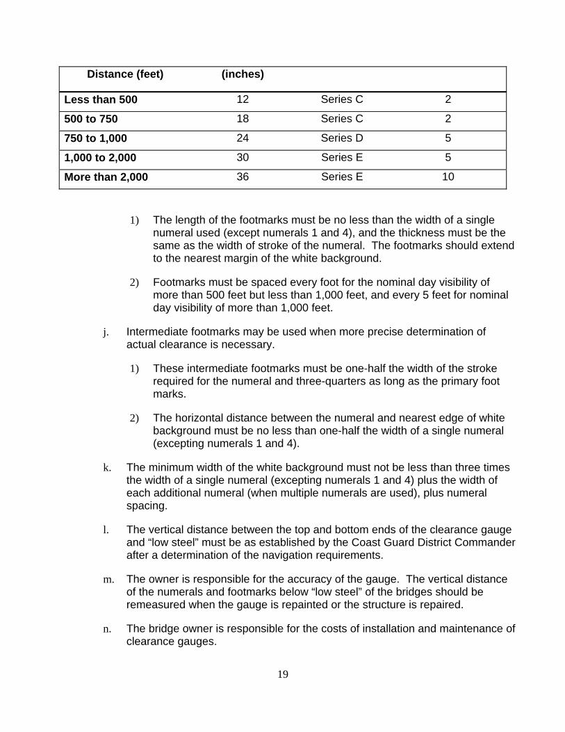
19
Distance (feet) (inches)
Less than 500 12 Series C 2
500 to 750 18 Series C 2
750 to 1,000 24 Series D 5
1,000 to 2,000 30 Series E 5
More than 2,000 36 Series E 10
1) The length of the footmarks must be no less than the width of a single numeral used (except numerals 1 and 4), and the thickness must be the same as the width of stroke of the numeral. The footmarks should extend to the nearest margin of the white background.
2) Footmarks must be spaced every foot for the nominal day visibility of more than 500 feet but less than 1,000 feet, and every 5 feet for nominal day visibility of more than 1,000 feet.
j. Intermediate footmarks may be used when more precise determination of actual clearance is necessary.
1) These intermediate footmarks must be one-half the width of the stroke required for the numeral and three-quarters as long as the primary foot marks.
2) The horizontal distance between the numeral and nearest edge of white background must be no less than one-half the width of a single numeral (excepting numerals 1 and 4).
k. The minimum width of the white background must not be less than three times the width of a single numeral (excepting numerals 1 and 4) plus the width of each additional numeral (when multiple numerals are used), plus numeral spacing.
l. The vertical distance between the top and bottom ends of the clearance gauge and “low steel” must be as established by the Coast Guard District Commander after a determination of the navigation requirements.
m. The owner is responsible for the accuracy of the gauge. The vertical distance of the numerals and footmarks below “low steel” of the bridges should be remeasured when the gauge is repainted or the structure is repaired.
n. The bridge owner is responsible for the costs of installation and maintenance of clearance gauges.
20
2. Under special or peculiar circumstances, or conditions which make compliance with these standards impractical, the bridge owner may apply in writing to the District Commander for permission to deviate from these standards or obtain a waiver of the requirement for clearance gauges. In some instances, the District Commander may authorize use of electronic measuring devices as replacement for the fixed gauges.
J. Approval of Falsework and Construction Procedures
1. The clearances provided for navigation through or under the bridge spans must be approved by the Coast Guard. This authority includes the construction, modification, operation, maintenance, and removal of bridges. The Coast Guard authorizes the temporary restriction of passage through or under a bridge by use of falsework, pilings, floating equipment, closure of draws, or any work or activities which temporarily reduce the navigational clearances and design flood flows, including obstruction of any or all spans of the bridge.
2. A Coast Guard bridge permit normally includes a condition stating that the plans for cofferdams, falsework, or any other temporary structures that are to be placed in the water to facilitate the bridge construction, must be submitted to and approved by the District Commander before the start of construction.
3. Approval of a temporary reduction of previously approved navigational clearances for any of these temporary structures varies greatly. Approval depends on the location of the bridge, type of river traffic, the time of year that the structures will be in place, etc.
4. For these reasons, you are encouraged to specify the minimum navigational clearances that must be maintained during the construction of a bridge in any construction contract.
5. You may obtain this information by writing to the appropriate Coast Guard District Commander.
6. Your requests for approval of the plans for temporary structures and erection schemes should be made in writing to the Coast Guard District Commander. This request should be supported with reproducible tracings and two (2) copies of plans, including tentative work scheduled for the temporary structures and any other temporary hazards to navigation, such as a moored floating plant.
7. Plans for cofferdams, falsework bents, brackets, temporary dolphins, survey towers, test piles, work dikes, etc., should be submitted to the Coast Guard District Commander for his approval prior to commencement of construction.
K. Pre-Construction Conferences
1. Coast Guard personnel may be available upon request to attend a pre-construction conference for a bridge permitted by the Coast Guard. The Coast Guard appreciates the opportunity to explain procedures and answer any questions

21
concerning our requirements. Invitations for Coast Guard personnel to attend pre-construction conferences should be made by phoning or writing to the appropriate District bridge administration staff.
22
CHAPTER 3 ENVIRONMENTAL PROCEDURE
A. Coast Guard Policy
1. Implementing the Bridge Administration Program includes assessing the social, economic, environmental, and other interrelated effects that may result from the project. The following section describes the information required to document the environmental effects resulting from bridge projects.
B. Policy
1. Coast Guard policy ensures that efforts are made to improve the relationship between man and his environment and to preserve the natural beauty of the countryside, coastal areas, and natural and cultural resources. Coast Guard investigations include consultations with local, state, and federal agencies and the public. Recommendations and decisions are based on providing for the reasonable needs of navigation and consideration of these social, economic, and environmental goals.
2. Coast Guard environmental considerations extend beyond the bridge and approaches to include the causally related primary and secondary environmental impacts of the proposed bridge project. When the Coast Guard is the lead federal agency in a project involving a bridge, the National Environmental Policy Act (NEPA) jurisdiction extends to the logical termini on both sides of the bridge or the bridge and road sections having independent utility.
C. Requirements
1. Before issuing a bridge permit, the Coast Guard must comply with various federal laws and regulations relating to the environment. Section D of this chapter contains a list of requirements that you must comply with. Your responses to these requirements must be submitted with the formal bridge permit application.
2. Using the information from these responses, the Coast Guard District bridge administration staff can determine what is required to complete the environmental document.
3. If the District staff determines that additional information is required to complete the environmental analysis documentation, they will contact you. The Coast Guard will use this information to support the final action of either issuing or denying a bridge permit.
23
D. Information for Environmental Investigation
1. You must provide the following required information in your application package: (Offices that can help you obtain further information are noted below in parentheses)
a. Alternatives: The National Environmental Policy Act (NEPA) of 1969 (42 U.S.C. 4321), as amended, and its implementing instructions (40 CFR 1500-1508), require all federal agencies to use a systematic, interdisciplinary, scientific approach when analyzing project impacts under their respective jurisdictions.
1) These studies must assess: primary and causally related impacts due to the construction of the proposed bridge project, irreversible or irretrievable commitments of resources, comments of federal, state and local government agencies having jurisdiction by law or expertise, and comments of other interested parties or groups.
2) The following information is required to document alternatives:
(a) Identification of the alternatives for your proposed project
(b) Location
(c) Design
(d) Probable impacts of each alternative on the quality of the human environment
(e) Commitments of resources
(f) Comments of federal, state and local government agencies, and other interested parties or groups. (For further information, contact your local Coast Guard District.)
b. Section 4(f): 49 U.S.C. 303 (formerly Section 4(f) of the Department of Transportation Act of 1966, as amended, states that a special effort must be made to preserve the natural beauty of the countryside, public parks and recreational lands, wildlife and waterfowl refuges, and historic sites. Section 4(f) further states that a project requiring the use of Section 4(f) lands shall not be approved unless:
1) There is no feasible and prudent alternative to the use of such lands, and
2) Such use includes all possible planning to minimize harm to such lands resulting from the project. Other 4(f) considerations include:
24
3) Historic and cultural resources include historic districts, objects, archaeological remains, and historic structures, including bridges. Normally, these properties are 50 years old or older. However, in certain instances, more recent properties may be eligible.
4) The following information is required to document Section 4(f) resources:
(a) Identification of any public parks, publicly owned recreation areas, wildlife or waterfowl refuges, and any historic and/or cultural sites or resources of national, state, or local significance located in or within a ½ mile radius of the proposed project site
(b) Location of 4(f) resources in relation to your proposed project boundaries
(c) Determination of whether your project will require taking land from any of these protected areas
5) All bridge actions also require compliance with the National Historic Preservation Act of 1966, Section 106 (16 U.S.C. 470) and Protection and Enhancement of the Cultural Environment (E.O. 11593). (For further information, contact local parks or recreation officials, State Historic Preservation Officer (SHPO), or local historic preservation organizations.)
c. Coastal Zone Management Plan: The Coastal Zone Management (CZM) Act of 1972 (16 U.S.C. 1451), as amended, and its implementing instruction (15 CFR 930), require all projects located within the designated coastal zone of a state to be consistent with the state's federally approved CZM plan.
1) Section 307 of that act instructs federal agencies not to take action until they have received written certification from the applicant and the state CZM agency, signifying that your proposed project is consistent with the state's coastal zone management plan.
2) If your State or territory has a federally approved CZM plan, and your project is located in the coastal zone, the following information is required:
(a) Written certification that your proposed project is consistent with the approved state CZM Plan
(b) The State CZM Program office concurrence in writing with your certification (For further information, contact the State Coastal Zone Management Office.)
d. Wetlands: Wetlands are defined as lands either permanently or intermittently covered or saturated with water. Wetlands usually have at least three main characteristics in common:
25
1) Wetlands lie between terrestrial (upland) and aquatic (water) systems, and have unique traits and characteristics.
2) Wetlands are flooded or have saturated soils for significant time periods.
3) Wetlands grow special vegetation because of their wet soil conditions.
4) Wetlands generally include, but are not limited to, swamps, marshes, bogs, sloughs, estuarine areas, mudflats, and shallow lakes and ponds with emergent vegetation.
5) Executive Order 11990, Protection of Wetlands, states that no federally approved project shall occur in wetlands unless there is no practical alternative to constructing in the wetlands. As a result, the Coast Guard must analyze alternative locations which avoid taking wetlands. If no alternative locations or designs are practicable, then the Coast Guard must ensure that the project design includes all practicable measures to minimize wetland impacts.
6) If your proposed project is located in or adjacent (within 500 feet) to a wetland, the following information is required:
(a) The amount of wetlands that will be used or affected
(b) Alternatives that avoid taking any wetlands
(c) Conformance to 16 U.S.C. 1451, the Coastal Zone Management Act of 1972 (For further information, contact the State Fish and Game Commission or the local U. S. Fish and Wildlife Service (USFWS) area or regional office.)
e. Floodplain: The base floodplain is the area that would be inundated by a base flood or 100-year flood. The base flood is defined as that flood having a one-percent chance of being exceeded in any given year. Executive Order 11988, Floodplain Management and Protection, requires federal agencies to avoid authorizing projects in the base floodplain unless there is no practical alternative. By their very nature, most bridges are located within the base floodplain. Therefore, the Coast Guard must ensure that the project design includes all measures practicable to minimize floodplain impacts and to protect the natural and beneficial values of the floodplain.
1) If your proposed project is located in a base floodplain, be sure that your application package includes the following information:
(a) Discussion of the proposed project impacts on natural and beneficial floodplain values
(b) The degree that your action supports development in the floodplain
26
(c) Any risk to human safety (For further information, contact the regional office of the Federal Emergency Management Agency (FEMA).)
f. Water Quality Certification: Section 401 of the Clean Water Act of 1977 (33 U.S.C. 1251), as amended, prohibits federal permitting or licensing agencies from issuing authorizations for construction activities having discharges into navigable waters, until the appropriate water quality certifying agency has issued a water quality certification or waiver procedures have been satisfied.
1) If applicable to your proposed project, you must:
(a) Obtain a Water Quality Certification (WQC) or waiver from the appropriate federal, interstate, or state agency
(b) Include the WQC or waiver in your permit application package
g. Threatened and Endangered Species: The Endangered Species Act of 1973 (16 U.S.C. 1531), as amended, prohibits any activity threatening the continued existence of a federally designated endangered or threatened species. If threatened or endangered species are potentially present in your proposed project area, then you must:
1) Contact the State Fish and Game Commission or the U. S. Fish and Wildlife Service (USFWS) representative for assistance in determining whether your project is located in the range or habitat of endangered or threatened species.
2) If your project is within the range of such species, contact the Coast Guard District with jurisdiction over your proposed project’s geographic area for further guidance.
h. Essential Fish Habitat: The Magnuson-Stevens Fishery Conservation and Management Act (16 U.S.C. 1855), as amended, requires federal agencies which fund, permit, or carry out activities that may adversely impact Essential Fish Habitats (EFH) to consult with the National Marine Fisheries Service (NMFS) regarding potential adverse effects of actions on EFH.
1) If you know at the time of application for a bridge permit that your proposed project will impact EFH, highlight that fact in your application. In processing your application, the Coast Guard will initiate consultation with the NMFS and coordinate, as appropriate, any NMFS recommended action with you.
i. Wild and Scenic Rivers: Section 7 of the Wild and Scenic Rivers Act of 1968 (16 U.S.C. 1271), as amended, prohibits the issuance of any federal permit for
27
construction of projects having adverse impacts on a river, or a proposed river, with values qualifying it for protection under this act.
1) To determine whether there are any designated or proposed wild, scenic, or recreational rivers located in or within ½ mile radius of your proposed project, you must:
(a) Contact the U. S. National Park Service (NPS) representative with jurisdiction over the geographic area of your proposed bridge for assistance in identifying wild and scenic rivers in your project area
(b) If your proposed project will affect a wild and scenic river, contact the Coast Guard District with jurisdiction over the geographic area of your proposed project for further guidance
j. Prime and Unique Farmland: The Council on Environmental Quality directed federal agencies authorizing construction projects to evaluate impacts on prime and unique farmlands. Agencies should ensure that such farmlands are not irreversibly converted to uses which eliminate their productivity, scenic or wildlife habitat values, or benefit as open space.
1) If prime and unique farmlands are within your proposed project area, then you must:
(a) Contact the U. S. Natural Resources Conservation Service (NRCS) representative with jurisdiction over the geographic area of your proposed project for information regarding prime and unique farmlands under the Farmlands Protection Policy Act of 1981 (7 U.S.C. 4201)
(b) State the number of acres of designated prime or unique farmlands being taken by your proposed project
(c) Contact the Coast Guard District with jurisdiction over the geographic area of your proposed project for further guidance if your project will affect prime and unique farmlands.
k. Clean Air: The Clean Air Act (CAA), (42 U.S.C. 7401), as amended, requires that any new activity engaged in or approved by federal agencies must conform to an applicable air quality implementation plan, if in an area designated “non-attainment” or “maintenance.” The Coast Guard must ensure that projects under its jurisdiction meet the National Ambient Air Quality Standards (NAAQS) before issuing a bridge permit.
1) Those standards were established pursuant to Section 109 of the CAA and include standards for the following criteria pollutants:
(a) Carbon monoxide (CO)
28
(b) Lead (Pb) (c) Nitrogen Oxide (NOx) (d) Ozone (O3) (e) Particulate matter (PM10) (f) Sulfur dioxide (SO2)
2) The General Conformity Rule (40 CFR 93.150) applies to general projects in areas designated “non-attainment” or “maintenance.” An air quality conformity analysis and determination is required for each of the criteria pollutants.
3) Transportation plans, programs and projects funded or approved under Title 23, United States Code, or the Federal Transit Act require air quality conformity analyses and determinations pursuant to 40 CFR Part 51 and 93, Subpart T (51.390, 93.100), the Transportation Conformity Rule. This determination is normally completed by the FHWA or the FTA, as appropriate, for Title 23 Projects.
4) The Transportation Conformity Rule applies to projects in areas designated “attainment” and “non-attainment.” The criteria pollutants and time periods may vary from those in the General Conformity Rule.
5) Certain projects may generate low levels of direct or indirect emissions of the criteria pollutants. They are likely to be below minimum allowable levels and may be exempt from the General Conformity Rule air quality assessment.
6) During the bridge permitting process, early coordination and consultation with the state and local air quality agencies is important to determine whether your project is consistent with an approved Federal or State Implementation Plan (FIP or SIP) governing the ambient air quality at the proposed bridge project location.
l. Noise Levels: All authorized bridge construction work must comply with the provisions of the Noise Control Act of 1972 (42 U.S.C. 4331), as amended. Under the Noise Control Act, the adverse impacts on existing activities or land uses that may result from the bridge, its related highway sections, or its construction must be considered.
1) Include the following information in your application packet concerning noise levels:
(a) The anticipated design noise levels for the proposed project
(b) A description of all possible measures to minimize the noise impact if there is no alternative to avoid the adverse effects
29
(c) The FHWA’s Federal-Aid Highway Program Manual (Volume 7, Chapter 7, Section 3) and any state standards may be used as guides for noise levels for particular activity categories (For further information, contact the Local Highway Department.)
m. Residential or Business Displacement: All bridge actions must comply with the Uniform Relocation Assistance and Real Property Acquisition Policies Act of 1970 (42 U.S.C. 4601). The Act applies to projects that involve federal funding.
1) When applicable, the following information is required for displaced residences or businesses:
(a) A determination of whether your proposed project requires the displacement of residences or businesses
(b) The measures that will provide relocation and compensation if the proposed project requires the displacement of residences or businesses
2) Bridge actions must also comply with the Native American Graves Protection and Repatriation Act of 1990 (25 U.S.C. 3001) and Executive Order 12898, Federal Actions to Address Environmental Justice in Minority Populations and Low-Income Populations. (For further information, contact your local Coast Guard District.)
2. For More Information: As stated throughout this manual, your local Coast Guard District is available to provide information regarding any of your questions in the bridge permit application process. Also refer to the appendices in the last section of this document for guidelines and other sources of information.

A-1
APPENDIX A: GLOSSARY Bent: A supporting unit of a trestle or a viaduct type structure. A “bent” consists of two or more columns or column-like members connected at their topmost ends by a cap, strut, or other member holding them in their correct position.
Bridge: Any structure over, on, or in navigable waters of the United States used for transporting persons, vehicles, commodities or other physical matter and providing for the passage or flow of water through or under the structure.
The term “bridge” includes all integral bridge elements: approaches and appurtenances, regardless of the materials used, whether natural or manufactured, or the construction methodology.
Types of “bridges” include: highway bridges, railroad bridges, pedestrian bridges, aqueducts, aerial tramways and conveyors, overhead pipelines, and similar structures of the same function with their approaches, fenders, pier protection systems, foundations, and appurtenances (integral features).
The definition of “bridges” does not include: aerial power transmission lines, submerged pipelines, and other similar structures and works unless they are integral features of a bridge used in its construction, maintenance, operation or removal; or they are affixed to the bridge and affect the bridge clearances.
Bridge Permit: An authorization issued by the U. S. Coast Guard, approving the location and plans of a bridge across a navigable waterway of the United States. A “bridge permit” includes the approved bridge project plans.
A “bridge permit” expresses the assent of the Federal Government as far as the project affects the public right of navigation, giving due consideration to the impacts on the quality of the human environment.
A “bridge permit” does not give any property rights, in either real estate or materials, or authorize any injury to private property or invasion of private rights. It does not remove the necessity of obtaining the assent of other agencies with cognizance of any aspect of the location, construction, or maintenance of a bridge.
Permits for completed bridges remain valid indefinitely, unless otherwise conditioned or amended, as long as the bridge remains in place, continues to be used for transportation purposes, and conforms to the original approved plans.
Causeway: A raised road of solid fill across water or marshland, constructed so that the water or marshland is on both sides of the road and water is unable to pass through.
A raised road with any openings is a “bridge” with solid fill approaches, not a “causeway.”
Congressional approval is required before the Coast Guard may approve a “causeway” across waters which are regularly navigated.
A-2
Clearance Gauges: A series of markings painted on or attached to bridge piers to indicate the vertical clearance available beneath the navigation span between “low steel” and various water levels. They may also be authorized electronic displays serving the same purpose.
Cofferdam: An open box-like structure that surrounds the area where an abutment, pier, retaining wall, or other structure will be placed. Water is removed from the enclosure so that the excavation for preparing a foundation and the abutment, pier, or other construction may be done in the open air.
Commencement of Construction: Normally considered as the date when work actually starts at the proposed bridge site, its approaches, or ancillary works.
However, when construction will be done under a construction contract with performance guaranteed by bond or other surety, the date of the contract should be the date of commencement.
Completion of Construction: Normally considered as the date when the structure completely spans the waterway as specified in the plans with the installation of any required navigational lights. At this time, the bridge is open to traffic or placed in operation, and all temporary falsework has been removed from the waterway.
Dolphin: A group or cluster of piles driven in one to two circles about a center pile and drawn together at their top ends around the center pile. “Dolphins” form a buffer or guard to protect channel span piers or other portions of a bridge exposed to possible damage by hits from water-bound traffic.
Encroachment: Bridge construction or modification where any part of a bridge structure or approach roadway is located in the floodplain. An “encroachment” does not exist in replacement projects when only the piers, pilings, or pile bents are in the floodplain.
Falsework: Any temporary structure that facilitates the construction, modification, or removal of a bridge. Types of “falsework” include: work platforms, temporary bents, erection towers, and cofferdams.
Fender: A structure whose purpose is to fend off vessels from colliding with the bridge. This structure may be composed of steel cells, pile dolphins, sheer fences, or walers attached to or separated from the bridge pier, designed to protect the pier from damage due to hits.
Kilometer: A unit of length in the International System of units (SI) which equals 1,000 meters, 0.621 statute miles, or 0.540 nautical miles.
Lead Agency: The federal agency with the primary responsibility to prepare the NEPA document.
Local Notice to Mariners: A notice issued by each U.S. Coast Guard District to distribute important information affecting navigational safety within the District. The “Local Notice to Mariners” (LNM) reports changes to and deficiencies in aids to navigation maintained by and under the authority of the U.S. Coast Guard.
A-3
Low Steel: That point on a bridge which is the lowest part of the superstructure or the navigation span.
Meter: A unit of length in the SI system of measurement that equals 39.37 inches or 3.281 feet.
Modifications to the Bridge: Deviations from the approved bridge location or plans that require a new or amended bridge permit. This requirement applies to “modifications” required both before and after the bridge is constructed.
Repair or replacement of parts in-kind does not require a bridge permit unless the proposed work will affect the approved navigational clearances or configuration of the bridge.
Nautical Mile: A distance of 6,076 feet, or 1.85197 kilometers.
Navigable Waters of The United States: For bridge administration purposes: waters subject to tidal influence, waterways with a history of substantial commercial navigation, waterways that presently have commercial navigation, or waterways that are susceptible to commercial development.
A stream that conforms to the above definition would not change its navigable character due to natural or artificial obstructions such as falls, shallows, rapids, dams or bridges. The legal definition of navigable waters is found in 33 CFR 2.05-25.
Navigational Lighting: The lights installed and maintained on a bridge by the owner as private aids to navigation. If lighting is required, the Coast Guard District Commander must approve “navigational lighting” prior to the construction of a bridge.
Pier: A structure composed of stone, concrete, brick, steel, or wood that is built in shaft- or block-like form to support the ends of the spans of a multi-span superstructure at an intermediate location between its abutments.
Pile: A rod or shaft-like linear member of timber, steel, concrete, or composite materials driven into the earth to carry structure loads through weak soil strata to soil strata capable of supporting such loads.
Riprap: Brick bats, stones, concrete blocks, or other protective covering material deposited on river and stream beds and banks, or lake, tidal or other shores to prevent erosion and scour.
Standard Datums: (For datums not listed, please contact the local Coast Guard District for assistance)
High Water (HW): The maximum height reached by a rising tide.
Mean High Water (MHW): The average of the height of the diurnal high waters at a particular location measured over a lunar cycle of 19 years.
A-4
Mean Low Water (MLW): The average of the height of diurnal low waters at a location measured over a lunar cycle of 19 years.
Mean Sea Level (MSL): The average height of the sea surface for all tide stages over a 19-year period. The datum for topographic maps and most land elevation references.
Normal Pool Elevation: Height, in feet, above sea level where a river section is maintained behind a dam (impoundment design elevation).
100-Year Flood: The water surface elevation with a one-percent chance of being exceeded in any given year, commonly known as a base flood.
Two-Percent Flow Line: The water surface elevation that is not expected to be exceeded more than two-percent of the time at a particular location.
Starling: An extension at the upstream end only, or at both the upstream and downstream ends of a pier built with surfaces battered, thus forming a cut-water to divide and deflect the stream water and floating debris. When on the downstream end, a “starling” reduces crosscurrents and eddies, which produce deposits of sand, silt, and detritus downstream from the pier.
Statute Mile: A distance of 5,280 feet, equivalent to 1.60935 kilometers.
Superstructure: The structure of a bridge above the piers.
Waler (Wale, Wale-Piece): A wooden or metal piece or an assemblage of pieces placed inside and/or outside the wall portion of a crib, cofferdam or similar structure, usually in a horizontal position to maintain its shape and increase its rigidity, stability, and strength. “Walers,” or comparable non-sparking material, are required on steel structures to prevent steel-to-steel contact between a barge and a steel structure. An assemblage of wale pieces is termed a “waling.”
B-1
APPENDIX B: COAST GUARD DISTRICT MAP
Coast Guard Districts
8th District
5th District
9th District1st District
11th District
7th District
17th District
13th District
14th District
BRIDGE ADMINISTRATION OFFICES
ATLANTIC AREA
PACIFIC AREA

C-1
APPENDIX C: COAST GUARD DISTRICT BRIDGE ADMINISTRATION OFFICES
Commander (obr) First Coast Guard District Battery Park Building New York, NY 10004-5073 Tel: 212-668-7021
Commander (obr) Ninth Coast Guard District 1240 East 9th Street Cleveland, OH 44199-2060 Tel: 216-902-6085
Commander (aowb) Fifth Coast Guard District LANTAREA Federal Building 431 Crawford Street Portsmouth, VA 23704-5004 Tel: 757-398-6222
Commander (oan) Eleventh Coast Guard District Building 50 - 6 Alameda, CA 94501-5100 Tel: 510-437-3516
Commander (oan) Seventh Coast Guard District Brickell Plaza Federal Building 909 SE First Avenue Miami, FL 33130-3050 Tel: 305-415-6755
Commander (oan) Thirteenth Coast Guard District Jackson Federal Building 915 Second Avenue Seattle, WA 98174-1067 Tel: 206-220-7272
Commander (obc) Eighth Coast Guard District Hale Boggs Federal Building 500 Poydras Street New Orleans, LA 70130-3310 Tel: 504-589-2965
Commander (oan) Fourteenth Coast Guard District Federal Bldg 300 Ala Moana Blvd., Rm. 9139 Honolulu, HI 96850-4982 Tel: 808-541-2319
Commander (obr) Eighth Coast Guard District 1222 Spruce Street St. Louis, MO 63103-2398 Tel: 314-539-3900 ext. 2378
Commander (oan) Seventeenth Coast Guard District P. O. Box 25517 Juneau, AK 99802-5517 Tel: 907-463-2268

D-1
APPENDIX D: SAMPLE LETTER OF APPLICATION FOR A PERMIT {Editor’s Note: See the previous page for the proper Bridge Administration office address} Dear Sir:
Application is hereby made by (name of applicant, consultant or engineering firm representing the applicant) at (address of correspondent) for approval by the Commandant, U.S. Coast Guard, of the location and plans of a (type of bridge) to be constructed (modified) across the (name of waterway), mile (miles above the mouth of the waterway), at/near (city, county, state).
Enclosed herewith is a letter of authorization from (structure owner) and an extract of (the motions from corporate meetings, etc.) authorizing me to make this application. [Editor’s Note: This paragraph is required when an entity other than the owner of the bridge is applying for the bridge permit on behalf of the owner.]
Choose one of the two statements below:
Federal funds will be used for this project and (have been/will be) applied for.
Federal funds will NOT be used for this project.
Federal agencies which must grant approvals, easements or other actions for this project include:
The bridge will have (a/no) significant effect on the human environment. The impacts to the human environment are as follows: (briefly describe key effects)
An environmental analysis describing these effects has been prepared as prescribed by Section 102(2)(C) of the National Environmental Policy Act of 1969, as amended, and is enclosed.
There (are/are no) publicly owned lands from a park, recreational area, or wildlife or waterfowl refuge, or any land from an historic (including archaeological) site, in the way of the (type of structure, e.g., bascule bridge, causeway, pipeline, etc.), in either the vicinity or the approaches of the structure.
The project (will/will not) result in displacements or relocations (residences, businesses, people) and (will/will not) affect minority or low-income populations under Environmental Justice requirements.
Legal authority for the (type of structure) is found in the General Bridge Act of 1946, as amended. The laws of the State of ______________________ do not require us to obtain a state permit for this work. (Or enclose the state permits)
Enclosed is a letter of authorization from (structure owner) and an extract of (the motions from Corporate meetings, etc.) authorizing me to make this application.
D-2
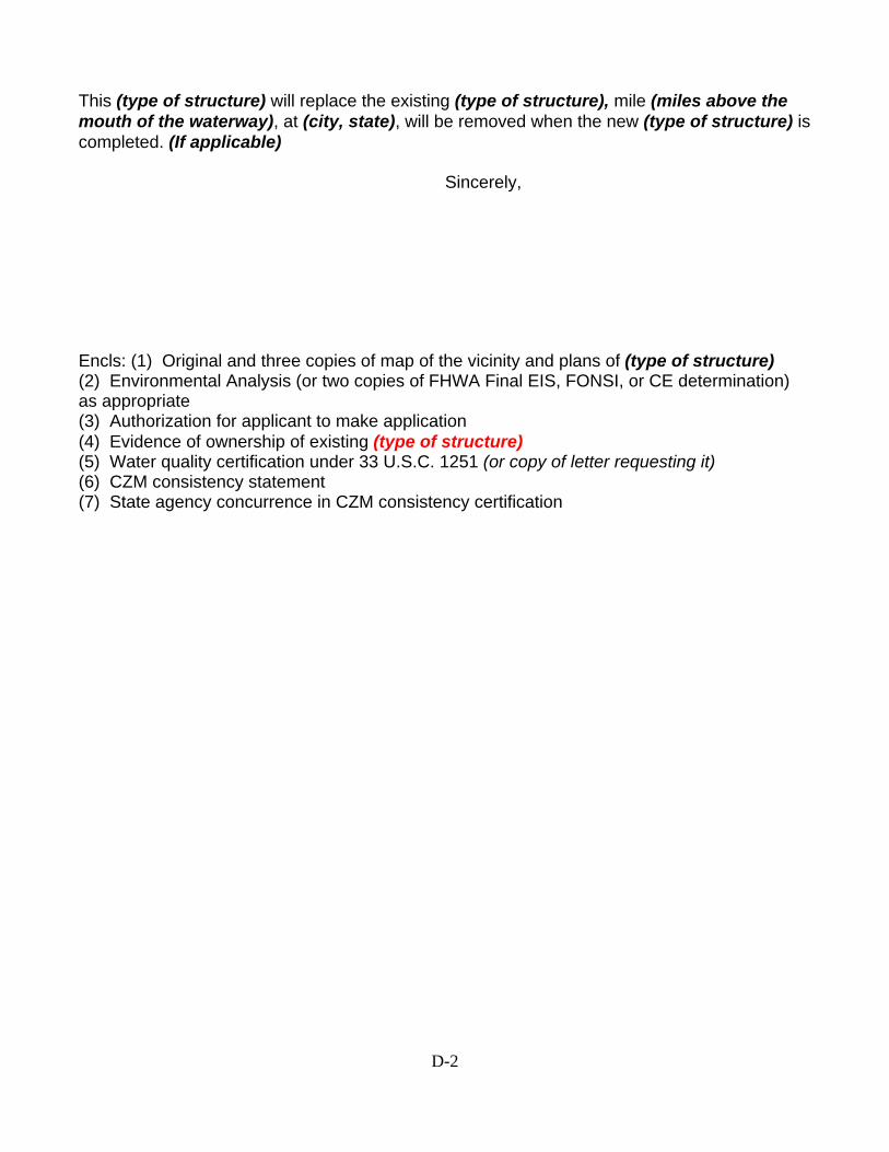
This (type of structure) will replace the existing (type of structure), mile (miles above the mouth of the waterway), at (city, state), will be removed when the new (type of structure) is completed. (If applicable) Sincerely,
Encls: (1) Original and three copies of map of the vicinity and plans of (type of structure) (2) Environmental Analysis (or two copies of FHWA Final EIS, FONSI, or CE determination) as appropriate (3) Authorization for applicant to make application (4) Evidence of ownership of existing (type of structure) (5) Water quality certification under 33 U.S.C. 1251 (or copy of letter requesting it) (6) CZM consistency statement (7) State agency concurrence in CZM consistency certification

D-3

E-1
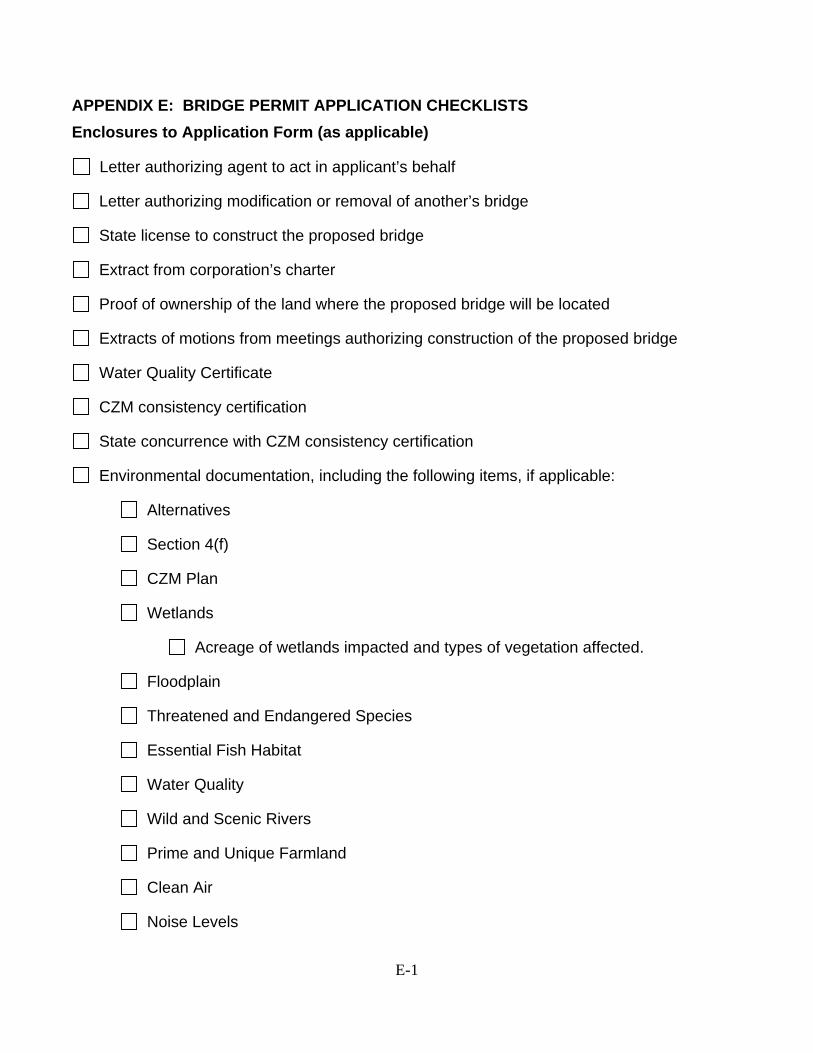
APPENDIX E: BRIDGE PERMIT APPLICATION CHECKLISTS Enclosures to Application Form (as applicable)
Letter authorizing agent to act in applicant’s behalf
Letter authorizing modification or removal of another’s bridge
State license to construct the proposed bridge
Extract from corporation’s charter
Proof of ownership of the land where the proposed bridge will be located
Extracts of motions from meetings authorizing construction of the proposed bridge
Water Quality Certificate
CZM consistency certification
State concurrence with CZM consistency certification
Environmental documentation, including the following items, if applicable:
Alternatives
Section 4(f)
CZM Plan
Wetlands
Acreage of wetlands impacted and types of vegetation affected.
Floodplain
Threatened and Endangered Species
Essential Fish Habitat
Water Quality
Wild and Scenic Rivers
Prime and Unique Farmland
Clean Air
Noise Levels
E-2
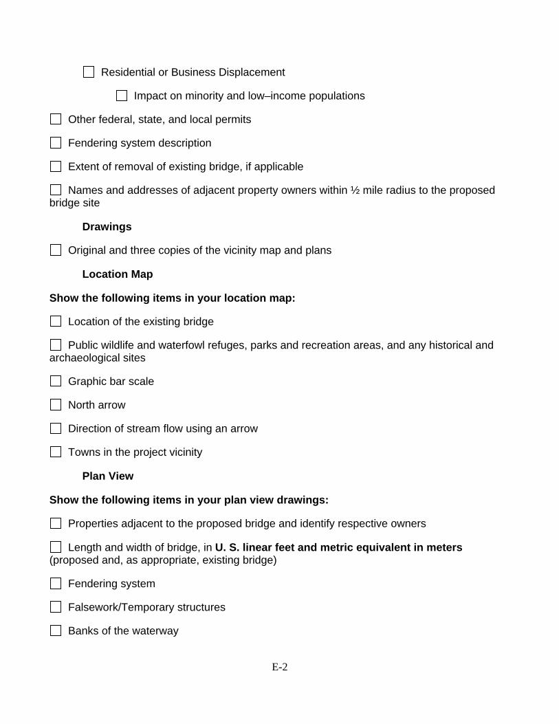
Residential or Business Displacement
Impact on minority and low–income populations
Other federal, state, and local permits
Fendering system description
Extent of removal of existing bridge, if applicable
Names and addresses of adjacent property owners within ½ mile radius to the proposed bridge site
Drawings
Original and three copies of the vicinity map and plans
Location Map
Show the following items in your location map:
Location of the existing bridge
Public wildlife and waterfowl refuges, parks and recreation areas, and any historical and archaeological sites
Graphic bar scale
North arrow
Direction of stream flow using an arrow
Towns in the project vicinity
Plan View
Show the following items in your plan view drawings:
Properties adjacent to the proposed bridge and identify respective owners
Length and width of bridge, in U. S. linear feet and metric equivalent in meters (proposed and, as appropriate, existing bridge)
Fendering system
Falsework/Temporary structures
Banks of the waterway
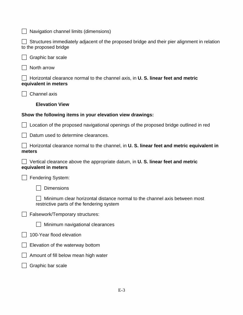
E-3
Navigation channel limits (dimensions)
Structures immediately adjacent of the proposed bridge and their pier alignment in relation to the proposed bridge
Graphic bar scale
North arrow
Horizontal clearance normal to the channel axis, in U. S. linear feet and metric equivalent in meters
Channel axis
Elevation View
Show the following items in your elevation view drawings:
Location of the proposed navigational openings of the proposed bridge outlined in red
Datum used to determine clearances.
Horizontal clearance normal to the channel, in U. S. linear feet and metric equivalent in meters
Vertical clearance above the appropriate datum, in U. S. linear feet and metric equivalent in meters
Fendering System:
Dimensions
Minimum clear horizontal distance normal to the channel axis between most restrictive parts of the fendering system
Falsework/Temporary structures:
Minimum navigational clearances
100-Year flood elevation
Elevation of the waterway bottom
Amount of fill below mean high water
Graphic bar scale
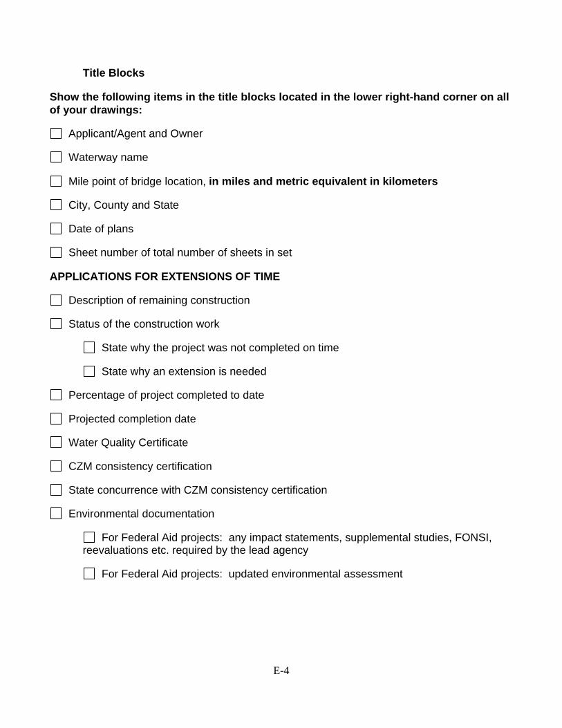
E-4
Title Blocks
Show the following items in the title blocks located in the lower right-hand corner on all of your drawings:
Applicant/Agent and Owner
Waterway name
Mile point of bridge location, in miles and metric equivalent in kilometers
City, County and State
Date of plans
Sheet number of total number of sheets in set
APPLICATIONS FOR EXTENSIONS OF TIME
Description of remaining construction
Status of the construction work
State why the project was not completed on time
State why an extension is needed
Percentage of project completed to date
Projected completion date
Water Quality Certificate
CZM consistency certification
State concurrence with CZM consistency certification
Environmental documentation
For Federal Aid projects: any impact statements, supplemental studies, FONSI, reevaluations etc. required by the lead agency
For Federal Aid projects: updated environmental assessment
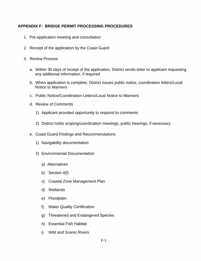
F-1
APPENDIX F: BRIDGE PERMIT PROCESSING PROCEDURES
1. Pre-application meeting and consultation
2. Receipt of the application by the Coast Guard
3. Review Process
a. Within 30 days of receipt of the application, District sends letter to applicant requesting any additional information, if required
b. When application is complete, District issues public notice, coordination letters/Local Notice to Mariners
c. Public Notice/Coordination Letters/Local Notice to Mariners
d. Review of Comments
1) Applicant provided opportunity to respond to comments
2) District holds scoping/coordination meetings, public hearings, if necessary
e. Coast Guard Findings and Recommendations
1) Navigability documentation
2) Environmental Documentation
a) Alternatives
b) Section 4(f)
c) Coastal Zone Management Plan
d) Wetlands
e) Floodplain
f) Water Quality Certification
g) Threatened and Endangered Species
h) Essential Fish Habitat
i) Wild and Scenic Rivers
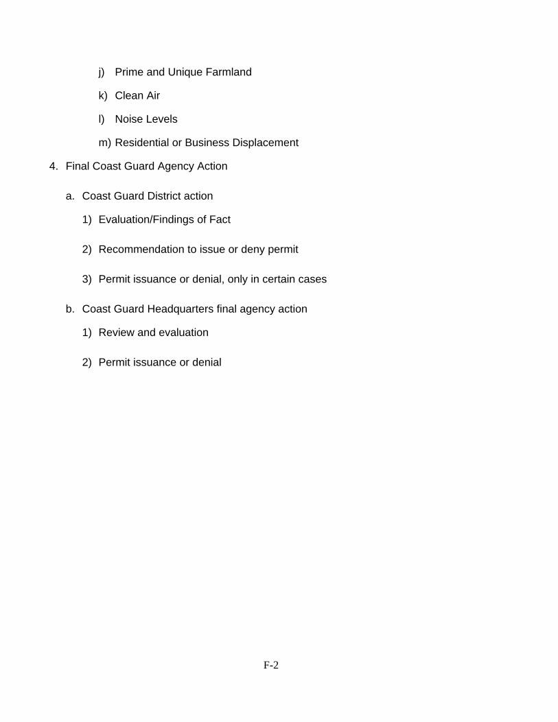
F-2
j) Prime and Unique Farmland
k) Clean Air
l) Noise Levels
m) Residential or Business Displacement
4. Final Coast Guard Agency Action
a. Coast Guard District action
1) Evaluation/Findings of Fact
2) Recommendation to issue or deny permit
3) Permit issuance or denial, only in certain cases
b. Coast Guard Headquarters final agency action
1) Review and evaluation
2) Permit issuance or denial
G-1
APPENDIX G: SAMPLE PLANS SUBMITTED FOR APPROVAL The plans submitted with your bridge permit application become an official permanent part of the permit or permit amendment when issued. Therefore, the plans must be legible, accurate and contain the information needed for the Coast Guard to evaluate the bridge project and its location. If the plans are not legible enough or do not contain the required information they will be returned to the applicant for repair. The permit process will be halted until the plans are resubmitted. Plan requirements are stated in Appendix E. Remember that all drawings will be on letter-size sheets. As few sheets will be used as necessary to show clearly what is proposed. Examples follow.
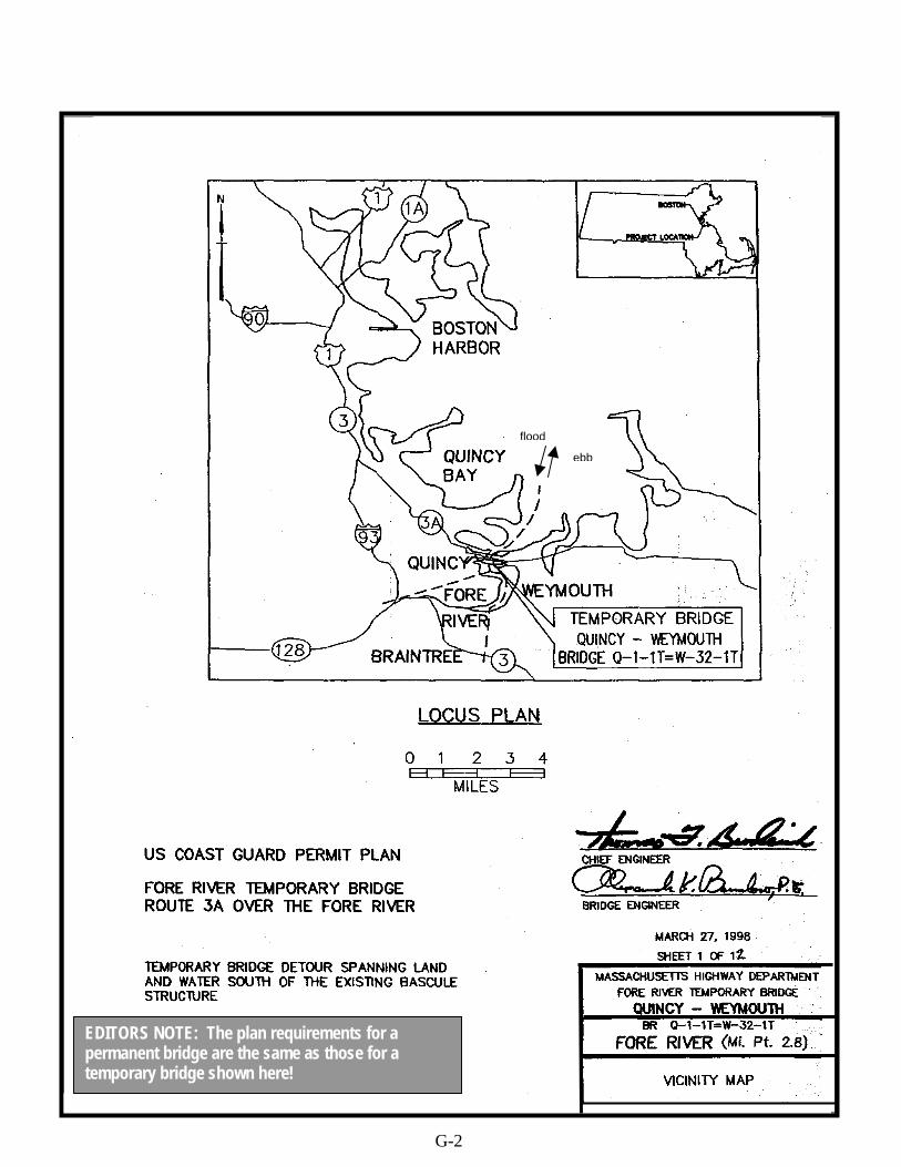
EDITORS NOTE: The plan requirements for a permanent bridge are the same as those for a temporary bridge shown here!
G-2
flood
ebb

G-3
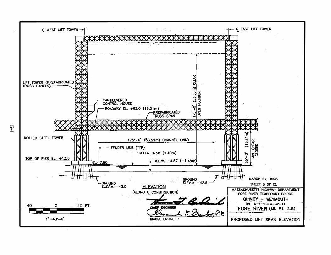
G-4

N
Flood/Ebb
G-5

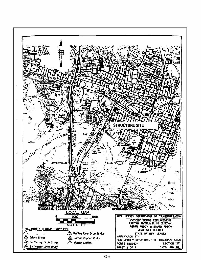
G-6
ebb
flood

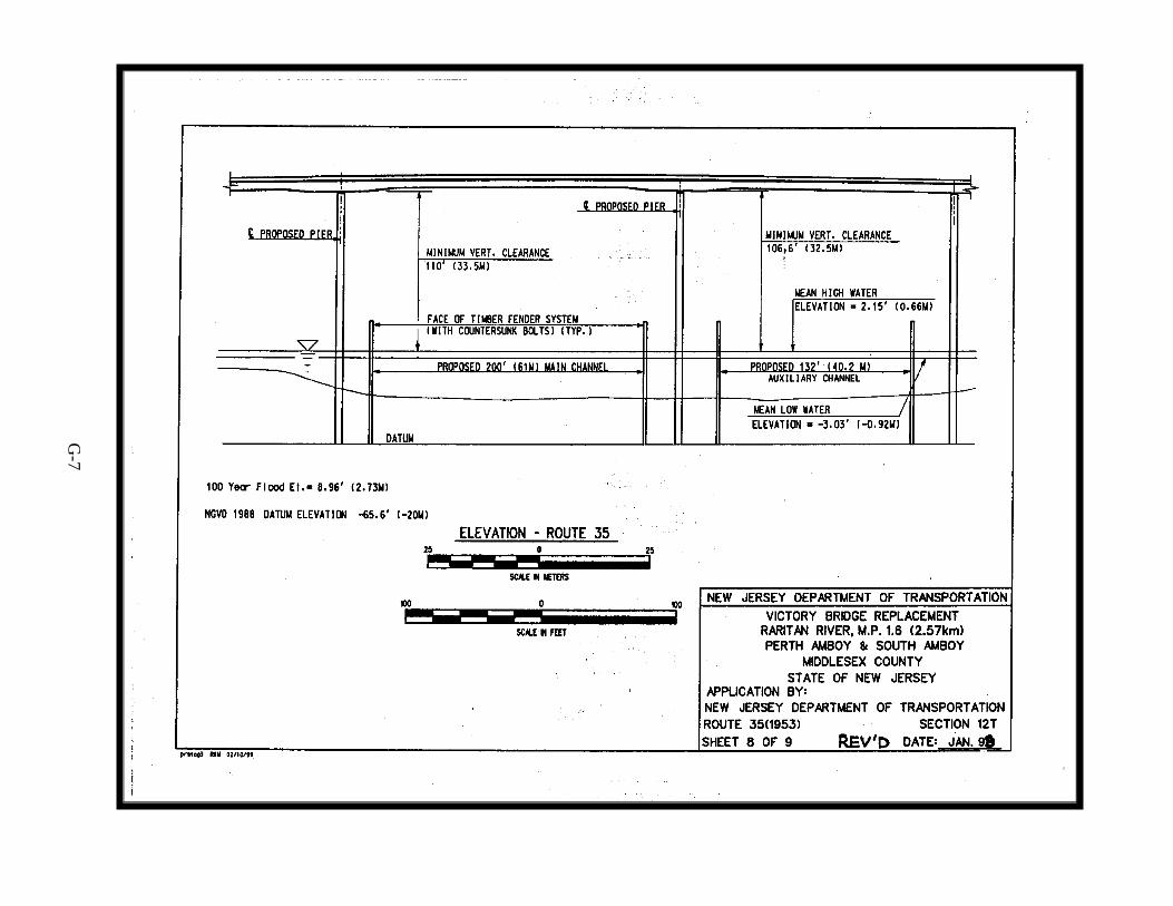
G-7

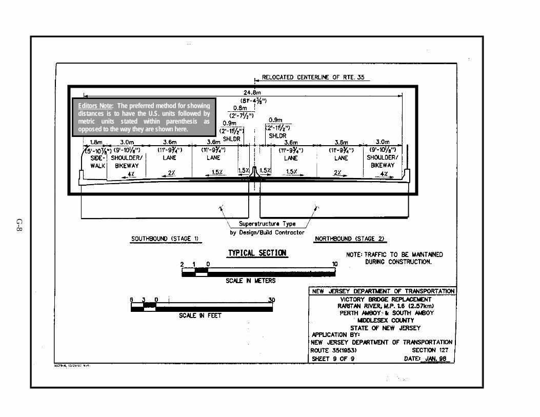
Editors Note: The preferred method for showingdistances is to have the U.S. units followed bymetric units stated within parenthesis asopposed to the way they are shown here.
G-8
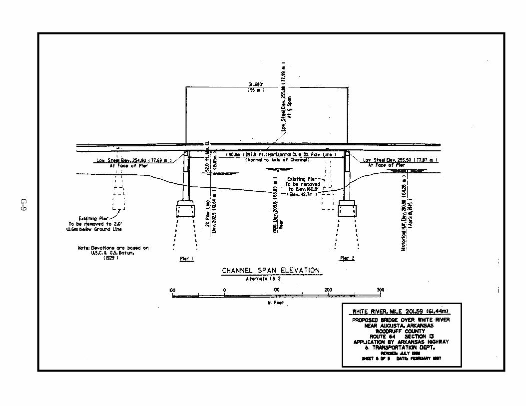
G-9
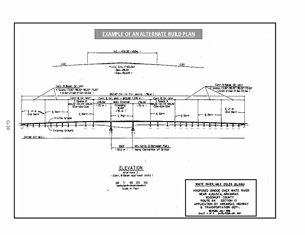
EXAMPLE OF AN ALTERNATE BUILD PLAN
G-10