Embed Size (px)
Citation preview
.·. ENVIRONMENTAL AS.SESSMENT/ PROGRAMMATIC SECTION. 4(f) EVALUATION
. . .
for··
the Proposed Reconstruction and Widening of 1-94 · West of 12th Street to Sprinkle Road
. ' in the Cities of Kalamazoo and Portage Kalamaz:oo. CountyMichigan
Michigan.Department of :Transportation - • • • ; _J
· Prepare.d by the:. .
. MICHIGAN DEPARTMENT OF TRANSPORTATION
I. ·In cooperation with the . i . U.S. DEPARTMENT OF TRANSPORTATION.
.FEDERAL HIGHWAY·ADMINISTRATION
I
I
' , - ' '
'- ' ' .{_ '.

This document has been: published by authorization of the Director of the State vf Michigan's Department of Transportation inkeeping with the intent of the National Environmental Policy Act of 1969and subsequ nt · implementing regulations and policies that direct agencies to prc·,ride the public and other agencies an opportunity to review and cmnment on pt:oposed projects and alternatives so ID>'lt potentiai impacts on rhe project can be considered. and taken into account duringthe decision-making process. The cost of publishing 85 copiesof this docUffi;!nt at $2.68 per copy is $227.93; and the document has been printed' in accordance with Mtc.izigan Executive Directive 1991-6. . ' . .
ENVIRONMENTAL ASSESSMENT/ PROGRAMMATIC SECTION 4(f) EVALUATION
for
the Proposed Reconstruction and Widening of 1-94 West of 12th Street to Sprinkle Road
in the cities of Kalamazoo and Portage Kalamazoo County, Michigan
PREPARED by the
MICHIGAN DEPARTMENT OF TRANSPORTATION in Cooperation with the
- U.S. DEPARTMENT OF TRANSPORTATION FEDERAL HIGHWAY ADMINISTRATION
APPROVED:
q-!o.-O"L Date for the Federal Highway Administration
For additional information concerning the proposed project, or this document,contact: Mr. Ronald Hatcher Area Engineer Federal Highway Administration 315 West Allegan Street, Rm. 207 Lansing, Ml 48933 Phone: (517} 702-1832
Mr.Ron Kinney, Manager Environmental Section Michigan Department of Transportation P.O. Box 30050 Lansing, Ml 48909 Phone: (517} 335-2621

PREFACE
The National Environmental Policy Act (NEPA) of 1969 requires that the social, economic, and natural environmental impacts of any proposed action of the federal government be analyzed for
. decision-making and public information purposes. There are three chtsses of action. Class IActions, which are those that may significantly affect the environment, require the preparation of an Environmental Impact Statement (EIS). Class II Actions (categorical exclusions) are those that do not individually or cumulatively have a significant effect on the environment and do not require the preparation of an EIS or an Environmental Assessment (EA). Class III Actions are those for which the significance of impacts is not clearly established. Class III Actions require the preparation of an EA to determine the significance of impacts and the appropriate environmental document to be prepared- either an EIS or a Finding of No Significant Impact (FONSI).
This document is an Environmental Assessment for the proposed reconstruction ofi-94, from west of 12th Street easterly to Sprinkle Road in the Cities of Kalamazoo and Portage, Kalamazoo County, Michigan. It describes and analyzes one construction alternative, and the measures taken to minimize harm to the project area. It will be distributed to the public and to various federal, state, and local agencies for review and comment. An opportunity for a public hearing on this document will be advertised in local papers. If review and comment by the public and interested agencies support the determination of "no significant impact", this EA will be forwarded to the Federal Highway Administration (FHWA) with a recommendation that a FONSI be prepared. If it is determined that the preferred alternative will have significant impacts that cannot be mitigated, the preparation of an EIS will be required.
This document also contains a Programmatic Section 4(t) Evaluation for the proposed reconstruction ofi-94. Section 4(t) of the Department of Transportation Act requires that an evaluation be prepared when the proposed action may have an adverse effect on a property eligible for or listed on the National Register of Historic Places or may impact publicly owned land from a park, recreation area, or wildlife/waterfowl refuge of national, state or local significance. The proposed project will impact a non-motorized recreational trail. This evaluation must determine that there is no prudent and feasible alternative that avoids the 4(t) impact, and that all possible measures to minimize harm have been taken, before the project may proceed.
This document was prepared by the Environmental se-ction of the Michigan Department of Transportation (MDOT), in cooperation with the Federal Highway Administration (FHWA) and other members of the I-94 project study team. The study team includes representatives from the following divisions within the Michigan Department of Transportation: Design, Project Planning, Real Estate, Construction and Technology, Traffic and Safety, and the Southwest Region. Information contained in this Environmental Assessment was also furnished by other federal and state agencies, local units of government, public interest groups, and individual citizens.
iii

Table of Contents
PREFACE . . . . . . . . . . . . . . . . . . . . . . . . . . . . . . . . . . . . . . . . . . . . . . . . . . . . . . . . . . . . . . . . . . . . 111
SECTION 1 -PROPOSED PROJECT
1.1 Description of and Need for the Proposed Project . . . . . . . . . . . . . . . . . . . . 1 1.2 Alternatives Considered........................................ 1 1.3 Other Alternative Considered and Dismissed . . . . . . . . . . . . . . . . . . . . . . . 2
SECTION 2- AFFECTED ENVIRONMENT, POTENTIAL IMPACTS, AND MEASURES TO MITIGATE IMPACTS DURING CONSTRUCTION
2.1 Right of Way Impacts . . . . . . . . . . . . . . . . . . . . . . . . . . . . . . . . . . . . . . . . . 7 2.2 Indirect and Cumulative Impacts . . . . . . . . . . . . . . . . . . . . . . . . . . . . . . . . . 7 2.3 Social Impacts . . . . . . . . . . . . . . . . . . . . . . . . . . . . . . . . . . . . . . . . . . . . . . . 8 2.4 Environmental Justice . . . . . . . . . . . . . . . . . . . . . . . . . . . . . . . . . . . . . . . . . 9 2.5 Maintaining Traffic . . . . . . . . . . . . . . . . . . . . . . . . . . . . . . . . . . . . . . . . . . . 9 2.6 Historic and Archaeological Resources . . . . . . . . . . . . . . . . . . . . . . . . . . . . 9 2.7 Noise ...................................................... 9 2.8 Air Quality .................................................·. 13 2.9 Farmland ................................................... 14 2.10 Endangered and Threatened Species .............................. 14 2.11 Stream Crossings ............................................. 15 2.12 Flood Plains/Hydraulics ........................................ 16 2.13 Wetlands ................................................... 18 2.14 Permits ..................................................... 18 2.15 Measures to Minimize Impacts During Construction ................. 18
SECTION 3- PUBLIC AND AGENCY INVOLVEMENT
3.1 Public Involvement ........................................... 23 3.2 Local Agency Participation ..................................... 23
SECTION 4- PROJECT COSTS
4.1 Project Costs ................................................ 23
SECTION 5- CONCLUSION
5.1 Conclusion .................................................. 23
v
SECTION 6 -PROGRAMMATIC SECTION 4(f) EVALUATION
6.1 Introduction ................................................. 24 6.2 Proposed Action .............................................. 24 6.3 Description of Section 4(t) Property .............................. 25 ·6.4 hnpacts to Section 4(t) Property ............... ..•.............. 25 6.5 Avoidance Alternatives ........................................ 25 6.6 Measures to Minimize Harm .................................... 27 6.7 Coordination ................................................ 27 6.8 Conclusion .................................................. 27
APPENDICES
Appendix A- Maintaining Traffic Plan .................................. A-1 Appendix B- Noise ................................................. B-1 Appendix C - Air Quality ............................................. C-1 Appendix D - Coordination Letter from MDNR ........................... D-1 Appendix E - Letter from the City of Portage ............................. E-1
EXHIBITS
1.1 Project Location Map . . . . . . . . . . . . . . . . . . . . . . . . . . . . . . . . . . . . . . . . . . 3 1.2 I-94 Proposed hnprovements . . . . . . . . . . . . . . . . . . . . . . . . . . . . . . . . . . . . 4 1.3 I-94 Proposed Improvements . . . . . . . . . . . . . . . . . . . . . . . . . . . . . . . . . . . . 5 1.4 I-94 Proposed Improvements . . . . . . . . . . . . . . . . . . . . . . . . . . . . . . . . . . . . 6 2.1 Flood Hazard Areas and Wetland Map ............................ 19 6.1 Map of Bicentennial Park ...................................... 26
vi
SECTION I PROPOSED PROJECT
1.1 DESCRIPTION OF AND NEED FOR THE PROPOSED PROJECT
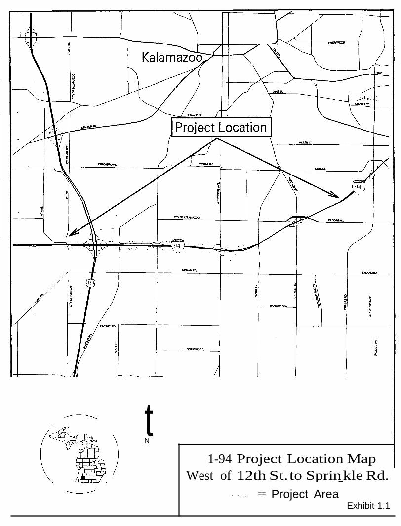
This Environmental Assessment/Section 4(f) Evaluation [EA/4(f)] describes the proposed improvements to 6.7 miles of I-94 from West of 12th Street to Sprinkle Road in the cities of Kalamazoo and Portage, Michigan (Exhibit 1.1). The Michigan Department of Transportation is proposing to add an additional lane to both eastbound and westbound I-94 from west of 12th street to Sprinkle Road, as well as improve several interchanges within this section of roadway.
The I-94 freeway is a major east/west facility linking Michigan to several midwest states and Ontario, Canada. The section of I-94 being studied, traverses through the cities of Kalamazoo and Portage. This urban section of I-94 is a four-lane facility with merge/weave lanes, and currently carries more vehicles per day than any other 4-lane freeway in the state. Traffic volumes range from 57,000 vehicles to over 81,000 vehicles per day; while commercial vehicles average between 14 to 20 percent.
The need for improving this section of I-94 is based on the inadequate roadway capacity, existing geometric deficiencies, and deteriorated condition of the pavement and bridges. Over the last three years, MDOT has conducted studies which concluded that the existing I-94 roadway and bridges need to be improved in order to improve traffic operations on the I-94 Corridor which serves as a vital link to the economy in the Kalamazoo area.
1.2 ALTERNATIVES CONSIDERED
1.2.1 No Build
This alternative involves taking no action to widen I-94, other than routine maintenance and preservation of the existing system. Routine maintenance and preservation of the roadway and bridges would not correct all of the deficiencies. This alternative is the base condition used to compare with the other alternatives.
1.2.2 Widen and Reconstruct I-94
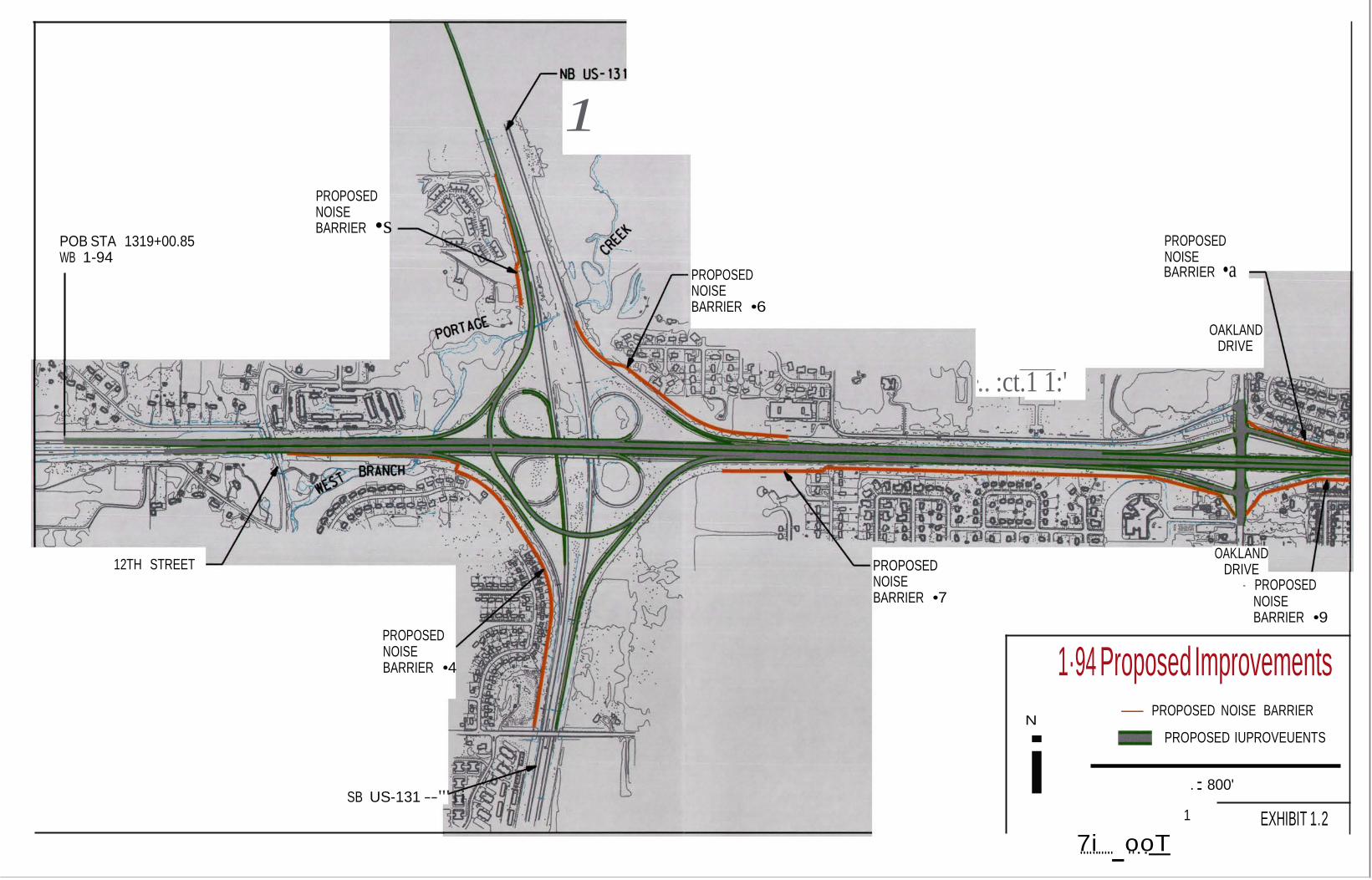
The preferred alternative is the reconstruction and widening ofi-94 from West of 12th Street to Sprinkle Road in the cities of Kalamazoo and Portage, Michigan (See Exhibits 1.2, 1.3 and 1.4). MDOT is proposing to widen I-94 from four to six lanes and preserve the merge/weave lanes between Westnedge Avenue and Oakland Drive, and between Oakland Drive and US-131. The widening from west of 12th Street to east of Oakland Drive; and from the Norfolk Southern Railroad Bridge between Westnedge Avenue and Lovers Lane, as well as the Conrail Railroad Bridge between Portage Road and Sprinkle Road, will be done within the median. The rest of the widening will be done outside of the existing lanes.
1
1\IDOT is proposing to replace17 bridges within the project limits. Also being proposed are three new bridge structures which will be constructed as part of the realigned I-94/US-131 Interchange. A new ramp (Ramp G) from southbound US-131 to eastbound I-94 will be constructed. The proposed alternative for carrying Ramp Gover US-131 consists of a single span bridge over southbound US-131 and a single span bridge over northbound US-131 with retained earth between them over the intervening median berm. The Westnedge Avenue Interchange will also be improved by reconfiguring the I-94 entrance and exit ramps to a Single Point Urban Interchange (SPUI) configuration with the addition of one through lane in each direction on Westnedge Avenue and the creation of one southbound left turn lane to the eastbound I-94 entrance ramp, and the creation of two northbound left turn lanes to the westbound I-94 entrance ramp. The other interchanges improvements include: improvements at Oakland Drive and Portage Road Interchanges; and improvements to the I-94 eastbound exit ramp and the I-94 westbound entrance ramps at Sprinkle road.
1.2.3 Alternative Considered and Dismissed
MDOT did consider another alternative to address the existing deficiencies along the I-94 Corridor. MDOT considered widening I-94 without improving theinterchanges. However, after conducting several studies, it was determined that widening I-94 without improving the interchanges would not alleviate all of the deficiencies that existed on I-94 between 12th Street and Sprinkle Road.
2
tN
1-94 Project Location Map West of 12th St. to Sprin kle Rd.
- -, ... == Project Area Exhibit 1.1

i
1 POB STA 1319+00.85 WB 1-94
PROPOSED NOISE BARRIER •s
PROPOSED NOISE BARRIER •6
·.. :ct.1 1:' .
PROPOSED NOISE BARRIER •a
OAKLAND DRIVE
12TH STREET PROPOSED NOISE BARRIER •7
PROPOSED NOISE BARRIER •4
SB US-131 --"'1i ·
OAK.LAND DRIVE
- PROPOSED NOISE BARRIER •9
1·94 Proposed Improvements
- PROPOSED NOISE BARRIER
N PROPOSED IUPROVEUENTS
.: 800'
1
7....i......._o...o. T EXHIBIT 1.2

EXIST lNG NOISE BARRIER B no BE REPLACED>
PROPOSED NOISE BARRIER •a
nnnoosED RIGHT OF WAY TO BE
RED BY THE CITY OF PORTAGE
EXIST lNG NOISE BARRIER A no BE REPLACED>
PROPOSED NOISE BARRIER •9
PROPOSED NOISE BARRIER •g
RIGHT OF WAY TO BE IRED BY THE ClTY OF PORT AGE
NSRR 1·94 Proposed Improvements
PROPOSED IMPROVEMENTS POTENTIAL RIGHT OF WAY ACQUISITION PROPOSED NOISE BARRIER
.. .. IN - EXISTING NOISE BARRIER
L__
...,. .. ,.: 800'
EXHIBIT 1.3
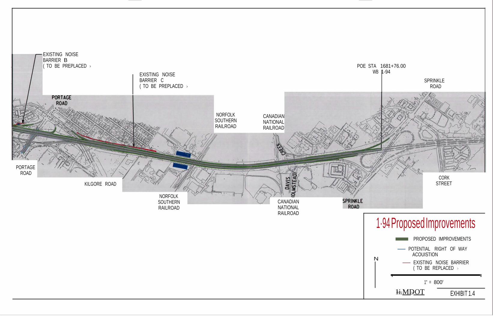
EXISTING NOISE BARRIER B ( TO BE PREPLACED >
EXISTING NOISE BARRIER C ( TO BE PREPLACED >
POE STA 1681+76.00
WB 1-94
SPRINKLE
ROAD
NORFOLK SOUTHERN RAILROAD
CANADIAN NATIONAL RAILROAD
PORTAGE
ROAD KILGORE ROAD
NORFOLK
SOUTHERN RAILROAD
CANADIAN NATIONAL RAILROAD
CORK STREET
1·94 Proposed Improvements
PROPOSED IMPROVEMENTS
- POTENTIAL RIGHT OF WAY ACOUISTION
N - EXISTING NOISE BARRIER
( TO BE REPLACED >
I I
1" = 800'
1..,i....MD., OT
EXHIBI
T 1.4
SECTION2 AFFECTED ENVIRONl\tiENT, POTENTIAL IMPACTS, AND MEASURES TO MITIGATE IMPACTS DURING CONSTRUCTION
Because of its limited scope, the proposed project is expected to have minimal, if any, social, economic, or environmental impacts. As with all proposed projects; however, a review of potential impacts was conducted by MDOT and FHWA staff. Those impacts which had a reasonable possibility for individual or cumulative significant impacts were analyzed further. The result of this analysis, and measures to minimize short-term impacts during construction are discussed below.
2.1 RIGHT OF WAY IMPACTS
In order to widen and reconstruct I-94, , right-of-way acquisition will be required for this project (See Exhibits 1.2, 1.3 and 1.4). MDOT is proposing to acquire right of way at the following locations: 1) Two acres will be required in the southwest and the northeast quadrants at the Norfolk Southern Railroad/Portage Creek Bridge crossing: 2) One acre will be required along the west side of Lovers Lane Road. The city of Portage is responsible for purchasing this one acre of right of way: 3) One acre will be required on the south side of I-94, west of the Conrail Railroad tracks: 4) One acre will be required on the south side of I-94 just north of the Mead property; 5) One acre will be required on the north side of I-94, just west of the Norfolk Southern Railroad for a detention pond: 6) One acre will be required on the south side of I-94, just west of the Norfolk Southern Railroad for a detention basin.
There will be no relocations of private residences or commercial businesses; however, grading permits may be required for the construction of the proposed noise barriers and retaining walls.
All right-of-way will be acquired in conformance with the Uniform Relocation Assistance and Real Property Acquisition Policies Act of 1970, as amended.
2.2 INDIRECT AND CUMULATIVE IMPACTS
Since the proposed project involves widening the existing I-94 freeway within the existing right- of-way from 12th Street to Sprinkle Road, any indirect (secondary) impacts would be limited to the interchange improvement areas. Since this is an urban area, the impacts at the interchanges would likely be limited to future redevelopment of existing ·businesses located there. The existing freeway and the proposed improvements are consistent with the Kalamazoo and Portage zoning maps and land use plans. There are a few park or open space areas and school properties that are not available for development adjacent to the freeway within the project limits. While these properties will not be affected by indirect development, they may be indirectly affected by noise from the proposed project improvement. See Noise Analysis in Appendix B.
The zoning adjacent to the west end of the project area in Texas Township is residential. The area at the east end of the project area in Comstock Township adjacent to the freeway is zoned
7
- -- ------ -- --- --- - -- ---- -- --
for a variety of uses including single family residential, ge11eral business, manufacturing and industrial and some agricultural residential. '
As far as cumulative impacts are concerned, the Kalamazoo/Portage area has grown dramatically due to the influence of many major developments in the area. Some past and present factors in the growth of this area include Western Michigan University (WMU), Kalamazoo College, Kalamazoo Valley Community College, Nazareth College, the Kalamazoo/Battle Creek International Airport, Kalamazoo Air Museum, Amtrack Rail Service, General Motors, Pharmacia, Borgess and Bronson Hospitals, Wings Stadium, and Maple Hill and Crossroads Malls. A current development project that will influence the future of the area is the Technology Park at the former WMU!Lee Baker Farm on Parkview Road at Drake Road. The construction of I-94 and US-131 and their various interchanges also had an impact on the intensity and direction of development in the project area. The growth of the Battle Creek commercial district adjacent to the I-94 corridor east of Kalamazoo has also influenced growth on the east side of Kalamazoo to a greater degree than to west side of the city, which remains more rural. While most of these developments have been implemented by the private sector, some represent public investments, too. The decisions to implement the majority of these ventures were made locally, with the exception of the Interstate and U.S. freeways, the international airport, and the military installation of Fort Custer east of the project area in the vicinity of Battle Creek.
Other proposed local, state, and federal transportation improvements expected to be included in the Kalamazoo Area Transportation Authority (KATS) 2025 Long Range Plan which is currently under development include various widening projects along most of the local roads that connect directly or indirectly to I-94 at interchanges, including Kilgore Road, Oakland Drive, Parkview Avenue, Sprinkle Road, and Westnedge Avenue. The City of Portage Major Thoroughfare Plan identifies funded projects for widening Kilgore Road, Lovers Lane, Mall Drive, Milham Avenue, Oakland Drive and extending Romence Road. In the MDOT Five Year Plan, Road and Bridge Program IV 2002-2006, rehabilitation projects are planned along I-94 in Calhoun County, east of Kalamazoo, as well as a rehabilitation ofUS-131 from M-43 north to M-89 north of Kalamazoo.
The traffic models indicate that widening I-94 will attract traffic to the improved route, and that many of the local roads will benefit from decreased traffic, especially routes closest to existing I-94 and US-131.
2.3 SOCIAL IMPACTS
The proposed project will not cause any negative impacts on any minority, ethnic, low-income, elderly or handicapped groups. No neighborhoods will be separated from community facilities or services. There will be no long term negative impacts on .area schools, churches, recreation areas, or police and fire protection facilities. However, there will be temporary impacts to a non- motorized trail which is discussed in Section 6; and traffic disruptions during construction. Access for emergency vehicles will be provided for during the improvements to the roadway and bridges.
8
MDOT will coordinate with local officials in providing updated information in assisting all emergency vehicles in selecting the best route to use during construction.
2.4 ENVIRONMENTALJUSTICE
The puipose of Executive Order 12898 on Federal Actions to Address Environmental Justice in Minority and low-income Populations is to identify, address, and avoid disproportionately high and adverse human health or environmental effects on minority and low-income populations. Disproportionately high and adverse human health or environmental effects on minority and low- income populations are not anticipated as a result of this project. It has been determined from visual inspection, project information, and census data that there will be no disproportionately adverse effects on minority and low-income populations in the project area.
However, as required by Executive Order 12898, a continued effort will be made to identify such groups or individuals during the study of this project. If such groups are found, every effort will be made to actively involve them in the project development process, and to avoid or mitigate any potential disproportionately adverse impacts that may result from the proposed project.
2.5 MAINTAINING TRAFFIC
During the widening of I-94, traffic in each direction will be maintained on the existing roadway. A minimum of two 11 foot lanes in each direction will be maintained on I-94, and where possible, 8 foot temporary shoulders will be provided. Several temporary detours will also be required during various stages of construction. Eastbound I-94 traffic to northbound US-131 and southbound US-131 traffic to westbound I-94 will use Stadium Drive and 9m Street as a detour route. The second detour will divert Lover's Lane traffic to Milham and to either Portage Road or Westnedge, south ofl-94; and Kilgore to either Portage or Westnedge just north ofi-94. The third detour will be needed for temporary ramp closures. Traffic will be detoured to Kilgore, Milham and Westnedge. For a complete description of the proposed maintaining traffic plan, refer to Appendix A.
Although there will be short-term impacts, such as an increase in traffic volumes on local roads, and longer travel times, these impacts will only be temporary.
2.6 HISTORIC AND ARCHAEOLOGICAL RESOURCES
Based on a review of historic and archaeological data bases, this project will not affect any historic or archaeological resources.
2.7 NOISE
Sound is created when an object moves: the rustling of leaves as the wind blows, the air passing through our vocal cords, and the almost imperceptible movement of the speakers on a stereo. All
9
- --
of these types of movements cause waves to occur in air molecules. When these waves hit our ears, we perceive them as sound.
The strength of the sound waves that reach our ears is quantified by units of measure called
. decibels (dB). Traffic noise levels are expressed in terms of the hourly A-weighted equivalent sound level in decibels (d.B(A)). The A-weighting scale is.a standardized method of sound level measurement that closely resembles the sensitivity of the human ear. Because traffic noise is a time-varying level, it is commonly expressed as an equivalent sound level (leq), representing the average energy level of the time-varying sound for the period being considered. Typically, this period is one hour. Consequently, the noise level measurement unit is denoted as Leq(h).
Impact Criteria
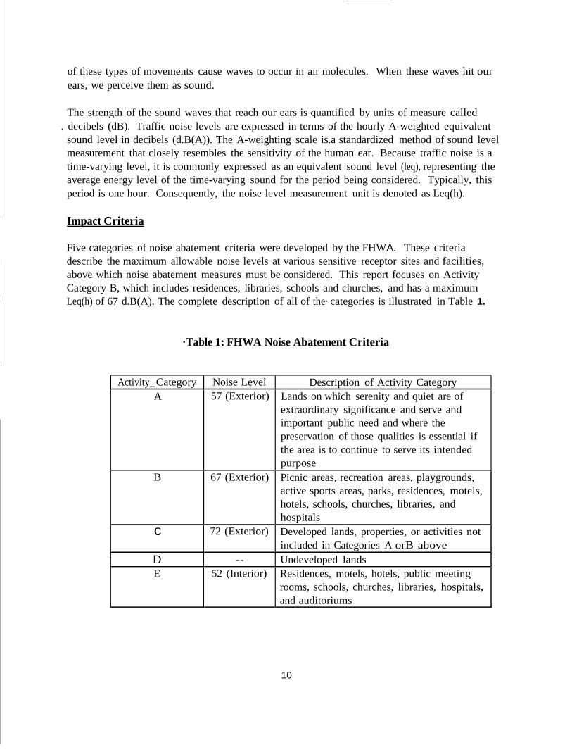
Five categories of noise abatement criteria were developed by the FHWA. These criteria describe the maximum allowable noise levels at various sensitive receptor sites and facilities, above which noise abatement measures must be considered. This report focuses on Activity Category B, which includes residences, libraries, schools and churches, and has a maximum Leq(h) of 67 d.B(A). The complete description of all of the· categories is illustrated in Table 1.
·Table 1: FHWA Noise Abatement Criteria
Activity_ Category Noise Level Description of Activity Category A 57 (Exterior) Lands on which serenity and quiet are of
extraordinary significance and serve and important public need and where the preservation of those qualities is essential if the area is to continue to serve its intended purpose
B 67 (Exterior) Picnic areas, recreation areas, playgrounds, active sports areas, parks, residences, motels, hotels, schools, churches, libraries, and hospitals
c 72 (Exterior) Developed lands, properties, or activities not included in Categories A orB above
D -- Undeveloped lands E 52 (Interior) Residences, motels, hotels, public meeting
rooms, schools, churches, libraries, hospitals, and auditoriums
10
Current FHWA guidelines indicate that a traffic noise impact occurs when the predicted noise levels approach or exceed the noise abatement criteria or when predicted traffic noise levels substantially exceed the existing noise levels.
The Michigan Department of Transportation (MDOT) established a noise analysis and abatement
·policy in June of 1996. This policy states that where feasible and reasonable, highway traffic noise will be abated on developed land adjacent to the highway right-of-way in the interest of public health and welfare. The developed lands that will be studied and considered for abatement includes residential land uses, hospitals, libraries and schools. Areas that are primarily commercial will not receive noise abatement since noise barriers would tend to decrease the visibility of the commercial structures.
MDOT states that noise abatement is considered feasible and reasonable if noise levels can be reduced by 6 dB(A) or more, and the cost per benefitting residence is at or below $32,200 (2002 dollars). In order to determine the total cost of each barrier, a unit cost of $23 (2002 dollars) per square foot of wall was used. Also; proposed noise barriers must be a minimum of 600 feet long and a maximum of 24 feet high to be considered feasible and reasonable.
Results of Analysis
The following is the result of the noise analysis that was conducted on the existing and proposed noise barriers along I-94.
Proposed Noise Barriers
Barriers 1, 2, and 3 (Appendix B, Table 3) were determined to be both infeasible and unreasonable. Each of these barriers was either not able to reach the noise reduction goal of 6 dB(A) while staying below the maximum barrier height of 24 feet or was going to cost more than $32,200 per benefitting resident. It is not recommended that any of these barriers be constructed.
Barriers 4, 5, 6, 7 and 9 were determined to be both feasible and reasonable. Each of these barriers was able to achieve the noise reduction goal of 6 dB(A). Also, the cost of each barrier per benefitting resident was less than $32,200.
Barriers 8, 10, and 11 are possibly feasible and reasonable. Each of these barriers is able to achieve the acoustic noise abatement goal since at least one receptor beyond the barrier has a 6 dB(A) noise level reduction. However, the cost of these barriers per benefitting resident is more than $32,200, which is above the MDOT maximum. Several residents from the areas that would be protected by these barriers have written letters complaining about freeway noise and have requested that barriers be built. This fact in combination with the desire to continue noise abatement throughout the project corridor would give weight to considering these barriers as both feasible and reasonable. Based on this analysis, MDOT is proposing to construction barriers at these three locations.
11
Existing Noise Barriers
The existing noise barriers at the Portage interchange (Existing Walls A, B, & C) were also analyzed. The existing heights are able to satisfy the noise, abatement criteria by creating at least a 6 dB(A) reduction in the noise level at a receptor beyond the barrier. Many of the receptors are able to meet this criterion. Several receptors showed increased noise levels under the proposed condition; however, none uf the increases were above 1 dB(A).
This analysis also considered extending existing Barrier A to include the area between the southwest end of existing Barrier A and Lovers Lane approximately 1,170 feet. This additional segment would be effective from an acoustic standpoint, and since the overall cost of this barrier is well within the MOOT limits, existing Barrier A and its proposed addition should still be considered feasible and reasonable.
Almost all of the receptors are favorably affected by the presence of the existing noise barriers, although the situation will degrade for some receptors after the proposed highway improvements are constructed. However, the number of receptors that are benefitted by the existing barriers is much higher than those that are not. The existing barriers will be replaced with the same material as the new barriers.
Conclusion
Application of MOOT's noise regulations ensures that all reasonable and feasible mitigation measures are incorporated into projects to minimize noise impacts. Feasibility deals primarily with engineering considerations (e.g. can a barrier be built given the topography; can a substantial noise reduction be achieved given certain access, drainage, safety, or maintenance requirements; are other noise sources present in the area, etc.). Reasonableness for abatement measures includes consideration of noise abatement benefits, cost of abatement, views of impacted residents, changes in noise levels, and environmental impacts of abatement construction.
Noise abatement is considered feasible and reasonable if noise levels can be reduced by 6 dB(A) or more, and the cost per benefitting residence is at or below $32,200. The cost of the proposed barriers was calculated using the MOOT estimate of $23 per square foot of barrier. Based on these criteria, the following results can be drawn for the proposed barriers. Barriers 1, 2, 3 are not feasible or reasonable since they fail to meet both of these requirements. Barriers 4, 5, 6, 7, and 9 are considered feasible and reasonable since they do meet both of the requirements. Barriers 8, 10, 11 are very close to being considered feasible and reasonable. Barriers 8, 10, and 11 are able to meet the acoustic criteria; however, the cost per benefitting resident for these barriers is above the MOOT limit. Barriers 8, 10, and 11 will be considered as special circumstances since MOOT has received numerous letters from the residents in the area.
Barriers 4 through 11 will be constructed as shown in Exhibits 1.2, 1.3 and 1.4. All of these barriers will satisfy the MOOT noise abatement criteria, or are close enough to satisfying the
12
criteria that they can be considered special circumstances. Barriers 6, 7, 8, and 10 will directly affect residential areas that have sent letters of concern to MDOT regarding the noise levels generated by highway traffic on I-94. The remaining recommended barriers will also protect residential areas that are particularly close to the highway corridor.
As with any major construction project, areas around the construction site would likely experience varied periods and degrees of noise impact if the proposed project were constructed. Construction noise would be minimized by the use of mufflers on construction equipment. Air compressors or other concentrated noise sources would meet federal noise level standards, and would, if possible, be located away from or shielded from residences and other sensitive noise receptors.·
2.8 AIR QUALITY
Specifications and standards referred to in this study are found in the Clean Air Act (CAA) as amended in 1990.
The proposed project is located in Kalamazoo County. The Air Quality Division of the Michigan Department of Environmental Quality (MDEQ) has stated that the United States Environmental Protection Agency (EPA) has determined that this area is in attainment with regard to all criteria pollutants: carbon monoxide (CO), nitrogen dioxide, sulfur dioxide, in both Particulate matter standards and total suspended particulates and ozone. Since this project is located in an air quality attainment area, the air quality conformity requirements of 23 CFR 770 and 40 CFR Part 93 do not apply.
The primary air pollutants emitted by motor vehicles include carbon monoxide, nitrogen oxides, and hydrocarbons. The latter two pollutants are not, individually, a health concern at normal ambient concentrations; however, in sunlight they interact to form ozone, which may be harmful to human health. Because this process takes place in the atmosphere, away from the local sources, ozone levels in the Kalamazoo area would not be significantly affected by changes in traffic patterns.
Carbon monoxide, in high concentration, is a more immediate health threat, because of its interference with the oxygen carrying capability of the blood. High concentrations are generally limited to areas within 200 to 300 feet of major roads, intersections, or parking lots where high volumes of traffic and substantial vehicular deceleration, idling, and acceleration occur. Colder temperatures are also a factor; thus winter is the time when standards are more apt to be exceeded. The ambient air quality standards for CO are 35.0 parts per million (ppm) for a one hour period; and 9.0 ppm for an eight hour period (not to be exceeded more than once per year). The primary and secondary standards are identical.
A microscale carbon monoxide analysis was prepared in order to determine the existing and future maximum one hour concentrations of CO which can be expected for this project area. An eight hour maximum has also been predicted. The locations, traffic characteristics, and
13
----· -----------------------------------------------
meteorological conditions used for the analysis were selected to approximate a worst case condition. These criteria are described in Appendix C.
The overall traffic conditions will be improved as a result of this project (as compared to the no- build alternative). This, plus the results of the analysis, has led the Michigan Department of Transportation to determine that the build alternative may have a positive impact on regional and local air quality.
2.9 FARMLAND
Based on a review of the land use cover maps and site inspections, this project will not impact any farmland. The area required for grading permits is not zoned agriculture. Therefore, additional coordination under the Federal Farmland Protection Policy Act (FPPA) is not required.
2.10 ENDANGERED AND THREATENED SPECIES
Endangered and threatened species are officially protected in Michigan by both federal and state Endangered Species Acts, Public Law 93-205 and Part 365 of Public Act 451 (Natural Resources and Environmental Protection) respectively. An endangered species (E) under the Acts is defined as in danger of extinction throughout all or a significant portion of its range. A threatened species (T) under the Acts is likely to become an endangered species within the foreseeable future throughout all or a significant portion of its range. Special concern (SC) species are not afforded legal protection under the Michigan Act but are of concern because of declining or relict populations within Michigan or are species for which more information is needed. A candidate species is a species for which the U.S. Fish and Wildlife Service has sufficient information on their biological status to propose them as threatened or endangered under the Federal Endangered Species Act, but for which development of a proposed listing regulation is precluded by other higher priority listing activities.
A review of the U.S. Fish and Wildlife Service's 2001, "County Distribution of Michigan
I
Federally Listed Threatened, Endangered, Proposed and Candidate Species" shows that the endangered Mitchell's satyr butterfly (Neonympha mitchellii), the endangered American burying beetle (Nicrophorus americanus), and the candidate Eastern massasauga rattlesnake (Sistrurus catenatus) are listed for Kalamazoo County.
The Michigan Natural Features Inventory (MNFI) in the Michigan State University Cooperative Extension Service, maintains and updates a database for all State and Federal T/E/SC species, natural plant communities and other natural features. An assessment of the project's probable i_mpact on the federally listed species using the MNFI and the results of 2001 field reviews of the project area shows that none of the species listed for Kalamazoo County will likely be adversely affected for the reasons described below:
Mitchell's satyr butterfly: The Mitchell's satyr butterfly is a species that occurs in such calcareous wetlands as open fens, wet prairies, prairies, and sedge meadows. Given that the
14
MNFI Mitchell's satyr records for Kalamazoo County are all from habitats located in calcareous wetland habitats that are not in the vicinity of the project study area, and that there are no suitable habitats for this species in proximity to the proposed project. The proposed project should not have any adverse impact on the Mitchell's satyr butterfly.
American burying beetle: The American burying beetle is currently known only from locations in Nebraska, Rhode Island, Oklahoma and Arkansas. The Michigan Natural Features Inventory (MNFI) shows that the most recent record from Kalamazoo County is for a 1961 sighting of a single beetle from the Kellogg Biological Station. Consequently, the lack of recent sightings from Kalamazoo County or from anywhere else in the Michigan suggests that it is highly unlikely that the American burying beetle is still present in the state, and therefore, it is unlikely that the proposed project will adversely affect this species.
Eastern massasauga rattlesnake: The habitat of the Eastern massasauga rattlesnake in spring includes open, shallow water wetlands or shrub swamps. In summer, the species moves to drier, upland sites, including open fields, grassy meadows or farmed areas. The MNFI shows that there are several records for the Eastern massasauga rattlesnake from the Portage Creek and West Fork of Portage Creek watersheds, including records from the immediate vicinity of the project area. Although the proposed project will require some work on the bridge carrying I-94 over the Portage Creek, and the culverts carrying I-94 and US-131 over the West Fork of Portage Creek and I-94-over Davis Creek, the culvert extension and reconstruction of the culvert's head walls should have no adverse impact on the wetlands that are contiguous to these streams and which may provide habitat for the Eastern massasauga rattlesnake. However, because the Eastern massasauga is known to occur within proximity to the project area, it is recommended that construction workers be informed of the possible presence of the snake, be notified that it is illegal to kill them, and that if any Eastern massasauga rattlesnakes are seen that the Michigan Department of Natural Resource be notified immediately.
This project was also checked against the MNFI database by the MDNR for the potential presence of state listed endangered and threatened species (See MDNR letter in Appendix D). In addition to the records for the federal candidate and state special concern Eastern massasauga rattlesnake as described above, the state special concern Leadplant (Amorpha canescens) was also identified by the MDNR as likely to occur in or near this project area. Although candidate species receive no statutory protection under the Federal Endangered Species Act and special concern species are not currently protected under Michigan endangered species legislation, the Eastern massasauga rattlesnake will be protected by the recommended procedures described above. There will be no impacts to the Leadplant as they were all removed from MDOT right-of- way and were transplanted to new locations under permit by the MDNR in 1991.
2.11 STREAM CROSSINGS
This project involves 4 stream crossings which includes two crossings of the West Fork of the Portage Creek, Portage Creek and Davis Creek. These three watercourses are part of the
I Kalamazoo River Watershed, and flow into the Kalamazoo River north of the project area. The
15
West Fork of the Portage Creek flows to the north and is crossed by I-94 just west of the US-131 western ramps. It is also crossed by southbound US-131 ramp in the northwest quadrant of I-94 and US-131. The Portage Creek crosses I-94 just west of Lovers Lane approximately 1 mile west of the Portage Road/I-94 interchange. Davis Creek crosses I-94 approximately 1 mile west of the Sprinkle Road/ I-94 interchange.
The proposed project involves the reconstruction and widening I-94 from 2 to3 lanes in each direction within the project area. Construction activity at the I-94/West Fork of the Portage crossing includes extending the twin culvert approximately 20 feet on the north side to accommodate the realignment of the ramp. At the southbound US-131 ramp crossing the West Fork of the Portage, the headwall will be replaced on the efist side. At the Portage Creek and I-94 crossing, the bridges will be extended in the median; however, the structures will span the creek and there will be no construction activity in the creek. Davis Creek will involve repair of the culvert to correct minor leakage and placement of headwalls on both the north and south ends of the culvert.
During the reconstruction of the I-94 roadway and bridges, there is the potential for increased nonpoint source pollution of the watercourses, due to erosion and sedimentation occurring at the construction sites. Although sedimentation is generally short term in nature and only lasts during the construction period, the effects of sedimentation represent long term adverse impacts on fish and benthic macro-invertebrate community. These impacts include increased scouring of the stream bottom, smothering of fish, reduction in the transmission of light for photosynthesis, and a reduction in dissolved oxygen. The runoff from the construction site will be slowed to a non- erosive level to reduce the transport of sediments to the stream. This will be accomplished by· reducing gradients, installing velocity reduction devices (such as: checkdams, drop structures, baffles, sediment basins and diversions), and using vegetative controls (grassed waterways, overland sheet flow, etc.).
An increase of the volume and velocity of storm water runoff will occur as a result of the widening of the roadway. The conversion of existing natural condition to roadway will increase the impervious surface within the drainage region which will generate higher quantities and velocities of storm water runoff. In comparison to the total watershed area, this increase will not be significant and is not anticipated to adversely impact water quality or fisheries resource.
During the design phase, project drainage requirements will be determined and detention basins will be added to mitigate the impact of additional volume and velocity of runoff created by the additional lane in each direction. Strict soil erosion and sedimentation controls will be implemented on this project. All areas adjacent to the creeks will be stabilized as soon as possible during construction.
2.12 FLOOD PLAINS/HYDRAULICS
The proposed project will require encroachment onto the base floodplains of Davis Creek, Portage Creek, and the West Fork of Portage Creek. Te base floodplains of these creeks, as
16
defined in the Flood Insurance Rate Maps for the Cities of Kalamazoo and Portage, are shown in Exhibit 2.1.
At the I-94 crossing of Davis Creek the roadways are canied over the creek by two, 267'6" long, 8 ft culverts. The proposed project will require an encroachment onto the base floodplain of this creek as a result of the placement of headwalls on both the north and south ends of this culvert. Exhibit 2.1 shows that areas of 100 year flooding lie upstream and downstream of the culverts and that they are approximately 425 and 320 feet wide, respectively. However, the area within the right-of-way of the I-94 crossing is an area of minimal flooding.
The reconstruction of the I-94/US-131 interchange that is to be done as a part of this project will require the modification of the two, 256' 7" long, 6 ft culverts that carry SB US-131 over the West Fork of Portage Creek. These culverts will be modified by constructing culvert headwalls that are approximately two feet higher than the box culverts. The higher headwalls are necessary to accommodate the realignment of US-131 Ramps D and G. The Flood Hazard Boundary Map for the city of Portage does not show any base floodplain area at either the upstream or downstream ends of the culverts carrying SB US-131 and Ramps D and Gover the creek. However, the Flood Hazard Boundary Maps do show an approximately 550 feet wide area of base floodplain at the downstream end of the culvert carrying NB US-131 over the creek.
The proposed project will also require a 20-foot extension of the two 320'7", 6 ft culverts that carry I-94 over the West Fork of Portage Creek. This culvert will be extended by approximately 20 feet on its northern end to accommodate the realignment of US-131 Ramp D (SB US-131 to WB I-94). The Flood Hazard Boundary Map for the City of Portage does not show an area of base floodplain at the I-94 crossing of the West Fork of Portage Creek.
Although the proposed extensions of the culverts carrying I-94 over the West Fork of Portage Creek, and the proposed construction of headwalls at Davis Creek, and the culverts carrying SB US-131 over the West Fork of Portage Creek should not result in any increased flooding risks either upstream or downstream of the freeway crossings, hydraulic analyses will be conducted as part of the design of this project to ensure that the proposed culvert extensions will not cause an increased flood stage that would result in "harmful interference."
At the I-94 crossing of Portage Creek the base flood elevation is at 827 feet National Geodetic Vertical Datum (NGVD) and the base floodplain is approximately 60 feet wide. The bridges carrying I-94 over the Norfolk Southern Railroad, also carry I-94 over Portage Creek. The bridge carrying the railroad over Portage Creek lies a short distance downstream of the I-94 bridges, and the width of the 100-year flood area upstream of this bridge is approximately 120 feet. However, downstream of the bridge the floodplain widens to approximately 400 feet.
The proposed project will require median widening of both railroad bridges that carry I-94 over the railroad and Portage Creek. A hydraulic analysis will be required to ensure that these structures will have adequate hydraulic capacity. Consequently, widening the bridges carrying
17

I-94 over Portage Creek should not result in an increased flood stage that would result in "harmful interference."
In summary, the base floodplain encroachments that will result from this project are not likely to result in any substantial risk to human life, the interruption or -termination of emergency services or evacuation routes, a substantial loss in natural and beneficial floodplain values, or the support of probable incompatible floodplain development.
2.13 WETLANDS
A review of the project's potential impact on wetlands was made using U.S. Geological Survey Maps, National Wetland Inventory Maps, and Michigan Department of Transportation field delineations conducted in the spring of 2002. The results of this review showed that there are many wetlands in proximity to the proposed project (See Exhibit 2.1). These wetlands are in the riverine and palustrine systems with palustrine emergent, scrub/shrub and forested wetlands being the most prominent system and classes of wetlands present. Although these wetlands are principally located in proximity to Davis Creek, Portage Creek and the West Fork of Portage Creek, the proposed work at these stream crossings should not result in any filling or dredging of wetlands. Other project area work that will be done in proximity to these wetlands is the construction of several detention basins. The detention basins will be designed to avoid impacts to the wetlands. Thus, no impacts to wetlands·areas are expected from this project.
2.14 PERMITS
A Permit under Part 31 of Public Act 451 of the 1994 Natural Resources and Environmental Protection, Water Resources Protection, National Pollutant Discharge Elimination System Construction Site Storm Water Discharge Notice of Coverage is required for any construction activity resulting in earth disturbance of 5 acres or more.
A permit under Part 301 of Public Act 451 of the 1994 Natural Resources and Environmental Protection Act, Inland Lakes and Streams Protection, permit is required to place fill material below the ordinary high water elevation of any inland stream or lake and for any temporary river or stream crossing.
Final mitigation measures proposed in areas requiring the above permits will be developed in consultation with the appropriate resource agencies, and will be included in the permit application.
2.15 :MEASURES TO MINIMIZE IMPACTS DURING CONSTRUCTION
The goal of mitigative measures is to preserve, to the greatest extent possible, existing neighborhoods, land use, and resources, while improving transportation. Although some adverse impacts are unavoidable, the Michigan Department of Transportation (MDOT), through the route location, design, environmental, and construction processes, takes precautions to protect as many
18
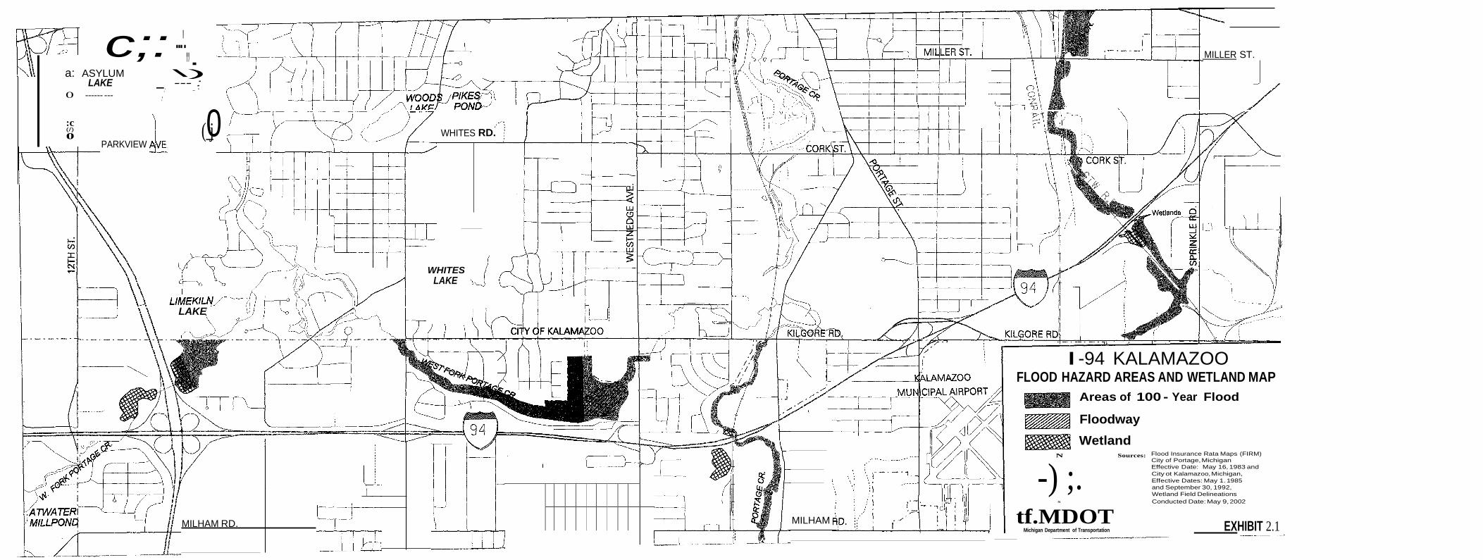
EXHIBIT 2.1
c;: ---'-,, a: ASYLUM \)
MILLER ST.
LAKE --- : 0 ------ ---
:c (/) 0
PARKVIEW
,' - '
''
(_0j WHITES
RD.
WHITES LAKE
LAKE
I -94 KALAMAZOO FLOOD HAZARD AREAS AND WETLAND MAP
Areas of 100 - Year Flood
Floodway
Wetland
N Sources:
-) ;. s
Flood Insurance Rata Maps (FIRM) City of Portage, Michigan Effective Date: May 16, 1983 and City ot Kalamazoo, Michigan, Effective Dates: May 1. 1985 and September 30, 1992, Wetland Field Delineations Conducted Date: May 9, 2002
MILHAM RD. MILHAM tf.MDOT
Michigan Department of Transportation
social and environmental systems as possible. Construction activities which include the mitigation measures listed below are those contained in the current Michigan Standard Specifications for Construction. These measures include:
1. The contractor shall locate all active underground utilities prior to starting work,
and shall conduct his operations in such a manner as to ensure that those utilities not requiring relocation will not be disturbed. Relocated utilities may be temporarily interrupted for short time periods.
2. Accelerated sedimentation caused by highway construction will be controlled
before it enters a water body or leaves the highway right-of-way by the placement of temporary or permanent soil erosions and sedimentation control measures. MDOT has developed a series of standard erosion control items to be included on design plans to prevent erosion and sedimentation. The design plans will describe the erosion controls and their locations.
3. When surplus or unsuitable material is to be disposed of outside the right-of-way,
the contractor shall obtain and file with MDOT written permission from the owner of the property on which the material is to be placed. In addition, no surplus or unsuitable material is to be disposed of in any public or private wetland area, watercourse, or floodplain without prior approval (and permit) by the appropriate resource agencies and the Federal Highway Administration.
4. Disruption of traffic in the construction area will be minimized to the extent
possible. Although control of all construction-related inconveniences is not possible, motorist and pedestrian safety will be ensured by signing all construction areas. Access will be maintained to properties adjacent to I-94 to the extent possible.
5. Construction noise will be minimized by measures such as requiring that
construction equipment have mufflers, that portable compressors meet federal noise-level standards for that equipment, and that all portable equipment be placed away from or shielded from sensitive noise receptors if at all possible. All local noise ordinances will be adhered to.
6. If nests of migratory birds are present under the I-94 Portage Creek bridge, the
provisions of the Migratory Bird Treaty regarding nest removal will be followed.
7. A Project Area Contamination Survey (PACS) will be conducted to determine if any known or potential sites of environmental contamination exist that could affect the project's design, cost, or schedule. The PACS will cover existing right- of-way (ROW), proposed fee ROW, proposed grading permits, and proposed easements. The PACS process involves an office review of information, a site investigation, and a written report of the findings. Common hazardous/
21
contaminated sites identified include leaking underground fuel storage tanks from former or existing gas stations, former landfills, adjacent industrial or commercial operations, and asbestos lined utility pipes or structure components.
8. During the construction of the project, the contractor will be responsible for
adequate dust-control measures so as not to cause detriment to the safety, health, welfare, or comfort of any person, or cause damage to any property, residence or business. All bituminous and portland cement concrete proportioning plants and crushers must meet the requirements fo the.rules of Part 55 of Act 451, Natural Resource and Environmental Protection. For any portable bituminous or concrete plant or crusher, the contractor must apply for a permit-to-install or a general permit from the MDEQ.
Design plans will be reviewed by MDOT prior to contract letting in order to incorporate any additional social, economic, or environmental protection items. The construction site will be reviewed to ensure that the mitigation measures proposed are carried out, and to determine if additional protection is required. More mitigation measures may be developed if additional impacts are identified. Specific mitigation items will be included on the design plans and permit applications.
The final mitigation package will be reviewed by MDOT representatives, in cooperation with concerned state, federal, and local agencies. Some changes in the early mitigation concepts discussed in this document may be required when design begins or when in- depth soil borings are taken and analyzed. These mitigation concepts will be implemented to the extent possible. Where changes are necessary, they will be designed and field reviewed before permits are applied for and construction begins. Changes may also be necessary during the construction phase, but they will reflect the early mitigation intent.
22
SECTION 3- PUBLIC AND AGENCY INVOLVEMENT
3.1 PUBLIC INVOLVEMENT
A public hearing on the proposed project to obtain citizen and local agency comments on specific aspects of the project will be held after the EN4(f) document has been made available to the public. The hearing will allow citizens and local agencies an opportunity to review and comment on specific aspects of the project. A copy of the EN4(f) document will be made available for review at local agencies before the public hearing date.
3.2 LOCAL AGENCY PARTICIPATION
The Michigan Department of Transportation, Federal Highway Administration, and several local agencies (cities of Kalamazoo and Portage, Oshtemo Township, Kalamazoo County, the Kalamazoo County Road Commission and the Kalamazoo Area Transportation Study (KATS) Team) have participated in several I-94 studies over the last three years. The purpose of these studies was to analyze the existing interstate and local road systems and determine what types of improvements were needed to improve the interstate and local roads systems within the Kalamazoo study area.
SECTION 4 - PROJECT COSTS
4.1 PROJECT COSTS
The estimated costs (in 2002 dollars) for constructing the proposed project is approximately $280 million dollars, which includes preliminary engineering, final design, right of way, construction engineering, roadway construction and bridge construction.
SECTION 5- CONCLUSION
5.1 CONCLUSION
The Michigan Department of Transportation has reviewed this project for potential impacts on the human and natural environments. Based on the information in this Environmental Assessment, field reviews, and coordination with other agencies and the public, it is anticipated that this project will have no long-term significant negative impacts on the natural or human environment within the project area.
23
SECTION6 PROGRAMMATIC SECTION 4(f) EVALUATION
6.1 INTRODUCTION
This project is being processed for approval under the U.S. Department of Transportation, Federal Highway Administration's (FHWA) Programmatiy Section 4(f) Evaluation published in the August 22, 1983 Federal Register.
Section 4(f) of the 1966 Department of Transportation Act specifies that publicly-owned land from a park, recreational area, or wildlife and waterfowl refuge of national, state or local significance, or any land from a historic site of national, state or local significance, may not be used for transportation projects unless: 1) there is no feasible and prudent alternative; and 2) proposed projects include all possible planning to minimize harm.
Section 6(f) of the Land and Water Conservation Fund Act (L&WCF), as amended, ensures that property acquired or developed with L&WCF assistance shall not be converted to other than public outdoor recreation uses with out the approval of the Secretary of the U.S. Depart ent of the Interior. However, no lands within the proposed project have been acquired or developed with L&WCF assistance. Thus, Section 6(f) documentation is not required.
This Section 4(f) Evaluation discusses the proposed project, its potential impact to a Section 4(f) property, avoidance alternatives and measures to minimize harm. Based on the following evaluation, a preliminary determination has been made by the Division Administrator that the proposed action will temporarily impact a Section 4(f) resource, that all alternatives have been fully evaluated, and that measures will be taken to minimize the impacts to the Section 4(f) land. Upon consideration of comments received from resource agencies and the public concerning the proposed action, the Federal Highway Administration will either apply the Section 4(f) Evaluation and document the project files or prepare a separate Final Section 4(f) Evaluation for processing under the procedures set forth in Federal Highway Administration regulations 23 CPR 771.135.
6.2 PROPOSED ACTION
The Michigan Department of Transportation is proposing to add an additional lane to both eastbound and westbound I-94 from west of 12th Street to Sprinkle Road, as well as improve several interchanges and bridges in the cities of Kalamazoo and Portage, Michigan.
The I-94 freeway is a major east/west facility linking Michigan to several Midwest states and Ontario, Canada. The section of I-94 being studied, traverses through the cities of Kalamazoo and Portage. This urban section of I-94 is a four-lane facility with merge/weave lanes, and currently carries more vehicles per day than any other 4-lane freeway in the state. Traffic volumes range from 57,000 vehicles to over 81,000 vehicles per day; while commercial vehicles average between 14 to 20 percent.
24
The need for improving this section of I-94 is based on the inadequate roadway capacity, existing geometric deficiencies, and deteriorated condition of the pavement and bridges. Over the last three years, MDOT has conducted studies which concluded that the existing I-94 roadway and bridges need to be improved in order to improve traffic operations on the I-94 Corridor which serves as a vital link to the economy in the Kalamazoo area.
6.3 SECTION 4(f) FACILITY
Portage Creek Bicentennial Park Trail
The Portage Creek Bicentennial Park, owned by the City of Portage, began in 1976 in honor of the nation's 200th birthday. The Portage Creek Bicentennial Park is a three and a half mile, 12 foot wide, linear park running along Portage Creek from the City Centre north to Kilgore Road. The park protects the sensitive environment of the Portage Creek basin and offers residents many opportunities to enjoy the creek including overlook decks, canoeing, and bicycling. (See Exhibit 6.1 for a map of the Portage Creek Bicentennial Park).
Featured attractions of the Portage Creek Bicentennial Park include over four miles of hiking and biking trails from the Portage District Library to Kilgore Road, the Milham Avenue activity area, Milham Avenue Pedestrian Overpass, and the Celery Flats Interpretive Center and Historical Area. Most facilities are accessible to persons using wheelchairs.
The park trails are used by hundreds of people daily for cycling, walking, jogging, and in-line skating. The Portage Creek Bicentennial Park Trail also provides convenient access to the Portage Bikeway, a 40 mile system of paved pathways connecting neighborhoods, shopping areas, schools, businesses and other points of interest.
6.4 IMPACTS ON THE SECTION 4(f) FACILITY
This project will not permanently affect the Portage Creek Bicentennial Park Trail, which is located within MDOT's right of way by permit an<;I subject to the conditions of the permit. During construction, MDOT in cooperation with the city of Portage will provide a signed, designated non-motorized route to accommodate pedestrians and bicyclists during construction. The designated pedestrian detour route will be determined in cooperation with the City of Portage's Department of Transportation and Utilities.
6.5 AVOIDANCE ALTERNATIVES
The proposed project cannot be done without temporarily impacting the recreational trail. The Portage Creek Bicentennial Park Trail lies perpendicular to the I-94 bridge structures, therefore, the Section 4(f) property cannot be avoided unless a no build alternative is chosen. Because the no build alternative is not an option, the trail must be temporarily detoured.
25
NORTH
KEY
-0 PARKING PORTAGE
CREEK ASPHALT TRAIL
::<-:':J:-.:, RAILROAD ••• FOOTTRAIL lliiD RESTROOM
I
Bl
SOUTH WESTN50Gl:AVENUe
!Em PICNIC I PLAYGROUND
"!:';' .'4 o;:-.·u-"... 5
P•l I •
_,.-! .,.... -- ••••:
LOVSi'\S!.AtiE
Portage Parks take pride in being accessible.Should accommodations be required,can the ParkS and Recreation Department at 329-4522 for assis:ance.
PORTAGE CREEK BICE,NTENNIAlPAR <----
Exhibit 6.1
6.6 MEASURES TO MINIMIZE HARM
Several steps will be taken to limit the impact to the Portage Creek Bicentennial Park Trail. The construction area will be limited to only the area needed to add an additional lane on I-94 in each direction and upgrade the bridges. The area will be fenced, and signs will be installed to alert
· · pedestrians to choose an alternate route while the I-94 structures are un er construction. Access to the rest of the trail will be maintained; when construction of the roadways have been completed, the trail will be restored to its original state.
6.7 COORDINATION
Coordination with the owner of the 4(f) property is required as part of the review. To comply with this requirement, MDOT wrote to the City of Portage (owner of the property). Comments have been incorporated into the document. (See coordination letter Appendix E.)
MDOT has also notified the MDNR of the proposed project in regards to a 6(f) impact. According to the MDNR, no Land and Water Conversation Funds were spent on the Portage Creek Bicentennial Park Trail. No land conversion is needed for this project.
Clean Michigan Initiative (CMI) grant funds were used to construct the portion of the Portage Creek Bicentennial Park Trail temporarily affected by the proposed project. The city of Portage will be required to submit a CMI project change to the MDNR before the trail is detoured. The MDNR has agreed to continued coordination with MDOT and does not foresee any insurmountable issues from a grants management perspective. MDOT will provide detailed plans to the MDNR, Grants Administration Division when they are developed.
6.8 CONCLUSION
Based upon the above considerations, there is no feasible and prudent alternative to the use of the Portage Creek Bicentennial Park Trail. The proposed action includes all possible planning to minimize harm to the trail resulting from such use.
27

APPENDIX A
MAINTAINING TRAFFIC PLAN

Maintaining Traffic Plan
The project consists of widening I-94 Interstate Highway from two lanes to three lanes in each direction, for approximately 6.7 miles from west of 12th Street to Sprinkle Road in Kalamazoo County, Michigan. The project will also include the addition of a new south to east ramp at the I- 94/US 131Interchange with the preservation of the merge/weave lanes between Westnedge Avenue and Oakland Drive. A minimum of two 11'-lanes of traffic in each direction will be maintained during construction on I-94, and where possible, 8' temporary shoulders will be provided. It is assumed that there will be no construction work during the winter months. Due to funding constraints, the project has been split into five contracts to be undertaken over a ten-year period. The following are the Contracts and the proposed staging for construction.
Contract 1: From 12th Street to east ofi-94/US131Interchange (approximately 1.5 miles) including improvements to ramps at the US131Interchange. Construction will commence approximately 1000' west of 12th Street to accommodate the transition from two lanes to three lanes in each direction. It is proposed to construct this section over three construction seasons as follows:
First construction season: Preparatory work for the construction of the mainline. This will involve the construction of crossovers, removal of collector distributor barrier wall, lane widening on each side of EB I-94, the widening of the 12th Street Bridge in the EB direction and a temporary ramp connector for the WB I-94 to NB US 131 ramp.
Second construction season: The following directions of traffic will be detoured NB US-131to WB I-94, WB I-94 to SB US-131and WB I-94 to SB US-131,EB I-94 to NB US-131 using 9th Street and Stadium Drive. All traffic will be shifted to EB lanes and two lanes of traffic will be provided in each direction, except between US-131 and Oakland Drive interchanges where three lanes will be provided in each direction. Construction of roadway, bridges and all related ramps on the WB I-94 will be undertaken during this period. Also a temporary ramp will be constructed for the SB US-131 to EB I-94 direction. At the end of this season the traffic will be shifted back onto WB I-94 and all related ramps reopened to traffic.
Third Construction season: Traffic for the following directions will be detoured, EB I-94 to SB US- 131, NB US-131 to EB I-94, EB I-94 to NB US-131, WB I-94 to SB US-131, and NB US-131 to WB I-94. The mainline I-94 traffic will be shifted to the completed westbound I-94 with 2lanes in each direction, the traffic on the SB US-131 to EB I-94 ramp will be shifted to the temporary ramp to facilitate the construction of the new SB US-131 to EB I-94 and EB I-94 roadway and related ramps will be constructed. At the completion of the EB roadway the EB traffic will be shifted onto the EB roadway and the closed ramps reopened to traffic. A temporary concrete barrier will be placed in the crossover area east of the interchange until Contract 2 starts. Flexible delineator posts glued to the pavement will be used to keep the third EB through lane inaccessible to traffic until the end of Contract 2.
Detour: Temporary detours will be routed along Stadium Drive to 9th Street.
A-1
Contract 2: From 1000' east of the US131/I-94 Interchange 300' east of the Oakland Drive (approximately 1.0 mile). It is proposed to construct this s ction over two construction seasons as follows:
First construction season: Construction of Oakland Drive Bridge: This will involve the
· construction of crossovers and various traffic shifts for East and Westbound I-94 to facilitate the completion of Oakland Drive Bridge. The ramps at the Oakland Drive Interchange will be kept open to traffic and one lane of traffic in each direction shall be maintained on Oakland Drive during the Bridge construction. Traffic on mainline I-94 shall be maintained with two lanes in each direction. Approach roadway work on Oakland Drive shall be completed during this period.
Second Construction season: Construction of Mainline I-94. The westbound mainline traffic shall be shifted to the eastbound roadway using crossovers already in place. Two lanes of traffic shall be provided in each direction and temporary ramp tie-ins shall be provided to facilitate movements to and from ramps and the Westbound roadway shall be completed. The Eastbound traffic will then be shifted to the completed westbound roadway, ramp tie-ins will be provided for the various ramps and the eastbound roadway shall be completed. At the completion of the EB I-94 roadway the EB traffic will be shifted back to the EB and the permanent concrete barrier in the median will be installed to approximately 300' from the end of the contract.
Detours: None will be required.
Contract 3: From 300' east of the Oakland Drive interchange to 500' east of Lover's Lane, (approximately 2.0 miles). Includes the construction of Lover's Lane Bridge over I-94, I-94 Bridge over Norfolk Southern Railroad and Westnedge Interchange. It is proposed to construct this section over three construction seasons as follows:
First construction season: Construction of Lover's Lane Bridge. Lane widenings and required crossovers shall be constructed and traffic on Lovers Lane shall be detoured (Milham to Portage to Kilgore). Lovers Lane Bridge shall be closed to traffic; the bridge will be demolished and reconstructed utilizing various traffic shifts on I-94. Two lanes of traffic shall be maintained in each direction on I-94; however, single lane traffic will be maintained during nighttime at certain periods. An incentive/disincentive clause shall be included in the contract to ensure that construction is completed within this season. During this time part of the EB I-94 Bridge over Norfolk Southern Railroad and Portage Creek structures shall be constructed. EB I-94 traffic shall be maintained on the existing EB Bridge. Crossovers required for the construction of the mainline roadway will be constructed before the end of this season.
Second construction season: Shift traffic to EB I-94 and construct all of Westbound I-94 roadway and bridges. Exit and entrance ramps on westbound I-94 will be closed for brief periods of time and traffic detoured to the nearest adjacent interchange. The EB exit ramp to Westnedge will be modified and signalized at its terminal to allow left turns op. Westnedge. At the end of this season the traffic will be shifted back onto WB I-94 and all related ramps reopened to traffic.
A-2
Third construction season: Shift all I-94 traffic to completed WB I-94 and construct EB roadway and bridges. Traffic from EB I-94 to Westnedge shall be detoured (Oakland, Milham, Portage). At the completion of the EB I-94 roadway the EB traffic will be shifted back to the EB, all related ramps reopened to traffic and the permanent concrete barrier in the median will be installed to approximately 500' from the end of the contract.
Detours: Lover's Lane traffic will be routed to Milham and either Portage Road or Westnedge, south of I-94; and Kilgore to either Portage or Westnedge north of I-94.
Contract 4: From 500' east of Lover's Lane to 500' east of Portage Road interchange, (approximately 1.2miles). This section involves the construction of Portage Road Interchange, East and Westbound I-94 roadway and the rehabilitation of the Kilgore Road Bridge. It is proposed to construct this section over one construction season as follows:Commence Rehabilitation of Kilgore Road Bridge in February and construct required crossovers for mainline I-94 and temporary ramp connector for eastbound exit as soon as the weather permits. Detour all exit/entrance ramps to the nearest interchange east and west of Portage. (Detour routes, Kilgore, Milham and Westnedge). Close all ramps except EB I-94 to Portage and Portage to EB I-94 and shift all traffic on I-94 to EB I-94 and construct WB I-94 roadway, bridge and related exit/entrance ramps. One lane of traffic shall be maintained in each direction on Kilgore Road. After completion of WB roadway, detour traffic from NB Portage to WB I-94, SB Portage to EB I-94 and NB Portage to EB I-94. (Portage, Kilgore, Westnedge) and close these ramps. EB exit ramp to Portage will be kept open via a ramp connector. Shift all traffic to WB I-94 and construct EB I-94 roadway, bridges and related ramps. At the completion of the EB I-94 roadway the EB traffic will be shifted back to the EB roadway, all related ramps reopened to traffic and the permanent concrete barrier in the median will be installed to approximately 500' from the end of the contract.
Detours: Kilgore, Milham and Westnedge for short durations during temporary ramp closures.
Contract 5: From 500' east of Portage to Sprinkle Road, (approximately 1.2 miles). This involves the construction of CNRR and NSRR Bridges and I-94 roadway. It is proposed to construct this section over two construction seasons as follows: -
First Construction season: Construct crossovers and temporary pavement widenings necessary for the construction of bridges and traffic shifts on I-94 and part width of the CNRR Bridges on WB I-94 to accommodate proposed traffic shift. Reconfigure ramp terminals and provide temporary signals on Sprinkle Road to allow left turns. Shift I-94 to WB roadway and construct EB I-94 roadway and related bridges at CNRR and NSRR crossings. Traffic from EB I-94 to Sprinkle shaH use a temporary ramp connector, the NB Sprinkle to WB I-94 and SB Sprinkle to EB I-94 shall be closed and traffic in these directions would be allowed to make left turns at the reconfigured terminals of SB Sprinkle to WB I-94 and NB Sprinkle to EB I-94 ramps. At the end of this season the traffic will be shifted back onto EB I-94 and all related ramps and I-94 reopened to traffic.
Second Construction season: Shift traffic to completed EB roadway and construct WB roadway and related bridges. Temporary ramp connectors shall be placed for SB Sprinkle to WB I-94 and
A-3

EB I-94 to Sprinkle the NB Sprinkle to WB I-94 and SB Sprinkle to EB I-94 shall be closed and traffic in these directions would be allowed to make left turns at the reconfigured terminals of SB Sprinkle to WB I-94 and NB Sprinkle to EB I-94 ramps. At the completion of the WB I-94 roadway the WB traffic will be shifted back to the WB roadway, all related ramps reopened to traffic, and the permanent concrete barrier in the median will be installed to the end of the contract.
Detours: None will be required.
A-4

APPENDIX B
NOISE ANALYSIS
Noise Model Input
Version 1.1 of the FHWA Traffic Noise Model (TNM) was used to predict the noise levels attributable to vehicular traffic for the Existing Condition (2000) as well as the No-Build and Proposed Conditions in the design year (2025). Parameters considered in the TNM program include
·vehicle. mix (trucks and automobiles), peak evening traffic volumes, vehicle speeds, site characteristics (topography and land features) and receptor locations relative to the roadway.
Noise receptors were identified along the entire length of the proposed project using site survey, air photos and road layout plans. Two hundred forty-six (246) Category B noise receptor sites were selected within the vicinity of the road rights-of-way. In several instances, one receptor was used to represent several different homes. Consequently, every home along the project is not represented by an actual receptor; however, the receptors in the vicinity provide an acceptable indication of the noise levels at each home.
Land use and zoning plans were reviewed for the project area. Land west of the Westnedge Road interchange is proposed for commercial development. The land immediately beyond the right-of- way is located in the City of Portage and is zoned General Business/Commercial. The City of Kalamazoo has a small portion of the land beyond, which is zoned Institutional. Since this land will not have any residential uses associated with it, it was not included in the analysis. The same can be said of the Sprinkle Road interchange, since the areas surrounding this interchange are zoned General Commercial.
Existing and proposed traffic volumes were obtained for both the current year (2000) and the design year (2025) for this project in October 2001. It was determined that the evening peak hour traffic volumes were heavier than the morning peak hour traffic volumes. Consequently, the results for the evening peak hour were utilized in this analysis. The use of the evening peak hour traffic volumes will give a worst-case sound level at each representative receptor. A particular receptor may not generally be in use during the evening peak hour; however, the traffic volume associated with the evening peak hour may also occur at different times of the day, which would create the worst-case sound level. ·
Predicted Noise Levels
For the purposes of this discussion, the number of receptors for each condition was limited. Representative receptor sites for this discussion were selected and analyzed based upon their proximity to the right-of-way. Noise levels were determined for the remaining receptors, and they were used in the feasibility study; however, for the purpose of this discussion they were left out.
Existing Condition. Through the use of the TNM program, vehicular traffic noise levels were estimated under the existing evening peak hour traffic volumes. The analysis for the Existing 2000 evening peak period condition shows 160 of the 246 sites exceeding the Category B noise criterion of 66 dB(A). Table 2, shows the noise level at selected receptors for this condition.
B-1
No-Build Condition. The No-Build 2025 evening peak hour traffic volumes along with the existing layout provided the results for the No-Build Condition. For this condition, 168 of the 246 sites exceed the Category B criterion. Primarily, the sites that had noise levels above the criterion for the Existing Condition also had noise levels above the criterion for the No-Build Condition. As previously noted, Table 2 shows the noise level at selected receptors for this condition.
Proposed Without Barrier Condition. The Proposed 2025 projected evening peak hour traffic volumes along with the proposed layout provided the results for this condition. For the Proposed Without Barriers Condition, 172 of the 246 sites exceed the Category B criterion. Table 2 shows the noise level difference between this Condition and the No-Build Condition. At almost all of the receptors shown in the table, the noise level for the Proposed Condition is higher than the noise level . for the No-Build Condition. Since there are a significant number of sites that have noise levels above the Category B noise criterion, a feasibility study was undertaken to determine the effectiveness of using noise barriers to mitigate the traffic noise levels.
Feasibility Study
Various methods can be used to reduce the noise generated by traffic along an existing highway corridor. The first is to use buffer zones. This method would maintain undeveloped land adjacent to the highway right-of-way in an undeveloped condition, thereby removing the possibility of residential construction nearest to the noise source. This is not a viable option in this case, since both the highway and the residential areas adjacent to it have been in place for a number of years. The second option would be to use vegetation. A 200-foqt width of dense vegetation can reduce traffic noise by as much as 10 dB(A), which would equate to a halving of the loudness of traffic. The proximity of the residential areas to the right-of-way would preclude this option since there are not many locations where a 200-foot strip of area is available for the planting of dense vegetation. The third option is to use different pavement types. Research shows that changes in pavement can reduce the noise associated with tire contact. However, it has not been determined whether this would be a significant enough decrease when compared to the noise generated by the engine and exhaust systems of vehicles. The final option is to use barriers. Barriers can be either walls or earthen berms. Earthen berms take up a significant amount of space in order to maintain a gentle enough slope for maintenance. Walls take up much less space, and can be built of a variety of materials in order to make the barrier more aesthetically pleasing.
Eleven barriers were proposed along different sections of the I-94 project corridor. For the most part, the barriers were located along the right-of-way line for I-94, with each barrier affecting a different set of receptors. In some instances, the barrier was brought to the edge of the road to avoid obstacles or to stay out of a proposed cut section at the right-of-way line. For the feasibility study, the noise barriers were assumed to be effective if they met the MDOT's noise abatement criteria, which states that if the noise level can be reduced. by 6 dB(A) or more, and the cost per benefitting residence is at or below $32,200, then the barrier is assumed to be effective. Table 3 is a summary of the results of the noise abatement feasibility study in which eleven barrier locations were analyzed.
B-2
Several letters expressing concern about highway noise were sent to MDOT from landowners in the vicinity of this project. The letters were clustered in four different locations: 1) the residential area north ofl-94 and east of US-131 (Barrier #6 was designed for this area), 2) the residential area south of I-94 and west of Oakland Drive (Barrier #7 was designed for this area), 3) The residential area north of I-94 and east of Oakland Drive (Barrier #8· was designed for this area), 4) the residential
. area north of I-94 and east of Westnedge Avenue (Barrier #10 was designed for this area), and 5) south of I-94 and east of Lovers Lane (the extension of Existing Barrier A was designed for this area).
B-3
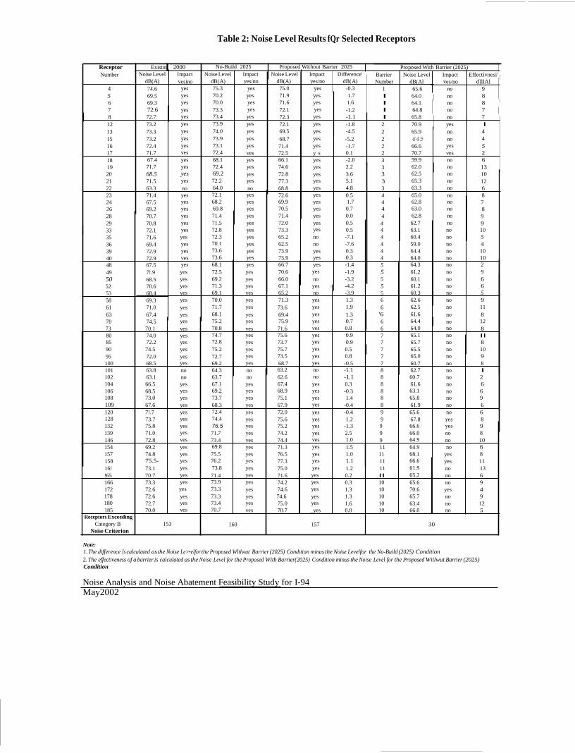
Table 2: Noise Level Results fQr Selected Receptors
Receptor Existin 2000 No-Build 2025 Proposed Without Barrier 2025 Proposed With Barrier (2025) Number Noise Level Impact Noise Level Impact Noise Level Impact Difference' Barrier Noise Level Impact Effectivnesi'
dB(A) vesino dB(A) yes/no dB(A) yes/no dB(A) Number dB(Al ves/no d]llAl 4 74.6 yes 75.3 yes 75.0 yes -0.3 1 65.6 no 9 5 69.5 yes 70.2 yes 71.9 yes 1.7 I 64.0 no 8 6 69.3 yes 70.0 yes 71.6 yes 1.6 I 64.1 no 8 7 72.6 yes 73.3 yes 72.1 yes -1.2 I 64.8 no 7 8 72.7 yes 73.4 yes 72.3 yes -1.1 I 65.8 no 7 12 73.2 yes 73.9 yes 72.1 yes -1.8 2 70.9 yes I 13 73.3 yes 74.0 yes 69.5 yes -4.5 2 65.9 no 4 15 73.2 yes 73.9 yes 68.7 yes -5.2 2 645 no 4 16 72.4 yes 73.1 yes 71.4 yes -1.7 2 66.6 yes 5 17 71.7 ves 72.4 ves 72.5 y s 0.1 2 70.7 ves 2 18 67.4 yes 68.1 yes 66.1 yes -2.0 3 59.9 no 6 19 71.7 yes 72.4 yes 74.6 yes 2.2 3 62.0 no 13 20 68.5 yes 69.2 yes 72.8 yes 3.6 3 62.5 no 10 21 71.5 yes 72.2 yes 77.3 yes 5.1 3 65.3 no 12 22 63.3 no 64.0 no 68.8 yes 4.8 3 63.3 no 6 23 71.4 yes 72.1 yes 72.6 yes 0.5 4 65.0 no 8 24 67.5 yes 68.2 yes 69.9 yes 1.7 4 62.8 no 7 26 69.2 yes 69.8 yes 70.5 yes 0.7 4 63.0 no 8 28 70.7 yes 71.4 yes 71.4 yes 0.0 4 62.8 no 9 29 70.8 yes 71.5 yes 72.0 yes 0.5 4 62.7 no 9 33 72.1 yes 72.8 yes 73.3 yes 0.5 4 63.1 no 10 35 71.6 yes 72.3 yes 65.2 no -7.1 4 60.4 no 5 36 69.4 yes 70.1 yes 62.5 no -7.6 4 59.0 no 4 39 72.9 yes 73.6 yes 73.9 yes 0.3 4 64.4 no 10 40 72.9 ves 73.6 yes 73.9 yes 0.3 4 64.0 no 10 48 67.5 yes 68.1 yes 66.7 yes -1.4 5 64.3 no 2 49 7!.9 yes 72.5 yes 70.6 yes -1.9 5 61.2 no 9 50 68.5 yes 69.2 yes 66.0 no -3.2 5 60.1 no 6 52 70.6 yes 71.3 yes 67.1 yes i -4.2 5 61.2 no 6 53 68.4 yes 69.1 yes 65.2 no -3.9 5 60.3 no 5 58 69.3 yes 70.0 yes 71.3 yes 1.3 6 62.6 no 9 61 71.0 yes 71.7 yes 73.6 yes 1.9 6 62.5 no 11 63 67.4 yes 68.1 yes 69.4 yes 1.3 '6 61.6 no 8 70 74.5 yes 75.2 yes 75.9 yes 0.7 6 64.4 no 12 73 70.1 ves 70.8 ves 71.6 ves 0.8 6 64.0 no 8 80 74.0 yes 74.7 yes 75.6 yes 0.9 7 65.1 no II 85 72.2 yes 72.8 yes 73.7 yes 0.9 7 65.7 no 8 90 74.5 yes 75.2 yes 75.7 yes 0.5 7 65.5 no 10 95 72.0 yes 72.7 yes 73.5 yes 0.8 7 65.0 no 9 100 68.5 yes 69.2 yes 68.7 yes -0.5 7 60.7 no 8 101 63.8 no 64.3 no 63.2 no -1.1 8 62.7 no I 102 63.1 no 63.7 no 62.6 no -1.1 8 60.7 no 2 104 66.5 yes 67.1 yes 67.4 yes 0.3 8 61.6 no 6 106 68.5 yes 69.2 yes 68.9 yes -0.3 8 63.1 no 6 108 73.0 yes 73.7 yes 75.1 yes 1.4 8 65.8 no 9 109 67.6 yes 68.3 yes 67.9 yes -0.4 8 61.9 no 6 120 7!.7 yes 72.4 yes 72.0 yes -0.4 9 65.6 no 6 128 73.7 yes 74.4 yes 75.6 yes 1.2 9 67.8 yes 8 132 75.8 yes 76.5 yes 75.2 yes -1.3 9 66.6 yes 9 139 71.0 yes 71.7 yes 74.2 yes 2.5 9 66.0 no 8 146 72.8 ves 73.4 ves 74.4 ves 1.0 9 64.9 no 10 154 69.2 yes 69.8 yes 71.3 yes 1.5 11 64.9 no 6 157 74.8 yes 75.5 yes 76.5 yes 1.0 11 68.1 yes 8 158 75.5- yes 76.2 yes 77.3 yes 1.1 11 66.6 yes 11 16! 73.1 yes 73.8 yes 75.0 yes 1.2 11 61.9 no 13 !65 70.7 yes 71.4 yes 71.6 yes 0.2 II 65.2 no 6 166 73.3 yes 73.9 yes 74.2 yes 0.3 10 65.6 no 9 172 72.6 yes 73.3 yes 74.6 yes 1.3 10 70.6 yes 4 178 72.6 yes 73.3 yes 74.6 yes 1.3 10 65.7 no 9 180 72.7 yes 73.4 yes 75.0 yes 1.6 10 63.4 no 12 185 70.0 ves 70.7 ves 70.7 _yes 0.0 10 66.0 no 5
Receptors Exceeding Category B 153 160 157 30
Noise Criterion
Note: 1. The difference Is calculated as the Noise Le>•elfor the Proposed Wltlwut Barrier (2025) Condition minus the Noise Levelfor the No-Build (2025) Condition 2. The effectiveness of a barrier.is calculated as the Noise Level for the Proposed With Barrier(2025) Condition minus the Noise Level for the Proposed Witlwut Barrier (2025) Condition
Noise Analysis and Noise Abatement Feasibility Study for I-94 May2002
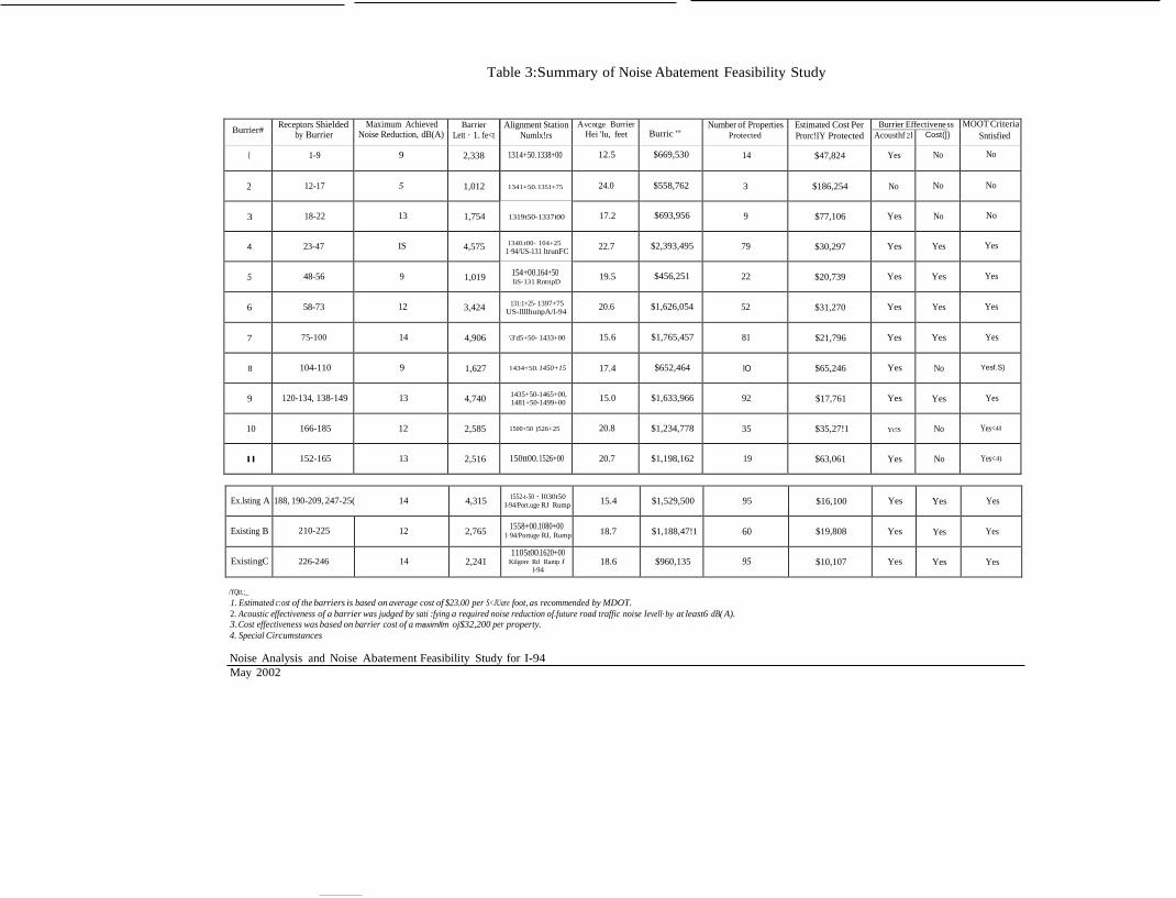
Burrier# Receptors Shielded by Burrier
Maximum Achieved Noise Reduction, dB(A)
Barrier Lett · 1. fe<t
Alignment Station Numlx!rs
Avcntge Burrier Hei 'lu, feet
Burric "'
Number of Properties Protected
Estimated Cost Per Prorc!IY Protected
Burrier Effectivene ss }
MOOT Criteria Acousthf 2l Cost(]
I 1-9 9 2,338 1314+50.1338+00 12.5 $669,530 14 $47,824 Yes No No
2
12-17
5
1,012
1341+50. 1351+75
24.0
$558,762
3
$186,254
No
No
No
3
18-22
13
1,754
1319t50-1337t00
17.2
$693,956
9
$77,106
Yes
No
No
4
23-47
IS
4,575
1340.t00- 104+25
1·94/US-131 ltrunFC
22.7
$2,393,495
79
$30,297
Yes
Yes
Yes
5
48-56
9
1,019 154+00.164+50
liS-131 RntnpD
19.5
$456,251
22
$20,739
Yes
Yes
Yes
6
58-73
12
3,424 131:1+25- 1397+75
US-llllhunpA/l-94
20.6
$1,626,054
52
$31,270
Yes
Yes
Yes
7
75-100
14
4,906
\3'd5+50- 1433+00
15.6
$1,765,457
81
$21,796
Yes
Yes
Yes
8
104-110
9
1,627
1434+50. 1450+15
17.4
$652,464
lO
$65,246
Yes
No
Yesf.S)
9
120-134, 138-149
13
4,740 1435+50-1465+00,
1481+50-1499+00
15.0
$1,633,966
92
$17,761
Yes
Yes
Yes
10
166-185
12
2,585
1500+50 )526+25
20.8
$1,234,778
35
$35,27!1
Yt!S
No
Yes<4l
II
152-165
13
2,516
150tt00.1526+00
20.7
$1,198,162
19
$63,061
Yes
No
Yes<4)
Table 3:Summary of Noise Abatement Feasibility Study
Sntisfied
Ex.lsting A
188, 190-209, 247-25( 14
4,315 1552-t-50 · I030t50
I-94/Port.uge RJ Rump
15.4
$1,529,500
95
$16,100
Yes
Yes
Yes
Existing B
210-225
12
2,765 1558+00.1080+00
1·94/Portuge RJ, Rump
18.7
$1,188,47!1
60
$19,808
Yes
Yes
Yes
ExistingC
226-246
14
2,241
1105t00.1620+00 Kilgore Rd Ramp I
l-94
18.6
$960,135
95
$10,107
Yes
Yes
Yes
/YQtt.;_ 1. Estimated c:ost of the barriers is based on average cost of $23.00 per S<JUare foot, as recommended by MDOT. 2. Acoustic effectiveness of a barrier was judged by sati :fying a required noise reduction of.future road traffic noise Ievell· by at least6 dB( A). 3. Cost effectiveness was based on barrier cost of a maximllm oj$32,200 per property. 4. Special Circumstances
Noise Analysis and Noise Abatement Feasibility Study for I-94 May 2002

APPENDIX C
AIR QUALITY

Microscale Analysis
A microscale carbon monoxide analysis was prepared in order to determine the existing and future maximum one hour concentrations of CO which can be expected for this project area. An eight hour maximum has also been prepared. The locations, traffic characteristics, and
. meteorological conditions used for the analysis were selected to approximate a worst case condition. ·
The California Line Source Diffusion Model (CALINE 4) was used to compute CO concentrations. The revised 1992 Environmental Protection Agency (EPA) emission factors, as computed by the Mobile Source Emission Factor Model (MOBlLE Sa [26 March 1993]) computer program, were used as the input data. The results of this analysis are summarized in Table 1.
The maximum eight hour CO concentrations were computed from the following formula:
C8::: (0.06)x(8 hour average hourly traffic)x(Cl) (peak hour traffic)
where: C8 = maximum 8 hr CO concentration ·
C1 =maximum 1 hour CO concentration 0.06 =Persistency factor to take into account variations in wind speed, wind direction,
and atmosphere stability over an eight hour period.
The section of the I-94 chosen for the analysis is from just west of Westnedge Avenue to just east of Portage Road. This section has the highest traffic volumes and the most residential receptors impacted by each of the alternatives.
CO concentrations predicted for both the construction year, 2000, and the year 2025 show the build alternative to be less than the no-build. For all residential cases, the CO levels are predicted to be well below the National Air Quality Standard of 36 ppm for one hour and 9 ppm for 8 hrs for the build alternative. The ROW (receptors 5 & 10) are consistent with the residential receptors.
Receptor 4 on the south side and receptor 7 on the north side had the highest concentrations. It should be noted that receptor 4 shows a greater then 9 ppm eight hour on the 2025 no-build. In each case the build alternative is significantly better than the no-build year. The 2025 build prediction shows a concentration below the maximum standard at this receptor.
Analysis Criteria
The existing year data are from 2000. For immediate impact, 1995 was chosen for the construction year. For future impact, the year 2015 was used.
C-1
-- --- -
The CO concentrations were predicted at the five closest residences in each direction. The highest projected concentration for each direction is shown in Table 1.
The worst case condition is Stability Class 6 (F), with a 0.5 rnls parallel wind, and an ambient temperature of 30 degrees Fahrenheit (-0.5 C). CALINE 4.0 compares wind angles and
. determines the worst case as a function of the program.
The background CO level used for the analysis is 4.2 ppm for the one hour concentration and 2.6
. ppm for the 8 hour. These were based on monitoring performed by MDEQ in a like area of Grand Rapids.
The design hour traffic volumes (DHV) used in the analysis are 3635 westbound (WB) and 3486 eastbound (EB) for the existing road for 2000, 4256 WB and 4082 EB for the 2025 no-build, and 4475 WB and 4291 EB for the 2025 build.
Roadway widths were thirty-six (36) feet for existing/no-build alternatives for each direction, and forty-eight (48) each direction for the build alternative. Because of the median width with two 12' shoulders, each direction is treated as a separate roadway. Design hour speeds used for the analysis were 45 mph for all mainline alternatives.
TABLE1
ALTERNATIVE
DHV
ONE HOUR ' HIGH(PPM)
ADT
EIGHT HOUR IDGH(PPM)
2000 EASTBOUND EXISTING
3486
12.2
34,860
7.3
2000 WESTBOUND EXISTING
3635
13.0
36,350
7.8
2025 EASTBOUND EXISTING
4082
14.3
40,820
8.6
2025 WESTBOUND EXISTING
4256
15.2 ' '
42,560
9.1
2025 EASTBOUND BUILD
4291
13.4
42,910
8.0
2025 WESTBOUND BUILD
4475
14.3
'
44,750
8.6
C-2

APPENDIX D
COORDINATION LETTER FROM MDNR
JOHN ENGLER GOVERNOR
DEPARTMENT OF NATURAL RESOURCES L<\l'Sll"G
July 19, 2002
K L. COO:..
TO: David Schuen, Project Planning Division
Department ofTransportation
FROM: Lori G. Sargent, Endangered Species Specialist. Wildlife Division
SUBJECT: Widening of I-94
The location of the proposed project was checked against known localities for rare species and unique natural features. which are recorded in a statewide database. This continuously updated database is a comprehensive source of information on Michigan's endangered, threatened and special concern species, exemplary natural communities and other unique natural features. Records in the database indicate that a qualified observer has documented the presence of special natural features at a site. The absence of records may mean that a site has not been surveyed. Records may not always be up-to-date. In some cases, the only way to obtain a definitive statement on the presence of rare species is to have a competent biologist perform a field survey.
Under Act 451 of 1994. the Natural Resources and Environmental Protection Act, Part 365. Endangered Species Protection, "a person shall not take, possess. transport, ...fish. plants, and wildlife indigenous to the state and determined to be endangered or threatened.'' unless first receiving an Endangered Species Permit from the Department of Natural Resources, Wildlife Division. Responsibility to protect endangered and threatened species is not limited to the list below. Other species may be present that have not been recorded in the database.
The presence of threatened or endangered species does not preclude activities or development. but may require alterations in the project plan. Special concern species are not protected under endangered species legislation. but recommendations regarding their protection may be provided. Protection of special concern species will help prevent them from declining to the point of being listed as threatened or endangered in the future.
The following is a summary of the results for the project in: Kalamazoo County; sections 24, 25. 26. 27, 18. 29. 30. 31. T2S RlOW, sections 34, 35. 36. T2S RllW, sections 2. 3, 4. 5, 6, T3S RllW, section 1. 2. 3. 4, T3S R12W:
The following special features are known to occur on or near the site(s) and may be impacted by the project.
Common name Status Scientific name Eastern massasauga Leadplant
special concern special concern
Sistrurus catenatus Amorpha canescens
The Eastern massasauga rattlesnake has been known to occur in the area. This species has recently become a candidate for federal protection. Massasauga are usually associated with damp lowlands. including river bottom woodlands. shrub swamps. bogs and fens. marsh borders, sedge meadows. and moist prairie. In early summer many Massasaugas move into adjacent well-drained uplands to spend the warmer months foraging in shrubby fields and grasslands. including pastures and hay fields. These snakes usually overwinter singly in crayfish or mammal burrows. often close to the groundwater level, and emerge in April as water levels rise. They spend much time in spring basking on higher ground. such as sedge and grass clumps, muskrat and beaver lodges, or the edges of dikes and other embankments.
Leadplant has been found in section 5. T3S R11W near the highway. It inhabits prairies. dry bluffs and hills, sandy roadsides and clearings. Flowering occurs in June and July.
STEVENS T. MASON BUILDING • P.O. BOX 30028 • LANSING, MICHIGAN 48909·7528 www.m1Ch1gan.gov • (517) 373-2329
David Schuen MOOT
Page 2
Thank you for your advance coordination in addressing the protection of Michigan's natural resource heritage. .Responses and correspondence can be sent to: Michigan Department of Natural Resources. Wildlife Division- Natural Heritage Program, PO Box 30180, Lansing, MI 48909. If you have further estions I can be reached at 517-373-1263.
LGS:thg - <-)-

APPENDIX E
LETTER FROM THE CITY OF PORTAGE

a J-..--
Transportation & Utilities Department August 12, 2002
Ms. Ann M. Lawrie Bureau of Transportation Planning Michigan Department of Transportation 425 West Ottawa Street Post Office Box 30050 Lansing, Michigan 48909
Dear Ms. Lawrie:
The City ofPortage supports the efforts ofMDOT to widen the I-94 corridor from 12th Street to Sprinkle Road.
I have spoken with you regarding the proposed construction of the I-94 lane widening in the vicinity of Portage Creek in the City of Portage. The proposed work will involve the minor use of the Bicentennial Park Trail area which has been determined to qualify as Section 4(t) land. The City of Portage agrees this project will have no significant impact to the resource and the amount and location of the land to be used does not impair the use of the remaining Section 4(f) land for its intended purpose.
The City of Portage understands and agrees that as a result of this project the proposed work will not result in any temporary or permanent adverse change to the current activities, features, or attributes which are important to the purposes or functions that qualify for protection under Section 4(f), and that it will include only a minor amount of Bicentennial Trail land. The City ofPortage has also reviewed and agrees to the assessment of the impacts of the proposed project as well as the proposed mitigation for this project on the Bicentennial Park Trail under I-94.
The City of Portage appreciates the coordination efforts made on behalf of your department. If I can be of further assistance, please feel free to contact me at 616/324- 9256.
Sincerely, - . ()
w. W. Christopher Barnes, P.E. City Engineer
c: Dallas Williams, Director of Transportation & Utilities MDOTI94bicentenn


,_


![Osmotically InducedProtonExtrusionfromCarrot Suspension Culture' · PlantPhysiol. Vol. 85, 1987 specificactivityof[TPP+]. SincediffusionofTPP+fromthecells is slowtherewasnoleakageofTPP+duringthe](https://img.pdfslide.us/doc/110x75/5f64d5e401c79f447360bbb8/osmotically-inducedprotonextrusionfromcarrot-suspension-culture-plantphysiol-vol.jpg)