Embed Size (px)
Citation preview
of T
From:
Robert bald Admini
regal
tion
Kessman othy Gilc
el Mc
e Jasi-
a Boun
nties Transportation Study
Reply to
ed
fir. Harry filler, Director, H
dary
To:
Acting Director, APO Bure York State Department of Transportation
York
On behalf of the Federal Transit Administration and the Federal Highway Administration (FHA},
WI acknowledge receipt of your October 9, 2003 memorandum transmitting the 2000 Federal-aid Adjusted Urbanized Area Boundary (UAB) for the Herkimer-Oneida Counties Transportation Study Your memorandum also notes that the Metropolitan Planning Area boundary (MPA} for HOOTS
sins unchanged (all of Herkimer and Oneida Counties) .
djtd the ause urbanized area shall encompass at a minimum Bureau of the Census. This adjusted boundary is offici
etimes called the Federal-aid adjusted boundary. The MPA, which is olitan transportation planning purposes, is to encompass the UAB and the
ar period of the Long Range Plan
As outline the entire urbanized area as des known as the boundary used for contiguous areas expected to become urbanized within the 20
of Title 23) .
to be in compliance wi it an electronic pdf map of the UAB containing our signatures for your use.
the proposed functional classification changes emanating from the revised UABs.
of Planning and Program Development, FTA Region 11 tor, Planning and Strategy Group, NYSDOT *5-309
ector, Program Management Division, or. Technical Services Division, NYSDOT *7A-210 MC 0862
ski, Regional Planning and Program Director, NYSDOT Region n Planner CTS
Attn . of: HPD-
Date :
October 20, 2003
fith ing and Program Development
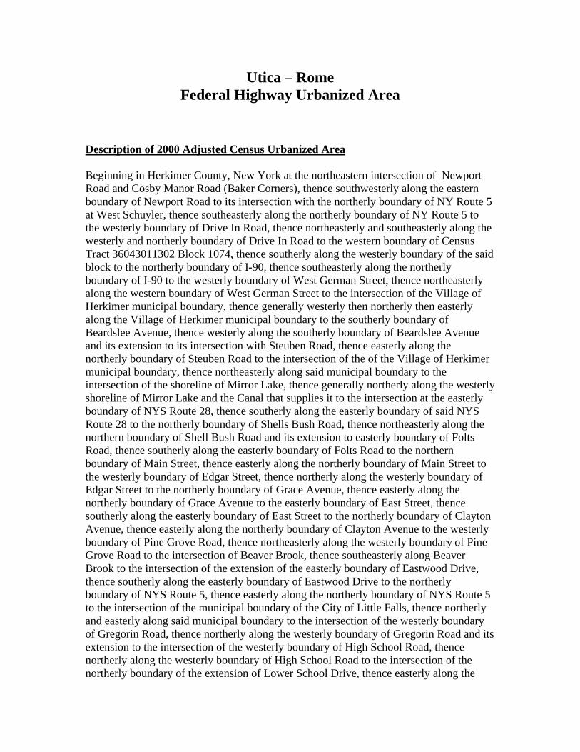
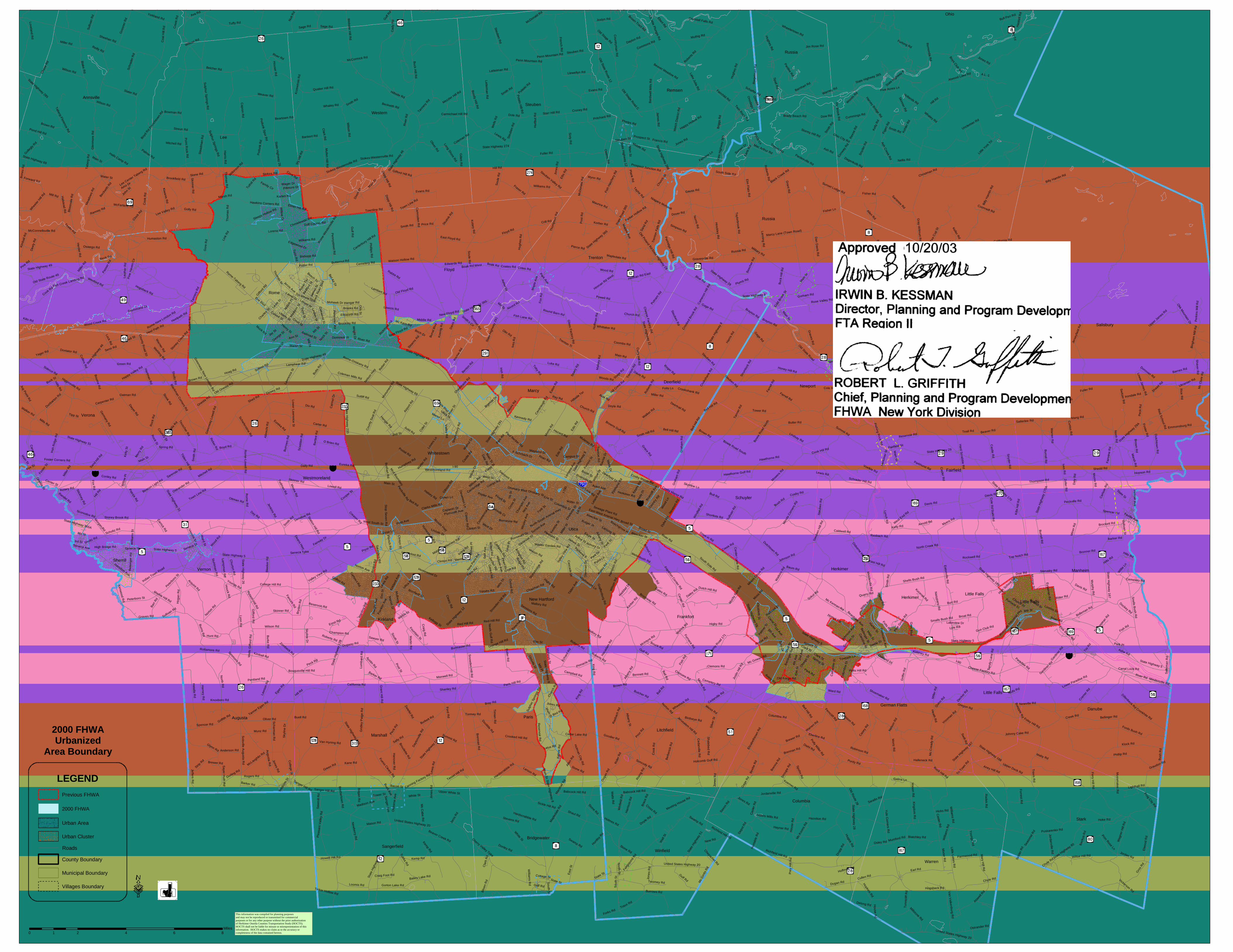
Utica – Rome Federal Highway Urbanized Area
Description of 2000 Adjusted Census Urbanized Area Beginning in Herkimer County, New York at the northeastern intersection of Newport Road and Cosby Manor Road (Baker Corners), thence southwesterly along the eastern boundary of Newport Road to its intersection with the northerly boundary of NY Route 5 at West Schuyler, thence southeasterly along the northerly boundary of NY Route 5 to the westerly boundary of Drive In Road, thence northeasterly and southeasterly along the westerly and northerly boundary of Drive In Road to the western boundary of Census Tract 36043011302 Block 1074, thence southerly along the westerly boundary of the said block to the northerly boundary of I-90, thence southeasterly along the northerly boundary of I-90 to the westerly boundary of West German Street, thence northeasterly along the western boundary of West German Street to the intersection of the Village of Herkimer municipal boundary, thence generally westerly then northerly then easterly along the Village of Herkimer municipal boundary to the southerly boundary of Beardslee Avenue, thence westerly along the southerly boundary of Beardslee Avenue and its extension to its intersection with Steuben Road, thence easterly along the northerly boundary of Steuben Road to the intersection of the of the Village of Herkimer municipal boundary, thence northeasterly along said municipal boundary to the intersection of the shoreline of Mirror Lake, thence generally northerly along the westerly shoreline of Mirror Lake and the Canal that supplies it to the intersection at the easterly boundary of NYS Route 28, thence southerly along the easterly boundary of said NYS Route 28 to the northerly boundary of Shells Bush Road, thence northeasterly along the northern boundary of Shell Bush Road and its extension to easterly boundary of Folts Road, thence southerly along the easterly boundary of Folts Road to the northern boundary of Main Street, thence easterly along the northerly boundary of Main Street to the westerly boundary of Edgar Street, thence northerly along the westerly boundary of Edgar Street to the northerly boundary of Grace Avenue, thence easterly along the northerly boundary of Grace Avenue to the easterly boundary of East Street, thence southerly along the easterly boundary of East Street to the northerly boundary of Clayton Avenue, thence easterly along the northerly boundary of Clayton Avenue to the westerly boundary of Pine Grove Road, thence northeasterly along the westerly boundary of Pine Grove Road to the intersection of Beaver Brook, thence southeasterly along Beaver Brook to the intersection of the extension of the easterly boundary of Eastwood Drive, thence southerly along the easterly boundary of Eastwood Drive to the northerly boundary of NYS Route 5, thence easterly along the northerly boundary of NYS Route 5 to the intersection of the municipal boundary of the City of Little Falls, thence northerly and easterly along said municipal boundary to the intersection of the westerly boundary of Gregorin Road, thence northerly along the westerly boundary of Gregorin Road and its extension to the intersection of the westerly boundary of High School Road, thence northerly along the westerly boundary of High School Road to the intersection of the northerly boundary of the extension of Lower School Drive, thence easterly along the
northerly boundary of Lower School Drive and its extension to the municipal boundary of the City of Little Falls, thence northerly and easterly to the northeast corner of the City of Little Falls municipal boundary, thence southerly, easterly and southerly again along the municipal boundary of the City of Little Falls to the southeast corner of the City of Little Falls, thence generally westerly along the municipal boundary of the City of Little Falls to the north shore of the Mohawk River (also known as the Erie Canal), thence westerly along the northerly shore of the Mohawk River to the intersection of the Town of Herkimer municipal boundary, thence southerly along municipal boundary of the Town of Herkimer and the Town of German Flatts to the intersection of the southern shore of the Erie Canal, thence westerly along the southern shore of the Erie Canal to the intersection of the stream that drains Spohns Gulf, thence southerly along said stream to the southerly boundary of NYS Route 5S, thence westerly along the southern boundary of NYS Route 5S to its intersection with the southerly boundary of Summit Ave, thence continuing westerly along the southern boundary of Summit Ave to the easterly boundary of Columbus Street, thence southerly along the easterly boundary of Columbus Street and its extension to the southerly boundary of I-90, thence westerly along the southerly boundary of I-90 to the intersection of the northerly shore of the Mohawk River, thence westerly along the northerly shore of the Mohawk River to the easterly boundary of Main Street (Main Street crosses the Mohawk River and Erie Canal from the Village of Mohawk to the Village of Herkimer at this point), thence southerly along the easterly boundary of Main Street to the southerly shore of the Mohawk River, thence easterly along the southerly shore of the Mohawk River to the intersection of the easterly municipal boundary of the Village of Mohawk, thence southwesterly along said municipal boundary to the easterly boundary of NYS Highway 168, thence southerly along the easterly boundary of NYS Highway 168 to the extension of the southerly boundary of Fulmer Lane Drive at the most southerly intersection of said Drive with NYS Highway 168 (Fulmer Lane Drive is a horseshoe shaped Drive that touches NYS Highway 168 in two places), thence westerly and northerly along the southerly boundary of Fulmer Lane Drive and its extension to the intersection of a driveway centerline heading northwesterly off of Fulmer Lane Drive, thence northwesterly along said driveway centerline to Fulmer Creek, thence northerly along said Creek to the intersection of the Village of Mohawk municipal boundary, thence northwesterly along said municipal boundary to the intersection of the easterly boundary of Warren Road, thence southerly along the easterly boundary of Warren Road to the intersection of the northwesterly boundary of Census Tract 36043010502 Block 2002, thence easterly along northerly boundary of said Block 2002 to the northeast corner of said Block 2002, thence southerly along the easterly boundary of said Block 2002 to the southerly boundary of Ward Road, thence westerly along the southern boundary of Ward Road to the easterly boundary of Warren Road, thence southerly along the easterly boundary of Warren Road to the intersection of the northerly boundary of Census Tract 36043010502 Block 2004, thence westerly along the northerly boundary of said Block 2004 to the northwest corner of said Block 2004, thence continuing westerly along the northerly boundaries of the following Census Boundaries:
1) Tract 105.02 Block 2005 2) Tract 105.02 Block 2006 3) Tract 105.02 Block 2007
4) Tract 105.02 Block 2008 5) Tract 105.02 Block 2009 6) Tract 105.02 Block 2010 7) Tract 105.02 Block 2011 to the Town of Frankfort municipal boundary,
thence northerly along said municipal boundary to the southwesterly boundary of Avery Road, thence northwesterly along the southwesterly boundary of Avery Road and its extension to the northerly boundary of McGowan Road, thence northeasterly along the northerly boundary of McGowan Road approximately 120 feet to the intersection of the centerline of a Niagara Mohawk power line, thence northwesterly along the said power line to the westerly boundary of Reese Road, thence northeasterly along the westerly boundary of Reese Road to the westerly boundary of Litchfield Road, thence northerly along the westerly boundary of Litchfield Road to the southerly boundary of NYS Route 171, thence crossing NYS Route 171 to the westerly boundary of Brookside Drive, thence northerly along the westerly boundary of Brookside Drive to the southwesterly boundary of NYS Route 5S, thence northwesterly along the southerly boundary of NYS Route 5s to the intersection of the southerly boundary of a ramp onto NYS Route 5S (said ramp is an extension of Bleecker Street, easterly of Frankfort Center Road), thence northwesterly along said southerly ramp boundary to the southerly boundary of Bleecker Street and its extension ,thence westerly along the southerly boundary of Bleecker Street and its extension to the easterly boundary of Ferguson Road, thence southerly along the easterly boundary of Ferguson Road to the northerly boundary of Welshbush Road, thence easterly along the northerly boundary of Welshbush Road to the easterly boundary of Brown Road and its extension, thence southeasterly along the easterly boundary of Brown Road and its extension to the easterly boundary of Gates Road, thence southwesterly along the easterly boundary of Gates Road and its extension to the southerly boundary of Brockway Road, thence westerly along the southerly boundary of Brockway Road to the easterly boundary of Wilson Road, thence southerly along the easterly boundary of Wilson Road to the easterly boundary of Graffenburg Road, thence southerly along the easterly boundary of Graffenburg Road and its extension to the southerly boundary of Higby Road, thence northwesterly along the southerly boundary of Higby Road to the intersection of the Town of New Hartford municipal boundary and the County of Oneida boundary, thence southerly along the said municipal boundary to the southeast corner of the Town of New Hartford, thence westerly along said municipal boundary to the easterly boundary of Mohawk Street, thence southerly along the easterly boundary of Mohawk Street to the northerly boundary of Pinnacle Road, thence easterly along the northerly boundary of Pinnacle Road to the easterly boundary of Campbell Road and its extension, thence southerly along the easterly boundary of Campbell Road and its extension to the intersection of Finger Creek, thence westerly along Finger Creek to the easterly boundary of Mohawk Street, thence southerly along the easterly boundary of Mohawk Street to the northeasterly boundary of Church Road and its extension, thence southwesterly along the easterly boundary of Church Road to the easterly boundary of Holman City Road, thence southerly along the easterly boundary of Holman City Road to the extension of the southerly boundary of Kehoe Road, thence southwesterly along the southerly boundary of Kehoe Road and its extension to the easterly boundary of Stone Road, thence southerly along the easterly boundary of Stone Road to the extension of the easterly boundary of Marshall Road, thence southerly along the easterly boundary of
Marshall Road and its extension to the intersection of the northerly boundary of Census Tract 36065025500 Block 1086, thence northwesterly and southwesterly along said Block 1086 to the Town of Paris municipal boundary, thence westerly along the said municipal boundary to the westerly boundary of NYS Route 8, thence northerly along the westerly boundary of NYS Route 8 to the intersection of NYS Route 8 and Main Street (Main Street in Cassville), thence continuing northerly along the westerly boundary of Main Street to the southerly boundary of Summit Road, thence westerly along the southerly boundary of Summit Road approximately 1580 feet to the northwesterly corner of Census Tract 36065025500 Block 2053, thence easterly along the northerly boundary of said Block 2053 and Block 2054 to the northeast corner of said Block 2054(intersection with Sauquoit Creek), thence southeasterly along Sauquoit Creek to the westerly boundary of Reservoir Road, thence northerly along the westerly boundary of Reservoir Road to the southerly boundary of Sulphur Springs Road, thence westerly along the southerly boundary of Sulphur Springs Road to the westerly boundary of Bray Road and its extension, thence northerly along the westerly boundary of Bray Road and its extension to the westerly boundary of Census Tract 36065025500 Block 2003 (tributary of Sauquoit Creek), thence northeasterly along the westerly boundary of said Block 2003 and Block 2002 to the westerly boundary of Oneida Street, thence northerly along the westerly boundary of Oneida Street to the southerly boundary of Butler Road, thence westerly along the southerly boundary of Butler Road to the northerly boundary of Orchard Street and its extension, thence northeasterly along the northerly boundary of Orchard Street and its extension to the westerly boundary of Oneida Street, thence northerly along the westerly boundary of Oneida Street to the intersection of the Town of New Hartford municipal boundary, thence westerly along said municipal boundary to southwest corner of the Town of New Hartford, thence northerly along the Town of New Hartford municipal boundary to southerly boundary of Red Hill Road, thence westerly along the southerly boundary of Red Hill Road and its extension to the intersection of Kellogg Street, thence continuing westerly along the southerly boundary of Kellogg Street to the intersection of the municipal boundary of the Village of Clinton, thence southwesterly along the Village of Clinton municipal boundary to the easterly boundary of Fountain Street, thence southerly along the easterly boundary of Fountain Street to the easterly boundary of South Street and its extension, thence southerly along the easterly boundary of South Street and its extension to the westerly boundary of Grant Road, thence northwesterly along the westerly boundary of Grant Road to the easterly boundary of Post Road, thence southerly along the easterly boundary of Post Road to the southerly boundary of Furnace Street and its extension, thence westerly along the southerly boundary of Furnace Street and its extension to the easterly boundary of NYS Route 12B, thence southwesterly along the eastern boundary of NYS Route 12B to the westerly boundary of NYS Route 233 and its extension, thence northerly along the westerly boundary of NYS Route 233 to the southerly boundary of College Hill Rd, thence westerly along the southerly boundary of College Hill Road to the westerly boundary Miller Road and its extension, thence northerly along the easterly boundary of Miller Road and its extension to the southerly boundary of Griffin Road, thence westerly along the southerly boundary of Griffin Road to the intersection of the Town of Kirkland municipal boundary, thence northeasterly along the said municipal boundary to the westerly boundary of Campus Road, thence northerly along the westerly boundary of
Campus Road and its extension to the northerly boundary of Norton Avenue, thence easterly along the northerly boundary of Norton Avenue to the intersection of the Town of Kirkland municipal boundary, thence northeasterly along the said municipal boundary to westerly boundary of Saunders Road, thence northerly along the westerly boundary of Saunders Road to the westerly boundary of NYS Route 233, thence continuing northerly (for approximately 7 miles) along the westerly boundary of NYS Route 233 to the intersection of the City of Rome municipal boundary, thence westerly along the said municipal boundary to the southwest corner of the City of Rome, thence northerly along said municipal boundary to the northerly boundary of Rome-New London Road, thence easterly along the northerly boundary of Rome-New London Road to the westerly boundary of Tannery Road, thence northerly along the westerly boundary of Tannery Road to the intersection of Beaver Creek, thence northwesterly along Beaver Creek to the southerly boundary of Rome-Taberg Road (a.k.a. NYS Route 69) , thence northwesterly along the southerly boundary of Rome-Taberg Road to the intersection of the City of Rome Municipal boundary, thence easterly along said municipal boundary to westerly boundary of Gore Road, thence northerly along the westerly boundary of Gore Road and its extension to the northerly boundary of Lee Valley Road, thence easterly along the northerly boundary of Lee Valley Road to the westerly boundary of Thomas Road, thence northerly along the westerly boundary of Thomas Road to the northerly boundary of Lee Center Stokes Road, thence easterly along the northerly boundary of Lee Center Stokes Road to the westerly boundary of Brookside Drive, thence northerly and easterly along the westerly and northerly boundary of Brookside Drive and its extension to the easterly boundary of NYS Route 26, thence southerly along the easterly boundary of NYS Route 26 to the northerly boundary of Stokes Westernville Road, thence easterly along the northerly boundary of Stokes Westernville Road to the intersection of the Town of Lee municipal boundary, thence southerly along said municipal boundary and running through Delta Lake to the intersection of the southerly shoreline of Delta Lake, thence southeasterly along the shoreline to the intersection of the City of Rome municipal boundary, thence easterly along the said municipal boundary to the intersection of the shoreline of Delta Lake, thence northeasterly and southeasterly along the shoreline (northerly of Tuegega Point Road) to intersection of City of Rome municipal boundary, thence easterly along said municipal boundary (north of Town Line Road West) to the northeast corner of the City of Rome, thence southerly along the said municipal boundary to the intersection of Slate Creek, thence easterly along Slate Creek to the westerly boundary of Rickmeyer Road, thence northerly along the westerly boundary of Rickmeyer Road to the northerly boundary of Middle Road and its extension, thence easterly along Middle Road and its extension to the northern boundary or Rome Floyd Road (a/k/a NYS Route 365), thence easterly along the northern boundary of Rome Floyd Road to the westerly boundary of Floyd Camroden Road, thence northerly along the westerly boundary of Floyd Camroden Road to the northern boundary of NYS Route 921A and its extension, thence southeasterly along the northern boundary of NYS Route 921A and its extension to the northern boundary of Rome Floyd Road, thence easterly along the northern boundary of Rome Floyd Road to the westerly boundary of Floyd Steuben Road (a/k/a Soule Road), thence northerly along the westerly boundary of Floyd Steuben Road to the intersection of Lower Dry Creek, thence southeasterly along Lower Dry Creek to the southerly boundary of Rome Floyd Road, thence westerly along the
southerly boundary of Rome Floyd Road to the easterly boundary of Davis Road, thence southerly along the easterly boundary of Davis Road to the southerly boundary of Charles Road and its extension, thence northwesterly along the southerly boundary of Charles Road and its extension to the southerly boundary of Rome Floyd Road, thence westerly along the southerly boundary of Rome Floyd Road to the easterly boundary of Koenig Road, thence southerly along the easterly boundary of Koenig Road to the southerly boundary of Stearns Road and its extension, thence westerly along the southerly boundary of Stearns Road and its extension to the westerly boundary of Middle Road and its extension, thence northwesterly along the westerly boundary of Middle Road and its extension to the southerly boundary of Rome Floyd Road, thence westerly along the southerly boundary of Rome Floyd Road to the intersection of Six Mile Creek, thence southeasterly along Six Mile Creek to the northerly boundary of River Road, thence easterly along the northerly boundary of River Road to the westerly boundary of Chaminade Road, thence northerly along the westerly boundary of Chaminade Road and its extension to the easterly boundary of NYS Route 291, thence southeasterly along the easterly boundary of NYS Route 291 to the southeast corner of Census Tract 36065023701 Block 8026, thence northeasterly along the said Block 8026 to the easterly boundary of Irish Road, thence southerly along the easterly boundary of Irish Road and its extension to the easterly boundary of Fox Road, thence southerly along the easterly boundary of Fox Road to the northwest corner of Census Tract 036065023800 Block 9002, thence southeasterly along the northerly boundary of said Block 9002 to the northerly boundary of Koronowski Road and its extension, thence southeasterly along the northerly boundary of Koronowski Road and its extension to the westerly boundary of Hayes Road, thence northeasterly along the westerly and northerly boundary of Hayes Road to the westerly boundary of Cavanaugh Road, thence northerly along the westerly boundary of Cavanaugh Road to the northerly boundary of Ray Road and its extension, thence easterly along the northerly boundary of Ray Road and its extension to the northerly boundary of Morgan Road, thence easterly along the northerly boundary of Morgan Road and its extension to the easterly boundary of Glass Factory Road, thence southerly along the easterly boundary of Glass Factory Road to the northerly boundary of Burton Manor, thence easterly along the northerly boundary of Burton Manor Road to the westerly boundary of Old Route 12, thence northerly along the westerly boundary of Old Route 12 to the westerly boundary of Stage Road, thence northerly along the westerly boundary of Stage Road to the northerly boundary of Miller Road and its extension, thence easterly along the northerly boundary of Miller Road and its extension to the easterly boundary of Old Route 12, thence southerly along the easterly boundary of Old Route 12 to the northerly boundary of Doyle Road, thence easterly along the northerly boundary of Doyle Road and its extension to the easterly boundary of NYS Route 12, thence southerly along the easterly boundary of NYS Route 12 approximately 1.43 miles to the intersection of the centerline of a Niagara Mohawk power line, thence easterly along the said power line to the intersection of the municipal boundary of Deerfield (Oneida County/Herkimer County Boundary), thence southerly along the said municipal boundary to the northerly boundary of Cosby Manor Road, thence easterly along the northerly boundary of Cosby Manor Road to the point of beginning at the northeasterly intersection of Cosby Manor Road and Newport Road.
Lee
Verona
Rome
Annsville
Floyd
Paris
Western
Trenton
Vernon
Steuben
Marcy
Remsen
Kirkland
Marshall
Deerfield
Augusta
Westmoreland
Sangerfield
Utica
Whitestown
Bridgewater
New Hartford
Sherrill
Ohio
Salisbury
Russia
Stark
Warren
Fairfield
Norway
Schuyler
Frankfort
Danube
Columbia
Litchfield
Manheim
Winfield
Newport
German Flatts
Herkimer
Russia
Herkimer
Little Falls
Little Falls
Little Falls
I-90
Oneida S
t
River Rd
Seneca Tpke
Fox
Rd
Cooper St
Gage Rd
Lowell Rd
Mohaw
k St
Eas
t St
Coa
l Hill
Rd
Oswego Rd
Carter Rd
Cid
er S
t
Skylin
e D
r
So
ule
Rd
Post St
Sheehan Rd
Dix Rd
Shanley Rd
State Highway 49
State H
ighway 26
Ha
rris Rd
Bar
tlett
Rd
Thomas S
t
Judd Rd
Tren
ton
Rd
Summit Rd
Cam
roden Rd
Buck H
ill Rd
Fairchild Rd
Genesee St
Rome-Taberg Rd
Quaker Hill Rd
Higby Rd
Mason Rd
Powell Rd
Gle
nm
ore
Rd
Stat
e H
ighw
ay 4
6
Fuller Rd
State Highway 274
State
Hig
hw
ay 2
33
Ives
Rd
Fountain St
Sta
te H
ighw
ay 1
2B
Glass F
actory Rd
Streun Rd
Point R
ock Rd
Knoxboro Rd
Coombs Rd
Miller Rd
South S
t
Stat
e H
ighw
ay 8
I-790
Sally Rd
Pine Rd
Turin R
d
Whittaker Rd
Blake R
d
Belcher Rd
Capron R
d
Roc
k R
d
Starr Hill Rd
College Hill Rd
Mallory Rd
North R
d
Shed Rd
Mad
ison
St
Norton Ave
Marble Hill Rd
State Highway 31
Burns R
d
Germ
any Rd
Skinner Rd
Tuffy Rd
Maxwell Rd
Ford R
d
Doolittle Rd
Youngs Rd
White St
Golly Rd
Donley Rd
State
Hig
hway
12
Ritc
hie
Rd
Eureka Rd
Floyd Rd
Jones Rd
Kellogg St
Spring Rd
Senn Rd
Gu
lf Rd
Gor
e R
d
Jenkins Rd
Holm
an City R
d
Day
tonv
ille
Rd
Map
leda
le R
d
Irish Rd
Mor
ris R
d
Bell Hill Rd
Old Floyd Rd
Oxford R
d
United States Highway 20
Link
Rd
Sutliff Rd
Bo
ga
n Rd
Lew
is R
d
French R
d
Ro
me
-Lo
we
ll Rd
State Highway 69
Dw
yer Rd
Sta
te H
ighw
ay 2
91
Jam
es Rd
Webster H
ill Rd
Eagle St
Shaul Rd
Utica R
d
Hill Rd
Korber Rd
Cro
oked
Bro
ok R
d
Pleasant St
Steuben Valley Rd
Beaver Creek Rd
Brothertow
n Rd
Town Line Rd
Elli
s R
d
State Highw
ay 315
Townline Rd
Tho
mps
on R
d
Stone Rd
Stage R
d
George St
Palmer Rd
Mea
dow
s R
d
Elmer Hill Rd
Ava Rd
Rome-New London Rd
Rutger St
Liberty St
Canning Factory Rd
Brimfield St
Luke Rd
Hug
hes
Rd
Lake Julia Rd
Steuben Rd
Blo
ssva
le R
d
Augusta R
d
Sand
Hill Rd
Paris Hill Rd
Ha
no
ver R
d
Tilden Hill R
d
Bleecker St
Happy Valley Rd
Westmoreland Rd
Dayton Rd
Albany S
t
Blue Rd
Com
mer
cial
Dr
Paris R
d
Buck St
Bray Rd
Arquint Rd
Peter
boro
St
Jam
es S
t
Oliver Rd
Main St
Lee Center Taberg Rd
King
Rd
Koe
nig
Rd
Cav
anau
gh R
d
Sch
arm
an
Rd
West South St
Pond Hill Rd
Iris
h R
idge
Rd
Dole Rd
Re
servo
ir Rd
Muck Rd
Putn
am R
d
Ba
rdw
ell M
ills
Rd
Brookfield Rd
Toby Rd
Airp
ort R
d
Pinnacle Rd
Commons Rd
Sulphur S
prings Rd
Utica St
Tibbitts Rd
Lee Valley Rd
Moore R
d
Hay
es R
d
Norto
n Rd
Grace R
d
Ble
eke
r R
d
Fren
chto
wn
Rd
Rome-Oriskany Rd
Coleman Mills Rd
Clarks Mills Rd
Peck Rd
Herkimer Rd
Crooked Hill Rd
Turin S
t
State Highway 3
65
Martin St
Sanger Hill Rd
Coo
k R
d
Rabbit Rd
Hoag Rd
Smith Rd
Stear
ns R
d
Oriskany Blvd
Kimball Rd
New Floyd Rd
Wilson Rd
Tild
en A
ve
Wood Creek Rd
Middle Rd
Blackman C
orners Rd
Mill Rd Marsh Rd
Doxtator RdYager Rd
Va
lley R
d
We
lls G
iffor
d R
d
Pas
ser R
d
Rickm
yer R
d
Slater Rd
Bris
tol R
d
Strip R
d
Canal S
t
Yorkland Rd
Lamphear Rd
Hogsback Rd
Fairway Dr
Grange Hill Rd
Lau
the
r R
d
Ottman Rd
Teelin Rd
Butler R
d
Cherry Valley Tpke
Sessions Rd
Kirk
land
Ave
Burrstone Rd
Crill Rd
Barker Rd
Humaston Rd
Bliv
en R
d
Halsey Rd
Bento
n Rd
Herder R
d
Sa
yer H
uth
Rd
Erie Blvd
Grid
ley
Pa
ige
Rd
McFarland Rd
East Floyd Rd
Day Rd
Walker R
d
Mitchell Rd Humphrey Rd
Tann
ery
Rd
North-South Arte
rial Hwy
Edic
Rd
Sly
Hill
Rd
Creaser Rd
Glynn Rd
Pod
unk
Rd
Muthig Rd
Law
son
Rd
Lock Rd
Arthur St
York St
Olin Rd
Sixty R
d
Green Rd
Deans H
wy
Upper White St
New
Par
is R
d
Court St
Gib
son
Rd
Old Oneida Rd
Sul
pher
Spr
ings
Rd
Sholtz R
d
Griffen Rd
Erie St
So
lsville A
ug
usta R
d
Lorena Rd
Snow
den Hill R
d
Bla
ck R
iver
Blv
d
Rottamore Rd
Stokes-Westernville Rd
Tudman R
d
Kotary R
dPennystreet R
d
Oriskany St
Ho
ga
n R
d
Craig R
d
Wood Rd
Bon
es R
dJoslyn Rd
Babcock Hill Rd
Egan
Rd
Carmichael Hill Rd
Mille
r St
Park Dr
Gorton Lake Rd
Roberts Rd
Sch
rade
r Rd
Woods Hwy
Cosby Manor Rd
Doyle Rd
Law
renc
e S
t
Dugway Rd
Brennan R
d
Ha
talla
Rd
Smith Hill Rd
Dominick St
Se
ifert
Rd
Daily Rd
Larson Rd
Elm St
Graves Rd
Stop
Se
ven
Rd
Lansing St
State Highw
ay 28
Weaver Rd
Stokes Rd
Jay S
t
Red Hill Rd
Cedar Lake Rd
Mu
llen H
ill Rd
Gos
sner
Rd
Hamilton Ave
Old S
tate Route 12
Sidecut Rd
Spencer Rd
Randel Rd
Merritt Pl
Kiw
anis Rd
Tubbs Rd
Fraser Rd
Nut
t Rd
Fancett Rd
Brig
gs R
d
Campbell Rd
Champion Rd
Craig Foot RdO
tis St
Mills Rd
Jervis Ave
Boyd
Rd
State Highway 285
Loomis Rd
Kemp Rd
Gra
nt H
ill Rd
Zwiefel R
d
Taberg-Florence Rd
Bu
rke R
d
Beacon Light Rd
Limberlost Rd
Cam
pus Rd
O Brien Rd
McConnellsville Rd
Barr
Rd
Clinton St
Hartm
an Rd
Edwards Rd
College S
t
State Highway 5
Austin Rd
Cou
nty
Sea
t Rd
Maurice Rd
Churton R
d
Canterbury Hill Rd
Clinton R
d
Scholtz Rd
Dee
ly R
d
Hangar Rd
Valley View Rd
Bell Rd
Price Rd
Pritchard Rd
Dunbarton R
d
Brayton Rd
Oatman Rd
Jug Point R
d
Kilts Rd
Plank R
d
Forward Rd
Bailey Lake Rd
Jani
s R
d
Seneca St
Munz Rd
Rogers Rd
Ernst Rd
Llewellyn Rd
Reilly Rd
Hardscrabble Rd
Bankert Rd
Sleepy Hollow Rd
Har
ding
Rd
Locust St
Sarenski Rd
Slone Rd
Dav
is R
d
Amo Dr
Wehling Rd
Skut
nik
Rd
Will
iam
s S
t
Levit
t St
Fish Lane RdR
ome-
Wes
tern
ville
Rd
Evans Rd
Cemetery Rd
Ma
rtin R
d
Riverside Dr
Golleg
ly Rd
Hunt Rd
Ple
asan
t Val
ley
Rd
Hof
fman
Rd
Collins R
d
Wilc
ox Rd
Indian Town Road
6th S
t
Beckwith Rd
Wynn Rd
Mill St
Station Hill R
d
Sh
erm
an
Dr
Brouilette Rd
Mc C
abe Rd
Lum
ba
rd R
d
Dewey Rd
Chapman Rd
Tassel Hill R
d
Mar
shal
l Rd
Williams Rd
Mulaney Rd
Ostrander R
dCenter St
Cha
mpl
in A
ve
Sul
livan
Rd
Echa
rd R
d
Fost
er S
t
Armory Dr
Tipp St
Cotes Rd
Jeffe
rs Rd
Ray Rd
Ney
Ave
Patrick Rd
Beartown Rd
California Rd
Ste
adm
an R
d
Seneca Ave
Butts
Rd
Deerfield Dr
Phillips R
d
Linden St
Watson Hollow Rd
Be
tsin
ger
Rd
Maynard Dr
Mer
ry R
d
Wright D
rN
ewberry R
d
Bougusville Hill Rd
Tanner Egan R
d
Old State Route 49
Potash H
ill Rd
Laurel St
Ro
me
Rd
Neals G
ulf Rd
Postal Rd
Keh
oe R
d
Gille
tt Rd
East-West Arterial Hwy
Stuhlm
an Rd
Middle Settlement R
d
McLaughlin R
d
Warner R
d
Cre
ek R
d
Bry
den
Rd
Reber R
d
Ebert Rd
Pierce Rd
Carpenter Rd
Boak Rd
Chu
rch
St
Durling Rd
Heelpath Rd
Schaffer Rd
Giffo
rd R
d
Bedf
ord
St
Fuess Cleary R
d
San
d R
d
Loveland Rd
Potter Rd
Swamp Rd
Keye
s R
d
Crandall Falls Rd
Wel
ch D
istr
ict R
d
Hilts R
d
Riv
er S
t
Alb
rech
t Rd
Simm
ons Rd
Beck Rd
Church Rd
Whe
eler
Hill
Rd
Latteiman Rd
Whaley Rd
Ellsworth Rd
Clock
Rd
Will
ow P
l
Kennedy Rd
Kem
ble
St
Sta
te R
oad
365
Griffith Rd
Bigelow D
r
Coates Rd
Henry St
Long Shore R
d
Mcd B
oundary
2nd St
Morgan Rd
Bacon St
Tormey Rd
Sa
wm
ill R
d
Brown Rd
Hazard Rd
West St
Cro
ss S
t
Charle
s St
Oneida Rd
Cham
inade
Rd
Ros
er T
er
Cornell St
Railroad St
Main Rd
Prospect St
Greenw
ay New
London Rd
Mc Kern Rd
Van Hyning Rd
Kane Rd
Potato H
ill Rd
Pillmore Dr
Calvert St
Trenton Tl
Columbia St
Gifford Hill Rd
Stickney R
d
Gre
enw
ay L
owel
l Rd
Ha
rne
y Rd
Anderson Rd
Woods Rd
Low
er L
aw
rence
St
Pulaski R
d
Pryor Rd
Lampm
an Rd
Round Barn Rd
State St
Howell Hill Rd
Bird Rd
Parkway E
Tower St
Houck R
d
Hillside Rd
Taylor Rd
Cru
iksh
ank
Rd
Old Stage Road C
Mezzler H
ill Rd
Zombeck Rd
Cheese F
actory Rd
Penn Mountain Rd
Lela
nd A
ve
Tre
nton
Fal
ls R
d
Beaver Meadow Rd
Boody H
ill Rd
Cam
pion Rd
Th
om
as
Rd
Tim
ian
Rd
Sewage Plant Rd
Sage Rd
Gilbert R
d
Prospect Junction Rd
Cleary R
d
Love
rs L
n
Ca
dy
Rd
Pentland Rd
Schieferstine Rd
Park
St
Dopp H
ill Rd
Fish Creek Landing Rd
Golf Course Rd
Fran
klin
Ave
Sea
vy R
d
John
St
McDonald Rd
Cam
eron
Hill
Rd
Broad St
Bowman Rd
Verona S
t
Bur
row
s R
d
Parker Hollow Rd
Wilk
inson
Rd
Pe
rime
ter R
d
Mappa A
ve
Ranney Rd
Old Poland R
dP
ost R
d
Kenw
ood Rd
Mill P
l
Fish
Hat
cher
y R
d
Pearl S
t
Alvord Rd
Hinman Rd W
est
Asher D
r
Park Ave
Houser R
d
Pratt Ave
Water St
Huntle
y Rd
Buell A
ve
Ridge R
d
Madison Ave
Brown Tract Rd
Stone
y Cre
ek R
d
Butternut Rd
Tuth
ill Rd
Stevens Rd
Wager Dr
Rav
ine
Dr
Jordan Rd
Sawyer Rd
Carrick R
d
Mon
umen
t Rd
Dw
ight
Ave
Wills
Dr
Arlington Rd
Old Stage Rd
Sickle Hill Rd
Sconodoa Rd
County R
oad 50
Beech St
Cascade D
r
Bria
rclif
f Ave
Foster Corners Rd
Nel
son
Hw
y
Lyon
Pl
Sca
dden
Rd
Happy Hollow Rd
Fairview Ln
Sunset Ave
Wilbur R
d
State H
ighway 28B
Phelps Rd
Curran Rd
Oakw
ood St
Alle
n R
d
Teuscher Rd
Curry H
ill Rd
Burkett Rd
Rock S
t
Mohawk Dr
Elm
hurs
t Rd
Campus Dr
Buell Rd
Booth St
Francis Rd
Hinman Rd East
Conley Rd
Latus Rd
Peckville Rd
8th St
7th
St
Sanger A
ve
Tinker Hollow Rd
Pond Ln
Master Garden Rd
Saunders R
d
Irving R
d
Castle
Rd
Beechgrove Pl
Steuben St
Folts Ln
Car
mel
Dr
Country D
r
Plymouth Ave
Cla
rk R
d
Eat
on R
d
Stook Rd
Manor Ln
F Schrbach Dr
Brooks Rd
Stoney Brook Rd
Paul Becker Rd
Wal
nut D
r
Harbor Lock Rd
Hawkins Corners Rd
Mulberry S
t
Gra
ha
m R
d
Crown Ln
Bishopp Rd
McCormick Rd
Bro
dy D
r
Rostiser R
d
Ann St
Forr
est S
t
Drummond Dr
Ow
ens Rd
Parkside Ct
Halstead R
d
High Bridge Rd
Bushart R
d
Go
lf A
ve
Halls Camp Rd
Nock
St
Cove Rd
Map
le A
ve
Capardo Dr
Burmaster Rd
Browns Gulf Rd
Dale R
d
Bourne R
d
Lincoln Dr
Wexford Rd
Karlen Rd
Wal
ter R
d
Coleman Rd
Hu
rlbu
t Rd
Heel Path Rd
Higginsville Rd
School Rd
Podunk S
pur Rd
Lyon
Rd
Marvin S
t
Park
Rd
Lewicki Rd
Roger Rd
Deertrail Rd
Devereux Ln
Cottage St
Willow
Dr
Tab
erg
Rd
Crookshank RdO
sbor
ne A
ve
Countrym
an Rd
Sycamore St
Chmielewski Rd
3rd St
Hill Cre
st Rd
Hillside Ter
Niagara Mohawk
West Dr
State Highway 365A
Willson Rd
Cha
rlotte
St
Sauquoit St
Brewer Rd
Welch St
Boak Rd West
Kel
ly S
t
Family Cir
Wes
ley
Ave
Hillside A
ve
Denslow Rd
Smith's Cir
Wadsworth Ln
Abbo
tt Pl
Roosevelt DrSt
oneb
ridge
Rd
Croney Rd
Pin
e H
aven
Cir
Dix
on D
r
Birch Dr
Floyd St
Ward S
t
Alda Rd
Twin R
ock Rd
Sha
cksb
ury
Rd
Lorr
aine
Ave
Allm
an
Pl
Auert Ave
Brookley Rd
1/2 Mile P
lungis Rd
Poplar Ave
1st S
t
Onodago S
t
Fox St
Croft Rd
Wel
ls R
d
Bel A
ir Dr
Flagg St
Hom
estead Rd
Wells D
r
Cambridge R
d
Krz
ewin
ski R
d
Lambert Rd
Cha
se R
d
Bun
al B
lvd
Homewood Dr
Bleach
ery
Pl
Rose Ln
Edgewood Dr
Brown Rd
Smith Rd
Th
om
as R
d
Oneida S
t
Woo
d Rd
Sm
ith R
d
Skinner Rd
Mill S
t
Walker Rd
State H
ighway 12
One
ida
Rd
Middle Rd
New Floyd Rd
King
Rd
State Highway 365
Will
ow D
r
Dopp H
ill Rd
Ma
in S
t
Sullivan Rd
Skinn
er R
d
Tre
nton
Rd
Sage Rd
Church Rd
Lew
is R
d
State Highway 5
Red Hill Rd
Sky
line
Dr
Main S
t
Sta
te H
ighw
ay 3
65
Clinton S
t
Har
ris R
d
Hardscrabble Rd
Penn Mountain Rd
Peck
Rd
Water St
Gul
f Rd
Mad
ison
St
State Highway 49
Boyd Rd
Steuben Rd
Main St
Chu
rch
Rd
Hill Rd
Seneca St Mason Rd
Williams Rd
State H
ighway 12
Evans Rd
State
Hig
hw
ay 2
6
Jones Rd
Cook Rd
Sholtz Rd
Jam
es S
t
Mitchell Rd
Mal
lory
Rd
French R
d
Smith Rd
Sanger Hill Rd
Mille
r Rd
Smith
Rd
State Highway 49
Clinton Rd
Reservoir Rd
Giff
ord
Rd
Peterboro St
Riv
er R
d
Main S
t
White St
Rober
ts Rd
Mai
n St
River Rd
Hangar Rd
Will
ow D
r
River Rd
Kim
ball
Rd
Sou
le R
d
State H
ighway 8
Stat
e H
ighw
ay 4
6
Sulphur S
prings Rd
Hill Rd
Roberts Rd
William
s Rd
Barker Rd
Reb
er R
d
Davis Rd
Jon
es
Rd
Town Line Rd
McD
onal
d R
d
Kotary Rd State Highw
ay 31
State Highway 8
Kemp R
d
State St
Erie Blvd
Fox R
d
Jone
s R
d
Lewis Rd
Mille
r Rd
Jones Rd
Steuben R
d
State Highway 69
Wilson Rd
Stat
e H
ighw
ay 8
Main S
t
Hug
hes
Rd
Mapledale Rd
Main St Main St
Valle
y V
iew
Rd
Wilson R
d
Edic
Rd
State H
ighway 8
Sta
te H
ighw
ay 1
2
Gulf Rd
James St
Clark R
d
Beck
with
Rd
Oliver R
d
State
High
way 1
2
Latte
iman
Rd
Elm
St
Wilson Rd
Rob
erts
Rd
Oneida S
t
Ste
uben
Rd
Stat
e H
ighw
ay 2
91
Green Rd
Eureka Rd
Miller Rd
So
uth
St
Steuben R
d
Tann
ery
Rd
Stone Rd
Snowde
n Hill
Rd
Stokes-Westernville Rd
I-90
State H
ighway 5S
State Highway 8
New
port
Rd
Higby Rd
Jers
eyfie
ld R
d
Castle R
d
Military Rd
State Highway 168 State
Highway 1
67
Grant R
d
Wal
l St
Tra
vis Rd
Dairy Hill Rd
State Highway 29
Alba
ny R
d
Stat
e H
ighw
ay 5
1
Gray-W
ilmurt R
d
Norway St
Burt RdA
lbany St
Middleville R
d
Black Creek R
d
Hard S
crabble Rd
Fige
rt R
d
Jordanville Rd
Jones Rd
Cole R
d
Robinson Rd
Hall Rd
State Highway 169
Win
dfal
l Rd
Snells B
ush Rd
South Side Rd
Aney Hill Rd
Hicks Rd
Russia Rd
Platform Rd
State Highway 365
Hinckley R
d
Creek Rd
Little Lakes Rd
Hawthorne Rd
Eatonville R
dShells Bush Rd
Eliz
abet
htow
n R
d
Ste
uben
Hill
Rd
Earl Rd
Hayner Rd
King
do
m R
d
Ball R
d
Silv
er S
t
Warre
n Rd
State Highway 5
Stone Rd
Bull Rd
Bellinger Rd
Paradise Rd
North R
d
Unclemier Rd
State Highway 80
Phillip Rd
Summit Rd
Brockway Rd
State Highway 170
Fords Bush Rd
Bull Hill Rd
Bush Rd
Mc
Koo
ns R
d
Babcock Hill Rd
Ber
beric
k R
d
Mang Rd
Curtiss R
d
Stru
mlo
ck R
d
Bar
ringe
r Rd
Thompson Rd
Butler Rd
Honey Hill Rd
Mow
ers R
d
Mill
er R
d
West
End Rd
Pardeeville Rd
Peckville Rd
Fie
ry Hill R
d
State H
ighway 29A
Count
y R
oad
171
Ger
man
St
Dise Rd
Spohn R
d
Hopson Rd
Bronner Rd
Stahl R
d
Parkhurst Rd
Hurricane R
d
Lighthall Rd
Rose Valley Rd
Wiltse Hill Rd
Caldwell Rd
Rock Hill Rd
Graffenburg R
d
Gould Rd
Klock Rd
Mc Kennan Rd
Elm Tree Rd
Cullen Rd
Hill Rd
Sny
der R
d
Emmonsburg Rd
Wheelertown Rd
Lanning Rd
Flin
t Ave
Baum Rd
Davis Rd
Jerusalem Hill Rd
Spall R
d
Billy Hamlin Rd
Prior R
d
Newville Rd
Johnny Cake Rd
Ashe Rd
Cram
er R
d
Osley Rd
Little
York
Trl
Win
field
Rd
Chyle Rd
Gag
e R
d
Mortz R
d
Cas
ey R
d
Brewer Rd
Co
ok
Rd
Hoke Rd
Murphy R
d
Cedarville R
d
Newport-Gray Rd
California Rd
Hou
se R
d
Muc
ky R
un R
d
Irondale Rd
Brockett Rd
Ritter Rd
Dutch Hill Rd
Meeting House Rd
Gra
ham
Rd
Hogsback Rd
Grif
fin R
d
Hugick R
d
Mai
n St
Ree
se R
d
Old State Road
Shortlots Rd
Clemons Rd
Tea
Cup
St
Bennett Rd
Gulf Rd
Roberts Rd
Dover Rd
Gro
s R
d
Lynch Rd
Pine
Gro
ve R
d
1st Ave
Bra
ce R
d
Ohio City Rd
Farrell Rd
North Creek Rd
Simpson Rd
Welshbush Rd
Myers Rd
Bell Hill R
d
Cook Hill Rd
Min
er R
d
Rid
er R
d
Center R
d
Sw
ift Rd
Goodier Rd
Elw
ood
Rd
Bee
cher
Rd
Tower Rd
Millers Mills Rd
Stro
upe
Rd
Doyle Rd
Mc Gowan Rd
Shaad Rd
Folts Rd
White C
reek Rd
Gates Rd
Hac
adam
Rd Bouck Rd
Marsh R
d
Top Notch Rd
Millstone Rd
Wils
on R
d
A L -1
Pec
k R
d
Shedd Rd
Johnson Rd
River Rd
Columbia Rd
Rice R
d
Moore R
d
Santmire Rd
Burrows Rd
Mixter R
d
Traux Rd
Beaver Rd
Josl
in H
ill R
d
Broat Rd
Wag
ner
Hill
Rd
Sulphur S
prings Rd
Bu
rrell Rd
State St
Lower Paradise Rd
Nellis Rd
Kel
ly R
d
4th
Ave
Oregon Rd
Monroe S
t
Fishing R
ock Rd
Ryan Rd
Ste
uben
Rd
Dockey Rd
Qui
nn R
d
No
rth St
Frog City Rd
Sarafin Rd
Stormy Hill Rd
Avery Rd
Broad St
Fisher Ln
Dutchtow
n Rd
He
lmer A
ve
Cronkhite Rd
Fisher Rd
Ots
ego
St
Lindsay Rd
United States Highway 20
Osborne Hill R
d
Teall Rd
Zoller R
d
Hughes R
d
Cosby Manor Rd
Wat
kins
Rd
Upper James R
d
Eberline Rd
Sta
te H
ighw
ay 1
70A
Barnes Rd
Koh
ler R
d
Diehl Rd
Forks Rd
Dro
pp R
d
Morris R
d
Bleecker St
Purdy Rd
Mason Rd
Fish
Rd
Ash Rd
Sm
ith R
d
Schrader Hill Rd
Yule C
orners Rd
Elm
Flats R
d
Parmwood RdJordan Rd
Min
ots
Cor
ners
Rd
Frankfort Center R
d
Norton Rd
Youngs R
d
Dillenbeck Rd
Atwood Lake Rd
Ras
bach
Rd
Bin
gham
Mill
Rd
Brown R
d
Blatchley Rd
Sandy Lane Rd
Cemetery Rd
Wheelock Rd
Loomis St
Butcher Rd
Partridge H
ill Rd
Dan D
avis Rd
Ives Rd
2nd
Ave
Shoemaker Rd
Car
lson
Rd
Carder Lane R
d
McIntyre Rd
Steele St
Putts Hill Rd
Norris R
d
Taylorbrook R
d
Upper Deck Rd
Sterusky Rd
New Rd
Graves R
d
5th Ave
Dow Rd
Harvey Bridge R
d
Fai
rvie
w R
d
Soncody Rd
Woo
d Ln
Stanley Rd
State Highway 28
Reservoir Rd
Gauss Rd
Swamp Rd
Bren
na R
d
Canal St
Allen Rd
Sh
ave
r Rd
Tri-T
own
Rd
Mary H
ill Rd
Con
way
Rd
Vickerson Rd
Cummings Rd
Mill St
Mille
rs G
rove
Rd
Bee
be R
d
Vrooman R
d
Donovan Rd
Mac Arthur Rd
Pe
rkin
s M
ill R
d
Atswel
l Rd
Bidleman Rd
Elm
St
Har
rison
Rd
Mc
Clu
re R
d
Chepachet Rd
Daley Rd
Smalls Bush Rd
Plumb Rd
Ukranian Rd
Ris
ing
Rd
Decke
r Rd
Hux
tabl
e R
d
Polly Miller R
d
Birdseye Rd
Hopkins R
d
Furnace St
Sa
ltsm
an
Rd
Holmes Rd
Ward Rd
Buc
k H
ill R
d
Halleneck Rd
Ferncliff Rd
Prim Rose Ln
Furnace Rd
Dagenkolb Rd
Kerbe
r Rd
Clark St
Barnhart Rd
Furlong Rd
Cas
ler
Rd
Brayton Rd
Dep
ot R
d
Barker Rd
Corido
r 4
Saxo
n R
d
Voelkle Rd
Gar
dine
r Rd
West S
t
Delong Rd
Dug
an R
d
Heath R
d
Gro
s Blvd
Cosby Rd
Gravesville Rd
Nulls Rd
Brady Beach Rd
Lower Jam
es Rd
Cheese Factory Rd
Tun
nicl
iff R
d
Sic
kler
Rd
Satterlee Rd
Burwell St
Foley Hill Rd
Ra
de
k Rd
Mumford Rd
Willi
e Ln
Maby Rd
So
uth
St
Weiss Rd
Okk M
ountain Dr
Has
kell
Rd
Richfield Hill Rd
Five Acres Ln
Bellinger S
t
Jim Rose Rd
Red Mill Rd
Van V
alkenburg Rd
Sokol R
d
Brennan Rd
Woo
ds R
d
Keller R
d
Mex
ico
Rd
Bow
ie R
oad
Nor
th
Observatory R
d
Lewis Rd
Palm
er S
t
Kast Hill Rd
Lane
Rd
Koerner Rd
Twomey Rd
Faville Ave
Caroline S
t
Railroad S
t
Coonradt Rd
Cross Rd
Foster R
d
East S
t
Col
umbi
a S
t
Ostrander Rd
Christman Rd
Gun Club Rd
Sul
livan
Rd
Rockwell Rd
Oakland Dr
Homyk Rd
Mos
s Rd
Hazelton Rd
Kiddney Rd
Old C
ity Rd
Puskarenko Rd
Tisi
Rd
Fink Basin Rd
Bull Pen Rd
Mc
Cre
ady
Rd
Hadda
d Dr
Sh
ale
be
d R
d
Fo
rrest Rd
Spruce St
Church St
Mu
ssma
ker Rd
Whaley Rd
Sunset Lodge Rd
Her
kim
er S
t
Widr
ick R
dFa
irgro
und
Rd
Red S
chool Rd
Eysam
an Rd
Harter St
Hawthorne Gulf Rd
Rath R
d
Skinner R
d
Will
iam
s R
d
Fly B
rook Rd
Spencer Rd
Shu
ll S
t
Rie
gelm
an R
d
Boepple R
d
Hollands Rd
Old Forge Rd
Holcomb Gulf Rd
Kilt
s H
ill R
d
Hotel Rd
Mallory Rd
Topper Rd
Galina Ln
Bac
kus
Rd
Tann
er R
d
Fairfield St
Arnold Rd
Col
d Br
ook
St
Rip
ley
Rd
High S
choo
l Rd
John
son
Ave
Hilts R
d
Park Rd
Gorham Rd
Doty D
r
Tim
mer
man
Rd
Shady Ln
Old R
oute 28
Bro
mle
y Rd
Mindenville Rd
Towpath Ln
Seas
onal
Rd
Lakeview Dr
Fuller Rd
Ham
pton
Rd
Sw
itzer Rd
Dyk
e R
d
Rivers
ide
Indu
stria
l Pky
Lyle Rd
Willi
s Ave
Park Pl
Kucerak Rd
Graudon Rd
Walts R
d
Marcy Lane (Town Road)
Cou
ntry
Rd
Guideboard R
d
Ash C
reek Rd
Harter R
d
Bowie Road South
Nasypany R
d
Eliza
be
th S
t
Sullivan S
t
Protection A
ve
Dal
y R
d
Spruce Drive North
Warney Rd
Spring St
Drive-in Rd
Hoffman Rd
Rem
onda Rd
Quarry Rd
Tucker Rd
Pre
y H
ill R
d
Sunset D
r
Skyview Ln
School Ln
Mc
Gin
tis R
d
Beardslee Ave
Canal Lock Rd
Pardee Rd
Cat
herin
e S
t
Nel
son
Rd
Boys Club R
d
Chesley T
rl
Burrell R
d
Black C
reek Rd
Creek Rd
Main St
Steuben Rd
Casler R
d
Brow
n RdM
ain St
Farr
ell R
d
Jon
es
Rd
Bill
y H
amlin
Rd
Cole Rd
Main S
t
Gardin
er R
d
Bu
sh R
d
State
Hig
hw
ay 2
8
Military Rd
Gag
e R
d
Clark St
Gage Rd
Burt R
d
Jordanville Rd
Roberts R
d
Casler R
d
Cemetery Rd
Hilts Rd
Wa
rren
Rd
State
Hig
hw
ay 1
67
Rasbach Rd
River Rd
State Highway 28
Ma
son R
d
William
s Rd
Smith
Rd
State Highway 5
South Side Rd
North St
United States Highway 20
Chyle Rd
Reese Rd
Kelly Rd
Snyder R
d
Snyder R
d
Bell
Hill
Rd
Brown Rd
Davis Rd
Fish Rd
New
port-Gray R
d
Bell Hill R
d
Jones Rd
Ball R
d
Dugan Rd
Jone
s R
d
Dutchtown Rd
Clemons Rd
River Rd
Lynch Rd
Brown Rd
Davis Rd
Smith Rd
Gulf Rd
State Highway 5
Ho
use R
d
Richfield Hill Rd
San
dy L
ane
Rd
Ce
da
rville R
d
0 2 4 6 81Miles
This information was compiled for planning purposesand may not be reproduced or transmitted for commercialpurposes or for any other purpose without the prior authorizationof Herkimer Oneida Counties Transportation Study (HOCTS).HOCTS shall not be liable for misuse or misrepresentation of thisinformation. HOCTS makes no claim as to the accuracy orcompleteness of the data contained hereon.
2000 FHWAUrbanized
Area Boundary
LEGENDPrevious FHWA
2000 FHWA
Urban Area
Urban Cluster
Roads
County Boundary
Municipal Boundary
Villages Boundary