Embed Size (px)
Citation preview

OF GOLD AND GRAVELA Pictorial History of Mining Operations at
Coal Creek and Woodchopper Creek, 1934–1938
Yukon-Charley Rivers National Preserve
National Park Service
Edited and Notes by Chris Allan


OF GOLD AND GRAVELA Pictorial History of Mining Operations at
Coal Creek and Woodchopper Creek, 1934–1938
Yukon-Charley Rivers National Preserve
Edited and Notes by Chris Allan
2021

AcknowledgmentsI would like to thank Lynn Johnson, the granddaughter of Walter Johnson who designed the CoalCreek and Woodchooper Creek dredges; Rachel Cohen of the Alaska and Polar RegionsCollections & Archives; and Jeff Rasic, Adam Freeburg, Kris Fister, Brian Renninger, and LynnHorvath who all helped with editing and photograph selection.
Front Cover: View from the pilot house of the Coal Creek gold dredge showing the bucket line carrying gravel to beprocessed inside the machine. The bucket line could dig up to twenty-two feet below the surface. University of AlaskaFairbanks, Alaska & Polar Regions Collections and Archives, Stanton Patty Family Papers.
Title Page Inset: A stock certificate for Gold Placers, Inc. signed by General Manager Ernest N. Patty, November 16,1935. University of Alaska Fairbanks, Alaska & Polar Regions Collections and Archives, Stanton Patty Family Papers.
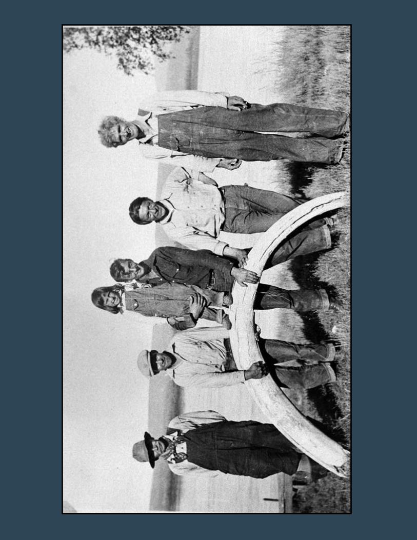
Back Cover: Left to right: The mail carrier Adolph “Ed” Biederman, his son Charlie, daughter Doris, the trapper andminer George Beck, Ed’s son Horace, and Jack Welch, the proprietor of Woodchopper Roadhouse. The group is atSlaven’s Roadhouse on the banks of the Yukon River posing with a mammoth tusk recovered from a placer miningtunnel. University of Alaska Fairbanks, Alaska & Polar Regions Collections and Archives, George Beck FamilyPapers.
For additional copies contact:Chris Allan
National Park ServiceFairbanks Administrative Center
4175 Geist RoadFairbanks, Alaska 99709
Printed in Fairbanks, Alaska

Introduction 1
Collections & Photographers 2
Chapter 1: The Search for Gold 3
Chapter 2: Stripping and Thawing 7
Chapter 3: Dredge Construction 13
Chapter 4: Building the Camps 24
Chapter 5: Life and Work in Mining Country 31
Chapter 6: Slaven’s Roadhouse 43
Conclusion 47
Sources 48
CONTENTS

Map
by
Mar
tin B
yrne
, GIS
Tea
m, N
PS A
lask
a Re
gion
al O
ffice
.

Gold mining along the stretch of the Yukon River that nowpasses through Yukon-Charley Rivers National Preserve beganin fits and starts. First came fur traders prospecting for gold inthe 1880s, then discoveries near Circle City in 1893, and a fewyears later the famous Klondike stampede which also inspiredminers to seek their fortunes on the American side of the border.In all of these cases, the gold was hard to find and harder torecover. This booklet focuses on a later era when miners on twinYukon tributaries—Coal Creek and Woodchopper Creek—useddredges to harvest traces of gold from massive amounts of gravel.Between 1934 and 1960, these mechanized giants transformedthe landscape, provided work for dozens of miners, and did whatearlier generations could not—make relatively poor groundprofitable.
This effort was the brainchild of Alexander McRae, aCanadian investor who made his fortune in the lumber, salmoncanning, and whaling industries before turning his attention tonorthern gold. Always alert for new business opportunities,McRae examined the economic landscape of the Great Depressionand predicted the U.S. government would soon boost the price ofgold. To find promising mining lands, he hired the best miningexpert he could find—Ernest Patty—who was then a professor inthe School of Mines at Alaska’s newly founded college inFairbanks. Together the two men zigzagged their way acrossAlaska and the Yukon Territory looking for mining claims to buy.
After a number of disappointments, Patty recommended theyvisit Coal Creek, located between the towns of Circle and Eagle.The creek had long been home to “pick and shovel miners” andwith their permission, Patty and McRae purchased churn drills togauge the amount of gold they might expect to unearth. Thedrilling teams also explored as far away as the Charley River.When they were satisfied with the numbers, measured in penniesper cubic yard, McRae purchased multiple claims from CoalCreek’s old-timers and formed a new mining company—GoldPlacers, Inc.—with Patty as general manager.
Just as McRae had predicted, President Roosevelt passed theGold Reserve Act on January 30, 1934, which raised the price ofgold from $20 to $35 an ounce as part of an effort to combat thedepression and stabilize the value of the dollar. Moving quickly,Patty hired the dredge designer Charles Janin to identify therequirements for successful dredging at Coal Creek and searchedfor a manufacturer. The winning bid for the project came fromthe Walter W. Johnson Company for a medium-sized, four-cubic-foot bucket dredge with a steel pontoon hull that cost $143,000,including delivery from Oakland, California.
From the beginning, Gold Placers, Inc. employed acombination of experienced dredgers, local small-scale miners,and students who Patty recruited from the School of Mines. Theemerging mining camp also had a family atmosphere because oneof the dredge’ first winchmen, Alvin Hendricks, arrived with hiswife Mildred and five-year-old son. Ernest Patty’s wife Kathrynand their sons also spent the summers at the camp, and in lateryears, three Han Athabascan families—the Junebys, Pauls, andDavids—came from nearby Eagle Village to live while the menworked for the company.
Dredging was difficult, muddy, noisy work. To prepare theground, tractor operators (called catskinners) stripped away mossand tree stumps, hydraulic cannons blasted away the dense, blacksoil, and workers pounded “points” that injected water into theearth to melt frozen gravel. After the ground was thawed, thedredge, groaning and clanking, dug into the gravel layer up totwenty-two feet below the surface. In its first year, the dredgeproduced over 3,000 ounces of gold and nearly 400 ounces ofsilver. These results were so encouraging that Patty recommendedthat McRae also buy mining claims along neighboringWoodchopper Creek. The Canadian agreed and promptly ordereda second dredge and founded a second company—Alluvial Golds,Inc.
The two companies, each with its own dredge, worked assibling operations. The Coal Creek operation had the YukonRiver landing where nearly all of the dredge parts and fuel arrived,while Woodchopper Creek camp had the only airstrip in the area,allowing planes to deliver people and supplies. A rough 12-mileroad ran from the river landing at Slaven’s Roadhouse up the CoalCreek drainage and over the hills to the Woodchopper camp.Over the next twenty-five years, the twin dredges worked inconcert, sharing crewmen and parts, and unearthing over 10,000pounds of gold worth, at the time, over six million dollars.
The photographs in this booklet were all taken by companyemployees between 1935 and 1938. Today much of what appearsin the images—the dredges, camp buildings, roads, hydraulicpipe, and prospecting drills—remains in place. Slaven’sRoadhouse also survives and has become a public-use cabin andone of the most popular stops for travelers on the Yukon River.All of these historic resources are part of the Coal Creek HistoricDistrict, which is listed on the National Register of Historic Placesand managed by the National Park Service. If you have a chanceto visit, please help to protect these resources by leavingeverything as you found it to be enjoyed by generations to come.
— Chris Allan
1
Introduction
2
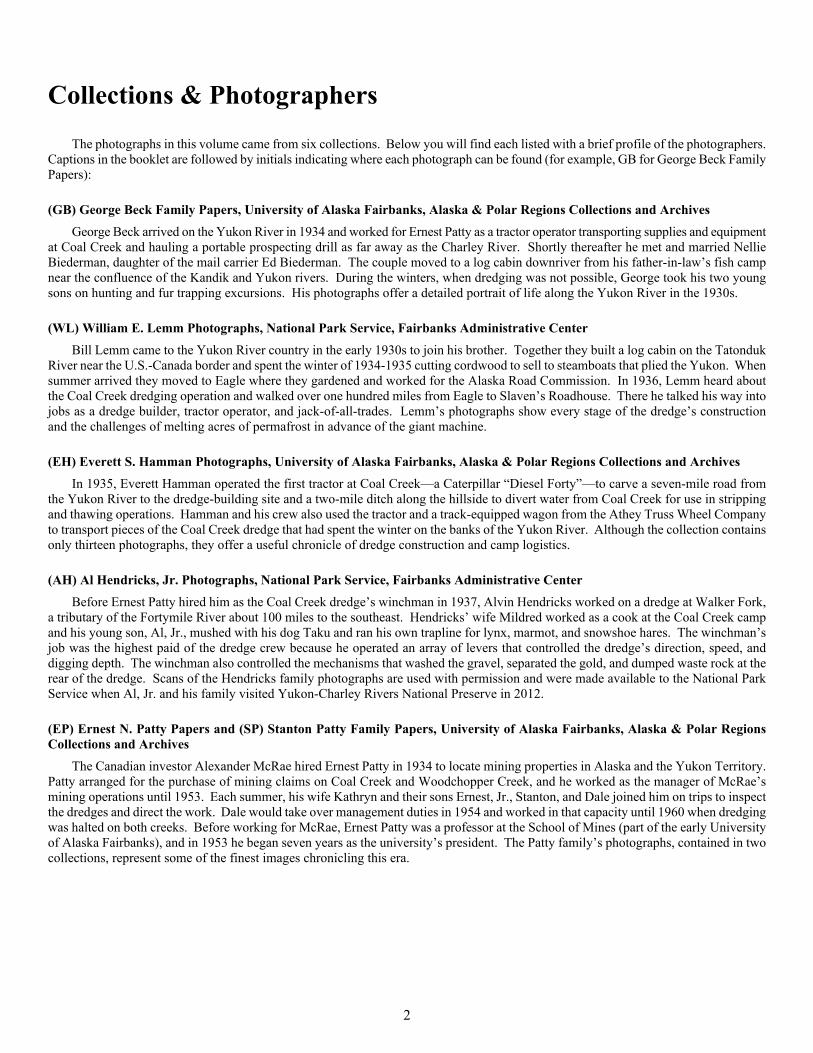
Collections & Photographers
The photographs in this volume came from six collections. Below you will find each listed with a brief profile of the photographers.Captions in the booklet are followed by initials indicating where each photograph can be found (for example, GB for George Beck FamilyPapers):
(GB) George Beck Family Papers, University of Alaska Fairbanks, Alaska & Polar Regions Collections and ArchivesGeorge Beck arrived on the Yukon River in 1934 and worked for Ernest Patty as a tractor operator transporting supplies and equipment
at Coal Creek and hauling a portable prospecting drill as far away as the Charley River. Shortly thereafter he met and married NellieBiederman, daughter of the mail carrier Ed Biederman. The couple moved to a log cabin downriver from his father-in-law’s fish campnear the confluence of the Kandik and Yukon rivers. During the winters, when dredging was not possible, George took his two youngsons on hunting and fur trapping excursions. His photographs offer a detailed portrait of life along the Yukon River in the 1930s.
(WL) William E. Lemm Photographs, National Park Service, Fairbanks Administrative CenterBill Lemm came to the Yukon River country in the early 1930s to join his brother. Together they built a log cabin on the Tatonduk
River near the U.S.-Canada border and spent the winter of 1934-1935 cutting cordwood to sell to steamboats that plied the Yukon. Whensummer arrived they moved to Eagle where they gardened and worked for the Alaska Road Commission. In 1936, Lemm heard aboutthe Coal Creek dredging operation and walked over one hundred miles from Eagle to Slaven’s Roadhouse. There he talked his way intojobs as a dredge builder, tractor operator, and jack-of-all-trades. Lemm’s photographs show every stage of the dredge’s constructionand the challenges of melting acres of permafrost in advance of the giant machine.
(EH) Everett S. Hamman Photographs, University of Alaska Fairbanks, Alaska & Polar Regions Collections and ArchivesIn 1935, Everett Hamman operated the first tractor at Coal Creek—a Caterpillar “Diesel Forty”—to carve a seven-mile road from
the Yukon River to the dredge-building site and a two-mile ditch along the hillside to divert water from Coal Creek for use in strippingand thawing operations. Hamman and his crew also used the tractor and a track-equipped wagon from the Athey Truss Wheel Companyto transport pieces of the Coal Creek dredge that had spent the winter on the banks of the Yukon River. Although the collection containsonly thirteen photographs, they offer a useful chronicle of dredge construction and camp logistics.
(AH) Al Hendricks, Jr. Photographs, National Park Service, Fairbanks Administrative CenterBefore Ernest Patty hired him as the Coal Creek dredge’s winchman in 1937, Alvin Hendricks worked on a dredge at Walker Fork,
a tributary of the Fortymile River about 100 miles to the southeast. Hendricks’ wife Mildred worked as a cook at the Coal Creek campand his young son, Al, Jr., mushed with his dog Taku and ran his own trapline for lynx, marmot, and snowshoe hares. The winchman’sjob was the highest paid of the dredge crew because he operated an array of levers that controlled the dredge’s direction, speed, anddigging depth. The winchman also controlled the mechanisms that washed the gravel, separated the gold, and dumped waste rock at therear of the dredge. Scans of the Hendricks family photographs are used with permission and were made available to the National ParkService when Al, Jr. and his family visited Yukon-Charley Rivers National Preserve in 2012.
(EP) Ernest N. Patty Papers and (SP) Stanton Patty Family Papers, University of Alaska Fairbanks, Alaska & Polar RegionsCollections and Archives
The Canadian investor Alexander McRae hired Ernest Patty in 1934 to locate mining properties in Alaska and the Yukon Territory.Patty arranged for the purchase of mining claims on Coal Creek and Woodchopper Creek, and he worked as the manager of McRae’smining operations until 1953. Each summer, his wife Kathryn and their sons Ernest, Jr., Stanton, and Dale joined him on trips to inspectthe dredges and direct the work. Dale would take over management duties in 1954 and worked in that capacity until 1960 when dredgingwas halted on both creeks. Before working for McRae, Ernest Patty was a professor at the School of Mines (part of the early Universityof Alaska Fairbanks), and in 1953 he began seven years as the university’s president. The Patty family’s photographs, contained in twocollections, represent some of the finest images chronicling this era.

3
Churn drills, like this one at Coal Creek, pulverized gravel to create a slurry that could be tested for gold worth pennies per cubicyard. By drilling at 100-foot intervals, Gold Placers, Inc. created detailed maps of gold values across the drainage. (SP)
4
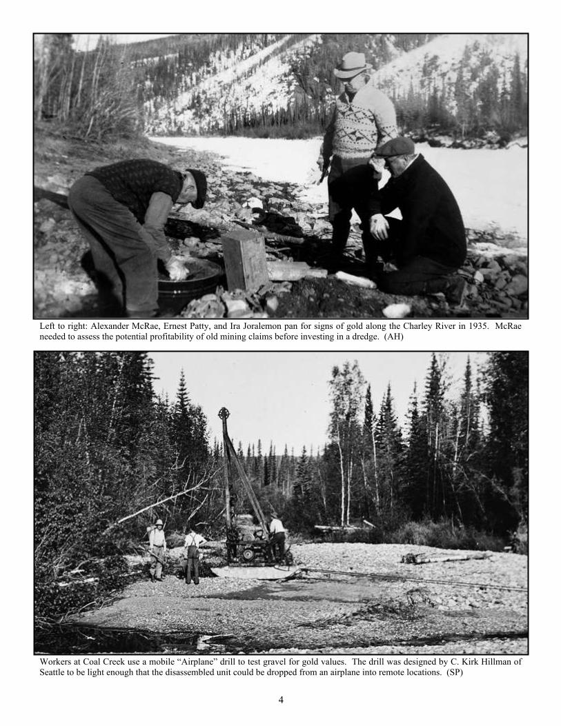
Left to right: Alexander McRae, Ernest Patty, and Ira Joralemon pan for signs of gold along the Charley River in 1935. McRaeneeded to assess the potential profitability of old mining claims before investing in a dredge. (AH)
Workers at Coal Creek use a mobile “Airplane” drill to test gravel for gold values. The drill was designed by C. Kirk Hillman ofSeattle to be light enough that the disassembled unit could be dropped from an airplane into remote locations. (SP)

5
The “Prospector” by C. Kirk Hillman was a churn drill capable of moving with tracks over rugged terrain. This drill and the “Airplane”model were used to create maps of gold values at Coal Creek, Woodchopper Creek, and beyond. (SP)
A Caterpillar tractor pulled this “go-devil,” a sledge that carried supplies for the “Prospector” churn drill. The sledge carried fuel,tools, bits, drill pipe, and steel sluice boxes for processing the rock slurry recovered from drill holes. (SP)

6
Workers with their partially assembled prospecting drill at the Charley River. Roughly 100 stampeders worked the gravels of CharleyRiver tributaries in 1898-99, but when Ernest Patty sent this crew in the 1930s, they did not find enough to warrant dredging. (GB)
Frank Slaven (foreground) and other old-timers prospecting for gold near the Charley River. They are using a steam boiler to meltfrozen ground and buckets to bring the gravel to the surface. The ladder next to the boiler emerges from their mine shaft. (WL)

7
A battery of hydraulic cannons, called giants, strip away the organic material (called muck) to begin thawing the permafrost below.This ground preparation was essential because the dredge’s buckets would be damaged by frozen gravel. (EH)

8
Ernest Patty and his wife Kathryn stand along the two-mile ditch above Coal Creek. The ditch provided water under pressure forstripping and thawing in advance of the gold dredge. (EP)
This penstock (right of ditch) diverts water to a system of hydraulic piping (far right) for stripping and thawing. As the waterdescended into the valley, gravity created enough pressure to supply multiple giants and hundreds of thawing points. (SP)

9
An elaborate system of hydraulic piping was used to transport water for giants and thawing points. The points, made of rubber hoseand steel pipe with a chisel bit, were driven into frozen ground, inches at a time, to melt many acres of permafrost. (SP)
This temporary bridge supports a pipe carrying water under pressure across a portion of Coal Creek. As the dredge moved alongthe creek drainage, this bridge would be dismantled and erected elsewhere. (SP)

10
Caterpillar-style tractors with bulldozer blades were the only vehicles capable of maneuvering through a soggy landscape of meltedearth and diverted creek water. And even with treads, these machines often became mired and needed to be rescued. (AH)
A dredge employee uses a hydraulic cannon, or giant, to strip away the ground’s organic layer and accelerate thawing in advance ofthe dredge. At the rear of the nozzle are counter-weights to help the worker handle the power of the cannon. (AH)

A Caterpillar tractor hauls a load of piping from the Yukon River near Slaven’s Roadhouse to the area of dredge operations. TheAlaska Road Commission and Gold Placers, Inc. worked to improve this roadway between 1935 and 1939. (GB)
11

12
A field of thawing points used to inject air-temperature water into the ground to melt permafrost. This work needed to be done theyear before the dredge arrived to ensure that thawing had reached at least twenty-five feet of depth. (SP)
Thawing points were equipped with a “hammer and anvil” system, which allowed a worker to drive the chisel bit a few inches at atime into melting permafrost. The work was backbreaking and made more difficult by mosquitoes and standing water. (AH)

13
Employees on a break during the construction of the Coal Creek gold dredge. The Walter W. Johnson Company of Californiadesigned the dredge and sent a foreman, Sam Palmer, to direct the work. The dredge was assembled in seventy-two days. (WL)

14
A steamboat pushing a barge carrying parts for the Coal Creek dredge to the landing at Slaven’s Roadhouse. Without the WhitePass Railroad between Skagway and Whitehorse and steamboats like this one, the enterprise would not have been possible. (WL)
Workers rest on the edge of a Yukon River barge delivering sections of the Coal Creek dredge’s steel pontoons. At the time, mostdredge pontoons were made of wood, but steel was necessary in Alaska to resist the crush of ice in winter. (WL)

15
Frank Slaven (left) and others unload dredge parts from a barge near Slaven’s Roadhouse (at right on the bluff). The price of thedredge included delivery to this point; reaching the construction site seven miles inland was up to Gold Placers, Inc. (GB)
Workers transport the 40-foot-long “spud” weighing nearly seventeen tons to the dredge construction site. The spud, installed atthe rear of the dredge, served as an anchor and pivot point that could be raised or lowered as the dredge advanced. (GB)

16
In early March 1936, tractors and sledges on the bank of the Yukon River prepared to move dredge parts up Coal Creek to beginconstruction. Moving heavy loads overland was easier over snow and when the ground was still frozen. (GB)
Dredge buckets and sections of the trommel (the dredge’s main gravel-washing mechanism) lie in the snow, waiting to be transportedto the construction site. In all, the parts, tools, and other equipment weighed about 400 tons. (EP)

17
Construction of the Coal Creek dredge took place on a frozen pond because the ice provided a flat, level surface, and when the pondmelted in the spring, the dredge would float and be ready for action. (WL)
The Coal Creek dredge’s superstructure of steel I-beams riveted into place begins to take shape. The notch at the bow of the dredge,between two sections of pontoon, would allow its sixty-two buckets to dig over twenty feet into the earth. (GB)

18
Workers on the “bull gang” affix steel struts to create the dredge’s superstructure. The metal was held in place by rivets that had tobe pounded with hammers while they were still red-hot and malleable. (GB)
With the dredge’s superstructure nearly complete, the workers next installed the bow gantry and bucket line and the stacker thatejected waste rock to the rear. They also placed thirty tons of ballast rock inside the pontoons to prevent listing. (WL)

19
Dredge buckets, each capable of holding four cubic feet of material, wait to be installed. Each season, the digging edge of the bucketswas worn away from constant use, so the buckets were designed with replaceable lips. (WL)
On the lower right one can see the Atlas diesel engine that powered most of the dredge. The pilot house at the upper-left is wherethe winchman used levers controlling an elaborate suite of cables and winches to operate the dredge. (WL)

20
Ropes and pulleys were essential for lifting heavy dredge parts into place; the siding has been installed on the port side and soon thebucket line (parts seen at far left) will be lifted into place. (WL)
The Atlas diesel engine used heavy canvas drive belts to power the dredge’s bucket line and trommel. Atlas engines were typicallyused on ships where constant movement and wet conditions were the norm—dredges were no different. (WL)

21
The construction of the Coal Creek dredge began on April 8, 1936 and ended on June 18—in just seventy-two days these workersassembled an enormously complex mining behemoth that would soon begin digging and processing gravel. (WL)
The Coal Creek dredge working within sight of new camp buildings. As the dredge moved across the landscape, most of the campmoved with it. This early location, near a tributary called Cheese Creek, was abandoned by 1938. (AH)

22
Once in operation, the dredge floated in a pond of its own making, and as it excavated gravel, long steel cables attached near thebow were used to pull the machine left, right, or forward. Note ripples in the water where a cable slipped beneath the surface. (SP)
The dredge’s sixty-two buckets could be raised or lowered to find the richest layer of gold-bearing gravels, and the work continuednon-stop until late October or early November when sub-zero weather ended the season. (AH)

23
The Coal Creek gold dredge on its first full day of operation, July 1, 1936. General Manager Ernest Patty later wrote, “Its two dieselengines began coughing; the winchman moved the dredge out of the construction pit and the bucket line started to revolve and biteinto the gravel. It was a great moment to hear the thump of the first gravel falling into the hopper.” (EH)

24
Dredge worker and photographer Bill Lemm at a Coal Creek bunkhouse. For Lemm and other members of the crew, buildings likethese were home for the four-month dredging season. (WL)
25
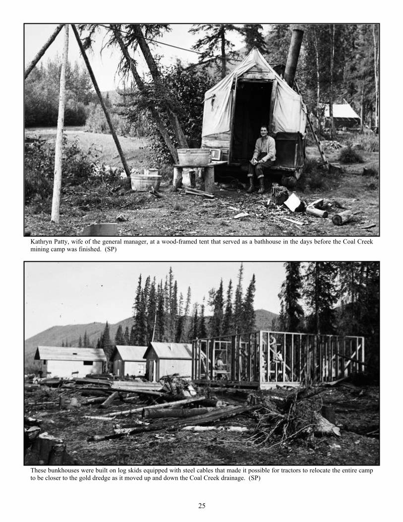
Kathryn Patty, wife of the general manager, at a wood-framed tent that served as a bathhouse in the days before the Coal Creekmining camp was finished. (SP)
These bunkhouses were built on log skids equipped with steel cables that made it possible for tractors to relocate the entire campto be closer to the gold dredge as it moved up and down the Coal Creek drainage. (SP)

Coal Creek dredge workers in front of their temporary quarters before frame bunkhouses were completed. Manydredge workers were students in the University of Alaska’s mining program in Fairbanks. (AH)
26

The Coal Creek dredge in its first weeks of operation near the Cheese Creek tributary. To the left of the spruce tree is a machineshop, blacksmith’s shop, and warehouse for dredge parts. (SP)
The earliest camp buildings at Coal Creek were a combination of log cabins and frame structures. The logs were local, but thematerials for the rest of the buildings arrived from California via Yukon River steamboat. (EP )
27

28
A barefooted dredge employee repairs chimney flashing to stop a roof leak in his temporary bunkhouse at the Coal Creek miningcamp. (WL)
The early days of construction at Woodchopper Creek mining camp in 1937. Not long after this photograph was taken, bulldozerscleared land for an airstrip because there was no road linking the Woodchopper camp directly to the Yukon River. (EP)

A pilot with the Pollack Flying Service of Alaska delivers supplies at the newly constructed Woodchopper Creek airstrip. (AH)
Bill Lemm making coffee at the summit of the road between the Yukon River and the Coal Creek mining camp. This road waseventually extended westward across the hills to reach the Woodchopper Creek camp. (WL)
29

30
Dredge workers near the newly finished kitchen and mess hall at Woodchopper Creek mining camp. With a road linkingWoodchopper Creek to Coal Creek, supplies and sometimes whole buildings could be transported back and forth. (SP)
Built in 1937, the Woodchopper Creek gold dredge was also owned by the Canadian investor Alexander McRae. It operated underthe business name Alluvial Golds, Inc. and was similar in design to the one at Coal Creek. (SP)

31
Mildred and Al Hendricks, Jr. in one of the International trucks used to drive the road between the Yukon River and CoalCreek mining camp and from Coal Creek to the Woodchopper Creek camp. (AH)

32
Dredge workers at the Coal Creek mining camp engaged in a fierce tug-of-war on Independence Day. This was the only day duringthe season the crews were not working. (AH)
A potato-sack race on Independence Day. The piles of waste rock in the distance, called tailings, were deposited by the CoalCreek gold dredge. (AH)

33
Dredge workers at the Coal Creek mining camp display their team banner in preparation for Independence Day celebrations. Thename P.O.I.N.T.S. is a reference to their work driving thawing points into the earth in advance of the dredge. (WL)
Al Hendricks, Jr. (left in coveralls) and his dog Taku gather outside the Coal Creek camp’s mess hall to enjoy an IndependenceDay orchestra. The triangle hanging from the building was used to call the dredge workers to meals. (AH)

34
Al Hendricks, Jr. (left), son of the Coal Creek dredge winchman, and Stanton Patty, son of the general manager at bothCoal Creek and Woodchopper Creek, shared adventures in the mining camps each summer. (AH)

35
Dredge workers were never idle. Here they cut and stack cordwood to fuel the steam boilers mounted inside each dredge. The boilershelped to melt ice that built up inside the dredge in Spring or Fall when temperatures dropped. (SP)
Bill Lemm, a catskinner and dredge worker, transports a portable cookhouse using his tractor and the Athey wagon. Moving buildings,either dismantled or on log skids, was a routine part of dredge operations. (WL)

36
Dredge workers repair the heavy cables used to lock the floating dredge to anchors on land and to pull it forwardwhen the buckets were done excavating a section of earth. The head net hints at the mosquito menace. (WL)

37
Mildred Hendricks (left) and friends gather on an upper deck of the Coal Creek gold dredge. Mildred worked as a cook in the miningcamp and was married to the dredge winchman, Alvin Hendricks. (AH)
George Beck (right) and another catskinner pose in front of one of the company’s Caterpillar tractors at Coal Creek camp. Becausethe tractor arrived in Alaska without a seat, they bolted a small sofa in its place. (GB)

38
A dredge worker drives points in a thawing field while the Coal Creek dredge works the previous year’s meltedgravel. The steel piping of a thawing point was long because it needed to melt up to twenty-five feet down. (AH)
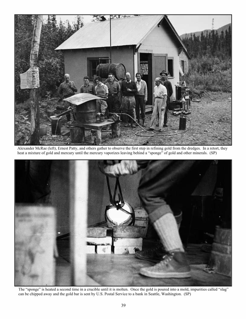
Alexander McRae (left), Ernest Patty, and others gather to observe the first step in refining gold from the dredges. In a retort, theyheat a mixture of gold and mercury until the mercury vaporizes leaving behind a “sponge” of gold and other minerals. (SP)
The “sponge” is heated a second time in a crucible until it is molten. Once the gold is poured into a mold, impurities called “slag”can be chipped away and the gold bar is sent by U.S. Postal Service to a bank in Seattle, Washington. (SP)
39

The old-timers: Art Reynolds (left) lived and mined at Sam Creek; Phil Berail (middle) worked as a hydraulic foreman for GoldPlacers, Inc; and Sandy Johnson, known for building cabins along the Yukon, helped to build Slaven’s Roadhouse. (EP)
40

41
After long hours driving a tractor or working on the dredge, Bill Lemm gave his fellow mine employees haircuts. (WL)
Moving along Coal Creek during periods of high water was never easy. To make their way up the drainage, dredge workersinstalled a cable-sling tramway while others used improvised log bridges at their own peril. (AH)

42
Workers take a break on the upper deck of the Coal Creek gold dredge. The size of dredging crews fluctuated from over one hundredin the early years to fewer than twenty during WWII when labor was scarce and only one dredge was in operation (AH)
Martin Adamik stands at the edge of his garden on the Coal Creek tributary of Boulder Creek. Adamik was famous for his vegetablesand for his reclusive ways, though in 1936 he was listed on the Gold Placers, Inc. payroll. (AH)

43
Glen Franklin, seen here at Slaven’s Roadhouse, was the accountant for Gold Placers, Inc. and served as the camp’s postmaster.Here he hoists a bag of gold worth $40,000 that will travel by boat to Fairbanks and then will be sent to a Seattle bank. (WL)

44
In the mid-1930s, Frank Slaven, one of Coal Creek’s original gold miners, built and operated a roadhouse. He is seen here with hispartner Mary Bissel and the men helping him to build the half-frame, half-log structure. (EH)
The steamboat Yukon pushes the barges Muskrat and Stewart to the landing below Slaven’s Roadhouse. Barges like these carriedsupplies, including food and fuel, for the Coal Creek and Woodchopper Creek mining camps. (AH)

45
Visitors to Slaven’s Roadhouse rest their feet at an elevated cache where meat and other foodstuffs could be stored out of the reachof hungry animals. (WL)
Bill Lemm stands atop 480 cords of wood on the banks of the Yukon River not far from Slaven’s Roadhouse. After drying for ayear, the wood was sold as fuel to passing steamboats. (WL)

46
Bill Lemm uses the camp’s Athey wagon and a Caterpillar tractor to unload barrels of diesel and machine oil from a barge on theYukon River. The Ford truck was also used to transport fuel and lubricants to keep the dredges working. (WL)
Jim McDonald and Bill Lemm watch over a stockpile of fuel barrels on the landing below Slaven’s Roadhouse. The two Atlasgenerators on the Coal Creek dredge used 180 gallons of diesel each day, and more was needed to keep the tractors running. (WL)

Yukon-Charley Rivers National Preserve is special for manyreasons—for its natural beauty, its wildlife, its intact riverecosystems, and for its public-use cabins that shelter rivertravelers. But evidence of the preserve’s gold mining past is oftenhidden along woodsy trails and in overgrown camps located milesinland from the Yukon River. National Park Service planners inthe 1970s knew that mining equipment and historical buildingswere scattered thinly across the landscape, so they worked hardto ensure that the history of the place would not be ignored orforgotten.
In 1980, the U.S. Congress passed into law the AlaskaNational Interest Lands Conservation Act that established Yukon-Charley Rivers National Preserve and many other park units. Thelegislation lists the reasons for creating the 2.5-million-acrepreserve, including “to protect and interpret historical sites andevents associated with the gold rush on the Yukon River.” Thisbooklet supports that mandate and the preserve’s efforts to protectproperties of regional and national significance.
Historic preservation is an important part of the National ParkService’s mission, and in Yukon-Charley Rivers NationalPreserve, the agency maintains a wide array of cabins, miningcamps, and other historic structures. At the heart of the preserve,the Coal Creek Historic District serves as a hub where multiplepreservation projects have taken place through the years,including restoration of Coal Creek mining camp, the Coal Creekgold dredge, and Frank Slaven’s roadhouse.
The twin gold camps of Coal Creek and Woodchopper Creekcontinued to produce profits through the 1950s, but, after aquarter-century of operation, the richest gold deposits were goneand rising costs for labor and supplies forced the gold dredgesinto retirement. Independent operators periodically leased themining claims and operated the dredges, but they never returnedto their former glory. Today these reminders of the past allow usto better understand a compelling period in the history of Alaskawhen gold-seekers struggled to confront the realities of miningin the Far North.
Conclusion
47
Members of the crew who replaced the roof of the Coal Creek dredge in 2017 (left to right): Don Corwin, Vincent Maccioli, RandySmith, and Al Williams. Historic preservation efforts like these ensure that visitors continue to enjoy the preserve’s history.

SOURCES
Allan, Chris. Gold, Steel & Ice: A History of Mining Machines in Yukon-Charley Rivers NationalPreserve. Fairbanks: National Park Service, 2015.
Beckstead, Douglas. The World Turned Upside Down: A History of Mining on Coal Creek andWoodchopper Creek, Yukon-Charley Rivers National Preserve, Alaska. Fairbanks: National ParkService, 2003.
Houlette, Christopher. “Snare Creek: Historic Archaeology at a Han Athabaskan Enclave in the CoalCreek Mining District, Alaska.” Cultural Resource Report NPS/YUCH/CRR 2016/002. National ParkService, Yukon-Charley Rivers National Preserve, 2016.
Joralemon, Ira B. Adventure Beacons. New York: Society of Mining Engineers of AIME, 1976.
Patty, Ernest N. North Country Challenge. New York: David McKay Company, 1969.
-----. “Placer Mining in the Sub-Arctic,” Western Miner 18 (April 1945), 44-49.
-----. “Solar Thawing Increases Profit from Sub-Arctic Placer Gravels,” Mining Engineering 190(January 1951), 27-28.
Spence, Clark C. The Northern Gold Fleet: Twentieth-Century Gold Dredging in Alaska. Urbana andChicago: University of Illinois Press, 1996.
Webb, Melody. The Last Frontier: A History of the Yukon Basin of Canada and Alaska. Albuquerque:University of New Mexico Press, 1985. Also titled Yukon: The Last Frontier from University ofBritish Columbia Press, 1993.
48