Embed Size (px)
Citation preview
September 23,2003
Corporation of the District of Summerland Box 159 Summerland, B.C. VOH 120
AS A RESULT OF OR0 iN MEADOW VALLEY
Dear Sir:
Golder Associates
d, B.C. (Figure 1). The water wells are f of the District of Summerland (DOS), to
ut Creek Balacing Reservoir. This is an
e of this letter is to address concerns raised by the c Summerland Trout Hatchery regarding the proposed
p
I .O BACKGROUND
Golder has been assisting DOS with the development of an interim groundwater supply system in the Meadow Valley area, in order to supplement surface water flow into the Trout Creek Balancing Reservoir. The area in Meadow Valley where the development of water wells has been focused is known as the Summerland Rodeo Grounds (Figure 2),
The objective of the groundwater development proyrarn is to construct approximately three water wells capable of delivering a combined maximum uolumc; in the order of
SEP-23-2003 18:03 1 250 860 9574 P. 02
Meadow Valley Groundh der Development District of Summerland - 2 -
September 23,2003 03- 1440- 145
1,000 USgpm, which will be directed into the balancing reservoir. The water supply wells are located along the concrete lined flume which diverts surface water fiorn Trout Creek into the reservoir. It is understood that the wells would be used on an intermittent basis only, during periods when surface water flows from Trout Creek were not avdlablc to meet the water demands of Summerland.
2.0 OVERVIEW OF HYDROGEQLOGY IN STUDY AREA
2.1 G8nerd GUOlOgy
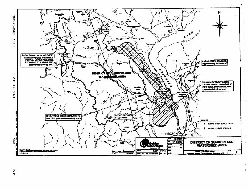
The Study Arcs includes the entire catchments of
upper reaches of the Trout Creek catc
The Study Area is do Jurassic age Okanag
with the Middle
. A major fault exists NNLing
ornplex and consists of lacustrine, glacial clay, silty sand, sand and gravel overlying bedrock.
ht swficial deposits in the area arc considered to vial fans, deltas and associated gully and stream
Based on a review of water well records and information from die Ministry of Water, Land and Air Protection (MWLAP) water well registry system, several aquifers appear to be present in the Study Area. These aquifers include both unconfined aid confined aquifers within the valley infill deposits alvng Trout Crcck, fractured bedrock aquifers
’ Naismith, Hugh. I962 Late WAal Hlrtoy and Sudicirl bcpatils of Ihe Okanspm VJlcy. Provincc of British Columbia Bulletin
46, Minisuy oFEnor(yy, Mints and Pcwleum Resources, 46 pp SEP-23-2003 18:03 1250 860 9874 P. 03
Meadow Valley GroUnhT.~ttr Development September 23,2003 . . District of Summerland - 3 - 03-1440-145
within the upland areas sunounding Trout Creek, En- Creek and Darke Valley, and a system of aquifers under the Town of Summcrtilnd itself. The dominant aquifer that has been the focus of this investigation is the Meadow Valley Aquifer (also known as the Faulder Aquifer), which is comprised of separate unconfined and confined aquifers,
Meadow Vallev Aauifer s
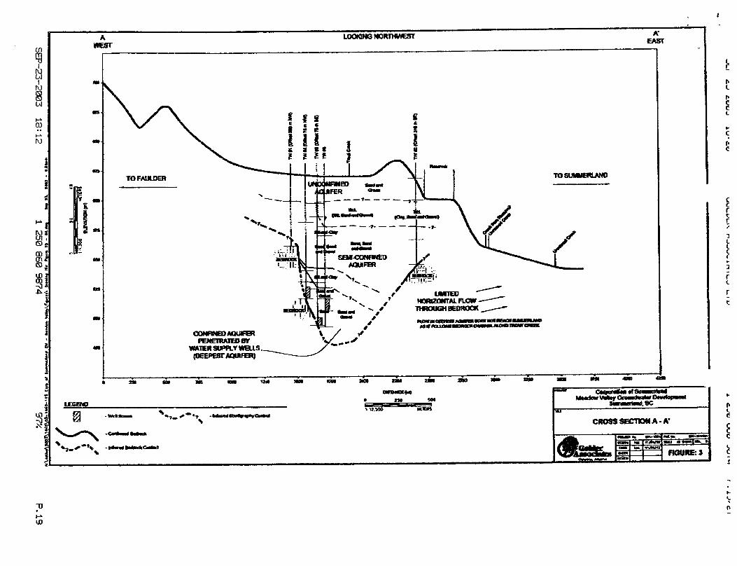
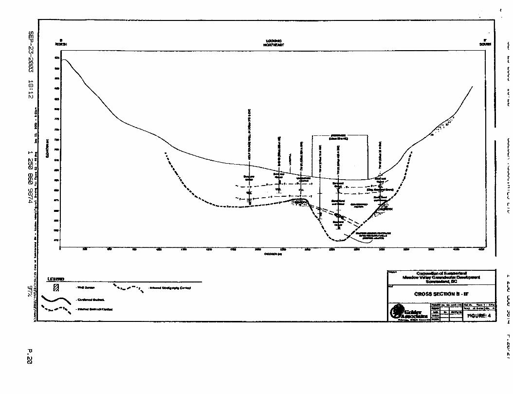
low ground surhce, and a fully confined aquifer located beneath clay and below ground surface, Cross sections showing the t Figures 3 and 4. MWLAP has undertaken some nature of the unconfined to semi-confined
base of the central castcm portion of the
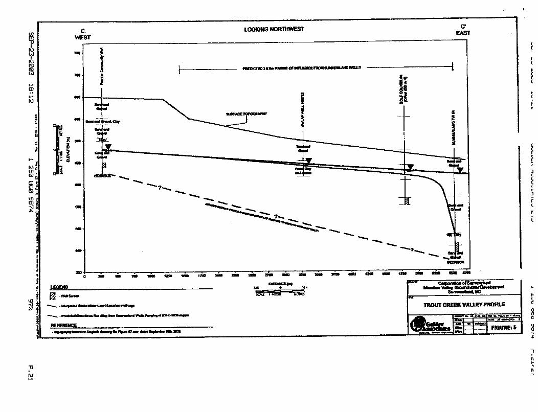
Figwe 5 , the Faulder Community aquifer system, as are the DOS w
ths greater than 80 rn ems are provided on
n the extent and
Figure 5). As shown in atcd in a deep confined
has low vuinerabili records indicate upwards of forty water
tcords for this aquifer indicate water- from 28,7 m (94 A) to 66.4 m (218 ft), at various depths. Numerous well logs
near the balancing reservoir, and therefore the potential for development of groundwater in this area was initially determined to be only moderately good. Additional infomation regarding subsurface conditions in the eastern extent of the Fsul&t Aquifer was obtained from DOS regarding a water well drilled recently at the Summerland Rodeo Ground. The information in the well log also supports the presence of upper and lower aquifers, with an overburden sand and gravel deposit (unconfined to semi-canfmed system) present to depths of approximately 70 m below ground surface, and a deeper, confined sand and gravel system present at depths greater than 80 m below ground surface.
i 250 860 9874 P.04 SEP-23-2003 18:O4
Meadow Valley Grouna.,der Development District of Summerland - 4 -
Eneas Creek Total Area
Septcmbcr 23,2003 034440- 145
~ -~ -
110 810
Cross sections shown in Figure 3 and Figure 4 present sectional hydrogdogicd interpretations at the southern limits (Section A-A') and north-central limits (Section B- B') of the Meadow Valley area, and provide a general summary of the subswface stratigraphy. As shown in the cross sections, it can be i n f e d that flow within the deep confined aquifer is controlled by bedrock and directed along the main axis of Trout Creek to the south, following a deep bedrock channel. However, i t can be inferred that groundwater from the overburden, unconfined aquifer system partially recharges arcas to the east, specifically the Town of Summerland.
Copies of selected water well records available for the S&*Area from the MWLAP Database and for the Rodeo Grounds water well arc pres@tt%i id$@xmlix 1.
': b f .!
(!r+ I, 4 l i l
Area including Town of Summerland 40
3.0 PRELIMINARY WATER BALANCE
3.11 Annual Recharge EWnatst
850 (Total)
charge to the subsurface in atchments which meat
rint ma occupied by oximately 660 k m 2 (or
anting reservoir. A supmary of Area is provided in Figw 1 and
in the area o f the Town of Summer1
Note that the catchment area for the southeastern portion of Trout Creek, southeast of the Rodeo Grounds, accounts for approxhtcly 40 km2 wad has not bocn included os parr of the study ma.
SEP-23-2003 18:04 1 250 860 9874 P. 65
Meadow Valley Groundwater DcveIopment September 23,2003 . I . District of Summerland - S - 03-1 440- 145
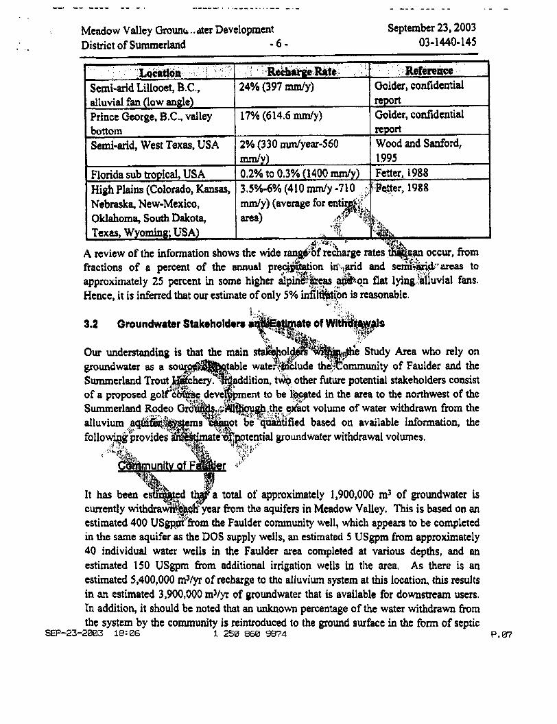
For &e purpose of this investigation, it has been assumed that recharge to the subsurface is primarily via infiltration of precipitation and snow melt within these catchment mas, and that the majority of the infiltration (approximately 80%) is concentrated iii the alluvium aquifer systems (unconfined and confined systcms). It is anticipated that the remainder of the precipitation (approximately 20%) recharges localized bedrock aquifer systems. It is also assumed that the area above the Think Dam, equivalent to 165 km2 or approximately 20% of the total recharge area, is controlled by DOS, and therefore does not contribute recharge to the alluvium systems. As such, i4,can be inferred that precipitation h m approximately 495 km2 (the m a
kmz recharges the area between the Community of F wells,
The mean annual precipitation in the Sum Canada, Canadian Climate Nonnals 1971-2D this precipitation, or 13.5 d y r , is available as r annual recharge to the Swnmcrland Trout Creek, southeast of the Rode on an area of 850 kmz), of which ap recharge the alluvium aquifer systems. only, and does not a
e DOS water supply
, a preliminary estimate of the e southeastern portion of
m3/yr) is anticipated to e is based on prtxipitatioa
as cantributions fiom septic
The total estimated re fer system supplying the Faulder area 346,000 m3/y~. An additional 432,000 m3/yr ty of Fauldcr and the proposed DOS water
ed volumc of recharge to the alluvium aquifer the DOS water supply wells is approximately
1 250 860 9874 F. 06 SEP-23-2003 18 : 05
Meadow Valley Grounb.. ilter Development September 23,2003 03 - 1440- 1 45 . I District of Summerland -6-
Oklahomtt, South Dakota,
fractions of o percent of the annual pr approximately 25 percent in some higher Hence, it i s inferred that our estimate of only
3.2 Groundwater Stakeholdom
Study Area who rely on
Summerland Tro cd in thc area to the northwest of the
ed based on available information, the
total of approximately 1,900,000 m3 of groundwater is ftom the aquifers in Meadow Volley, This is based on an
estimated 400 US&''fiom the Faulder community well, which appears to be completed in the same aquifer as thc DOS supply wells, an estimated 5 USgprn from approximately 40 individual water wells in the Faulder urea completed at various depths, and an estimated 150 USgpm h m additional irrigation wells in the area. As there is an estimated 5,400,000 mVyr of recharge to thc alluvium system at this location, this results in an cstimated 3,900,000 m 3 / ~ of groundwater that is available for downstream users. In addition, it should be noted that m unknown percentage of the water withdrawn from the system by the community is reintroduced to the ground surface in the form of septic
SEP-23-2003 18: 06 1 250 860 9874 P. 07
- .
Meadow Valley Grounawater Development September 23,2003 . . District of Summerland - 7 - 03-1440-145
Community of Faulder estimated withdrawal volume
disposal to ground, waste water disposal and irrigation. As such, the estimates provided are considered to bc conservative in nature.
1,900,000 mVyr
Summerla nd Trout Hat chew
Proposed District of Summerland withdrawal volume I
According to a previous study conducted by the Ministry of Environment, the Summerland Trout Hatchery obtains their potable watcr fkom a local spring known as Shaughnessy Springs (Figure 1). The reported yield ofthe Spring has been estimated to be approximately 0.08 m3/sec, As of September 1986, two Iic&$shave r;. been issued for the Spring to the Department of Recreation and Cons+wd$i$a, for a total withdrawal volume of 0.09 m3/sec (slightly greater than the repoqt$yid@;~. I .*, Based on the water withdrawal licenses, the estimated usage over each y q i&pproxirn#!$ 2,840,000 m3.
, ;y'* "A,, w:
I 2,000,000 rn'/yr
course development is order of 3,800 mVday for
It is understood , in the area of the
s ~ u n e s that the wells are operating a worst case scenario, The maximum
e 3,878,000 mYyr net surplus estimated to exist
o Grounds catchment areas versus the estimated volume of catchment areas.
Total recharge to area between Tusk Dam and Summerland water supply wells ( including Community of Faulder)
5,778,000 mVyr
SEF-23-2003 18:06 1 250 860 9874 P. 08
. -.
L Remaining volume of recharge not being consumed
Meadow Vailey Grounb . der Development September 23,2003 District of Summerland - 8 - 03-1440-145
at Rodeo Grounds I
1,878,000 mVyr
Based on the availabk information, it is inferred that sufficient volumcs of water exist to supply both the Community of Fauldtr and the DOS water s s on an emergency
wishes to make
with a detrimental impact on both human users
Note that water withdrawal volumes for the’pr been taken into consideration at this the , as the ume of water requircd for the
A specific water balance for the E
nment in September 1986,
a significant sand and gravel aquifer rc, it was suggested that the recharge
erland Reservoir, with the primary sources
entitled “Assessm
er portioiis of Eneas Creek and water additions fiom septic disposal to the ground and irrigation systems in the Summerland area. Available information iildicates that the decp confined system of the Faulder Aquifer does not contribute recharge to the overburden aquifer systems of Summerland. As such, it is our opinion that water volumes fiom Shaughnessy Springs will not be adversely affected by the withdrawal of groundwater from water supply wells screened within the deep confined aquifer system in the Meadow Valley area.
SEP-23-2003 18:07 1250 860 9874 97% P. 09
Meadow Valley Grow- rvater Development September 23,2003 a . District of Summerland - 9 - 03-1440- 145
4.0 STATUS OF GROUNDWATER DEVELOPMENT BY DOS
4.1 Subsurface Conditions in the Test Well Area
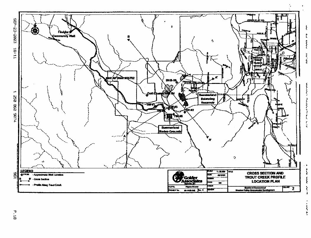
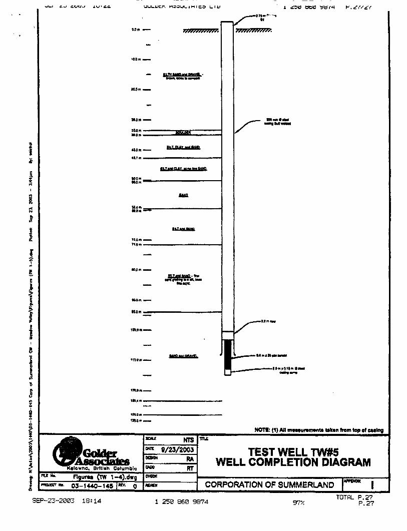
Galder has ncently supervised the completion of five test wells (TW1, through TWS) to assess the subsurface conditions and available yield from aquifers in the area of the Summerland Balancing Resmoir. Three of the test wells (TW3, TW4 and TWS) have been successhlly completed as water supply wells, while and T W ) w m considered unsuitable. All five Test Well in the area of the concrete lined flume, which diverts surface water fro (Figure 2).
intake from Trout Creek, while TW2 is locat discharge into the reservoir. Both of the$ ranging from approximately 23 m to 73 m belo considered suitable for high yield w and TW5, all located in the central water supply wells.
ver, test wells TW3, TW4 rnplctcd successfully as
e two systems consist of an t within alluvial sands and gravels
coafined aquifer located beneath surface (Figures 3 and 4). TW3,
within the confined aquifer system. A detailed &countered at each test well and associated screen
wells. Pumping tests have been completed on TW3 and W4, with testing on TWS schcdulcd to begin on September 23, 2003. The purpose of the pumping tests is to; assess potential well capacities; the characteristics of the aquifer; estimate fbndamental aquifer properties such as transmissivity and stomtivity; and, to cvaluatc the potential for well interference. The following provides the preliminary results of the pumping tests conducted to date.
SEP-23-2003 18:07 1 250 860 9874 P. 10
. .
. .. Meadow Valley Grounu mter Development District of Summerland - 10-
September 23,2003 03- 1 440- 1 4 5
A scrim of pumping tests were conducted on TW3, consisting of a step-drawdown test. 24 hour constant-ratc pumping test and recovery testing. Water levels were measured in the well being pumped (TW3), and several observation wells as follows: the Rodeo Grounds water well, the Gibbs wcll (located in a nearby gravel pit, south of the landfill) and a *low monitoring well in a nearby gravel pit located between the landfill and the reservoir. Durlng the constant rate pumping test, approximately 350 IJSgpni was discharged to a nearby gully over a 24 hour period.
Bas4 on a review of the pumping test results, the is estimated to be in the range of 2x10³ m%ec to (dimensionless) is estimated to be 3x10³,. Based on confined aquifer system, the predicted extent of
pumping rate of 900 to 1,000 USgpm. As approximately 5 km from the DOS water supp
DOS water supply wells. d of groundwater from the
r system within the area. As such, Golder doe beneath the landfill
and soon to be conducted at TW5 will
g Water Quality (Health Canada, 1996 and revisions).
to assess drinking water quality, it is generally taste, appearance and odour which are commonly used to describe water quality. The following section outlines the results of the groundwater analyses for TW3. A groundwater sample was also collected from TW4; however, the analyes have not yet been completed.
SEP-23-2003 18:08 1 250 860 9874 96.% P. 11
UUbYhI \ 6 I.-'.+U". I , L-.' L I Y * LdY Y U W dU ,-.I 4 . *L, c I dLI *d LVY" .V ' . l
. - Meadow Valley Grow, Jter Development September 23,2003
- 11- 03-1 4404 45 .. District of Summerland
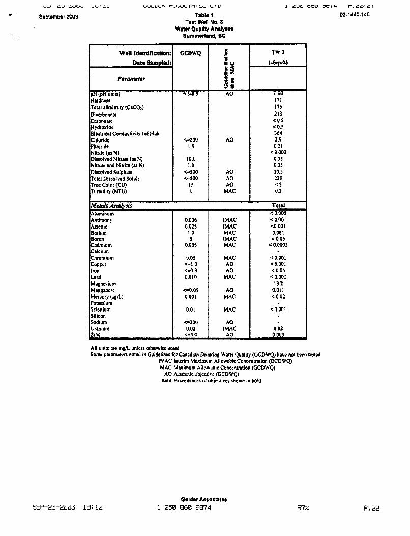
Some of the more common parameters used to describe the physical quality of drinking water include turbidity, iron, manganese, chloride, and nitrates, the results of which arc summarized below for TW3.
Turbtditv: Turbidity is both an aesthetic and health related guideline. The current maximum acceptable turbidity limit is 1 nephelometric unit (NTU). Turbidity concentrations at TW3 were reported to be 0.2 NTUs, which is well below the guideline,
detection limit of 0.05 m@L, which is well
98%: Manganese is an a manganese is 0.05 mg/L in drinking to be 0.01 rne;/L, well below the guidefinc.
ChloridK Chloride is an chloride is 250 m@L. Dissolv be 3.9 mg/L, well below the guid
mn and manganese concentrations. However,
etal and nutrient parameters, and is considered an
Water quality results for TW4 (already samplcd) and 7 W 5 (to be sampled shortly) will be provided in the final report. A summary of analytical results for TW3 is provided on the attached Table 1.
SEP-23-2003 13:08 1 250 860 9874 P. I 2
Meadow Valley Grounawatcr Development District of Summerland - 12-
September 23,2003 03- 1440-1 45
6.0 POTENTIAL IMPACTS TO STAKEHOLDERS
5.1 Communlty of Faulder
It is understood that the Community of Fauldcr is concerned that the withdrawal of groundwater fiom the Faulder Aquifer by DQS Will adversely impact water supply volumes within the Community. Based on available information, the following conclusions can be made:
proposed DOS water supply wells, and. the first point of
0 Preliminary water balance approximately 5,800,000 inVr watcr supply wclls for the the Fa ty. Total estimated
mVyr for Faulder and 2, d), which represents 67% of the available rcchar water withdrawn from
be used on an intermittent basis, as o
impacted by DOS's maximum withdrawal of approximately 2,000,000 mVyr of groundwater from the aquifer system over tho short term ( up to 2 years); however, us indicated in section 3.2 Ionger term withdrawal would be predicated on satisfactory monitoring results for the aquifer.
SEP-23-2003 18:09 1250 860 9874 P. 13
. . , . . _ I
Meadow Valley Grounawatcr Development .. District of Summerland - 13 -
September 23,2003 03-1440-145
6.2 Summorlrnd Fish Hatcheries
It is understood that the Summerland Hatchery is concerned that the proposed large withdrawal of groundwater fiom arcas upgradient of the Hatchery will adversely impact Q local spring (Slraughnessy Springs) which supplies water to the hatchery. As stated in Section 3.2, it has been previously suggested by MWLAP that the main source of recharge for the Springs is the Summerland system of aquifers, which include Prairie Creek and Eneas Creek and in our opinion, is recharged b ral shallow aquifer
lete the water supply ion, the following volumes of the Spring. Based on the resuIts of
conclusions can be made:
east and northeast. Thus, it is infe
overburden aquifers whi&
system in the area of Trout
the east of the reservoir, and that these
and storage reservoir is known le&, potentidly in (1,400,000 mVy) into the overburden aquifer
draw groundwater from the deep confined aquifcr system o the storage reservoir, it is our opinion that this will increase
water volumes to the overburden system and indirectly Shaughnessy Springs, rather than deplete the groundwater recharge to the overburden system.
Based on the above, it is our opinion th3t Shauglmessy Spring will not be adversely impacted by DOS's maximum withdrawal of a total of approximately 2,000,000 m3/yr over a period of up to 2 years of groundwater fiom the aquifer system, Longer term withdrawals would be predicted on satisfactory results of aquifer monitoring.
SEP-23-2003 18:lQ 1250 860 98'74 P. 14
Meadow Valley Gr0u.n~ der Development September 23,2003 District of Summerland - 1 4 - 03-1 440- 145 -.
5.3 Proposed Oolf Course Development
At this time, Golder cannot comment on the potential impacts to the proposed golf course development, due to limited information regarding the proposed development. Howcvcr, the potential exists that groundwater flows for the proposed development would bc restricted by the combined use of the deep confined aquifer system by the Community of Faulder and the District of Sruamerlandb
8.0 LlMlTATlONS
of the District of Summerland and is intended to provide a prelimh surrounding areas from groundwater withd~awal
maintenance of wclls may alltvi er makes no prediction
oftssional standards and
has been nlade usi
onably good understanding of the current the limited available data in particular
covered during future work, including excavations,
by the drilling contractors, the pumping test contractors and
misstatements or inaccuracies contained in this report as a result of omissions, misinterpretations or fraudulent acts of others.
A n y use which third parties make of this report, or my reliance OA or decisions to be made based on it, me the responsibility of such third parties. Goldcr Associates Limited accepts no responsibility for damages, if any, suffered by any third party as a result of decisions made or actions based on this report.
SEP-23-2003 18:16 1 250 860 9874 P. 15
--. -- ---- -- - ---- - - - - _ _ - - -. .
Meadow Valley Grounr, Dtvelopnamt September 23,2003 District of Summerland - 1 5 - 03- 1440-145 c.
7.0 CLOSURE
We trust that this letter provides you with the information you require at this time. Should you require additional information, please feel f3ec to contact the undersigned st your earliest convenience.
Yours very truly,
9 ' 1 ' I , ,
GOLDER ASSOCIATES LTD. I "a
Jacqueline Foley, M.Sc. Hydrogeologist
Remi All&, P.Eng. Senior Hydrogeologist
argent, M.Sc., P.Geo.
JDFIRPMSIat N\ACTIVPU001\IU0\03.luDI45 cow.
SEP-23-2663 1 8 : l O 1250 860 9874 P. 16
Ln
I N w I
R) m a Inl
B
r co .. I-r r
P
w m m m m u3 co il P
! i
i
J
ai
i 1
I
01 .xi
1 I
IJ
-J r
* ?
! I I I I
I I
I I
I I I I
1 I I
I
I
I
C
t r f
1 c e f 3 r c -
r - t
I CROSS-A-A' I
F
I CROSS SSmN B - tr
C EAST C LCXMNGNQ#RMIEST
WEST
7 a
ea
Q
E - !! 1,
fbl
¶i
I
I
*1
I i
September 2003
H'cll Idcoriflrrrtion: Data Sampled:
Pwameter
&I (PH units) Mardnw total alkalinity (CaCO,) B icabonafe Cubnnatc Hydroridc Eltcuial Conductivity (uS).l;rb Chloride Fluoride Nlvitc (as N) Dissolved Niuaro (as N) Nltruk ~d Nitrite (Y N) Ditsofved Sulphutr TOW Disrolvcd Solids
Turbidity @TU) rrue coiar (cui
Aluminum Antirnnn y Arsenic Barium Boron Cadmium Calciriin Chromium CfVW l T W Lead Magnesium MM~WICSC Msrcury (ugh)
Selcnium Silicon Sodium Uranium Zinc
1'ot.ctiurn
T8ble 1 tort WmII No. 3
Wmr Quallty An8lySe9 Summerland, I C
c3JQ 1.5
10.0 1.0
<-so0 4 0 0
1s I
A 0
A 0 A 0 A 0
MAC - 0.006 0.025
I .D 5
0.005
0.05 e-1.0
3 1).010
caO.05 0.001
0.01
-200 0,OL
-5.0 -
lMAC
MAC [MAC MAC
MAC A 0 A 0 MAC
A 0 MAC:
MAC
A 0 lMAC A 0
rmc
n v 3 1.Sfp-03
7.80 171 175 213 0.5
.c 0,s 364 3.9 u.21
< 0.002 0.33 0.33 10.3 220 e 5 0.2
t0m1 - c u.001 ca.001 0.081 r; 060s 0.0002
*:o.w1 4 0.001 < 0.05 e 0,001
13.2 0.01 I 9: 0.02
0,NI
0.02 0.009
All wits JIC ingl uirlctr othemioc iiotcd Some pormteb noted In Guidelines for Canadian Drinking Water Qunlity (GCDWQ) hrvc not beep ccstcd
IMAC lnicrim Mwimum Allunable Concentration {GCDWQ) MAC Muirnum Allowlrhle Conccntrvlian (GCOWQ)
BoIJ Execcdancac oJ'ohic.ctiues vhwn in bold A 0 A u h t i c objcolivc (GCDWQ)
SEP-23-2603 18: 12 Goldrr Astockter
1 250 866 9874 97% P.22
JLI CJ C W W J rCU.LI
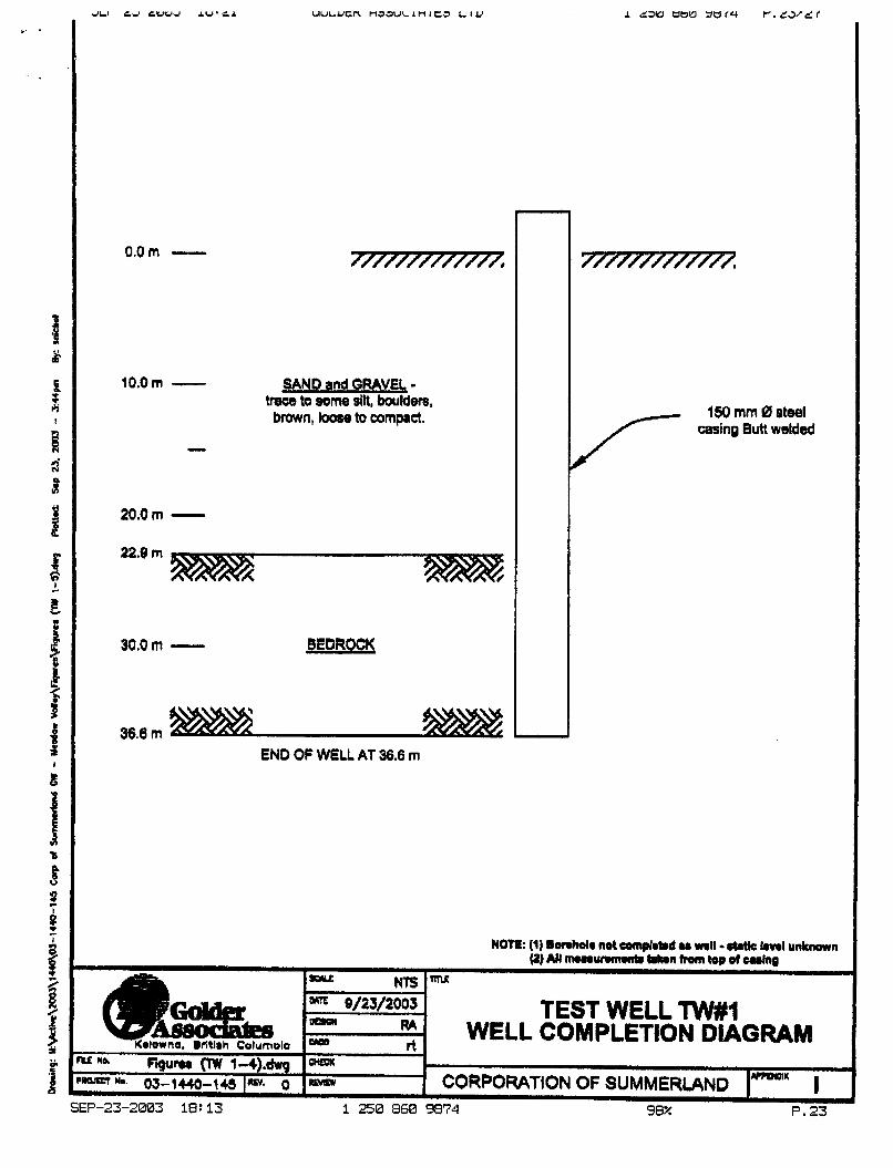
0.0m -
10.0m - SAND and QRAVEI, - tmw to some silt, bwlden, brown, loose to compact.
20.0rn - 22.8 rn
30.0m -
36.6 m
/- 150 mm 0 steel
casing Butt wetdm
END OF WELL AT 36.6 m
NOTI: (I) 9onhdr not comqlrt.d u wall -a kvrl unknarn
TEST WELL TW#l WELL COMPLETION DIAGRAM
_J
I M P W I U - CORPORATION OF SUMMERLAND I 99% P. 23 i 250 860 9874
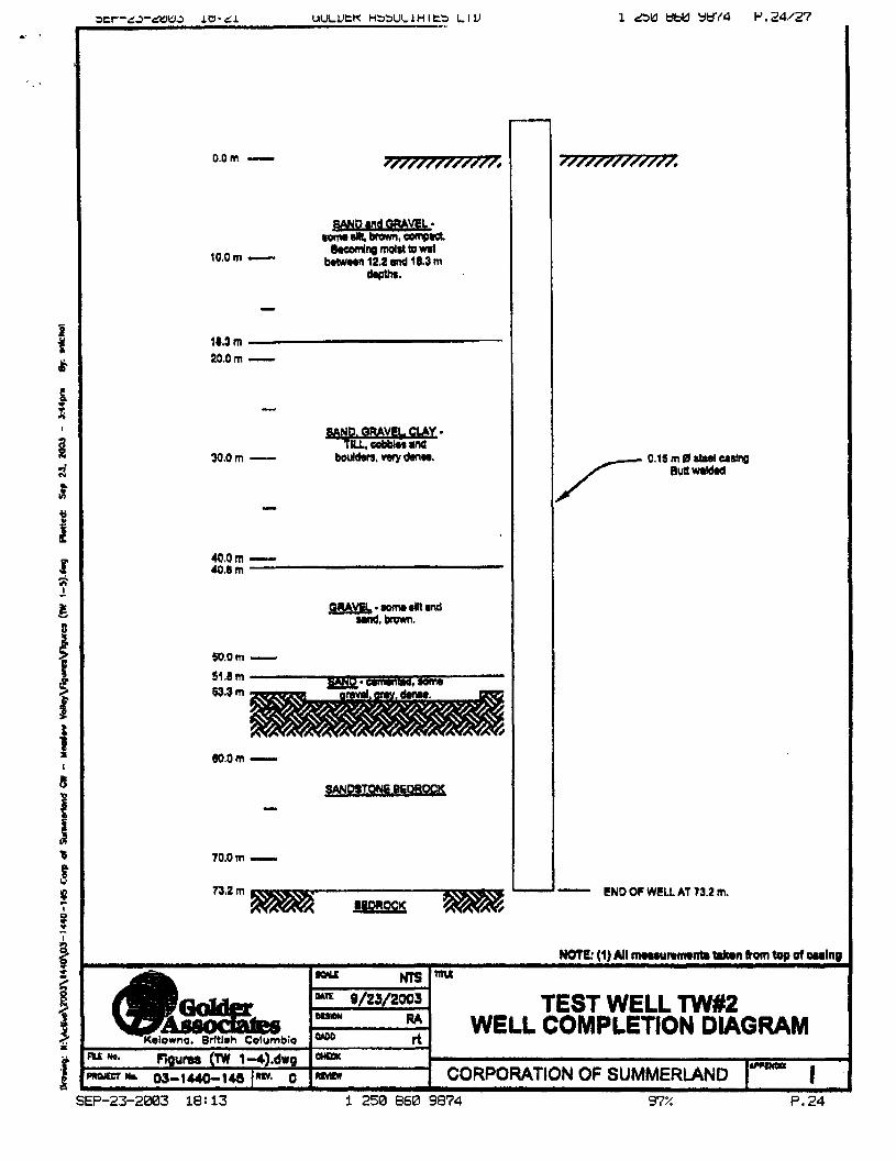
0.0 rn -
10.0m - brrwrrn 12.2 md 18.3 m apult.
18.3 m 20.0 m -
M.0m - 1o.e m
50.0m - J14m 63.3 m
604m -
70.0m - 73.2 rn
wmx
TEST WELL TW#2 WELL COMPLETION DIAGRAM
bio
i Epum (TW 1-4).dwg 1- - - c 7 h 03-1uo-145 Im 0 I- CORPORATION OF SUMMERLAND I
SEP-23-2003 18:13 1 258 860 9874 97% P. 24
I n
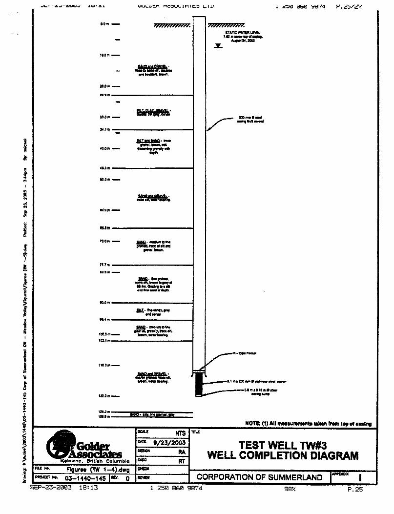
t * 2 w 0
f L
M.Om -
110.0 m -
Ir0.C m - 1s.o m 998.8 m mYQ* uly. am PAnW. w.
TEST WELL W#3 WELL COMPLETION DIAGRAM
lWqO m I U
NOTE; (1) All mruunmrnb b b n horn t q of walng
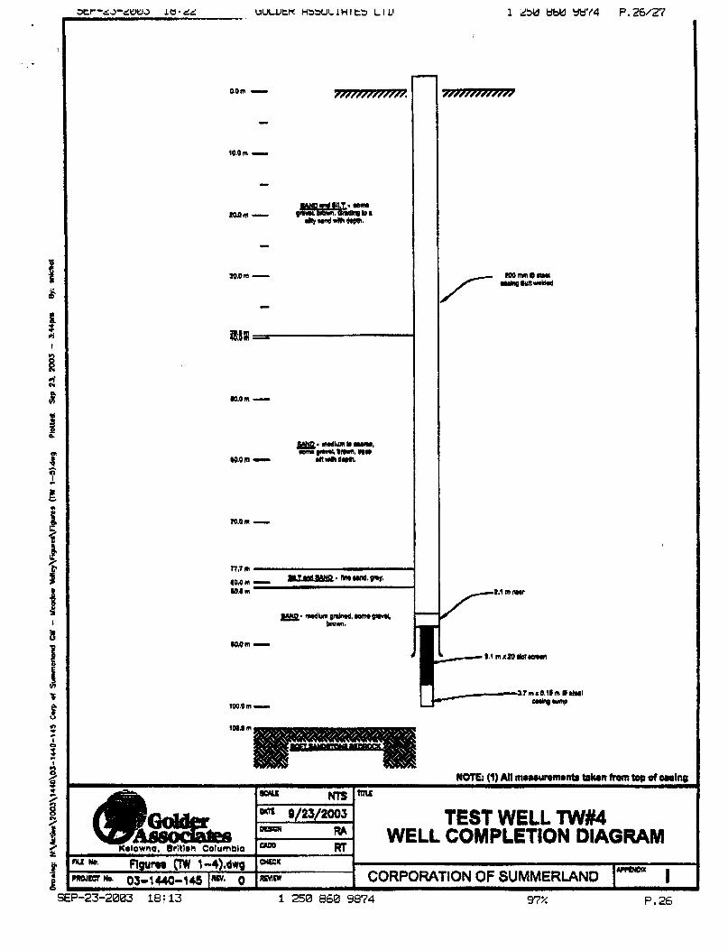
TEST WELL W##4 WELL COMPLETION DIAGRAM
97% P. 26
. .
V
f L
TEST WELL W#5 WELL COMPLETION DIAGRAM
9T4 P.27 SEP-23-2883 18:14 1258 868 9874