Embed Size (px)
Citation preview
DEPARTMENT OF THE INTERIOR UNITED STATES GEOLOGICAL SURVEY
Overview o f t he Geology and Geophysics o f the T i k i s h l a Park D r i l l Hole, USGS A-84-1, Anchorage, Alaska
by
Lynn A. yehlel, Jack K. Odunl, Henry R. schmolll, and La r r y L. ear born^
Open-Fi 1 e Report 86-293
Prepared i n cooperat ion w i t h t h e A1 aska Department o f Natura l Resources, Di v i s i o n o f Geolog ica l and Geophysical Surveys,
Th is r epo r t i s p r e l i m i n a r y and has not been reviewed f o r con fo rmi ty w i t h U.S. Geolog ica l Survey e d i t o r i a l standards and s t r a t i g r a p h i c nomenclature. Any use of t r ade names i s f o r d e s c r i p t i v e purposes on ly and does not imp ly endorsement by t he USGS.
Iu. S. Geol og i c a l Survey '~ i v i s i o n o f Geolog ica l and Geophysical Denver, Col orado Surveys, Department o f Na tu ra l
Resources, S ta te o f Alaska - 1986
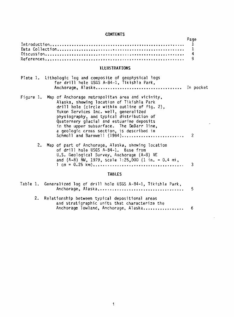
CONTENTS Page
Introduction...................................................... 1 Data Collection.......................,.,.......................... 1 Discussion.......................................................... 4 References.......................................................... 9
ILLUSTRATIONS
P l a t e 1. L i t h o l o g i c l o g and composite o f geophysical l ogs f o r d r i l l ho le USGS A-84-1, T i k i s h l a Park, ................................... Anchorage, A1 ask?. I n pocket
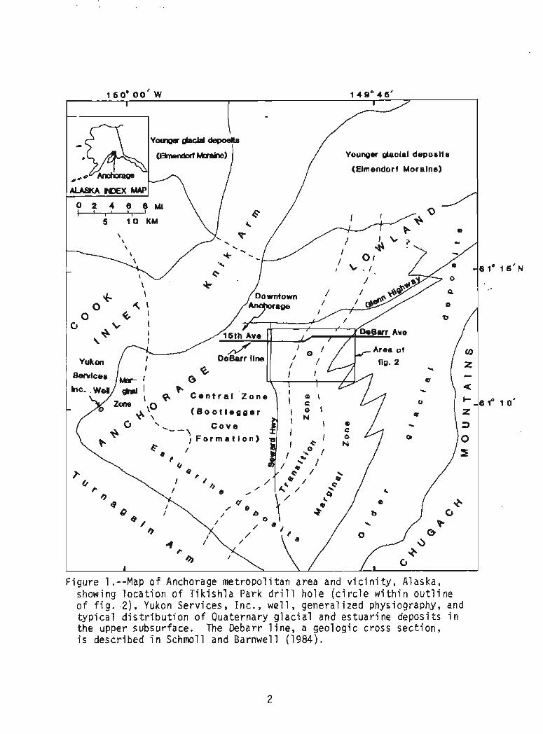
F i gu re 1. Map o f Anchorage m e t r o p o l i t a n area and v i c i n i t y , Alaska, showing l o c a t i o n o f T i k i s h l a Park d r i l l h o l e ( c i r c l e w i t h i n o u t l i n e o f f i g . 2) , Yukon Serv ices Inc. w e l l , genera l i zed physiography, and t y p i c a l d i s t r i b u t i o n o f Quaternary g l a c i a l and es tua r i ne depos i t s i n t h e upper subsurface. The DeBarr l i n e , a geo log ic cross sec t ion , i s descr ibed i n .......... .... ... Schmoll and Barnwel l (1984).,. ,. ,,., 2
2. Map of p a r t of Anchorage, Alaska, showing l o c a t i o n o f d r i l l ho le USGS A-84-1. Base from U.S. Geolog ica l Survey, Anchorage (A-8) NE and (A-8) NW, 1979, sca le 1:25,000 (1 in . = 0.4 m i , ...................................... 1 cm = 0.25 km) 3
TABLES
Table 1. Genera l ized l o g o f d r i l l ho le USGS A-84-1, T i k i s h l a Park, Anchorage, Alaska...,....,........................... 5
2. Re1 a t i o n s h i p between t y p i c a l depos i t i ona l areas and s t r a t i g r a p h i c u n i t s t h a t cha rac te r i ze t h e Anchorage lowland, Anchorage, Alaska....,....,....... 6
OVERVIEW OF THE GEOLOGY AND GEOPHYSICS OF THE TIKISHLA PARK DRILL HOLE, USGS A-84-1, ANCHORAGE, ALASKA
BY Lynn A. Yehle, Jack K. Odum, Henry R. Schmoll, and La r r y L= Dearborn
INTRODUCTION
The Anchorage metropol i t a n area occupies a lowland adjacent t o t h e upper end o f Cook I n l e t ( f i g . 1). The lowland i s unde r l a i n by a wedge of Quaternary depos i t s ( M i 1 l e r and Dobrovol ny, 1959) t h a t decrease i n th ickness f rom about 1,565 ft (477 m) o r sha l lower ( i n t e r p r e t e d from Alaska Geolog ica l Soc ie ty , 1969, 1970) a t i t s western edge t o e s s e n t i a l l y zero where Mesozoic metamorphic rocks crop ou t i n t h e Chugach Mountains along t h e eastern edge o f t h e lowland (C la rk , 1972; G. R. Wink ler , w r i t t e n commun., 1986). Beneath t h e Quaternary depos i t s i s a wedge of T e r t i a r y sedimentary rocks t h a t a l s o t h i n s toward t h e eas t (Barnwel l and others , 1973; P l a f k e r and others , 1982). These T e r t i a r y rocks, as f a r as i s p r e s e n t l y known, a re concealed i n - t h e m e t r o p o l i t a n area but crop ou t l o c a l l y , i n t h e Eagle R i v e r area about 12 m i (19 km) nor theas t o f - downtown Anchorage (Mi 11er and Dobrovolny, 1959; Wol f e and o thers , 1966; Zenone and others , 1974; Magoon and others , 1976).
I n o rde r t o i n v e n t o r y and c h a r a c t e r i z e f o r reg iona l eng ineer ing geo log ic purposes some o f t h e deep subsurface hor izons o f Quaternary and o l d e r age u n d e r l y i n g Anchorage, a 760- f t -deep (232-m) ho le was d r i 11 ed d u r i ng August 1984. It i s l o c a t e d on an area o f t h i n a r t i f i c i a l f i l l about 345 ft (105 m) south o f t h e al inement o f East 20th Avenue i n T i k i s h l a Park i n NE1/4NE1/4SW1/4 sec. 21, T. 13 N., R. 3 W. o f t h e Seward Mer id ian a t l a t 61.20Z0 N., l ong 149.822~ W. ( f i g . 2). The a l t i t u d e of t h e s i t e i s about 115 f t (35.0 m), and t h e Midd le Fork Chester Creek f lows past i t about 205 f t (62.5 m) t o t h e southeast a t an a l t i t u d e o f about 100 f t (30.5 m).
D r i 11 i n g equipment cons i s ted o f a wate r -c i r c u l a t i n g Mayhew 2000 r o t a r y - d r i 11 u n i t operated by personnel o f Exp lo ra t i on and Supply Company, Anchorage, Alaska. The h o l e was s t e e l cased t o a depth o f 140 ft (42.7 m) , and of nominal 0.50 ft (0.15 cm) diameter, va ry i ng l o c a l l y , accord ing t o t h e c a l i p e r logging, f rom 0.44 t o 0.64 ft (0.13 t o 0.19 m) i n ac tua l dimension ( p l . 1) .
We acknowledge t h e ass is tance o f numerous i n d i v i d u a l s i n t he Anchorage o f f i c e of t h e U.S. Geolog ica l Survey, who helped us l o c a t e w e l l data, which s u b s t a n t i a l l y a ided us i n s e l e c t i n g t h e s i t e f o r our d r i l l hole. We are g ra te fu l , a lso, t o personnel o f t h e Department o f Parks and Recreat ion, M u n i c i p a l i t y of Anchorage, who granted permiss ion t o d r i l l on land under t h e i r j u r i s d i c t i o n and f a c i l i t a t e d access t o t h e s i t e .
MTA COLLECTION
Most samples were c o l l e c t e d d i r e c t l y from t h e c i r c u l a t i ng, fi ne-grained s l u r r y as i t issued f rom t h e d r i l l p i p e and be fo re t h e s l u r r y en te red t h e h o l d i n g tank. Cor ing was at tempted a t var ious depths and was successfu l i n bedrock because o f i t s compact, r e l a t i v e l y hard, and un i form nature. Cor ing was mos t l y unsuccessfu l where nonl i t h i f i e d mix tu res o r t h i n i n t e r l a y e r i ngs of s o f t and hard m a t e r i a l s seemed t o e x i s t . Useful core was recovered from t h e f o l l o w i n g s i x i n t e r v a l s which a l s o are noted on p l a t e 1. Nominal diameter o f t h e core was 0.21 ft (0.064 m ) .

7
I d " C O O
1 0
< O , (nm a CU rn - - =I?
Q l w F F
0 m c U
V) 7
I- n .y m L h urn
7 L
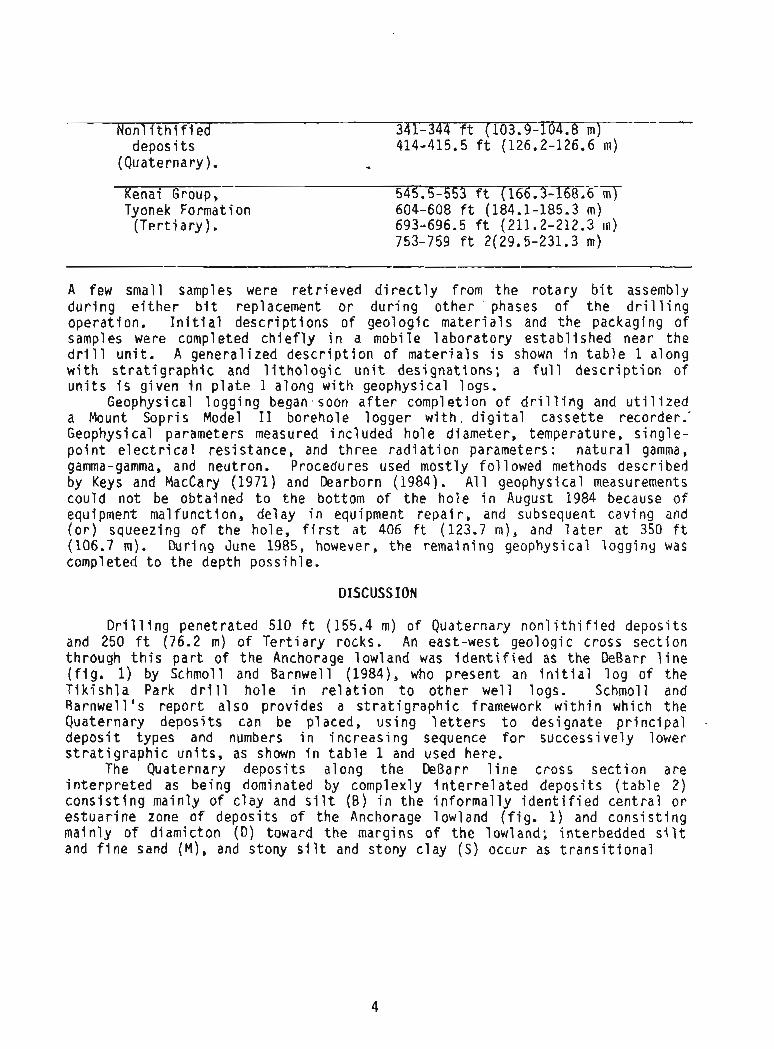
N o n l i t h i f i e d 3 4 1 - 3 4 4 ft ( 1 0 3 . 9 - T 0 4 . 8 m T - depos i t s 414-415.5 ft (126.2-126.6 m)
(Quaternary). - Kenai Group, 545.5-553 ft (166.3-16- Tyonek Format ion 604-608 ft (184.1-185.3 m)
( T e r t i a r y ) . 693-696.5 ft (211.2-212.3 m) 753-759 f t 2(29.5-231.3 m)
A few smal l samples were r e t r i e v e d d i r e c t l y f rom t h e r o t a r y b i t assembly d u r i n g e i t h e r b i t replacement o r d u r i n g o t h e r ' phases o f t h e d r i l l i n g operat ion. I n i t i a l d e s c r i p t i o n s o f geo log ic m a t e r i a l s and t h e packaging o f samples were completed c h i e f l y i n a mob i le l a b o r a t o r y es tab l i shed near t h e d r i l l u n i t . A genera l i zed d e s c r i p t i o n o f m a t e r i a l s i s shown i n t a b l e 1 along w i t h s t r a t i g r a p h i c and l i t h o l o g i c u n i t des igna t ions ; a f u l l d e s c r i p t i o n o f u n i t s i s g iven i n p l a t e 1 a long w i t h geophysical logs,
Geophysical l o g g i n g began soon a f t e r complet ion o f d r i 11 i n g and u t i 1 i z e d a Mount Sopr is Model I 1 borehole l ogge r w i t h d i g i t a l casse t t e recorder.' Geophysical parameters measured i nc l uded h o l e diameter, temperature, s i n g l e - p o i n t e l e c t r i c a l res is tance , and t h r e e r a d i a t i o n parameters : n a t u r a l gamma, gamma-gamma, and neutron. Procedures used mos t l y f o l 1 owed methods descr ibed by Keys and MacCary (1971) and Dearborn (1984). A1 1 geophysical measurements cou ld no t be ob ta ined t o t h e bottom of t he h o l e i n August 1984 because o f equipment malfunct ion, de lay i n equipment r e p a i r , and subsequent caving and ( o r ) squeezing o f t h e ho le , f i r s t a t 406 ft (123.7 m), and l a t e r a t 350 f t (106.7 m). Dur ing June 1985, however, t h e remain ing geophysical l ogg ing was completed t o t h e depth poss i hle.
DISCUSS ION
D r i l l i n g pene t ra ted 510 ft (155.4 m) o f Quaternary nonl i t h i f i e d depos i ts and 250 ft (76.2 m) o f T e r t i a r y rocks. An east-west geolog ic cross sec t i on through t h i s p a r t o f t h e Anchorage low land was i d e n t i f i e d as t h e DeBarr l i n e ( f i g . 1) by Schmoll and Barnwel l (1984), who present an i n i t i a l l o g o f t he T i k i s h l a Park d r i l l ho le i n r e l a t i o n t o o t h e r w e l l logs. Schmoll and Rarnwel l ' s r epo r t a l s o prov ides a s t r a t i g r a p h i c framework w i t h i n which t h e Quaternary depos i ts can be placed, us i ng 1 e t t e r s t o des ignate p r i n c i p a l depos i t types and numbers i n i nc reas ing sequence f o r success ive ly lower s t r a t i g r a p h i c u n i t s , as shown i n t a b l e 1 and used here.
The Quaternary depos i ts a long t h e DeBarr l i n e cross s e c t i o n are i n t e r p r e t e d as be ing dominated by complexly i n t e r r e l a t e d depos i ts ( t a b l e 2) c o n s i s t i n g ma in ly o f c l a y and s i l t (B ) i n t h e i n f o r m a l l y i d e n t i f i e d c e n t r a l o r e s t u a r i n e zone of depos i ts of t h e Anchorage lowland ( f i g . 1) and c o n s i s t i n g ma in ly o f d iamic ton (D) toward t h e margins o f t h e lowland; in terbedded s i l t and f i n e sand (M) , and stony s i l t and stony c l a y (S) occur as t r a n s i t i o n a l

TABLE 1. --General - i zed 1 og o f d r i 11 - hol e USGS A-84-1, - T i k i s h l a Park, Anchorage, Alaska
[ L e t t e r e d s t r a t i g r a p h i c u n i t s mod i f i ed f rom Schmoll and Barnwel l (1984), numbered l i t h o l o g i c u n i t s descr ibed i n d i v i d u a l l y on p l . 13
S t r a t i - L i t h o - Depth t o g raph ic l o g i c D e s c r i p t i o n ' Thickness base of u n i t u n i t u n i t - 7ft) - ( f t ) (m)
Nan1 i t h i f i e d depos i t s (Quate rnary )
A r t i f ! c ia1 fill ....................... 13 Peat o v e r l y i n g f i n e pebble gravel and
coarse sand------------------------- 10 Diamicton----------------------------- 13 S i l t y f i n e sand and f i n e sandy s i l t - - - 42 Diamicton------------------------------ 36 Sand and gravel------------------------ 9 Stony s i l t and stony c lay , and
diamicton--------------------------- 48 Gravel and sand-----------------+----- 18 S i l t y g rave l and p o s s i b l y d iamicton-- - 10 Gravel-------------------------------- 10 Diamicton---- - - - - - - - - - - - - - - - - - - - - - - - - - 16 Gravel-------------------------------- 12 Diamicton----------------------------- 15 Sandy gravel-------------------------- 8 Stony s i l t and s tony c l a y ;
d iamicton(?)- - - - - - - - - - - - - - - - - - - - - - - - 27 Sand and g rave l ....................... 12 S i l t y f i n e sand and f i n e sandy s i l t ;
p o s s i b l y some d iamicton-+-- - - - - - - - - - 16 -Djamictan----+------------.+------------ 22 S i l t y f i n e sand and f i n e sandy s i l t ,
l o c a l l y s tony(?)- - - - - - - - - - - - - - - - - - - - 20 Diamjcton----------------------------- 29 S i l t y f i n e sand and f i n e sandy s i l t - - - 18 In terbedded(?) g rave l , sand, and
some si l t - - ------------------------- 15 S i l t y f i n e sand and f i n e sandy s i l t ,
l o c a l l y stony(?)-------------------- 2 1 Gravel and sand; some i n te rbeds o f
diamicton(?)------------------------ 19 In terbedded g rave l , sand, and s i 1 t---- 5 1
Kenai Group, Tyonek Format ion(?) ( T e r t i a r y ) -- s i 87-91 S i 1 t s tone , sandstone, and mi nor
claystone--------------------------- 34 (544) 11 (166) s c 92-100 S i l t s t o n e , c laystone, and some sand-
stone; mi nor carbonaceous zones and a t h i n coal bed--------------------- 62 (606) 19 (185)
cs 101-106 S i 1 t s t o n e and c l aystone, v a r i a b l y carbonaceous; severa l t h i n coa l beds 87 (693) 26 (211)
sc 107 S i l t s t o n e and claystone--------------- 37 (730) 12 (223) cs 108 Carbonaceous s i 1 t s t o n e w i t h numerous
t h i n coal beds---------------------- 20 (750) 6 (229 ) s s 109 F ine sandstone w i t h minor c laystone-- - 10 (760) 3 (232)
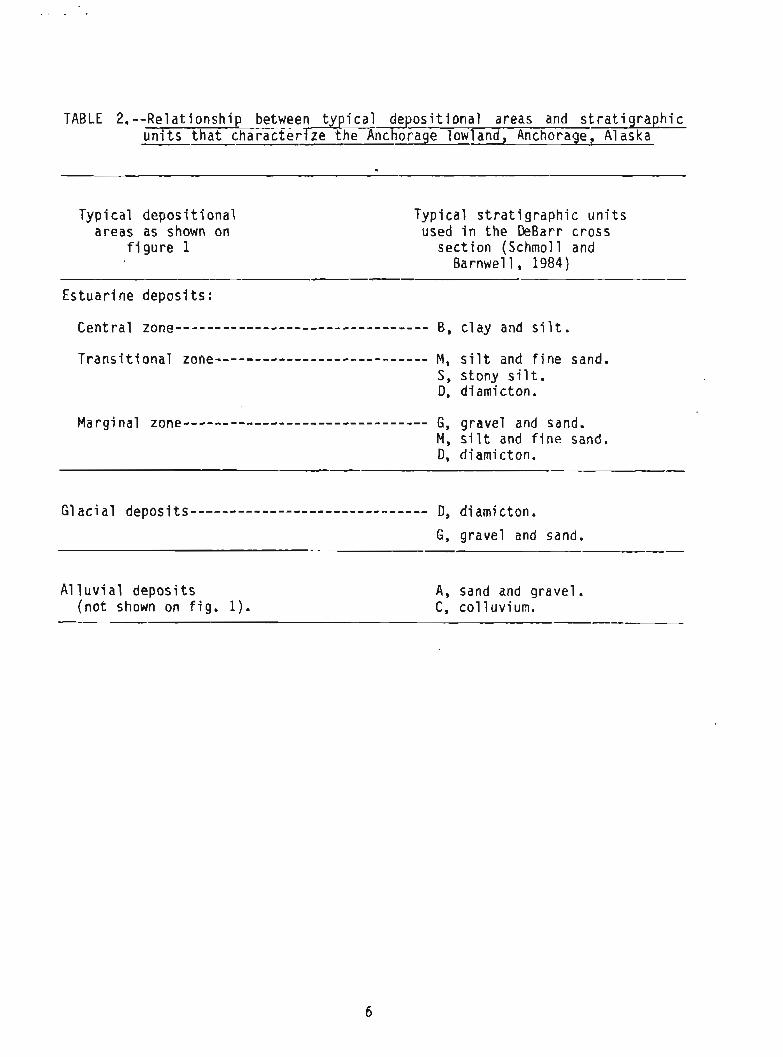
TABLE 2. --Re1 a t i o n s h i p between t y p i c a l d e p o s i t i o n a l areas and s t r a t i g raph i c u n i t s t h a t cha rac te r i ze t h e -~nchorage lowland, Anchorage, Alaska
Typ i ca l d e p o s i t i o n a l areas as shown on
f i g u r e 1
Typ ica l s t r a t i g r a p h i c u n i t s used i n t h e DeBarr cross
sec t i o n (Schmol 1 and Barnwel l , 1984)
Es tua r i ne depos i ts :
Cen t ra l zone-------------------------------- B, c l a y and s i l t .
T r a n s i t i o n a l zone--------------------------- M, s i l t and f i n e sand. S, stony s i l t . D, d i arni cton.
Marg ina l zone------------------------------- G, gravel and sand. M, s i l t and f i n e sand, D, d iamicton.
G l a c i a l deposits------------------------------ 0, d i ami c t on.
G, gravel and sand. P - -------
A1 1 u v i a1 depos i t s A, sand and gravel , ( no t shown on f i g . 1). C, c o l l u v i u n . - -------

zone depos i t i ona l u n i t s . I n a general way, t he c l a y - s i 1 t - d i am ic ton complexes are i n t e r p r e t e d as hav ing formed i n mixed e s t u a r i n e and g l a c i a l environments, w i t h t h e boundaries po r t r ayed on f i g u r e 1 s h i f t i n g w i t h t ime, so t h a t i n any g iven s t r a t i g r a p h i c column, such -as t h e T i k i s h l a Park d r i l l ho le , r ep resen ta t i on o f any o f t h e zones are l i k e l y t o be present. Beds o f gravel and sand ( A ) occur s t r a t i graph ica l 1y between c l ay -s i 1 t - d i ami c ton complexes, and a re cons idered marker beds on t h e DeBarr cross sect ion, u n i t 1 occu r r i ng a t t h e sur face, and u n i t s 2 through 7 o c c u r r i n g success ive ly lower s t r a t i g r a p h i c a l l y . The gravel and sand beds a re thought t o represent main ly a l l u v i a l cond i t i ons , such as those o f t h e present, no t po r t r ayed on f i g u r e 1.
Table 1 presents a re f i ned bu t s t i l l genera l i zed ve rs i on o f t h e geo log ic log , grouping t h e more de ta i l ed , numbered l i t h o l o g i c u n i t s shown i n p l a t e 1. I t a l s o shows t h e l e t t e r e d s t r a t i g r a p h i c u n i t des igna t ions used on t h e DeBarr cross s e c t i o n as a p p l i e d t o m a t e r i a l f rom the T i k i s h l a Park d r i l l hole. A l l o f t h e A u n i t s t h a t were i d e n t i f i e d f rom o the r ho les along t h e DeBarr l i n e are present i n t h e T i k i s h l a Park l o g a t approx imate ly t h e i r expected p o s i t i o n s , and an a d d i t i o n a l lower u n i t , A-7, i s i d e n t i f i e d o n l y from t h i s d r i l l hole.
As t h e T i k i s h l a Park s i t e occupies a t r a n s i t i o n a l p o s i t i o n between t h e c e n t r a l and marg ina l d e p o s i t i o n zones o f t h e Anchorage lowland, i t was expected t h a t bo th s t r a t i g r a p h i c u n i t types B and D would be w e l l represented, - as w e l l as a r e l a t i v e l y l a r g e p r o p o r t i o n o f t h e t r a n s i t i o n a l M and S u n i t s . However, no t h i c k B u n i t s were found i n t he d r i l l hole. Thus, no c l a y and s i l t u n i t s t y p i c a l o f t h e P le is tocene age Boot legger Cove Format ion ( u n i t 6-1 on t h e DeBarr cross s e c t i o n ) were found except f o r l i t h o l o g i c u n i t 8, on ly 4 ft (1.2 m) t h i c k . Instead, t h a t f o rma t i on i s apparen t l y represented by a f a c i e s c o n s i s t i n g o f s i l t and f i n e sand, an M u n i t , and perhaps by some p o s s i b l y d i s c o n t i nuous diami c ton (D) u n i t s . Most o f t h e i n t e r v a l s between t h e A u n i t s c o n s i s t o f D and M u n i t s , w i t h t he excep t ion of one zone, c o n s i s t i n g o f l i t h o l o g i c u n i t s 41-43, which was genera l i zed as an S u n i t . From a d e p o s i t i o n a l s tandpo in t , i t thus appears t h a t throughout t h e Quaternary Period, g l a c i e r and estuary-margi n cond i t i ons p r e v a i l e d a t t h i s s i t e , punctuated by t imes o f subaer ia l cond i t i ons such as t h e present .
Below s t r a t i g r a p h i c u n i t A - 7 , t h e r e l a t i v e l y t h i c k sequence o f beds compr is ing l i t h o l o g i c u n i t s 77-86 has been grouped as an I u n i t . Th is sequence l a c k s d iamicton, which i s common h ighe r i n t h e s t r a t i g r a p h y o f t h e ho le ; consequent ly, t h e sequence may represent a dominant ly a1 1 u v i a1 env i ronment o f d e p o s i t i o n as opposed t o a g l a c i a1 env i ronment o f depos i t ion . Because t h e I - u n i t beds occur on l y beneath g l a c i a l u n i t s , t h e I beds may represen t p reg l a c i a1 env i ronments.
A major l i t h o l o g i c change i s present below u n i t 86 and t h e geolog ic m a t e r i a l s e x h i b i t e d unmistakable d r i 11 i n g c h a r a c t e r i s t i c s o f f i r m , r e l a t i v e l y hard ma te r i a1 s which a re c o r r e l a t e d w i t h bedrock. Based upon good exami na t i on of cores, bedding throughout t h i s i n t e r v a l of bedrock i s e i t h e r f l a t l y i n g o r a t a ve ry low ang le t o t h e h o r i z o n t a l .
A1 1 o f t h e geophysical l ogs had no t been run by t he t i m e t h e DeBarr cross s e c t i o n was developed. When run and ava i l ab le , a f t e r June 1985, t he logs were used t o r e f i n e t h e i n i t i a l geo log ic i n t e r p r e t a t i o n s presented i n t h e cross sec t ion . I n p a r t i c u l a r , t h e res i s tance and n a t u r a l gamma l ogs were u t i l i z e d f o r many d i f f e r e n t depths t o p rov ide both general and s p e c i f i c ref inement of va r ious s t r a t i g r a p h i c u n i t s , especi a1 l y f o r i n t e r v a l s where carbonaceous m a t e r i a l was ind ica ted . Several coal beds as much as 3 f t (0.9 m) i n t h i ckness were i n t e r p r e t e d f rom t h e geophysi ca l 1 ogs.
The temperature l o g shows c h i e f l y a gradual downhole reduc t i on o f temperature t o a minimum o f about 40.5 OF (4.7 OC) a t 235 f t (71.6 m) and t hen a gradual inc rease i n temperature t o about 43.7 OF (6.5 OC) near t h e bottom o f t h e h o l e a t 754 ft (229.8 m). The temperature g rad ien t below 480 ft (146.5 m) i s almost i d e n t i c a l a t s i m i l a r depth i n t e r v a l s t o t h e g rad ien t o f t h e Yukon Services, Inc., w e l l (Campbell Po in t U n i t No. 1 ) s i t e d 8.0 m i 612.8 km) t o t h e southwest ( f i g . 1) where a va lue o f 0.00932 f t / OF (0.0158 m/ C ) was obta ined (Keys and MacCary, 1971 Two re1 a t i v e l y near-surface increases i n temperature o f about 0.3 bi (0.5 OC) occur, one near 76 f t (23.2 m) and another near 120 ft (36.6 m). Both o f these increases may r e l a t e t o t h e presence o f re1 a t i v e l y coarser and probably more permeable rnater i a1 s t h a t probably c o n t r i b u t e minor i n f l o w s o f water. A p o s s i b l e water i n f l o w noted by t h e d r i l l e r a t about 510 f t (155.4 m) was no t r e f l e c t e d i n t h e temperature p r o f i l e , p o s s i b l y because no d i f f e r e n c e i n temperature e x i s t e d between ground- water and t h e d r i l l - h o l e f l u i d .
The age o f t he n o n l i t h i f i e d m a t e r i a l s above u n i t 77 i s undoubtedly Quaternary. However, t h e I i n t e r v a l c o n s i s t i n g o f l i t h o l o g i c u n i t s 77 through 86 a re somewhat en igmat ic and cou ld be e i t h e r r e l a t i v e l y o l d Quaternary o r young T e r t i a r y i n age, For deeper u n i t s , those below l i t h o l o g i c u n i t 86, we do no t have as y e t any new age de te rmina t ions . Therefore, t h e assumption i s - con t inued t h a t these rocks, as i n t e r p r e t e d on t h e DeBarr cross s e c t i o n (Schmoll and Barnwel l , 1984), a re p a r t o f t he Kenai Group (Wol f e and Tanai , 1980) and probably l i e w i t h i n t h e Tyonek Formation, as a r e s i m i l a r rocks exposed i n t h e Eagle R i v e r area (Wolfe and others , 1966). There i s a p o s s i b i l i t y , however, t h a t these rocks may belong t o t h e next younger format ion, t h e Beluga Format ion o r t h e even younger S t e r l i n g Formation.
REFERENCES
A1 aska Geolog ica l Soc ie ty , 1969, South t o n o r t h s t r a t i graph ic c o r r e l a t i o n sec t ion , Anchor Po in t t o Campbell - Point , Cook I n l e t Basin, [Alaska Cook I n l e t Bas in s t r a t i g r a p h i c study]: S t r a t i g r a p h i c Committee, Year 1968-69, Chairman, R. E. Church, 5 p l .
1970, South t o n o r t h s t r a t i g r a p h i c c o r r e l a t i o n sec t i on , Campbell Po in t t o Rosetta, and west t o eas t s t r a t i graphic c o r r e l a t i o n sec t ion , Beluga R i v e r t o Was i l l a , Cook I n l e t basin, [Alaska Lower Sus i tna-Knik A r m s t r a t i g raph ic sec t ions ] : S t r a t i graphic Committee, Year, 1969-70, Chai rman, R. E. Church, 2 p l .
Barnwel l , W. W., Beaty, Wi l l i am, k a r b o r n , L. L., Dobrovolny, Ernest, George, R. S., Schmoll, H. R., Selkregg, L. L., and Zenone, Chester, eds., 1973, Road l o g and guide--Geology and hydro logy f o r p lanning, Anchorage area: Anchorage, A1 aska Geolog ica l Soc ie ty , 34 p.
Clark , S. H. B., 1972, Reconnaissance bedrock geo log ic map of the Chugach. Montains near Anchorage, A1 aska: U.S. Geolog ica l Survey Misce l laneous F i e l d Stud ies Map MF-350, sca le 1:250,000.
Dearborn, L. L., 1984, C o r r e l a t i o n of geophysical w e l l l o g s f o r a water development i n south Anchorage, Alaska, i n Shor t notes on Alaskan geoloyy, 1982-83: Alaska D i v i s i o n o f ~ e o l z i c a l and Geophysical Surveys Pro fess iona l Report 86, p. 19-27.
Keys, W. S., and MacCary, L. M,, 1971, A p p l i c a t i o n o f borehole geophysics t o water- resource i n v e s t i g a t i o n s , Chapter E l i n C o l l e c t i o n of environmental data, Book 2: U.S. Geolog ica l Survey Techn iques o f Water-Resources I n v e s t i g a t i o n s Report TWI 2-El, 126 p.
Magoon, L. B., Adkison, W. L., and Egbert, R. M., 1976, Map showing geology, w i l d c a t we l l s , T e r t i a r y p l a n t f o s s i l l o c a l i t i e s , K - A r age dates, and pe t ro leum opera t ions , Cook I n l e t area, A1 aska: U.S. Geolog ica l Survey M i s c e l l aneous Geologic I n v e s t i g a t i o n s Map 1-1019, sca le 1: 250,000.
M i l l e r , R. D., and Dobrovolny, Ernest, 1959, S u r f i c i a l geology o f Anchorage and v i c i n i t y , Alaska: U.S. Geolog ica l Survey B u l l e t i n 1093, 128 p.
P la f ke r , George, Bruns, T. R., Winkler, G. R., and Tysdal, R, G., 1982, Cross s e c t i o n o f t h e eas te rn A l e u t i a n arc, from Mount Spurr t o t h e A l e u t i a n t r e n c h near M idd le ton Is land , A1 aska: Geolog ica l Soc ie ty o f America, Map and Chart Ser ies MC-28P, sca le 1:1,000,000.
Schmoll, H. R., and Barnwel l , W. W. , 1984, East-west geo log ic cross s e c t i o n a long t h e DeBarr l i n e , Anchorage, A1 aska: U.S. Geolog ica l Survey Open-Fi l e Report 84-791, 10 p.
Wolfe, 3. A., Hopkins, D. M., and Leopold, E. B., 1966, T e r t i a r y s t r a t i g r a p h y and paleobotany o f t h e Cook I n l e t region, Alaska: U. S. Geolog ica l Survey P ro fess iona l Paper 398-A, 29 p.
Wolfe, J. A., and Tanai , Toshima, 1980, The Miocene Seldovia Point f l o r a from t h e Kenai Group, A laska: U.S. Geological Survey Professional Paper 1105, 52 p.
Zenone, Chester, Schno l l , H. R . , and 'Oobrovolny, Ernest, 1974, Geology and ground water f o r land-use p lann ing i n t h e Eag le River-Chugiak area, Alaska: U.S. Geological Survey Open-File Report 74-57, 25 p.