Embed Size (px)
Citation preview

February 2018
Ōtaki to north of Levin Project
HAERE MAI, WELCOME
1
We are consulting on options to develop a new State Highway 1 between Ōtaki and north of Levin to make getting around safer, and more reliable for you and other road users.
We want to hear your views on these proposed options.
We invite you to consider the series of displays that present the options and the process and investigations that we have undertaken to develop and shortlist the options.
Our team is here to answer any questions you may have and to listen to your feedback about the options.
Please help yourself to our handouts and feedback form.

February 2018
Ōtaki to north of Levin Project
We are asking people for their feedback on a shortlist of corridor options for the Ōtaki to north of Levin (O2NL) project.
After our community engagement in June 2017, a long list of options was developed and assessed. This process is described on the following boards.
WHAT ARE WE CONSULTING ON?
TO FOXTON
Any northern option can connect to any southern option. Thus the alignment of connections between northern and southern options as shown here is indicative only.
Lake Horowhenua
Lake Papaitonga
Forest Lakes
Ōtaki River
Manawatū River
Ōhau River
Waikawa River
Peka Peka to Ōtaki section of the Wellington Northern Corridor
Waitarere Beach
Poroutawhao
Koputaroa
End of Wellington Northern Corridor
LEVINTown Centre Queen St East
Queen St West
MANAKAU
ŌHAU
ŌTAKI
KUKU
Kimberley Rd
Wak
efiel
d Rd
S6
S7
N5
N4
S7A
N9
Existing State Highway
Local roads
Railway
Peka Peka to Ōtaki Expressway
LEGEND
NOTE: Diagram is indicative only and not to scale
Route options
2 lane section
Stage 2 Option development to occur once wider strategic studies are completed
4 lane sections
Ōtaki to north of Levin – shortlisted options
Shortlisted options
WHY NOT IMPROVE THE EXISTING ROAD?The current and forecast high levels of traffic on SH1 and SH57 means we need to consider providing a high-standard four-lane state highway with central median and edge barriers and grade separated interchanges.
It is difficult to upgrade or convert the existing state highway into a high-standard four-lane road state highway due to the following factors:
• To meet design standards, replace existing bridges and avoid historical buildings, marae and urupa, only 30% of the current road would be able to be used.
• As the new road would need to have a central median barrier and access points onto the new road would be limited, parallel roads would need to be constructed to provide access to existing properties and business. These are likely to be needed on each side of the new road resulting in eight lanes of roads in some locations. This would cause significant community effects particularly through Manakau, Ōhau and Levin.
2
The shortlisted options we are consulting on are shown in the diagram on the left.
The O2NL project will improve the safety and resilience problems associated with sections of State Highway 1 (SH1) and State Highway 57 (SH57). The project proposes a higher quality route that will enhance road safety and allow reliable journeys and connections between the main freight hubs of Wellington (and the South Island) with areas to the north and east, such as Palmerston North and Hawke’s Bay.

February 2018
Ōtaki to north of Levin Project 3
WHAT YOU TOLD US
ENGAGEMENT HIGHLIGHTS 2017 In June 2017, we sought the various perspectives of people who live, work and travel in the area. This has helped us understand community values and interests, including cultural, environmental, business and social issues, to help us achieve the best outcome for the region and for road users who travel through the region. This information together with our technical information was used to develop 23 possible corridor options.
YOU SAID“A west side bypass of Levin would provide a shorter route, but ground conditions will be technically challenging, although not in-surmountable. Historical and cultural issues will be significant to Tangata Whenua.”
WE WILL: Give further consideration to possible route options to the west of Levin.
“Integrated cycleway/native plantings off-highway would be a huge benefit to residents and local biodiversity which would be a positive offset to the construction.”
WE WILL: Take this into account for all the options that are considered.
“As our corridor to the east of Levin and Manakau is so developed, being able to fit an expressway down this narrow strip is a huge issue. It’s where all the top quality soils and greenbelt residential developments are.”
WE WILL: Consider how to mitigate options to maintain people's lifestyle and productive land.
FEEDBACK SUMMARYRoute suggestionsSome people talked about routes to the east of Levin, others would rather see a route to the west of Levin. It is important to find a route that minimises the impact on residential and agricultural land. Some suggested that the project should also improve SH1 to Foxton or beyond.
BypassThere was strong support for the need to bypass Levin and other townships/villages. Some concern was expressed about removing passing traffic and potential trade from Levin, but the majority recognised the need to reduce congestion and move heavy vehicles out of the Levin town centre.
SafetyThere were positive comments about the recent safety improvements, and more comments highlighting remaining safety concerns on the network, like dangerous intersections, the narrow bridges and lack of safe passing opportunities.
ValuesThere are a number of features unique to the Horowhenua District: highly productive soils; village character; marae; rural lifestyle; spiritual connection between Lake Horowhenua and the Tararua Ranges; heritage buildings.
The diagram above shows the areas of interest and/or importance identified by the community through the June 2017 engagement. You can see this map on our website www.nzta.govt.nz/O2NL
people attended open days,drop in sessions and communitymeetings in June and July 2017
1,676feedback formscompleted
217pins and stickerson the maps
553 newsletterlanguages– English– Te Reo
2newsletters sent to households, businesses and land-owners at the start of the engagement period
1300

February 2018
Ōtaki to north of Levin Project
SH1 between Ōtaki and Levin provides a strategic and economic link to Wellington, the port, airport and central New Zealand. SH1 has a key role in enabling the flow of people, goods and services throughout New Zealand.
BACKGROUND
TRAFFIC VOLUMESTraffic volumes on SH1 between Ōtaki and Levin are shown in the diagram below. The figures shown are the average daily traffic numbers (both directions) in 2016.
TO FOXTON
8,273
19,688
10,269
17,916
13,611
13,123
9,035
4,796
16,465
16,064
Lake Horowhenua
Lake Papaitonga
Forest Lakes
Ōtaki River
Manawatu River
Ōhau River
Waikawa River
Waitārere BeachPoroutawhao
Koputaroa
LEVINTown Centre
Queen St
MANAKAU
ŌHAU
ŌTAKI
KUKU
Existing State Highway
Local roads
Railway
State Highway Traffic Volumes – 2016
Low
Medium
High
LEGEND
NOTE: Diagram is indicative only and not to scale
RESILIENCEThere is no local alternative route between Manakau and Ōhau, which means when SH1 is closed due to flooding or crashes, drivers either need to wait or travel via State Highway 2. This adds another two hours to the journey between Waikanae and Palmerston North and can cause significant congestion.
SAFETYSH1 between Ōtaki and north of Levin has experienced a high number of accidents resulting in deaths and serious injuries. SH57 from its intersection with SH1 through to Heatherlea East Road also has a poor safety record. 50 deaths and serious injuries have occurred on these highways over the past five years. The diagram below shows the number and location of accidents resulting in deaths and serious injuries over the period 2011–2016.
TO FOXTON
1
2
3
4
4
4
3
3
11
1
1
1
1
1
2
2
2
2
2
2
Lake Horowhenua
Lake Papaitonga
Forest Lakes
Ōtaki River
Manawatu River
Ōhau River
Waikawa River
Waitārere BeachPoroutawhao
Koputaroa
LEVINTown Centre
Queen St
MANAKAU
ŌHAU
ŌTAKI
KUKU
Existing State Highway
Local roads
Railway
Fatal and serious crashes over 6 years (2011-2016)
LEGEND
NOTE: Diagram is indicative only and not to scale
1 2 3 4
4

February 2018
Ōtaki to north of Levin Project
OPTION DEVELOPMENT
Original map size: A3Date: 12/12/2017Map 15, Version 3
¯
This document is produced for internal use only and has not been approved for external release. Its conclusions are based on the information currently available to NZTA and may change as further information becomes available either internally or externally.While all reasonable skill and care has been exercise in collating and presenting this information. MWH accepts no liability for any loss, damage, injury or expense (whether direct, indirect or consequential) arising out of the provision of this information or its use.
OTAKI-LEVIN EXPRESSWAY
1:79,718Scale
0 0.85 1.7 2.55 3.40.425
KilometersMap 20. Combined 1
Legend
Area Boundary
Landscape features
Queen Elizabeth II Trust covenanted land
Protected areas (land areas that have some form of legal protection)
Tangata whenua values (includes watercourse and information provided by local iwi)Places of significanceAreas of significanceMāori land
Ecological dataNationally and regionally significant areasThreatened flora and fauna Streams and watercourses
Heritage dataArchaeological points (supplied by the NZ Archaeological Association database and includes known areas of archaeological interest)Heritage buildingsNotable trees (supplied by Horowhenua District Council and are listed in the District Plan)
MAPPING CONSTRAINTS AND DEVELOPING OPTIONSThe features identified by the community during the June 2017 engagement were used to update our constraints map. This information combined with technical information provided by environmental, engineering, planning, property and transport specialists, was used to help identify potential corridor options. The map below shows some of the constraints. The darker the colour, the more constraints in that location.
INVESTIGATION PROCESS
PROJECT REFERENCE GROUP In early 2017 we asked members of the local community, iwi and relevant stakeholders to join the O2NL Project Reference Group (PRG). The purpose of the PRG is to provide information and a community voice as part of the O2NL project investigation process, helping us understand local issues and opinions and provide feedback directly to their whanau and community. The project team and the PRG meet on a regular basis and this is planned to continue throughout the life of the project.
A selection of maps showing all features and constraints, including geotechnical, land and soils class information and landscape character information, such as whether it is a natural or built environment, is available on the project website www.nzta.govt.nz/O2NL.
5
Workshop 1: Site visit
Test and develop optionsConsider assessment criteria
August 2017
Develop options
Workshop 2:Assess optionsWeight criteria
August 2017
Traffic modelling of remaining options
Worst performing options removed
Discuss remaining options with iwi
Assess against construction costs
Final shortlist for engagement
Map constraints
Workshops attended by: Project Reference Group, Council officers, iwi representatives,
subject matter experts, design engineers, RMA planners, NZTA staff
OPTION ASSESSMENT
February 2018
Ōtaki to north of Levin Project
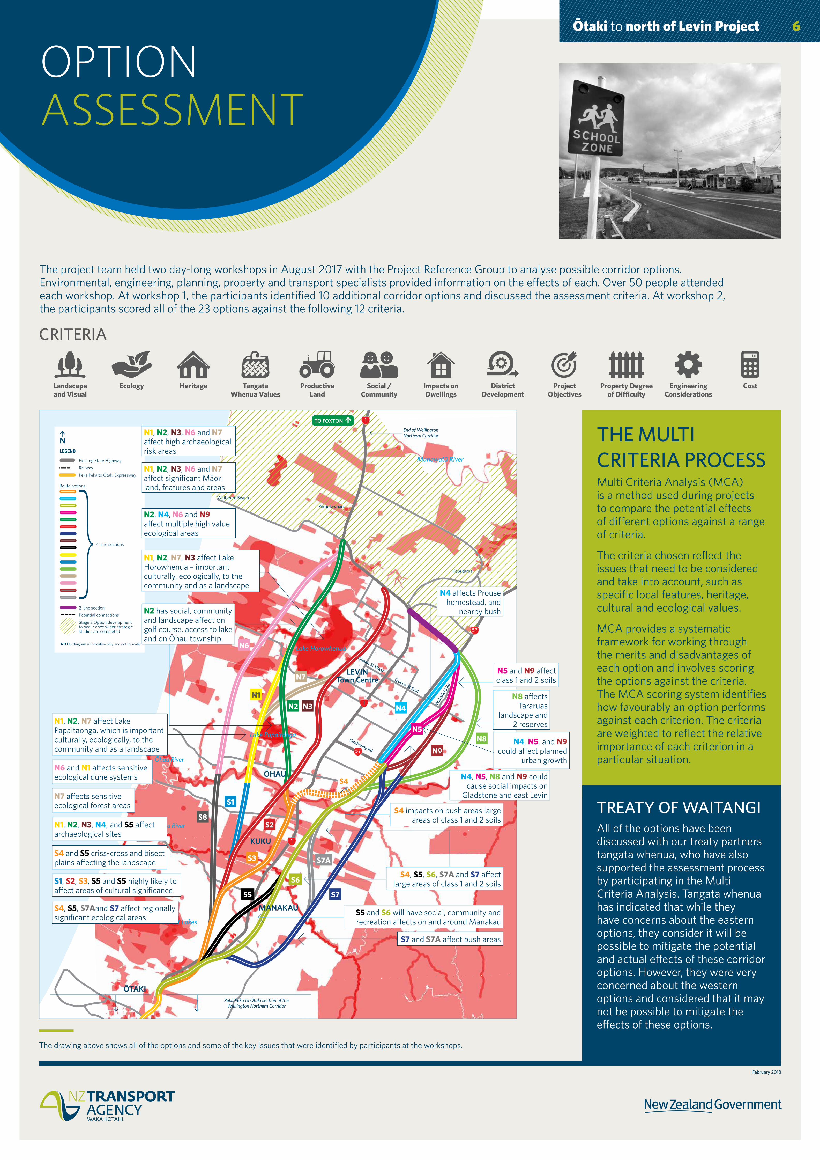
OPTION ASSESSMENT
The project team held two day-long workshops in August 2017 with the Project Reference Group to analyse possible corridor options. Environmental, engineering, planning, property and transport specialists provided information on the effects of each. Over 50 people attended each workshop. At workshop 1, the participants identified 10 additional corridor options and discussed the assessment criteria. At workshop 2, the participants scored all of the 23 options against the following 12 criteria.
6
Landscape and Visual
Ecology Heritage Tangata Whenua Values
Productive Land
Social / Community
Impacts on Dwellings
District Development
Project Objectives
Property Degree of Difficulty
Engineering Considerations
Cost
THE MULTI CRITERIA PROCESS Multi Criteria Analysis (MCA) is a method used during projects to compare the potential effects of different options against a range of criteria.
The criteria chosen reflect the issues that need to be considered and take into account, such as specific local features, heritage, cultural and ecological values.
MCA provides a systematic framework for working through the merits and disadvantages of each option and involves scoring the options against the criteria. The MCA scoring system identifies how favourably an option performs against each criterion. The criteria are weighted to reflect the relative importance of each criterion in a particular situation.
The drawing above shows all of the options and some of the key issues that were identified by participants at the workshops.
CRITERIA
TREATY OF WAITANGIAll of the options have been discussed with our treaty partners tangata whenua, who have also supported the assessment process by participating in the Multi Criteria Analysis. Tangata whenua has indicated that while they have concerns about the eastern options, they consider it will be possible to mitigate the potential and actual effects of these corridor options. However, they were very concerned about the western options and considered that it may not be possible to mitigate the effects of these options.
Date: 12/12/2017Map 15, Version 3
This document is produced for internal use only and has not been approved for external release. Its conclusions are based on the information currently available to NZTA and may change as further information becomes available either internally or externally.
While all reasonable skill and care has been exercise in collating and presenting this information. MWH accepts no liability for any loss, damage, injury or expense (whether direct, indirect or consequential) arising out of the provision of this information or its use.
TO FOXTON
S1
N2
S3
S6
S7
S4
N5
N4
S5
N3N1
S2
N7
S8
N6
N8
S7A
N9
Lake Horowhenua
Lake Papaitonga
Forest Lakes
Ōtaki River
Manawatū River
Ōhau River
Waikawa River
Peka Peka to Ōtaki section of the Wellington Northern Corridor
Waitarere Beach
Poroutawhao
Koputaroa
End of Wellington Northern Corridor
LEVINTown Centre Queen St East
Queen St West
MANAKAU
ŌHAU
ŌTAKI
KUKU
Kimberley Rd
Wak
efiel
d Rd
Existing State Highway
Railway
Peka Peka to Ōtaki Expressway
LEGEND
NOTE: Diagram is indicative only and not to scale
Route options
2 lane section
Potential connections
Stage 2 Option development to occur once wider strategic studies are completed
4 lane sections
Ōtaki to north of Levin – option assessment
N1, N2, N7, N3 affect Lake Horowhenua – important culturally, ecologically, to the community and as a landscape
N2 has social, community and landscape affect on golf course, access to lake and on Ōhau township.
N1, N2, N7 affect Lake Papaitaonga, which is important culturally, ecologically, to the community and as a landscape
S7 and S7A affect bush areas
S4 impacts on bush areas large areas of class 1 and 2 soils
S5 and S6 will have social, community and recreation affects on and around Manakau
N4, N5, and N9 could affect planned
urban growth
S4, S5, S6, S7A and S7 affect large areas of class 1 and 2 soils
N4 affects Prouse homestead, and
nearby bush
N1, N2, N3, N6 and N7 affect significant Māori land, features and areas
N1, N2, N3, N6 and N7 affect high archaeological risk areas
N2, N4, N6 and N9 affect multiple high value ecological areas
N6 and N1 affects sensitive ecological dune systems
N1, N2, N3, N4, and S5 affect archaeological sites
S4 and S5 criss-cross and bisect plains affecting the landscape
S1, S2, S3, S5 and S5 highly likely to affect areas of cultural significance
S4, S5, S7Aand S7 affect regionally significant ecological areas
N7 affects sensitive ecological forest areas
N4, N5, N8 and N9 could cause social impacts on
Gladstone and east Levin
N8 affects Tararuas
landscape and 2 reserves
N5 and N9 affect class 1 and 2 soils

February 2018
Ōtaki to north of Levin Project
OPTION ASSESSMENT
The Multi Criteria Analysis process concluded that a number of options should be discarded. The scoring demonstrated that some options would potentially have significant environmental effects which could not be appropriately mitigated.
The remaining options are shown below.
Date: 12/12/2017Map 15, Version 3
This document is produced for internal use only and has not been approved for external release. Its conclusions are based on the information currently available to NZTA and may change as further information becomes available either internally or externally.
While all reasonable skill and care has been exercise in collating and presenting this information. MWH accepts no liability for any loss, damage, injury or expense (whether direct, indirect or consequential) arising out of the provision of this information or its use.
TO FOXTON
S1
N1
S8
N6
S6
S7
N5
N4
N8
S7A
N9
Lake Horowhenua
Lake Papaitonga
Forest Lakes
Ōtaki River
Manawatū River
Ōhau River
Waikawa River
Peka Peka to Ōtaki section of the Wellington Northern Corridor
Waitarere Beach
Poroutawhao
Koputaroa
End of Wellington Northern Corridor
LEVINTown Centre Queen St East
Queen St West
MANAKAU
ŌHAU
ŌTAKI
KUKU
Kimberley Rd
Wak
efiel
d Rd
Route options
2 lane section
Stage 2 Option development to occur once wider strategic studies are completed
Existing State Highway
Local roads
Railway
Peka Peka to Ōtaki Expressway
LEGEND
NOTE: Diagram is indicative only and not to scale
4 lane sections
Ōtaki to north of Levin – option assessment
7
During the next steps of the investigation process, it became apparent that one of the options (S7) would be significantly more expensive than was originally envisaged. Option S7 avoids a significant part of the Manakau lifestyle area and so it was decided to include a new variation of option S7 that avoids the Manakau lifestyle area and also avoids some parts of the terrain that were resulting in significant cost increases to S7. This new option named S7A, was identified by attendees of workshop 2 during the MCA process. This is discussed further on the next board.
NEXT STEPS• Traffic modelling.
• Assessing constructability to provide a much better understanding of the potential construction cost.
The results of these investigations are provided on the next board.
We also discussed the options again with tangata whenua.
February 2018
Ōtaki to north of Levin Project
FURTHER INVESTIGATION
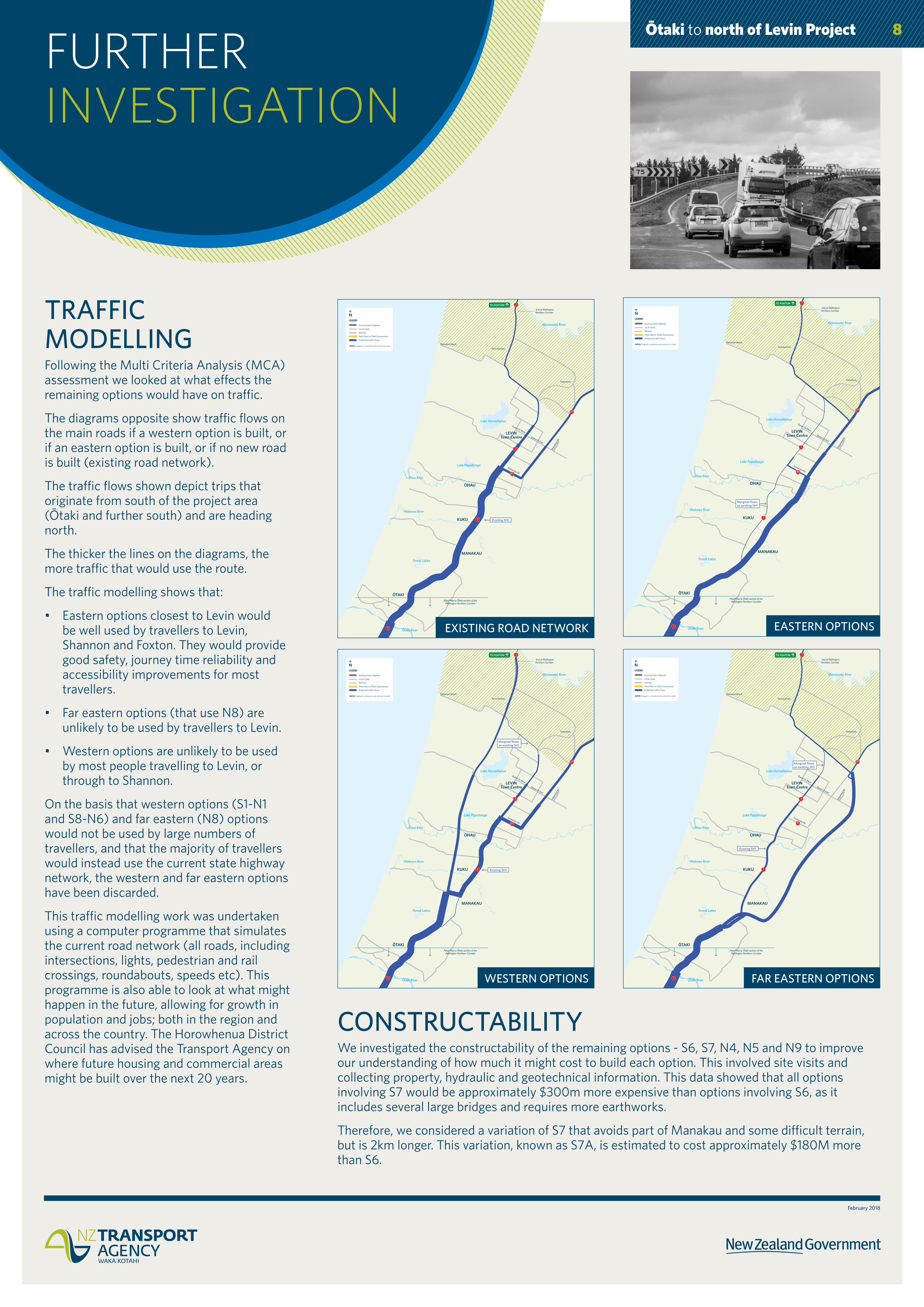
TRAFFIC MODELLING Following the Multi Criteria Analysis (MCA) assessment we looked at what effects the remaining options would have on traffic.
The diagrams opposite show traffic flows on the main roads if a western option is built, or if an eastern option is built, or if no new road is built (existing road network).
The traffic flows shown depict trips that originate from south of the project area (Ōtaki and further south) and are heading north.
The thicker the lines on the diagrams, the more traffic that would use the route.
The traffic modelling shows that:
• Eastern options closest to Levin would be well used by travellers to Levin, Shannon and Foxton. They would provide good safety, journey time reliability and accessibility improvements for most travellers.
• Far eastern options (that use N8) are unlikely to be used by travellers to Levin.
• Western options are unlikely to be used by most people travelling to Levin, or through to Shannon.
On the basis that western options (S1-N1 and S8-N6) and far eastern (N8) options would not be used by large numbers of travellers, and that the majority of travellers would instead use the current state highway network, the western and far eastern options have been discarded.
This traffic modelling work was undertaken using a computer programme that simulates the current road network (all roads, including intersections, lights, pedestrian and rail crossings, roundabouts, speeds etc). This programme is also able to look at what might happen in the future, allowing for growth in population and jobs; both in the region and across the country. The Horowhenua District Council has advised the Transport Agency on where future housing and commercial areas might be built over the next 20 years.
8
Existing SH1
TO FOXTON
Lake Horowhenua
Lake Papaitonga
Forest Lakes
Ōtaki River
Manawatū River
Ohau River
Waikawa River
Peka Peka to Ōtaki section of the Wellington Northern Corridor
Waitarere Beach
Poroutawhao
Koputaroa
End of Wellington Northern Corridor
LEVINTown Centre Queen St East
Queen St West
MANAKAU
OHAU
ŌTAKI
KUKU
Kimberley Rd
Wak
efiel
d Rd
Existing State Highway
Local roads
Railway
Peka Peka to Ōtaki Expressway
Predicted traffic flows
LEGEND
NOTE: Diagram is indicative only and not to scale
Ōtaki to north of Levin – Existing network
EXISTING ROAD NETWORK
Marginal flows on existing SH1
TO FOXTON
Lake Horowhenua
Lake Papaitonga
Forest Lakes
Ōtaki River
Manawatū River
Ohau River
Waikawa River
Peka Peka to Ōtaki section of the Wellington Northern Corridor
Waitarere Beach
Poroutawhao
Koputaroa
End of Wellington Northern Corridor
LEVINTown Centre Queen St East
Queen St West
MANAKAU
OHAU
ŌTAKI
KUKU
Kimberley Rd
Wak
efiel
d Rd
Existing State Highway
Local roads
Railway
Peka Peka to Ōtaki Expressway
Predicted traffic flows
LEGEND
NOTE: Diagram is indicative only and not to scale
Ōtaki to north of Levin – Eastern option
EASTERN OPTIONS
Existing SH1
Marginal flows on existing SH1
TO FOXTON
Lake Horowhenua
Lake Papaitonga
Forest Lakes
Ōtaki River
Manawatū River
Ohau River
Waikawa River
Peka Peka to Ōtaki section of the Wellington Northern Corridor
Waitarere Beach
Poroutawhao
Koputaroa
End of Wellington Northern Corridor
LEVINTown Centre Queen St East
Queen St West
MANAKAU
OHAU
ŌTAKI
KUKU
Kimberley Rd
Wak
efiel
d Rd
Existing State Highway
Local roads
Railway
Peka Peka to Ōtaki Expressway
Predicted traffic flows
LEGEND
NOTE: Diagram is indicative only and not to scale
Ōtaki to north of Levin – Far Eastern option
FAR EASTERN OPTIONS
Existing SH1
Marginal flows on existing SH1
TO FOXTON
Lake Horowhenua
Lake Papaitonga
Forest Lakes
Ōtaki River
Manawatū River
Ohau River
Waikawa River
Peka Peka to Ōtaki section of the Wellington Northern Corridor
Waitarere Beach
Poroutawhao
Koputaroa
End of Wellington Northern Corridor
LEVINTown Centre Queen St East
Queen St West
MANAKAU
OHAU
ŌTAKI
KUKU
Kimberley Rd
Wak
efiel
d Rd
Existing State Highway
Local roads
Railway
Peka Peka to Ōtaki Expressway
Predicted traffic flows
LEGEND
NOTE: Diagram is indicative only and not to scale
Ōtaki to north of Levin – Western option
WESTERN OPTIONS
CONSTRUCTABILITYWe investigated the constructability of the remaining options - S6, S7, N4, N5 and N9 to improve our understanding of how much it might cost to build each option. This involved site visits and collecting property, hydraulic and geotechnical information. This data showed that all options involving S7 would be approximately $300m more expensive than options involving S6, as it includes several large bridges and requires more earthworks.
Therefore, we considered a variation of S7 that avoids part of Manakau and some difficult terrain, but is 2km longer. This variation, known as S7A, is estimated to cost approximately $180M more than S6.

February 2018
Ōtaki to north of Levin Project
SHORTLISTED OPTIONS The shortlisted options propose a four-lane state highway separated by a median barrier and include a bypass north of Levin. The options all begin at Taylors Road north of Ōtaki, linking in with the Kāpiti Expressway, and end just north of Levin.
TO FOXTON
Existing State Highway
Local roads
Railway
Peka Peka to Ōtaki Expressway
LEGEND
NOTE: Diagram is indicative only and not to scale
Route options
2 lane section
Stage 2 Option development to occur once wider strategic studies are completed
4 lane sections
Any northern option can connect to any southern option. Thus the alignment of connections between northern and southern options as shown here is indicative only.
Lake Horowhenua
Lake Papaitonga
Forest Lakes
Ōtaki River
Manawatū River
Ōhau River
Waikawa River
Peka Peka to Ōtaki section of the Wellington Northern Corridor
Waitarere Beach
Poroutawhao
Koputaroa
End of Wellington Northern Corridor
LEVINTown Centre Queen St East
Queen St West
MANAKAU
ŌHAU
ŌTAKI
KUKU
Kimberley Rd
Wak
efiel
d Rd
S6S7
N5
N4
S7A
N9
Ōtaki to north of Levin – shortlisted options
ROAD DESIGN ASSUMPTIONSAll options would allow the construction of four-lane sections of the state highway north of Levin in the future if needed.
Each option is represented by a broad 300 metre wide corridor within which a proposed expressway will be able to be constructed. The final design width of the road is likely to be between 60 and 100 metres and may be placed anywhere within the 300 metre wide corridor. This includes room for stormwater runoff treatment, embankments and planting. Additional width will likely to be needed at interchanges and where new local road connections need to be provided.
9
Otaki to Levin:Typical Corridor Layouts
Date 22 DEC 2017Status DRAFT
1. Typical PlanNot to scale
Road width - back of swale to back of swale approx. 50 metres as per typical cross section
Current indicative corridor width - 300m
2. Typical Cross SectionNot to scale
February 2018
Ōtaki to north of Levin Project
SOUTHERN SECTION
The shortlist is made up of three possible corridor options. All three options connect with the Kāpiti Expressway (Mackays to Peka Peka and Peka Peka to north of Ōtaki) and link to the three possible northern corridor options. The key features below list some of the advantages and disadvantages that have been identified so far. We are seeking the community’s views on these.
10
Project Objectives• Best safety
performance of all options
• Shortest and most direct route to Levin
• Provides best journey time saving
• Most resilient option as has fewest and smallest structures
Environmental & Community• SH1 no longer runs
through middle of Manakau
• Best performing at the MCA. Overall least challenging and best opportunity to manage effects
• Likely to have least cultural effects of southern options
Cost• Lowest cost option
Environmental & Community• Affects Manakau
properties• Affects up to 230 ha
of highly productive lands
• Social, community and recreation effects on Manakau
• Affects residential properties and farms located to the east of existing SH1
• Some cultural effects
Project Objectives• Some safety
performance, but is 1km longer than S6
• Provides good journey time savings
• Least resilient option. Crosses a fault line, large bridges and fills required
Environmental & Community• Affects least number
of properties• Avoids some
potential effects on Manakau
• Takes SH1 away from Manakau township
• Likely to have least cultural effects of southern options
Environmental & Community• Affects significant
bush/ecological areas including Manakau campsite
• Affects up to 315 ha of highly productive lands
• Affects lifestyle properties including those located to the south of Manakau.
• Affects farms, businesses and residential properties (located in the Waiauti Valley - east of existing SH1)
• Some cultural effects
Cost• Highest cost
southern option
Project Objectives• Some safety
benefits, but is 2km longer than S6
• Provides some journey time saving
• Moderate resilience - less structures
Environmental & Community• Avoids some
potential effects on Manakau
• Takes SH1 away from Manakau township
Environmental & Community• Poor fit with the
landscape as road traverses diagonally across from Waiauti valley towards existing SH1
• Affects significant bush / ecological areas including Manakau campsite
• Affects up to 290 ha of highly productive lands
• Affects lifestyle properties located to the south of Manakau
• Traverses some farms, businesses and residential properties (located in the Waiauti Valley - east of existing SH1)
• Some very large bridges and fill required
• Some cultural effects
Cost• High cost option
SOUTHERN OPTION S6 SOUTHERN OPTION S7ASOUTHERN OPTION S7
KEY FEATURES OF THE SOUTHERN OPTIONS
POSI
TIV
ESN
EGAT
IVES
TO FOXTON
Existing State Highway
Local roads
Railway
Peka Peka to Ōtaki Expressway
4 lane section
Stage 2 Option development to occur once wider strategic studies are completed
LEGEND
NOTE: Diagram is indicative only and not to scale
Lake Horowhenua
Lake Papaitonga
Forest Lakes
Ōtaki River
Manawatū River
Ōhau River
Waikawa River
Peka Peka to Ōtaki section of the Wellington Northern Corridor
Waitarere Beach
Poroutawhao
Koputaroa
End of Wellington Northern Corridor
LEVINTown Centre Queen St East
Queen St West
MANAKAU
ŌHAU
ŌTAKI
KUKU
Kimberley Rd
Wak
efiel
d Rd
S6
Ōtaki to north of Levin – shortlisted options
TECHNICALLY BEST PERFORMING OPTION
TO FOXTON
Lake Horowhenua
Lake Papaitonga
Forest Lakes
Ōtaki River
Manawatū River
Ōhau River
Waikawa River
Peka Peka to Ōtaki section of the Wellington Northern Corridor
Waitarere Beach
Poroutawhao
Koputaroa
End of Wellington Northern Corridor
LEVINTown Centre Queen St East
Queen St West
MANAKAU
ŌHAU
ŌTAKI
KUKU
Kimberley Rd
Wak
efiel
d Rd
S7
Existing State Highway
Local roads
Railway
Peka Peka to Ōtaki Expressway
4 lane section
Stage 2 Option development to occur once wider strategic studies are completed
LEGEND
NOTE: Diagram is indicative only and not to scale
Ōtaki to north of Levin – shortlisted optionsTO FOXTON
Existing State Highway
Local roads
Railway
Peka Peka to Ōtaki Expressway
4 lane section
Stage 2 Option development to occur once wider strategic studies are completed
LEGEND
NOTE: Diagram is indicative only and not to scale
Lake Horowhenua
Lake Papaitonga
Forest Lakes
Ōtaki River
Manawatū River
Ōhau River
Waikawa River
Peka Peka to Ōtaki section of the Wellington Northern Corridor
Waitarere Beach
Poroutawhao
Koputaroa
End of Wellington Northern Corridor
LEVINTown Centre Queen St East
Queen St West
MANAKAU
ŌHAU
ŌTAKI
KUKU
Kimberley Rd
Wak
efiel
d Rd
S7A
Ōtaki to north of Levin – shortlisted options
Length
16.7km $560 – 640mCost***
Approximate number of dwellings
affected*
86
Approximate area of productive soils
affected**
up to 290 ha* Estimate based on available aerial photography.** Class I, II and III soil areas excluding land in small blocks and land zoned for other purposes.*** Indicative at 2017.
Length
15.7km $640 – 740mCost***
Approximate number of dwellings
affected*
57
Approximate area of productive soils
affected**
up to 315 ha* Estimate based on available aerial photography.** Class I, II and III soil areas excluding land in small blocks and land zoned for other purposes.*** Indicative at 2017.
Length
14.7km $420 – 480mCost***
Approximate number of dwellings
affected*
107
Approximate area of productive soils
affected**
up to 230 ha* Estimate based on available aerial photography.** Class I, II and III soil areas excluding land in small blocks and land zoned for other purposes.*** Indicative at 2017.
Any northern option can connect to any
southern option. Thus the alignment of connections between
northern and southern options as shown here
is indicative only.
Any northern option can connect to any
southern option. Thus the alignment of connections between
northern and southern options as shown here
is indicative only.
Any northern option can connect to any
southern option. Thus the alignment of connections between
northern and southern options as shown here
is indicative only.
February 2018
Ōtaki to north of Levin Project
NORTHERN SECTION
The shortlist is made up of three possible corridor options. All three options link to the three possible southern corridor options and to a northern bypass of Levin located between SH57 and SH1.The key features below list some of the advantages and disadvantages that have been identified so far. We are seeking the community’s views on these.
11
NORTHERN OPTION N4 NORTHERN OPTION N9NORTHERN OPTION N5
Project Objectives• Good safety benefits• Shortest route with
good journey time benefits
• Opportunity for good access to Levin town centre
• Opportunity to provide access to planned industrial development areas identified in District Plan
• Aligns with road corridor identified in the District Plan ‘Green Belt growth area’.
Environmental & Community• Uses existing
infrastructure corridor with opportunity to address severance effects of SH58
Cost• Low cost option
Cost• Low cost option
Cost• Low cost option
Environmental & Community• Close to and likely
to affect significant ecological areas
• Close to and could affect historic homestead
• Some affect on productive land
• Affects lifestyle residential property and local community
• Affects property and businesses located on the eastern side of SH57
Project Objectives• Good safety benefits• Good journey time
benefits• Opportunity to
provide access to planned industrial development areas identified in the District Plan
• Provides access to Green Belt growth area identified in the District Plan Environmental &
Community• Avoids significant
ecological areas• Avoids historic
homestead
Environmental & Community• Some affects on
productive land• Affects lifestyle
residential property and community
• Potential effect on some businesses
Project Objectives• Good safety benefits• Good journey time
benefits• Opportunity to
provide access to planned industrial development areas identified in the District Plan
• Provides access to Green Belt growth area identified in the District Plan
Environmental & Community• Avoids significant
ecological areas• Avoids historic
homestead
Environmental & Community• Close to and likely
to affect significant ecological areas
• Affects productive land
• Affects lifestyle residential property and local community
• Potential effect on some businesses
POSI
TIV
ESN
EGAT
IVES
KEY FEATURES OF OPTIONS
TO FOXTON
N4
Lake Horowhenua
Lake Papaitonga
Forest Lakes
Ōtaki River
Manawatū River
Ōhau River
Waikawa River
Peka Peka to Ōtaki section of the Wellington Northern Corridor
Waitarere Beach
Poroutawhao
Koputaroa
End of Wellington Northern Corridor
LEVINTown Centre Queen St East
Queen St West
MANAKAU
ŌHAU
ŌTAKI
KUKU
Kimberley Rd
Wak
efiel
d Rd
Existing State Highway
Local roads
Railway
4 lane section
2 lane section
Stage 2 Option development to occur once wider strategic studies are completed
LEGEND
NOTE: Diagram is indicative only and not to scale
Ōtaki to north of Levin – shortlisted optionsTO FOXTON
N9
Lake Horowhenua
Lake Papaitonga
Forest Lakes
Ōtaki River
Manawatū River
Ōhau River
Waikawa River
Peka Peka to Ōtaki section of the Wellington Northern Corridor
Waitarere Beach
Poroutawhao
Koputaroa
End of Wellington Northern Corridor
LEVINTown Centre Queen St East
Queen St West
MANAKAU
ŌHAU
ŌTAKI
KUKU
Kimberley Rd
Wak
efiel
d Rd
Existing State Highway
Local roads
Railway
4 lane section
2 lane section
Stage 2 Option development to occur once wider strategic studies are completed
LEGEND
NOTE: Diagram is indicative only and not to scale
Ōtaki to north of Levin – shortlisted optionsTO FOXTON
N5
Lake Horowhenua
Lake Papaitonga
Forest Lakes
Ōtaki River
Manawatū River
Ōhau River
Waikawa River
Peka Peka to Ōtaki section of the Wellington Northern Corridor
Waitarere Beach
Poroutawhao
Koputaroa
End of Wellington Northern Corridor
LEVINTown Centre Queen St East
Queen St West
MANAKAU
ŌHAU
ŌTAKI
KUKU
Kimberley Rd
Wak
efiel
d Rd
Existing State Highway
Local roads
Railway
4 lane section
2 lane section
Stage 2 Option development to occur once wider strategic studies are completed
LEGEND
NOTE: Diagram is indicative only and not to scale
Ōtaki to north of Levin – shortlisted options
Length
9.5km $280 – 320mCost* **
Approximate number of dwellings
affected*
74
Approximate area of productive soils
affected**
up to 130 ha* Estimate based on available aerial photography.** Class I, II and III soil areas excluding land in small blocks and land zoned for other purposes.*** Indicative at 2017.
Length
9.8km $280 – 320mCost***
Approximate number of dwellings
affected*
76
Approximate area of productive soils
affected**
up to 95 ha* Estimate based on available aerial photography.** Class I, II and III soil areas excluding land in small blocks and land zoned for other purposes.*** Indicative at 2017.
Length
9.5km $280 – 320mCost***
Approximate number of dwellings
affected*
82
Approximate area of productive soils
affected**
up to 40 ha* Estimate based on available aerial photography.** Class I, II and III soil areas excluding land in small blocks and land zoned for other purposes.*** Indicative at 2017.
Any northern option can connect to any southern option. Thus the alignment of connections between northern and southern options as shown here is indicative only.
Any northern option can connect to any southern option. Thus the alignment of connections between northern and southern options as shown here is indicative only.
Any northern option can connect to any southern option. Thus the alignment of connections between northern and southern options as shown here is indicative only.

February 2018
Ōtaki to north of Levin Project
CORRIDORS12
Length of option
Approximate journey time saving from ŌtakiEstimated reduction in deaths
and serious injuries every 5 years
Estimated Cost
(Indicative at 2017)to Foxton to Levin Town Centre to Shannon
S6 – N4 24.1km
6½ minutes 1¼ minutes 5¾ minutes 28-30 $690m – $800mS6 – N5 24.4km
S6 – N9 24.2km
S7 – N4 25.2km
6 minutes 50 seconds 5½ minutes 26-28 $920m – $1.06bnS7 – N5 25.5km
S7 – N9 25.3km
S7A – N4 26.1km
5½ minutes 15 seconds 5 minutes 24 $830m – $960mS7A – N5 26.4km
S7A – N9 26.2km
Boards 10 and 11 discuss northern and southern corridor options. By combining options from the northern and southern sections, complete corridor options, beginning at Taylors Road north of Ōtaki and ending just north of Levin, are formed. The transport benefits and the costs of nine complete corridors (comprised of different combinations of southern and northern sections) are provided in the table below.
TO FOXTON
Any northern option can connect to any southern option. Thus the alignment of connections between northern and southern options as shown here is indicative only.
Lake Horowhenua
Lake Papaitonga
Forest Lakes
Ōtaki River
Manawatū River
Ōhau River
Waikawa River
Peka Peka to Ōtaki section of the Wellington Northern Corridor
Waitarere Beach
Poroutawhao
Koputaroa
End of Wellington Northern Corridor
LEVINTown Centre Queen St East
Queen St West
MANAKAU
ŌHAU
ŌTAKI
KUKU
Kimberley Rd
Wak
efiel
d Rd
S6
S7
N5
N4
S7A
N9
Existing State Highway
Local roads
Railway
Peka Peka to Ōtaki Expressway
LEGEND
NOTE: Diagram is indicative only and not to scale
Route options
2 lane section
Stage 2 Option development to occur once wider strategic studies are completed
4 lane sections
Ōtaki to north of Levin – shortlisted options
SOUTHERN CONNECTIONAll of the options use the same corridor between the Kāpiti Expressway (Mackays to Peka Peka and Peka Peka to north of Ōtaki) and Manakau. The southern end of this corridor is at a fixed point, ending at the Kāpiti Expressway. The location of this section of corridor has been developed taking into consideration numerous constraints including wetlands, heritage and cultural aspects, landscape effects, ground conditions and construction costs. Because corridor options using the valley to the east would require a significant detour, they were discounted.
LINKING TO THE NORTHAll of the corridor options include a northern link road between SH1 and SH57. The location of this northern link road takes into consideration numerous constraints including wetlands, heritage and cultural aspects, landscape effects, ground conditions and construction costs.
Existing State Highway
Local roads
Railway
Peka Peka to Ōtaki Expressway
LEGEND
NOTE: Diagram is indicative only and not to scale
Route options
2 lane section
Stage 2 Option development to occur once wider strategic studies are completed
4 lane sections

February 2018
Ōtaki to north of Levin Project
CONNECTIONS
INTERCHANGES Interchanges will be required as part of the O2NL project. They will provide access onto and off the new state highway. The number, location and form of the interchanges will depend on the preferred corridor option. Interchanges will be needed at the locations shown in the figure below. These will provide access to:
• Levin from the north (located near to the intersection of SH1 with Heatherlea East Road).
• Levin from the south (located around Tararua Road or Kimberley Road).
• The north of Levin from SH57, where the new expressway connects with the existing state highway.
We are also considering an interchange to the north or to the south of Manakau.
Please note: we are collecting information now to inform the next phase of investigations. No decision on interchange locations will be made as part of this (February-March 2018) community engagement process.
EXAMPLES OF POTENTIAL INTERCHANGE TYPES
LOCAL ROAD ACCESSAll of the proposed corridor options cross a number of local roads and properties. Local road access to all properties would be maintained as part of the construction of any of the options, and all local roads would be reconnected to the existing network. This level of design would be undertaken after a preferred corridor option has been selected.
WALKING AND CYCLINGWe have had good support and feedback from the local community on the provision of new and enhanced walking and cycling facilities. Research that students from Waiohepu College undertook also supports the provision of these facilities.
During the next stages of investigation we will consider opportunities for these facilities including:
• providing facilities on the current road (now SH1) to take advantage of the significant reduction in traffic that will occur should a new state highway be constructed.
• providing new facilities parallel to and as part of the new state highway.
WAIOPEHU COLLEGE RESEARCH INFOIn late 2017, the Waiopehu College Year 13 Geography class investigated the potential form of cycling infrastructure that could be provided as part of the project. The students collected data from the community by undertaking a survey. They provided the O2NL project team with their assessment and recommendations. Copies of the students’ research can be found on the project website (www.nzta.govt.nz/projects/wellington-northern-corridor/otaki-to-north-of-levin/technical-reports).
TO FOXTON
Lake Horowhenua
Lake Papaitonga
Forest Lakes
Ōtaki River
Manawatū River
Ōhau River
Waikawa River
Peka Peka to Ōtaki section of the Wellington Northern Corridor
Waitarere Beach
Poroutawhao
Koputaroa
End of Wellington Northern Corridor
LEVINTown Centre Queen St East
Queen St West
MANAKAU
ŌHAU
ŌTAKI
KUKU
Kimberley Rd
Wak
efiel
d Rd
S6
S7
N5
N4
S7A
N9
Existing State Highway
Local roads
Railway
Peka Peka to Ōtaki Expressway
LEGEND
NOTE: Diagram is indicative only and not to scale
Route options
2 lane section
Stage 2 Option development to occur once wider strategic studies are completed
4 lane sections
Ōtaki to north of Levin – interchanges
BIFURCATION
COMPACT DIAMOND
DIAMOND
13

February 2018
Ōtaki to north of Levin ProjectINTERIM SAFETY IMPROVEMENTS TO SH1 AND SH57
We are currently investigating further interim safety improvements to the sections of SH1 and SH57 that run through the O2NL project area. These investigations will consider small scale improvements to the current roads to provide immediate safety benefits ahead of construction of O2NL. The types of improvements that might be undertaken to SH1 are shown on the diagram below. More information about the improvements will be made available later this year.
Lake Papaitonga
Lake Waitawa
Lake Kopureherehere
Ohau River
Tui Glen Dr
Tararua Rd
Kimberley Rd
Mcleavey Rd
Boulton Rd
Buller Rd
Vista Rd
Joblins Rd
Muhunoa East Rd
Muhunoa West Rd
Arap
aepa
e Rd
Wairiri St
Bish
ops R
dBr
uce R
d
Papa
itong
a La
ke R
d
Hogg
s Rd
Sold
iers
Rd
Kuku Beach Rd
Kuku E Rd
Whakahoro Rd
N Manakau Rd
Waikawa Beach Rd
Taka
pu R
d
Gleeson Ave
S Manakau Rd
Honi
Taip
ua S
t
Atkins Rd
Lawlors Rd
Taylors Rd
Tayl
ors
Rd
Greenwood Blvd
Parakawau Rd
ŌHAU
MANAKAU
Man
akau
Heig
hts D
r
Waitohu Valley Rd
Forest Lakes Rd
LEVIN
ŌTAKI
Enhance Threshold
Reseal and improve roadmarking situation
Seal turning area
Investigate/rectify retaining structure opposite “The Shekineh”
Remove bright “Vacancy” sign
Consider banning right turn out of Whakahoro Road
Upskill Marae staff to self-provide TTM for events or VMS
Seal shoulder/carpark
Adjust marking and alignment of left acceleration lane
Reallocate road space to provide wide SBD shoulder
Extend existing barriers slightly south to improve hazard protection
Level and clean chevrons. Check reflectivity
Remove hazardous sign posts from rest area
Upgrade “Major Intersection Ahead” signs
Consider removing weigh station
Existing State Highway
Local roads
Railway
MAINTENANCEDeficiencies to be addressed
Check/improve skid resistence
QUICK WINSImprove signs/delineation/markings
Localised hazard removal
Other
BLOCK FUNDING/SAFER CORRIDORSHazard removal/barriers
Potential wide centreline
Other
RONS/OTHERWorks to be covered under M&O funding
SH1/57 – Construct roundabout if realignment work still generates significant traffic at the intersection
LEGEND
ROUTE WIDE MEASURESMaintenance: North of Pukehou Rail overbridge more frequent remarking and sign/delineation cleaning.
Block funding/Safer corridors: Further investigation into a speed limit reduction to 80km/h north of Pukehou rail overbridge.
Longlife marking, red rrpms and additional ATP north of Pukehou rail overbridge.
This map does not contain specific details on measures.
NOTE: diagram is indicative only and not to scale
Taylors Road to South of Levin – Interim safety improvements
14
SAFETY IMPROVEMENTS TO SH1 NORTH OF LEVINWe need to address the poor safety record for this section of the SH1 between Levin and the Manawatu River.
The current proposed safety improvements for this section of SH1 include realignment of SH1 at Waitārere Curves and provision of north bound passing lanes to the north and south of the Waitārere Curves.
We have committed to discussing and co-designing these proposals with the local community and iwi and we will commence this work once a preferred corridor option has been selected.
SH57 SAFE ROADS ALLIANCEThe Safe Roads Alliance will be investigating what improvements can be undertaken to the southern section of SH57 between Heatherlea East Road and SH1. Details of these investigations will be available later.
The Safe Roads Alliance is currently undertaking safety improvements to SH57 between Heatherlea East Road and Shannon. These will include safety barriers, rumble strips, wider centre lines and wider shoulders. Details are available on the project web site: www.nzta.govt.nz/projects/sh57-sh1-to-shannon

February 2018
Ōtaki to north of Levin ProjectHISTORY AND ARCHAEOLOGICALRISK
HISTORICAL OVERVIEW OF THE HOROWHENUA-KAPITIMāori have occupied the Horowhenua-Kāpiti coast for more than 700 years.
Before the 1880s, māori settlements were concentrated in the coastal dune belt and adjacent to the major rivers, lakes and wetlands. Within the forest, sites of māori occupation were generally located in small clearings or along the margins of the streams and tracks that crossed the forest. The rivers and coast also provided the main routes for the movement of goods and people. Māori living in the area benefited from a diverse and rich range of plant and animal (fish and bird) resources.
The first European settlers were whalers and traders who arrived in the middle decades of the 19th century and lived in or nearby the māori settlements.
The forested land to the east was not heavily settled until after the completion of the Wellington-Manawatu Railway in 1886. Prior to this, the forest was still being used primarily for resource gathering, including bird snaring, collecting forest fruits and obtaining timber. Tracks out of the area also passed through the forest.
In the 1880s, settlements shifted inland nearer to the railway line as it was the primary transportation, trade and communication route. During this time there was considerable forest clearance with new settlers occupying land made available by the government at Ōtaki, Manakau, Ōhau, Levin, and Shannon.
ARCHAEOLOGICAL RISKThis shows the risk of an archaeological site being encountered should major construction associated with road construction occur. The risk is an estimate based on the number of known archaeological sites.
Given the history of the area, and based on experience, it is very likely there will be a large number of undiscovered sites that will mostly relate to early periods of māori occupation.
The areas of highest archaeological risk are predominantly located among the lakes, lagoons and wetlands of the coastal dune belt, west of the historic forest edge.
Inland hunting and resource collection camps and small scale sites associated with forest paths are located east of Levin and Manakau and are medium risk areas.
Forest clearings containing settlements and/or cultivation grounds result in areas of high risk. These are located between the historic forest edge and State Highway 1, south of Ōhau and between Levin, and the eastern shore of Lake Horowhenua.
Most archaeological sites of European origin are located in and around the townships of Manakau, Ōhau and Levin. There are also a small number of sites related to early European occupation located to the west of the historic forest edge.
There was a substantial māori settlement south of Shannon, near Paiaka, at the north eastern extent of the study area.
¥¥1
¥¥57
¥¥57
¥¥1
¥¥1
¥¥1
$
5 km
LEVIN
OTAKI
OHAU
MANAKAU
WAITARERE BEACH
HOKIO BEACH
WAIKAWA BEACH
Archaeological RiskLow
Medium
High
Forest edge (1872)
Study Area

to north of Levin Project
18-025
WHAT HAPPENS NOW?
15
Following this consultation we’ll use your feedback, along with our technical assessments and fieldwork, to identify a preferred corridor for the Ōtaki to north of Levin project.
Once feedback is received and considered, advice on a preferred option will be presented to the NZ Transport Agency Board in mid-2018. The next steps for the project will take into account changes to the Government’s transport system priorities which will be outlined in the new Government Policy Statement.
We appreciate the importance of this project to the community and the impact it has on the wide range of stakeholders. We’ll keep the community updated as we progress through the decision-making process.
PRODUCT DEVELOPMENT
FUTURE STAGES – TIMING TO BE CONFIRMED
BUSINESS CASE PHASES
Strategic case
Long list to short list
Opt
ion
anal
ysis
NZ Transport Agency Board decision
Engagement
CURRENT STAGES
Short list of corridor options
Engagement
IMPLEMENTATION
PRE-IMPLEMENTATION
Consent and design phase
DETAILED BUSINESS CASE
Develop and investigate indicative alignment

Ōtaki to north of Levin Project
February 2018
16
You can:
• drop into our pop-up shop:183 Oxford Street, Levin
• complete our printedfeedback form
• have your say online:www.nzta.govt.nz/O2NL
• email us: [email protected]
• write to us:Ōtaki to north of LevinProject TeamPO Box 5084, Thorndon,Wellington 6145
• phone us: 0508 625 4636.
TIMELINE
VISIT USWe are holding events throughout the Horowhenua area during February and March.
We are also available at our pop-up shop, 183 Oxford Street, Levin which will be open every Tuesday, Wednesday and Friday from 10am – 4pm, and Thursday from 12pm – 6pm until 9 March.
Further opportunity for
feedback
2016 – 2017 Investigation
of options from Taylors Road to north of Levin
NOW
Engagement on shortlisted options
JUNE 2017 Engagement
to gather community information and
values
RMA application
2014 – 2016 Future proofing investigation of state highway options between
Ōtaki and SH57/Ōhau
MID 2018 Announcement of preferred corridor
Corridor refinement
Options assessment shortlisting
HOW YOU CAN GIVE FEEDBACK
Consideration of feedback and option
recomendation