Embed Size (px)
Citation preview
Oeology and Mineralogy
PHiSPHATI ©IPOSITS II HORTHEHM ALASKA*
William V. Patton5
Trace Elements Investigations Report 679
This preliminary report is distributed without editorial and technical review for conformity with official standardsand nomenclature» It is not for publicinspection or quotation.
of Rawand in
concerns work done on behalf of the DivisionMaterials of the U» S. Atomic Energy Commission* cooperation with the Ue S. Department of the Navy, of Naval Petroleum and Oil Shale Reserves.
USGS - fEI-679
GEOL0GY AJTD MINERALOGY
Distribution Ho. of copiesDivisi©n of Raw Jfeterials# Albuquerque. ........ 1Division ©f Raw Materials,, Austin ........... 1Division ©f Raw Bfeterials 9 Casper ........... 1Division ©f Raw Ifeterials^ Denver ........... 1Division of Raw Materials 9 Rapid City ......... 1Division ©f Raw Ifeterials^ Salt Lake City ....... 1Division of Raw Matarialg, SpokaQe 0 .......... 1Di¥i@i©Q of Raw Mat@fial@j, Waghington ......... 3Expl©rati®a Division, Grand Junction Operations Office 1Grand Juncti©ia Operations Of fie®. ........... 1'Technical Infomation Service Eartensi©n, Oak Ridge. . . 6
Alaskan Geology Branch^ Msnlo Park. .......... 5Foreign Geology Branch, Washington. ...*.....« 1Ftels Branch;, Washington. <,... ........*.* 1Geochemistry and Petrology Branch, Washington ..... 1Geophysics Branch, Washington ............. 1Mineral Classification Branch P Washington ......<> 2Mineral Deposits Branch^ Washington .......... 1Ao Lo Irokaw^ Grand Junction. ..........*.. 1L, R 0 Page p Washington. ................ 1A. E. Weissenlborn^ Spokane. .............. 1
Denver . ...... . •*............ 2RPS 5 - Washington (including master) ....... _2
37
Page
Regional setting. .*.*«*o.o..a.................. «.*«......•'..«.. .12Tiglukpsak Cre®k ami upper llrmktagiak River areas * .,«. 0 ....... 14
group 0 ...... .. .......«..-......•.«.•.•«. 14' member 0 <>«><....«......<..<,.« 16
age » <» <> o « ^ ...... .,.» ..,«,«,.«,«, 1?
Slmblik formation „ *.... „.. 0 ...... ......... 18
figlnkpmk fomatlomo . ....... . ..*.,. ... ••••« 20©f Quaternary age ...... o .. o ..«,..,«,...«, 20
f IglmkpEk Creek area . * . . . . .....<. * ..«*•..»... . «,.,.... 21
mpper Mrkktagiak' River areas'. *..»........ 23composition ®t .the phosphate rock.„ 0 »...... 24
5747
Flat® 1. tttp of -northern Alatfca Showing Itwatlon of
2, Colwmar
3- ptespbatic ©f the •lirrnktaglak liver area
ipper Ilriktaglak liver area, north front of
zone of black
, In envelope
. In envelope
. . . 11
Figure 1north flank of
the Brooks In the adjoining foothills. . . 13
3. loeatloia of measi-ired Creek area, E@rth@nt Alaska,
location of measuredtpper fimktagiak liveT
O O 6 O 0000
5* Correlatedi
®ect.t©ms. ;,of black chert-shale Uneaten*, Lisbmme gromp. . „ . , la envelope
Table 1. SewlfiLaBititatlv® speotrographic axmlf^es of selected
2. Malyses of
William W. Patton^, Jr., and John J 0 Matzk©
ABSTRACT
T*^/^J I/1 ?•?£& Y*£& /I *$ <s f* (f^r^a T*<3nr5 iT^T X Uuiv Wt^X^ y.JL0UUVf5X cU Ui
Arctic Slope of Alaska during the geological investigation of Naval
Petroleum Reserve Ho. **• between 19^4 and 1953« They occur In at
least two stratigraphic units , the Lisburne group (Mississlppian)
and the Shublik formation (Triassic) and have been found at widely
scattered localities along the north front of the Brooks Range and
In the adjoining foothills. Tne deposits in the Lisburne group in
the central Brooks Range and foothills are of principal interest and
hare been examined in detail and systematically sampled at two
localities , Tiglukpuk Creek and upper Kiruktagiak River.
The Tiglukpuk Creek and upper liruktagiak River areas are underlain
by a thick sequence of highly deformed sedimentary rocks Including the
Waehsiniath limestone and Alapah limestone of the Lisburne group (Missis -
sipplan)^ the Sikglkpuk formation (Permian?)., the Shublik formation
(Triassic)^ and the Tiglukpuk formation ( Jurassic ). The phosphate
deposits are confined to the black chert-shale member of the.Alapah
limestone s near the top of the Lisburne group. This member^ which
ranges from about 40 to 100 feet in thickness , consists chiefly of
dark shaly limestone ̂ muds tone, and phosphate rock and forms a dis
tinctive lithologie unit within the massive light-colored fossil-
clastic limestone that comprises the bulk of .the 2,000-
6
The -tirvnlffeTOus phosphate rock from northern Alaska contains
carbonate-fluorapatite as the phosphate mineral and, In .general,
Is similar in mineralogy, phosphate, uranium, and minor element
content to phosphateB from the Phosphoria formation of 'Permian age
in the northwestern part of the United States. Other minerals
identified are ealcite, dolomite, quartz, and purple and colorless
fluorlte. Carbonaceous matter stains all the phosphate rock.
In the Tlglukpuk Creek area the phosphatic zone In the black chert-
shale member is 36 feet thick and averages 8 percent P2<>5 and .004
percent eU* A 43-inch sequence of rock 16 feet below the top of the
zone averages 21 percent F20c and .008 percent eU. In the upper 20
feet of the zone six beds, from 1 to 5*5 inches thick, contain 30
percent P2Qc and from .010 percent to .017 percent eU. In the upper
Kiruktagiak River area the phosphate zone Is 38 feet thick and averages
12 percent P20c and ,006 percent eU. The upper 19 feet averages 19
percent p20c and .009 percent eU; one 27-inch sequence of rock 16 feet
below the top contains 27 percent ?2®5 an<* *®®9 percent eU. Because of
the marked lateral variation in lithology and phosphate content in the black
chert-shale member and the complex structure of the central Brooks Range
and foothills, much work remains to be done before the phosphate deposits
can be fully evaluated.
Samples containing as much as 35-8 percent Pg^s have been collected
from the Shublik formation at several localities in the eastern Brooks
Range. These deposits have not been sampled and measured systematically,
so nothing is known of their thickness and extent.
3-A
PLATE 1 TEI-679
0 5 10 20 30 40
Scale in miles
50
158°
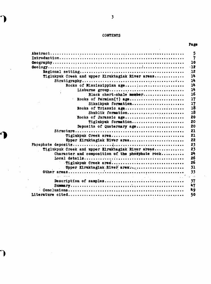
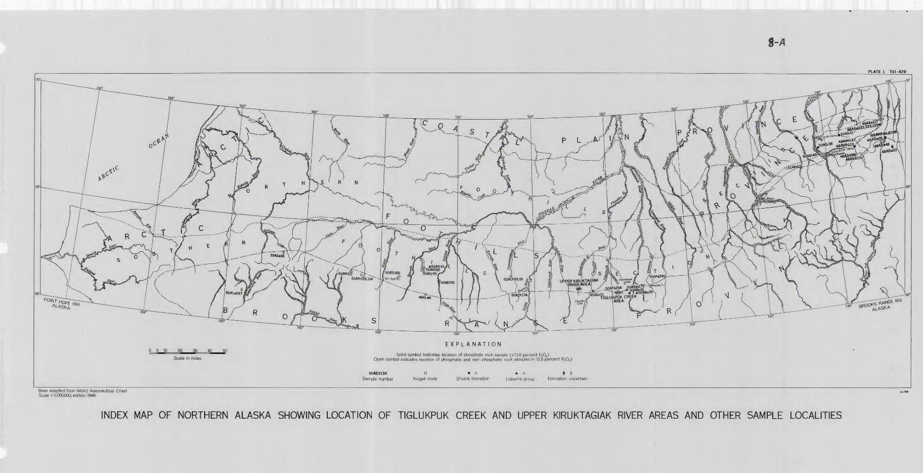
EXPLANATION
Solid symbol indicates location of phosphate rock sample (>13.8 percent P2 O6 ). Open symbol indicates location of phosphatic and non-phosphatic rock samples (<13.8 percent P2 O6 ).
50ADU34 n • o A A • 0Sample number Kingak shale Shublik formation Lisburne group Formation uncertain
152"
Base adapted from World Aeronautical Chart Scale 1:1,000,000; edition 1946
INDEX MAP OF NORTHERN ALASKA SHOWING LOCATION OF TIGLUKPUK CREEK AND UPPER KIRUKTAGIAK RIVER AREAS AND OTHER SAMPLE LOCALITIES
In connection with the U0 S» lavy's investigations of laval
Petroleum Reserve No» **• and adjoining areas, between 19*Mf and 1953,
deposits of sedimentary phosphate rock were discovered on the Arctic
Slope of Alaska 0 The U. S* Geological Survey, as a cooperating agency,
was chiefly responsible for the study and sampling of these deposits.
The analytical work was done by the Geological Survey on behalf of the
Division of Raw Materials, U. S« Atomic Energy Commission. A, E. Glover
of the Alaska Territorial Department of Mines first authenticated the
occurrence of phosphate when he analyzed a prospector's sample from the
upper Anaktuvuk River valley in 19^-8.
Phosphate rock deposits in northern Alaska have been found at widely
scattered localities and in two separate stratigraphic units, the Lls-
tm:m@ group ©f Misslssippian age and the Shublik formation of Triassle
age« The deposits In the Lisburne group in the central Brooks Range
and Arctic Foothills have received the most attention and are the best
known., This report is primarily concerned with detailed studies of
these deposits at two specific localities, the upper Kiruktagiak River
area and the Tiglukpmk Creek area. However, brief notes and analyses
art given of samples collected from the phosphate deposits that have
been found elsewhere on the Arctic Slopeo
The phosphate deposits In the Lisburne group were first sampled by
George 0ryc, U. S* Geological Survey, (personal communication) in
during the course of a boat traverse down the Chandler River. In
phosphate rock was found In the upper Klruktaglak River area by a field
a
party engaged In geologic mapping" along the mDttntaln front aslug
"weasels" famphibious tractors) for transportation (W 0 *T* Patton^ Jr.,
and I, Lo Tallleur, U. So Geological Survey, written conmiunleatlon).
•The following year additional were discovered- near the head
of Tlglukpuk Creek (H. I, Beiser^ w. W. Patton, Jr.* and A, So Keller*
U0 So Geological Survey* written communication). Also In. 195®* deposits
were noted on the Anaktavnk Kiver and at Chandler Lake by a field party
engaged in detailed stratlgraphlc investigations of the Llsbum© group
miing light plane and helicopter (W. P. Brosge1 and H. N. Reiser, U. S.
3eolx>gioal Survey^ written communication).
In 1953 two localities, the upper Ilniktagiak River area and the
Tlglnkpuk Greek area (pi. 1),, were selected for detailed examination
of the phosphate deposits in the Llsburne group. On Jmie J 9 1953,
W, Wo Patton, Jr., and A« L 0 Bowaher landed on the ice at lilhite Lake
in'the Chandler River valley in a "bush plane*' mounted on skiSo They
packed their camping equipment 6 miles acres® the divide to the Kiruk-
tagiak River where a focd sache had been airdropped earlier. Six days
were spent in the area^ 3 of which were devoted to measuring and sampl
ing the phosphate zone on the Klruktaglak River and Monetla Greek. A
total of 42 sampler was collected for analysis* On June 11 the samples
equipment were packed back to White Lake^ and the party was picked
up and returned to the base camp at Umiato
On June 23 fatten and M. ¥. Carson, field assistant^ landed on
latvaknaak Lake in a "bush plane" mounted on floats. They walked 5
miles west to the confluence of Tlglukpuk Creek and Sklmo Creek where
teen cached by airdrop» Field work in the area TOS cut short
by a snow and sleet storm lasting from 'June 2% to July 3* and only 3
xmt of 1C days could be devoted to an examination of the phosphate
deposits. Thirty samples were collected for analysis. On July 4
the nen returned to Hatvakruak Lake and were picked up by plane.
All the samples from the upper Siruktagiak liver and Tiglukpuk
Greek areas were given a rapid field test for phosphate by Mfetcfco
in the tl. 8* Geological Survey laboratory at College, Alaska, ~an$ sub
sequently some of these samples wer© sent to the U. 3. Seoiogleml Survey
laboratory in Washington, B. C., for more refined analyses. In addition
38 selected samples from elsewhere on the Arctic Slope were submitted to
the laboratory in Washington for phosphate and radiometric analyses,
38 samples are from several stratigraphic units, including the
Lisburne group, and were collected between 19^5 and 1951 from widely
scattered localities across almost the entire length of the Arctic Slope,
The sections of this report on character and composition of the
phosphate rock wer© written by John J. Matzko. Kit rest of the report
was prepared by W. W. Patton, Jr., with the aid and advice of other
geologists who have been engaged in the petroleum investigations of
the Arctic Slope, particularly H. M. Reiser, W. P. Brosg4 and A, L*
Bowsher«
GEOGRAPHY
The Arctic Slope of Alaska is subdivided (Payne, 1951) into three
physiographic provinces, the Brooks Range, the Arctic Foothills, and tjie
Arctic Coastal Plain.(See pi, 1«) The Brooks Range province extends
east-west across northern Alaska from the International Boundary to near
Cape Msbume on the Arctic Coast. The Arctic Foothills province adjoins
the Brooks Range province an the north and Is divisible into a Northern
Foothills section and a Southern Foothills section. All known occurrences
of phosphate rock are In the Southern Foothills section and along the
northern margin of the Brooks Range province (pi. 1).
fhe Southern Foothills section has a maximum relief of about 2,000 •
feet and is characterized by scattered groups of irregularly shaped ridges
knobs separated by extensive tracts of gently rolling uplands (pi. ^
The northward-flowing rivers cross the foothills through broad, mature
valleyso The major river valleys are mantled with glacial debris, which
produces an uneven, hummocky, moralnal topography and hundreds of small
lakes. Except for rldgetops and steep declivities, the foothills are
everywhere cloaked by a heavy growth of mosses, lichens, grasses, and
sedges. There are no trees except for patches of stunted willows along
the creek bottoms.
From altitudes of 2,000 to 5,000 feet along the southern margin of
the foothills, the Brooks Range rises abruptly to 5,000 feet at the
western end, 7,000 feet in the central part, and over 9,000 feet near
the eastern end. The larger rivers such as the Kllllk and Anaktuvuk
head near the center of the Range and meander northward through deep,
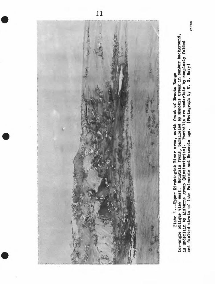
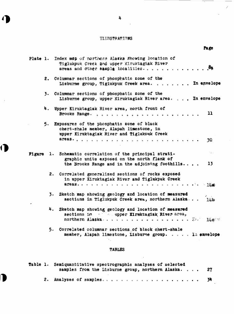
Plate
^.--
Uppe
r Kiruktaglak River
area,
north
fron
t of
Bro
oks
Range
Low-angle
obli
que
view
west.
Moun
tain
front,
para
llel
ed b
y Honotli
Cree
k in
aen
ter background,
is u
nder
lain
by
Lisb
urne
gr
oup
(Mississippian).
Foothills
are
unde
rlai
n by
com
plex
ly f
olded
and
faul
ted
stra
ta o
f la
te Pa
leoz
oic
and
Meso
zoic
ag
e.
(Pho
togr
aph by
U.
S. N
avy)
257UU

flat -floored, U-shaped glacial valleys. Snail Imkes, which are impounded
behind of nominal debris, are common along the valley floors. The
smaller streams such ag Tlglukpuk and Skimo Greeks have not been as ex
tensively glaciated , They head high in the mountains a few miles from
the north front, flow down through steep-walled canyons over cataracts
and waterfalls, and then with an abrupt decrease in gradient meander
out across the foothills. The north flank of the mountains is notably
barren and rugged . Tundra growth extends up the mountain slopes a few
hundred feet but then gives way to bare rock or talus. There are no trees.
Aircraft provide the only practical means of access to this region.
Livengood and Circle, the northern termini of the Alaska road system, are
miles to the south* Fairbanks and the nearest railroad are nearly
miles to the south. The closest settlements with permanent airfield
facilities are Settles, 100 miles to the south, and ttelat, 80 miles to
the north o The phosphate deposits at Tlglukpuk Creek and the Kiruktaglak
River are accessible during the summer from nearby lakes that are suitable
for the landing of a "bush plane" mounted on floats.
REGIONAL SETTING
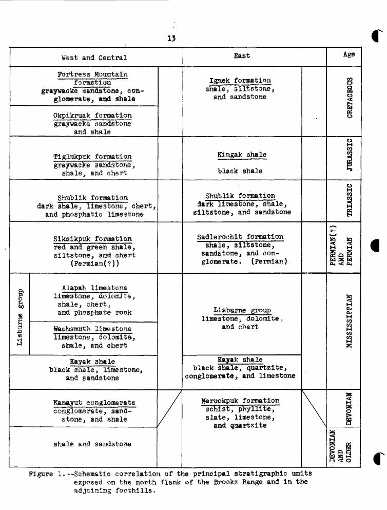
The northern slope of the Brooks Range and the adjoining foothills
are underlain by a thick succession of sedimentary rocks that range in
age from Devonian or older to Cretaceous (fig. 1). The rocks are pre-
Paleozolc in the mountains and Mesozolc in the foothills.
West and Central
Fortress Mountainfomssrtion
graywaoke sandstone; eon- glomerate, mud shale
Okpiknak formationgra'ywacke sandstone
and shale
Tiglukpik formationgraywacke sandstone,
shale , and chert
Shublik formationdark shale, limestone, chert, and phosphatlc limestone
Siksikpiak formationred and green shale, gilts tone, and chert
(Permian(?|)
o. Alapah limestoneg lines-tone s dolomite, f£ shale, chert , c and phosphate rock
§ tiaehsmuth limestone3 limestone, dolomite.^ a shale, and chert
layak shaleblack shale, limestone,
and sandstone
Kanayut conglomerateconglomerate, sand
stone, and shale
shale and sandstone
//
East
Ignek formationshale, siltstone,
and sandstone
Kingak shale
black Bhale
Shublik formationdark limestone, shale, siltstone, and sandstone
Sadlerochlt formationshale, si It stone,
sandstone, and con glomerate. (Permian) -
Lisburne grouplimestone , dolomite ,
and chert
Kayak shaleblack shale, quartzite,
conglomerate^ and limestone
Neruokpuk formationschist, phylllte, slate, limestone, and ^aartzite
\\
Age
8§
o
0 M «1
31
O
CQ
g
c-
*-* M
M(X, PHI
03CQ M «J
M
1
c» 5 o
Figure 1.--Schematic eorrelatioa of the principal stratigraphic unitsexposed on the north flank of the Brooks Range and in the
eastern part of the Brooks Range-Foothills belt, the rocks are
dteformed principally by eastward "trending folds, some of which are
overturned to the norttiu Faults of relatively small displacement
occur locally,, The intensity of deformation Increases westward so
that in the central and western part of the belt Imbricate faults
and large-scale overthrusta are the predominant structural features.
fPYr1 T TtVISTTW r'BOTPlT AUTOi WDDTTB XTTtJTTHW ftf»T AIT 'DTtJIJDIluJUUJLlruE uitaBJi AMU urrJcal HiitOJviAwXAJl ill Visit
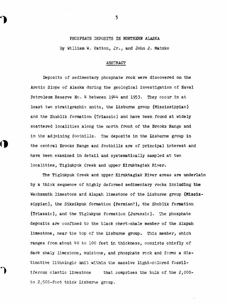
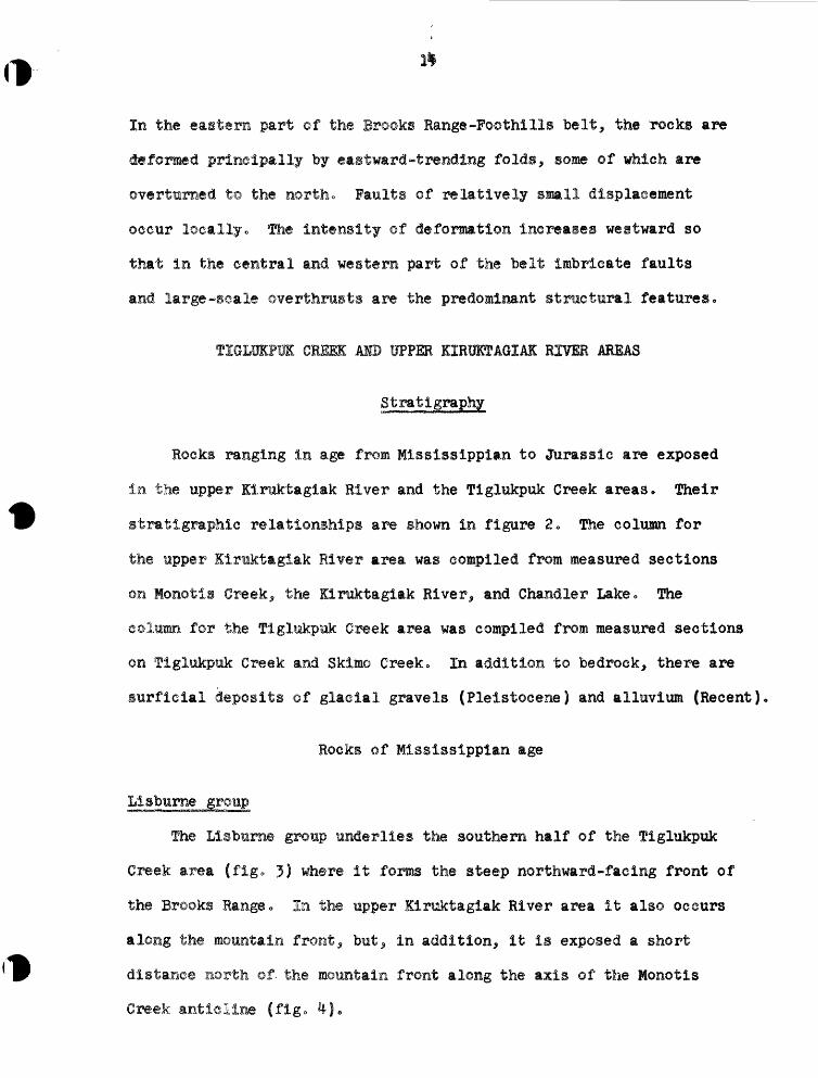
Rocks ranging in age from Mississlppian to Jurassic are exposed
in the upper Klruktagiak River and the Tiglukpuk Creek areas * Their
stratlgraphie relationships are shown in figure 2 0 The column for
the upper Klruktagiak River area was compiled from measured sections
on Monotis Creek,, the Klruktaglak River, and Chandler Lake» The
column for the Tiglukpuk Creek area was compiled from measured sections
on Tiglukpuk Creek and Skimo Creek. In addition to bedrock, there are
§urflcial deposits of glacial gravels (Pleistocene) and alluvium (Recent)
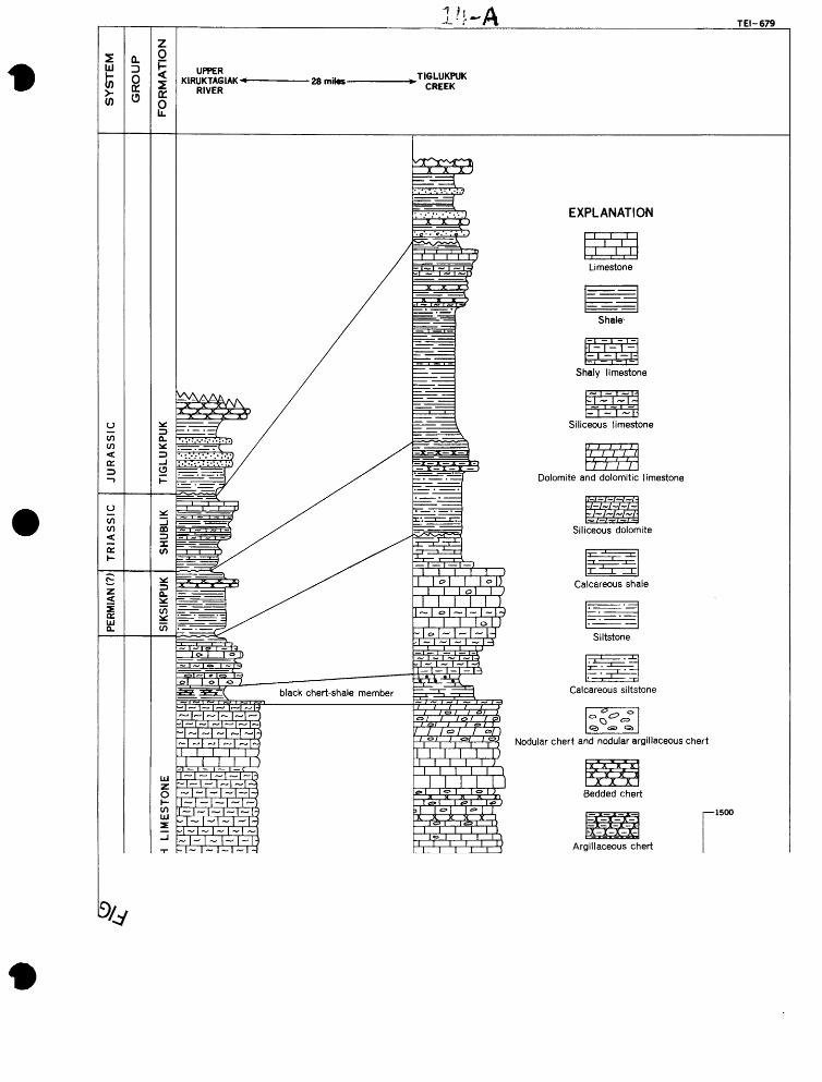
Rocks of Mississlpplan age
The Llsbume group underlies the southern half of the figlukpuk
Creek area (flg« 3) where it forms the steep northward-facing front of
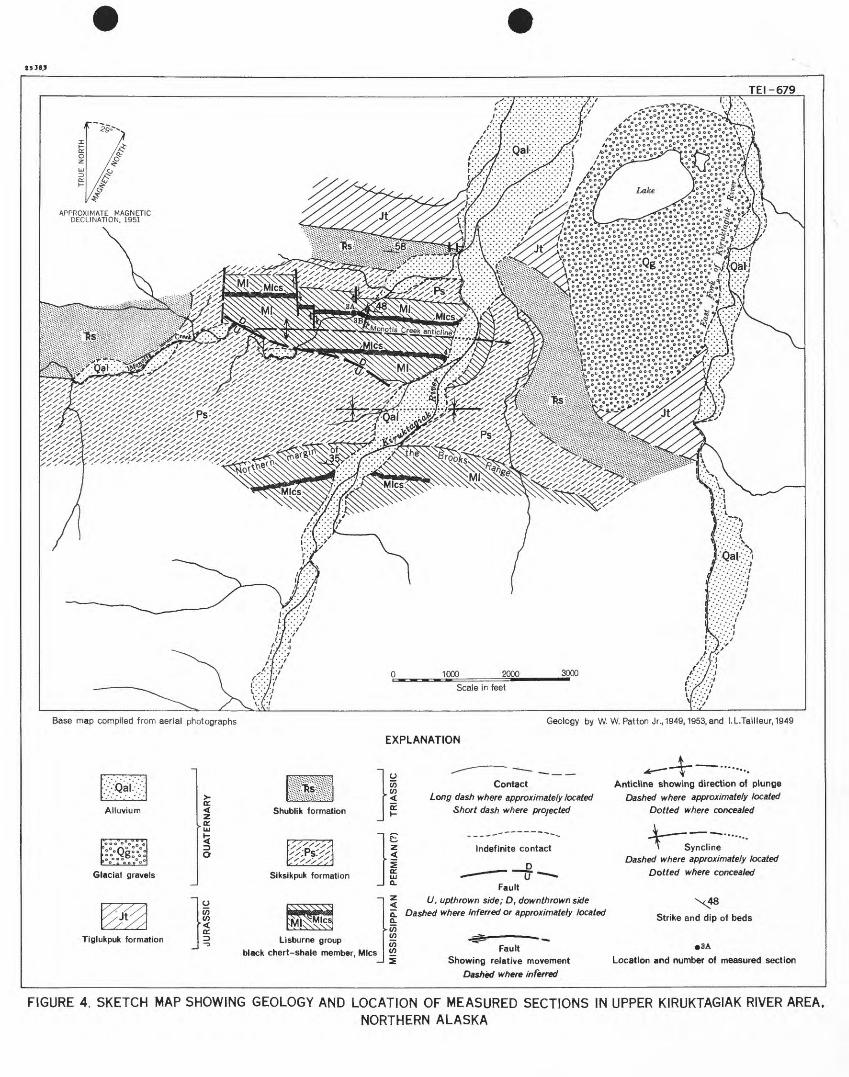
the Brooks Range. In the upper Kiruktaglak River area it also occurs
along the mountain front,, but^ in addition, it Is exposed a short
distance north of. the mountain front along the axis of the Monotis
Creek anticline (fig» *0«

l'J-ATEI-679
Nodular chert and nodular argillaceous chert

(D C
33 m CO m o x "TJ
X o
z (D
(D m
O O
(D Z
O 5 O o z m
J L
J
I
TR
IAS
SIC
JU
RA
SS
IC
QU
AT
ER
NA
RY
J
LM
ISS
ISS
IPP
IAN
P
ER
MIA
N(?
)m
X T3 O
m
oS
o
\
i!?
\5
Q; <
A
(D r- c O
33 m
m 33 Z
O
33 X m 33 z tn
||| ir/
*
a>
5* •
§ of
/
5 g
a /
1. SI
a >
3
aS,
S P
i CD

r
J53BS
TEI-679
X^^ 000 »°C O O ^ O O Of
0 °° °°° ° *"•
Base map compiled from aerial photographs Geology by W. W. Patton Jr., 1949,1953, and I.L.Tailleur,1949
EXPLANATION
Tiglukpuk formation
Contactiong </as/? w/?ere approximately located
Short dash where projected
Anticline showing direction of plunge Dashed where approximately located
Dotted where concealed
Indefinite contact
^^ __ __D
Fault
U, upthrown side; D, downthrown side Dashed where inferred or approximately located
JL————.* SvnclineSyncline
Dashed where approximately located
Dotted where concealed
Strike and dip of beds
Lisburne group —
black chert-shale member, Mlcs ^J S
FaultShowing relative movement
Dashed where inferred
•3A
Location and number of measured section
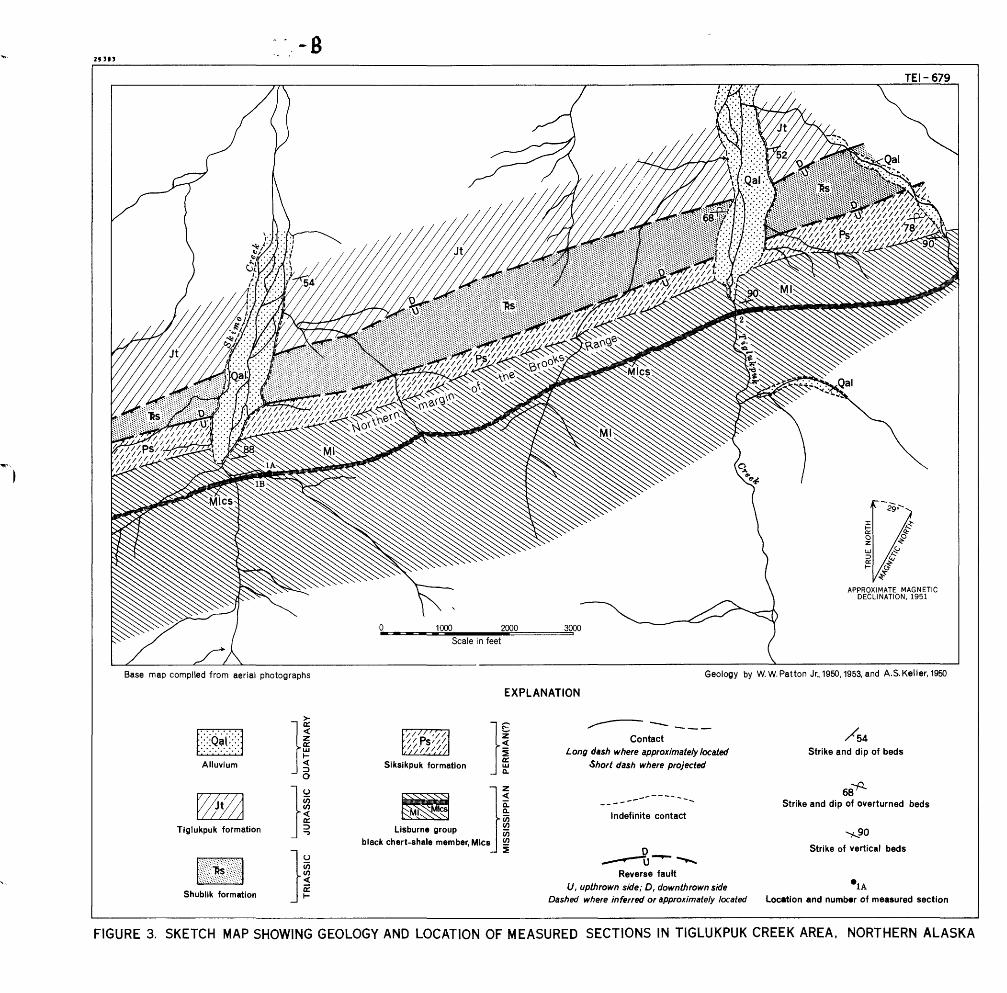
FIGURE 4. SKETCH MAP SHOWING GEOLOGY AND LOCATION OF MEASURED SECTIONS IN UPPER KIRUKTAGIAK RIVER AREA.NORTHERN ALASKA

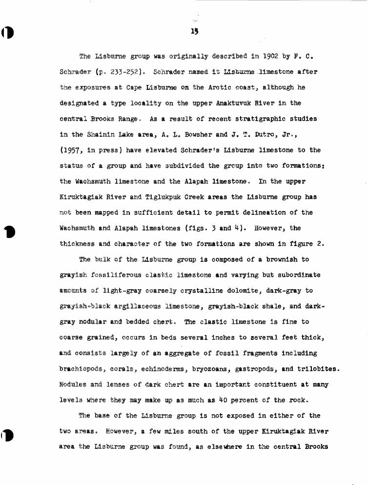
Llsbmnie group was originally described in 1902 by P. C,
Sefarader (p, 233-252)« Sehrader named It ilsfcusae^limestone after
the at Cape Llsburae ©si the Arctic coast, although he
designated a type locality ©n the upper Anaktuvuk River in the
central Brooks Range. As a result ©f recent stratigraphic studies
in the Shalnin Lake area^ A. L» Bowsher and J« T, Dutro^ Jr 0>
(1957* In press) have elevated Schrader's Llsburne limestone to the
status of a group and have subdivided the group into two formations:
the Wachsmuth limestone and the Alapah limestone. In the upper
liruktaglak River and Tiglukpuk Greek areas the Llsbume group has
not been mapped in sufficient detail to permit delineation ©f the
Wachsmuth and Alapah limestones (figs. 3 and 4). However, the
thickness and character of the two formations are shown in figure 2«
The bulk of the Llsburne group Is composed of a brownish to
grayish fossillferous elastic limestone and varying but subordinate
©f light~gray coarsely crystalline dolomite^ dark-gray to
grayish-black argillaceous limestone^ grayish-black shale, and dark-
gray nodular and bedded chert. The clastic limestone is fine to
coarse grained^ occurs in beds several inches to several feet thick^
and consists largely of an aggregate of fossil frapients including
braehi©pods 5 corals, echlnodenss^ bryozoans^ gastropods, and trllobltes.
Modules and lenses of dark chert are an important constituent at many
levels where they may make up as much as 40 percent of the.rock..
The base of the Llsburne group is not exposed in either of the
two areaso However^ a few miles south ©f the upper Elruktaglak liver
area the Llsburne group was found,, as elsewhere In the central Brooks
Range, to rest tipon. the layak shale (Mississippi*?*)* The total thlek~
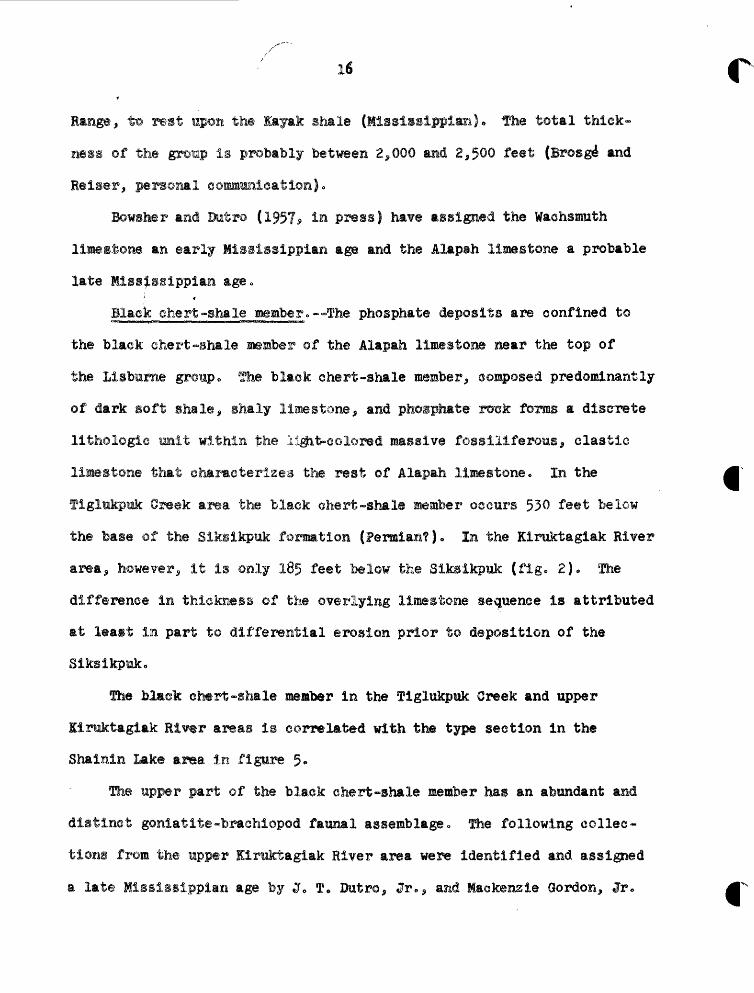
of the group is probably between 2*000 and 2,500 feet (Brosge1 and
Bowsher and Butro (1997* In press ) have assigned the Waehsmiith
limestone an early Mississippi*!! age and the Alapah limestone a probable
late Hiss^ssipplan age.,
Black chert-shale member.—The phosphate deposits are confined to
the black chert-shale member of the Alapah limestone near the top of
the Llsbame group„ The black ehert-shal® member^ composed predominantly
of dark soft shale, shaly limestone, and phosphate xtrek forms a discrete
lithologic unit within the Ij&it-eolored massive fossiilferous^ clastic
limestone that characterizes the rest of Alapah limestone* In the
flglttkpmk Greek area the black chert-shale member osemrs 530 feet below
the base of the Sikslkpuk fonnmtion (Permian?). la the Klruktaglak River
area^ however, it is only 185 feet below the Slksikpuk (fig. 2). The
difference In thickness ©f the overlying limestone sequence is attributed
at least IE part to differential erosion prior t© deposition of the
Sikslkpak.
The Mmek chert -shale member in the figlukptak Greek and upper
limktagiak Rlwr areas is correlated with the type section in the
Shalnln Lake area in figure 5.
The upper part ©f the black chert-shale member has an abundant and
distinct goniatlt©»brachlopod faunal assemblage 0 The following collec
tions from the upper lirmktagiak River area were identified and assigned
a late Mississippian age by J 0 T* Dutro 5 Jr<^ asid Mackenzie Gordon^ Jr*
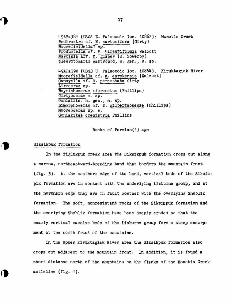
1 E. Paleozoic loo. 10862); Monotls Hudirostra of. !<> oarbonlferm (Glrty)
RC gen., n. sp.
Paleozoic loo. 10864): Kiruktagiak River
Caneye1la of. Co pereostata Olrty
Rocks of Permlan(?) age
Slkslkpnk formation
In the flglmkpuk Greek area the Slksikpuk formation crops out along
a narrow, nortfeea^tward-trending band that borders the mountain front
(fig. 5)o At the southern edge of the band, vertical beds of the Slksik
puk formation are la contact with the underlying Llsburne group, and at
the northern edge they are in fault contact with the overlying Shublik
formation-, The soft> nonreslstant rooks of the Sik&Skpuk formation and
the overlying Shablik formation have been deeply eroded so that the
nearly vertical mwlve beds of the Lisburne group form a steep escarp
ment at the north front of the mountains.
In the Mpper Ilraktagiak River area the Slksikpuk formation also
crops out adjacent to the mountain front» In addition, it is found a
short distance north ©f the mountains on the flanks of the Monotis Creek
Siksikpuk formation derives its name from the Siksikpuk River
of union figlakpuk Creek is a aajor tributary* The type locality Is on
figlukpak Creek and Skimo Creek (Fatten* 1957* in press}..
The chief components ©f the Sikslkpuk formation are variegated shale
and siltstone that, locally* are notably calcareous* eherty* or ferruginous.
There are all gradations from thin, fissile ©lay shale through platy* silty
shale to 6~ineh beds of siltstone„ Shades of green* gray,, and dark red are
predominant roek solorso The variegated nature of the fresh rock and
bright yellow and red weathering of the ferruginous beds serve to
even at a distance,-the Siksikpuk formation from the gray
In the Tiglukpusk 3reek area the Siksikpuk formation i$ about 350 feet
Slksikpuk formation lias bee:a assigned tentatively tc the Permian,
based upon a eoral^ brachiopod, and gastropod faunal assemblage from the
Shablik forsation
In the Tiglnkpisk Greek area the Shublik formation bounds the Siksikpuk
fonsation on the north and crops out aloag a narrow^ northea3tward->trending
band (fig, 3)» In the upper liruktaglak River area it crops out in a narrow
band which swings north from the mountains at the eastern si4© of the area,
wraps around the eastward-plunging end of the Monotig Ci»@ek anticline, and
19
then trends westward along the north flank ©f the Monotis Creek anticline
(figo l*), Like the Siksikpuk formation, the Shublik is not resistant to
erosion and is characterise tie ally expressed at the surface by subdued
topography *
The Shublik formation was originally described and named by £• de K.
Leffingwell (1919, p- 115-118) in the Canning River region of the eastern
Brooks Range, Because of its remarkably uniform and distinctive lithology
and the abundance of diagnostic fossils, it can be mapped and correlated
over most of northern Alaska with confidence.
The Shublik formation is composed principally of highly carbonaceous,
grayish-black shale, chert, and limestone* The dark color distinguishes
it from the variegated roaks of the underlying Siksikpuk formation. In
the Tiglukpuk Creek and upper Kiruktaglak River areas the Shublik forma
tion can be subdivided into three members: (1) a lower member of black,
gray, and greenish-gray shale with minor Intercalated dark limestone;
(2) a middle Member of dark siliceous limestone, blaek paper shale, and
dark, calcareoiui shale; and (3) an upper member of dark, fossiliferous
limestone capped by dark shale. The lower member is about 100 feet thick
in the upper Kiruktagiak River area but- over 5^0 feet thick in the figliicpuk
Creek area 0 The middle and upper members are approximately the same thick
ness in the two areas, that is, 130 to 150 feet and 60 to 80 feet respectively.
The lower member has an ammonite-pelecypod fauna which has been dated
as early Middle Trlassic by Beruhard Kunroel (personal communication,
April 7^ 1952)0 The middle and upper members have a typical Late Trlassic
assemblage including Monotis suboircularis (Sabb) and Ralobia.
fli@ Tlglukpak formation crops oat along the northern edge of the
upper Itnktaglak liver and the Tlglnkpuk Creek areas (figs.. 3 and 4),
It is exposed In cutbacks along Sklmo Creek 5 figlukpnk Creek^ and the
limktagiak River. In the Interstream areas it is typically expressed
at the surface by discontiguous* low^ rubble-covered' ridges.
The type geetioa and type locality of the Tigliakpuk formation
(Patton, 1956* P« 213-218} are oa ?iglukpuk Greek 2 to 3'miles morth
&f the mapped af^a (flg» 3}"
Probably not more than the basal 400 feet of the nearly 1,500-foot
thick figliikp-ok formation is exposed la either the upper Itrarbagiak or
Yigliakpuk Greek areas (fig. 2). 2his basal section rests dlvcYmformably
the Shublik formation a^d is eoxpoeed dominaiatlj of gre'eniste-gray
^ d&rk-gray shale and silts^one, variegated shale and slltstone,
The figlttkpmk formation include3 rocks of bot|i Middle and Late
Jurassic ag@ 0 fhe Middle &arasslo rocks are limited in areal distribu
tion ©n the Arctic Slope, fhe bmlk of the formation* including the ex
posures in the Tiglttkpak Oreek and upper Kiraktaglak River areas, is
Late Jurassic in ag» 0
Deposits of Quaternary age
fhe northeasters! eoraer of the t$pp©F Klruktagiak River area is
mantled by glacial gravel that appears to have been derived chiefly
from the Paleozoic rooks of the Brooks Range» These deposits are
largely obscured by a heavy growth of tundra; however* their distribution
Is outlined by low morainal ridges and disrupted drainage,
Horth of the nountaln front stream gravels fill the valleys of the
Kirnlrtaglak River, the east fork of the Ilrmktagiak Kiver^ Tiglukpmk
streams leave the mountains has ca»ed the valleys to become choked with
gravel, and the streams have been diverted Into a network of braided
Structure
Tlglttkpuk Creek area
The rocks ©f the ftglukpmk Creek area lie along the north flank
of a broads eastward-trending anticline 0 The axis is located about a
mile of the southern edge of the mapped area (tig, 3). At the
mountain front the JLisbume group stands vertically or nearly vertically
and strikes f 0 75® Eo For the most part, the massive Llsbtarne group is
free from minor folds and faults. North of the nouataln front, however,
the less competent Slksikpuk, Shublik, and Tlglukpuk formations have been
intensely crumpled and broken* The faults, most of which have relatively
small displacement, have not been shown on figure 3 except for the two
reverse faults along the contact of the Slksikpuk and Shublik formations
and along the contact of the Shublik and figlukpuk formations. At the
mountain front the strata dip principally southward, although north from
the front the succession ©f progressively younger rocks indicates a north
ward regional dlp 0 This is the result of isoclinal folds that are overturned
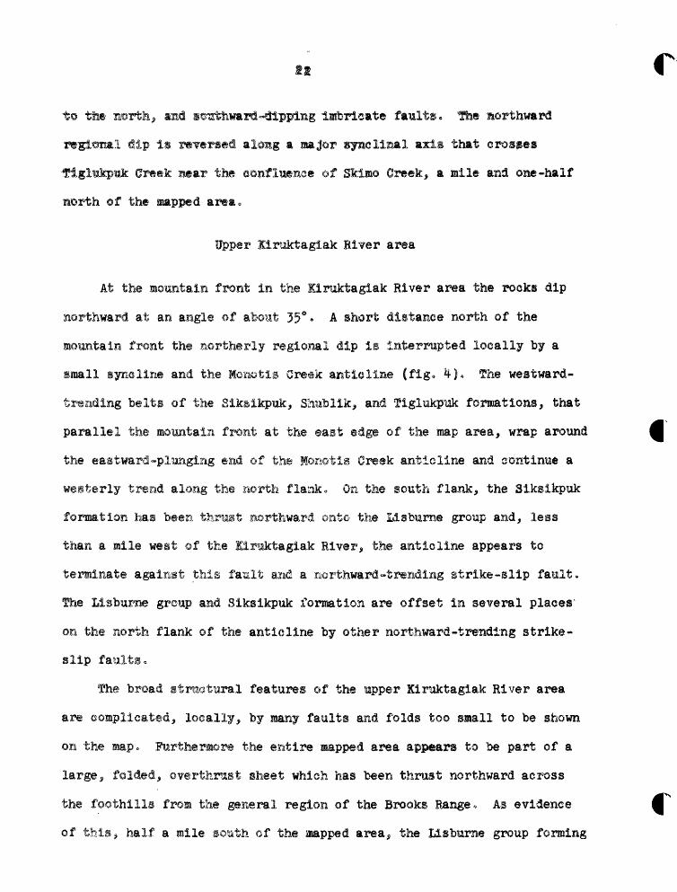
to tfae naorth^ and s&gMumrd«dipping Imbricate faults, the northward
regional dip is reversed along a ma$&p synclinal mxis that crosses
•figliakpmk Cr«ek Btar the confluence of Skiaao Creek, a mile and one-half
Upper liraktaglak RiYer area
At the mountain front in the llruktagiak River area the rocks dip
northward at an angle of about 35°« A short distance north of the
mountain front the northerly regional dip is interrupted locally by a
small syneline and the Monotia Greek anticline (fig. 4-J. The westward-
trending belts of the Siksikpiik, Shublik, and flglukpnk formations, that
parallel the mountain front at the east edge of the map area, wrap around
the eastward-plunging of the Monotis Creek anticline and continue a
westerly trend along the north flank. OR the south flank, the Sikslkpuk
formation has been thrust northward onto the Lisbmme group and, lees
than a mile weat ©f the Klruktagiak liver, the anticline appears to
terminate against this fault and a northward-trending strike-slip fault.
The Lisburae group aad Siksikpuk formation are offset in several plaoes'
on the north flank of the anticline by other northward-trending strlke-
slip faultso
The broad strmotiiral features of the upper Kiruktagiak River area
are oomplicated, locally, by many faults and folds to© small to be shown
on the mapo ftartheraore the entire napped area appears to be part of a
large, folded, owrtferast sheet which has been thrust northward across
the foothills from the general region of the Brooks Hangeo As evidence
of this, half a mile south of the Mapped area, the Ilsbttrne group forming
the north flank of the mountains has been eroded away^ revealing
AID KXBOTAQIAK AK1AS
In the upper finsktaglak River and figlukpuk Creek areas the
phosphate deposits occur in the middle and upper parts of the black
chert-shale member of the Alapah limestone, Lisbume group (fig. 5)«
Columnar sections, lithologic descriptions 5 P2%* ^Oc and equivalent
uranium analyses are given on plates 2 and 3 for those parts of the
black chert-shale member that were logged and sampled in detail. The
rocks comprising the phosphatic zone are composed chiefly of a aajixttBpe-
of phosphate mineral^ calcium carbonate, silt and clay. Depending upon
which is the predominant somponent^ they are called phosphate rock*
limestone^or mudstone fas used here mudstone includes shale, slltstone
and elaystonejo The common rock names are modified by the adjectives
phosphatlCj calcareous, or argillaceous if one or both of the other
principal components are present in appreciable amounts.
Because of the necessity for back-packing the samples several miles
to a place where they could be picked up by an airplane, the number and
weight of the nanples were limited.. Only those parts of the black chert-
shale member that appeared t© be phosphatlc were sampled. The samples
weighed about 1 pound each and consisted of representative chips from
each bed or Interval ©f similar lithology. In those parts of the section
where two different rock types occur in thin alternating layers, only one
representative sample of each type was collected.
All 8l samples collected in the upper Klruktagiak River and
Tiglukpuk Greek areas were tested for PgOc content and equivalent
uranium. Twenty of the samples were analyzed for P20^ in the U. S«
Geological Survey laboratory in Washington, D. C.,by accurate labora
tory methods. The rest were analyzed by a simple field test (Shapiro,
1952) by the U. S» Oeological Survey at College, Alaska. According to
Shapiro the simple field test for phosphate is capable of an accuracy
to the nearest 5 percent.
Character and composition of the phosphate rock
The phosphate rock is dark gray or black; but, where it has been
exposed, it weathers light gray or brown and generally is coated with a
characteristic bluish-white bloom. Occasionally secondary purple fluorite
is visible on bedding surfaces and in veinlets* Thickness of beds ranges
from a fraction of an inch in the highly argillaceous rock to 2 feet in
the highly calcareous rock,
The texture of the rock is usually pelletal, that is, granular,•
oolitic,or pebbly. The size of the pellets is generally between 0.1
mm and 2 mm but way be as much as 10 mm. Most of the pellets are ellipti
cal and oriented with the long axis parallel to the bedding plane. Some
of the pellets, however, are fragmented and disoriented, and many contain
caleite veinlets. This suggests some post-depositional movement and
crushing. In thin section, the concentric structure is indicated in some
of the phosphatic pellets by alternating light and dark-brown rings due
to variations In the carbonaceous content, but most of the pellets do not
show any recognizable structure. Ho nuclei have been identified in them.
In this report phospiiatlc samples are classed as phosphate rock
if they contain more than 13*8 percent ?2®5 • ^ tne^ contain less than
13° 8 percent but more than 5 percent P2®c 5 the adjective phosphatlc Is
applied to the common rock name, i.e.,, phosphatlc mudstone, phosphatlc
limestone„
Samples of the Llsburne group phosphate rock were examined by X-ray
analysis s and the phosphatlc pelletal material was identified as a carbonate
fluorapatlte. The d-spaelngs are similar^ in general, to those of the
phosphate mineral from the Phosphorla formation in the northwestern part
of United States (R. A. Gulbrandson, personal communication). The apatite
in the Alaskan phosphate rock is generally either oolloform or crypto-
erystalline, isotropic appearing, and usually highly stained by carbona-
tnl t~tca TSQ 1 & $ i^atwir •% f 4 curi 4 v» "hVsa oawml e»«£ 5ill.nt? i clj.gs JLUcriw JL J. JLctis ill l»ilc kj<a.JHpi5;ffl>
fluorlte, and qwartEio All the samples contain these minerals in varying
amountso Calcite oeours as secondary large clear crystals with prominent
twinning^ as small grains interstitial to the phosphate,, and as a secondary
filling or replacement in shattered pellets. Some specimens contain dolo
mite rhombs. Most of the samples contain purple and colorless fluorlte as
(1) veinlets cutting the phosphate pellets, (2) blebs In the center of the
pellets and frequently closely related to carbonaceous matter > or (31 between
the pelletso In this latter case, veinlets of phosphatic or carbonaceous
matter generally are associated with the flue-rite „ The quartz is most
commonly fine-grained, angular to subrounded* and is dispersed throughout
the phosphate pellets or confined to interstices between the pellets.
- - Speotrographlc analyses of a few selected isopies indicate that
the phosphate rock from the Listourne group contains as many as 30
different elements besMeg fluorine and uranium* The results of these
analyses are shown In table lo
Preliminary investigation of the phosphate rock from northern Alaska
shows a probable relationship of the uranium* phosphate and organic content.
Thompson (1953) has demonstrated that the uranium content of the Fhosphoria
formation of Idaho, Wyoming^and Utah shows a stronger relationship to the
product of the phosphate and organic content than to either one separately,
but that singly the correlation' with phosphate content is better than the
correlation with organic content. A similar relationship appears to exist
in the phosphate roeks of the Lisburne group.
To determine the distribution of radioactivity in the phosphate rock
©f the Lisbume group, exposures with nuclear emulsion film were made of
the nor© radioactive samples« The film was exposed for periods up to 60
days, but this maximum exposure was evidently-insufficient, because no
alpha tracks, which indicate the presence of radioactive material, were
Local details
figlukpuk Creek area
In the Tiglukpuk Greek area the black chert-shale member of the
Alapah limestone occurs along a narrow Ho 75° £„-striking belt a short
distance south of the mountain front (fig. 3). Exposures are found along
Tiglukpuk Creek, _Skimo Creek, and the small tributaries. Owing to its
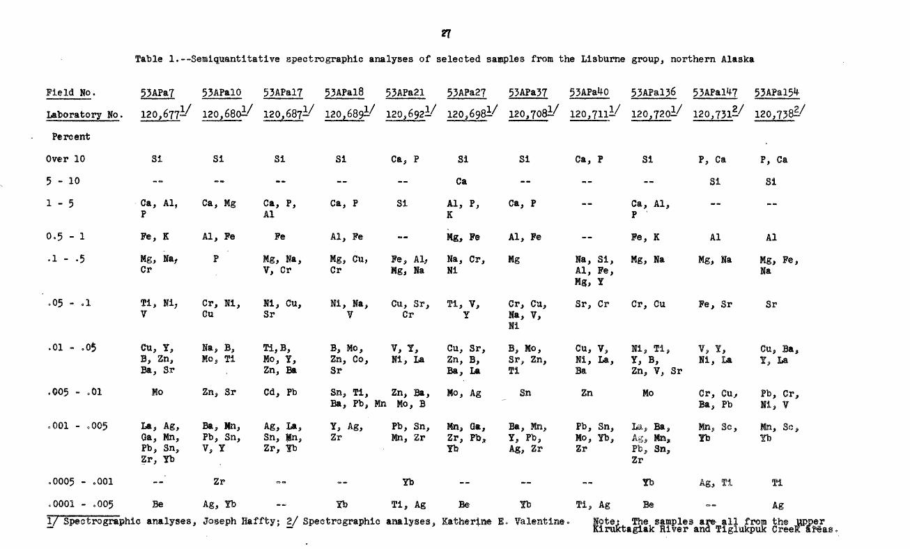
Table 1.—Semlquantitative spectrographic analyses of selected samples from the Lisburne group, northern Alaska
Field No.
Laboratory No.
Percent
Over 10
5-10
1 - 5
0,5 - 1
.1 - .5
o05 - *l
.01 - ,05
,00$ - .01
.001 - ,005
.0005 - .001
cOOOl - ,00$
53APa7 53APalO 53APal7 53APal8 53APa21 53APa27 53APa37 53APa*fO 53APal3o 53APal^7 53APal5*f1 / 1 / 1 / 1 / 1 / I/ I/ 1 / I/ 5> / 5*
120, 677^' 120,680i' 120,687-' 120,689=.' 120,692-' 120, 698^' 120,708^' 12Q,71li' 120,720-' 120,731-' 120,738^
31 31 Si Si Ca, P Si Si Ca, P Si P, Ca P, Ca
Ca — — — Si Si
Ca, Al, Ca, Mg Ca, P, Ca, P Si Al, P, Ca, P — Ca, Al, P Al K P
Fe, K Al, Fe Fe Al, Fe — Mg, Fe Al, Fe — Fe, K Al Al
Mg, Na, P Mg, Na, Mg, Cu, Fe, Al, Na, Cr, Mg Na, Si, Mg, Na Mg, Na Mg, Fe, Cr V, Cr Cr Mg, Na Ni Al, Fe, Na
Mg, Y
Ti, Ni, Cr, Ni, Hi, Cu, Ni, Na, Cu, Sr, Tl, V, Cr, Cu, Sr, Cr Cr, Cu Fe, Sr Sr V Gu Sr V Cr Y Na, V,
Ni
0u, Y, Na, B, Ti,B, B, Mo, V, Y, Cu, Sr, B, Mo, Cu, V, Ni, Tl, V, I, Cu, Ba, B, Zn, Mo, Tl Mo, Y, Zn, Co, Hi, La Zn, B, Sr, Zn, Ni, La, Y, B, Ni, La Y, La Ba, Sr . Zn, Ba Sr Ba, La fl Ba Zn, V, Sr
Mo Zn, Sr Cd, Pb Sn, Ti, Zn, Ba, Mo, Ag Sn Zn Mo Cr, Cu/ Pb, Cr, Ba, Pb, Mn Mo, B Ba, Pb Hi, ?
La, Ag, Ba, Mn, Ag, La, Y, Ag, Pb, Sn, Kit, ®a, Ba, Mn, Pb, Sn, La^ Ba, Mn,, Sc, Mn, So, Ga, Mn, Pb, Sn, Sn, gn, Zr Mn, Zr Zr, PbA Y, Pb, Mo, Yb, Ag, !te, Tb Yb Pb, Sn, V, Y Zr, fb Yb Ag, Zr Zr Pb, Sn, Zr, Yb Zr
Zr — -- Yb — — — Tb Ag^ Ti Tl
Be Ag, Yb Tb Ti, Ag Be Yb Ti^ Ag Be — Ag
I/ Spectrdgraphlc analyses, Joseph Hafftyj 2/ Spectrographic analyses, lather^ae E» ¥al@ntin@ The samples are all from the upper ;aglak Elver ana Tiglukpuk Creel areas

nonresistmnt nature the black chert-shale member 'does not crop out in
the interatream areas. It can be traced, however, by a series of saddles
and trenehlike depressions across the mountainous ridges of the more
resistant limestone (pi. 5C)° On Skimo Greek the black chert-shale member
is nearly 100 thick. It is overlain by massive siliceous limestone
and underlain by magsive dolomitic limestone. The base of the member is
marked by a 6-foot ledge of ahert (fig. 5)»
phosphatic ©f the black chert-shale member was logged and
in two places (fig. 3). Section I (pi. 2) occurs on a small
tributary ©f Skimo Greek where the entire black chert-shale member is
exposed along steep canyon walls. Part IA is on the northeast side of
the stream and part IB lies directly opposite on the southwest side. The
phosphatie zone is approximately 36 feet thick. Forty-six beds comprising
phMphatic zon& in section I were sampled. A 4-3-inch sequence of beds
16 feet below the top averages 21 percent P^OK and .008 percent eU, and
six beds, from 1 to 5=5 inches thick, containing 30 percent PgOc and from
cOlO percent to .017 percent eW occur In the upper 20 feet.
Section II (pi. 2) was measured on the east side of Tiglukpuk Creek,
about lj miles east of Skimo Creek, fhe phosphate zone here is poorly
exposed, so the measured section as shown on plate 2 is not complete.
fwenty»five beds were sampled. Pour beds, from 2 to 9«5 inches thick
and containing 30 percent P2®5 and from .011 percent to .020 percent eU,
occur in the upper 15 feet; and one bed, 4.5 inches thick, of 22 percent
PpOe and .013 percent eU, occurs 16 feet below the top of the section.
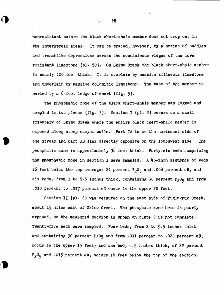
29
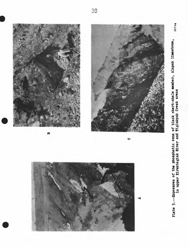
EXPLAKATX01 OP PLATE 5
Ao Looking east toward valley of Klruktagiak River in background.
Black abert-shale member, Alapah limestone (Hac) on north flank
of Monotis Creek anticline. A9 location ©f measured section
III A, and BS location of measured section III B (pi. 3) near
center of picture.
B» Exposures ©f interbedded phosphate rock and phosphatlc limestone
in the black chart-stale member, Alapah limestone, at locality of
measured section IV (pi. 3) on Kiruktagiak River,
Co Looking west at an exposure of black chert-shale member, Alapah
limestone in flglukpuk Creek area near locality of measured section I
(pi. 2}» The dark, nonreslstant beds at the top ©f the black chert-
shale member on the left are overlain by massive ledges of light-
colored limestone on the righto Strata dip very steeply north.
Saddle on ridge in background Is underlain by black ehert-shale
member.
B
CO
€D
Plate 5.
—Exp
osur
es o
f the
phos
phat
ic z
one
of bla
ck c
hert
-sha
le «
e»be
r, A
lapa
h llnestone,
in t
ippe
r Ki
mkta
glak
Riv
er and
Tiglukpuk C
reek
are
as
5 *

31
El on plate 2« It is not possible, however, t© make a be"d~for~bed
correlation even though the two sections are only li miles apart. This
may be to fades changes and to lensing out of certain bets. Some
limestone beds 5 for example, were observed to pinch out In a few feet.
It may also be due In part to discrepancies in measurement and descrip
tion of section II as a result ©f the poor exposure.
The black chert ~s!ial@ member ©f the Alapah limestone In the upper
Kinaktagiak Bl¥@r area occurs on both flanks of the Monotis Creek anti
cline and also 2^000 feet t© the south within the belt of Lisrburne group
that forms the north front ©f the motsntains (fig* ^). Outcrops of the
black etert-shale are found on Monotls Greek and along the west bank ©f
lirmktaglak Ii¥er5 but the complete sequence is'not exposed at any
one locality* A composite ©f several partial sections indicates that
the total thickness of the black chert-shale member in this area is
approximately 60 feet, Tfee base of the member is marked by a resistant
8-foot ledge ©f dark chert that overlies a sequence of massive light-
colored fossiliferotts^ elastic limestone. The topmost beds of the member
are overlain by a resistant 17-inch bed of light-colored dense limestone.
Two sections of the pho^pfeatic zone of the black chert-shale member
were sampled and logged in the upper Kiraktagiak River area* Section 111
shown on plate 3 Is located on Monotlg Creek on the north flank of the
Monotis anticline about 2^000 feet west ©f the Kiruktagiak River.
Fart A ©f section 111 is on the west side of Monotis Creek and part B
is opposite part A ©a the east side (plo 5A) 0 Fifty-five beds of section
III were sampled. The uppr 19 feet of the section averages 1$ percent
PgO^ and .009 percent e¥* including one 27-inch sequence containing 2J
percent P20c and 0 009 percent eU, 16 feet below the top»
Section IV shown on plate 3 is on the south flank of the Monotis
Creek anticline on the Kiruktagiak River. Twenty-two beds were sampled.
The upper 37 inches of the sampled beds averageB 25 percent ?2®5 and
.01^ percent eU> and the top 13 feet averages 17 percent P2©5 and .007
percent ePo
Some lines of correlation are indicated between sections -III and I?
on plate 3° However, the two sections cannot be correlated bed-far-bed,
in spite ©f the fact that they are only 2,000 feet apart« As is the ease
in the Tlglukpuk Creek area,, this may be due in part to the lenticular
nature of the strata. It may also be due in part to discrepancies in
measurement resulting from small faults and folds. Evidence of crumpling
and bedding plane movement was found in bed 26 in section III and in bed
95 in section IV.
Most beds in sections 111 and I? were tested in the field for calcium
carbonate with dilute HClo Section III on the whole appeared to have a
substantially lower calcium carbonate content than section IV. This may
be the result of leaching„ fhe rocks in section III appear to be slightly
weatheredo At section IV 9 however, they are being actively eroded by the
river and are fresh°
33
19*Mt> and 1953 all the stratlgraphie units shown In figure 1 were examined
criticallyo Hundreds of rock specimens were collected from all parts of
the stratigraphlc ^accession across almost the entire length of the Brooks
Rang®-foothills belt. Thirty~eight of these were selected for eliemical
and radiometric analyses for phosphate and equivalent uranium. Only 11
proved to be phosphate rock(more than 13.8 percent PgOjl however, all 38
are described on the following pages and are located on plate l.
These data, although largely negative, outline in a general way the
extent of the phosphate deposits of the Lisburne group in the central
Range-foothi11s belto They also indicate the possibility that
significant phosphate deposits occur in the Shubllk formation in the
eastern Brooks Range.
Eighteen of the samples are from the Lisburne group, 15 are from
the Shublik formation, and 1 is from the Kingak &hale. fhe stratigraphlo
position of % samples is uncertain. The samples are listed on the f©Haw
ing pages together with the field notes of the collectors. Six of the
samples have been examined In thia section under the petrographic micro
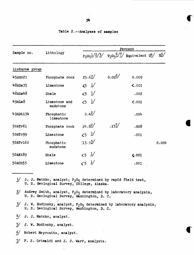
scope o results of the phosphate and radiometric analyses are given
£ o «••
Sample no»
Llsburne group
45Adr21
48ASa55
48ASa48
49ALa8
Wl51f
50ATr6l
50ATr99
50ATrl60
50AIt89
50ACh53
Lit ho logy
Phosphate rock
Limestone
Shale
Limestone andaittdstone
Phosphatie limestone
Phosphate rock
Limestone
Phogphatie muds tone
Shale
Limestone
PaOjl/S/i/ v2
25o6i/ Oo
<5 I/
<5 y<5 y*.*/
24 0 8i/ .:
<5 y•to.*/
<s y<5 I/
Percent
0c~/!/ Equivalent uJt/ U.2/
02^7 Oo009
<o001
c002
<o001
,004
III/ o008
.001
0.00*
<o001
.001
j/ J. J. Matzko, analyst; P20^ determined by rapid field test, U. S, Geological Survey, College, Alaska.
£/ Audrey Smith5 analyst, f2Q^ determined by laboratory analysis,U, S» Geological Survey, Washington, Do C,
2/ J« WP Budinsky, analyst, P20e determined by laboratory analysis,U 0 So Geological Survey, Wasnington, D. G.
V J« Jo Matzko, analyst.
j?/ J 0 W 0 BMdinsky 5 analyst *
6/ Robert Meyrowitz, analyst.
7/ Fo S. Grimaldi and J e J 0 Warr, analysts.
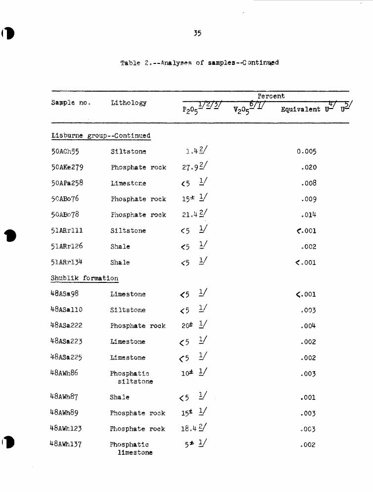
fable 2o—Analysea of samples--
Sapple n
Lieburne
50ACh55
50AIe279
50APa258
50AB076
50ABo?8
51ARrlll
51ARrl26
51ARrl34
Shublik
48ASallO
48ASa222
48ASa223
48ASa225
48AWh86
48AWh87
48AWh89
48AWil23
48A¥hl37
10 0 Llthology
i group --Continued
Si It stone
( Phosphate rock
! Limestone
Phosphate roek
Phosphate rock
Siltstone
Shale
Sh&l©
formation
Limestone
Slltstone
Phosphate rock
Limestone
Limestone
Phosphatisslltstone
Shale
Phosphate rock
Phosphate rock
Phosphatlc
P2o5
1»4
27,9
<5
15*
21,4
<5
<5
<5
<5
<5
20*
<5
C510*
<515*
18.4
5*
~" ^
&
ii/
I/
vi/i/T /±iv
yi/i/i/i/i/i/i/2/
I/
PercentV7/ V !?<- - Equivalent Bh- IJ—
0.005
.020
.008
.009
.01*
C001
-002
<o001
<.001
,003
.004
.002
.002
.003
.001
.003
.003
»002limestone
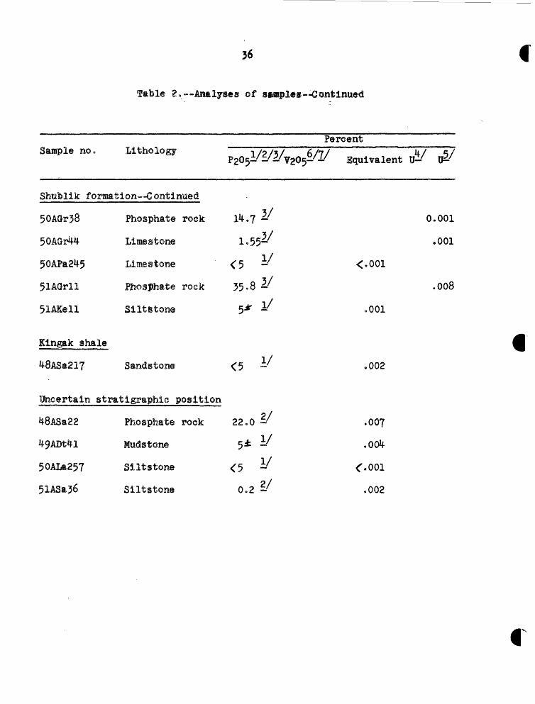
Table 2.—Analyses of ss^ples—Continued
Sample no 0 Lithology 1/2/3/
Shufelik formation— Continued
50AGr38 Phosphate roek 1%.7 -
50AGi44 Liiaestone 1«55~
50APa245 Limestone <5 -
51AOrll Jhosjttiate rock 35-8 -'
51AKell Siltstone 5* ^
Kingak shale
48ASa217 Sandstone <5 -'
Uncertain stratigraphlc position
48ASa22 Phosphate rock 22,0 -'
%9ADt^l Muds tone 5^ ~
50ALa257 Siltstone <5 i/
51ASa36 Siltstone 0.2 -/
Percent6/7/ 4/ 5/ >0^-/i/ Equivalent 0— U^
0.001
.001
<.001
.008
oOOl
.002
.007
<.001
.002
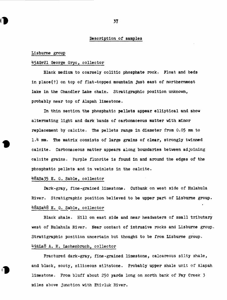
37
rescriptIon of samples
Cteorge Qrycj collector
Black medium to coarsely oolitic phosphate rock. Float and beds
in plae«(?) on top of flat-topped mountain Just east of northernmost
lake in the Chandler Lake chain. Stratigraphic position unknown,
probably near top of Alapah limestone.
In thin section the phosphatic pellets appear elliptical and show
alternating light and dark bands of carbonaceous matter with minor
replacement by eaieite* -the pellets range in diameter from 0.0$ mm to
1.4 urn. The matrix consists of large grains of clear^ strongly twinned
calcite. Carbonaceous matter appears along boundaries between adjoining
caleite grains . Purple fluorlte is found in and around the etJges of the
phosphatic pellets and ia veiniets in the calcite.
Q Qo Sable, collector
Bark-gray,, fine -grained limestone. Cutbank on west side of Hulahula
River o Stratigraphic position believed to be upper part of Iiisburne group.
jjfiASaWj £• a. Sable, collector
Black shale o Hill on east side and near headwaters of small tributary
west of Hulahula River <> lear contact of intrusive rocks and Lisburne group ,
Stratigraphic position uncertain but thought to be from Lisburne group .
Ao Ho Lachenbruch, collector
Fractured dark-gray, fine-grained limestone, calcareous silty shale,,
and black, sooty, siliceous slltstone. Probably upper shale unit of Alapah
limestone* From bluff about 250 yards long on north bank of Pay Creek 3
miles above junction with Etivlok River.
Llstmrne group -"Continue d
Ro Lo Detteraan, collector
Black phosphatic limestone „ Sample from a chert , shale, and
limestone sequence ̂ probably the blaek chert -shale member of the Alapah
limestone . On north side at base of the northernmost Lisburne group
ridge . West side of Killlk River <>
50ATr6l I. Lo Tailleur g collector
Phosphate rock« Prom 8-foot zone of rubbl© of black chert j black,
paper shale; black^ shaly dolomite ̂ and oolitic phosphate rock. This
zone underlies an outcrop and float of interbedded black chert and dark-
gray dolomite. Probably two horizons of phosphate rock, each about 6
inches thick . Between Etivluk and Ipnavik Rivers on westernmost segment
of high ridge of Lisbume group*.
Thin-section examination shows large dolomite rhombs replacing the
phosphatic pellets c The presence of dolomite was also confirmed by X-ray
examination . Many of the dolomite rhombs have ragged edges due to solution.
Fine-grained quartz is present. The average diameter of the pellets is 1.5
mm9 of the dolomite rhombs, 1.0 mm, and of the quartz grains, 0.2 mm.
50ATr99 I. Lo Tailleur, collector
Black limestone.. Prom rubble traces of black shaly limestone that
weathers medium gray and black^ and from cindery limestone that appears
to be brecciated and cemented with bitumen and weathers medium gray.
Probably near top of Llsburne gr©up. Between Etlvluk and Ipnavik River
on headwaters of Hard Way Creek.
39
lo Lo Taillearj collector
Phoephatic calcareous loadstone. Badly slumped cuttank exposure
©f black, very bituminous shale, sooty chert, and fine-'grained, dark
limestone with a strong fetid odor 0 Sequence underlies Siksikpuk
formation.. Believed to be equivalent to the Alapah limestone formation.
On north limb of overturned anticline that forms Mount Bupto.
Shale c Fifty feet of blaek tsherty shale with 18-inch flatiron
concretions with pyritlzed eephalopods. Bands of chert. Probably from
approximately same horizon as 50ATr99« Craggy ridge at west end of
southern ridge of Llsbumegroup. Between Etivluk and Ipnavik Rivers.
Dark-gray to black limestone. About 10 feet of limestone, dar&
gray t© black with strong petroliferous odor, highly fractured, irregularly
bedded in beds one<°half t© 10 inches thick, tan to white weathered. Lime
stone locally weathers bluish white. Lisburne group. Hear head of
Oolamnagavik River*
*>OACh55 RQ Mo Chapman, collector
Black siltsfcone* About 30 feet of interbedded, grayish-black*,
petroliferous limestone and black, shaly siltstone* S©»e 1- to >-f©ot
oval concretions of limy giltstoneo
A thin-section examination Indicates that the black siItstone contains
subangular quartz grains cemented by abundant carbonaceous matter and only
a few phosphatic nodules. One large, rounded grain of chert with a clear
©enter and edges stained by carbonaceous material.
Lisbtirne group—Continued
jOAKe279 Ao So toller, collector
Pfeasphat© roeko Sequence of black chert, lenticular dark siltstone,
dark brittle shale, and oolitic phosphate rocko Probably black chert-
shale member of Alapah limestone. On thrust plate overlying Siksikpuk
formation shale and chert„ Between Tiglukpuk Creek and Anaktuvuk liver,
3 miles south of Iatvakruak Lake.
50APa238 Wo W. Patton 3r* a collector
Black shaly limestone. Sample from base of 100-foot sequence of
dark calcareous shale at the top of the Alapah limestone. At mountain
front three-fourths mile east of figlukpuk Creek.
$OABo76 A» L» Bowsher, collector
Phosphate rocko Sample from same stratigraphic level of black chert-
shale ajember as 50AB©?8o From weathered dip slope, West side of Anaktuvuk
valley opposite sample 5QAB®?8 locality.
50ABQ7B A e L» Bovshgr, collector
Phosphate rock. Sample is from thin stringers of phosphatic limestone
that occur in calcareous shale along with chert and limestone nodules, *J-5
feet above base of the black chert-shale member of the Alapah limestone,
fhe base of the black chert-shale member is approximately 2,630 feet above
the base of the Lisburne group. From measured section of Alapah limestone
formation on east side of Anaktuvuk valley near mountain front.
50AB©T6 Ao Lo B©wsher, collector—Continued
Thin-section examination of 50AB©76 and 5'0AB©T8 stows phogphatlc
pellets in a calotte matrix,, fhe pellets have concentric growth rings
and have a lack of orientation that is thought to be caused primarily
by minor cataclastie deformation* The calcite is mostly fine grained
and exhibits minor twinning . Quarts is abundant and occurs mainly in
the phosphatle pellets. The fluorite is purple and commonly has centers
jlARrlll H, I. Relseiy collector
Black to gray slltstoneo Sample from 3-foot bed of black to gray
siltstone at top of 96-fe*ot section of platy black shale. Llsbume group,
Precise stratigraphies position not known.
Shale o Sample from cutbank exposure of faulted section of black
shale at least 27 feet thick o Occurrence ©f Ferieycltis suggests the beds
are equivalent to the lower part- of the Waehsmuth limestone formation,
However, rubble of Sikslkpuk formation above the cutbank suggests that
the beds may be equivalent to the Alapah limestone formation. Headwaters
of liligwa River.
jlARrl3*» Ho I. Reiser., collector
Shale . Same locality as 50ARrl26.
Llabarne group—Continued
Shublik formation
48ASaft8 E. 0, Sable, oolleotor
Dark gray to black limestone. Shale and limestone sequence of
Shubllk formationa Precise stratlgraphle position is unknown. Tributary
east trf SaxUvraohit River.
foffASallO E» Go Sable, collector
Dark gray to black siltstone. Sample probably from within 50 feet
of the base of the Shubllk formation. Bedding traces on hillside east of
Sadlerochlt River.
48ASa222 E. 8. Sable^ collector
Phosphate rock. Sample from 10-foot bed within 25 feet of base of
Sfrabllk formation. Large eastward-facing cliff on west side o~f Sadlerochlt
River,
48ASa223 Eo G» Sable, collector
Black, very fine grained limestone. Sample from 90 to 108 feet above
base of Shubllk formation. Same locality as ^8ASa222.
jf6ASa225 E. G. Sable, collector
Dark gray to black sandy limestone. Sample from 140-165 feet above
base of Shubllk formation. Same locality as 48ASa222.
Sfattblik formation — Continued
4&AWh86, 87, and 89 C«__L. Whlttlngton, collector
Exposed sections
Shublik formation.Black, fossiliferous limestone containing
numerous phosphatic nodules. ^8AWh89. ..... 20 feetCove rede ..................... l80Dark-gray to black si It stone with about
10 percent interbedded black, earthyehaleo Upper half black weathering,lower half dull-brown weathering.Phogphatlc nodules throughout silt-stome, from very sparse to a 1-footbed composed almost entirely of nodules.Modular phosphatic slltstone ^8AWh86.Earthy shale 48AWh8? .............. 120
Sadlerochit formation.Dark-gray siltstone similar to above, tout
lacks nodules. Brown weathering ........ 30Covered, below which are several exposuresof Sadlerochit formation ............ 500
last bank Hulahula River at north edge of mountains. Steeply
northward -dipping rocks forming north flank of an anticline.
C. L.
The sample is a black siltstone, weathers black, and contains black,
phosphatic nodules. Prom the basal few feet of Shublik formation. The
underlying siltstone of the Sadlerochit formation differs in weathering
brown and not having any nodules. West bank of Sadlerochit River.
Northern edge of the southern of two belts of Shublik formation In the
Iklakpauruk sync linori urn.
fOTmation--Continued
C 0 L, Wnittington, collector
Exposed section?
Shublik formation.Black, fossiliferotis limestone
black ptoowphatic nodules . 4&ftWhl3T- ...... 50 feetBlack^ earthy, calcareous shale with some
layers of phosphatic nodules .......... 20Covered o 0 »o 000 e,«. ».««.»<.». ...» 20Black, thin-bedded, fine-grained sandstone
with only occasional layers of sparsenodules. ............ o ••••••• 6
Dark-gray siltstone with numerous layersof phosphatic nodules. ............. 35
Covered below. Contact with Sadlerochitformation believed to be within a fewfeet of base of siltstone .
-West bank of Sadlerochit River, northward -dipping beds of south
flank of Ignek valley sync linorl urn.
George Qryo, collector
Phosphate rocko Sample from about 165 feet above base of well-
exposed 265 -foot section of Shublik formation. Bluish-black shale and
bluish-black limestone , believed to be phosphatic, is common throughout
section. Upper and lower contacts of Shublik formation are not exposed.
Exposure located at base of conspicuous isolated low peak immediately in
front of ridge which extends west from Mount We Her in the Shublik Mountains,
George Gryc, collector
Black limestone-, Sample from a 20-foot thick black limestone that
contains abundant brachiopod shells and "nodules" which appear to be
shell fillings . Limestone, fossils and "nodules" commonly have pronounced
bluish cast suggestive of the presence of phosphate. The limestone is
Snttblik foTOErtl on "••Continued
f^OAgr1!-^ George Qryc<» collectors-Continued
overlain by 1,000 feet of predominantly shate with lenses and nodules
of black limestone o Shubllk formation at type locality, Shutsilk Island,
Catming River,
50APa24g Wo W. Patton, Jr., collector
Dark limestone . Sample Is from thin-bedded, fosslliferous dark
limestone 73 to 100 feet below top of Shublik formation. Uppermost
21*f feet of Shublik formation is exposed in a cutbank xm the east side
of a small tributary near the head of Kanayut River .
george Clrye, collector
Phosphate rock- Sample from basal 20 feet of 100-foot sequence
of black* oolitic limestone „ Bluish bloon, indicative of phosphate,
noted in at least the basal 20 feet- Base of sequence within 20 feet
of contact with Sadlerochit formation. Total thickness of Shubllk
formation at this locality is about ^75 feet. South side of Sadlerochit
MoTmtainsj between the two major forks of the Kataktunak River which join
at south edge of mountains,
Petrographlc examination indicates a fine-grained phosphate rock
containing equlgranular phosphatlc pellets; only a very few show con
centric structure. The pellets are closely packed and distorted, are
stained a light brown and are generally Isotropic. The average size of
the pellets is 0*2 mm along the long axis and 0.1 ran along the short axis.
Slmblik formation-
George Qryc, collector— Continued
Quartz grains make up 3 percent of the constituents and are generally
angular. fhe quartz Is chiefly interstitial but also occurs in the pellets j
a few grains exhibit strain figures. The average size of the quartz is
0.05 inm.
Only trace amounts of carbonate, serlcite, and hematite are found.
fhe carbonate (caleite?) generally consists of anhetlral grains in phosphatic
pellets j the grains are about 0.004 iam in average size. ^The sericlte and
hematite occur very sparsely and are interstitial between the quartz and
phosphate „
51AKell A, S v Keller, collector
Dark-gray slltstone. Sample is associated with fossils Germanonautilus
brooks! Smith and Monotis sp« and probably is from uppermost beds of Shublik
formation. East side of tributary of the Shavlovlk River, on rabble trace
one -fourth mile east of river channel. In this general area between the
Ivlshak and Canning Rivers phosphatic beds have been noted at several
localities In the uppermost beds of the Shublik formation and also near
the base.
Klngak shale
48ASa217 E. 0, Sable, collector
Dark-gray to black sandstone. Fossils indicate an Early Jurassic age.
Isolated cut bank exposure on east pide of Sadie rochit River.
Uncertain styatigraphie position
48ASa22 £, Q» Smble^ collector
ThKjgphmte rock* Strati graphic position ttsskiwwfio Appears to be
associated with black shale and Sadleroehit formation ̂ juartzltes .
Possibly from Shublik formation., High ridge west of the tkpilak River.
49APt|J-l Ro Lo Betteman, collector
Calcareous mudstone,. Sample from bluff about one -fourth mile long
exposing red and green shale at north end, chert of the Siksikpulc formation
In middle,, and igneous and associated contact rock at south end. Sample
from contact rock between igneous rock and chert in the Slfcsikpuk, about
300 feet above red and green shale . First bluff on east side of Nigu
River, 5 miles upstream from junction with Itlvluk River.
Ao Ho Lachenbruch> collector
Blaek slltston®. Sample from near contact of mafic Igneous mass.
Precise stratlgraphie position unknown. Shublik formation?
51ASa36 Bo Go Sable , ©ollector
Black siltstone. Stratigraphic position -of saiuple unknown. May be
Lisburne group, Shublik formation or Tlglukpuk formation.
Summary
Phosphate roek samples ^5AGr21, 50AKe279, 50ABo76, and 50ABo78 were
collected from the black cherc-shale member; of the Alapah limestone.
Their distribution Indicates that phosphate deposits of the black chert -
shale member of the Alapah Haiestone, which have been described on the
upper Klruktaglak River and on figlukpuk Creek, extend eastward at least
to the Anaktuvnk River . At Shainin Lake, 10 miles east of the Anaktuvuk
River, thin beds of "phosphorite (?) M are reported in the type section of
the black chert -shale member (Bowsher and Butro, 1957* in press ), but no
samples are available.. last of Shainin Lake the Lisburne group has been
examined in detail at a number of localities but no phosphate rock has
been found (W. P. Brosgl', personal communication).
West of the Klruktagiak Elver only two samples from the Llsburne
group proved to be significantly phosphatic, 50ATr6l and $OAfrl6o. They
were collected in the foothills between the Etivlisk and SCuna Rivers, 100
miles west of the Kiruktagiak River. The strati graphic position within
the Llsburne group ©f 50ATr6l Is uncertain. Sample $OATri6o is from a
sequence of dark shale and chert that underlies the Sikslkpuk formation
fauna similar to that of the Alapah limestone . This suggests that the
sample is probably from a stratigraphies level correlative with the black
chert -shale wember in the flglukpuk Creek and upper Klruktagiak River areas.
lo deposits of phosphate rock have been found in the Llsburra group
along the Brooks Range -foothills belt between the Kirmktagiak River and the
Etivluk River (R. M. Chapman, personal comsuniofttion) cr west of the Kuna
River (1. Lo Tailleur, E. 0, Sable and J. f. Dutro^ Jr., personal
communications ) .
Five specimens from the Shubllk formation proved to be phosphate rock,
48ASa222 5 48AWh89, 48AWhl23, 50AGr38, and JlAOrll. All five were collected
along the north flank of the Brooks Range between the Canning and Okpllak
Rivers . ^|>ree are from the basal 25 feet of the Shublik formation. Sample
*f8AWh89 occurs 300 feet above the base and 51AQrll Is l65f feet above the base*
Keller noted the occurrence of ptxosphvtic 'rocks near the -base and near
the top of the Snubllk formation in the area tetimm ̂ wCaimiiig and
XvlBfaak Kiverao Jfan© of the Shubiik deposits ha^e been
systematically sampled, so nothing Is known about their thickness and
quality 0
phosphate deposits in the black chert-shale member of the
Alapah limestone fMlssissippian) have been measured and smujpled at two
localities in the central Brooks Range and Arctic Foothills provinces,
learly all the phosphate rock is low or medium grade. Furnace-grade
phosphate rock (2§ percent or more f2®5^ was £®imd to thicknesses up
to 37 inchesj but no thicknesses of acid-grade phospfiate rock (31 percent
or more PgOe! exceed 16 Inches- A comparison of measured sections of the
black chert-shale member in the upper liraktagiak Ri¥er, figlmkpnk Creek,
and Shainin Lake areas indicate that there are marked lateral variations
In lithology as well as phosphate content , Because of these fades
changes and because of the complex structure of the rocks along the
mountain front } further work will be necessary before th© black chert-
shale phosphate deposits can be fully evaluated.
Samples of phosphate rock containing as much as 35•8 percent ?20$
and .008 percent ¥ have been found in the Trlasslc Shubiik formation in
the eastern Brooks Range. Nothing Is known about the thickness and extent
of the deposits, but further investigation woald seem warranted in view of
the high grade and widespread distribution of the samples.
LITERATURE CITED
Altschuler, Z. S., Cisney, B, A*, and Barlow, I* H., 1952, X-ray evidence of the nature of the carbonate -apatite (abs)$ Geol» Soc. America Bull., v. 63>noo 12, pt. 2, p c 1230-1231.
Bowsher, A* L* , and Xtatro, J. T., Jr», 1957,'. The Paleozoic section in the Shalnln Lake area, central Brooks Range , Alaska: U* S. Geol<, Survey Prof* Paper 3Q3A5 p. 1-39.
Gryc, George, Fatten, W. W., Jr., and Payne, T. Go, 1951, Present Cretaceous stratlgraphlc nomenclature of northern Alaska? Washington Acad. Sol. Jour., v. 41, no. 5, p. 159-167 .
Leffingwell, E. de K., 1919, The Canning River region, northern Alaska; U. S. Oeolo Survey Prof. Paper 109, 251 P»
McKelvey, V. E., Davidson^ D. P., Q'Malley, P. W., and Smith, L. E.,1953, Stratlgraphic sections of the Phosphoria formation in Idaho, 1947.48, Part 1: II. S. Geol. Survey Circ. 208, ^9 p.
Patton, W. W., Jr«, 195^, New formation of Jurassic age, in 0ryc, George, and others, Mesozolc sequence in the Colville River region, northern Alaska; Am» Assoc» Petroleum Geologists Bull., v. ^0, no« 2, p. 213-
Patton, W. We, Jr«, 1956, lew and redefined formations of early Cretaceous age, in Gryc, George, and others, Mesozolc sequence $n the Colvllle River region, northern Alaska; Am. Assoc. Petroleum Geologists Bull., v. 40 5 no. 2, PO 219-223.
Patton, W. W«, Jr«, 1957 $ & new upper Paleozoic formation, central Brooks Range, Alaska; U. S. Geol. Survey Prof, Paper 303B 9 p« 40-45-
Payne, f . 0., and others, 1951, Geology of the Arctic Slope of Alaska; U. S. Geol 0 Survey Oil and Gas Xnv. map 3 OM 126 .
Schrader, F. C., 1902, Geological section of the Rocky Mountains in northern Alaska; Geol* Soc. Arerica Bull. v» 13, p. 233-252.
Shaplro, Leonard, 1952, Simple field method for the determination ofphosphate in phosphate rocks; Am. Mineralogist, v. 37? ^os- 3 and ^, P-
<1^Piw»wiTsfflrtT!i M W IQ^X TTHT 's^FvJi "KmrHH irts» rt-f1 tit** ** "ft win ^ini i1^ t^-1K "f^iA«5!T*«'Ha'f*i(3 1^«is<^<3 AiiwiiijpoUfi, Flo & o) <>>>yjj$ JUXQI vrxpy,uiori <ui Utiaiiiuuui JLSI rACH piiyspna.wc usswo
of the Phosphoria formations u. S, Geolo Survey Bull. 988-D5PO 45-65o
Wedow, Helmuth^ Jr 0 , 195^ 5 Reconnaissance for radioactive deposits in the Eagle~latlon area, east-central Alaska^ 19^8« ¥. S 0 Geol,Survey Clrc«