Embed Size (px)
Citation preview
OCTOBER, 2011
CONTENT
� Composition of the Working Group for “SPACE”(WG 14) 1
� Terms of reference of the Working Group 3
� Executive summary 4
1. Introduction 9
2. Performance Appraisal of 11th Five Year Plan 16
3. Programme Directions 2025 25
4. 12th Plan – Programme Proposals 37
4.1 Approach and Methodology 37
Highlights of the 12thPlanProposals 37
4.2 Satellite Communication 39
4.3 Space based Navigation System 47
4.4 Earth Observation Systems and Atmospheric Science Programme 55
4.5 Disaster Management Support 66
4.6 Space Transportation System 74
4.7 Space Sciences and Planetary Exploration 83
4.8 Space Technology Initiatives for NE development 87
5. 12th Plan – Technology and Policy Initiatives 90
5.1 Technology Initiatives 90
5.2 Policy Initiatives 97
5.3 International Co-operation 99
6. 12th Plan – Capacity Build-up 101
6.1 Human Resources Development 101
6.2 Facility and Infrastructure 103
6.3 Industry Interface 105
7. 12th Plan – Mission Profile and Plan Outlay 110
7.1 Mission Profile 110
7.2 Plan Outlay 110
8. Next Step in Plan Formulation 115
Appendix-1: Detailed Performance Appraisal of 11th Five Year Plan 116
Appendix-2: Office Memorandum on Constitution of Working Group-14
Appendix-3: Detailed Break Up of 12th Plan Outlay
12th PLAN WORKING GROUP OF THE DEPARTMENT OF SPACE WG-14: REPORT
Page | 1
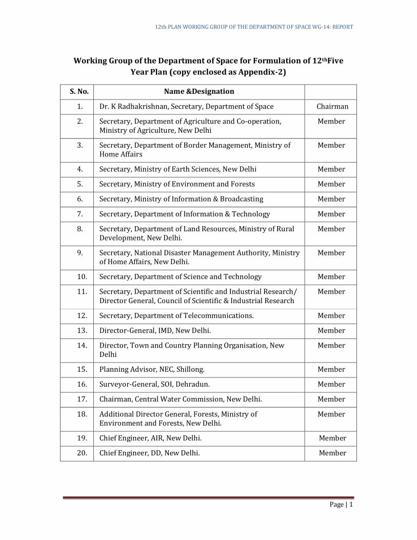
Working Group of the Department of Space for Formulation of 12thFive
Year Plan (copy enclosed as Appendix-2)
S. No. Name &Designation
1. Dr. K Radhakrishnan, Secretary, Department of Space Chairman
2. Secretary, Department of Agriculture and Co-operation, Ministry of Agriculture, New Delhi
Member
3. Secretary, Department of Border Management, Ministry of Home Affairs
Member
4. Secretary, Ministry of Earth Sciences, New Delhi Member
5. Secretary, Ministry of Environment and Forests Member
6. Secretary, Ministry of Information & Broadcasting Member
7. Secretary, Department of Information & Technology Member
8. Secretary, Department of Land Resources, Ministry of Rural Development, New Delhi.
Member
9. Secretary, National Disaster Management Authority, Ministry of Home Affairs, New Delhi.
Member
10. Secretary, Department of Science and Technology Member
11. Secretary, Department of Scientific and Industrial Research/ Director General, Council of Scientific & Industrial Research
Member
12. Secretary, Department of Telecommunications. Member
13. Director-General, IMD, New Delhi. Member
14. Director, Town and Country Planning Organisation, New Delhi
Member
15. Planning Advisor, NEC, Shillong. Member
16. Surveyor-General, SOI, Dehradun. Member
17. Chairman, Central Water Commission, New Delhi. Member
18. Additional Director General, Forests, Ministry of Environment and Forests, New Delhi.
Member
19. Chief Engineer, AIR, New Delhi. Member
20. Chief Engineer, DD, New Delhi. Member

12th PLAN WORKING GROUP OF THE DEPARTMENT OF SPACE WG-14: REPORT
Page | 2
S. No. Name &Designation
21. Joint Secretary, HRD, New Delhi. Member
22. Additional Secretary, Department of Health and Family Welfare, New Delhi
Member
23. Dr. P S Goel, Honorary Distinguished Professor, ISRO Member
24. Dr. B N Suresh, Vikram Sarabhai Distinguished Professor, ISRO
Member
25. Dr. T K Alex, Director, ISRO Satellite Centre, Bangalore Member
26. Dr. R R.Navalgund, Director, Space Applications Centre, Ahmedabad
Member
27. Shri P S Veeraraghavan, Director, Vikram Sarabhai, SpaceCentre, Thiruvananthapuram
Member
28. Prof. J N Goswami, Director, PRL, DOS, Ahmedabad Member
29. Director, IIT, Chennai Member
30. Prof. R S Deshpande, Director, Institute for Social and
Economic Change, Bangalore
Member
31. Prof. J Srinivasan, Professor, Centre for Atmospheric and Oceanic Sciences Indian, Institute of Science, Bangalore.
Member
32. Prof. P Venkata Rangan, VC, Amrita Vidyapeetham,
Coimbatore
Member
33. Chairman and Managing Director, HAL, Bangalore. Member
34. Shri JDPatil, Executive Vice president-Defense &Aerospace, Larsen & Toubro Ltd.
Member
35. Shri S.M. Vaidya, Vice President & Business Head, Godrej Precision Systems Ltd.
Member
36. Dr. Ajay Parida, Executive Director, MSSRF, Chennai. Member
37. Shri A.K. Verma, Adviser (S&T), Planning Commission Member
38. Shri V. Koteswara Rao, (succeeded Dr. V.S. Hegde on July 7, 2011), Scientific Secretary, ISRO
Member-
Secretary
12th PLAN WORKING GROUP OF THE DEPARTMENT OF SPACE WG-14: REPORT
Page | 3
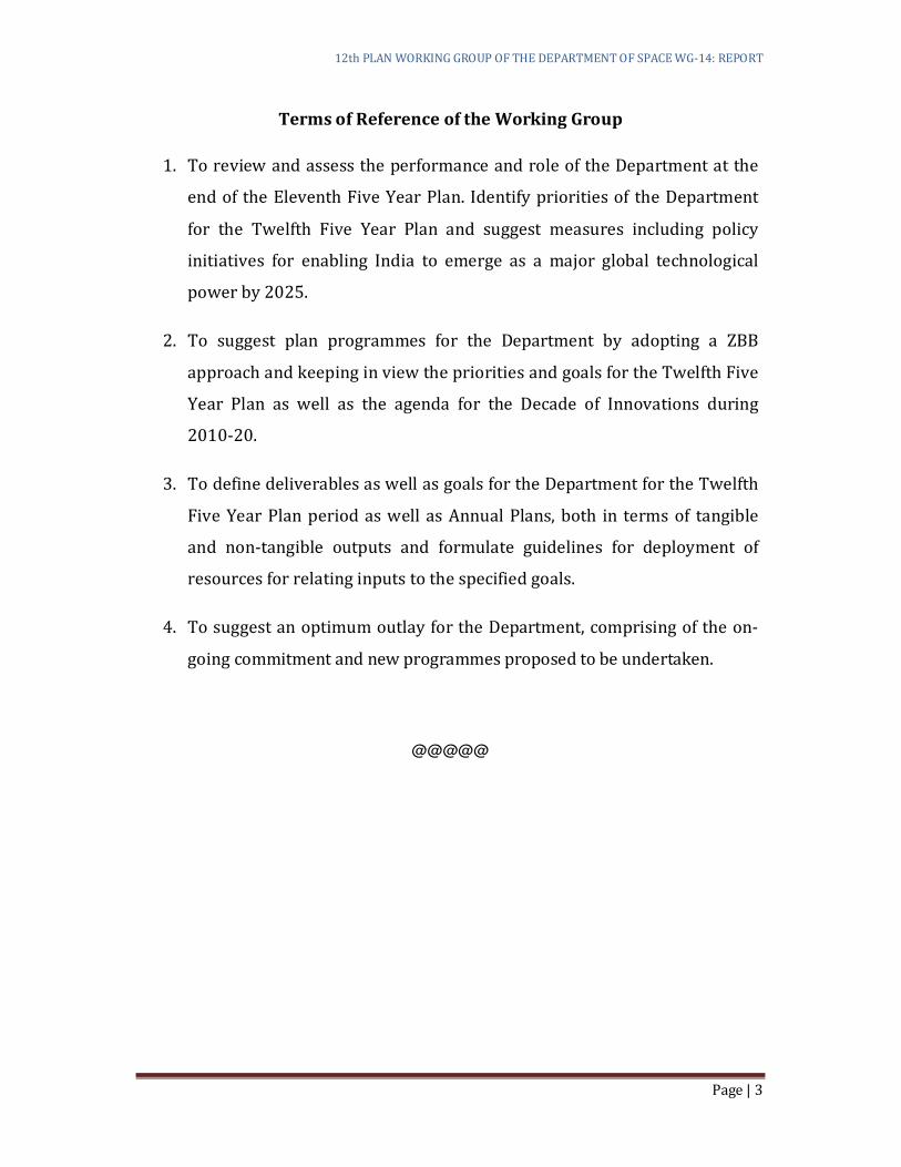
Terms of Reference of the Working Group
1. To review and assess the performance and role of the Department at the
end of the Eleventh Five Year Plan. Identify priorities of the Department
for the Twelfth Five Year Plan and suggest measures including policy
initiatives for enabling India to emerge as a major global technological
power by 2025.
2. To suggest plan programmes for the Department by adopting a ZBB
approach and keeping in view the priorities and goals for the Twelfth Five
Year Plan as well as the agenda for the Decade of Innovations during
2010-20.
3. To define deliverables as well as goals for the Department for the Twelfth
Five Year Plan period as well as Annual Plans, both in terms of tangible
and non-tangible outputs and formulate guidelines for deployment of
resources for relating inputs to the specified goals.
4. To suggest an optimum outlay for the Department, comprising of the on-
going commitment and new programmes proposed to be undertaken.
@@@@@
12th PLAN WORKING GROUP OF THE DEPARTMENT OF SPACE WG-14: REPORT
Page | 4
Executive Summary
The guiding vision for the Indian Space Programme, from the very inception
has been to be 'second to none' in the development of space technology and its
applications to solve the real problems of man and society. The emphasis on
self-reliance has been an important component of the vision, with which India
undertook development of satellites, launch vehicles and associated ground
segment indigenously in a progressive manner.
Today, India’s core competence in space is its ability to conceive, design, build
and operate complex space systems and use them in various frontiers of
national development. India today has developed two operational space
systems namely IRS (Indian Remote Sensing) and INSAT (Indian National
Satellite System) satellites and capability to launch them through PSLV (Polar
Satellite Launch Vehicle) and GSLV (Geo-stationary Satellite Launch Vehicle).
India has also taken initiatives in space exploration missions such as
Chandrayaan-1
Accomplishments of 11th Five Year Plan:
During the first four and half years of the 11th plan, Indian space programme
witnessed several major successes and achieved greater heights. The
successful launch of Chandrayaan-1 on-board PSLV-C11, a historic feat of
placing Indian tri-color on lunar surface and detection of water molecules on
Moon surface were the most significant events.
The other notable achievements were launching of TEN satellites (including
CARTOSAT-2A and IMS-1) in a single launch of PSLV-C9, launch of Microwave
Radar Satellite (RISAT-2) and Mini Satellite ANUSAT on-board PSLV-C12,
OCEANSAT-2 and six nano-satellites onboard PSLV-C14; CARTOSAT-2B,
ALSAT-2A, NLS 6.1 & 6.2 and STUDSAT on board PSLV-C15, RESOURCESAT-2,
YOUTHSAT and X-SAT on-board PSLV-C16. The INSAT/GSAT system was
further augmented with the launch of INSAT-4CR (on-board GSLV-F04), GSAT-
12 (on-board PSLV-C17) and GSAT-8 (Procured Launch). Two satellites for
international customers (AGILE and TECSAR) were launched on commercial
basis by PSLV-C8 and PSLV-C10. In addition two state-of-the-art
communication satellites (W2M and HYLAS) were built for European
customers. Further, four major on-going missions are getting ready for launch
12th PLAN WORKING GROUP OF THE DEPARTMENT OF SPACE WG-14: REPORT
Page | 5
before the closure of the 11th Plan viz. PSLV-C18/Megha-Tropiques and PSLV-
C19/RISAT-1.
During 11th Plan, a total of 27 missions have already been accomplished (15
satellite missions and 12 launch vehicle missions). Keeping in view the
progress of on-going missions, another 4 missions (2 satellite missions and 2
launch vehicle missions) are realizable before March 2012. Hence a total of 31
missions are likely to be achieved during the 11th Plan Period as compared to
20 missions accomplished during 10th Plan. In addition, substantial progress
has been made towards realization of ongoing missions such as INSAT-
4/GSAT-series, INSAT-3D/3DR, GSAT-11, GISAT, CHANDRAYAAN-2,
ASTROSAT, IRNSS, SARAL and ADITYA-1.
Besides this, several societal application missions such as Tele-education (over
55,000 EDUSAT classrooms established), Tele-medicine (382 Hospitals
provided with Tele-medicine facility), Village Resource Centres (set up in 473
locations), space based Potential Fish Zone mapping benefitting the fishermen
community of coastal areas, locating drinking water sources using IRS
imageries covering more than 2 lakh habitations in ten States, Space
technology based Disaster Management Support etc. have made significant
contributions to the National Development.
12th Five Year Plan 2012-17 Proposals
12th Five Year Plan proposals have been formulated under the overall
programmatic directions laid out by “Space Vision India 2025”. Inputs
generated by various committees/task forces on long term planning such as
Earth Observation Strategy 2025 committee, The GSLV/ Satcom Strategy
Review and Formulation Committee, Mars Mission Study Team, the PC-NNRMS
deliberations etc. have been considered while formulating 12th Plan
proposals. In addition, the broad directions for the 12th plan brought out in
the approach paper by Planning Commission have also been suitably taken
into account.
In the area of Satellite Communications, the approach to plan preparation for
the 12th FYP for has been to augment the INSAT capacity to bridge the gap
between the demand and supply of the transponders for meeting all the
requirements of the country and also to maintain sufficient spares capacity to
12th PLAN WORKING GROUP OF THE DEPARTMENT OF SPACE WG-14: REPORT
Page | 6
meet contingencies. Development of state of the art technologies and latest
applications areas shall also be pursued.
In order to accommodate the projected demand for 794 transponders from the
operational transponder capacity of 198 from INSAT/GSAT satellites at the
end of 11th FYP, 14 communication satellites are planned to be realised during
the 12th Plan period for (a) increasing the transponder capacity (b)
introducing new generation broadband VSAT systems (c) introduction of Ka
band systems (d) building high power S-band satellite mobile communications
and (e) introduction of new generation geo-imaging satellite.
In terms of spacecraft platforms, it is planned adopt I-2K, I-3K and I-4K buses
for the communication satellites. I-3K and I-4K buses are planned to be
launched using procured foreign launcher. It is also planned to initiate
development of High throughput I-6K – 12KW bus in higher frequency bands
like Ka/Ku and the technologies associated with it.
Maintaining and securing sufficient orbit-spectrum resources for country’s
Satcom activities will be a thrust area of 12th Plan. It has been planned to
pursue rigorously to secure spectrum for 100 additional Ku-band
transponders and around 50 C-band/Ext C-band transponders in newer
orbital locations.
Satellite based Navigation service is an emerging satellite based system with
commercial and applications. Establishment of an independent Indian
Regional Navigation Satellite System (IRNSS) over Indian region,
Implementation of the final operational phase for satellite based augmentation
system (SBAS) GAGAN (GPS Aided Geo Augmented Navigation) over the Indian
Airspace are important targets for 12th Plan. Formulation of Indian Satellite
Navigation Policy to facilitate growth of Satellite based navigation application
will also be pursued.
The thrust areas of Earth Observation and Atmospheric Sciences
Programme for the 12th Plan will be on continuation of established services
with improved capabilities with three thematic series of Indian EO satellites
i.e. Natural resources, Cartography and Ocean & atmosphere, including all-
weather capability; development of newer state of the art capabilities to meet
specific user requirements; augmentation of ground segments for effective
12th PLAN WORKING GROUP OF THE DEPARTMENT OF SPACE WG-14: REPORT
Page | 7
utilization of the various sensors; and special emphasis application missions in
the areas of agriculture, environment, large scale mapping, infrastructure
planning, oceanography, climate and atmospheric studies. To achieve the
above, eight Earth Observation missions are planned during the 12th Five Year
Plan. With the realization of these missions, there would be significant
improvements in the areas of short term weather and ocean state forecasting,
natural resources management, high resolution cartography, large scale
mapping, space based Essential Climate Variables (ECVs) with enhanced
spatial, spectral, radiometric and temporal resolution.
The Disaster Management Support (DMS) Programme of ISRO is intended
to provide near real time information support and services from imaging and
communication satellites towards efficient management of disasters in the
country. Major programmatic targets of DMS programme during 12th Five
Year Plan will be Operationalization of National Database for Emergency
Management (NDEM), Continuation of impact mapping and monitoring of
natural disasters with improved turnaround time and with newer capabilities,
acquisition of close contour data through ALTM, extension of the
communication network to the District Emergency Operation centres, geo-
location based services such as Search & Rescue and distress alerts,
operational dissemination of the information and products directly to the
affected areas, Operational utilization of early warning systems and extension
of the Hydro-meteorological network.
The main focus of the Space Transportation Systems during 12th plan period
will be towards achieving self-sufficiency in launching our satellites,
developing launch vehicles for enhanced payload capability, adopting
appropriate outsourcing strategies for assuring productionisation of launch
vehicles, enhancement of infrastructure for launch vehicles and developing
advanced technologies for the future. Towards this, enhancement of level of
production of PSLV Vehicle systems with vigorous industry participation,
completion of qualification of indigenous Cryogenic Upper Stage (CUS),
proving GSLV, with indigenous cryogenic stage, as a reliable workhorse launch
vehicle, Completion of development and qualification of C25 Engine & Stage,
completion of development flights of GSLV MkIII with 4.0 T GTO capability,
progress on the development of Semi cryogenic engine with the establishment
of test facilities, augmentation spaceport infrastructure to meet the launch
12th PLAN WORKING GROUP OF THE DEPARTMENT OF SPACE WG-14: REPORT
Page | 8
vehicle requirements shall be pursued. During the 12th Plan period, 17 PSLV
missions, 6 GSLV MK-II missions and 2 GSLV MK-III missions (this also
includes one experimental mission) are planned to be accomplished.
Space Sciences & Planetary Exploration missions contribute significantly
towards understanding the mysteries of the universe, our existence and
provide an opportunity towards development of cutting edge technologies.
Through space science investigations, we seek to understand the processes
governing solar radiation, evolution of planetary system, formation of galaxies,
evolution of stellar systems and the universe. Missions initiated during the
11th Plan such as Chandrayaan-2, Astrosat-1 and Aditya-1 will be realised in
12th plan. Undertaking India's First Mission to MARS will be an important
milestone during the 12th Plan. In addition, an X-Ray polarimeter (POLIX) to
study the x-ray polarization from bright x-ray emitting objects shall also be
pursued.
Overall Mission Profile and Outlay
For 12th Five Year Plan 2012-2017, a total of 58 missions are projected to be
undertaken which includes 33 satellite missions and 25 launch vehicle
missions. Out of the 33 satellite missions, three missions viz. Cartosat-2C,
Cartosat-2D and GSAT-7 are to be funded by user agencies. Considering the
immediate pressing need to augment the transponder capacity of INSAT/GSAT
system and the availability of GSLV-MK II and development status of GSLV-MK
III, the Department has opted for availing procured launch services for few
communication satellites.
The financial resource requirements for the missions planned for 12th Five
Year Plan as well as for advance investments required for the missions to be
realised during the early phase of 13th Plan works out to ` 55,000 Cr at current
(2011-12) prices. (Provisional)
@@@
12th PLAN WORKING GROUP OF THE DEPARTMENT OF SPACE WG-14: REPORT
Page | 9
1. Introduction
1.1. Since the inception, the primary objective of the Indian Space
Programme resonated with the vision of Dr.Vikram A Sarabhai
mandating the utilization of complex technologies like space for
finding solutions to the real problems of common man. This vision has
been shared, sustained, enriched and carried forward as it evolved
over the past five decades. Today, the fruits of space research are
reaching the common people and society, touching their daily life, be it
a fisherman, a farmer, a student, a patient from a remote area, an
administrator or a policy maker.
1.2. The Indian Space Programme saw its first ray of light in the early 60’s
in a Church building in a tiny fisherman hamlet in Thumba near
Thiruvananthapuram with the setting up of Thumba Equatorial Rocket
Launch Station (TERLS). The initial years were dedicated towards
scientific experiments using sounding rockets, indigenous
development of sounding rockets and dedication of TERLS to the
United Nations.
1.3. The significant milestones of the 70’s were (a) demonstration of the
efficacy of satellite for developmental communication, (b) use of
remote sensing techniques for study of natural resources,(c)
realisation of India’s experimental satellites Aryabhatta and Bhaskara-
1 flown on Soviet launchers. Successful flight testing of Satellite Launch
Vehicle SLV-3 in 1980 as well as development of satellites for Earth
Observation (Bhaskara-II) and for Communication (APPLE) that were
launched in 1981 marked the culmination of the experimental phase.
1.4. The Indian National Satellite (INSAT) System, the Indian Remote
Sensing Satellite Constellation (IRS series), the National Natural
Resources Management System (NNRMS) as well as undertaking
development of the Polar Satellite Launch Vehicle (PSLV) and
Geosynchronous Satellite Launch Vehicle (GSLV) (and their forerunner
ASLV ) were the cornerstones of the operational phase of Indian Space
Programme during the 80’s and 90’s.
12th PLAN WORKING GROUP OF THE DEPARTMENT OF SPACE WG-14: REPORT
Page | 10
1.5. During the last decade, India emerged as a significant player in the
comity of space faring nations with the capability of building and
launching satellites to both Polar sun-synchronous and Geo-
synchronous transfer orbits.
1.6. India has evolved as the role model for the world in the area of space
applications; one amongst six in the world with capability to make
satellites and launch them; one of the four with demonstrated
capability for re-entry of spacecraft; presumably the first one to launch
10 satellites in one single mission and launched the CHANDRAYAAN-1
satellite that facilitated the major discovery of water molecules and
water ice on the lunar surface.
1.7. The Indian Space Programme is poised for further accomplishments in
its programmatic aspirations and taking the ISRO saga forward. The
next decades appear more promising and challenging with increased
number of missions and newer technology developments.
1.8. A comprehensive planning would determine where the nation’s space
technological capabilities are going over the next five years, how it's
going to get there and what impact it would bring about for the benefit
of the nation. The focus of such a strategic plan is usually on the entire
gamut of activities that encompass a space system. There are a variety
of perspectives, models and approaches that has been used in bringing
out this planning document, considering the strategic nature of the
department, culture of the department, complexity and size of the
department in view of the blend of R&D and missions in the horizon of
its activities.
1.9. This planning document accords all elements of the multi-dimensional
ISRO activities, taking cognizance of the recommendations of several
user communities or Strategy defining committees.
Today ISRO is credited with: (a) realisation of 34 launch vehicle
missions (including 7 failed missions); (b)successful realisation of
62 Satellites (including 5 INSAT-1 Satellites built abroad to our
specifications), (c) building of 2 satellites for foreign customers and
(d) launching of 26 foreign satellites by PSLV.
12th PLAN WORKING GROUP OF THE DEPARTMENT OF SPACE WG-14: REPORT
Page | 11
“Having achieved so much, it is important that we look ahead and plan for the future.
Dr. Vikram Sarabhai had once said and I quote “Technology is not an objective to be
aimed at, but a tool to be used for the benefit of the common man,” unquote. I believe it
is important for ISRO to concentrate its resources and evolve a perspective plan for its
future development that is based on clearly defined objectives and benefits.
Large scale poverty is the foremost challenge facing our country. The unfortunate
truth is that the fruits of our growth are not equally shared among different segments
of our society. We have to be acutely conscious of regional disparities and imbalances
within the country, and address the inequalities that exist.
Space based applications are a very potent means of bridging these divides in our
society. It is therefore necessary that we work towards reducing the cost of access to
space. This requires expediting the development of heavy lift launchers, advanced
propulsion systems, including the cryogenic stage, and recoverable and reusable
launch systems. We should pay greater attention to the Geosynchronous Satellite
Launch Vehicle Programme.
Food security and self-sufficiency in agriculture, particularly paying special attention
to the needs of the small and marginal farmers, remains yet another fundamental goal.
In such a scenario, managing the environment and tackling climate change will be
major challenges. Our disaster warning and response capabilities will have a major
impact on livelihood security for our people. The role of space based observation
systems, development of newer class of environment and monitoring sensors and study
of weather related phenomena assume great importance in this regard.
Taken together, the space programme has a vital role to play in making the concept of
sustainable development a reality.
The other major goal before us is the socio-economic empowerment of our people. The
Satellite Instructional Television Experiment, which was the brainchild of this Centre,
demonstrated for the first time how space technology could be used for broadcasting
and for reaching the benefits of education to the village level”
1.10. The Hon. Prime Minister of India outlined the future directions for the
Indian Space Programme during his address of March 24, 2011 to the
ISRO/DOS community. Excerpts are reproduced below:
12th PLAN WORKING GROUP OF THE DEPARTMENT OF SPACE WG-14: REPORT
Page | 12
“Although we have come a long way since then, there is much more that needs to be
done. Tele-education, tele-medicine and Village Resource Centre services deserve
high priority. ISRO’s contribution to the monitoring of programmes like the
Mahatma Gandhi National Rural Employment Guarantee Scheme, the Accelerated
Benefit Irrigation Programme and Bharat Nirman is laudable. “
Empowerment requires that we ensure space services are available to all sections of
society. Access to information should be easy. In the years ahead ISRO should make a
conscious effort to reach out to beneficiaries and consumers of space products so that
they can extract maximum advantage from the technology that is available in the
country.
The information and communications revolution is upon us. It is changing the lives of
millions of our people across cities, towns and villages faster than we could have
imagined. This transformation has been made possible in large measure due to the
space infrastructure you have built. We should aim to master newer technologies for
more sophisticated communication satellites. For example, satellite based broadband
internet services could bring about a new technological revolution that directly
benefits rural and remote areas.
I am glad that ISRO is aiming to achieve self-reliance in the area of navigation
through the Indian Regional Navigation Satellite System. This will enable secure
transport and better air traffic management and search and rescue operations.
I have referred earlier to the spirit of scientific inquiry. We will do all that is
necessary to promote scientific discoveries, and for ISRO to remain at the cutting
edge of technology. You will have the government’s support in your quest to better
understand the solar system and universe and in the continuing discovery of space”
As our economy expands, there will be growing pressure on our resources, whether it
is land, water or minerals. Remote sensing applications for such purposes will be
critical. Simultaneously, the processes of urbanization will gather speed and we will
have to face the challenge of management of urbanization.”
Expanding horizons of Indian Space Programme
1.11 In the years to come, India will look forward to sustain its rightful place as
the leading space faring nation and to take leadership in a few niche areas.
Today’s knowledge based society demands information generation and
dissemination to various strata of society to improve the quality of life. The
space infrastructure would prove to be the ideal medium for meeting this
12th PLAN WORKING GROUP OF THE DEPARTMENT OF SPACE WG-14: REPORT
Page | 13
demand. ISRO would also engage and collaborate in Space science and
Planetary exploratory missions guided by compelling scientific inquisition
by pursuing breakthrough technologies, embracing the challenge of
developing reliable, self-reliant and cost effective space infrastructure.
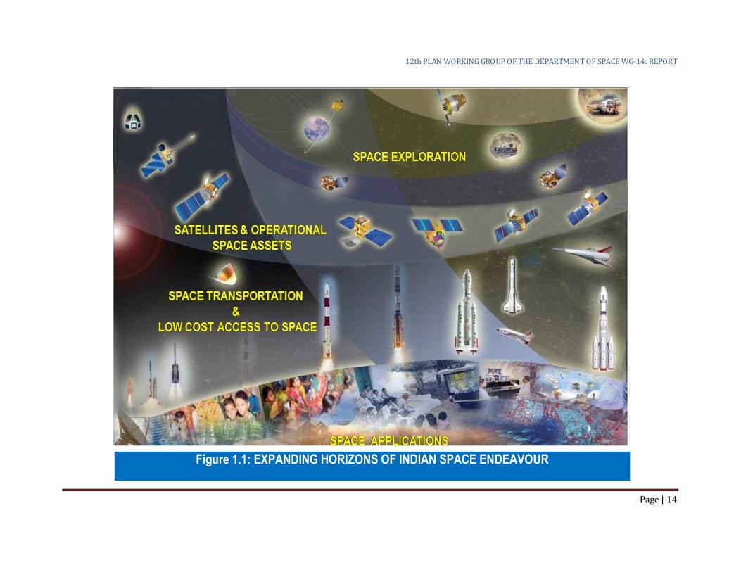
1.12 In the Expanding Horizons of Indian Space Programme (as depicted in
Figure 1.1), the Space Based Application Programme remains the
substratum of the entire gamut of activities supporting the National
imperatives of social security. Also, there will be continued focus on Low
cost access to space in a self-reliant manner. Operational space assets are
to be maintained and protected for optimum operational lives while newer
initiatives would be mounted in the domains of space exploration and
inter-planetary mission in the quest of technology development and
enhancing scientific knowledge-base in the country.
1.13 Under such ever changing scenarios, the priorities of the Space Programme
would be -
(i) To contribute towards the national endeavours in food and water
security, weather and climate, environment and ecosystem,
education and health care, skill development, rural communication,
infrastructure development, disaster management support, smart
governance, sustainable development and related national
imperatives through space application programmes;
(ii) To create, sustain and manage operational space assets with the
participation of Indian industry as a risk-sharing partner for the
production of such assets;
(iii) To develop newer capabilities towards (a) low cost access to space;
(b) contribute to answering fundamental scientific quests; (c)
scientific exploration of Earth as a total system, Moon, Mars and
beyond in the solar system; (d) critical technologies related to
human space flight programme, eventually leading to human
presence in solar system ensuring synergy of national capabilities
and international cooperation and
(iv) To facilitate advanced research in conjunction with academia on
cutting-edge technologies with a target to make India a technology-
leader in certain niches.
12th PLAN WORKING GROUP OF THE DEPARTMENT OF SPACE WG-14: REPORT
Page | 14
Figure 1.1: EXPANDING HORIZONS OF INDIAN SPACE ENDEAVOUR
12th PLAN WORKING GROUP OF THE DEPARTMENT OF SPACE WG-14: REPORT
Page | 15
1.10 Considering the importance of self-reliance, strategic technology like space
and also considering the impact that it brings to the societal application
programmes, feedback has been received from several stake holder
agencies. Such feedback from user agencies (Planning Commission,
National Natural Resource Management System, INSAT Co-ordination
Committee etc.) has been given utmost priority in drafting this document.
The spill-over missions from the 11th Five Year Plan has been reviewed
carefully before including into the 12th Plan. Some of these missions have
also been assigned priority for completion within the 12th plan.
Under 12th Five Year Plan, 25 launch vehicle missions and 33 spacecraft
missions are envisaged with a number of facility/infrastructure
developments and technology demonstrating missions. The total proposed
outlay for the 12th plan is ` 55,000 Cr with a Plan component of `47,500 Cr
and non-Plan component of ` 7,500 Cr.
12th PLAN WORKING GROUP OF THE DEPARTMENT OF SPACE WG-14: REPORT
Page | 16
2. Performance Appraisal of 11th Five Year Plan
Programmatic targets
2.1 The overall direction of the Indian Space programme during 11th Plan was
to sustain and strengthen the already established space based services
towards socio-economic development of the country. Major thrust areas
have been development of next generation heavy lift launch vehicle GSLV-
MK III; critical technologies for the human spaceflight programme;
Competitive and state-of-the-art space segment augmentation in
INSAT/GSAT system; ensuring continuity of data with enhanced
capabilities through constellation of earth observation satellites;
undertaking space science and planetary exploration missions;
strengthening space-based disaster management support; atmospheric
research programme and societal applications.
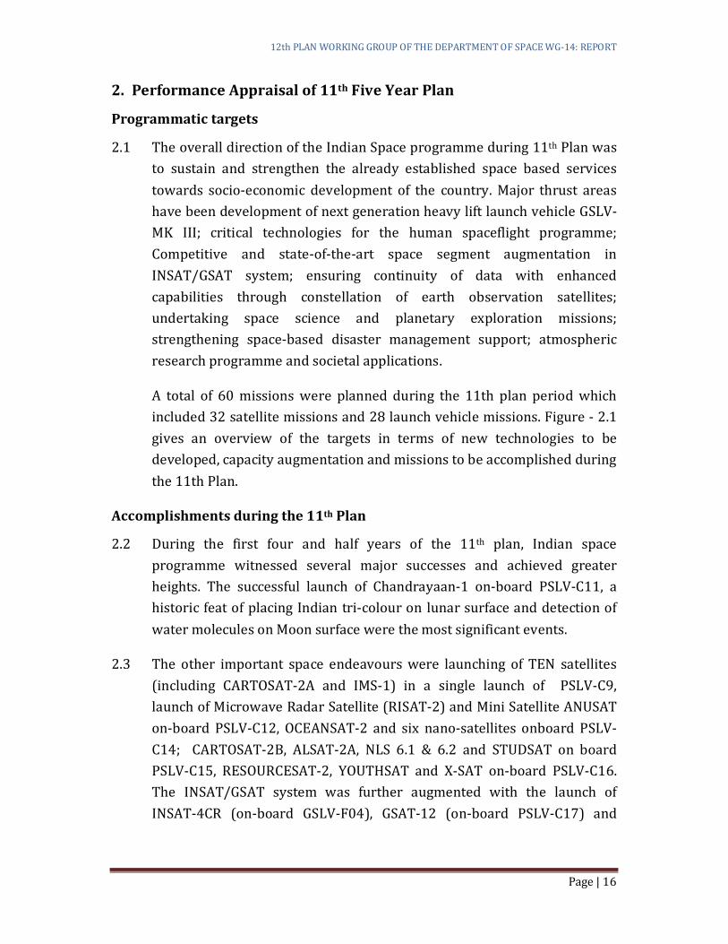
A total of 60 missions were planned during the 11th plan period which
included 32 satellite missions and 28 launch vehicle missions. Figure - 2.1
gives an overview of the targets in terms of new technologies to be
developed, capacity augmentation and missions to be accomplished during
the 11th Plan.
Accomplishments during the 11th Plan
2.2 During the first four and half years of the 11th plan, Indian space
programme witnessed several major successes and achieved greater
heights. The successful launch of Chandrayaan-1 on-board PSLV-C11, a
historic feat of placing Indian tri-colour on lunar surface and detection of
water molecules on Moon surface were the most significant events.
2.3 The other important space endeavours were launching of TEN satellites
(including CARTOSAT-2A and IMS-1) in a single launch of PSLV-C9,
launch of Microwave Radar Satellite (RISAT-2) and Mini Satellite ANUSAT
on-board PSLV-C12, OCEANSAT-2 and six nano-satellites onboard PSLV-
C14; CARTOSAT-2B, ALSAT-2A, NLS 6.1 & 6.2 and STUDSAT on board
PSLV-C15, RESOURCESAT-2, YOUTHSAT and X-SAT on-board PSLV-C16.
The INSAT/GSAT system was further augmented with the launch of
INSAT-4CR (on-board GSLV-F04), GSAT-12 (on-board PSLV-C17) and
12th PLAN WORKING GROUP OF THE DEPARTMENT OF SPACE WG-14: REPORT
Page | 17
12th PLAN WORKING GROUP OF THE DEPARTMENT OF SPACE WG-14: REPORT
Page | 18
GSAT-8 (Procured Launch). Two satellites for international customers
(AGILE and TECSAR) were launched on commercial basis by PSLV-C8 and
PSLV-C10. In addition two state-of-the-art communication satellites (W2M
and HYLAS) were built for European customers. Further, two major on-
going missions are getting ready for launch before the closure of the 11th
Plan viz. PSLV-C18/Megha-Tropiques and PSLV-C19/RISAT-1.
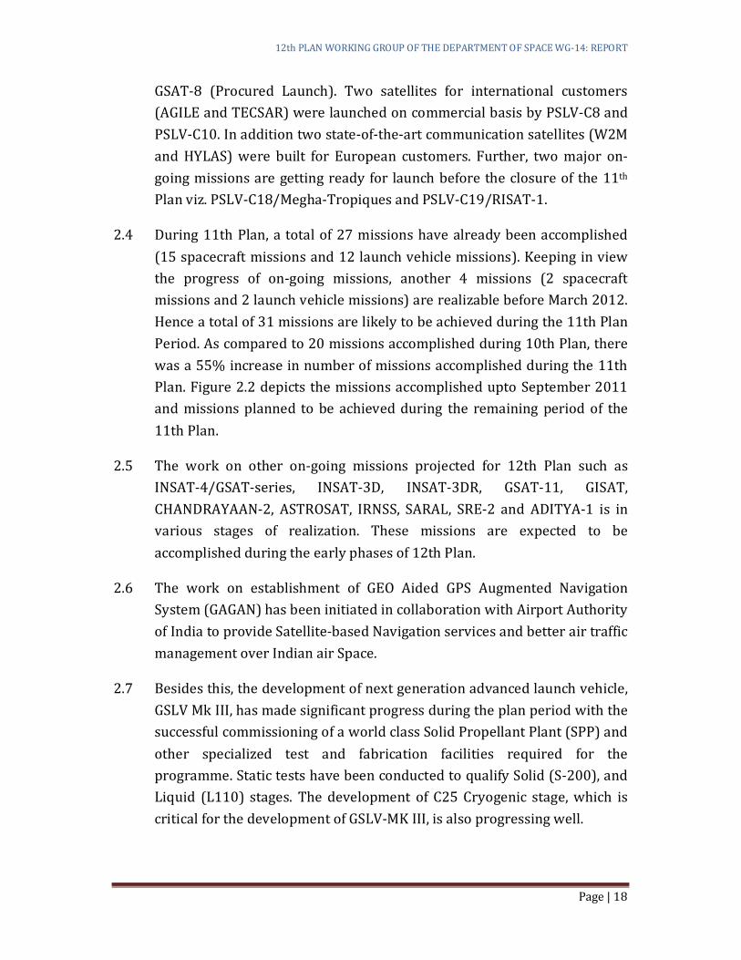
2.4 During 11th Plan, a total of 27 missions have already been accomplished
(15 spacecraft missions and 12 launch vehicle missions). Keeping in view
the progress of on-going missions, another 4 missions (2 spacecraft
missions and 2 launch vehicle missions) are realizable before March 2012.
Hence a total of 31 missions are likely to be achieved during the 11th Plan
Period. As compared to 20 missions accomplished during 10th Plan, there
was a 55% increase in number of missions accomplished during the 11th
Plan. Figure 2.2 depicts the missions accomplished upto September 2011
and missions planned to be achieved during the remaining period of the
11th Plan.
2.5 The work on other on-going missions projected for 12th Plan such as
INSAT-4/GSAT-series, INSAT-3D, INSAT-3DR, GSAT-11, GISAT,
CHANDRAYAAN-2, ASTROSAT, IRNSS, SARAL, SRE-2 and ADITYA-1 is in
various stages of realization. These missions are expected to be
accomplished during the early phases of 12th Plan.
2.6 The work on establishment of GEO Aided GPS Augmented Navigation
System (GAGAN) has been initiated in collaboration with Airport Authority
of India to provide Satellite-based Navigation services and better air traffic
management over Indian air Space.
2.7 Besides this, the development of next generation advanced launch vehicle,
GSLV Mk III, has made significant progress during the plan period with the
successful commissioning of a world class Solid Propellant Plant (SPP) and
other specialized test and fabrication facilities required for the
programme. Static tests have been conducted to qualify Solid (S-200), and
Liquid (L110) stages. The development of C25 Cryogenic stage, which is
critical for the development of GSLV-MK III, is also progressing well.
12th PLAN WORKING GROUP OF THE DEPARTMENT OF SPACE WG-14: REPORT
Page | 19
12th PLAN WORKING GROUP OF THE DEPARTMENT OF SPACE WG-14: REPORT
Page | 20
2.8 The development of higher thrust Semi-cryogenic engine (with Liquid
oxygen as oxidiser and aviation grade Kerosene as fuel) which forms the
core stage of future vehicles has also been initiated. The design of the
engine, development of a single element pre-burner and demonstration of
ignition, design of test facilities have been completed during this Plan.
2.9 In the area of Space Science and Planetary exploration, a study report on
the feasibility of undertaking a planned Mission to Mars has been
completed. As per the study report, it is feasible to undertake Indian’s first
mission to Mars during the 12th Plan.
2.10 Detailed feasibility studies on undertaking indigenous human spaceflight
mission have been carried out. During the mid-term appraisal of the 11th
Plan, it was felt prudent to implement the programme in a phased manner
considering the magnitude of complexities and developmental efforts
involved. The Department will continue the activities related to
development of critical technologies required for the successful
culmination of the programme which envisages carrying humans to low
earth orbit and their safe return to earth.
2.11 R & D activities on advanced launch vehicle technologies including Air
breathing propulsion and Reusable Launch Vehicle Technology
Demonstrator have been initiated during the 11th Plan.
2.12 Realisation of Hypersonic Wind Tunnel (HWT) facilities consisting of 1m
HWT and 1m shock tunnel for aero thermal and aerodynamic
characterization of advanced launch vehicles such as RLV, TSTO and re-
entry vehicles has been accomplished.
2.13 During the 11th Plan, Indian Institute of Space Science & Technology (IIST)
has been set-up at Trivandrum, Kerala in order to create quality scientific
human resource tuned to suit the requirements of state-of-the-art space
research programme.
2.14 As envisaged during the mid-term appraisal, Remote Sensing Data Policy
2011 has been brought out enabling dissemination of high resolution data
to concerned users in a timely manner.
12th PLAN WORKING GROUP OF THE DEPARTMENT OF SPACE WG-14: REPORT
Page | 21
2.15 This apart, several initiatives on the societal applications of space
technology such as Tele-education (over 55,000 EDUSAT classrooms
established), Tele-medicine (382 Hospitals provided with Tele-medicine
facility), Village Resource Centres (set up in 473 locations), space based
Potential Fish Zone mapping benefitting the fishermen community of
coastal areas, locating drinking water sources using IRS imageries
covering more than 2 lakh habitations in ten States, Wasteland mapping
and time series analysis to reclaim wastelands and improve productivity of
the whole country using IRS data for development of waste lands, Space
technology based Disaster Management Support etc. have made significant
contributions to the National Development.
2.16 A detailed account of accomplishments of the Department vis-a-vis the
targets set for the 11th Five Year Plan is given in Appendix-1.
Mission failure& recovery plan
2.17 During the 11th FYP there were failures of 2 Geo-synchronous Satellite
Launch Vehicle (GSLV) flights viz. GSLV-D3 with Indigenous Cryogenic
Stage during April, 2010 and GSLV-F06 with Russian Cryogenic Stage
during December, 2010.
2.18 The GSLV-D3 mission failed as the Indigenous Cryogenic engine after its
ignition couldn’t sustain the combustion beyond 1 second. Based on the
recommendations of the Failure Analysis Committee, comprehensive test
procedures to verify the health of all flight systems/ components of the
Indigenous Cryogenic Stage have been introduced.
2.19 The reason for the unsuccessful launch of GSLV-F06 has been the untimely
and inadvertent snapping of a group of 10 connectors located at the
bottom portion (shroud) of the Russian Cryogenic Stage. Based on the
recommendations of the Failure Analysis Committee, redesign of the
shroud, revisit of the connector mounting scheme, additional wind tunnel
testing etc. are being addressed.
2.20 In addition, a seven member “GSLV Programme Review and Strategy
Formulation Committee” under the chairmanship of Dr. K. Kasturirangan,
was constituted to look into the future of the GSLV Programme and the
strategies for meeting the demands of communication transponders in the

12th PLAN WORKING GROUP OF THE DEPARTMENT OF SPACE WG-14: REPORT
Page | 22
immediate future. The recommendations of this committee are getting
implemented in the 12th plan formulation.
Mid-Term appraisal
2.21 During Mid-Term Appraisal of 11th Plan in September 2009, the following
mid-course corrections were effected:
(a) Considering the technological complexities involved and the
magnitude of efforts required in realising the Human Spaceflight
Programme (HSP), it was planned to realize the HSP in phases with
focus on developing critical technologies in the first phase.
(b) In order to facilitate the Department of Space to provide high
resolution data in time to concerned users, it was planned to put in
place suitable mechanisms and to revisit the policy frameworks to
consider whether high resolution data (at least up to 2.5 metre
resolution) can be made available to users in a timely manner.
(c) For ISRO to retain an R&D character at the organization level, it is
important to farm out production jobs to industries in the wake up
enhanced throughput requirement of satellites and launch vehicles
(From 20 missions in the 10th Plan to 60 missions during 11th Plan).
In this direction, strategies to achieve a quantum jump in Industry
participation may, therefore, be worked out in the coming years.
(d) Space science research/planetary exploration programme has been
an important component of the Indian Space Programme and
several missions including Chandrayaan-2 and ASTROSAT have
been planned in the coming years. Akin to this, a major challenge
lies in creating a human resource base in the country for analysing
the enormous amount of scientific data that would be available from
these missions. There is a need to adopt aggressive measures in this
direction to ensure availability of scientists in the area of space
science and planetary exploration.
Spillover Missions to 12th Five Year Plan
Owing to the development complexity, realization of some of the mission planned
for 11th Plan, have spilled over to the 12th Plan. These primarily relate to
navigation satellites, development of new generation launch vehicle GSLV Mk III,
operational flights of GSLV, Chandrayaan-2 etc.
12th PLAN WORKING GROUP OF THE DEPARTMENT OF SPACE WG-14: REPORT
Page | 23
(a) One of the major targets for 11th Plan was to establish Indian
Regional Navigational Satellite System with a constellation of seven
satellites. Considerable progress has been achieved in realizing the
various subsystems of these satellites. However, the delay in
realizing this satellite system were mainly attributed to the
procurement of the Atomic clocks from foreign sources and the
technological complexities of the system requiring several levels of
qualification and testing. This resulted in spillover of 7 satellites and
7 PSLV missions to the 12th Plan.
(b) During the 11th plan 13 GSLV missions were planned of which only
three were attempted. This was primarily due to the failure of two
GSLV missions (GSLV-D3and GSLV-F06) which necessitated
corrective actions related to redesign and additional testing of some
of the vehicle level elements.
(c) Similarly, due to technological complexities involved in realizing the
new generation launch vehicle GSLV Mk-III, the first developmental
flight could not be taken up. However, considerable progress has
been made in realizing two major propulsion modules (S200 and
L110) and various elements of the launch vehicle.
(d) Another important target was the realization of India’s second
mission to moon - Chandrayaan-2. However, the important
discoveries made by Chandrayaan-1, necessitated a revision of the
final selection of scientific instruments to be flown in this mission.
Financial Performance
2.22 The total Indicative Outlay for Space programme for 11th five year plan
was ` 34,883 Cr with a plan component of ` 30,883 Cr and non-Plan
component of ` 4,000 Cr. However, based on the annual plan outlay
allocated to the Department, the final plan outlay likely to be made
available for the department during 11th plan would be around ` 21,580 Cr
(Plan: ` 18,100 Cr; Non-plan: ` 3,480 Cr). Accordingly, some of the
activities related to programmes/projects such as Manned Mission
Initiative, Chandrayaan-2, Resourcesat-3, Cartosat-3, GSAT-13 & 14, IRNSS
etc. have been phased out to 12th Five Year Plan.
12th PLAN WORKING GROUP OF THE DEPARTMENT OF SPACE WG-14: REPORT
Page | 24
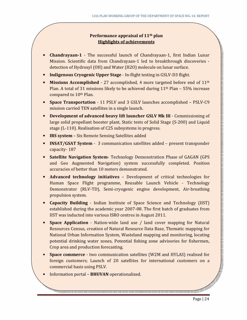
Performance appraisal of 11th plan
Highlights of achievements
• Chandrayaan-1 - The successful launch of Chandrayaan-1, first Indian Lunar
Mission. Scientific data from Chandrayaan-1 led to breakthrough discoveries -
detection of Hydroxyl (OH) and Water (H2O) molecule on lunar surface.
• Indigenous Cryogenic Upper Stage - In-flight testing in GSLV-D3 flight.
• Missions Accomplished - 27 accomplished, 4 more targeted before end of 11th
Plan. A total of 31 missions likely to be achieved during 11th Plan – 55% increase
compared to 10th Plan.
• Space Transportation - 11 PSLV and 3 GSLV launches accomplished – PSLV-C9
mission carried TEN satellites in a single launch.
• Development of advanced heavy lift launcher GSLV Mk III - Commissioning of
large solid propellant booster plant, Static tests of Solid Stage (S-200) and Liquid
stage (L-110). Realisation of C25 subsystems in progress.
• IRS system – Six Remote Sensing Satellites added
• INSAT/GSAT System - 3 communication satellites added – present transponder
capacity- 187
• Satellite Navigation System- Technology Demonstration Phase of GAGAN (GPS
and Geo Augmented Navigation) system successfully completed. Position
accuracies of better than 10 meters demonstrated.
• Advanced technology initiatives – Development of critical technologies for
Human Space Flight programme, Reusable Launch Vehicle - Technology
Demonstrator (RLV-TD), Semi-cryogenic engine development, Air-breathing
propulsion system.
• Capacity Building - Indian Institute of Space Science and Technology (IIST)
established during the academic year 2007-08. The first batch of graduates from
IIST was inducted into various ISRO centres in August 2011.
• Space Application - Nation-wide land use / land cover mapping for Natural
Resources Census, creation of Natural Resource Data Base, Thematic mapping for
National Urban Information System, Wasteland mapping and monitoring, locating
potential drinking water zones, Potential fishing zone advisories for fishermen,
Crop area and production forecasting.
• Space commerce - two communication satellites (W2M and HYLAS) realised for
foreign customers; Launch of 20 satellites for international customers on a
commercial basis using PSLV.
• Information portal – BHUVAN operationalized.
12th PLAN WORKING GROUP OF THE DEPARTMENT OF SPACE WG-14: REPORT
Page | 25
3. PROGRAMME DIRECTIONS 2025
3.1 The guiding vision for the Indian Space Programme, from the very inception
has been to be 'second to none' in the development of space technology and
its applications to solve the real problems of man and society. The emphasis
on self-reliance has been an important component of the vision, with which
India undertook development of satellites, launch vehicles and associated
ground segment indigenously in a progressive manner. Today, India’s core
competence in space is its ability to conceive, design, build and operate
complex space systems and use them in various frontiers of national
development. India today has developed two operational space systems
namely IRS (Indian Remote Sensing) and INSAT (Indian National Satellite
System) satellites and capability to launch them through PSLV (Polar
Satellite Launch Vehicle) and GSLV (Geo-stationary Satellite Launch
Vehicle). India has used the space systems for development of the country
through application programmes such as Tele-education, Tele-medicine and
Village Resource Centers (VRC). India has also taken initiatives in space
exploration missions such as Chandrayaan-1. The space technology
institutions/centres created in the country and the overall system/project
management practices evolved in the course of implementation have been
vital outcomes of the space programme.
3.2 With the maturity and self-reliance in space technology achieved by ISRO,
the next phase of vision of space for India for 2025 has been laid out.
• Operational services in communications and navigation.
• Enhanced imaging capability for natural resource management, weather
and climate change studies.
• Space science missions to better understand the solar system and
universe.
• Planetary exploratory missions
• Development of heavy lift launcher
• Reusable launch vehicles – technology demonstrator missions leading to
Two Stage to Orbit (TSTO)
• Critical technology development for Indian Manned Space Mission.
12th PLAN WORKING GROUP OF THE DEPARTMENT OF SPACE WG-14: REPORT
Page | 26
3.3 Space technology is a powerful catalyst for social development in the areas
of natural resource management, food security, rural development,
education and literacy, health-care and environment. Innovations in space
based communications and earth observations will be perused to achieve
faster delivery of information to remote areas and finer observation of
planet earth.
3.4 Operational services in communications and navigation.
3.4.1 Satellite communication continues to play a key role in broadcasting, VSAT
communication, last-mile connectivity in remote locations and islands, etc.
Advance coding and compression technologies are making the satellite
communication very reliable and cost effective. Satellite bus technologies
are also seeing major improvements with the adaptation of technologies
like Ion propulsions, unfurlable antennas, multi-beams, spot-beams, higher
frequency bands, etc. ISRO is taking a lead role in developing advanced
technologies for both satellite and ground systems and generate an
extensive R&D base in the country through the participation of industry
and academic institutions. Specific agenda are set to transform India into a
vibrant satellite communication and navigation industrial base in the
world and invite international participation.
3.4.2 Continuity of Services: The satellite communication shall provide for
continuity of traditional services like Broadcasting, Telecommunication,
Broadband, Satellite Navigation, Meteorological Imaging and Data
collection etc. through INSAT, GSAT and METSAT Missions and shall also
meet the broad objective of reaching the un-reached.
3.4.3 Enhancement of Satellite Capacity through
(a) Moving to higher frequency bands like Ku, Ka and V/Q bands and high power transmissions through multi-beams with spectrum reuse to meet the fast-growing demand for the bandwidth.
(b) Adoption of regenerative transponders capable of on-board switching and multiplexing and increasing the data carrying capacity by several orders (about 15 to 20 times) by advanced coding techniques.
12th PLAN WORKING GROUP OF THE DEPARTMENT OF SPACE WG-14: REPORT
Page | 27
(c) Separation of satellite system into bus-module and energy-modules so that the energy-modules periodically replaced and the life cycle of the bus-module is increased substantially.
(d) Satellite as major switching station with multiple spot beams and large unfurlable/reconfigurable antenna systems, making the satellite communication a highly reliable, ubiquitous and cost effective option.
(e) Independent satellite navigation constellation and exploitation of the existence of a large number of navigation satellites over the Indian sky.
(f) Adoption of technologies for jam-proof and encrypted communications.
(g) Use of ion thrusters to enhance the on-orbit life of satellites.
(h) Inter-satellite communication between GEO - GEO to achieve inter-continental connectivity and between GEO - LEO to address the requirements of remote sensing satellites data to be brought to a centralized processing facility without establishment of multiple ground stations.
(i) Aero-mobile communication to provide internet and telecom access to air passengers.
(j) Efforts to secure required orbital slots and spectrum assets for the country.
3.4.4 Satellite Communication Applications
(a) Direct To Home (DTH) and triple play (high speed internet, high speed multimedia, high speed broadband wireless access) services, with personalized access to the entertainment user-segment; stationary and mobile.
(b) Anytime and anywhere connectivity to provide access to emerging business applications with encryption to meet the demands of business user-segment.
(c) Facilitate enhanced meteorological data dissemination to support disaster management and mitigation through high performance meteorological payloads/satellites. Achieve enhanced capability in satellite aided search and rescue operations through increased international participation.
(d) Provide low cost telecom, weather and Geographical Information Systems to all villages and remote areas of the country to meet the emergency and disaster management communications without loss of time, using space platforms.
12th PLAN WORKING GROUP OF THE DEPARTMENT OF SPACE WG-14: REPORT
Page | 28
(e) Provide high accuracy satellite based positioning, navigation and timing service over the Indian sub-continent, through Indian and other Navigation Satellites over the Indian sky by integrating their performance in a state-of-the-art GNSS receiver. Integrate the Position, navigation and Timing (PNT) service into low cost mobile handsets with indoor positioning capability.
(f) Medium earth orbit (20,000 km) based search and rescue ground systems development.
(g) Ground based observation system for GEO satellite surveillance
(h) Expand developmental programmes including tele-education,tele-medicine and Village Resource Centres to the entire country by providing self-sustaining satellite based countrywide education and training network through the realization of dedicated satellites for societal applications.
3.5 Enhanced imaging capability for natural resource management,
weather and climate change studies.
3.5.1 The relevance of Earth Observations (EO) from space has become more
pertinent in recent years in view of growing concern on global well-being.
There has been wider recognition that an improved understanding of the
Earth System and its processes, particularly in understanding the non-
linear land-air-ocean interactions in the light of anthropogenic
interventions is important. A variety of instruments employing various
measurements technology and techniques, both active and passive sensing
have been flown on many space missions. There is a need to evolve
constellations of small satellites, formation flights, autonomous missions,
intelligent networking, event driven observations, sensor web, data
mining/ fusion, on-board processing, quantitative remote sensing etc. to
meet such requirements.
3.5.2 With the ever-increasing advances in EO technologies and techniques,
ISRO recognizes the importance of seamlessly integrating them with
applications covering in the public good, commercial and strategic needs of
the country. Vision for the Indian EO programme envisages “developing a
self-reliant, multi-dimensional programme, providing operational services
to the community, and striving to make these services as part of
everybody’s day to day life.”

12th PLAN WORKING GROUP OF THE DEPARTMENT OF SPACE WG-14: REPORT
Page | 29
3.5.3 Strategy for Payload and Application
(a) Development of hyper-spectral sensors, atmospheric chemistry instruments, earth radiation budget radiometers, temperature and humidity sounders, cloud profilers, rain Radars, Lidars, synthetic aperture radiometer, multi-angular/polarization instruments, imaging microwave radiometers, advanced ocean color instruments, radar altimeters, scatterometers as well as various gravity magnetic field and geo-dynamic instruments.
(b) Monitoring global scale activities, sparsely populated deserts, mountains, forests, and polar regions; the mid and upper troposphere and stratosphere; measure the solar output, earth radiation budget, vegetation cover, ocean biomass productivity, atmospheric ozone, stratospheric water vapour and aerosols, greenhouse gas distributions, sea level and ocean interior, ocean surface conditions and winds, tropical precipitation and many more.
3.6 Atmospheric Observation Payloads
3.6.1 Atmospheric Science Programme envisages significant contribution to the
national system by way of advanced satellite missions, institutionalize a
fully automated ground observation network providing real time in-situ
observations and develop fully evaluated modelling packages in the areas
of now-casting, local weather forecast, cyclone track and intensity
prediction.
(a) Development of hyper-spectral sensors for monitoring atmospheric dynamics, minor constituents etc.
(b) Active microwave systems such as rain radar, cloud radar, multi-channel radiometer, active optical systems such as Spaceborne Lidar, Differential Interferometer Active Lidar that will provide vital observations on atmospheric water vapour, profiles, wind and rainfall.
(c) A GPS occultation system with a constellation of satellites to generate adequate upper atmospheric profiles in the tropical region.
(d) Development of an advanced instrumented aircraft for in-depth study of cloud-development and related atmospheric processes.
(e) Developing a fully automated observation network integrating space and ground systems.
(f) Development of SMART sensors in future satellites that can detect severe weather events and trigger maximum observations from space and ground systems for monitoring and forecast
12th PLAN WORKING GROUP OF THE DEPARTMENT OF SPACE WG-14: REPORT
Page | 30
(g) A networked system to automate observations, monitoring and real-time warning by suitable integration of meteorological and communication satellites
(h) Establishing data centers for disseminating real time data from multiple sensors.
(i) Advanced modelling activity for development of operational packages for data assimilation from ground and space systems including direct assimilation of radiance in models towards improvement in now-casting, local specific forecasts and cyclone track and intensity prediction.
3.7 Environment and Climate
Development of combination of air and space borne LIDAR systems along
with different types of ground and space based microwave radars to
generate models for climate/global change phenomena using multi-
platform observations and new technologies.
3.8 Satellite System and Services
• Deployment of polar orbiting RESOURCESAT/RISAT, CARTOSAT and
OCEANSAT, experimental polar orbiting SARAL and Megha-Tropiques
with low inclination orbit;
• Geo-stationary Metsat, Geo Imager and Sounder sensors on INSAT. It
has also been planned to supplement these with improved
geostationary imaging capability, technology experimental missions
especially for microwave in L-band and millimeter wave, polarimetric
radiometer, hyper-spectral, stereo-viewing and supplemented with
aerial sensor delivery for disaster applications (X & C band SAR).
• Services like improving weather forecasting and warning,
understanding and adapting to climate variability and change, periodic
mapping of natural resources at various scales, information system
and database creation for various natural resources, crop acreage and
production estimation, soil moisture mapping, watershed development
monitoring, command area monitoring, potential fishery zone
mapping, monitoring of accelerated irrigation benefit programme,
potential drinking water site identification, creation of spectral library
for rocks & minerals, inter-linking of rivers, ocean salinity sensing,
12th PLAN WORKING GROUP OF THE DEPARTMENT OF SPACE WG-14: REPORT
Page | 31
monitoring of extreme events, support for urban and rural governance,
rural road connectivity, etc.
3.9 Ground Systems
• Development of new applications combining imaging and non-imaging sensors and the geophysical parameters derived from them using suitable algorithms.
• Calibration and validation of sensors and optimum information extraction from the combined datasets are some of the emerging areas of interest. Advanced techniques in data fusion and in the data mining solutions are thrust areas for developments.
• Making use of advanced modelling techniques combined with advances in geo-spatial technology, for emerging EO applications.
3.10 Space Sciences
3.10.1 Space science missions to better understand the solar system and
universe. The space science aims mainly to find solutions to numerous
unresolved questions about the
(a) Evolution of the universe, galaxy, stellar and planetary systems and
also the origin of life and intelligence,
(b) Effect of solar variability (solar wind, UV/EUV radiation) on the
climate and weather of space and also direct or indirect impact on
earth’s meteorology/environment related processes.
In addition, the unique opportunities provided by the space platforms to
conduct in-situ measurements or under the zero-g conditions of space
would be used for understanding basic science related questions in
plasma physics, material science, phase transitions, etc.
3.10.2 Astronomy:
• Continuation of ASTROSAT programme
• Advanced sensor/ detector development programme for fainter objects detection with better angular resolution.
• Small Satellites to carry out dedicated scientific research in the field of Astronomy and solar science
12th PLAN WORKING GROUP OF THE DEPARTMENT OF SPACE WG-14: REPORT
Page | 32
• Coordinated observations with a solar coronagraph and ground-based optical telescopes, radio telescopes such as the GMRT, ORT and the low frequency telescope at Gauribidanur for study of coronal mass ejections and the consequent space weather.
• The space borne solar coronagraph ADITYA-1in visible and near IR bands with polarimeter and spectrograph to study
o Coronal waves and heating of the corona
o Dynamics of Coronal loops: formation and evolution
o Temperature diagnostics of the corona (using line ratio
techniques)
o Development and origin of CMES
o Space weather Prediction
o Topology of magnetic fields
• New initiatives related to X-ray astronomy with multi wavelength astronomy for development of
o Soft X-ray, high-resolution spectroscopy with focusing optics and bolometer (5-10 years from date).
o X-ray polarimeter (4-8 years).
o A sensitive X-ray sky monitor (~5years).
o A black hole monitor (~4-6 years).
o High sensitivity hard X-ray experiment (6-8 years)
3.10.3 Space Weather and Solar-Terrestrial Physics: Space Weather is a
manifestation of Sun-Earth relation. It refers to the conditions on the Sun
and in the Solar Wind that can cause disturbances in the outer layers of
the Earth’s atmosphere. The main objective of this area is to achieve
better quantitative estimates of influences of solar variability on the
earth.
• Small Satellites for Earth’s Near-Space Environment (SENSE): a twin-
satellite mission to probe the electromagnetic environment of the
Earth’s near-space region. The mission proposes launch of two small
satellites, namely, SENSE-P and SENSE-E, at low Earth orbits (~500
km), one with high inclination (~80º) and the other with an inclination
of ~30º in order to realize multiple scientific goals such as study of the
ionosphere-thermosphere system including electric field, current
12th PLAN WORKING GROUP OF THE DEPARTMENT OF SPACE WG-14: REPORT
Page | 33
system, ionospheric irregularities, ionospheric disturbances and
neutral atmospheric structure and energetics.
• A dedicated mission to explore the inner Magnetosphere, Ring current
zones, Plasmasphere, Plasmapause regions, etc.
3.10.4 Micro-gravity science: The SRE programme has been taken up as a
series of launches catering to different types of small science/applications
experiments which would provide the expertise and experience to carry
out large scale experiments on-board Indian recoverable satellites.
• More experiments using µ-gravity capsule on the indigenous satellite
system.
• Up-gradation of the balloon drop parachute system
• Development of advanced technologies to enable possible manned
missions necessary for µ-gravity driven manufacturing projects.
3.11 Planetary exploratory missions
3.11.1 The primary focus of the planetary science / exploration programme
beyond Chandrayaan-1 is governed by science aspects with the Basic
theme of “Understanding the Origin and Evolution of Solar System Objects”.
Additional objectives could be exploration of resources on Moon and
Mars.
• Missions to Moon: Chandrayaan-2: To further our understanding of origin and evolution of the Moon with improved versions of Chandrayaan-1 instruments for imaging, mineralogy and chemistry; addition of alpha and neutron spectrometers in orbiter. Studies of lunar radiation environment including solar wind-magnetotail interactions.
• Mars Orbiter: with science goals of understanding Martian atmospheric processes and weather/dust storms; Martian ionosphere, effect of solar wind, surface magnetic fields, search for paleo-water and surface resources.
• Remote Sensing Asteroid Orbiter & Comet Flyby: with science goal of understanding evolution of asteroids and comets, early solar system processes, meteorite-asteroid connection, physical and chemical properties of asteroid and cometary material. Primary Target: 4 Vesta; Near-earth asteroid as an option.
12th PLAN WORKING GROUP OF THE DEPARTMENT OF SPACE WG-14: REPORT
Page | 34
• A Technology Demonstration Mission/ flyby to outer solar system
• Simulation experiments on processes to harness planetary resources for special minerals including deposits leading to energy generation, etc.
3.12 Space Transportation Systems
The currently operational expendable launch vehicles PSLV and GSLV are
catering towards launching of 1.5 tonne class remote sensing and 2 tonne
class communication satellites, for meeting the national requirements.
3.12.1 Development of heavy lift launcher: To reduce the cost of access to
space, especially for communication satellites, it is required to launch
satellites with large number of transponders. This requires development
of space transportation system capable of keeping satellites in the order of
4 to 5 tonne in geo-transfer orbit. GSLV-Mk-III is being developed to meet
this requirement. Besides meeting the requirements of the country, GSLV-
MK-III, once developed and commissioned, will be able to fetch few
International contracts, as 70% of the satellite-launches required globally
fall in this weight-class.
3.12.2 Development of Unified modular launch vehicle to reduce the number
of propulsion modules for all the three types of launch vehicles. This
would mean that the core vehicle would be a standard configuration and
depending on the payload mass to be delivered in orbit, the solid strapon-
motors with different propellant loadings could be added.
3.12.3 Development of semi cryogenic propulsion stage as the first stage of the
Unified modular launch vehicle and the heavier cryogenic stage as the
upper stage to reduce the cost of launch.
3.13 Reusable launch vehicles – technology demonstrator missions
leading to Two Stage to Orbit (TSTO)
3.13.1 The launch cost of the present expendable systems, is roughly in the range
of 12,000 –15,000 $/ kg. To make the space exploitation more affordable,
the cost of access to space needs to be substantially brought down by an
order of magnitude.

12th PLAN WORKING GROUP OF THE DEPARTMENT OF SPACE WG-14: REPORT
Page | 35
• Development of technologies to make the systems recoverable and
reusable and adopting advanced and efficient propulsion systems like
air-breathing propulsion, use of semi-cryogenics are envisaged in
order to bring down the per kg cost of the payload (vehicle hardware
contributes 70% of the total cost of the launch vehicle).
• Development of newer Reusable Launch Vehicle technologies like aero
thermodynamic characterization of wing body configuration at
hypersonic speeds, reusable thermal protection systems, advanced
lightweight materials, autonomous navigation, guidance and control
systems, landing mechanisms, etc. are envisaged.
3.14 Human Space Flight
3.14.1 Indian Human Space programme is another very important initiative that
has been taken up. Human spaceflight programme is a highly complex
technological venture demanding multi-disciplinary expertise. This
programme envisages design, development, validation of the space
capsule and development of indigenous launch capability for carrying
two member crew to low earth orbit and to return them safely to a
predetermined destination on earth. This initiative will involve number
of technical challenges like crew module design, environmental control
and life support system, mission management with human in loop, crew
escape system, launch pad related facilities and establishment of
dedicated astronaut training facilities.
3.14.2 The understanding of the effect of human physiology and psychological
systems under reduced gravitational force, atmospheric pressure and
temperature in the space environment are very crucial to this mission.
Space environment will induce short term and long-term harmful defects
on the human body. The effective way of managing this is to design a
capsule, which will negate this harmful effect. Crew safety is one of the
important aspects which are to be addressed at every phase of the
mission. The launch vehicle will have to be suitably human rated to be
reliable and efficient.
3.14.3 This programme envisages setting up of large facilities for production of
hardware, testing and qualification and this is expected to give a big

12th PLAN WORKING GROUP OF THE DEPARTMENT OF SPACE WG-14: REPORT
Page | 36
boost to the Indian industries. Basic research activities needed for the
programme will benefit the R&D institutions and academic community of
the country. Thus this programme will lead to development of a host of
new technologies and programmes which will benefit the various
scientific, academic and industrial community. Human Spaceflight
programme presents an opportunity for demonstration of a national
effort to place our country in the exclusive club of space fairing nations
with human mission capability.
3.15 12th Five Year Plan proposals of the Department is a step towards
establishing India’s leadership position in the area of Space Science
and Technology. They are primarily towards:
i. Undertaking the entire gamut of space related activities from
designing and building of satellites and launch vehicles, socially
relevant application programmes to developing cutting edge
technologies including capacity building all under a single umbrella
ii. India being the only country having a multi-wavelength space based
observatory capable of monitoring of intensity variations in a broad
range of cosmic sources with the realisation and launch of ASTROSAT
mission in the first year of the 12th plan.
iii. Retaining the position of being the only provider of Scatterometer
data by launching SCATSAT-1. Globally, data from scatterometer is in
high demand owing to its usage in predicting sea state forecasting,
coastal zone studies and inputs for weather forecasting and climatic
studies. This mission will further augment service provided by
Oceansat-2 satellite launched during 11th Plan.
iv. Positioning India’s Polar Satellite Launch vehicle in the international
market as the most preferred option for launching small/mini
satellites.
12th PLAN WORKING GROUP OF THE DEPARTMENT OF SPACE WG-14: REPORT
Page | 37
4. 12th PLAN – PROGRAMME PROPOSALS
4.1 Approach and Methodology
4.1.1 From time to time, efforts have been made to refine the futuristic
directions and thrust areas for Indian Space Programme. “Space Vision
India 2025” presented during 110th Space Commission meeting laid out
the vision for India’s Space Programme till 2025. Detailed exercise has
been carried out in bringing out the “Earth Observation Strategy2025”
identifying the critical future missions keeping in view the developmental
needs of the country and harnessing the latest technologies available in
the area of remote sensing. The PC-NNRMS, during its meeting held in July
2011 deliberated on the EO data requirements for the 12th plan.
Constitution of “Mars Mission Study Team” was another step towards
exploring the possibility of undertaking a technologically challenging
mission to Mars. “The GSLV/ SATCOM Strategy Review and Formulation
Committee” constituted in Dec 2010 provided the future directions for the
GSLV and the Satellite Communication programmes. The launch vehicle
community through various level of discussions have come out with the
critical technologies required for the future of space transportation
systems. The inputs generated through these initiatives have provided
valuable inputs for the formulation of the Plan proposals. In addition, the
broad directions for the 12th plan brought out in the approach paper by
Planning Commission have also been suitably taken into account in the
plan proposals.
4.1.2 A plan drafting group, constituted by Chairman, ISRO / Secretary, DOS
have synthesised the various inputs generated including those from ISRO
Centres / Units and the Programme Offices in ISRO HQ and have generated
the draft plan proposal which presented in this document.

12th PLAN WORKING GROUP OF THE DEPARTMENT OF SPACE WG-14: REPORT
Page | 38
12TH PLAN PROPOSALS IN A NUTSHELL
Launch vehicle proLaunch vehicle proLaunch vehicle proLaunch vehicle programme gramme gramme gramme
• Developmental Flight of GSLV Mk III – the next generation launch vehicle
• Evolve GSLV with Indigenous Cryogenic stage as a proven reliable vehicle.
• Develop critical technologies for Human Space Flight Programme and demonstrate the performance through unmanned flights.
• Realisation of total 25 launch vehicle flights – 17 PSLVs + 6 GSLVs + 2 GSLV Mk IIIs. (as against 14 flights during 11th plan)
Satellite based Navigation programme Satellite based Navigation programme Satellite based Navigation programme Satellite based Navigation programme
• Establish the constellation of IRNSS with 7 satellites – 3 GEO and 4 GSO.
• Commissioning of ground segment – TTC & Uplink stations, SCC, CDMA ranging stations, Navigation control centre and data communication links.
• Implement Fully Operational phase of GAGAN - GPS Aided GEO Augmented Navigation.
• Introduce Satellite based Navigation services in the country – position, velocity and time services, precision agriculture, GIS, DMS, fishery, etc.,
Satellite Communication pSatellite Communication pSatellite Communication pSatellite Communication programme rogramme rogramme rogramme
• Augment the INSAT/GSAT capacity to ~400 Transponders in C, Ku, Ka, MSS and BSS bands.
• Realisation of advanced Ka band communication satellite with multi beam technology.
• Development and qualification of next generation 6K-20KW satellite bus
• Rejuvenate and expand the societal applications – Telemedicine, Tele-education, VRCs.
EO and Atmospheric ScienceEO and Atmospheric ScienceEO and Atmospheric ScienceEO and Atmospheric Science
• Provide continuity of services with improved data with three thematic series of EO Satellites – Natural Resources, Cartography, Ocean/atmosphere
• Realisation of Geo-imaging satellite for DMS and resource survey applications.
• Newer Missions / payloads – enhanced cartography (0.25m resolution), advanced OCM for marine biology
• Thrust area of EO applications – Space based Information System for Decentralised Planning.
Space Science and Planetary ExplorationSpace Science and Planetary ExplorationSpace Science and Planetary ExplorationSpace Science and Planetary Exploration
• Undertaking challenging Mission to Mars.
• Realisation of Chandrayaan-2 with Rover and Lander. • Multi-wavelength Astronomy observational satellite - ASTROSAT
• Undertake X ray Astronomy satellite POLIX
Total of 58 Missions – 33 Satellites and 25 Launch Vehicles
(Against 31 Missions in 11th plan)

12th PLAN WORKING GROUP OF THE DEPARTMENT OF SPACE WG-14: REPORT
Page | 39
4.2 Satellite Communications
Global Trends
4.2.1 Satellite communication continues to play a key role in providing
conventional communication services like broadcasting, VSAT
communication and providing last-mile connectivity in remote locations &
islands, etc. However, today the space industry is entering a new and
exciting phase promising the huge growth prospects. Many traditional
applications like Fixed Satellite Service(FSS), Broadcast Satellite Service
(BSS) and Mobile Satellite Service(MSS) are morphing into newer and
richer forms such as High Density Fixed Satellite Services (HDFSS),
internet over satellite and mobile multimedia services. All these market
scenarios are demanding generational shift in spacecraft payload and bus
system configuration, architecture and design.
4.2.2 Broadcast and VSAT sector requirements are continuously increasing
particularly from emerging regions in Asia, Africa & Latin America. The
extent to which projected growth will materialize will depend to a large
extent on the rate of expansion of new applications like broadband and
mobile satellite services. Consumers in the emerging markets including
India will rush to sign up for new TV platforms and higher definition
services resulting in phenomenal growth.
4.2.3 It is estimated that satellite operators should provide more than 900 Gbps
capacity to meet the emerging demand compared to what is available
today. Such a future growth is mostly expected to come from realization of
dedicated Ka-band spacecraft of a typical 100 Gbps capacity which will
trigger a sea change in data bit cost and quality paradigms, facilitating
space segment integration into terrestrial networks.
4.2.4 More and more international players are announcing new ventures to
meet this demand and join information revolution bandwagon. Major
satellite operators have announced launch of next-generation, high
throughput satellite in near future to expand their rapidly growing
broadband internet service. The multimedia mobile communication for
handheld users is another emerging sector. Considering the scarce

12th PLAN WORKING GROUP OF THE DEPARTMENT OF SPACE WG-14: REPORT
Page | 40
spectrum availability for such applications, effective and efficient use of
spacecraft based system is envisaged.
4.2.5 Satellite payload has to evolve from the present level of complexity that is
suited for the TV broadcasting and telephone trunking to a level that is
required for multimedia applications. These payloads should be capable to
handle tens of spot beams and thousands of carriers in Ku and Ka band.
The complexity is due to increase in number of access ways to satellite
(from one or two beams to tens of spot beams) and decrease in processed
information quantum i.e. elementary bandwidth processed by payload
(large earth stations transmitting bulk of data being replaced by numerous
small stations transmitting data bursts or packets). There has been
renewed emphasis on providing satellite based services directly to the
consumers. The emerging mobile and high bandwidth services demand
greater performance from payload to support new applications with the
use of low cost ground terminals. It calls for increase in payload power and
bandwidth in the single platform. Increase in power allows reduction in
ground terminal size or availability of larger capacities with the same
terminals. Satellite throughput or bandwidth per spacecraft is also
increasing as most of the commercial operators are delivering combined C
and Ku band satellites with 80-100 transponders.
Approach to Plan Formulation
4.2.6 The approach to plan preparation for the 12th Plan for satellite
communications will be to augment the INSAT capacity and to bridge the
gap between the demand and supply of the transponders for meeting all
the requirements of the country and also to maintain sufficient spares
capacity to meet contingencies. Development of state of the art
technologies and latest applications areas shall also be pursued.
4.2.7 There are important social programmes such as, Tele-education, Tele-
medicine and Village Resource Centers that are to be given further
expansion in the 12th Plan. In addition, keeping in view the changing
national scenarios, newer implementation models for these societal
programmes will also be considered. Development of critical technologies
in all disciplines of satellite communication will be pursued. Continuation

12th PLAN WORKING GROUP OF THE DEPARTMENT OF SPACE WG-14: REPORT
Page | 41
of support to the strategic requirements of the country is another crucial
area that would continue to be pursued during 12th Plan.
Thrust Areas
4.2.8 The main thrust areas of satellite communications during 12th plan are:
(a) Continuity of services provided by the INSAT system to be guaranteed.
(b) Building INSAT system capacity to meet increasing demands of Commercial, Government and Social sectors with adequate spares. Provide INSAT capacity to cover Asia, Africa and Eastern Europe in order to explore TV Market globally.
(c) Maintaining and securing sufficient orbit-spectrum resources for country’s Satcom activities. Pursuing rigorously to secure spectrum for 100 additional Ku-band transponders and around 50 C-band/Ext C-band transponders in newer orbital locations.
(d) Develop satellite technologies to realize flexible payloads in terms of reconfigurable coverage, bandwidth and power.
(e) Build advanced communication technology High Throughput Satellite (HTS) in higher frequency band like Ka/Ku, Ka/Ka or any other band on I-6K platform.
(f) Realization of an advanced communication technology Ka/Ku-band I-4K satellite and development of ground segment for its optimum utilization.
(g) Realization of S-band multimedia satellite (S-BSS & S-MSS), which was envisaged in the 11th FYP, and realization of high power, high capacity multi-beam satellite (S-band MSS) to meet growing demand. Development of ground segment for their utilization along with developing Indian industry for production of ground user terminals.
(h) Study of Ka & V-band propagation effect and development of appropriate models and mitigation methods
(i) Continue to provide support and consultancy to established tele-education networks. Establish tele-education networks in the remaining states. Jointly promote the establishment of DTH based tele-education solution with State governments/UT/MHRD.
(j) Continue to provide support and consultancy for established telemedicine networks and expansion. Support satellite based Continued Medical Education(CME) programme through tele-medicine network.

12th PLAN WORKING GROUP OF THE DEPARTMENT OF SPACE WG-14: REPORT
Page | 42
(k) Tribal Area Development Project (TADP) with a special focus on the education & development of tribal areas starting with Gujarat and Rajasthan is to be initiated.
(l) Bringing synergy between communication & navigation systems by developing location based services for societal applications.
(m) Development of the ground segment compatible with MEOSAR based Search & Rescue system.
(n) Continuation of an effective support to space based disaster management system.
(o) Reviewing the Indian Satcom Policy and revise it, if necessary.
(p) Incorporation of a methodology towards assessment of authentication of demand of satellite transponders from various user segments.
Demand Scenario
4.2.9 The operational transponder capacity from INSAT/GSAT satellites at the
end of 11th Plan is satisfying a demand of around 198 transponders. Apart
from the operational transponders, the transponder demand during the
12th plan period is arising from (a) retiring of operational INSAT satellites
(b) outstanding request from customers (c) to cater to the demands of the
customers who are currently availing capacity from foreign satellites (d)
expected growth in the industry due to the introduction of HDTV,
expansion of TV channels, broadband VSAT services, satellite mobile
communication etc. In addition there is a need for planning sufficient
transponder back-up capacity for the operational services.
Users meet on GSAT-11 held in Aug 2010 at New Delhi and workshop on
Communication Satellite technology held in Jan 2011 at SAC, Ahmadabad
gave an understanding of the user requirements at a broad level. In
addition, interaction with customers and correspondence with various
government user departments has provided inputs for estimating the
demand. During the Working Group Meeting for formulation of 12th Five
Year Plan, the various user agencies like Doordarshan have expressed
their future requirements for the expanding business scenario.
Taking these factors in to account, the total transponder demand during
the 12th Plan stands at 794. This is a preliminary assessment of the
Demand which needs to be firmed up in due course of time for planning

12th PLAN WORKING GROUP OF THE DEPARTMENT OF SPACE WG-14: REPORT
Page | 43
purposes. It is expected that the actual demand could be marginally less
than what is indicated above.
The following table (Table 4.4.1) describes all the future communication
satellite missions as envisaged for 12th Five Year Plan.
Table 4.2.1: Communication Satellite Missions for 12th Five Year Plan
Satellites in 12th
FYP (Platform)
Time Frame
Launch Vehicle
Payload
Configuration Coverage
GSAT-10 (I-3K)
2012-13 Procured Launch
Ku Band: 12 Ext C band: 6 C band: 12
India Coverage and expanded coverage
GSAT-14
(I-2K)
2012-13 GSLV
Ku Band: 6
Ext C band: 6
Ka beacon: 1
India Coverage
GSAT-6
(I-2K)
2013-14 GSLV
BSS (C X S): 5 spot
MSS (S XC): 5 spot
C band feeder
link: India
coverage
S band user link:
five spot beam
over India
GSAT-15
(I-3K)
2013-14 Procured launch
Ku Band: 24
GAGAN
India Coverage
GSAT-16
(I-3K)
2014-15 Procured launch
Ku Band: 12
C Band: 24
Ext C Band: 12
India Coverage
GSAT-11: (ACTS-1)* (I-4K)
2014-15 Procured Launch
High Throughput Satellite (Ku/Ka) 24 Transponder
Equivalent
India Coverage with 10 Gbps throughput capacity for VSAT application
GSAT-9
(I-2K)
2015-16 GSLV
Ku Band: 12 India Coverage
GSAT-17
(I-3K)
2015-16 Procured launch
C Band: 24
Ext C Band: 12
India Coverage
GSAT-18
(I-3K)
2015-16 Procured launch
Ku Band: 12
Ext C band: 12
C Band: 24
India Coverage

12th PLAN WORKING GROUP OF THE DEPARTMENT OF SPACE WG-14: REPORT
Page | 44
GSAT-6A
(I-2K)
2016-17 GSLV
BSS (C X S): 5 spot
MSS (S XC): 5 spot
C band feeder
link: India
coverage
S band user link:
five spot beam
over India
GSAT-19E
(I-3K)
2016-17 GSLV-Mk III
TBD India Coverage
GSAT-11S
(I-4K)
2016-17 Procured Launch
S Band multi-
beam: 34
India Coverage
with 10Gbps
throughput
GSAT-Ka*
(I-6K)
2016-17 Procured Launch
High Throughput
Satellite (Ka/Ka)
24 Transponder
Equivalent
India Coverage with 40 Gbps throughput capacity for VSAT application
*These high through put satellites come with multi-beam technology, primarily
for VSAT/Broadband applications. Their throughput, in Giga Bits Per Second
(GBPS) is very high compared to traditional bent-pipe transponders.
Figure 4.2.1 describes the Transponder build Up Scenario owing to the above
mentioned satellite missions. In addition to the above mission work towards
development of the following satellites viz GSAT-20, GSAT-21 will also be
initiated in 12th plan which will fructify during the early phases of 13th Plan.
Accordingly, it is assessed that the total transponders to be made available by
end of 12th plan period would be 398 including minimum spare capacity.

12th PLAN WORKING GROUP OF THE DEPARTMENT OF SPACE WG-14: REPORT
Page | 45
Figure 4.2.1
Communication Satellite Missions
4.2.11 During 12th Plan, 14 communication satellites are planned to (a) increase
the transponder capacity (b) to introduce new generation broadband
VSAT systems (c) introduction of Ka band systems (d) building high
power S-band satellite mobile communications and (e) introduction of
new generation geo-imaging satellite.
4.2.12 During 11th FYP seven satellites were realized and launched (INSAT-4CR,
GSAT-4, GSAT-5P, GSAT-8, GSAT-12, W2M & Hylas). Work on realization
of 5 satellites (GSAT-10, GSAT-14, GSAT-6, GSAT-9) is in progress and
these satellites are in the advanced stage of completion. Realization of
ACTS-1 (GSAT-11) has also been initiated. GSAT-11 satellite is the next
generation I-4K satellite incorporating several emerging new
technologies. This satellite is a high through-put satellite with multi-
beam technology, primarily for VSAT/Broadband applications. Its
throughput, in Giga Bits Per Second (GBPS) is very high compared to
traditional bent-pipe transponders. Following table gives the new
missions planned in the 12th FYP with replacement satellites in order to
provide continuity to the existing services and new satellites to take care
121218
42
1212
42
5
5
76
36
24
78
55
148
84
48
102
55
244
84
48
102
24
10
44
312
2012-13 2013-14 2014-15 2015-16 2016-17
Transponder Build up during 12th FYP
MSS
BSS
KA-BAND
KU-BAND
EXT-C-BAND
C-BAND

12th PLAN WORKING GROUP OF THE DEPARTMENT OF SPACE WG-14: REPORT
Page | 46
of the additional requirements of users. The following graph depicts the
build-up of the transponder capacity in various frequency bands during
the 12th Plan. Figure 4.2.2 shows the availability of the transponders in
various bands from end of 11th FYP to the beginning of 13th FYP
considering the end of life of existing satellites during the period.
Figure 4.2.2
69
34
62
2 1
168
81
46
80
2 1
210
81
46
104
7
6
244
105
58
140
7
6
316
114
66
164
55
354
102
60
158
2410
44
398
2011-12 2012-13 2013-14 2014-15 2015-16 2016-17
Transponder Availability During 12th Plan
MSS
BSS
KA-BAND
KU-BAND
EXT-C-BAND
C-BAND

12th PLAN WORKING GROUP OF THE DEPARTMENT OF SPACE WG-14: REPORT
Page | 47
4.3 Space Based Navigation System
Approach to plan preparation
4.3.1 Satellite Navigation service is an emerging satellite based system with
commercial and strategic applications. ISRO is committed to provide the
satellite based Navigation services to meet the emerging demands of the
Civil Aviation requirements and to meet the user requirements of the
positioning, navigation and timing based on the independent satellite
navigation system. To meet the Civil Aviation requirements, ISRO is
working jointly with Airport Authority of India (AAI) in establishing the
GPS based Geo Augmented Navigation (GAGAN) system. To meet the user
requirements of the positioning, navigation and timing, ISRO is
establishing a regional satellite navigation system called Indian Regional
Satellite Navigation System (IRNSS).
Global Trends:
4.3.2 The satellite navigation services offered, or being offered in near future by
the Global Navigation Satellite Systems (GNSS) are bringing benefits to
users worldwide and also contributing to the gradual transformation of
society. In the current scenario, the Global Positioning System (GPS) and
its receivers are quite familiar and the receivers are available at the
affordable price achieving the positioning precisions of a few meters. The
applications fields are very wide, still emerging and not limited to
transport, banking, environment, geology, oil exploration etc. The demand
for the satellite navigation services and derived products around the world
is growing at a rapid rate with generalization of its use in personal
navigation in cars and its integration in the personal mobile
communications.
4.3.3 The operation of a GNSS system is based on a time-difference-of-arrival
concept. A receiver receives a signal from a satellite, containing the
information about the position of the satellite and its clock. This receiver is
then able to determine the distance between both by measuring the travel
time of the signal. With the information of at least four satellites, the
receiver will know its position using the triangulation method with an

12th PLAN WORKING GROUP OF THE DEPARTMENT OF SPACE WG-14: REPORT
Page | 48
accuracy ranging between centimetres and few meters, depending on
various factors.
4.3.4 GNSS services are based on huge infrastructures which require a big effort
and high investments for its development and maintenance. The
infrastructure includes in-orbit satellites carrying high precision clocks,
and a complex system of high capacity ground stations (basically big
antennas and processing centres) worldwide distributed. Few
governments or organisations are able to set up such a system. As a result,
currently, there are only two global operative systems (GPS and GLONASS,
although this last one has never been fully developed), both with a military
origin. This scenario is expected to change considerably in the coming
years, with the on-going development of the first civilian system
(GALILEO), the improvement of the current existing systems (third
generation of GPS, full deployment of GLONASS and enhancement from the
regional system of Beidou-1 to global navigation system of Beidou-2), the
availability of various regional augmentation systems, and other regional
navigation systems.
4.3.5 This changing scenario, with an increasing number of available systems
(both globally and regional) and the consequent gain in performances
(positioning and time accuracy, continuity, integrity) will revolutionize the
navigation applications and services at many different levels. Concepts like
interoperability of the systems, security issues, or integration with other
growing communications and information technologies are drawing a new
landscape in the following decade for the applications and services of
GNSS systems.
4.3.6 The status of various existing and currently under development GNSS and
Regional systems other than Indian systems are as follows:
GPS (US):
• As on Sep 2011, 31 satellites are operational.
• GPS has achieved a RMS signal-in-Space User Range Error (URE) of 0.9
by 2009 in SPS service.
• The first block of IIF satellites was launched in June 2010 with
operational service in L5 band and with best GPS clock performance.

12th PLAN WORKING GROUP OF THE DEPARTMENT OF SPACE WG-14: REPORT
Page | 49
• GPS has planned Civil Capability Improvements 24 satellites with L2C
service by 2016, with L5 service by 2018 and with L1C service by
2021.
• GPS III integrity enhanced by SV reliability and on-board clock
monitoring.
GLONASS (Russia):
• As on Sep 2011, 27 satellites are in orbit of which 23 satellites are in
service.
• The 1st generation of GLONASS-K satellite was launched on Feb 26,
2011 with test CDMA signal in L5 band. GLONASS-K transmits 5
signals. Civil and military signals in each of the L1 & L2 & a new CDMA
signal for civil applications in L5 band at a center frequency of
1202.025 MHz. As of now, extensive studies are being carried out for
developing new CDMA signals in the L1 & L2 bands in addition to the
L3 signal.
GALILEO (EU):
• Galileo will launch first two operational satellites in October 2011 and
subsequent launch of operational satellites in coming years. Galileo
plans to provide initial satellite navigation services in 2014 and
complete constellation by 2019.
EGNOS (EU):
• EGNOS Open Service (OS) is available from 1st October, 2009 and
Safety Of Life (SOL) service is available from 2nd March, 2011.
COMPASS / BEIDOU (CHINA):
• China started building its own satellite navigation system in 2000 and
had set up a regional satellite navigation system after launching three
Beidou geostationary satellites between October 2000 and May 2003.
Beidou is the Chinese pinyin of compass.
• The Beidou-1 system could not meet growing demand, so a better
functional Beidou-2 regional and global navigation system is being set
up in two stages.
• Eighth COMPASS / BeiDou-2 satellite have been launched by April 10,
2011. Between the early part of 2011-2015 period, 12 to 14 navigation

12th PLAN WORKING GROUP OF THE DEPARTMENT OF SPACE WG-14: REPORT
Page | 50
satellites will be launched to provide navigation, timing and short
message services in the Asia and Pacific region. By 2020 a global
navigation system comprising more than 30 satellites will be in place.
QZSS (JAPAN):
• First satellite of QZSS was launched in September 2010.
Thrust areas for the current plan
4.3.7 The major thrust areas of Satellite Based Navigation Programme are:
(a) Implement the final operational phase for satellite based augmentation system (SBAS) GAGAN over the Indian Airspace jointly with Airport Authority of India and providing position, navigation and timing services through an integrated receiver.
(b) Implement an independent Indian Regional Navigation Satellite System (IRNSS) over Indian region and encourage the growth of user segment in Indian Market.
(c) Develop indigenous expertise in applications of Global Navigation Satellite System (GNSS) for critical National applications, identify specific application software development areas and work towards development of receivers for IRNSS including Global Navigation Satellite System (GNSS) through participation of Indian industry.
(d) Secure sufficient orbit-spectrum resources for country’s Sat-Nav Programme activities.
(e) The IRNSS constellation to be increased from 7 to 11 satellites, to meet the user’s requirements of the extended service coverage.
(f) There is a need to formulate the Indian Satellite Navigation Policy as ISRO is implementing and going to provide Satellite based Navigation services in India.
Programmatic Target of 12th FYP
4.3.8 The Satellite Navigation Program (SNP) has the primary objective of
establishing a space based infrastructure, ground segment for satellite
based position, navigation and timing services. The SNP also has an
objective for the user segment, the task of developing the receivers for
IRNSS including GNSS indigenously through participation of Indian
industry.

12th PLAN WORKING GROUP OF THE DEPARTMENT OF SPACE WG-14: REPORT
Page | 51
4.3.9 Currently, the SNP has the responsibility of realizing two space based
navigation systems viz., GAGAN and IRNSS.
4.3.10 GPS Aided GEO Augmented Navigation (GAGAN) is a Satellite Based
Augmentation System (SBAS) implemented jointly with Airport Authority
of India (AAI). The main objectives of GAGAN are to provide Satellite-
based Navigation services with accuracy and integrity required for civil
aviation applications over Indian Air Space and to provide better Air
Traffic Management over Indian Airspace. The system will be
interoperable with other international SBAS systems like US-WAAS,
European EGNOS and Japanese NSAS and provide seamless navigation
across regional boundaries. The GAGAN project is implemented in two
phases viz., (i) Technology demonstration phase (TDS), (ii) Fully
operational phase (FOP). Currently GAGAN-FOP phase is under progress.
Most of the ground segments are realized. When commissioned for
service, GAGAN-FOP will provide a civil aeronautical navigation signal
consistent with International Civil Aviation Organization (ICAO)’s
Standards and Recommended Practices (SARPs).
4.3.11 GAGAN made significant progress during 11th plan period.
(a) The first GAGAN payload is available on GSAT-8 launched in 2011 and in-orbit tests were conducted successfully. The second GAGAN payload on GSAT-10 is planned to be launched in the end of 11th Plan. The third GAGAN payload on GSAT-15 is planned to be launched in 12th Plan.
(b) Ground segment consisting of 15 INRES stations with redundancies, 2 MCC and 2 INLUS are ready in 11th Plan. The third INLUS is in progress and made available in 12th Plan.
(c) High available Data communication network with OFC as primary network and VSAT as secondary network is expected to be completed by the end of 2011. The second OFC as tertiary network will be established in the 12th Plan.
(d) Development of regional Ionosphere ISRO GIVE Model – Multi Layer Data Fusion (IGM-MLDF) is completed and the software based on DO-178 will be completed in 12th Plan.
(e) Overall system Integration, validation and stability test will be done in 12th Plan.

12th PLAN WORKING GROUP OF THE DEPARTMENT OF SPACE WG-14: REPORT
Page | 52
(f) System Documentation, studies and analysis of Hazardous Misleading Integrity (HMI), Certification of the GAGAN system will be done after the availability of all GAGAN payloads in the 12th Plan.
4.3.12 The major milestones for the GAGAN during the 12th Five year plan are
given in Table 4.3.1 as follows:
Table 4.3.1
Milestone Year
Availability of 2nd GAGAN payload 2012.
Availability of 3rd GAGAN payload (In orbit
Spare)
2013-2014
The certification and Operation of GAGAN
system for Civil Aviation
2013-2014
Applications other than Civil Aviation 2012 – 2016 and Beyond
4.3.13 GAGAN is planned to get into operation by the year 2014. Maintenance of
the Space segment, maintenance of INLUS RF portion and exploring the
possible applications will be a continuing process and will extend beyond
the 12th Plan period.
4.3.14 Indian Regional Satellite Navigation System (IRNSS) is an
independent and indigenously developed Indian Satellite based
positioning system for critical National applications. The main objective is
to provide Reliable Position, Navigation and Timing services over India
and its neighbourhood, to provide fairly good accuracy to the user and to
provide Integrity and Ionospheric correction messages to user. The IRNSS
will provide basically two types of services viz., (i) Standard Positioning
Service (SPS); (ii) Restricted Service (RS)
4.3.15 Space Segment consists of seven satellites, three satellites in GEO orbit
and four satellites in GSO orbit with inclination of 29° to the equatorial
plane. The 3 GEOs will be located at suitable orbit slots and the 4 GSOs
have their longitude crossings at two suitable orbit slots (two in each
plane). All the satellites will be visible at all times in the Indian region.
Ground Segment is responsible for the maintenance and operation of the
IRNSS constellation. It provides the monitoring of the constellation status,
computation of the orbital and clock parameters and navigation data

12th PLAN WORKING GROUP OF THE DEPARTMENT OF SPACE WG-14: REPORT
Page | 53
uploading. The Ground segment comprises of TTC & Up-linking Stations,
Spacecraft Control Centre, IRNSS Timing Centre, CDMA Ranging Stations,
Navigation Control Centre and Data Communication Links. User segment
mainly consists of a single frequency receiver for Standard Positioning
Service (SPS), dual frequency IRNSS receiver for both SPS & RS service
and a multi-mode receiver compatible with other GNSS providers.
4.3.16 Both the navigation systems will provide position, velocity and time (PVT)
to the users with the specified accuracies and will be compatible and
interoperable with other Global Navigation Satellite Systems (GNSS).Both
the systems are being established to meet the societal applications such as
precision agriculture, Geographic Information Systems (GIS), disaster
management, fishery, Location Based Services (LBS), Intelligent Transport
Systems (ITS) etc.
4.3.17 The IRNSS first satellite was to be launched in 2008 and constellation to
be completed by 2012 as per the 11th Plan. Now the launch of all these
satellites has spilled over to 12th Plan with first launch scheduled in 2012
and the seven satellite constellation to be completed by 2015-16. IRNSS
activity is entirely new development program in ISRO and new technology
elements had to be developed in Space segment, Navigation payload
design and Ground segments. This necessitated new design and
implementation. This new design and implementation required several
new simulation, facility development, augmentation and
experimentations. In addition some of the contracts have taken more time
to be signed after resolving technical and commercial aspects. These
aspects lead to a delay in implementation of IRNSS programme.
4.3.18 The ground segment is being realized in two phases. In first phase, 1
IRNSS Navigation Centre (INC), 1 IRNSS Network Timing centre (IRNWT),
4 IRNSS CDMA ranging stations (IRCDR), 6 IRNSS Laser Ranging Stations
(ILRS), 10 IRNSS Range and Integrity Monitoring Stations (IRIMS), 2
IRNSS Data Communication Network (IRDCN) and 2 Satellite Control
Facility (SCF) will be established and in the second phase 2nd INCC, 2nd
IRNWT and 7 IRIMS will be established. In the 11th FYP, Phase 1 will be
completed except for the spill over of establishing 1 IRCDR station at
Jodhpur, reference receivers in all 10 IRIMS to the 12th Plan.
Infrastructure for the 7 IRIMS of the 2nd phase will be completed in the

12th PLAN WORKING GROUP OF THE DEPARTMENT OF SPACE WG-14: REPORT
Page | 54
11th Plan with a spill over of reference receiver in all 7 IRIMS to the 12th
Plan. The 2nd INC and 2nd IRNWT will be realized in 12th Plan.
4.3.19 The major milestone for the IRNSS during the 12th Five year plan is
described in Table 4.3.2 as follows:
Table 4.3.2
Milestone Year
IRNSS-1 2012-13
IRNSS-2 2013-14
IRNSS-3 2013-14
IRNSS-4 2014-15
IRNSS-5 2014-15
IRNSS-6 2014-15
IRNSS-7 2015-16
Operations of Ground Segment 2012-13
IRNSS network time characterization 2012
Initiation of the establishment of second Navigation Control Centre
2012-13
User Receiver Development 2012
Integrated GNSS receiver 2013
Constellation Expansion and Ground spare satellites
2016-17 & Beyond
4.3.20 The project has an approval for 2 ground spare satellites in addition to 7
satellite constellation. To meet the user’s requirements of the extended
service coverage, it is required to increase the number of satellites in the
constellation from 7 to 11. These additional 4 satellites will be ready in
12th FYP and will be launched in the beginning of 13th Plan.
4.3.21 The Constellation Expansion, Ground spare satellites, Maintenance of
Space Segment, Maintenance of Ground Segment, Modernization of the
existing navigation system, exploring of possible and potential satellite
navigation applications will be a continuous process and will extend
beyond the 12th Plan.

12th PLAN WORKING GROUP OF THE DEPARTMENT OF SPACE WG-14: REPORT
Page | 55
4.4 Earth Observation Systems and Atmospheric Science Program
Global Trends
4.4.1 A variety of instruments employing various measurements technology
and techniques, both active and passive sensing have been flown on many
space missions. As per Committee on Earth Observation Satellites (CEOS),
where 30 space agencies are members, around 100 new satellite
missions will be launched upto 2013. CEOS agencies are operating or
planning 261 individual satellite Earth Observation missions carrying
775 instruments (416 distinct instruments, some being repeats) on their
EO missions in the next 15 years (2010-2025 period). Most of the space
faring nations and space agencies such as, NASA, NOAA, CSA, ESA, CNES,
DLR, JAXA and China are working on constellations of small satellites,
formation flights, autonomous missions, intelligent networking, event
driven observations, sensor web, data mining/ fusion, on-board
processing, quantitative remote sensing etc.
4.4.2 The Key global trends in Earth Observation are observed as:
• Significant rise in number of satellites in medium to high resolution
(~2.5m), funded by govt. and Scientific payloads development
• New government participants in EO is increasing like Nigeria, Malaysia,
Thailand, Turkey, Taiwan, Indonesia, and others
• Era of constellations like RapidEye (5), GeoEye (2), DigitalGlobe (3 in
Q3/09), COSMO-SkyMed (4), SAR-Lupe (5), DMC (5), and others
• Constellations addressing need for coverage and revisit time
• Surge in radar satellites like TerraSAR-X, COSMOS-SkyMed, SAR-Lupe,
Radarsat-2, TecSAR – total of 11 operational satellites
• Less sophisticated platform, mini & micro-satellites driving down
satellite costs
• Increased funding – Private investment (RapidEye), Public Private
Partnerships (TerraSAR-X), and dual-use programs (Cosmo-SkyMed)
• Ease of data access

12th PLAN WORKING GROUP OF THE DEPARTMENT OF SPACE WG-14: REPORT
Page | 56
• Emphasis is on commercialization and privatization of high resolution
satellite programmes.
The Thrust Areas
4.4.3 The thrust areas of EO for the 12th Plan have been identified based on
detailed deliberations in the inter-centre committee of ISRO. The points
considered are:
(a) providing continuity of services for mapping, monitoring, and inventory of natural resources including processed products for ocean and atmosphere applications;
(b) addressing gap areas and new emerging requirements, specifically identified by user ministries (PC-NNRMS outcome) under the NNRMS umbrella;
(c) global trends, current status, Indian capabilities and planned research and development.
4.4.4 The above points have also been discussed in the Inter-Ministerial
platforms and the feedback has been incorporated appropriately.
Considering the above, the following prioritized areas have been
identified:
i. Continue with three thematic series of Indian EO satellites (Natural resources, Cartography and Ocean & atmosphere, including all-weather capability) with specific improvements wherever essential.
ii. Develop new payloads to meet the user requirements involving state-of-the-art technologies in the areas of electrical, electronics, software and mechanical systems.
iii. Provide spacecraft platform stability by implementation of advanced technologies, like, control moment gyros and fiber optics gyros. This will enable reliable and performance-rich observation system with operational data products.
iv. In parallel, undertake ground segment, calibration & validation, assimilation & modeling and large demonstrative studies for effective utilization of the various sensors.
v. Special emphasis in the areas of agriculture, environment, large scale mapping, infrastructure planning, oceanography, climate and atmospheric studies.

12th PLAN WORKING GROUP OF THE DEPARTMENT OF SPACE WG-14: REPORT
Page | 57
Requirements Analysis for 12th FYP
4.4.5 Based on the user inputs (a) A series of meetings of NNRMS Standing
Committees; (b) PC-NNRMS meetings with participation of user Ministries;
(c) Prof. Vaidyanathan Committee report, a detailed analysis was carried
out to identify gap areas in applications, keeping in view the current
capabilities of payloads and proposed activities for new payload
development. This has resulted in arriving at a set of missions which
addresses user requirements and possible newer areas of applications in
the coming years. Specific focus has been on the user requirements, based
on which, functional characteristics of payloads have been considered
while defining the future missions (Table-4.1).
Table 4.1: User Requirements analysis
Theme User Requirements Proposed Sensor Configurations
Optical Sensors
Agri. • Repeat coverage ( < 10 days) • Multiple crop area identification
(~ 2 m Mx) • Drought damage quantification • Crop Inundation • Damage assessment • Quantification growth parameters
& condition
1. GISAT Mission
Frequent Monitoring ~50m Mx ; 500 m HySI (VNIR and SWIR); ~1.5 km (Thermal Bands)
2. Resourcesat-3 series
20 m Mx/ 740 km swath; 5 days
3. Cartosat 2C/ 2D Mission 0.64 m PAN/ 2.5 m Mx/ 9.6 km swath
4. Cartosat 3 series
0.25 m PAN, 1m Mx , 5m (MIR), 16 km swath
5. Cartosat 1A/1B/1C Mission
1.25 m Stereo PAN ; 2.5 m Mx; 25 m HySI (VNIR and SWIR) / 60 km swath
Water • Irrigation planning • Irrigation Infrastructure
Bio-Res. • Forest Cover, Glacier/ Snow, Vegetation Type
• Primary productivity/ carbon balance
Geology • Mineral identifications • Lithological information
Rural • Land Information System
Carto- Urban
• Cartographic mapping, High resolution DEMs, 3D city models and urban flooding
Environment • Green house gases (CO2, AOD, CH4, NOx, SO4, O3)
R & D Satellite(IMS Bus): Spectrometer

12th PLAN WORKING GROUP OF THE DEPARTMENT OF SPACE WG-14: REPORT
Page | 58
Theme User Requirements Proposed Sensor Configurations
Ocean Biology
Continuity of ocean colour measurements, Atm. correction, algal bloom detection, SST
Oceansat-3/3A/3B Mission 13 Channels (400-1010 nm range) ;2 Channels (11 and 12 μm)
Ocean and Atmospheric
Atmospheric Motion Vector, Outgoing Long Wave Radiation, Upper Tropospheric Humidity, Temperature & Humidity Profile, SST
INSAT-3D/3DR/3DS Mission
6 Channel Imager, 19 Channel Sounder
Microwave Sensors
Agri. Water
• Kharif season crop assessment • Flood damage • Soil Moisture
1. RISAT -1 A (C-band) Mission 2. RISAT -2 A (X-band) Mission 3. RISAT – 3 (L-band) Mission
Ocean & Atmosphere
Wind vectors with improved Repetivity
Scatsat- 1 Mission
Ku Band Pencil beam Scatterometer
Temperature and humidity profile Microwave Sounding Unit
Tropical water cycle and radiation budget : Microwave radiometers and sounders
MeghaTropiques Mission
MADRAS, ScaRab, SAPHIR, ROSA
Sea Surface Altimetry SARAL Mission
Ka Band Altimeter
Spill over Missions from 11th Plan
4.4.6 It was planned to have eight (8) new missions (Resourcesat-2,
Resourcesat-3, DMSAR-1, GEO-HR (GISAT), TES-HYS, Cartosat-3, SARAL,
Megha-Tropiques) in the 11th FYP, in addition to the three (3) carry-over
missions (INSAT-3D, RISAT-1, Oceansat-2) from the 10th FYP. A total of
eight (8) missions were realized in 11th FYP, which included four (4) of the
planned missions, namely, Oceansat-2, Resourcesat-2, Megha-Tropiques,
RISAT-1 (likely by Jan 2012) and four (4) unplanned missions (Cartosat-
2A, IMS-1, RISAT-2, Cartosat-2B). Remaining five (5) missions (INSAT-3D,
Resourcesat-3, GISAT, Cartosat-3, SARAL) are being carried over to the
12th FYP and two (2) missions (DMSAR-1, TES-HYS) are not being pursued
further.

12th PLAN WORKING GROUP OF THE DEPARTMENT OF SPACE WG-14: REPORT
Page | 59
4.4.7 The carried over five (5) missions would provide operational observation
capabilities with respect to atmosphere, natural resources, near real-time
monitoring of disaster, high resolution imaging and physical & biological
oceanography, respectively. The missions that are not pursued further are
addressed through RISAT series with microwave imaging and Cartosat-3
satellite for hyper-spectral observations.
Programme Proposals - 12th Plan
4.4.8 There are 8 missions planned for 12th Plan (including special projects) that
covers observation in the area of natural resources, ocean & atmosphere,
climate and environment, all weather and high resolution imaging. With
the realization of these missions, there would be significant improvements
in the areas of short term weather and ocean state forecasting, natural
resources management, high resolution cartography, large scale mapping,
space based Essential Climate Variables (ECVs) with enhanced spatial,
spectral, radiometric and temporal resolution, which are summarized in
Table-4.2.
Table 4.4.2: 12th Plan EO Mission Profile
Year Satellite Orbit & weight Sensors
Applications
2012-13
INSAT-3D GEO/2050 kg Imager & Sounder
Cloud images, Atmospheric observations on Temperature & Humidity profiles, Sea surface Temperature
SARAL 800 km / 450 kg Altimeter & ARGOS
Sea Surface Height, Ocean Waves & Winds, Date relay applications
2014-15 Cartosat-2C 500 km / 700 kg
< 0.64m Pan & 2.5m MX with 10 km swath
Enhanced Cartography

12th PLAN WORKING GROUP OF THE DEPARTMENT OF SPACE WG-14: REPORT
Page | 60
Year Satellite Orbit & weight Sensors
Applications
2015-16
Resourcesat-2A 817 km/1200
kg AWiFS, LISS-III & IV
natural resources mapping & monitoring
Cartosat-2D 500 km/700 kg < 1m Pan & 2m MX with 10 km swath
Enhanced Cartography
2016-17
Oceansat-3 720 km / 450
kg 13 band OCM and 2 band TIR
Advance OCM for Marine Biology
CARTOSAT-3 500 km/1500
kg
0.25m Pan; 1 m MX; and 5m MIR
Enhanced Cartography; Resource Mapping applications
GISAT GSO/855 kg 4 MX in VINIR; TIR; HySI in VNIR to SWIR
Geo Imaging in with high temporal res. For natural resources and disaster management
In addition to the above mission work towards development of the following
satellites viz CARTOSAT-1A, RISAT-3, INSAT-3DR, CARTOSAT-1A/1B, SCATSAT-1
and MEGHA-TROPIQUES-1A will also be initiated in 12th plan which will fructify
during the 13th Plan and beyond.
New Initiatives
4.4.9 Essentially, INSAT-3D/3DR, SARAL and GISAT represent the missions
spilled over from 11th plan. Several new initiatives have been planned
during 12thPlan, which include:
• Medium resolution and Hyperspectral imaging from Geo platform
• Millimeter wave humidity and temperature sounder
• Fourier transform spectrometer for GHGs sensing
• Ocean Colour and Sea Surface Temperature from same platform
• Development of Optical filters like wedge filters, Offner gratings and
strip filters

12th PLAN WORKING GROUP OF THE DEPARTMENT OF SPACE WG-14: REPORT
Page | 61
• Development of ultra-light weight telescope optics with physical
diameter ~1m.
• Ka-band transmission system to transmit the voluminous data from
spacecraft in a limited time period of ground station visibility,
configurable onboard Data handling system with advanced algorithms
of Data compression.
• Dissemination of ocean and atmosphere data to the global user
community in near real time
• L-band Microwave radar
• ASIC based advanced data handling, storage and encryption system for
future IRS Missions.
• Indigenous development of Infrared focal plane arrays and novel IR
imaging systems based on Quantum Well/ Quantum Dot/ Dot In Well
structures belonging to Nano-technology class of devices.
• Advanced on-board computer which will exploit the miniaturization
technologies in electronics.
• Rigid, Light weight structure development for spacecraft bus
• MEMS thrusters for small satellites
• Rendezvous and Docking (RVD): Space Docking Experiment based on
the low impact docking concept (Berthing Scheme) using two small
satellites (IMS-1 class ~ 100 kg).
4.4.10 Besides the missions planned for realisation in 12th plan as elaborated
above, it is also planned to initiate work during 12th plan on (a)
Precipitation Radars; (b) Space borne LIDARs; (c) Altimeters and (d)
Radio Occultation Experiments using IRNSS Platform for atmospheric
parameters, which would fructify during 13th plan period.
Thrust Areas for EO Applications – 12th FYP
4.4.11 While ensuring continuity of services in the areas of Natural Resources
Census (1:50000 & 1:250000 scale), Ground water potential mapping,
snow and glacier studies, coastal zone management, PFZ, Ocean State
forecasting, weather forecast, Space based Information Support for

12th PLAN WORKING GROUP OF THE DEPARTMENT OF SPACE WG-14: REPORT
Page | 62
Decentralized Planning (SIS-DP), Accelerated Irrigation Benefit
Programme (AIBP), India-Water Resource Information System (India-
WRIS), National Urban Information System (NUIS), including the
initiative to help user Ministries in the institutionalization process for
remote sensing based services ( with MoEF, MoES, MoA, MoWR, already
in the forefront), the following initiatives in different application sectors
are also proposed.
4.4.12 Land use Zoning
Use of NRC outputs for Land use Zoning & as input to Land use Planning
and Policy Preparation, as a newly emerged requirement, in light of
National Land Acquisition and Rehabilitation and Resettlement Bill, 2011,
passed by Govt. of India.
4.4.13Geology
• Hyper spectral studies will continue for some more mineralized belts
in association with GSI. RISAT data will be utilized for protrozoic
belts of India for structural mapping.
• Use of field remote sensing equipment like Ground Penetrating Radar
(GPR) for sub surface geology, Glacial ice thickness etc.
4.4.14Water Resources
• National water resources assessment in all the river basins as a
national programme, in consultation with CWC.
• Snow melt runoff modeling for planning of water distribution in
irrigation projects and hydropower generation
4.4.15Agriculture
• Operational use of RISAT data for crop inventory and condition
assessment,
• Polarimetric SAR for improved crop discrimination
• Hyper spectral data for crop condition assessment and Integrated
pest & diseases management
• Crop specific drought and its impact assessment for major crops

12th PLAN WORKING GROUP OF THE DEPARTMENT OF SPACE WG-14: REPORT
Page | 63
• Multistage national crop production forecasting for Horticultural and
additional crops under FASAL
• Soil moisture observation system in rain-fed and drought prone
states
• Field studies on crop simulation models and retrieval of crop
biophysical parameters
• Impacts of climate variability and change on crop phenology and
growth
4.4.16Cartography, Urban Environment & Infrastructure Planning
• Large scale mapping and High resolution DEM
• 3D Urban modeling and information systems
4.4.17Atmospheric Sciences
• Operational parameter retrieval for forthcoming missions (INSAT-3D,
MT, SCATSAT-TSU, Radio occultation)
• Mesoscale modeling for improved weather forecasting
• Contributing to observation infrastructure through Indigenous
development/ design of ground based network.
• Study of atmospheric chemical transport using chemical transport
modeling
• Initiatives towards the development of rain radar.
4.4.18Ocean Sciences
• Operational and improved high resolution coastal forecast
• Location specific ocean forecast
• System studies on advanced sensors
• Phytoplankton physiology using Fluorescence response, organic
carbon and fluxes and underwater light field
• Estimation of Ocean Heat Content using SARAL / Altika derived Sea
surface heights and impact on cyclone generation
4.4.19Forest& Environment monitoring
• Forest change alert system using IRS sensor data twice in a year for
indicating the hotspots of changes in forest cover for efficient forest

12th PLAN WORKING GROUP OF THE DEPARTMENT OF SPACE WG-14: REPORT
Page | 64
monitoring and planning conservation strategies and
implementation.
• Desertification status monitoring
• Coastal Processes, Coastal Eco system and Coastal Zone Management
4.4.20Climate Change
• Continuity of aerosol radiative forcing over India, atmospheric GHGs
and Trace gases, Energy, water and mass exchanges in vegetative
systems, atmospheric boundary layer characterization
• The multi-spatial thematic datasets will be used for identifying areas
suitable for greening for Green India Mission.
• Polar Science Studies
• Green House Gases Monitoring from space
• Paleo-climatic research to understand present and predicting future
change in the Earth system functioning.
• Modeling energy and mass exchange in vegetative system
• Monitoring the drivers of global warming like trace gases, greenhouse
gases, aerosols, characterization of atmospheric mineral dust,
carbonaceous aerosols, emission sources, chemistry and transport
over Indian region
• Modeling the Impact of Climate Change on agricultural system
Productivity, horticultural crops and hydrology
• Study of oceanic nitrogen cycles, the carbon dynamics of ocean and its
role vis-à-vis global climate change
• Vegetation carbon pools and fluxes assessment in soil and vegetation
• Carbon biogeochemical cycle and Net Carbon balance
• Carbon-cycle modeling and simulation by integrating all the ground
based and satellite measurements into a coupled surface (land and
ocean) and atmospheric model Impact of Black carbon and debris
cover on glacial ice melting
• Impact of Climate change on natural ecosystem
4.4.21Web based Data and Information services
• Unified ISRO Portal as a common gateway for data and services
through distributed geoportal environment.

12th PLAN WORKING GROUP OF THE DEPARTMENT OF SPACE WG-14: REPORT
Page | 65
• Bhuvan to provide enhanced services, multiple timeline datasets,
distributed services
• As per the new policy, coarse resolution datasets of some latency
would be made freely available as a web service.
• Thematic maps would be made available through WMS standards.
• The services of MOSDAC would be expanded

12th PLAN WORKING GROUP OF THE DEPARTMENT OF SPACE WG-14: REPORT
Page | 66
4.5 Disaster Management Support Programme
4.5.1 The Disaster Management Support (DMS) Programme of ISRO is intended
to provide near real time support and services from imaging and
communication satellites towards efficient management of disasters in the
country.
Overview of the accomplishments in 11th FYP
4.5.2 The major focus of the DMS Programme in the 11th Plan was to implement
essential support services in terms of value added data products and
information and communication support for the major natural disasters.
The Decision Support Centre (DSC) established at National Remote
Sensing Service Centre (NRSC) Hyderabad as a single window for all
services has responded comprehensively to all the major disasters such as
flood, cyclone, drought, landslides, earthquakes and forest fires. All the
flood events were monitored and the flood inundation layer super
imposed with base details were disseminated to the concerned Relief
Commissioners, Ministry of Home Affairs, and Central Water commission
in near real time (5-6 hrs).
4.5.3 National Database for Emergency Management (NDEM) is conceived as
a GIS based repository of data to support disaster/ emergency
management in the country, in real/ near real time. The NDEM will
contain datasets at different scales/ details: (i) National level core geo-
spatial data at 1:50,000 scale; (ii) Hazard specific data for multi-hazard
prone districts at 1:50,000 scale; (iii) Data for multi-hazard prone cities/
towns at 1:10,000 scale; and (iv) Data for major cities at 1:2,000 scale.
4.5.4 An NDEM server is established at NRSC and the data base available with
ISRO in 1:50K, 1:10K and 1:2K were loaded on to the server. The design of
Decision support systems for flood, drought, landslides and radiological
disasters are completed. A mobile device based software solution has been
developed to collect field data including geographic location coordinates,
field photos and scientific parameters and transmit the collected
information in near real time to the central server where the data is
organized and utilized. Civil works related to NDEM building is in the final
stages. The architecture and specifications of the NDEM infrastructure are

12th PLAN WORKING GROUP OF THE DEPARTMENT OF SPACE WG-14: REPORT
Page | 67
being reviewed based on the suggestions of inter departmental technical
Group.
4.5.5 Development and deployment of fail-safe emergency communication
equipment is an important component of the DMS System. ISRO/DOS has
developed on-site deployable emergency communication equipment.
Presently 4 WLL VSATs (2 vehicle mounted and 2 container based), nine
INMARSAT Mini-M terminals and eight INSAT Type-C terminals are
available for emergency communication. Further, 50 numbers of INSAT
Type-D terminals have been procured and distributed to various ISRO
centres for use during emergency situations.27 terminals are being used
by CRPF for its emergency operations. A Distress Alert Hub has been set-
up at Chennai, and around 1850 Distress Alert Terminals (DAT) for
fishermen have been procured and distributed to fishermen through
Indian Coast Guard. ISRO/SAC had conceptualized DTH based Disaster
Warning system. In the DTH based warning system, individual or group of
DTH receivers could be selected and sent with siren warning followed by
voice message. Satellite link is being established from IMD cyclone
warning centre and Doordarshan using DMS network for bringing full
operational mode through Doordarshan.
4.5.6 ISRO/DOS has undertaken the task of setting up a satellite based Virtual
Private Network (VPN), at the behest of MHA, as a part of the overall, fail-
safe disaster/ emergency communication network in the country. The
National Emergency Operation Centre (NEOC) of MHA, Cabinet Secretariat,
NDMA, PMO, other key data providing agencies (IMD, CWC, GSI, SOI,
INCOIS, NIDM), and the Decision Support Centre (DSC) of NRSC are
connected with 20 multi-hazard prone State Emergency Operation Centres
(SEOCs).
4.5.7 The Airborne Laser Terrain Mapper (ALTM) and Digital Camera have
been procured to strengthen the monitoring capability for disaster
management. ALTM DC data acquisition for over 30000 sq. km was
completed. Data processing of 8800 sq. km (Orissa and AP – sabari ) was
completed. Data processing of 21600 sq. km (Bihar and Assam Phase I) is
in progress and will be delivered during the 11th FY period.Using ALTM
camera 50 cm contour is being generated with about 20cm accuracy.About

12th PLAN WORKING GROUP OF THE DEPARTMENT OF SPACE WG-14: REPORT
Page | 68
` 200 cr has been earmarked during 12th plan for procurement of new
aircraft.
4.5.8 Considerable progress has been achieved in developing Early warning
systems for flood, cyclone and drought. A prototype for flood early
warning using high resolution DEM for forecasted discharge is being
attempted on pilot scale in Godavari basin. The results were shared with
CWC and the validation exercises are going on. Another model is
developed for north east region based on the meteorological inputs. This
also has shown considerable promise to the entire NE region. Further a
Flood Hazard atlas was prepared for Assam region considering the flood
events in the last 10 years. Flood hazard mapping based on existing
embankment breach points are also being carried out.
4.5.9 Airborne Synthetic Aperture Radar (ASAR): The cloud cover during the
disaster events, especially during flood season was a major hurdle to have
observations using optical sensors. Hence development of Aircraft
versions of SAR payloads was pursued during 11th FYP for easy
deployment during disasters. The development model of C-band SAR has
been realized and had extensive experimental flights. The flight model is
realized and undergoing T&E for operationalization. Similarly the X-band
SAR is being developed and the developmental model will be realized in
this financial year itself.
4.5.10 Hydrometeorological networks: Monitoring the extreme weather
based disasters sucha s cyclone, floods, drought, etc. need real time
observation of the associated parameters. Towards this the Automatic
Weather Stations (AWS) enabled with satellite based real time data
transfer was pursued in 11th FYP. More than 1000 AWSs has been
established in various parts of the country. The data from these AWS are
made available through the ISRO web site (www.mosdac.gov.in) in near
real time.
4.5.11 For the surveillance and monitoring of severe weather systems such as
cyclones development and establishment of Doppler weather Radars
were planned. In the 11th FYP, four S band DWRs are made ready through
industry participation. Efforts are on to install these radars. Further a C-

12th PLAN WORKING GROUP OF THE DEPARTMENT OF SPACE WG-14: REPORT
Page | 69
band DWR is being planned at Trivandrum to study the onset of
monsoon, and is in the final stages of development.
4.5.12 Constellation of EO satellites for DMS: Currently 9 Remote Sensing
Satellites (Resourcesat-2, Oceansat-2, Cartosat -1, 2, 2A & 2B, TES, IMS-1
& RISAT-2) are providing EO data. INSAT-3A and Kalpana satellites in the
geosynchronous orbit provide data in support of weather monitoring.
These data are being effectively used for disaster management purposes.
Further GISAT, INSAT-3D in the GEO orbit and RISAT-1 in the LEO orbit
will further augment the data availability for continuous monitoring of
natural disasters, weather observation and all weather capabilities
respectively.
Thrust Areas of 12th Plan
4.5.13 The major thrust areas of DMS programme in 12th Five Year Plan are:
(a) Operationalization of National Database for Emergency Management
(NDEM)
(b) Continue impact mapping and monitoring of natural disasters with
improved turnaround time and with newer capabilities
(c) Risk evaluation and reduction
(d) Acquisition of close contour data through ALTM
(e) Extension of the communication network to the District Emergency
Operation centres
(f) Geo-location based services such as Search & Rescue and distress
alerts
(g) Operational dissemination of the information and products directly to
the affected areas
(h) Operational utilization of early warning systems
(i) Extension of the Hydro-meteorological network
(j) Key areas of research and development
(k) Continued participation in international initiatives
Programmatic Targets for the 12th Plan
4.5.14 The DMS programme is driven by EO satelliltes and communication
satellites to support DMS activities. DOS plans to provide necessary
bandwidth in the communication satellites including in S-band,

12th PLAN WORKING GROUP OF THE DEPARTMENT OF SPACE WG-14: REPORT
Page | 70
Navigation systems such as GAGAN and IRNSS, in addition to EO satellites
such as RISAT-1 and GISAT for observation for enhanced observation
capabilities. These initiatives would further improve disaster related
services under DMS.
4.5.15 Operationalization of National database for Emergency Management
(NDEM) with multi thematic, multi-scale database and relevant
Decision Support Systems: The NDEM as envisaged with multi-tier
database will be operationalised. National level core geo-spatial data at
1:50,000 scale; Hazard specific data for multi-hazard prone districts at
1:10,000 scale; Database for multi-hazard prone cities/ towns at
1:10,000 scale; and Database for major cities at 1:2,000 scale will be
organized in association with other participating organizations.
Development of Decision support tools for addressing emergency
management within national disaster frame work will be taken up.
Institutional mechanism for sharing & updating database on continuous
basis, mirroring / replica of databases at Ministry of Home Affairs with
suitable access/security mechanism and dissemination during
Emergency would be implemented.
4.5.16 Impact mapping and monitoring of natural disasters with improved
accuracy and turnaround time: As the satellite based observation is
getting augmented with new and improved sensors, the data availability
for disaster management support purposes will be improved. The
Decision Support System (DSC) at NRSC who is engaged in providing
services for DMS will strive to improve the turnaround time of products.
The planned GISAT in the geosynchronous platform will provide data of
any region of interest, every 5 minutes and for the Indian landmass at
every half an hour. The RISAT satellites will ensure all weather data
availability.
4.5.17 Early warning system for drought monitoring and assessment, spatio-
temporal distributed water balance models, quantitative impact of
drought on production, agricultural drought assessment from
geostationary platforms will be taken up. Daily forest fire alerts during
forest fire season is being provided presently. Further, identification of
forest fire pockets in various regions, fire prone zones, fire frequency
analysis, studies on burnt area analysis, and causative factors for forest

12th PLAN WORKING GROUP OF THE DEPARTMENT OF SPACE WG-14: REPORT
Page | 71
fire will be carried out. The satellite based inputs will be used for effective
integration of forest working plan management. In the 12th FYP emphasis
will be given to customize the early warning systems for different
geographical regions and operationalise them.
4.5.18 Risk evaluation and risk reduction: As the DMS programme has
considerably advanced in generating the database and monitoring the
impacts, the emphasis in the 12th FYP will be towards risk mapping and
risk mitigation measures. The risk involved in a disaster is disaster
specific and region specific. The advancement in knowledge and
realization of database such as NDEM will help in risk evaluation.
Towards this as the first step a North Eastern Regional Node for Disaster
Risk Reduction (NER-DRR) will be established for assessment of disaster
specific risk and mitigation methods for the North Eastern region. The
DSC at NRSC will address the other part of the country in a phased
manner.
4.5.19 Acquisition of close contour data through ALTM: During the 12th FYP
ALTM-DC data acquisition of 48000 sq. km area of the major flood prone
regions are planned. These data will be processed and the close contour
information will be passed on to other groups for flood modelling and
other activities. Further to increase the efficiency of data acquisition,
replacement of the old ALTM-DC system, GPS receivers and processing
systems are also planned during the 12th FYP.
4.5.20 Extension of the communication network to the District Emergency
Operation centres: The satellite based communication network for
Disaster management, set up at the behest of MHA at present connect 20
State Emergency Operation Centres with knowledge providing nodes and
decision making nodes. This network was planned to be extended to the
other states of country and to 241 multihazard prone districts of the
country in phases. This could not be completed due to the bandwidth
crunch. As DOS is planning to increase the number of transponders in this
FYP, the second phase of extending it to the multihazard prone districts
will be taken up in association with MHA.
4.5.21 Geo-Location based services: The realization of IRNSS will be made
operational in the 12th FYP. Eventhough it is primarily meant for civil
aviation, it will give opportunity to give a wide opportunity to devise

12th PLAN WORKING GROUP OF THE DEPARTMENT OF SPACE WG-14: REPORT
Page | 72
position based services such as search and rescue services and distress
alert services.
4.5.22 Connectivity and information reach out: The information reaching the
region and people directly exposed to the immediate risk is most
important in reducing the casualties. This will also help in coordinating
rescue operations in the remote areas. The development of deployable
communication equipment, DTH based disaster warning systems etc., are
efforts towards this. The advancement of communication systems and
improvement in satellite technology such as S-band transmission will
give opportunity to test and develop efficient and cost effective
communication devices which could be used at the disaster sites.
Integration of mobile communication technology with the DMS servers
could improve the information dissemination to directly to the person in
the danger zone.
4.5.23 Extension of hydro-meteorological network: The in-situ observation
network in support of extreme weather phenomena needs further
extension of the networks such as Automatic Weather Stations and
Doppler Weather Radars. Two Polarimetric S-band Doppler Weather
radars (DWRs) are to be installed in the North East region. The first
system will be installed at Cherrapunji, Meghalaya and site for 2nd DWR
in NE region is to be finalized. Additionally two more similar DWRs are
projected by SASE/DRDO, Chandigarh to cover the Himalayan region. One
location is identified as Banihal pass in J & K and site for 2nd system is to
be identified. The total cost of system and civil works will be shared
equally by ISRO and DRDO. One C band polarimetric DWR is under
development as a technology demonstrator and for rainfall
measurements and will be installed at TERLS, Thiruvananthapuram.
These systems will be commissioned in the12th five year plan.
4.5.24 Key areas of Research & Development: R&D in the areas of early
warning and efficient dissemination mechanisms will be continued. The
R&D for early warning covers flood, cyclone, drought, earthquakes and
landslides. While there has been some advancement in the early warning
in case of flood, cyclones and drought further refinement is required.
Improvement in the Tropical Cyclone Track, intensity and landfall
prediction will be attempted using INSAT-3D and Megha-Tropiques

12th PLAN WORKING GROUP OF THE DEPARTMENT OF SPACE WG-14: REPORT
Page | 73
Mission based automated system, development of wind-hazard model for
land falling cyclones, prediction of tropical cyclogenesis using Numerical
Weather Prediction model and advanced satellite observations are the
key areas of research related to cyclones. In the case of landslides,
improvements in rainfall threshold and slope instability based models for
early warning of landslides will be attempted. Early warning of
Earthquakes is yet another challenging area, not completely understood
by the scientific community. There are various precursors identified for
earthquake. Crustal deformation mapped through InSAR techniques,
study of ionospheric perturbations, land surface temperature anomalies,
gravity anomalies etc will be studied as a possible precursor for
predicting the earthquake. Similarly, assimilation of temperature,
humidity profile and winds in mesoscale models using historical data of
extreme rainfall events for possible predictions, flash flood monitoring/
prediction, and developing techniques for using satellite data in
conjunction with field data for avalanche forecasting are some of the
other areas envisaged.
4.5.25 Participation in international initiatives: There has been various
efforts from specialized professional bodies/organizations such as Inter-
Governmental Oceanographic Commission (IOC), Global Earth Observing
System of Systems (GEOSS), Integrated Global Ocean Service Systems
(IGOSS), World Meteorological Organisation (WMO), Coordination Group
on Meteorological Satellites (CGMS) towards efficient management of
disasters. DOS has been in close association with International Charter
‘Space and Major Disasters’ and Sentinel Asia programme. This
association will be continued and strengthened by providing data and
products from IRS satellites, secretarial support and supporting the
capacity building.

12th PLAN WORKING GROUP OF THE DEPARTMENT OF SPACE WG-14: REPORT
Page | 74
4.6 Space Transportation System
4.6.1 The main focus of the Space Transportation Systems during 12th plan
period will be towards achieving self-sufficiency in launching our
satellites, developing launch vehicles for enhanced pay load capability,
adopting appropriate outsourcing strategies for assuring
productionisation of launch vehicles, enhancement of infrastructure for
launch vehicles and developing technologies for the future programme of
ISRO will be the focus during the upcoming plan period.
Global Trends
4.6.2 Global trend for Space Transportation systems among space faring nations
is currently focused towards expendable launch vehicles with wide range
of payload capability that is achieved through optimum stage selection.
The reusable launch vehicle programme world-wide is given lesser thrust,
because of the increased cost and lower reliability with the current
technologies. The grounding of the space shuttle is a case in point. Also
focus on human in space programme has marginally decreased and in
contrast the scientific missions and communication satellite launches are
given more thrust. Hence a global shift in the concept of low cost access to
space is emerging with focus from reusable launch vehicles to expendable
launch vehicles.
Indian Scenario
4.6.3 In the Indian scenario, reduction of launch cost, and achieving self-reliance
in launch vehicle technology will be given maximum thrust. To meet the
payload requirement up to 4 tons in a cost effective way, the existing class
of PSLV,GSLV MK-II and GSLV MK III would be utilized. To further reduce
the cost of launching, development of Unified Launch Vehicle with semi-
cryogenic engine will be given due attention. Also technology
development programmes for evolving a cost effective and reliable
Reusable launch vehicle and also human in space mission would be given
sufficient thrust. Novel scientific missions to Mars, moon and other
interplanetary missions are envisaged.

12th PLAN WORKING GROUP OF THE DEPARTMENT OF SPACE WG-14: REPORT
Page | 75
Major Thrust Areas
4.6.4 The major thrust areas of Space Transportation System during 12th plan
period would include:
(a) Enhanced level of production of PSLV Vehicle systems with vigorous
industry participation to meet the projected launch requirements.
(b) Complete the qualification of indigenous Cryogenic Upper Stage (CUS)
(c) Complete the development flights and operationalise GSLV MK II with
indigenous Cryogenic Upper Stage
(d) Complete development and qualification of C25 Engine & Stage
(e) Complete the first developmental flight of GSLV Mk III with 4.0 T GTO
capability
(f) Enhancement of infrastructure to meet the launch vehicle
requirements and advanced mission requirements.
(g) Demonstrate critical technology related to RLV & DMRJ through
technology demonstration
(h) Develop the critical technology & subsystems related to Human Space
flight programme
(i) Develop and demonstrate the critical technologies that will make
ISRO’s launch vehicle more cost effective and more capable.
(j) Continue the technology development efforts to improve the present
capabilities and to contribute for long term Space Research.
Programmatic Targets:
4.6.5 The mission profile for meeting the satellite launch demand includes 17
PSLV missions, 6 GSLV MK-II missions and 2 GSLV MK-III missions (this
also includes one experimental mission). This demands increased stage
and system production rates, expanding human infrastructure and test
facilities and substantial technological achievements in cryogenic stage
elements.

12th PLAN WORKING GROUP OF THE DEPARTMENT OF SPACE WG-14: REPORT
Page | 76
4.6.6 The Polar Satellite Launch Vehicle (PSLV) is a reliable work horse
designed and developed for launching satellites in the Sun Synchronous
low earth orbits and GTO. It has a maximum capability of 1750 kg payload
into a 622 km Sun Synchronous polar orbit (SSPO) and 1100kg in GTO.
PSLV has a pedigree of 2 developmental and 16 operational flights. During
the 12th plan, 17 PSLV launches (as against 11 PSLVs in 11th plan) are
planned with suitable productionisation program and participation from
Indian industry.
4.6.7 Geosynchronous Satellite Launch Vehicle (GSLV) is developed by ISRO
towards achieving indigenous launch capability of 2000 kg class satellites
such as INSAT, GSAT etc into GTO. The GSLV is a three stage vehicle. It
adopts the flight-proven solid and liquid stages of ISRO's Polar Satellite
Launch Vehicle (PSLV) and a cryogenic upper stage. GSLV had three
developmental flights and four operational flights. Out of seven flights,
GSLV D1, D2 and F01 were successful. GSLV F04 was partially successful
and GSLV F02, D3 and F06 could not meet mission objectives.
4.6.8 Several measures have been undertaken to enhance the reliability of
GSLV.The wealth of flight data and system performance information are
harnessed from the previous 7 flights are analysed in detail. Corrective
steps are identified and design modifications are implemented wherever
required and necessary re-qualification of systems are also undertaken.
The technical aspects are being reviewed by a panel drawn from national
expertise comprising of members from research institutions, academia
and industry. Their technical inputs are being incorporated in the design.
Further, additional characterisations addressing all possible failure
scenarios are undertaken and robustness of the system is enhanced with
increased design margins.
4.6.9 It is targeted to realize 6 flights of GSLV during 12th plan period to meet
the projected launch requirements including Chandryaan-2. Some of the
important milestones of GSLV in the months to come are:
(a) Completion of modifications on Fuel booster Turbo Pump as per GSLV
D3 FAC recommendations and completion of tests.
(b) Finalization of design improvements in the Cryo stage lower shroud
as per GSLV F06 FAC recommendation.

12th PLAN WORKING GROUP OF THE DEPARTMENT OF SPACE WG-14: REPORT
Page | 77
(c) Demonstration of 4 m diameter payload fairing for larger payloads.
(d) Qualification of the Indigenous cryo stage in the next developmental
flight of GSLV and productionise CUS.
(e) Demonstration of reliability of GSLV by successful future flights
(f) Suitable productionisation strategies and enhanced infrastructure to
meet the commitment
4.6.10 Cryogenic upper stage project envisages the development and delivery
of indigenous cryogenic upper stage (CUS) for GSLV MK-II programme.
The major accomplishments during the 11th Plan were successful stage
hot tests, structural qualification tests, stage propellant mock up trials,
realization of first flight stage and flight testing in GSLV D3 mission. In
the flight the main engine and two vernier engines successfully ignited.
However due to anomaly in the LH2 booster turbo pump, the mission
could not be accomplished. Based on accumulated wealth of ground hot
test data and flight data, necessary improvements are incorporated in
fuel booster turbo pump and qualified. The CUS stage with improved
turbo pump will be flight tested in GSLV D5 in 2012.
4.6.11 GSLV Mk-III is intended to be a cost effective launcher for placing 4 ton
class spacecraft to GTO. The major accomplishments in the 11th plan
were the completion of S200 static tests, L110 stage hot tests, subsystem
tests of CE20 engine, and structural testing of major elements. Though
the progress in realization of subsystems have been substantial during
the previous plan period, the targeted milestone of first development
flight was not achieved due to time taken for new technology
development and constraints of facility sharing. Though extensive
analysis and tests are performed to validate the new technologies, flight
test is the best confidence builder. Considering the complexity of the
vehicle design and also the maturity and readiness of S200 and L110
stages, it is proposed to have an experimental mission of LVM3 with a
passive C25 stage to demonstrate the critical atmospheric phase of flight
and build up the required confidence prior to the use of C25 stage in
LVM3 D1 flight.

12th PLAN WORKING GROUP OF THE DEPARTMENT OF SPACE WG-14: REPORT
Page | 78
4.6.12 Accordingly, in the 12th plan, it is proposed to undertake flight test
(LVM3-X Mission) by last quarter of 2012. The launch complex facilities
will be made operational with mock up activities. With the completion of
qualification of C25 by 2014, the first development mission of GSLV Mk-
III, i.e. LVM3-D1 mission will be scheduled during 2016-17 followed by
LVM-D2 and one operational flight LVM3-M1 during the early phase of
13th plan period.
4.6.13 The payload capability of GSLV Mk-III can be further enhanced by 500 kg,
if Two Burn Option for C25 stage is available. After the successful
development of C25 and flight testing, the development of two burn
option can be initiated, which require additional hardware design,
engine and stage. The improvement in the performance of S200 is
proposed by changing the grain geometry of head end segment.
4.6.14 Semi-cryogenic project envisages the design and development of
2000kN semi-cryogenic engine for the future heavy lift unified launch
vehicle (ULV) and re-usable launch vehicles (RLV). Semi cryogenic
engine uses a combination of liquid oxygen and Isrosene as propellants
which are eco-friendly and cost effective. The major accomplishments in
the 11th FYP were completion of engine design, development of a single
element pre-burner and demonstration of ignition, initiation of materials
procurement and development of strategic materials, design of test
facilities. In the 12th FYP, the facilities required for production, assembly
and testing will be established and engine developmental tests will be
carried out.
4.6.15 A Semi Cryogenic Stage (SC160) with 160ton propellant loading
powered by 2000kN semi-cryogenic engine is planned to be used in
place of L110 stage of GSLV Mk III. This will enhanced the GTO pay load
capability from 4 T to 6T. In the 12th FYP this stage development will be
initiated.
4.6.16 For the atmosphere studies, scientific payloads are regularly launched by
Rohini series of sounding rockets from TERLS and SDSC SHAR.
Sounding Rocket programme also caters to development and flight
testing of low cost sub systems and for technology demonstration of new

12th PLAN WORKING GROUP OF THE DEPARTMENT OF SPACE WG-14: REPORT
Page | 79
systems. Twenty six RH200 rockets were successfully launched during
11th plan period, the five-year MIDAS campaign. 165 RH200 flights were
undertaken from TERLS Range during the 11th five year plan period. Two
RH300 MkII flights were undertaken for Mesospheric Airglow Emission
Studies with scientific payloads from PRL, Ahmedabad. For studying the
middle and upper atmosphere during solar annular eclipse, eleven
sounding rocket flights were conducted for SooyaGrahan-2010 Campaign
viz. two RH560 MkII, five RH300 MkII and four RH200 during 14 – 17,
January 2010 and data received handed over to scientists of PRL,
Ahmedabad and Space Physics Laboratory, VSSC.
4.6.17 In the 12th plan, regular flights of RH 200 vehicle are planned from
TERLS Range. In addition RH200 and RH300 Mk II flights are planned for
several scientific studies. Developmental flights of RH 300 Mk III vehicle
for 160 km altitude with 60 kg payload and RH 560 Mk III vehicle by
replacing 560 booster with 560 M motor for 560 km altitude with 100 kg
payload are being planned and the vehicles are planned to be
operationalized. A new RH560 launcher will be made operational at
SDSC SHAR to meet the increased launch frequency. As a part of
academic collaborative programme, RH 200 Technology Demonstrator
flights are also planned under Indian Institute of Space and Technology
(IIST) student rocket programme during 2012. This totally accounts to
more than 150 flights in the 12th plan.
4.6.18 Space Recovery Capsule Experiment-II Project has been formed in
April 2008 with the main objective of realizing a fully recoverable
capsule and the associated technologies. The first orbital reentry and
recovery mission of India, Space Capsule Recovery Experiment (SRE-1),
was successfully carried out on 22nd January 2007. SRE-1, after
completion of micro gravity experiments in orbit, re-entered earth’s
atmosphere and was recovered safely at Bay of Bengal near Chennai. SRE
mission and its success was the culmination of the systematic effort by a
large number of expert teams from ISRO centres as well as other Govt. of
India organizations, academic institutes and industry.

12th PLAN WORKING GROUP OF THE DEPARTMENT OF SPACE WG-14: REPORT
Page | 80
4.6.19 Advanced Technology Vehicles Project was formed to support the new
technology areas especially Dual Mode Ram Jet Engine and Scram Jet
Engine flight test demonstration. The first development flight of ATV
D01(using RH 560 sounding rocket) was a 100% successful flight in
which all the vehicle parameters were measured and vehicle
characterization was done. The requirement to dwell the vehicle in the
defined M-q window for a minimum of 5s was also demonstrated. In the
12th plan, five numbers of ATV development flights are scheduled to be
flight tested with Dual Mode Ramjet-Scramjet Engine Modules from 2012
to 2015 and developmental flights of ATV-EX vehicle, improving ATV-
D01 configuration with sustainer fins in cruciform configuration to
achieve 600 km altitude with 200 kg payload.
4.6.20 A series of the Reusable Launch Vehicle technology demonstration
missions have been envisaged to realize fully re-usable Two Stage to
Orbit (TSTO) vehicle. For this purpose a winged Reusable Launch Vehicle
Technology Demonstrator (RLV-TD) has been configured. RLV-TD will
act as a flying test bed to evaluate various technologies required to
qualify re-entry mission viz. hypersonic flight, light weight structures,
control surfaces, control actuators under hypersonic flight environment,
thermal protection systems, autonomous navigation, guidance and
control, landing, powered cruise flight etc. and air breathing propulsion.
RLV-TD activities that spill over to 12th plan period include Carbon-
Carbon nose cap realization, fabrication of all structural components for
proto/flight, structural testing and accomplishment of HEX-01 flight.
Scheduled activities could not be completed as per plan due to
constraints of resource sharing and time taken for new technology
developments to meet the stringent mission requirements. In the 12th
plan, hypersonic experiment flights (HEX1 & HEX2) are planned and
developmental works will be initiated for HEX3, Landing Experiment, Re-
entry experiment. The additional launch base infrastructure like jetty, air
strip is planned for realization at SDSC SHAR for the Reusable launch
vehicles.
4.6.21 Air Breathing Propulsion will play an important role in an advanced
TSTO Reusable Launch Vehicle enabling cost reduction and improving

12th PLAN WORKING GROUP OF THE DEPARTMENT OF SPACE WG-14: REPORT
Page | 81
vehicle operability. Starting with Dual Mode Ramjet-Flight Technology
Demonstration (DMRJ-FTD) programme for 0.1-ton class ram-scramjet
engine, development of air breathing propulsion is envisaged in a
progressive manner. One-ton class of turbojet, ramjet and scramjet
engines are planned to be used in Reusable Launch Vehicle Technology
Demonstrator (RLV-TD) programme. This would pave the way for
subsequent development of bigger air breathing engines (of 10 ton class
and above) for advanced TSTO-RLV. Vehicle characterization flight has
been successfully carried out. Scramjet/Ramjet flights have spilled over
to 12th five-year plan due to development issues of the new technology
and constraints in sharing of resources among other projects.
4.6.22 During the 12th plan period, the major activities planned under Air
Breathing (AB) propulsion are to realize ramjet-scramjet engines for
DMRJ-FTD programme (using Advanced Technology Vehicle), to initiate
the air breathing propulsion development activities for RLV application,
to have specific technology development activities unique to air
breathing engines and to augment the Scramjet Propulsion Test Facility
(SPTF) at Mahendragiri for ‘near’ flight condition simulations.
4.6.23 For achieving technological pre-eminence and as the natural progression
of its current endeavors, ISRO has been mooting the idea of an Indian
Manned Space Mission. This was debated in various forums and a
majority of experts nation-vide endorsed the programme, noting that
this would enthuse the scientific community of the country and would be
a pride to every Indian apart from the many technological achievements.
It was decided that the entire programme will be split into three
different phases with the first phase targeting design, development and
performance demonstration of critical technologies leading to manned
space missions. The second phase and third phase would establish the
necessary infrastructure, do qualification tests including flight testing
with test vehicles, PSLV, GSLV and GSLV Mk III and finally demonstrate
the first Indian Human Spaceflight. Meanwhile, the first phase of the
revised program with a total cost of ` 435.00 crores, was prepared as a
Project Report and was submitted for Government approval. During the
12th plan period, it is proposed to develop and demonstrate all the major

12th PLAN WORKING GROUP OF THE DEPARTMENT OF SPACE WG-14: REPORT
Page | 82
technology elements and infrastructure essential for Human Spaceflight
Programme (HSP) including pad abort test, Orbital Vehicle (OV), Crew
Escape System (CES), Environmental Control and Life Support Systems
(ECLSS) & Flight Suit, Human rating of Launch Vehicle and realizing
essential facilities including third launch pad for the development and
flight testing of these systems. Mission and configuration studies and
technical developmental activities will also be initiated for the Human
Lunar Missions.
4.6.24 Unified Launch Vehicle conceptualizes a generic launch vehicle
configuration to be able to meet the varying requirement from mission to
mission by varying the propulsion system with considerable cost
advantage. Unified Launch vehicle with semi-cryo stage has the features
of a world class expendable launch vehicle, with GTO payload capability
of 6t and LEO payload capability of 15t. Studies and developmental
activities of ULV will be initiated in the 12th plan period.
4.6.25 The Human Rating process of GSLV Mk III for meeting the
requirements of HSP is to be initiated in the 12th plan period. The work
contents are, redesign of vehicle structures including propellant tanks
and motor cases if necessary, re-qualification tests including stage
functional tests of S200, L110 and C25. Intelligent systems to monitor
and identify the imminent failure of systems are to be developed. The
redundancy schemes in all the avionics, control systems, pyro systems
and mechanisms are to be re-looked and re-qualified. Additional facilities
for structural test are to be developed for conducting these tests.
4.6.26 Studies will be initiated for identification of a suitable site for
establishment of a Second Launch complex to meet the enhanced
launch requirements with payload gain.

12th PLAN WORKING GROUP OF THE DEPARTMENT OF SPACE WG-14: REPORT
Page | 83
4.7 Space Sciences and Planetary Exploration
4.7.1 Space Sciences & Planetary Exploratory missions contribute significantly
towards understanding the mysteries of the universe, our existence and
provide an opportunity towards development of cutting edge technologies.
Through space science investigations, we seek to understand the
processes governing solar radiation, evolution of planetary system,
formation of galaxies, evolution of stellar systems and the universe.
4.7.2 Successful launch and realisation of Chandrayaan-1, India’s first Mission to
Moon in 2008 has been a land mark achievement in Indian Space
Programme. The major contributions of Chandrayaan-1 were the
discovery of water on the lunar surface and exosphere, clear evidence for
the production of energetic neutral atoms and the development of detailed
Digital Elevation Model of regions mapped by its stereographic camera.
The work on Chandrayaan-2, Astrosat-1 and Aditya, initiated during 11th
plan, is in progress and all these missions will be realised in 12th plan.
Global Trends:
4.7.3 The international scenario in planetary exploration is primarily towards
MARS & Moon exploration. However, International space agencies from
USA (NASA), Europe (ESA), Japan (JAXA) and China are also contemplating
solar system exploration mission to study Mercury, Jupiter, Saturn and
Pluto. In addition some missions are also planned to reach Near Earth
Objects and Asteroids.
4.7.4 As far as MARS is concerned, the scenario is for Lander/ Rover missions
for in-situ measurements, characterization of Martian atmosphere,
identification of life indicators etc. Missions that are planned by NASA are
MARS Science Laboratory CURIOSITY(Rover mission), MAVEN (Orbiter).
Also NASA/ ESA are jointly planning a mission called ExoMARS to study
trace gases on the Martian atmosphere.
4.7.5 Some of the important scientific missions to Moon in future are GRAIL
(Lunar gravity mapping), LADEE (lunar atmosphere and Dust studies),
SunRise (Sample Return far side mission). All these missions are from
NASA, USA.

12th PLAN WORKING GROUP OF THE DEPARTMENT OF SPACE WG-14: REPORT
Page | 84
4.7.6 In the coming decade, more than 50 research missions are expected to be
launched by ESA/NASA/JAXA etc. to advance the understanding of the
early universe in the field of astronomy. Many of them are aimed towards
studying the earliest galaxies and some of the first stars formed after the
Big Bang. Missions are also initiated to use X-ray polarization as the new
tool to study neutron stars and black-holes.
Thrust areas / Initiatives during the 12th Five Year Plan:
4.7.7 The major thrust areas of Space Science and Planetary Exploration
programmes during 12th plan period are:
(a) Undertaking a technologically challenging “Mission to MARS”
(b) Exploration of Moon (Orbiter, Lander, Rover mission) - Realization of scientific payloads to study Lunar surface composition, morphology, Lunar Polar Ice detection and regolith characterization
(c) Realisation of the first Indian space science mission to study the Solar Corona
(d) An X-Ray polarimeter (POLIX) to study the x-ray polarization from bright x-ray emitting objects
(e) Initiatives towards undertaking MARS orbiter and Lander mission during 2018 launch opportunity- Identification of scientific payloads etc. Exploration of MARS surface features viz. morphology, topography, mineralogy and martian atmosphere
(f) Initiatives towards Lunar sample return missions from the polar region of moon and a possible establishment of lunar observatory
(g) Studies towards undertaking mission to Near Earth Objects and Asteroids
(h) Feasibility studies for use of Nuclear propulsion systems (RTG’s) for Interplanetary missions
(i) Initiatives towards next space based Astronomy missions – Development of Infra-Red Spectroscopic Imaging Survey experiment, Gas Electron Multiplier (GEM) detector, X-ray instruments based on Solid State Detectors etc.
(j) Astrobiology Laboratory – Studies towards understanding of growth factor and sustenance of life systems under space environment and

12th PLAN WORKING GROUP OF THE DEPARTMENT OF SPACE WG-14: REPORT
Page | 85
search for life on other planets. Establishment of laboratory to study this would feed into future space exploration and space habitats.
(k) Space Habitat - Some of the technologies to be developed towards this would be development of inflatable structures for human habitat and solar cells with higher efficiency
Programmes during the 12th Five Year Plan:
4.7.8 Besides the spill over missions of Chandrayaan-2, Astrosat-1 and Aditya,
the newer mission that is planned to be realised during the 12th plan is
MARS Orbiter Mission. In addition, POLIX mission to study the X-ray
polarization from bright x-ray emitting objects will be pursued.
4.7.9 Mission to MARS (during November 2013 launch opportunity):
Mars with its many similarities to Earth is an important planet to
understand the origin and evolution of the solar system. India certainly
cannot afford to be behind in its independent exploration of the red
planet.
4.7.10 India’s first Mission to MARS during the 2013 would be important more
from the technological perspective viz. entire mission design, planning,
management and operations, communication from a distance of nearly
400 million km. This mission will demonstrate ISRO’s capability to
undertake deep space planetary mission where the travel time from
Earth to MARS is nearly 300 days. The Indian Mission to Mars would
also provide an opportunity to the scientific community, to further
understand the Martian Science.
4.7.11 The present plan is to launch an MARS orbiter using Polar Satellite
Launch Vehicle (PSLV-XL) during the November 2013 launch
opportunity. MARS orbiter will be placed in an orbit of 500 x 80,000 km
around MARS and will have a provision for carrying nearly 25 kg of
scientific payloads on-board. The launch is planned during 2013.
4.7.12 Chandrayaan-2: After the first lunar mission, ISRO has undertaken the
lunar landing mission, Chandrayaan-2, comprising of an Orbiter Craft, a
Lander Craft and a Rover. Chandrayaan-2 is an Indo- Russian mission
with Orbiter and Rover supplied by India whereas the Lander module
will be from Russia. The objective of this mission is to land at a suitable

12th PLAN WORKING GROUP OF THE DEPARTMENT OF SPACE WG-14: REPORT
Page | 86
site on the lunar surface and carry out in-situ analysis by extracting the
regolith by a drill or robotic arm for scientific studies of the lunar surface
including analyses / detection of water ice (H2O) etc. The launch is
planned during 2014.
4.7.13 ASTROSAT-1 is the first Indian Astronomy mission which will conduct
simultaneous multi-wavelength observation of celestial objects covering
optical, Ultraviolet and X-ray bands. The payloads for ASTROSAT are
realized by ISRO, Tata Institute of Fundamental Research (TIFR) and
Indian Institute of Astrophysics (IIA). The launch ASTROSAT is expected
to increase the user community in the area of space science. The launch
is planned during 2012-2013.
4.7.14 ADITYA-1 is the first Indian space borne solar coronagraph mission to
observe the coronal mass ejections (CMEs). Study of CMEs is important
to understand how the magnetic fields from the interior of the Sun
emerge at the surface leading to large mass ejections from the surface.
Mass ejections can lead to major increases in charge particle background
even around the Earth. The launch is planned during 2015-2016.
4.7.15 X-ray Polarimeter Mission (POLIX): X-ray astronomy missions
undertaken so far have made detailed studies towards imaging, timing
and spectroscopy. One of the areas so far not explored has been
polarization measurements. Many celestial X-ray sources have neutron
stars with magnetic fields as high as 109 to 1012 Gauss. Polarization
measurement is the only method of directly measuring the magnetic
fields in these objects (neutron stars). The X-ray Polarimeter
Experiment (POLIX) aims to measure the degree and direction of the X-
ray polarization of a few bright cosmic X-ray sources using the principle
of anisotropic Thomson scattering in 5-30 keV energy band.
4.7.16 Capacity Building: Keeping in view the recent initiatives/missions
undertaken in the area of Space science research and planetary
exploration viz. Chandrayaan-1 & 2, Astrosat, Mission to Mars, Aditya-1
etc., efforts will be made in creating a human resource base in the
country for analysing the enormous amount of scientific data that would
be available from these missions. There is also a need to adopt aggressive

12th PLAN WORKING GROUP OF THE DEPARTMENT OF SPACE WG-14: REPORT
Page | 87
measures in this direction to ensure availability of scientists in the area
of space science and planetary exploration during the 12th Plan period.
4.8 Space Technology Initiatives for NE development.
4.8.1.1 The North Eastern Space Applications Centre (NESAC) has the mandate
of providing support to developmental activities in the North Eastern
Region (NER) through establishing an operational remote sensing
based natural resources information generation facility, an operational
satellite communications application segment to assist education,
health, social welfare and other developmental activities. NESAC has
also the mandate of establishing a regional facility for undertaking
research in space science, organize training/ lectures/ seminars and
symposia and research in space applications. In this endeavour, NESAC
is to cooperate and collaborate with other national and /or
international institutions, and publish and disseminate information on
activities and research conducted in the Centre.
4.8.1.2 NESAC has taken up during 11th plan several collaborative projects
along with the Space Applications Centre (SAC), National Remote
Sensing Centre (NRSC), Indian Institute of Remote Sensing (IIRS),
Universities/IITs of NER and State Remote Sensing Agencies on
identified problems of the NER States in the areas of Remote Sensing
and GIS, Satellite Communication, DMS, Space Science and Atmospheric
Sciences.
Projects proposed for implementation during the 12th FYP
4.8.3 During the 12th Plan period, NESAC will pursue the recommendations of
the HPC constituted for identifying the areas of priority based on the
inputs received from the eight NE states.
4.8.4 Natural Resources Repository (NRR): NESAC will be participating in
LULC–50K updation project, database generation at 1:10K scale under SIS-
DP project. NESAC will also carry out geomorphological mapping and
ground water prospects mapping for entire NER in collaboration with
NRSC and State Remote Sensing Centres. A DBT funded project on
developing an early warning system for tea mosquito bug infestation in tea

12th PLAN WORKING GROUP OF THE DEPARTMENT OF SPACE WG-14: REPORT
Page | 88
garden will be completed. EOAM funded project on mapping of major
vector borne diseases in NER will also be completed.
4.8.5 NESAC will focus on preparing the remote sensing and GIS based forest
working plan inputs for the states of Arunachal Pradesh, Assam,
Meghalaya, Nagaland, Sikkim and Tripura. Utilization of RISAT data along
with other SAR data will be a major focus during the 12th FYP considering
the problem of persistent cloud cover in NER. A major project is proposed
under EO-A for use of hyper-spectral data in the region. Scope of studies
related to Health GIS will be expanded to a large extent during 12th FYP.
NESAC proposes to use LIDAR data for various applications in the areas
like forest biomass and timber stock estimation. ALTM data for selected
areas are proposed to use in developing flood inundation simulation
models in Brahmaputra and Barak valley.
4.8.6 Satellite Communication: NESAC will expand the Telemedicine network
to all the district hospitals in NER. EDUSAT network will be expanded to a
large extent connecting large numbers of schools, professional institutes
and training centres. NESAC will support establishment of ground control
station for the IRNSS.
4.8.7 Disaster Risk Reduction for NER – A new Initiative: NESAC shall
operationalize Flood Early Warning System (FLEWS) for all the flood
prone districts in NER. North Eastern Regional Node for Disaster Risk
Reduction (NER-DRR) cell initiated by Chairman, ISRO on 26th July’ 2011
will be made operational during 12th FYP. Creation of digital database for
disaster-prone areas (Flood, landslide, earthquake, etc.) in each State of
NER is also planned during 12th FYP. Hazard Risk Vulnerability Assessment
(HRVA) for selected areas in NER initiated during 11th FYP will be
completed during 12th FYP. District-wise drought assessment will be
continued for entire NER.
4.8.8 Space and Atmospheric Science: Specific Studies will be taken up to
characterize the regional aerosol and Green House Gases (GHG) to
generate inventory of their regional source and sink by means of field
campaigns and estimate their radiative forcing. The cloud-aerosol
interaction and its impact on cloud precipitation efficiency and monsoon
modulation shall be studied. NESAC will continue the numerical weather

12th PLAN WORKING GROUP OF THE DEPARTMENT OF SPACE WG-14: REPORT
Page | 89
forecasting for NER by improving the resolution with assimilation of more
parameters and will also conduct research towards appropriate physics
parameterization of atmospheric process unique to the region. The
weather advisory services shall be extended to entire NER. A laboratory
for Space weather and Ionospheric studies under the CAWSES-India
programme shall be established to study the Sun-Ionosphere interaction.
@@@@@

12th PLAN WORKING GROUP OF THE DEPARTMENT OF SPACE WG-14: REPORT
Page | 90
5. 12th PLAN – TECHNOLOGY AND POLICY INITIATIVES
5.1 Technology Initiatives
5.1.1 Technological advancement, which is essential to maintain competitive
relevance, will be an important thrust area for future space endeavors. The
current level of technologies have to be upgraded to a higher magnitude
and novel concepts have to be developed in order to achieve a much better
and reliable space system. New technologies acquired will be the driving
force for futuristic space missions. Towards this the following
technological development activities are planned during the 12th plan
period.
Launch Vehicle Development Area:
(a) Composite segmented booster case for large solid motors,
(b) Elastic memory composites and Carbon-carbon technology
demonstrators including optimization studies of carbon-carbon
processing through CVI furnace, multidirectional perform &
Characterization of thermo structural products at elevated
temperature
(c) Automated real time structural integrity evaluation through acoustic
emission monitoring for weld quality & in-flight integrity evaluation of
structural components
(d) Optimal Trajectory design for various Lunar and interplanetary
missions
(e) Orbital debris tracking and collision modeling
(f) Close loop speed control system for turbine
(g) Thin film coating for realizing zero lock ILG
(h) Autonomous Navigation Systems for long duration missions and HSP
mission
(i) Atom interferometer based gyro and accelerometer.
(j) High resolution optical encoder

12th PLAN WORKING GROUP OF THE DEPARTMENT OF SPACE WG-14: REPORT
Page | 91
(k) Miniaturization of systems incorporating ASIC, SMD intensive and COB
technology.
(l) MEMS Tunneling Accelerometer technology with compact sensor
electronics.
(m) CFD solvers and associated high performance computing platforms
(n) Advanced engine actuator systems
(o) Robotics for planetary missions
(p) Miniaturization of electronic components
(q) Development of new guidance, simulation and control algorithms for
robotics, interplanetary missions and human in space missions
(r) Nano materials and composite, high temperature material and
composite, special alloys, radiation shield materials.
(s) Lunar soft lander
(t) Design of seal for minimum wear and leak, development of ceramic
ball bearings and non-conventional bearings
(u) Dual bell nozzle
(v) Supersonic film cooling technology
(w) Study on 10T thrust pump feed earth storable engine for application in PSLV.
Earth Observations and Atmospheric Sciences Area
(a) Design and development of bus systems with required positioning
accuracy, attitude and platform stability
(b) Air borne imaging spectrometer covering larger spectral bandwidth
(c) Green House Gases and Trace gases sensors using hyperfine and
ultrafine spectrometers
(d) Field based multi-frequency microwave Ground Penetrating Radar
(e) Sensors for new categories and applications such as sounding by
millimeter wave, LIDAR based sensors.
(f) Grids/ Cloud computing for EO data processing and dissemination

12th PLAN WORKING GROUP OF THE DEPARTMENT OF SPACE WG-14: REPORT
Page | 92
(g) Online geospatial data processing and development of specialized
packages
(h) Development of immersive data visualization techniques for cyclone
tracking, floods and 3D city simulation
(i) Super resolution technique for enhanced spatial and spectral
restoration
(j) Building antenna and RF acquisition processing for new frequencies
like Ka band
(k) Reflective Optics with large diameter mirrors
(l) Indigenous Processor for space applications, customized for Indian
satellites.
(m) Very High Resolution Optical Sensor enabling technologies
(n) Advance SiC Mirror technology for 2 to 2.5 M Optics
(o) Multi-Band spectral filter development
(p) Detector Development
(q) Deformable mirror segments using suitable materials / activators
(r) Printed phased array & Reconfigurable Planar Antennas
(s) High Speed - High Power RF Switches
(t) Reconfigurable – reprogrammable Micro-Controller based systems
(u) Stress free mounting/ holding for very large optical/antenna
components
(v) Lightweight composite structure for electro-optics module
(w) CFRP and composite based telescope/ antenna structures
(x) Faster / efficient software for Data Product generation
(y) Platform independent emulators and hardware simulation
Satellite communications Area:
Spacecraft Related Technologies
(a) I-4K bus with modular design (Bus module & payload module)
(b) 10 KW power generation and handling

12th PLAN WORKING GROUP OF THE DEPARTMENT OF SPACE WG-14: REPORT
Page | 93
(c) Single fully regulated 70-volt bus with Modular high power Battery
Discharge Regulators (BDRs)
(d) Higher capacity Lithium ion batteries
(e) Electric propulsion along with chemical propulsion
(f) Highly stable platforms, on-board optical/RF tracking system
(g) DTG based Inertial Reference Unit (IRU)
(h) Miniaturization – MMICs, ASICs, FPGAs, HMCs, BGAs based systems
(i) I-6K Unified bus with modular design ,multi EV panels and scalable
structure (Bus module & payload module)
(j) 20 KW DC power generation and handling by deploying a scalable and
modular configuration
(k) Development of a new SADA system to handle power upto 20 kW
(l) Thermal control system to handle power dissipation in excess of 8 KW
using Deployable radiators and various types of heat pipes including
flexible links
(m) High capacity electrical propulsion system
(n) Autonomous precision antenna pointing system using advanced
tracking mechanism
(o) DTG based Inertial Reference Unit (IRU) with star trackers
(p) Ku band TTC RF system
(q) Inter-satellite communication links
(r) Design and development of New I-4 K SADA with 120 V capability to
handle 20kW in 70V and delivery to GSAT -11E.
(s) Solar power Satellite -Proof of concept
Payload Related Technologies:
(a) C, Ku-band TWTA development
(b) Ku-band Microwave Power Module (MPM), (using SL-TWTA + EPC +
MMIC based L-SSPA integrated in single package)
(c) Digital Beam Former

12th PLAN WORKING GROUP OF THE DEPARTMENT OF SPACE WG-14: REPORT
Page | 94
(d) Flexible payload by developing flexible TWTA, EPC and Agile receivers
& converters, and flexible dynamic range ALC Driver Amplifiers
(e) 12m unfurlable reflector, adaptive reconfigurable antennas, advanced
multi spot bean antennas, active integrated antenna, Electromagnetic
and photonic band gap antennas (EBG & FBG), dielectric loaded horns,
microstrip phased array antennas
(f) Multi-channel Waveguide Rotary Joint
(g) On-board processing payloads; On-board Transparent Bandwidth
Processor and signalling demodulator; High Data Rage Modulator
(h) On-board RF tracking system and digital Tracking Receiver for APM of
multi-beam satellite
(i) Development of sub-systems at V-band to be initiated
(j) Development of high data rate free space Optical link for LEO to GEO
(k) GaN Device based SSPA: C-band (63 W), L-band (150 W) & S-band (250
W)
(l) EPC for GaN based SSPA
(m) Multiport Amplifiers (MPA): Ku-band MPA and S-band MPA
(n) Design of MMIC (L to W-band) and MMIC + LTCC based Sub-systems
for miniaturization
(o) LTCC based Passive Components (Filters, PD, Couplers etc.)
(p) Pre-distortion type IMUX Filters: C-band & S-band (Use of low Q
Resonators, Size & mass reduction by 70% with Equivalent RF
performance as that of DR based Filters) and Ku-band (Use of low Q
DR)
(q) Ku-band Temp. Compensated Filter based OMUX (300 W / Ch)
(r) S-band Narrowband (2.5 MHz) High Power O/P Filters
(s) Development of Digital m-ary Modulator with suitable coding for
increased throughput, Power and Spectral Efficiency
(t) Development of Automatic Modulation Recognition techniques for
onboard adaptive demodulation systems to improve QoS and to
establish secured & strategic communication

12th PLAN WORKING GROUP OF THE DEPARTMENT OF SPACE WG-14: REPORT
Page | 95
(u) Study of
� Translucent processor
� Adaptive Digital Beam former
� Indian Data Relay Satellites and
� Safety and security of satellites and to prevent unauthorized use of
satellites
Ground Segment & Applications related technologies
(a) Development of Ground segment commensurate with GSAT-6, 6A, & GSAT-11 satellites.
(b) User terminals compatible to multi-beam satellite for mobile communication
(c) Broad-band miniaturized antenna technology in L & S-bands
(d) Mobile multi-media hand-held receiver technology
(e) Advanced R&D for miniaturized re-configurable IDU (baseband & Modem for satellite terminals) using ASIC
(f) Development of Portable Ku-band Tele-medicine Terminal
(g) Miniaturized version of Ka-band user terminals
(h) Development of Optical Communication Terminal to be continued.
(i) Ka& V-band propagation studies and development of mitigation techniques
(j) Satcom based Automatic Identification System (AIS)
(k) Development of two-way audio-data communication distress alert terminals for Fishermen
(l) Ground segment for MEOSAR based Search & Rescue System
(m) Development of CospasSarsat compatible low cost Position Locator Beacons for search& rescue operations
(n) GMR standards for SATCOM Terminals for future Geo- mobile satellite
(o) LTE / LTE Advance for seamless communication across terminals and satellite network

12th PLAN WORKING GROUP OF THE DEPARTMENT OF SPACE WG-14: REPORT
Page | 96
Satellite Based Navigation Area
(a) Development of Indigenous Space qualified atomic clocks & On-board time synchronization technology.
(b) GaN Device based SSPA for L-band (150 W) & S-band (250 W).
(c) Productionization of Navigation satellites
(d) Development of Block / Stream Cipher for Encryption
(e) Characterization of IRNSS Network Time
(f) Technology development for the for the following type of user receivers including Integrated IRNSS and GNSS receiver preferably with Indian Industry participation .
� Development of SPS and RS User Receivers
� Multi-GNSS User Receiver (IRNSS, GPS, Glonass, Galileo) for improved PNT Solution
� User Receiver based on Carrier Phase Measurement for centimeter level accuracy
� Low cost and compact User Receiver
(g) Indigenous Reference Receiver Development with Indian Industry participation.
(h) Development of GNSS Signal Generators and Simulators
(i) Monitoring of satellite navigation signals for Quality of Service (QoS) of IRNSS and also other GNSS signals for Interference Analysis.
(j) Study and Analysis for Global Indian Navigational System (GINS).
(k) Study & Development initiatives for All Optical Atomic Clock (Ultra Stable for IRNSS, Deep Space Communication)
(l) Study and assess the requirement of Pseudolite in Indian scenario.
(m) Study on the use of C-band for satellite navigation.
(n) Study and plan for Indoor applications using the local augmentation.
(o) Study for improving the Weather prediction model by using the constellation of Observing System for Meteorology, Ionosphere and Climate (COSMIC).

12th PLAN WORKING GROUP OF THE DEPARTMENT OF SPACE WG-14: REPORT
Page | 97
Technology Demonstrator/ Experimental Satellites
During the 12th plan period a number of small satellite (IMS class) missions
have been planned to demonstrate the emerging newer technologies. One of
the major missions being the technology demonstration related to Docking
and Rendezvous. These satellites will be flown on the PSLV missions as
auxiliary or co-passenger satellites.
In addition, opportunities will be provided to the Indian student community
to fly their nano-satellites for technology demonstration purposes.
5.2 Policy Initiatives
5.2.1 SATCOM Policy: SATCOM Policy in the country was introduced during
1997-2000 time frame enabling use of INSAT system by Private parties
and the procedures to be followed in allocating the transponder capacity.
The INSAT Co-coordinating Committee, which is the apex committee to
provide directions on INSAT system planning as well as the Technical
Advisory Group (TAG) have been recently reconstituted. INSAT system
has grown many folds since the formulation of the Satcom policy and
number of users on INSAT systems has also increased remarkably. Taking
into account the last decade experience and considering the current
growth scenario of Satellite Communications in the country, theSatcom
policy 2000 will be revisited and revised, if required.
5.2.2 Remote Sensing Data Policy: Government of India has recently approved
Remote Sensing Data Policy (RSDP 2011), containing modalities for
managing and/or permitting acquisition/ dissemination of remote sensing
data in support of developmental activities. Department of Space has been
identified as the nodal agency by the Government for all actions under this
policy which includes (i) license and /or permission for operating a
remote sensing satellite from India (ii) acquisition/distribution of remote
sensing data within India and (iii) acquisition/distribution of remote
sensing data for use in countries other than India.
5.2.3 The policy allows distribution of all satellite data of resolutions up to 1 m
on a non-discriminatory and “as requested basis” to the user; and all data
of better than 1 m resolution would be subject to screening and clearance
by the appropriate agency prior to distribution.

12th PLAN WORKING GROUP OF THE DEPARTMENT OF SPACE WG-14: REPORT
Page | 98
5.2.4 The recent initiative of Vetting of Images and Geospatial Information for
Licensing for National Security VIGIL (in planning stage) is an effort of the
inter-Ministerial Committee lead by DST and supported by DOS to draft a
Bill to regulate the dissemination of images (satellite & aerial), Geo Spatial
Information and terrestrial photography through web-hosting and in
physical form and subject to a transparent licensing conditionality and in
consonance with prevailing National Policies. The VIGIL Act will provide
sufficient 'teeth' to the Remote Sensing Data Policy of 2011 for its effective
implementation
5.2.5 Currently, satellite images better than 1 m resolution data is already
available for browsing, visualization and down-loading through
internet/web based service in public domain by the global player like
Google Earth and Wikimapia. Taking in to account of technological
improvement and global trend, the policy will be reviewed from time-to-
time by Government, as per the provision contained in the policy.
5.2.6 Space Legislation:Internationally the outer space activities are governed
by the United Nations treaties on outer space activities namely Outer
Space Treaty (1967), Rescue agreement (1968), Liability Convention
(1972), Registration Convention (1975) and Moon Treaty (1979). India
has acceded to these treaties. (has ratified first four and signed only on last
one). India has been complying with certain requirements of these treaties,
in terms of fostering of international cooperation, registration of space
objects in UN Registry, sharing of experience and capacity building in
space technology and applications amongst developing and third world
countries etc.
5.2.7 Indian space activities were started in early 1960s, with a thrust to
develop indigenous capabilities towards realizing space systems and
applications for national needs. Space activities in India, were streamlined
under the Department of Space in 1972, which was identified as the nodal
department as per the Allocation of Business Rules of Govt. of India.
Though, a dedicated legislation for pursuing space activities was not
formulated, such activities have been guided by other supportive/ related
legislations and policies. For example, Remote Sensing Data Policy, SAT
Com Policy, Industry Participation Policy etc., are already in place.

12th PLAN WORKING GROUP OF THE DEPARTMENT OF SPACE WG-14: REPORT
Page | 99
5.2.8 It is also necessary that relevant domestic laws are required to be enacted
or amended in order meet the obligations committed under international
conventions and treaties. This has been emphasized vide a recent
communication from the Cabinet Secretariat bearing No.1/13/2/2010-Cb
Dt. August 23, 2011.
5.3.9 Internationally too, there exists a demand from UN Committee on Peaceful
Uses of Outer Space (UN COPUOS) to all space-faring nations, to enact
national legislations in order to fulfil the obligations under UN Treaties on
outer space activities. Most countries are in the process of formulating
national legislations.
5.3.10As the programmes are expanding multi-dimensionally with participation
of Indian industry/ private sector, international partners and
commercialization ventures as well, there is a need to regulate these
activities through an appropriate legislation, namely ‘Space Act’.
53.11ISRO on its part has made studies on these lines and got exposed to the
requirements fairly well. Taking cognizance of the developing scenario,
both nationally and internationally, a focused initiative is intended to be
pursued towards formulation a Space Act, which would involve a thorough
consultation with all stake holders concerned
5.3 International Co-operation
5.3.1 The 11th Five Year plan witnessed significant progress in international
cooperative endeavours and initiatives. Chandrayaan-1 mission with
multi-lateral cooperative mechanism, and Megha-Tropiques satellite, the
Indo-French joint mission are the shining examples of India’s global
collaboration with major space agencies of the world.
5.3.2 Currently, India is respected as an emerging space power which can
achieve its goals in a more cost-effective and time-efficient manner.
Developed countries view India as a ‘Safe Partner’ and Developing
Countries view India as a ‘Leader’ in space technology.
5.3.3 In addition to continuing, strengthening and establishing newer
cooperation relations with space entities in other countries, the

12th PLAN WORKING GROUP OF THE DEPARTMENT OF SPACE WG-14: REPORT
Page | 100
international cooperative activities of ISRO would receive special impetus
to enhance the presence of Indian space capabilities in the international
forums.
5.3.4 Some of the vital initiatives in International Co-operation would include
Joint development and launch of small satellites with United Kingdom;
Sharing of satellite data with Association of South East Asian Nations
(ASEAN) for disaster management support; Establishing a network of
weather stations in SAARC countries to support severe thunderstorm
predictions; Taking up joint activities in space science under International
Space Exploration Coordination Group (ISECG); and Joint realisation of
satellites for earth observation, earth system science with other space
agencies like ESA, NASA, JAXA and CNES.
5.3.5 India would continue to share its expertise in capacity building and
disaster management support with the needy countries through various
international fora. ISRO would also continue to actively participate in the
activities of Global Earth Observation System of Systems (GEOSS) and also
support space based virtual constellation of satellites for various themes
by committing its satellites and data products for global cause.
5.3.6 In the beginning of 12th Five Year Plan, India will be hosting two major
global events, the COSPAR Scientific Assembly in July 2012 and Committee
for Earth Observation System (CEOS) Plenary in November 2012.
5.3.7 Globally there is a paradigm-shift in international cooperative initiatives
considering cost, time and spread. ISRO would be adequately geared-up to
handle the same and play a meaningful role in international cooperation
@@@@@@

12th PLAN WORKING GROUP OF THE DEPARTMENT OF SPACE WG-14: REPORT
Page | 101
6. 12th PLAN – CAPACITY BUILD UP
6.1 Human Resource Development
6.1.1 The Department of Space, during the XI plan period ending 2012, pursued
the research and development activities in cutting edge technologies of
Space and continued to provide the operationalised space based services
to the nation. Indian Space Research Organization, a prime Research and
Development agency, under the Department has realized a good number of
complex missions both in Launch Vehicles and Satellites and has been able
to lay foundation to provide newer services in near future and leapfrog to
handle more complex missions. The organization has been able to realize
the complex goals within the technology denial regime on various critical
technologies and is very well placed to make very useful contribution in
many other areas by technical/scientific consultancy to different
industries/ academia/autonomous institutions.
6.1.2 Since inception, ISRO has been very careful in planning its human
resources for realization of its goals and objectives. The Organisation has
evolved a unique model of developing core competencies within the
system for realization of space systems involving development of critical
technologies, utilizing Indian Industries for realization of matured
technologies into flight worthy systems and tapping the research potential
of Indian academia for long term technology development. ISRO has been
highly selective in inducting the best and highly talented young mind from
the academia to pursue career in Space. The Organisation has also
developed extensive training and development schemes to impart many of
the high technological knowledge which are essential for young engineers
to take up challenges in Space. The Department of Space has started its
own academic institution with an objective of developing and imparting
highly specialized and customized curriculum to the bright students
selected through all India selection and award degree at the end of
successful completion of the academic requirements with set standards.
All such successful students will be absorbed in ISRO as Scientist /
Engineers. At present, the organization has sanctioned manpower
strength of 17500.

12th PLAN WORKING GROUP OF THE DEPARTMENT OF SPACE WG-14: REPORT
Page | 102
6.1.3 During the 11th plan period, the Department of Space has been successful
in containing the manpower growth to barest minimum in the most critical
technologies areas. The Department has set up high level work study
group for taking up a holistic review of human resources requirement
required to realize the targeted objectives. With extensive work study
approaches, the Department was able to contain the growth within the
permitted levels through dynamic re-deployments and pro-actively
develop systems which enabled utilization of resources in Industries and
academia. The growth in Scientific and Technical manpower resources
was limited to 425 posts only which is approximately 2.5 % of its total
human resources. The Department also experienced high order attrition
of nearly 800 Scientists/Engineers and support staff due to
superannuation leaving behind a very high standard legacy. The
Department has been able to overcome the impact of attrition of high
caliber and experienced professionals through its pre-drawn and properly
tuned succession plans for many of the key positions through internal re-
deployments of second level personnel. The Department had been able to
groom the second level professionals to take over techno-managerial
responsibilities through series of training modules in academia and
professional institutions.
6.1.4 The Department of Space has drawn up its planned objectives to be
pursued during the 12th five year plan period which contemplates
seamless continuation of space based services, provide newer services
through development of new technologies and development of newer
systems, embarking on development of new missions to achieve self
reliance in launch vehicle and satellite systems. Apart from this, the
Department has also drawn up plans to realize the first phase of
developmental activities pertaining to its ambitious plan of Human Space
Programme, which calls for dedicated and sustained efforts in
development and qualification of critical technologies through extensive
development and testing processes. Many of these activities will have to
be developed exclusively by deploying in-house, experienced, skilled and
bright Scientists/Engineers well complimented by support S & T staff.
Few of the production jobs, involving high risks, security and strategic
concerns will have to be realized by creating certain newer production
facilities as well as augmenting existing infrastructure. In the present

12th PLAN WORKING GROUP OF THE DEPARTMENT OF SPACE WG-14: REPORT
Page | 103
assessment of the activities that are planned for the 12th five year plan, it is
estimated that the internal HR needs to be augmented by 1100 posts (750
Scientist/Engineers, 250 S & T support staff and 100 Administrative and
auxiliary services) during the first three years of 12th five year plan period.
Continuous development of its Human Resources to take up technical,
techno-managerial and administrative challenges will be the focus during
the plan period through special training in professional institutions.
Specialised training on skill development, knowledge enhancement and
exposure on new vistas of technologies will also be planned through close
participation of specialists in the field both from Industries and academia.
6.1.5 Towards improvising the organization and methods, development of
digital workflow based computerized working in Administrative areas is
already in progress. Taking the best advantage of IT and Communication,
the system is aimed at moving towards near-paperless office.
Improvements in work methods and simplification of administrative
processes in all functional areas will be taken up on continuous basis to
improve the efficiency as well as to optimize the human resources.
6.2 Facility and Infrastructure
6.2.1 Realization of operational space systems and development of advanced
complex space technologies requires a host of technical facilities and
infrastructure. Specialized technical facilities for supporting the
development, fabrication, integration and testing of the satellite systems
and launch vehicles systems as well as launch and mission management
are an integral part of the space programme. Over the years, the ISRO
Centres / Units have been developed with the state of art infrastructural
facilities essential for realizing the space systems in a cost effective
manner. While maximal use of the Indian Industry’s capability is ensured,
it is very essential to renew / refurbish the existing critical in-house
facilities, augmenting the capacity of existing facilities to meet the
throughput requirements as well as build up new technical facilities
commensurate with the programmatic requirements.

12th PLAN WORKING GROUP OF THE DEPARTMENT OF SPACE WG-14: REPORT
Page | 104
6.2.2 The critical facilities to be considered amongst others during the 12th plan
include,
• Third Launch Pad at Sriharikota: To support the increased launch
frequency of PSLV, GSLV; and also to provide active redundancy to the
existing launch pads; to support the requirements of the next
generation launch vehicles – the third launch vehicle is being
envisaged.
• Multiple Object Tracking Radar: This is being developed for tracking
of a maximum of seven targets during nominal mission of launch
vehicles and simultaneously tracking of more than 10 objects during
non-nominal missions. It will also be useful in tracking the space
debris to safeguard our space assets.
• Second Vehicle Assembly Building: On an average, during a launch
campaign in the second launch pad, of PSLV or GSLV, the occupancy of
the vehicle assembly building is nearly 40-45 days, where as the
occupancy at the launch pad in 10-12 days only. At this, a second
Assembly Building would immensely help improve the launch turn
around. A second vehicle assembly building is conceived to provide for
redundant assembly facility for GSLV Mk III also.
• Second Cryogenic Main Engine and Stage Test facility at LMF,
Mahendragiri: Currently the main cryogenic engine test facility is
shared between GSLV and GSLV Mk III projects – resulting into a
schedule clash. This new facility is planned to test and qualify the
indigenous cryogenic upper stage for the GSLV and the C25 cryogenic
stage for the GSLV- Mk III programme both and acting as a redundancy.
• Solar cell production facility: Towards minimizing the dependency
for solar cell from foreign sources, it is proposed to establish a solar
cell production facility at ISRO Satellite Centre. This would also enable
indigenization and further research towards increasing the efficiency
of the solar cells.
• Productionisation efforts: Space Technology Parks at ISITE,
Bangalore; SDSC – Sriharikota; Space Application Centre, Bopal
(Ahmadabad), Satellite Production Centre at Chitradurga, Production
Island at LPSC Valiamala etc.

12th PLAN WORKING GROUP OF THE DEPARTMENT OF SPACE WG-14: REPORT
Page | 105
6.3 Industry Interface
Industry Participation
6.3.1 In accordance with ISRO’s policy of maximally utilizing industrial
capability, the Indian industries took active part in realizing hardware and
software services for space segment as well as ground segments. During
the 11th plan period, the emphasis on capacity building in industries to
meet the throughput requirements for proven satellites and launch
vehicles subsystems and ground segment has been achieved to a large
extent. Strategies adopted in 11th plan on standardization of subsystems
and form out to industries with bulk ordering approach has paid rich
dividends. ISRO has been able to strengthen the productionisation through
industries by adopting vendor development, vendor qualification,
documentation and quality control approaches.
6.3.2 During the 11th plan period, in the launch vehicle area and spacecraft
segment, the magnitude of industry contribution has grown apace with
needs of operational flights and reliable spacecraft subsystems. With
projects such as human spaceflight mission and planetary missions
beyond moon on the anvil in the near future, industry is expected to play a
larger role in achieving the goals. Some of the major elements that are now
being produced by industry include fabrication of spacecraft structures,
solar array deployment mechanisms, heat pipes for spacecrafts, realization
of VIKAS engines for L40/PS2/GS2 stage, battery fabrication and testing,
solar panel fabrication, propellant production etc.
6.3.3 The share of industries in the space budget is expected to increase further
in the coming years. The quantum of contracts to Indian industry is
expected to grow significantly in view of expected growth in the
magnitude of space transportation and satellite system during 12th plan
period. The idea is to have industry as a risk sharing partner and this will
be achieved by involving industry from the preliminary stage of
development of space systems. In addition to this some other innovative
business models for increased participation from industries will also be
considered during this plan period.

12th PLAN WORKING GROUP OF THE DEPARTMENT OF SPACE WG-14: REPORT
Page | 106
6.3.4 With ISRO envisaging large volume of production and higher degree of
R&D for future works, it is planned to further augment the role of Indian
Industry. While considering, the industry participation aspects such as
realistic production levels, enhancement of throughput of product on a
demand basis, timely realization, strategic aspects, continued
commitments, human resource factor, industry consortium, extent of use
of ISRO's internal facilities in the contest of industry participation are
thoroughly addressed.
6.3.5 The major facilities to be realized with industry participation in the 12th
plan period include third work centre for S139 segment hardware
fabrication, second work centre for production of 18 LPM Axial Piston
Pumps (EGC System of PSLV, GSLV and GSLV Mk III), second work centers
for PSLV core structures (1/2L, 2/3L and IS3/4), second 500 TPA
Ammonium Perchlorate Plant , Air Separation Plant (20 TPD) , Second
N2O4 production plant, Production of strategic materials i.e., Hafnium,
Niobium , Magnesium recycling Plant at KMML, Production plant for
Isrosene, augmentation of production facilities for GSLV MkIII tank-ages,
second work centre for fabrication of Cryo engine etc.
6.3.6 Indigenization of strategic components/materials will continue to be
pursued in this plan and also through industry participation to reduce the
dependence on import. This includes Liquid Hydrogen storage tank,
Cryogenic and high pressure flow components, Materials for Semi-cryo
engine, Sensors for cryogenic application, SiC/SiC composites for satellite
thrusters, Adhesives for solar cell, Ultra high purity chemicals
Technology Transfer
6.3.7 One of the main objective of space industry partnership is to provide
industry with the technical wherewithal through technology transfer so as
to enable Indian industries to cater to the needs of new market that are
emerging from applications of space program. Technology Transfer from
ISRO promotes the development of Spin Offs of space technology in other
areas and enables industry to cater to diversified needs of society.

12th PLAN WORKING GROUP OF THE DEPARTMENT OF SPACE WG-14: REPORT
Page | 107
6.3.8 Right from its inception, ISRO as a matter of policy has been involved in
the technology transfer to Indian industry, both to meet the space program
needs as well as to disseminate “Spin Offs” for non space uses.
Concentrated efforts were made during the 11th plan period to maximize
the know how transfer from ISRO to Indian industries. A large number of
technologies have been successfully transferred and productionised in
industries in the fields of electronic and computer based systems,
speciality polymer, chemicals and materials, electro optical instruments,
mechanical equipment and ground systems related to satellite
communications, broadcasting and meteorology. Industries in the large,
medium and small scale sectors have largely been beneficiaries of the
technology transfer scheme. During the 11th plan period , know how of
varied technologies like Nickel Hydrazine Nitrate, Search and Rescue
Beacon, Ternary Eutectic Chloride Powder, Umbilical Pads, ASIC based
Demodulator, Indigenous GIS Software, Distress Alert Transmitter , MSS
Type D Terminal, Monopulse Tracking receiver, H Digital Holographic
Software etc. were successfully disseminated to Indian industry.
6.3.9 During the 12th plan, it is planned to place systematic efforts to maximize
the number of know how transfers from ISRO. Greater thrust would be
accorded for industry to take up “Spin Offs” developed by ISRO for societal
applications. The strategy in 12th plan period would be to identify similar
socially relevant technologies like Automatic Weather Stations, Search and
Rescue Beacons, Distress Alert Transmitters etc. for know-how transfer to
Indian industries.
6.3.10 Entrepreneurship must be encouraged and promoted for venturing
venture into space industry. During the 12th plan period, promising
entrepreneurs shall be identified and encouraged to take
productionisation and commercialization of ISRO developed
technologies. Drive towards technology incubation efforts and industry
as a partner in joint development effort for “spin offs” is planned.
6.3.11 Efforts to identify IPR’s that have potential for commercialisation have
resulted in a number of technologies that have been identified for know-
how transfer to industry in the 12th plan period.

12th PLAN WORKING GROUP OF THE DEPARTMENT OF SPACE WG-14: REPORT
Page | 108
Intellectual Property Rights Protection
6.3.12 ISRO has been investing in developing a patent portfolio and in this area,
while ISRO’s objective has been to safeguard the technologies developed
in ISRO Centres, simultaneously the approach has been to enable
maximal commercial exploitation of such resources through appropriate
technology transfers or licensing schemes. During the 11th plan period, a
large number of patents were granted for the various innovative
products/ processes developed by ISRO. The resolute efforts put in by
DOS/ISRO has resulted in the filing of large number of patents and
copyrights new products / processes and software developed by
ISRO/DOS during the 11th plan period. The 11th plan period also
witnessed a number of PCT applications being filed for protection of
innovations in other countries.
6.3.13 ISRO Scientists/ Engineers are being encouraged and sensitized about the
relevance of obtaining IPR’s for the innovative work being carried out by
them. ISRO Scientists/Engineers are being constantly encouraged to
obtain appropriate copyright applications for the software developed and
being utilised for various applications.
6.3.14 During the 12th plan period, emphasis will be on to adequately strengthen
the IPR portfolio consisting of patents, copyrights and trademarks. A
strengthened IPR portfolio will add value to ISRO’s endeavours apart
from safeguarding use of novel technologies developed by us. The IPR’s
will further act as a cradle for potential technology transfer candidates to
industries and will also help in analyzing the quality of innovations.
During the plan period, the driving force for IPR protection will be to
facilitate production and commercial exploitation of innovations.
Innovation Management
6.3.15 In the context of the national drive on declaring the next decade as
“Decade of Innovations”, the imperative for providing further impetus to
the process of innovation in ISRO is well recognized and ISRO believes
that it is essential to nurture organizational eco system to promote
innovations. Towards this, in order to catalyze and facilitate the process

12th PLAN WORKING GROUP OF THE DEPARTMENT OF SPACE WG-14: REPORT
Page | 109
during the 11th plan period, an “Office of Innovations Management (OIM)”
has been formed at ISRO.
6.3.16. Towards this, a document named “ISRO’s Catalogue of Innovation (2005-
10)” has been brought out capturing, essentially, vibrant spirit and
innovations existing in ISRO. In this document, the statistical profile of
innovation in different work centres has been presented. The next
activity towards this would be identification of innovations that can be
patented, indigenized or could be transferred to industry.
6.3.17. During the 12th plan period, efforts will be on to impart structured
education in sustenance of innovation culture. Concentrated efforts will
be put to identify innovative technologies, obtaining IPR rights for
safeguarding innovations, providing platform for recognizing innovators
and to create a health environment for sustaining innovation culture.
During the 12th plan period, the goal of enhancement of innovation
environment will be viewed and executed as an organizational initiative.
The concentration will be on innovations which will facilitate space
programs.
@@@@@

12th PLAN WORKING GROUP OF THE DEPARTMENT OF SPACE WG-14: REPORT
Page | 110
7. 12th PLAN – MISSION PROFILE AND PLAN OUTLAY
7.1 Mission Profile
7.1.1 For 12th Five Year Plan 2012-2017, a total of 58 missions are projected to
be undertaken which includes 33 satellite missions and 25 launch vehicle
missions. Out of the 33 satellite missions, three missions viz. Cartosat-2C,
Cartosat-2D and GSAT-7 are to be funded by user agencies. The mission
profile of the Department for the 12th Five Year Plan has been evolved
taking into account the national needs and requirements to maintain the
continuity of services. The number of missions to be taken up during the
plan period was optimized considering the projected internal production
capacity, availability of spaceport infrastructure and throughput of the
industry partners. Considering the immediate pressing need to augment
the transponder capacity of INSAT/GSAT system and the availability of
GSLV-MK II and development status of GSLV-MK III, the Department has
opted for availing procured launch services for few communication
satellites.
7.1.2 The overall Mission Profile envisaged during 12th five year plan and part
of 13th five year plan is summarized in Figure 7.1 (including user funded
missions).
7.2 12th Plan Outlay
7.2.1 The financial resource requirements for the missions planned for 12th Five
Year Plan as well as for advance investments required for the missions to
be realised during the early phase of 13th Plan works out to `55,000 Cr at
current (2011-12) prices. Out of this, the Plan component for 12th Plan
would be `47,500 Cr while the Non-Plan component would be `7,500 Cr
approximately.

12th PLAN WORKING GROUP OF THE DEPARTMENT OF SPACE WG-14: REPORT
Page | 111
7.2.2 Broadly, the outlay projected for 12th Plan has six major components as
detailed in the following table.
Table 7.2.1: Summary of 12th Plan Outlay
Sl.
No
Components Projected
Outlay
(`̀̀̀inCrores)
%agew.r.t.
Total
Outlay
1 COMPLETION OF MISSIONS INITIATED DURING 11TH PLAN PERIOD
(GSLV-MK III, GSLV/PSLV operational, INSAT-3/4 series, SARAL, GISAT, GSAT-11, Astrosat, Chandrayaan-2, Aditya-1 and IRNSS)
5,128 9%
2 NEW MISSIONS TO BE INITIATED AND COMPLETED
DURING 12TH PLAN (GSAT-15-21, GSAT-24, Resourcesat-2A/3, RISAT-1A, Scatsat-1, Environmental Satellite -1, Oceansat-3, Cartosat-3, MARS-1, Polix and application missions)
17755 32%
3 NEW MISSIONS TO BE INITIATED FOR
REALIZATION BEYOND 12TH PLAN
(IRNSS-8 to 11, Semi-Cryo development, RISAT-3, Carosat-1A Environmental Satellite - 2, Mars-2, GSAT-22/25/27/28, RLV)
7,805 15%
4 MANNED MISSION INITIATIVES 1,147 2%
5 TDPs/R&D/FACILITY REPLACEMENT &
AUGMENTATION/ PRODUCTIONISATION/
INDEGENISATION ETC.
11,165 20%
6 ORGANISATION AND INFRASTRUCTURE
MAINTENANCE, GRANT-IN-AID & OTHERS
12,000 22%
TOTAL 55,000 100%

12th PLAN WORKING GROUP OF THE DEPARTMENT OF SPACE WG-14: REPORT
Page | 112
MISSIONS 2012-13 2013-14 2014-15 2015-16 2016-17 2017- 18
EARTH OBSERVATION
SATELLITES
COMMUNICATION & NAVIGATION
SATELLITES
SPACE SCIENCE &
PLANETARY
EXPLORATION
SATELLITES
12th FIVE YEAR PLAN MISSION PROFILE ( 2012 -2017)
Total Missions : 58 (Satellites: 33 Launch vehicles: 25)
PSLV GSLV GSLV-MkIII
INDIAN LAUNCH
VEHICLES
RISAT-1A
SCATSAT-1
GSAT-7A
INSAT-3DR
GSAT– 20
MARS-2ADITYA
GSAT-21(P)(satellite procured)
RESOR-2A OCEAN-3
CARTO-3
GSAT-14 GSAT-6A
GSAT– 19E
INSAT-3D GSAT-7
GSAT-15
GSAT-16
GSAT-11
GSAT-17
GSAT-18
GSAT-11S
GSAT-KaGSAT-10
CARTO-2C
GISAT
SARAL
CARTO-2D
IRNSS-1 IRNSS-2
IRNSS-3
IRNSS-4
IRNSS-5
IRNSS-6
IRNSS-7
C21Antrix
C20 C22 D5 X1Exp
GSAT-6 GSAT-9
C23 C24 D6C25 C26 C27 C28 F08C29 C30 C33Antrix
C31 C32 F09 C34C35 F10F11 D1
MARS
CHANDYAAN-2ASTROSAT
Procured Launch Service
C37 F12 F13 D2C36

12th PLAN WORKING GROUP OF THE DEPARTMENT OF SPACE WG-14: REPORT
Page | 113
7.2.3 The detailed break-up of the 12th plan outlay is presented in the
Appendix 3.
7.2.4 Space is inherently a technology intensive endeavour and long term
technology development / R&D is crucial for its long term viability.
Accordingly, it can be seen from the above that about 15% of the total
outlay proposed for the 12th Plan (Sl. No. 3, 4 & 5) has been towards
"Preparing for Future", which includes advance investments for missions
planned for realisation in the early phases of 13th Plan, initiatives on
technology development / R&D / capacity buildup, advanced propulsion
systems development for next generation launch vehicles and Manned
Mission initiatives.
7.2.5 The tentative annual phasing of expenditure and the plan component
therein are given below
Table 7.2.2: Phasing of 12th Plan Outlay
(`̀̀̀inCrores)
FinancialYear Total Budget Plan Component 2012-13 8,800 7,600
2013-14 9,900 8,550
2014-15 11,000 9,500
2015-16 12,100 10,450
2016-17 13,200 11,400
Total 55,000 47,500
7.2.6 The major objective of the Indian Space programme has been to provide
space infrastructure for socio-economic development of the country in a
cost effective way and achieve self-reliance in production and launch of
satellites. A study carried out by Madras School of Economics has
examined the tangible benefits and identified the intangible benefits vis-a-
vis the investments made in space. A detailed study on economic costing of
INSAT transponders with 10% cost of capital on investments and 5.5%
discount factor on future returns has brought out the cost advantage of
INSAT transponders by at least 25% of the prevailing international prices.
The cost performance of INSAT system has been considered to be
commendable keeping in view the relatively high capital cost in India and

12th PLAN WORKING GROUP OF THE DEPARTMENT OF SPACE WG-14: REPORT
Page | 114
the dependence on some foreign components in the production of the
satellites.
7.2.7 In remote sensing, benefits are in the form of cost savings due to mapping,
value added products/services and the social impact it has made in several
sectors of national importance. The cost of mapping based on IRS data is
found to be one-third compared with the conventional methods of
mapping. Preparation of urban perspective plans, forest working plans,
waste land maps, hydro-geomorphological maps for location of drinking
water sources, bio-diversity atlas, water shed development plans, potential
fishing zone advisories are some of the important applications of IRS data
which has brought significant economic and social benefits to the country,
far exceeding the investments made in remote sensing. The potential
benefits are large and they occur over time.
7.2.8 The derivative benefits of space programme are in the form of application
of space technologies in non-space projects, creation of critical manpower
in the Industry, improved managerial efficiency, and access to new
markets using successful execution of space contracts as credentials. The
critical manpower developed in-house ISRO is an invaluable asset for the
country. A host of indigenous technologies have been realized in the
development process. In the era of control regimes and import restrictions
in high technology field, it is difficult to attach a value for the technologies
realized in-house. Moreover, the political good will generated due to
collaborative missions such as Chandrayaan-1 & 2, Megha-Tropiques,
SARAL, Youthsat are immeasurable in monetary terms. The success of
Chandraan-1 mission and its detection of water molecules on the moon
surface have elevated the position of Indian among the comity of nations.
7.2.9 Thus, in a nutshell, the Indian Space Programme has paved the way for
creating cost-effective space infrastructure for the country in a self-reliant
manner and the economic and social benefits brought in by the application
of space technology to the national development have been significant. The
Space Programme is poised to play a pivotal role in the national
development in the forthcoming decade.

12th PLAN WORKING GROUP OF THE DEPARTMENT OF SPACE WG-14: REPORT
Page | 115
8. Next step in Plan Formulation
8.1 Twelfth Five Year Plan proposals of the Department have been prepared
by considering the requirements of various user Ministries/Departments
and the inputs received from various ISRO/DOS Centres/Units. The
proposals were presented to the Working Group of Department Of Space
(WG-14) meeting on 29th September, 2011. Based on the proceeding of the
meeting, the plan proposals are now suitably modified and the report of
the Working Group shall be presented to Steering Committee on Science &
Technology for review on 18th October, 2011. After the proposals are
reviewed by Steering Committee, final modifications will be carried out
and the 12th plan proposals will be submitted to Planning Commission.

12th PLAN WORKING GROUP OF THE DEPARTMENT OF SPACE WG-14: REPORT
Page | 116
APPENDIX-1
Department of Space
DETAILED PERFORMANCE APPRAISAL OF 11th FIVE YEAR PLAN
MAJOR TARGETS /ACHIEVEMENTS IN A NUTSHELL
The overall thrust of the Indian Space programme during 11th Plan was to sustain and strengthen the already established space based services towards socio-economic development of the country. Major thrust areas of the space programme during the 11th Plan period has been on developing next generation advanced heavy lift launch vehicle GSLV-MK III; developing critical technologies for the human spaceflight programme; Competitive and state-of-the-art space segment augmentation in INSAT/GSAT system; ensuring continuity of data with enhanced capabilities through constellation of earth observation satellites; undertaking space science and planetary exploration; strengthening space-based disaster management support; atmospheric research programme and societal applications of space technology.
2. During the first four and half years of 11th plan, Indian space programme
witnessed several major successes and achieved greater heights. The successful launch of Chandrayaan-1 and historic feat of placing Indian tri-colour on Moon’s surface, detection of water molecules on Moon surface were some of the most significant events.
The Other important space endeavours included launching of TEN satellites including CARTOSAT-2A and IMS-1 in a single launch of PSLV-C9, launch of Microwave Radar Satellite (RISAT-2) and Mini Satellite ANUSAT onboard PSLV-C12, OCEANSAT-2 and six nano-satellites onboard PSLV-C14, CARTOSAT-2B, ALSAT-2A, NLS 6.1 & 6.2 and STUDSAT on board PSLV-C15, RESOURCESAT-2, YOUTHSAT and X-SAT onboard PSLV-C16. The INSAT/GSAT system was further augmented with the launch of INSAT-4CR (onboard GSLV-F04), GSAT-12 (onboard PSLV-C17) and GSAT-8 (Procured). Two commercial satellites of international customers (AGILE and TECSAR) were launched by using PSLV. Other achievements included building two state-of-the-art communication satellites (W2M and HYLAS) for an European customer, establishment of GEO And GPS Augmented Navigation System (GAGAN) and setting up of Indian Institute of Space Science and Technology. Besides this, GSLV Mk III, the next generation

12th PLAN WORKING GROUP OF THE DEPARTMENT OF SPACE WG-14: REPORT
Page | 117
advanced launch vehicle under development, has made significant progress in the last two years with the successful commissioning of a world class solid propellant plant at SDSC-SHAR, Sriharikota for manufacturing large solid stage booster segments (S-200) for GSLV Mk III vehicles
4. In terms of Missions, ISRO has successfully accomplished 25 missions which included twelve launch vehicle missions with PSLV and GSLV and thirteen satellite Missions, besides commercial ventures of realizing two communication satellites (W2M and Hylas) and launching 10 foreign small/micro/nano satellites onboard PSLV. Keeping in view the progress of ongoing missions, another 4 missions (2 spacecraft missions and 2 launch vehicle missions) are realizable before March 2012.
5. Besides this, several initiatives on the societal applications of space technology such as Tele-education (over 55,000 EDUSAT classrooms established), Tele-medicine (382 Hospitals provided with Tele-medicine facility), Village Resource Centres (set up in 473 locations), space based Potential Fish Zone mapping benefitting the fishermen community of coastal areas, locating drinking water sources using IRS imageries covering more than 2 lakh habitations in ten States, Wasteland mapping and time series analysis to reclaim wastelands and improve productivity of the whole country using IRS data for development of waste lands, Space technology based Disaster Management Support etc., have made significant contributions to the National Development.
6. Following is the brief summary of the plan programmes envisaged during the Eleventh Plan vis-a-vis the achievements in the area of Launch Vehicle Development, Earth Observation Systems, Satellite Communications & Navigation (INSAT, GSAT & IRNSS), Space Science Programme, Atmospheric Science Programme and Disaster Management Support:
Launch Vehicle Development:
11th Plan Targets:
In the area of launch vehicle development, the major target for 11th Plan is to complete the development and operationalisation of GSLV Mk III capable of launching 4T class INSAT satellite, improving the capabilities of workhorse missions PSLV and GSLV for launching IRS and INSAT (2T class) satellites, technology development and demonstration missions on Reusable Launch Vehicle including space recovery technologies and air breathing propulsion. Technology development and demonstration missions related to Reusable Launch Vehicle including space recovery technologies and air breathing propulsion were also planned.

12th PLAN WORKING GROUP OF THE DEPARTMENT OF SPACE WG-14: REPORT
Page | 118
Building up large space systems like space stations, servicing and refuelling of satellites in space and material processing are promising greater economic benefit to the nation. These require a large scale involvement of human beings in space for building and maintaining space assets. Space has emerged as the next frontier of human endeavour and manned missions are the logical next step to space research. Therefore, it was considered necessary to initiate the development of Manned Missions during 11th Plan period by development of critical technologies. The major objective of the Manned Mission programme is to develop a fully autonomous manned space vehicle to carry two crew to 400 km LEO and safe return to earth.
Achievements
a) Development of GSLV Mk III, has made significant progress during the plan period with the successful commissioning of a world class Solid Propellant Plant (SPP) at SDSC-SHAR, Sriharikota for manufacturing large solid stage booster segments (S-200) for the vehicle. Specialized test and fabrication facilities required for L 110 liquid stage and higher thrust cryogenic stage have also been commissioned at Liquid Propulsion Systems Centre. Two static tests have been successfully conducted to qualify S-200 stage. Similarly, L110 stages have gone through two static tests. The development of C25 Cryogenic stage, which is critical for the development of GSLV-MK III, is progressing well.
b) Operational flights of PSLV C8 carrying Italian Agile satellite (on 23rd April 2007), PSLV C9 carrying Cartosat-2A/IMS/Nanosatellites(on 28th April 2008), PSLV C10 carrying TECSAR satellite (on 21st January 2008), PSLV C11 carrying Chandrayaan-1 (on 22nd October 2008), PSLV C12 carrying RISAT-2/ANUSAT (on 20th April 2009), PSLV C14 carrying Oceansat-2/Nanosatellites (on 23rd September 2009), PSLV C15 carrying Cartosat-2B/ALSAT-2A/NLS 6.1 & 6.2/STUDSAT (on 12th July 2010), PSLV C16 carrying Resourcesat-2/Youthsat/X-Sat (on 20th April 2011), PSLV C17 carrying GSAT-12 (on 15th July 2011), GSLV F04 carrying INSAT-4CR (on 2nd September 2007), have been successfully completed. Preparations for PSLV C18/Megha-tropiques Mission and PSLV C19/RISAT-1 Missions are in advanced stages of realisation during 11th Plan.
c) Testing of indigenous cryogenic stage for the full flight duration of 720 seconds has been successfully conducted on 15th November 2007 at Mahendragiri. The indigenous cryo stage will replace the Russian supplied cryogenic stage of GSLV.

12th PLAN WORKING GROUP OF THE DEPARTMENT OF SPACE WG-14: REPORT
Page | 119
d) The Government have approved in Jan 2009 a project on development of higher thrust Semi-cryogenic engine (with Liquid oxygen as oxidiser and aviation grade Kerosene as fuel) which will be the core stage in future launch vehicles. The total cost of the project is` 1798 crores and the realisation schedule is about 5-6 years. Work on design of the semi-cryogenic engine and establishment of test facilities has been initiated.
e) The Government has approved PSLV Operational flights C14 to C28 (Cost: `1518 crores approved in March 2008) and GSLV Operational flights F11 to F16 ( Cost: ` 1280.96 crores approved in August 2008). Production of the PSLV& GSLV hardwares in the Industry and the procurement of materials / components are in progress to meet the launch schedules of satellites planned for 11th plan and beyond.
f) Detailed feasibility studies on development of Manned Mission have been completed and the project report on Human Space Flight Programme (HSP) is formulated. The total estimated cost of HSP programme is `12,400 crores and the development lead-time is about 8-10 years. A High-level committee headed by Dy. Chairman, Planning Commission has reviewed the need and benefits and recommended the HSP programme for approval. During the mid-term appraisal of the 11th Plan, it was felt prudent to implement the programme in a phased manner considering the magnitude of complexities and developmental efforts involved. The Department has initiated the development of critical technologies required for the successful culmination of the programme which envisages carrying humans to low earth orbit and their safe return to earth.
g) R & D activities on advanced launch vehicle technologies including Air breathing propulsion and Reusable Launch vehicles have been initiated. As a first step towards realizing a Two Stage To Orbit (TSTO), a series of technology demonstration missions have been conceived. For this purpose, a winged Reusable Launch Vehicle Technology Demonstrator (RLV-TD) has been configured. Engineering/Structural model development of the RLV-TD and hardware realisation for the Air breathing Propulsion system is in advanced stages.
h) Realisation of Hypersonic wind tunnel (HWT) facilities consisting of 1m HWT and 1m shock tunnel for aero thermal and aerodynamic characterization of advanced launch vehicles such as RLV, TSTO and re-entry vehicles has been accomplished.

12th PLAN WORKING GROUP OF THE DEPARTMENT OF SPACE WG-14: REPORT
Page | 120
Earth Observation (EO) Systems
11th Plan Targets:
9. The Earth Observation (EO) Systems during 11th Plan are driven by two major considerations viz., ensuring continuity of EO data with improved quality duly addressing the current gap areas and the urge to maintain the global leadership in EO systems. The EO series of satellites, both in IRS and INSAT/METSAT series, addressed broadly the thematic applications in three streams viz., Resourcesat series, Cartosat series and Atmosphere series. An important specific target for 11th Plan is to realize the Microwave remote sensing satellite RISAT-1 (Radar Imaging Satellite) which provides all-weather remote sensing capability crucial for applications in Agriculture and Disaster Management. Strengthening ground segment to ensure and enhance effective utilization of the remote sensing data has been an important thrust area. Creation of Natural Resource Inventory and Data bases, Food security, Water security, Disaster Management support, Infrastructure development, Weather forecasting, Ocean State Forecasting, Environment protection, climate variability and change are some of the thrust areas of EO systems applications identified for 11th Plan.
Achievements:
a) Earth Observation system was augmented with launch of Six Remote Sensing Satellites viz. Cartosat-2A, RISAT-2 IMS-1, Oceansat-2, Cartosat-2B and Resourcesat-2.
b) Two major ongoing missions are getting ready for launch before the closure of the 11th Plan viz. PSLV-C18/Megha-Tropiques and PSLV-C19/RISAT-1. Megha-Tropiques is a joint ISRO-CNES mission aimed at understanding the life cycle of convective systems and their role in the associated energy and moisture budget of the atmosphere in the tropical regions. The spacecraft has been shipped to the Spaceport and is slated to be launched during October, 2011 along with one foreign satellite viz. VESSELSAT-1 from Luxembourg and two Indian university satellites namely JUGNU from IIT Kanpur and SRMSAT from SRM University, Chennai. Radar Imaging Satellite (RISAT-1), weighing about 1800 kg, is a microwave remote sensing satellite with day and night all-weather imaging capability is in the advanced stages of realisation. The Transmit-Receive Modules, one of the critical technology elements required for realization of the satellite has been realised successfully through Indian Industries. RISAT-1 is slated to be launched during first Quarter of 2012.
c) The Government have approved in Feb 2009 a new satellite project SARAL – Satellite for Argos and Altika at a total estimated cost of

12th PLAN WORKING GROUP OF THE DEPARTMENT OF SPACE WG-14: REPORT
Page | 121
`73.75 crores. SARAL is a joint small satellite mission with French Space Agency CNES for oceanographic and climatic research. Subsystem realization of the satellite is in progress.
d) Detailed studies were completed for future EO missions such as Cartosat-3, Resourcesat-3, RISAT-3. Formulation of project reports for approval of the Government is in progress.
e) Over a period of time EO products and services have been effectively utilized to showcase varieties of applications in many areas of resources inventory and monitoring. In doing so, various technologies, with respect to satellite and aerial remote sensing; Geographical Information Systems (GIS) and Global Positioning Systems have been utilized based on requirements. These technologies are enabling decision making possibilities at local level as well as planning and decision making at regional and national scales for effective management of our resources. Various applications have been successfully demonstrated through a well co-ordinated effort of central government ministries and state remote sensing infrastructure at national level, state level and even in many cases at local level. Geospatial databases on a variety of natural resources themes have been prepared at various scales for resource monitoring. Major EO Application initiatives in the 11th FYP includes:
• Rajiv Gandhi National Drinking Water Mission (RGNDWM): Under Phase III A of the project, ground water prospect mapping work in 6 states has been completed. In Phase III B ground water prospects mapping has been completed for Arunachal Pradesh, Haryana, West Bengal (part) &U.P. (part) and ground water Quality mapping is in progress. Under Phase IV, mapping for the remaining states of the country including the UT’s and Islands is initiated.
• ‘India-WRIS’, a web enabled single window water resources information system, is being developed with the available information (both spatial and non-spatial data). The ßeta version with some of the important databases was launched on December 7, 2010. Further development of the information system is underway having which consists of 107 layers and a large number of variables as per requirements of CWC.
• Accelerated Irrigation Benefit Programme (AIBP): Under AIBP scheme of Bharat Nirman, Irrigation Infrastructure mapping for 53 sites has been carried out. In Phase-II another 50 irrigation projects have been taken up with an Irrigation Potential target of 8.5 lakh ha across 14 States.

12th PLAN WORKING GROUP OF THE DEPARTMENT OF SPACE WG-14: REPORT
Page | 122
• National Project for Repair, Renovation and Restoration (NPRRR) Evaluation of irrigation tanks identified under NPRRR for about 742 tanks distributed in 9 districts of six states - has been completed.
• National Wetland Inventory and Assessment (NWIA): Wetland Atlases showing 19 categories of wetlands at 1:50,000 scale were prepared using pre and post monsoon season IRS P6 LISS III data (2006-07). The National Wetland Atlas and the State/ UT Atlases were officially released by Hon’ble Minister of State, Environment and Forests, Govt. of India on June 8th 2011.
• Snowmelt runoff forecasting in Sutlej river Basin (up to Bhakra Reservoir) over the last two decades (during April-May-June), has demonstrated and established the satellite data utility for deriving advance information on seasonal snowmelt runoff. As an extension and operationalization of this application, studies in five major Himalayan river basins, namely, Chenab, Beas, Yamuna, Ganga and Sutlej basins have been taken up at the instances of CWC. The study aims to develop seasonal and short-term snow melt runoff forecast models for these river basins.
• Snow and Glacier Studies (including inventory of glaciers of entire Himalayan region at 1:50,000 scale, snow cover monitoring for Indian Himalayas at 10 days interval, monitoring of glaciers for retreat/advance and mass balance for glaciers of selected basins) has been taken up at the behest of MoEF. Phase-I of the project has been completed and final technical report is submitted to MoEF. Phase-II of the project has been approved and work has been initiated. Snow cover mapping for 2008-09 has been completed for Chenab and Satluj basins.
• NUIS programme Under NUIS, NRSC/ ISRO is carrying out thematic Geodatabase Creation for 152 towns at 1:10,000 scale using Cartosat-1 and LISS-IV imagery, besides Aerial Flying for mapping at 1:2,000 scale. Till date, 102 towns (67%) covering an area of 34,580 sq. kms out of 152 towns (100%) have been completed and tested for quality of information.
• Monitoring and Evaluation (M&E) of 77 sub-watersheds (742 micro-watersheds) in 5 districts under Karnataka Watershed Development Programme (KWDP) - known as Sujala Watershed Development Programme. The project witnessed optimal utilization of technologies like remote sensing, GIS and MIS as a part of planning, management and monitoring. The impact assessments have indicated measurable impacts. The methodology developed under the project is being replicated under NWDPRA project for 120

12th PLAN WORKING GROUP OF THE DEPARTMENT OF SPACE WG-14: REPORT
Page | 123
watersheds in 3 states. Specific inputs were also provided during the formulation of Integrated Watershed Management Programme (IWMP) under DOLR. Also, the initiatives have been taken to help some of the neighbouring countries viz., Senegal, Bangladesh, Sri Lanka and Tajikistan, to utilize such technology in their own projects. Sujala Phase II is initiated for additional 6 districts in Karnataka based on the success of Phase I.
• Natural Resources Census (NRC) Under NRC project of ISRO/DOS, preparation of land use/land cover (LU/LC) mapping at 1:250,000 scale has been completed consecutively for the sixth year (2010-2011) and hosted on web portal of Bhoosampada, NRSC. Mapping activity for LU/LC and land degradation at 1:50,000 scale has also been completed. Seamless LU/LC database on 1:50000 scale for entire country has been generated. The spatial statistics are organized to present the LU/ LC data on 79 classes at national, state and district levels. Land degradation mapping at 1:50,000 scale has also been completed. National Geomorphological mapping at 1:50,000 scale is in progress.
• At the behest MoES, INCOIS along with NRSC, has generated DEM using Cartosat-1 stereo pairs along Indian Coast, to meet the immediate requirement of Tsunami Early Warning Center. The specification of the coastal DEM, 20 km buffer from the coastline towards land portion, includes posting interval of 10m, with planimetric accuracy of 10m; and vertical accuracy of 5 to 6 m. This project has demonstrated the potential of Cartosat-1 data to generate high-quality DEM.
• Natural disasters such as Cyclone, Flood, Drought, Earthquake, Tsunami, Landslide, and Forest Fire are being monitored under the DMS programme. The meteorological satellites, INSAT and METSAT, have distinct advantages with their capability to image on a continuous basis, which is essential for tracking the tropical cyclones and deriving atmospheric wind vectors over large oceanic areas. The IRS series of satellites captures disaster events, and has been helpful in providing valuable data for risk management related activities. The aerial survey systems, such as the Aerial Laser Terrain Mapper (ALTM) and Synthetic Aperture Radar (SAR) helps in filling the observational gaps. Further, under National Database for Emergency Management (NDEM), databases at different scales/ details viz., National level core geo-spatial data at 1:50,000 scale; Hazard specific data for multi-hazard prone districts at 1:50,000 scale; Data for multi-hazard prone cities/ towns at 1:10,000 scale; and Data for major cities at 1:2,000 scale are being organised.

12th PLAN WORKING GROUP OF THE DEPARTMENT OF SPACE WG-14: REPORT
Page | 124
• One of the major project, initiated in the 11th FYP is the Space based Information Support for Decentralised Planning (SIS-DP) at the behest of Planning Coming. Under this project, the resource information is being prepared mainly from four different sources (1) High resolution satellite images, (2) Village cadastral maps, (3) User departments data, (4) Existing resource GIS layers / databases generated by central / state centers. All the thematic layers will be created on 1:10,000 scale using ortho-rectified high resolution satellite images (Cartosat + LISS 4 Mx fused). Currently, generation of resources maps at 1:10,000 scale for 5 states (Andhra Pradesh, Assam, West Bengal, Haryana & Kerala have been taken up.
• ISRO/ DOS has developed many Web Enabled Geospatial Information Systems (viz., NRDB, Bhuvan, MOSDAC site on meteorology and ocean data, Bhoosampada, BIS, IBIN, WaLIS, UIS, PMO-GIS, WRIS, etc.,) to provide information services in the public domain. Efforts are also on to showcase all types of data and services through a simple design of unified geoportal of ISRO.
• Integrated Multi-mission Ground segment for Earth Observation Satellites (IMGEOS) was conceived and being implemented at NRSC, Shadnagar to realize faster processing and dissemination of data products to users, specifically to meet requirements of disaster and other emergency applications Specific objectives of IMGEOS are (i) Multi-mission Acquisition and Processing; (ii) Effective Delivery Mechanisms; (iii) Real time, Web-based Services; (iv) Mission oriented Out-reach Activities; (v) Populating Free-ware Tools for Data/ Products Access etc.
• Government of India has recently approved new Remote Sensing Data Policy (RSDP 2011), which allows distribution of all satellite data of resolutions up to 1 m on a non-discriminatory and “as requested basis” to the user; and all data of better than 1 m resolution would be subject to screening and clearance by the appropriate agency prior to distribution.
• Under the framework of NNRMS, 27 States have established Remote Sensing Applications Centres (SRSACs), which are supporting the state agencies for their needs of natural resources information and developmental support. These Centres are equipped with facilities for Remote Sensing and GIS (supported through EOS, ISRO) and are carrying out various application projects of relevance to their respective States. The State Centres also participate in the NNRMS national level projects/ missions coordinated by ISRO/DOS and other agencies.

12th PLAN WORKING GROUP OF THE DEPARTMENT OF SPACE WG-14: REPORT
Page | 125
• ISRO has been making concentrated efforts towards capacity building in the area of Remote Sensing and GIS by organizing regular multi-level, multi theme training programmes for the benefit of professionals engaged in natural resources management, environmental assessment, disaster management support; university faculty members; school teachers and school students. Indian Institute of Remote Sensing (IIRS), Dehradun, a premier training and education institute, is engaged in developing trained professional in the fields of remote sensing, Geoinformatics and GPS technology for natural resources, environmental and disaster management. The National Remote Sensing Agency (NRSC), Hyderabad also organizes regular and customized courses for the benefit of user organizations in the area of RS & GIS for the professionals.
Satellite Communications and Navigation:
11th Plan Targets:
10. The major emphasis in Satellite Communications during 11th Plan was towards meeting the growing demand for transponders, ensuring continuity of quality services, protectionof space systems, efficient spectrum management and continuous improvement in technology. Based on the demand, the INSAT system capacity was targeted to be progressively augmented to about 500 transponders by end of 11th Plan. Development of cost-effective 4T-12KW bus with capacity of more than 50 transponders and flexible enough to accommodate wide range of payloads was to be undertaken. The thrust areas of applications include expansion and growth of tele-education, telemedicine and village resource centers; strategies for operationalisation and institutionalisation with the involvement of Central Government Ministries / Departments, State Governments and NGOs; self-sustenance and large scale training.
In the area of Satellite Navigation, besides completing the ground augmentation system of GAGAN (GPS Aided GEO Augmented Navigation), a major target for 11th Plan was to establish Indian Regional Navigational Satellite System with a constellation of 7 satellites. Co-operation and participation in global navigational systems were also planned to be pursued.
Achievements:
a) The INSAT-4CR satellite carrying 12 high power Ku band Transponders has been successfully launched by GSLV F04 on 2nd September 2007 and operationalised. The satellite has been realised in the fast track mode consequent to the launch failure of INSAT-4C / GSLV F02 mission in July 2006.

12th PLAN WORKING GROUP OF THE DEPARTMENT OF SPACE WG-14: REPORT
Page | 126
b) The development of advanced experimental low cost communication satellite GSAT-4 and GSAT-5P were also completed. However, the satellites could not be placed into their intended orbits due to failure of GSLV D3 and GSLV-F06 flights.
c) The INSAT/GSAT system were further augmented with the launch of GSAT-8 (procured) and GSAT-12 (on-board PSLV-C17). With this the current INSAT system capacity has become 187 Transponders which are used for telecommunication, TV broadcasting, DTH services, business communications, rural area connectivity, Tele-education, Tele-medicine, Village Resource Centres, Search and Rescue operations and Emergency Communications. GSAT-10 satellite with 12 Ku-band, 12 C-band, 12 extended C-Band and GAGAN payload under advanced stages of realization.
d) The Imager and Sounder payloads for the advanced meteorological satellite INSAT-3D have been realised. Integration and testing activities are under progress for launch during 2012.
e) The Government have approved four INSAT/GSAT followon satellites viz., GSAT-9 configured with 12 high power Ku band transponder(Cost: ` 140 crores approved in Jan 2008), GSAT-10 configured with 24 Transponders (Cost: ` 735 crores approved in August 2009); GSAT-11 configured as an advanced multi beam communication satellite (Cost: ` 500 crores approved in Aug 2009); GSAT-12 configured around 1K bus with 12 C band transponders. (Cost: `80 crores approved in Feb 2009). The work on these satellite projects has been initiated. Further, work on other on-going INSAT/GSAT projects viz. INSAT-4D/GSAT-5, INSAT-4E/GSAT-6, INSAT-4G / GSAT-8 is also in progress.
f) Technology Demonstration Phase of the GAGAN – GPS And Geo Augmented Navigation System – has been successfully completed and position accuracies of better than 10 meters has been achieved. GAGAN, a joint initiative of DOS and AAI, will augment the GPS based positioning services in the country for civil aviation and other services. The Final Operations Phase of GAGAN, funded by AAI, has also been initiated which will get a further boost with the on-orbit availability of 2-channel GAGAN payload on-board GSAT-8.
g) With a view to establish a regional satellite navigation system over Indian Region, the Indian Regional Navigational Satellite System (IRNSS) has been initiated. IRNSS is a constellation of 7 satellites – 3 in GEO and 4 in GSO orbit. The configuration of the space and ground segment of IRNSS have been finalised and the development work has been progressing well. The irst IRNSS satellite is targeted for launch in 2012-13.

12th PLAN WORKING GROUP OF THE DEPARTMENT OF SPACE WG-14: REPORT
Page | 127
h) Significant progress has been achieved in thrust areas of Space applications viz., Tele-Education, Tele-Medicine and Village Resource Centres. Under EDUSAT based Tele-education programme, about 55,000 class rooms in various parts of the country have been operationalised covering primary education, secondary education, professional education, informal education and training/development. Satellite based Tele-medicine connectivity has been established in 382 hospitals wherein 306 hospitals in remote/rural areas are connected to 60 super speciality hospitals in district headquarters. Village Resource Centres have been set up in 473 locations which are providing integrated space services to the rural community.
Space Science Research:
11th Plan Targets:
12. The interest in Space Science researchduring 11th Plan was focussed in four major areas viz., Planetary Exploration / Science, Astronomy and Astrophysics, Space Weather and Weather & Climate. The Space Science research in the country has gained impetus in the recent years with the undertaking of Planetary mission Chandrayaan-1, Multi-wavelength astronomy satellite ASTROSAT and climatic research satellite Megha-Tropiques and created special awareness and enthusiasm amongst the younger generation. A major target for 11th Plan, therefore, was to complete these ongoing missions and plan for followon missions Chandrayaan-2 and Astrosat-2 for continued investigations. Besides this, a number of small satellite missions have also been planned for studies in Solar Physics (Space borne Coronagraph “Aditya”), Earth’s Near Space Environment (Twin satellite missions SENSE-P and SENSE-E), investigations on inner magnetosphere (ITM) and studies in atmospheric aerosol and trace gases (I-STAG mission). Akin to this, a major challenge lies in creating the human resource base in the country for analysis of the enormous amount of scientific data that would be available from these missions. It was also planned during the 11th Plan period to undertake technology development for newer missions such as Mars Orbitor, Asteroid Orbitor and Fly-by Missions to Comets and Outer Solar System with a primary interest to understand the origin and evolution of solar system.
Achievements:
a) Chandrayaan-1, India’s first unmanned moon mission, has been successfully launched on 22nd October 2008 onboard PSLV C11. Subsequent to the launch, through a carefully planned complex orbital maneuvers, Chandrayaan-1 was placed in Moon’s orbit which is about 4 lakh kms from earth. The deep space network with two large antennae

12th PLAN WORKING GROUP OF THE DEPARTMENT OF SPACE WG-14: REPORT
Page | 128
(18 meter and 32 meter dia) with associated ground segment was established in Bylalu, near Bangalore to provide TTC support for the Mission. The momentous task of placing the Moon Impact Probe instrument with Indian Tricolor painted on its surface carried by Chandrayaan-1 was accomplished on November 14, 2008. The excellent quality of high resolution data from all the instruments has led to identification of new lunar features and characteristics, excellent topography of lunar features and crater basins, an insight into the shadowed areas in the lunar polar regions and environmental factors around Moon.
b) The Government has approved in September 2008 undertaking Chandrayaan-2 with an Orbiter and Lander rover. The total estimated cost of Chandrayaan-2 is ` 425 crores. The work on realisation of payloads and spacecraft subsystems is in progress.
c) The Government has also approved Aditya-1 satellite project to measure solar coronagraph with a cost of ` 392 Crores. The development work of Solar Coronagraph, the instrument to be flown on Aditya-1, has already been initiated.
d) The development of multi-wavelength astronomy satellite Astrosat has progressed well. The payload instruments and the spacecraft subsystems are under fabrication.
e) A study report on the feasibility of undertaking a planned Mission to Mars has been completed. As per the study report, it is feasible to undertake Indian’s first mission to Mars during the early phase of 12th Plan.
f) Detailed studies on various small satellite missions for space science research in the area of solar physics, space weather and environment and atmospheric sciences have also been undertaken. Based on the studies, specific scientific missions to be flown as piggyback payloads are planned to be initiated.
g) Research / Exploratory studies in the areas of Global climate change, infrared astronomy, astrophysics, planetary atmosphere, aeronomy, solar physics are being carriedout using ground based facilities.
Disaster Management Support:
11th Plan Targets:
13. Disaster Management Support, was intended to provide timely and reliable space inputs and services to the DMS in the country and was a vital area of space applications during 11th Plan period. The major initiatives planned during 11th Plan period includes realization of a National Data Base for Emergency Management, Impact mapping and monitoring support for Disaster events, Satellite based communication

12th PLAN WORKING GROUP OF THE DEPARTMENT OF SPACE WG-14: REPORT
Page | 129
support for Disaster Management, strengthening of early warning systems and development of tools and techniques for decision support systems for Disaster Management.
Achievements: a) ISRO provided necessary information support for monitoring of Major
Disasters during the plan period. All the flood events were monitored and the flood inundation layer super imposed with base details were disseminated to the concerned Relief Commissioners, Ministry of Home Affairs, and Central Water commission in near real time (5-6 hrs). The cyclones originating in Indian Oceanic regions were observed, tracked and intensity were forecast on a regular basis. As a part of the National Agricultural Drought Monitoring System (NADAMS) monthly reports on the crop condition are being prepared for 13 states and provided to Dept. Of Agriculture & Cooperation and concerned states. The Indian Forest Fire Response and Assessment System (INFFRAS) is deriving daily active forest fires twice daily and disseminated to the forest officers and updated on the website. A new methodology for semi-automatic detection of landslides is developed.
b) The work on realisation of a National Data Base for Emergency Management to support disaster/ emergency management in the country, in real/ near real time has been initiated. An NDEM server is established at NRSC and the data base available with ISRO in 1:50K, 1:10K and 1:2K were loaded on to the server. The design of Decision support systems for flood, drought, landslides and radiological disasters are completed. A mobile device based software solution has been developed to collect field data including geographic location coordinates, field photos and scientific parameters and transmit the collected information in near real time to the central server where the data is organized and utilized. Civil works related to NDEM building is in the final stages. The architecture and specifications of the NDEM infrastructure are being reviewed based on the suggestions of inter departmental technical Group. Besides creation of data layers, several application tools like river-watch tool, flood hazard information system, flood disaster decision support system, etc., have been developed.
c) An Airborne Synthetic Aperture Radar (ASAR) has been developed for aircraft based surveys as a part of disaster management support system and demonstration flights have been completed. The flight model has also been realized and undergoing T&E for operationalisation. Similarly the X-band SAR is being developed and the developmental model will be realized during the 11th plan.
d) Towards emergency communication for disaster management activities, a Virtual Private Network (VPN) has been set up with 29

12th PLAN WORKING GROUP OF THE DEPARTMENT OF SPACE WG-14: REPORT
Page | 130
Nodes networking the State and District level emergency control centres with Ministry of Home Affairs for near real time management of natural disasters.
e) The Government have approved setting up of dedicated aerial survey facilities (Cost: ` 179.86 crores approved in July 2009) to support Disaster Management System in the country.
f) The Airborne Laser Terrain Mapper (ALTM) and Digital Camera data have been procured to strengthen the monitoring capability for disaster management. ALTM DC data acquisition for over 30000 sq. km was completed. Data processing of 8800 sq. km (Orissa and AP – sabari) was completed. Data processing of 21600 sq. km (Bihar and Assam Phase I) is in progress and will be delivered during the 11th plan period.
g) Monitoring the extreme weather based disasters such as cyclone, floods, drought etc. need real time observation of the associated parameters. Towards this the Automatic Weather Stations (AWS) enabled with satellite based real time data transfer was pursued in 11th FYP. More than 1000 AWSs has been established in various parts of the country. The data from these AWS are made available through the ISRO web site (www.mosdac.gov.in) in near real time.
h) A new methodology for assessing the Area favourable for Crop Sowing (AFCS), has been derived from Shortwave Angle Slope Index (SASI) images and incorporated in the drought assessments. The AFCS values are useful to assess the intensity of early season/sowing-period agricultural drought intensity in terms of timeliness in the commencement of sowings, extent of delay or reduction in crop sowings.
Atmospheric Science Programme:
11th Plan Targets: 14. Considering the need to provide an impetus on studies and research in the
critical area of atmospheric research, an Atmospheric Science Programme (ASP) has been planned with special emphasis on use of satellite and advanced observation tools, techniques of modelling and a mechanism for interactions with scientific departments and academia for initiating suitable projects, leading to operational end user products in different domains. The primary goals of the Atmospheric Science Programme was to pursue high quality research and development work in Meteorology, Atmospheric processes, Atmospheric dynamics with emphasis on use of satellite inputs.

12th PLAN WORKING GROUP OF THE DEPARTMENT OF SPACE WG-14: REPORT
Page | 131
Achievements:
a) Development of low cost Automatic Weather Stations (AWS) for improved data for weather forecasting has been successfully completed and the densification of the meteorological observation network with deployment of AWS is in progress. Over 1000 AWS have been deployed as on date in various parts of the country.
b) A project on Prediction of Regional Weather through Observation Network AndModelling (PRWONAM) has been initiated for improving regional weather prediction over Sriharikota to support the launches and the results are encouraging. This system is in operation during the last 10 PSLV/GSLV launches
c) Development and deployment of Doppler Weather Radar for North-East Region of the country for improved data for forecasting the weather phenomena is in advanced stages of realisation.
d) A major Field Campaign in Bay of Bengal was conducted for a period of 35 days from Dec. 27, 2008 to Jan. 31, 2009 in winter season. 30 scientists from 12 national institutions participated in the campaign and observations were made using nearly 90 instruments. Nearly 15,000km length of Bay of Bengal region was systematically covered for multi-platform observations. It is expected that this campaign would bring out the atmospheric structures over Bay of Bengal region in the winter season and many new observational findings for future weather modelling.
HRD, Indigenisation, International Co-operation, Industry Interface,
Commercialisation & Others:
11th Plan Targets: 15. Human Resource Development, International co-operation, Industry and
Academia interface, indigenous development of space materials and components and Space commerce were the priority areas during 11th Plan period. An important target during the Plan period was to set up Indian Institute of Space Science and Technology with a view to capture the talent at ‘plus two’ level in order to create quality human resources in the country for ISRO.
Achievements:
a) The Indian Institute of Space Science and Technology has been set up in Thiruvananthapuram and the Institute has started functioning from the academic year 2007-08. About 150 students in three streams viz., avionics, aerospace and applied science are admitted annually. Initially, the Institute made use of the ISRO infrastructural facilities in

12th PLAN WORKING GROUP OF THE DEPARTMENT OF SPACE WG-14: REPORT
Page | 132
Trivandrum for conducting the courses. Subsequently, the institute started functioning from its newly developed campus at Valiamala, Trivandrum since August 2010. The first batch of graduates from the institute has been inducted to various ISRO/DOS centres/units during August 2011.
b) The Government has approved the proposal for upgradation of VLSI fabrication facilities at SCL, Chandigarh from the current 0.8 micron capability to better than 0.25 micron capability at a total estimated cost of ` 920 crores. The upgradation activities of the facilities are under progress.
c) Two state of the art communication satellites viz. W2M and Hylas were built by ISRO under a contract between Antrix/ISRO and EADS/Astrium for a European customer. Both the satellites were launched successfully on Ariane launch vehicles from Kourou, French Guyana. As part of the contract, both the satellites were handed over to the customer after initial Launch and Early Orbit Phase (LEOP) operations carried out from Master Control Facility at Hassan.In addition, PSLV has launched two satellites with dedicated launch (Agile of Italy and TECSAR of Israel).
@@@@@

No. 12016/3/2011-S&T Government of India
Planning Commission Science and Technology Division
Yojana Bhawan, Sanasd Marg,
New Delhi-110001
Dated 18.04.2011
OFFICE MEMORANDUM
Subject: WG-14: Constitution of Working Group of the Department of Space
The Steering Committee on Science and Technology for the formulation of Twelfth Five Year Plan, during its first meeting held on Stn April, 2011 under the Chairmanship of Dr. K. Kasturirangan, Member (Science). Planning Commission has decided to constitute a Working Group for the Department of Space. The composition and Terms of Reference of the Working group are as under:
COMPOSITION
S.No. Name & Designation
1. Dr K Radhakrishnan, Secretary, DOS Chairman
2. Secretary, Dept of Agriculture and Co-operation, Ministry of Agriculture, New Delhi
Member
3. Secretary, Department of Border Management, Ministry of Home Affairs
Member
4. Secretary, Ministry of Earth Sciences, New Delhi Member
5. Secretary, Ministry of Environment and Forests, ' Member
6. Secretary, Ministry of Information & Broadcasting Member
7. Secretary, Department of Information & Technology Member
8 Secretary, Department of Land Resources, Ministry of Rural Development, New Delhi.
Member
9 Secretary, National Disaster Management Authority, Ministry of Home Affairs, New Delhi.
Member
10. Secretary, Department of Science and Technology Member
11. Secretary, Department of Scientific and Industrial Research/ Director General, Council of Scientific & Industrial Research
Member
12. Secretary, Department of Telecommunications. Member
13. Director-General, IMD, New Delhi. Member
14. Director, Town and Country Planning Organisation, New Member
15. Planning Advisor, NEC, Shillong. Member
16. Surveyor-General, SOI, Dehradun. Member
17. Chairman, Central Water Commission, New Delhi. Member
18. Additional Director General, Forests, Ministry of Environment and Forests, New Delhi.
Member
APPENDIX-2

19. Chief Engineer, AIR, New Delhi. Member
20. Chief Engineer, DD, New Delhi. Member
21. Joint Secretary, HRD, New Delhi. Member
22. Additional Secretary, Department of Health and Family Welfare, New Delhi.
Member
23. Dr P S Goel, Honorary Distinguished Professor, ISRO Member
24 ' Dr B N Suresh, Vikram Sarabhai Distinguished Professor, ISRO
Member
25. Dr T K Alex, Director, ISRO Satellite Centre, Bangalore Member
26'
Dr R R Navalgund, Director, Space Applications Centre, Ahmedabad
Member
27. Shri P S Veeraraghavan, Director, Vikram Sarabhai, Space Centre, Thiruvananthapuram
Member
28. Prof. J N Goswami, Director, PRL, DOS, Ahmedabad Member
29. Prof. M S Ananth, Director, IIT, Chennai Member
30. Prof R S Deshpande, Director, Institute for Social and Economic Change, Bangalore
Member
31. Prof. J. Srinivasan, Professor, Centre for Atmospheric and Oceanic Sciences Indian Institute of Science, Bangalore.
Member
32. Prof. P Venkata Rangan, VC, Amrita Vidyapeetham, Coimbatore
Member
33. Chairman and Managing Director, HAL, Bangalore. Member
34. Shri. J.D. Patil, Executive Vice president-Defense & Aerospace, Larsen & Toubro Ltd.
Member
35. Shri. S.M. Vaidya, Vice President & Business Head, Godrej Precision Systems Ltd.
Member
36.• Dr Ajay Parida, Executive Director, MSSRF, Chennai. Member
37. Shri A.K. Verma, Adviser (S&T), Planning Commission, or his Nominee
Member
38. Dr V S Hegde, Scientific Secretary, ISRO Member- Secretary
Terms of Reference
1. To review and assess the performance and role of the Department at the end of the Eleventh Five Year Plan. Identify priorities of the Department for the Twelfth Five Year Plan and suggest measures including policy initiatives for enabling India to emerge as a major global technological power by 2025
2. To suggest plan programmes for the Department by adopting a ZBB approach and keeping in view the priorities and goals for the Twelfth Five Year Plan as well as the agenda for the Decade of Innovations during 2010-20.
3. To define deliverables as well as goals for the Department for the Twelfth Five Year Plan period as well as Annual Plans, both in terms of tangible and non-tangible outputs and formulate guidelines for deployment of resources for relating inputs to the specified goals
4. To suggest an optimum outlay for the Department, comprising of the on-going commitment and new programmes proposed to be undertaken.
2
APPENDIX-2

5. The Chairman may co-opt any other member.
6. The expenditure towards TA/DA in connection with the meetings of this Working Group in respect of Official Members would be borne by their respective Ministries/Departments. In respect of Non-Official Members, the expenditure would be met by the Department of Space, as admissible to class-I officers of the Government of India. .
7. The report of the Working Group would be submitted to the Steering Committee on the S&T for the formulation of Twelfth Five Year Plan by 15 th July, 2011
( R.K. Gupta) Joint Adviser (S&T)
Copy forwarded to:
1. Secretary, Department of Space 2. Chairman, all Members and Member-Secretary of the Working Group
3. PS to Deputy Chairman, Planning Commission 4. PS to Adviser to PM on PI3 5. PS to Minister of State (Planning) 6. PS to all Members, Planning Commission 7. PS to Member-Secretary, Planning Commission 8. All Principal Advisers/Sr. Advisers/Advisers/HODS, Planning Commission
9. Director(PC), Planning Commission 10. Information Officer, Planning Commission 11. Library, Planning Commission
( R.K. Gupta) Joint Adviser (S&T)
3
APPENDIX-2

APPENDIX-3
Department of Space
12th
Five Year Plan
FINANCIAL OUTLAY PROJECTIONS
(Plan + Non-Plan)
(`̀̀̀ in Crores)
Sl
No
Mission Total Cost
(Projects)
12th
Plan
Projected Outlay
(at 2011-12 prices)
1. Earth Observation Systems and Atmospheric Science Program - Missions
Approved and ongoing
1.1 RISAT-1 378.49 0.25
1.2 Megha-Tropiques 81.60 0.40
1.3 INSAT-3D 200.00 5.00
1.4 INSAT-3DR (2 Nos) 140.00 77.85
1.5 SARAL 73.75 30.00
1.6 GISAT 392.00 360.00
New Missions - to be realised during 12th Plan
1.7 Resourcesat-2A 180.00 180.00
1.8 EnvSat-1 100.00 100.00
1.9 Oceansat-3 250.00 250.00
1.10 SCATSAT-1 150.00 150.00
1.11 RISAT-1A 425.00 400.00
1.12 Cartosat-3 700.00 650.00
1.13 Resourcesat-3 220.00 170.00
1.14 INSAT-3D Launch Services 450.00 300.00
New Missions - to be realised beyond 12th Plan
1.15 RISAT-3 500.00 350.00
1.16 Cartosat-1A 300.00 50.00
1.17 EnvSat-2 205.00 100.00
1.18 Scatsat-2 180.00 30.00
1.19 Megha-Tropiques-1A 100.00 10.00
1.20 Oceansat-3A 300.00 25.00
Subtotal – 1 4865.75 3238.50

APPENDIX-3
Sl No
Mission Total Cost (Projects)
12th
Plan Projected
Outlay (at 2011-12 prices)
2. Earth Observation Systems and Atmospheric Science - Application initiatives
2.1 Remote Sensing Applications 85.00 85.00
2.2 National Natural Resources Manamement System (NNRMS)
475.00 475.00
Subtotal - 2 560.00 560.00
3. Satellite Communication - Missions
Test Satellites to be flown on GSLV/GSLV-Mk III
3.1 GSAT-14 (Ku-6, Ext-C-6, Ka-1) - ongoing 50.00 50.00
3.2 GSAT-19 - new 70.00 50.00
Operational Satellites to be flown on
GSLV/GSLV-Mk III
3.3 GSAT-9 (Ku-12) 140.00 30.00
3.4 GSAT-6 (BSS-5 spot, MSS-5 spot) 269.00 40.00
3.5 GSAT-6A (BSS-5 spot, MSS-5 spot) 147.00 100.00
3.6 GSAT-12 (C-12; Launched by PSLV) 80.00 0.10
3.7 GSAT-17 (C-36; GSLV Mk II) 300.00 300.00
3.8 GSAT-26/GSAT-19E (C-36; GSLV Mk III) 140.00 100.00
3.9 GSAT-22 (C-36; GSLV) 250.00 100.00
3.10 GSLV-23 (Ku-4, C-2, UHF-3,S-1, GSLV) 260.00 100.00
3.11 GSAT-25 (Ku-12; GSLV) 160.00 60.00
3.12 GSAT-18 (3 Ton; Ku-12, C-36; GSLV) 320.00 250.00
Operational Satellites - Procured Launch
3.13 GSAT-11 -Adv Communication Satellite (4 Ton; Ku/Ka-24)
500.00 400.00
3.14 GSAT-8 (3 Ton; Ku-24, GAGAN) 300.00 2.40
3.15 GSAT-10 (3 Ton; C-18, Ku-12, GAGAN) 321.00 150.00
3.16 GSAT-15 (3 Ton; Ku-24, GAGAN) 278.00 250.00
3.17 GSAT-16 (3 Ton; C-36, Ku-12) 284.00 240.00
3.18 GSAT-21 (4 Ton; Ku/Ka-24 equivalent) 500.00 500.00

APPENDIX-3
Sl No
Mission Total Cost (Projects)
12th
Plan Projected
Outlay (at 2011-12 prices)
3.19 GSAT-24/GSAT-11S (S multi band-34, S-34) 1200.00 800.00
6 Ton Ka-Band Satellites - Procured Launch
3.20 GSAT-20 (Ka) 1000.00 1000.00
3.21 GSAT-27 (Ka) 1000.00 800.00
3.22 Procured Launch Services 6000.00
3.23 Service Charges for Leasing INSAT/GSAT Transponders
600.00 1200.00
3.24 Augmentation of Capacity through short-term Leasing of Transponders
1000.00 1000.00
3.25 Procurement of Heavier Class Satellite 1000.00 1200.00
Subtotal - 3 10169.00 14722.50
4. Satellite based Navigation System
4.1 IRNSS (1 to 7) - ongoing 1420.00 740.00
4.2 IRNSS (8 to 11) - new 800.00 200.00
4.3 GPS Aided Geo Augmented Navigation (GAGAN) - Ground station augmentation
500.00 400.00
4.4 Satellite Navigation Applications 200.00 100.00
Subtotal - 4 2920.00 1440.00
5. Satcom Applications
5.1 Tele-education 150.00 150.00
5.2 Tele-medicine 300.00 300.00
5.3 Other satcom applications 250.00 250.00
Subtotal - 5 700.00 700.00
6. Integrated Space Technology Services
6.1 Disaster Management Support (including procurement of DMS Aircraft)
500.00 500.00
6.2 Village Resource Centres 90.00 90.00
Subtotal - 7 590.00 590.00
7. Space Sciences and Planetary Exploration - Missions
7.1 Astrosat-1 177.85 10.00

APPENDIX-3
Sl No
Mission Total Cost (Projects)
12th
Plan Projected
Outlay (at 2011-12 prices)
7.2 MARS-1 350.00 350.00
7.3 Chandrayaan-2 425.00 335.00
7.4 Aditya-1 127.75 100.00
7.5 Polix 100.00 80.00
7.6 MARS-2 500.00 350.00
Space Science and Planetary Exploration Research
8.7 Sounding Rockets 45.00
8.8 Space Science Promotion and Outreach 25.00
8.9 ISRO Geosphere Biosphere Programme 150.00
8.10 Space Science Instrumentation 5.00
8.11 Multi-institutional Projects 6.00
8.12 Science Payload/Sensor Development 10.00
8.13 Planetary Exploration (PLANEX) 15.00
8.14 Microgravity Research 4.00
8.16 Atmospheric Science Programme 400.00
8.17 Science Data Utilization Plan 20.00
8.18 PRL Plan Component 150.00
8.19 NARL Plan Programmes 100.00
8.20 SPL Programmes 25.00
Subtotal - 8 1680.60 2180.00
9. Space Transportation System
Launch Vehicle Programme
9.1 PSLV (14-28) - ongoing 1518.00 772.00
9.2 PSLV - New 1728.00 1425.00
9.3 GSLV-Operational - ongoing 3550.96 1275.00
9.4 GSLV-MK III - Developmental 2498.00 470.00
9.5 GSLV-MK III - Operational 3220.00 2700.00
Advanced Space Transportation System

APPENDIX-3
Sl No
Mission Total Cost (Projects)
12th
Plan Projected
Outlay (at 2011-12 prices)
9.6 HSP (Pre-Project) - Ongoing 145.00 62.00
9.7 HSP (Phase-I) - New 435.00 435.00
9.8 HSP (Phase-II) - New 6300.00 650.00
9.9 Semi-Cryo Engine Development - Ongoing 1798.00 1200.00
9.10 Semi-Cryo Stage Development Project - New 700.00 200.00
9.11 Reusable Launch Vehicle - Ongoing 400.00
9.12 Advanced Technology Vehicle - New 25.00
9.13 Air Breathing Propulsion System - ongoing 80.00
Subtotal - 9 21892.96 9694.00
10 Small Satellite Systems 150.00
11 Technology Development 2500.00
12 Advanced R & D 1200.00
13 Technical Facilities - Replacement & Augmentation
6000.00
14 Development of Space Materials and Components
200.00
15 Industry Interface/ productionisation 800.00
16 Advance Procurement / Stockpiling of Critical
Components
300.00
17 International Co-operation 25.00
18 Sponsored Research 140.00
19 Organisation & Infrastructure Maintenance,
Facility Operation, HRD etc
10000.00
20 Land and General Civil Works 1750.00
21 Housing 250.00
Grand Total 40458.31 55000.00
Plan Component 47500.00
Non-Plan Component 7500.00