Embed Size (px)
Citation preview

OCR B GCSE GEOGRAPHY REVISION – PRACTICE QUESTIONS Here is a list of example questions for each topic to help you understand what you could be asked on each section – but it is not an exhaustive list. There is also a very comprehensive set of example exam questions at the end of every chapter in your textbook – use these too. There is no markscheme for these questions but see the guidance in your mock revision pack for an idea about how they will be marked.
GLOBAL HAZARDS
From the exam specification Short questions (1-4 marks)
Long questions (6-8 marks)
1.1 How do plate tectonics shape our world?
a. Why do we have weather extremes? • Outline of the global circulation system including the effects of high and low pressure belts in creating climatic zones. • How the global circulation of the atmosphere causes extremes in weather conditions in different parts of the world. • The extremes in weather conditions associated with wind, temperature and precipitation in contrasting countries. • The distribution and frequency of tropical storms and drought, and whether these have changed over time. • Outline the causes of the extreme weather conditions associated with tropical storms. • Outline the causes of the extreme weather conditions of El Niño/La Niña leading to drought.
- Which climate zone is found where Hadley and Ferrel cells meet? (1 mark) -Why do deserts form 30 degrees North and South of the equator? (4 marks) -Draw a diagram to show the formation of a tropical storm. (3 marks)
- Explain how human factors can make the effects of drought worse. (6 marks)
b. When does extreme weather become a hazard? • Case studies of two contrasting natural weather hazard events arising from extreme weather conditions. Flash flooding: Boscastle 2004 Drought: The ‘big dry’ Australia • For each chosen hazard event, study the place specific causes (including the extreme weather conditions which led to the event), consequences of and responses to the hazard.
-Describe and explain two effects of a hazardous weather event you have studied. (4 marks)
-Explain how an extreme weather event you have studied was caused by a combination of human and physical factors. (Boscastle) (8 marks) - Evaluate the success of the responses to a drought event you have studied. (Australia drought). (8 marks)
OCR B GCSE GEOGRAPHY REVISION – PRACTICE QUESTIONS
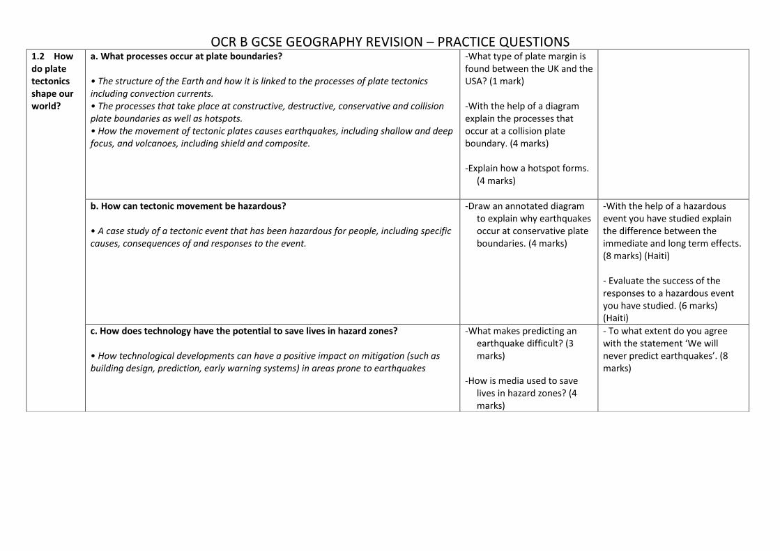
1.2 How do plate tectonics shape our world?
a. What processes occur at plate boundaries? • The structure of the Earth and how it is linked to the processes of plate tectonics including convection currents. • The processes that take place at constructive, destructive, conservative and collision plate boundaries as well as hotspots. • How the movement of tectonic plates causes earthquakes, including shallow and deep focus, and volcanoes, including shield and composite.
-What type of plate margin is found between the UK and the USA? (1 mark) -With the help of a diagram explain the processes that occur at a collision plate boundary. (4 marks) -Explain how a hotspot forms.
(4 marks)
b. How can tectonic movement be hazardous? • A case study of a tectonic event that has been hazardous for people, including specific causes, consequences of and responses to the event.
-Draw an annotated diagram to explain why earthquakes occur at conservative plate boundaries. (4 marks)
-With the help of a hazardous event you have studied explain the difference between the immediate and long term effects. (8 marks) (Haiti) - Evaluate the success of the responses to a hazardous event you have studied. (6 marks) (Haiti)
c. How does technology have the potential to save lives in hazard zones? • How technological developments can have a positive impact on mitigation (such as building design, prediction, early warning systems) in areas prone to earthquakes
-What makes predicting an earthquake difficult? (3 marks)
-How is media used to save
lives in hazard zones? (4 marks)
- To what extent do you agree with the statement ‘We will never predict earthquakes’. (8 marks)

OCR B GCSE GEOGRAPHY REVISION – PRACTICE QUESTIONS
CHANGING CLIMATE
From the exam specification Short questions (1-4 marks)
Long questions (6-8 marks)
2.1. What evidence is there to suggest climate change is a natural process?
a. What evidence is there for climate change?
The pattern of climate change from the beginning of the Quaternary period to the present day.
The range and reliability of evidence relating to climate change including evidence from sea ice positions, ice cores, global temperature data, paintings and diaries.
Figure 1 and 2. Mastodons were widespread across the USA and Europe during cold
glacial periods
- Study figures 1 and 2. How can fossils provide useful evidence about past climates? (3) - Compare the reliability of two sources of evidence of climate change (4)
“Proxy data are not reliable sources of paleoclimatic information” To what extent do you agree with this view? (6)
b. Is climate change a natural process?
Outline the causes of natural climate change including the theories of sun spots, volcanic eruptions and Milankovitch cycles.
Investigate the natural greenhouse effect and the impacts that humans have on the atmosphere, including the enhanced greenhouse effect.
- What is meant by the term ‘volcanic winter’(4) - What is the enhanced Greenhouse effect? (4) - What are sunspots and how do they affect the Earth’s climate? (4)
Discuss the view that climate change is a purely natural process (8)
c. Why is climate change a global issue?
Explore a range of social, economic and environmental impacts of climate change worldwide such as those resulting from sea level rise and extreme weather events. The impacts studied should relate to the 21st century.
Explore a range of social, economic and environmental impacts of climate change within the UK such as the impact on weather patterns, seasonal changes and changes in industry. The impacts studied should relate to the 21st century.
- Outline two possible effects of climate change on extreme weather across the planet over the next 50 years (4)
Assess whether the social impacts of climate change experienced in the UK in the 21st Century are greater than the environmental impacts (8)

OCR B GCSE GEOGRAPHY REVISION – PRACTICE QUESTIONS
DISTINCTIVE LANDSCAPES
From the exam specification Short questions (1-4 marks)
Long questions (6-8 marks)
3.1. What makes a landscape distinctive?
a. What is a landscape?
How the concept of a landscape can be defined, including the differences between built and natural landscapes.
What are the main characteristics of a ‘built’ landscape (2) Look at Figure A (of a coastal landscape) and annotate the landscape elements that you can see (2) Briefly describe what is meant by a natural landscape (1)
b. Where are the physical landscapes of the UK?
Overview of the distribution of upland, lowland and glaciated landscapes in the UK.
Overview of the characteristics of these landscapes which make them distinctive including their geology, climate and human activity.
Describe the distribution of upland and lowland landscapes in the UK (4) Explain how geology can affect the landscape that forms on the surface (3) Compare land uses in upland and lowland areas in the UK (4)
Explain how the geology of the UK gives rise to distinctive landscapes. Refer to one or more named rock types (6) Describe how the climate of the UK gives rise to distinctive landscapes. Refer to named locations in your answer (6)
3.2. What influences the landscapes of the UK?
a. What physical processes shape landscapes?
The geomorphic processes that are involved in shaping landscapes, including weathering (mechanical, chemical, biological), mass movement (sliding, slumping), erosion (abrasion, hydraulic action, attrition, solution), transport (traction, saltation, suspension, solution), deposition.
The formation of coastal landforms including headlands, bays, cave, arch, stack, beach and spit.
The formation of river landforms including waterfall, gorge, v-shaped valley, floodplain, levee, meander, ox-bow lake.
Outline the role of erosion in shaping a headland. Refer to a named example you have studied (4) Explain the stages in the formation of an arch (4) Explain how freeze-thaw weathering could cause the cliffs shown in the figure to break up (4) Describe a process of weathering, other than freeze-thaw, that can affect landscapes (2) Explain how constructive waves contribute to deposition on the coast (3)
With the aid of an annotated diagram, explain what is likely to happen to the landform in Figure B (of an arch) over the next 100 years (6) Explain how an oxbow lake could form on the river pictured (6)

OCR B GCSE GEOGRAPHY REVISION – PRACTICE QUESTIONS
Describe the formation of one river landform you have studied. You can use diagrams to help you (4) Study Figure 2, a photograph of a coastal area. Use evidence from Figure 2 to suggest how this coastal area may change in the future. Explain your answer (4) Suggest one reason for building embankments along a river (1) Explain how embankments could influence geomorphic processes in a river (3)
b. What are the characteristics of your chosen landscapes?
Case study of two landscapes in the UK, one
coastal landscape and one river basin, to include the study of: - its landforms created by geomorphic
processes - the geomorphic processes operating at
different scales and how they are influenced by geology and climate
- How human activity, including management, works in combination with geomorphic processes to impact the landscape.
For a named coastal landscape in the UK, explain how the landscape was formed (4) For a named river basin in the UK, describe its location. You could draw a labelled sketch map to help you (4) For one landform in a named river basin, explain how geomorphic processes have led to its formation (4) With reference to a landscape you have studied, explain what makes it distinctive (4)
For a named coastal landscape, assess the influence of weather and climate on the landscape (6) Discuss the factors that need to be considered in managing a coastal landscape (6) For a river basin you have studied, explain how human activity has affected the geomorphic processes in this landscape (6) For a river basin you have studied, discuss whether human activities in the river basin help to increase of reduce the risk of flooding (8 + 3 SpaG) For a named river basin in the UK, assess whether the negative impacts of human activity on the landscape are greater than the positive impacts (8+3SpaG)

OCR B GCSE GEOGRAPHY REVISION – PRACTICE QUESTIONS
b. What are the characteristics of your chosen landscapes?
Case study of two landscapes in the UK, one
coastal landscape and one river basin, to include the study of: - its landforms created by geomorphic
processes - the geomorphic processes operating at
different scales and how they are influenced by geology and climate
- how human activity, including management, works in combination with geomorphic processes to impact the landscape.
Define the erosional landforms in one coastal landscape you have studied and explain how they were formed (6) Assess how far the impacts of human activity on one coastal landscape have been negative (8 + 3 SpaG) With reference to a stretch of coastline you have studied:
a) Explain the processes of erosion affecting it (3)
b) Explain how the different groups of people who use the coastline may have conflicting views on how it should be used (4)
c) Name three different methods used to protect the coastline from erosion
With reference to a river that you have studied:
a) Describe the geomorphic processes that operate in the upper course of the river (4)
b) Explain how human activity affects the river’s natural flow (3)
OCR B GCSE GEOGRAPHY REVISION – PRACTICE QUESTIONS
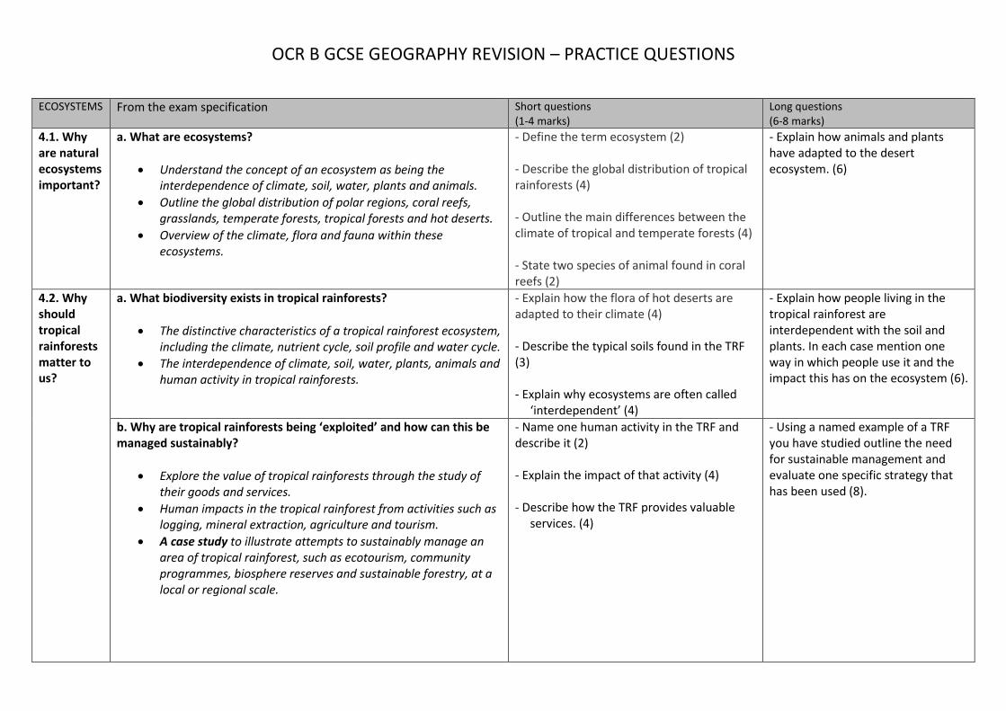
ECOSYSTEMS From the exam specification Short questions
(1-4 marks) Long questions (6-8 marks)
4.1. Why are natural ecosystems important?
a. What are ecosystems?
Understand the concept of an ecosystem as being the interdependence of climate, soil, water, plants and animals.
Outline the global distribution of polar regions, coral reefs, grasslands, temperate forests, tropical forests and hot deserts.
Overview of the climate, flora and fauna within these ecosystems.
- Define the term ecosystem (2) - Describe the global distribution of tropical rainforests (4) - Outline the main differences between the climate of tropical and temperate forests (4) - State two species of animal found in coral reefs (2)
- Explain how animals and plants have adapted to the desert ecosystem. (6)
4.2. Why should tropical rainforests matter to us?
a. What biodiversity exists in tropical rainforests?
The distinctive characteristics of a tropical rainforest ecosystem, including the climate, nutrient cycle, soil profile and water cycle.
The interdependence of climate, soil, water, plants, animals and human activity in tropical rainforests.
- Explain how the flora of hot deserts are adapted to their climate (4) - Describe the typical soils found in the TRF (3) - Explain why ecosystems are often called
‘interdependent’ (4)
- Explain how people living in the tropical rainforest are interdependent with the soil and plants. In each case mention one way in which people use it and the impact this has on the ecosystem (6).
b. Why are tropical rainforests being ‘exploited’ and how can this be managed sustainably?
Explore the value of tropical rainforests through the study of their goods and services.
Human impacts in the tropical rainforest from activities such as logging, mineral extraction, agriculture and tourism.
A case study to illustrate attempts to sustainably manage an area of tropical rainforest, such as ecotourism, community programmes, biosphere reserves and sustainable forestry, at a local or regional scale.
- Name one human activity in the TRF and describe it (2) - Explain the impact of that activity (4) - Describe how the TRF provides valuable
services. (4)
- Using a named example of a TRF you have studied outline the need for sustainable management and evaluate one specific strategy that has been used (8).

OCR B GCSE GEOGRAPHY REVISION – PRACTICE QUESTIONS
4.3. Is there more to polar environments than ice?
a. What is it like in Antarctica and the Arctic?
Outline the distinctive characteristics of Antarctica and the Arctic, including climate, features of the land and sea, flora and fauna.
The interdependence of climate, soil, water, plants, animals and human activity in either the Antarctic or the Arctic polar region.
Explore a range of impacts of human activity on either the Antarctic or the Arctic ecosystems, such as scientific research, indigenous people, tourism, fishing, whaling and mineral exploitation.
- Outline the impacts of human activities on either the Arctic or Antarctic ecosystems (4) - Describe the ways in which climate affects soils and people in the Arctic (4) - Suggest three ways in which the polar
environments are different to each other (3)
- Outline 2 modern human activities in the Arctic or Antarctic and evaluate their impact on the ecosystem (6).
b. How are humans seeking a sustainable solution for polar environments?
A case study to examine one small-scale example of sustainable management in either the Antarctic or the Arctic such as sustainable tourism, conservation and whaling.
A case study to examine one global example of sustainable management in either the Antarctic or the Arctic by investigating global actions such as Earth Summits or the Antarctic Treaty.
- Define sustainable management (2) - Describe one global scale example of
sustainable management in either the Arctic or Antarctic (4).
- Suggest two unsustainable practices that
are prevented by the Antarctic Treaty. (2)
- Using a small scale example you have studied explain how sustainable management is used in the Arctic or Antarctic (6).

OCR B GCSE GEOGRAPHY REVISION – PRACTICE QUESTIONS
URBAN FUTURES
From the exam specification Short questions (1-4 marks)
Long questions (6-8 marks)
5.1. Why do more than half the world’s population live in urban areas?
a. How is the global pattern of urbanisation changing?
How urban growth rates vary in parts of the world with contrasting levels of development.
Outline characteristics of world cities and megacities and their changing distribution since 1950.
- Define the following terms: urbanisation, megacity, word city. (3) - How has the global location of megacities changed since the 1950s? (2) - Suggest some advantages and disadvantages of megacities for the people who live in them. (4) - Why do some cities grow in status? (4) - Describe the difference between a megacity and a world city, giving a named example of each. (4)
- Why do some cities grow faster than others? (6) - How have the characteristics of world cities and megacities changed since the 1950s? (8)
b. What does rapid urbanisation mean for cities?
Understand the causes of rapid urbanisation in LIDCs, including the push and pull factors of rural-urban migration and internal growth.
Investigate the consequences of rapid urban growth in LIDCs.
Understand the causes and consequences of contrasting urban trends in ACs, including suburbanisation, counter-urbanisation and re-urbanisation.
- Identify three typical city functions and for each one suggest a city that is well known for that function. (3) - State the three factors that account for why urban areas grow. (3) - Explain how the growth of squatter settlements is connected with the rapid growth of cities. (4) - Explain how the population of cities in LIDCs and EDCs grows by rural-urban migration. (3) - Explain how the population of cities in LIDCs and EDCs grows by natural growth. (3) - Describe and explain the process of suburbanisation. (4) - Describe and explain the process of suburbanisation. (4) - Describe and explain the process of re-urbanisation. (4)
- To what extent is natural growth more of a factor than rural-urban migration in explaining LIDC urban growth? (8) - Assess whether the consequences of rapid urban growth in LIDCs have been more positive or negative. (8)

OCR B GCSE GEOGRAPHY REVISION – PRACTICE QUESTIONS
5.2. What are the challenges and opportunities for cities today? This enquiry question is studied through case studies of one city in an AC and one city in an LIDC or EDC to answer sub-questions a and b.
a. What is life like for people in a city?
The city’s location and importance within its region, the country, and the wider world.
Patterns of national and international migration and how this is changing the growth and character of the city.
Explore the ways of life in the city, such as culture, ethnicity, housing, leisure and consumption.
Investigate the contemporary challenges that affect life in the AC city, such as housing availability, transport provision, access to services and inequality.
Investigate the contemporary challenges that affect life in the LIDC or EDC city, such as squatter settlements, informal sector jobs, health or waste disposal.
- Define the term social inequality. (2) - Suggest how cities in advanced countries can be classed as ‘divided cities’ as a result of social inequality, with reference to a named city. (4) - For one city you have studied, explain why the city first developed. For the same city, explain why it grew. (4) - For a named city explain how migration is changing the character of the city.(4) - For a named city outline one challenge that it faces. (4) - For a named city explain its importance to the region, country and wider world. (4) - Define the term ‘informal sector’. (2)
- With reference to a city you have studied, outline the negative consequences of rapid urban growth in LIDCs. (5) - Compare the causes and consequences of recent urban trends in ACs with those in LIDCs and EDCs. (8) - What are the challenges and opportunities for cities today? (8) - Suggest how challenges faced by LIDC cities can be solved. (6) - Suggest how the challenges faced by AC cities can be solved. (6) - To what extent does the ethnic composition of a city determine its character? (8)
b. How can cities become more sustainable?
For each city investigate one initiative to make it more sustainable, such as use of brownfield sites, waste recycling and transport improvements.
- Sustainability involves three elements. What are those three elements? (3) - With reference to a city you have studied, outline one scheme for improving the sustainability of a particular area. (4) - For a named city in a LIDC describe efforts to improve the way of life for people in the city. (3) - Define the term brownfield. (1)
- How have some LIDC cities attempted to improve the quality of life for people wo live in them? Evaluate the success of these schemes. (8) - For a named city in an AC describe one initiative you have studied and how it will help to make the city more sustainable. (6) - With reference to one named city evaluate whether it should be considered ‘sustainable’ (8)

OCR B GCSE GEOGRAPHY REVISION – PRACTICE QUESTIONS
DYNAMIC DEVELOPMENT
From the exam specification Short questions (1-4 marks)
Long questions (6-8 marks)
6.1. Why are some countries richer than others?
a. What is development and how can it be measured?
Definition of ‘development’ and the ways in which countries can be classified, such as AC, EDC and LIDC.
Global distribution of ACs, EDCs and LIDCs.
Economic and social measures of development, such as GNI per capita and Human Development Index, and how they illustrate the consequences of uneven development.
- Name one measure of social development. Describe how it shows how developed a country is (3) - What is the difference between absolute and relative poverty? (2) - Describe the distribution of LIDCs around the world. (4)
b. What has led to uneven development?
Outline the human and physical factors influencing global uneven development.
Explore the factors that make it hard for countries to break out of poverty, including debt, trade and political unrest.
- How can physical factors such as natural resources affect how developed a place can become? (3) - What is meant by debt? (1) - What is the impact of political instability on development? (4)
- Examine the causes of uneven development (8).
6.2. Are LIDCs likely to stay poor? This enquiry question is studied through one case study of an LIDC to answer sub-questions a, b and c.
a. How has an LIDC developed so far?
Overview of the economic development of an LIDC, including influences of population, society, technology and politics, particularly in the past 50 years, or post-independence.
Explore whether Rostow’s model can help determine the country’s path of economic development.
The extent to which the relevant Millennium Development Goals have been achieved for this LIDC.
Investigate how the LIDC’s wider political, social and environmental context has affected its development.
- The Rostow model demonstrates how countries can develop over time. Describe what is meant by the ‘take off’ stage. (4)
- For a named LIDC or EDC describe its level of development and examine the social, political and technological influences affecting its development. (8) - Assess the extent to which a named LIDC you have studied has achieved the Millennium Development Goals. (6)
OCR B GCSE GEOGRAPHY REVISION – PRACTICE QUESTIONS
b. What global connections influence its development?
The country’s international trade, such as potential reliance on a single, or few, commodities and how this influences development.
The benefits and problems of trade and Trans National Company (TNC) investment for development.
The advantages and disadvantages of international aid or debt relief for its development.
- Describe how aid can benefit an area. (3) - What are transnational companies? Give an example of one. (2) - Self-help schemes are often found in areas trying to escape poverty. Explain what is meant by ‘self-help’ (2)
- Evaluate the impact that a
transnational company can have on a location. Suggest some possible advantages and disadvantages for the host nation (6)
- Assess the impact of aid in an LIDC you have studied. (6)
c. What development strategy is most appropriate?
Compare the advantages and disadvantages of one top-down and one bottom-up strategy in the country.
- Why can bilateral aid, also known as tied aid, be a problem for the country receiving it? (3) - Explain the difference between top-down and bottom-up development strategies. (4)
- Sometimes nations employ different strategies to help reduce poverty. These can be classed as top-down or bottom-up. Discuss the advantages and disadvantages of each type of strategy and assess which is likely to be more effective long term. (8) - With reference to a named LIDC example, describe how either a top-down or bottom-up strategy has led to improvements in living conditions for the local population. (6)

OCR B GCSE GEOGRAPHY REVISION – PRACTICE QUESTIONS
UK IN THE 21ST CENTURY
From the exam specification Short questions (1-4 marks)
Long questions (6-8 marks)
7.1. How is the UK changing in the 21st century?
a. What does the UK look like in the 21st century?
Overview of human and physical geographical characteristics of the UK, including population density, land use, rainfall and relief, and significant issues associated with these characteristics, including water stress and housing shortages.
- Describe the population density of the UK. (3) - Why do mountains in the west of the UK receive high rainfall totals? (3) - Describe the pattern of water stress in England.(3) - Suggest reasons for this pattern. (3)
- Why do cities such as London have high population densities? (6) - Explain how patterns of rainfall and population density may cause problems in South East England? (6) - Why do many people with to live in courses on the edge of towns and cities? (6)
b. How is the UK’s population changing?
Overview of population trends in the UK since 2001, using population pyramids and migration statistics, to determine its position on the Demographic Transition Model.
An understanding of the causes, effects, spatial distribution and responses to an ageing population.
A summary of the how the population structure and ethnic diversity of a named place of the UK has changed since 2001.
- Suggest what stage of the demographical transition model the UK is at? (4) - Suggest why there was a sudden rise in migration to the UK between 2000-2010. (4) - How has migration affected UK birth rates and death rates? (4) - Why do you think there are such high concentrations of elderly people in the South of England? (4) - What health and lifestyle changes are responsible for people living longer today than in the past? (3)
- What are the arguments in favour and against allowing migration to the UK to continue? (8) - How might high concentrations of elderly people create challenges for local authorities? (6) - Explain how the population structure and ethnic diversity has changed in one named UK place you have studied. (8)

OCR B GCSE GEOGRAPHY REVISION – PRACTICE QUESTIONS
c. How is the UK’s economy changing?
Identify major economic changes in the UK since 2001 by examining changes in the job market including political priorities, changing employment sectors and working hours.
Investigate the pattern of core UK economic hubs.
Identify the changes in one economic hub and its significance to its region and the UK.
- Describe how the UK’s employment structures have changed since 2001. (3) - How do big infrastructure projects such as crossrail help to boost the economy? (4) - Suggest how changing political priorities might have affected the UK economy since 2001. (4) - Describe what an economic hub is. (2)
- For an economic hub you have studied, discuss how its economy has changed over time ( 6 marks) - For an economic hub you have studied, explain its significance to its region and the wider UK (8)
7.2 Is the UK losing its global significance?
a. What is the UK’s political role in the world?
Examine the UK’s political role in one global conflict through its participation in international organisations.
- Name one international organisation of which the UK is a member. Explain the purpose of this organisation (4)
- For a global conflict you have studied, explain how the UK played a role through its involvement with international organisations. (8)
b. How is the UK’s cultural influence changing?
Explore the UK’s media exports and their global influence including television programmes and film.
The contribution of ethnic groups to the cultural life of the UK through one of food, media or fashion.
- Suggest reasons why the sale of UK television programs to the US is so high. (4) - Why do you think China is importing far more UK television shows? (3) - Describe how ethnic groups have contributed to the UK through either food, media or fashion. (4)
- Explain how media exports might encourage people to visit the UK. (6)
- Explain how UK media exports can have a global influence. (8)

OCR B GCSE GEOGRAPHY REVISION – PRACTICE QUESTIONS
RESOURCE RELIANCE
From the exam specification Short questions (1-4 marks)
Long questions (6-8 marks)
8.1. Will we run out of natural resources?
a. How has increasing demand for resources affected our planet?
Outline the factors leading to demand outstripping supply of food, energy and water.
Overview of how environments and ecosystems are used and modified by humans including: - mechanisation of farming and commercial fishing to provide food - deforestation and mining to provide energy - reservoirs and water transfer schemes to provide water.
Using Fig 1 and your own knowledge, describe how changes in global population are affecting demand for resources (3) – Fig is of population vs year Outline one other factor that is affecting global demand for resources (2) Describe the environmental impact of changing farming practices (3) Describe how deforestation can increase energy supply (3) Outline the environmental impacts of mining fossil fuels to increase energy supply (4) Other than water transfers, describe one large-scale way of increasing water supply and explain how it could help make water supply more reliable (3) Suggest reasons why population growth has led to resources becoming exhausted (3) Describe two impacts of commercial fishing on ocean ecosystems (3) Describe two ways in which ecosystems are altered by obtaining energy supplies (4)
There are various different methods for producing energy. Choose two of the following methods and evaluate their advantages and disadvantages: nuclear power, natural gas, coal mining, oil drilling, geothermal energy, hydro-electric power. (8)

OCR B GCSE GEOGRAPHY REVISION – PRACTICE QUESTIONS
8.2. Can we feed nine billion people by 2050?
a. What does it mean to be food secure?
Understand the term ‘food security’ and the human and physical factors which influence this.
How world patterns of access to food are illustrated, such as the world hunger index and average daily calorie consumption.
Investigate the differences between Malthusian and Boserupian theories about the relationship between population and food supply.
Using Fig 1, describe the distribution of countries that produced less than 2.8 million tonnes of cereals from 2012-2014 (2) – Fig is world map with cereal production by country Explain the physical factors that can contribute to food insecurity (4) Explain the human factors that can contribute to food insecurity (4) Describe what it means for a person to be food secure? (2) With reference to both Physical & Human factors, explain why food security is a growing issue for many countries, both LIDCs and ACs (4) How is the World Hunger Index calculated? (2) How is food waste linked to food security (2)
Compare Malthus’s and Boserup’s theories about how population growth and food availability are linked (6)
b. How can countries ensure their food security?
Case study of attempts to achieve food security in one
country to include: - Investigation of statistics
relating to food consumption and availability over time.
- The success of one attempt in helping achieve food security at a local scale such as food banks, urban gardens and allotments.
- The effectiveness of one past and one present attempt to achieve food security at a national scale such as global food trade, GM crops, and ‘The Green Revolution’ and food production methods.
With reference to a country you have studied, outline the problems that it faced when trying to feed its population both now and in the past (4) Case study – explain how effective one attempt to achieve food security at a National scale has been (4) For a country you have studied, describe how one piece of data shows food security changing over time (4) For a current national food security scheme in a country you have studied, explain 2 ways food security will be improved (4)
For a country you have studied, evaluate the success of a local-scale attempt to increase food security (6) For a country you have studied, describe the key features of an attempt to achieve food security at a national scale (6) For a country you have studied, compare the effectiveness of one past and one present attempt to increase food security at a national scale (8 + 3 SpaG) Evaluate the methods that are being suggested by the government of one country to ensure its future food security (6)

OCR B GCSE GEOGRAPHY REVISION – PRACTICE QUESTIONS
c. How sustainable are these strategies?
Explore the environmental, economic and social sustainability of attempts to achieve food security, in relation to: - ethical consumerism, such as
fairly traded goods and food waste
- food production, such as organic methods and intensive farming
- technological developments, such as GM crops and hydroponics
- small scale ‘bottom up’ approaches, such as urban gardens and permaculture.
Explain how ethical consumerism can help to increase food security (4) Explain why an ethical consumer might prefer to buy fairly traded goods (3) Other than buying fairly traded goods, outline on way of making food consumption more ethical (2) Explain how environmentally sustainable one method of improving food production is (4) Other than urban gardens, describe one small-scale, bottom-up approach to increasing food production and explain how it is sustainable (4) Outline the attempts being made by the UK to reduce food waste on a national and local scale (4)
Assess how far technological developments that increase food production are sustainable (6) Using an example, explain how ethical consumerism can improve food security (6)
OCR B GCSE GEOGRAPHY REVISION – PRACTICE QUESTIONS
FIELDWORK General theory Based on your project
PHYSICAL - Name a primary data collection suitable for carrying out a physical geography fieldwork investigation looking at the impact of groynes on the movement of sediment. (1) - Identify two variables which could be used to investigate how a river changes along its course. (2) - What might be the risks associated with coastal fieldwork and how would you minimise these? (4) - Suggest how you would use computers and the internet to investigate coastal change. [4 marks] - Figs 5, 6 and 7 in the separate Resource Booklet show information from a GCSE geography student’s fieldwork investigation. Using evidence from Figs 5, 6 and 7, write a conclusion to the question for investigation “Does the process of longshore drift occur at Sheringham?” Develop your answer. - Describe one way this data (showing changes in shape and size of material in a river along its course) might be presented in a fieldwork investigation and explain why you have chosen to use this method (4)
- You will have carried out some physical fieldwork as part of your course. Briefly describe the fieldwork and explain how your fieldwork conclusions improved your understanding of the geographical question or issue. (8) - Justify the sampling strategies used in your enquiry. (4) - Assess the appropriateness of your data presentation methods. (6)
HUMAN - Devise a hypothesis for investigating the character of a city (3 marks) - What would be the sequence of enquiry investigating the impact of migration on a city? (4 marks) - Describe and justify a technique you would use to collect information about the challenges faced by those living in an inner city area (6 marks) - State a potential risk associated with conducting fieldwork in an urban area. Explain how you would take steps to minimise the risk (5 marks) - In what way would secondary data help improve your understanding of an urban area (4 marks) - State two types of data that could be used during an investigation into changing land use in a CBD over the last ten years and give reasons for your choices (4).
- You will have carried out some human geography fieldwork as part of the course. Briefly describe the fieldwork and evaluate the methods that you used and the accuracy of the results obtained. (8) - For a human geography fieldwork investigation that you have completed, evaluate one technique that you used to collect qualitative data. (2) - Justify the choice of location used to collect data. (4)