Embed Size (px)
Citation preview

OceansOceans
ESSTD2004ESSTD2004

1: Overview1: Overview

ExplorationExploration


Hydrologic CycleHydrologic Cycle
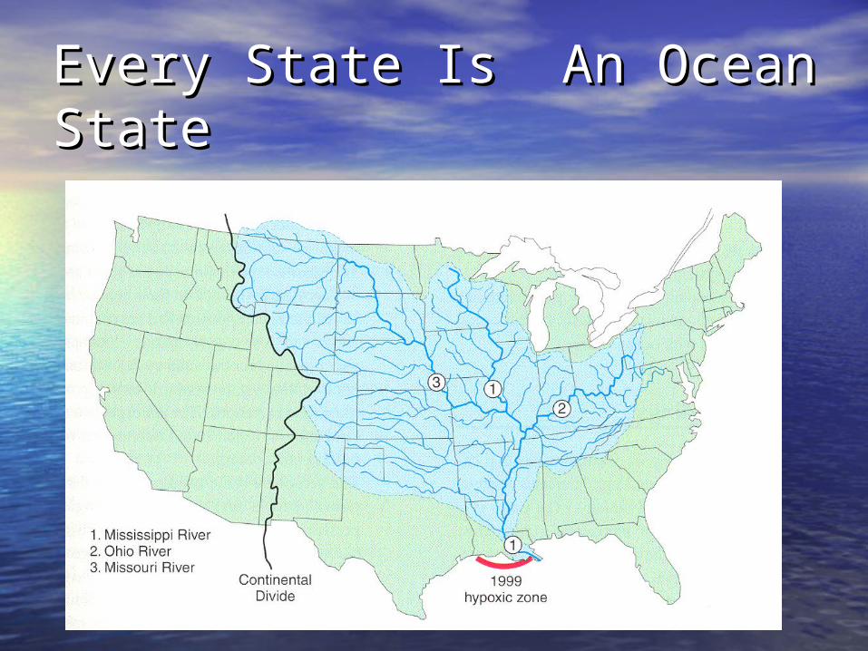
Every State Is An Ocean Every State Is An Ocean StateState

Heights and DepthsHeights and Depths
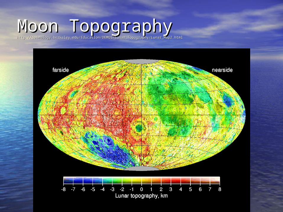
Moon TopographyMoon Topographyhttp://cosmology.berkeley.edu/Education/DEMOS/Lunar_Topography/Lunar_Map2.htmlhttp://cosmology.berkeley.edu/Education/DEMOS/Lunar_Topography/Lunar_Map2.html

Venus TopographyVenus Topographyhttp://www.higp.hawaii.edu/~hamilton/venus.htmlhttp://www.higp.hawaii.edu/~hamilton/venus.html

Jupiter – an Ocean PlanetJupiter – an Ocean Planet
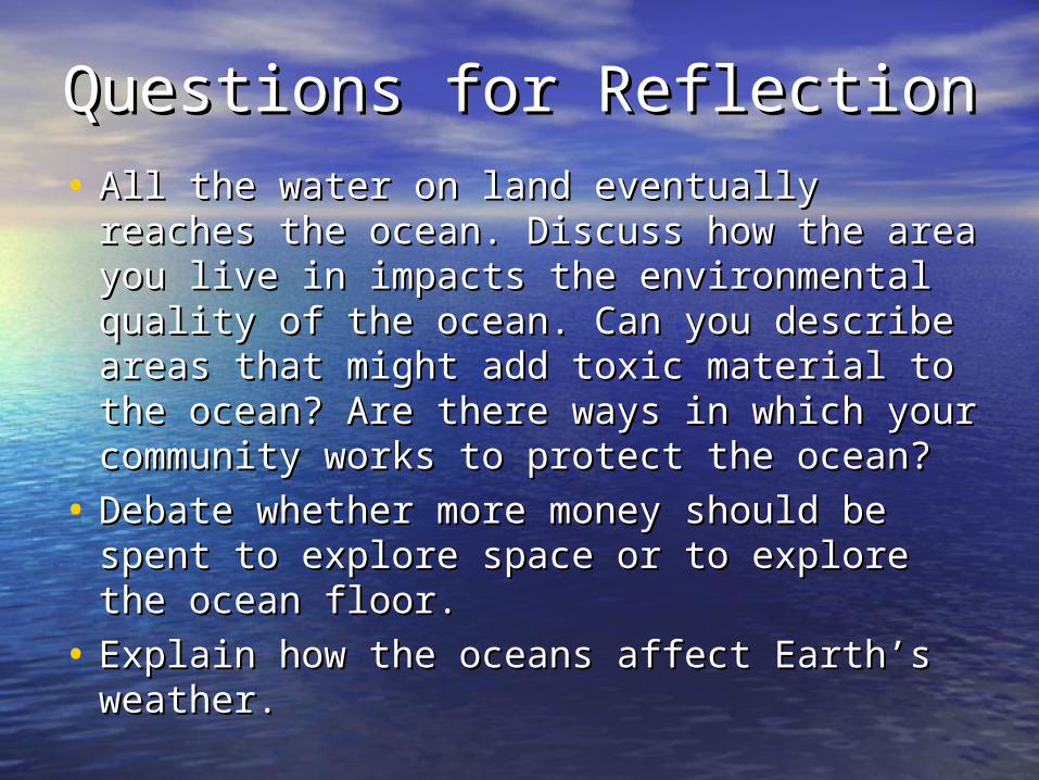
Questions for ReflectionQuestions for Reflection• All the water on land eventually reaches All the water on land eventually reaches
the ocean. Discuss how the area you live the ocean. Discuss how the area you live in impacts the environmental quality of in impacts the environmental quality of the ocean. Can you describe areas that the ocean. Can you describe areas that might add toxic material to the ocean? Are might add toxic material to the ocean? Are there ways in which your community there ways in which your community works to protect the ocean?works to protect the ocean?
• Debate whether more money should be Debate whether more money should be spent to explore space or to explore the spent to explore space or to explore the ocean floor. ocean floor.
• Explain how the oceans affect Earth’s Explain how the oceans affect Earth’s weather.weather.

Investigations 1Investigations 1•Closed-loop MappingClosed-loop Mapping - Plan a round - Plan a round
trip, log your travels and check your trip, log your travels and check your accuracy.accuracy.– http://physics.gallaudet.edu/navigatehttp://physics.gallaudet.edu/navigate
•Shuttle OceanographyShuttle Oceanography – Look for – Look for interesting shuttle ocean interesting shuttle ocean photographsphotographs– http://daac.gsfc.nasa.gov/CAMPAIGN_DOCS/http://daac.gsfc.nasa.gov/CAMPAIGN_DOCS/
OCDST/shuttle_oceanography_web/OCDST/shuttle_oceanography_web/oss_contents.htmloss_contents.html
•Global Topographic MapGlobal Topographic Map – Find – Find interesting ocean basin features.interesting ocean basin features.– http://physics.gallaudet.edu/etopo5/http://physics.gallaudet.edu/etopo5/

2: Plates and Oceans2: Plates and Oceans
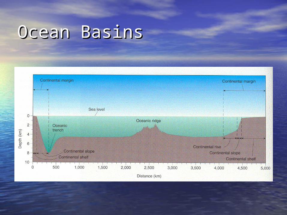
Ocean BasinsOcean Basins

Plate BoundariesPlate Boundaries
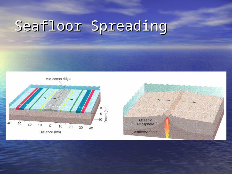
Seafloor SpreadingSeafloor Spreading

Atlantic and Pacific Basin Atlantic and Pacific Basin DynamicsDynamics

Plate SubductionPlate Subduction
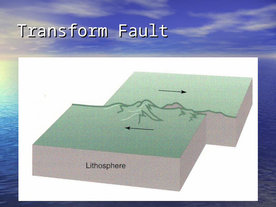
Transform FaultTransform Fault

Questions for ReflectionQuestions for Reflection
• Ocean fossils and layers of sedimentary Ocean fossils and layers of sedimentary rock can be found on the tops of mountains. rock can be found on the tops of mountains. What does that show about the Earth’s What does that show about the Earth’s surface?surface?
• Why is the seafloor lower than the surface Why is the seafloor lower than the surface of the continents?of the continents?
• No oceanic crust older than about 160M No oceanic crust older than about 160M years is known from the present oceans. years is known from the present oceans. Why are they so young?Why are they so young?
• Would you expect lavas that erupt under Would you expect lavas that erupt under water to cool more or less rapidly than water to cool more or less rapidly than those that erupt in air?those that erupt in air?
• What would the surface of the Earth be like What would the surface of the Earth be like without active plate tectonics?without active plate tectonics?

Questions for ReflectionQuestions for Reflection
• How did ancient civilizations explain How did ancient civilizations explain the occurrence of earthquakes and the occurrence of earthquakes and volcanoes?volcanoes?
• Does plate tectonics operate on any Does plate tectonics operate on any other planet in our solar system?other planet in our solar system?

3: SeaWater3: SeaWater

The Water MoleculeThe Water Molecule

Water Energy Water Energy TransformationsTransformations

Latent Heats of WaterLatent Heats of Water
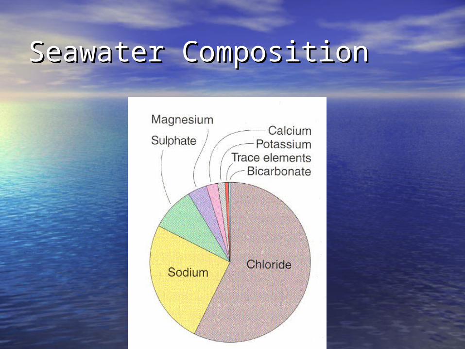
Seawater CompositionSeawater Composition
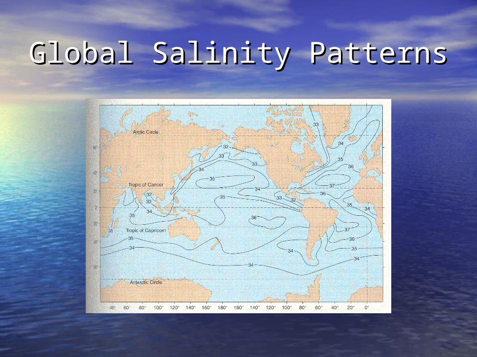
Global Salinity PatternsGlobal Salinity Patterns

T-S GraphT-S Graph
Questions for ReflectionQuestions for Reflection
• List important properties of water.List important properties of water.
• Describe thermohaline circulation.Describe thermohaline circulation.
• In what major process does water get In what major process does water get transferred from the ocean to the transferred from the ocean to the atmosphere?atmosphere?
• Why are temperature and salinity the Why are temperature and salinity the most important tracers of water most important tracers of water masses?masses?
• What resources are extracted from What resources are extracted from seawater?seawater?

Investigations 3Investigations 3• Measure Salinity using the GLOBE Program Measure Salinity using the GLOBE Program
protocolprotocol• Wave Speed and Depth – Set up a rain Wave Speed and Depth – Set up a rain
gutter and measure the speed of waves in gutter and measure the speed of waves in water depths of 1 cm, 2 cm,…water depths of 1 cm, 2 cm,…
• Thermohaline Circulation and the Thermohaline Circulation and the Rayleigh-Taylor Instability – Experiment Rayleigh-Taylor Instability – Experiment with “baby food” jars studying mixing of with “baby food” jars studying mixing of cold, hot, salty, fresh water.cold, hot, salty, fresh water.
• Water On the Balance – Does dipping your Water On the Balance – Does dipping your finger into water on a scale change the finger into water on a scale change the reading?reading?
4: Oceans and the 4: Oceans and the AtmosphereAtmosphere

Solar CycleSolar Cycle

Effect of Solar ElevationEffect of Solar Elevation

Coriolis EffectCoriolis Effect

Global Wind PatternsGlobal Wind Patterns

High Pressure CentersHigh Pressure Centers

Low Pressure CentersLow Pressure Centers
Questions for ReflectionQuestions for Reflection• Why are the cloud patterns we see in Why are the cloud patterns we see in
weather satellite images dominated by weather satellite images dominated by swirls?swirls?
• Why do hurricanes not form at the equator? Why do hurricanes not form at the equator? Why do they not form over land? There are Why do they not form over land? There are no hurricanes formed in the South Atlantic no hurricanes formed in the South Atlantic Ocean. Why?Ocean. Why?
• What special conditions are necessary for What special conditions are necessary for hurricanes to form?hurricanes to form?
• In what major process does water get In what major process does water get transferred from the ocean to the transferred from the ocean to the atmosphere?atmosphere?
• Why is the concentration of carbon dioxide Why is the concentration of carbon dioxide dissolved in seawater greater than in the dissolved in seawater greater than in the atmosphere?atmosphere?
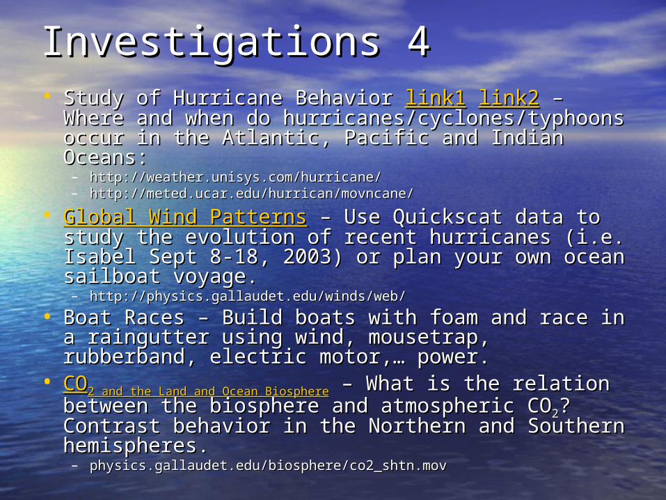
Investigations 4Investigations 4• Study of Hurricane Behavior Study of Hurricane Behavior link1link1 link2link2 – Where – Where
and when do hurricanes/cyclones/typhoons occur and when do hurricanes/cyclones/typhoons occur in the Atlantic, Pacific and Indian Oceans:in the Atlantic, Pacific and Indian Oceans:– http://weather.unisys.com/hurricane/http://weather.unisys.com/hurricane/– http://meted.ucar.edu/hurrican/movncane/http://meted.ucar.edu/hurrican/movncane/
• Global Wind PatternsGlobal Wind Patterns – Use Quickscat data to – Use Quickscat data to study the evolution of recent hurricanes (i.e. study the evolution of recent hurricanes (i.e. Isabel Sept 8-18, 2003) or plan your own ocean Isabel Sept 8-18, 2003) or plan your own ocean sailboat voyage.sailboat voyage.– http://physics.gallaudet.edu/winds/web/http://physics.gallaudet.edu/winds/web/
• Boat Races – Build boats with foam and race in a Boat Races – Build boats with foam and race in a raingutter using wind, mousetrap, rubberband, raingutter using wind, mousetrap, rubberband, electric motor,… power.electric motor,… power.
• COCO22 and the Land and Ocean Biosphere and the Land and Ocean Biosphere – What is the relation – What is the relation between the biosphere and atmospheric CObetween the biosphere and atmospheric CO22? ? Contrast behavior in the Northern and Southern Contrast behavior in the Northern and Southern hemispheres.hemispheres.– physics.gallaudet.edu/biosphere/co2_shtn.movphysics.gallaudet.edu/biosphere/co2_shtn.mov

5: Currents5: Currents
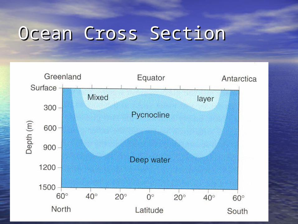
Ocean Cross SectionOcean Cross Section
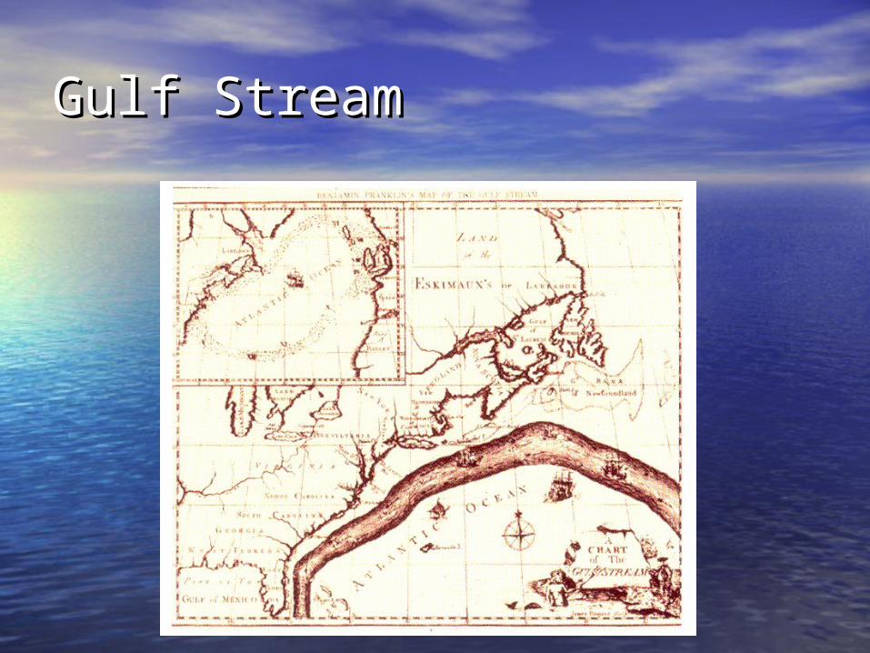
Gulf StreamGulf Stream

Gulf StreamGulf Stream

Ekman TransportEkman Transport

Western Boundary CurrentsWestern Boundary Currents

Gyre DynamicsGyre Dynamics

Global CurrentsGlobal Currents

UpwellingUpwelling

DownwellingDownwelling

El Nino EventsEl Nino Events


Questions for ReflectionQuestions for Reflection
• What causes the principal open-What causes the principal open-ocean surface currents?ocean surface currents?
• Discuss why it is important to study Discuss why it is important to study ocean currents. Include in your ocean currents. Include in your discussion ways that plants, animals, discussion ways that plants, animals, and humans use ocean currents. and humans use ocean currents.
• Why does a wind driven current not Why does a wind driven current not flow in the same direction as the flow in the same direction as the wind that causes it?wind that causes it?

Questions for ReflectionQuestions for Reflection
• If the thermal energy from solar If the thermal energy from solar radiation is largely absorbed by the radiation is largely absorbed by the surface layers, how can it be carried surface layers, how can it be carried deeper?deeper?
• If higher average temperatures than If higher average temperatures than now characterized the Earth's now characterized the Earth's surface and the poles were ice free, surface and the poles were ice free, what implications might such what implications might such conditions have for ocean conditions have for ocean circulation?circulation?

Investigations 5Investigations 5• Water Current PatternsWater Current Patterns – Study the seasonal patterns of – Study the seasonal patterns of
the equatorial currents in the Atlantic, Pacific and Indian the equatorial currents in the Atlantic, Pacific and Indian Oceans.Oceans.– http://physics.gallaudet.edu/currents/currents.htmlhttp://physics.gallaudet.edu/currents/currents.html
• DriftersDrifters – Pick a region with interesting geography or – Pick a region with interesting geography or currents and track a drifter.currents and track a drifter.– http://w3.jcommops.org/cgi-bin/WebObjects/Argohttp://w3.jcommops.org/cgi-bin/WebObjects/Argo
• Sea Surface TemperatureSea Surface Temperature – Search for and estimate the – Search for and estimate the intensity of El Nino events.intensity of El Nino events.– http://physics.gallaudet.edu/sstdv/web/sstdv.htmlhttp://physics.gallaudet.edu/sstdv/web/sstdv.html
• Ocean Basin DynamicsOcean Basin Dynamics – Experiment with a computer – Experiment with a computer basin computer model to see how winds, ocean depth/size basin computer model to see how winds, ocean depth/size and the Coriolis force affects water currents and the sea and the Coriolis force affects water currents and the sea level.level.– http://physics.gallaudet.edu/obdv/obdv.htmlhttp://physics.gallaudet.edu/obdv/obdv.html

Credits and ResourcesCredits and Resources• Slides from Slides from Datastreme OceanDatastreme Ocean, M. Grant , M. Grant
Gross, Elizabeth Gross, American Gross, Elizabeth Gross, American Meteoroloigical Society, 2004.Meteoroloigical Society, 2004.
• Quickscat and Sea Surface Temperature Quickscat and Sea Surface Temperature data from the Jet Propulsion Laboratorydata from the Jet Propulsion Laboratory– podaac.jpl.nasa.govpodaac.jpl.nasa.gov
• Rayleigh-Taylor Instability – Fascinating Rayleigh-Taylor Instability – Fascinating Gateway to the Study of Fluid DynamicsGateway to the Study of Fluid Dynamics, , Robert F. Benjamin, The Physics Teacher, Robert F. Benjamin, The Physics Teacher, Vol. 37, 1999, pp 332-336Vol. 37, 1999, pp 332-336
• Map Images for Class GraphingMap Images for Class Graphing– http://physics.gallaudet.edu/mapimages/http://physics.gallaudet.edu/mapimages/