Embed Size (px)
Citation preview

Oceanography Branch CTD Data Report CTD_REPORT_2011001S1 NOAA Fisheries Service Northeast Fisheries Science Center Woods Hole, MA 02543 S1 11-01 2011 Scallop Survey Data Coverage: May 12 – June 18, 2011 Mid Atlantic Bight and Georges Bank This report presents a summary of surface and bottom temperature and salinity data collected during the Northeast Fisheries Science Center’s 2011 Sea Scallop Survey aboard the UNOLSR/V Hugh R. Sharp. All data was obtained with the shipboard Seabird Electronics SBE Model 9/11+ CTD. No salinity correction was necessary. The cast numbering was started at 001 for each leg making it necessary to rename all the files for processing. Leg I occurred on May 12 – May 20 and includes casts 101 – 147; Leg II took place on June 9 – June 18 and includes casts 201 – 239. No CTD casts were conducted on Leg III. Data presented here have been audited, however, corrections and/or updates may be applied at a later time. The most recent and complete station data can be found in an NODC formatted ASCII file at: ftp://ftp.nefsc.noaa.gov/pub/hydro/s11101.dat This report may be viewed on the Oceanography Branch website at: http://www.nefsc.noaa.gov/HydroAtlas/ choose: 2011 Cruises MAY_SCALLOP_S11101 CTD_REPORT_2011001S1 Revised: March 26, 2012

-76 -74 -72 -70 -68 -66
LONGITUDE
35
36
37
38
39
40
41
42
43
44
LAT
ITU
DE
3
9
15
21
27
33
39
4551
57
6369
758187
9399
117
123129
135 142
148154 161167
173179
185191
197
203209216
223
229235242
248
258
270
288
300
GOMWEST
GOMEAST
GEORGESBANK
MABNORTH
MABSOUTH
Sharp 2011 Scallop SurveyMay 12 - June 18, 2011CTD Station Positions
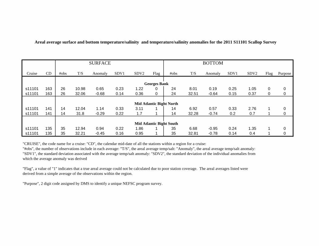
Areal average surface and bottom temperature/salinity and temperature/salinity anomalies for the 2011 S11101 Scallop Survey
SURFACE BOTTOM
Cruise CD #obs T/S Anomaly SDV1 SDV2 Flag #obs T/S Anomaly SDV1 SDV2 Flag Purpose
Georges Banks11101 163 26 10.98 0.65 0.23 1.22 0 24 8.01 0.19 0.25 1.05 0 0s11101 163 26 32.06 -0.68 0.14 0.36 0 24 32.51 -0.64 0.15 0.37 0 0
Mid Atlantic Bight Norths11101 141 14 12.04 1.14 0.33 3.11 1 14 6.92 0.57 0.33 2.76 1 0s11101 141 14 31.8 -0.29 0.22 1.7 1 14 32.28 -0.74 0.2 0.7 1 0
Mid Atlantic Bight Souths11101 135 35 12.94 0.94 0.22 1.86 1 35 6.68 -0.95 0.24 1.35 1 0s11101 135 35 32.21 -0.45 0.16 0.95 1 35 32.81 -0.78 0.14 0.4 1 0
"CRUISE", the code name for a cruise: "CD", the calendar mid-date of all the stations within a region for a cruise:"#obs", the number of observations include in each average: "T/S", the areal average temp/salt: "Anomaly", the areal average temp/salt anomaly:"SDV1", the standard deviation associated with the average temp/salt anomaly: "SDV2", the standard deviation of the individual anomalies fromwhich the average anomaly was derived
"Flag", a value of "1" indicates that a true areal average could not be calculated due to poor station coverage. The areal averages listed were derived from a simple average of the observations within the region.
"Purpose", 2 digit code assigned by DMS to identify a unique NEFSC program survey.
-76 -74 -72 -70 -68 -66
LONGITUDE
35
36
37
38
39
40
41
42
43
44
LAT
ITU
DE
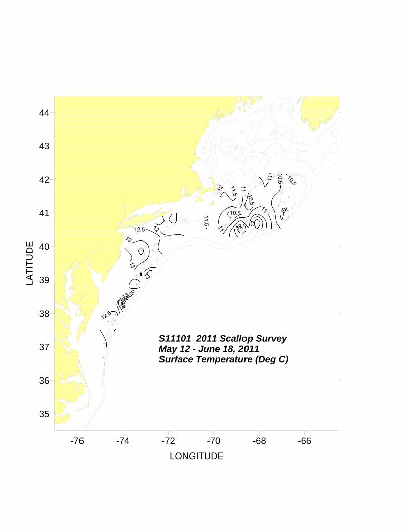
S11101 2011 Scallop SurveyMay 12 - June 18, 2011Surface Temperature (Deg C)

-76 -74 -72 -70 -68 -66
LONGITUDE
35
36
37
38
39
40
41
42
43
44
LAT
ITU
DE
S11101 2011 Scallop SurveyMay 12 - June 18, 2011Surface Temperature Anomaly

-76 -74 -72 -70 -68 -66
LONGITUDE
35
36
37
38
39
40
41
42
43
44
LAT
ITU
DE
S11101 2011 Scallop SurveyMay 12 - June 18, 2011Surface Salinity (PSU)
-76 -74 -72 -70 -68 -66
LONGITUDE
35
36
37
38
39
40
41
42
43
44
LAT
ITU
DE
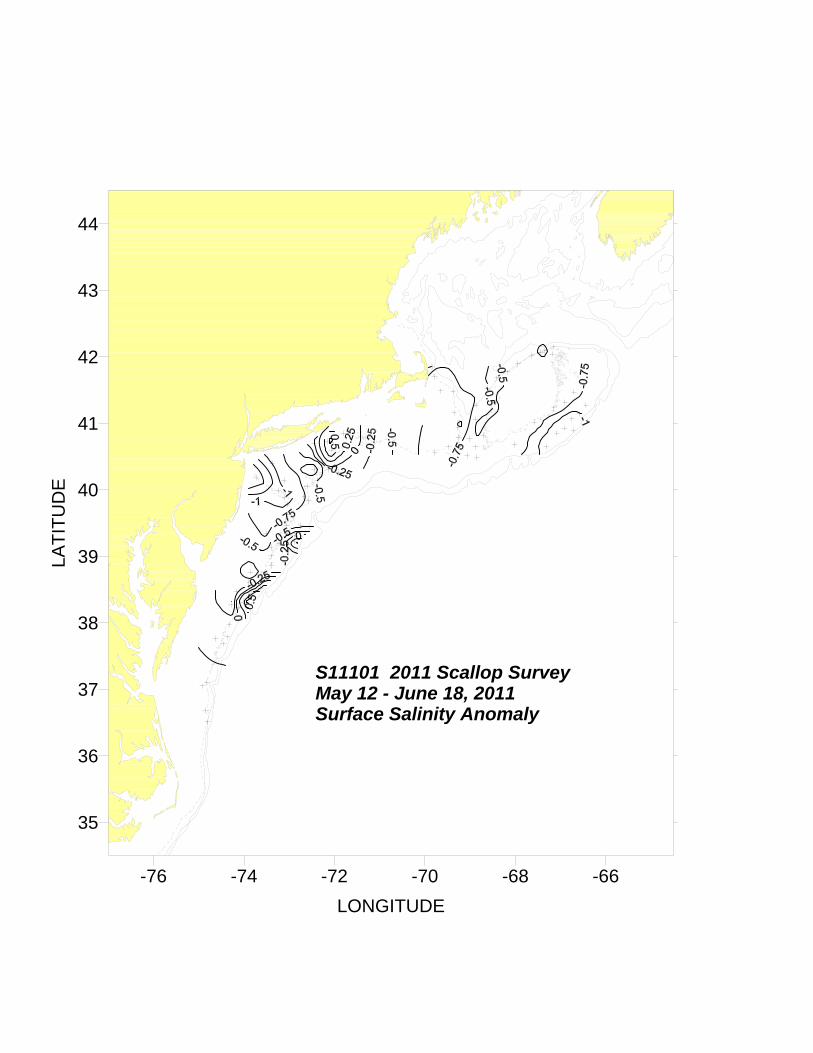
S11101 2011 Scallop SurveyMay 12 - June 18, 2011Surface Salinity Anomaly

-76 -74 -72 -70 -68 -66
LONGITUDE
35
36
37
38
39
40
41
42
43
44
LAT
ITU
DE
S11101 2011 Scallop SurveyMay 12 - June 18, 2011Bottom Temperature (Deg C)
-76 -74 -72 -70 -68 -66
LONGITUDE
35
36
37
38
39
40
41
42
43
44
LAT
ITU
DE
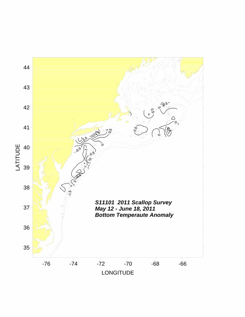
S11101 2011 Scallop SurveyMay 12 - June 18, 2011Bottom Temperaute Anomaly

-76 -74 -72 -70 -68 -66
LONGITUDE
35
36
37
38
39
40
41
42
43
44
LAT
ITU
DE
S11101 2011 Scallop SurveyMay 12 - June 18, 2011Bottom Salinity (PSU)

-76 -74 -72 -70 -68 -66
LONGITUDE
35
36
37
38
39
40
41
42
43
44
LAT
ITU
DE
S11101 2011 Scallop SurveyMay 12 - June 18, 2011Bottom Salinity Anomaly

R/V Hugh R. Sharp 2011 Scallop Cruise S1110112 May - 18 June, 2011
Cast Sta Lat Long Day Mo Year Time Btm Surface Surface Deepest Deepest Meters# # deg N deg W (GMT) Depth Temp Salinity Observed Observed from
m deg C PSU Temp deg C Salinity PSU Bottom101 3 3828.2 7409.9 12 5 2011 3:30 52 12.51 32.25 7.28 32.74 3102 6 3816.2 7417.0 12 5 2011 7:34 54 12.61 32.07 7.32 32.81 2103 9 3758.2 7419.7 12 5 2011 12:31 64 11.73 32.41 6.81 32.74 3104 12 3745.9 7437.7 12 5 2011 17:13 58 11.94 32.38 7.64 32.85 4105 15 3703.2 7454.9 13 5 2011 0:12 47 13.14 32.32 7.58 32.99 1106 18 3641.0 7451.1 13 5 2011 4:41 49 12.26 32.47 7.53 33.01 3107 21 3630.7 7448.4 13 5 2011 7:46 74 11.42 32.76 7.59 33.32 4108 24 3706.0 7449.4 13 5 2011 13:48 60 12.11 32.52 7.66 32.96 2109 27 3741.0 7427.3 13 5 2011 19:51 67 12.45 32.88 6.44 32.72 2110 30 3747.3 7421.9 13 5 2011 22:46 67 12.36 32.57 6.27 32.82 4111 33 3813.5 7407.4 14 5 2011 3:25 69 12.32 32.50 6.13 32.74 3112 36 3818.5 7401.2 14 5 2011 6:52 69 19.03 35.62 9.89 33.94 2113 39 3831.3 7337.8 14 5 2011 11:00 70 16.35 34.78 10.74 33.92 1114 42 3836 4 7353 5 14 5 2011 14:08 54 11 92 32 48 6 11 32 58 2114 42 3836.4 7353.5 14 5 2011 14:08 54 11.92 32.48 6.11 32.58 2115 45 3845.8 7351.4 14 5 2011 17:55 45 12.78 32.14 6.45 32.58 1116 48 3843.7 7331.1 14 5 2011 21:42 69 12.16 32.55 5.92 32.74 3117 51 3838.4 7329.0 15 5 2011 1:10 74 11.95 32.47 6.08 32.87 3118 54 3851.8 7323.1 15 5 2011 5:13 66 11.74 99.99 6.18 32.81 2119 57 3900.5 7324.2 15 5 2011 9:41 60 11.98 32.31 5.74 32.60 1120 60 3908.0 7324.1 15 5 2011 13:10 60 12.40 31.82 5.85 32.51 3121 63 3920.6 7330.5 15 5 2011 17:31 51 13.53 31.27 7.20 32.41 2122 66 3911.8 7313.0 15 5 2011 22:08 65 12.44 32.33 5.56 32.67 2123 69 3910.9 7302.3 16 5 2011 1:27 68 12.59 32.27 9.72 33.63 1124 72 3913.0 7252.7 16 5 2011 5:33 84 14.69 33.64 6.00 32.77 1125 75 3918.8 7252.9 16 5 2011 8:40 77 12.49 32.36 7.53 33.07 3126 78 3920.6 7304.2 16 5 2011 12:31 65 11.52 32.34 6.20 32.79 2127 81 3928.2 7303.8 16 5 2011 15:52 70 13.28 32.00 5.11 32.60 4128 84 3927.8 7244.8 16 5 2011 19:16 81 12.03 31.79 8.00 33.19 6

R/V Hugh R. Sharp 2011 Scallop Cruise S1110112 May - 18 June, 2011
Cast Sta Lat Long Day Mo Year Time Btm Surface Surface Deepest Deepest Meters# # deg N deg W (GMT) Depth Temp Salinity Observed Observed from
m deg C PSU Temp deg C Salinity PSU Bottom129 87 3931.5 7304.7 16 5 2011 23:10 66 13.42 31.46 4.96 32.48 5130 90 3938.2 7302.6 17 5 2011 2:19 57 13.74 31.28 4.84 32.41 1131 93 3946.8 7302.8 17 5 2011 6:41 59 13.34 31.29 5.16 32.64 2132 96 3953.1 7306.8 17 5 2011 10:38 74 14.18 30.76 5.29 32.66 4133 99 3959.4 7314.7 17 5 2011 13:58 56 14.04 30.37 5.01 32.51 1134 114 4011.2 7343.8 18 5 2011 14:46 64 13.42 28.95 7.06 31.64 2135 117 4023.7 7322.7 18 5 2011 19:28 30 11.73 30.92 11.45 30.98 1136 120 4008.4 7306.5 19 5 2011 0:36 45 12.81 31.50 4.80 32.15 4137 123 3953.9 7240.5 19 5 2011 5:40 57 13.05 31.30 5.11 32.52 2138 126 3950.5 7234.6 19 5 2011 10:30 63 12.17 32.28 5.40 32.58 2139 129 4003.3 7236.4 19 5 2011 14:34 62 13.05 31.46 5.37 32.51 2140 132 4008.4 7222.8 19 5 2011 18:40 68 12.34 32.28 5.75 32.50 1141 135 4018.5 7226.4 19 5 2011 21:25 54 12.66 30.96 5.83 32.41 3142 139 4018 2 7208 2 20 5 2011 2:43 64 12 07 32 32 6 09 32 44 2142 139 4018.2 7208.2 20 5 2011 2:43 64 12.07 32.32 6.09 32.44 2143 142 4015.8 7154.6 20 5 2011 6:07 69 12.03 32.35 6.05 32.67 2144 145 4035.9 7204.4 20 5 2011 9:41 53 11.42 32.28 6.65 32.29 1145 148 4050.8 7148.1 20 5 2011 14:22 47 11.11 32.19 7.86 32.17 2146 151 4043.7 7208.9 20 5 2011 18:13 45 11.57 32.14 8.06 32.19 2147 154 4041.4 7226.9 20 5 2011 21:27 40 10.96 31.48 10.13 32.08 5201 158 4033.6 6947.0 9 6 2011 4:15 66 11.58 31.74 8.35 32.30 1202 161 4038.8 6928.7 9 6 2011 9:19 56 9.88 31.62 9.08 31.71 2203 164 4031.1 6904.1 9 6 2011 14:53 78 12.87 32.33 8.27 32.64 3204 167 4038.8 6914.8 9 6 2011 18:31 54 10.81 32.25 9.07 32.38 3205 170 4047.2 6915.3 9 6 2011 21:32 59 10.74 31.82 9.35 32.14 1206 173 4046.3 6900.7 10 6 2011 1:37 74 10.18 32.35 9.31 32.36 4207 176 4056.2 6916.1 10 6 2011 7:25 56 9.35 31.47 8.99 31.62 2208 179 4048.7 6842.8 10 6 2011 12:40 64 10.11 32.34 9.90 32.35 3209 182 4038.8 6852.8 10 6 2011 16:30 67 13.39 32.33 8.79 32.45 4

R/V Hugh R. Sharp 2011 Scallop Cruise S1110112 May - 18 June, 2011
Cast Sta Lat Long Day Mo Year Time Btm Surface Surface Deepest Deepest Meters# # deg N deg W (GMT) Depth Temp Salinity Observed Observed from
m deg C PSU Temp deg C Salinity PSU Bottom210 185 4029.1 6850.9 10 6 2011 20:17 76 13.12 32.28 8.01 32.94 4211 188 4041.0 6801.2 11 6 2011 3:05 85 13.92 32.13 7.78 32.73 4212 191 4038.9 6719.2 11 6 2011 9:33 100 10.90 31.69 8.71 33.65 3213 194 4101.1 6734.8 11 6 2011 15:22 65 11.25 32.31 7.93 32.35 4214 197 4114.0 6709.2 11 6 2011 19:16 60 9.16 32.31 9.01 32.30 3215 200 4051.3 6704.8 11 6 2011 23:01 90 9.79 31.47 6.01 32.55 1216 203 4055.7 6654.7 12 6 2011 3:10 86 9.35 31.53 6.27 32.46 2217 206 4053.9 6643.0 12 6 2011 6:40 101 10.82 31.68 8.89 33.82 1218 209 4104.0 6645.1 12 6 2011 10:53 78 10.24 31.55 6.09 32.52 5219 212 4119.1 6654.4 12 6 2011 15:22 70 10.46 32.31 8.37 32.43 4220 216 4108.8 6634.8 12 6 2011 21:07 94 9.79 31.80 6.32 32.46 2221 219 4116.3 6626.5 13 6 2011 0:41 97 10.21 31.70 6.89 32.63 3222 223 4128.3 6642.5 13 6 2011 5:28 81 10.51 32.10 8.68 32.39 2223 226 4202 4 6710 9 13 6 2011 12:16 52 10 09 32 29 9 89 32 31 1223 226 4202.4 6710.9 13 6 2011 12:16 52 10.09 32.29 9.89 32.31 1224 229 4209.2 6710.0 13 6 2011 16:10 98 9.98 32.17 6.55 33.07 6225 232 4205.9 6720.7 13 6 2011 20:10 63 11.69 31.92 6.21 32.82 3226 235 4204.3 6726.8 13 6 2011 23:57 60 10.29 32.20 9.21 32.24 3227 238 4201.3 6738.1 14 6 2011 3:28 66 11.44 31.94 6.98 32.40 5228 242 4153.9 6756.7 14 6 2011 7:58 80 11.43 31.79 6.55 32.79 2229 245 4146.5 6810.1 14 6 2011 12:49 65 10.20 32.12 8.40 32.25 3230 248 4141.2 6824.7 14 6 2011 20:57 85 10.14 32.16 6.32 32.38 4231 251 4131.8 6837.1 15 6 2011 0:58 122 12.28 31.42 5.93 32.67 4232 258 4118.8 6826.7 15 6 2011 8:07 62 9.14 32.12 7.57 32.18 1233 264 4116.5 6852.2 15 6 2011 15:53 108 11.75 31.40 5.50 32.49 2234 270 4103.8 6852.8 16 6 2011 0:07 72 9.68 32.23 7.53 32.17 1235 282 4109.6 6921.3 16 6 2011 18:34 52 11.09 31.40 8.88 31.51 1236 288 4128.7 6922.6 17 6 2011 4:05 70 12.90 31.17 5.65 31.93 2237 294 4142.1 6947.4 17 6 2011 10:58 51 12.99 30.58 5.99 31.68 2

R/V Hugh R. Sharp 2011 Scallop Cruise S1110112 May - 18 June, 2011
Cast Sta Lat Long Day Mo Year Time Btm Surface Surface Deepest Deepest Meters# # deg N deg W (GMT) Depth Temp Salinity Observed Observed from
m deg C PSU Temp deg C Salinity PSU Bottom238 300 4151.0 6950.6 17 6 2011 20:19 67 12.55 30.66 5.65 31.90 2239 306 4129.3 6938.7 18 6 2011 4:24 31 10.17 31.04 8.43 31.31 1