Embed Size (px)
Citation preview

Sustained Ocean Color Research and OperationsWhat are the minimum requirements to continue the SeaWiFS/MODIS time-series?
Based on a National Research Council report by the Ocean Studies Board May 2011
James A. Yoder, Woods Hole Oceanographic Institution; D. Antoine, Laboratoire d’Océanographie de Villefranche; C. Del Castillo, Johns Hopkins University; R.H. Evans, University of Miami; C. Mengelt, National Academy of Sciences; C. Mobley, Sequoia Scientific Inc., Bellevue, Washington; J.L. Sarmiento, Princeton University; S. Sathyendranath, Dalhousie University, Dartmouth; C.F. Schueler, Orbital Sciences Corporation, Santa Barbara; D.A. Siegel, University of California, Santa Barbara; C. Wilson, National Oceanic and Atmospheric Administration

The United States is at risk of losing access to ocean color data because SeaWiFS has ceased operation, MODIS is aging and planned new U.S. satellite missions might not meet accuracy requirements for climate/research quality data (see Figure 1).
Ocean color refers to the technique of measuring water-leaving spectral radiance from the ocean, which is used to determine ocean phytoplankton biomass and other biogeochemical constituents of ocean waters.
Given the importance of maintaining the ocean color time-series for (A) determining impacts of
climate change on global phytoplankton abundance, (B) determining primary production in relation to the ocean carbon and other cycles and for ecosystem-based management, (C) determining role of phytoplankton absorption for upper ocean heat fluxes, (D) monitoring harmful algal blooms, (E) for Naval operations and for (F) oil spill monitoring; NOAA, NASA, NSF, and ONR asked the National Research Council (NRC) to convene a committee of experts to identify options to minimize the risk of a data gap (see Box 6).
Here we summarize the NRC report’s findings (see Box 2).
Acronym ListACE Aerosol-Cloud-EcosystemsCZCS Coastal Zone Color ScannerGCOM-C Global Change Observation Mission for
Climate ResearchGEOCAPE Geostationary Coastal and Air Pollution
EventsGLI Global ImagerHyspIRI Hyperspectral Infrared ImagerJPSS Joint Polar Satellite System
MERIS Medium-Resolution Imaging SpectrometerMODIS Moderate Resolution Imaging
SpectroradiometerNASA National Aeronautics and Space
AdministrationNOAA National Oceanic and Atmospheric
AdministrationNPP NPOESS Preparatory ProjectNSF National Science Foundation
OCM Ocean Colour MonitorOCM-2 Ocean Colour Monitor on-board
Oceansat-2 OCTS Ocean Color and Temperature ScannerOLCI Ocean Land Colour InstrumentONR Office of Naval ResearchPACE Pre-Aerosol-Clouds-EcosystemS-GLI Second-Generation Global ImagerSeaWiFS Sea-viewing Wide Field-of-view SensorVIIRS Visible Infrared Imager Radiometer Suite


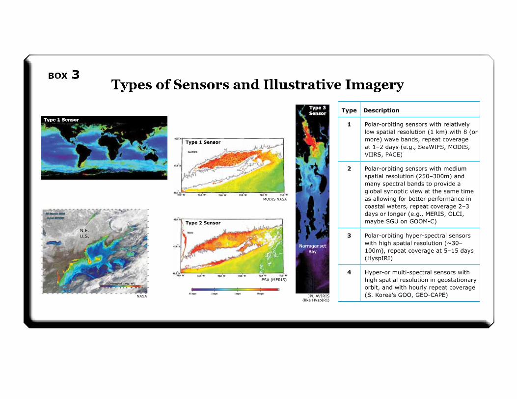
Type Description
1 Polar-orbiting sensors with relatively low spatial resolution (1 km) with 8 (or more) wave bands, repeat coverage at 1–2 days (e.g., SeaWIFS, MODIS, VIIRS, PACE)
2 Polar-orbiting sensors with medium spatial resolution (250–300m) and many spectral bands to provide a global synoptic view at the same time as allowing for better performance in coastal waters, repeat coverage 2–3 days or longer (e.g., MERIS, OLCI, maybe SGU on GOOM-C)
3 Polar-orbiting hyper-spectral sensors with high spatial resolution (~30–100m), repeat coverage at 5–15 days (HyspIRI)
4 Hyper-or multi-spectral sensors with high spatial resolution in geostationary orbit, and with hourly repeat coverage (S. Korea’s GOO, GEO-CAPE)
Type 1 Sensor
Type 1 Sensor
Long Island
Long Island
N.E.U.S.
NASA
Type 2 Sensor
ESA (MERIS)
Type 3 Sensor
Narraganset Bay
JPL AVIRIS (like HyspIRI)
Type 1 Sensor
MODIS NASA


1. Sensor characteristics, such as band-set and signal-to-noise, need to be equivalent to or better than the combined best attributes from SeaWiFS and MODIS;
2. Pre-launch sensor characterized and calibrated;
3. Post-launch vicarious calibration using a MOBY-like approach;
4. Monitoring the sensor stability using monthly lunar looks;
5. ≥ 6 months sensor overlap to produce continuous climate data records;
6. Support for on-going development and validation of atmospheric correction, bio-optical algorithms, and ocean color products;
7. Periodic data reprocessing; and
8. A system to archive, make freely available, and distribute rapidly and efficiently all raw and processed data, and documentation related to all aspects of the mission. “Raw data” refers to imagery to which new calibration factors can be applied during reprocessing.

To assess lessons learned in global ocean color remote sensing from the SeaWiFS/MODIS/MERIS era to guide planning for acquisition of continuous global ocean color radiance data to support U.S. research and operational needs. In particular the committee was tasked with the following:
• Identify research and operational needs and the associated high-level requirements for a sustained ocean color observations from space;
• Review the capability of current and planned national and international sensors in meeting these requirements;
• Identify and assess the observational gaps and options for filling these gaps between the current and planned sensor capabilities and timelines; and
• Identify minimum requirements for a sustained, long-term global ocean color program within the United States for the maintenance and improvement of associated ocean biological, ecological, and biogeochemical records, which ensures continuity and overlap among sensors, including plans for sustained, rigorous on-orbit sensor inter-calibration, vicarious calibration, and data validation program; algorithm development and evaluation; data processing, re-processing, distribution and archiving.
AcknowledgmentsWe would like to thank the following sponsors for their generous support for this study:NOAA (contract # DG133R08CQ0062), NASA (grant # NNX09AP57G), NSF (grant # OCE-0948911), and ONR (contract # N00014-05-G-0288). Any opinions, findings, conclusions, or recommendations expressed in this publication are those of the author(s) and do not necessarily reflect the views of the organizations or agencies that provided support for the project.