Embed Size (px)
Citation preview

OBSTRUCTING HUMAN RIGHTS: THE TEXAS-MEXICO BORDER WALL
The Working Group on Human Rights and the Border Wall
Submission to the Inter-American Commission on Human Rights
June 2008

TABLE OF CONTENTS
I. List of Faculty and Students involved in the Working Group on Human Rights and
the Border Wall at the University of Texas II. Obstructing Human Rights: The Texas-Mexico Border Wall: Background and
Context III. Violations on the Part of the United States Government of the Right to Property
and Non-Discrimination Held by Residents of the Texas Rio Grande Valley IV. An Analysis of Demographic Disparities Associated with the Proposed U.S.-
Mexico Border Fence in Cameron County, Texas V. The Environmental Impacts of the Border Wall Between Texas and Mexico VI. Violations on the Part of the United States Government of Indigenous Rights Held
by Members of the Lipan Apache, Kickapoo, and Ysleta del Sur Tigua Peoples of the Texas-Mexico Border

WORKING GROUP ON HUMAN RIGHTS AND THE BORDER WALL AT THE UNIVERSITY OF TEXAS
Jude Benavides Assistant Professor of Hydrology and Water Resources, Department of Chemistry and Environmental Sciences The University of Texas at Brownsville Ariel Dulitzky Visiting Professor of Law and Latin American Studies and Associate Director, Rapoport Center for Human Rights and Justice The University of Texas School of Law Karen Engle Cecil D. Redford Professor in Law and Director, Rapoport Center for Human Rights and JusticeThe University of Texas School of Law Lindsay Eriksson JD, Environmental Law Clinic The University of Texas School of Law Denise Gilman Clinical Professor, Immigration Clinic The University of Texas School of Law Ximena Gonzalez Undergraduate Intern, Rapoport Center for Human Rights and Justice The University of Texas Michelle Guzman Undergraduate Degree Candidate, Anthropology Department The University of Texas Charles R. Hale Professor, Department of Anthropology The University of Texas Barbara Hines Director and Clinical Professor, Immigration Clinic The University of Texas School of Law Zachary Hurwitz, Masters Degree Candidate, Geography Department The University of Texas

Leah Nedderman Master’s Degree, LBJ School of Public Affairs and Lozano Long Institute of Latin American Studies The University of Texas Shannon Speed Assistant Professor, Department of Anthropology The University of Texas Melinda Taylor Director and Clinical Professor, Environmental Law Clinic The University of Texas School of Law Gerald Torres Bryant Smith Chair in Law The University of Texas School of Law Mariah Wade Professor, Department of Anthropology The University of Texas Sarah Wesley Graduate Intern, Rapoport Center for Human Rights and Justice The University of Texas Jeff Wilson Assistant Professor, Department of Chemistry and Environmental Sciences The University of Texas at Brownsville Christopher Woodruff Masters Degree Candidate, Lozano Long Institute of Latin American Studies The University of Texas
OBSTRUCTING HUMAN RIGHTS: THE TEXAS-MEXICO BORDER WALL
The Working Group on Human Rights and the Border Wall By Denise Gilman
Background and Context
June 2008

Introduction
In the name of immigration control and national security, the United States has undertaken a massive project to build physical barriers along segments of the border between the United States and Mexico. Unfortunately, the project also involves massive violations of human rights. Although specific details about the project are hard to come by and vary daily, the United States claims that it will install 370 miles of border wall before the end of 2008.1 Over a hundred miles of wall will be built along the Texas/Mexico border. The construction of the wall along the Texas/Mexico border will destroy important environmental resources, will involve the unfair and discriminatory taking of private property without a clear and fair process and will affect the means of subsistence and way of life of persons living in border communities, including the members of several indigenous groups.
In response to this looming threat, a multi-disciplinary collective of faculty and students
at the University of Texas at Austin formed to analyze the human rights impact of the construction of a border wall on the Texas/Mexico border. This project is facilitated through the Rapoport Center for Human Rights and Justice at the University of Texas Law School and is supported by the University of Texas office of Thematic Initiatives and Community Engagement. The Working Group includes faculty and students from the Geography Department, the Anthropology Department, the LBJ School of Public Affairs, the Teresa Lozano Long Institute of Latin American Studies and the Immigration Clinic, Environmental Clinic and Rapoport Center at the Law School. The Working Group is collaborating with affected individual property owners, indigenous communities, environmental groups, Environmental Sciences faculty at the University of Texas at Brownsville and other academics and advocates to carry out work on this project.
The Working Group has conducted extensive research and analysis of the legal,
historical, property, environmental, indigenous, community and other impacts of the proposed border wall. In addition, in early May 2008, a delegation of the Working Group travelled to the Rio Grande Valley area of the Texas/Mexico border to conduct fact finding regarding the impact of the border wall on human rights. The group viewed some of the affected areas and properties along the border and met with: property owners, including Dr. Eloisa Tamez and other residents in and near Brownsville as well as residents of the El Granjeno and Los Ebanos communities; officials at the Mexican Consulate in Brownsville, Texas; the President of the University of Texas at Brownsville and other faculty; student and community advocates involved in documenting the effects of the border wall; attorneys with Texas Rio Grande Legal Aid and faculty at the Colegio de la Frontera Norte in Matamoros, Mexico.
1 Throughout this paper and the accompanying briefing papers submitted to the Inter-American Commission on Human Rights, we use the terms “fence” and “wall” interchangeably to describe the 18-foot high reinforced barriers designed to halt pedestrian and vehicular passage, which are scheduled to be constructed on the Texas/Mexico border. The statutes that mandate the construction of the barriers use the term “fence,” but the term “wall” is more commonly used by communities along the Texas/Mexico border and impacted property owners and provides an apt description. Photographs of the types of structures to be built can be found at Congressional Research Service Report for Congress, Border Security: Barriers Along the U.S. International Border 42 (May 13, 2008) [hereinafter CRS Barriers Report], attached as Exhibit 3 to this briefing paper.
2

The Working Group submits these briefing papers to the Inter-American Commission on Human Rights (the “Commission”) with the request that the Commission consider the violations of human rights taking place through the construction of walls along the Texas/Mexico border. These briefing papers focus on the human rights impact of border wall construction on the Texas/Mexico border, although wall segments also have been and will be built along the border between Mexico and the states of California, New Mexico and Arizona. These briefing papers focus on the Texas/Mexico border because: 1) the Working Group enjoys a unique connection to the residents of Texas and the Texas/Mexico border region; 2) the construction of border fencing in Texas presents issues involving the public taking of private land that are not present in the other states where the majority of property along the border is federal land; and 3) the next phase of border wall construction will take place predominantly in Texas. The papers focus most heavily on the area along the Texas/Mexico border known as the Rio Grande Valley, which is located at the southernmost tip of Texas. Much of the border wall construction planned for Texas is scheduled to take place in this area, and residents of this area were the first to contact the University of Texas regarding the severe impact that the border wall will have on their human rights. The papers do nonetheless address border wall construction in other areas of Texas where important human rights issues are raised, particularly in relation to the indigenous communities that live in western Texas. History of the Border Wall Historically, the United States and Mexico have not been separated by a physical wall or other barrier along most of the border. Border bridges and official land crossing points have existed at irregular intervals to control and facilitate cross-border movement. These entry points often include some limited fencing or wall in their immediate vicinity, but there has been no attempt until recent years to wall the border elsewhere. This is not surprising, because the border between the United States and Mexico is approximately 2000 miles (3,100 kilometers) long, is irregular in its shape and passes through rough and difficult terrain. From the southmost tip of Texas and the Gulf of Mexico, it follows the winding course of the Rio Grande River to the border crossing at El Paso, Texas, and Ciudad Juárez, Chihuahua; westward from that area it crosses vast tracts of the Sonoran and Chihuahuan Desert and the Colorado River Delta; it goes westward from there to the San Diego and Tijuana border area before reaching the Pacific Ocean.2
In 1990, the United States government began to erect physical barriers along the border
but only along a short stretch in the San Diego, California area.3 In 1996, Congress passed immigration legislation known as the Illegal Immigration Reform and Immigrant Responsibility Act (“IIRIRA”) which included in its provisions a grant of broad authority to the government to construct barriers along the border.4 This legislation also gave the government the power to take land, through condemnation proceedings if necessary, in the vicinity of the international land border when the government deems the land essential to “control and guard the boundaries and
2 International Boundary and Water Commission, United States Section, The International Boundary and Water Commission, Its Mission, Organization and Procedures for Solution of Boundary and Water Problems, available at: http://www.ibwc.state.gov/About_Us/About_Us.html. 3CRS Barriers Report at 3. 4 See IIRIRA, Pub.L. 104-208, Div. C, Section 102(a)-(c).
3

borders of the United States.”5 In 2005, Congress passed further legislation, known as the REAL ID Act which, among other things, authorized the Secretary of the Department of Homeland Security (“DHS”) to waive all legal requirements to expedite the construction of border barriers.6
Despite this legislation, the United States government did not undertake efforts to build
barriers outside of the San Diego area. Then, Congress passed the Secure Fence Act of 2006, which mandated that DHS construct fencing along five separate and specific stretches of the southern border, including several areas in Texas.7 The statute gave detailed parameters regarding the locations in which the wall was to be built, although it did not clarify the total mileage to be constructed under the law. The legislation still did not envision a border wall along the entire southwest border but did provide significant new impetus for construction of a wall along significant segments of the border.
Pursuant to the Secure Fence Act of 2006, the government constructed about 70 miles of
wall along the Arizona/Mexico border in 2007.8 By late 2007, the government had turned its attention to the Texas/Mexico border and began plans to construct over 100 miles of wall along various stretches of that border by the end of 2008.
As DHS began the process of surveying properties along the Texas/Mexico border to
determine which land the government would seek to take for construction of the fence, Congress acted again on the border fence issue. In December 2007, Congress amended the statute on construction of the border wall as part of the Consolidated Appropriations Act, FY2008.9 The latest legislation, in a turnabout, orders DHS to construct at least 700 miles of fencing along the southern border of the United States but does not dictate where this fencing must be built. Instead, it leaves decisions regarding locations for the fence up to DHS. The legislation does further mandate that 370 miles of the required 700 miles of fencing be constructed by the end of 2008. Importantly, the new law also requires consultation with those affected by the fence, providing that DHS “shall consult with . . . States, local governments, Indian tribes, and property owners in the United States to minimize the impact . . . for the communities and residents located near the sites [where] fencing is to be constructed.”10 The law also requires that DHS consider alternatives to physical fencing. Despite the new authority for flexibility regarding the location of the wall and the absolute requirement of consultation, DHS has not altered its approach to the border fence in any significant way. DHS has moved forward with its plans to put up expansive segments of wall along the Texas/Mexico border and has vowed to begin physical construction in the summer of 2008.11 Border Wall Construction Process
5 See id., Section 102(d); 8 United States Code 1102(b). 6 REAL ID, Pub.L. 109-13, Div. B. 7 See Secure Fence Act of 2006, Pub.L. 109-367, Section 3, attached as Exhibit 1 to this briefing paper. 8 Associated Press, 70 Miles of New Border Fencing Almost Complete (Sept. 29, 2007). 9 Pub.L. 110-161, Div. E, Section 564, attached as Exhibit 2 to this briefing paper. 10 Id. (emphasis added). 11 The Brownsville Herald, Border Wall Construction Slated to Begin by End of July (May 25, 2008).
4

The border construction process along the Texas/Mexico border, including the taking of land, has involved various stages and actors. Border wall construction is the responsibility of DHS and specifically the sub-component of DHS entitled U.S. Customs and Border Protection (“CBP”). DHS began seeking temporary access to property along the Texas/Mexico border at the end of 2007 for the purpose of conducting surveys and mapping. Although the access was temporary, it constituted a taking of land, because it required a temporary and partial relinquishment of land ownership rights to DHS. Some property owners voluntarily granted access to their land, although many did so without full knowledge of the consequences to their property or their rights to demand compensation from the United States government for this use of their property.12 Others refused to grant access voluntarily. DHS successfully sued approximately 60 of those property owners in condemnation proceedings in January and February 2008 to obtain the right to take the land for temporary access purposes.13 Those sued included individual property owners, city governments that own property, school districts and the University of Texas at Brownsville. Once the government obtained access to land, voluntarily or through condemnation suits, CBP worked with the United States Army Corps of Engineers to conduct land surveys.14
DHS is now entering into the next phase of the process. Before it can actually construct
border wall segments, it must obtain ownership of the property upon which it wishes to build. DHS, working with the United States Army Corps of Engineers, is currently making offers, mostly in the $4000-$10,000 range, for the purchase of land.15 If property owners do not voluntarily agree to sell portions of their land, DHS initiates condemnation lawsuits. DHS filed about 50 such lawsuits in the month of May 2008 alone.16 DHS need only formally take the land upon which it actually plans to install the wall, often only a segment of the entire property. However, the wall will, in many cases, also deprive the owners of effective use of other parts of their property not purchased by DHS, because it will be difficult, if not impossible, to traverse the wall and reach property on the other side.
Once DHS obtains title to lands along the Texas/Mexico border, construction of the wall
can begin. The government will contract out the work for the construction of the wall and has
12 See, e.g., Working Group interview with Idalia Benavidez (May 2, 2008). 13 See, e.g., United States of America v. 1.04 Acres of Land and Eloisa G. Tamez, Complaint in Condemnation, Case 1:08-cv-00044, filed in the United States District Court for the Southern District of Texas on May 28, 2008. We obtained the number of complaints by searching the federal courts’ publicly available electronic database known as PACER for all temporary condemnation actions filed at the beginning of 2008 by the United States in the United States District Courts for the Southern and Western Districts of Texas, which are the courts with jurisdiction over the targeted area. 14 See CRS Barriers Report, at 20; Correspondence from the Forth Worth District of the United States Army Corps of Engineers to Dr. Eloisa Tamez seeking access to property to perform surveys and site evaluations (Dec. 7, 2007) (on file with the authors). 15 See Working Group interview with Idalia Benavidez (May 2, 2008); United States of America v. 0.43 Acres of Land and Estate of Pilar Cabrera, Declaration of Taking, Case 1:08-cv-194, filed in the United States District Court for the Southern District of Texas on May 28, 2008. 16 See, e.g., United States of America v. 0.43 Acres of Land and Estate of Pilar Cabrera, Declaration of Taking, Case 1:08-cv-194, filed in the United States District Court for the Southern District of Texas on May 28, 2008. We obtained the number of complaints by searching the federal courts’ publicly available electronic database known as PACER for all recent condemnation actions filed by the United States in the United States District Court for the Southern District of Texas, which is the court with jurisdiction over the targeted area.
5

already begun to invite bids.17 Private companies will carry out this major government project for profit.
On April 1, 2008, in the midst of significant opposition to the construction of the wall,
DHS Secretary Michael Chertoff executed a waiver of 30 environmental and other laws pursuant to his authority granted by federal statute.18 In addition to key environmental laws such as the National Environmental Policy Act and the Endangered Species Act, Secretary Chertoff waived myriad other laws including, for example, the National Historic Preservation Act, the Native American Graves Protection and Repatriation Act and the American Indian Religious Freedom Act.19 The waiver announcement lists numerous specific stretches of land along the Texas border with Mexico where the environmental and other laws will now be inapplicable. This waiver thus allows construction on the Texas/Mexico border to move forward without compliance with the numerous procedural and substantive requirements that would otherwise apply to such an extensive project.
The United States government has not been transparent in its plans for the wall along the
Texas/Mexico border. It has therefore been extremely difficult for the Working Group, and the public in general, to obtain concrete information regarding planned locations for the wall segments or even the total mileage that the wall will cover along the Texas/Mexico border.
First, the United States government has not even been clear and specific about the total
number of miles of wall that it plans to construct. As noted above, the original Secure Fence Act of 2006 set out specific locations for fencing but did not specify the total mileage of fencing it mandated. Calculations of the total mileage involved varied but suggested that the law required upward of 700 miles of wall, and at least one government report concluded that the law required 850 miles of wall.20 The Secure Fence Act required construction of the wall in priority areas, amounting to over 300 miles, by the end of 2008. The Consolidated Appropriations Act, FY2008 requires at least 700 total miles of wall and mandates the construction of 370 miles of fencing by the end of 2008. Finally, DHS Secretary Chertoff’s April 2008 waiver of environmental and other laws to allow for expedited construction applies to approximately 470-490 miles of the border.21 It is unclear when those 490 miles of barriers are scheduled for construction. The government has alternatively promised to construct 570 or 670 total miles of
17 Associated Press, “Army invites companies to bid on border fence work” (May 28, 2008); United States Government Accountability Office, Secure Border Initiative: Observations on Selected Aspects of SBInet Program Implementation 7 n.8, 12 (Oct. 24, 2007) [hereinafter GAO Secure Border Initiative Report], attached as Exhibit 4 to this briefing paper. 18 Department of Homeland Security, Office of the Secretary, Determination Pursuant to Section 102 of the Illegal Immigration Reform and Immigrant Responsibility Act of 1996, As Amended (April 1, 2008) [hereinafter DHS Waiver Determination]. 19 Id. 20 See CRS Barriers Report, at 10; Newsweek, Brownsville’s Bad Lie (April 26, 2008); The Texas Observer, Holes in the Wall (Feb. 18, 2008); Statement by Representative Bryan Conoway, Library of Congress Congressional Record, “Providing for Consideration of H.R. 6061, Secure Fence Act (Extension of Remarks), September 21, 2006. 21 Department of Homeland Security, Statement of Secretary Michael Chertoff Regarding Exercise of Waiver Authority (April 1, 2008); The New York Times, Homeland Security Stands by its Fence graphic, available (May 21, 2008).
6
barrier by the end of 2008.22 Those numbers lead to further confusion, though, because they include both pedestrian fencing and vehicle barriers that are not designed to prevent pedestrians from passing through the border. 23 The vehicle barriers will presumably not count toward the total mileage of reinforced fencing mandated in the statutes.
Putting aside the government-created confusion regarding the number of miles of wall to
be built, the best estimate of total construction of pedestrian fencing planned for the end of 2008 is 370 miles, based on a review of various official statements.24 The remaining mileage to be constructed in 2008 corresponds to vehicle barriers. As the government asserts that it has already constructed about 170 miles of pedestrian fencing, it appears that the government plans to construct another 200 miles before the end of the year.25 The waivers signed by the Secretary of DHS designating areas of construction suggest that approximately 130 miles of that new pedestrian fence will be constructed along the Texas/Mexico border with the longest segments placed in the Rio Grande Valley in the southernmost part of Texas.26
Second, despite the obvious importance of this information, it is also impossible to
determine the exact properties and locations in which DHS plans to build the fence along the Texas/Mexico border. DHS has published no comprehensive maps of planned construction. Selected maps displaying specific segments of the planned wall were originally available on a CBP website as part of the draft environmental impact statements the government prepared before the environmental laws were waived. However, government officials repeatedly stated that those maps were outdated without providing newer maps. The maps have now been removed from the website and are no longer available.
On April 11, 2008, the Working Group filed a Freedom of Information Act request with
the U.S. Army Corps of Engineers and with CBP seeking, among other things, copies of all maps showing planned locations for the wall along the Texas/Mexico border. More than six weeks later, we have not yet received the requested maps.
This lack of transparency itself leads to serious concerns about the United States
government’s commitment to guaranteeing human rights. It also makes it more difficult to
22 See GAO Secure Border Initiative Report, at 7; DHS, Fact Sheet: U.S. Department of Homeland Security Five-Year Anniversary Progress and Priorities (March 6, 2008). 23 See id. 24 See GAO Secure Border Initiative Report, at 7; DHS, Fact Sheet: U.S. Department of Homeland Security Five-Year Anniversary Progress and Priorities (March 6, 2008); CRS Barriers Report, at 10. 25 See DHS, Fact Sheet: U.S. Department of Homeland Security Five-Year Anniversary Progress and Priorities (March 6, 2008). It is worth noting that it seems unlikely that DHS will meet these goals. To date, DHS only claims to have built 170 miles worth of pedestrian fencing. Id. About 80 miles of that construction were built before 2007 and the implementation of the Secure Fence Act. See GAO Secure Border Initiative Report, at 11. In 2007, DHS built only about 75 miles of fence. See id. It is difficult to imagine how DHS will nonetheless build 200 miles of pedestrian fencing in 2008, particularly since the Government Accountability Office has concluded that DHS will face greater challenges than it has in the past in constructing fencing in 2008 on the Texas/Mexico border. See id. at 3. Of course, the likelihood that DHS will not complete all planned miles by the end of 2008 does not ameliorate the severe impacts of the planned construction. It simply makes it more difficult to know where DHS will start construction and how much it will achieve by the end of 2008, imposing additional uncertainty and stress on affected border residents. 26 DHS Waiver Determination, Project Areas Attachment.
7

describe and analyze the specific human rights impact of the government’s border wall program. For purposes of the briefing papers, the Working Group relied on information about the planned locations for the border wall available from litigation documents filed against and by affected property owners, the testimony of individuals along the Texas/Mexico border who spoke with the Working Group, the original piecemeal draft environmental impact maps, the geographic locations identified in the DHS waivers of environmental and other laws, and press accounts.
Several important and troubling aspects of the planned locations for construction of the
border wall in Texas have nonetheless become clear from the information available. As is described in detail in the briefing papers submitted by the Working Group, the wall is scheduled to be built through sensitive environmental areas, indigenous lands and small private properties but will not run through larger and more lucrative properties owned by businesses. Some of the affected property, such as the land owned by Eloisa Tamez, has been held by families since the 1700s when it was parceled out in land grants by the Spanish crown and has been guaranteed by successive governments and treaties, including the Treaty of Guadalupe Hidalgo. The wall will be constructed on portions of the campus at the University of Texas at Brownsville, effectively dividing the campus into two segments. It will also cut through sites of importance to the lengthy and unique history of the Texas/Mexico border, such as the United States National Historic Landmark site at Fort Brown and ancient cemeteries.
The locations that DHS has selected for the fencing will have a devastating impact on the
property of individuals who own land along the border. Residents along the border will lose not only the segment of their properties upon which the wall is built27 but will also lose access to their property on the other side of the wall. In the Rio Grande Valley, the wall will not closely follow the curving path of the river. Rather, it will be built in straighter line segments, which roughly follow the path of levees previously built to protect against flooding. As a result, large pieces of land along the river banks will be cut off by the wall. 28 Some stretches of fence will be built a mile inland from the river. In a few cases, individual homes or even entire plots of property will end up completely on the southern side of the wall.29 In many areas, the land is already partially disrupted by the existing levees. However, rather than build on, immediately next to or on the river side of the existing levees, DHS plans to build another barrier away from the river side of the levees. In other words, the wall will leave the levees and additional property on the side of the wall adjacent to the river, and the wall will not be passable at will like the levees. 27 Actually, DHS will take possession of the land on which the wall is built and additional land around the wall–another 30 to 60 feet on each side. DHS, Environmental Impact Statement for Construction, Maintenance, and Operation of Tactical Infrastructure: Rio Grande Valley Sector, Texas (Draft) (2007). 28 See The Washington Post, Border Fence Would Slice Through Private Land (Feb. 16, 2008) (highlighting several examples in which the wall will make large portions of land unavailable on the Mexico side of the fence; for one property, 25 of 80 acres of farmland would be left on the south side of the wall). 29 The Brownsville Herald, Living on the wrong side of the fence (April 26, 2008) (quoting a specialist with the U.S. Army Corps of Engineers). Some have suggested that the United States is essentially ceding territory to Mexico. Reuters, Texan Mayors Threaten Court to Stop Border Fence (Oct. 12, 2007) (quoting the mayor of Del Rio, Texas). While this suggestion is probably not technically correct, because the official border between the two countries will remain the same regardless of the placement of the wall, it raises important questions about control and sovereignty on the land on the other side of the wall. It is likely that a no-man’s land of sorts will be created on the other side of the fence.
8

For many residents along the border, the inability to reach large portions of their property
which abut the river will destroy their livelihood. Many of these residents use these portions of their land to graze and water livestock, to irrigate crops, to enter the river for recreation and transportation and to fulfill other economic purposes. To calm angry property owners, DHS has suggested that it might place gates or doors in the wall at some intervals. However, it has not provided any specific plan for access to property on the other side of the wall. It seems certain that gates, if they are installed, would be placed at some distance from one another, requiring residents to travel lengthy distances outside of their property to enter a gate and turn around to return to their property. Obvious questions are also raised about the nature of the gates. DHS has not explained how the gates will function or whether residents will be required to provide evidence of citizenship to travel around their communities or to enter and exit their own land.30 Ineffectiveness of the Texas/Mexico Border Wall as an Immigration Control or Anti-Terrorism Measure
The stated goal of the border wall statutes is to protect and control the border by preventing unlawful entries by intending immigrants, terrorists or drug traffickers.31 While this goal is presumably lawful, as a matter of international human rights law, the construction of a border wall is not likely to be effective in achieving the objective.32
The legislation cites the prevention of terrorism as an important goal of the border fence, and United States government officials repeatedly recite this refrain. One Border Patrol official stated that the wall along the Texas/Mexico border was necessary to prevent the arrival of weapons of mass destruction.33
However, government officials have provided no evidence that terrorists are using the Texas/Mexico border to enter the United States. It has been well-established that the 9/11 terrorists entered the country through legal immigration channels, and there have been no
30 See The Brownsville Herald, Living on the Wrong Side of the Fence (April 26, 2008) (including interviews with several landowners – one with property that will fall completely on the south side of the fence and one with land that will be split in half, leaving the property’s farmland on the other side of the fence-- who sought unsuccessfully for months to obtain assurances from DHS that they would have access to their land after the fence is built); Letter from the Department of the Army to Ms. Rita P. Taylor (April 4, 2008) (on file with the authors) (stating that roadways through the fence would allow access to her property and attaching a map that shows the roadways but does not show how they will connect with her property); Newsweek, Brownsville’s Bad Lie (April 26, 2008) (reflecting DHS’ response to questions about access to the golf course at the University of Texas at Brownsville, which will be left on the Mexico side of the wall, as suggesting that plans had not been made for access and that “options might include an electronic gate”); The New York Times, In Texas, Weighing Life with a Border Fence (indicating that DHS has told concerned local officials that “there would be some kind of gates through the fence, but what kind and where have yet to be specified”). 31 See Secure Fence Act of 2006, Pub.L. 109-367, Section 2; 8 United States Code 1102(b). 32 The Working Group briefing paper on property rights and equal protection assesses at much greater length the failure of the border wall to meet the tests of proportionality and least restrictive measures applicable under international human rights law. Here, we simply hope to analyze briefly the likely effectiveness of the border wall approach. 33 YouTube, Brownsville Protests Border Wall, available at: http://www.youtube.com/watch?v=GUMFfV_qbNM&feature=related.
9

credible reports that terrorists are now more inclined to sneak across land borders.34 If terrorists were to attempt to cross a land border illegally to enter the United States, it is more likely that they would cross into the United States from Canada, since there are fewer controls on the Canadian border.35 Because there is no evidence that terrorists seek to enter the United States through the Texas/Mexico border, the construction of a wall along that border will not be effective in preventing terrorism. Nor will the construction of a wall along the Texas/Mexico border serve as an effective means of preventing or controlling unauthorized immigration. According to official reports of the United States government, prior experiments with the border wall have proven ineffective. The original segment of border wall built in the San Diego area “did not have a discernible impact on the influx of unauthorized aliens coming across the border.”36 Attempted crossings and apprehensions in the San Diego area decreased only after additional steps were taken, including the dispatch of additional agents and resources, which did not rely on physical barriers.37 Even after the implementation of increased enforcement strategies in the San Diego area, the government has found “little impact” on overall attempted crossings into the United States and apprehensions.38 These government reports question the effectiveness of physical barriers as long as there are gaps in the border wall, because the physical barriers simply redirect attempted border crossings to areas in which there is no wall.39 There are no plans to build a solid border wall, and it seems unlikely (and undesirable as a human rights matter) that a solid border wall will ever be built given the length of the border between the United States and Mexico, the rough terrain it covers and the prohibitive cost. The government has further noted that, while fences that channel immigration into more remote and rough terrain do not effectively deter immigration, they do lead to more migrant deaths.40 These analyses, by the United States government itself, suggest that the intermittent border wall to be built along the Texas/Mexico border will have little impact on overall unauthorized entries into the United States and will have a deadly effect on immigrants. Physical barriers are also extremely susceptible to being breached and therefore are not reliable as a means of immigration control. Official government reports note that “in the limited areas where fencing has been erected, there have been numerous breaches of the border fencing and a number of tunnels discovered crossing underneath he fencing.”41 DHS Secretary Michael
34 National Commission on Terrorist Attacks Upon the United States, Staff Statement No. 1: Entry of the 9/11 Hijackers into the United States 35 Government Accountability Office, Border Security: Security Vulnerabilities at Unmanned and Unmonitored U.S. Border Locations 1-2 (Sept. 27, 2007) (describing unmanned and unmonitored roads crossing the border between the United States and Canada and the ability of government investigators posing as unlawful border crossers to move freely along the Canada/U.S. border). 36 See CRS Barriers Report, at 3 37 Id. at 3, 13. The government uses numbers of apprehensions near the border as a proxy for number of attempted crossings and as a means of assessing the effectiveness of immigration control programs. 38 Id. at 17. 39 Id. at 32. 40 Id. at 40 (“on average 200 migrants died each year in the early 1990s, compared with 472 migrant deaths in 2005”). 41 Id. at 32;
10

Chertoff has acknowledged that fencing is likely to breached and that tunnels have been built to get around it in some areas where it is already in place.42
The United States government has all but recognized that a wall is an inadequate tool for stemming unauthorized border crossings. DHS Secretary Michael Chertoff has acknowledged that physical barriers are largely symbolic and are not “a cure-all.”43 DHS has stated that it understands control of the border to require the “ability to consistently (1) detect illegal entries into the United States; (2) identify and classify these entries to determine the level of threat involved; (3) respond to these entries; and (4) bring events to a satisfactory law enforcement resolution.”44 Yet, the function of a wall is simply to put a physical halt, usually temporary, to an attempted border crossing and then make the crossing more difficult or deflect it elsewhere. The physical barrier does nothing to detect illegal entries or allow for categorization of the persons entering and does not respond to any entries through apprehension or other law enforcement resolution. The interposition of a wall is a method that avoids actual contact between potential border crossers and United States government officials. By its terms, it fails to fulfill the requirements of an effective system for border control as defined by the United States government itself. The primary failure of the wall, though, is that it focuses on the physical border in the south of the United States as the crux of immigration control. Yet, the reality of immigration and individual and government decision-making takes place in the interior of the United States, suggesting that the channeling of resources toward physical barriers along the border will be ineffective in addressing immigration issues. Over half of the undocumented immigrants in the United States arrived legally by entering at an official land border or airport port of entry.45 These immigrants later fell out of status or violated their status and joined the undocumented population. In fact, statistical and anecdotal information suggests that unauthorized border crossings have decreased in the past several years along the Texas/Mexico border and elsewhere.46 This trend suggests that factors, such as the drooping economy and interior immigration enforcement actions, have had the greatest impact and that physical barriers are unnecessary and miss the target in addressing unauthorized immigration issues. The core of the unauthorized immigration issue is the failure of the current United States immigration system to reflect the reality of global migration, to recognize the needs of United States employers and immigrant workers and to protect the human right of immigrant families to avoid separation. Currently, the immigration system provides almost no route for hard-working immigrants to obtain lawful status. The few immigrants wishing to work or rejoin their families
42 CNN, Chertoff to Hunter: Border Fence “Overly Simplistic” (July 1, 2007); The New York Times, Homeland Security Stands by its Fence (May 21, 2008). 43 The New York Times, Homeland Security Stands by its Fence. 44 GAO Secure Border Initiative Report, at 4 n.3. 45 Pew Hispanic Center, Modes of Entry for the Unauthorized Migrant Population (May 22, 2006). 46 The New York Times, Homeland Security Stands by its Fence (May 21, 2008); The New York Times, A Natural Treasure that May End Up Without a Country (April 7, 2008) (quoting the manager of a nature reserve in the Rio Grande Valley as stating that he had seen a notable drop-off in illegal crossings through the reserve in the last decade); see also Melissa del Bosque, The Texas Observer, Holes in the Wall: Homeland Security Won’t Say why the Border Wall is Bypassing the Wealthy and Politically Connected (quoting a security official at the University of Texas at Brownsville as clarifying that unauthorized border crossers do not enter through the university campus).
11

in the United States, who are fortunate enough to qualify for lawful status, must wait for decades and are forced through expensive and inefficient immigration processing. The system begs for unauthorized immigration to occur. Yet, while immigration reform has been discussed in the last several sessions of Congress, no structural change has been forthcoming. Until this system is changed, no physical border wall will allow the United States government to control and regularize immigration.
The United States government estimates that each mile of border fence will cost approximately 2 to 4 million dollars.47 The total estimated cost of construction for the next planned 200 miles or so of pedestrian fencing to be completed by the end of this year is approximately $890 million.48 At this cost, it seems reasonable to expect an effective strategy for reaching the government’s goals regarding immigration control and the prevention of terrorism. Instead, the proposed border wall is only likely to be effective in providing government officials with the political opportunity to say that they have accomplished something concrete, however ineffective. Widespread Opposition to the Texas/Mexico Border Wall
The United States government’s plans to construct a border wall in Texas have generated widespread opposition. The wall will cut through an area in which communities have always viewed themselves as cross-border and transnational in nature. The ties between towns and residents north and south of the Rio Grande River are extremely strong, and residents on the border have traditionally traveled back and forth between Mexico and Texas regularly for social and economic purposes. Many families include both Mexican and United States citizens with family members living on each side of the border and visiting each other regularly.49 Some border residents even maintain homes in both Mexico and Texas.50 Others travel back and forth daily to shop and conduct business. Many residents along the Texas/Mexico border see the Rio Grande River “as a meeting point rather than a dividing line,” and they see the wall as an affront to the unique border identity and culture that has flourished in communities along both sides of the border.51 There is no doubt that the wall will disrupt the way of life, culture and economic viability of many communities along the border.
Border residents and politicians have been largely united in their vocal opposition to the
wall.52 The mayor of Eagle Pass, Texas has called the border “useless, expensive and potentially damaging.”53 The president of the University of Texas at Brownsville, Juliet Garcia, has noted 47 See CRS Barriers Report, at 27 (quoting the Congressional Budget Office); GAO Secure Border Initiative Report, at 12 (quoting CBP figures). 48 GAO Secure Border Initiative Report, at 12. 49 Newsweek, Brownsville’s Bad Lie. 50 Current, Muro del odio: People of the Forgotten River Grapple with the Border Wall (Feb. 27, 2008). 51 Newsweek, Brownsville’s Bad Lie. 52 See, e.g., AFP, Controversial Border Fence Hot Issue in Texas Primary (Feb. 25, 2008); Houston Chronicle, Hostile Reception for Pro-Fence Congressman in Brownsville (April 28, 2008); Los Angeles Times, A Town Against the Wall (Dec. 17, 2007) (“complaints are heard from El Paso to Brownsville, in river towns only a football field away from sister cities in Mexico, where the prevailing culture has long been bilingual and binational, and where everyone knows someone on the other side”); The Washington Times, Texas cities join suit against Mexico border fence (May 29, 2008). 53 The Washington Times, Texas cities join suit against Mexico border fence (May 29, 2008).
12
that the proposed construction on the university’s campus of “an 18-foot high steel barrier between two friendly countries” would “destroy the campus climate.”54 Students and public school teachers have announced their opposition to the wall and have organized well-attended protest marches.
Several lawsuits have been initiated against the United States challenging its actions in
constructing the law. Eloisa Tamez, a vocal property owner in opposition to the wall and the taking of her land, initiated class action litigation against DHS, asserting that the government had failed to properly consult with individuals and communities affected by the wall, to consider alternatives to the wall or to negotiate regarding the taking of land.55 A coalition of mayors from border towns and cities has now joined the litigation.56 Another lawsuit is currently pending before the United States Supreme Court challenging the constitutionality of the legislation that gave the Secretary of DHS authority to waive environmental and other standards and the Secretary’s exercise of that waiver.57
The construction of the border wall has evoked ire internationally as well, particularly
among otherwise friendly governments in Latin America.58 Mexico is obviously the country most affected by the construction of the wall. The wall sends a message of antagonism rather than cooperation to Mexico and necessarily creates a negative impact on diplomatic relations between the two countries. In addition, numerous treaties between the United States will likely be affected by the construction of the wall. These treaties govern, for example, access to and control of the Rio Grande River and use of water as well as environmental protection along the border.59
The Mexican government has made its opposition to the wall clear. The government’s
official position states: “The government of Mexico reiterates its rejection of this [border wall] project, because it does not correspond to the climate of cooperation and joint responsibility that should exist between our countries, nor does it offer a solution to address effectively the problems that we share in the border area.”60 The Mexican government has received support from Canada and other member states of the Organization of American States for its objections 54 UTB/TSC, UTB/TSC Hosts Border Wall Subcommittee Meetings (April 28, 2008), available at blue.utb.edu/newsandinfo/BorderFence%20Issue/03_19_2008UpdatedBorderFenceInfo.htm. 55 Tamez et al v. Chertoff et al, Complaint #08-CV-0555, filed in the United States District Court for the Southern District of Texas; Dallas Morning News, Rio Grande valley resident blocks seizure of her land for border fence (Feb. 7, 2008); Rio Grande Guardian, Tamez Sues Chertoff (Feb. 19, 2008). 56 The Washington Times, Texas cities join suit against Mexico border fence (May 29, 2008). 57 Rio Grande Guardian, South Texas Environmental Groups Sue DHS over Chertoff Waivers (May 29, 2008); Defenders of Wildlife v. Chertoff, Case 07-1180, petition for writ of certiorari filed with the United States Supreme Court. 58 Even President Mikhail Gorbachev, former leader of the Soviet Union, has expressed his opinion questioning the wisdom of the wall. See YouTube, Gorbachev on the U.S./Mexico Border Wall, available at http://www.youtube.com/watch?v=qGk2iec8v7Y. 59 See, e.g., Boundary Treaty of 1970; Mexico and United States of America Agreement on Co-Operation for the Protection and Improvement of the Environment in the Border Area (Signed at La Paz, Baja California, on Aug. 14, 1983); Rio Grande Guardian, Marin: 18 Feet Concrete Levee Wall Would Violate Treaty with Mexico (April 21, 2008); IPS, US-Mexico: Border Wall Condemns Jaguars to Extinction (April 30, 2008). 60 See Ministry of Foreign Affairs of the Government of Mexico, Communiqué 167, El gobierno de México protesto ante autoridades de EUA y gestiono la inmediata remoción de un tramo del muro fronterizo que se construyo en territorio Mexicano (June 25, 2007).
13

to the wall. In the fall of 2006, the Mexican government presented a declaration against the wall at the Organization of American States that received the support of 27 other countries and also obtained a resolution at the Summit of the Americas –an important gathering of heads of state from the region-- urging the United States to reconsider its decision to build a wall.61 In February 2008, representatives of the legislatures from Canada and Mexico, meeting in an inter-parliamentary session, set forth an agreement in opposition to the border wall.62 The Chilean legislature sent its own formal protest in support of Mexico and against the wall to the United States government.63
Human Rights Impact of the Texas/Mexico Border Wall The planned wall along the Texas/Mexico border not only engenders widespread opposition while remaining ineffective in fulfilling the government’s immigration control and anti-terrorism objectives, but also violates international human rights law. The Working Group has analyzed and documented, in separate briefing papers accompanying this document, a series of human rights violations taking place as a result of the construction of segments of border wall along the Texas/Mexico border. These human rights violations constitute breaches of the United States’ obligations under the American Declaration of the Rights and Duties of Man, interpreted in light of the American Convention on Human Rights and other relevant international human rights norms.64 The briefing papers address the following issues:
1. Violations of the right to property and equal protection guaranteed under international human rights law. The United States government, in its implementation of plans to construct a wall along the Texas/Mexico border, has not acted rationally in attempting to build a wall that will deprive residents along the border of the right to hold and use their properties. The government has failed to adopt proportional means of meeting its governmental goal of controlling the border, and the construction of a border wall, involving the taking of property, is not the least restrictive means of achieving governmental goals. In addition, the government has not provided justification for its
61 International Herald Tribune, Mexico Gets Support of 27 Nations to Attack U.S. Plans for Border Fence in OAS; Special Communiqué of the XVI Summit of the Americas of Heads of State and Government Against the Construction of a Wall on the Mexico-United States Border (Nov. 2006), available at www.sre.gob.mx/dgomra/cibero/ibero4.htm. 62 La Crónica, Interparlamentaria Mexico-Canada acuerda condena al muro fronterizo (Feb. 19, 2008). 63 Proceso.com.mx, Condena el senado de Chile la construcción del muro en la frontera de EU con México (Jan. 2, 2008), available at www.proceso.com.mx/noticia.html?sec=0&nta=56179. 64 The American Declaration constitutes a source of international legal obligation for the United States as a member state of the Organization of American States. See I/A Court H.R., Advisory Opinion OC-10/89 Interpretation of the American Declaration of the Rights and Duties of Man Within the Framework of Article 64 of the American Convention on Human Rights, July 14, 1989, Ser. A Nº 10 (1989), paras. 35-45; I/A Comm. H.R., James Terry Roach and Jay Pinkerton v. United States, Case 9647, Res. 3/87, 22 September 1987, paras. 46-49. According to the jurisprudence of the inter-American human rights system, the provisions of the American Declaration should be interpreted and applied in the context of ongoing developments in international human rights law and, specifically, in the light of the American Convention on Human Rights and other prevailing international and regional human rights instruments. See,I/A Comm. H.R. Report Nº 52/01, Case 12.243, Juan Raul Garza (United States), paras. 88, 89 (confirming that while the Commission does not apply the American Convention on Human Rights in relation to member states that have yet to ratify that treaty, the Convention’s provisions may well be relevant in informing an interpretation of the principles of the Declaration); I/A Comm. H.R., Report Nº 75/02, Case 11.140, Mary and Carrie Dann (United States), para. 127.
14
differential treatment of properties along the border as it has not explained why certain lucrative properties are not to be affected by border wall construction. Statistical analysis suggests that the border wall and the necessary taking of property resulting from its construction will disproportionately impact poor Latino immigrant families.65
2. Severe degradation of the environment and violations of the government’s human rights obligation to evaluate and take into account harm to the environment when undertaking public projects. In its construction of a border wall, the United States government is bypassing numerous domestic laws designed to protect the environment and the people who utilize and enjoy it. The negative impact of the wall on important and scarce natural resources, including the ocelot and other wildlife populations, plants and birds found along the Texas/Mexico border will be severe. The environmental degradation will cause significant harm to the residents of the Texas/Mexico border area who have traditionally held an important connection to the natural resources prevalent in the border area.66
3. Violations of the rights of indigenous communities protected under international human
rights law. The wall will directly impact the lands of the Lipan Apache, Kickapoo and Tigua (Ysleta del Sur) indigenous communities living along the Texas/Mexico border. Yet, the United States government has proceeded forward in planning for the taking of portions of these lands without engaging in meaningful consultations with members of the affected indigenous communities.67
The Working Group has endeavored to work expeditiously to provide the Inter-American
Commission on Human Rights with this set of briefing papers, because the United States government is moving forward rapidly and aggressively with its plans to construct the border wall. Each of the human rights issues we raise requires further analysis and development, and the Working Group plans to engage in continued work on the human rights violations caused by the border wall.
Conclusion Given the gravity of the human rights situation created by the construction of a border wall on the Texas/Mexico border, the Working Group respectfully requests that the Inter-American Commission on Human Rights immediately take notice of the issue and initiate an investigation. We ask that the Commission publicly announce its serious concerns about the human rights violations related to the construction of the border fence during its 132nd period of sessions to be held in Washington, D.C. in July of 2008. Finally, we request that the Commission set a general hearing on the border fence issue to be held during the 133rd period of sessions of the Commission scheduled to take place in Washington, D.C. in October of 2008. 65 Ariel Dulitzky, Denise Gilman & Leah Nedderman, Violations on the Part of the United States Government of the Right to Property and Non-Discrimination Held by Residents of the Texas Rio Grande Valley; Jeff G. Wilson, et al., An Analysis of Demographic Disparities Associated with the Proposed U.S.-Mexico Border Fence in Cameron County, Texas. 66 Lindsay Eriksson & Melinda Taylor, The Environmental Impacts of the Border Wall Between Texas and Mexico. 67 Zachary Hurwitz & Michelle Guzman, Violations on the Part of the United States Government of Indigenous Rights Held by Members of the Lipan Apache, Kickapoo, and Ysleta del Sur Tigua Peoples of the Texas-Mexico Border.
15

H. R. 6061
One Hundred Ninth Congressof the
United States of America AT THE SECOND SESSION
Begun and held at the City of Washington on Tuesday, the third day of January, two thousand and six
An Act To establish operational control over the international land and maritime borders
of the United States.
Be it enacted by the Senate and House of Representatives of the United States of America in Congress assembled,
SECTION 1. SHORT TITLE.
This Act may be cited as the ‘‘Secure Fence Act of 2006’’.
SEC. 2. ACHIEVING OPERATIONAL CONTROL ON THE BORDER.
(a) IN GENERAL.—Not later than 18 months after the date of the enactment of this Act, the Secretary of Homeland Security shall take all actions the Secretary determines necessary and appro-priate to achieve and maintain operational control over the entire international land and maritime borders of the United States, to include the following—
(1) systematic surveillance of the international land and maritime borders of the United States through more effective use of personnel and technology, such as unmanned aerial vehicles, ground-based sensors, satellites, radar coverage, and cameras; and
(2) physical infrastructure enhancements to prevent unlaw-ful entry by aliens into the United States and facilitate access to the international land and maritime borders by United States Customs and Border Protection, such as additional checkpoints, all weather access roads, and vehicle barriers. (b) OPERATIONAL CONTROL DEFINED.—In this section, the term
‘‘operational control’’ means the prevention of all unlawful entries into the United States, including entries by terrorists, other unlaw-ful aliens, instruments of terrorism, narcotics, and other contra-band.
(c) REPORT.—Not later than one year after the date of the enactment of this Act and annually thereafter, the Secretary shall submit to Congress a report on the progress made toward achieving and maintaining operational control over the entire international land and maritime borders of the United States in accordance with this section.
SEC. 3. CONSTRUCTION OF FENCING AND SECURITY IMPROVEMENTS IN BORDER AREA FROM PACIFIC OCEAN TO GULF OF MEXICO.
Section 102(b) of the Illegal Immigration Reform and Immigrant Responsibility Act of 1996 (Public Law 104–208; 8 U.S.C. 1103 note) is amended—

H. R. 6061—2
(1) in the subsection heading by striking ‘‘NEAR SAN DIEGO, CALIFORNIA’’; and
(2) by amending paragraph (1) to read as follows: ‘‘(1) SECURITY FEATURES.—
‘‘(A) REINFORCED FENCING.—In carrying out subsection (a), the Secretary of Homeland Security shall provide for least 2 layers of reinforced fencing, the installation of addi-tional physical barriers, roads, lighting, cameras, and sen-sors—
‘‘(i) extending from 10 miles west of the Tecate, California, port of entry to 10 miles east of the Tecate, California, port of entry;
‘‘(ii) extending from 10 miles west of the Calexico, California, port of entry to 5 miles east of the Douglas, Arizona, port of entry;
‘‘(iii) extending from 5 miles west of the Columbus, New Mexico, port of entry to 10 miles east of El Paso, Texas;
‘‘(iv) extending from 5 miles northwest of the Del Rio, Texas, port of entry to 5 miles southeast of the Eagle Pass, Texas, port of entry; and
‘‘(v) extending 15 miles northwest of the Laredo, Texas, port of entry to the Brownsville, Texas, port of entry. ‘‘(B) PRIORITY AREAS.—With respect to the border
described—‘‘(i) in subparagraph (A)(ii), the Secretary shall
ensure that an interlocking surveillance camera system is installed along such area by May 30, 2007, and that fence construction is completed by May 30, 2008; and
‘‘(ii) in subparagraph (A)(v), the Secretary shall ensure that fence construction from 15 miles northwest of the Laredo, Texas, port of entry to 15 southeast of the Laredo, Texas, port of entry is completed by December 31, 2008. ‘‘(C) EXCEPTION.—If the topography of a specific area
has an elevation grade that exceeds 10 percent, the Sec-retary may use other means to secure such area, including the use of surveillance and barrier tools.’’.
SEC. 4. NORTHERN BORDER STUDY.
(a) IN GENERAL.—The Secretary of Homeland Security shall conduct a study on the feasibility of a state of-the-art infrastructure security system along the northern international land and maritime border of the United States and shall include in the study—
(1) the necessity of implementing such a system; (2) the feasibility of implementing such a system; and (3) the economic impact implementing such a system will
have along the northern border. (b) REPORT.—Not later than one year after the date of the
enactment of this Act, the Secretary of Homeland Security shall submit to the Committee on Homeland Security of the House of Representatives and the Committee on Homeland Security and Governmental Affairs of the Senate a report that contains the results of the study conducted under subsection (a).

H. R. 6061—3
SEC. 5. EVALUATION AND REPORT RELATING TO CUSTOMS AUTHORITY TO STOP CERTAIN FLEEING VEHICLES.
(a) EVALUATION.—Not later than 30 days after the date of the enactment of this Act, the Secretary of Homeland Security shall—
(1) evaluate the authority of personnel of United States Customs and Border Protection to stop vehicles that enter the United States illegally and refuse to stop when ordered to do so by such personnel, compare such Customs authority with the authority of the Coast Guard to stop vessels under section 637 of title 14, United States Code, and make an assess-ment as to whether such Customs authority should be expanded;
(2) review the equipment and technology available to United States Customs and Border Protection personnel to stop vehicles described in paragraph (1) and make an assess-ment as to whether or not better equipment or technology is available or should be developed; and
(3) evaluate the training provided to United States Customs and Border Protection personnel to stop vehicles described in paragraph (1). (b) REPORT.—Not later than 60 days after the date of the
enactment of this Act, the Secretary of Homeland Security shall submit to the Committee on Homeland Security of the House of Representatives and the Committee on Homeland Security and Governmental Affairs of the Senate a report that contains the results of the evaluation conducted under subsection (a).
Speaker of the House of Representatives.
Vice President of the United States andPresident of the Senate.

H.R.2764
Consolidated Appropriations Act, 2008 (Enrolled as Agreed to or Passed by Both House and Senate)
BORDER SECURITY FENCING, INFRASTRUCTURE, AND TECHNOLOGY
For expenses for customs and border protection fencing, infrastructure, and technology, $1,225,000,000, to remain available until expended: Provided, That of the amount provided under this heading, $1,053,000,000 is designated as described in section 5 (in the matter preceding division A of this consolidated Act): Provided further, That of the amount provided under this heading, $650,000,000 shall not be obligated until the Committees on Appropriations of the Senate and the House of Representatives receive and approve a plan for expenditure, prepared by the Secretary of Homeland Security and submitted within 90 days after the date of enactment of this Act, for a program to establish a security barrier along the borders of the United States of fencing and vehicle barriers, where practicable, and other forms of tactical infrastructure and technology, that includes:
(1) a detailed accounting of the program's progress to date relative to system capabilities or services, system performance levels, mission benefits and outcomes, milestones, cost targets, program management capabilities, identification of the maximum investment (including lifecycle costs) required by the Secure Border Initiative network or any successor contract, and description of the methodology used to obtain these cost figures; (2) a description of how activities will further the objectives of the Secure Border Initiative, as defined in the Secure Border Initiative multi-year strategic plan, and how the plan allocates funding to the highest priority border security needs; (3) an explicit plan of action defining how all funds are to be obligated to meet future program commitments, with the planned expenditure of funds linked to the milestone-based delivery of specific capabilities, services, performance levels, mission benefits and outcomes, and program management capabilities; (4) an identification of staffing (including full-time equivalents, contractors, and detailees) requirements by activity; (5) a description of how the plan addresses security needs at the Northern Border and the ports of entry, including infrastructure, technology, design and operations requirements; (6) a report on costs incurred, the activities completed, and the progress made by the program in terms of obtaining operational control of the entire border of the United States; (7) a listing of all open Government Accountability Office and Office of Inspector General recommendations related to the program and the status

of Department of Homeland Security actions to address the recommendations, including milestones to fully address them; (8) a certification by the Chief Procurement Officer of the Department that the program has been reviewed and approved in accordance with the investment management process of the Department, and that the process fulfills all capital planning and investment control requirements and reviews established by the Office of Management and Budget, including Circular A-11, part 7; (9) a certification by the Chief Information Officer of the Department that the system architecture of the program is sufficiently aligned with the information systems enterprise architecture of the Department to minimize future rework, including a description of all aspects of the architectures that were and were not assessed in making the alignment determination, the date of the alignment determination, and any known areas of misalignment along with the associated risks and corrective actions to address any such areas; (10) a certification by the Chief Procurement Officer of the Department that the plans for the program comply with the Federal acquisition rules, requirements, guidelines, and practices, and a description of the actions being taken to address areas of non-compliance, the risks associated with them along with any plans for addressing these risks, and the status of their implementation; (11) a certification by the Chief Information Officer of the Department that the program has a risk management process that regularly and proactively identifies, evaluates, mitigates, and monitors risks throughout the system life cycle and communicates high-risk conditions to U.S. Customs and Border Protection and Department of Homeland Security investment decision makers, as well as a listing of all the program's high risks and the status of efforts to address them; (12) a certification by the Chief Human Capital Officer of the Department that the human capital needs of the program are being strategically and proactively managed, and that current human capital capabilities are sufficient to execute the plans discussed in the report; (13) an analysis by the Secretary for each segment, defined as no more than 15 miles, of fencing or tactical infrastructure, of the selected approach compared to other, alternative means of achieving operational control; such analysis should include cost, level of operational control, possible unintended effects on communities, and other factors critical to the decision making process; (14) a certification by the Chief Procurement Officer of the Department of Homeland Security that procedures to prevent conflicts of interest between the prime integrator and major subcontractors are established and that the Secure Border Initiative Program Office has adequate staff and resources to effectively manage the Secure Border Initiative program, Secure Border Initiative network contract, and any related contracts, including the exercise of technical oversight, and a certification by the Chief

Information Officer of the Department of Homeland Security that an independent verification and validation agent is currently under contract for the projects funded under this heading; and (15) is reviewed by the Government Accountability Office:
Provided further, That the Secretary shall report to the Committees on Appropriations of the Senate and the House of Representatives on program progress to date and specific objectives to be achieved through the award of current and remaining task orders planned for the balance of available appropriations: (1) at least 30 days prior to the award of any task order requiring an obligation of funds in excess of $100,000,000; and (2) prior to the award of a task order that would cause cumulative obligations of funds to exceed 50 percent of the total amount appropriated: Provided further, That of the funds provided under this heading, not more than $2,000,000 shall be used to reimburse the Defense Acquisition University for the costs of conducting a review of the Secure Border Initiative network contract and determining how and whether the Department is employing the best procurement practices: Provided further, That none of the funds under this heading may be obligated for any project or activity for which the Secretary has exercised waiver authority pursuant to section 102(c) of the Illegal Immigration Reform and Immigrant Responsibility Act of 1996 (8 U.S.C. 1103 note) until 15 days have elapsed from the date of the publication of the decision in the Federal Register. SEC. 564. IMPROVEMENT OF BARRIERS AT BORDER. (a) Section 102 of the Illegal Immigration Reform and Immigrant Responsibility Act of 1996 (8 U.S.C. 1103 note) is amended--
(1) in subsection (a), by striking `Attorney General, in consultation with the Commissioner of Immigration and Naturalization,' and inserting `Secretary of Homeland Security'; and (2) in subsection (b)--
(A) in the subsection heading, by striking `in the Border Area' and inserting `Along the Border'; (B) in paragraph (1)--
(i) in the heading, by striking `SECURITY FEATURES' and inserting `ADDITIONAL FENCING ALONG SOUTHWEST BORDER'; and (ii) by striking subparagraphs (A) through (C) and inserting the following:
`(A) REINFORCED FENCING- In carrying out subsection (a), the Secretary of Homeland Security shall construct reinforced fencing along not less than 700 miles of the southwest border where fencing would be most practical and effective and provide for the installation of additional physical barriers, roads, lighting, cameras, and sensors to gain operational control of the southwest border. `(B) PRIORITY AREAS- In carrying out this section, the Secretary of Homeland Security shall--

`(i) identify the 370 miles, or other mileage determined by the Secretary, whose authority to determine other mileage shall expire on December 31, 2008, along the southwest border where fencing would be most practical and effective in deterring smugglers and aliens attempting to gain illegal entry into the United States; and `(ii) not later than December 31, 2008, complete construction of reinforced fencing along the miles identified under clause (i).
`(C) CONSULTATION- `(i) IN GENERAL- In carrying out this section, the Secretary of Homeland Security shall consult with the Secretary of the Interior, the Secretary of Agriculture, States, local governments, Indian tribes, and property owners in the United States to minimize the impact on the environment, culture, commerce, and quality of life for the communities and residents located near the sites at which such fencing is to be constructed. `(ii) SAVINGS PROVISION- Nothing in this subparagraph may be construed to--
`(I) create or negate any right of action for a State, local government, or other person or entity affected by this subsection; or `(II) affect the eminent domain laws of the United States or of any State.
`(D) LIMITATION ON REQUIREMENTS- Notwithstanding subparagraph (A), nothing in this paragraph shall require the Secretary of Homeland Security to install fencing, physical barriers, roads, lighting, cameras, and sensors in a particular location along an international border of the United States, if the Secretary determines that the use or placement of such resources is not the most appropriate means to achieve and maintain operational control over the international border at such location.'; and (C) in paragraph (4), by striking `to carry out this subsection not to exceed $12,000,000' and inserting `such sums as may be necessary to carry out this subsection'.
(b) No funds appropriated in this Act for U.S. Customs and Border Protection `Border Security Fencing, Infrastructure, and Technology' may be obligated unless the Secretary of Homeland Security has complied with section 102(b)(2)(C)(i) of the Illegal Immigration Reform and Immigrant Responsibility Act of 1996 (8 U.S.C. 1103 note) as amended by subsection (a)(2).

Order Code RL33659
Border Security: Barriers Along the U.S. International Border
Updated May 13, 2008
Blas Nuñez-NetoAnalyst in Domestic Security
Domestic Social Policy Division
Yule KimLegislative Attorney
American Law Division

Border Security:Barriers Along the U.S. International Border
Summary
Congress has repeatedly shown interest in examining and expanding the barriersbeing deployed along the U.S. international land border. The 109th Congress passeda number of laws affecting these barriers, and oversight of these laws and of theconstruction process may be of interest to the 110th Congress. The United StatesBorder Patrol (USBP) deploys fencing, which aims to impede the illegal entry ofindividuals, and vehicle barriers, which aim to impede the illegal entry of vehicles(but not individuals) along the border. The USBP first began erecting barriers in1990 to deter illegal entries and drug smuggling in its San Diego sector. The ensuing14 mile-long San Diego “primary fence” formed part of the USBP’s “PreventionThrough Deterrence” strategy, which called for reducing unauthorized migration byplacing agents and resources directly on the border along population centers in orderto deter would-be migrants from entering the country. In 1996, Congress passed theIllegal Immigration Reform and Immigrant Responsibility Act which, among otherthings, explicitly gave the Attorney General (now the Secretary of the Department ofHomeland Security) broad authority to construct barriers along the border andauthorized the construction of a secondary layer of fencing to buttress the completed14 mile primary fence. Construction of the secondary fence stalled due toenvironmental concerns raised by the California Coastal Commission. In 2005,Congress passed the REAL ID Act that authorized the Secretary of the Departmentof Homeland Security (DHS) to waive all legal requirements in order to expedite theconstruction of border barriers. DHS has announced it will use this waiver authorityto complete the San Diego fence. The Secure Fence Act of 2006 directed DHS toconstruct 850 miles of additional border fencing. This requirement was subsequentlymodified by the Consolidated Appropriations Act, 2008 (P.L. 110-161), which wasenacted into law on December 26, 2007. The Act requires the Secretary of HomelandSecurity to construct fencing along not less than 700 miles of the southwest border.
While the San Diego fence, combined with an increase in agents and otherresources in the USBP’s San Diego sector, has proven effective in reducing thenumber of apprehensions made in that sector, there is considerable evidence that theflow of illegal immigration has adapted to this enforcement posture and has shiftedto the more remote areas of the Arizona desert. Nationally, the USBP made 1.2million apprehensions in 1992 and again in 2004, suggesting that the increasedenforcement in San Diego sector has had little impact on overall apprehensions. Inaddition to border fencing, the USBP deploys both permanent and temporary vehiclebarriers to the border. Temporary vehicle barriers are typically chained together andcan be moved to different locations at the USBP’s discretion. Permanent vehiclebarriers are embedded in the ground and are meant to remain in one location.
A number of policy issues concerning border barriers generally and fencingspecifically may be of interest to Congress, including, but not limited, to theireffectiveness, costs versus benefits, location, design, environmental impact, potentialdiplomatic ramifications, and the costs of acquiring the land needed for construction.

Contents
Background . . . . . . . . . . . . . . . . . . . . . . . . . . . . . . . . . . . . . . . . . . . . . . . . . . . . . . 1
The San Diego Border Primary Fence . . . . . . . . . . . . . . . . . . . . . . . . . . . . . . . . . . 2Operation Gatekeeper . . . . . . . . . . . . . . . . . . . . . . . . . . . . . . . . . . . . . . . . . . 3Sandia National Laboratory Study . . . . . . . . . . . . . . . . . . . . . . . . . . . . . . . . . 4
Congressional Border Barrier Legislation . . . . . . . . . . . . . . . . . . . . . . . . . . . . . . . 5Section 102 of IIRIRA — Improvement of Barriers at the Border . . . . . . . . 5Expansion of Waiver Authority under the REAL ID Act . . . . . . . . . . . . . . . 7The Secure Fence Act . . . . . . . . . . . . . . . . . . . . . . . . . . . . . . . . . . . . . . . . . 10
The San Diego Sandia Fence . . . . . . . . . . . . . . . . . . . . . . . . . . . . . . . . . . . . . . . . 11The California Coastal Commission . . . . . . . . . . . . . . . . . . . . . . . . . . . . . . 11Current Status of the San Diego Triple Fence . . . . . . . . . . . . . . . . . . . . . . . 12
The San Diego Fence and USBP Apprehensions . . . . . . . . . . . . . . . . . . . . . . . . 13
Border Barrier Construction . . . . . . . . . . . . . . . . . . . . . . . . . . . . . . . . . . . . . . . . . 18Steps Prior to Construction . . . . . . . . . . . . . . . . . . . . . . . . . . . . . . . . . . . . . 18
Environmental Impact Assessments . . . . . . . . . . . . . . . . . . . . . . . . . . 18Land Acquisition . . . . . . . . . . . . . . . . . . . . . . . . . . . . . . . . . . . . . . . . . 19
Border Fence Construction Process and Funding . . . . . . . . . . . . . . . . . . . . 20Types of Fences and Barriers . . . . . . . . . . . . . . . . . . . . . . . . . . . . . . . . . . . . 24
Landing Mat Fencing . . . . . . . . . . . . . . . . . . . . . . . . . . . . . . . . . . . . . . 24Sandia Secondary Fence . . . . . . . . . . . . . . . . . . . . . . . . . . . . . . . . . . . 25
Other Border Barriers: Vehicle Barriers . . . . . . . . . . . . . . . . . . . . . . . . . . . 26Permanent Vehicle Barriers . . . . . . . . . . . . . . . . . . . . . . . . . . . . . . . . . 26Temporary Vehicle Barriers . . . . . . . . . . . . . . . . . . . . . . . . . . . . . . . . . 27
Current Status . . . . . . . . . . . . . . . . . . . . . . . . . . . . . . . . . . . . . . . . . . . . . . . . 27
Legislation in the 110th Congress . . . . . . . . . . . . . . . . . . . . . . . . . . . . . . . . . . . . . 28Enacted Legislation . . . . . . . . . . . . . . . . . . . . . . . . . . . . . . . . . . . . . . . . . . . 28Proposed Legislation . . . . . . . . . . . . . . . . . . . . . . . . . . . . . . . . . . . . . . . . . . 29
Legislation in the 109th Congress . . . . . . . . . . . . . . . . . . . . . . . . . . . . . . . . . . . . . 31
Issues For Congress . . . . . . . . . . . . . . . . . . . . . . . . . . . . . . . . . . . . . . . . . . . . . . . 32Effectiveness . . . . . . . . . . . . . . . . . . . . . . . . . . . . . . . . . . . . . . . . . . . . . . . . 32Costs . . . . . . . . . . . . . . . . . . . . . . . . . . . . . . . . . . . . . . . . . . . . . . . . . . . . . . . 33Fence Design . . . . . . . . . . . . . . . . . . . . . . . . . . . . . . . . . . . . . . . . . . . . . . . . 34Fence Location . . . . . . . . . . . . . . . . . . . . . . . . . . . . . . . . . . . . . . . . . . . . . . . 35Land Acquisition . . . . . . . . . . . . . . . . . . . . . . . . . . . . . . . . . . . . . . . . . . . . . 36Diplomatic Ramifications . . . . . . . . . . . . . . . . . . . . . . . . . . . . . . . . . . . . . . 37Environmental Considerations . . . . . . . . . . . . . . . . . . . . . . . . . . . . . . . . . . . 38Legal Considerations . . . . . . . . . . . . . . . . . . . . . . . . . . . . . . . . . . . . . . . . . . 39Unintended Consequences . . . . . . . . . . . . . . . . . . . . . . . . . . . . . . . . . . . . . . 40

Appendix A. Examples of USBP Border Fencing . . . . . . . . . . . . . . . . . . . . . . . . 42
Appendix B. The San Diego Fence . . . . . . . . . . . . . . . . . . . . . . . . . . . . . . . . . . . 43
Appendix C. Permanent Vehicle Barrier Schematic . . . . . . . . . . . . . . . . . . . . . . 44
Appendix D. Permanent Vehicle Barriers . . . . . . . . . . . . . . . . . . . . . . . . . . . . . . 45
Appendix E. Data from Figure 4 . . . . . . . . . . . . . . . . . . . . . . . . . . . . . . . . . . . . . 46
Appendix F. Legal Requirements Waived by DHS for the Construction of the San Diego Border Fence . . . . . . . . . . . . . . . . . . . . . . . . . . . . . . . . . . . . . . . 47
Appendix G. Legal Requirements Waived by DHS for the Construction of Physical Barriers and Roads in the Vicinity of the Barry M. Goldwater Range in Southwest Arizona . . . . . . . . . . . . . . . . . . . . . . . . . . . . . . . . . . . . 49
Appendix H. Legal Requirements Waived by DHS for the Construction of Physical Barriers and Roads in the Vicinity of the San Pedro Riparian National Conservation Area in Southeast Arizona . . . . . . . . . . . . . . . . . . . 51
Appendix I. Legal Requirements Waived by DHS for the Construction of Physical Barriers and Roads in Hidalgo County, Texas . . . . . . . . . . . . . . . 55
Appendix J. Legal Requirements Waived by DHS for the Construction of Physical Barriers and Roads at Various Project Areas Located in California, Arizona, New Mexico, and Texas . . . . . . . . . . . . . . . . . . . . . . . 59
List of Figures
Figure 1. Imperial Beach Station Apprehensions . . . . . . . . . . . . . . . . . . . . . . . . 14Figure 2. Chula Vista Station Apprehensions . . . . . . . . . . . . . . . . . . . . . . . . . . . 15Figure 3. Apprehensions at San Diego Sector Stations, Excluding Imperial
Beach and Chula Vista . . . . . . . . . . . . . . . . . . . . . . . . . . . . . . . . . . . . . . . . . 16Figure 4. Apprehensions at San Diego Sector Stations and Tucson Sector . . . . 17
List of Tables
Table 1. Border Patrol Tactical Infrastructure Appropriations . . . . . . . . . . . . . . 21Table 2. DOD Funding for the Southwest Border Fence . . . . . . . . . . . . . . . . . . 23

1 8 U.S.C. §1103 (a)(5). Although the law still cites to the Attorney General, the authoritiesgranted by this section now appear to rest with the Secretary of DHS. See The HomelandSecurity Act of 2002, P.L. 104-208, §§102(a), 441, 1512(d) and 1517 (references to theAttorney General or Commissioner in statute and regulations are deemed to refer to theSecretary of DHS).2 For more information on the San Diego border fence, please refer to CRS Report RS22026,Border Security: The San Diego Fence, by Blas Nuñez-Neto and Michael John Garcia.3 For an expanded discussion of the USBP, please refer to CRS Report RL32562, BorderSecurity: The Role of the U.S. Border Patrol, by Blas Nuñez-Neto.
Border Security: Barriers Alongthe U.S. International Border
Background
Within the Department of Homeland Security’s (DHS) Customs and BorderProtection (CBP), the U.S. Border Patrol (USBP) is charged with securing ournation’s land and maritime borders between official ports of entry (POE) to deter andinterdict terrorists, weapons of mass destruction, and aliens attempting to enter thecountry unlawfully. In order to discharge its duties, the USBP deploys personnel,technology, and tactical infrastructure such as vehicle barriers and fencing. Fencingis erected on the border to impede the illegal entry of unauthorized aliens, whilevehicle barriers are designed to impede the entry of vehicles but do not impede theentry of individuals. This report will analyze the barriers that are currently beingconstructed and maintained along the border by the USBP, including historical andfuture cost estimates and the policy issues involved. Because the current debate haslargely focused on the deployment of fencing to the border, this report will focus onthe policy issues surrounding the construction of border fencing. However,information concerning the kinds of vehicle barriers being deployed at the border willbe provided where available.
Using the broad powers granted to the Attorney General (AG) to control andguard the U.S. border,1 the USBP began erecting a barrier known as the “primaryfence” directly on the border in 1990 to deter illegal entries and drug smuggling inits San Diego sector.2 The San Diego fence formed part of the USBP’s “PreventionThrough Deterrence” strategy,3 which called for reducing unauthorized migration byplacing agents and resources directly on the border along population centers in orderto deter would-be migrants from entering the country. The San Diego primary fencewas completed in 1993, covering the first 14 miles of the border from the PacificOcean. The fence was constructed of 10-foot-high welded steel army surplus landing

CRS-2
4 U.S. Government Accountability Office, Border Control — Revised Strategy Is ShowingSome Positive Results, GAO/GGD-95-30, January 31, 1995. (Hereafter referred to as GAOReport 95-30.)5 See P.L. 104-208, Div. C. IIRIRA was passed as part of the Omnibus ConsolidatedAppropriations Act of 1997.6 P.L. 109-13.7 From CBP Congressional Affairs, September 25, 2006.
mats4 with the assistance of the Corps of Engineers and the California NationalGuard. In addition to the 14 miles of primary fencing erected in its San Diego sector,the USBP maintains stretches of primary fencing in several other sectors along thesouthwest border, including Yuma, Tucson, El Centro, and El Paso.
In 1996, Congress passed the Illegal Immigration Reform and ImmigrantResponsibility Act (IIRIRA), which, among other things, explicitly gave the AttorneyGeneral broad authority to construct barriers along the border and authorized theImmigration and Naturalization Service (INS) to construct a secondary layer offencing to buttress the completed 14 mile primary fence.5 Construction of thesecondary fence stalled after 9.5 miles had been completed due to environmentalconcerns raised by the California Coastal Commission (CCC). In 2005, Congresspassed the REAL ID Act, which, among other things, authorized the Secretary of theDepartment of Homeland Security (DHS) to waive all legal requirements to expeditethe construction of border barriers.6 In 2006, Congress passed the Secure Fence Act,which, among other things, directed DHS to construct five separate stretches offencing along the southern border totaling 850 miles.7 This requirement wasmodified by provisions in Division E of H.R. 2764, the Consolidated AppropriationsAct, 2008 (P.L. 110-161), which was enacted into law on December 26, 2007. TheSecretary of Homeland Security is now required to construct reinforced fencing alongnot less than 700 miles of the southwest border, in locations where fencing is deemedmost practical and effective.
In addition to border fencing, the USBP deploys both permanent and temporaryvehicle barriers at the border. Vehicle barriers are meant to stop the entry ofvehicles, but not people, into the United States. Temporary vehicle barriers aretypically chained together and can be moved to different locations at the USBP’sdiscretion. Permanent vehicle barriers are embedded in the ground and are meant toremain in one location. The USBP is currently erecting a 150 mile stretch of vehiclebarriers in conjunction with the National Park Service near Yuma, Arizona.
The San Diego Border Primary Fence
The USBP’s San Diego sector extends along the first 66 miles from the PacificOcean of the international border with Mexico, and covers approximately 7,000square miles of territory. Located north of Tijuana and Tecate, Mexican cities witha combined population of more than two million people, the sector features no
CRS-3
8 U.S. Department of Justice, Office of the Inspector General, Operation Gatekeeper: AnInvestigation Into Allegations of Fraud and Misconduct, July 1998, available at[http://www.usdoj.gov/oig/special/9807/gkp01.htm#P160_18689].9 GAO Report 95-30.10 U.S. Department of Justice, Office of the Inspector General, Operation Gatekeeper: AnInvestigation Into Allegations of Fraud and Misconduct, July 1998, at [http://www.usdoj.gov/oig/special/9807/index.htm]. (Hereafter referred to as DOJ-OIG Gatekeeper Report.)11 DOJ-OIG Gatekeeper Report.
natural barriers to entry by unauthorized migrants and smugglers.8 As a result of thisgeographical reality and in response to the large numbers of unauthorized alienscrossing the border in the area, in 1990 the USBP began erecting a physical barrierto deter illegal entries and drug smuggling. The ensuing “primary” fence covered thefirst 14 miles of the border, starting from the Pacific Ocean, and was constructed of10-foot-high welded steel.9
Operation Gatekeeper
The primary fence, by itself, did not have a discernible impact on the influx ofunauthorized aliens coming across the border in San Diego. As a result of this,Operation Gatekeeper was officially announced in the San Diego sector on October1, 1994. The chief elements of the operation were large increases in the overallmanpower of the sector, and the deployment of USBP personnel directly along theborder to deter illegal entry. The strategic plan called for three tiers of agentdeployment. The first tier of agents was deployed to fixed positions on the border.The agents in this first tier were charged with preventing illegal entry, apprehendingthose who attempted to enter, and generally observing the border. A second tier ofagents was deployed north of the border in the corridors that were heavily used byillegal aliens. The second tier of agents had more freedom of movement than the firsttier and were charged with containing and apprehending those aliens who made itpast the first tier. The third tier of agents were typically assigned to man vehiclecheckpoints further inland to apprehend the traffic that eluded the first two tiers. Asthe Department of Justice Inspector General report notes, “given Gatekeeper’sdeterrence emphasis, many agents were assigned to first-tier, fixed positions alongthe border. These agents were instructed to remain in their assigned positions ratherthan chase alien traffic passing through adjacent areas. Prior to Gatekeeper, suchstationary positions were relatively rare.”10
Operation Gatekeeper resulted in significant increases in the manpower andother resources deployed to San Diego sector. Agents received additional nightvision goggles, portable radios, and four-wheel drive vehicles, and light towers andseismic sensors were deployed.11 According to the former INS, between October1994 and June of 1998, San Diego sector saw the following increases in resources:
! USBP agent manpower increased by 150%;! Seismic sensors deployed increased by 171%;! Vehicle fleet increased by 152%. ! Infrared night-vision goggles increased from 12 to 49;

CRS-4
12 U.S. Department of Justice, Immigration and Naturalization Service, “OperationGatekeeper Fact Sheet,” July 14, 1998.13 DOJ-OIG Gatekeeper Report.14 See California Coastal Commission, W 13a Staff Report and Recommendation onConsistency Determination, CD-063-03, October 2003 [hereinafter “CCC Staff Report”],at 14-16 (stating that construction of the primary fence significantly assisted the USBP’sefforts in deterring smuggling attempts via drive-throughs using automobiles andmotorcycles).15 GAO 95-30, p. 13. 16 GAO 95-30, p. 13.
! Permanent lighting increased from 1 mile to 6 miles, and 100portable lighting platforms were deployed;
! Helicopter fleet increased from 6 to 10.12
As a result of the increase in resources and the new strategy that were the maincomponents of Operation Gatekeeper, the USBP estimated in 1998 that the entire 66miles of border patrolled by the San Diego sector’s agents could be brought undercontrol in five years.13
Sandia National Laboratory Study
According to CBP, the primary fence, in combination with various USBPenforcement initiatives along the San Diego border region (i.e., OperationGatekeeper), proved to be successful but fiscally and environmentally costly.14 Forexample, as unauthorized aliens and smugglers breached the primary fence andattempted to evade detection, USBP agents were often forced to pursue the suspectsthrough environmentally sensitive areas. It soon became apparent to immigrationofficials and lawmakers that the USBP needed, among other things, a “rigid”enforcement system that could integrate infrastructure (i.e., a multi-tiered fence androads), manpower, and new technologies to further control the border region.
The concept of a three-tiered fence system was first recommended by a 1993Sandia Laboratory study commissioned by the former Immigration andNaturalization Service (INS). According to the Sandia study, the use of multiplebarriers in urban areas would increase the USBP’s ability to discourage a significantnumber of illegal border crossers, to detect intruders early and delay them as long aspossible, and to channel a reduced number of illegal border crossers to geographiclocations where the USBP was better prepared to deal with them.15 The Sandia studyfurther noted that segments of the border could not be controlled at the immediateborder due to the ruggedness of the terrain, and recommended the use of highwaycheckpoints in those areas to contain aliens after they had entered the countryillegally.16 The study concluded that aliens attempting to enter the United States fromMexico had shown remarkable resiliency in bypassing or destroying obstacles in theirpath, including the existing primary fence, and postulated that “[a] three-fence barrier

CRS-5
17 Peter Andreas, “The Escalation of U.S. Immigration Control in the Post-NAFTA Era,”Political Science Quarterly, vol. 113, no. 4, winter 1998-1999, p. 595.18 8 U.S.C. §1103 (a)(5).19 P.L. 104-208, §102.20 The Consolidated Appropriations Act, 2008 (P.L. 110-161) amended IIRIRA § 102 toexpressly refer to the Secretary of Homeland Security, rather than the Attorney General.Although IIRIRA § 102 previously referred to the Attorney General, the authorities grantedby this section nonetheless appeared to rest with the Secretary of DHS following theenactment of the Homeland Security Act of 2002. See P.L. 104-208, §§102(a), 441, 1512(d)and 1517 (references to the Attorney General or Commissioner in statute and regulations aredeemed to refer to the Secretary).21 See CCC, Staff Report, supra note 14, at pp. 7 nt. 2 and 23 nt. 4.
system with vehicle patrol roads between the fences and lights will provide thenecessary discouragement.”17
Congressional Border Barrier Legislation
As previously mentioned, the INS constructed the primary fencing in San Diegousing the broad authority granted to the AG in order to guard and control the U.S.border by the Immigration and Nationality Act (INA).18 In 1996, Congress expresslyauthorized the AG to construct barriers at the border for the first time in the IllegalImmigration Reform and Immigrant Responsibility Act (IIRIRA).19 This legislationhas subsequently been amended on several occasions.
Section 102 of IIRIRA — Improvement of Barriers at the Border
Section 102 of IIRIRA concerned the improvement and construction of barriersat our international borders. As originally enacted, § 102(a) appeared to give theAG20 broad authority to install additional physical barriers and roads “in the vicinityof the United States border to deter illegal crossings in areas of high illegal entry intothe United States.” The phrase “vicinity of the United States border” was not definedin the INA or in immigration regulations. The section also did not stipulate whatspecific characteristics would designate an area as one of “high illegal entry.”
As originally enacted, § 102(b) mandated that the AG construct a barrier in theborder area near San Diego. Specifically, §102(b) directed the AG to construct athree-tiered barrier along the 14 miles of the international land border of the U.S.,starting at the Pacific Ocean and extending eastward. Section 102(b) ensured that theAG will build a barrier, pursuant to his broader authority in §102(a), near the SanDiego area, although there is some debate concerning whether IIRIRA requiredcontinuous triple fencing and roads for the entire 14-mile corridor.21 IIRIRA §102(b) also provided authority for the acquisition of necessary easements, requiredcertain safety features be incorporated into the design of the fence, and authorized a

CRS-6
22 The actual costs associated with constructing the San Diego fence have been considerablygreater than anticipated by IIRIRA and will be discussed in more detail later in this report.23 For more detailed discussion of the Secure Fence Act, see infra at 29.24 For more detailed discussion of the amendments made by the Consolidated AppropriationsAct, see infra at 26-27.25 Department of Homeland Security, Environmental Impact Statement for the Completionof the 14-mile Border Infrastructure System, San Diego, California (July 2003) [hereinafter“EIS, San Diego Border Fence”].26 P.L.107-273, §201(a).
total appropriation not to exceed $12 million to carry out the section.22 The SecureFence Act of 2006 (P.L. 109-367) amended IIRIRA § 102(b) by removing thespecific provisions authorizing construction of the San Diego fence (though not theprovisions concerning fence safety features, easements, or appropriations) and addingprovisions authorizing five stretches of two-layered reinforced fencing, totalingroughly 850 miles, along the southwest border.23 IIRIRA § 102(b) was againamended by the Consolidated Appropriations Act, 2008 (P.L. 110-161). TheSecretary of Homeland Security is now required to construct reinforced fencing alongnot less than 700 miles of the southwest border, in locations where fencing is deemedmost practical and effective.24 The Consolidated Appropriations Act also amendedIIRIRA § 102(b) to authorize the appropriation of “sums as may be necessary to carryout this subsection.” Although IIRIRA § 102(b) no longer contains a specificauthorization for the San Diego fence, the project appears permissible under thegeneral fence authorization contained in IIRIRA §102(a).
As originally enacted, IIRIRA § 102(c) waived the Endangered Species Act(ESA) of 1973 (16 U.S.C. §§1531 et seq.) and the National Environmental PolicyAct (NEPA) of 1969 (42 U.S.C. §§4321 et seq.), to the extent the AG determinednecessary, in order to ensure expeditious construction of the barriers authorized to beconstructed under §102. The waiver authority in this provision appeared to applyboth to barriers that may be constructed in the vicinity of the border and to the barrierthat was to be constructed near the San Diego area. The INS (and CBP after 2003)never exercized this original waiver authority, instead choosing to comply with theNEPA and the ESA. The INS published a Final Environmental Impact Studypursuant to NEPA and received a non-jeopardy Biological Opinion from the U.S.Fish and Wildlife Service under the ESA.25 This waiver authority was expanded inthe 109th Congress by the REAL ID Act, which will be discussed in greater detailsubsequently, and DHS has exercised this expanded waiver authority in order tocontinue construction of the San Diego border fence, as well as physical barriers androads along the southwest border.
Section 102(d) also provided the AG with various land acquisition authorities.In 2002, Congress authorized the AG to use INS funds to purchase land forenforcement fences and to construct the fences.26

CRS-7
27 For more information on the REAL ID Act, see CRS Report RL32754, Immigration:Analysis of the Major Provisions of the REAL ID Act of 2005, by Michael John Garcia,Margaret Mikyung Lee, and Todd Tatelman.28 As initially introduced as H.R. 418, the REAL ID Act required the Secretary of DHS towaive all laws necessary to ensure expeditious construction of the security barriers. H.R.418 was passed by the House as a stand-alone piece of legislation, but was subsequentlyattached as an amendment to House-passed H.R. 1268, the emergency supplementalappropriations bill for FY2005. During conference, language was revised in H.R. 1268, sothat the Secretary was authorized, but not required, to waive all “legal requirements”(instead of “all laws”) deemed necessary to ensure construction of the security barriers. Theconferees also added provisions to the REAL ID Act which made waiver decisions effectiveupon publication in the Federal Register, and permitted federal court review of waiverdecisions only in limited circumstances. The conference version of H.R. 1268 was enactedon May 11, 2005.29 Some courts, for instance, have found the “notwithstanding” phrase not dispositive indetermining the preemptive effect of a statute. See, e.g., E.P. Paup v. Director, OWCP, 999F.2d 1341, 1348 (9th Cir. 1993); Oregon Natural Resources Council v. Thomas, 92 F.3d 792,796 (9th Cir. 1996). But see Puerto Rico v. M/V Emily S., 132 F.3d 818 (1st Cir. 1997);Schneider v. United States, 27 F.3d 1327 (8th Cir. 1994).
Expansion of Waiver Authority under the REAL ID Act
As mentioned above, pursuant to the REAL ID Act of 2005 (P.L. 109-13,Division B),27 the Secretary of DHS was given broad authority to waive legalrequirements that might otherwise delay the construction of the security barriersdescribed under § 102 of IIRIRA. Specifically, the Secretary of DHS is authorizedto waive all legal requirements necessary to ensure expeditious construction of thesesecurity barriers.28 Such waivers are effective upon publication in the FederalRegister. Federal district courts are provided with exclusive jurisdiction to reviewclaims alleging that the actions or decisions of the Secretary violate the U.S.Constitution, and district court rulings may be reviewed only by the Supreme Court.
The scope of this waiver authority is substantial. Whereas IIRIRA hadpreviously authorized the waiver of NEPA and ESA requirements, the REAL ID Actauthorizes the waiver of all legal requirements determined necessary by the Secretaryfor the expeditious construction of authorized barriers, and only allows judicialreview for constitutional claims. This waiver authority appears to apply to allbarriers that may be constructed under IIRIRA — that is, both to barriers constructedin the vicinity of the border in areas of high illegal entry and to the barrier that is tobe constructed near the San Diego area. Furthermore, these claims can only beappealed to the Supreme Court (i.e., there is no intermediate appellate review), whosereview is discretionary.
Some have expressed concern with the apparent breadth of the waiver provisionand the limited scope of judicial review of waiver decisions. As passed into law, theREAL ID Act waiver provision begins with the arguably ambiguous“notwithstanding any other law” phrase29 and allows the waiver of all “legal
CRS-8
30 “[T]he Constitution is filled with provisions that grant Congress or the States specificpower to legislate in certain areas,” Justice Black wrote for the Court, but “these grantedpowers are always subject to the limitations that they may not be exercised in a way thatviolates other specific provisions of the Constitution.” Williams v. Rhodes, 393 U.S. 23, 29(1968).31 Some of these waiver provisions grant the President or the head of an Executive agencythe authority to waive a law[s] if deemed necessary in the national interest or in the interestof national defense. See, e.g., 10 U.S.C. §1107(a); 22 U.S.C. §2375(d); 29 U.S.C. §793; 42U.S.C. §6212(b); 42 U.S.C. §6393(a)(2); 50 U.S.C. §2426(e). Examples of waiver authoritywith a congressional notification element include 15 U.S.C. §719f; 22 U.S.C. §2378; 22U.S.C. §2371; and 41 U.S.C. §413. 32 P.L. 93-153, Title II, § 203 (1973); 43 U.S.C. §1652(c)-(d).33 151 Cong. Rec. H557 (daily ed. February 10, 2005).
requirements.” Although the term “legal requirement” is not defined, it cannot grantthe Secretary the authority to unilaterally waive a person’s constitutional rights.30
The provision has been construed by Secretary Chertoff to apply to the waiverof laws in their entirety, along with regulations and requirements deriving from orrelating to such laws. Congress commonly waives preexisting laws, but the newwaiver provision uses language and a combination of terms not typically seen in law.Most waiver provisions have contained qualifying language that (1) exempts anaction from other requirements contained in the Act that authorizes the action, (2)specifically delineates the laws to be waived, or (3) waives a grouping of similarlaws. Also common are waiver provisions that contain reporting requirements orrestrictions which appear to limit their breadth.31 One waiver authority that appearsanalogous to that contained in the REAL ID Act is § 203 of the Trans-AlaskaPipeline Authorization Act, as amended, which authorizes the Secretary of theInterior to waive all procedural requirements in law related to the construction of theTrans-Alaska pipeline and limits judicial review to constitutional claims.32
Although some argue that the waiver authority can extend to any law, includingthose seemingly unrelated to building a fence (e.g., civil rights or child labor laws),the provision is tempered by the requirement that the Secretary must determine thelaw (subject to the waiver) is necessary “to ensure expeditious construction” of thebarriers. In other words, the Secretary may be confined to laws that, in effect, willimpede the construction of the fence — not those that only tangentially relate to ordo not necessarily interfere with construction. For example, because child labor lawswould not prevent the Secretary from expeditiously constructing the fence, it followsthat the Secretary does not have the authority to waive these protections. Thisinterpretation is buttressed by the legislative history of the REAL ID Act, whichindicates that several Members called for the waiver provision because of laws thatwere complicating and ultimately preventing the completion of the fence.33 Thedecision to waive a law, nonetheless, is solely in the Secretary’s discretion. Untilsuch time that DHS waives an applicable law, however, it must follow all legalrequirements normally imposed on federal agencies.
On September 22, 2005, a notice was issued in the Federal Register indicatingthat Secretary Chertoff, acting pursuant to the authority provided under the REAL ID

CRS-9
34 Dept. of Homeland Security, “Determination Pursuant to Section 102 of the IllegalImmigration Reform and Immigrant Responsibility Act of 1996 as Amended by Section 102of the REAL ID Act of 2005,” 70 Federal Register 55622-02, September 22, 2005[hereinafter “DHS Notice”].35 Dept. of Homeland Security, “Determination Pursuant to Section 102 of the IllegalImmigration Reform and Immigrant Responsibility Act of 1996 as Amended by Section 102of the REAL ID Act of 2005 and as Amended by the Secure Fence Act of 2006,” 72 FederalRegister 2535-01, January 19, 2007.36 Defenders of Wildlife v. Bureau of Land Management, Case 1:07-cv-01801-ESH (D.D.C.2007). Plaintiffs’ request for a temporary restraining order can be viewed at[http://www.defenders.org/resources/publications/programs_and_policy/in_the_courts/san_pedro_border_wall_tro_filing.pdf].37 Dept. of Homeland Security, “Determination Pursuant to Section 102 of the IllegalImmigration Reform and Immigrant Responsibility Act of 1996 as Amended by Section 102of the REAL ID Act of 2005 and as Amended by the Secure Fence Act of 2006,” 72 FederalRegister 60870-01,October 26, 2007.38 Plaintiffs’ amended complaint can be viewed at [http://www.defenders.org/resources/publications/programs_and_policy/in_the_courts/san_pedro_border_wall_amended_complaint.pdf].
Act, had exercised waiver authority over various legal requirements in order toensure the expeditious construction of the San Diego border fence.34 A listing oflaws waived by the Secretary can be found in Appendix F. A notice was alsopublished on January 19, 2007, indicating that the Secretary was waiving variouslegal requirements in order to ensure the expeditious construction of physical barriersand roads in the vicinity of U.S. border area known as the Barry M. Goldwater Range(BMGR), in southwestern Arizona.35 A listing of the federal laws waived by theSecretary pursuant to this notice can be found in Appendix G.
On October 5, 2007, Defenders of Wildlife and the Sierra Club brought suit inthe U.S. District Court for the District of Columbia seeking a temporary restrainingorder enjoining DHS from border fence and road-building activities in the San PedroRiparian National Conservation Area, located in the vicinity of the U.S. border insoutheastern Arizona.36 On October 10, 2007, the presiding district court judge issueda temporary restraining order (TRO) halting fence construction activities in theConservation Area, finding the relevant federal agencies had failed to carry out anenvironmental assessment as legally required. On October 26, 2007, a notice waspublished in the Federal Register indicating that the Secretary of Homeland Securityhad exercised waiver authority over various legal requirements in order to ensure theexpeditious construction of physical barriers or roads through the San Pedro RiparianNational Conservation Area (including any and all lands covered by the TRO),37
thereby enabling the DHS to resume fence construction. A listing of the federal lawswaived by the Secretary pursuant to this notice can be found in Appendix H.Defenders of Wildlife and the Sierra Club subsequently filed an amended complainton November 1, 2007, challenging the constitutionality of DHS’s waiver authority.38
On December 18, 2007, the district court issued an opinion rejecting plaintiffs’

CRS-10
39 Defenders of Wildlife v. Chertoff, Case 1:07-cv-01801-ESH, 2007 U.S. Dist. LEXIS92648 (D.D.C. December 18, 2007)40 From CBP Congressional Affairs, September 25, 2006.41 P.L. 110-161, Div. E, § 564. Unlike under prior law, the Consolidated Appropriations
(continued...)
constitutional challenge and granting DHS’s motion to dismiss the case.39
Consequently, the plaintiffs have filed a petition for a writ of certiorari to the U.S.Supreme Court, which is still pending.
On April 3, 2008, DHS published two separate notices in the Federal Registerindicating that the Secretary of Homeland Security had exercised his waiver authorityover a panoply of legal requirements regarding the construction of the border fence.The first notice announced the exercise of the waiver authority to ensure theconstruction of border fencing in Hidalgo County, Texas. A list of the waived lawscan be found in Appendix I. The other notice waived laws to expedite theconstruction of fencing on certain lands along the border located in California,Arizona, New Mexico, and Texas. Appendix J enumerates the laws waived by theSecretary for this purpose.
The Secure Fence Act
The Secure Fence Act (P.L. 109-367) was signed into law on October 26, 2006.The Act directed DHS to construct two-layered reinforced fencing and additionalphysical barriers, roads, lighting, cameras, and sensors along five stretches of thesouthwest border. CBP has estimated that these stretches of fencing total roughly850 miles40 of the southern border. The five stretches of the border that DHS wasrequired to fence were the 20 miles around Tecate, CA; from Calexico, CA toDouglas, AZ; from Columbus, NM to El Paso, TX; from Del Rio, TX to Eagle Pass,TX; and from Laredo, TX to Brownsville, TX. The Act designated the roughly 370mile portion of the fence between Calexico, CA, and Douglas, AZ, a priority area anddirected DHS to ensure that “an interlocking surveillance camera system” is installedalong this area by May 30, 2007, and that the fence is completed in this area by May30, 2008. The Act also designated a 30-mile stretch around Laredo, TX, as a priorityarea and directed DHS to complete this fencing by December 31, 2008.
The requirements enacted by the Secure Fence Act were modified in the 110th
Congress by the Consolidated Appropriations Act, FY2008 (P.L. 110-161), whichwas enacted on December 26, 2007. The Act makes a number of modifications to§102 of IIRIRA, significantly increasing the Secretary of Homeland Security’sdiscretion as to where to construct fencing along the southwest border. Whereas theSecretary was previously required to install roughly 850 miles of reinforced fencingalong five stretches of the southwest border, a more general requirement has nowbeen imposed on the Secretary to construct reinforced fencing:
along not less than 700 miles of the southwest border where fencing would bemost practical and effective and provide for the installation of additional physicalbarriers, roads, lighting, cameras, and sensors to gain operational control of thesouthwest border.41

CRS-11
41 (...continued)Act, as enacted, does not specify that reinforced fencing be “at least 2 layers.” See P.L.104-208, Div. C, § 102(b), as amended by P.L. 109-367, § 3.42 Ibid.
The Act further specifies that the Secretary of Homeland Security is not required toinstall:
fencing, physical barriers, roads, lighting, cameras, and sensors in a particularlocation along an international border of the United States, if the Secretarydetermines that the use or placement of such resources is not the mostappropriate means to achieve and maintain operational control over theinternational border at such location.42
The Act also amends the provisions of IIRIRA §102 concerning fenceconstruction in priority areas, by requiring the Secretary of Homeland Security toidentify either 370 miles or “other mileage” along the southwest border wherefencing would be most practical and effective, and to complete construction offencing in identified areas by December 31, 2008. This language replaces the priorlanguage of IIRIRA §102 concerning priority areas, which had been added by theSecure Fence Act.
The Consolidated Appropriations Act does not modify the existing waiverprovision or limitation on judicial review contained in IIRIRA §102, but does imposenew consultation requirements on the Secretary of Homeland Security when carryingout duties under this section, and conditions appropriations under the Act uponcompliance with these requirements. Specifically, the Secretary is required to consultwith the Secretaries of the Interior and Agriculture, state and local governments,Indian tribes, and property owners “to minimize the impact on the environment,culture, commerce, and quality of life” in areas near where fencing is to beconstructed. The Act specifies that this consultation requirement does not create ornegate any right to legal action by an affected person or entity.
The San Diego Sandia Fence
In 1996, construction began on the secondary fence that had been recommendedby the Sandia study with congressional approval. The new fence was to parallel thefourteen miles of primary fence already constructed on land patrolled by the ImperialBeach Station of the San Diego sector, and included permanent lighting as well as anaccess road in between the two layers of fencing. Of the 14 miles of fencingauthorized to be constructed by IIRIRA, nine miles of the triple fence had beencompleted by the end of FY2005. Two sections, including the final three mile stretchof fence that leads to the Pacific Ocean, have not been finished.
The California Coastal Commission
In order to finish the fence, the USBP proposed to fill a deep canyon known as“Smuggler’s Gulch” with over two million cubic yards of dirt. The triple-fence

CRS-12
43 See CCC, Staff Report, at 5-7. After California’s Coastal Management Plan was approvedby the National Oceanic and Atmospheric Administration pursuant to the CZMA in 1977,apparently all federal activities affecting coastal zone resources in California became subjectto the CCC’s regulatory purview. 44 16 U.S.C. §1456(c).45 16 U.S.C. §1456(c)(1)(B).46 DHS Notice, supra note 35.
would then be extended across the filled gulch. California’s Coastal Commission(CCC), however, objected to and essentially halted the completion of the fence inFebruary 2004, because it determined that CBP had not demonstrated, among otherthings, that the project was consistent “to the maximum extent practicable” with thepolicies of the California Coastal Management Program — a state program approvedunder the federal Coastal Zone Management Act (CZMA) (16 U.S.C. §§1451-1464).43 The CZMA requires federal agency activity within or outside the coastalzone that affects any land or water use or natural resource of the coastal zone to becarried out in a manner that is consistent to the maximum extent practicable with thepolicies of an approved state management program.44 If a federal court finds afederal activity to be inconsistent with an approved state program and the Secretaryof DHS (Secretary) determines that compliance is unlikely to be achieved throughmediation, the President may exempt from compliance the activity if the Presidentdetermines that the activity is in the “paramount interest of the United States.”45
According to the CCC, CBP did not believe that it could make furtherenvironmental concessions and still comply with IIRIRA. The CCC held thatCongress did not specify a particular design in the IIRIRA, and that CBP failed topresent a convincing argument that the less environmentally damaging alternativeprojects it rejected would have prevented compliance with the IIRIRA. Specifically,the CCC was concerned with the potential for significant adverse effects on (1) theTijuana River National Estuarine Research and Reserve; (2) state and federally listedthreatened and endangered species; (3) lands set aside for protection withinCalifornia’s Multiple Species Conservation Program; and, (4) other aspects of theenvironment. In response to the CCC’s findings, Congress expanded the waiverauthority in the REAL ID Act, described in more detail below, in order to allow DHSto waive the CZMA, among other things. Current Status of the San Diego Triple Fence
As previously discussed, DHS announced in September 2005 that it wasapplying its waiver authority established by the REAL ID Act to facilitate thecompletion of the San Diego fence.46 The military has now begun the process ofupgrading and rebuilding the San Diego border fence. Congress appropriated $31million in FY2007 for construction of the remaining 4.5 miles of the San Diego
CRS-13
47 H.Rept. 109-699, p. 130.48 Interview with CBP Congressional Affairs, January 26 , 2006.49 If the same person is apprehended multiple times attempting to enter the country in oneyear, each apprehension will be counted separately by the USBP in generating theirapprehension statistics. This means that apprehension statistics may overstate the numberof aliens apprehended each year.
fence.47 DHS has begun construction on the final 4.5 miles of the San Diego fence,beginning the process of filling in the area known as Smuggler’s Gulch.48
The San Diego Fence and USBP Apprehensions
Apprehension statistics have long been used as a performance measure by theUSBP. However, the number of apprehensions may be a misleading statistic forseveral reasons, including the data’s focus on events rather than people49 and the factthat there are no reliable estimates for how many aliens successfully evade capture.This makes it difficult to establish a firm correlation between the number ofapprehensions in a given sector and the number of people attempting to enter throughthat sector. While caution should be taken when attempting to draw conclusionsabout the efficacy of policy initiatives based solely on apprehensions statistics, theyremain the most reliable way to codify trends in illegal migration along the border.
The San Diego fence spans two border patrol stations within the San Diegosector: Imperial Beach station and Chula Vista station. As previously noted, theprimary fence was constructed in those two stations beginning in FY1990; thesecondary fence was constructed beginning in FY1996. Figure 1 shows the starkdecrease in apprehensions at the Imperial Beach station from FY1992 to FY2004.The majority of the decrease occurred in the four year period from FY1995 throughFY1998 and coincided with Operation Gatekeeper, which as previously notedcombined the construction of fencing along the border with an increase in agents andother resources deployed directly along the border. For the period from FY1998 toFY2004, apprehensions at the Imperial Beach station averaged about 14,000 eachyear.

CRS-14
Source: CRS analysis of CBP data.
Figure 2 shows the apprehensions at the Chula Vista station over the sameperiod of time. The trend in apprehensions at Chula Vista is somewhat similar toImperial Beach, with overall apprehensions dropping significantly from FY1992 toFY2002. Apprehensions increased slightly from FY2002 to FY2004, but remain farbelow their early 1990s levels. Interestingly, the rate of decline in Chula Vista in themid-1990s lagged behind the rate of decline in Imperial Beach station during thisperiod. This suggests that as enforcement ramped up in Imperial Beach station,unauthorized migration shifted westward to Chula Vista. From FY1992 to FY1998,for example, apprehensions decreased by 92% in Imperial Beach, but only by 54%in Chula Vista. From FY1998 through FY2001, apprehensions leveled off in ImperialBeach, averaging around 16,000 a year, but continued to decline at Chula Vista, from72,648 in FY1998 to 3,080 in FY2002. Overall, the trend indicates the following:as enforcement measures, in this case including fencing, were deployed — firstfocusing on Imperial Beach, and later extending to Chula Vista — the flow ofunauthorized migration pushed eastward. The drop in apprehensions occurred firstin Imperial Beach, and then later pushed eastward to Chula Vista.
202,173
165,287
186,894
120,630
74,979
27,865 15,832 15,974 19,815 15,48011,405 10,218 9,112
202,173
165,287
186,894
120,630
74,979
27,865 15,832 15,974 19,815 15,48011,405 10,218 9,112
FY1992FY1993
FY1994FY1995
FY1996FY1997
FY1998FY1999
FY2000FY2001
FY2002FY2003
FY2004
0
50,000
100,000
150,000
200,000
250,000
Figure 1. Imperial Beach Station Apprehensions

CRS-15
50 For more information on overall apprehension trends, please refer to CRS ReportRL32562, Border Security: The Role of the U.S. Border Patrol, by Blas Nuñez-Neto.
Source: CRS analysis of CBP data.
Figure 3 shows the aggregate apprehensions made at the other San Diego sectorstations, excluding Imperial Beach and Chula Vista. Those stations are El Cajon,Campo, San Clemente, Temecula, and Brown Field. Figure 3 shows that at the timeapprehensions were beginning to decline in Imperial Beach (starting in FY1995) andChula Vista (starting in FY1996), apprehensions at other San Diego sector stationsalmost doubled. This suggests that as enforcement efforts increased in the twowesternmost stations, including the installation of fencing and the deployment ofadditional agents, the flow of illegal migration pushed eastward to the other stationsin the San Diego sector. While apprehensions declined in the non-fenced stations ofthe San Diego sector from FY1997 to FY2001, the rate of decline was not as steepas the rate of decline at the stations where fencing was deployed. Overall, the declinein apprehensions in the rest of the San Diego sector has lagged behind the decreasesin Imperial Beach and Chula Vista: from FY1992 to FY2004, apprehensions in theother San Diego sector stations decreased by 42%, compared to decreases of 95% inImperial Beach and 94% in Chula Vista. In FY2003 and FY2004, apprehensionsincreased slightly in the rest of San Diego sector, possibly in response to theincreasing USBP focus on the Tucson sector in Arizona.50 It seems, then, that the
158,952156,273
107,872
141,096
111,413
67,804
72,648
27,08519,453
9,627
3,080 4,545
9,923
158,952156,273
107,872
141,096
111,413
67,804
72,648
27,08519,453
9,627
3,080 4,545
9,923
FY1992FY1993
FY1994FY1995
FY1996FY1997
FY1998FY1999
FY2000FY2001
FY2002FY2003
FY2004
0
20,000
40,000
60,000
80,000
100,000
120,000
140,000
160,000
Figure 2. Chula Vista Station Apprehensions

CRS-16
installation of border fencing, in combination with an increase in agent manpowerand technological assets, has had a significant effect on the apprehensions made inthe San Diego sector. This in turn suggests that fewer unauthorized aliens areattempting to cross the border in the San Diego sector as a result of the increasedenforcement measures, including fencing, manpower, and other resources, that weredeployed to that sector.
Source: CRS analysis of CBP data.
Figure 4 shows overall San Diego sector apprehensions, breaking out theImperial Beach and Chula Vista stations, and compares them to the apprehensionsmade at the Tucson sector between FY1992 and FY2004. The data used to createthis graph can be seen presented in table form in Appendix E. Figure 4 shows thatin FY1992, Imperial Beach and Chula Vista accounted for 64% of all apprehensionsmade in the San Diego sector; by FY2004 the two stations accounted for only 14%of all apprehensions made in the sector. However, as apprehensions declined inImperial Beach and Chula Vista stations and San Diego sector as a whole over thelate 1990s and early 2000s, apprehensions in the Tucson sector in Arizona increasedsignificantly over this period. Over the 12-year period between 1992 and 2004,overall apprehensions in the San Diego sector declined by 76%. However, asapprehensions were decreasing in the San Diego sector, they were increasing in othersectors further east. This increase was most notable within the Tucson sector inArizona, where apprehensions increased six-fold (591%) between FY1992 andFY2004. As Figure 4 shows, overall apprehensions in the San Diego and Tucsonsectors combined have averaged roughly 620,000 yearly since FY1992, with the San
204,456
210,129
155,386
262,505
297,423
189,321
160,781
140,640
113,866
85,815 87,195
96,752119,293
204,456
210,129
155,386
262,505
297,423
189,321
160,781
140,640
113,866
85,815 87,195
96,752119,293
FY1992FY1993
FY1994FY1995
FY1996FY1997
FY1998FY1999
FY2000FY2001
FY2002FY2003
FY2004
0
50,000
100,000
150,000
200,000
250,000
300,000
Figure 3. Apprehensions at San Diego Sector Stations, Excluding Imperial Beach and Chula Vista

CRS-17
51 CRS analysis of CBP data.
Diego sector accounting for the lion’s share during the early 1990s and the Tucsonsector accounting for the majority in the early 2000s. This provides further indicationthat the construction of the fence, combined with the increases in manpower in theSan Diego sector, changed the patterns of migration for unauthorized aliensattempting to enter the country illegally from Mexico.
Source: CRS analysis of CBP data.
As Figures 1-4 show, the increased deployment of agents, infrastructure,technology, and other resources within the San Diego sector has resulted in asignificant decline in the number of apprehensions made in that sector. Nationally,apprehensions made by the USBP grew steadily through the late 1990s, only todecline in the early 2000s. However, in 1992 the USBP apprehended 1.2 millionunauthorized aliens; in 2004, the USBP also apprehended 1.2 million unauthorizedaliens.51 While the increased enforcement in the San Diego sector has resulted in ashift in migration patterns for unauthorized aliens, it does not appear to havedecreased the overall number of apprehensions made each year by USBP agents. Aspreviously noted, apprehensions statistics can be somewhat misleading, but theynevertheless remain the best way to codify trends in unauthorized migration along the
FY1992FY1993
FY1994FY1995
FY1996FY1997
FY1998FY1999
FY2000FY2001
FY2002FY2003
FY2004
0
100,000
200,000
300,000
400,000
500,000
600,000
700,000
800,000
Tucson
Imperial Beach Station
Chula Vista Station
Other San Diego Sector Stations
Figure 4. Apprehensions at San Diego Sector Stations and Tucson Sector

CRS-18
52 EIS, San Diego Border Fence. 53 Defenders of Wildlife, On the Line — The Impacts of Immigration Policy on Wildlife andHabitat in the Arizona Borderlands, 2006, p. 26. (Hereinafter, Defenders of Wildlife, Onthe Line.)
border. However, it is impossible to ascertain solely by looking at apprehensionsstatistics how many unauthorized aliens are attempting to enter the country illegally,because it is unclear how many individuals evade being captured by the USBP eachyear.
Border Barrier Construction
The USBP has been constructing and maintaining barriers along theinternational land border since 1991. These barriers have historically been limitedto selected urban areas as part of the USBP’s overall strategy of rerouting illegalmigration away from urban areas towards geographically isolated areas where theiragents have a tactical advantage over border crossers. Two main types of borderfencing have been constructed: primary fencing located directly on the border alongseveral urban areas; and Sandia fencing, also known as secondary or triple fencing,in San Diego. Additionally, the USBP has begun installing permanent vehiclebarriers in various segments of the border. Vehicle barriers are designed to impedethe entry of vehicles while allowing individuals and animals to cross the borderfreely. As such, they have a lower environmental footprint than border fencing.
Steps Prior to Construction
Several considerations come into play whenever the USBP contemplatesconstruction along the border. There are a number of steps that must be taken beforethe construction process can begin. These steps include, but are not limited to,determining what the environmental impact of the construction will be; acquiring theland needed for the fence; acquiring the materials that will be used for the fence; andsecuring the assistance of the Corps of Engineers and the National Guard for theconstruction process. The role the Corps of Engineers plays in assisting the USBPwith th entire process of constructing border fencing, including acquiring materials,will be discussed subsequently in the construction process section. This section willcover the issues associated with environmental assessments and land acquisition.
Environmental Impact Assessments. Land along the southwest bordersupports a number of animals and plants and provides habitat to many protectedspecies. The U.S. Fish and Wildlife Service, for example, reported that a total of 18federally protected species have the potential to be found along certain sections of theCalifornia border.52 In Arizona, at least 39 federally endangered, threatened, orcandidate species can be found living along its border.53 More than 85% of the landsdirectly along the Arizona border are federal lands, much of it set aside to protectwilderness and wildlife. For example, the Organ Pipe Cactus National Monument,the Cabeza Prieta National Wildlife Refuge, and the Buenos Aires National WildlifeRefuge can all be found adjacent to the border. The southwest border region is
CRS-19
54 Eilene Zimmerman, SFGate.com, Border protections imperil environment — Lastwilderness area south of San Diego could be damaged, February 27, 2006, at[http://www.sfgate.com/cgi-bin/article.cgi?file=/c/a/2006/02/27/MNG2GHFBFL1.DTL&type=printable].55 EIS, San Diego Border Fence, at 1-10. 56 Id. at 1-11.57 See generally, Defenders of Wildlife, On the Line, p. 26.58 Letter from Peter C. Sornsen, Acting Field Supervisor, U.S. Dept. of the Interior, to JamesCaffrey, Acting Director, Facilities & Engineering Division, Immigration and NaturalizationService, Re: Endangered Species Consultation for the Proposed 14-Mile BorderInfrastructure System (July 1, 2003) (on file with author).59 8 U.S.C. §1103(b).60 8 U.S.C. §1101 note (b)(2).
considered a fragile environment, susceptible to harm from even the slightest changesto the ecosystem.54
Many are concerned with the geographic footprint and subsequentenvironmental impacts of both illegal immigration and USBP activities. Until theearly 1990s, the USBP’s enforcement activities along the border were nominal andthe environmental consequences of illegal crossings went largely unnoticed. Asillicit trafficking escalated, however, so did the USBP’s activities and enforcementfootprint, including the construction of fencing and other barriers. Although the SanDiego fence reportedly reduced the number of aliens attempting to drive across theopen border (and consequently the enforcement footprint to stop such activities), itdid little to block the flow of foot traffic.55 Illegal aliens often damage habitat bycutting vegetation for shelter and fire, causing wildfires, increasing erosion throughrepeated use of trails, and discarding trash.56 Environmentalists claim that theUSBP’s enforcement activities, including the pursuit of illegal aliens, use of off-roadvehicles and construction of roads and fences, compound the degradation.57 TheREAL ID Act will allow the DHS Secretary to waive any legal requirements neededto expedite the construction of border fencing. Until such time that DHS waives anapplicable law, however, it must follow all legal requirements normally imposed onfederal agencies, including, for example, NEPA documentary requirements.
Land Acquisition. The construction of a fence along the border necessarilyrequires the government to acquire some type of interest in the land. The San Diegoborder fence, for example, is to extend approximately 150-feet north of theinternational boundary.58 Current immigration law authorizes the Secretary of DHSto contract for and buy any interest in land adjacent to or in the vicinity of theinternational land border when the Secretary deems the land essential to control andguard the border against any violation of immigration law.59 It also authorizes theSecretary to accept any interest in land along the border as a gift and to commencecondemnation proceedings if a reasonable purchase price can not be agreed upon.With respect to the San Diego border fence, the law requires the Secretary topromptly acquire such easements as necessary to implement the statute.60 If DHSexercises its eminent domain powers, it must provide just compensation as required

CRS-20
61 35 Stat. 2136. The reservation also extends sixty-feet from the margin of any river thatforms the international boundary. This language, however, does not apply to lands that abutthe Rio Grande River in Texas since there are no federal “public lands” in Texas. Title tomost of the western territories was obtained by the United States from foreign powersthrough purchase and treaty. Generally, the terms of acquisition provided for recognition ofthe few existing private property rights, but granted title over the vast non-private lands tothe United States. Texas was an exception; it was admitted by annexation in 1845, andretained title to all its public lands. See United States v. Denver, 656 P.2d 1, 5 n.2 (Co.1982). 62 37 Stat. 1741. 63 Department of Homeland Security, Congressional Budget Justifications for Fiscal Year
(continued...)
by the Constitution. In the case of the San Diego fence, construction of the final 4.5miles continues to be held up as DHS acquires the necessary land.
DHS is authorized to acquire new interests in lands under the INA. However,the federal government may already own some land along the border pursuant topresidential proclamations made long ago. In 1907, President Roosevelt reservedfrom entry and set apart as a public reservation all public lands within 60-feet of theinternational boundary between the United States and Mexico within the State ofCalifornia and the Territories of Arizona and New Mexico.61 Known as the“Roosevelt Reservation,” this land withdrawal was found “necessary for the publicwelfare ... as a protection against the smuggling of goods.” The proclamationexcepted from the reservation all lands, which, as of its date, were (1) embraced inany legal entry; (2) covered by any lawful filing, selection or rights of way dulyrecorded in the proper U.S. Land Office; (3) validly settled pursuant to law; or (4)within any withdrawal or reservation for any use or purpose inconsistent with itspurposes. A similar reservation was made by President Taft in 1912, for all publiclands laying within 60-feet of the boundary line between the United States andCanada.62 This proclamation states that the customs and immigration laws of theUnited States could be better enforced and the public welfare thereby advanced bythe retention in the federal government of complete control of the use and occupationof lands abutting the international boundary lines. The proclamation also providesexceptions similar to those described in the Roosevelt Reservation.
Border Fence Construction Process and Funding
CBP has, in the past, constructed the majority of border fencing under aMemorandum of Agreement (MOA) with the ECSO (Engineering and ConstructionSupport Office) of the U.S. Army Corps of Engineers (Corps). ECSO managesseveral components of the construction process for CBP, including planning andacquisition of real estate; drafting the environmental protection plan; designing theproject and formulating the engineering costs; overseeing the construction process;and enforcing the appropriate warranties. On most of the tactical infrastructureprojects, National Guard units and military units from the Department of Defense(DOD) Joint Task Force North provide the labor. DOD uses these projects as partof their training regimen, leveraging their ability to deploy tactical infrastructure andthereby providing zero labor costs to CBP.63 The funding for land acquisition and

CRS-21
63 (...continued)2007, pg. CBP Construction 20. Hereafter referred to as DHS FY2007 Justifications.64 FY2006 is an exception. Within the conference report, $35 million was identified for theSouthwest Border Fence and $35 million was identified for the construction of vehiclebarriers and other border infrastructure in Tucson sector. H.Rept. 109-241.
fence materials comes out of the CBP construction account within the DHSappropriation. Specific funding for fence construction is rarely identified in theconference reports, though it typically has been identified within the DHS (andpreviously the former INS) Congressional Budget Justifications.64 Table 1 shows theoverall amount appropriated for the USBP construction account, and the specificamounts identified for tactical infrastructure within that account, since FY1996.Appropriations for fencing and other border barriers has increased markedly over thepast five years, from $6 million in FY2002 to $647 million in FY2007. The FY2008appropriation, according to CBP, would include $196 million for fence construction.
Table 1. Border Patrol Tactical Infrastructure Appropriations(millions of dollars)
Fiscal YearConstruction Account
(total)Tactical Infrastructure
Construction
2008 1,225a 196a
2007 1,500b 647b
2006 298 93
2005 92 15
2004 89 14
2003 235 23
2002 128 6
2001 133 3
2000 100 9
1999 90 4
1998 76 8
1997 10 4
1996 25 4
Sources: For FY2006, the amounts appropriated for construction and tactical infrastructure wereidentified from the FY2007 DHS Congressional Budget Justifications. For FY2004-FY2005, theamounts appropriated for construction and tactical infrastructure were identified from the FY2006DHS Congressional Budget Justifications. FY2003 construction and tactical infrastructure fundingwas identified from the FY2005 DHS Congressional Budget Justifications. FY1996-FY2002 tacticalinfrastructure funding was identified in the FY2003 INS Congressional Budget Justifications; fundingfor FY1998-FY2000 includes San Diego fencing as well as fencing, light, and road projects in ElCentro, Tucson, El Paso, and Marfa. FY2001 and FY2002 construction funding identified from the

CRS-22
65 From e-mail correspondence with CBP, July 27, 2007.66 From e-mail correspondence with CBP, July 19, 2007.67 SBInet is the technological and infrastructure component of the Secure Border Initiative(SBI), a multifaceted approach to securing the border. In its FY2007 budget submission,DHS asserted that it had “developed a three-pillar approach under the SBI that will focuson controlling the border, building a robust interior enforcement program, and establishinga Temporary Worker Program.” DHS FY2007 Justification, p. CBP S&E 4.68 The FY2008 total enacted appropriation of for SBInet was $1,225 million; this totalincluded an emergency appropriation of $1,053 million. However this may be somewhatmisleading because the FY2008 request for the account, which had been fully funded byboth the House and Senate Committees on Appropriation, was $1,000 million. The amountof additional funding (above the request) provided in FY2008 was thus $225 million and not$1,053 million.69 DHS FY2009 Justification, p. CBP BSFIT 11.
FY2002 INS Congressional Budget Justifications. FY2000 construction funding identified from theFY2001 INS Congressional Budget Justifications and H.Rept. 107-278. FY1999 construction fundingidentified from P.L. 105-277. FY1998 construction funding identified from P.L. 105-119. FY1997funding identified from P.L. 104-208. FY1996 construction funding identified from P.L. 104-134.
Notes: In FY2003 immigration inspections from the former INS, Customs inspections from theformer customs service, and the USBP were merged to form the Bureau of Customs and BorderProtection within DHS. As a result of this the data for years prior to FY2003 may not be comparablewith the data for FY2004 and after. The USBP construction account has been used to fund a numberof projects at the border, including fencing, vehicle barriers, roads, and USBP stations andcheckpoints. In FY2007, the appropriations committee created a new Border Security Fencing,Infrastructure, and Technology (BSFIT) account within the CBP. This account funds the constructionof fencing, other infrastructure such as roads and vehicle barriers, and border technologies such ascameras and sensors. Border fencing and infrastructure construction was transferred from the USBPConstruction account to the new BSFIT account.
a. In FY2008, Congress appropriated $1,225 million for BSFIT in the Consolidated AppropriationsAct (P.L.110-161). According to CBP, $196 million will be used for border fencing.65
b. The BSFIT appropriation in the FY2007 DHS Appropriation Act was $1.2 billion (see H.Rept. 109-699). Combined with the $300 million already appropriated in the emergency supplemental,the overall BSFIT appropriation for FY2007 was $1.5 billion. The appropriators did not offerguidance on how this funding was to be allocated between these different purposes. Accordingto CBP, $647 million will be obligated for fencing in FY2007.66
In FY2009, the Administration requested $775 million for the deployment ofSBInet-related67 technologies and infrastructures in FY2009, a decrease of $450million over the FY2008-enacted level of $1,225 million.68 Within the FY2009request, the Administration is proposing to allocate $275 million for developing anddeploying additional technology and infrastructure solutions to the southwest border.An additional $410 million is requested for operations and maintenance of thecameras, sensors, and fencing that will have been constructed by the end of calendaryear 2008 with prior-year funding.69 It does not appear that this request wouldinclude funding for new fencing or vehicle barriers at the border. Instead, theAdministration notes that this funding will cover the costs associated with operatingand maintaining the technologies that have been deployed to the border as part of theSBInet program, as well as the 370 miles of fencing and 300 miles of vehicle

CRS-23
70 From conversations with CBP Congressional Affairs, March 13, 2008.71 From interviews with CBP, November 30, 2005 and September 13, 2006, and the Corpsof Engineers, November 29, 2005.
barriers, which are scheduled to be completed by the end of calendar year 2008 withfunding appropriated in FY2007 and FY2008. Most of the fencing that will beconstructed in 2008 will be contracted out; the Corps and the National Guard will beinvolved mainly in the project to finish the San Diego fence.70
Under the MOA, once CBP purchases the materials and acquires the land, theCorps of Engineers undertakes the engineering studies and provides the manpowerand machinery that are used to install the fencing. The actual manpower is typicallyprovided by the State National Guard (the California National Guard, for example,constructed much of the San Diego fence), although occasionally the military, andsometimes the USBP, are involved in the construction.71 The Corps of Engineersfunding comes from the Department of Defense Drug Interdiction and Counter-DrugActivities Account. Table 2 shows the funding for the “Southwest Border Fence”sub-account within this DOD Account, from FY1997 to FY2006. As previouslynoted, however, much of the new fence construction currently taking place is beingdone by private contractors.
Table 2. DOD Funding for the Southwest Border Fence(millions of dollars)
Fiscal Year DOD Funding
2008 1.2
2007 N/A
2006 3.5
2005 N/A
2004 4.0
2003 4.7
2002 5.0
2001 5.0
2000 4.0
1999 3.0
1998 4.0
1997 5.0
Source: FY2008, H.Rept. 110-434; FY2007, H.Rept. 109-676; FY2006, H.Rept. 109-359; FY2005,H.Rept. 108-622; FY2004, H.Rept. 108-283; FY2004, H.Rept. 107-732; FY2002, H.Rept. 107-333;FY2002, H.Rept. 106-945; FY2000, H.Rept. 106-371, FY1999, H.Rept. 105-746; FY1998, H.Rept.105-265; FY1997, H.Rept. 104-724.
Notes: N/A means not available. No funding was identified for border fencing in the FY2007 DODConference report, H.Rept. 109-676. The House Committee had recommended $8 million for thisactivity in H.Rept. 109-504, while the Senate Committee had not recommended any funding for it in

CRS-24
72 Bollard fencing is comprised of vertical installations of solid concrete, metal spheres, orlarge posts, embedded into the ground at small enough intervals as to be impassable. Bollardfencing is difficult to compromise but expensive to install. See Appendix A for a depictionof bollard fencing.73 Picket fencing is comprised of metal stakes set sufficiently close together as to beimpassable. See Appendix A for a depiction of picket fencing.74 Roughly 13 miles of these alternate forms of fencing have been constructed to date,according to an interview with CBP Congressional Affairs on September 13, 2006.75 U.S. Army Corps of Engineers, Construction Engineering Research Laboratories,Engineering Life-Cycle Cost Comparison Study of Barrier Fencing Systems, USACERLTechnical Report 99/28, February 1999, p. 14. Hereafter referred to as Corps of EngineersStudy. 76 Interview with CBP Congressional Affairs, September 13, 2006.77 Telephone conversation with CBP, November 30, 2005.78 The Corps of Engineers used 1997 dollars in their study. For the purposes of this report,the numbers predicted by the Corps were adjusted to 2005 dollars using the Gross DomesticProduct (GDP) deflator, available at [http://www1.jsc.nasa.gov/bu2/inflateGDP.html]. Thiswebsite appears to be no longer operating; however, GDP deflator tables are also publishedby the Bureau of Economic Adjustment (BEA) at the Department of Commerce and are
(continued...)
S.Rept. 109-292. FY2005 funding for the “Southwest Border Fence” sub-account was also notidentified in the DOD Conference Report, H.Rept. 108-622. The House Committee had recommended$7 million for this sub-account in H.Rept. 108-553; while the Senate Committee had not recommendedany funding for it in S.Rept. 108-284.
Types of Fences and Barriers
The USBP currently uses three main types of barriers along the border: primaryfencing immediately on the international border, Sandia fencing behind the primaryfencing, and vehicle barriers meant to stop vehicles, but not people on foot, fromtraversing the border. While other forms of primary fencing, such as bollardfencing72 and picket fencing,73 have been constructed in limited areas,74 historicallythe agency has largely focused on using the landing mat fencing as a primary fenceand the Sandia fence as a secondary fence.
Landing Mat Fencing. Landing mat fencing is composed of army surpluscarbon steel landing mats which were used to create landing strips during theVietnam War. The landing mats form panels 12 feet long, 20 inches wide, and 1/4inch thick, which are welded to steel pipes buried 8 feet deep every 6 feet along thefence. Each mile of fencing requires the use of 3,080 panels.75 There are about 5miles of surplus landing mat fencing remaining as of 2006.76 According to theUSBP, sites that feature landing mat fencing include the following USBP stations:Campo, CA; Yuma, AZ; Nogales, AZ; Naco, AZ; Douglas, AZ, and El Paso, TX.77
In a 1999 study which was commissioned by the INS and performed under aMemorandum of Understanding, the Corps of Engineers predicted that constructioncosts for the landing mat fencing would range from $388,005 to $431,117 per mile.78

CRS-25
78 (...continued)available at [http://bea.gov/bea/dn/nipaweb/TableView.asp?SelectedTable=13&FirstYear=1997&LastYear=2005&Freq=yr]. The actual predictions made by the Corps forconstructing and maintaining primary fencing, in 1997 dollars, were $341,584 to $379,538per mile for construction costs, and $1,534 to $15,629 per mile per year in maintenancecosts. The 25-year life-cycle costs for constructing and maintaining landing mat fencingwere predicted to range between $4,725,572 and $7,340,098 per mile in 1997 dollars.79 Corps of Engineers Study, p. 21.80 Net present value is a term used by the Corps of Engineers in their life cycle costsanalyses for construction projects. It amortizes the future costs of a project and shows whatthe entire costs of the project will be. In this case, these numbers represent 25 yearpredictions and have been adjusted from 1997 dollars to 2005 dollars using a GDP Deflator81 DHS published a Federal Register notice on September 22, 2005, declaring the waiver of,in their entirety, (1) the National Environmental Protection Act (42 U.S.C. 4321 et seq.);(2) the Endangered Species Act (16 U.S.C. 1531 et seq.); (3) the Coastal Zone ManagementAct (16 U.S.C. 1451 et seq.); (4) the Federal Water Pollution Control Act (33 U.S.C. §§1251et seq.); (5) the National Historic Preservation Act (16 U.S.C. §§470 et seq.); (6) theMigratory Bird Treaty Act (16 U.S.C. §§703 et seq.); (7) the Clean Air Act (42 U.S.C.§§7401 et seq.); and (8) the Administrative Procedure Act (5 U.S.C. §§551 et seq.).82 DHS FY2007 Justifications, p. CBP Construction 18.
This estimate includes the cost of materials, despite the fact that the landing matfencing constructed to date has been comprised of army-surplus panels acquired byCBP at no cost. As previously noted, however, only about 5 miles of surplus landingmat fencing material remains available. Maintenance costs per year could varywidely depending on the number of breaches the fence undergoes. Low levels ofdamage to the fence would result in low annual repair costs, while a large number ofbreaches could result in stretches of fencing needing to be replaced. Per mile, theCorps of Engineers estimated that yearly maintenance costs would probably rangefrom $1,742 to $17,753.79 The Corps of Engineers noted that the net present value80
of the fence after 25 years of operation would range from $5.4 million and $8.3million per mile depending on the amount of damage sustained by the fencing eachyear.
Sandia Secondary Fence. The secondary fence proposed by the Sandiastudy has only been constructed over roughly 9.5 miles of the 14 miles in the originalplan due to environmental concerns voiced by the California Coastal Commission.As previously discussed, P.L. 109-13 included language that will allow waiver of alllegal requirements determined necessary by the Secretary of DHS for the expeditiousconstruction of authorized barriers and only allows judicial review for constitutionalclaims. On September 14, 2005, DHS announced it is applying its new waiverauthority to complete the San Diego fence.81 DHS is currently estimating that it willcost an additional $66 million to finish the San Diego fence, bringing overall costsfor this 14 mile-long project to $127 million. Additionally, DHS notes that it will usea mix of DOD resources and private contractors to finish the fence, and that the costof using contractors is included in the request.82
The Sandia fence, as it has been constructed in the San Diego sector, is asecondary fence constructed behind the primary fence. Enough space is left between
CRS-26
83 The numbers used by the Corps of Engineers were cited in 1997 dollars. They have beenadjusted to 2005 dollars using the GDP deflator cited above. The actual costs per mile inthe Corps of Engineers Study were: $691,680 to $768,533 for construction, and $839 to$6,715 for maintenance. Net Present Value after 25 years in 1997 dollars ranged from $9.73million to $54.23 million. Corps of Engineer Study, pp. 3 and 23.84 Jonathan Athens, “Officials say OK to Border Fence,” YumaSun.com (July 20, 2005)available at [http://sun.yumasun.com/google/ysarchive14980.html].85 DHS FY2007 Justifications, pg. CBP Construction-7. CBP project length does not
(continued...)
the two fences to accommodate an access road. The secondary fence is an angledtwo-piece fence. The fence is vertical up to ten feet high, and then extends out at anangle towards the climber. This prevents climbing by using gravity and the weightof the climber against them. The Corps of Engineers estimated that Sandia fencingcosts per mile would range from $785,679 to $872,977 for construction and $953 to$7,628 per mile yearly for maintenance. Additionally, the Corps of Engineers studynotes that the Sandia fence would possibly need to be replaced in the fifth year ofoperation and in every fourth year thereafter if man-made damage to the fence was“severe and ongoing.” For this reason, in the study the Corps of Engineers noted thatthe net present value of the fence after 25 years of operation, per mile, would rangefrom $11.1 million to $61.6 million.83
Other Border Barriers: Vehicle Barriers
The USBP utilizes various different types of barriers to impede vehicles fromcrossing into the United States from Mexico. Some of these barriers are temporaryand can be moved to different locations when needed, others are permanent barriers.The main purpose of vehicle barriers is to prevent smugglers from easily driving theirvehicles across the border.
Permanent Vehicle Barriers. Permanent vehicle barriers, as their namesuggests, are not designed to be moved but rather are permanent installations.Permanent vehicle barriers are typically steel posts, or bollards, that are excavated 5feet deep and inserted into a poured concrete base. The posts alternate in above-ground height in order to dissuade individuals from forming a ramp over the barrier.They are spaced so as to allow foot and animal traffic but not vehicular traffic. TheUSBP recently began building permanent vehicle barriers in the Yuma sector, witha substantial stretch slated to be built along the Organ Pipe Cactus NationalMonument. When linked with the 30 miles of vehicle barriers built by the NationalPark Service, a USBP spokesman reportedly noted that the total 123 mile length ofthe project “will form the largest continuous physical barrier along the border in thenation.”84
In the FY2007 DHS Congressional Budget Justifications, DHS notes that theYuma vehicle barrier project would take until at least 2010 (and possibly longer) tocomplete if CBP continued to use the Corps of Engineers and other militarypersonnel to construct the barriers. Instead, CBP proposes hiring commercialcontractors to build 39 miles of vehicle barriers in the Yuma sector, or almost halfof the project’s 93 mile total.85 CBP is projecting that the project will be completed

CRS-27
85 (...continued)include the 30 miles of vehicle barriers maintained by the National Park Service.86 DHS FY2007 Justifications, pg. CBP Construction-18. It is unclear why the project ispredicted to take less time with contractors, and yet the overall completion date for theconstruction is predicted to be 2011.87 From the National Park Service, February 9, 2006. The National Park Service notes that30 miles of permanent vehicle barriers are being built at the Organ Pipe Cactus NationalMonument, and one mile is being built in the Coronado National Monument.88 U.S. Department of Justice, Immigration and Naturalization Service, Final EnvironmentalAssessment U.S. Border Patrol Temporary Vehicle Barriers Naco and Douglas, Arizona,November 2002.89 SBInet forms part of the Secure Border Initiative, which DHS has billed as a multifacetedapproach to securing the border. DHS FY2007 Justifications, pg. CBP S&E-4.90 Department of Homeland Security, Customs and Border Protection, “Fence Lab To TestEffective Low Cost Solutions,” Secure Border Initiative Monthly, April 2007.
by FY2011, and that the overall project costs will be $116 million.86 This means that,overall, the project will cost roughly $1.25 million per mile. The National ParkService has spent $11.1 million to construct 18 miles of permanent vehicle barriersin Organ Pipe Cactus National Monument, and has obligated, but not yet spent, anadditional $6.6 million in FY2005 funding to complete the remaining 13 miles of theproject.87
Temporary Vehicle Barriers. Temporary vehicle barriers are typically builtfrom welded metal, such as railroad track, but can also be constructed from telephonepoles or pipe. These barriers are built so that they cannot be rolled or movedmanually; they can only be moved with a forklift or a front-end loader. They areusually built at USBP stations and transported to areas of high vehicle entry, wherethey are placed and chained together.88 The main advantage of the temporary vehiclebarriers is their ability to be redeployed to different areas to address changes insmuggling patterns. The main disadvantage of these barriers is that they are easierto compromise than permanent vehicle barriers.
Current Status
In FY2007, DHS unveiled a new program, called SBInet,89 that will deploy amix of personnel, technology, infrastructure, and response assets in order to “providemaximum tactical advantage in each unique border environment.” While SBInet hasbeen billed as a nationwide initiative, its initial rollout has been confined to thesouthwest border. As part of SBInet, DHS awarded a contract to Boeing to serve asthe project’s lead technology integrator.
The SBInet program has included the construction of barriers as part of itsapproach to securing the border. Boeing, in conjunction with the Sandia NationalLaboratory, created a Fence Lab program to test the efficacy of 8 different fencedesigns.90 In FY2007, CBP constructed a total of 76 miles of border fencingbringing the overall fencing at the border to 154 miles. In FY2008 through the endof the calendar year, CBP is planning to construct an additional 216 miles of fencing;

CRS-28
91 Presentation given by Rowdy Adams, SBI Deputy Executive Director, Department ofHomeland Security, at the Border Management Summit, October 23, 2007.92 From CBP Congressional Affairs, March 13, 2008,93 Ibid.94 Presentation given by Rowdy Adams, SBI Deputy Executive Director, Department ofHomeland Security, at the Border Management Summit, October 23, 2007.95 Testimony of GAO Director of Homeland Security and Justice Issues Richard Stana, inU.S. Congress, Committee on Appropriations, Subcommittee on Homeland Security, DHSHas Taken Actions to Strengthen Border Security Programs and Operations, But ChallengesRemain, 110th Cong., 2nd Sess., March 6, 2009. Hereafter referred to as GAO Border SecurityTestimony.
this would bring the overall fencing at the border to 370 miles by the end of calendaryear 2008.91 Through early April, 2008, CBP had constructed an additional 18 milesof fencing, bringing the total milage of fencing constructed at the border to 172.92
The fencing that has been constructed thus far as part of SBInet has been primaryfencing, and a few different designs have been used, including bollard fencing.While the National Guard was involved in some of the construction in FY2007,much of it was undertaken by contractors. In 2008, the majority of the fenceconstruction will be done by contractors.93
In FY2007, CBP constructed 110 miles of vehicle barriers. Through early Aprilin 2008, CBP had constructed an additional 32 miles of vehicle barriers, bringing thetotal vehicle barrier milage to 142. CBP plans to build 158 additional miles ofvehicle barriers by the end of calendar year 2008; this would bring the overall totalmilage of vehicle barriers at the border to 300.94
In testimony before the Appropriations Committee, the GovernmentAccountability Office (GAO) noted that CBP’s goal for fencing and vehicle barrierdeployment in 2008 “will be challenging because of factors that include difficultiesacquiring rights to border land and an inability to estimate costs for installation.”95
Legislation in the 110th Congress
The issue of border security continues to be of interest to the 110th Congress.The following sections describe a representative selection of the legislation enactedor considered by Congress concerning barriers at the border.
Enacted Legislation
As previously noted, the Consolidated Appropriations Act of 2008 (P.L. 110-161) made significant changes to the Secure Fence Act. The Act gives DHSdiscretion as to where fencing should be erected along the border, requires that 700miles of reinforced fencing be constructed, and designates 370 miles as a priority areathat must be constructed by December 31, 2008. In addition, the Act provides a totalof $1,225 million for SBInet. This represents an increase of $225 million over theAdministration’s request, and the amounts recommended by the House and Senate-

CRS-29
96 The FY2008 appropriation for DHS included some funding that was designated asemergency spending in addition to the regularly appropriated funding. For more informationabout this, please refer to CRS Report RL34004, Homeland Security Department: FY2008Appropriations, Coordinated by Jennifer E. Lake and Blas Nuñez-Neto.97 From e-mail correspondence with CBP, July 27, 2007.
passed versions of the bill. Of the $1,225 million provided by P.L. 110-161, $1,053million is designated as emergency funding, and $172 million is comprised of regularappropriations.96 The $1,225 million is apportioned as follows: $1,088 million fordevelopment and deployment ($1,053 million in emergency funding, and $35 millionin regular appropriations); $73 million for operation and maintenance; and $64million for program management. Funding for the construction of the border fenceis included in the development and deployment activity in the BSFIT account.However, it is important to note that other items, such as the deployment of camerasand sensors to the border, are also funded under this activity. Currently availableauthoritative documentation does not provide funding details below the activity level.Therefore, the portion of this funding that would be specifically directed to the borderfence cannot be precisely determined. However, according to CBP CongressionalAffairs, the President’s $1,000 million FY2008 request for BSFIT included $196million in fence-related funding.97 P.L.110-161 also withholds $650 million of thefunding provided for SBInet until an expenditure plan is received and approved bythe House and Senate Appropriations Committees.
Proposed Legislation
In addition to the Consolidated Appropriations Act, a number of bills have beenintroduced in the 110th Congress that included provisions relating to the constructionof border fencing. Although the following analysis is not intended to provide acomprehensive list of every bill introduced that had fencing provisions, it doesprovide an overview of the main types of fence-related bills that have beenintroduced and their overarching themes.
Prior to enactment of the Consolidated Appropriations Act, a number of otherbills were introduced in the 110th Congress that would expand or underlined theSecretary of Homeland Security’s authority to construct fencing at the border. H.R.4192, H.R. 3638, and H.R. 2954 would direct the President to construct the fencingauthorized by the Secure Fence Act. S. 2348 would authorize $3 billion inemergency funding for a variety of border security purposes, including theconstruction of 700 miles of fencing. S. 2294 and S. 1984 would call for theconstruction of 700 miles of fencing and 300 miles of vehicle barriers within twoyears of enactment. S. 1269 would call for the construction of double layer fencingalong the border from the Pacific Ocean to the Gulf of Mexico. S. 330 would call forreplacing existing fencing in Tucson and Yuma sectors with double layer fencing andconstructing a total of 370 miles of fencing and 500 miles of vehicle barriers alongthe border.
The issue of barriers at the border has also been of interest to the 110th Congressas a component of the larger immigration debate. During May and June 2007, theSenate considered a number of comprehensive immigration reform measures (S.

CRS-30
98 See S.Amdt. 1168 (adopted by unanimous consent and modifying S.Amdt. 1150 to S.1348); S. 1639, § 103.
1348, S.Amdt. 1150 to S. 1348, S. 1639), though cloture was unable to be achievedon any of these proposals. Both S.Amdt. 1150, as amended, and S. 1639, asintroduced, included language concerning fencing at the border that was similar tothat which was ultimately enacted as part of the Consolidated Appropriations Act forFY2008.98
Some comprehensive immigration reform proposals considered also includedprovisions requiring that the construction of border barriers serve as a triggermechanism for broader immigration reform to occur. S.Amdt. 1150, as introduced,would require the construction of 370 miles of fencing and 200 miles of vehiclebarriers before some provisions relating to legalization, adjustment of status, andtemporary workers could take effect. In addition, S.Amdt. 1150 would amend §102of IIRIRA to expressly authorize the construction of the San Diego fence. During theinitial Senate floor debate for S.Amdt. 1150, S.Amdt. 1172 was adopted byunanimous consent and amended the trigger mechanisms to require 300 miles ofvehicle barriers. S. 1639, as introduced, included similar language to S.Amdt. 1150,as amended, concerning barriers at the border. S. 1639 would require DHS toconstruct 370 miles of fencing and 300 miles of vehicle barriers as part of the triggermechanisms required before some provisions relating to legalization, adjustment ofstatus, and temporary workers could take effect. S. 1369 would also expresslyauthorize the completion of the San Diego fence.
A number of bills that have been introduced in the second session of the 110th
Congress would amend the changes to the Secure Fence Act that were enacted by theConsolidated Appropriations Act of FY2008. H.R. 5568 would insert the word“physical” before all previously enacted occurrences of the word “fencing” (e.g., inthe Secure Fence Act and §102 of IIRIRA). S. 2712 would require that the 700 milesof reinforced fencing authorized by the Consolidated Appropriations Act becompleted by December 31, 2010. H.R. 5124 would require that the fencingconstructed under the Act’s authorization be double layer, at least 14 feet tall, and becompleted within six months of the bill’s enactment. In addition, the bill wouldprohibit DHS from counting fencing in existence prior to January 1, 2008, toward the700-mile total. H.R. 4987 would replace the 700-mile requirement enacted by theConsolidated Appropriations Act and replace it with language, similar to that in theoriginal Secure Fence Act, requiring five specific stretches of fencing to beconstructed. H.R. 4960 would repeal the consultation requirement enacted by theConsolidated Appropriations Act.
Lastly, several introduced bills include other fencing provisions not directlyrelated to the construction of fencing. H.R. 5728 would establish a BorderImprovement Trust Fund and allow taxpayers to designate $5 ($10 for joint filers)from their annual income tax returns for this fund. The fund could be used to pay forcosts associated with constructing and maintaining fencing and barriers at the border.S. 2709 would impose a minimum sentence of five years for any alien convicted ofdamaging fencing or infrastructure (including cameras and sensors) at the border.
CRS-31
99 From CBP Congressional Affairs, September 25, 2006.100 H.Rept. 109-699, p. 130.101 For more information about DHS Appropriations, please refer to CRS Report RL33428,Homeland Security Department: FY2007 Appropriations, Jennifer Lake and Blas Nuñez-Neto, Coordinators.102 Bills with border fencing language in the 109th Congress included H.R. 418, H.R. 1268,H.R. 4083, H.R. 4312, H.R. 4313, H.R. 4437, H.R. 5067, H.R. 5456, H.R. 5631, H.R. 6061,S. 1916, S. 2049, S. 2061, S. 2117, S. 2368, S. 2377, S. 2454, S.Amdt. 3192, S. 2611, S.2612, S. 3564, and S.Amdt. 4788.
Legislation in the 109th Congress
The 109th Congress enacted three pieces of legislation concerning borderfencing, and considered several more. The REAL ID Act (P.L. 109-13), aspreviously noted, expanded DHS’ waiver authority to expedite the construction ofborder fencing. The Secure Fence Act of 2006 (P.L. 109-367) directed DHS toconstruct five stretches of border fencing totaling roughly 850 miles.99 The FY2007DHS Appropriations Act (P.L. 109-295) provided $1.2 billion for the installation offencing, infrastructure, and technology along the border; $31 million of this total wasdesignated for the completion of the San Diego fence.100 In addition to these Acts,a number of bills with fencing related provisions were passed by the House and theSenate. H.R. 4437, which would have directed DHS to construct five stretches offencing along the border, was passed by the House on December 16, 2005. S. 2611,which called for 370 miles of fencing to be constructed, was passed by the Senate onMay 25, 2006. S.Amdt. 4788 was added to the Department of Defense Appropriationbill, H.R. 5631, on August 2, 2006, and would have appropriated $1.8 billion to theNational Guard for the construction of border fencing. H.R. 5631 was passed by theSenate on September 7, 2006; however, this fencing provision was stripped from thebill during conference.
P.L. 109-295, the FY2007 DHS Appropriations Act, provided $1.2 billion infunding for border fencing, infrastructure, and technology; combined with thesupplemental appropriation provided by P.L. 109-234, the conferees noted that DHSwould have $1.5 billion for border infrastructure construction in FY2007.101 Theconferees directed DHS to submit an expenditure plan for this funding within 60 daysof the bill’s enactment, and withheld $950 million of the funding until the plan isreceived and approved by the House and Senate Committees. However, the Act didnot place any restrictions on how DHS is to apportion this appropriation betweenfencing, infrastructure, and technology.
In addition to the bills discussed above, there were a number of bills in the 109th
Congress that would have expanded the current fencing and other forms of barriersat the international land border. Some of these bills would have required fencing tobe constructed along the entire southwest border, others would have identifiedparticular stretches of land which would receive fencing, and still others would havecalled for studies to determine whether fencing is a cost-effective way of securing theborder.102

CRS-32
103 For the views of supporters of border fencing, refer to “We Need a Fence,” available at[http://www.weneedafence.com/], and Thomas Sowell, “Let’s Get Our Terms Straight,”available at [http://www.annistonstar.com/opinion/2006/as-insight-0402-0-6d01s3130.htm].104 For the views of opponents of border fencing, refer to Eilene Zimmerman, “Against theWall,” Salon, December 12, 2005, at [http://dir.salon.com/story/news/feature/2005/12/12/border_wall/index.html], and Molly Ivins, “Another Brick in the Wall,” available at[http://www.annistonstar.com/opinion/2006/as-insight-0402-0-6d01s3130.htm].
Issues For Congress
Congress may consider a number of policy issues concerning the constructionof barriers along the border, including, but not limited to, their effectiveness, overallcosts compared with benefits, possible diplomatic ramifications, unintendedconsequences, and the locations in which they are to be constructed. Although theseissues apply to all potential barriers at the border, due to the focus on border fencingin the current congressional debate, this section will focus its analysis on the potentialpolicy issues surrounding the construction of fencing at the border.
Effectiveness
Proponents of border fences point to the substantial reduction in apprehensionsalong the San Diego sector as tangible proof that fences succeed in reducing cross-border smuggling and migration where they are constructed.103 Opponents attributepart of the decrease in apprehensions to the increase in manpower and resources inthe sector and, pointing to the increase in apprehensions in less-populated sectors,contend that the fence only succeeds in re-routing unauthorized migration and not instopping it.104 The USBP, for its part, states that border fencing is a force multiplierbecause it allows its agents to focus enforcement actions in other areas. The USBPhas also stated that the fencing constructed in urban areas has helped rerouteunauthorized migration to less populated areas where its agents have a tacticaladvantage over border crossers. As previously noted, the number of USBPapprehensions in 2004 were almost identical to the number of apprehensions in 1992;the main difference is that San Diego accounted for the majority of apprehensions in1992, whereas in 2004 Tucson and Yuma sectors accounted for the majority ofapprehensions.
A possible issue for Congress concerns the overall effectiveness of borderfencing, especially if it is not constructed across the entire border in question. In thelimited urban areas where border fencing has been constructed, it has typicallyreduced apprehensions. However, there is also strong indication that the fencing,combined with added enforcement, has re-routed illegal immigrants to other lessfortified areas of the border. Additionally, in the limited areas where fencing hasbeen erected, there have been numerous breaches of the border fencing and a numberof tunnels discovered crossing underneath the fencing. It stands to reason that evenif border fencing is constructed over a significant portion of the land border, theincidences of fence breaches and underground tunnels would increase. Possiblepolicy options to address these issues could include mandating that border fencingbe highly tamper-resistant or directing CBP to invest in tunnel-detectiontechnologies.

CRS-33
105 As previously noted on pages 19-21, these numbers reflect Corps figures for theconstruction and 25-year life cycle costs associated with erecting primary landing mat andsecondary Sandia fencing along the border. The Corps study used 1997 dollars, which havebeen adjusted by CRS using a GDP deflator to 2005 dollars. The actual predictions madeby the Corps for constructing and maintaining primary fencing, in 1997 dollars, were$341,584 to $379,538 per mile for construction costs, and $1,534 to $15,629 per mile peryear in maintenance costs. The 25-year life-cycle costs for constructing and maintaininglanding mat fencing were predicted to range between $4.73 and $7.34 million per mile in1997 dollars. The actual predictions made by the Corps for constructing and maintainingSandia fencing, in 1997 dollars, were: $691,680 to $768,533 per mile for construction, and$839 to $6,715 per mile for maintenance. The 25-year life cycle costs for constructing andmaintaining Sandia fencing were predicted to range between $9.73 million to $54.23 millionper mile in 1997 dollars. Corps of Engineer Study, p. 3 and pp. 21-23.106 Congressional Budget Office, Congressional Budget Office Cost Estimate: S. 2611Comprehensive Immigration Reform Act of 2006, as passed by the Senate on May 25, 2006,August 18, 2006, p. 14, at [http://www.cbo.gov/ftpdocs/75xx/doc7501/s2611spass.pdf].107 From the DHS FY2006 and FY2007 Congressional Budget Justifications.
Costs
Because border fencing is a relatively new and limited phenomenon along theU.S.-Mexico border, there is a dearth of information concerning its overall costs andbenefits. The Corps of Engineers study predicted that the costs of constructing adouble layer fence consisting of primary fencing and Sandia fencing would rangefrom $1.2 million to $1.3 million a mile, excluding the costs of land acquisition. TheCorps of Engineers also predicted that the 25-year life cycle cost of the fence wouldrange from $16.4 million to $70 million per mile depending on the amount ofdamage sustained by the fencing.105 If significant portions of the border were to befenced, reducing the areas along which individuals could cross the border, it maystand to reason that the fencing will be subjected to more breaches and other attemptsto compromise than the fencing that has already been constructed. This may meanthat the costs of maintaining border fencing that is widely deployed in the future willbe higher than they have been thus far for the limited deployment. The Corpsestimates do not include the costs of acquiring the land or most labor costs, sinceconstruction would be done by DOD; these could well turn out to be significantexpenses if private contractors are used to construct the fencing as per DHS’ FY2007Congressional Budget Justifications. The Congressional Budget Office (CBO) hasestimated that border fencing would cost $3 million a mile to construct and thatmaintenance would total roughly 15% of the overall project costs per year.106
However, the CBO does not elaborate on what is included in those estimates. DHSpredicts that the San Diego fence will have a total cost of $127 million for its 14-milelength when it is completed — roughly $9 million a mile. Construction of the first9.5 miles of fencing cost $31 million, or roughly $3 million a mile, whileconstruction of the last 4.5 miles of fencing is projected to cost $96 million, orroughly $21 million a mile.107 However these costs may be somewhat misleadingdue to the following factors: construction of the fence was delayed for an extendedperiod of time; the remaining construction involves filling a relatively large gulchwhich may be more complex than the average stretch of border; and DHS is

CRS-34
108 See Jason Ackleson, “Fencing in Failure; Effective Border Control is Not Achieved byBuilding More Fences,” Immigration Policy in Focus, Vol. 4, Issue 2, April 2005, availableat [http://www.ailf.org/ipc/policy_reports_2005_fencinginfailure.asp].109 For a series of examples, see Parapundit, Immigration Border Control Archives, availableat [http://www.parapundit.com/archives/cat_immigration_border_control.html].110 Testimony of Kevin Stevens, Senior Associate Chief of Customs and Border Protection,in U.S. Congress, House Homeland Security Committee, Economic Security, InfrastructureProtection and Cyber Security Subcommittee, and House Government Reform Committee,Criminal Justice, Drug Policy, and Human Resources Subcommittee, Fencing the Border:Construction Options and Strategic Placement, 109th Cong., 2nd sess, July 20, 2006.Hereafter referred to as: Fencing the Border hearing, July 20, 2006.111 Rockings refer to the phenomenon of individuals on the Mexican side of the borderhurling stones and other items over the fence at USBP agents and vehicles. In the Yumasector, for example, agents patrolling along the fence are deployed in armored vehiclesknown as “war-wagons” to protect themselves from rockings and other forms of assault,which are common in that area. Information obtained during a CRS site visit to Yuma sectorin August 2005.
proposing to use private contractors to expedite the construction process which mayincrease the labor costs and thus may increase the overall project costs.
Some have argued that building fences on the border is too expensive and wouldconsume funding that would be better spent on hiring additional agents or deployingadditional technologies to the border.108 Others maintain that the costs of fencing arenegligible compared to the costs of illegal immigration, and that fencing has beenproven effective at decreasing illegal immigration in those areas where it has beendeployed.109 The USBP has testified that “for border control, for border security, weneed that appropriate mix. It’s not about fences. It’s not about Border Patrol agents.It’s not about technology. It’s about all of those things.”110 At issue for Congress ishow best to allocate scarce border security resources while safeguarding homelandsecurity. Does border fencing represent the best investment of border securityfunding, and what is the appropriate mix of border security resources? How muchwill maintaining border fencing cost in the future, and which agency will beresponsible for this maintenance? Will using private contractors to expedite theconstruction of border fencing increase or decrease the costs?
Fence Design
Congress mandated the design of the border fence in San Diego in IIRIRA.Many different fence designs could be deployed to the border, and each have theirrelative strengths and weaknesses. Concrete panels, for example, are among themore cost-effective solutions but USBP agents cannot see through this type offencing; the USBP testified about their preference for fencing that can be seenthrough, so as to identify the activity occurring on the Mexican side of the border andthus preserve their tactical advantage over potential border crossers, and to betteravoid potential rockings111 or other violent incidents. Sandia fencing has beeneffective in San Diego and can be seen through, but is among the more expensivefencing options. Bollard fencing has been effective in its limited deployment and canalso be seen through, but is also expensive to install and to maintain. Chain link

CRS-35
112 Fencing the Border hearing, July 20, 2006.113 Fencing the Border hearing, July 20, 2006.114 Interview with CBP Congressional Affairs, September 13, 2006.
fencing is relatively economical, but more easily compromised.112 If fencing is to beconstructed along the border, an issue concerns what kinds of fencing should beconstructed in order to maximize its deterrent effect and its utility to the USBP whileminimizing the costs associated with its construction and maintenance.
Fence Location
The USBP has testified that border fencing is most effective for its operationalpurposes when deployed along urban areas.113 In these areas, individuals crossing theborder have a short distance to cover before disappearing into neighborhoods; oncethey have entered neighborhoods it is much more difficult for USBP agents toidentify and apprehend unauthorized aliens. Also, from populated areas it isrelatively easy for unauthorized aliens to find transportation into the interior. Forthese reasons, all of the border fencing constructed by the USBP to date has beenbuilt in urban areas abutting the border, such as San Diego, Nogales, and El Paso.In rural areas, the USBP testified that it has a tactical advantage over border crossersbecause they must travel longer distances before reaching populated areas.According to CBP, fencing is manpower intensive because agents must continuallycheck the fence for breaches and for illegal activity. This does not represent aproblem in urban areas, because the USBP stations are typically located near theborder in those areas. In some of the more rural areas of the border, where the nearesttowns and USBP stations may be many miles away from the border, this would meanthat agents would need to spend much of their working day commuting from thenearest USBP station to the fence location.114 Additionally, because the borderfencing constructed to date has been built along urban areas it has been relativelyeasy to house the individuals involved in its construction. If border fencing isextended into the more remote areas of the border, the costs of its construction mayincrease due to the need to bring the individuals and goods needed to build the fenceto these areas for extended periods of time. Lastly, some areas of the border areprone to severe weather effects, such as flash flooding, that could compromise anypermanent structures constructed there.
A very practical issue concerns what areas of the border should be fenced.Should fencing be restricted to urban or semi-urban areas in order to give the USBPa tactical advantage over border crossers, or should fencing be constructed along anygeographical area of the border that features large numbers of unauthorizedimmigration? In rural areas, should fencing be limited to areas of high illegal entryin order to impede individuals from crossing the border, or should fencing beconstructed as a deterrent in any area, even those featuring low levels of illegal entry?Should fencing be deployed in sectors where the distance between the nearest USBPstation and the fence requires agents to spend most of their day commuting? Shouldfencing be deployed to the northern border as well as the southwest border? Willbuilding fencing along more remote or environmentally harsher areas of the borderincrease the construction costs?

CRS-36
115 Charles F. Wheatley, Study of Withdrawals and Reservations of Public Domain Lands,at Vol. III, at A-7 (1969); see also Steel v. Smelting Co., 106 U.S. 447, 453 (1882)(observing that the patent, like the deed of an individual, is inoperative if the governmentnever owned the property, or had previously conveyed it, or had reserved it from sale);United States v. Fennell, 381 F. Supp. 2d 1300 (D. N.M. 2005). Cf. United States v.California, 332 U.S. 19, 39 (1947) (finding the federal government’s paramount rights in thethree-mile belt along the California coast were not lost by reason of the conduct of its agentsor the acquiescence of such agents in California’s claim of title).116 See United States v. Midwest Oil, 236 U.S. 459, 471 (1915) (upholding the President’sauthority to make land withdrawals on the basis of implied acquiescence in suchwithdrawals by Congress), repealed by 43 U.S.C. §1714. The President’s constitutionalinherent withdrawal power derived from three theories — residual Executive power,stewardship, and constitutional necessity. See Wheatley, Study of Withdrawals, at Vol I, at134. In Midwest Oil, the Court noted that by 1910, the President had implemented at least252 executive orders making reservations for useful, though non-statutory purposes. Id. at471.117 U.S. CONST. Art. IV, §3, cl.2.
Land Acquisition
There are a number of issues associated with the acquisition of the land thatwould be required for border fencing. Much of the land along the California andArizona border is owned by the federal government; however most of the land alongthe Texas border is owned by private individuals. What will the costs of acquiringthe land to construct border fencing be, and have these costs been factored intoestimates of border fencing costs? Will eminent domain be used to confiscate landfrom individuals who do not wish to have fencing built on their lands?
The reservations made by Presidents Roosevelt and Taft may have keptsubstantial parcels of land within the federal domain, depending mostly on theamount of public lands at the time and valid existing claims. CRS was not able todetermine how many valid claims and land patents exist, if any, or the number ofprivate developments that may be encroaching on the reservations. Nonetheless, itappears that only those who qualify under an exception or were provided land bystatute have valid fee title claims within the reserved strip. If lands were mistakenlygranted, sold, or transferred to private parties, these conveyances could be voidbecause, as a general rule, rights can not be acquired in lands actually embraced ina legally valid withdrawal.115 Compensation under the Fifth Amendment for privatelandowners may not be owed if private claims are not legitimate. Because theproclamations do not cite any supporting authority, some question the President’simplied or inherent constitutional powers to issue them.116 Others may argue thatthey conflict with the exclusive mandate given Congress by the Property Clause ofthe Constitution to regulate and dispose of federal property.117 An issue for Congressmay include whether these proclamations are, in fact, valid, and if so what actions areappropriate to take in the instances where individuals own land within thereservation’s boundaries. Assuming the proclamations are valid, the reservationsmay provide the first 60 feet of necessary space for fence construction in many areas.However, the two layer fencing constructed to date includes 150 feet of land betweenits layers. An issue for Congress may involve whether to confine border fencing to

CRS-37
118 The USBP has been prohibited from building permanent camera installations and frompaving access roads leading to and along the border. Information obtained during a CRSsite-visit to the Tohono O’odham reservation, August 2005.119 Randal Archibald, “Border Fence Must Skirt Objections From Arizona Tribe,” New YorkTimes, September 20, 2006.120 25 U.S.C. §324. 121 United States v. Sioux Nation of Indians, 448 U.S. 371 (1980).122 Mexican Government Press Release, “Crecimiento con Calidad: El Presidente VicenteFox encabezará la cena de gala de la XI Cumbre Anual Hemispheria San Pedro 2005: RubénAguilar, Vocero de Presidencia,” May 12, 2005. Translation by CRS. Available at[http://www.presidencia.gob.mx/actividades/crecimiento/?contenido=18195&pagina=31].
the 60-feet easement reserved by the proclamations, or whether to acquire theadditional 90 feet of land that would be needed to construct Sandia-style fencing.
A corollary issue may involve the authority of DHS to construct border fencingalong tribal lands. The Arizona desert along the Tohono O’odham reservation hasbecome one of the most heavily trafficked border areas in the country, and the USBPhas been restricted in its operations in the reservation due to tribal concerns.118 TheTohono O’odham have reportedly vowed to fight the construction of fencing ontribe-owned land, citing environmental and cultural concerns.119 Under current law,the Secretary of the Interior may grant rights-of-way over and across tribal land,provided the Secretary receives prior written consent of the tribe.120 If the tribe doesnot consent, DHS may look to its new waiver authority to construct a fence acrosstribal lands. It is unclear, however, whether the expanded waiver that was given tothe Secretary of DHS would allow (or was intended to allow) the Department tooverride the statutory authority given to another federal agency. Ultimately, federalgovernment holds all Indian lands in trust, and Congress may take such lands forpublic purposes, as long as it provides just compensation as required by the FifthAmendment.121
Diplomatic Ramifications
The governments of Mexico and Canada have both voiced concern about theUnited States constructing barriers along the international border. Mexican PresidentVicente Fox has come out strongly against the construction of border barriers onnumerous occasions, stating his belief that these projects isolate the two nations,create frustration and misunderstandings, and do not solve the underlying problemsthat lead individuals to enter the United States illegally. Mexican Press SecretaryRubén Aguilar Valenzuela stated his government’s belief that “history has also taughtus that a wall is never the solution to problems and that all walls eventually get torndown.”122 The Mexican government has reportedly forwarded numerous diplomaticnotes to the White House registering its complaints against the possible expansionof border fencing. The Canadian government has also reportedly voiced concernover legislative proposals that would require a study of fencing options along thenorthern border, citing the difficulties of fencing the northen border and the fact that

CRS-38
123 Beth Gorham, “Canada Balks at U.S. Plan for Border Fence,” Canadian Press, December17, 2005, at [http://www.canada.com/nationalpost/story.html?id=6c13f3fd-bdfb-4346-99ef-3f01f870c801&k=60592&p=1].124 Eunice Moscoso, “Border Fence Would Cost Millions, Not Work Critics Say,” Cox NewsService, November 9, 2005.125 Eilene Zimmerman, SFGate.com, Border protections imperil environment — Lastwilderness area south of San Diego could be damaged, February 27, 2006, available at[http://www.sfgate.com/cgi-bin/article.cgi?file=/c/a/2006/02/27/MNG2GHFBFL1.DTL&type=printable].126 Id; Defenders of Wildlife, On the Line, pp. 16-19.
the U.S. government has never discussed such a plan with Canadian authorities.123
Deputy Assistant Secretary for Immigration and Customs Enforcement John P. Clarkreportedly stated during Congressional testimony that the proposed expansion ofborder fencing “harkens back to the Chinese wall and the Berlin Wall, not themessage we want to send to the Mexican government, the Canadian government, andthe rest of the world.”124 There are a number of possible issues for Congress toconsider involving the potential diplomatic ramifications of constructing barriersalong the border: Do the gains in border security outweigh the risk of alienatingMexico and Canada? Should the Mexican or Canadian government’s opinions orwishes be taken into account when border fencing is concerned? Given the need tocoordinate intelligence and law enforcement activities at the border, shouldmaintaining cordial working relationships with Mexico and Canada take precedenceover sealing the border with physical barriers?
Environmental Considerations
A great deal of debate has been around the environmental impacts of borderfencing. The addition of fences along the southwest border, according to some, couldharm sensitive environments, adversely affect critical habitat for protected species,and block migratory patterns for animals. Indeed, these concerns were among themany voiced by the CCC in its objection to the completion of the San Diego borderfence. After immigration officials, the CCC, and the environmental community couldnot agree on a fence design, Congress passed waiver language in the REAL ID Actthat allows the Secretary of DHS to waive all “legal requirements” necessary toensure expeditious construction of the barriers and roads in the vicinity of the U.S.border. The Secretary used this provision to waive a number of primarilyenvironmental laws (see Appendix A) in order to complete the San Diego borderfence. DHS maintains, however, that it will follow “best management practices”throughout construction and will be “mindful of the environmental impacts” thatmight occur.125 Nonetheless, the Secretary’s broad waiver authority has manyworried about potential fence projects along other areas of the southwest border.Some argue that a fence along the Arizona border could be especially destructive toendangered jaguar and Sonoran desert pronghorn populations that usually roam thisarea because it would fragment native habitat and ultimately reduce gene pools.126
Officials from the U.S. Fish and Wildlife Service, however, have said that it is tooearly to speculate about the potential impact of a border fence on wildlife

CRS-39
127 Chuck Mueller, Dailybulletin.com, Experts say border fence would hurt bighorn sheep(August 14, 2006) available at [http://www.dailybulletin.com/news/ci_4177153]. Reportsalso indicate that a constant flow of illegal aliens into the native habitat for these animalsinterferes with their use of certain lands and survival. See Defenders of Wildlife, On theLine, p. 18.128 Indeed, §129 of S. 2611, passed by the Senate in the 109th Congress, called on theSecretaries of the Interior, Agriculture, Defense, and Commerce, and the Administrator ofthe EPA to assess the environmental impacts, including the impact on zoning, global climatechange, ozone depletion, biodiversity loss, and transboundary pollution, of physical barriersalong the southern international land and maritime borders.129 Defenders of Wildlife, On the Line, p. 35; Anne Minard, National Geographic News, U.S.Immigration Law Could Harm Desert Animals, Critics Say, (March 31, 2006) available at[http://news.nationalgeographic.com/news/2006/03/0331_ 060331_desert_fence.html]. 130 See generally, Defenders of Wildlife, On the Line. 131 Sierra Club v. Ashcroft, No. 04-CV-272, (S.D. Cal. February 10, 2004).
migration.127 Others note that unauthorized migration negatively impacts theenvironment, and believe that the construction of fencing could actually have abeneficial impact for protected lands if it reduces the number of unauthorizedmigrants traversing through environmentally sensitive lands.
As Congress debates immigration reform and the addition of new border fences,Members will undoubtedly be called upon to balance national security interests withenvironmental protections. Because there does not appear to be a clear consensus onthe environmental impacts of border fencing, there is some interest in a study of theissue.128 The effects of the San Diego border fence, for example, may help scientistsbetter understand and predict potential environmental consequences elsewhere.Should fencing be expanded along the southwest border, Congress may be interestedin environmentally sensitive alternatives to normal fencing and whether they caneffectively limit illegitimate cross-border traffic. Some argue that vehicle barriersmay be less intrusive because they allow unimpeded wildlife movement but can limitdamaging vehicular traffic.129 Congress may also call on the Secretary to cooperateor coordinate certain activities with the environmental community, since theSecretary could waive many environmental requirements.130
Legal Considerations
The building of barriers along the international border has raised a number oflegal issues. Most stem from requirements posed by environmental laws. Before thepassage of the REAL ID Act waiver provision, for example, the Sierra Club and otherenvironmental groups challenged, under the National Environmental Policy Act, thefederal government’s plan to complete the San Diego border fence.131 The lawsuitalleged, among other things, that the government’s final environmental impactstatement did not address the entire 14-mile border infrastructure system andinadequately addressed the parts that were evaluated. After Secretary Chertoffexercised the waiver authority, the court dismissed the environmentalists’ lawsuit inDecember 2005.
CRS-40
132 Laws that allow a district court ruling to be appealed directly to the Supreme Courtinclude 13 U.S.C. §141 (illegal use of census data); 15 U.S.C. §29 (Sherman Act violations);18 U.S.C. §700 (flag desecration violations); 42 U.S.C. §1971 (voting rights violations); and42 U.S.C. §2000a-5 (civil rights violations). 133 See supra at 10.
With respect to the Secretary’s use of the waiver authority, the provision allowslegal redress only for constitutional violations and limits review to the district courtsof the United States (though the Supreme Court retains discretionary appellate reviewover district court decisions). In essence, an individual could not sue DHS forbypassing the environmental impact statement requirements of the NationalEnvironmental Policy Act (a law it has waived) because that would be a statutoryviolation, but an individual could sue for the taking of property without “justcompensation” as provided by the Fifth Amendment. Should a district court make aruling, that decision can only be appealed if the petitioner files a petition for a writof certiorari to the Supreme Court and the Court, in its discretion, chooses to grantcertiorari. In other words, there is no intermediate appellate court review guaranteedas of right to a petitioner. Appeal directly from a district court to the Supreme Courtrarely appears in law.132 Still, when Congress determines a particular class of casesto be of great public import, it is not unprecedented for it to require prompt reviewin the highest court of the land. As previously discussed, the Sierra Club andDefenders of Wildlife brought suit in the U.S. District Court for the District ofColumbia in late 2007, challenging the constitutionality of the waiver authorityprovided to the Secretary of Homeland Security by the REAL ID Act, but the courtrejected plaintiffs’ constitutional challenge and dismissed the claim.133 Consequently,the plaintiffs have filed a petition for a writ of certiorari to the U.S. Supreme Court,which is still pending.
Unintended Consequences
Considerable evidence shows that the USBP’s historical strategy of “Preventionthrough Deterrence,” whereby agents and resources including border fencing andother barriers have been concentrated along urban areas and areas traditionallyfeaturing high levels of illegal entry, has succeeded in changing the flow of illegalmigration. While San Diego, CA, and El Paso, TX, were historically the two sectorsthat featured the most apprehensions and the highest levels of illegal immigration,since the mid-1990s and the advent of Operations Gatekeeper and Hold the Line inthose sectors, the more remote geographical areas of the Arizona border have becomethe hot-spots for illegal migration into the United States. One unintendedconsequence of this enforcement posture and the shift in migration patterns has beenan increase in the number of migrant deaths each year; on average 200 migrants diedeach year in the early 1990s, compared with 472 migrant deaths in 2005. Anotherunintended consequence of this enforcement posture may have been a relativeincrease, compared with the national average, in crime along the border in these moreremote regions. While crime rates in San Diego and El Paso have declined over thepast 15 years, the reduction in crime rates along the more rural areas of the borderhave lagged behind the national trends. Another unintended consequence of theborder fencing has been the proliferation of tunnels dug underneath the border. InSan Diego, where the double-layer Sandia fencing has been constructed, smugglers
CRS-41
have dug numerous tunnels underneath the border fence. One such tunnel was almosta kilometer long and was built from reinforced concrete — evidence of a rathersophisticated smuggling operation.
A possible issue for Congress to consider as it debates expanding the existingborder fencing is what the unintended consequences of this expansion could be.Given the re-routing of migration flows that have already occurred, are DHS and therelevant border communities prepared to handle the increased flow of illegalmigration to non-reinforced areas? Is DHS prepared to deal with an increase in thephenomenon of cross-border tunnels and other attempts to defeat the purpose of thefencing? What will the impact on crime rates be along the unreinforced areas of theborder? Will USBP agents be required to spend some of their patrolling timeguarding the fence?

CRS-42
Appendix A. Examples of USBP Border Fencing
Source: U.S. Department of Justice, Immigration and Naturalization Service, EnvironmentalAssessment for Infrastructure Within U.S. Border Patrol Naco-Douglas Corridor Cochise County,Arizona, August, 2000, p. 1-13.

CRS-43
Appendix B. The San Diego Fence
Source: U.S. Department of Homeland Security; Environmental Impact Statement for theCompletion of the 14-Mile Border Infrastructure System San Diego, California, July 2003.

CRS-44
Appendix C. Permanent Vehicle Barrier Schematic
Source: U.S. Department of the Interior, National Park Service, Proposed Vehicle BarrierEnvironmental Assessment, April, 2003.

CRS-45
Appendix D. Permanent Vehicle Barriers
Source: CBP Congressional Affairs.
CRS-46
Appendix E. Data from Figure 4
FY1992 FY1993 FY1994 FY1995 FY1996 FY1997 FY1998 FY1999 FY2000 FY2001 FY2002 FY2003 FY2004
Other San DiegoSector Stations
204,456 210,129 155,386 262,505 297,423 189,321 160,781 140,640 113,866 85,815 87,195 96,752 119,293
Chula VistaStation
158,952 156,273 107,872 141,096 111,413 67,804 72,648 27,085 19,453 9,627 3,080 4,545 9,923
Imperial BeachStation
202,173 165,287 186,894 120,630 74,979 27,865 15,832 15,974 19,815 15,480 11,405 10,218 9,112
Tucson 71,036 92,639 139,473 227,529 305,348 272,397 387,406 470,449 616,346 449,675 333,648 347,263 490,827
Source: CRS Presentation of CBP data.

CRS-47
Appendix F. Legal Requirements Waived by DHS for the Construction of the San Diego Border Fence
Laws Waived General Requirements
National Environmental Policy Act (NEPA) 16 U.S.C. §§ 4321 et seq.
Under NEPA, an environmental impact statement must be prepared for “every recommendation or reporton proposals for legislation and other major federal actions significantly affecting the quality of the humanenvironment.” If an agency is uncertain whether an action’s impacts on the environment will be significant,it usually prepares an environmental assessment (EA). An EA is carried out to clarify issues and determinethe extent of an action’s environmental effects. NEPA also has public notice and comment requirements.
Endangered Species Act (ESA) 16 U.S.C. §§ 1531 et seq.
Section 7 of the ESA mandates that each federal agency consult with the Fish and Wildlife Service (FWS)or National Marine Fishery Services (NMFS), depending on the listed species involved, to ensure that itsactions are “not likely to jeopardize the continued existence of any endangered species or threatened species,or result in the destruction or adverse modification of” designated critical habitat. Once consulted, FWS orNMFS must, if listed endangered species might be affected, prepare a biological opinion to determine theactual impact of the proposed action. Mitigation measures could be required.
Costal Zone Management Act (CZMA)16 U.S.C. §§ 1451 et seq.
The CZMA requires federal agency activity within or outside the coastal zone that affects any land or wateruse or natural resource of the coastal zone to be carried out in a manner that is consistent to the maximumextent practicable with the policies of an approved state management program. The federal agency mustsubmit a consistency determination to the applicable state agency.
Federal Water Pollution Control Act (Clean Water Act)33 U.S.C. §§ 1251 et seq.
Section 404 of the Clean Water Act establishes a program to regulate the discharge of dredged or fill materialinto waters of the United States, including wetlands. Section 404 requires a permit before dredged or fillmaterial may be discharged into waters of the United States, unless the activity is exempt.
National Historic Preservation Act (NHPA)16 U.S.C. §§ 470 et seq.
In accordance with the NHPA and its implementing regulations, 36 CFR Part 800, sites determined to beeligible for inclusion in the National Register of Historic Places must be protected, either through avoidanceor other mitigative action, from direct and indirect impacts. The NHPA also has procedural requirements,including public notice and comment.

CRS-48
Laws Waived General Requirements
Migratory Bird Treaty Act (MTBA)16 U.S.C. §§ 703 et seq.
Section 2 of the MTBA sets out the types of prohibited conduct and states: “Unless and except as permittedby regulations ... it shall be unlawful at any time, by any means, or in any manner, to pursue, hunt, take,capture, kill, attempt to do these acts, [or] possess ... any migratory bird, [or] any part, nest, or eggs of anysuch bird....” Violations of the MTBA may result in civil or criminal penalties.
Clean Air Act (CAA)42 U.S.C. §§ 7401 et seq.
The Clean Air Act requires the Environmental Protection Agency to establish minimum national standardsfor air quality, known as National Ambient Air Quality Standards (NAAQS), and assigns primaryresponsibility to the states to assure compliance with the standards. Areas not meeting the standards, referredto as “nonattainment areas,” are required to implement specified air pollution control measures. Federalactions located in NAAQS nonattainment areas must comply with the federal general air conformity rule setforth by the CAA and codified in 40 CFR Part 51. The general conformity rule requires federal agencies toensure that actions undertaken in nonattainment or maintenance areas are consistent with the applicable stateplan. The states administer the CAA through a comprehensive permitting program.
Administrative Procedure Act (APA)5 U.S.C. §§ 551 et seq.
The APA establishes the general procedures that an agency must follow when promulgating a legislativerule. An agency must publish a notice of proposed rulemaking in the Federal Register, afford interestedpersons an opportunity to participate in the proceeding through the submission of written comments or, atthe discretion of the agency, by oral presentation, and when consideration of the matter is completed,incorporate in the rules adopted “a concise general statement of their basis and purpose.” A final rule mustbe published in the Federal Register “not less than 30 days before its effective date.”

CRS-49
Appendix G. Legal Requirements Waived by DHS for the Construction of Physical Barriersand Roads in the Vicinity of the Barry M. Goldwater Range in Southwest Arizona
Laws Waived General Requirements
National Environmental Policy Act (NEPA) 16 U.S.C. §§ 4321 et seq.
See Appendix F for description of requirements.
Endangered Species Act (ESA) 16 U.S.C. §§ 1531 et seq.
See Appendix F for description of requirements.
Federal Water Pollution Control Act (Clean Water Act)33 U.S.C. §§ 1251 et seq.
See Appendix F for description of requirements.
Wilderness Act , 16 U.S.C. §§ 1131 et seq. The Wilderness Act established a National Wilderness Preservation System on federal lands “where the earthand its community of life are untrammeled by man, where man himself is a visitor who does not remain.”Within designated wilderness areas, section 4(c) of the Act generally prohibits structures or installations,motor vehicle or other forms of mechanical transport, and temporary roads.
National Historic Preservation Act (NHPA)16 U.S.C. §§ 470 et seq.
See Appendix F for description of requirements.
National Wildlife Refuge System AdministrationAct, 16 U.S.C. §§ 668dd-668ee.
The National Wildlife Refuge System (NWRS) was primarily established to ensure the conservation of fish,wildlife, and plants. Designated areas may be used for other purposes (e.g., hunting, timber harvest, andgrazing) only to the extent that such activities are compatible with the purposes for which the refuge wascreated. The refuges are managed by the Fish and Wildlife Service.
Military Lands Withdrawal Act of 1999 (P.L.106-65, 113 Stat. 885 (Oct. 5, 1999).
The Military Lands Withdrawal Act of 1999 withdrew the lands within the Barry M. Goldwater Range andgenerally reserved such lands to the Secretaries of the Air Force and the Navy for military purposes. TheSecretaries of the Air Force, Navy, and Interior were required to establish an integrated natural resource plan(INRP) which, among other things, provided that “all gates, fences, and barriers constructed on suchlands...be designed and erected to allow wildlife access, to the extent practicable and consistent with militarysecurity, safety, and sound wildlife management use.”

CRS-50
Laws Waived General Requirements
Sikes Act, 16 U.S.C. §§ 670 et seq. The Sikes Act requires the Secretary of Defense to carry out a program providing for the conservation andrehabilitation of natural resources on military installations (e.g., public lands withdrawn or reserved for useby a military department), pursuant to an INRP prepared in cooperation with the Secretary of the Interior.
Administrative Procedure Act (APA)5 U.S.C. §§ 551 et seq.
See Appendix F for description of requirements.

CRS-51
Appendix H. Legal Requirements Waived by DHS for the Construction of Physical Barriersand Roads in the Vicinity of the San Pedro Riparian National Conservation Area
in Southeast Arizona
Laws Waived General Requirements
National Environmental Policy Act (NEPA) 16 U.S.C. §§ 4321 et seq.
See Appendix F for description of requirements.
Endangered Species Act (ESA) 16 U.S.C. §§ 1531 et seq.
See Appendix F for description of requirements.
Federal Water Pollution Control Act (Clean Water Act)33 U.S.C. §§ 1251 et seq.
See Appendix F for description of requirements.
National Historic Preservation Act (NHPA)16 U.S.C. §§ 470 et seq.
See Appendix F for description of requirements.
Migratory Bird Treaty Act (MTBA)16 U.S.C. §§ 703 et seq.
See Appendix F for description of requirements.
Clean Air Act (CAA)42 U.S.C. §§ 7401 et seq.
See Appendix F for description of requirements.
Archeological Resources Protection Act (ARPA)16 U.S.C. §§ 470aa et seq.
The Archeological Resources Protection Act generally prohibits the damage, removal, excavation, oralteration of any archeological resource located on public lands or Indian lands, except pursuant to a permitissued by the appropriate federal land manager.
Safe Drinking Water Act (SDWA)42 U.S.C. §§ 300f et seq.
The Safe Drinking Water Act provides federal authority for the establishment of standards and treatmentrequirements for public water supplies, control of the underground injection of wastes, and protection ofsources of drinking water. Federal agencies involved in certain activities that may contaminate drinkingwater are subject to all federal, state, and local requirements concerning the protection of water systems tothe same extent as any person is subject to such requirements.

CRS-52
Laws Waived General Requirements
Noise Control Act (NCA)42 U.S.C. §§ 4901 et seq.
Pursuant to the Noise Control Act, the federal government has established standards for maximum soundlevels generated from a variety of products. In addition, section 4 of the NCA requires federal agencies,subject to presidential exemption, to comply with federal, state, interstate, and local requirements respectingcontrol and abatement of environmental noise to the same extent that any person is subject to suchrequirements.
Solid Waste Disposal Act (SWDA), as amended bythe Resource Conservation and Recovery Act(RCRA)42 U.S.C. §§ 6901 et seq.
Through the SWDA, as amended by RCRA, entities that transport or produce solid or hazardous waste arerequired to comply with regulations concerning the management, production, and storage of waste.Moreover, each federal agency engaged in any activity resulting, or which may result, in the disposal ormanagement of solid waste or hazardous waste is subject to all federal, state, and local requirementsconcerning such waste to the same extent as any person is subject to such requirements.
Comprehensive Environmental Response,Compensation, and Liability Act (CERCLA)42 U.S.C. §§ 9601 et seq.
CERCLA established broad federal authority to respond to the release or threatened release of hazardoussubstances. Among other things, it established requirements for closed and abandoned hazardous waste sites,and provided for liability of persons responsible for the release of hazardous waste at these locations.Federal agencies and instrumentalities are subject to these requirements to the same extent asnongovernmental entities, including with respect to liability.
Federal Land Policy and Management Act(FLPMA) 43 U.S.C. §§ 1701 et seq.
The Federal Land Policy and Management Act establishes guidelines for the management and protection offederal public lands, as administered by the Secretary of the Interior through the Bureau of LandManagement (in coordination with the Secretary of Agriculture with respect to lands in the National ForestSystem), and imposes procedural requirements for land transfers and exchanges. In developing land useplans, the Secretary is required to consider protection of areas of critical environmental concern andcompliance with federal and state pollution control laws. The Secretary of the Interior, with respect to thepublic lands, and, the Secretary of Agriculture, with respect to lands within the National Forest System, areauthorized to grant rights-of-way through such lands to other federal agencies, subject to terms andconditions imposed by the Secretary authorizing the right-of-way.

CRS-53
Laws Waived General Requirements
Fish and Wildlife Coordination Act (FWCA)16 U.S.C. §§ 661 et seq.
The Fish and Wildlife Coordination Act generally provides that whenever the waters of any stream or otherbody of water are proposed to be modified by a federal agency, the agency must first consult with the UnitedStates Fish and Wildlife Service, Department of the Interior, and the head of the agency exercisingadministration over the wildlife resources of the state where the construction will occur, with a view to theconservation of wildlife resources.
Archaeological and Historic Preservation Act(AHPA)16 U.S.C. §§ 469 et seq.
The purpose of the Archeological and Historical Preservation Act is to provide for the preservation ofhistorical and archeological data which might otherwise be irreparably lost or destroyed as the result of,among other things, any alteration of terrain caused by a federal construction project. If a federal agencybecomes aware that its activities in connection with a construction project may cause irreparable loss ordestruction of significant scientific, prehistorical, historical, or archeological data, the agency must notifythe Secretary of the Interior. If the Secretary deems such data to be significant and in danger of beingirrevocably lost or destroyed, he is authorized to take action to protect and recover it.
Antiquities Act 16 U.S.C. §§ 431 et seq.
The Antiquities Act authorizes the President to declare as national monuments historic landmarks, historicand prehistoric structures, and other objects of historic or scientific interest. This land is then withdrawnfrom any other use. The Secretaries of the Interior, Agriculture, and the Army may issue permits to qualifiedscientific or educational institutions for the excavation of archaeological sites and gathering of objects ofantiquity on lands under their respective jurisdictions. Penalties are provided for damaging resourcesprotected under the Act.
Historic Sites, Buildings, and Antiquities Act(HSBAA)16 U.S.C. §§ 461 et seq.
The Historic Sites, Buildings, and Antiquities Act declares it the national policy to preserve histories, sites,buildings, and objects of national significance. The Secretary of the Interior, through the National ParkService, is charged with implementing the policy of the HSBAA, including through the acquisition,maintenance, administration of historic sites. Persons who violate any rules or regulations promulgatedunder the HSBAA may be subject to a fine.

CRS-54
Laws Waived General Requirements
Arizona-Idaho Conservation Act of 1988 16 U.S.C.§§ 460xx et seq.
The Arizona-Idaho Conservation Act established the San Pedro Riparian National Conservation Area,consisting of public lands surrounding the San Pedro River in Cochise County, Arizona. The Secretary ofthe Interior is responsible for managing the area in a manner that conserves and protects its wildlife and otherresources. The Secretary may only permit uses of the conservation area that are determined to further theprimary purposes for which the conservation area was established. Except in limited circumstances,motorized vehicles are permitted only on designated roads. Persons who violate the Act or its implementingregulations are subject to a fine and/or imprisonment.
Wild and Scenic Rivers Act 16 U.S.C. §§ 1281 et seq.
The Wild and Scenic Rivers Act establishes a National Wild and Scenic Rivers System (System) protectingrivers and adjacent lands with important scenic, recreational, geologic, fish and wildlife, historic, cultural,or other similar values. Components of the System are to be administered in a manner that protects andenhances the free-flowing and undeveloped nature of areas covered by the Act.
Farmland Protection Policy Act (FPPA)7 U.S.C. §§ 4201 et seq.
The Farmland Protection Policy Act requires the Department of Agriculture, in cooperation with otherfederal entities, to develop criteria for identifying the effects of federal programs on the conversion offarmland to nonagricultural uses. Federal agencies are thereafter required to use this criteria to identifyfarmland that is converted by federal programs and take into account the adverse effects of such programson the preservation of farmland. Agencies must consider alternative actions, as appropriate, that could lessensuch adverse effects.
Administrative Procedure Act (APA)5 U.S.C. §§ 551 et seq.
See Appendix F for description of requirements.

CRS-55
Appendix I. Legal Requirements Waived by DHS for the Construction of Physical Barriers andRoads in Hidalgo County, Texas
Laws Waived General Requirement
National Environmental Policy Act (NEPA) 16 U.S.C. §§ 4321 et seq.
See Appendix F for description of requirements.
Endangered Species Act (ESA) 16 U.S.C. §§ 1531 et seq.
See Appendix F for description of requirements.
Federal Water Pollution Control Act (Clean Water Act)33 U.S.C. §§ 1251 et seq.
See Appendix F for description of requirements.
National Historic Preservation Act (NHPA)16 U.S.C. §§ 470 et seq.
See Appendix F for description of requirements.
Migratory Bird Treaty Act (MTBA)16 U.S.C. §§ 703 et seq.
See Appendix F for description of requirements.
Clean Air Act (CAA)42 U.S.C. §§ 7401 et seq.
See Appendix F for description of requirements.
Archeological Resources Protection Act(ARPA) 16 U.S.C. §§ 470aa et seq.
See Appendix H for description of requirements.
Safe Drinking Water Act (SDWA)42 U.S.C. §§ 300f et seq.
See Appendix H for description of requirements.
Noise Control Act (NCA)42 U.S.C. §§ 4901 et seq.
See Appendix H for description of requirements.

CRS-56
Laws Waived General Requirement
Solid Waste Disposal Act (SWDA), as amendedby the Resource Conservation and Recovery Act(RCRA)42 U.S.C. §§ 6901 et seq.
See Appendix H for description of requirements.
Comprehensive Environmental Response,Compensation, and Liability Act (CERCLA)42 U.S.C. §§ 9601 et seq.
See Appendix H for description of requirements.
Federal Land Policy and Management Act(FLPMA) 43 U.S.C. §§ 1701 et seq.
See Appendix H for description of requirements.
Fish and Wildlife Coordination Act (FWCA)16 U.S.C. §§ 661 et seq.
See Appendix H for description of requirements.
Archaeological and Historic Preservation Act(AHPA)16 U.S.C. §§ 469 et seq.
See Appendix H for description of requirements.
Antiquities Act 16 U.S.C. §§ 431 et seq.
See Appendix H for description of requirements.
Historic Sites, Buildings, and Antiquities Act(HSBAA)16 U.S.C. §§ 461 et seq.
See Appendix H for description of requirements.
Farmland Protection Policy Act (FPPA)7 U.S.C. §§ 4201 et seq.
See Appendix H for description of requirements.
Administrative Procedure Act (APA)5 U.S.C. §§ 551 et seq.
See Appendix F for description of requirements.
CRS-57
Laws Waived General Requirement
Coastal Zone Management Act (CZMA)16 U.S.C. §§ 1451 et seq.
See Appendix F for description of requirements.
National Wildlife Refuge SystemAdministration Act16 U.S.C. §§ 668dd-668ee
See Appendix G for description of requirements.
Fish and Wildlife Act of 195616 U.S.C. §§ 742a et seq.
The Fish and Wildlife Act establishes a comprehensive national fish, shellfish, and wildlife resourcespolicy. The law requires the Secretary of Interior to develop measures for “maximum sustainableproduction of fish,” make economic studies of the industry and recommend measures to insure the stabilityof fisheries, take steps “required for the development, management, advancement, conservation andprotection of the fisheries resources,” and take steps “required for the development, management,advancement, conservation, and protection of fish and wildlife resources” through research, acquisition ofland or water, development of existing facilities, and other means.
Rivers and Harbors Act of 189933 U.S.C. § 403
The Rivers and Harbors Act makes it a misdemeanor to discharge refuse into the navigable waters of theUnited States without a permit. It also makes it a misdemeanor to excavate, fill, or alter the course,condition, or capacity of any port, harbor, channel, or other area within the reach of the Act without apermit.
Eagle Protection Act16 U.S.C. §§ 668 et seq.
The Eagle Protection Act provides for the protection of the bald eagle and the golden eagle by prohibitingthe taking, possession, and commerce of such birds.
Native American Graves Protection andRepatriation Act (NAGPRA)25 U.S.C. §§ 3001 et seq.
The Native American Graves Protection and Repatriation Act requires federal agencies and institutionsreceiving federal funding to return Native American cultural items and human remains to their respectivepeople. If federal officials anticipate that activities on federal and tribal land might have an effect onAmerican Indian burial, or their activities inadvertently discover such burials, they must consult withAmerican Indian tribal officials as part of their compliance duties.
American Indian Religious Freedom Act(AIRFA)42 U.S.C. § 1996
The American Indian Religious Freedom Act ensures American Indian groups access to religious sites bydirecting federal agencies to consult with American Indian spiritual leaders to determine appropriateprocedures to protect access and other religious rights.
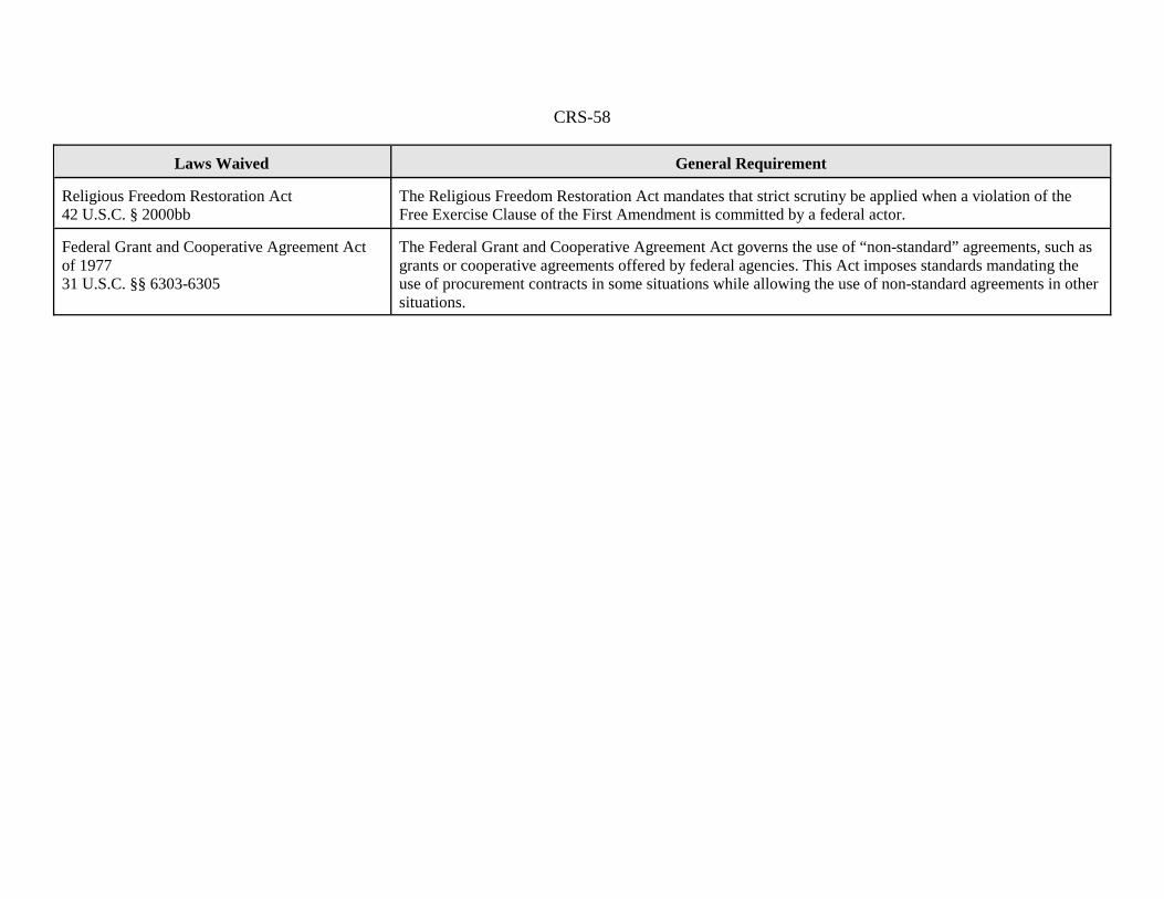
CRS-58
Laws Waived General Requirement
Religious Freedom Restoration Act42 U.S.C. § 2000bb
The Religious Freedom Restoration Act mandates that strict scrutiny be applied when a violation of theFree Exercise Clause of the First Amendment is committed by a federal actor.
Federal Grant and Cooperative Agreement Actof 197731 U.S.C. §§ 6303-6305
The Federal Grant and Cooperative Agreement Act governs the use of “non-standard” agreements, such asgrants or cooperative agreements offered by federal agencies. This Act imposes standards mandating theuse of procurement contracts in some situations while allowing the use of non-standard agreements in othersituations.

CRS-59
Appendix J. Legal Requirements Waived by DHS for the Construction of Physical Barriers andRoads at Various Project Areas Located in California, Arizona, New Mexico, and Texas
Laws Waived General Requirement
National Environmental Policy Act (NEPA) 16 U.S.C. §§ 4321 et seq.
See Appendix F for description of requirements.
Endangered Species Act (ESA) 16 U.S.C. §§ 1531 et seq.
See Appendix F for description of requirements.
Federal Water Pollution Control Act (Clean Water Act)33 U.S.C. §§ 1251 et seq.
See Appendix F for description of requirements.
National Historic Preservation Act (NHPA)16 U.S.C. §§ 470 et seq.
See Appendix F for description of requirements.
Migratory Bird Treaty Act (MTBA)16 U.S.C. §§ 703 et seq.
See Appendix F for description of requirements.
Clean Air Act (CAA)42 U.S.C. §§ 7401 et seq.
See Appendix F for description of requirements.
Archeological Resources Protection Act (ARPA) 16U.S.C. §§ 470aa et seq.
See Appendix H for description of requirements.
Safe Drinking Water Act (SDWA)42 U.S.C. §§ 300f et seq.
See Appendix H for description of requirements.
Noise Control Act (NCA)42 U.S.C. §§ 4901 et seq.
See Appendix H for description of requirements.

CRS-60
Laws Waived General Requirement
Solid Waste Disposal Act (SWDA), as amended by theResource Conservation and Recovery Act (RCRA)42 U.S.C. §§ 6901 et seq.
See Appendix H for description of requirements.
Comprehensive Environmental Response, Compensation,and Liability Act (CERCLA)42 U.S.C. §§ 9601 et seq.
See Appendix H for description of requirements.
Federal Land Policy and Management Act (FLPMA) 43 U.S.C. §§ 1701 et seq.
See Appendix H for description of requirements.
Fish and Wildlife Coordination Act (FWCA)16 U.S.C. §§ 661 et seq.
See Appendix H for description of requirements.
Archaeological and Historic Preservation Act (AHPA)16 U.S.C. §§ 469 et seq.
See Appendix H for description of requirements.
Antiquities Act 16 U.S.C. §§ 431 et seq.
See Appendix H for description of requirements.
Historic Sites, Buildings, and Antiquities Act (HSBAA)16 U.S.C. §§ 461 et seq.
See Appendix H for description of requirements.
Farmland Protection Policy Act (FPPA)7 U.S.C. §§ 4201 et seq.
See Appendix H for description of requirements.
Administrative Procedure Act (APA)5 U.S.C. §§ 551 et seq.
See Appendix F for description of requirements.
Coastal Zone Management Act (CZMA)16 U.S.C. §§ 1451 et seq.
See Appendix F for description of requirements.
National Wildlife Refuge System Administration Act16 U.S.C. §§ 668dd-668ee
See Appendix G for description of requirements.

CRS-61
Laws Waived General Requirement
Fish and Wildlife Act of 195616 U.S.C. §§ 742a et seq.
See Appendix I for description of requirements.
Rivers and Harbors Act of 189933 U.S.C. § 403
See Appendix I for description of requirements.
Eagle Protection Act16 U.S.C. §§ 668 et seq.
See Appendix I for description of requirements.
Native American Graves Protection and Repatriation Act(NAGPRA)25 U.S.C. §§ 3001 et seq.
See Appendix I for description of requirements.
American Indian Religious Freedom Act (AIRFA)42 U.S.C. § 1996
See Appendix I for description of requirements.
Religious Freedom Restoration Act42 U.S.C. § 2000bb
See Appendix I for description of requirements.
Wild and Scenic Rivers Act16 U.S.C. § 1281 et seq.
See Appendix H for description of requirements.
The Wilderness Act16 U.S.C. §§ 1131a et seq.
See Appendix G for description of requirements.
Otay Mountain Wilderness Act of 1999P.L. 106-145
The Otay Mountain Wilderness Act designates certain public lands in California as “wilderness”to be protected under the Wilderness Act. Any lands acquired by the United States within thedesignated area shall become part of the “wilderness area” and subject to the protections of theWilderness Act.
Section 102(29) and 103 of Title I of the CaliforniaDesert Protection ActP.L. 103-433, 50 Stat. 1827
The California Desert Protection Act designates certain lands within the Inyo National Forest as“wilderness” to be protected under the Wilderness Act.
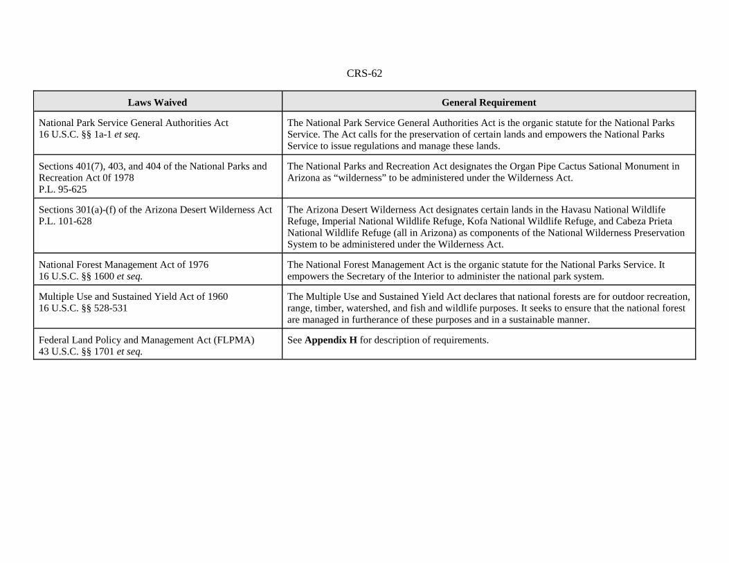
CRS-62
Laws Waived General Requirement
National Park Service General Authorities Act16 U.S.C. §§ 1a-1 et seq.
The National Park Service General Authorities Act is the organic statute for the National ParksService. The Act calls for the preservation of certain lands and empowers the National ParksService to issue regulations and manage these lands.
Sections 401(7), 403, and 404 of the National Parks andRecreation Act 0f 1978P.L. 95-625
The National Parks and Recreation Act designates the Organ Pipe Cactus Sational Monument inArizona as “wilderness” to be administered under the Wilderness Act.
Sections 301(a)-(f) of the Arizona Desert Wilderness ActP.L. 101-628
The Arizona Desert Wilderness Act designates certain lands in the Havasu National WildlifeRefuge, Imperial National Wildlife Refuge, Kofa National Wildlife Refuge, and Cabeza PrietaNational Wildlife Refuge (all in Arizona) as components of the National Wilderness PreservationSystem to be administered under the Wilderness Act.
National Forest Management Act of 197616 U.S.C. §§ 1600 et seq.
The National Forest Management Act is the organic statute for the National Parks Service. Itempowers the Secretary of the Interior to administer the national park system.
Multiple Use and Sustained Yield Act of 196016 U.S.C. §§ 528-531
The Multiple Use and Sustained Yield Act declares that national forests are for outdoor recreation,range, timber, watershed, and fish and wildlife purposes. It seeks to ensure that the national forestare managed in furtherance of these purposes and in a sustainable manner.
Federal Land Policy and Management Act (FLPMA)43 U.S.C. §§ 1701 et seq.
See Appendix H for description of requirements.

United States Government Accountability Office
GAO Testimony Before the Subcommittees on Management, Investigations, and Oversight, and Border, Maritime and Global Counterterrorism, Committee on Homeland Security, House of Representatives
SECURE BORDER INITIATIVE
Observations on Selected Aspects of SBInet Program Implementation
Statement of Richard M. Stana, Director Homeland Security and Justice Issues
For Release on Delivery Expected at 2:00 p.m. EDT Wednesday, October 24, 2007
GAO-08-131T

What GAO Found
United States Government Accountability Office
Why GAO Did This Study
HighlightsAccountability Integrity Reliability
October 24, 2007
SECURE BORDER INITIATIVE
Observations on Selected Aspects of SBInet Program Implementation
Highlights of GAO-08-131T, a testimony before the subcommittee on Management, Investigation, and Oversight, and Border, Maritime and Global Counterterrorism, Committee on Homeland Security, House of Representatives
In November 2005, the Department of Homeland Security (DHS) established the Secure Border Initiative (SBI), a multiyear, multibillion dollar program to secure U.S. borders. One element of SBI is SBInet—the U.S. Customs and Border Protection (CBP) program responsible for developing a comprehensive border protection system through a mix of security infrastructure (e.g., fencing), and surveillance and communication technologies (e.g., radars, sensors, cameras, and satellite phones). The House Committee on Homeland Security asked GAO to monitor DHS progress in implementing the SBInet program. This testimony provides GAO’s observations on (1) SBInet technology implementation; (2) SBInet infrastructure implementation; (3) the extent to which CBP has determined the impact of SBInet technology and infrastructure on its workforce needs and operating procedures; and (4) how the CBP SBI Program Management Office (PMO) has defined its human capital goals and the progress it has made to achieve these goals. GAO’s observations are based on analysis of DHS documentation, such as program schedules, contracts, status, and reports. GAO also conducted interviews with DHS officials and contractors, and visits to sites in the southwest border where SBInet
deployment is underway. GAO performed the work from April 2007 through October 2007. DHS generally agreed with GAO’s findings.
DHS has made some progress to implement Project 28—the first segment of SBInet technology across the southwest border, but it has fallen behind its planned schedule. The SBInet contractor delivered the components (i.e., radars, sensors and cameras) to the Project 28 site in Tucson, Arizona on schedule. However, Project 28 is incomplete more than 4 months after it was to become operational—at which point Border Patrol agents were to begin using SBInet technology to support their activities. According to DHS, the delays are primarily due to software integration problems. In September 2007, DHS officials said that the Project 28 contractor was making progress in correcting the problems, but DHS was unable to specify a date when the system would be operational. Due to the slippage in completing Project 28, DHS is revising the SBInet implementation schedule for follow-on technology projects, but still plans to deploy technology along 387 miles of the southwest border by December 31, 2008. DHS is also taking steps to strengthen its contract management for Project 28. SBInet infrastructure deployment along the southwest border is on schedule, but meeting CBP’s goal to have 370 miles of pedestrian fence and 200 miles of vehicle barriers in place by December 31, 2008, may be challenging and more costly than planned. CBP met its intermediate goal to deploy 70 miles of new fencing in fiscal year 2007 and the average cost per mile was $2.9 million. The SBInet PMO estimates that deployment costs for remaining fencing will be similar to those thus far. In the past, DHS has minimized infrastructure construction labor costs by using Border Patrol agents and Department of Defense military personnel. However, CBP officials report that they plan to use commercial labor for future fencing projects. The additional cost of commercial labor and potential unforeseen increases in contract costs suggest future deployment could be more costly than planned. DHS officials also reported other challenging factors they will continue to face for infrastructure deployment, including community resistance, environmental considerations, and difficulties in acquiring rights to land along the border. The impact of SBInet on CBP’s workforce needs and operating procedures remains unclear because the SBInet technology is not fully identified or deployed. CBP officials expect the number of Border Patrol agents required to meet mission needs to change from current projections, but until the system is fully deployed, the direction and magnitude of the change is unknown. For the Tucson sector, where Project 28 is being deployed, Border Patrol officials are developing a plan on how to integrate SBInet into their operating procedures. The SBI PMO tripled in size during fiscal year 2007, but fell short of its staffing goal of 270 employees. Agency officials expressed concerns that staffing shortfalls could affect the agency’s capacity to provide adequate contractor oversight. In addition, the SBInet PMO has not yet completed long-term human capital planning.
To view the full product, including the scope and methodology, click on GAO-08-131T. For more information, contact Richard M. Stana at (202) 512-8777 or [email protected].

Chairman Sanchez, Mr. Souder, Chairman Carney, Mr. Rogers and Members of the Subcommittees: I am pleased to be here today to discuss observations on selected aspects of the Secure Border Initiative’s SBInet program implementation. Securing the nation’s borders from illegal entry of aliens and contraband, including terrorists and weapons of mass destruction, continues to be a major concern. Much of the United States’ 6,000 miles of international borders with Canada and Mexico remains vulnerable to illegal entry. Although the Department of Homeland Security (DHS) apprehends hundreds of thousands of people entering the country illegally each year, several hundreds of thousands of individuals also enter the United States illegally and undetected. In November 2005, DHS announced the launch of the Secure Border Initiative (SBI), a multiyear, multibillion dollar program aimed at securing U.S. borders and reducing illegal immigration. Elements of SBI will be carried out by several organizations within DHS. One element of SBI is SBInet. Under SBInet, the U.S. Customs and Border Protection (CBP) is responsible for developing a comprehensive border protection system. You requested that we monitor the SBInet program and provide periodic updates on the status of the program. My testimony today is the first in a series of interim reports on SBInet implementation and focuses on the following issues: • SBInet’s technology implementation; • SBInet’s infrastructure implementation; • the extent to which CBP has determined the impact of SBInet
technology and infrastructure on its workforce needs and operating procedures; and
• how the CBP SBI Program Management Office (PMO)1 has defined its
human capital goals and the progress it has made to achieve these goals.
1The SBInet PMO is part of the CBP SBI PMO. The SBInet PMO is responsible for overseeing all SBInet activities; for acquisition and implementation, including establishing and meeting program goals, objectives, and schedules; for overseeing contractor performance; and for coordinating among DHS agencies.
Page 1 GAO-08-131T

To address these issues, we analyzed DHS documents, including program schedules and status reports, and workforce data. We interviewed DHS and CBP headquarters and field officials, including representatives of the SBInet PMO, Border Patrol, CBP Air and Marine, and the DHS Science and Technology Directorate. We also visited the Tucson and Yuma, Arizona Border Patrol sectors2—two sites where SBInet deployment was underway at the time of our review. We performed our work from April 2007 through October 2007 in accordance with generally accepted government auditing standards. (App. I provides a detailed discussion of our scope and methodology.) We also have work underway to review other components of the SBInet
program. Specifically, we are conducting work for the House Committee on Homeland Security to assess the development and deployment of SBInet’s command, control, and communications systems, and surveillance and detection systems and expect to issue a report next year. In addition, we are reviewing DHS’s use of performance-based services acquisition, an acquisition method structured around the results to be achieved instead of the manner by which the service should be performed. We expect to issue a report on this effort in January 2008.
DHS has made some progress to implement the first segment of SBInet technology, Project 28—a $20 million project to secure 28 miles along the southwest border, but it has fallen behind its planned schedule. Boeing—the prime contractor that DHS selected to acquire, deploy, and sustain systems of new surveillance and communications technology across U.S. borders—delivered and deployed the system components (i.e., radars, sensors, computers) to the Project 28 site in the Tucson sector on schedule. However, Project 28 is incomplete more than 4 months after it was to become operational—at which point Border Patrol agents were to begin using SBInet technology to support their activities, and CBP was to begin its operational test and evaluation phase. According to CBP and Boeing officials, the delays are primarily attributed to software integration problems—such as long delays in radar information being displayed in command centers. In September 2007, CBP officials told us that Boeing was making progress in correcting the system integration problems, but CBP was unable to provide us with a specific date on when Boeing would
Summary
2The U.S. Border Patrol has 20 sectors responsible for detecting, interdicting, and apprehending those who attempt illegal entry or smuggle people—including terrorists or contraband, including weapons of mass destruction—across U.S. borders between official ports of entry.
Page 2 GAO-08-131T

complete the necessary corrections to make Project 28 operational. CBP reports that it is in the early stages of planning for additional SBInet technology projects along the southwest border; however, Boeing’s delay in completing Project 28 has led CBP to extend timelines for deploying some technology projects scheduled for calendar years 2007 and 2008. CBP reports that it has taken steps to strengthen its contract management for this project. Deploying SBInet’s infrastructure along the southwest border is on schedule, but meeting the SBInet program’s goal to have 370 miles of pedestrian fence and 200 miles of vehicle barriers in place by December 31, 2008, may prove challenging and more costly than planned. CBP met its intermediate goal to deploy 70 miles of new fencing in fiscal year 2007 and the average cost per mile was $2.9 million. The SBInet PMO estimates that deployment costs for remaining fencing will be similar to those thus far. In the past, DHS has minimized infrastructure construction labor costs by using Border Patrol agents and Department of Defense (DOD) military personnel. However, CBP officials report that they plan to use commercial labor for future fencing projects. The additional cost of commercial labor and potential unforeseen increases in contract costs suggest future deployment could be more costly than planned. Also, while deployment of tactical infrastructure is on schedule, CBP officials reported that meeting deadlines has been challenging because of factors the officials will continue to face, including conducting outreach necessary to address border-community resistance, identifying and completing steps necessary to comply with environmental regulations, and addressing difficulties in acquiring rights to border lands. The impact of SBInet on the Border Patrol’s workforce’s needs and operating procedures remains unclear because the SBInet technology is not fully identified or deployed. CBP officials expect the number of Border Patrol agents required to meet mission needs to change from the current projections, but until the system is fully deployed, the direction and magnitude of the change is unknown. In addition, for the Tucson sector, where Project 28 is being deployed, the Border Patrol is developing a plan on how to integrate SBInet into its operating procedures. Moreover, the delays in deploying Project 28 will require revising the SBInet’s training curriculum, and trainers and operators will be retrained.
The SBI PMO tripled in size in fiscal year 2007 but fell short of its staffing goal of 270 employees. Agency officials expressed concerns that staffing shortfalls could affect the agency’s capacity to provide adequate contractor oversight. In addition, the SBI PMO has not yet completed its long-term human capital planning.
Page 3 GAO-08-131T

In their oral comments on a draft of this statement, DHS generally agreed with our findings and provided clarifying information that we incorporated as appropriate.
The SBInet program is responsible for identifying and deploying an appropriate mix of technology (e.g., sensors, cameras, radars, communications systems, and mounted laptop computers for agent vehicles), tactical infrastructure (e.g., fencing, vehicle barriers, roads,), rapid response capability (e.g., ability to quickly relocate operational assets and personnel) and personnel (e.g., program staff and Border Patrol agents) that will enable CBP agents and officers to gain effective control3 of U.S. borders. SBInet technology is also intended to include the development and deployment of a common operating picture (COP) that provides uniform data through a command center environment to Border Patrol agents in the field and all DHS agencies and to be interoperable with stakeholders external to DHS, such as local law enforcement. The initial focus of SBInet is on the southwest border areas between ports of entry4 that CBP has designated as having the highest need for enhanced border security because of serious vulnerabilities. Through SBInet, CBP plans to complete a minimum of 387 miles of technology deployment across the southwest border by December 31, 2008. Figure 1 shows the location of select SBInet projects underway on the southwest border.
Background
3DHS defines effective control of U.S. borders as the ability to consistently: (1) detect illegal entries into the United States; (2) identify and classify these entries to determine the level of threat involved; (3) respond to these entries; and (4) bring events to a satisfactory law enforcement resolution.
4At a port of entry location, CBP officers secure the flow of people and cargo into and out of the country, while facilitating legitimate travel and trade.
Page 4 GAO-08-131T
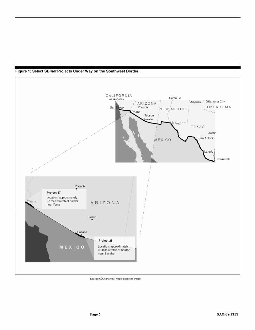
Figure 1: Select SBInet Projects Under Way on the Southwest Border
Page 5 GAO-08-131T

In September 2006, CBP awarded a prime contract to the Boeing Company for 3 years, with three additional 1-year options. As the prime contractor, Boeing is responsible for acquiring, deploying, and sustaining selected SBInet technology and tactical infrastructure projects. In this way, Boeing has extensive involvement in the SBInet program requirements development, design, production, integration, testing, and maintenance and support of SBInet projects. Moreover, Boeing is responsible for selecting and managing a team of subcontractors that provide individual components for Boeing to integrate into the SBInet system.5 The SBInet contract is largely performance-based—that is, CBP has set requirements for SBInet and Boeing and CBP coordinate and collaborate to develop solutions to meet these requirements—and designed to maximize the use of commercial off-the-shelf technology. 6 CBP’s SBInet PMO oversees and manages the Boeing-led SBInet contractor team. The SBInet PMO workforce includes a mix of government and contractor support staff. The SBInet PMO reports to the CBP SBI Program Executive Director. CBP is executing part of SBInet activities through a series of task orders to Boeing for individual projects. As of September 30, 2007, CBP had awarded five task orders to Boeing for SBInet projects. These include task orders for (1) Project 28, Boeing’s pilot project and initial implementation of SBInet technology to achieve control of 28 miles of the border in the Tucson sector; (2) Project 37, for construction approximately 32 miles of vehicle barriers and pedestrian fencing in the Yuma sector along the Barry M. Goldwater Range (BMGR);7 (3) Program Management, for engineering, facilities and infrastructure, test and evaluation, and general program management services; (4) Fence Lab, a project to evaluate the performance and cost of deploying different types of fences and vehicle barriers; and (5) a design task order for developing the plans for several technology projects to be located in the Tucson, Yuma, and El Paso sectors.
5Boeing employs several companies as subcontractors on the SBInet project. These companies provide Boeing with a variety of services. For example, Boeing has used a subcontractor to install laptops into CBP vehicles, while it has used another to develop and deploy mobile sensor towers.
6Commercial off-the-shelf is a term for software or hardware, generally technology or computer products, that are available for sale, lease, or license to the general public.
7Project 37 consists of three phases, which when complete are to provide control over 37 miles of border in the Yuma sector. The first two phases focus on deployment of tactical infrastructure. The third phase will focus on technology systems.
Page 6 GAO-08-131T

In addition to deploying technology across the southwest border, the SBInet PMO plans to deploy 370 miles of single-layer pedestrian fencing and 200 miles of vehicle barriers by December 31, 2008. Whereas pedestrian fencing is designed to prevent people on foot from crossing the border, vehicle barriers are other physical barriers meant to stop the entry of vehicles. The SBInet PMO is utilizing the U.S. Army Corps of Engineers (USACE) to contract for fencing and supporting infrastructure (such as lights and roads), complete required environmental assessments, and acquire necessary real estate.8
DHS has estimated that the total cost for completing the deployment for the southwest border—the initial focus of SBInet deployment—will be $7.6 billion from fiscal years 2007 through 2011. DHS has not yet reported the estimated life cycle cost for this program, which is the total cost to the government for a program over its full life, consisting of research and development, operations, maintenance, and disposal costs.9 For fiscal year 2007, Congress appropriated about $1.2 billion for SBInet, about which 40 percent DHS had committed or obligated as of September 30, 2007. For fiscal year 2008, DHS has requested an additional $1 billion.10
DHS has made some progress to implement Project 28—the first segment of technology on the southwest border, but it has fallen behind its planned schedule. Project 28 is the first opportunity for Boeing to demonstrate that its technology system can meet SBInet performance requirements in a real-life environment.11 Boeing’s inability thus far to resolve system integration issues has left Project 28 incomplete more than 4 months after its planned June 13 milestone to become operational—at which point, Border Patrol agents were to begin using SBInet technology to support
SBInet Technology Deployment Delays May Increase Schedule Risks
8The SBInet PMO contracted with Boeing Company to construct 32 miles of fencing in the BMGR. Deployment of this fencing has been completed, and the SBInet PMO plans to use USACE to contract for all remaining pedestrian fencing and vehicle barriers to be deployed through December 31, 2008.
9GAO, Missile Defense: Actions Needed to Improve Information for Supporting Key
Decisions for Boost and Ascent Phase Elements, GAO-07-430 (Washington, D.C.: April 2007).
10DHS and DOD appropriations bills for fiscal year 2008 that include additional funding for border security are awaiting final action in Congress.
11CBP has established performance requirements for SBInet technology. These include requirements for (1) probability of detection; (2) correctly identifying threats; (3) apprehension; (4) system availability; and (5) false alarm rate.
Page 7 GAO-08-131T

their activities, and CBP was to begin its operational test and evaluation phase. Boeing delivered and deployed the individual technology components of Project 28 on schedule.12 Nevertheless, CBP and Boeing officials reported that Boeing has been unable to effectively integrate the information collected from several of the newly deployed technology components, such as sensor towers, cameras, radars, and unattended ground sensors. Among several technical problems reported were that it was taking too long for radar information to display in command centers and newly deployed radars were being activated by rain, making the system unusable. In August 2007, CBP officially notified Boeing that it would not accept Project 28 until these and other problems were corrected. In September 2007, CBP officials told us that Boeing was making progress in correcting the system integration problems; however, CBP was unable to provide us with a specific date when Boeing would complete the corrections necessary to make Project 28 operational. See figures 2 and 3 below for photographs of SBInet technology along the southwest border.
Figure 2: Project 28 Mobile Sensor Tower Deployed in Tucson Sector
12Project 28 components include: 9 mobile radar/sensor towers; 4 underground sensors, 70 small hand-held satellite phones for agents to communicate throughout the Tucson sector; and 50 CBP agent vehicles with secure-mounted laptop computers and communications capabilities.
Page 8 GAO-08-131T

Figure 3: At Left, Mounted Laptop Installed in Border Patrol Vehicle; at Right, Project 28 Command and Control Center
The SBInet PMO reported that is in the early stages of planning for additional SBInet technology projects along the southwest border; however, Boeing’s delay in completing Project 28 has led the PMO to change the timeline for deploying some of these projects. In August 2007, SBInet PMO officials told us they were revising the SBInet implementation plan to delay interim project milestones for the first phase of SBInet technology projects, scheduled for calendar years 2007 and 2008.13 For example, SBInet PMO officials said they were delaying the start dates for two projects14 that were to be modeled on the design used for Project 28 until after Project 28 is operational and can provide lessons learned for planning and deploying additional SBInet technology along the southwest border. According to the SBInet master schedule dated May 31, 2007, these projects were to become operational in December 2007 and May 2008. Despite these delays, SBInet PMO officials said they still expected to complete all of the first phase of technology projects by the end of calendar year 2008. As of October 15, 2007, the SBInet PMO had not provided us with a revised deployment schedule for this first phase.
13The SBInet PMO plans to deploy SBInet projects in three phases. Phase one projects are scheduled between April 2007 and December 2008; phase two projects are scheduled between May 2008 and early 2010; and phase three projects are scheduled to begin in May 2009.
14The two projects are Project 37 BMGR phase three technology deployment, and the Texas Mobile System, technology deployment for about 70 miles of border in the El Paso sector.
Page 9 GAO-08-131T

CBP reports that it is taking steps to strengthen its contract management for Project 28. For example, citing numerous milestone slippages by Boeing during Project 28 implementation, in August 2007, CBP sought and reached an agreement with Boeing to give it greater influence in milestone setting and planning corrective actions on the Project 28 task order. While CBP had selected a firm-fixed-price contract to limit cost overruns on Project 28,15 CBP officials told us that the firm-fixed-price contract CBP used for Project 28 had limited the government’s role in directing Boeing in its decision making process. For example, CBP and contractor officials told us they expressed concern about the timeline for completing Project 28, but CBP chose not to modify the contract because doing so would have made CBP responsible for costs beyond the $20 million fixed-price contract.16 In mid-August 2007, CBP organized a meeting with Boeing representatives to discuss ways to improve the collaborative process, the submission of milestones, and Boeing’s plan to correct Project 28 problems. Following this meeting, CBP and Boeing initiated a Change Control Board.17 In mid-September representatives from Boeing’s SBInet team and its subcontractors continued to participate on this board and vote on key issues for solving Project 28 problems. Although CBP participates on this committee as a non-voting member, a senior SBInet
official said the government’s experience on the Change Control Board had been positive thus far. For example, the official told us that the Change Control Board had helped improve coordination and integration with Boeing and for suggesting changes to the subcontractor companies working on Project 28.
15A firm-fixed-price contract provides for a price that is not subject to any adjustment on the basis of the contractor’s cost experience in performing the contract. This contract type places maximum risk upon the contractor and full responsibility for all costs and resulting profit or loss.
16In April 2007, CBP and Boeing reached an agreement to modify the terms of the Project 28 contract, increasing it to about $20.66 million. CBP modified the contract to add several project design requirements that the existing task order did not address.
17The Change Control Board is a voting body that represents the interests of program and project management by ensuring that a structured process is used to consider proposed changes and incorporate them into a specified release of a product.
Page 10 GAO-08-131T

Deploying SBInet’s tactical infrastructure along the southwest border is on schedule, but meeting the SBInet program’s goal to have 370 miles of pedestrian fence and 200 miles of vehicle barriers in place by December 31, 2008, may be challenging and more costly than planned. CBP set an intermediate goal to deploy 70 miles of new pedestrian fencing by the close of fiscal year 2007 and, having deployed 73 miles by this date, achieved its goal. Table 1 summarizes CBP‘s progress and plans for tactical infrastructure deployment.
SBInet Tactical Infrastructure Deployment on Track but May Be Challenging and More Costly than Planned
Table 1: Tactical Infrastructure Deployment Progress as of September 30, 2007
Infrastructure type
Miles in place before SBInet
Miles deployed through SBInet
Total miles in place
Target for 12/31/08
Miles remaining to meet 12/31/08 target
Pedestrian fencing 78 73 151 370 219
Vehicle barriers 57 53 110 200 90
Source: GAO analysis of CBP data.
Costs for the 73 miles of fencing constructed in fiscal year 2007 averaged $2.9 million per mile and ranged from $700,000 in San Luis, Arizona, to $4.8 million per mile in Sasabe, Arizona. CBP also deployed 11 miles of vehicle barriers and, although CBP has not yet been able to provide us with the cost of these vehicle barriers, it projects that the average per mile cost for the first 75 miles of barriers it deploys will be $1.5 million. Figure 4 presents examples of fencing deployed.
Page 11 GAO-08-131T

Figure 4: At Left, SBInet Fencing Being Deployed at Sasabe, Arizona; at Right, SBInet Fencing Deployed at Yuma, Arizona
CBP estimates costs for the deployment of fencing in the future will be similar to those thus far. However, according to CBP officials, costs vary due to the type of terrain, materials used, land acquisition, who performs the construction, and the need to meet an expedited schedule. Although CBP estimates that the average cost of remaining fencing will be $2.8 million per mile, actual future costs may be higher due to factors such as the greater cost of commercial labor, higher than expected property acquisition costs, and unforeseen costs associated with working in remote areas. To minimize one of the many factors that add to cost, in the past DHS has used Border Patrol agents and DOD military personnel. However, CBP officials reported that they plan to use commercial labor for future infrastructure projects to meet their deadlines. Of the 73 miles of fencing completed to date, 31 were completed by DOD military personnel and 42 were constructed through commercial contracts. While the non-commercial projects cost an average of $1.2 million per mile,18 the commercial projects averaged over three times more—$4 million.19
18CBP’s estimates of non-commercial fencing projects do not include labor costs associated with using government personnel.
19According to the Congressional Research Service (CRS), DHS predicts that the San Diego fence will have a total cost of $127 million for its 14-mile length when it is completed— roughly $9 million a mile. Construction of the first 9.5 miles of fencing cost $31 million, or roughly $3 million a mile, while construction of the last 4.5 miles of fencing is projected to cost $96 million, or roughly $21 million a mile. DHS is proposing to hire private contractors to expedite the construction of the remaining 4.5 miles of fencing; according to CRS this fact, and the complexity of the construction, may account for part of the difference in cost.
Page 12 GAO-08-131T
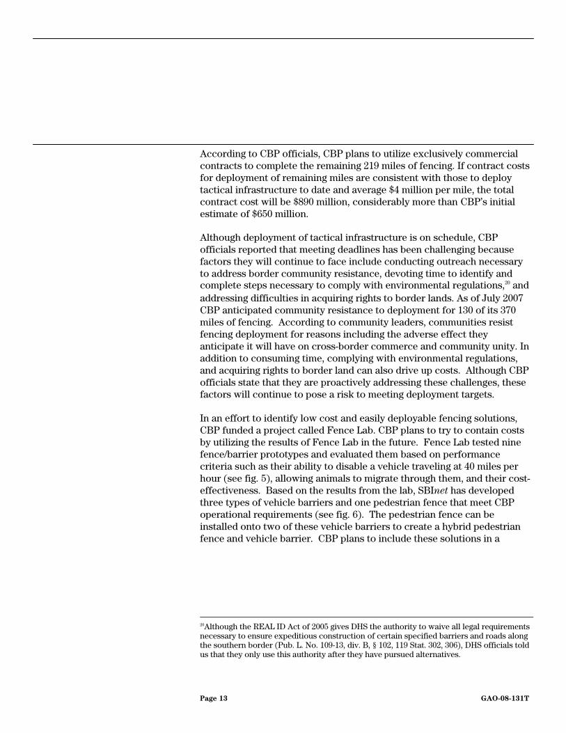
According to CBP officials, CBP plans to utilize exclusively commercial contracts to complete the remaining 219 miles of fencing. If contract costs for deployment of remaining miles are consistent with those to deploy tactical infrastructure to date and average $4 million per mile, the total contract cost will be $890 million, considerably more than CBP’s initial estimate of $650 million. Although deployment of tactical infrastructure is on schedule, CBP officials reported that meeting deadlines has been challenging because factors they will continue to face include conducting outreach necessary to address border community resistance, devoting time to identify and complete steps necessary to comply with environmental regulations,20 and addressing difficulties in acquiring rights to border lands. As of July 2007 CBP anticipated community resistance to deployment for 130 of its 370 miles of fencing. According to community leaders, communities resist fencing deployment for reasons including the adverse effect they anticipate it will have on cross-border commerce and community unity. In addition to consuming time, complying with environmental regulations, and acquiring rights to border land can also drive up costs. Although CBP officials state that they are proactively addressing these challenges, these factors will continue to pose a risk to meeting deployment targets. In an effort to identify low cost and easily deployable fencing solutions, CBP funded a project called Fence Lab. CBP plans to try to contain costs by utilizing the results of Fence Lab in the future. Fence Lab tested nine fence/barrier prototypes and evaluated them based on performance criteria such as their ability to disable a vehicle traveling at 40 miles per hour (see fig. 5), allowing animals to migrate through them, and their cost-effectiveness. Based on the results from the lab, SBInet has developed three types of vehicle barriers and one pedestrian fence that meet CBP operational requirements (see fig. 6). The pedestrian fence can be installed onto two of these vehicle barriers to create a hybrid pedestrian fence and vehicle barrier. CBP plans to include these solutions in a
20Although the REAL ID Act of 2005 gives DHS the authority to waive all legal requirements necessary to ensure expeditious construction of certain specified barriers and roads along the southern border (Pub. L. No. 109-13, div. B, § 102, 119 Stat. 302, 306), DHS officials told us that they only use this authority after they have pursued alternatives.
Page 13 GAO-08-131T

“toolkit” of approved fences and barriers,21 and plans to deploy solutions from this toolkit for all remaining vehicle barriers and for 202 of 225 miles of remaining fencing. Further, CBP officials anticipate that deploying these solutions will reduce costs because cost-effectiveness was a criterion for their inclusion in the toolkit. SBInet officials also told us that widely deploying a select set of vehicle barriers and fences will lower costs through enabling it to make bulk purchases of construction and maintenance materials.
Figure 5: Fence Lab crash testing conducted in May 2007
21 As the SBInet PMO uses testing and evaluation to identify tactical infrastructure and technology components that effectively secure the border, the SBInet PMO is approving them for inclusion in a master “toolkit” of approved solutions. In addition to vehicle barriers and fences, the toolkit will include technology components such as radars and satellite phones as well as a list of approved vendors. In the future, the SBInet PMO plans to choose among its toolkit components to craft border security solutions.
Page 14 GAO-08-131T

Figure 6: Vehicle Barriers and Fencing Developed by Fence Lab That Meet Performance Requirements and Are Included in SBInet’s “Toolbox” of Approved Fences and Barriers.
While SBInet Program officials expect SBInet to greatly reduce the time spent by CBP enforcement personnel in performing detection activities,22 a full evaluation of SBInet’s impact on the Border Patrol’s workforce needs has not been completed. The Border Patrol currently uses a mix of resources including personnel, technology, infrastructure, and rapid response capabilities to incrementally achieve its strategic goal of establishing and maintaining operational control of the border. 23 Each year through its Operational Requirements Based Budget Program (ORBBP), the Border Patrol sectors outline the amount of resources needed to
SBInet Impact on Border Patrol’s Workforce Needs and Operating Procedures Remains Unclear
22SBI PMO expects SBInet to provide the capability to predict, deter, detect, identify, classify, track, respond to, and resolve border incursion; and the operational enhancements of SBInet will provide efficiencies by reducing the time agents spend performing detection and characterization activities.
23CBP defines operational control as the ability to detect, respond, and interdict border penetrations in areas deemed as high priority for threat potential or other national security objectives.
Page 15 GAO-08-131T
achieve a desired level of border control.24 Border Patrol officials state this annual planning process allows the organization to measure the impact of each type of resource on the required number of Border Patrol agents. A full evaluation of SBInet’s impact on the Border Patrol’s workforce needs is not yet included in the ORBBP process; however, the Border Patrol plans to incorporate information from Project 28 a few months after it is operational. According to agency officials, CBP is on track to meet its hiring goal of 6,000 new Border Patrol agents by December 2008, but after SBInet is deployed, CBP officials expect the number of Border Patrol agents required to meet mission needs to change from current projections, although the direction and magnitude of the change is unknown. In addition, in June 2007, we expressed concern that deploying these new agents to the southwest sectors coupled with the planned transfer of more experienced agents to the northern border will create a disproportionate ratio of new agents to supervisors within those sectors—jeopardizing the supervisors’ availability to acclimate new agents.25 Tucson Sector officials stated CBP is planning to hire from 650 to 700 supervisors next year. To accommodate the additional agents, the Border Patrol has taken initial steps to provide additional work space through constructing temporary and permanent facilities, at a projected cost of about $550 million from fiscal year 2007 to 2011. The SBInet PMO expects SBInet to support day-to-day border enforcement operations; however, analysis of the impact of SBInet technology on the Border Patrol’s operational procedures cannot be completed at this time because agents have not been able to fully use the system as intended. Leveraging technology is part of the National Border Patrol Strategy which identifies the objectives, tools, and initiatives the Border Patrol uses to maintain operational control of the borders. The Tucson sector, where Project 28 is being deployed, is developing a plan on how to integrate SBInet into its operating procedures. Border Patrol officials stated they intend to re-evaluate this strategy, as SBInet technology is identified and deployed, and as control of the border is achieved.
24The Border Patrol defines five levels of border security ranging from “controlled”—the highest sustainable level of control to “remote/low activity”—the lowest level of control.
25GAO, Border Patrol Costs and Challenges Related to Training New Agents, GAO-07-997T (Washington, D.C.: June 2007).
Page 16 GAO-08-131T

According to agency officials, 22 trainers and 333 operators were trained on the current Project 28 system, but because of deployment delays and changes to the COP software, the SBInet training curriculum is to be revised by Boeing and the government. Training is continuing during this revision process with 24 operators being trained each week. According to CBP officials, Border Patrol agents are receiving “hands on” training during evening and weekend shifts at the COP workstations to familiarize themselves with the recent changes made to the Project 28 system. However, training is to be stopped once a stabilized version of the COP can be used and both trainers and operators are to be retrained using the revised curriculum. Costs associated with revising the training material and retraining the agents are to be covered by Boeing as part of the Project 28 task order; however, the government may incur indirect costs associated with taking agents offline for retraining.
The SBI PMO tripled in size in fiscal year 2007 but fell short of its staffing goal of 270 employees.26 As of September 30, 2007, the SBI PMO had 247 employees onboard, with 113 government employees and 134 contractor support staff. SBI PMO officials also reported that as of October 19, 2007, they had 76 additional staff awaiting background investigations. In addition, these officials said that a Human Capital Management Plan has been drafted, but as of October 22, 2007, the plan had not been approved. In February 2007, we reported that SBInet officials had planned to finalize a human capital strategy that was to include details on staffing and expertise needed for the program.27 At that time, SBI and SBInet officials expressed concern about difficulties in finding an adequate number of staff with the required expertise to support planned activities about staffing that shortfalls could limit government oversight efforts. Strategic human capital planning is a key component used to define the critical skills and competencies that will be needed to achieve programmatic goals and outlines ways the organization can fill gaps in knowledge, skills, and abilities.28 Until SBInet fully implements a comprehensive human capital
SBI PMO Did Not Meet All of Its Staffing Goals and Has Not Yet Completed Long-Term Human Capital Planning
26GAO, SBInet Expenditure Plan Needs to Better Support Oversight and Accountability, GAO-07-309 (Washington, D.C.: February 2007).
27GAO-07-309.
28See GAO, Human Capital: Key Principles for Effective Strategic Workforce Planning, GAO-04-39 (Washington, D.C.: December 2003) and GAO, Framework for Accessing the
Acquisition Function at Federal Agencies GAO-05-218G (Washington, D.C.: September 2005).
Page 17 GAO-08-131T
strategy, it will continue to risk not having staff with the right skills and abilities to successfully execute the program.
Project 28 and other early technology and infrastructure projects are the first steps on a long journey towards SBInet implementation that will ultimately require an investment of billions of taxpayer dollars. Some of these early projects have encountered unforeseen problems that could affect DHS’s ability to meet projected completion dates, expected costs, and performance goals. These issues underscore the need for both DHS and Boeing, as the prime contractor, to continue to work cooperatively to correct the problems remaining with Project 28 and to ensure that the SBInet PMO has adequate staff to effectively plan and oversee future projects. These issues also underscore Congress’s need to stay closely attuned to DHS’s progress in the SBInet program to make sure that performance, schedule, and cost estimates are achieved and the nation’s border security needs are fully addressed. This concludes my prepared testimony. I would be happy to respond to any questions that members of the Subcommittees may have.
For questions regarding this testimony, please call Richard M. Stana at (202) 512-8777 or [email protected]. Other key contributors to this statement were Robert E. White, Assistant Director; Rachel Beers; Jason Berman; Katherine Davis; Jeanette Espínola; Taylor Matheson; and Sean Seales.
Concluding Observations
Contacts and Acknowledgments
Page 18 GAO-08-131T

Appendix I: Scope and
Methodology
Page 19 GAO-08-131T
Appendix I: Scope and Methodology
To determine the progress that the Department of Homeland Security (DHS) has made in implementing the Secure Border Initiative (SBI) SBInet’s technology deployment projects, we analyzed DHS documentation, including program schedules, project task orders, status reports, and expenditures. We also interviewed DHS and the U.S. Customs and Border Protection (CBP) headquarters and field officials, including representatives of the SBInet Program Management Office (PMO), Border Patrol, CBP Air and Marine, and the DHS Science and Technology Directorate, as well as SBInet contractors. We visited the Tucson Border Patrol sector—the site where SBInet technology deployment was underway at the time of our review.
To determine the progress that Department of Homeland Security (DHS) has made in infrastructure project implementation, we analyzed DHS documentation, including schedules, contracts, status reports, and expenditures. In addition, we interviewed DHS and CBP headquarters and field officials, including representatives of the SBInet PMO, and Border Patrol. We also interviewed officials from the U.S. Army Corps of Engineers and the Department of the Interior. We visited the Tucson and Yuma, Arizona Border Patrol sectors—two sites where tactical infrastructure projects were underway at the time of our review. We did not review the justification for infrastructure project cost estimates or independently verify the source or validity of the cost information.
To determine the extent to which CBP has determined the impact of SBInet technology and infrastructure on its workforce needs and operating procedures, we reviewed documentation of the agency’s decision to hire an additional 6,000 agents and the progress hiring these agents. We also interviewed headquarters and field officials to track if and how CBP (1) is hiring and training its target number of personnel, (2) it is planning to train new agents on SBInet technology, and (3) it will incorporate the new system into its operational procedures, and any implementation challenges it reports facing in conducting this effort.
To determine how the SBInet PMO defined its human capital goals and progress it has made in achieving these goals, we reviewed the office’s documentation on its hiring efforts related to SBInet, related timelines, and compared this information with agency goals. We determined that the workforce data were sufficiently reliable for purposes of this report. We also interviewed SBI and SBInet officials to identify challenges in meeting the goals and steps taken by the agency to address those challenges.

Appendix I: Scope and
Methodology
We performed our work from April 2007 through October 2007 in accordance with generally accepted government auditing standards.
(440584)
Page 20 GAO-08-131T

This is a work of the U.S. government and is not subject to copyright protection in the United States. It may be reproduced and distributed in its entirety without further permission from GAO. However, because this work may contain copyrighted images or other material, permission from the copyright holder may be necessary if you wish to reproduce this material separately.

GAO’s Mission The Government Accountability Office, the audit, evaluation, and investigative arm of Congress, exists to support Congress in meeting its constitutional responsibilities and to help improve the performance and accountability of the federal government for the American people. GAO examines the use of public funds; evaluates federal programs and policies; and provides analyses, recommendations, and other assistance to help Congress make informed oversight, policy, and funding decisions. GAO’s commitment to good government is reflected in its core values of accountability, integrity, and reliability.
The fastest and easiest way to obtain copies of GAO documents at no cost is through GAO’s Web site (www.gao.gov). Each weekday, GAO posts newly released reports, testimony, and correspondence on its Web site. To have GAO e-mail you a list of newly posted products every afternoon, go to www.gao.gov and select “E-mail Updates.”
The first copy of each printed report is free. Additional copies are $2 each. A check or money order should be made out to the Superintendent of Documents. GAO also accepts VISA and Mastercard. Orders for 100 or more copies mailed to a single address are discounted 25 percent. Orders should be sent to:
U.S. Government Accountability Office 441 G Street NW, Room LM Washington, DC 20548
To order by Phone: Voice: (202) 512-6000 TDD: (202) 512-2537 Fax: (202) 512-6061
Contact:
Web site: www.gao.gov/fraudnet/fraudnet.htm E-mail: [email protected] Automated answering system: (800) 424-5454 or (202) 512-7470
Gloria Jarmon, Managing Director, [email protected], (202) 512-4400 U.S. Government Accountability Office, 441 G Street NW, Room 7125 Washington, DC 20548
Susan Becker, Acting Manager, [email protected], (202) 512-4800 U.S. Government Accountability Office, 441 G Street NW, Room 7149 Washington, DC 20548
Obtaining Copies of GAO Reports and Testimony
Order by Mail or Phone
To Report Fraud, Waste, and Abuse in Federal Programs
Congressional Relations
Public Affairs
PRINTED ON RECYCLED PAPER

Violations on the Part of the United States Government of the Right to Property and
Non-Discrimination Held by Residents of the Texas Rio Grande Valley
The Working Group on Human Rights and the Border Wall
Leah Nedderman, Ariel Dulitzky and Denise Gilman
2008

Introduction The Secure Border Fence Act of 2006 and the Consolidated Appropriations Act of 2008 direct the construction of 700 miles of reinforced fencing on the Southwest border of the United States. Approximately 70 miles of this fencing is slated to be constructed in the Texas Rio Grande Valley. The lands being taken by the U.S. government for the purpose of building the fence include public and privately held lands1. Several private properties that are currently being accessed by the U.S. government for the purpose of surveying and construction are owned by citizens with deep historical claims to their land. Dr. Eloisa Tamez, a life-long resident of El Calaboz, Texas is one such property owner. Dr. Tamez, self identified as Lipan Apache, is the owner of a small piece of property that has been in her family since 1774. The proposed wall will bisect her land, leaving the majority of her property on the south side of the barrier.2 The case of Idalia Benavidez and her family is another example. For five generations, the Benavidez family has lived on a seven-acre plot of farmland near the U.S.–Mexico border west of Brownsville, Texas. They have harvested cotton and squash and raised goats and pigs. They have helped build the levee that is located across the rear of the property. In April, federal officials arrived asking to purchase a rectangular slice of their property abutting the levee for $4,100 to make way for the border fence. The Benavidez family refused. Idalia Benavidez told the Working Group that one of the government employees told her, "I don't want to scare you but whether you agree or not, the government's going to build the fence." If the 18-foot-high barrier is built on their property, it will cut off the Benavidez cows and goats from a pasture south of the fence's proposed path3. Many other private property owners are being affected in similar ways. In the process of planning and constructing the border fence on the Texas/Mexico border, and particularly in the Rio Grande Valley, the United States government is violating residents’ right to property. Additionally, the Department of Homeland Security (DHS), and Customs and Border Protection in particular, are conducting the border fence planning and construction process in ways that violate the principles of equal protection and non-discrimination as understood by international human rights law.
1 The public lands are property of the State of Texas, different cities, counties and school districts, among others. 2 The Working Group has interviewed and consulted with Dr. Eloisa Tamez. 3The Working Group interviewed Idalia Benavidez. See also Arian Campo-Flores and Andrew Murr, Brownsville’s Bad Lie, Newsweek, May 05, 2008.
2

This briefing paper examines these violations. Its central arguments are: The United States government is violating residents’ right to property.4 The placement (location) of the border fence is discriminatory. The placement (location) of the border fence is arbitrary. The burden is on the United States government to demonstrate that the
construction of a border fence is a reasonable and necessary measure to protect the State’s national security objectives and that there are no other less restrictive measures available, but the government has not carried its burden.
Domestic Law on the Border Fence Two pieces of legislation are central to U.S. policy concerning the border fence:
P.L. 109-367, the Secure Fence Act of 2006 P.L. 110-161, the Consolidated Appropriations Act of 2008
P.L. 109-367, the Secure Fence Act of 2006, was signed into law on October 26, 2006. The act directed DHS to construct two-layered reinforced fencing and additional physical barriers, roads, cameras, sensors, and lighting along five stretches of the southwest border. According to the act, the Texas portion of the border fence would be located: from 5 miles west of the Columbus, New Mexico, port of entry to 10 miles east of El Paso, Texas; from 5 miles northwest of the Del Rio, Texas, port of entry to 5 miles southeast of the Eagle Pass, Texas, port of entry; and from 15 miles northwest of the Laredo, Texas, port of entry to the Brownsville, Texas, port of entry. P.L. 110-161, the Consolidated Appropriations Act of 2008, was enacted on December 26, 2007 (fourteen months after the Secure Fence Act of 2006). Most importantly, the act significantly increased the Secretary of Homeland Security’s discretion as to where to construct fencing. Whereas the Secretary was previously required to build the fence in specific areas, the new legislation includes a more general requirement to construct barriers: “along not less than 700 miles of the southwest border where fencing would be most practical and effective and provide for the installation of additional physical barriers, roads, lighting, cameras, and sensors to gain operational control of the southwest border5.” The act also amends the provisions concerning fence construction in priority areas, by requiring the Secretary of Homeland Security to identify either 370 miles or “other mileage” along the southwest border where fencing would be most practical and effective, and to complete construction of fencing in those identified areas by December 31, 2008. Another important change enacted by this legislation is that the Secretary is
4 Current U.S. immigration law authorizes the Secretary of DHS to contract for and buy any interest in land adjacent to or in the vicinity of the international border when the Secretary deems the land essential to control and guard the border against any violations of immigration law. It also authorizes the Secretary to commence condemnation proceedings if a reasonable purchase price cannot be agreed upon. See Illegal Immigration Reform and Immigrant Responsibility Act, section 102. 5 P.L. 110-161.
3
not required to install: “fencing, physical barriers, roads, lighting, cameras, and sensors in a particular location...if the Secretary determines that the use or placement of such resources is not the most appropriate means to achieve and maintain operational control over the international border at such location.” Despite the important modifications and new requirements for consultation and consideration of alternatives included in this legislation, DHS does not appear to have changed its plans for wall locations significantly from those designated in the Secure Fence Act of 2006. International Law as it Applies to the Border Fence - The Right to Property and the Principle of Equal Protection and Non-Discrimination Article II of the American Declaration on the Rights and Duties of the Man (“American Declaration”) says that: “All persons are equal before the law and have the rights and duties established in this Declaration, without distinction as to race, sex, language, creed or any other factor.” Article V of the American Declaration states: “Every person has the right to the protection of the law against abusive attacks upon his honor, his reputation, and his private and family life.” Article IX of the American Declaration states: “Every person has the right to the inviolability of his home.” Article XXIII of the American Declaration states: “Every person has a right to own such private property as meets the essential needs of decent living and helps to maintain the dignity of the individual and of the home.” The Inter-American Court of Human Rights (“the Inter-American Court” or IACtHR) has said that the right to property must be understood in the context of a democratic society. In that context, the State, in order to guarantee other rights of vital relevance can limit or restrict or even expropriate since the right to private property is not an absolute right6. However, the Inter-American system has put strict limitations on a State’s ability to affect a person’s right to property. The Inter-American Court has held, on several occasions, that, in accordance with Article 21 of the American Convention on Human Rights (“American Convention”)7, a State may restrict the use and enjoyment of the right to property only where the restrictions on
6 See IACtHR, Case of Salvador-Chiriboga v. Ecuador. Preliminary Objections and Merits. Judgment of May 6, 2008 (Only in Spanish). Series C No. 179, para. 60. 7 The Inter-American Commission on Human rights (“the Commission” or IACHR) has clarified that, in interpreting and applying the Declaration, it is necessary to consider its provisions in the context of the international and inter-American human rights systems more broadly and in the light of developments in the field of international human rights law. This includes, in particular, the American Convention on Human Rights which, in many instances, may be considered to represent an authoritative expression of the fundamental principles set forth in the American Declaration. IACHR, Garza v. United States, Case 12.275, Annual Report of the IACHR 2000, paras. 88 and 89.
4

the right are: a) previously established by law; b) necessary; c) proportional, and d) with the aim of achieving a legitimate objective in a democratic society.8
The Inter-American Court has recognized its power to review the public utility or social interests invoked to restrict the right of property or to expropriate property. According to the Court, States must use the least restrictive means when the rights and duties contained in the Convention are affected9. The tribunal has explained that when restricting rights, including the right to property, States must ensure that the measures are necessary, in the sense that they are absolutely essential to achieve the purpose sought and that, among all possible measures, there is no less burdensome one in relation to the right involved, that would be as suitable to achieve the proposed objective10. The Court requires that the restriction must be proportionate to the interest that justifies it and must be appropriate for accomplishing this legitimate purpose, interfering as little as possible with the effective exercise of the right11. Particularly, if various options are available to achieve an objective, the one which least restricts the right protected must be selected12. The Inter-American Court has further held that the requirement of proportionality in a democratic society must be respected not only in the law that frames the restrictions but also by the administrative and judicial authorities in the application of the law. States should ensure that reasons for the application of restrictive measures are provided13. In addition, in accordance with case law from the Inter-American system, “there is an inseparable connection between the obligation to respect and guarantee human rights and the principle of equality and non-discrimination. States are obliged to respect and guarantee the full and free exercise of rights and freedoms without any discrimination.”14 Restrictions and limitations on the right to property must also respect the principle of equality and non-discrimination.
8 See IACtHR, Case of the Saramaka People. v. Suriname. Preliminary Objection, Merits, Reparations, and Costs. Judgment of November 28, 2007 Series C No. 172; para 127; Case of the Yakye Axa Indigenous Community v. Paraguay. Merits, Reparations and Costs. Judgment of June 17, 2005. Series C No. 125, paras. 144-145 and Case of the Sawhoyamaxa Indigenous Community v. Paraguay. Merits, Reparations and Costs. Judgment of March 29, 2006. Series C No. 146, para. 137. 9 See IACtHR, Case of Salvador-Chiriboga, supra note 6, para. 73. 10 See IACtHR, Case of Chaparro Álvarez y Lapo Íñiguez. v. Ecuador. Preliminary Objection, Merits, Reparations and Costs. Judgment of November 21, 2007. Series C No. 170, para. 93. 11 See, e.g., IACtHR, Case of Claude-Reyes et al. v. Chile. Merits, Reparations and Costs. Judgment of September 19, 2006. Series C No. 151, para. 91. 12 See IACtHR, Case of Yatama v. Nicaragua. Preliminary Objections, Merits, Reparations and Costs. Judgment of June 23, 2005. Series C No. 127, para. 206. 13 See IACtHR, Case of Ricardo Canese v. Paraguay. Merits, Reparations and Costs. Judgment of August 31, 2004. Series C No. 111, para. 132, citing the U.N. Human Rights Committee, General Comment No. 27 of November 2, 1999, para. 15. 14 See IACtHR, Advisory Opinion OC-18/03 of September 17, 2003, Requested by the United Mexican States; Juridical Condition and Rights of the Undocumented Migrants, para. 85.
5

The principle of equal and effective protection of the law and of non-discrimination is enshrined in multiple international instruments.15 As stated by the Inter-American Court: “the fact that the principle of equality and non-discrimination is regulated in so many international instruments is evidence that there is a universal obligation to respect and guarantee the human rights arising from that general basic principle.”16 As stated by the Inter-American Commission on Human Rights, the jus cogens nature of non-discrimination implies that, owing to its preemptory nature, all States must observe this fundamental rule, whether or not they have ratified the conventions establishing the principle of equality and non-discrimination. International law allows States to make reasonable distinctions between groups or individuals in order to pursue legitimate aims in the interest of the State or society—including national security objectives such as border security. However to be permissible, the distinctions must fall within narrow parameters. With regards to the possibility of the State to make distinctions between individuals and groups, the Inter-American Court has found that “the term distinction will be used to indicate what is admissible, because it is reasonable, proportionate and objective.”17 The term “discrimination” will be used to refer to any exclusion, restriction or privilege that is not objective and reasonable, and which adversely affects human rights.18
The principle of proportionality is thus included as a requirement to establish the validity of restrictions on the right to property as well as to decide whether a measure is discriminatory. In regards to proportionality in the discrimination context, the Inter-American human rights organs apply a standard very similar to the one applied in assessing restrictions on the right to property and other rights in general. The Inter-American Commission has established that, if various options are available to achieve an objective, the one that least restricts the right protected must be selected.19 Similarly, in order to justify permissible distinctions, the State must demonstrate that its objectives cannot be satisfied any other way than through discriminatory means.20
International law provides additional guidance for considering the human rights implications of the construction of the fence and its effect on the property rights of border residents. The International Court of Justice (ICJ) considered issues relevant to the Texas/Mexico border-wall when it ruled on the construction of a wall by Israel in the occupied Palestinian territory21. In this case, although the Israeli government had broad
15 As noted by the Inter-American Court, some of these instruments include: OAS Charter, Article 3(1); American Declaration on the Rights and Duties of Man, Article 2; American Convention on Human Rights, Articles 1 and 24; Charter of the United Nations, Article 1(3). 16 See IACtHR, Advisory Opinion OC-18/03, supra note 14, para. 86. 17 Ibid. para 84. 18 Ibid. 19 As stated by the Inter-American Commission in its submission in the proceedings on Advisory Opinion OC-18/03, supra note 14, para. 47. 20 Ibid. 21ICJ Legal Consequences of the Construction of a Wall in the Occupied Palestinian Territory, Advisory Opinion of 9 July 2004.
6

authority to confiscate land, villages complained that they had been unfairly deprived of their land through such seizures. The ICJ ruled that the wall and the route chosen for the wall and its associated security regime "gravely infringe a number of rights of Palestinians residing in the territory” and "the infringements resulting from that route cannot be justified by military exigencies or by the requirements of national security or public order.”22 The ICJ decision is crucial in the sense that it held that grave property violation cannot stand even in the face of military justifications or national security goals and their connection to the construction of the wall. In order to reach its conclusion, the ICJ took into account the provisions of the International Covenant on Civil and Political Rights (ICCPR), to which the U.S. is a party, among other instruments23. Crucially, the ICJ observed that, in regard to the restrictions provided for under Article 12, paragraph 3 of the ICCPR relating to the right of freedom of movement, it is not sufficient that such restrictions be directed to the ends authorized; they must also be necessary for the attainment of those ends, conform to the principle of proportionality and be the least intrusive instrument amongst those which might achieve the desired result. The ICJ concluded that these conditions were not met in regards to the wall constructed in the occupied Palestinian territories24. This briefing paper will demonstrate that although the U.S. government has the right to subordinate the use of private property for reasons of public utility and social interest—including national security and the control of immigration—, it has not done so in a way that comports with international human rights law. By planning for the construction of a border wall across land owned by persons living along the Texas/Mexico border, the U.S. government is violating the right to property and the right to non-discrimination. The restrictions on the right to property imposed in this case are not proportional to the State’s objectives; those restrictions defy the principle of necessity because they are arbitrary, discriminatory, and disproportional given that other less restrictive measures are available. Each of these points is explored below. Arbitrary Distinctions with Regard to the Location of the Fence The United States has made arbitrary distinctions with regard to the location of the border fence. It has done so in two ways:
Legislation that mandates the fence has made arbitrary distinctions with regard to fence location and length and;
DHS has executed the planning and construction of the fence using methods that make arbitrary distinctions between properties.
The Legislation Makes Arbitrary Distinctions
Congress has determined that the border fence will consist of intermittent barriers along the Texas/Mexico border. The use of intermittent fencing raises serious questions not
22 Ibid, para. 137. 23 Ibid, para. 136. 24 Ibid, para. 136.
7
only about the effectiveness of the proposed barriers, but also about the arbitrary nature of their placement. The differences between the Secure Fence Act of 2006 and the Consolidated Appropriations Act of 2008 suggest that the decision-making process leading to the planned locations for construction of the border fence has been arbitrary and non-objective. The Secure Fence Act of 2006 placed requirements on DHS as to the segments of the Texas/Mexico border that should be fenced, although it left many gaps along the border and did not specify the exact location of the fence along those segments25. Current legislation, as passed in the Consolidated Appropriations Act of 2008, removed these requirements and gave DHS complete freedom in determining the location of the intermittent fencing barriers. While the newer legislation allowed for more flexibility in determining wall construction sites and required greater consultation and consideration of alternatives, DHS has forged forward with plans to construct physical fencing, rather than implement alternatives such as heightened Border Patrol presence or increased technology in most of the areas designated in the original Secure Fence Act. These changes in the legislation reflect the arbitrary nature of the decision-making process that will determine the fate of hundreds of property owners in South Texas. First, the lack of specificity with regards to fence location in the Consolidated Appropriations Act of 2008 raises serious questions as to the rationale behind the locations specified in the Secure Fence Act of 2006. Second, the differences between the two laws also call into question the rationale behind the current fencing locations adopted by DHS, which appear to closely follow those dictated in the Secure Fence Act despite Congress’ decision not to mandate fencing in those specific areas. Third, the changes between the first and second bills undermine the legitimacy of the border fence project by demonstrating the arbitrary nature of the Congressional decision-making process itself26. The Secure Fence Act of 2006 does not indicate why or how the locations specified in the legislation were chosen. Sufficient information and data do not exist to justify the building of the border fence in these areas or establish the logical basis for its location. Legislative records from 2006, the year in which the border fence was debated in both the U.S. House of Representatives and the Senate, demonstrate the arbitrary nature of the location of the border fence. 25 For example, the Secure Fence Act of 2006, while requiring the construction of a fence “extending 15 miles northwest of the Laredo, Texas, port of entry to the Brownsville, Texas, port of entry”, did not specify whether that segment should be built following the river bank or in a different location or how close the fence should be to the river bank. 26 Current legislation appears also to reduce the number of miles of the fence by approximately 150 miles. This calculation is based on U.S. Customs and Border Patrol’s estimate that the fence mandated in the Secure Fence Act of 2006 would require 850 miles of physical barriers. The Consolidated Appropriations Act of 2008 only requires the construction of reinforced fencing along not less than 700 miles of the southwest border. Source: Congressional Research Service, Report for Congress: Barriers along the U.S. International Border.” Updated January 8, 2008, page 2. Other sources suggest that the Secure Fence Act would only have required 700 miles of fencing. It is simply impossible to tell, without expert mapping, which estimate is correct since the Secure Fence Act did not give a total mileage number or even the mileage included in each of the segments of the border it identified for placement of the wall.
8

Statements made by Representative Chris Van Hollen during debates in the U.S. House of Representatives demonstrate Congress’ lack of: 1) knowledge about the rationale behind the location of the fence, and 2) technical expertise to make location decisions. His statement suggests that Congress does not know why certain precise locations were targeted, and not others:27
I want to make my position on this issue clear. I support the construction of a fence to better secure our border...However, this bill simply doesn't provide for a fence. In a typical example of congressional overreaching and micromanagement, the bill specifies exactly how such a fence will be built and the precise location of each segment of the fence. We are neither engineers nor construction managers nor do we know the best alignment of such a fence. We should simply direct the experts to construct a fence that accomplishes the objective of preventing illegal immigration and allow it to be built in the most cost-effective manner.
Representative Bryan Conoway presented a similar argument to his colleagues in the House, demonstrating that Congress was unqualified to make decisions about the location of the border fence:28
The first step is to thoroughly analyze what is needed along all of our borders to meet our goal. At a minimum, the Border Patrol should be asked to provide us with what they think in their professional judgment is needed to do their job. The bill set the amount of fencing for the southern border at 700 miles without properly consulting the Border Patrol, who knows best where a fence is needed. A proper analysis of the problem may show that we actually need 1,000 miles or it may show us that only 500 miles is needed to secure the border. The bill designates specifically where the fencing is to be built in Texas. The communities where the fence is mandated to be constructed should have some input into this bill before the law was passed. Also, most of the border between Texas and Mexico is private property. We should have known what impact that will have on the cost of constructing the fence as well as how much of the property might have to be taken via eminent domain proceedings.
Senator John Kerry made similar arguments to the Senate:29
27 Statement by Representative Chris Van Hollen, Library of Congress Congressional Record, “Personal Explanation,” September 14, 2006, page H6590. 28 Statement by Representative Bryan Conoway, Library of Congress Congressional Record, “Providing for Consideration of H.R. 6061, Secure Fence Act (Extension of Remarks), September 21, 2006. 29 Statement by Senator John Kerry, Library of Congress Congressional Record, “Secure Fence Act of 2006 (Resumed), September 29, 2006, page S10612.
9
The Secretary of Homeland Security has not asked for the amount of fencing provided for in this bill. Although the bill does not authorize a specific amount of fencing, it does dictate exactly where the fencing should be put up. Some people believe the bill authorizes 730 miles of fencing, but Customs and Border Protection, however, estimates that it will require 849 miles of fencing to get the job done.
These statements by Congressmen Van Hollen, Conoway, and Kerry are representative of arguments presented by many other members of Congress and clearly indicate that Congress was fundamentally uninformed with regard to the location and even the proposed length of the border fence. It appears that Congress did not ask for or receive basic and vital information from DHS that would inform its decisions about the fence locations specified in the 2006 legislation. Furthermore, Representative Conoway’s testimony reiterates the failure of Congress and DHS to consult with local communities or to incorporate resident concerns into the decision-making process. Further indicating the arbitrary nature of the location of the southern border fence, legislators and public officials have asked why the U.S. government will secure the southern border but not the northern border between the U.S. and Canada. As Representative Phil Gingrey stated in 2006: “If we are really concerned about terrorists, we ought to be much more concerned about our northern border, where there are many more miles of unprotected border without camera sensors, without fencing.”30
Congressional records indicate that location decisions have also been based on budgetary concerns without proper regard either for the effectiveness of the locations or for the property rights of border residents. Many members of Congress raised concerns over the dearth of funding available for the border fence project while others pointed out that decisions regarding the location of the fence were being made based on the project’s budget. These legislators’ concerns point to a process that consisted of weighing generally permissible national security objectives against budgetary allocations and political concerns without due consideration and balancing of the rights of border residents. In addition to the arbitrary determinations made by the Secure Fence Act of 2006, dramatic changes to U.S. legislation produced by the Consolidated Appropriations Act of 2008 raise important questions as to the rationale behind the locations planned for the border fence. While the rationale for the original locations designated in the Secure Fence Act of 2006 was vague or nonexistent, the later legislation’s failure to mention any specific areas at all to be fenced or to provide any but the most general criteria for determining which areas should be fenced – “where fencing would be most practical and effective”—calls into question the validity of the current mandate that no less than 700 miles of fencing be constructed. 30 Statement by Representative Phil Gingrey, Library of Congress Congressional Record, “Personal Explanation, U.S. House of Representatives,” September 14, 2006, page H6587.
10
The Consolidated Appropriations Act of 2008 no longer mandates that DHS build fencing in any particular location along the Texas/Mexico border. The repeal of the previous mandate, absolutely requiring 70 miles of fencing in specific areas of the Rio Grande Valley and designating 30 miles of construction in the Rio Grande Valley as a priority to be completed by the end of 2008, indicates the arbitrary nature of the original legislation. Presumably, border security objectives for the southern border have not changed substantially in the 14 months between the Act of 2006 and the Act of 2008; nor has the security situation at the border changed fundamentally. Again, it appears clear that the original legislation was based less on valid and coherent intelligence indicating essential locations for the fence, and more on other factors such as political expedience and budgetary considerations. Despite these legislatives changes, DHS is forging forward to build the wall in essentially the same areas listed in the Secure Fence Act of 2006 regardless of the new legislation which allow for more individual and collective consultation and consideration.
The Planning and Construction Make Arbitrary Distinctions31
In various public statements, DHS has provided glimpses into the rationale for the specific locations of the segments of wall, including: “The approach [DHS] take[s] to managing the borders [is] driven by the landscape, the flow [of illegal pedestrian traffic], the particular challenges there are in any one of the locations.”32 While statements from DHS provide some insight into the rationale employed by DHS in determining the location of the border fence, the government’s explanations are undeniably vague and do not justify the condemnation of specific plots of land held by private property owners. One conclusion that can be drawn from the void left by these unanswered questions is that decisions regarding the location of the fence are arbitrary and do not take into account all relevant factors such as the degree of impact that the placement of the fence in certain areas will have on landowners in those areas. For instance, DHS surveyed private property for construction planning purposes in El Calaboz, Texas, at the property of Dr. Eloisa Tamez. The Working Group visited the North and South sides of Dr. Tamez’s property, which are bisected by a levee. On the levee, the Working Group witnessed measuring poles placed there by DHS, which indicate that the border fence will be constructed on the levee. This fence will cut off Dr. Tamez’s access to the South side of her property. In essence, Dr. Tamez will lose important rights to her land, which has been in her family for centuries. Yet, DHS has not made clear what characteristics of her property make it an important location for a fence to protect national security.
31 An accompanying paper demonstrates that there are marked and statistically significant differences in the demographics of people affected by the proposed fence in Cameron County, Texas. See J. Wilson, et al., An Analysis of Demographic Disparities Associated with the Proposed US-Mexico Border Fence in Cameron County, Texas. 32 Office of the Secretary of Homeland Security. “Remarks by Homeland Security Secretary Michael Chertoff at Pen-and-Pad Briefing on the Department’s Fifth Anniversary.” March 6, 2008.
11

The fence will run across the entirety of Dr. Tamez’s property in El Calaboz. However, just 6.7 miles southeast, the fence will stop abruptly before reaching the Western property line of the River Bend Resort and Country Club, a popular winter retreat. The fence will renew again just East of the property line. Unlike Dr. Tamez, patrons of the resort will have unfettered access to the river. If the fence had followed the levee into this property, as it will on Dr. Tamez’s property, it would have completely cut off the resort from the golf course that it owns. As it is, the country club, golf course, and vacation rental properties, will be unaffected by the fence. (See Appendix 2 for a map of the planned border fence in this area). Recent media reports indicate that similar distinctions are being made in other areas, and that the planning and construction of the border fence is being implemented according to arbitrary distinctions. The following examples of arbitrary distinctions with regard to the planning and construction of the fence are cited by recent media reports and verified by the Working Group:
In Granjeno, Texas, DHS originally planned to build an 18-foot high fence or wall through the property belonging to Daniel Garza—74-year-old retiree born and raised in Granjeno33. There were reportedly no plans to build the fence through the next-door property belonging to Dallas billionaire Ray L. Hunt and his relatives.34 Instead that property has been designated for large scale profitable development and agriculture undisturbed by the construction of the fence. There was no explanation from the United States as to why security concerns disappear on Mr. Hunt’s properties. Mr. Hunt is reportedly a close friend of President George W. Bush, and recently donated $35 million to Southern Methodist University to help build President Bush’s presidential library. In 2001, President Bush made him a member of the Foreign Intelligence Advisory Board, where Hunt received a security clearance and access to classified intelligence.35
Original maps for locations for the fence would have had the fence running
through an important local university campus, the University of Texas at Brownsville. Yet, there has been no indication that illegal immigration through campus is common and it is, in fact, unlikely that it would be. The University of Texas Brownsville and Texas Southmost College (UTB/TSC)
33 Fortunately, it now appears that the land of small landowners in El Granjeno will not be ceased, as the county has made a deal with the Federal Government to combine construction of the wall with repairs to an already existing levee. 34 The Working Group interviewed residents of Granjeno, Texas who provided information on the Hunt properties. Residents stated that Hunt Plantation Company (of the Hunt Family, which also owns Hunt Oil Company) owns large acreage of monoculture agriculture, which borders Granjeno to the north and northeast. The Hunt Family also owns Sharyland, the large housing development recently constructed between Granjeno and McAllen, Texas. The land on which Sharyland is located was formerly a plantation area owned by Hunt Co. According to Granjeno resident, Gloria Garza, all agriculture in the area is the property of Hunt Co. 35 Melissa Del Bosque, “Holes in the Wall: Homeland Security won’t say why the border wall is bypassing the wealthy and politically connected,” Texas Observer, February 22, 2008. http://www.texasobserver.org/article.php?aid=2688
12

have become vocal opponents of the border fence and have called the placement of the border fence “arbitrary and capricious.”36 In fact, through negotiations with DHS, UTB has been able to change the location and reduce the extension of the fence through its campus, making clear that the original plan for the fences in this area had little rationale.
Chad Foster, Mayor of Eagle Pass, Texas, and Chair of the Texas Border
Coalition has stated: “I puzzled a while over why the fence would bypass the industrial park and go through the city park.” He was reportedly utterly unsuccessful in finding “any logical answers from Homeland Security as to why certain areas in [Eagle Pass] ha [ve] been targeted for fencing over other areas.”37
These stories point to the disproportionately negative impact that the fence will have on certain individuals and communities, and the difficulty that residents have had in getting answers to the question: What is the rationale behind the location of the fence on this land? This unanswered question is especially problematic in those instances in which sections of the fence skip properties belonging to individuals and businesses with more political and/or economic power than most residents in the area. Furthermore, even though the locations discussed above cannot yet be verified with complete certainty, that residents cannot verify these locations is yet another indication of the utter failure on the part of DHS to sufficiently inform affected residents or explain the location of the border fence and its rationale. Finally, in a statement to the U.S. House of Representatives Committee on the Judiciary, Secretary Chertoff stated: “Of course, it makes little sense to secure the long stretches of border between our official ports of entry if we continue to have possible gaps in border security at the ports of entry.”38 Yet, in the same way, it makes little sense to construct a border fence through private property belonging to individual residents and skip neighboring properties, such as those belonging to Hudson Bend and Ray Hunt. The distinctions made between such properties constitute blatantly unequal treatment of border residents. The Specific Location of the Border Fence is Not Clearly Justified and Less-Intrusive Measures Exist for Obtaining Operational Control of the Border Because construction of the wall on the Texas-Mexico border, as planned, involves the taking of property and also treats property owners differently from one another and therefore unequally, the United States government must justify the decision to construct 36 Christopher Sherman, “Border fence lawsuit dismissed against UTB-TSC,” Valley Morning Star, March 19, 2008. http://www.valleymorningstar.com/news/fence_21831___article.html/university_government.html. 37 Melissa Del Bosque, “Holes in the Wall: Homeland Security won’t say why the border wall is bypassing the wealthy and politically connected,” Texas Observer, February 22, 2008. http://www.texasobserver.org/article.php?aid=2688. 38 Michael Chertoff. “Before the United State House of Representatives Committee on the Judiciary.” March 5, 2008. http://www.dhs.gov/xnews/testimony/testimony_1204746985090.shtm.
13

the wall as planned and must also demonstrate that it is implementing the least restrictive means to achieve its goals in doing so. Yet, the United States has continually changed the justifications both for the construction of the fence in general and for the specific locations for fencing, thus making it impossible to establish a rational link between the deprivation or limitation of property rights and equal protection and the measures being adopted by the government. According to the Secure Fence Act of 2006, the purpose of the fence is to “achieve and maintain operational control over the entire international land and maritime borders of the United States”. ‘‘Operational control’’ is defined as “the prevention of all unlawful entries into the United States, including entries by terrorists, other unlawful aliens, instruments of terrorism, narcotics, and other contraband”39. In different statements by U.S. officials, all these purposes –prevention of entrance of terrorists and instruments of terrorism, undocumented migrants, drug trafficking and contraband—were used to justified either the construction of the fence in general or its specific or proposed location. Whenever one of those justifications has been challenged, the U.S. authorities have elected one or more of the other reasons as justification for the taking of private property. It is impossible to know if the border fence that cuts through private property has a reasonable relationship to the objective of operational control of the border. Since 2001, the U.S. has consistently invoked national security objectives to justify a number of human rights restrictions. In contrast, international human rights law holds that restrictions of rights must be proportionate to the State’s ultimate objective, and national security objectives do not give States free reign to restrict rights in unreasonable ways. In sum, the U.S. has not made the case that the border fence accomplishes a legitimate purpose for the State. As mentioned earlier, various human rights bodies hold that, if various options are available to achieve an objective, the one that “least restricts the right protected must be selected.”40 Similarly, in order to justify any form of discrimination, the State must demonstrate that its objectives cannot be satisfied any other way than through discriminatory means.41
In 2007 and early 2008, DHS approached border property owners and demanded that they “voluntarily” execute a six-month right-of-way to their properties for site assessment and survey. These waivers permit DHS to move structures and vegetation, store vehicles and equipment, and bore holes in property.42 Property owners executed these six-month waivers but were not informed that they had the right to arrive at a fixed price for this use of their land.43 In other words, these waivers were not signed knowingly. Those who
39 Secure Fence Act of 2006, section 2 (a) and (b). 40U.N. Human Rights Committee, General Comment No. 18: Non-Discrimination 10/11/1989, at section 82, citing Inter-American Court on Human Rights, Compulsory Membership in an Association Prescribed by Law for the Practice of Journalism. 41 Ibid. 42 Peter Schey, Civil Action No. 08-CV-0555, First Amended Complaint for Injunctive and Declaratory Relief (Class Action), page 3. 43 Congress has dictated that DHS negotiate with border property owners to reach a fixed price for the property before seeking condemnation of the land. These provisions require that Secretary Chertoff clearly
14

refused to sign the waivers were sued for possession of their land, which has been granted. DHS has apparently now completed the site evaluation stage and moved on to the process of permanently taking private property for the construction of the fence. In the spring of 2008, DHS began to make financial offers to purchase land (in the range of $4,000) and by May 2008, the government had begun suing private property owners to obtain land from those who do not wish to sell voluntarily at the offered price or at all. Forced taking of land to allow the construction of a border fence that runs through private property is not the least restrictive, least onerous means of achieving the national security and immigration control goals of the government. Multiple legislation, press releases, policy briefings, and statements by DHS recognize the availability of less intrusive measures for securing the southern border of the United States. Those that are officially recognized and employed by DHS include the following: unattended ground sensors, truck-mounted mobile surveillance systems, remote video surveillance systems, unmanned aerial systems, and fixed- and rotary-wing aircraft to detect, classify, track and respond to illegal border crossings.44 Before passing the Consolidate Appropriations Act of 2006, Congress seriously debated several alternative bills that did not include a border fence. Alternative legislation, such as the “Thompson Substitute”45 focused on reforming immigration laws and procedures. None of these alternative measures would have required the arbitrary and discriminatory restriction of the right to property on the border. Additionally, proposed legislation mandates other measures including the development and implementation of improved satellite communications and other technologies to ensure clear and secure two-way communication capabilities among Border Patrol agents and between all border security agencies of the Department of State, local, and tribal law enforcement agencies.46 As Senator Leahy stated in a Senate proceeding, “In a country on the cutting-edge of technology, with a history of legendary ingenuity, and driven by innovators of the highest caliber, we can do better: we can secure our borders through human innovation, technology, and vigilance.”47 In fact, many of these alternatives might be better at meeting the government’s stated goals, because they would allow direct contact between Border Patrol officials and those attempting to cross the border, thereby allowing for better categorization of border crossers and for physical apprehension where necessary.
define the interest he seeks in real property and then, if the property owners agree upon a price, DHS must purchase the interest. If a price is not agreed upon, only then is he to proceed with the condemnation process. 44 See the following for details on alternative options: United States Government Accountability Office, Testimony before the Subcommittees on Management, Investigations, and Oversight, and Border, Maritime and Global Counterterrorism, Committee on Homeland Security, House of Representatives, Secure Border Initiative: Observations on Selected Aspects of SBInet Implementation, Wednesday, October 24, 2007. Available: www.gao.gov/new.items/d08131t.pdf. 45 The “Thompson Substitute” was an amendment to the Secure Border Fence Act of 2006, proposed by Mississippi Congressman Bernie Thompson in September, 2006. 46 E.g. U.S. Senate Bill 1984: Immigration Enforcement and Border Security Act of 2007. 47 Library of Congress Congressional Record, “Secure Fence Act of 2006 (Resumed),” Senate, September 29, 2006, page S10610.
15

Recent negotiations between DHS and the University of Texas at Brownsville and Texas Southmost College (UTB/TSC) are a powerful demonstration of the availability of less-intrusive measures for realizing national security objectives. In the early months of 2008, DHS surveyed the property of UTB/TSC and informed the university that a segment of fencing would be constructed through university property. University officials strongly contested this plan, insisting that DHS alter the location of the fence. After a prolonged battle with UTB/TSC, DHS sued the university. A Brownsville federal judge dismissed the suit, after ensuring that DHS would renegotiate the location of the fence.48 Accordingly, a new agreement between DHS and UTB/TSC stipulates among other things:49
DHS will work with the University to jointly assess alternatives to a physical barrier.
DHS has agreed that, should damage to University property occur, it will make repairs or offer an appropriate fair market value settlement.
DHS has been authorized to conduct studies, including environmental assessments, and to consult with the University regarding alternatives to a physical barrier.
DHS will consider the University's unique status as an institution of higher education and will take care to minimize impact on its environment and culture.
DHS will conduct investigations to minimize the impact of any tactical infrastructure on commerce and the quality of life for the communities and residents located near the University.
DHS has agreed not to clear land, mow grass or otherwise alter the physical landscape of University property without the University's consent.
DHS will coordinate all entry to the campus and give prior notice of all activities on campus to campus police. (See Appendix 1 for text of the agreement and a map showing the original and the
revised proposed location of the fence). Under pressure that it perhaps did not expect, DHS has demonstrated a willingness to seriously engage UTB/TSC in further discussions over the location of the fence, while other property owners and residents are consistently ignored by the United States government. The agreement outlined above makes significant alterations to the original approach used by DHS in dealing with the property in question, demonstrating the unnecessary expansiveness of the original approach.
48The University of Texas at Brownsville and Texas Southmost College, “UTB/TSC Hosts Border Wall Subcommittee Hearings,” April 28, 2008. http://blue.utb.edu/newsandinfo/BorderFence%20Issue/03_19_2008UpdatedBorderFenceInfo.htm 49 The agreement, negotiated between DHS officials and attorneys with the University of Texas System and Texas Southmost College, was presented at a scheduled hearing on March 19 in U.S. District Court in Brownsville.
16

State Restrictions on the Right to Property are Not Proportional U.S. immigration law authorizes the Department of Homeland Security to contract for and buy any interest in land adjacent to or in the vicinity of the international land border when the Secretary deems the land essential to control and guard the border against any violation of immigration law. It also authorizes the Secretary to commence condemnation proceedings if a reasonable purchase price can not be agreed upon50. This is the mechanism that the United States government is employing to obtain the land across which it will build its border wall51. Taking segments or the entirety of a property owner’s land to build a fence across it, or severing portions of an individual’s land with a fence is a severe restriction on the right to property of residents on the Texas/Mexico border. It is not proportional to the government’s proposed national security and immigration control goals because the U.S. government has not considered and therefore not adopted the least restrictive means. Yet, the government is choosing to take privately held land to attain its goals. Even during its initial surveying process to consider the exact coordinates for the fence, DHS has demonstrated a serious lack of proportionality. DHS has offered residents $100 in exchange for unlimited access to their property for a six-month time period. This compensation is entirely insufficient, and the requirements imposed by the six-month period are unreasonable, especially given the paltry compensation. In essence, by demanding unlimited access for a six-month period with nominal compensation, DHS is already attempting to establish control over these properties. The compensation available to property owners for right-of-access to their land is disproportionate to:
The potential damages to private property The opportunity cost of using that land in other ways during the six-month time
period The mental stress placed on land owners by the presence of CBP agents
occupying their land and The quasi-possession of properties by DHS.
It is not surprising that the decisions regarding construction of the fence are contrary to property rights since DHS has failed to consult with property owners and others along the Texas/Mexico border regarding the best procedure that would still meet the government’s goals. Secretary Chertoff has failed to comply with the consultation requirement of the Consolidated Appropriations Act of 2008, which mandates that DHS consult with property owners, cities, and other stakeholders in order to minimize the impact on the environment, culture, commerce, and quality of life for the communities and residents 50 8 U.S.C. §1103(b). Congressional Research Service, Report RL33659 Border Security: Barriers Along the U.S. International Border, Updated January 8, 2008, by Blas Nuñez-Neto and Michael John Garcia at 17. 51 Unlike prior fencing projects that were primarily located on federal land, approximately 54 percent of the planned fence in the U.S./Mexico border is scheduled to be constructed on private property See Government Accountability Office, Report GAO-08-508T, Secure Border Initiative: Observations on the Importance of Applying Lessons Learned to Future Projects, February 27, 2008, at 15.
17

located near the sites at which activities relating to the border fence may occur. This Act is in keeping with international law in that it allows for a method of interaction between the State and residents that would produce the least intrusive measures for obtaining the State’s objectives. In this case, proper consultations might have led to a decision to use methods other than physical fencing requiring the taking of land to control part of the border. In other cases, proper consultation might have led to better locations for the fence that would cause the least degree of interruption in the property owners’ use of their land. However, DHS failed to follow this process. In addition, DHS has not made known to property owners the process by which the government will fix the price of their land.52 Particularly, the government has not issued rules, guidelines, instructions, directives, or policies regarding how to fixing the price of residents’ properties.53 In fact, even the construction of the fence does not require the seizure of land as the government is proposing. In Hidalgo County, federal and local authorities reached an agreement that would largely eliminate the need to take land for the fence. The plan will modify levees along the Rio Grande with an 18-foot sheer face on the river side. Yet, DHS has not explored similar plans elsewhere. The Burden Rests on the United States Government to Show it has Adopted the Least Restrictive Means and the Government has not Met that Burden The burden is not on citizens to demonstrate that the construction of a border fence is an unreasonable and unnecessary measure to protect national security; the burden is on the government to show that it has adopted the least restrictive means of meeting a legitimate governmental objective. The U.S. government has not provided sufficient evidence to support its position that the fence is necessary and that its planned locations are the most appropriate. As demonstrated in prior sections of this briefing paper, it is extremely difficult for persons and organizations outside the government and not privy to government intelligence to determine: 1) the reasoning behind the placement of the border fence, and 2) whether the
52 The Working Group interviewed El Calaboz, Texas residents Hidalia and Guadalupe Benavides. The family seeks to rescind the contract they signed to give access to DHS to their property, because Mrs. Benavides argues that the agreement she was asked to sign by DHS only allowed access to DHS survey machinery, and it said nothing of negotiating a price for the sale of the right to use her property (temporary easement). She stated she does not remember what language (English or Spanish) the agreement was in, and that DHS told her orally that it was an agreement only to leave machines on her property. Mrs. Benavideas stated that she does not know how to read either language (“poquito”), nor does her husband. She also stated that she was never offered money for the temporary easement, and that one day DHS came to offer money to purchase her property. The Working Group witnessed and photographed requests by DHS that offer $4,100 to purchase the Benavides property. No severance damage was offered by DHS in its offer to purchase the property. The Benavides family can trace the land back to the turn of the 19th Century. 53 Peter Schey, Civil Action No. 08-CV-0555, First Amended Complaint for Injunctive and Declaratory Relief (Class Action), page 4.
18

border fence will be the most effective means of protecting national security. The information provided by the U.S. government is both limited and vague. Though the Consolidated Appropriations Act of 2008 requires Secretary Chertoff to consult with affected residents, DHS has repeatedly failed to do so. This lack of communication is indicative of a general pattern of behavior.54 The State has consistently failed to produce the rationale for and justification of the location of the border fence. For this reason, the Texas Border Coalition, an organization of mayors, county commissioners and economists, filed a federal lawsuit in May arguing that the Department of Homeland Security failed to conduct required negotiations with property owners and local authorities in planning construction of the barrier in Texas55. The following example demonstrates the lack of proper consultation by DHS. In December of 2007, DHS held a town meeting in Brownsville allegedly to comply with the legislative requirement to conduct proper consultation with affected communities. At the town meeting, community participants were forced to assemble at the Events Center where government officials simply entered community participant’s comments into a computerized system. Government officials did not provide residents a forum or time to make public comments, to exchange information between DHS and the community or the opportunity to ask questions directly. Professor Juliet Garcia, President of UTB/TSC, stated to the Working Group that “the town meeting was guarded by heavily armed guards from DHS and Border Patrol. There were also plainclothes Border Patrol officers at the meeting”. Dr. Garcia felt that there was such a lack of freedom for the community to make public comments that she and other community members held a second town meeting that same night across the street in a field56. Other participants told the Working Group that the atmosphere was intimidating, orchestrated and not conducive to meaningful community input. One student described the meeting as “not a friendly place and very uncomfortable.”57 The Working Group conducted interviews with UTB/TSC President, Dr. Juliet Garcia, and UTB/TSC professor Jude Benavidez.58 These interviews reveal the State’s failure to provide affected communities, including UTB/TSC with information regarding the border fence. Though DHS was required to inform residents about plans for the border fence in Brownsville, Dr. Garcia first learned about the location of the border wall on the university campus when a UTB/TSC official attended a public hearing held by DHS in June or July 2007. No prior notice had been given and it was not until this hearing that the university realized the fence would cut through its campus. At the hearing, it became apparent that DHS representatives were using outdated maps of the campus in planning
54 For example, Representative Hinojosa referred to meetings between DHS and the residents of Laredo, Texas in 2006 as “sham hearings that only allowed testimony from one side of the issue and are being used to justify this bill.” Library of Congress Congressional Record, “Personal Explanation, House of Representatives,” September 14, 2006, page H6583. 55 See Randal C. Archibold and Julia Preston, Homeland Security Stands by Its Fence, New York Times, May 21, 2008. 56 Interview with Professor Juliet Garcia, President of UTB, on May 2, 2008. 57 Interview with faculty and students at UTB on May 2. 2008. 58 Interview May 02, 2008.
19

the location of the wall; DHS was not aware that UTB/TSC had expanded its campus substantially, in the direction of the river. Therefore, DHS had severely underestimated the amount of land that would be cut off from the main campus by their planned border fence. Not only did DHS fail to make the plans for the fence public in a timely manner, it failed to seek out and obtain critical information about the impact of the chosen fence location. Not only has DHS provided little information about or proof of the effectiveness of the fence and the rationale behind its location, it appears that this information is a moving target. In a March 2008 press conference, Secretary Chertoff stated: “Well, 670 miles should be done by the end of this year. We will probably build some additional fencing beyond that. I can’t tell you what an exact number is. I suspect that the physical fencing will—if there’s going to be more than the 670 [miles], whatever that number is, it will probably be done in the following year.”59 Essentially, the United States is abusing its power to keep national security information confidential. The State is either purposefully withholding information on the exact locations of the border fence and the rationale behind these locations, or it has not yet determined the exact location of the border fence. In the first case, the government is abusing its privileged position, presumably in order to quell opposition on the part of property owners, such as the current litigation, Civil Action No: 8-CV-0555.60 If the second case is true, the State’s argument that border fence locations are chosen based on local intelligence and other rational criteria for effectiveness is undermined, as it would appear that this information is either imprecise or unavailable. Conclusion In the process of planning and constructing the border fence in the Texas/Mexico border and particularly in the Rio Grande Valley, the United States government is violating residents’ right to property. Additionally, the government is conducting the border fence
59 Office of the Secretary of Homeland Security. “Remarks by Homeland Security Secretary Michael Chertoff at Pen-and-Pad Briefing on the Department’s Fifth Anniversary.” March 6, 2008. 60 Civil Action No: 8-CV-0555 is an action brought by attorneys from the Center from Human Rights and Constitutional Law: Peter A. Schey, Carlos Holguin, and Dawn Schock, and attorneys from the South Texas Civil Rights Project: James Harrington, Abner Burnett, and Corinna Spencer-Scheurick. The civil action is brought on behalf of plaintiffs Eloisa Garcia Tamez, Benito J. Garcia, Idalia Benavidez, Eduardo Benavidez. The plaintiffs are private land owners in the Texas Rio Grade Valley who are affected by, and opposing the border fence. The defendants are Secretary Michael Chertoff and Acting Executive Director of Asset Management for U.S. Customs and Border Patrol, Robert F. Janson. The civil action claims that: defendant Chertoff and those working as his agents have disregarded the laws of the U.S. in pushing forward to plan to build at least 70 miles of border wall in the Rio Grande Valley; six-month right-of-access waivers signed by several of the plaintiffs are entirely unreasonable and were signed without plaintiffs being informed of their legal rights; DHS has not properly consulted with affected communities; DHS is no longer required to construct fencing in the Texas Rio Grande Valley; and DHS has failed to make known its rules and policies relating to the process of negotiating for residents’ property rights. The plaintiffs seek to certify and class and the issuance of temporary and permanent injunctive and declaratory relief to require Secretary Chertoff to act in full compliance with federal laws regarding the construction of the border fence.
20

planning and construction process in ways that violate the principles of equal protection and non-discrimination as understood by international human rights law. Although the U.S. government has the right, according to international law, to subordinate the use of private property for reasons of public utility and social interest—including national security and the control of immigration—it has not done so in a way that comports with international human rights law. By planning for the construction of a border wall across land owned by persons living along the Texas/Mexico border, the U.S. government is violating the right to property and the right to non-discrimination because the restrictions on the right to property imposed in this case:
are not proportional to the State’s objectives defy the principle of necessity because they are arbitrary are discriminatory and are not proportional given that other less restrictive measures are
available.
21

Appendix 1: April 2008 Agreement Between DHS and UTB/TSC
22

23

24

Appendix 2: Map of the Border Fence Skipping River Bend Resort
25

An analysis of demographic disparities associated with the proposed U.S.-Mexico border fence in Cameron County, Texas J. Gaines Wilson1, 2,*, Jude Benavides1, 2, Anthony Reisinger2, Joseph Lemen2, Zachary Hurwitz1, 3, Jessica Spangler1, 4, and Karen Engle1, 5
1The Working Group on Human Rights and the Border Wall; The Rapoport Center for Human Rights and Justice; University of Texas School of Law; Austin, Texas. 2Department of Chemistry and Environmental Sciences; University of Texas at Brownsville; Brownsville, Texas. 3Department of Geography and the Environment; University of Texas at Austin; Austin, Texas. 4Department of Geography; Texas State University; San Marcos, Texas. 5The University of Texas School of Law; University of Texas at Austin; Austin, Texas. *Correspondence to: Jeff Wilson, PhD; Assistant Professor of Environmental Science; Department of Chemistry and Environmental Sciences; University of Texas at Brownsville, 80 Fort Brown Road; Brownsville, Texas 78520; UNITED STATES; [email protected].
ABSTRACT/SUMMARY Introduction The United States Department of Homeland Security (DHS) plans to install a fence along the U.S.-Mexico border by late December 2008. While much attention has been drawn to the environmental, social and political issues surrounding the fence, analysis of demographic data on the populations that will be directly affected has been limited. This paper utilizes geographic information systems (GIS) and U.S. Census Bureau data with the objective of understanding the underlying demographics in areas along the proposed Rio Grande Valley section of the border fence located in Cameron County, Texas. Data and Methods Demographic measures of income, education, ethnicity, citizenship status and language for Cameron County census block groups were obtained from the U.S. Census Bureau and associated with corresponding census blocks in the path of the proposed fence. GIS was utilized for mapping the sections of the proposed fence based on imagery from DHS Environmental Impact Statements. The proposed fence is not a continuous barrier: lengths of open space (gaps) exist along each section of fence. For the purposes of analysis, each individual census block was classified into one of two categories: either ‘fence’ or ‘gap’. Census blocks designated as ‘fence’ are those that are fully bisected by the proposed fence, adjacent to the fence, with some portion of the fence entering the boundary of the block, or on the Mexican side of the proposed fence. Blocks designated ‘gap’ are approximated based on spaces between segments of the proposed fence. Two-tailed independent samples t-tests were performed on multiple demographic factors to test for statistically significant disparities in demographics between the blocks designated ‘gap’ and ‘fence’. Results A total of 17 demographic factors in 242 census block areas designated either ‘fence’ or ‘gap’ were tested for disparities. Fourteen of seventeen factors were found to have statistically significant (p < 0.05) differences in means between gap and fence designations. All income factors were higher in gaps as compared to fence-designated block estimates. Household income in gap-designated areas was $3,141 higher than fence-designated areas in 2000 and $3,833 higher in 2007. For race and ethnicity factors, gap-designated areas were on average significantly less Hispanic (90.72% vs. 94.13%, p < 0.01), less Hispanic Indian (0.34% vs. 0.49%, p < 0.01), and less Spanish Speaking (87.92% vs. 91.40%, p < 0.01). Census blocks designated ‘gaps’ contained a lower percentage of foreign-born naturalized citizens (8.99% vs. 11.17%, p < 0.01) and foreign-born non-U.S. citizens (18.29% vs. 20.73%, p < 0.01). Households in gap areas were also smaller (3.86 persons vs. 3.96 persons, p = 0.144) and older (28.7 yrs. vs. 26.7 yrs, p = 0.000). Discussion These results indicate that there are marked and statistically significant disparities in the demographics between groups directly affected and not affected by the proposed U.S.-Mexico border fence in Cameron County, Texas. The authors urge caution in the wider interpretation of these results until a larger sample size can be extracted from a wider study area along the U.S.-Mexico border. However, based on these preliminary results, special consideration to demographic disparities is warranted and should be integrated into the DHS planning and decision-making process with reference to the U.S.-Mexico Border fence.

INTRODUCTION Under the authority of the Secure Border Fence Act of 2006 and the Consolidated Appropriations Act of 2008, the United States Department of Homeland Security (DHS) intends to construct 700 miles (1155 km) of barrier along the U.S.-Mexico border (U.S. Congress 2006; 2008). DHS reports that 302 miles of fencing has been constructed as of March 2008 and that it is ‘well on its way to constructing a total of 6701 miles of fencing by the end of 2008’. (DHS, 2008a). In late May 2008, the U.S. Army Corps of Engineers issued to contractors an invitation to bid on construction of the fence in Texas. (Gamboa, 2008). The stated purpose of the border fence is to increase border security and to prevent illegal cross-border activity near points of entry (DHS, 2007; DHS, 2008b). One of the key aspects of the fence is the fact that it is not a continuous barrier. In the Texas Rio Grande Valley Sector alone, there are 21 discreet sections of the fence ranging from 1 mile to 13 miles in length (DHS, 2007). DHS has not publically disclosed the rationale or decision-making process for its choice as to precisely where the fence will and will not be installed. A number of local landowners and local organizations have commented anecdotally on the seemingly arbitrary nature of fence and questioned the rationale behind placement of the open, or ‘gap’, locations along the border (del Bosque, 2008; Dulitzky and Nedderman, 2008). There may be socio-economic disparities inherent in the designation of fenced and gap areas. These disparities have yet to be systematically quantified and evaluated. The Lower Rio Grande Valley of Texas, though remote geographically, is at the center of the debate and controversy surrounding the proposed fence (e.g., see Blumenthal, 2008). Of special note is the area of the fence planned in Cameron County, Texas. Cameron County is the eastern-most point of the proposed fence and contains a sizable population living near or on the proposed route. Brownsville, Texas is the county seat for Cameron County and the home of the University of Texas at Brownsville/Texas Southmost College (UTB/TSC). In early 2008, DHS surveyed the UTB/TSC campus and informed university officials that a segment of fence would be constructed through campus, isolating the golf course, historical sites, and a satellite campus on the Mexican side of the fence. When University officials contested the action, DHS brought a civil suit against UTB/TSC (UTB/TSC, 2008). Although DHS and the University parties eventually reached a settlement agreement, approximately 60 cases against private landowners are currently pending in court.2 The focus of the work presented here is exclusively on Cameron County due to the time-sensitivity and critical nature of the situation in Brownsville and the immediately surrounding area. In this paper, we aim to: (i) understand the underlying demographics along the path of the proposed fence utilizing spatial and statistical analysis; and (ii) discuss how resulting data might inform claims that the construction of the border wall discriminates against certain, protected populations (e.g. ethnic minorities, low-income groups and under-educated groups). In the first section we outline the data and methods of analysis, followed by results of the analysis and finally, a discussion of the results, their wider implications, limitations of the study, and future work to be considered.
1DHS defines a ‘barrier’ as consisting both of solid fencing and semi-porous ‘vehicle barriers’. The proportion of the 670 miles of barrier which is made up of both fencing and vehicle barriers is unclear.
2 The Working Group on Human Rights and the Border Wall based at the University of Texas School Of Law has compiled a list of complaints brought by the U.S. Government against private landowners. The number of open cases adjusts weekly due to settlements and new actions filed. As of June 1, 2008 the Working Group was tracking 60 cases in which the government has sought temporary access.

DATA and METHODS
Study area The study area for this research is the U.S.-Mexico border in Cameron County, Texas. Cameron County is the southernmost county in the state of Texas, consisting of 387,000 persons that are predominantly of Hispanic ethnicity (86%) (U.S. Census Bureau, 2006). Cameron County and the adjoining county to the north, Hidalgo County, are the two poorest counties in the United States in terms of percentage of the population living below the poverty line (U.S. Census Bureau, 2006).
Border fence route data The map of the proposed route for the border fence in Cameron County was based on maps published as part of the November 2007 DHS Environmental Impact Statement (EIS) for the Rio Grande Valley Sector. There have been several routes proposed by the DHS over the course of the last 18 months. In the latest EIS, both the initial ‘Route A’ and the proposed revisions – ‘Route B’ – are discussed. The route utilized in this study was ‘Route B’ – what DHS refers to as the ‘preferred alternative’ (DHS, 2007: ES-4). The EIS also includes an alternative that ‘the proposed tactical infrastructure [fence] would not be built,’ but that alternative does not currently seem to be under serious consideration given DHS’s waiver of environmental regulations and its insistence on having much of the fence built by the end of 2008.
Demographic data The demographic data utilized in this study was at the census block group level. A block group is the smallest unit of aggregation for which full demographic data are tabulated. The block group data was available through the ESRI Community Info (People) database which includes projections to 2007 on a limited number of factors. Census block boundaries were obtained from the Office of the Texas State Demographer (Texas State Demographer, 2008).
Spatial analysis and block designation The EIS on the Rio Grande Valley Sector released by DHS in November 2007 contained detailed maps of the proposed routes of the border fence. It was made available in Adobe's Portable Document Format (PDF) on compact discs, along with the hard copy versions. PDF's containing map pages within Cameron County's geographic extent were converted into 300 dot per inch .TIFF image files to retain image quality, and then were imported into the GIS and digitized using the lat/lon grid lines as anchor points. A one-mile section of the fence was ground-proofed using a sub-meter Trimble GPS loaded with the digitized map and was found to be precise to ± 3m. For sections designated as ‘gaps’ in the fence, an anticipated path between the two inside end points of the fence was entered into the GIS. Environmental Systems Research Institute’s (ESRI) ArcGIS 9.2 and associated extensions were utilized for all GIS analyses with the 1983 North American Datum (NAD) Universal Transverse Mercator (UTM) Zone 14N coordinate system projection for all layers. As stated in the November 2007 EIS, there are several alternative routes. Under route options ‘A’ and ‘B’ of the draft border fence paths, the total impact buffer zone would be 60 feet, or 30 feet on either side of the proposed fence (DHS, 2007). Based on this information, a buffer of 30’ was created on either side of the fence in the GIS. We used a buffer of 60’ as this was a conservative measure (one fence design specification alternative discussed in the EIS called for 130’ between two separate layers of fencing) (DHS, 2007:11). This 60-foot wide buffer was used to evaluate areas affected by the fence as this is the minimum area of land required to install the fence and patrol roads on either side of the fence. In Cameron County, census block groups were first identified by overlaying the digitized map of the fence (as described above) over the border area census blocks groups obtained from ESRI. The process for defining which census blocks were affected and categorized as ‘fence’ or ‘gap’ was as follows. Census blocks received a ‘fence’ designation if they met any of the following conditions:

if the census block was bisected entirely by the proposed fence and buffer-zone; if the census block was partially bisected by the proposed fence and buffer-zone; if the census block was between the fence and the Rio Grande river;
Gap-designated blocks were defined by first extrapolating a reasonable path between inside sections of the border fence route. Census blocks that were intersected by or isolated on the Mexican side based on this ‘reasonable path’ were designated as ‘gaps’. A spatial join was performed in the GIS between the fence buffer and the individual census blocks, then each individual block was examined for quality control purposes.
Figure 1. Study area and proposed fence sections with estimated path of gaps in Cameron County, Texas. Demographic aggregation Data on the range of factors of interest in this study was not available at the census block level. The U.S. Census bureau only collects information on a limited number of factors at the block level. In order to have sufficient statistical power for such a small area as one county, it was necessary to estimate block data based on census block groups. A census block group consists of approximately 50 blocks. Demographic factors for individual blocks were derived from census block groups under the assumption that block groups are demographically homogenous. Accordingly, every block in a census block group was assigned the same values and this data was used in the analysis of individual gap/fence-designated blocks.
Statistical analysis Data was exported from GIS to a format suitable for data preparation and analysis. For population data and for each of the demographic variables under study, descriptive statistics for the block groups were calculated, including sample size (n), median, mean, minimum, maximum and standard deviation. For the purposes of determining statistically significant differences between mean values for gap and fence blocks, an independent samples t-test was performed, with the grouping variable designated as ‘gap’ or ‘fence’ and respective demographic factors designated as the test variables. For data preparation and descriptive statistical analyses, Excel 2007 was utilized and SPSS v.15 was utilized for t-tests.
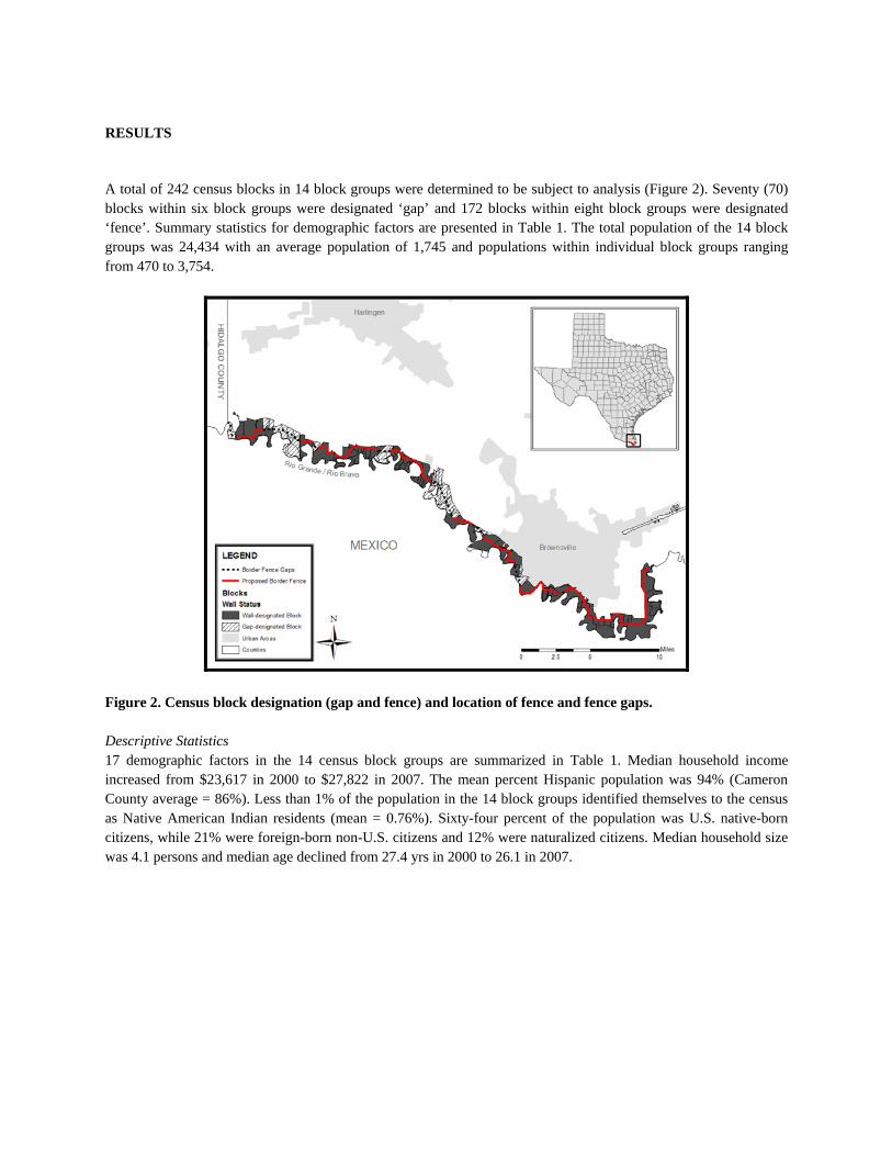
RESULTS
A total of 242 census blocks in 14 block groups were determined to be subject to analysis (Figure 2). Seventy (70) blocks within six block groups were designated ‘gap’ and 172 blocks within eight block groups were designated ‘fence’. Summary statistics for demographic factors are presented in Table 1. The total population of the 14 block groups was 24,434 with an average population of 1,745 and populations within individual block groups ranging from 470 to 3,754.
Figure 2. Census block designation (gap and fence) and location of fence and fence gaps.
Descriptive Statistics 17 demographic factors in the 14 census block groups are summarized in Table 1. Median household income increased from $23,617 in 2000 to $27,822 in 2007. The mean percent Hispanic population was 94% (Cameron County average = 86%). Less than 1% of the population in the 14 block groups identified themselves to the census as Native American Indian residents (mean = 0.76%). Sixty-four percent of the population was U.S. native-born citizens, while 21% were foreign-born non-U.S. citizens and 12% were naturalized citizens. Median household size was 4.1 persons and median age declined from 27.4 yrs in 2000 to 26.1 in 2007.

Table 1. Summary statistics for census block groups. Figures are based on census block groups. n* Median Mean Minimum Maximum SD Population 24,434 1,615.5 1,745.3 470 3754 906.3 Education and Income Median Household Income (2000) $23,617 $24,281 $18,418 $31,094 $4,348 Median Household Income (2007) $27,822 $28,602 $22,022 $36,575 $5,149 Per Capita Income $7,192 $7,814 $5,182 $12,202 $2,076 Percent of 25+ Pop. with High School Diploma 2,187 18.09% 18.14% 9.10% 29.60% 5.12% Race, Ethnicity and Language Percent Hispanic Population 23,261 94.18% 94.33% 82.93% 100.00% 6.15% Percent American Indian 182 0.47% 0.76% 0.31% 1.59% 0.47% Percent Hispanic American Indian in Combination 125 0.40% 0.51% 0.00% 1.52% 0.42% Percent Hispanic Indian Alone or in Combination 144 0.41% 0.62% 0.00% 1.59% 0.49% Percent White in any combination 2,187 18.09% 18.14% 9.10% 29.60% 5.12% Percent 5+ Population that Speaks Spanish 24,419 91.98% 91.67% 81.52% 99.08% 4.95% Diversity Index# 44.9 47.2 24.1 72.1 13.2 Citizenship Percent Foreign-Born and Not a Citizen 5,382 21.44% 22.18% 10.80% 32.61% 5.32% Percent Foreign-Born/Naturalized Citizen 2,837 11.62% 11.53% 5.09% 17.07% 3.44% Percent Native/Born in the U.S. 15,844 64.12% 64.60% 52.95% 84.11% 7.29% Other Factors Average Household Size 4.1 4.1 2.8 5.2 0.6 Median Age (2000) 27.4 27.6 23.1 35.2 3.7 Median Age (2007) 26.100 27.007 22.4 33.4 3.8
*For population and percentage values, n is the base population for that particular variable which is used to calculate proportions. A total of 14 U.S. Census block groups will be affected by the fence, consisting of six designated ‘gap’ and eight designated ‘fence’. Within these 14 block groups, there were 242 blocks affected, consisting of 70 designated ‘gap’ and 172 designated ‘fence’. Data for individual census blocks were derived from census block groups under the assumption that block groups are demographically homogenous. #The ‘Diversity Index’ is a measure developed by ESRI that summarizes racial and ethnic diversity. The index ranges from 0 (no diversity) to 100 (complete diversity). The diversity index for the United States on average in 2000 was 54.6 (ESRI, 2006). Fence vs. gap analysis Of the 17 demographic factors tested, 14 showed a statistically significant (p < 0.05) difference in means between gap and fence-designated areas (Table 2). This level of statistical significance (0.05 or lower) is the standard acceptable level in peer-reviewed academic journal for most statistical examinations. Income factors were higher overall in the gaps areas as compared to fence-designated blocks. In 2000, the mean of the median household incomes between in gap areas was 13.4% higher than in fence areas ($26,512 vs. $23,371, p < 0.01). This disparity in mean of median household incomes between gap and fence designations increased in 2007 to 13.9% ($31,316 vs. $27,483, p < 0.01). Per capita income was also found to be higher in gap areas ($8,453 vs. $8,013, p = 0.095). For race and ethnicity factors, gap-designated areas were on average significantly less Hispanic (90.72% vs. 94.13%, p < 0.01), less Spanish-speaking (87.92% vs. 91.40%, p < 0.01) and less Hispanic Indian (0.34% vs. 0.49%, p < 0.01). Overall, American Indian identification was lower in gap areas (0.57% vs. 0.64%) but the differences were not deemed to be statistically significant given the small sample size (n = 182).

For citizenship demographic factors, it was found that census blocks designated gaps contained a lower percentage of foreign born non-U.S. citizens (18.29% vs. 20.73%, p < 0.01), a lower percentage of foreign born naturalized citizens (8.99% vs. 11.17%, p < 0.01), and a higher percentage of native-born U.S. citizens (71.7% vs. 66.8%, p < 0.01). Other factors in the analysis included households size, which was smaller in gap areas (3.86 persons vs. 3.96 persons, p = 0.144) and older (28.7 yrs. vs. 26.7 yrs, p = 0.000). Median age was higher in gap areas for both 2000 (28.7 vs. 26.7, p < 0.01) and 2007 (29.6 vs. 27.6, p < 0.01).
Table 2. Disparities in mean values, t-values and statistical significance for demographic factors in ‘gap’ and ‘fence’ designated census blocks. Demographic factors† Gap* Fence** t*** p‡
Education and Income Median Household Income (2000) $26,512 $23,371 4.501 0.000 Median Household Income (2007) $31,316 $27,483 4.358 0.000 Per Capita Income $8,453 $8,013 1.676 0.095 Percent of 25+ Population with High School Diploma 21.44% 17.29% 6.039 0.000 Race, Ethnicity and Language Percent Hispanic Population 90.72% 94.13% -4.612 0.000 Percent American Indian 0.57% 0.64% -1.358 0.176 Percent Hispanic American Indian and Other 0.28% 0.39% -2.354 0.019 Percent Hispanic Indian 0.34% 0.49% -2.723 0.007 Percent White and Other 0.73% 0.77% -2.815 0.005 Percent 5+ Population that Speaks Spanish 87.92% 91.40% -5.693 0.000 Diversity Index# 55.3 46.6 4.219 0.000 Citizenship and origin Percent Foreign-Born and Not a U.S. Citizen 18.29% 20.73% -3.512 0.001 Percent Foreign-Born/Naturalized U.S. Citizen 8.99% 11.17% -6.039 0.000 Percent Native/Born in the U.S. 71.69% 66.82% 4.948 0.000 Other Factors Average Household Size 3.86 3.96 -1.465 0.144 Median Age (2000) 28.68 26.74 3.652 0.000 Median Age (2007) 29.60 27.57 3.721 0.000
†All values are for 2000 Census unless otherwise indicated; * there were 70 blocks designated ‘gap’ ** there were 172 blocks designated ‘fence’ *** degrees of freedom = 240 for all tests ‡Bolded figures indicate a statistically significant difference in means to the 0.05 level. #The ‘Diversity Index’ is a measure developed by ESRI that summarizes racial and ethnic diversity. The index ranges from 0 (no diversity) to 100 (complete diversity). The diversity index for the United States on average in 2000 was 54.6 (ESRI, 2006).

DISCUSSION The results presented in this paper indicate that the construction of a border barrier and the necessary taking of property associated with it would have substantial disproportional impacts based on ethnicity, income and citizenship status in Cameron County, Texas. Our comparison of the areas planned to be fenced along the border with those areas where ‘gaps’ in the fence are planned suggests disproportionate impact on individuals with lower income and education, Hispanic ethnicity and non-U.S. citizenship status in Cameron County, Texas. A primary implication of this work is that the impact of the fence and its current placement should be examined more carefully to mitigate the effects on marginalized groups. In this final section we discuss the implications of our findings, opportunities for improvement in the study, and further work. There exists no evidence to date that DHS has made an attempt to mitigate the impact on these marginalized and underrepresented groups. While DHS appears not to have studied the disparities between fence and gap areas, it has acknowledged that the general placement of the fence along the Mexican border ensures that poor Hispanic immigrant families are those who would most likely to be affected by its construction. This concern was included in the EIS prepared for the area discussed here, but has not been further addressed by the U.S. government. We discuss the EIS below both because it highlights the government’s awareness of disparities and because the government’s own data supports some of our independently reached conclusions. In addition to the disparities in demographics that were not addressed sufficiently, there is also little evidence that the DHS did not address additional environmental factors not included in the EIS (see Taylor and Eriksson, 2008), land rights issues (Dulirzky and Nedderman, 20008) and indigenous rights (Hurwitz and Guzman, 2008). Part three of the DHS November 2007 methodology for evaluating potential environmental justice impacts states that DHS shall ‘assess whether there are potential significant adverse effects on minority and low-income populations that would be disproportionately high and adverse’ (DHS, 2007: 3-66). In an attempt to conduct this assessment, factors of interest were aggregated at the county and census tract level by DHS for the Rio Grande Valley sector of the fence. Census tracts are a larger unit of aggregation that census blocks or census block groups, roughly four times the size of the census block groups utilized in this paper for demographic data. For comparison purposes between those affected and not affected by the fence, EIS designates areas as either ‘included in the project area’ or ‘areas not included’. Income disparities were not reported in the EIS below the county level of aggregation, but race/ethnicity factors taken into account by the EIS are displayed in Table 3.

Table 3. Environmental justice factors at the census tract level reported in the Department of Homeland Security Environmental Impact Statement (DHS, 2007).
Percentage of Total Population
Geographic Area by Census Tract
White and not Hispanic or Latino (A)
Asian and not
Hispanic or Latino (B)
Black or African
American and not
Hispanic or Latino (C)
Other Races, Two or More
Races, and not Hispanic or Latino (D)
Hispanic or Latino Ethnicity
(E)
Total Racial and Ethnic Minorities
(B +C+D+E)
Difference in Percent
Minority Population
Above/Below Texas Avg.
Texas 52.4% 2.6% 11.3% 1.7% 32.0% 47.6% ---
Cameron County 14.5% 0.4% 0.3% 0.3% 84.5% 85.5% 37.9%
Census Tracts Included in Project3
7.6% 0.0% 0.0% 0.1% 92.2% 92.3% 44.8%
Census Tracts Not Included in Project3
15.3% 0.5% 0.4% 0.3% 83.5% 84.7 37.1%
It should be noted that there are limitations to our study. The census data utilized presents both temporal and spatial challenges. In temporal terms, census data here was based on the last full census which was undertaken in 2000. There have been shifts in underlying population demographics over the past eight years, but a comparison between 2000 figures and estimates from 2007 points to the fact disparities are relatively consistent and perhaps understated. Between 2000 and 2007 the difference in median household income between gap-designated areas and affected areas (fence) increased from $3,141 to $3,833 (see Table 2). This suggests that disparities between 2000 and 2007 may have increased for other factors as well. From a spatial perspective, there is an issue with the aggregation of census block groups into census blocks. Openshaw defined this issue as the modifiable area unit problem (MAUP) which, in brief, deals with the variation which can occur when data from one scale of areal units is aggregated into more or less areal units, as is the case here (Openshaw, 1984). As the data for the range of relevant demographic factors for this study are not available from the U.S. Census Bureau, we assumed homogenous distribution throughout census block groups and aggregated into census blocks. By dividing the 14 block groups into blocks we obtained 242 individual blocks in the path of the fence which could then be coded ‘gap’ or ‘fence’. This effectively parceled up percentages of each block group into designations that could then be analyzed. Although the level of demographic variation within census block groups is unclear due to lack of data at the block level, the EIS issued by DHS in November 2007 states that:
‘[the selected] census tracts have demographic characteristics similar to those of the persons living at or near the proposed construction activities. In some cases, the population in the census tract closest to the project area would seem to be lower in income than the population in the same census tract farther away from the river’ (DHS, 2007).
Thus, DHS’s own census track analysis reinforces both that the assumption of homogeneity is reasonable and that DHS is aware that lower income individuals are generally most likely to be affected by the fence. 3 The DHS methodology for determining how census tract areas are coded as ‘included in the project area’ and ‘not included’ was not specified in the EIS. It is therefore difficult to judge whether the areas designated by the EIS as ‘Census Tracts Not Included in the Project Area’ are referring to ‘gaps’ in the fence as designated in this paper or if they refer to entire areas outside the fence and gaps in the fence. Based on the fact that all 14 block groups in our analysis contained at least some portion of proposed fence, the EIS is most likely referring to census tracts outside the area of the fence or away from the actual path of the fence in Cameron County

The results presented in this paper suggest several opportunities for future work. First, the study area should be increased to include all Texas sections of the proposed and existing fence along the U.S.-Mexico border and the aggregation level should be reduced to the block level for demographic measures that are available (race and ethnicity only). This would address the concern over aggregation of certain factors from the block group to the census block level. Another point of future analysis might include community-level surveys of how the fence is impacting socio-cultural factors in urban and rural areas affected by the fence. A 2004 study by the General Accounting Office noted that while illegal migrant apprehensions in urban areas such as San Diego and El Paso decreased by a combined 64% since 1993, apprehensions on land managed by the Department of the Interior (DOI) in rural areas increased dramatically (GAO, 2004). A more thorough analysis of environmental impacts of the proposed fence would also be valuable, especially given Secretary Chertoff’s waiver of federal environmental laws over certain portions of the proposed fence (DHS, 2008b). As noted above, there have been several revisions to the route of the proposed fence. It would be informative to analyze how these shifts in the location of the proposed fence have altered not only the environmental impacts but also the populations affected by those impacts. Finally, under circumstances that a barrier actually is constructed along the proposed path, it would be beneficial and necessary to track the impacts on populations and the environment over time. In conclusion, the results presented here, while made under certain necessary assumptions, support the premise that there is a substantial and statistically significant disparity in socio-economic demographic factors between those living in the path of the proposed fence and those living in the gaps. This disparity merits further and immediate examination.

REFERENCES
Blumenthal, R., 2008. In Texas, Weighing Life With a Border Fence The New York Times, New York. del Bosque, M., 2008. Holes in the Wall, The Texas Observer, Austin.
DHS, 2007. Environmental Impact Statement for Construction, Maintenance, and Operation of Tactical Infrastructure: Rio Grande Valley Sector, Texas (Draft), U.S. Department of Homeland Security, Washington, D.C.
DHS, 2008a. Fact Sheet: U.S. Department of Homeland Security Five-Year Anniversary Progress and Priorities, Department of Homeland Security, Washington D.C.
DHS, 2008b. Press release: DHS Exercises Waiver Authority to Expedite Advancements in Border Security. U.S. Federal Government.
ESRI, 2006. ESRI Demographic Update Methodology: 2006/2011. Environmental Systems Research Institute, pp. 18.
Gamboa, S., 2008. Army invites companies to bid on border fence work, Associated Press. May 28.
GAO, 2004. Border security: Agencies need to better coordinate their strategies and operations on federal lands. 04-590, General Accounting Office.
Dulirzky, A. and Nedderman, L., 2008. Violations on the part of the United States government of the right to property and non-discrimination held by residents of the Texas Rio Grande Valley. . In: D. Gilman (Editor), Report from the Working Group on Human Rights and the Border Wall to Inter-American Commission on Human Rights of the Organization of American States. Rapoport Center at the University of Texas School of Law, Austin.
Hurwitz, Z. and Guzman, M., 2008. Violations on the part of the United States government of indigenous rights held
by members of the Lipan Apache, Kickapoo, and Ysleta del Sur Tigua Peoples of the Texas-Mexico border. In: D. Gilman (Editor), Report to the Inter-American Commission on Human Rights of the Organization of American States. The Working Group on Human Rights and the Border Wall; Rapoport Center for Human Rights and Justice; University of Texas School of Law, Austin.
Office of the President, 1994. Executive Order 12898, Federal Actions to Address Environmental Justice in Minority Populations and Low-Income Populations. Federal Register Doc. 94-3685, pp. 859.
Openshaw, S., 1984. The modifiable areal unit problem. Geo Books, Norwich, UK. Taylor, M. and Eriksson, L., 2008. Environmental impacts of border wall construction. In: D. Gilman (Editor),
Report to the Inter-American Commission on Human Rights of the Organization of American States. The Working Group on Human Rights and the Border Wall; Rapoport Center for Human Rights and Justice; University of Texas School of Law, Austin.
Texas State Demographer, 2008. Texas State Data Center and Office of the State Demographer at University of
Texas at San Antonio. U.S. Census Bureau, 2006. Cameron County, Texas Fact Sheet. U.S. Census Bureau. U.S. Congress, 2006. Secure Fence Act of 2006. 109th U.S. Congress, pp. 4. U.S. Congress, 2008. Consolidated Appropriations Act, 2008. 110th U.S. Congress, pp. 614.

USEPA, 1994. Environmental Justice Compliance and Enforcement. U.S. Environmental Protection Agency.
UTB/TSC, 2008. Upated Border Fence Information, University of Texas at Brownsville Website. www.utd.edu.

The Environmental Impacts of the Border Wall Between Texas and Mexico
Lindsay Eriksson1 and Melinda Taylor2
1 University of Texas School of Law. 2 Clinical Professor of Law, University of Texas
1

INTRODUCTION
The United States government asserts that construction of the border wall between Texas and Mexico would affect wildlife and aquatic resources by conferring only “short‐ and long‐term negligible to moderate adverse and minor beneficial impacts.”3 This assertion is inaccurate, according to ecologists and wildlife biologists and information contained in the government’s own preliminary environmental documents. To the contrary, the detrimental effect of the border wall on wildlife and the environment in Texas will be significant. The serious deleterious effects of the border wall have been documented by scientific research, review of historical evidence, and expert opinion. In contrast, the data relied upon to formulate the government’s conclusion of “negligible to moderate adverse and minor beneficial impacts” is almost non‐existent. Furthermore, in its environmental reviews the government failed to adequately consider the proposed border wall’s indirect or cumulative effects, the effects to wildlife and conservation lands, and meaningful alternatives that could minimize environmental damage.
INTERNATIONAL AND DOMESTIC LEGAL FRAMEWORK
In the United States, the National Environmental Policy Act (NEPA) requires that federal agencies conduct analyses of the environmental effects of “major Federal actions” that “significantly affect the quality of the human environment.” 4 NEPA requires that agencies prepare environmental impact statements (EIS) to document the environmental effects and analyze alternatives to the Federal action (including “no action”).5 The EIS must meet certain statutory criteria. In addition to an analysis of alternatives, NEPA requires an EIS to include (1) a description of the environmental impacts of the proposed action, (2) any unavoidable adverse environmental impacts, (3) the relationship between short term uses of the environment and maintenance of long term ecological productivity, (4) an analysis of secondary and cumulative impacts, and (5) a description of any “irreversible and irretrievable commitments of resources” that would be involved in the proposed action, should it be implemented.6
In addition to NEPA, the federal Endangered Species Act (ESA) requires that federal agencies consult with the Secretary of the Interior when a proposed agency action “may affect” a plant or animal that has been listed as “threatened” or “endangered” pursuant to the law.7 The consultation process requires that the agency document the effects of the proposed action on the species and their habitats, ensure that the action will not “jeopardize the continued existence” of the species, and implement measures designed to minimize the impact of the proposed action on the species.8
In April 2008, Secretary of Homeland Security Michael Chertoff exercised his authority under federal immigration law to waive all applicable environmental statutes that may apply to the
3 Draft Environmental Impact Statement for Construction, Maintenance, and Operation of Tactical Infrastructure, Rio Grande Valley Sector. 4 42 U.S.C. § 4332(C). 5 Id. 6 Id. 7 16 U.S.C. § 1536(a)(3). 8 16 U.S.C. § 1536(b).
2

construction of the border wall, including NEPA and the ESA .9 In doing so, he authorized a stark departure from the normal protocol of taking account of environmental issues in situations in which a government project will have clear and far reaching environmental impacts.10 The procedural protections provided by NEPA and the ESA were rendered toothless by the waiver.
In addition to U.S. laws that are intended to protect the environment, both for its own sake and for the benefit of people who rely on wildlife and other natural resources, international law requires that natural resources be protected. For example, the Inter‐American Commission on Human Rights concluded in a report involving the Maya Indigenous Communities of the Toledo District of Belize that environmental damage caused in that case by logging impacted the property rights of the Mayan people.11 In this case, environmental resources, and the people who rely on them, will suffer as a result of the U.S. government’s decision to build the wall without a thorough analysis or mitigation of its environmental impacts.
Insufficiency of Government Analysis
Prior to issuing the waiver of environmental laws, the Department of Homeland Security (DHS) had prepared a draft environmental impact statement (DEIS) and a draft environmental assessment (EA) for certain segments of the wall.12 The DEIS and EA were inadequate. It is likely that, had the waiver not been issued by DHS, environmental and indigenous groups would have challenged the sufficiency of the NEPA environmental review. Essentially, the environmental studies commissioned by DHS appeared to be designed to support a predetermined decision: construct the border fencing regardless of any cost to the natural environment or the people who depend on it.
Several U.S. environmental organizations commented on the draft environmental documents
earlier this year. Following is a description of some of the most serious inadequacies that were identified by the organizations in their comments. First, the DEIS and EA inadequately addressed the wall’s effects on wildlife and ecology, basing conclusions on unacceptably short studies outside normal migratory and breeding seasons.13 Second, no analyses on the impacts of wetlands were included. Third, the EA did not mention potential impacts to threatened and endangered species, despite the fact that affected project areas are home to numerous bird and mammalian species that depend on the impacted areas for water, food, cover, and migration. The project areas covered by the Rio Grande Valley DEIS are home to several endangered or threatened species, yet the DEIS contained only a
9 The waiver authority is found in section 102 of the Illegal Immigration Reform and Immigrant Responsibility Act, 8 U.S.C. § 1103. 10 “DHS Exercises Waiver Authority to Expedite Advancements in Border Security,” Department of Homeland Security Press Release, April 1, 2008, available at http://www.dhs.gov/xnews/releases/pr_1207080713748.shtm. 11 I/A Comm. H.R., Report N° 40/04, Case 12.053, Maya Indigenous Community (Belize), Annual Report of the Inter‐American Commission on Human Rights 2004. 12 An EA was prepared for the El Paso segment and a draft EIS (DEIS) was prepared for another segment in the Rio Grande Valley. 13 The El Paso EA bases its conclusion on two single day surveys which were conducted outside migratory and breeding seasons, while the Rio Grande Valley DEIS’s conclusions are based on a 6‐day biological study also conducted outside the breeding season.
3

cursory analysis of the effects of construction on these species. Finally, the DEIS and EA failed to address the impacts of artificial night lighting on migratory birds or other animals.
One of the most significant flaws in the DEIS is the inadequate discussion of alternatives. As
mentioned above, NEPA requires that an EIS contain a discussion of the “alternatives to the proposed action.”14 This analysis of alternatives is “the heart” of the NEPA process, and is intended to provide a “clear basis for choice among options by the decision maker and the public.”15 An agency’s failure to consider reasonable alternatives is fatal to its NEPA analysis of a proposed action.16 However, before the analysis of alternatives is even reached, an agency must first specify the “purpose and need to which the agency is responding in proposing the alternatives included in the proposed action.”17 A project’s stated goal will dictate the range of “reasonable” alternatives and an agency cannot define its objectives in “unreasonably narrow terms.”18 By logical and legal extension, then, every time an agency prepares an EIS, it must answer three questions in the following order:
1. What is the purpose of the proposed project (the major federal action)? 2. Given that purpose, what are the reasonable alternatives to that project? 3. To what extent should the agency explore each particular reasonable alternative?19
Instead of articulating a purpose that reflects the national goal of improving border security, and then addressing different avenues by which to achieve that goal, DHS instead defined border wall construction itself as the goal: The “purpose of the Proposed Action is to increase border security… through the construction, operation, and maintenance of tactical infrastructure in the form of fences, roads, and supporting technological and tactical assets.”20 By so drastically narrowing the scope of the project’s purpose, DHS restricted the range of alternatives considered to an extent that U.S. courts have not allowed.21
In addition to inadequate treatment of alternatives, DHS failed to consider indirect effects such as immigration diversion and interference with land management practices that would result from the border wall’s construction. Agencies are required to assess foreseeable, indirect effects of their actions: “Reasonable forecasting and speculation is implicit in NEPA, and we must reject any attempt by agencies to skirt their responsibilities under NEPA by labeling any and all discussion of future environmental
14 42 U.S.C. §433. 15 40 C.F.R. 1502.14; Citizens for a Better Henderson v. Hodel, 768 F.2d 1051, 1057 (9th Cir. 1985) (EIS must consider “every” reasonable alternative). 16 See Idaho Conservation League v. Mumma, 956 F.2d 1508, 1519‐20 (9th Cir. 1992) (The existence of a viable, but unexamined alternative renders an environmental impact statement “inadequate.”). 17 40 C.F.R. §1502.13. 18 City of Carmel by the Sea v. DOT, 95 F.3d 892 (9th Cir. 1996). 19 Id. at 903. 20 Draft Environmental Impact Statement for Construction, Maintenance, and Operation of Tactical Infrastructure, Rio Grande Valley Sector, p. 5. 21 See Carmel by the Sea, 123 F.3d at 1155.
4

effects as crystal ball inquiry.”22 DHS has over a decade of experience with the phenomenon of shifting migration, where increased enforcement efforts in one zone predictably lead to increased illegal immigration and subsequent increased enforcement efforts within adjoining areas. These indirect effects, and the environmental impacts that will accompany them, are nonetheless overlooked by DHS in its environmental analyses.
Finally, the EA and DEIS also failed to adequately consider cumulative effects. Cumulative effects are defined in NEPA regulations as “the impact on the environment which results from the incremental impact of the action when added to other past, present, and reasonably foreseeable future actions regardless of what agency (Federal or non Federal) or person undertakes such other actions.”23 Failure to conduct a detailed cumulative effects analysis discredits DHS’ position, as “[g]eneral statements about ‘possible’ effects and ‘some risk’ do not constitute a ‘hard look’ absent a justification regarding why more definitive information could not be provided.”24 The environmental analyses commissioned by DHS produced only ambiguous generalities with no effort to provide specific details of likely cumulative effects.
Direct Wildlife & Ecological Impacts
The direct effects of border wall construction and maintenance will be significant and detrimental to past, present, and future conservation efforts. The fence is slated to traverse important ecological areas, including (but not limited to) the Lower Rio Grande Valley National Wildlife Refuge and The Sabal Palm Audubon Center and Sanctuary. The Nature Conservancy also owns property in the region, which is managed as wildlife sanctuary. This section will examine some of the direct impacts on those regions that will likely result from the construction and maintenance of the border wall.
Movement & Habitat Fragmentation
The Lower Rio Grande Valley in general, including protected areas like the Wildlife Refuge and the Sabal Palm Audubon Center, is home to a vast array of wildlife and plant diversity, including endangered and threatened species. Many of the rare species are found on both sides of the border; their ranges are not restricted to one country or the other. The refuges’ primary wildlife conservation strategy has been to link habitat patches that are isolated due to intense agriculture, urbanization, and other factors, in order to create and maintain a more continuous wildlife corridor for the species that migrate and move among habitat areas. This goal of habitat connection in south Texas has been a guiding management practice since 1979, and the federal government has spent over $80 million in taxpayer money to support piecemeal aggregation of the refuge which today exceeds 90,000 acres.25 Various government and private agencies in Texas and Mexico have entered into agreements or memoranda of understanding (MOUs) over the years to establish international wildlife corridors and
22 Methow Valley Citizens Council v. Regional Forester, 833 F.2d 810, 816‐17, rev’d on other grounds, Robertson v. Methow Valley Citizens Council, 490 U.S. 332 (1989) (internal quotations and citations omitted). 23 40 C.F.R. §1508.7. 24 Neighbors of Cuddy Mountain v. U.S. Forest Service, 137 F.3d 1372, 1379‐80 (9th Cir. 1998). 25 Defenders of Wildlife, RE: Comments on Draft Environmental Impact Statement for Construction, Maintenance, and Operation of Tactical Infrastructure, Rio Grande Valley Sector, Texas, submitted December 31, 2007, at 4.
5

protected areas. These MOUs resulted from many years of collaboration and negotiation on both sides and are imminently threatened by the proposed border wall construction along the Rio Grande River.
Construction of the proposed border wall will degrade and fragment over 500 acres of land, of which over 400 serve as wildlife habitat. Destruction and/or alteration of this habitat will impose additional stress on wildlife in a region that has already been cleared of 95% of its native vegetation. Major wildlife impacts from border wall construction include at least the following: increased road mortality along access and patrol roads, loss of habitat cover and connectivity, altered wildlife behavior and range due to high intensity lightning/construction/operational noise, and the interruption of mating activities necessary to sustain wildlife populations over time.26 These effects are significant and irreversible, and fly in the face of DHS’s conclusion that the construction of a border fence “would not significantly increase impediments” to wildlife movement and migration in its vicinity.27
The wall segments described in the Rio Grande Valley DEIS could imperil the recovery of endangered species in the project area including the ocelot and jaguarondi. The ocelot and jaguarondi are tropical species at the northern limit of their natural habitat range. The barrier that would be created by the border wall would almost certainly expedite the disappearance of these species from the U.S. and could essentially nullify decades of cost‐ and labor‐intensive planning, restoration, and recovery efforts. Habitat connectivity has been shown to be extremely critical in the outer range of a species distribution, where resources are typically smaller, more isolated, and lower in quality.28 Border wall construction and maintenance will further isolate resource patches and prevent critical dispersal events from occurring.
The U.S. Fish and Wildlife Service (FWS) draft ocelot recovery plan, which has not yet been released for public review, confirms the serious implications of border security construction activities such as lighting, fencing, road construction, and human activity, which are among critical threats that will collectively determine the endangered ocelot’s chances at recovering in the U.S. 29 Specifically, habitat loss and travel corridors necessary for ocelot population maintenance will be severely compromised by the border wall. Recovery of the ocelot in the U.S. will be more challenging if the population is genetically and demographically isolated from the much larger Mexican population.30
An extensive body of scientific research supports the major impacts of habitat fragmentation. The movement ability of a given species is a key factor in determining its distribution, abundance, extinction/recovery, and gene flow.31 Restoring populations of threatened and endangered species (such as the ocelot) requires management approaches that enhance – or, at least, maintain – habitat
26 Id. note 3 at 5. 27 Id. at 9. 28 J.H. Brown, D.W. Mehlman, and G.C. Stevens, Spatial Variation in Abundance, Ecology 76:2028‐45, 1995; R.J. Wilson et. al., Large Scale Patterns of Distribution and Persistence at the Range Margins of a Butterfly, Ecology 83:3357‐3368, 2002. 29 U.S. Fish and Wildlife Service, Draft Ocelot (Leopoldus pardalis) Recovery Plan, Southwest Region, Albuquerque, NM. 2007(b)(revision dated 04/07). 30 Id. 31 See i.e. J. Colbert et. al., Dispersal, Oxford University Press, London, 2001.
6

connectivity. Impermeable border walls will certainly block and/or limit cross border dispersal events between resource patches to the detriment of wildlife populations. For example, mule deer depend upon seasonal migration and will be prevented from easily accessing resources by the construction of the border fence. While they may be able to circumvent the wall, to do so will require them to re‐learn how to access these resources and expend greatly more energy to do so. If they are unable to circumvent the wall, population loss will result. The negative effects of impermeable walls on wildlife movement have been documented in other countries: a security fence build along the India‐Pakistan border has altered wildlife movements and resulted in increased human‐wildlife conflict.32
Impacts to Other Threatened and Endangered Species
The construction of the border wall will deleteriously affect other endangered species, in addition to the ocelot and jaguarondi. Five endangered species are known to exist in the El Paso area, including the Northern aplomado falcon, Southwestern willow flycatcher, and Mexican wolf. Moderate and highly suitable habitat for the endangered falcon exists both to the immediate north and south of the project area, and while the species was not detected during surveys for the proposed project, currently unoccupied habitat could easily become occupied as the species recovers and expands its range into suitable habitats adjacent to the project corridor. The Northern aplomado falcon has been sighted a mere 35‐40 miles from the project corridor, which in terms of highly mobile raptors is quite close.33
Additionally, the Mexican gray wolf, the most endangered mammal in North America, is currently the subject of intense reintroduction efforts in Arizona and New Mexico. As this population expands, more reintroduction sites will be utilized. Several sites along the U.S.‐Mexico border show promise, and scientists believe it is essential that protected wolf habitat areas include functional corridors for wolf populations in border regions. Border fencing is contradictory to maintaining these transboundary connections, and will have long term negative effects on Mexican wolves’ ability to move between suitable habitat in the U.S. and Mexico.
Artificial Night Lighting
Part of the proposed border fence infrastructure calls for miles of high intensity artificial lighting, which has been shown to have detrimental effects on migratory birds: light towers have been documented to cause “tower kills” when large concentrations of birds become confused by the lights and fatally collide with the structures or each other.34 However, not much is known about night lighting impacts on other animals such as mammals. Even if animals, as suggested by one ecologist, “choose to move away from” the lights, this avoidance effect itself would be significant to species in the lighted area, especially nocturnal animals.
32 A. Pahalwan, Fenced In, Kashmir’s leopards, bears stalk villages, Reuters, available at http://www.reuters.com/article/scienceNews/idUSDEL17197120061123 (accessed May 2008). 33 Id. at 12. 34 Defenders of Wildlife, RE: Comments on Draft Environmental Assessment for the Proposed Construction, Operation and Maintenance of Tactical Infrastructure, U.S. Border Patrol El Paso Sector, El Paso, Texas, submitted March 19, 2008, at 8.
7

Indirect Effects on Wildlife and Ecology
NEPA defines indirect effects as those effects that “are caused by action and are later in time or farther removed in distance, but are still reasonably foreseeable.”35 Significant indirect effects of border wall construction will include diversion of immigration flow and impairment of land management practices such as prescribed burns and other wildfire strategies.
Shifting Immigration Patterns
Since the early 1990’s, which marked the beginning of the Border Patrol’s implementation of its deterrence strategy, fence construction and associated infrastructure development of roads, lighting systems, remote camps, and other enforcement efforts have had clear indirect “ripple effects” on other areas of the border by shifting—but not decreasing – illegal immigration activities. The shifting effects caused by enforcement efforts, as well as their environmental effects, have been extensively documented: A 2004 study noted that while illegal migrant apprehensions in urban areas such as San Diego and El Paso decreased by a combined 64% since 1993, apprehensions on land managed by the Department of the Interior (DOI) increased dramatically.36 Between 1997 and 2000, the number of undocumented migrants apprehended on DOI lands exploded from 512 to over 113,000, while the National Park Service estimates that 200,000 undocumented migrants entered Arizona’s Organ Pipe National Monument alone in 2001.37
Construction of the border wall in proposed areas will undoubtedly result in this same pattern of diverting illegal immigration through more isolated pathways, potentially affecting the wildlife and ecology in those areas in ways they would not have been affected otherwise. In its draft ocelot recovery plan (supra), FWS anticipates the effects of shifting migrants into more remote and sensitive areas as an important factor affecting the recovery of this endangered species: “One result of increased [enforcement efforts] on traditionally used points of entry by undocumented immigrants is to push potential immigration into the most inaccessible zones where impacts on the ocelot and other species may be high.”38
Interference with Land Management Practices
The proposed construction of border fencing will alter normal habitat and wetland management on refuge lands. If the border wall is constructed as proposed, as many as 40,000 acres of federally maintained land could end up inaccessible to U.S. land managers. Federal land managers will be prevented or hindered from performing tasks necessary to control invasive plants and respond to the 300+ wildfires per year on refuge land. Prescribed burns, an important tool in wildfire management, will be severely obstructed if fire crews are bound on one side by the Rio Grande River and the other by an impenetrable wall. The Sabal Palm Audubon Center could end up entirely on the other side of the
35 40 C.F.R. §1508.8(b). 36 GAO Report 04‐590, Border Security: Agencies Need to Better Coordinate Their Strategies and Operations on Federal Lands (2004). 37 Id. 38 Id. note 3.
8

fence, raising a host of practical and serious questions related to insurance, access to local government services, and entitlement to U.S. federal funds.
Incompatibility with Bi‐national Conservation Efforts
The Mexican government has stated its opposition to the border wall on many grounds, including the fact that it will have negative impacts on the ecosystems along the border that both countries are trying to manage and protect. In a communiqué issued by the Mexican government in June 2007, for example, the government stated, “Mexico has emphasized the negative impact that [the wall] will have on ecosystems on the border, particularly in relation to migratory species.”39
In May 2007, the Mexican Secretariat of Environment and Natural Resources convened a scientific workshop that included 55 experts and academics from the U.S. and Mexico to discuss the environmental impact of construction of the border wall. The papers were collected in the publication A Barrier to Our Shared Environment. The Border Fence between the United States and Mexico. 40 The papers in the book documented the threat that the border fence represents for the viability of species and ecosystems. Some of the papers also addressed the fact that construction of the border wall represents a regression in bilateral diplomacy and runs counter to efforts to conduct productive binational dialogues between the governments of the United States and Mexico to avoid foreseeable damages to the border ecosystems.41
Environmental Damage Impact on Humans
The damage to wildlife, wildlife habitats, and border ecosystems that will likely result from construction and maintenance of the border wall will impact people, too. The indigenous people who live along the border depend on the natural environment for their sustenance and survival, as well as for ritual purposes. The impacts on these peoples are described in a separate paper.42 Other residents of the region enjoy access to the national wildlife refuge and other sanctuaries in order to observe wildlife and the natural environment. The species that historically populated the border region, many of which are rare and in decline today, are part of the natural heritage of Americans and Mexicans. The citizens of both countries will be poorer if this natural heritage is lost.
CONCLUSION
The construction of the border wall will have significant impacts on humans, wildlife, and the environment. U.S. law – the National Environmental Policy Act and the Endangered Species Act, specifically – mandates that federal agencies document the impacts of proposed federal actions on the
39 The communiqué is found on the website of the Ministry of Foreign Relations at http://www.sre.gob.mx/csocial/contenido/comunicados/2007/jun/cp_167.html. 40 Available at: http://www.ine.gob.mx/publicaciones/consultaPublicacion.html?id_pub=519. 41 Id. 42 See Michelle Guzman & Zachary Hurwitz, Violations on the Part of the United States Government of Indigenous Rights Held by Members of the Lipan Apache, Kickapoo, and Ysleta del Sur Tigua Tribes of the Texas‐Mexico Border, at 15‐17.
9

human environment and minimize impacts to threatened and endangered species. In this case, DHS Secretary Michael Chertoff has waived U.S. federal and state environmental laws applicable to the border wall. As a result, there will be no meaningful government review of the impacts of the wall on the environment and the people who live in the border region. The result will be the loss of rare species and our bi‐national natural heritage.
10

Violations on the Part of the United States Government of Indigenous Rights Held by Members of the Lipan Apache, Kickapoo, and Ysleta del Sur Tigua Tribes of the
Texas-Mexico Border
The Working Group on Human Rights and the Border Wall University of Texas at Austin
By Michelle Guzman and Zachary Hurwitz
June 2008 (revised October 18, 2008)

2
The Secure Border Fence Act of 2006 and the Consolidated Appropriations Act of 2008 mandate the construction of 700 miles of reinforced fencing on the Southwest border of the United States. As of March 2008, U.S. Customs and Border Protection (CBP) reported that it had completed close to 170 miles of pedestrian fencing. CBP reports that it is “well on its way to constructing” 370 miles of pedestrian fencing by the end of 2008.
Introduction
1 Much, if not all, of the fencing scheduled to be completed in 2008 is planned along the Texas-Mexico border. More than 100 miles of fencing is slated to be constructed on the Texas-Mexico border by December 31st, 2008, with about 50 miles being planned for the Rio Grande Valley.2
The border fence is scheduled to roughly follow, in most places, the southernmost levee built during the 1930s and under jurisdiction of the International Border and Water Commission (IBWC), the bi-national commission that presides over the Rio Grande River as an international boundary.
3 The levee crosses, and the border fence is scheduled to cross, through or near four areas of indigenous peoples in the border region: the Lipan Apache in the southern Rio Grande Valley; the Kickapoo Traditional Tribe of Texas southeast of Rosita South and outside of Eagle Pass, Texas; the Jumano community in Redford, southeast of Presidio, Texas; and the Tigua people southeast of El Paso, Texas. In 2008, the Secretary of the US Department of Homeland Security, Michael Chertoff, signed a Multistate Waiver of federal environmental and related legislation. However, once the Multistate Waiver was signed, the Army Corps of Engineers did not undertake a new EIA reflecting how bypassing this legislation would impact plans for the construction of the border fence. Instead, they replaced the EIA of 2006 with “Environmental Stewardship Plans” (ESPs) for each fence section, in order “to continue to protect valuable natural and cultural resources” and to “develop appropriate best management practices (BMPs) to avoid or minimize adverse impacts.4
1 Department of Homeland Security, “Fact Sheet: US Department of Homeland Security Five-Year Anniversary Progress and Priorities,” March 6, 2008.
” The scheduled locations of the border fence in relation to indigenous people and their lands are assumed to remain largely unchanged, since DHS has retained its December 31st, 2008 date for construction of fencing in Texas and the waivers issued to allow expedited construction apply to many of the previously identified areas.
http://www.dhs.gov/xnes/releases/pr_1204819171793.shtm 2 Calculation made by the authors from DHS pronouncements, including: www.dhs.gov/xlibrary/assets/press_border_waivers_08-2177_All_Segments_Project_Area-Final_v2_040108.pdf 3 Ibid. It is worth noting that the fence will, in most places, not be built on top of the levee or between the levee and the river and so will leave additional land, including both the levy and any land between the fence and the levy, outside of the reach of property owners, essentially on the Mexico side of the border. 4 The 2008 Environmental Stewardship Plans are available at the Army Corps of Engineers border fence website: http://www.borderfenceplanning.com/
3
Through planning for and construction of the fence, the United States government is affecting traditional indigenous lands in the path of or near scheduled fencing. Private properties, which the U.S. government seeks to take for the purpose of surveying and construction, are owned by citizens with deep historical claims to their land. Dr. Eloisa Tamez, a life-long resident of El Calaboz, Texas in the Rio Grande Valley is one such property owner. Dr. Tamez is Lipan Apache and the owner of a small piece of property that has been in her family since the mid-1700s. The land originally came into her family as a result of a land grant from the Spanish crown, and the family’s ownership has since been confirmed by successive governments and treaties dictating land ownership along what is now the Texas/Mexico border. The proposed wall will bisect her land, leaving the majority of her property on the south side of the barrier inaccessible.5
The United States government is violating the indigenous peoples’ right to recognition of juridical personality and civil rights protected in Article XVII of the American Declaration of the Rights and Duties of Man (the American Declaration) by failing to recognize the legal personality of the indigenous people of the Texas-Mexico border.
Other private property owners, some of whom also have indigenous heritage, are being affected in similar ways.
Similarly, the federal government’s planned fence construction will affect
traditional lands of the Kickapoo Tribe and the Tigua people and will cut these indigenous communities off from important ceremonial and religious sites and the Rio Grande River. The unique trans-border nature of the indigenous peoples on the Texas-Mexico border, whose traditional lands are located in both Texas and Mexico, will be greatly and negatively impacted by a border wall.
In the process of planning and constructing the border fence along the Texas/Mexico border, the United States government is violating the rights of indigenous peoples by damaging their relationships to land and natural resources, as well as religious and cultural sites, along the border. Additionally, the Department of Homeland Security (DHS), CBP, and the Army Corps of Engineers are conducting the border fence planning and construction process in ways that violate the rights of self-determination and non-discrimination of these indigenous communities as understood by international human rights law.
This briefing paper examines these violations. The central points of this paper are:
The United States government is violating the right to property as supported by Article XXIII of the American Declaration by taking indigenous-owned lands and not establishing free, prior, and informed consent with indigenous communities of
5 The Working Group has interviewed and consulted with Dr. Eloisa Tamez and her daughter Margo Tamez on this briefing paper.

4
the Texas-Mexico border prior to surveying lands and planning, designing and constructing the fence, as supported by ILO Convention 169.
Indigenous communities of the Texas-Mexico border have the right to legal protections and remedies as supported by Article XVIII of the American Declaration. These rights are also not being respected.
The United States government is violating the right of indigenous people to enforce treaties and agreements with the government that the communities entered into in the past, as supported by Article 37(1) of the UN Declaration on the Rights of Indigenous Peoples.
The United States government will impede access and cause irreparable harm to natural resources deemed significant to the survival, development, religion and continuation of the ways of life of indigenous people of the Texas-Mexico border, as supported by Article XXIII of the American Declaration.
The American Declaration constitutes a source of international legal obligation for all member states of the Organization of American States, including the U.S.
International Human Rights Law as it Applies to the Border Fence’s Impact on Indigenous Rights
The rights of indigenous people are widely supported in U.S. domestic and international law. These norms may be applied to the violations of indigenous peoples’ rights by the U.S. government in respect to the exploration and construction of the border fence on the Texas-Mexico border.
6 According to the jurisprudence of the inter-American human rights system, the provisions of its governing instruments, including the American Declaration, should be interpreted and applied in light of developments in the field of international human rights law since those instruments were first composed and with due regard to other relevant rules of international law applicable to member states against which complaints of human rights violations are properly lodged. In particular, the organs of the inter-American system have previously held that developments in the corpus of international human rights law relevant to interpreting and applying the American Declaration may be drawn from the provisions of other prevailing international and regional human rights instruments. These other instruments include the American Convention on Human Rights, which may generally be considered to represent an authoritative expression of the fundamental principles set forth in the American Declaration.7
6 See I/A Court H.R., Advisory Opinion OC-10/89 Interpretation of the American Declaration of the Rights and Duties of Man Within the Framework of Article 64 of the American Convention on Human Rights, July 14, 1989, Ser. A Nº 10 (1989), paras. 35-45; I/A Comm. H.R., James Terry Roach and Jay Pinkerton v. United States, Case 9647, Res. 3/87, 22 September 1987, Annual Report 1986-87, paras. 46-49 7 See,I/A Comm. H.R. Report Nº 52/01, Case 12.243, Juan Raul Garza (United States), Annual Report of the IACHR 2000, paras. 88, 89 (confirming that while the Commission clearly does not apply the American Convention in relation to member states that have yet to ratify that treaty, the Convention’s provisions may well be relevant in informing an interpretation of the principles of the Declaration).
Pertinent developments have also been

5
drawn from the provisions of other multilateral treaties adopted inside and outside of the framework of the inter-American system, including for example the Geneva Conventions of 1949, the Vienna Convention on Consular Relations and, of particular pertinence to the present case, International Labour Organisation Convention Nº 169 concerning Indigenous and Tribal Peoples in Independent Countries and other instruments concerning the rights of indigenous peoples.8
By not recognizing the legal status of indigenous people along the Texas-Mexico border as such, especially as regards the Lipan Apache of the Coastal Bend Region and South Rio Grande Valley, the U.S. government is violating indigenous peoples’ right to recognition of juridical personality and the right to enjoy civil rights as supported by Article XVII of the American Declaration: “Every person has the right to be recognized everywhere as a person having rights and obligations, and to enjoy the basic civil rights.” In the case of
This paper thus references the provisions of the American Declaration as well as other international human rights norms in analyzing the actions of the United States in developing and constructing the Texas-Mexico border wall.
In several cases and reports, the Inter-American Commission on Human Rights (the Commission) and the Inter-American Court of Human Rights (the Court) have held that members of indigenous and tribal communities require special measures that guarantee the full exercise of their rights, particularly with regards to their enjoyment of the land, in order to safeguard their physical and cultural survival.
Saramaka People v. Suriname, the Court held that the acknowledgement of the clan’s communal juridical personality is one of the “special measures” owed to indigenous and tribal groups in order to ensure they can use their land according to their own traditions.9
By not obtaining the Free, Prior, and Informed Consent (FPIC) of indigenous peoples on the Texas-Mexico border before commencing the exploration and construction of the border fence, the U.S. government is further violating indigenous peoples’ right to property and judicial protection. The government is also violating the provisions of International Labor Organization Convention No. 169 which provides: “States must consult people living on the land before doing exploration or exploitation of the land.”
10 In the case of Maya Indigenous Communities of the Toledo District v. Belize, the Commission established that the state must obtain fully informed consent from the indigenous community before beginning a project and the community must know the consequences and processes of the project.11
8 See, e.g., Report Nº 75/02, Case 11.140, Mary and Carrie Dann (United States), Annual Report of the IACHR 2002, para. 127. 9 I/A Court H.R., Case 12.338, Saramaka People v. Suriname, Judgment of November 27, 2007.
10 http://www.unhchr.ch/html/menu3/b/62.htm 11 I/A Comm. H.R., Case 12.053, Maya Indigenous Communities of the Toledo District v. Belize, 2004 Annual Report of the Inter-American Commission on Human Rights.

6
By planning to construct sections of the border fence on private property owned by indigenous community members and by impacting lands on which indigenous peoples depend for natural, cultural, and spiritual resources, the U.S. government is violating indigenous peoples’ right to property as provided by Article XXIII of the American Declaration: “Every person has a right to own such private property as meets the essential needs of decent living and helps to maintain the dignity of the individual and of the home.” In the cases of Sawhoyamaxa Indigenous Community v. Paraguay and Mayagna (Sumo) Awas Tingni Community v. Nicaragua, the Court held that close ties between a clan and its land must be secured as property rights.12
Indigenous peoples have the right to own, use, develop and control the lands, territories and resources that they possess by reason of traditional ownership or other traditional occupation or use, as well as those which they have otherwise acquired.
The right to property is also supported in Article 26 of the United Nations Declaration of the Rights of Indigenous Peoples:
13
In the case of
The U.S. government’s actions also violate indigenous peoples’ right to judicial
protection, as supported by Article XVIII of the American Declaration, which provides:
Every person may resort to the courts to ensure respect for his legal rights. There should likewise be available to him a simple, brief procedure whereby the courts will protect him from acts of authority that, to his prejudice, violate any fundamental constitutional rights.
Indigenous Community Yakye Axa v. Paraguay, the Court held that states must grant effective protection to indigenous people that takes into account their economic and social characteristics, as well as their situation of special vulnerability, their customary law, values and customs, and states must establish an effective means for guaranteeing clans their right to communal property with due process guarantees.14
12 I/A Court H.R., Sawhoyamaxa Indigenous Community v. Paraguay, Judgment of March 29, 2006; and I/A Court H.R. The Mayagna (Sumo) Awas Tingni Community v. Nicaragua, Judgment of August 31, 2001.
By constructing the wall on private and traditional lands of indigenous peoples on the Texas-Mexico border and by cutting off access to the Rio Grande River and other important sites as well as creating barriers to free crossing of the border, the U.S. government is violating the right of indigenous communities to enforce previous treaties and agreements that they have entered into in the past, as supported by Article 37 of the United Nations Declaration of the Rights of Indigenous Peoples:
13 http://www.iwgia.org/graphics/Synkron-Library/Documents/InternationalProcesses/DraftDeclaration/07-09-13ResolutiontextDeclaration.pdf 14 I/A Court H.R., Indigenous Community Yakye Axa v. Paraguay, Judgment of June 17, 2005.

7
Indigenous peoples have the right to the recognition, observance and enforcement of treaties, agreements and other constructive arrangements concluded with States or their successors and to have States honour and respect such treaties, agreements and other constructive arrangements.15 These treaties and agreements that have not been respected include, for example:
The Colonial del Nuevo Santander Treaty (signed on March 15, 1791 with the Spanish Colonial Government); The Alcaldes de las Villas de la Provincia Treaty (signed on August 17, 1822 with the Spanish Colonial Government); The Live Oak Point Treaty (signed on January 8, 1838 with the Republic of Texas Government); and The Treaty of Guadalupe Hidalgo (signed on February 2, 1848 between the United States and Mexico). These various treaties guarantee protection of the civil and human rights, including rights to respect for traditional lands, of indigenous communities in Texas. They bind the United States, until abrogated, either as signatory or as successor to the governments originally signing the treaties. An additional agreement is codified at 25 United States Code § 1300b-13(d), which outlines the “Border Crossing, Living and Working Rights of the Kickapoo Traditional Tribe of Texas” providing:
Notwithstanding the Immigration and Nationality Act, all members of the Band [the Kickapoo] shall be entitled to freely pass and repass the borders of the United States and to live and work in the United States.
The United States government is violating the right to recognition of juridical personality and civil rights in failing to recognize the legal personality of indigenous peoples of the Texas-Mexico border and respect their rights to property and legal protection.
The border fence is scheduled to cross through the community of Ranchería El Calaboz, which has residents who are descendants of Lipan Apache. The Lipan Apache of South Texas are descended from the original Ndé buffalo hunters who call themselves the Cúelcahén Ndé or “People of the Tall Grass”
Lipan Apache of South Texas
16 or Ndé, which means “the people”17 and the Spanish colonizers later referred to Ndé as Apache who migrated from the southern plains before European contact.18
15
Mounted Ndé buffalo hunters settled in West Texas and were called Apache by Spaniard settlers. The Lipan Apaches of the Coastal
http://www.iwgia.org/graphics/Synkron-Library/Documents/InternationalProcesses/DraftDeclaration/07-09-13ResolutiontextDeclaration.pdf 16 Maestas, Enrique Gilbert-Michael, Ph.D., Co-Edited Romero, Daniel C. Jr., M.S.W., (2004), “Anthropological Report on the Cuelcahén Ndé Lipan Apaches of Texas,” Edinburg, Texas. 17 Ibid.; see also Sandra L. Myres, The Lipan Apaches in Indian Tribes of Texas at 129-145 (1971). 18 Ibid.; Campbell, Thomas Nolan, (1997), “Ethnohistoric Notes on Indian Groups Associated with Three Spanish Missions at Guerrero, Coahuila,” University of Texas at San Antonio, Center for Archeological Research, Archaeology and History of the San Juan Bautista Area, Coahuila and Texas, Report No. 3.
8
Bend Region, which included most of south Rio Grande Valley, settled in the area after many battles with Spaniards and Spaniard-indigenous alliances. After battling Indian raids by Spanish and United States militaries, as well as Texas Rangers, the Lipan Apache often took defensive refuge on rancherías created by Spanish land grants.19 Over the years, significant mixing between the Lipan Apache and Spanish colonizers took place.20 Such miscegenation with Spaniard colonizers is evident in the genealogy of the Cuelga de Castro line, a chief of the Lipan Apache. Further historical accounts, genealogies, and testimonies have recorded the adoption of Hispanic names and language by Lipan Apache.21 Thus, currently many families may properly claim both Hispanic and Lipan Apache heritage.22
19 Maestas, Enrique Gilbert-Michael (2003) “Culture and History of Native Peoples of South Texas,” Dissertation, University of Texas at Austin; Armando C. Alonzo, Tejano Legacy: Rancheros and Settlers in South Texas, 1734-1900 at 51 (describing skirmishes between Lipan Apaches and Spanish settlers). 20 Maestas, Enrique Gilbert-Michael (2003) “Culture and History of Native Peoples of South Texas,” Dissertation, University of Texas at Austin; Armando C. Alonzo, Tejano Legacy: Rancheros and Settlers in South Texas, 1734-1900 at 54-55. 21 Ibid. 22 See generally Martha Menchaca, Recovering History, Constructing Race: The Indian, Black, and White Roots of Mexican Americans (2001).
The Native American Cultural Affiliation Overview, written for the U.S. Army Corps of Engineers Galveston District by Karen Gardener in 2001, describes the ethno-history and legal status of the Lipan Apache in United States federal law. However, in its assessments made in connection with the construction of a border fence, the U.S. Army Corps does not recognize the living members of the Lipan Apache band of South Texas, due to their shared heritage with Mexican-American communities living in the Rio Grande Valley.
This briefing paper argues that members of the mixed Lipan Apache and
Mexican-American communities of the Rio Grande Valley area practice cultural relationships to the land and natural resources that are sufficiently similar to Lipan Apache traditions and practices and to indigenous practices in general as underlined in international law such that they can uphold a claim that construction of a border fence through their lands, resulting in government taking of their property and loss of access to traditional lands, violates international human rights. This paper also argues that the Army Corps environmental assessment for the border fence performed previous to the waiver of applicable laws by DHS Secretary Michael Chertoff on April 1st, 2008 makes the Lipan Apache identity of property owners in the Lower Rio Grande Valley and Coastal Bend region invisible. By not recognizing the Lipan Apache identity of property owners in the Rio Grande Valley in the areas slated for border fence construction, the U.S. government violates the right to recognition of juridical personality and civil rights and the right to property as supported by Articles XVII and XXIII of the American Declaration.

9
The Native American Cultural Affiliation Overview of the U.S. Army Corps of Engineers acknowledges the identity of the Lipan Apache and describes them as a federally unrecognized indigenous group that has associated itself with the Mescalero Apache to advance land claims:
The land claims were brought before the Indian Claims Commission by the Apache Tribe of the Mescalero Reservation on behalf of the Lipan Apache Tribe and the Mescalero Apache Tribe against the United States of America (Docket No. 22-0, for the taking of ancestral lands belonging to them. This claim was settled in a Findings of Fact on Compromise Settlement heard before the Indian Claims Commission, with a decision rendered on February 19, 1976. This claim was resolved in favor of the Indians, based on the conclusion that the United States removed the title of the Lipan Apache to their aboriginal lands in Texas on 1 November 1856 and from the Mescalero Apache on 27 May 1873, without payment of any form of compensation.
The Lipan Apache applied for federal recognition in 1999 and their juridical personality has not yet been recognized by the U.S. government. While Lipan Apache land claims have remained legally associated with the Mescalero Apache in the eyes of the U.S. government, individual property owners outside of Mescalero Apache lands also claim Lipan Apache heritage, exercising their right to self-determination as recognized by Articles XVII and XXIII of the American Declaration and Article 3 of the Declaration of the Rights of Indigenous Peoples of the United Nations.23
Anthropologist Enrique Maestas, himself Lipan Apache and an expert scholar on the history of South Texas indigenous people’s ethno history, links current border families with Spanish surnames that self-identify as Lipan Apache to the pedestrian buffalo hunters known as Cúelcahén Ndé. He argues that the historical lands of the Cúelcahén Ndé people were constituted by the region between the Pecos River and Rio Grande River and most of the Costal Bend Region, but was porous to interaction and mixing with Spanish colonizers, and the result was the transformation of the social spaces of the Cúelcahén Ndé into rancherías, settlements, and buffalo hunting territory.
24
One such ranchería is the Ranchería El Calaboz, owned by Dr. Eloisa Tamez. The legal title of Ranchería El Calaboz dates to the original San Pedro de Carricitos Land Grant from Spain that benefited the Tamez family.
25
23 Article 3 of the UN Declaration of the Rights of Indigenous Peoples states: “Indigenous peoples have the right to self-determination. By virtue of that right they freely determine their political status and freely pursue their economic, social and cultural development.” 24 Maestas, Enrique Gilbert-Michael, (2003) “Culture and History of Native Peoples of South Texas,” Dissertation, University of Texas at Austin.
Dr. Tamez’s daughter, Dr. Margo
25 Texas General Land Office, Guide to Spanish and Mexican Land Grants in South Texas #336 (1998) (identifying the land grant of San Pedro de Carricitos); Florence Johnson Scott, Historical Heritage of the

10
Tamez, has identified her family as Lipan Apache. In a presentation about their lands, Margo gave a statement regarding her family’s Lipan Apache heritage:
I am born on my mother’s side for the £ebaiyé t’nde’ hi’ke nnee’ gową goshjaa ha’áná’ idiłí (Lipan and Chiricahua People of the “Jail Village”/El Calaboz), and on my maternal grandmother’s side for the Euskara and T’nde’(Basque-Lipan People), and on my fathers’ side I am from the Suma’ nde’ hi’ke nnee’ gową goshjaa ni’gosdzáń łichíí (Jumano and Chiricahua Red Earth Mud People).26
The Kickapoo Traditional Tribe of Texas descends from the original Kickapoo (Kiikaapoa) of the Great Lakes region.
The Federal Land Trust to the Kickapoo Traditional Tribe of Texas of Nacimiento, Mexico, and Eagle Pass, Texas
The border fence is scheduled to separate traditional lands pertaining to the Kickapoo Traditional Tribe of Texas on the Mexico and Texas sides of the Rio Grande River. The fence will also cross through and disturb or destroy traditional sites of the Kickapoo along the Rio Grande River and will impede access to the Rio Grande River and free crossing across the border by the Kickapoo.
The Kickapoo Tribe of Texas is the proprietor of a Federal Indian Land Trust
located between the Rio Grande River and the town of Rosita South, near Eagle Pass, Texas. The land trust was regularized into law in the year 1983.
27 The Kickapoo were forced to migrate and relocate south of the Great Lakes through subsequent conflicts with French colonials and then American Indian Removal Policy during the 18th century. Rebellions led by Pontiac and Tecumseh were unsuccessful in abating white settlers and served to split the Kickapoo into Kansas Kickapoo, Oklahoma Kickapoo, and the Texas-Mexico border region Kickapoo.28
Lower Rio Grande at 107 (1937) (setting forth the history of the San Pedro de Carricitos land grant from the Spanish crown to Pedro Villareal); Armando C. Alonzo, Tejano Legacy: Rancheros and Settlers in South Texas, 1734-1900, at 28-39, 61-65 (1998) (describing the Spanish land grant process in the lower Rio Grande River Valley and land tenure patterns during the period of transition of control from Spain to Mexico). 26 “Lipan Apache Women’s Defense,” http://lipanapachecommunitydefense.blogspot.com/ 27 Carolyn Mitchell Burnet, The First Texans, at 124 (1995). 28 Texas State Historical Association, Handbook of Texas Online, available at http://www.tshaonline.org/handbook/online/articles/KK/bmk9.html
Violence against Kickapoo in Texas led some of this last band to flee to Mexico and to Indian Country (Oklahoma). President Sam Houston of the Republic of Texas attempted to settle Kickapoo on the Texas-Mexico border through a peace agreement with no results, and the Kickapoo united with Mexican guerillas to fight American colonizers in Texas. The Texas Republic administration of Mirabeau Lamar then embarked on a vigorous Indian removal campaign. The Mexican government,
11
however, awarded the Kickapoo land grants southwest from the border in El Nacimiento, Coahuila, for their service in battling the U.S. and Texan militaries.29
Subsequent migrations and relocations moved the Kickapoo back and forth between El Nacimiento and Indian Territory in Oklahoma.
30 Over time, the Kickapoo of El Nacimiento gathered in camps near the Texas border. The Kickapoo did not legally hold title to land in Texas until 1985, but because they have traditionally camped near the international bridge between Piedras Negras, Coahuila, and Eagle Pass, Texas, they have “long been identified with this state.”31 The US government, in 1983, granted the Texas Band of Oklahoma Kickapoo a federal land grant southeast of Eagle Pass, Texas. The band then claimed official tribal status separate from the Kickapoo Tribe of Oklahoma, as the Kickapoo Traditional Tribe of Texas, as stated in their tribal constitution.32
29 Ibid 30 Ibid.; Carolyn Mitchell Burnet, The First Texans, at 124-131 (1995). 31 Texas State Historical Association, Handbook of Texas Online. 32 Constitution of the Kickapoo Tradicional Tribe of Texas, http://thorpe.ou.edu/constitution/kickapoo/index.html
As a result of their continual migration and relocation, the Kickapoo have
sustained a semi-nomadic lifestyle between Texas and Mexico. According to the Texas State Historical Association Handbook of Texas, “the group, which numbers between 625 and 650, spends the major portion of the year in El Nacimiento— about 130 miles southwest of Eagle Pass, Texas— but still lives a semi-nomadic life that has been adapted to modern economic conditions. In middle to late May most of the residents of Nacimiento divide into family-based bands and set out across Texas and other western states to work as migrant agricultural laborers. By late October or early November the bands make their way back to Nacimiento, where they pass the winter hunting, planting crops, raising cattle, and participating in religious ceremonies.”
Because the tribe’s traditional lands lie along both sides of the Rio Grande River
near Eagle Pass, the construction of the border wall will irrevocably divide their territory. The tribe’s migratory and cross-border nature is recognized by 25 United States Code § 1300b-13(d) which gives the tribe the right to pass and repass the Texas-Mexico border at will. Currently, the CBP impermissibly asks the Kickapoo to cross at the official Port of Entry in Eagle Pass showing their tribal ID cards, but the tribal members generally ignore this requirement and cross freely as they have traditionally done. If the border fence crosses through this area, it would impede the Kickapoo from passing and repassing freely as is their right.
By failing to acknowledge and give proper consideration to the juridical tribal personality of both the Lipan Apache and the Kickapoo Traditional Tribe of Texas, and through its insistence in taking land for the exploration and the construction of the border wall, the United States government is violating articles XVIII and XXIII of the American Declaration, as well as 25 United States Code § 1300b-13(d).

12
The border wall is also projected to be built on traditional lands of the sovereign Tigua Tribe, impacting their nearby reservation. The Tigua (Ysleta del Sur)
Tigua (Ysleta del Sur) of El Paso County
33 Pueblo Indians of El Paso County originally lived south of modern Albuquerque, New Mexico along the Rio Grande River before coming to Texas.34 The Tigua ancestral home, Gran Quivera, was started about 800 A.D. north of El Paso in the Manzano Mountains, southeast of modern Albuquerque.35 With an increase of Spanish missions and settlements throughout the 1600s, disease and slavery killed many of the Tigua of Gran Quivera. By 1675, after years of drought and after the Pueblo Revolt in New Mexico, the Tigua population continued to dwindle, and as a result they resettled and began farming along the Rio Grande River near modern El Paso. Gran Quivera was left abandoned, yet the ruins remain and are currently protected by the National Park Service.36
In the late 17th century, the Ysleta del Sur Pueblo, 12 miles east of modern El Paso, was founded by the Tigua Pueblo Indians who had moved from New Mexico. The collective possession of the Pueblo was confirmed by the Spanish crown in a land grant which the Spanish and Mexican authorities acknowledged in documents dated 1751, 1825, 1839, and 1841. Under Mexican rule (1821-1848), the Tigua were recognized as an Indian group with an Indian settlement, and they continued to have rights to their traditional lands. The grant to the Tigua, comprised of 36 square miles, was not respected after 1848 when Mexico ceded New Mexico and West Texas to the United States, despite assurance by the United States that the land rights of former Mexican citizens (Spanish/Mexican grants) now found in territory of the United States would be honored. The Ysleta del Sur Pueblo was deprived of almost all of their land grants as a result of a series of incorporation acts passed by the Texas Legislature. By these acts the land grants were partitioned into individual tracts and conveyed to new applicants. According to a recent federal study, the Texas Legislature illegally incorporated the town of Ysleta in 1871. The unlawful incorporation included not only the immediate area of the former Ysleta Pueblo, but the entire Ysleta Grant.
37 Thereafter, many tribal members were forced to leave and relocate to small plots north of the pueblo.38
In 1987, the Tigua Tribe was finally fully recognized by the federal government of the United States.
39
33 The tribal community of The Ysleta del Sur Pueblo is known as the “Tigua” tribe. 34 Randy Lee Eickhoff, Exiled: The Tigua Indians of Ysleta del Sur at 19 (1996). 35 Ibid., 57-58.
The Ysleta del Sur Pueblo still exists today with a tribal
36 Moore, R Edward. "The Tigua Indians of Texas." Texas Indians. Living History Studies. 19 Apr. 2008, http://texasindians.com, Path: tigua. 37 Scharrer, Garry. "Report confirms Indians' land claim." San Antonio Express-News, 19 Jan. 2008, http://www.mysanantonio.com/news/metro/stories/MYSA012008.01A.Indianland.29b80ea.html; see also Randy Lee Eickhoff, Exiled: The Tigua Indians of Ysleta del Sur (1996). 38 Ysleta del Sur Pueblo. 2 June 2008, http://ydsp.stantonstreetgroup.com/index.sstg. 39 Randy Lee Eickhoff, Exiled: The Tigua Indians of Ysleta del Sur at 204-05; see also Pub.L.No. 90-287 (April 12, 1968).

13
enrollment of over sixteen-hundred people. In April 2008, the Tribal Census Department reported the tribal member make-up as follows: 47% male, 54% females, 24% under the age of 17, 7% between 18 and 21 years old, 56% between the ages of 22 and 55, and 14% age 55 or older.40
The combined reservation lands of the Tribe include two housing communities and several tracts of land.
41 According to the tribal council, for almost 40 years the tribe has owned and operated a diverse set of tribal enterprises and corporations that provide employment for its members and the El Paso community. The common goal of the tribal businesses is to advance the tribe toward self-determination and self-governance.42 The Tribal Council (the Council) of the Ysleta del Sur Pueblo is the traditional governing body of the Ysleta del Sur Pueblo exercising all inherent governmental power, fiscal authority and tribal sovereignty as recognized in the August 18, 1987 Ysleta del Sur Pueblo Restoration Act.43
A recent federal study conducted by Charles R. Cutter and Hana Samek Norton, two historians hired by the U.S. Department of Interior with expertise in Spanish colonial relations with American Indian peoples, confirmed the important historical relationship between the Tigua and the land and river in the El Paso area. As a result of this study, the U.S. government signed an agreement with the tribe in January 2007 stipulating its responsibility to help the Tigua develop the tribe's potential land and water rights claims "and to take actions consistent with those rights."
44 Yet, construction of the border fence sections planned for the El Paso area will sever Tigua traditional lands along the Rio Grande River and will impede access to traditional sites along an extensive stretch of the river that have been used by the community for 300 years.45
40 Ysleta del Sur Pueblo. 2 June 2008, http://ydsp.stantonstreetgroup.com/index.sstg. 41 See Figure 2. 42 Ysleta del Sur Pueblo. 2 June 2008, http://ydsp.stantonstreetgroup.com/index.sstg. 43 101 Stat. 666 Public Law No. 100-89; Houser, Nicholas P. Ysleta del Sur. 13 June 2006. 15 May 2008, http://ydsp.stantonstreetgroup.com/index.sstg. 44 Scharrer, Garry. "Report confirms Indians' land claim." San Antonio Express-News, 19 Jan. 2008, http://www.mysanantonio.com/news/metro/stories/MYSA012008.01A.Indianland.29b80ea.html. 45 See County of El Paso, et al. v. Chertoff, et al., Complaint for Declaratory and Injunctive Relief, No. EPO8CA0196, filed in the United States District court of the Western District of Texas, El Paso Division (June 2, 2008), par. 29.
By failing to give proper consideration to the juridical tribal personality of the
Tigua (Ysleta del Sur) in planning and constructing the border wall in areas where the Tigua have traditionally held land and by cutting off access for the Tigua to the Rio Grande River and to traditional sites, the United States government is violating Articles XVIII and XXIII of the American Declaration.

14
Exploration and construction of the border wall further violates the rights of the indigenous peoples of the Texas-Mexico border with regards to the Native American Graves Protection and Repatriation Act (NAGPRA). In an effort to expedite the construction of the border wall, and without further explanations as to why the waivers were necessary,
The United States government is violating the right of indigenous people to enforce past treaties and agreements. The indigenous people affected by the planned border wall have certain rights protected by treaties and agreements that the United States must respect. These treaties and agreements include, for example: The Colonial del Nuevo Santander Treaty (signed on March 15, 1791 with the Spanish Colonial Government); The Alcaldes de las Villas de la Provincia Treaty (signed on August 17, 1822 with the Spanish Colonial Government); The Live Oak Point Treaty (signed on January 8, 1838 with the Republic of Texas Government); and The Treaty of Guadalupe Hidalgo (signed on February 2, 1848 between the United States and Mexico). These various treaties guarantee protection of the civil and human rights of indigenous communities in Texas, including the right to respect for traditional lands and property ownership. By taking property from indigenous landholders and by interfering with access to traditional lands, through construction of the border wall, the United States fails to respect its pre-existing obligations secured through treaties and other agreements. Exploration and construction of the border wall also violates the right of the Texas Traditional Tribe of Kickapoo to enforce their unique right to pass and repass the international border utilizing only their tribal ID card, as stated in 25 United States Code § 1300b-13(d). Upon receiving legal recognition of juridical personality by the United States government in 1983, the Kickapoo were guaranteed the right to pass and repass due to their unique status as a transboundary indigenous people whose community members live in both Mexican and U.S. territory. Construction of the border fence violates this right by limiting the movement of tribal members on the U.S. side and movement of tribal members back and forth between Mexico and the U.S..
46 Secretary of Homeland Security Michael Chertoff announced April 1, 2008 that NAGPRA (along with dozens of other federal laws) would be waived. NAGPRA, a federal law passed in 1990, creates a legal process for federal agencies and institutions that receive federal funding to return American Indian human remains and cultural items to their respective tribes or lineal descendants.47 The waivers apply to approximately 470 miles of land in a stretch of area from California through Texas,48
46 The Tigua, the City of El Paso, the County of El Paso and several environmental groups have filed suit challenging the REAL ID Act, which grants Chertoff his waiver power. The groups contend that the REAL ID Act's waiver provision unconstitutionally allows the DHS secretary unilaterally to repeal laws. 47 Capriccioso, Rob. "NAGPRA waived to build U.S.-Mexico fence." Indian Country Today. 11 Apr. 2008, http://www.indiancountry.com/. 48According to Indian Country Today, Sherry Hutt, the national NAGPRA program manager, was not previously informed about the waiver.

15
which include Texas-Mexico border indigenous peoples’ historical grave sites and other culturally significant lands, such as ceremonial sites. In an interview with the Working Group, the Ysleta del Sur lieutenant governor, Carlos Hisa, explained that historical Tigua grave sites will likely be impacted by the border wall.49 Eric Anico of the Kickapoo Tribe similarly notes that the border wall will affect burial grounds and other ceremonial sites.50 The blanket waiver by DHS violates the government’s obligation to respect its prior commitments, leaving certain indigenous peoples along the Texas-Mexico border, including the Tigua, without the ability to secure the human and cultural remains of their tribes and lineal descendants.
The U.S. government is violating indigenous peoples’ right to enforce treaties and agreements, which are binding on the United States. The right to enforce such treaties and agreements is supported by Article 37 of the United Nations Declaration of the Rights of Indigenous Peoples. The United States is therefore in violation of its obligations under international law. The United States government is taking actions that will cause irreparable harm and limit access to natural resources deemed significant to the survival, development, and continuation of the ways of life of indigenous people of Texas.
The Working Group interviewed Dr. Eloisa Tamez about the historical and current uses of her land.
Historical and Current Land Use of the Lipan Apache
51
practices . . .with Texas Indians are hunting and gathering for food and medicines in south Texas, preparation of corn tortillas and tamales, planting corn, beans, squash, and chiles, oral and incarnate traditions reproducing an Indigenous identity based on the land and water. This
Dr. Tamez stated that her family has maintained cultural uses of their land as Lipan Apache since the 1700s, when her ancestors were granted a Spanish land title. Dr. Tamez stated that her grandfather used to plant seasonal crops on the south side of her property past the levee; he would go all the way to the river to get water for irrigation. She stated that her grandmother would harvest golondrina plant from the south side of the property to treat the eyes of Dr. Tamez’s grandfather when the sulfur powder he utilized to control pests irritated his vision.
Enrique Maestas corroborates historical and current uses of land and natural
resources typical of Mexican American communities in South Texas as inheritances of Lipan Apache customs and traditions. He writes:
Concrete cultural practices that affiliate Mexican American cultural
49 Phone interview with Carlos Hisa conducted by Michelle Guzman in April 2008. 50 See written testimony of Eric Anico, member of the Kickapoo Traditional Tribe of Texas (Oct. 13, 2008). 51 Working Group interview with Dr. Eloisa Tamez on her property, May 2, 2008.

16
identity is reaffirmed in Native American ceremonial observance in south Texas. These Native American traditions are incorporated into ceremony through practices such as Native American oratory ritual, which guarantees each person the opportunity to speak and express themselves. Purification lodges, Native American dance societies, and the religious use of peyote are practices culturally affiliated with prehistoric, colonial, and modern Texas Indians. Often, and especially for newcomers, a testimony of their Native ancestry is part of this oratory. Women often prepare Native American food, such as corn, deer, and wild fruits using Native American technologies used by Texas Indians in missions. Therefore, cultural traditions reproduced in Mexican American families provide a Native American identity and Native American cultural foundations and supports for Native American ceremonial observance.52
Dr. Tamez has a close connection to her land and to the Rio Grande River that it borders— a connection which developed from family and community traditions, including indigenous uses. She has stated that the river is “spiritual” for her.
53 She has also stated that she maintains spiritual uses of her land including on the south side of her property past the levee, the access to which would be severed by the border fence.54
Our people are so closely tied to the environment that the wall has a huge impact. Our lifestyle is to look out and see the river and the wildlife and to enjoy them as a religious experience, but now we will look out and see the wall. Our religion is taking care of Mother Earth. The wall infringes on our religious beliefs and way of life in other ways, too. It will devastate the peyote fields that we still use for religious purposes; they are some of the few remaining fields.
Among these uses of her land, she currently has let the south side of the property go wild and is not planting crops, in order to give habitat for the ocelots and chachalacas (wild chicken) that are commonly seen on the south side of her property. She stated that jaguarandi also cross over the river from Mexico to mate. Her traditions in this regard are reflected in broader community traditions; Dr. Tamez explained to us that the city of Harlingen every year celebrates the ocelot with an ocelot fest.
General Council Chairman of the Lipan Apache Band, Daniel Castro Romero, Jr., has similarly referenced the importance of ongoing traditional uses of Lipan Apache and border lands and the connections between the indigenous community and the environment, which will be impacted by the border wall, saying:
55
52 Maestas p. 518; see also Sandra L. Myres, The Lipan Apaches in Indian Tribes of Texas at 131. 53 Comments by Dr. Eloisa Tamez, made at Abriendo Brecha conference at University of Texas at Austin, February 21, 2008. 54 Working Group interview with Dr. Eloisa Tamez on her property, May 2, 2008. 55 Phone interview conducted by Denise Gilman with Daniel Castro Romero Jr., June 9, 2008.

17
The Kickapoo are one of the more traditional tribes of the border region and possibly in all of the United States.
Historical and Current Land Use of the Texas Traditional Tribe of Kickapoo
56 They largely maintain land use practices from the past. Such practices include construction of wickiups, the traditional housing made of mats of cattails and fronds. The Kickapoo raise the same crops in Mexico and Texas as they have always raised, including squash, beans, potatoes, pumpkin, corn, sweet potatoes, and wheat and oats, and still hunt game including deer, bear, and squirrel, the meat of which is preserved as jerky.57 They regularly practice traditions at the banks of the Rio Grande River, such as gathering material for ceremonial use, offering prayers and tobacco, and visiting burial sites near the river, practices which are repeated several times a year.58
The Kickapoo have historical ties to land on both sides of the Rio Grande River. In Mexico, their traditional lands are in Nacimiento, Mexico. The Kickapoo Traditional Tribe of Texas consider land both north and south of the international border as their traditional hunting and ceremonial grounds.
The Tigua Indians of Ysleta del Sur Pueblo historically raised wheat, corn, grapes, cattle and horses. They traded these products, as well as hand made pottery, baskets, and rope throughout the region - north to New Mexico and south to Chihuahua, Mexico. They hunted throughout the Hueco Mountains, east to the Guadalupe Mountains, and south to Sierra Blancas. In the spring, Tigua hunters ventured east across the Pecos River into the plains to hunt buffalo. Tigua families also traveled with horses and ox carts 80-miles east the Guadalupe Salt Beds where they gathered salt for its sacred properties, to trade and to preserve and enrich their food.
Historical and Current Land Use of the Tigua (Ysleta del Sur) of El Paso County
59 The Tigua continue to farm the same land along the Rio Grande River and engage in other traditional uses of their land and the Rio Grande River.60
Additionally, the land of the Tigua and its natural resources continue to play a significant role in traditional ceremonial events. The Ysleta del Sur lieutenant governor, Carlos Hisa, explained to the Working Group that while the proposed border wall sections will not directly cut through Tigua reservation lands, the sections will directly impact land with extreme historical and religious significance for the Tigua.
61
56 Carolyn Mitchell Burnet, The First Texans, at 131.
Although
57 http://www.texasindians.com/kickapoo.htm 58 See written testimony of Eric Anico, member of the Kickapoo Traditional Tribe of Texas (Oct. 13, 2008). 59 "Newcomers: Tigua." Texas Beyond History. Jan. 2008. The University of Texas, http://www.texasbeyondhistory.net/trans-p/peoples/newcomers.html. 60 See, e.g., Randy Lee Eickhoff, Exiled: The Tigua Indians of Ysleta del Sur at 110. 61 Phone interview conducted by Michelle Guzman with Carlos Hisa in April 2008

18
Hisa would not disclose the exact location of these lands, nor their use, as to maintain what little privacy the tribe has left concerning these issues, he did acknowledge that the tribe is attempting to communicate with DHS in an effort to protect these significant areas. Furthermore, Tigua tribal members’ access to sections of the Rio Grande River will be cut off by the border fence. This separation from the river will interfere with or completely halt important religious and social traditions of the tribe. The river is where the tribe celebrates the beginning of a new calendar year each year, where it inducts elected tribal officials, and where it has conducted naming ceremonies for centuries. These ceremonies are significant to the survival, development, and continuation of the ways of life of the Tiguas.62
Construction of the border wall by the United States government will not only result in direct impacts on indigenous lands and the separation of families from other portions of their lands, it will cause significant harm to the wildlife, waterways and other natural resources so important to the lifestyle and religious observance of the indigenous communities living in Texas. A separate briefing paper more fully explores the significant environmental impacts of the border wall.
Elected representatives have recognized the unique and highly meaningful customs, uses and traditions of the Tigua. U.S. Representative Silvestre Reyes, D-Texas, signed onto a legal brief filed with the U.S. Supreme Court challenging the waivers of environmental and American Indian religious protection laws. Representative Reyes also met with Tigua tribal Governor Frank Paiz and has continued to urge DHS to respect the Tiguas' ceremonial customs. However, to date, DHS has not agreed to withdraw from its plan to build a fence that will negatively impact traditional Tigua lands and the tribe’s use of those lands.
63 Exploration and construction of the border fence violates indigenous peoples’ rights to access and use of natural resources they deem important for their survival, religion and ways of life, as supported by Article XXIII of the American Declaration, and Article 26(2) of the UN Declaration on the Rights of Indigenous Peoples.
DHS did not consult with indigenous people before beginning its survey project in preparation for construction of the border wall, and in some cases, residents were not even informed that a fence would be built on or near their lands. DHS has not “effectively” consulted with the affected communities about the planning and construction of a border fence. This failure to consult violates the interpretations of the Inter-American Court in accordance with ILO Convention 169, which understand that consent must be freely given, prior to the undertaking of a project, and according to
The United States government did not establish free, prior, and informed consent (FPIC) with indigenous communities prior to exploration activities.
62 Ibid.; see also Randy Lee Eickhoff, Exiled: The Tigua Indians of Ysleta del Sur at 123-150. 63 Lindsay Eriksson & Melinda Taylor, The Environmental Impacts of the Border Wall Between Texas and Mexico.

19
tribal customs and procedures. Informed consent means accepting and disseminating information, and constant communication between parties in good faith and in culturally appropriate ways. The failure to consult properly also violates Section 564 of the Omnibus Appropriations Bill for 2008, which required DHS to consult with affected property owners, Indian tribes, and local governments regarding construction of the border wall in order to minimize the impact on the environment, culture, commerce, and quality of life in areas considered for the border fence. The legislation also required DHS to perform an analysis on the “possible unintended effects on communities.”
The Working Group gathered testimonies from Ranchería El Calaboz and
Granjeno, two traditional Lipan Apache areas impacted by the exploration and planned construction of the border wall. In these testimonies, the violation of FPIC by the U.S. government is evident.64
A similar lack of consultation took place in relation to the Tigua Tribe. As stated in the El Paso Times, El Paso County Commissioner Veronica Escobar noted that federal officials have not done enough communicating with border residents in the El Paso area, and are moving forward with a costly plan that will not stop the flow of undocumented workers or drug and human traffickers into the United States. "We want to be consulted,"
For example, Dr. Eloisa Tamez has stated that Army Corps are surveying the south side of her property, but she does not know what they are doing. She asserts that the government does not have her consent to place a fence on her private property and has not offered her any choices regarding the fence. Hidalia and Guadalupe Benavides describe how the government communicated with them about their property through written documents in English, although they do not read well in any language, particularly English. They have attempted to ask questions of the government regarding the manner in which they would be able to reach the side of their property that would fall on the south side of the wall and have not received any clear response. A government official urged them to sign a document offering to purchase their property saying, “If you don’t sign, the government’s going to build the wall anyway,” and telling her that she did not want to “scare” her, “but if you don’t sign, you will be sued; what will you do then?” Gloria Garza described how government officials have repeatedly pressured her to sign paperwork giving the government rights to her property, stating that all they needed was “just a signature.” At one point, a government official asked for his papers back when it became clear the Garza family was not going to sign. Despite Gloria Garza’s refusal to provide permission, surveying has occurred on the levee on the Garza family property.
64 Interviews conducted by the Working Group with Dr. Eloisa Tamez, Hidalia and Guadalupe Benavides and Gloria Garza, May 2-3, 2008; see also Leah Nedderman, Ariel Dulitzky & Denise Gilman, Violations on the Part of the United States Government of the Right to Property and Non-Discrimination Held by Residents of the Texas Rio Grande Valley, at 19-20 (describing a lack of meaningful consultation at the government forums set up for this purpose and other failings in the government’s notification of affected parties).

20
she said. "We want to have a voice, and we want meaningful solutions."65 Also, in a 4-1 vote, the El Paso County Commissioners Court announced Tuesday, May 28 that it was planning to join two lawsuits challenging the border fence construction. County Attorney José Rodríguez said, “[W]hat the lawsuits seeks is to require the federal government to follow procedures and due process, and to observe the constitutional rights individuals and the community have in these matters.66
The lack of consultation with the Kickapoo Tribe is similarly evident. The U.S. government’s formal assessment of the impact of the border wall mentions the Kickapoo only once, in relation to municipal water systems.
67 The failure to include information about the impacts of the border wall on the Kickapoo is notable and evidences a lack of concern and consultation with the Kickapoo, given the proximity of the border wall to the Kickapoo reservation, the transnational characteristics of the tribe and the tribe’s traditional connection to the Rio Grande River.
The right to recognition of juridical personality and civil rights protected in Article XVII of the American Declaration;
Conclusion Exploration, planning and construction activities conducted by DHS, the U.S. Border Patrol, and the U.S. Army Corps of Engineers to further the U.S. government’s plan to construct wall segments along the U.S.-Mexico border have violated the rights of indigenous peoples in Texas. Such rights are recognized in international and domestic law as inviolable and therefore must be protected for the members of the Lipan Apache, Kickapoo, and Tigua (Ysleta del Sur) tribes located on the Texas-Mexico border. These rights include:
The right to property as supported by Article XXIII of the American Declaration and to be properly consulted prior to surveying lands and planning, designing and constructing the fence, as supported by ILO Convention 169;
The right to legal protections and remedies as supported by Article XVIII of the American Declaration;
The right of indigenous people to enforce treaties and agreements with the government that the communities entered into in the past, as supported by Article 37(1) of the UN Declaration on the Rights of Indigenous Peoples;
And the right to natural resources deemed significant to the survival, development, and continuation of the ways of life of indigenous people of the Texas-Mexico border, as supported by Article XXIII of the American Declaration.
65 Grissom, Brandi. "Planned border wall blocks Tiguas from sacred grounds." El Paso Times 14 May 2008: 1A. 66 Johnson, Erica Molina. "Violation of Constitution is alleged; County joins suits opposing barrier." El Paso Times 28 May 2008: 1A. 67 DHS Environmental Stewardship Plan, Del Rio Sector (July 2008).

21
According to the evidence gathered, the Working Group on Human Rights and the
Border Wall concludes that the Inter-American Commission on Human Rights should initiate an investigation into the violation of the above-mentioned rights on behalf of the United States government towards the members of the Lipan Apache, Kickapoo, and Tigua (Ysleta del Sur) peoples. Although possible violations of the rights of members of the Jumano Apache tribe have not been included in this briefing paper, the Working Group also recommends that the Inter-American Commission on Human Rights consider the situation of the community of Jumano Apache in and near Redford, Texas, outside of Presidio. Similar violations of indigenous rights are reported to be occurring in this community.

22
Figure 1. Border Wall Location Splitting Private Property of Indigenous Landowners in Ranchería El Calaboz, TX

23
Figure 2. Border Wall Location in Reference to Ysleta Mission and Land Trust