Embed Size (px)
Citation preview
OBSTACLES IN THE REUSE OF CLOSED MILITARY BASES IN THE U.S.
by
KASEY RYAN BOWLES
(Under the Direction of Stephen Ramos)
ABSTRACT
The purpose of this thesis is to address the land planning issues that bases face
once closure has been designated by evaluating the major hindrances that delay the time
it takes to complete the reuse process. The bases chosen for case studies were Athens
Naval Supply Corps School, Fort McPherson, Charleston Naval Complex and El Toro
Marine Corp Air Station. Each base was chosen for the purposes of providing a variety of
locations to examine how their regional contexts play a part in their respective reuse
processes as well as for the specific difficulties each faced that could be generalized
across the wider spectrum of BRAC closures. By discovering the commonly faced
obstacles across a variety of closed military bases this thesis intends to extrapolate a set
of generalized strategies to mitigate the impact obstacles can have on the length of the
reuse process.
INDEX WORDS: BRAC, Closed military bases, Obstacles, Reuse, Master plan,
Athens Naval Supply Corps School, Fort McPherson, Charleston Naval Complex, El Toro Marine Corps Air Station

OBSTACLES IN THE REUSE OF CLOSED MILITARY BASES IN THE U.S.
by
KASEY RYAN BOWLES
BS, University of Southern California, 2010
A Thesis Submitted to the Graduate Faculty of The University of Georgia in Partial
Fulfillment of the Requirements for the Degree
MASTER OF ENVIRONMENTAL PLANNING & DESIGN
ATHENS, GEORGIA
2012

© 2012
Kasey Ryan Bowles
All Rights Reserved

OBSTACLES IN THE REUSE OF CLOSED MILITARY BASES IN THE U.S.
by
KASEY RYAN BOWLES
Major Professor: Stephen Ramos
Committee: Umit Yilmaz Jack Crowley Darlene Hawksley Electronic Version Approved: Maureen Grasso Dean of the Graduate School The University of Georgia August 2012

iv
DEDICATION
“Whatever you do, work at it with all your heart, as working for the Lord, not for men”
Colossians 3:23 (NIV)
To my savior, Jesus Christ, for giving me the breath and life to have the
opportunity to glorify him as best as a sinner can on this earth. To the love of my life,
Joshua, without whom I would have given up on this thesis a long time ago. Thank you
for you constant support, words of encouragement and unconditional love; I am forever
grateful.

v
ACKNOWLEDGEMENTS
I would like to thank my major professor, Stephen Ramos, for keeping me on
track and never giving up on me no matter how many deadlines I failed to meet. Thank
you to my committee members, Umit Yilmaz, Jack Crowley and Darlene Hawksley, for
your dedication to my success and your inspiration as passionate individuals.
Thank you to all of the students, faculty and staff for making my education at
UGA the best possible, particularly Donna Gabriel, Michael Sims and Tina Shields- each
of you always had a smile on your face and heartfelt words of wisdom.
Heather Ryan-Lisbey, I owe you so much. Without you, I would have never
finished this thing. Thank you for always being there to study and procrastinate with, you
kept me from going insane. Done and done!

vi
TABLE OF CONTENTS
Page
ACKNOWLEDGEMENTS ................................................................................................ v
LIST OF TABLES ........................................................................................................... viii
LIST OF FIGURES ........................................................................................................... ix
CHAPTER
1 INTRODUCTION ............................................................................................ 1
2 HISTORY OF BRAC ....................................................................................... 4
A Historical Need for BRAC ...................................................................... 5
1988 BRAC Process ................................................................................... 7
1990-1995 BRAC Process .......................................................................... 9
2005 BRAC Process ................................................................................. 12
Conclusion ................................................................................................ 13
3 PROCESS ....................................................................................................... 14
Post-BRAC Closure Process ..................................................................... 14
Base-Wide Reuse Planning ....................................................................... 15
Disposal Decision Making ........................................................................ 18
Parcel-by-Parcel Implementation .............................................................. 19
Conveyances ............................................................................................. 19
Economic Issues ........................................................................................ 23
Environmental Issues ................................................................................ 26
Political Issues .......................................................................................... 27

vii
Conclusion ................................................................................................ 30
4 ATHENS NAVAL SUPPLY CORPS SCHOOL ........................................... 31
5 FORT MCPHERSON ..................................................................................... 43
6 CHARLESTON NAVAL COMPLEX ........................................................... 54
7 EL TORO MARINE CORPS AIR STATION ............................................... 64
8 ANALYSIS ..................................................................................................... 76
Fort McPherson ......................................................................................... 76
Charleston Naval Complex ....................................................................... 77
El Toro Marine Corps Air Station ............................................................ 78
Comparative Analysis ............................................................................... 79
9 CONCLUSION ............................................................................................... 86
REFERENCES ................................................................................................................. 89

viii
LIST OF TABLES
Page
Table 1: Building Analysis of Phase I Development ........................................................ 39
Table 2: Comparison of Presented Case Studies .............................................................. 84

ix
LIST OF FIGURES
Page
Figure 1: Timeline of Base Realignment & Closure Recommendations .......................... 22
Figure 2: Map of Athens Naval Supply Corps School Location ...................................... 32
Figure 3: Athens Naval Supply Corps School Vision Plan .............................................. 35
Figure 4: Athens Naval Supply Corps School Phase I Development Plan ....................... 38
Figure 5: Map of Fort McPherson Location ..................................................................... 44
Figure 6: Fort McPherson Master Plan ............................................................................. 48
Figure 7: Historic Officer’s Quarters at Fort McPherson ................................................. 50
Figure 8: Map of Charleston Naval Complex Location .................................................... 55
Figure 9: Portion of CNC Property Owned by The Noisette Company ........................... 60
Figure 10: The Noisette Company’s Master Plan ............................................................. 62
Figure 11: Map of El Toro Marine Corps Air Station Location ....................................... 66
Figure 12: Orange County Great Park Master Plan .......................................................... 72
Figure 13: Orange County Great Park Phase 1 of Western Sector ................................... 73
Figure 14: View of Balloon Ride at Orange County Great Park ...................................... 74

1
CHAPTER 1
INTRODUCTION
Hundreds of thousands of acres around the U.S. are sitting unused and vacant.
Some of these acres are lush forested plots, the last of their kind in their respective
locations, some are vacant parcels in prime real estate locations with potential while
others are just remnants of what was once there- old, dilapidated structures, or overgrown
airstrips. These parcels of land spread across the country are still attempting to become
reused after being closed by the U.S. Department of Defense (DOD) during a Base
Realignment and Closure Commission (BRAC) round. Hundreds of military bases have
been closed since the first BRAC was initiated in 1988, and still thousands of acres of old
bases remain untouched (Sorenson 2007). The land conversion and reuse process of
closed military bases varies from place to place and the successes and failures of each
project are as vast as the acres that they consume.
The purpose of this thesis is to address the land planning issues that bases face
once closure has occurred by discovering the major obstacles, or issues, that delay the
time it takes to complete the reuse process. Case studies have been used in order to better
understand the hindrances closed bases face. The bases chosen for case studies were
Athens Naval Supply Corps School located in Athens, Georgia, Fort McPherson located
in the metro-Atlanta, Georgia area, Charleston Naval Complex located in North
Charleston, South Carolina and El Toro Marine Corp Air Station located in Irvine,
California. Each base was chosen for the purposes of providing a variety of locations (i.e.

2
urban, coastal, suburban) to examine how their regional contexts play a part in their
respective reuse processes as well as for the specific difficulties each faced that could be
generalized across the wider spectrum of BRAC closures. These case studies also span
across different branches of the military in order to better investigate whether hindrances
faced are isolated within certain branches or site uses.
By presenting the commonly faced obstacles across a variety of closed military
bases this thesis intends to extrapolate a set of generalized strategies to mitigate the
impact different issues can have on the length of the reuse process. The goal is to
discover the issues closed bases face during the reuse process and provide a list of
suggestions for those involved in the process. Ultimately, by better understanding what
each military base faces upon designation of closure all parties involved can better
streamline the reuse process in order to lessen the time a base sits unused and decrease
the likelihood of bases that are designated for closure remaining vacant and underutilized.
Before researching the chosen case studies a general understanding of the Base
Realignment and Closure process is needed to understand how these bases come to a
closure designation and the history of the evolving process, which is what the following
chapter, Chapter Two, accomplishes. Chapter Three gives insight into what literature says
about the current process of military base closures and their conversion and begins to
discover some of the general issues closed bases face and the response of the stakeholders
involved. It also dives into the current research of existing closed bases that have been
reused or are waiting to be converted and provides a brief introduction of the case studies
that will be looked at in the following four chapters. Chapters Four through Six are
designed to analyze existing cases of military base land conversions in order to discover

3
the successes and shortcomings of each case. These cases will be looked at in-depth to
better discover the intricate details that significantly affect land reuse and vary from base
to base. After briefly looking at the history of BRAC, finding out what the current
literature says about existing military land conversion processes and studying four
different bases undergoing varying degrees of conversion, Chapter Seven will begin to
cross-examine the presented case studies in a comparative analysis and withdrawal best
management practices. Finally, Chapter Eight will sum up findings and formulate
suggestions for future BRAC closures to ease the land conversion process as well as
provide an overall conclusion for the thesis.

4
CHAPTER 2
HISTORY OF BRAC
The process and development of the Base Realignment and Closure Act (BRAC)
within the U.S. is a complex matter that can be studied and analyzed in-depth. Thus in
order to better understand the specific issue of land conversion and reuse of closed
military bases it is imperative to have a general and basic understanding of how BRAC
works. There are numerous literature sources that study the finite details of the BRAC
process and previous rounds for those interested in the development of how BRAC is
initiated and carried out. For the purposes of this thesis, a basic historical review of how
BRAC rounds brought our land uses to where they are today will be used.
According to a Department of Defense (DOD) study published in September of
2001, approximately 72% of the total 504,000 acres of unneeded land available for reuse
has been transferred from DOD property to a variety of federal and nonfederal bodies
while the remaining 28% was still in the DOD’s possession (GAO, 2005). Further
analysis of BRAC property was performed and found that of the unneeded property, 52%
was transferred to nonfederal bodies, 20% was transferred to federal agencies, 18% had
been leased but remained in DOD possession and 10% remained not transferred and
unused (GAO, 2005). This simple breakdown demonstrates the general categories
identified by the DOD that a closed base can end up in, but the successes of the use of the
base land once the transfer has occurred is still determined on an individual case by case

5
basis. To understand exactly how a base finds itself identified for closure during a BRAC
round, a general history of how BRAC came to be and all that it entails is vital.
A Historical Need for BRAC
The procedure for closing military bases in the U.S. has been an evolving process
since wartime lulls pronounced the excess of military installations. The history of base
closure is full of political currents and evolving policies aimed at lessening the impact of
closures on both the federal/state and local levels. In order to better mitigate the negative
impacts that can be associated with base closure and to streamline the realignment and
closure procedure, the U.S. Department of Defense (DOD) began the Base Realignment
and Closure Commission (BRAC) process in 1988 (Sorenson 2007).
Before BRAC was initiated base closure within the U.S. post-WWII was simple
abandonment. A service would deem its use of a base unnecessary and vacate the
premises, often leaving behind salvageable airstrips and useable structures to decay. By
the time the Vietnam War began the U.S. was searching for ways to cut back federal
spending. Secretary of Defense, Robert S. McNamara, began closing both domestic and
overseas military bases in order to increase cost savings (Sorenson 2007). Not
surprisingly, Congress and local stakeholders did not view McNamara’s actions
favorably- military bases were major sources of economic stability for local communities,
and provided sources of federal monies and employment. Throughout McNamara’s term,
he successfully closed over sixty bases on his own accord without the intervention of
Congress (Sorenson 2007). Though Congress attempted to pass legislation to restrict
some of the executive power being utilized to close bases, they failed to do so until 1976
(Sorenson 2007). Congress was able to add a stipulation to the Military Construction Bill

6
in 1976 that necessitated the notification of Congress by the DOD about any closing of a
military base with over 250 civilian employees (Sorenson 2007). This Bill also required
the DOD to conduct in-depth studies into the economic, environmental and military
impacts of base closure before commissioning a base to be closed (Sorenson 2007). This
measure, later named the O’Neill-Cohen Bill, also brought the National Environmental
Protection Act into the mix by stating that all closures must abide by NEPA (Sorenson
2007). All of these stipulations attempted to decrease the amount of power one branch
held and thus take politics out of the equation, which it succeeded in doing, but it
ultimately made all base closures extremely difficult to achieve. The O’Neill-Cohen Bill
was unanimously passed by Congress and signed into law by President Carter in 1977
(Sorenson 2007).
The O’Neill-Cohen Bill essentially marked the beginning of a ten-year hiatus
from base closures and realignments within the United States (Sorenson 2007). Congress
was badly bruised from the McNamara era and nobody wanted to be the one to initiate
congressional support for base closures as it was not in the interest of their constituents
and thus their reelection. This was all fine in the first years following the enactment of
the bill and the first Reagan Administration, considering defense spending was up while
the Cold War was continuing. The O’Neill-Cohen Bill began to exhibit its effects during
the second Reagan term and afterwards, when defense spending was on the decrease
three years in a row (Sorenson 2007). The Cold War was ending, technological advances
were on the rise and the need for immense military installations was no longer necessary.
While budgets decreased (over about ten years, 1985-1996, the defense budget fell from
$402 billion to $246 billion) the need to make military systems more efficient was

7
becoming a top priority, thus DOD officials sought base closures as sources of large
annual savings (Sorenson 2007).
To meet the growing need of a smaller budget BRAC was introduced in May of
1988 by then Secretary of Defense, Frank Carlucci, (though the original measure was
presented in 1987 by Texas Representative Richard Armey, without the majority support
needed to pass) (Sorenson 2007). By developing the first BRAC Carlucci and supporters
sought a way to achieve base realignments and closures without having to answer to the
limitations of the laws passed in 1977. The BRAC Commission was successful in
initiating the first BRAC round in 1988 and was able to suspend many of the 1977 laws
in order to achieve base closure and realignment by passing the BRAC measure
(Sorenson 2007). The following sections focus on the chronological development process
of BRAC rounds from 1988 through 2005.
1988 BRAC Process
As the first BRAC since the restricting 1977 legislation the Commission’s aim
was to successfully realign and close bases while reducing the suspicion of political ties
at work. Shortly after the 1988 measure passed, Carlucci appointed a BRAC Commission
consisting of both retired military and political personnel (Sorenson 2007). The original
Commission consisted of ten members and two co-chairs in charge of setting the
parameters and process for base closure and realignment and ultimately charged with
devising a list of bases that are to be affected (Sorenson 2007).
The Commission attempted to form structure of selection in order to increase
transparency of the reasons behind their base selections and continue to decrease
suspicions of biases. To begin the process of narrowing down the list of military bases to

8
be selected for the 1988 BRAC the Commission placed each U.S. base consisting of more
than fifty civilians or one-hundred military personnel into one of six categories- air,
ground, sea, training and administration, depot and other (Sorenson 2007). They then
used a list of twenty-one attributes that were needed in order for a base to fulfill its
mission to rank each of the bases (Sorenson 2007). The bases that ended up at the lower
end of the ranking were then focused on and relocation possibilities were considered to
get a better picture of whether or not the base needed to be closed or realigned (Sorenson
2007). Monetary value of a base and its necessary functions were not ignored by any
means, the Commission developed a simplistic system to take dollar savings into account,
which is briefly explained below.
The Commission identified two overall reasons for bases being on the BRAC list-
military value and cost savings (Sorenson 2007). Cost of Base Realignment Actions
(COBRA) was developed in order to address the number one national need for base
reduction, dollar savings (Sorenson 2007). COBRA was mostly used to calculate the
current cost of the existing base, the cost of performing current base functions at other
locations and the cost of BRAC closure actions to develop three net present value
estimates (Sorenson 2007). The Commission also used COBRA to analyze other needed
information like payback periods and environmental rehabilitation costs (Sorenson 2007).
Another important component of the 1988 BRAC process was the commitment of
the Commission to not interfere with existing military structure. This was particularly
difficult in the case of the Navy because of its commitment to developing a 600-ship
force (Sorenson 2007). The Commission also discovered that the cost savings of closing
air force bases was much higher than army bases, even though there were more army

9
installations that needed to be closed (Sorenson 2007). Some of these scenarios prompted
future changes in the BRAC process that will be addressed in the next section.
Ultimately the 1988 BRAC developed the baseline from which all subsequent
BRACs have been measured. This Commission recommended closing or realigning
ninety-one bases, eleven of which were major installations (Sorenson 2007). Though
many changes have occurred in the process of BRAC development since 1988, it is
important to note the significance this first BRAC had in establishing a more positive
image of the closure and realignment process making it possible for subsequent BRAC
rounds to occur.
1990-1995 BRAC Process
After the 1988 BRAC Commission completed its duties, Congress took a look at
the BRAC process and amended the existing legislation in 1990 to help mitigate some
issues that were found. For example, the Commission was no longer selected directly by
the Secretary of Defense and the evaluation process of each base was heavily streamlined
to allow respective military branches to develop their own ranking systems to better fit
their services unique missions (Sorenson 2007).
For the 1990-1995 BRAC rounds the President of the United States was
responsible for nominating two Commission members and the remaining were appointed
by the President but had to pass the approval of the Senate; this formed the entirety of the
eight-member Commission (Sorenson 2007). The nomination and approval process of
Commission members was not this seemingly simple and each had to go through a series
of nomination approval requirements via the Senate. Once the President had made his
own nominations for two Commission members he then had to consult the Speaker of the

10
House of Representatives and the majority leader of the Senate regarding the nomination
of two members each and consult with the minority leaders of the House of
Representatives and the Senate regarding the nomination of one member each (Sorenson
2007). In order to mitigate the suspicions of military or political influence over base
closure decisions some restrictive stipulations were made in terms of the individuals
eligible for participation on the Commission. The BRAC staff director could not have
served the military in active duty (regardless of civilian or uniformed status) within the
last twelve-month period (Sorenson 2007). The involvement of the DOD was also limited
for similar reasons (no more than one-third of the Commission could be comprised of
DOD staff members) (Sorenson 2007). The amendments to the 1988 BRAC legislation
also protected DOD employees on the Commission so that they could not be assessed in
their DOD position based on their BRAC decisions that may or may not negatively
impact DOD goals and priorities (Sorenson 2007).
Noting that each branch of military is remarkably different, congressional
amendments to the 1988 BRAC legislation made sure to allow for individual branch
methodology to rank their respective bases on a prioritized list for BRAC Commissioners
(Sorenson 2007). Each methodology had a different number of criteria it used to evaluate
a base’s ability to perform the necessary military functions needed for its existence to be
worthwhile. However, when it came to financial analysis, COBRA remained as the single
measurement tool to be used across all branches.
The process of designating bases to be heavily realigned or closed remained
somewhat uniform throughout the 1990-1995 BRAC rounds. During this time a BRAC
round occurred every two years with a round in 1991, 1993 and 1995. The 1991

11
Commission recommended the closure of thirty-four bases and the realignment of forty-
eight others; all recommendations were accepted by the President and were approved by
Congress (Sorenson 2007). Of theses bases, twenty-six of those on the closure list and
nineteen on the realignment list were considered major bases. The 1993 Commission
closed 130 bases (twenty-eight were major) and realigned forty-five others (thirteen were
major) (Sorenson 2007). The 1995 Commission closed thirty-three major bases, realigned
twenty-six major bases and closed or realigned several other minor installations, affecting
a total of 132 bases (Sorenson 2007).
Commencing three BRAC rounds under the same legislation can pose difficulty
in predicting the possible changes needed to adapt to arising issues. Throughout the 1990-
1995 BRAC process some changes were necessary and a few of them had significant
impacts on the way the respective BRAC round was carried out. For example, the
Commissions of these three BRAC rounds each consisted of eight members, meaning in
the event of a tie-vote an alternate decision needed to be made (Sorenson 2007). During
the 1991 BRAC a tie vote meant that a base remained open, assuming that if not enough
evidence could be produced to sway the Commission one way or the other, the base
deserved to stay alive. However, in the 1995 BRAC a tie vote meant the opposite and if
not enough evidence could be produced to convince a majority of the Commission to
keep a base open, it was closed. Another change that occurred during the BRAC rounds
of the 1990s was the effort to make the decision making process more open to the public
in order to avoid the suspicion of political involvement that was common during the 1988
BRAC. The Commissions during the 1990s held open hearings and provided decision-
making data to the public for viewing.

12
2005 BRAC Process
In order to authorize another BRAC round and the formation of a new
Commission, Congress had to pass new legislation. The 2005 BRAC was approved via
the National Defense Authorization Act for Fiscal Year 2002 and signed into law in
December of 2001 (Sorenson 2007). Several amendments were made to this statute and
the original statute that commissioned the BRAC rounds of the 1991, 1993 and 1995. The
major differences of the 2005 BRAC in comparison to previous rounds is outlined below
as derived from the 2005 Final Report to the President.
Previous BRAC rounds had all occurred during times of peace and declining
defense budgets and were thus focused on reducing unneeded military volumes in order
to see dollar savings without sacrificing military value. The 2005 BRAC occurred during
a time of war when the defense budget was on the rise and the DOD was moving away
from a typical focus on end-strengths and toward a capabilities-based method focusing on
increasing cross-branch operations (Sorenson 2007). This ultimately caused the purpose
of this BRAC to be based on strengthening military value while not decreasing dollar
savings.
After the terrorist attacks of September 11, 2001, homeland security and defense
became a priority for the military. Previous rounds did not have homeland defense as a
priority and thus the military value criteria needed to be changed to include this new
category. This BRAC, with its focus on joint operations, combined several interrelated
closures and realignments into a single recommendation. Thus, the 222 installation
recommendations by the DOD actually included about thirty-four that counted as two
recommendations (Sorenson 2007). This was in stark contrast to the 1995 BRAC round

13
which recommended 146 military installations each being single entities. The
consolidation of related installations ultimately led to the Commission’s recording of 190
separate DOD recommendations that affected about 837 separate BRAC actions
(Sorenson 2007). This number is more than twice of all previous BRAC
recommendations combined and included approximately 435 actions considered to be
Joint Cross Service Groups, a new category that was not recognized in previous BRAC
rounds (Sorenson 2007).
There were several other changes to the BRAC process of 2005 when compared
to previous rounds; one of the most notable changes was in regards to the Commission.
Previously the BRAC Commission had been made up of eight members, which caused
tie-vote situations in some cases. In order to avoid a tie situation, the 2005 BRAC
Commission consisted of nine members, the additional member being part of the sole
nominations provided by the President (the President is now responsible for the
nomination of three members as opposed to two) (Sorenson 2007).
Conclusion
With a firm understanding of how BRAC came to be and its impact on the
realignment and closure of military bases throughout the U.S. an explanation of how
BRAC is implemented and the process involved in closing a base can follow. Throughout
the next chapter the process of closure and realignment will be highlighted within the
BRAC framework as defined by various authors. A general understanding of the
framework of a closure and reuse process is the purpose of the following chapter, which
will be achieved by explaining the mandated process of BRAC closures and how this is
applied in particular cases.

14
CHAPTER 3
PROCESS
Post-BRAC Closure Process
After a brief overview of the BRAC process, essentially explaining how a military
installation finds itself on the list for bases to be realigned or closed, a question that
usually arises next is how the base actually closes and ultimately gets repurposed.
Discovering literature surrounding military base closures, the politics involved and the
economic and community impact is a modest task as these topics, particularly politics,
intrigues many and can stimulate many opinions. Effects on land use and the large
properties left after closure, however, is something that has clearly not fascinated a
plethora of scholars as the literature is few and far between.
The complexity of the BRAC process and the number of parties involved sheds
some light on the amount of intricacies involved in the closing of a base. Several groups
and individuals are typically involved throughout the development and implementation of
a reuse plan, especially early on. Some of those involved include a Local Redevelopment
Authority (LRA), Military Department (i.e. Installation Commander), state officials,
Office of Economic Adjustment (OEA), and the Base Transition Coordinator (BTC)
(FFRRO, 2010). The following explanation of the disposal and reuse process was largely
influenced by the Federal Facilities Restoration and Reuse Office’s (FFRRO) Base Reuse
Process resources.

15
As soon as a base has been designated on a BRAC round for closure, it will then
begin its reuse planning for the land that makes up the base once its date of approval for
closure has occurred (essentially signifying that the base has been officially approved for
closure). The base reuse process generally consists of three main phases that can be
worked on concurrently; base-wide reuse planning, disposal decision making and parcel-
by-parcel decision implementation (FFRRO, 2010). Throughout these phases the Military
Department and the LRA are the most important and active entities.
Base-Wide Reuse Planning
Base-wide reuse planning is generally done in four stages: comprehensive land-
use and redevelopment planning, environmental and other impact analyses, the BRAC
environmental process and installation management (FFRRO, 2010). Comprehensive
land-use and redevelopment planning encompasses the creation of an LRA recognized by
the OEA and its reuse planning actions, as well as Military Department disposal
preparation actions that are performed to aid the LRA in its planning efforts (FFRRO,
2010). This first stage is generally straightforward and is completed once a
comprehensive reuse plan, developed by the LRA, has been completed and submitted to
the Military Department. While the LRA conducts the usual steps necessary to complete
a comprehensive plan, the Military Department concurrently works on identifying
specific base property or pieces of property that will be available for reuse because it has
been deemed excess to the DOD’s needs and surplus to the Federal Government’s needs.
The Military Department also works on relocating active military mission elements,
develops and implements a caretaking plan for existing infrastructure that may not be
immediately used, identifies and studies environmental impacts that could occur to the

16
property as a consequence of closure efforts and runs an environmental baseline study to
establish the existing environmental conditions of the entire base (FFRRO, 2010).
Moreover, during this time the Military Department is responsible for classifying any
cultural or natural resources that may have been impacted by previous base activities and
to develop mitigation strategies to remedy those negative impacts.
The environmental impact and other impact analyses stage exists to investigate
the possible negative impacts military presence has had on the land as well as natural and
cultural resources in order to consider all disposal options and their related consequences.
Compliance with NEPA occurs during this stage and the mandated formal environmental
impact analysis required by NEPA legislation is typically done in the form of an
Environmental Impact Statement (EIS) (FFRRO, 2010). The specific analysis completed,
as a part of the NEPA process, is the in-depth environmental impact of military disposal
processes, not excluding foreseeable reuse activities, options for the suggested reuse and
disposal actions and the compilation of negative impacts and potential mitigation
strategies. The EIS must be completed within twelve months after the LRA has submitted
its reuse plan to the Military Department (FFRRO, 2010). The EIS is developed by
experts in a variety of applicable fields and takes public input into account in order to
develop the most comprehensive study possible of the probable impacts disposal and
reuse may have. Once the initial EIS is completed it is then made public for review
purposes for forty-five days. During the forty-five day review period, the findings are
presented in a public-hearing format to obtain input from other parties (FFRRO, 2010).
Once the review period has ended and final amendments have been made, the final EIS
document is then published and a Disposal Record of Decision (ROD) is delivered within

17
one month (FFRRO, 2010). The ROD declares that disposal activities have been
established and the Military Department is now free to dispose the property of the closed
base as long as all other necessary actions are completed.
Though the EIS is the usual means of complying with NEPA there are other
strategies to do so depending on the situation. Categorical Exclusion is a term used to
describe a scenario of disposal that can be used by the Military Department when a parcel
is directly transferred to another Federal Agency. Categorical Exclusion omits the
Military Department from having to conduct an EIS since the land is not leaving federal
ownership (FFRRO, 2010). Environmental Assessment (EA) is the brief environmental
analysis that is done before any other environmental analysis. An EA is performed in
order to determine whether there is enough supporting evidence to deem a full-blown EIS
appropriate, since an EIS clearly takes a significant amount of time, money and energy to
complete (FFRRO, 2010). If the EA determines that an EIS is not suitable for the given
scenario then a Finding of No Significant Impact (FONSI) is declared. A FONSI is the
establishment that the EA did not find any meaningful negative environmental impacts
associated with the disposal actions (FFRRO, 2010).
The BRAC Environmental Process encompasses all other environmental issues
that need to be addressed, including cleanup programs. This process is carried out by a
BRAC Cleanup Team (BCT) and is assigned to any base property that is going to be
accessible for reuse (FFRRO, 2010). The BCT is the oversight group that evaluates the
current state of implemented environmental programs at the base, including natural and
cultural resource programs. The BCT is responsible for expanding these programmatic
actions that need additional work and for designing a system for these programs that

18
utilizes reuse and environmental priorities. In order to track all of the actions and efforts
occurring with a particular base, a BRAC Cleanup Plan is developed and updated as
different actions are completed and contamination is mitigated (FFRRO, 2010).
In the case that an EIS is conducted and a BCT is established, a level of
environmental appropriateness is needed for a parcel’s intended reuse. The Military
Department must declare a Finding of Suitability to Transfer (FOST) or Finding of
Suitability to Lease (FOSL) in order for any property to be deeded or leased to another
entity (FFRRO, 2010). To support an FOST or FOSL an Environmental Baseline Survey
is performed and contains analysis of all applicable factors.
The last stage in the phase of base-wide reuse planning is installation
management. This is the stage in which all operations and maintenance of infrastructure,
responsibility of public goods, like fire protection and telephones are designated to
appropriate entities depending on the agreement between said entity and the Military
Department.
Disposal Decision Making
Disposal decision-making occurs with the issuance of an ROD (as briefly
described in the previous section) (FFRRO, 2010). This decision making process takes
into account all of the aforementioned components and cannot be completed until NEPA
compliance has been achieved and comprehensive reuse planning has been completed. In
identifying the decided disposal actions, the Military Department also declares its
decisions on property conveyance applications (conveyances will be discussed further
later on).

19
Parcel-by-Parcel Decision Implementation
Once all of the previous phases and stages have been completed, the reuse process
enters the decision implementation stage. This stage covers the time it takes to put all of
the disposal decisions into action and finalizes the actual hand-off of parcels to other
entities. Once all environmental, cultural and natural resource issues have been remedied
the applicable parcel can be disposed of according to established disposal and
conveyance actions previously set by the Military Department (FFRRO, 2010). To
reiterate, parcels cannot be disposed of or conveyed to other entities before their resource
and environmental remediation process has been completed unless it is to another federal
agency.
Conveyances
According to the Federal Facilities Restoration and Reuse Office (FFRRO) there
are eight different ways for property to be conveyed to another party upon completion of
required closing steps. The eight different conveyances are federal agency transfers,
public purpose conveyances, homeless assistance, negotiated sales, advertised public
sales, depository facilities, economic development conveyance to a local redevelopment
authority and conveyances for the cost of environmental remediation (FFRRO, 2010).
Below are brief descriptions of each conveyance type to shed light on their probability of
use as defined by the FFRRO.
Federal agency transfers are conveyances that occur when a non-DOD federal
agency would like the disposed land. Regardless of the particular federal agency, the
conveyance requires the payment of the full fair market value to the Military Department

20
unless the Office of Management and Budget and the Secretary of the Military
Department grant a waiver or an existing law excuses this particular transfer from
reimbursement.
Public purpose conveyances incorporate everything from airports, historic
monuments and health to wildlife conservation, education and parks and recreation.
Federal agencies with expertise in a given area, like the National Park Service, can
choose to act as a sponsor and can take part in the approval process. The plus side of
having a federal agency involved in a public conveyance is that it allows approved
recipients to become eligible for large price reductions (up to 100% of the fair market
value of the property).
Homeless assistance conveyances occur at no cost to either a specific organization
responsible for homeless assistance programs or to the LRA, which would be responsible
for overseeing the implementation of assistance programs. If property that was set aside
for homeless assistance is deemed as no longer required for homeless programming then
it can be transferred to the LRA by the Military Department.
Negotiated sales are conveyances made to public entities at fair market price but
the price has some movement for negotiation though Congress can ultimately review all
negotiations. While advertised public sales are done through a bidding process and the
conveyance is made to the entity with the highest bid above fair market price, all sales to
private entities over three million dollars are susceptible to review by the Attorney
General.
Economic development conveyances are made to LRAs in order to revitalize the
local community. These conveyances can be sold at or below fair market price have

21
negotiable payment conditions and terms and must be approved by the Military
Department.
For properties that are in need of dire environmental remediation, a conveyance
can be made for the cost of the environmental remediation. Basically, a party enters into
an agreement with the Military Department to pay all of the needed environmental
remediation costs as long as the remediation costs do not fall below the fair market price
of the property.
Depository institution facilities can be conveyed to the operating depository
institution of the facility at fair market value only when an institution has rehabilitated or
constructed the facilities.
To sum up the intricacies of the conveyance process, a closed military base is
conveyed to an entity, which is specified depending on the type of transfer, and is then
reused according to an approved master plan. For example, an LRA can obtain the
property of a closed base through an economic conveyance. This would entitle the LRA
to ownership of the site and the LRA is then responsible for the redevelopment of the
site, including leasing and/or selling parcels to achieve the implementation of its master
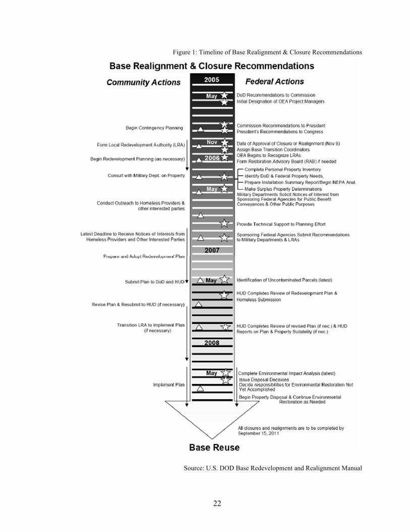
plan. Below is a graphic created by the DOD as part of the Base Redevelopment and
Realignment Manual published on March 1, 2006. This visual aid provides a more
concise timeline to better understand the basics of the closure process and the different
steps that are taken by the federal government and the local community.
22
Figure 1: Timeline of Base Realignment & Closure Recommendations
Source: U.S. DOD Base Redevelopment and Realignment Manual

23
With a general understanding of the BRAC process and the steps involved with
the reuse and conveyance of a base to a specified entity, a look at some of the general
issues outside literature have highlighted can now be explored.
Economic Issues
Each base that is closed is part of a local economy that has a varied reliance on
base activities for economic stability. The federal government has implemented several
programs to offer federal assistance to local communities in the wake of base closure in
order to lessen the negative impacts of closure (Webel 2005). Programs also exist to ease
the reuse development and implementation post closure in order to aid a community in
redeveloping its local economy through new efforts (Webel 2005). It is obvious that a
large parcel of property deemed disposable by the Military Department in a largely rural
area will not suddenly become the development epicenter of a new community based
solely on the fact that a large land mass is now available for conveyance. More
commonly, parcels in developed areas or unique natural environments are conveyed for
conservation or redevelopment purposes, largely because the local economy yields a
sustainable opportunity for these scenarios.
After the financial crisis of the United States in the new millennium the entirety of
the development industry took a hit. Because of this market crash, convincing investors
to be on board with a new development project has become rather difficult. Along with
the lack of enthusiasm from real estate developers is the general downturn of local
businesses that contributes to the vulnerable state of a local economy that can be
magnified from a base closure within the area. The existing health of a local economy
will have an effect on the health of an existing base and vice versa, especially if the base

24
is employing a large amount of civilian workers and the majority of its military force is
living off base. Thus a major concern of state and local officials, as well as their
constituents, when a base is designated to be closed per a BRAC round is the future
health of their economy (Rocca 2006).
Catherine Hill examines the economics particularly associated with military base
redevelopment in her case study article of the Truman Annex Naval Station
redevelopment in 2000 (Hill 2000). The former Truman Annex in Key West, Florida was
established for its first military use in 1823, and was last used in March of 1974 (Hill
2000). Though the base closed in the mid-seventies it was not permanently reused until
1996, this was mainly due to of the disagreement between the public and LRA of what to
do with the property and the economics associated with major development of the site.
After continued disagreements on the master plan the General Services Administration
(GSA) sold the property at auction in 1986 to developer Pritam Singh for $17 million
(Hill 2000).
After Singh bought the property for redevelopment, economics delayed the
project even further because of a variety of pre-sale development agreements (and
amendments) that were made between Singh and the City Commission. Singh had agreed
to build 225 units of market-rate housing, a minimum of ninety-five affordable housing
units and a 175-room hotel (Hill 2000). Singh successfully built the beginnings of his
plan but however carefully calculated Singh’s financial figures were, he was faced with a
vulnerable real estate market and was forced into bankruptcy, delaying the project even
further.

25
Two years after bankruptcy, Singh joined forces with another development group
named the Truman Annex Real Estate Company and began construction on the project
from scratch (Hill 2000). Within four years a total of 425 housing units were built,
consisting of seven multifamily projects and seventy-five single-family homes (Hill
2000). The adjacent Sunset Island property (formerly part of the Annex) was developed
after being sold to a development consortium that built a 178-room hotel, forty-five
houses and a 410-car parking garage (Hill 2000).
The Truman Annex was ultimately developed entirely from private funds and
took twenty-two years to be permanently reused. Major hiccups in the reuse of this
military base were particularly economic and political. Though the solution of political
disagreement came in the form of selling the land at auction, it was one that was sought
after in order to advance the reuse process. The economic issues this development faced
were unforeseen, as are most, considering the variety of components that compromise
feasible development.
Catherine Hill’s case study displays the commonly faced economic issues with
the private development of military bases. Strategies to mitigate the negative impacts of
economic factors will be presented in the following chapters by looking at four case
studies of closed bases in different phases of reuse. It is important to once again note the
lack of available literary research on the specific topic of economic hindrances of military
base reuse. There are several journal articles and in-depth studies that have been done on
the general economics of communities before and after closure but nearly none on the
effects economics can have on the reuse process.

26
Environmental Issues
Environmental issues are the one hindrance that can potentially delay a project
indefinitely. Depending on the previous uses of the closed military base a variety of
issues can be encountered. Robert Durant’s The Greening of the U.S. Military and
Kenneth Hansen’s The Greening of Pentagon Brownfields, details the environmental
policies that have influenced the different changes within the U.S. military that have
attempted to mitigate the negative impacts of environmental contaminants on military
bases (Durant 2007). Durant’s findings, in particular, have given this study on the
environmental hindrances within the base reuse process valuable guidance and insight.
To shed some light on the commonality of environmental issues at bases the DOD
estimated that during the Clinton Administration, in the early 1990s, there were 20,000
toxic waste sites across twenty-seven million acres of military base land (Durant 2007).
Of these sites, 60% were affected by contamination from fuels and solvents, 30%
suffered from toxic and hazardous wastes like explosive compounds and paints, 8% had
unexploded ordnances (UXOs) and 2% experienced low-level nuclear waste
contamination (Durant 2007). The amount of time and money it takes to clean up these
issues can be immense and during the early 1990s the Community Environment
Response Facilitation Act (CERFA) was enacted in order to increase the speed of DOD’s
cleanup efforts and President Clinton signed an executive order, titled Community
Reinvestment Program, that became known as his fast-track clean up program (Durant
2007). However, after these initial legislations were created, criticisms followed which
caused more legislation to be created to mitigate evolving issues and the relationship
between the Environmental Protection Agency (EPA) and the DOD grew. No matter how

27
many actions were taken by Congress, the process of base cleanup continues to take a
large amount of time (depending on the extent of the contamination, up to years) and
most of the delay is caused by the federal government as a result of what Hansen cites as
a, “lengthy military drawdown and environmental contamination, which…are probably
related in many cases.” (Hansen 2004).
According to Hansen, when addressing the future of environmental cleanup an
intergovernmental cooperation across federal, state and local levels will help to lessen the
time spent on cleanup actions (Hansen 2004). It is also useful to note the importance of
discovering and addressing environmental contamination in the beginning of the closure
and reuse process so that the cleanup can be incorporated from the start. Through the
BRAC process the federal government is liable for the costs and cleanup of
contamination on sites but through intergovernmental cooperation, cleanup can be done
at different levels for a more locally driven hands-on approach to speed the process
(Hansen 2004).
Political Issues
Politics can plague every part of the base closure process, from being selected as a
BRAC potential to being commissioned for closure, and the reuse process is not an
exception. Political disagreements during the reuse process typically stem from the type
of use that is going to be implemented on the property and how it will affect different
stakeholders, the more valuable the site the more the politics can become an issue.
Political issues with reuse can delay the implementation of a master plan dramatically, as
was the case with the reuse of the Philadelphia Naval Shipyard (Hess 2001).
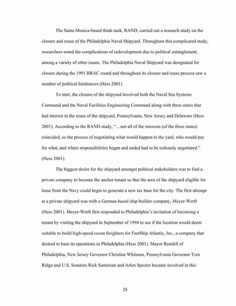
28
The Santa Monica-based think-tank, RAND, carried out a research study on the
closure and reuse of the Philadelphia Naval Shipyard. Throughout this complicated study,
researchers noted the complications of redevelopment due to political entanglement,
among a variety of other issues. The Philadelphia Naval Shipyard was designated for
closure during the 1991 BRAC round and throughout its closure and reuse process saw a
number of political hindrances (Hess 2001).
To start, the closure of the shipyard involved both the Naval Sea Systems
Command and the Naval Facilities Engineering Command along with three states that
had interest in the reuse of the shipyard, Pennsylvania, New Jersey and Delaware (Hess
2001). According to the RAND study, “…not all of the interests (of the three states)
coincided, so the process of negotiating what would happen to the yard, who would pay
for what, and where responsibilities began and ended had to be tediously negotiated.”
(Hess 2001).
The biggest desire for the shipyard amongst political stakeholders was to find a
private company to become the anchor tenant so that the area of the shipyard eligible for
lease from the Navy could begin to generate a new tax base for the city. The first attempt
at a private shipyard was with a German-based ship-builder company, Meyer-Werft
(Hess 2001). Meyer-Werft first responded to Philadelphia’s invitation of becoming a
tenant by visiting the shipyard in September of 1994 to see if the location would deem
suitable to build high-speed ocean freighters for FastShip Atlantic, Inc., a company that
desired to base its operations in Philadelphia (Hess 2001). Mayor Rendell of
Philadelphia, New Jersey Governor Christine Whitman, Pennsylvania Governor Tom
Ridge and U.S. Senators Rick Santorum and Arlen Specter became involved in this

29
prospect, whether personally or on behalf of their offices, after consideration of the
positive economic impacts of Meyer-Werft’s tenancy in Philadelphia (Hess 2001).
However much political support appeared during the first discussions of Meyer-
Werft’s tenancy was not enough to save the issue from political delays in the reuse
process. As stated above, the politics within the Philadelphia area were complicated and
the Meyer-Werft project depended on the support of Philadelphia Democrats, the
Republican administration in nearby Harrisburg as well as the collaboration of opposing
New Jersey political leaders (Hess 2001). This complicated political involvement
inevitably caused a slow negotiation process between the city, the Navy (holding the
potential lease) and Meyer-Werft. After much negotiation Meyer-Werft proposed a deal
in April of 1995 (Hess 2001). Though city leadership, particular members of Congress
and the Clinton Administration supported the proposal, the state of Pennsylvania raised
significant concerns (Hess 2001). The originally proposed deal was changed to
accommodate concerns from Pennsylvania political leaders but after additional back and
forth dealings the prospective project collapsed in September of 1995 and was
unsalvageable from then on (Hess 2001).
Future deals were attempted with new private entities and they faced similar
political entanglements, which delayed the reuse process even further. Ultimately the
Philadelphia Naval Shipyard was reused by both public and private entities (Hess 2001).
Though its history is deep, the RAND research on the closure and reuse process of the
shipyard gives unique insight into the political hindrances that can plague the reuse of
closed military bases.

30
Conclusion
As stated previously, the amount of literature available on the hindrances of
military base reuse is incredibly lacking. The few authors discussed in this chapter were
instrumental to a literary basis of this thesis. From financial to political to environmental
hindrances the delays in the reuse of bases can be extensive, especially if their potential is
not addressed from the beginning of the process. Since the prevalence and importance of
these issues have been established, the following three chapters will look at specific cases
that are in various environments and stages of reuse, and the applicability of hindrances
in these particular situations. Moving on to the next chapter, Athens Naval Supply Corps
School located in Athens, Georgia will be explained to provide research on an ideal
situation where stakeholders worked in harmony to develop a reuse plan for the site that
faced little to no opposition and is currently experiencing a smooth implementation
period. This section is purposed to highlight to process of reuse in an applied way in
order to better display the reuse process in an applied setting.

31
CHAPTER 4
ATHENS NAVAL SUPPLY CORPS SCHOOL
The Athens Naval Supply Corps School is quite possibly one of the few reuse
projects of a closed military base that has experienced an ideal scenario. As can be seen
in the following case studies, many experience at least one major hindrance throughout
the reuse process, though the site in Athens, Georgia has not. It is important to keenly
observe the steps that were taken throughout this reuse process to mitigate any potential
negative impacts that could occur, which ultimately sped up the entire process. This site
in Athens provides a unique case study to set the stage for those that follow in this thesis
by providing a best-case scenario situation in an area of city planning that typically
experiences far more hurdles.
The Naval Supply Corps School in Athens, GA was commissioned in 1954 and
was home to 22,455 graduates over the course of its fifty-seven year history (Dortch
2010). The property itself has been used as an educational site for over 120-years (Dortch
2010). The facility was officially closed on October 29, 2010 and the school has since
been relocated to Newport, Rhode Island (Dortch 2010). The property, situated on Prince
Avenue in the Normaltown area of Athens, is approximately fifty-eight acres and
contains both new and historic structures in the northeast area of Georgia, as seen in the
map below (UAFP, 2007). Athens, itself, is a college town centered on the University of
Georgia, which in the fall of 2011 boasted 33,904 students on top of an existing 116,714
population according to the 2010 Athens-Clarke County census (OPA, 2011). The

32
University of Georgia has provided a one of a kind location for the Naval Supply Corps
School and it is because of the university’s large presence within Athens that this site has
experienced such a positive reuse process, which will be addressed further later on. After
its closure the Department of the Navy conveyed the property to the Department of
Education in March of 2011 as a public purpose conveyance, which in turn deeded the
site to the University of Georgia on April 4, 2011 (UAFP, 2007). This type of
conveyance was achieved by an agreement made with the university to pay $8 million to
support local homeless assistance programs (Jackson 2008).
Figure 2: Map of Athens Naval Supply Corps School Location
Source: Google Maps

33
An implementing Local Redevelopment Authority was commissioned to decide
what to do with the property once the Navy was no longer functioning on the site. The
LRA reviewed several master plan proposals and ultimately chose the master plan that
had been submitted by the University of Georgia’s Office of University Architects
(Dortch 2010). UGA’s submitted plan outlined an educationally driven use of the site by
incorporating it as a health-sciences campus to house the new partnership established
between the University of Georgia and the Medical College of Georgia (UAFP, 2007).
The site’s original use was for educational purposes by UGA and the master plan
proposed by the university would bring the site full circle in its uses. The LRA chose the
university over others not only for its design elements but also for its ease of
implementation. Keeping the site for educational uses caused minimal pushback from
community members thus allowing for a more seamless transition of property ownership
and master plan implementation than typically seen at other reuse sites. It was also
because of its continued educational history that the Athens Naval Supply Corps School
did not have any large sources of environmental contamination needing extensive
remediation, which could have delayed the reuse process.
The process of transferring property ownership was done almost seamlessly. The
Department of the Navy had agreed to transfer ownership via an education conveyance to
the Department of Education on March 1st of 2011 and by April 4th the property was
already in the possession of the University of Georgia (Mathes 2012). Such a quick
transfer is unusual and can be credited to the efforts of the implementing LRA since they
were in charge of organizing the process while making sure that the proposed master plan
was in accordance with existing BRAC standards. It is important to also note the large

34
existing presence of UGA within Athens and their previous ownership of the property
during its earliest use as another possible contributor to the speediness of the transfer
timeline. In other cases, shown later, the conveyance process and selection of a master
plan can often hold a project up for years.
In order for UGA to receive the property from the Department of Education, the
university had to agree to several things (Mathes 2012). First, UGA had to remain in
accordance with and have an ongoing relationship with the state historic association
throughout the reuse process; this involves everything from existing historic variances to
renovations in varying degrees of historic structures (Mathes 2012). The university also
agreed that there would be no revenue generating on the site and the master plan must
also stick to the existing university-wide mission (Mathes 2012). Two of the hardest parts
of the agreement are those that involve a strict timeline for uses. UGA agreed to have the
health sciences campus operating with ongoing medical education on the site by the fall
semester of 2012 (Mathes 2012). They also committed to have all twenty buildings,
identified in their original application to the Department of Education, in use or in
renovation within three years of property ownership (Mathes 2012).
Pictured below is the original vision plan proposed for the site on behalf of
UGA’s Office of University Architects (UAFP, 2007). In order to fulfill the proposed
plan, the reuse process is being implemented in three phases. Phasing the implementation
process allows UGA to acquire the necessary financial approvals needed from the state's
Board of Regents and to begin using the campus as quickly as possible (Mathes 2012).

35
Sour
ce: U
nive
rsity
Arc
hite
cts
for F
acili
ties P
lann
ing
Figu
re 3
: Ath
ens N
aval
Sup
ply
Cor
ps S
choo
l Vis
ion
Plan

36
Phase One of the reuse plan involves the modification of three buildings (Miller,
Russell and Winnie Davis Halls) for a total projected budget of $11.4 million (Coleman-
Silvers 2012). Many of the modifications to be done on the existing structures revolve
around audio-visual and information technology needs as well as federal remediation
issues (i.e. asbestos, American with Disabilities Act (ADA) compliance mostly with
plumbing and fixture counts, etc.) (Coleman-Silvers 2012). Included in the first phase
budget were also $1.9 million for a childcare center and $1.5 million for the university to
exercise delegated authority over (Coleman-Silvers 2012). Miller Hall had historic
features that needed to be addressed in order to bring the building up to ADA standards,
such as stair case railings, and since it is a designated historic structure any changes had
to be approved by the state historic association. Small modifications made to Miller Hall
were done quickly in order to allow for immediate use of the building. Russell Hall
currently houses Information Technology (IT) infrastructure and distance education
technologies that can be utilized by the Health Sciences Center program. However,
Russell Hall was also identified as the future gross anatomy building, which requires
more intensive modifications than Miller. In order to house a functioning gross anatomy
lab Russell needs to be equipped with the proper technology and security features to
house cadavers and the necessary educational spaces for the medical programs. Winnie
Davis Hall has been programmed as the new home for the medical partnership building,
which houses all things administrative regarding the medical partnership program.
Winnie Davis Hall is one of the seven historic structures on the property and faces a large
pedestrian courtyard of sorts. Because of its historic status, the state historic association
must approve renovations done on this building causing potential delays in construction.

37
However, no major delays have been incurred as of yet since the Office of University
Architects has approached the state historic association in advance with the specifics of
their proposed plans (Coleman-Silvers 2012). George Hall is another building that was an
addition to the original phase one plan and is considered to be a pre-phase two project.
This building is also being renovated to better suite future occupancy needs and has
required an additional $1.2 million to complete, though the finances have been taken
from the allotted $1.5 million of delegated authority (Coleman-Silvers 2012).
Following is a visual display, submitted as part of the final master plan proposal,
of phase one of the development plan on behalf of UGA’s Office of University Architects
(UAFP, 2007). The tables following better explain the labeling system applied in the map
to designate the programming for each structure and its usable square footage.

38
Sour
ce: U
nive
rsity
Arc
hite
cts
for F
acili
ties P
lann
ing
Figu
re 4
: Ath
ens N
aval
Sup
ply
Cor
ps S
choo
l Pha
se 1
Dev
elop
men
t Pla
n
39
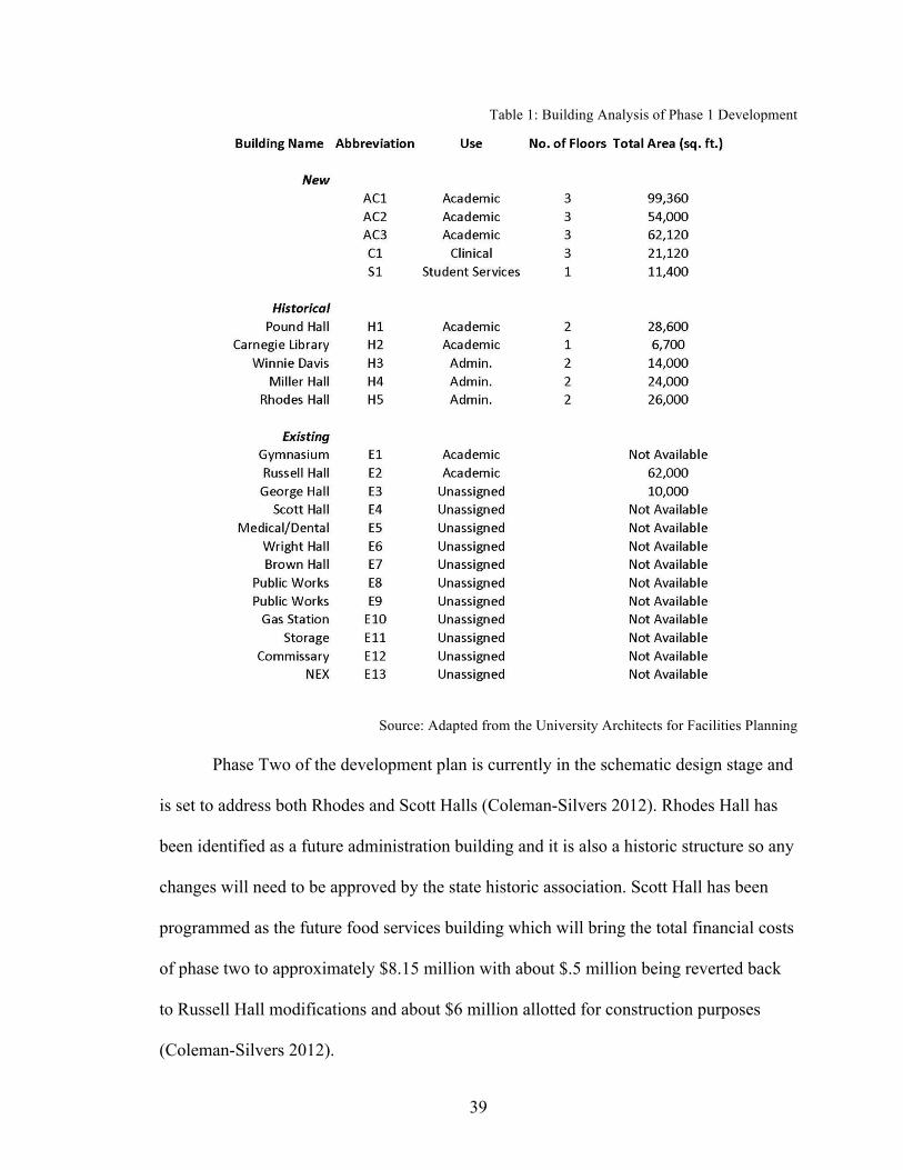
Table 1: Building Analysis of Phase 1 Development
Source: Adapted from the University Architects for Facilities Planning
Phase Two of the development plan is currently in the schematic design stage and
is set to address both Rhodes and Scott Halls (Coleman-Silvers 2012). Rhodes Hall has
been identified as a future administration building and it is also a historic structure so any
changes will need to be approved by the state historic association. Scott Hall has been
programmed as the future food services building which will bring the total financial costs
of phase two to approximately $8.15 million with about $.5 million being reverted back
to Russell Hall modifications and about $6 million allotted for construction purposes
(Coleman-Silvers 2012).

40
Phase Three is currently in the programming stage of development and is
including Wright and Pound Halls in its plan with a budget approximating $10 million
though the finances are still being developed (Coleman-Silvers 2012). Pound Hall is
scheduled to be the last historic structure modified on the site however its particular use
has yet to be established.
The process for deciding the future programming of structures is not reserved
exclusively for the Office of University Architects, a contributing factor to the success of
UGA’s reuse of the site. The Office of University Architects consults with both a large
and small planning group comprised of different stakeholders and interested parties
within the University setting (Coleman-Silvers 2012). The small planning group, made
up of about ten people, helps to decide which projects are to be completed under UGA’s
delegated authority (those monies the Board of Regents approves as part of the overall
budget to be decided as needed by UGA) (Coleman-Silvers 2012). The large planning
group is made up of about thirty people and meets once every other month to provide
general insight and critiques into the ongoing projects (Coleman-Silvers 2012). By
incorporating other interested parties into the programming process of the Health
Sciences Campus, the Office of University Architects is allowing for a variety of voices
to be heard and taken into consideration before and during the implementation of the
master plan as to mitigate any unforeseen potential problems or controversies with the
decisions that are being made.
The process of reuse experienced at the Athens Naval School site is unlike any
other commonly occurring base reuse process. Typically closed military bases are faced
with political, financial and/or environmental hindrances, and this site has yet to succumb

41
to any of those in a hindering way. What makes this case study truly unique is its relation
with its educational history and the efforts made by the implementing LRA to establish a
new use for the site, something the surrounding community would have major issues
with, from the beginning. Often, closed military bases are seen as blank slates and the
potential developers strive to scheme up a grand plan for the site however, as seen in this
case, the simpler the solution can often be the better one. Rather than the LRA choosing a
master plan with an entirely new programming plan, they analyzed what was best for the
existing population, took into account the importance of a timely reuse strategy and chose
the option with the best implementation strategy to allow for a smooth transition of
ownership and use.
It is obvious that a situation similar to the one experienced by the University of
Georgia is uncommon but it is important to note the steps the Office of University
Architects took to establish a phased implementation strategy that used what was already
available on the site to their advantage. Rather than clearing the site of unwanted
structures, their budget, given by the Board of Regents, forced them to work with existing
buildings and establish a positive relationship with the state historic association. UGA
laid out a simple goal of utilizing the old Naval site as a health sciences campus in a
timely manner and have done so by not getting caught up by small battles that could have
been waged over modifications to historic structures or establishing new programming on
the campus that would heavily contrast with the desires of the surrounding neighborhood.
Though the Athens Naval Supply Corps School is a rare case of the experiences
throughout an average reuse process, it is still a useful scenario to observe to better
understand the specifics of the process. This site in Athens has weathered a potentially

42
difficult situation well and provided other closed bases beginning the reuse process an
example to look towards, especially those in smaller cities or college towns. The
following three chapters begin to examine cases of other closed bases in different stages
of the reuse process. Each chapter tends to highlight a site that is experiencing a
particular hindrance more than others and allows the reader to better understand the
average issues a reuse process can face, specifically those that cause time delays. Each
case study begins with a brief historical overview and then a thorough explanation of the
reuse process, the desired master plan and the current stage the site is in. Following the
case study chapters, individual and comparative analysis examines the hindrances each
site faced and extrapolates lessons learned and those that can be generalized and applied
to other sites throughout the U.S.

43
CHAPTER 5
FORT MCPHERSON
Fort McPherson was established in September of 1885 in Atlanta, Georgia and
has been in use by military entities since about 1835 (USA, 1964). This army base is
located just three miles from Atlanta’s central business district and about twelve miles
from Fort Gillem, as seen in the map below. Its unique location provides an urbanized
setting for the base within the Atlanta metropolitan area, boasting a population of
4,124,300 in the ten-county Atlanta region, which helped to guide its reuse master plan
(ARC, 2011). Fort Gillem is Fort McPherson’s sub-post, located in Forest Park, GA, and
served as a supply depot for McPherson and other bases in the area. Gillem originally
consisted of 1,400 acres but because of its realignment it now exists as a military enclave
consisting of forty acres (Hawksley 2012). Fort McPherson’s history has largely been
administrative and healthcare related, especially in its recent past. The 488-acre site that
comprised the base was like a city within the greater Atlanta area and existed to care for
soldiers and their families (USA, 1964). Fort McPherson and Fort Gillem, designated on
the 2005 BRAC list, were officially closed and realigned, respectively, on September 15,
2011 (Global Security 2011c).

44
Figure 5: Map of Fort McPherson Location
Source: Google Maps
Being under 500-acres, Fort McPherson did not have the size to conduct extensive
training exercises or other large army activities, thus it was used largely as a housing
entity with small training locales throughout the base. Fort McPherson did have the
environmental contamination that the Charleston Naval Complex or El Toro Marine
Corps Air Station did, but some sites were identified for remediation. In total, nine sites
were designated as requiring remediation efforts (USACE 2010). Most of the remediation
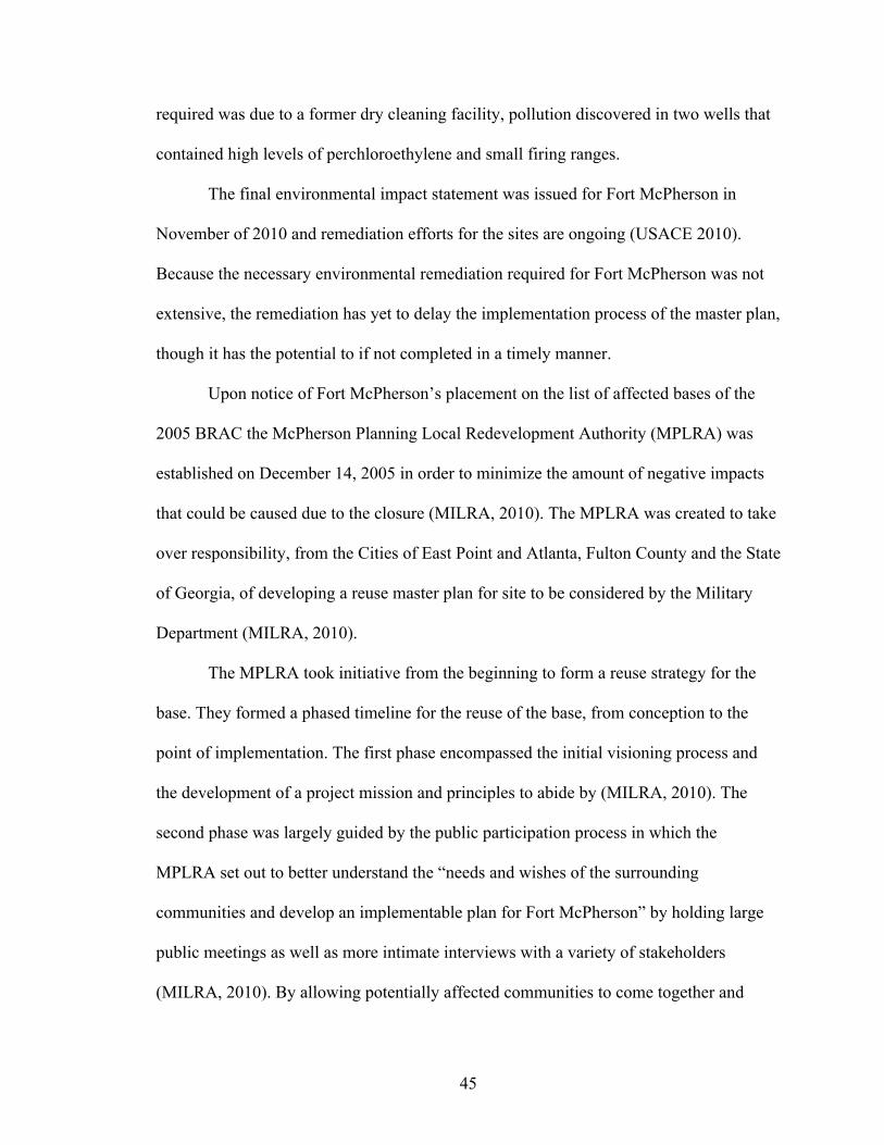
45
required was due to a former dry cleaning facility, pollution discovered in two wells that
contained high levels of perchloroethylene and small firing ranges.
The final environmental impact statement was issued for Fort McPherson in
November of 2010 and remediation efforts for the sites are ongoing (USACE 2010).
Because the necessary environmental remediation required for Fort McPherson was not
extensive, the remediation has yet to delay the implementation process of the master plan,
though it has the potential to if not completed in a timely manner.
Upon notice of Fort McPherson’s placement on the list of affected bases of the
2005 BRAC the McPherson Planning Local Redevelopment Authority (MPLRA) was
established on December 14, 2005 in order to minimize the amount of negative impacts
that could be caused due to the closure (MILRA, 2010). The MPLRA was created to take
over responsibility, from the Cities of East Point and Atlanta, Fulton County and the State
of Georgia, of developing a reuse master plan for site to be considered by the Military
Department (MILRA, 2010).
The MPLRA took initiative from the beginning to form a reuse strategy for the
base. They formed a phased timeline for the reuse of the base, from conception to the
point of implementation. The first phase encompassed the initial visioning process and
the development of a project mission and principles to abide by (MILRA, 2010). The
second phase was largely guided by the public participation process in which the
MPLRA set out to better understand the “needs and wishes of the surrounding
communities and develop an implementable plan for Fort McPherson” by holding large
public meetings as well as more intimate interviews with a variety of stakeholders
(MILRA, 2010). By allowing potentially affected communities to come together and

46
have a voice gave the master plan a community-backed effort from the start. The
MPLRA acknowledged local residents’ relations with the base from the designation of
closure which helped to better guide the plan for the site to be one that was supported by
local stakeholders, rather than fought against.
The influential issues of the project discovered from efforts during phase two
were then analyzed according to their relations to “…operations, rehabilitation and
capital improvements…” as part of phase three (MILRA, 2010). This phase also included
“…an evaluation of the cost effectiveness of demolition, reuse, infrastructure
improvements, and retrofitting facilities for ADA requirements.” (MILRA, 2010). The
parameters of what was to be accomplished on the site were hashed out during this phase
and the outline of the aspects the master plan would possess was beginning to take shape.
Though the MPLRA was working in a timely manner, because the base was designated
for closure as part of the 2005 BRAC process, the third phase of the reuse process
occurred just as the nation experienced the recession (MILRA, 2010). The economics of
the project had to be completely refigured after the recession hit and the affects of the
state of the market at the time caused unavoidable delays.
After the economic downturn, state legislation established the McPherson
Implementing Local Redevelopment Authority (MILRA) on September 2, 2009 to direct
the implementation process for the site (MILRA, 2010). In the fourth and final phase the
MILRA reviewed and edited the previous financial plans to take the current market into
account (MILRA, 2010). They then began to develop the specifics of the master plan and
hired HOK, an international architectural and planning firm, to further develop the details
of the master plan (MILRA, 2010). The MILRA then developed a business plan to better

47
clarify the economics of the plan and the phasing process of the implementation based on
current market realities (MILRA, 2010). Overall, there were three different master plan
analyses performed on the site, one completed in 2007 right before the major of effects of
the economic downturn were felt, one in 2009 after the MILRA had been established and
the final master plan in 2011 after the economy had taken its toll and the market began to
stabilize (MILRA, 2010).
The master plan for the site has been approached using sustainable urbanism as a
guide to develop a walkable, mixed-use environment that is apart of the larger
surrounding community (MILRA, 2010). Fort McPherson has a long and maintained
history, which has been treated as an asset of the site by the MILRA and HOK. The reuse
plan calls for the preservation of existing historic structures, many of which were former
living quarters for military families, to form a historic village as one of the design’s
centerpieces (MILRA, 2010). Along with the historic district are four featured design
components; the science and technology center, main street, open space and connective
infrastructure (MILRA, 2010). These five components serve as the main framework for
the development of the site, as seen in the final master plan pictured below.

48
Figure 6: Fort McPherson Master Plan
Source: McPherson Implementing Local Redevelopment Authority

49
Each featured design component was chosen and developed with purpose in order
to bring “…the vibrancy and diversity that will attract investors, developers, and
ultimately residents.” (MILRA, 2010). The science and technology center was developed
out of a growing desire for a health sciences hub; a physical place where researchers and
practitioners can come and work together in a single built environment. In a study done in
the summer of 2011 by Research!America, 74% of persons polled said that investment in
research to improve global health is important for economic development and 96%
expressed a desire for Georgia to become a leader in health research and development.
The location of the science and technology park at Fort McPherson provides easy access
multiple modes of transportation to numerous hospitals, medical research companies and
universities that can utilize the space for future development. This area of the master plan
was designed as a flexible block structure to promote a “…variety of building and site
requirements for a range of end users.” (MILRA, 2010).
The historic village was designed to consist of both existing historic structures
(like the one pictured below) as well as new development. The forty historic structures
already on the site are protected under the National Register of Historic Places and will
be retrofitted accordingly, as needed (MILRA, 2010). New development in the village
aims to further the scale and neighborhood feel of the area by recreating similar buildings
in both character and size.
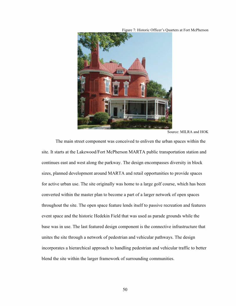
50
Figure 7: Historic Officer’s Quarters at Fort McPherson
Source: MILRA and HOK
The main street component was conceived to enliven the urban spaces within the
site. It starts at the Lakewood/Fort McPherson MARTA public transportation station and
continues east and west along the parkway. The design encompasses diversity in block
sizes, planned development around MARTA and retail opportunities to provide spaces
for active urban use. The site originally was home to a large golf course, which has been
converted within the master plan to become a part of a larger network of open spaces
throughout the site. The open space feature lends itself to passive recreation and features
event space and the historic Hedekin Field that was used as parade grounds while the
base was in use. The last featured design component is the connective infrastructure that
unites the site through a network of pedestrian and vehicular pathways. The design
incorporates a hierarchical approach to handling pedestrian and vehicular traffic to better
blend the site within the larger framework of surrounding communities.

51
Since the economy took a turn for the worse during the conceptual development
of the site, once the details of the master plan were being established a phasing strategy
was introduced as part of the business plan to better formulate an implementation
process. The business plan, as prepared by Huntley Partners, Inc., describes the phased
development plan according to expected financial constraints and places the fourth and
final build out phase to be completed in the year 2036 (Huntley, 2011).
Once the final master plan was developed, the MILRA then submitted it for
approval to the U.S. Department of Housing and Urban Development (HUD). HUD
approved the final draft of the master plan in September 2011, making this reuse plan the
official plan for the site (Hawksley 2012). After HUD’s approval, the MILRA continued
its talks with the Department of the Army in Washington, D.C. to begin the negotiating
process for attaining ownership of the site via an economic conveyance and is currently
still in this process, with hopes of a conveyance agreement to be achieved in the coming
months (Hawksley 2012).
While waiting for negotiations to finalize with the conveyance process of the
property, the MILRA sent out a request for proposal/request for qualifications
(RFP/RFQ) in November of 2011 for a master developer to work under an agreement
with the MILRA to develop the first phase of the plan, identified as the Economic
Development Conveyance (EDC) Parcel (MILRA, 2011). The EDC is a 113-acre portion
of the site that makes up the main hub of the science and technology park. The winning
firm of the RFP/RFQ was chosen in February of 2012 and was a collaborative team made
up of Forest City Enterprises, Inc. (Cleveland-based manager/developer company),
52
Cousins Properties, Inc. (Atlanta-based real estate company) and The Integral Group
LLC (Atlanta-based real estate company) (Sinderman 2012).
Currently, the site is still in use by two credit unions that have previously been
tenants under lease agreements but have made conveyance requests to the Department of
the Army to acquire the land and structures they currently occupy (Hawksley 2012). The
MILRA officially moved their offices to a building on the site in May of 2012 and the
commissary has remained open and operating on the site since the closure as well
(Hawksley 2012). The U.S. Department of Veterans Affairs (VA) was conveyed ten acres
of the site, including six buildings, for $12.5 million by the Department of the Army to
expand their services within the area (Redmon 2011). The VA has a budget of $40
million approved for renovations to the six buildings in order to accommodate a VA
healthcare campus (Redmon 2011). This area will be a part of the larger science and
technology park and will not affect the plans for the development of the remainder of the
site. The VA campus is set to include an outpatient clinic with a variety of specialty
departments, as well as a homeless program and temporary stay facility, and a live-in
rehabilitation facility for veterans struggling with substance abuse. The outpatient clinic
is scheduled to be partially in use by August of 2012 (Redmon 2011).
Fort McPherson has experienced a mostly positive reuse process with its major
hiccup being one that was largely out of its control, the market crash. The MLRA and
MILRA each did exactly what they were supposed to do and made sure to keep all
stakeholders informed of the various decisions that were being made. The MILRA took
ownership of the reuse process and reworked existing master plans to better
accommodate current market realities, while remaining true to their original mission

53
statement and purpose. Economic hindrances can be devastating to a project, whether
they are within an entitie’s control or not, but it is how the project moves forward and
handles the difficulties it is faced with that will determine how deeply a reuse effort is
affected. The next chapter takes a look at the process the Charleston Naval Complex had
to go through in order to overcome environmental issues that threatened to halt the reuse
effort and the way this situation was handled by those involved.
54
CHAPTER 6
CHARLESTON NAVAL COMPLEX
The Charleston Naval Base was first established in 1901 after the U.S. Navy
purchased approximately 1,190 acres along the Cooper River about five miles north of
downtown Charleston, in the city of North Charleston South Carolina (Sprott 2002). This
unique coastal low country area is part of the larger Charleston-North Charleston-
Summerville Metropolitan Statistical Area as seen in the map below, which in 2009 had a
total population of 664,607 (Census, 2011a). The was Navy began developing the site in
1902 and by1909 the first dry dock had been completed (Sprott 2002). Throughout its
history the base was used as a strategic defense location during several wars and it
continued to grow and encompass a variety of naval commands. The Naval Base soon
became the Charleston Naval Complex (CNC) in order to appropriately incorporate all
naval functions and properties within the nearly 2,922-acre property (NAVFAC, 2008).
The CNC was home to the Naval Shipyard, the Naval Station, the Naval Fleet and
Industrial Supply Center, the Fleet and Mine Warfare Training Center, and the Naval
Reserve Center along with several other small organizations (NAVFAC, 2008). The
Naval Shipyard and the Naval Station together occupied nearly 1,800-acres of the CNC
(Global Security 2011a).
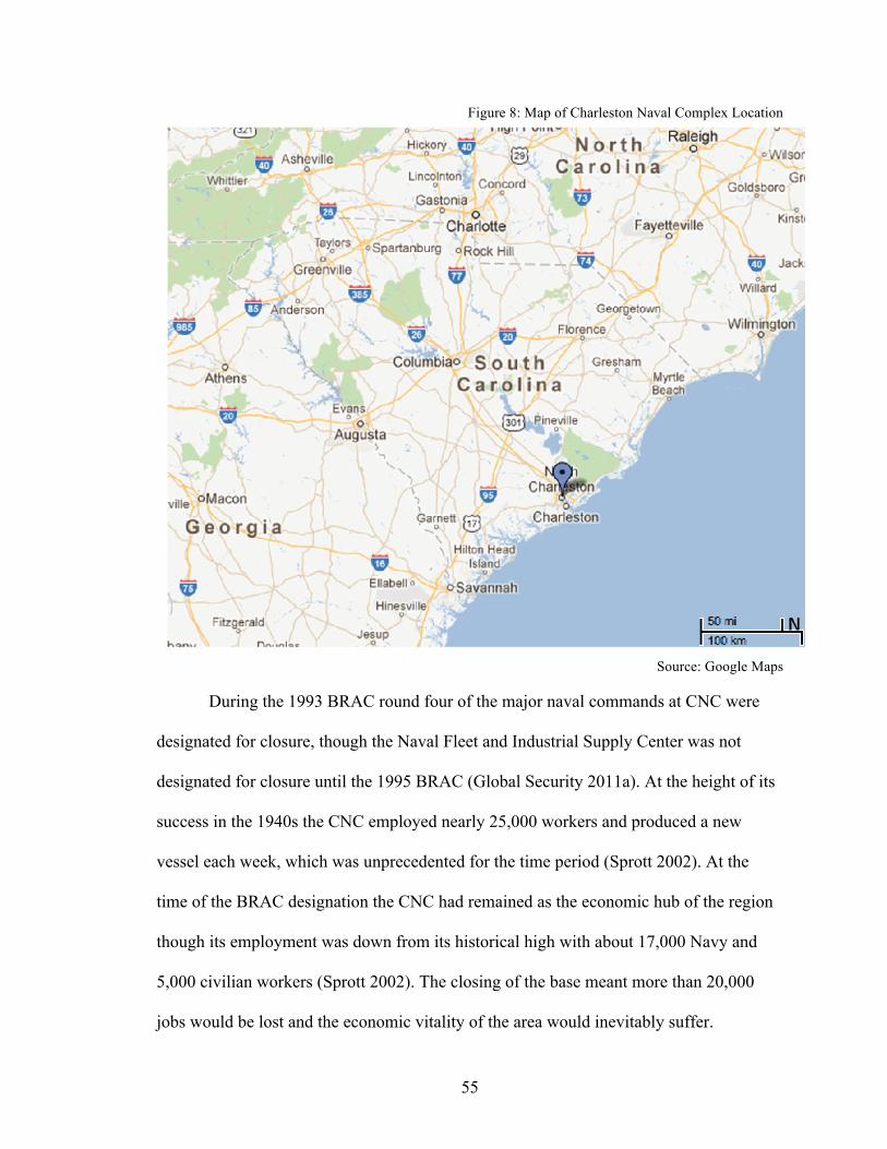
55
Figure 8: Map of Charleston Naval Complex Location
Source: Google Maps
During the 1993 BRAC round four of the major naval commands at CNC were
designated for closure, though the Naval Fleet and Industrial Supply Center was not
designated for closure until the 1995 BRAC (Global Security 2011a). At the height of its
success in the 1940s the CNC employed nearly 25,000 workers and produced a new
vessel each week, which was unprecedented for the time period (Sprott 2002). At the
time of the BRAC designation the CNC had remained as the economic hub of the region
though its employment was down from its historical high with about 17,000 Navy and
5,000 civilian workers (Sprott 2002). The closing of the base meant more than 20,000
jobs would be lost and the economic vitality of the area would inevitably suffer.
56
Upon notice of its BRAC designation on February 26, 1993, the then-Governor of
South Carolina, Carroll Campbell, gave the Trident Region’s (made up of Berkeley,
Charleston and Dorchester counties) Building Economic Solutions Together (BEST)
Committee the task of developing a reuse plan for the CNC in order to devise a plan that
addresses the wellbeing of the tri-county region (Sprott 2002). In May of 1994 the BEST
Committee had approved a general reuse plan titled the Civic and Marine Reuse Plan,
which incorporated five main employment components (shipyard, industrial park, office
district, intermodal cargo port, and a marine industrial park) along with public
recreational facilities and a public service office district (Sprott 2002). Once the BEST
Committee had established its approval for this reuse plan the General Assembly then
approved the creation of the Charleston Naval Complex Redevelopment Authority
(RDA) to take over the responsibilities of developing and implementing a detailed reuse
plan for the CNC (Sprott 2002). According to Jack Sprott, Executive Director of the
RDA, the
mission was straightforward: redevelop and reuse the closed military facilities through leasing
and/or conveyance, thereby returning properties to the community, enhancing tax bases, replacing
lost jobs, assisting public service organizations and improving economic growth in the area.
However, the RDA soon realized after a series of hang-ups that though the mission was
clear-cut, the process of achieving the goals were not as simple.
As with many redevelopment authorities, the RDA gained firsthand experience
with the sluggish pace at which bureaucratic entities move and had to deal with the slow
process of the U.S. Navy in its issuance of Findings of Suitability to Lease (FOSL)
(Sprott 2002). Much of the success of the reuse depended on how quickly the RDA could
get the structures on the site leased to other businesses to begin rebuilding economic

57
activity in the area before the Navy had completely ceased operations on the site. The
RDA developed a fast-track process that enabled them to get interim leases established
while not losing the prospective leaser to delays with government approval, considering
there were about four different government entities involved in each transaction (Sprott
2002). The first lease was signed on October 6, 1995 though the Navy did not end its use
of the site until April 1, 1996 (Jacobson 2000). Essentially, the RDA would lease
property from the Navy and then sublease the property to a variety of occupants. Political
agendas and legal disputes also caused minor delays that, if handled improperly, could
have held the reuse project up indefinitely. The RDA took the issues in stride, stayed
focused on their mission and moved forward in order to keep the momentum of the
project going, while handling legal matters as they came.
The most worrisome part of the reuse process was the potential time delay
environmental contamination could have on the redevelopment and conveyance of the
property. With the base’s long nautical history, the environmental effects were deep and
vast. Work on an Environmental Impact Statement began in 1994 during which time a
total of 195 Solid Waste Management Units (SWMUs) and 208 Areas of Concern
(AOCs) were identified (USN, 1998). Nine of the 195 SWMUs were designated as major
a site for remediation programming which had to be completed before the Navy could
convey the property to the RDA (USN, 1998). After the Navy, in compliance with
NEPA, had completed the required procedures, a record of decision (ROD) was given on
May 7, 1996 to outline the remediation plan to perform the environmental cleanup across
the site (DOD, 1996). The deliverance of the ROD served as the final step of the
environmental evaluation process for the site.

58
After the ROD was completed, the Navy sought out options for performing
remediation efforts on the property and ultimately decided to take an unconventional
approach to remediation performance. The Navy decided to seek out private companies
to enter into a contract to perform the necessary remediation on the site in order to
accelerate the redevelopment process, reduce costs and prepare the property for
conveyance as quickly as possible (CH2M HILL 2005b). In February of 2000 the Navy
entered into a fixed price insured contract with CH2M HILL, an international engineering
and planning firm, to complete the entire remediation process so that the property could
be conveyed and the Navy could be relieved of its ownership sooner than anticipated
(CH2M HILL 2005a). The Navy had performed financial analysis based on necessary
remediation and estimated it to cost $35 million however, CH2M HILL was able to
accomplish the clean up for $28.8 million dollars, saving the Navy 18% in total costs,
which was huge considering that remediation of 88 of 155 BRAC sites were evaluated to
have come in over budget by an average of 45% (CH2M HILL 2005b).
Remediation achieved through private contracting was not a common choice
when the contract was conceived and the CNC remediation process was the first of its
kind (CH2M HILL 2005a). This contract allowed the Navy to limit and reduce costs
while transferring the property to other entities as quickly as possible. CH2M HILL
became solely responsible for the following: investigations, remedial planning and
remedial action to close RCRA (Resource Conservation and Recovery Act identified
brownfield sites) and UST (underground storage tank) sites, regulatory approvals and
release of RCRA permit, property transfer documentation (Finding Of Suitability to
Transfer/Finding Of Suitability to Lease), operation and maintenance of remedial systems

59
for twenty years, liability for newly discovered sites, and no differing site conditions
clause (CH2M HILL 2005b). The contract essentially relieves the Navy of any necessary
actions within the remedial process for twenty years. Being the first contractual
remediation process the Navy had done, the CNC became a pilot project for other base
closures to learn from in order to speed up the remediation process and limit the
government’s liability and cost (CH2M HILL 2005a).
By May 25, 2005, CH2M HILL had implemented the vast majority of remedies
for designated sites and the then-Governor of South Carolina had signed a Finding of
Suitability for Early Transfer Agreement (FOSET) (CH2M HILL 2005b). During an
October 11, 2005 CNC Restoration Advisory Board Meeting, the Navy Co-Chair, Jeff
Meyers, had confirmed that the transfer of all CNC property had been completed and
several redevelopment activities were underway (CNCRAB, 2005). Within a five-year
period, CH2M HILL had nearly completed all remediation efforts and had achieved full
preparation of early transfers of the entire property (CNCRAB, 2008). In comparison, the
average time it takes to construct a clean up remedy is 10.6 years for the Navy, thus the
contract remediation performed at CNC was a huge success in terms of both budget and
time (NRC, 1999).
After the Navy closed the base on April 1, 1996, it conveyed the majority of the
property to the state of South Carolina, which had the RDA in place to take charge of its
conversion, while the remainder of the property was conveyed to other federal entities for
use (NAVFAC, 2008). Much of the site was sold or leased to over eighty-five private,
local, state and federal organizations like the Deytens Shipyards, Charleston Marine
Manufacturing, United States Postal Service and the Noisette Company, to name a few.

60
The site was full of a variety of uses and one developer took special interest in a large
parcel on the former base as well as the old North Charleston city center.
Developer John Knott was interested in the opportunities that the closed base
created for redevelopment in the area and in 2003 his firm, The Noisette Company
(named after the Noisette River that runs through the base property), entered into a
public-private agreement with the city of North Charleston, which transferred about 400
acres of base property to the company (Krohe 2005). Originally, the city of North
Charleston was given the larger north end portion of the base by the RDA for
redevelopment, which included about 300 acres of waterfront property that was then
given to The Noisette Company, seen below.
Figure 9: Portion of CNC Property Owned by The Noisette Company
Source: The Noisette Company

61
Rather than isolate the 400 acres transferred to Knott’s company with
redevelopment plans, The Noisette Company expanded their scope to include the 3,000-
acre city center of North Charleston, which was in need of revitalization (Krohe 2005).
The master plan encompasses a sustainable mixed-use perspective to integrate the former
base with the existing city. The plan designates key guidelines and recommendations that
help achieve the overall vision for the site, they include; regenerative land use, restoring
natural systems, restoring connections, neighborhoods as catalysts for change and the
Navy Yard at Noisette (Noisette, 2003).
The idea of regenerative land use was established in order to promote a live-work-
play lifestyle focused on key areas within the city in need of revitalization. The
sustainable portion of the master plan is seen throughout each element but particularly
noticeable with the effort behind restoring natural resources. By doing so, the natural
resources that surround the area can be better integrated into the daily lives of individuals
and seen as an asset, rather than be overlooked. A major focal point of this guiding
principle is the Noisette Preserve, which was designed to provide recreational activities
as well as educational opportunities. By restoring connections throughout the site, the
master plan intends to improve community connections via “…sustainable infrastructure
improvements in transportation systems, open space and recreation, and utility systems”
(Noisette, 2003). Utilizing neighborhoods as catalysts for change allows each
neighborhood to be in control of the success of their respective centers. Focusing on
neighborhood center vitality encourages a lasting mix of use and gives each
neighborhood its own identity. Lastly, the Navy Yard at Noisette occupies a large parcel
on the former base and converts the existing land into a new urban center with a variety
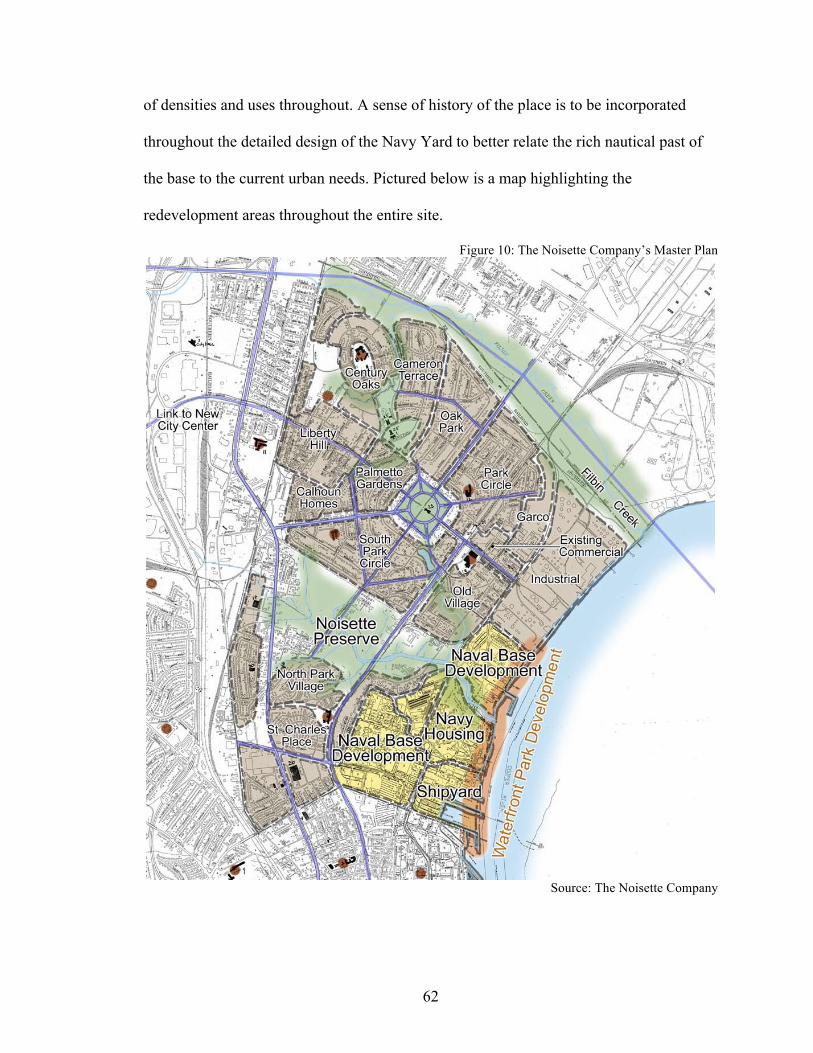
62
of densities and uses throughout. A sense of history of the place is to be incorporated
throughout the detailed design of the Navy Yard to better relate the rich nautical past of
the base to the current urban needs. Pictured below is a map highlighting the
redevelopment areas throughout the entire site.
Figure 10: The Noisette Company’s Master Plan
Source: The Noisette Company

63
Overall, the master plan for the development is to be implemented over the course
of fifteen years, separated into three five-year stages. The first stage occurred from 2004-
2008 and suffered from the economic downturn, as did the rest of the country, which
inevitably slowed the progress of implementation (Noisette, 2003). The second stage is
currently underway and is do to conclude at the end of 2013, with the third and last stage
to be completed by 2018 (Noisette, 2003).
This case study was chosen to display not only the environmental hindrances a
reuse project can face but also to showcase the ingenuity an LRA can have. LRA’s have
the ability to make or break a project based on their reactions to difficult situations. The
RDA associated with the CNC analyzed the reuse process and found new ways to speed
it up in order to begin rebuilding an economic foundation for the region. The following
chapter develops a case study on the El Toro Marine Corps Air Station in order to show
how instrumental political harmony is to the timeline of a reuse effort. Unlike the
scenario with the CNC, El Toro experienced much political interference from the
beginning.

64
CHAPTER 7
EL TORO MARINE CORPS AIR STATION
The El Toro Marine Corps Air Station (ETMCAS) was commissioned in
1942 and first utilized by the military in 1943 (Rowe 2006). As one of the country’s
largest Marine air stations, the nearly 4,700-acre base contained four runways and was
home to approximately 8,000 military personnel located in a largely suburban area in the
middle of Orange County, in the City of Irvine, California situated about an hour from
Los Angeles to the north and San Diego to the south (Global Security 2011b). Currently,
Irvine has a population of 212,375 while the county boasts 3,055,745 residents (Census
2011c, 2011b).
As part of the 1993 BRAC process the ETMCAS was commissioned for closure after
nearly fifty years of continuous operation (Rowe 2006). Once the site was commissioned
for closure, the base transferred the majority of its activities to the Miramar Marine Corps
Air Station and officially closed on July 2, 1999 (Rowe 2006). According to David
Sorenson, author of Military Base Closure: A Reference Handbook, the ETMCAS, as of
2007, was only at a 27% recovery rate and had created nearly 250 jobs while the closing
of the base ultimately cost nearly 980 jobs (Sorenson 2007). These statistics give a brief
preface as to the current state of affairs on the reuse of the base and numerically display
the negative consequences of immense political interference and continuing
environmental remediation efforts.

65
After forty-five years of use as an air station El Toro MCAS had experienced
serious environmental pollution due in part to the intensive cleaning techniques used on
both the landing strips and aircrafts. Because it was a Marine Corps air station, the Navy
has acted as the primary DOD agency in charge of the remediation efforts. According to
the US EPA twenty-four contaminated areas were identified, which included four
landfills containing solid and hazardous waste (EPA 2012). These twenty-four areas had
battery acids, leaded fuels, polychlorinated biphenyls along with other hazardous
substances that were supposedly spilled or dumped. Aside from these sites, it was
discovered that there was extensive groundwater contamination as well that had migrated
over three miles off base property. The hazardous substances detected in the groundwater
were volatile organic compounds (VOCs), mostly trichloroethene (TCE) caused by two
large aircraft hangers on base, though the contamination did not affect any drinking water
sources in the area.
Records of Decisions (RODs) have been issued for each of the twenty-four sites
and the remediation efforts are being addressed in several long-term phases (EPA 2012).
According to the US EPA’s Superfund information website, remediation actions have
only been completed on a handful of sites and the most recent ROD was issued in
February of 2012 for one of the groundwater sites. Though El Toro MCAS was
commissioned for closure in 1993, and officially closed in 1999, the environmental
remediation efforts are ongoing and will be for years to come. These remediation efforts
limit the portions available for current development of the site and can hold up portions
of the master plan.

66
Figure 11: Map of El Toro Marine Corps Air Station Location
Source: Google Maps
Once the base was commissioned for closure the debate of what would happen to
the large piece of land in the heart of Orange County began immediately. Though the
areas surrounding the base when it was first commissioned were largely agricultural, the
decades leading to its closure showed an increasing suburban encroachment. By the time
the base was commissioned for closure the site had become some of the most valuable
real estate in the county, making the decision of its reuse more difficult than one would
anticipate.
The political disputes that ensued once the base was listed for closure have been
considered a civil war of sorts between north and south Orange County stakeholders. As

67
was seen with the Athens Naval School site in the previous chapter, sometimes the best
reuse of a closed military site can be a public use of what it was before closure, but not
always. In the case of ETMCAS reusing the air station as a public international airport
was the first legitimate option for the site, as proposed by the county itself (Kranser
2005). Stakeholders of north Orange County favored the international airport plan for its
convenience in comparison to Los Angeles International Airport, which was their only
other option for international air travel in the area (Kranser 2005). Some residents of the
Newport Beach area were in favor of the airport plan as well, largely due to the fact that
if an international airport was established at El Toro then the current regional airport of
Orange County, John Wayne, would be closed and air traffic would be significantly
diminished in their backyards (Kranser 2005). Those opposed to the airport plan, largely
residents of surrounding south Orange County cities, were concerned about the
inescapable aircraft noise that would occur daily and the inevitable increase in traffic in
the area (Kranser 2005). In November of 1994, county voters approved a Measure A, by
51%, to convert the closed base into a commercial airport (Rowe 2006). Once approved,
the county took on leadership of the project and the existing LRA, El Toro Reuse
Planning Authority, and included the cities of Irvine and Lake Forest as participants
(Rowe 2006).
The international airport plan proposed by Orange County officials in 1996 was
five times the size of regional John Wayne airport, with an estimated thirty-eight million
annual passengers, and to be placed in the middle of a residential area (Kranser 2005).
There was no way for officials to relate the proposed El Toro airport to that of John
Wayne, which gave way for opposition from the get-go. The proposed airport was to be

68
close in size to that of the San Francisco International airport and unlike John Wayne, this
international airport would not have curfews for evening flights thus the aircraft noise
county residents worried most about was less regulated and would be an inconvenience
twenty-four hours a day, seven days a week (Kranser 2005). As specific plans for the
airport began to take shape, public opposition took the spotlight with greater numbers
than before. County residents gathered enough signatures on a petition to place Measure
S, the first measure opposing the base as the site of a commercial airport, on the ballot in
November of 1995 (Kranser 2005). However, opposition wasn’t strong enough and in
March of 1996 voters narrowly rejected Measure S, thus upholding Measure A (Kranser
2005).
Once county officials decided against following an inclusive planning process to
involve all Orange County cities, South County cities took the initiative to restart the El
Toro Reuse Planning Authority (ETRPA) as a grassroots effort to contest the airport in
May of 1995 and continued on, regardless of the results of the March 1996 vote (Kranser
2005). ETRPA took on legal matters pertaining to the county’s draft submission of the
Environmental Impact Report and succeeded in their challenge by achieving a court
ruling that the County of Orange abused its discretion by not fully complying with the
California Environmental Quality Act when it first approved the airport plan (Rowe
2006). The newly reactivated reuse authority then went on to propose what was known as
the Millennium Plan in March of 1998 (Rowe 2006). This plan included a, “mix of
residences, job creating opportunities, central park and extensive recreational uses…”
which provided a unique alternative to the traffic inducing airport and also served as the
precursor to the Orange County Great Park plan that is currently being implemented on
69
the site (Kranser 2005). The Millennium Plan caught the attention of stakeholders both on
the local and federal level and opened the eyes of those in support of the airport for
beneficial alternatives. Following the Millennium Plan proposal, south county cities
drafted Measure F, the Safe and Healthy Communities Initiative, in February 1999 and if
passed would then require a county voter approval of two-thirds for any plan to build or
expand toxic landfills, large jails or airports near homes (Rowe 2006).
With opposition growing and alternatives for uses other than an airport for the site
began to take shape in public view, the county attempted to gain support for the airport
plan by hosting a flight demonstration event on the base in June of 1999, one month
before the military officially closed the base (Rowe 2006). The county chartered
commercial airlines for the demonstration and had a variety of aircrafts fly in and out of
the base along proposed flight paths to produce the least amount of noise possible. The
flight demonstrations backfired on the county because the noise generated during the test
flights only increased residents’ opposition to the airport and the narrow flight paths that
were proposed. Local media coverage only perpetuated the noise issue after the test
flights had been completed and the signatures of county residents for a petition to get the
anti-airport Measure F on the ballot nearly doubled (Kranser 2005). By August of 1999
county residents turned in their Measure F petitions with a county record 192,000
signatures, which led to the measure qualifying in October 1999 for the March 2000
ballot (Rowe 2006). County voters approved Measure F in March by a 2-1 margin
thereby overturning the initial airport measure, Measure A (Rowe 2006).
The fight continued and the County of Orange kept disputing the opposition to the
commercial airport. On December 1, 2000 the Supreme Court ruled that Measure F was
70
“unconstitutionally vague” and therefore illegal because it took away the right of the
county’s Board of Supervisors to approve airport projects (Rowe 2006). The county then
launched a new public relations campaign in support of the airport to better educate the
public of the facts of the plan in an attempt to rally support. However, the efforts on
behalf of the county proved unsuccessful once again when the city of Irvine revealed a
new strategy in May of 2001, supported by its citizens, to squash the airport in the form
of the master planned Orange County Great Park designated as Measure W on the county
ballot in March 2002 (Rowe 2006). Measure W passed with a county vote of 58%
ultimately killing the airport plan for the base, though the county continued their efforts
to keep airport plans alive (Rowe 2006). In March of 2002 advocates of the airport plan
filed a lawsuit stating, “state and federal laws give county supervisors the right to decide
how to use the base.” (Rowe 2006). The presiding judge of the case ruled in favor of the
defendant thus upholding Measure W allowing the people of Orange County to decide
what happens with the property (Rowe 2006). This lawsuit truly marked the end of the
county’s airport plan for ETMCAS and the civil war that had continued for nearly ten
years. The county was out of options and the Great Park had officially been set in stone
as the final plan for the site after the Department of the Navy had adopted a non-aviation
reuse plan in April of 2002 and decided that it will be selling the base rather than
transferring it to the County of Orange or an individual city (Rowe 2006).
In 2003 the County of Orange and City of Irvine both adopted a property tax
transfer agreement in order to have the ability to annex the base property (Rowe 2006).
After a local agency formation commission voted five to two in favor of the annexation,
the City of Irvine completed the annexation of the property, which included a 1,000-acre
71
parcel that remained under the Federal Aviation Administration’s possession (Rowe
2006). Once the annexation process had been completed it was time for the Department
of the Navy to proceed with the selling of the site and they decided to do so in the form of
an online auction (Gaynor 2005). On February 16, 2005 Lennar Corporation won the bid
for the site for $649.5 million and completed the payment process as agreed upon with
the Department of the Navy on July 12, 2005 to officially take ownership of the site
(Rowe 2006). The City of Irvine and the Lennar Corporation came to a development
agreement that gave Lennar limited development rights in exchange for the land and
capital needed to construct the Orange County Great Park (Kranser 2005). Lennar gave
about $200 million dollars and transferred about 1,345-acres to public ownership to go
towards the installation of the Great Park (OCGP, 2005b).
During the selling of the property the first board of the Great Park Corporation
met to discuss a future course of action and began to hold a series of seminars to
determine how the park could be developed. The board decided to hold a design
competition and invited forty different landscape architects to participate (Kranser 2005).
A design jury was then developed and charged with the task of choosing the winner of
the design bids after narrowing the applicants down to seven. The jury ultimately decided
to choose the three top designs and asked the teams to collaborate their ideas to form the
final master plan for the site. From that point forward the Great Park Corporation was
responsible for the design, construction and maintenance of the site.
The Orange County Great Park plan is a master plan that encompasses a 165-acre
sports park, great canyon about two miles long and sixty feet deep with bridges, a
veterans memorial, botanical gardens, a three mile long wildlife corridor and a one-

72
hundred foot wide cultural terrace, among other things (OCGP, 2005a). The details of the
plan are many and pictured below is an aerial view of the site plan.
Figure 12: Orange County Great Park Master Plan
Source: Great Park Design Studio
The master plan is being implemented in a series of phases, the first of which is to
be completed this year. Phase one of the Great Park incorporates the western area of the
site, approximately 200-acres, and includes 100-acres of active park space (OCGP,
2005a). A detailed plan of the first phase located in the western portion of the site is
below, in order to better understand the magnitude of this phase and those that will
follow.

73
Figure 13: Orange County Great Park Phase 1 of Western Sector
Source: Orange County Great Park Corporation
In order to allow for immediate use of portions of the site before phase one of the
park is completed, the master plan allowed for two interactive attractions to be open to
the public. On July 14, 2007, the first attraction opened, which was a balloon ride that
soars about 500 feet over the site to give visitors a panoramic view of the base and the
current state of construction activities (Starnes 2009). The second attraction opened on
July 10, 2012 and was a kids rock playground which gave families a place to gather for
the day and enjoy the park that was taking shape around them, rather than just visiting for

74
a short period of time (Starnes 2010). Pictured below is an aerial photograph of visitors
aboard the balloon ride with a view of a final rendering of the master plan.
Figure 14: View of Balloon Ride at Orange County Great Park
Source: Tom Lamb
Another component to the master plan is that of the Great Park Neighborhoods, a
residential area that lies on the north/northwestern edges of the Great Park. This
residential area is incorporated into the overall master plan of the base and is the Lennar
Corporation’s development project. Upon purchase of the base site and after transferring
1,345-acres to public ownership Lennar created the Great Park Neighborhoods as part of
their project specific company, Heritage Fields El Toro, LLC (Gaynor 2005). Phase one
of the neighborhood development, which consists of 726 single-family homes surrounded
by walking trails, was approved by the City of Irvine in September of 2011 and broke
ground on January 31, 2012 (GPN, 2008). Heritage Fields expects the first homes to be
for sale in mid to late 2013 (GPN, 2008).
The El Toro Marine Corps Air Station experienced disagreements over its
redevelopment fate from the moment it was designated for closure as part of the 1993
BRAC. Politics drove the reuse effort to a screeching halt once the public was made

75
aware of the airport plan for the site. It is important to understand the magnitude of
negative impacts political and public disagreements can have on the timeline of a reuse
process. If there is no agreement as to how to move forward within the process, the
project stops in its tracks and can begin to fade away, ultimately dying out to be left as is,
a large parcel of wasted space.
To better appreciate the previously presented case studies, the following chapter
provides individual analysis focusing on the key issue each base faced, economic,
environmental and political. The emphasis is then placed on the general takeaways from
each case study and how the lessons learned from each can be applied to each other.
Ultimately, the next chapter provides much needed analysis on each base and their
respective reuse processes and begins to develop recommendations for other bases
beginning or experiencing difficulties in the reuse process.

76
CHAPTER 8
ANALYSIS
The purpose of this chapter is to provide individual and comparative analysis for
each case study, paying specific attention to the various hindrances that each faced. By
examining the positive and negative steps each reuse process experienced one can better
understand the issues that deter a reuse effort from completion and begin to see the
lessons that can be applied to other closed bases. To begin, each case study is studied on
an individual level, starting with Fort McPherson. Later on in the chapter, a comparative
analysis is presented to show how the lessons learned from each case study can be
applied to each other and further applied to the general collection of closed bases.
Fort McPherson
The reuse of Fort McPherson began quite smoothly; an LRA was established
almost immediately, surveying and public input sessions were conducted, economic
research was being performed on the area and the local and state officials were forming a
united front behind the master plan that was taking shape. However, no one really saw
the economic downturn that was coming and the hit that the real estate market would
take. Fort McPherson weathered potentially time consuming situations well; when
grassroots efforts were being formulated to propose alternative features to the master plan
to better accommodate the surrounding community the MILRA acknowledged their
efforts and commended them while taking their concerns into account when they
reevaluated the plan after the market crash.
77
After the first master plan was solidified in 2007, the second came right on its
heals in 2009 as the market crash was beginning to take its effect on the economy once
the MILRA was established. Soon after the 2009 master plan was created the MILRA
decided a large overhaul needed to be done on the economics of the plan in order to
account for current market realities. Though it could be speculated that finalizing the
master plan could have taken a shorter amount of time if it had not been for the
unforeseen market adjustments, the MILRA handled the situation as best they could and
kept the process progressing. Time will tell how long the actual implementation of the
master plan takes, depending on the health of the economy, dedication of the master
developer team and the interest from outside investors and businesses.
Charleston Naval Complex
The designation of closure of the Charleston Naval Complex (CNC) brought
immense worry to the surrounding community in regards to the economic fallout it was
about to face. Throughout its history the CNC had become the economic hub of the area
and without the Navy the community felt as though it had lost its stability. The local and
state governments acted quickly and began devising a plan for reuse of the base far
before it was actually closed. Rather than waste time attempting to save the base from
closure, the local government accepted the closure decision and immediately looked to
the potential and how the base could be reused to benefit the community.
Environmental remediation of CNC became a large component of the reuse
process due to the findings of an environmental analysis. The site had been used for over
ninety years as a naval command center, with shipbuilding and cleaning activities during
the majority of that time. The chemicals and products used during different naval

78
activities caused some severe environmental degradation at various locations within the
base that ultimately needed a large amount of remediation before proper transfer of the
property could occur. Rather than waiting on the typically slow process of government
run remediation efforts the Navy sought out other options and ultimately entered into a
contract with a private company to oversee and perform the remediation activities on the
site. This not only benefitted the Navy with a reduction in time and overall costs but it
also allowed the city to begin redevelopment efforts sooner than would have occurred
otherwise.
El Toro Marine Air Corps Station
The reuse of El Toro Marine Air Corps Station was plagued with issues from the
second its closure was announced. This was largely due to the pushback of the
commercial airport plan from south Orange County cities and residents while Orange
County officials pressed on with their plans for the airport and continued to fight against
the growing number of stakeholders in opposition of the plan. Though El Toro required
some environmental remediation because of its long history as a main hub for military air
traffic it wasn’t the environmental issues that held up the reuse for an extended period of
time beyond what was expected. Financial constraints were felt towards the time of
implementation of the plan due to current market realities after the large economic crash
of the new millennium. However, though finances have affected the phased development
process and could possibly require the plan to be scaled back at some point, it was not the
finances that hindered the timeline of the reuse process as much as the political strife did.
Politics were El Toro’s main source of delay in the reuse process. Rather than
each side of the issue accepting defeat, they each continued to fight for what they wanted
79
out of El Toro. When each measure was passed, approving the airport plans and revoking
approval, the opposing side refused to give up. One would have thought that after the first
measure to approve the airport passed by a slim margin, the public would not have fought
so hard to overturn it. The same goes for the county officials with the measures that
followed, approving an alternative park plan for the site rather than an airport. Why
didn’t the county and city officials promoting the airport plan accept defeat and listen to
what the growing number of citizens wanted? It was their desire to turn the site into an
economic powerhouse for the area that kept them fighting. They believed that what they
were doing would exponentially benefit the county as a whole and chose to ignore the
increasing public opposition for the sake of what they saw as the common good largely
influenced by their personal political agendas.
Comparative Analysis
Each and every closed military base is different and each has a variety of
contributing factors to the success of their reuse in a timely manner. Though the details of
a base closure and reuse process are different there are a few commonalities that all will
face at some point during the process. As seen with the case studies in the previous
chapters, each had to do with a variety of political, economic and environmental issues,
though the amount of time each reuse process was held up by these common hindrances
was different for each. Throughout the following analysis, a set of recommendations will
begin to come to light in order to guide those involved in the redevelopment of closed
military bases so as to ultimately lessen the time spent in the reuse process.
El Toro clearly got hung up on the politics of the redevelopment process
considering there was a war between stakeholders of north and south Orange County and

80
the county waged the fight for a commercial airport until the issue was ended in the
courts. Fort McPherson was more inclined for economic distress, largely due to the
economic recession experienced in the middle of its closure process and Charleston faced
a potentially project ending environmental remediation process that was largely mitigated
through their private contract. It is important to lessen the time it takes to reuse a closed
base as each BRAC is completed, ultimately improving upon past experiences. In order
to do so, looking at what has occurred at other bases is vital to learn from others mistakes
and successes.
When it comes to dealing with political interferences, it is important for the LRA
and the state and local government to present a united front to the public with their
desires for the closed base. Every base closure will have to face stakeholders with
different agendas, but when the LRA and politicians are not united on their goals, the
public can be less trusting of the proposed reuse plan. Take the El Toro case study for
instance, when north and south Orange County officials could not agree on a
redevelopment plan and thus the public began to take sides. The separation gave rise to a
time-consuming conflict over what to do with the base site; both local officials and
citizens were divided on the issue and continued to propose measures on the ballot for
vote and then take the results to court when a flaw was found. The years it took to hash
out the master plan for El Toro could have been significantly reduced if the county
officials presented a master plan for the base that took all stakeholders (both areas of the
county and all local residents) into account. When the idea for a commercial airport came
about, officials faced considerable opposition that only grew over the years and they

81
should have considered public opinion immediately, which would have led them to end
the airport fight sooner.
To quicken the reuse process, the LRA and local and state government officials
must present a united front that takes public input into major consideration. Officials
should keep the public good in their viewpoint at all times and when public or political
opposition begins to mount, never encourage a conflict, but rather diffuse the situation as
quickly as possible and continue to move forward with positive progress. Imagine how
different the El Toro reuse process could have been if the political conflict had been
handled according to the above recommendations.
Upon designation for closure, each reuse process will encounter financial
restraints. Fort McPherson began its reuse process during the height of the market and
developed a master plan with the current market in mind. Unfortunately, though the LRA
did everything they were supposed to do, the redevelopment process was affected by the
economic recession that hit a few short years after the base had been designated for
closure. The Fort McPherson LRA had developed a master plan for the closed base that
took the communities needs into account and brought a new economic heartbeat to the
area, this helped the LRA establish both political and public support for the plan though
the financials had to be altered after the recession hit. By having various stakeholders in
support of the master plan, the financial reassessment that was needed did not give a
foothold to opposition, since there was no substantial opposition to begin with. If there
had been a growing group of people against the development, financial issues could have
given them an opportunity to play up their cause in the media and give the master plan
negative attention.

82
The MILRA that was established after the recession hit handled the financial
hardships in the best possible way; they recognized the need for financial reassessment
and carried out two more master plans in succession of each other to improve the master
plan and increase its probability of successful implementation. The MILRA did not get
overzealous with its desire to redevelop the base as quickly as possible but instead saw
that a phased implementation would be the best solution to lessen the financials needed to
get the physical redevelopment started. Other closed bases can learn from how the
MILRA handled the financial difficulties by recognizing the problem as soon as it arises.
Rather than attempt to continue on with a plan in a new market, reassess the financial
calculations from the original plan and adjust them to better compliment current market
realities. It is also extremely important to remain flexible, the market can change quickly
and master plans need to have the ability to be edited when needed. The MILRA could
have easily stopped with their new financial changes with the master plan from 2009 but
instead they recognized that more changes were needed and pressed on to develop the
2011 master plan, which better accounted for the ever-changing market and was aimed at
developing the most viable master plan possible for implementation.
The Charleston Naval Complex was plagued with environmental issues that were
in need of remediation efforts before the reuse process could move forward. The Navy
was responsible for the remediation of the site but was dissatisfied with the status quo of
government-run remediation efforts and sought out alternative solutions. By developing a
contract with a private entity to oversee the remediation process, the Navy gave the RDA
a huge advantage. This private contract ultimately gave way to an early transfer
agreement that allowed the RDA to move forward with the financial and physical

83
redevelopment of the site rather than postpone their progress until the remediation efforts
had been completed. The RDA pressed for interim leases and suitability for an early
transfer agreement in order to keep the momentum of the project going which inevitably
gave the implementation of the master plan life.
The outcome of the CNC reuse process would have been drastically different if
the Navy and the RDA had not worked together. The Department of Defense and the
LRA must work together throughout the environmental remediation process to ensure
that the timeline of the project is on track and that other unforeseen issues have not come
up. The remediation process within the Navy takes, on average, 10.8 years, however the
remediation at the CNC occurred much faster because of the private company that
performed the remediation. The relationship between the military and the RDA was
important for the CNC and it is good to note the potential for other LRA’s to encourage
their respective military branches to seek out alternative solutions to the standard process
of environmental regulation in order to speed up the process. It is also valuable to see
how the RDA reacted to the potentially time-consuming remediation process, which was
by continuing to seek out businesses interested in relocating to the site and how they took
advantage of the interim leases available. Constant progress is vital to a reuse process,
when the progress ceases the project can stall and become subject to much criticism.
Forward advancement of the redevelopment plan must remain a primary goal so as to not
let the master plan fade out.
Though each case study varies in its size, location, branch of military and BRAC
round of closure, they all experienced similar issues in different intensities. Below is a

84
summary table highlighting the main features of each base closure to better visualize their
similarities and differences.
Table 2: Comparison of Presented Case Studies
Site Name El Toro MCAS Fort McPherson Charleston Naval Complex
Military Branch Marine Corps Army Navy
BRAC Round 1993 2005 1993
Closure Date July 2, 1999 September 15, 2011 April 1, 1996
Site Acreage 4,700 488 2,900
Environmental Conditions
24 major sites mostly groundwater/soil issues
9 major sites mostly soil issues
9 major sites mostly groundwater/soil issues
Main Struggle Political Economic Environmental
Current Status Phase 1 of Master Plan Implementation
Phase 1 of Master Plan Implementation
Pre-Phase 3 of Master Plan Implementation
Lesson Learned Public input and a united front from stakeholders is
key
Remain flexible and consider current market
realities
Work with the federal processes and be innovative
in devising solutions Source: Author
The main struggle each site faced provided an outline of a path for other reuse
efforts to follow or avoid. From understanding the importance of harmony among
stakeholders, to the unpredictability of the market to the significance of resourcefulness
to solving environmental issues, each case has delivered valuable experiences for others
involved in reuse efforts around the country to glean from. Three central lessons have
been learned throughout the case studies that are key to completing the reuse process in a
timely manner; gathering public input and a presenting a united front from stakeholders
to the public, maintain flexibility with the details of the master plan and the business plan
in order to account for current market realities, work with the federal processes that

85
dictate the path of reuse and devise innovative solutions to potentially time consuming
problems that are faced. The purpose of the following chapter, the conclusion of this
thesis, is to summarize the general findings of each case study and the applicability of the
lessons learned as well as reiterate the overall purpose of this thesis and the importance of
further research on this topic.

86
CHAPTER 9
CONCLUSION
The purpose of this thesis is to address the land planning issues that closed
military bases face once closure has occurred by evaluating the major hindrances that
delay the time it takes to complete the reuse process. Beginning with an overview of the
BRAC process to familiarize the reader with the way bases are closed, the development
of the research began to take shape. Investigating current literature for insight into base
closure and the reuse process better guided the case studies to incorporate closed bases
dealing with commonly faced issues. Each case study was chosen not only to highlight
their respective scenarios but to also reveal the commonalities between bases of different
locations, military branches and sizes. Every reuse process upon designation of a base’s
closure will face political, financial and environmental issues but by analyzing what
previously closed bases have done to mitigate the time delays of these issues, the reuse
process for future closures can be improved.
When dealing with political hindrances it is imperative for both the state and local
governments along with the Local Redevelopment Authority (LRA) to present a united
front and have an agreed upon course of action for the reuse of the site. Public input is
vital for the acceptance of a reuse plan by the local community and it is important for the
public to have a voice in the redevelopment process and for the officials to set aside their
personal agendas.

87
Economic difficulties will be encountered throughout the entirety of the reuse
process. Master plans must remain flexible and the business plans for the sites need to
take the current market realities, and the future changes that may occur, into
consideration. Quick action by the LRA is essential to keep the plan moving; an LRA
needs to address financial changes as soon as they arise in order to lessen the time taken
to backtrack through and drastically edit an older financial analysis. If the finances are
being consistently revised based on the current state of the market, there will be less to
edit as the market makes slight changes.
Environmental remediation is a mandatory component of the conveyance process
of military property to another entity. By maintaining a positive relationship between the
Department of Defense and the LRA, it becomes easier to communicate throughout the
remediation process and encourage fast track options for environmental cleanup. Just
because a site is undergoing remediation efforts does mean the rest of the project is put
on hold. Forward moving progress is fundamental to minimizing the amount of time a
reuse process will take. LRA’s must always continue to move forward with various
portions of the master plan, even if areas of it are delayed.
The recommendations for dealing with political, economic and environmental
hindrances can be applied to other bases experiencing closure and entering into the reuse
process. An LRA can benefit by beginning the reuse process by gathering public input
and a presenting a united front from all stakeholders involved to the public. Once the
LRA has progressed to the physical planning stages for the site it is important for them to
be aware of the benefits of maintaining flexibility with the details of the master plan and
the business plan in order to account for current market realities. Lastly, the LRA can

88
improve upon the typical timeline of a reuse project by working with the federal
processes that dictate the path of reuse and devise innovative solutions to potentially
time-consuming problems that are faced. By examining the current state of a sample of
bases throughout the country, we have gained a better understanding of the issues bases
face and the way in which those issues can consume years of a reuse process. Learning
from the successes and failures of others and applying what has been learned to existing
cases will allow those involved to continue to improve upon the BRAC closure and
transfer process and hopefully eliminate some of the time consuming issues that are
currently faced for future closures.
The research performed throughout this thesis can be continued in order to expand
upon what has already been found. Analysis done on a larger scale along the same lines
as this thesis can be beneficial to see how the of issues within the reuse process trend
across a larger number of closed bases. Lastly, analysis on the timeline of reuse for all
bases throughout the country and detailed research on the specific places within the reuse
process that hold up bases can help professionals to adjust the process to better work with
base closures and speed up the time it takes for a base to be reused.

89
REFERENCES
Atlanta Regional Commission (ARC). 2012. Regional Snapshot - 2011 Atlanta Region Population. Atlanta Regional Commission 2011 [cited June 19 2012]. Available from http://www.atlantaregional.com/info-center/arc-region/population-housing-data.
CH2M HILL, Inc. 2005a. Charleston Naval Complex Environmental Remediation (Portfolio of work).
———. 2005b. Performance Based Contracting (Presentation given to Federal Remediation Technologies Roundtable). Atlanta.
Charleston Naval Complex Restoration Advisory Board (CNCRAB). 2005. Charleston Naval Complex Restoration Advisory Board Meeting (Unpublished Meeting Minutes). North Charleston.
———. 2008. Charleston Naval Complex Restoration Advisory Board Meeting (Unpublished Meeting Minutes). North Charleston.
Coleman-Silvers, Krista. 2012. Author Conducted Interview with Project Manager at University of Georgia's University Architects for Facilities Planning. Athens.
Committee on Environmental Remediation at Naval Facilities - National Reseach Council (NRC). 1999. Environmental Cleanup at Navy Facilities: Risk-Based Methods, Compass Series. Washington, D.C.: National Academy Press.
Dortch, Deb. 2012. News Release: Navy Supply Corps School Athens Closes Doors After 57 Years. United States Navy 2010 [cited June 16 2012]. Available from http://www.navy.mil/submit/display.asp?story_id=56939.
Durant, Robert F. 2007. The Greening of the U.S. Military: Environmental Policy, National Security, and Organizational Change, Public Management and Change Series. Washington, D.C.: Georgetown University Press.
Gaynor, Diane. 2012. News Release: Changing of the Gaurd Ceremony Conducted Between Lennar, LNR, City of Irvine, and the U.S. Department of the Navy. Lennar Corporation 2005 [cited May 5 2012]. Available from http://phx.corporate-ir.net/phoenix.zhtml?c=65842&p=irol-newsArticle_Print&ID=750656&highlight=.
Global Security. 2012. Charleston Naval Station. Global Security 2011a [cited June 1 2012]. Available from http://www.globalsecurity.org/military/facility/charleston.htm.
———. 2012. El Toro Marine Corps Air Station. Global Security 2011b [cited June 1 2012]. Available from http://www.globalsecurity.org/military/facility/el-toro.htm.
———. 2012. Fort McPherson / Fort Gillem. Global Security 2011c [cited May 5 2012]. Available from http://www.globalsecurity.org/military/facility/fort-mcpherson.htm.
Great Park Neighborhoods (GPN). 2012. Frequently Asked Questions. Heritage Fields El Toro, LLC 2008 [cited June 18 2012].
Hansen, Kenneth N. 2004. The Greening of Pentagon Brownfields: Using Environmental Discourse to Redevelop Former Military Bases. Lanham, MD: Lexington Books.

90
Hawksley, Darlene. 2012. Author Conducted Interview with Darlene Hawksley at McPherson Implementing Local Redevelopment Authority. Atlanta.
Hess, Ronald Wayne. 2001. The Closing and Reuse of Philadelphia Naval Shipyard. Santa Monica, CA: RAND.
Hill, Catherine. 2000. "Measuring Success in the Redevelopment of Former Military Bases: Evidence From a Case Study of the Truman Annex in Key West, Florida." Economic Development Quarterly no. 14:265.
Huntley Partners (Huntley). 2011. Fort McPherson Business Plan: EDC Development Program Projections. Atlanta.
Jackson, Tom. 2008. "UGA Makes Initial Payment for Homeless Support Under Navy School Agreement." UGA Today.
Jacobson, Louis. 2000. "There is Life After a Military Base Closes." National Journal no. 32 (17):1292.
Kranser, Leonard. 2005. "The Grounding of El Toro." The Orange County Business Journal:10.
Krohe, James. 2005. "Extreme Makeovers: From Military Base to Urban Village Four Places That Have Done It." Planning no. 71 (4):4-11.
Mathes, Lara. 2012. Author Conducted Interview with Assistant Director of Campus Planning at University of Georgia's University Architects for Facilities Planning. Athens.
McPherson Implementing Local Redevelopment Authority (MILRA). 2010. Fort McPherson Resarch Park Master Plan + Development Districts Conceptual Plan (Unpublished Master Plan). Atlanta.
———. 2011. Request for Qualifications: Development of a 113-Acre Parcel - Fort McPherson, GA. Atlanta.
Naval Facilities Engineering Command (NAVFAC). 2012. Installation Fact Sheet - Former Naval Shipyard Charleston. Department of the Navy 2008 [cited June 6 2012]. Available from http://www.bracpmo.navy.mil/Print_BasePage.aspx?baseid=88.
Orange County Great Park Corporation (OCGP). 2005a. The Great Park Plan (Unpublished Master Plan). Irvine.
———. 2012. History of the Land. Orange County Great Park Corporation 2005b [cited May 3 2012].
Redmon, Jeremy. 2011. "VA to Build New Medical Campus at Fort McPherson." Atlanta Journal Constitution, August 23, 2011.
Rocca, Michael S. 2006. Protecting Your Base: Congressional Parties and BRAC. In 2006 Western Political Science Association Annual Meeting. Albuqueque, NM: Western Political Science Association.
Rowe, Jeff. 2006. "Great Park Timeline: The Chonology of Developments in the Creation of The Great Park in Irvine." The Orange County Register, January 6, 2006, 4.
Sinderman, Martin. 2012. "Carter, Cousins Teams Vie for Fort McPherson." Atlanta Business Chronicle, January 20, 2012.
Sorenson, David S. 2007. Military Base Closure: A Reference Handbook, Contemporary Military, Strategic, and Security Issues. Westport, CT: Praeger Security International.

91
Sprott, Jack C. 2002. "Charleston Naval Complex." Economic Development Journal no. 1 (2):23.
Starnes, Jenn. 2012. News Release: New Great Park Balloon Shines a Brighter Orange in the Sky. Orange County Great Park Corporation 2009 [cited April 10 2012]. Available from http://www.ocgp.org/2009/12/new-great-park-balloon-shines-a-brighter-orange-in-the-sky/.
———. 2012. News Release: Orange County Great Park Announces Opening of Kids Rock. Orange County Great Park Corporation 2010 [cited June 18 2012]. Available from http://www.ocgp.org/2010/07/orange-county-great-park-announces-opening-of-kids-rock/.
The Noisette Company (Noisette). 2003. The New American City: City of North Charleston Noisette Community Master Plan (Unpublished Master Plan). North Charleston.
United States Army (USA). 1964. The Fort McPherson Story, 1885-1963. Fort McPherson: Third United States Army.
United States Army Corps of Engineers (USACE). 2010. Environmental Impact Statement for Disposal and Reuse of Fort McPherson, Georgia.
United States Census Bureau (Census). 2011a. Large Metropolitan Statistical Areas-Population: 2000 to 2009.
———. 2011b. "Quick Facts: Irvine, California." ———. 2011c. Quick Facts: Orange County, California. United States Department of Defense (DOD). 2012. News Release: Navy Issues
Environmental Record of Decision for Reuse of Charleston Naval Base, May 7 1996 [cited May 31 2012]. Available from http://www.defense.gov/releases/release.aspx?releaseid=871.
United States Environmental Protection Agency (EPA). 2012. El Toro Marine Corps Air Station 2012 [cited July 11 2012]. Available from http://yosemite.epa.gov/r9/sfund/r9sfdocw.nsf/vwsoalphabetic/El+Toro+Marine+Corps+Air+Station?OpenDocument.
United States Federal Facilities Restoration and Reuse Office (FFRRO). 2012. Base Reuse Process Overview. United States Environmental Protection Agency 2010 [cited May 18 2012].
United States Government Accountability Office (GAO). 2005. Military Base Closures Updated Status of Prior Base Realignments and Closures: Report to Congressional Committees. Washington, D.C.: United States Government Accountability Office (GAO).
United States Navy (USN). 1998. FY 1999 Amended Budget Estimates (BRAC 1993). University of Georgia's Office of Public Affairs (OPA). 2012. The University of Georgia
By the Numbers. The University of Georgia 2011 [cited June 18 2012]. Available from http://www.uga.edu/profile/facts/.
University of Georgia's University Architects for Facilities Planning (UAFP). 2007. Adaptive Reuse Study Navy Supply Corps School (Unpublished Master Plan). Athens: University of Georgia.
Webel, Baird. 2005. Military Base Closures: Redevelopment Assistance Programs. United States Congressional Research Service.


![Bases Bases Bases Bases Bases Bases Bases Bases Bases ......Hair loss or alopecia is a problem in modern society, which is usually related to hair loss on the scalp [1]. The most common](https://img.pdfslide.us/doc/110x75/5f692ed64ffcd531a566bfdf/bases-bases-bases-bases-bases-bases-bases-bases-bases-hair-loss-or-alopecia.jpg)