Embed Size (px)
Citation preview

Observed & Modeled Characteristics1-3 May 2013 Upper Midwest Snowstorm
Tom Hultquist - NOAA/NWS Twin Cities, MN University of Minnesota
Ninth Northern Plains Winter Storm ConferenceSaint Cloud, MN 14-15 October 2014

Ninth Northern Plains Winter Storm Conference Saint Cloud, MN 14-15 October 2014
• Event Overview/Summary• Climatological Significance• Forecast Challenges• Reforecast Experiment
Outline
Observed & Modeled Characteristics 1-3 May 2013 Upper Midwest Snowstorm

Ninth Northern Plains Winter Storm Conference Saint Cloud, MN 14-15 October 2014
Observed & Modeled Characteristics 1-3 May 2013 Upper Midwest Snowstorm
Event Overview/Summary: Observed Snowfall
Location Snowfall (inches)Blooming Prairie, MN 18.0
Stockholm, WI 17.7
Goodhue, MN 17.5
Rice Lake, WI 17.0
Cameron, WI 16.0
Menomonie, WI 16.0
Ellsworth, WI 16.0
Ellendale, MN 15.8
Owatonna, MN 15.5
Dodge Center, MN 15.4
Rochester, MN 14.0
Ladysmith, WI 12.9
Albert Lea, MN 10.0
Eau Claire, WI 9.3

Ninth Northern Plains Winter Storm Conference Saint Cloud, MN 14-15 October 2014
Observed & Modeled Characteristics 1-3 May 2013 Upper Midwest Snowstorm
Event Overview/Summary: Synoptic Overview
Surface Evolution00Z 1 May 2013 - 12Z 3 May 2014

Ninth Northern Plains Winter Storm Conference Saint Cloud, MN 14-15 October 2014
Observed & Modeled Characteristics 1-3 May 2013 Upper Midwest Snowstorm
Event Overview/Summary: Synoptic Overview
Surface Evolution12Z 1 May 2013 - 12Z 3 May 2014

Ninth Northern Plains Winter Storm Conference Saint Cloud, MN 14-15 October 2014
Observed & Modeled Characteristics 1-3 May 2013 Upper Midwest Snowstorm
Event Overview/Summary: Synoptic Overview
850 mb Evolution00Z 1 May 2013 - 12Z 3 May 2014

Ninth Northern Plains Winter Storm Conference Saint Cloud, MN 14-15 October 2014
Observed & Modeled Characteristics 1-3 May 2013 Upper Midwest Snowstorm
Event Overview/Summary: Synoptic Overview
500 mb Evolution00Z 1 May 2013 - 12Z 3 May 2014

Ninth Northern Plains Winter Storm Conference Saint Cloud, MN 14-15 October 2014
Observed & Modeled Characteristics 1-3 May 2013 Upper Midwest Snowstorm
Event Overview/Summary: Synoptic Overview
300 mb Evolution00Z 1 May 2013 - 12Z 3 May 2014
Ninth Northern Plains Winter Storm Conference Saint Cloud, MN 14-15 October 2014
Observed & Modeled Characteristics 1-3 May 2013 Upper Midwest Snowstorm
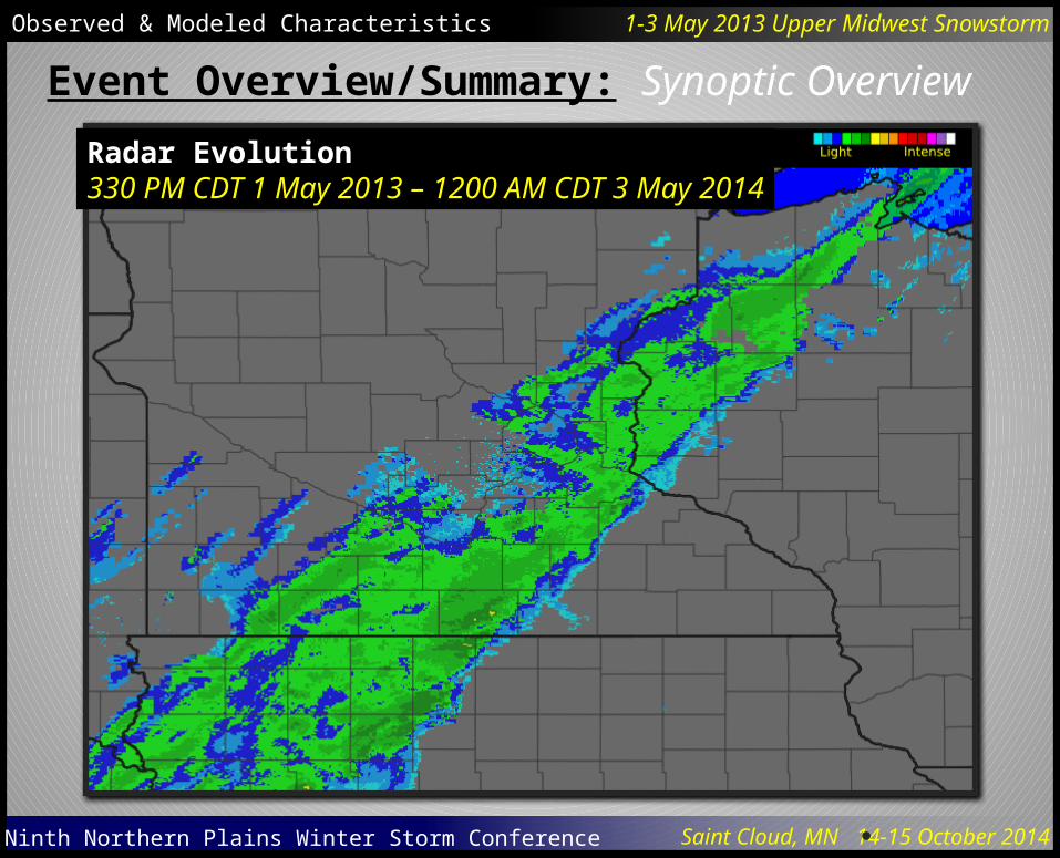
Event Overview/Summary: Synoptic Overview
Radar Evolution330 PM CDT 1 May 2013 – 1200 AM CDT 3 May 2014

Ninth Northern Plains Winter Storm Conference Saint Cloud, MN 14-15 October 2014
Observed & Modeled Characteristics 1-3 May 2013 Upper Midwest Snowstorm
• Some Minnesota Facts• Daily and monthly snowfall records were set in numerous
locations. The event went into the record books as depositing Minnesota's heaviest 24-hour May snowfall totals ever.•While May snowfalls are not uncommon in northern
Minnesota, heavy May snowfall in southern Minnesota is rare. A quick scan of all historical Minnesota May daily snowfall totals greater than or equal to 3.0 inches indicates that May 1938 may have been the last time any southern Minnesota observer reported snowfall totals of similar magnitude.
Climatological Significance

Ninth Northern Plains Winter Storm Conference Saint Cloud, MN 14-15 October 2014
Observed & Modeled Characteristics 1-3 May 2013 Upper Midwest Snowstorm
• Some Minnesota Facts (continued)•Minnesota's previous record statewide daily May
snowfall total was 12.0 inches. This threshold was reached twice: May 8, 1938 in Windom (Cottonwood County) and May 3, 1954 near Leonard (Clearwater County). The Minnesota State Climatology Office will now regard the May 2, 2013 snowfall measurement made in Dodge Center as the largest official 24-hour May snowfall total ever recorded in Minnesota. The Dodge Center snowfall observation made at 7:00 AM CDT on May 2 was 15.4 inches. More snow fell after observation time, adding up to a storm total of 17.2 inches.
Climatological Significance
Ninth Northern Plains Winter Storm Conference Saint Cloud, MN 14-15 October 2014
Observed & Modeled Characteristics 1-3 May 2013 Upper Midwest Snowstorm
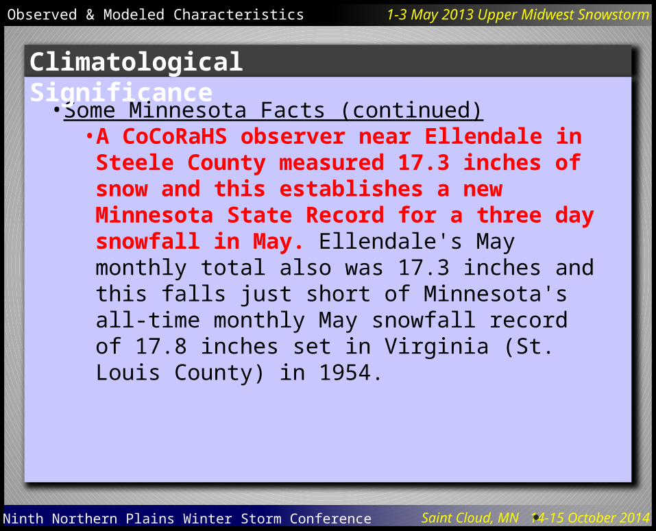
• Some Minnesota Facts (continued)• A CoCoRaHS observer near Ellendale in Steele County
measured 17.3 inches of snow and this establishes a new Minnesota State Record for a three day snowfall in May. Ellendale's May monthly total also was 17.3 inches and this falls just short of Minnesota's all-time monthly May snowfall record of 17.8 inches set in Virginia (St. Louis County) in 1954.
Climatological Significance
Ninth Northern Plains Winter Storm Conference Saint Cloud, MN 14-15 October 2014
Observed & Modeled Characteristics 1-3 May 2013 Upper Midwest Snowstorm
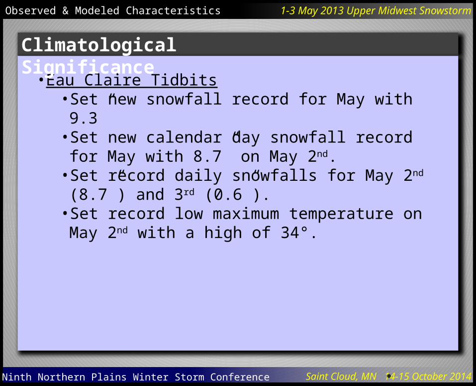
• Eau Claire Tidbits• Set new snowfall record for May with 9.3”• Set new calendar day snowfall record for May with 8.7”
on May 2nd.• Set record daily snowfalls for May 2nd (8.7”) and 3rd (0.6”).• Set record low maximum temperature on May 2nd with a
high of 34°.
Climatological Significance

Ninth Northern Plains Winter Storm Conference Saint Cloud, MN 14-15 October 2014
Observed & Modeled Characteristics 1-3 May 2013 Upper Midwest Snowstorm
Climatological Significance: Standardized Anomalies
500 mb Heights18Z 1 May 2013 through 00Z 3 May 2014

Ninth Northern Plains Winter Storm Conference Saint Cloud, MN 14-15 October 2014
Observed & Modeled Characteristics 1-3 May 2013 Upper Midwest Snowstorm
Climatological Significance: Standardized Anomalies
Mean Sea-level Pressure18Z 1 May 2013 through 00Z 3 May 2014

Ninth Northern Plains Winter Storm Conference Saint Cloud, MN 14-15 October 2014
Observed & Modeled Characteristics 1-3 May 2013 Upper Midwest Snowstorm
Climatological Significance: Standardized Anomalies
850 mb Temperature18Z 1 May 2013 through 00Z 3 May 2014

Ninth Northern Plains Winter Storm Conference Saint Cloud, MN 14-15 October 2014
Observed & Modeled Characteristics 1-3 May 2013 Upper Midwest Snowstorm
Climatological Significance: Standardized Anomalies
Precipitable Water18Z 1 May 2013 through 00Z 3 May 2014

Ninth Northern Plains Winter Storm Conference Saint Cloud, MN 14-15 October 2014
Observed & Modeled Characteristics 1-3 May 2013 Upper Midwest Snowstorm
Climatological Significance: Historical Pattern Type
Hultquist & Schmit 2009

Ninth Northern Plains Winter Storm Conference Saint Cloud, MN 14-15 October 2014
Observed & Modeled Characteristics 1-3 May 2013 Upper Midwest Snowstorm
Climatological Significance: Historical Pattern Type
Gulf-inverted Trough Composite Mean Sea Level PressureT-48 through T+48
Ninth Northern Plains Winter Storm Conference Saint Cloud, MN 14-15 October 2014
Observed & Modeled Characteristics 1-3 May 2013 Upper Midwest Snowstorm
• Significant May snowfall is climatologically rare• Large scale pattern was not necessarily eye-catching
(standardized anomalies for large scale mass fields were not extreme)• However, interaction effects of non-anomalous fields
produced highly anomalous results.•Model forecasts underwent fairly significant shifts in
potential placement of heaviest precipitation during critical watch/warning phases of the event.• Precipitation-type forecasting was difficult, with results
hinging to a large extent on where the heaviest precipitation occurred.•Most significant snowfall occurred overnight May 1st through
the morning of May 2nd.
Forecast Challenges
Ninth Northern Plains Winter Storm Conference Saint Cloud, MN 14-15 October 2014
Observed & Modeled Characteristics 1-3 May 2013 Upper Midwest Snowstorm
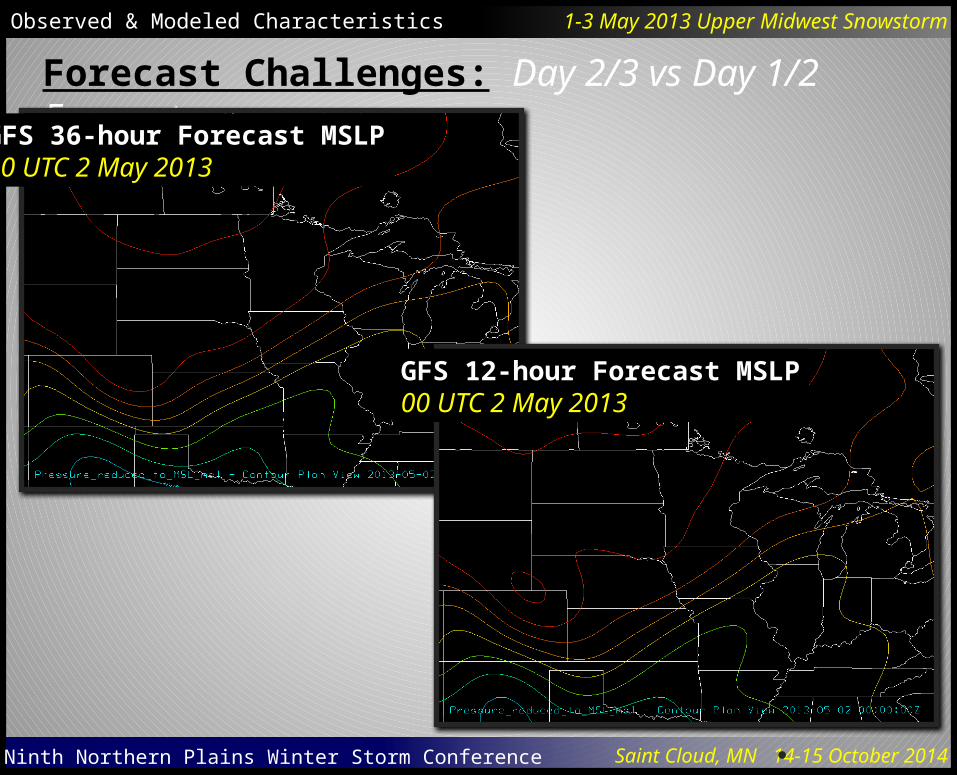
Forecast Challenges: Day 2/3 vs Day 1/2 Forecasts
GFS 36-hour Forecast MSLP00 UTC 2 May 2013
GFS 12-hour Forecast MSLP00 UTC 2 May 2013

Ninth Northern Plains Winter Storm Conference Saint Cloud, MN 14-15 October 2014
Observed & Modeled Characteristics 1-3 May 2013 Upper Midwest Snowstorm
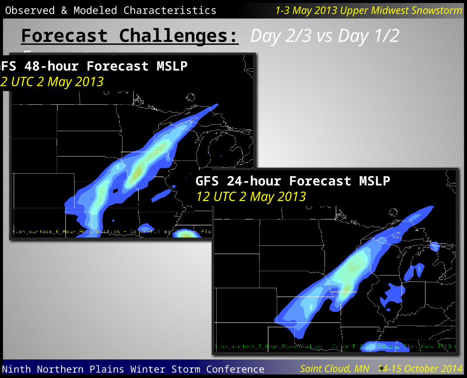
Forecast Challenges: Day 2/3 vs Day 1/2 Forecasts
GFS 48-hour Forecast MSLP12 UTC 2 May 2013
GFS 24-hour Forecast MSLP12 UTC 2 May 2013

Ninth Northern Plains Winter Storm Conference Saint Cloud, MN 14-15 October 2014
Observed & Modeled Characteristics 1-3 May 2013 Upper Midwest Snowstorm
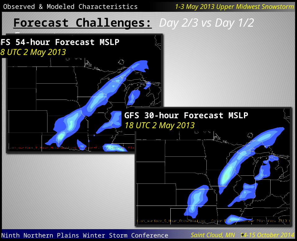
Forecast Challenges: Day 2/3 vs Day 1/2 Forecasts
GFS 54-hour Forecast MSLP18 UTC 2 May 2013
GFS 30-hour Forecast MSLP18 UTC 2 May 2013

Ninth Northern Plains Winter Storm Conference Saint Cloud, MN 14-15 October 2014
Observed & Modeled Characteristics 1-3 May 2013 Upper Midwest Snowstorm
Forecast Challenges: Day 2/3 vs Day 1/2 Forecasts
GFS 36-hour Forecast MSLP00 UTC 2 May 2013
GFS 12-hour Forecast MSLP00 UTC 2 May 2013

Ninth Northern Plains Winter Storm Conference Saint Cloud, MN 14-15 October 2014
Observed & Modeled Characteristics 1-3 May 2013 Upper Midwest Snowstorm
Forecast Challenges: Day 2/3 vs Day 1/2 Forecasts
GFS 42-hour Forecast MSLP06 UTC 2 May 2013
GFS 18-hour Forecast MSLP06 UTC 2 May 2013
Ninth Northern Plains Winter Storm Conference Saint Cloud, MN 14-15 October 2014
Observed & Modeled Characteristics 1-3 May 2013 Upper Midwest Snowstorm
Forecast Challenges: Day 2/3 vs Day 1/2 Forecasts
GFS 48-hour Forecast MSLP12 UTC 2 May 2013
GFS 24-hour Forecast MSLP12 UTC 2 May 2013
Ninth Northern Plains Winter Storm Conference Saint Cloud, MN 14-15 October 2014
Observed & Modeled Characteristics 1-3 May 2013 Upper Midwest Snowstorm
Forecast Challenges: Day 2/3 vs Day 1/2 Forecasts
GFS 54-hour Forecast MSLP18 UTC 2 May 2013
GFS 30-hour Forecast MSLP18 UTC 2 May 2013
Ninth Northern Plains Winter Storm Conference Saint Cloud, MN 14-15 October 2014
Observed & Modeled Characteristics 1-3 May 2013 Upper Midwest Snowstorm
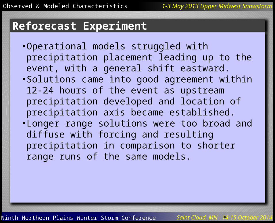
• Operational models struggled with precipitation placement leading up to the event, with a general shift eastward.• Solutions came into good agreement within 12-24 hours of
the event as upstream precipitation developed and location of precipitation axis became established.• Longer range solutions were too broad and diffuse with
forcing and resulting precipitation in comparison to shorter range runs of the same models.
Reforecast Experiment
Ninth Northern Plains Winter Storm Conference Saint Cloud, MN 14-15 October 2014
Observed & Modeled Characteristics 1-3 May 2013 Upper Midwest Snowstorm
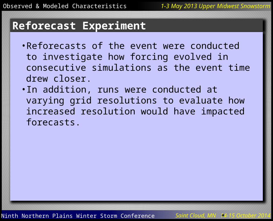
• Reforecasts of the event were conducted to investigate how forcing evolved in consecutive simulations as the event time drew closer.• In addition, runs were conducted at varying grid resolutions
to evaluate how increased resolution would have impacted forecasts.
Reforecast Experiment

Ninth Northern Plains Winter Storm Conference Saint Cloud, MN 14-15 October 2014
Observed & Modeled Characteristics 1-3 May 2013 Upper Midwest Snowstorm
Reforecast Experiment
• WRF-ARW 3.4• GFS Initial & Boundary Conditions
• 12Z 30 April, 00Z 1 May, and 12Z 1 May initial times
• 64 km > 16 km > 4 km grid configurations• 9 Simulations• 60 Vertical Levels• Kain-Fritsch used in 64 km and 16 km
grids• WSM6 Single-moment 6-class
Microphysics Scheme• Quasi-normal Scale Elimination (QNSE)
PBL Scheme• Noah Land Surface Model w/QNSE
Monin-Obukhov Similarity Theory Surface Layer Scheme• RRTMG Long Wave Radiation Scheme• RRTMG Shortwave Radiation Scheme
Model Configuration

Ninth Northern Plains Winter Storm Conference Saint Cloud, MN 14-15 October 2014
Observed & Modeled Characteristics 1-3 May 2013 Upper Midwest Snowstorm
Reforecast Experiment: 64 km vs 16 km
36-hour Precipitation Ending 00Z 3 May 2014
60-hour Forecast
60-hour Forecast
48-hour Forecast
48-hour Forecast
36-hour Forecast
36-hour Forecast
64 km
16 km

Ninth Northern Plains Winter Storm Conference Saint Cloud, MN 14-15 October 2014
Observed & Modeled Characteristics 1-3 May 2013 Upper Midwest Snowstorm
Reforecast Experiment: 64 km vs 16 km
60-hour Forecast 48-hour Forecast 36-hour Forecast
36-hour Precipitation Difference Ending 00Z 3 May 2014
60-hour Forecast48-hour Forecast36-hour Forecast
Ninth Northern Plains Winter Storm Conference Saint Cloud, MN 14-15 October 2014
Observed & Modeled Characteristics 1-3 May 2013 Upper Midwest Snowstorm
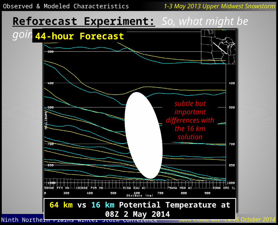
Reforecast Experiment: So, what might be going on?44-hour Forecast
64 km vs 16 km Potential Temperature at 08Z 2 May 2014
subtle but important
differences with the 16 km solution
Ninth Northern Plains Winter Storm Conference Saint Cloud, MN 14-15 October 2014
Observed & Modeled Characteristics 1-3 May 2013 Upper Midwest Snowstorm
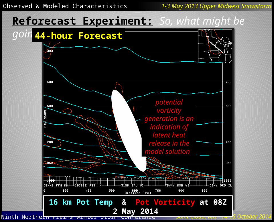
Reforecast Experiment: So, what might be going on?44-hour Forecast
16 km Pot Temp & Pot Vorticity at 08Z 2 May 2014
potential vorticity generation is an
indication of latent heat
release in the model solution

Ninth Northern Plains Winter Storm Conference Saint Cloud, MN 14-15 October 2014
Observed & Modeled Characteristics 1-3 May 2013 Upper Midwest Snowstorm
Reforecast Experiment: So, what might be going on?44-hour Forecast
64 km 2-D Frontogenesis at 08Z 2 May 2014
44-hour Forecast
16 km 2-D Frontogenesis at 08Z 2 May 2014

Ninth Northern Plains Winter Storm Conference Saint Cloud, MN 14-15 October 2014
Observed & Modeled Characteristics 1-3 May 2013 Upper Midwest Snowstorm
Reforecast Experiment: So, what might be going on?44-hour Forecast
64 km & 16 km Omega at 08Z 2 May 2014
16 km solution more narrowly
focused and equatorward

Ninth Northern Plains Winter Storm Conference Saint Cloud, MN 14-15 October 2014
Observed & Modeled Characteristics 1-3 May 2013 Upper Midwest Snowstorm
Reforecast Experiment: So, what might be going on?44-hour Forecast
64 km Geostrophic Saturated EPV & Theta-E Lapse Rateat 08Z 2 May 2014
64 km solution did provide
ingredients and a hint of what could occur
Ninth Northern Plains Winter Storm Conference Saint Cloud, MN 14-15 October 2014
Observed & Modeled Characteristics 1-3 May 2013 Upper Midwest Snowstorm
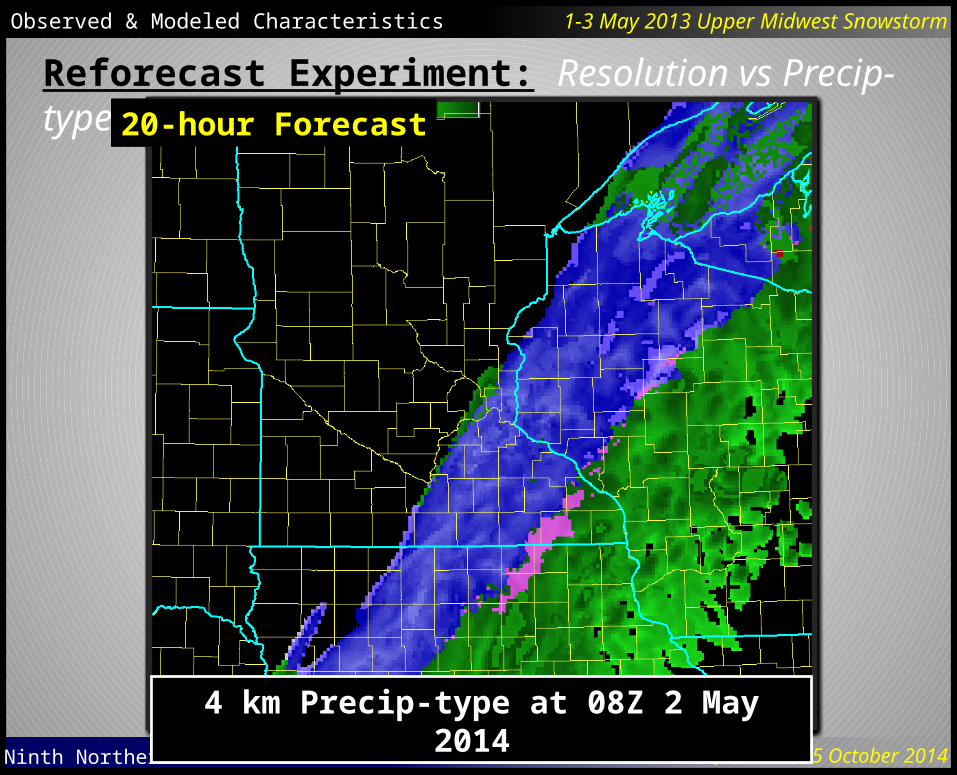
Reforecast Experiment: Resolution vs Precip-type 20-hour Forecast
64 km Precip-type at 08Z 2 May 2014
20-hour Forecast
16 km Precip-type at 08Z 2 May 2014
20-hour Forecast
4 km Precip-type at 08Z 2 May 2014

Ninth Northern Plains Winter Storm Conference Saint Cloud, MN 14-15 October 2014
•Was a historic and challenging event.• Forecast challenges arose due to anomalous nature of event,
inconsistent model behavior, narrow axis of heavy precipitation, and precipitation-type issues.• Improvement in guidance as event drew closer in time was
likely only partially due to initial condition uncertainties. Model resolution, and the ability to accurately forecast heavy/convective precipitation at longer lead times, likely played a role in model performance.• Sets the stage for additional experiments and evaluation.• HopWRF-TS now being run at MPX to provide forecasters
with enhanced resolution guidance over a forecaster-specified 36-hour time window between 0 and 174 hours.• GFS resolution upgrade coming around the holidays
(increase from ~27 km to ~10 km)
Concluding Thoughts
Observed & Modeled Characteristics 1-3 May 2013 Upper Midwest Snowstorm