Embed Size (px)
Citation preview


OBSERVATIONS ON THE RIGHT-OF-WAY OF
THE POINTED MOUNTAIN GAS PIPELINE
by
E.B. OwenNorthern Natural Resources and Environment Branch
Department of Indian and Northern Affairs
and
D.W. Van EykEnvironmental-Social Program
Northern Pipelines
for the
Environmental-Social ProgramNorthern Pipelines
February 1975
Environmental-Social CommitteeNorthern Pipelines,Task Force on Northern Oil DevelopmentReport No. 74-30
Information CanadaCat. No. R57-36/l975

TABLE OF CONTENTS
SUMMARY
PART I. TERRAIN CONDITIONS
1
1. Introduction 3
2. Terrain Damage(a) General. . . . . • . . . . . . . . . . . . . . . . . . . . . . 5(b) Swamp area west of Fisherman Lake.. 7(c) Kotaneelee River ..•.......... ~..... 8(d) LaBiche River ~. ...•.... 9(e) Permafrost Areas 10
3. Land Permit No. 2267 ...... . • . ~~ 11
4 . Recommendations 14
PART II. REVEGETATION
1. Introduction 17
2. Present Status of Revegetation(a) General. . . . . . . . . . . . . . . . . . . . . . . . . . .. 19(b) Swamp area west of Fisherman Lake .. 21(c) Kotaneelee River ...........•....... 21(d) LaBiche River ..............•....... 22(e) Permafrost Areas 22
3. Discussion and Conclusions 22
4 . Recommenda tions .....•...................
REFERENCES .....••................'.............•..
APPENDIX A. . .......•.........•....................
FIGURES ti ••••••••••••••••••••
24
26
27
35

Figure 1:
Figure 2:
Figure 3:
Figure 4:
Figure 5:
Figure 6:
Figure 7:
Figure 8:
Figure 9:
LIST OF FIGURES
Location map of the Pointed Mountain gaspipeline route.
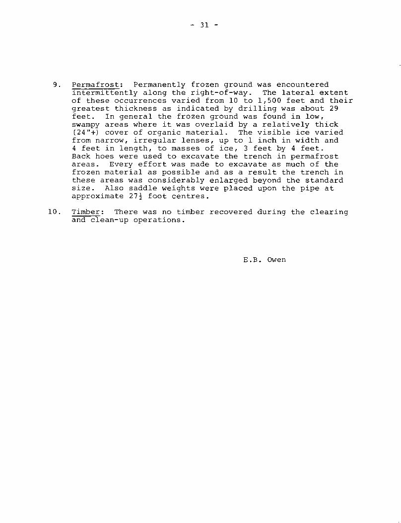
Water-filled borrow pit at edge of rightof-way excavated by seismic operators toobtain material to construct a crossingover the buried pipeline (Station 179+00).
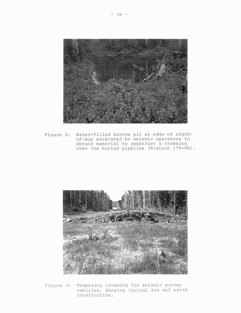
Temporary crossing for seismic surveyvehicles, showing typical log and earthconstruction.
Stream crossing the right-of-way atStation 507+00 is actively eroding thepipeline berm (eroding face is 1.0 m high) .
a) Gravel berm constructed over an exposedsection of the pipe in the KotaneeleeRiver.b) Gravel source from alluvial barapproximately 100.00 m upstream of theberm.
Recently constructed berm over exposedpipe at Fisherman Lake (Station 1701).Note ponding and renewed erosion bytruncated stream in centre of thephotograph.
Kotaneelee bluff (Station 1159+00) showingactively sliding slopes, sandbag breakersprotecting the pipeline berm and deepgullies eroded by diverted water~ Scaleis provided by person at top of the bluff.
Thermokarst subsidence associated with apermafrost area along right-of-way(Station 859+60).
Exposed pipe at Station 533+50~ Note thewood debris in the backfill of the trench.
4
36
36
37
37
38
38
39
39

Figure 10: Ubiquitous subsidence trench over theburied pipe. Depth varied from 15 cm tomore than 1.5 m. Note also better grassgrowth on spoil side of right-of-way,leaning trees and wood debris.
Figure 11: Aerial photograph in colour infraredshowing effect of warm pipeline on earlygrass growth. Grass (red) is beginningto grow on the berm while the rest of theright-of-way is still snow covered.
Figure 12: Four year old seismic line revegetated bynatural invasion of native species.
Figure 13: Accumulated winter killed grasses resemblean unmowed "hay field".
40
40
41
41

Le gazoduc de Pointed Mountain a ete 1e premier pipeline des Territoiresdu Nord-Ouest et du Yukon i ~tre construit sous reserve de remettre enetat l'emprise du pipeline, en vertu du Reglement sur l'utilisation desterres territoriales. La reussite ou l'echec des mesures prises i ceteffet par la societe Westcoast Transmission Company Ltd. sont d'un interetparticu1ier, non seulement afin de determiner si la societe a respecteles conditions et stipulations du permis d'utilisation des terres, maisaussi afin d'evaluer ces mesures comme moyen de determiner les besoinsappropries pour la remise en etat des futurs parcours de pipeline.
Un examen des 1ieux a ete entrepris en juin 1974 par les auteurs durapport, au nom de la Direction des res sources naturelles et del'environnement du Nord (ministere des Affaires indiennes et du Nord)et du Programme ecologique et social, pipelines du Nord (Groupe de travail sur l'exploitation du petrole dans le Nord), afin de decouvrir toutdommage cause au terrain pendant ou apres la construction du pipelineet pour evaluer toute mesure prise par la societe pour remettre l'empriseen etat apres la construction.
Le rapport se divise en deux parties.conditions generales du terrain et lade la couverture vegetale.
La premiere partie porte sur lespartie 2 etudie le retablissement
Les observations suivantes ont ete faites au cours de l'examen du terrain:
1. L'etat du terrain est assez bon sur presque tout 1e parcours. On acons tate que le conduit etait i decouvert en trois endroits (Station533150, st~tion 853fOO et station 1110-1112) et avait ete recouvertrecemment dans le lit de la riviere Kotaneelee et dans 1es terresmarecageuses du lac Fisherman.
2. Des appareils sismiques et d'entretien en mouvement le long dupipeline, ou traversant la ligne du conduit, ont endommage lesremblais de protection, nui aux bornes-signaux de la Commissiongeologique du Canada et perturbe le lit de certains cours d'eau.De nombreuses petites ballastieres se sont ouvertes le long del'emprise depuis la construction initiale du pipeline.
3. Neuf croisements sismiques ont ete enregistres, mais seulement troisetaient connus de Service des terres et for~ts du Nord-Ouest, i FortLiard. L'agent d'entretien de la societe Westcoast Transmission nesavait pas au juste de quel organisme gouvernemental relevait lasurveillance des travaux sismiques le long de l'emprise.
4. D'autres travaux de remise en etat s'imposent sur les berges desrivieres LaBiche et Kotaneelee, dans le lit de la riviere Kotaneeleeet dans les zones marecageuses du lac Fisherman.
5. Le programme de revegetation a produit une bonne pousse d'herbe a lasurface du sol presque tout le long du parcours. Cependant, lacouverture vegetale n'emp~che presque pas le ravinement cause parl'eau, d'autant plus que les brisants des berges sont mal construits.

6. Les especes vegetales indigenes ne sauraient concurrencer lesgraminees qui ont ete largement semees et qui croissent tres vite,mais elles dominent dans les substrats tourbeux et les endroitshumides.
7. La presence locale du pergelisol n'a pas empeche la croissance desgraminees semees a cette latitude.
8. Le cote compact de l'emprise a ete le moins favorable a la croissance de l'herbe, tandis que la terre de remblayage bien aereede la terrasse caillouteuse a bien repondu a l'ensemencement.Vne epaisse couche de copeaux de bois, qui apparait ici et lasur le cote du deblai, a retarde la croissance d'une couverturevegetale.
9. Vne voie de derivation et une ligne sismique amenagees sur uneterrain bien draine et de rtiveau, se sont recouvertes de vegetationpar un processus naturel, respectivement en deux et quatre ans,avons-nous constate au cours de l'etude.

- 2 -
2. Seismic and maintenance equipment moving acrossand along the line has damaged breakers,interfered with Canada Survey monuments anddisrupted stream channels. Numerous small borrowpits have been opened along the right-of-waysince the initial construction of the pipeline.
3. Nine seismic cross-overs were recorded, onlythree of which were known to exist by theNorthwest Lands and Forest Service in Fort Liard.Westcoast Transmission's maintenance officer wasuncertain as to which Government agency hasjurisdiction over seismic operations on theright-of-way.
4. Additional rehabilitation is required on theLaBiche River and the Kotaneelee River slopes,the Kotaneelee River channel and the FishermanLake swampland.
5. The vegetation program has yielded a good aboveground growth of grasses over most of the route.The grass cover has little effect in inhibitinggullying by water, concentrated by poorlyconstructed breakers on slopes.
6. Native species could not compete with theheavily seeded, rapidly growing introduced grassesbut were dominant on peaty substrates and wetlocations.
7. The local presence of permafrost did not inhibitthe growth of seeded grasses at this latitude.
8. The compacted side of the right-of-way was leastfavourable, the well-aerated backfill of the bermmost favourable, to the establishment of grasses.A dense layer of woodchips locally present on thespoil side retarded the establishment of vegetativecover.
9. A shoo-fly (by-pass)road and a seismic line on level,well drained terrain, were found to have becomerevegetated by natural means in two and four years,respectively.

- 1 -
SUMMARY
The Pointed Mountain gas pipeline was the firstbuilt in the Northwest Territories and the YukonTerritory for which specific provision to rehabilitatethe right-of-way were required under the authority ofthe Territorial Land Use Regulations. The success orfailure of the steps taken by Westcoast TransmissionCompany Ltd. in this regard is, therefore, of interestnot only in order to determine whether or not theCompany has complied with the terms and stipulationsof the land use permit but also in order to evaluatethe measures as an aid in determining appropriaterehabilitation requirements for future pipelinerights-of-way.
A field examination was, therefore, carried out bythe authors, on behalf of the Northern Natural Resourcesand Environment Branch (Dept. of Indian and NorthernAffairs) and the Environmental-Social Program,Northern Pipelines (Task Force on Northern OilDevelopment) in June, 1974, to examine any damage tothe terrain that may have been caused during orsubsequent to construction of the pipeline, and toassess any measures undertaken by the Company torehabilitate the route subsequent to construction.
The report is in two parts: Part 1 deals withterrain conditions in general and Part 2 discussesthe re-establishment of a vegetative cover.
The following observations were made in the courseof the field examination:
1. Terrain conditions are fair to good over most ofthe route. The pipe was found to be exposed atthree sites (Station 533+50, Station 853+00 andStation 1110-1112), and had recently beenre~cov~red in the Kotanee1ee River Channel andthe Fisherman Lake swampland.

- 3 -
PART I. TERRAIN CONDITIONSE.B. Owen,Northern Natural Resources and Environment Branch,Department of Indian and Northern Affairs.
1. Introduction
This report describes the observations made duringa brief visit to the Pointed Mountain Gas Pipeline inorder to examine any damage to the terrain that mayhave resulted from the construction of the pipeline andto assess any measures undertaken by the pipelinecompany to rehabilitate the route subsequent toconstruction.
Westcoast Transmission Company Limited's ~4.l mile(54.6 km) 20-inch (51 em) diameter gas transmissionline extensIori-"ttom the Beaver River gas field inextreme northern British Columbia to the PointedMountain gas field in the Northwest Territories is thefirst Canadian-owned pipeline in the NorthwestTerritories. Commencing at Beaver River the lineextends northerly for 2.5 miles (4.0 km) to the BritishColumbia/Yukon boundary and thence in a northeasterlydirection to Pointed Mountain (Fig. 1). The linecrosses the boundary between the Yukon and NorthwestTerritories at approximately mile 15.4 (24.6 km). Itwas constructed from January to March, 1972. Theauthor was present on the project from commencement ofclearing the right-of-way until final clean up was wellunderway. A preliminary report dated April 27, 1972,which briefly describes the construction of thepipeline appears in Appendix A.
Three days" (June 12-14, 1974) were spent walkingalong the pipeline right-of-way, proceeding north fromthe British Columbia/Yukon boundary, a helicopter wasused to cross the LaBiche and Kootaneelee Rivers andswampy stretches west of Fisherman Lake. This timeof year is probably the best "for an inspection of thepipeline route. The dense growth of grasses describedby Heginbottom (1974) had been winter killed and thenew growth had not reached sufficient height to impedefield observations. There were no fires that couldrequire the services of the chartered helicopter, andthe mosquito season had only just started. Anadditional day was spent examining the Pointed Mountain

- 4 -
FIGURE I - LOCATION MAP OF THE POINTED MOUNTAIN GAS PIPELINEROUTE.

- 5 -
gas gathering system and in discussion with theActing Resource Management Officer at Fort Liard. OnJune 13 we had a brief discussion with an official ofthe Fort Nelson district of Westcoast Transmission whovisited us on the right-of-way.
The chainages used in this report are those usedduring the construction of the pipeline. They aremeasured in hundreds of feet commencing at thesouthern (Beaver River) end of the line. Most of thechainage stations are still visible and it was thusrelatively easy to locate oneself along the line.
The term breaker refers to structures built acrossthe right-of-way to divert surface water way from theburied pipe. The following two types of breakers wereconstructed along the Pointed Mountain pipeline route:
(a) A shallow trench 12-24 in. (30-60 cm) deepand 24-36 in. (60-90 cm) wide, bulldozeddiagonally down slope across the right-ofway. The spoil was usually pushed up alongthe downstream side of the trench. Thesewere constructed during the final phase ofthe clean-up operation.
(b) Rows of sandbags extending from the buriedpipe to the sides of the right-of-way.These run diagonally down slope usually ina herring-bone pattern. In some places thesandbags were placed on ground surface andin others on a 10-12 in. (25-30 cm) diameterlog. Breakers consisting of sandbags wereused extensively on the steep south wall ofthe Kotaneelee River valley where unstablesoil conditions exist.
2. Terrain Damage
(a) General
Terrain conditions along the right-of-way may bedescribed as from fair to good. They are certainlynot excellent. During the construction pha~e it wasthis writer's opinion that the company was extremelycareful not to cause more d amaqe to the terrain thanwas necessary to construct a safe, dependable

- 6 -
pipeline. However, since that time both seismic andmaintenance equipment have moved across and along theline and in the course of their activities havedamaged breakers, blocked stream channels by means oftemporary crossings, and opened up numerous smallborrow pits to obtain material for pipeline crossingsand for covering the pipe in locations where it hadbecome exposed. It is understood that the seismicoperator intends to return to the area to conduct aclean-up operation in July, 1974. However, it seemsextraordinary that the blocked streams and truncatedbreakers were not restored during or immediatelyfollowing the operation.
Considerable terrain damage has resulted from theopening of small borrow pits along the edges of thepipeline right-of-way by the seismic operators toobtain material to construct 'cross-overs' over theburied pipe. At Station 1270+00 a borrow pit wasconstructed on the west side of the right-of-way inan area of permafrost which was clearly identified assuch by signs along the right-of-way. Water hadcollected in the muddy depression and it appearedlikely that thermal subsidence was occurring (Fig. 2).If the seismic line had been moved only 400 feet(122 m) north, the permafrost terrain would have beentotally avoided.
There seems to be some confusion as to the numberof temporary crossings constructed for seismicexploration along the right-of-way. The NorthwestLands and Forest Service at Fort Liard indicated thatthey had knowledge of only three 'cross-overs', butthe following nine were identified in the field:
1. Station 179+002. Station 192+503. Station 428+004. Station 586+505. Station 908+506. Station 993+007. Station 1270+008. Station 1480+00 plus one additional cross-over
north of Station 1270.
The Maintenance Manager for Westcoast Transmissionstated that the Company has no authority over seismic

- 7 -
operators using the pipeline right-of-way and was ofthe opinion that these operators would be under thejurisdiction of either the National Energy Board orthe Northwest Lands and Forest Service.
Two borrow pits have been opened by WestcoastTransmission immediately west of the right-of-way inthe proximity of Station 1712 to obtain material fora berm over an exposed section of the pipe in the low,swampy area west of Fisherman Lake. The borrow pitsare located close to a section of the right-of-waywhere permafrost was encountered during construction.As far as is known no attempt was made to determinethe presence of permafrost on the site before thesepits were opened.
Streams cutting across the pipeline right-of-wayrepresent a potential hazard to the integrity of theburied pipe. A drainage channel 4 ft. (1.2 m) deepand 6 ft. (2.0 m) wide had been eroded by an eastflowing creek (Station 507+00). The stream islaterally eroding into the pipeline berm (Fig. 4).
At approximately Station 772, on the top of thenorth wall of the LaBiche River valley, a small borrowpit was opened along the east side of the right-of-wayto obtain material for back-filling the steep,unstable slope leading down to the river.
with the apparent consent of the Fisheries andMarine Service, Environment Canada, WestcoastTransmission bulldozed some 400-500 cubic yards(400 m3
) of gravel from a bar in the south channel ofthe Kotaneelee River to cover an exposed section ofthe pipe (Fig. 5). The reasoning behind grantingpermission to remove granular materials from what, inthe past, has been considered to be an environmentallysensitive deposit is unclear to the writer.
(b) Swamp area west of Fisherman Lake
The trench for the pipe in this area was excavatedby backhoes straddling the ditch line since the groundwas saturated and thus soft even in mid-winter. Forthe most part, the trench was filled with water whenthe pipe was placed in it. Subsequently, saddleweights were set on the pipe. Since construction, the

- 8 -
following sequence of events has taken place:
(i) hydraulic erosion of the ground surfacewas caused by two small streams whosemeandering courses had been obstructedby the pipeline berm with no provisionto conduct the flow of water across theright-of-way,
(ii) the pipe expanded because of poortemperature control of the gas,
(iii) consequently, improperly placed saddleweights slid off the pipe and,
(iv) finally, the pipe rose from its bed andwas exposed at ground surface.
Rehabilitation procedures instigated so far byWestcoast consist of construction of a diversionditch to carry the flow from these streams, and burialof the exposed section of the pipe beneath a berm ofmaterial excavated from a nearby borrow pit (Fig.6).It is suggested that if these measures are notsuccessful it may be necessary to attach river weightsto the pipe.
(c) KotaneeZee River
Prior to construction it was realized that a cutwould be necessary at the top of the steep bluff thatforms the south wall of Kotaneelee River valley toproduce a grade suitable for installing the pipe. Itwas believed that 2:1 slopes on the sides (sand 68%,silt 20%, clay 6%) of the cut would ensure thestability of the silty sand deposits and still keepthe right-of-way within the confines of the 100 foot(30 m) width set out in the permit issued to theCompany. D~ring construction a field decision wasmade to decrease the slopes of the cut to 2!:1 andconsequently to increase the width of the right-of-way.The present width of the right-of-way at the top ofthe bluff exceeds 200 feet (60 m). The constructionmethod used was a standard cut-and-fill operationwhereby the material excavated from the cut wasbulldozed down slope to the toe of the bluff. Thedepth of the trench on the slope was the standard5 feet (1.5 m) but was increased slightly in the fill

- 9 -
area. However, even with the increased depth, asection of pipe at the bottom of the bluff rests onfill material and not in original soil.
Since construction, ~onsiderable surface watererosion has occurred in the cut (Fig. 7). Sand bagbreakers installed during construction have more orless successfully diverted water to the edges of thecut where it has eroded gullies up to 5 feet (1.5 m)deep along the toes of the side slopes thusincreasing their instability. Gullying has alsooccurred on the upslope side of the breakers.
The grade of the side slopes of the cut should bedecreased to about 3:1. This would entail a wideningof the right-of-way for which government approvalwould be required. As well as regrading the sideslopes Westcoast proposes to baekfill the gulliesalong the breakers and the toes of the side slopesand install sections and half-pipe 20-24 inches(51-60 cm) diameter. Also the entire right-of-way,including the cut slopes, would be fertilized andseeded.
The proposals by Westcoast to rehabilitate theright-of-way in the area if carried out in theirentirety should go a long way toward alleviating theexisting terrain problems. Otherwise a continuingmaintenance problem will exist.
During construction, the pipe was buried some23 feet (7 m) beneath the surface of the water inwhat was then the main channel of Kotaneelee Riverand 5 to 6 feet (1.5 - 2 m) beneath the rest of thevalley floor. Since that time the main flow of waterswitched to the south channel of the river andsubsequent scour exposed the pipe beneath that channel.As described previously, a gravel berm has since beenconstructed over the exposed section (Fig. 5). Thatberm is not a permanent solution as active erosion byriver water is occurring. To avoid a continuingmaintenance problem, the pipe should be reburied to agreater depth across the entire area where activechannels exist.
(d) LaBiche River
Considerable sliding has occurred in the upper
,.

- 10 -
part of the steep bluff forming the south wall of theLaBiche valley. The material is a silty, clayey till.Bedrock, consisting of highly weathered, thin-beddedshale and sandstone, overlain by a small terrace ofglaciofluvial gravel was encountered in the pipetrench at the toe of the bluff during construction.There has been no sliding in these materials.
Remedial work done on this bluff since constructionapparently has consisted of bulldozing material into asmall dike along the brow of the bluff. The purpose ofthe dike was to divert surface water to the sides of theright-of-way. This measure was only partially successful as much of the unstable dike material is slidingdown the right-of-way. It is suggested that rather thanadding material to the slope it should be cut back todecrease the grade, and that sand bag breakers beconstructed at least on the upper two-thirds of thebluff. The cut slopes along the sides of the right-ofway and the right-of-way itself should then be seededand fertilized.
(e) Permafrost Areas
The limits of the larger areas of permafrostterrain encountered during construction of the pipelinewere marked by plainly visible signs along the right-ofway. However, even without the markers these areascould be identified without difficulty during the visit.Permafrost occurred in low, swampy, poorly drainedlocalities and is usually covered with a dense growthof small black spruce. During construction it wasfound that it was extremely difficult to excavate thepipe trench in ice-rich permafrost as the ditchingmachines tended to 'climb', making it hard for theoperator to maintain the proper grade for the floor ofthe trench. In most permafrost areas, therefore, thepipe trench had to be excavated with back hoes orbulldozers equipped with rippers. The width of thetrench had to be increased to accommodate the saddleweights placed on the pipe in all permafrost areas.As a consequence of the greater movement of excavationequipment in the vicinity of the trench in permafrostareas considerably more terrain degradation hasoccurred than in other localities (Fig. 8).

- 11 -
Possible thermokarst features consisting ofrectangular shallow water-filled depressions up to3 feet (1 m) in depth and 10 feet (3 m) in diameterare present in some localities but are not common.Most occur within about 40 feet (12 m) of the buriedpipe.
Movement of heavy equipment along the right-of-waysince the construction period has caused considerabledamage to the terrain in some permafrost areas. Thereis evidence that some of this movement took place whenthe ground surface was not completely frozen. In onearea a corduroy road was constructed along the edge ofthe right-of-way to avoid a particularly wet spot.
3. Land Permit No: 2267
On January 20, 1972 a land use permit was issuedto Westcoast Transmission Company Ltd. under theauthority of the Territorial Lands Act to permit thecompany to construct, operate and maintain a buriednrl~ ninplinp rl~rn~Q rprr;rnr;ril lrin~Q ~r~~ rho.J~-;- L-,i"------ ------- ----~- ......---- ---- ......._- .... _-""~ • ..... ...... -
Pointed Mountain dehydration plant south to a point onthe 60th parallel of latitude, which at that pointforms the boundary line between the Yukon Territory andthe Province of British Columbia. The permit containsa series of stipulations, binding on the company, inrespect to erosion control and other means ofpreventing environmental degradation.
During the course of the field investigation itappeared that several of the stipulations in theagreement had not been carried out. However,subsequent discussions with Westcoast's MaintenanceManager and the Acting Resource Management Officer atFort Liard revealed that since construction seismicsurveys had taken place in several localities alongthe pipeline right-of-way. Consequently, until theseismic operators have completed their 'clean-up' presumably in July, 1974 - it will be difficult todetermine who is responsible for many of the obviousproblems along the right-of-way.
(a) Paragraph 18 of the agreement states that,during construction, Westcoast could extendthe width of the right-of-way to 100 feet(30 m). Although not definitely stated, it

- 12 -
is assumed that the 100 foot (30 m) limit wouldhold also for maintenance operations. - Duringthe field investigation it was noted thatduring its maintenance program Westcoast hadopened a number of borrow pits along the sidesof the right-of-way and thus effectivelyincreased its width to 200-300 feet (60-90 m) .
(b) Paragraph 23 of the agreement requires Westcoastto report, investigate and restore all damagedsurvey monuments. Since construction of thepipeline a series of bench marks marked ·CanadaSurvey' had been established along the eastside of the right-of-way. Some of these havesubsequently been disturbed by passing heavyequipment. Apparently, neither Westcoast'sMaintenance Manager nor the Acting ResourceManagement Officer had been aware of theexistence of these bench marks.
(c) In paragraph 28 it is stated that the pipeshould be laid underground and the groundshould be restored to its original level.During field investigation it was observedthat sections of pipe were exposed in thefollowing areas (Fig. 9):
Station 533+50Station 853+00Stations 1110 - 1112
Greater lengths of pipe had been exposedbeneath the south channel of the KotaneeleeRiver and in the swamp area west of FishermanLake but prior to this visit had been againcovered over with berms.
An almost continuous subsidence trenchranging from 6-12 inches (15 cm to 30 cm) ormore in depth exists over the buried pipe(Fig. 10). This is probably due to the lackof consolidation of the frozen ice-rich fill,placed over the pipe in the winter. Gullyingby water concentrated in the trench reacheddepths of 5 feet (1.5 m) or more in somelocations. Also the 3 to 4 foot (1 m) berminitially placed over the buried pipe was notalways located correctly. An official of

- 13 -
Westcoast stated that the company planned onbackfilling the trench with a special machinewith which they had had considerable successon previous occasions. He did not say wherethe backfill was to be obtained although somewould be available in the remnants of theberm which invariably exists along the westside of the trench.
(d) Paragraph 29 requires the company to set uperosion controls along the right-of-way. Insome places these controls leave much to bedesired. At the end of the clean-up phaseduring construction, bulldozed breakers wereconstructed at more or less regular intervalsalong most of the right-of-way. Some of thoseplaced on slopes performed in a satisfactorymanner; others, such as those on the tops ofsmall knolls, were useless. The sand bagbreakers on the steep bluff south of theKotaneelee River performed as well as could beexpected but few, if any, breakers wereinstalled on the steep till bluff immediatelynorth of the LaBiche River. Some smallc+-ro.:::.mc r-,..-"cc; Y'\rT ~ho ,..-; nh~_r'\4=_'f.7"::"l"7 ~h_-:)+- 'h_,=,,~_ ....__ ......... - --_ .... _-- ...... ::J _ ...... - ':].L .......... __ '1'1 ....... 1 .......................... .1..1. ....... """""
been disrupted by activities subsequent toconstruction of the pipeline, are flowingalong the right-of-way, frequently along thesubsidence trench overlying the buried pipe.
(e) Paragraph 30 relates to the disruption ofnatural drainage resulting from surfacesubsidence due to melting of permafrost. Insome permafrost areas small streams are nowflowing through shallow thermokarstdepressions.
(f) In paragraph 31 it is stated that thestability of slopes has to be maintained toavoid the possibility of landslides. This isunderstood to include cut slopes on the rightof-way. Most slopes are reasonably stableexcept those at the LaBiche and KotaneeleeRivers where considerable more remedial workis required.
(g) Paragraph 36 states that all debris depositedin any gully or stream must be removed.There are several streams along the right-ofway into which debris has been pushed to

(a)
- 14 -
assist equipment to cross the stream and whichsubsequently has not been removed. It isbelieved that most of this debris will beremoved during the clean-up by the seismicoperators.
4. Recommendations
( As far as the rehabilitation of the pipeline
)
1 right-of-way is concerned WestcoastTransmission seems to be long oh promises andshort on positive action. According to the
~responsible official, the Company is fullycognizant of the problems involved and hasplans to solve them in the near future.However, Westcoast's present maintenanceprogram seems stop-gap in nature and isprobably similar to those carried out inother parts of their gas transmission systemin Alberta and British Columbia.
(b) Aside from the fact that the clean-up ofseismic operations has not been completed,the rehabilitation efforts of westcoastTransmission along the pipeline right-of-wayshould not be declared satisfactory until thefollowing are done:
1. Borrow pit areas are graded, fertilizedand seeded;
2. All Canada Survey bench marks are checkedfor damage and replaced, if necessary;
3. The ubiquitous subsidence trench over theburied pipe is backfilled and a 24-inch(60 em) berm constructed over it;
4. The steep bluffs north of the LaBicheRiver and south of the Kotaneelee Riverhave been regraded, the present breakersrepaired and, in the case of the LaBichecrossing, more breakers constructed;
5. All streams crossing the right-of-wayhave been properly channelled. Thiswould include those in the swamp areawest of Fisherman Lake;

- 15 -
6. All trees that have fallen onto the rightof-way since construction are removed; and
7. At the Kotaneelee River crossing the pipeis buried across the entire area whereactive river channels exist to a depthcomparable to that beneath the formermain channel.
(c) All future borrow pit locations should beselected with care. It is suggested thatalong the pipeline route the best sites forborrow pits are on higher ground, especiallyon the tops of knolls where there would beless surface water accumulation and lesschance of encountering permafrost.
(d) The proponent should be required to have afull understanding of applicable legislationand jurisdiction regarding pipelineconstruction and operation.

- 17 -
PART II. REVEGETATIOND.W. Van Eyk,Environmental-Social Program,Northern Pipelines.
1. Introduction
The Pointed Mountain gas pipeline was the firstbuilt in the Northwest Territories and the YukonTerritory for which specific provisions to rehabilitatethe right-of-way were required under the authority ofthe Territorial Land Use Regulations. The success orfailure of the rehabilitation program carried out byWestcoast Transmission Company is therefore of interestnot only to determine whether or not the company hascomplied with the terms and stipulations of the landuse permit but also in order to evaluate the measuresas an aid in determining appropriate rehabilitationrequirements for future pipeline rights-of-way. Thisreport discusses the efforts made by the company tore-establish a vegetative cover on the cleared right-ofway.
Following laying of the pipe, backfilling of theditch, and removal of debris, the entire pipelineright-of-way was seeded and fertilized from a fixedwing aircraft on March 22, 1972. At that time,several inches of snow covered the ground surface. Theseed mixture used (designated as Westcoast TransmissionSeed Mix No.2) had the following composition (Kavanagh,1974, pers. com.):
I
I
Type of Seed
Tetraploid RyegrassPerennial RyegrassAnnual RyegrassManchar Bromegrass (P.R.)Boreal Fescue (P.R.)Climax TimothyRed TopCrested WheatgrassKentucky BluegrassHighland BentgrassAurora AlsikeRhizome Alfalfa
ApproximatePercent by Weight
4.04.04.0
15.025.0
8.05.05.07.05.08.0
10.0

- 18 -
The mixture was intended for a slightly basic(pH 8.0) silty clay soil with low nutrient and organicmatter contents.
The rate of application was 60 Ibs. of seed mix and300 Ibs. of 26-18-9 fertilizer per acre (67 kg and 336kg per hectare respectively). On August 15 r 1972, theright-of-way was refertilized from the air with 19-19-19fertilizer at an application rate of 150 Ibs. per acre(168 kg per hectare). According to Company personnel,no further follow-up operations were conducted exceptfor manual seeding and fertilization on the banks of theKotaneelee and LaBiche Rivers. A seed mixture of 54%creeping red fescue and 46% alsike clover with EssoEngro 34-0-0 commercial fertilizer was found stock-piledalong the right-of-way, presumably for these maintenanceoperations.
Several overflights of the pipeline route, carriedout by Government personnel in 1972 and 1973 haveidentified "trouble spots" along the right-of-way.Speller (1972) observed that the pipe was exposed at thesummit of the northeast LaBiche slope but that onlyminimal rutting occurred on gentle slopes, and thaterosion on several very steep slopes was minimal due toeffective sandbagging. An exposed section of pipe onthe LaBiche slope was photographed by Tywoniuk (pers.comm.). Heginbottom (1974) identified three problemsections, (during his reconnaisance survey in 1973) :(i) the steep Kotaneelee bluff; (ii) the steep LaBicheslope; and (iii) the swamp area west of Fisherman'sLake. He reported that Westcoast Transmission wasplanning a restoration program for the winter of 1973.
By June, 1974, the steep LaBiche slope had beengraded by end dumping of material over the crest of theslope. Ruts on various gentle slopes had developed intosizeable gullies up to 6 feet (2 m) deep exposing thepipe in three separate locations. A short steep slopejust south of the Kotaneelee bluff (approximate chainage1111-1112) had been graded by bulldozer but not reseeded.This repair work completely obliterated the previouslyexisting breakers. Gullying in the new material hadexposed a short section of the pipe. A three to fourfoot deep (1 m) gully had developed on the Kotaneeleeslope.

- 19 -
2. Present Status of Revegetation
(a) Gen e r a L
The growth of seeded grasses along the right-af-waywas found to be generally vigorous and dense. Thereare a number of sites, however, where growth has beencurbed or prevented by excess water, acidic peatconditions, steep unstable slopes, compaction byvehicles or the presence of wood debris.
On the compacted· 'vehicle-traffic' side of the right-of-way, the grass generally appeared less dense than onthe spoil side. Compaction evidently had produced asoil surface that was less receptive to the germination
.of seeds. The central pipeline berm, with its slightincrease in temperature from the hot22E' supported themost lush vegetation cover. This heat effect isapparent on air photos taken of the pipeline route inMay, 1974, which show the beginning of grass growth onthe berm while the rest of the cleared right-of-way isstill snow covered (Fig. 11). The well aerated soiland elevation of the berm presumably aided in thesuccess of the seeded grass.
The presence of chipped wood debris along the spoilside of the right-of-way has locally inhibited theestablishment of a vegetative cover. Grass cover therewas estimated at less than 20 per cent, and was in theform of individual plants growing in voids among thewood chips. The role of wood chips as an insulationmaterial was not examined but there did not appear to besubsidence of the ground surface associated with thiscover.
Native plant species generally occupied less than20 per cent of the right-of-way. Most were onlysuccessful where natural conditions had inhibited grassseed germination or where seeding may have been light.For example, wet seepage areas have a greater density ofnative plants than elsewhere because they provide asource of colonizing native plants and unfavourableconditions for commercial seed germination.
It appears that the heavy fertilization favours theexotic grasses to the extent that natural regenerationof indigenous species is significantly reduced. Thiswas illustrated by examination of a shoo-fly road at

- 20 -
mile 17 where native vegetation has re-established aground cover of 50 per cent in the two years followingconstruction. Seismic lines in permafrost-free levellocations similarly are readily colonized by nativeherbs, grasses and shrubs. One four-year-old seismicline through a mixed forest showed greater than 80 percent vegetation cover (Fig. 12).
Invasion by willows (Salix spp.),bog birch (Betulaglandulosa),alder (Alnus crispa), buffalo berry(Shepherdia canadensis) and wild rose (Rosa spp.) shrubswas observed. The presence of these shrubs appeared torelate to nearby existence of seed sources rather thanto particular landforms, soil types or slopes. Talllungwort (Mertensia paniculata) was common along theright-of-way, locally forming pure stands along the edgeof the clearing as well as being dominant alongnaturally revegetated seismic lines. Two species ofhorsetail (Equisetum arvense and E. scirpoides) werealso common among the seeded grasses and the latterformed pure native stands with cotton grass (Eriophorumspp.) in wet depressions. Aquatic sedge (Carex aquatilis)and beaked sedge (Carex rostrata) formed dense stands inswampy locations on the right-of-way. Fireweed(Epilobium angustifolium) occurred on dry slopes alongwith grasses. Wild strawberry (Fragaria glauca), pigweed(Chenopodium album), colt~s-foot (Petasites sagitatus~ ·P.frigidus) and vetch (Vicia americana) were additionalcommon native invaders along the grassed right-of-way.
In low-lying, peaty areas, neither compaction nor thepresence of spoil heaps seemed to greatly disturb theorganic ground layer. Mountain cranberry (Vacciniumvitis-idaea) I crowberry (Empetrum nigrum), cloudberry(Rubus chamaemorus), and moor-wort (Andromeda polifolia)were present on the right-of-way in association with themoss cover. Seeded grasses were virtually non-existenton the compacted side of the right-of-way but grew wellon the berm over the pipeline where the overturned soilformed a more favourable substrate. The peaty compactedside was likely too acid for the seed mixture. Grassregeneration was also better on the spoil side,presumably as a result of the thin cover of mineral soilremaining on the surface.

- 21 -
(b) Swamp area west of Fisherman Lake
In this area the berm had recently been rebuilt;seeding and fertilizing were not completed at the timeof this visit. Where grass seed had been applied, itappeared to have germinated successfully. Seeding hadnot been .carried out in the shallow borrow pits off theright-of-way where material to rebuild the berm hadbeen excavated~ It is questionable whether the grassmixture used to date would be successful in view of thefrequent flooding and depressional character of thesite. The existing pipeline berm has a damming effecton the numerous slow-moving small streams that enterFisherman Lake from the swamp area (Fig. 6). In time,these streams will erode through the uncompacted bermas has previously occurred. One stream had already cutthrough the berm by June, 1974. The berm was soft towalk on, suggesting seepage of water beneath it. If thepipeline would be properly buried with river weights andthe ground surface restored to its original configuration,revegetation by native swamp species would likely be"Y"::>nir1--J:""-- .
(c) KotaneeZee River
The silty-sand bluff bounding the south of theKotaneelee floodplain has the steepest slope encounteredalong the pipeline right-of-way. The pipeline berm,protected by sandbag breakers, was the only portion ofthe wide cut that had any vegetative cover (Fig. 7).Side slopes had no vegetation cover of any kind and wereactively sliding. The side slopes in fact had not beenseeded or fertilized. The proposal by the Company toseed the remaining slope after decreasing the slopeangle is met with some skepticism since shallow rootedgrasses cannot "hold" sliding material. Extensivegullying along the sloping right-of-way is due torunoff concentrated by the chevron breakers away fromthe pipeline berm. It would be necessary to furtherstabilize the slope by extending the breakers to theedge of the cleared right-of-way. Grass roots will notprovide sufficient stabilization to prevent gullyingand major sliding on those steep slopes. Erosion ofthe berm has been prevented by sandbag breakers ratherthan the grass cover.

- 22 -
(d) LaBiche River
The LaBiche bluff was found to be well vegetatedexcept for the upper portion where additional materialhad recently been end dumped. Gullying has occurredalong the compacted road side in spite of thevegetative cover. More serious erosion in the form ofdeep gullies, has taken place off the right-of-way onthe steep shoo-fly road; no restoration measures appearto have been taken. Native grasses and forbs are nowinvading the unused road but, as yet, have little covervalue.
(e) Permafrost Areas
, I,/ The local presence of permafrost could be readily,; detected by the hummocky ground surface on the rightI of-way, and by the adjacent stunted black spruce-
feathermoss forest. On permafrost terrain, thepreviously described differences between traffic andspoil side of the right-of-way were obscured. Grassgrowth frequently appeared greener as a result of thegreater moisture conditions associated with subsidence.The greater subsidence had also levelled the pipelineberm to general ground level. The hummocky groundsubsidence occurred in spring when the excess ice inthe backfill melted (Fig. 8). Except in peat richareas, seeded grasses grew equally well in permafrostterrain as elsewhere. The wet depressions wereoccupied by cottongrass, sedges and horsetails.
3. Discussion and Conclusions
The purpose of establishment of a vegetative coverover a cleared pipeline right-of-way is to:
(1) prevent water and thermal erosion throughthe soil binding action of the vegetativeroot mass; and
(2) minimize the scar on the landscape causedby construction.
It is obvious that the first objective is the moreimportant of the two as it relates both to the integrityof the pipeline and to the prevention of seriousenvironmental degradation, whereas the second relates

- 23 -
merely to cosmetic qualities. In the case of the_Pointed Mountain pipeline, it appears that these twoobjectlves and their relative importance has not beencl~y kept in focus by either Company or Governmentrepresentatives. A senior official of WestcoastTransmission has commented as follows:
"The grass catch achieved on the Pointed Mountainpipeline by September of 1972 was such that forthe most part the grasses were waist high in manyplaces with the expectation that certain areaswould reach shoulder height prior to the firstkilling frost". (Kavanagh, 1974, pers. commv )
Discussions with the Company's maintenance managerrevealed that Westcoast Transmission was entirelysatisfied with the revegetation program. The Companythus seems to regard the rapid production of a densegrass cover along the right-of-way as the principalgoal of revegetation.
A government official also has emphasized the wellgrassed condition uf the major portion of the route:
"Over much of the area the growth of these grasseshas been most impressive, reaching heights of asmuch as 1.5 m in some places and over 1.0 m inmany sections. Along the west side of the rightof-way, however, the growth was only fair to poorin many sections". (Heginbottom, 1974).
The current observations have confirmed that theseeding of exotic grasses, coupled with repeated heavyfertilizer application has quickly produced densevegetative cover over most of the cleared right-of-way;i.e., in those locations which are relatively level,well-drained and permafrost-free. On these sites, thedense growth of seeded grasses brough about by theheavy application of fertilizer, has resulted in theaccumulation of dead grass in such quantity that theright-of-way resembled an unmowed hayfield. This grassmat, together with remaining wood debris (logs andstumps) along the edge of the clearing, represents asignificant potential fire hazard (Fig. 13).

- 24 -
In response to the second objective, the inducedgrowth of exotic grasses temporarily hinders naturalre-invasion of indigenous species. A permanent coverof native vegetation over exposed surfaces in levellocations with nearby sources of native seeds, couldprobably be encouraged by the application of fertilizeralone.
On slopes, the grass cover is only able to holdfine material from slope wash and from shallow rillerosions. It cannot impede gullying by concentratedrunoff. Runo£f may be concentrated by breakers, bythe narroW depressed trench on the pipeline berm, orthe specific configuration of the slopes. In allthree instances where the pipe was found exposed,gullying by runoff in the trench over the pipeline wasidentified as the cause. In two of these cases, thewater had been concentrated by improperly constructedbreakers that conducted water to the subsidence trenchabove the pipeline instead of away from the right-ofway. At Station 533+50, gullying occurred in apermafrost area, exposing the pipe for more than tenfeet (3 m) (Fig. 8).
The rooting nature of grasses is not great enoughto significantly increase the angle of repose forunstable material. It would seem desirable to augmentthe surface holding capability of seeded grasses withshrubs or trees. The greater rooting depth of thesespecies would aid in the prevention of sliding if theslopes had been previously graded to a natural angle ofrepose. Provision must be made on steep slopes toconduct water to the base by culverts. Breakersshould be constructed across the entire slope so notto concentrate runoff on to the-grassed right-of-way.
4. Recommendations
Based on the above observations on the right-of-way restoration measures employed to-date on the PointedMountain gas pipeline, the following approach to pipeline right-of-way rehabilitation is recommended forecologically similar areas.
(1) In permafrost-free locations where erosionby flowing water is not expected to be asignificant problem, natural revegetation

- 25 -
by indigneous species should be permitted tooccur.Fertilization would probably enhance the rateof increase of vegetation cover.
(2) The trench over the pipeline should be refilledand bermed up during subsequent winter periodsto prevent aggravation of gullying and beallowed to revegetate naturally on levelterrain.
(3) Slopes that are subject to water or thermalerosion should be rehabilitated through thefollowing intensive measures:
(a) grading of the slope as close to theangle of repose of the substrate materialas feasible;
(b) eliminating concentrated flow of runoffand rainwater through properly constitutedsandbag (or similar) breakers, orientedtransverse a c ros s t.he ent i.r e f ace of theright-of-way slope; and
(c) manual seeding of deep-rooting grassesover the slope, and planting of willowor alder cuttings, immediately followingthe main spring runoff. This step shouldbe repeated until a continuousvegetation mat has been achieved.

/
- 26 -
REFERENCES
Heginbottom, J.A. 1974. Terrain performance, PointedMountain gas pipeline in "Report ofActivities", Geol. Surv. Can., Paper 74-1,Part B., p. 201.
Speller, S.W. 1972. Pointed Mountain pipelineinspection report. Unpubl. manuscript reportCan. WildlifeServ., D.D.E.

- 27 -
APPENDIX A.
Ottawa, OntarioApril 27, 1972
Preliminary Report on the construction by WestcoastTransmission Company Limited of a 20-inch natural gastransmission line from a dehydration plant presentlybeing constructed by Amoco Canada Limited adjacent toits gas field at Pointed Mountain, N.W.T. to a similardehydration plant operated by Amoco adjacent to itsBeaver River gas field in British Columbia.
General.
1. Owner: Westcoast Transmission Company LimitedPrime Contractor: Marine Pipeline Limited
.. ,.,.:
2. Total length: 34.1 milesTotal bedrock encountered: 6,100 feetTotal permafrost encountered: 7,300 feetRiver crossings: 2 (LaBiche and Kotaneelee Rivers)
3. Commencement of clearing of right-of-way: January 27, 1972 JCompletion of final clean up: March 27, 1972 I
---4. Bedrock consisted of thin-bedded sandstone interbedded with
black shale. These rocks as encountered in the trench weresoft and highly weathered. They were excavated withoutdifficulty by the wheel ditching machines except in a fewlocalities where the sandstone beds were 6 inches or morein thickness.
5. Soils encountered during excavation of the trench consistedchiefly of a faily dense, relatively stone-free, clay till.Topography in the till areas varied from gently ro-lllng-todrumlinoidal. The latter consisted of low, parallel ridgeswith a general strike of S 35 0E. A few large boulders,chiefly granitic, up to 36 inches in diameter were encounteredin the till on the crests of these ridges or along the toesof their slopes. None were encountered on their sides. Itwas necessary to use back hoes to remove the larger of theseboulders. Other soils encountered consisted of about 23,000£eet of glaciofluvial silt, sand and gravel, l5,O~_~e~t o~-'
~aciolacustrine varved clay_,-.Si..Lt,_-+saIl~_and gravEl+ and~5-0-0~eet of alluy~al ~jJ_~, sand and gravel, the latterchiefly-wnen crossing the flood plain of LaBiche andKotaneelee Rivers. These materials were excavated by wheel

- 28 -
ditching machines except in wet or permafrost areas where,because it was necessary to deepen and widen the trench inorder to place saddle weights, back hoes were used.
6. The pipeline was constructed using construction practicesand techniques commonly employed in the winter constructionof pipelines in remote areas covered generally with muskegand light timber. These varied little from those used inthe construction by Westcoast Transmission of the much
~'710nger, 24-inch pipeline from Beaver River to Fort Nelson,/~;~B.C. during the winter of 1970-1971. An interesting point
~ here is that during conversations on the project with personsintimately associated with the pipeline construction industryit was indicated they fully expect these same practices andtechniques will be used in the future construction of anynatural gas transmission line in Northern Canada with theexception that pipe wrapping with improved insulatingproperties might be used in areas of continuous permafrost.
7. The practices and techniques used during constructionconsisted of a continuous series of different operationswhich commenced at the south end of the pipeline route andended at the north end. The only exception to this was thelast phase of the final clean up which, because the camp waslocated at the south end of the line, started at the northend and worked south.
(a) Clearing: This operation consisted of removing fromthe. HO-foot right-af-way all trees, fallen logs, stumps,bushes and shrubs and disposing of them by burning.Most of the clearing was accomplished by bulldozersalthough some hand clearing was done especially insawing the larger logs in length suitable for pilingand burning. The clearing operation was subcontractedto Catre Construction Company.
(b) Grading: This operation consisted essentially ofgrading slopes by cutting and filling in order that thepipe could be bent and laid properly and an adequateworkway along the right-of-way could be maintained. Atthe same time a snow berm was constructed over theproposed trench line to decrease frost penetration.The grading operation was subcontracted to CatreConstruction Company.
(c) Hauling and Stringing: This operation consisted ofhauling the pipe along a winter road from Fort Nelson,B.C. where it had been delivered by railroad andstringing it along the graded right-of-way. Theaverage length of the 20-inch pipe was 57 feet and itsweight about 80 pounds per foot.

- 29 -
(d) Bending: Bending of the pipe was done by the primecontractor. An interesting point here is that althoughthe contract specifications stated the pipe bendsshould be laid out so as to conform to the bottom ofthe tranch in this operation the pipe was bent beforethe trench was dug. Deep sags were located and laidout in such a manner that it was necessary in someplaces to excavate the trench to more than standarddepth.
(e) Lining up and welding: The pipe was lined up on4" x 6" x 48" wood skids and welded by the primecontractor.
(f) X-ray examination of the welds: All welds were examinedvisually and with X-rays. The X-ray examination wasdone by a contractor, Conam Co. Ltd., who reporteddirectly to Westcoast Transmission.
(g) Trenching: Most of the trenching, in both soil andbedrock, was done by wheel ditching machines. Back hoeswere used to remove large boulders from the till andharder sections of bedrock. Hoes were also used inareas where water or permafrost were encountered becausea wider trench was required to accommodate the saddleweights specified for these areas. Bulldozers equippedwith rippers were frequently used to loosen the frozensurface soil especially in permafrost areas. The trenchat the two river crossings was excavated by dragline.
(h) Cleaning, taping and lowering in of the pipe: This wasa standard operation using standard equipment. Itfollowed as closely behind the trenching operation aswas possible.
(i) Addition of saddle weights: In areas where swamp orpermafrost conditions were encountered 4,000 poundsaddle weights were placed upon the pipe after it hadbeen lowered into the trench. The spacing ranged from25 to 27! feet in permafrost and 27 feet in swamp areas.
(j) Backfilling of trench: Initial backfilling was donecarefully with a small D-6 bulldozer so that large rocksor clods of frozen material w0uld not fall directly uponthe pipe and damage the wrapping. Once a protective padof material had been placed upon the pipe backfiliingwas completed and a crown, 2 to 3 feet in height, wasconstructed above the buried pipe.

(k)
(1 )
(m)
- 30 -
Final clean-up: The final clean-up operation followedimmediately behind the backfilling. This included thefelling and burning of all damaged trees, the removalof all refuse, boulders, stumps, etc., the smoothingof the earth along both sides of the trench which hadbeen disturbed during construction of the pipeline,the restoration as much as possible of all streambanks and the sufficient sloping of all side cuts andfil~s so as to prevent sloughing. The final phase ofthe clean-up operation was for the equipment to workfrom north to south along the right-of-way removing allroads, opening all stream courses crossing the rightof-way and constructing water breakers as required.
Final Pressure Test: After completion of the backfillinga final pressure test was made on the completed pipeline.Compressors were set up at the south end and a testpressure of 1,688 psi maintained in the line for 24 hourswith no pressure drop. This is 1.25 times the maximumoperating pressure for which the pipeline was designed.
Grass seeding and fertilization: After the final cleanup the entire right-of-way was seeded and fertilized byfixed-wing aircraft at a rate of 80 pounds of grass seedand ..lO.O.pounds of. fertilizerp~r.~G~e. This operationwas carried o'ut by a subcontractor, Conair Co.
8. Concrete for weights: Aggregate for the saddle and riverweights was obtained from a gravel bar in LaBiche Riverimmediately downstream from the pipeline crossing. The mixingplant was set up on the bar. The material was of a poorquality having a~gh silt content and containing numerouslarge stones some of whkh were~oft and weathered. Severalof the weights first constructed from this aggregate wererejected because of the poor quality of the concrete. Toovercome these deficiencies the subcontractor, PermanentConcrete Ltd., responsible for manufacturing the weights,increased the cement content in the mix and screened out allboulders and clods of material over 4 inches in diameter.Also, the filled forms were covered with polyethylene sheetingand heated to decrease the effect of the sub-zero temperatures.About 1,000 cubic yards of material was excavated from the bar,the top of which was estimated to be from 4 to 5 feet abovethe water in the river. After completion of this operationthe surface of the bar was smoothed so that no depression inwhich fish could be trapped, remained.
- 31 -
9. Permafrost: Permanently frozen ground was encounteredintermittently along the right-of-way. The lateral extentof these occurrences varied from 10 to 1,500 feet and theirgreatest thickness as indicated by drilling was about 29feet. In general the frozen ground was found in low,swampy areas where it was overlaid by a relatively thick(24"+) cover of organic material. The visible ice variedfrom narrow, irregular lenses, up to 1 inch in width and4 feet in length, to masses of ice, 3 feet by 4 feet.Back hoes were used to excavate the trench in permafrostareas. Every effort was made to excavate as much of thefrozen material as possible and as a result the trench inthese areas was considerably enlarged beyond the standardsize. Also saddle weights were placed upon the pipe atapproximate 27! foot centres.
10. Timber: There was no timber recovered during the clearingand clean-up operations.
E.B. Owen

F't. Nelson
WIV
,,,' 0 uti in e 0 f fOR m e f<
, - Ja l<e . -+- Q ~ C hAe 0 10 qjeD Is It e5
ec ... (." "'\.11• , r~ :::=:zs- 71
R ..... 5ednoc!<
/- D'luml inoid R I dqe'3
p _ Pe. R. m a. (?R. 0 stI P - I f"lteRmitrent peRmo rQOst
G - &Ro.",1 Fllft aqqlteqat.e
~""'"""=-""''''''''''''''''''''''''''''''' ''''''''I.....- -""",,,,,,,,:;;;,,_'''''''---o.,,,,,,,,,,,,,,,,,,,,""--...o..-_.......... ......... __

- 33 -
1:
4l. e c l::>
'"{TA
KAMlOOPS
--------u. S - - ____. 4. -- ___
-----WESTCOAST TRANSMISSION COMPANY LIMITED
SYSTEM MAPcompressor station ~
pipeline
o 100 200 300

- 35 -
FIGURES
- 36 -
Figure 2: Water-filled borrow pit at edge of rigthof-way excavated be seismic operators toobtain material to construct a crossingover the buried pipeline (Station 179-00).
Figure 3: Temporary crossing for seismic surveyvehicles, showing typical log and earthconstruction.

- 37 -
Figure 4: Stream crossing the right-of-way atStation 507-00 is actively erodinothe pipeline berm (eroding face is1.0 m high) .
Figure 5: a) Gravel berm constructed over an exposedsection of the pipe in the Kotaneelee River.b) Gravel source from alluvial barapproximately 100.00 m upstream of the berm.

- 38 -
Figure 6: Recently constructed berm over exposedpipe at Fisherman Lake (Station 1701).Note ponding and renewed erosion bytruncated stream in centre of thephotograph.
Fiqure 7: Kotaneelee bluff (Station 115 9-00) showingactively sliding slopes, sandbag breakersprotecting the pipeline berm and deepgullies eroded by diverted water. Scaleis provided by person at top of the bluff.

- 39 -
Figure 8: Thermokarst subsidence associated with apermafrost area along right-of-way(Station 859-60).
Figure 9: Exposed pipe at Station 533-50. Note thewood debris in the backfill of the trench.

- 40 -
Figure 10: Ubiquitous subsidence trench over theburied oipe . Depth varied from 15 cmt o more than 1 .5 m. Note also bettergrass qrowth on spoil side of right-ofway, leaning trees and wood debris.
Figur e 11 : Aerial photograph in colour infraredshowing ef f e c t, of warm pipeline on earlygrass growth. Grass (red) is beginningto grow on the berm while the rest ofthe right-of-way is still snow covered.

- 41 -
Fiqure 12: Four year old seismic line revegetatedby natural invasion of native species.
Figure 13: Accumulated winter killed grasses resemblean . unmowed "hay field".