Embed Size (px)
Citation preview
Major Concepts: Water quality Sediment Sedimentation Water pollution
Learning Skills:
Observing, inferring and predicting
Reading technical information and expanding on ideas
Subject Areas:
Science English Language Arts
* See Activity Summary
for a Correlation with NC Essential Standards.
Location: Fews Ford Access Area
Group Size: 8 students per group
Estimated time: 20 minutes
Appropriate Season: April to October
Materials: Provided by the educator: One
copy of Student's Infor-mation per student
Provided by park: Imhoff Cones (2), 2000 ml of water with high level of suspended solids.
Objectives: Demonstrate how to
measure sediment levels using the Imhoff cones.
Describe three ways sediment affects aquatic life.
List three origins of sediment and three possible ways to control the level of sediment in the river.
List the most important causes of stream degradation in North Carolina today.
Educator's Information:
n this activity, students will observe and determine the amount of sediment in the test cones. They will discuss the origin of sediment, how sediment is tested in streams and lakes, and the effect of sedimentation and turbidity on aquatic life. Instructions: 1. Before coming to the park, discuss the Student's Infor-mation with your class. 2. Park staff will prepare a 1,000 ml sample of sediment-laden water in an Imhoff cone prior to the arrival of the students. When the students arrive the group leader will discuss sediment and turbidity. At this point,
key points from the Student’s Information, stressing that some sediment is natural, but that most of the heavy sedi-ment we see in our streams is due to human activities. Have the students list several ani-mals or plants which might be disturbed or killed due to heavy sediment loads. Then have them list ways that sedi-ment could be controlled. En-courage students to suggest any personal actions they could take to decrease the sediment runoff into our wa-ters. Assessment: Pencil and paper test–
1. What is the most impor-tant cause of water pollution in North Carolina today? (Sedimentation)
2. List three ways that sedi-ment can enter a river or stream. (Urban runoff, construction sites, timber harvesting, livestock overgrazing near water body)
3. Describe three ways to control the amount of sedi-ment entering our rivers and streams. (Vegetative buffer––leave a strip of plants along the banks of a river to capture sediment; ground cover–– will hold soil in place; silt fence––will catch and trap sediment before it enters river; contour plowing––will prevent runoff from carrying soil down the hillside)
4. List two or more harmful effects that sediment has on aquatic life. (Can decrease the amount of dissolved oxygen in water, can smother fish eggs, can cover rocks thereby reducing habitat for insect larvae, and can clog fish gills)
Modification: If time permits, take a short hike upriver and measure sediment levels with the Imhoff cones at various sites along the Eno. Ask the park staff for trail suggestions. Also, look for possible origins of sediment.

Sedimentation and turbid- ity are the major causes of stream degradation in North Carolina today. Sediment clogs fish gills, destroys habitat needed for egg-laying, blocks sunlight, carries pollutants and buries plant life.
Sediments are solid materials, usually soil particles that settle to the bottom of a river, stream or lake. As a rule, particles of silt, clay and organic materials settle to the river bottom, especially in impounded or slow-moving stretches of river. These settled particles (sedimenta-tion) can accumulate and smother the eggs of fish and aquatic insects that were laid on the river bottom. Sediment settles into spaces between rocks making these micro-habitats unsuitable for mayfly nymphs, stonefly nymphs, caddisfly larvae and other aquatic insects which require such spaces.
Turbidity results from solids remaining suspended in the water. The water is no longer clear, but cloudy or muddy. Suspended solids vary, ranging from clay, silt and plankton to industrial wastes and sewage. They may come from soil erosion, waste discharge, and urban runoff from streets and parking lots. They also may be the result of excess nutrients, for when too much phosphorous and
nitrogen get into the water, an over abundance of algae may grow. Depending on the source(s) of the solids, turbid water may be almost any color: white, red-brown, green, gray, purple, etc.
At higher levels of turbidity, water loses its ability to support a diversity of aquatic organisms. Waters become warmer as suspended par-ticles absorb heat from sun-light. The higher the concen-tration of particles, the higher the water temperature rises, which means there is less oxygen available. Also, tur-bidity reduces the amount of light penetrating into the wa-ter which decreases photo-synthesis. This in turn further reduces oxygen concen-trations. Thus, fish and other aquatic creatures may die of suffocation.
Additionally, suspended solids may clog fish gills, re-duce growth rates and de-crease resistance to disease, as well as prevent egg and larval development.
Sediment: Where It Comes From
Sediment is the result of rain or other precipitation falling on exposed surfaces and carrying materials from them into streams and lakes. Sediment occurs naturally in small amounts in any body of water. Natural erosion of
river banks or shorelines is one example. However, hu-mans add significantly to sediment loads in a number of ways. Road construction, timber harvesting, allowing livestock to overgraze (so that the soil is bared), clear-ing land for buildings, and farming all can contribute to sediment problems in our water unless sediment con-trol methods are used.
Sediment: Stop It from the Start
With appropriate control methods, sediment can be stopped before it becomes a problem. Here are several ways:
1. Planning – anytime a project is planned near a body of water, appropriate sediment control methods should be included before the project starts.
2. Buffer areas – leaving wide undisturbed strips of vegetation between a project and a body of water is es-sential in helping stop ex-cessive sediment from reaching the water.
3. “Silt fence” – string a fine mesh net between the project and the body of water. When erected properly, it can trap a lot of sediment.
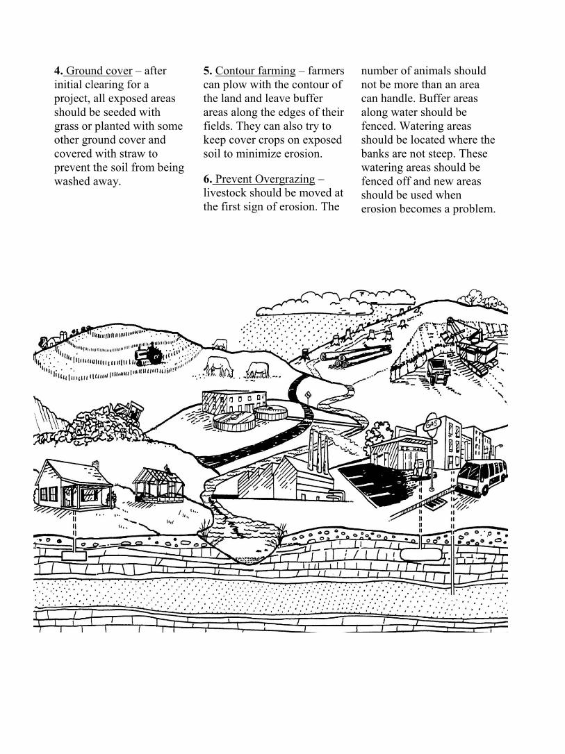
4. Ground cover – after initial clearing for a project, all exposed areas should be seeded with grass or planted with some other ground cover and covered with straw to prevent the soil from being washed away.
5. Contour farming – farmers can plow with the contour of the land and leave buffer areas along the edges of their fields. They can also try to keep cover crops on exposed soil to minimize erosion.
6. Prevent Overgrazing – livestock should be moved at the first sign of erosion. The
number of animals should not be more than an area can handle. Buffer areas along water should be fenced. Watering areas should be located where the banks are not steep. These watering areas should be fenced off and new areas should be used when erosion becomes a problem.
Major Concepts: Water quality Indicator species Adaptations Ecosystem Energy flow
Learning Skills:
Observing, using numbers, classifying, inferring and predicting
Reading informational materials; using keys and identification guides
Calculating stream index values
Subject Areas:
Science English Language Arts Mathematics
* See Activity Summary for a
Correlation with NC Essential Standards.
Special Considerations: See the safety message in Introduction on page 1.3.
Location: Few’s Ford Group Size:
16 students, 2 adults
Estimated Time: 1 hour
Appropriate Season: April to October
Materials: Provided by park: kick net, seine net, dip net, wide mouth plastic jars, aquaria, plastic tubs, clipboards, maker board, field guides, laminated fish keys, laminated invertebrate key, aquarium nets, plastic spoons, glass dishes, table, life jackets, extra activity sheets, examples of adult macroinvertebrates Provided by the educator: worksheets, pencil (one per student)
Note: Make sure participants bring a complete change of clothes. They should also wear clothes and shoes that they don't mind getting wet and/or dirty.
.
Objectives: • Describe 3 •
Objectives:
Describe 3 characteristics of aquatic macroinverte-brates that help them survive in aquatic habitats.
Using keys and field guides, identify 3 macro-invertebrates in the field.
Name 3 indicator species and explain how they are used to determine water quality.
Calculate the stream index rating for a river.
List and describe 5 factors necessary for a healthy river ecosystem.
Educator's Information:
o prepare your students for their visit, we recommend they complete the two pre-visit activities in this EELE. The purpose of this activity is to introduce students to macroinvertebrates and aquatic organisms and how they can be used as indicator species to determine the health of the river.
The students will be involved in collecting macro-invertebrates in the river and must be dressed appropriate-ly. Park staff will rope off the area where sampling will occur. Life jackets and a first aid kit will be available. Park staff will discuss safety considerations and the edu-cator will assist in seeing that all safety precautions are followed. The students will work in groups of four or five, with one person record-ing the data. After completing the worksheet, students will gather and discuss their results with park staff. Instructions: 1. Park staff will lead a brief discussion focusing on: mac-roinvertebrates (macros), what they are and why they are important; metamorpho-sis, what it is and how it is accomplished; and indicator species, what they are and how they are used to deter-mine the health of a river. Park staff will also cover use of the sampling equipment and safety precautions that must be followed. 2. Separate the students into groups of four or five and have them collect aquatic samples following all safety procedures.
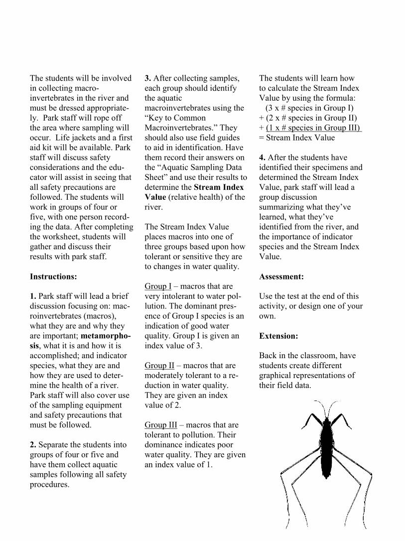
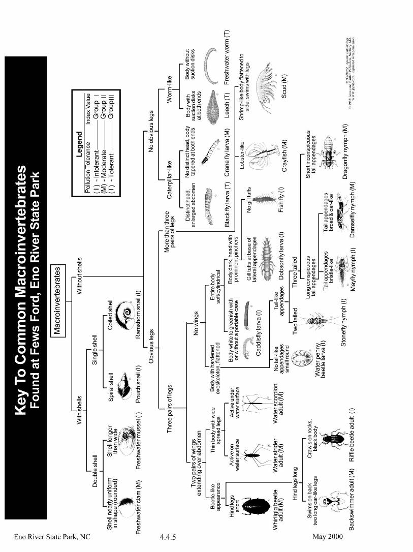
3. After collecting samples, each group should identify the aquatic macroinvertebrates using the “Key to Common Macroinvertebrates.” They should also use field guides to aid in identification. Have them record their answers on the “Aquatic Sampling Data Sheet” and use their results to determine the Stream Index Value (relative health) of the river. The Stream Index Value places macros into one of three groups based upon how tolerant or sensitive they are to changes in water quality. Group I – macros that are very intolerant to water pol-lution. The dominant pres-ence of Group I species is an indication of good water quality. Group I is given an index value of 3. Group II – macros that are moderately tolerant to a re-duction in water quality. They are given an index value of 2. Group III – macros that are tolerant to pollution. Their dominance indicates poor water quality. They are given an index value of 1.
The students will learn how to calculate the Stream Index Value by using the formula: (3 x # species in Group I) + (2 x # species in Group II) + (1 x # species in Group III) = Stream Index Value 4. After the students have identified their specimens and determined the Stream Index Value, park staff will lead a group discussion summarizing what they’ve learned, what they’ve identified from the river, and the importance of indicator species and the Stream Index Value. Assessment: Use the test at the end of this activity, or design one of your own. Extension: Back in the classroom, have students create different graphical representations of their field data.
Water, water everywhere nor any drop to drink” –so says the sailor in Samuel Taylor Coleridge's “Rime of the Ancient Mariner” as his boat is becalmed at sea. Fortunately, in our area, water is everywhere and there seems to be plenty to drink, at least for now. But that may be changing. Let's take a closer look at water and discover what a fragile and sensitive resource it is.
What is water? The dic-tionary defines water as a colorless, odorless transparent liquid occurring on earth as rivers, lakes, oceans, etc., and falling from the clouds as rain, snow, ice, etc. Water occupies more than 70 per-cent of the earth’s surface, and it makes up approximate-ly 60 percent of the human body. You may have heard the saying “Water is life.” Think about it for a minute. Can you think of any living organism that does not de-pend on water?
David Quammen, in his book, Natural Acts, A Sidelong View of Science and Nature says, “Without life, there would still be water. Without water no life.”
Water comes in many forms. To really appreciate it, you need to pick out one of its many forms and get to know
it personally. For your visit to Eno River State Park, you need to know more about water in the form of a river.
What is a river? A river is defined as a natural flow of water which empties into an ocean, a lake, or another river. It is the result of springs, streams and creeks joining together to produce a larger volume of flow. These smaller bodies of water are called tributaries. The land that a river and its tributaries flow through is called a wa-tershed. A healthy river must have a well-protected watershed because any kind of disturbance to the water-shed has an effect on the river.
River as an Ecosystem
A river is an ecosystem. The plants and animals in the river, along with the physical surroundings of the watershed form an interdependent system. You might compare a river to a fine stew or soup. The various living or once-living parts of the watershed are the ingredients for the stew or soup. Usually the more ingredients you add, the better the stew. A stew also needs spices to make it taste just right. In our analogy, the spices refer to the nonliving parts of the river ecosystem– oxygen, minerals, sunlight, etc. If you try to make a stew with just one ingredient, or if
you leave out an important spice, your stew is not going to be good.
Here then is a recipe for a fine healthy river:
Some sunlight – just enough for the algae, moss, diatoms and aquatic plants to carry on photosynthesis. (Too much sun heats up the water and robs it of dissolved oxygen.)
Fallen leaves – they provide the main source of energy for a river system. In the fall, leaves drift down from the trees into the water where they soon sink to the bottom or get caught in logjams or wedged between rocks. At this point, bacteria and fungi climb aboard the leaves and begin to “munch out,” caus-ing the leaves to decompose and break down into smaller pieces. The half-eaten leaves, bacteria and fungi are even-tually swept downstream where they provide food for munchers, grazers and filter feeders – the wonderfully adapted macroinvertebrates (macros), such as stonefly nymphs, mayfly nymphs, and caddisfly larvae. These organisms further break down the leaves into a very fine mulch called detritus. In addition to the munchers, grazers and filter feeders, there are other types of mac-roinvertebrates that prey on
other macroinvertebrates. Lots of different kinds of macros are a sign of a healthy river.
Dissolved oxygen and carbon dioxide – all the animals in the river need dissolved oxygen to breathe. These same animals breathe out carbon dioxide, which is essential for algae and other aquatic plants. These plants in turn take in the carbon di-oxide and give off oxygen.
Aquatic plants and animals – aquatic plants like river-weed and water willow pro-vide cover for macros and small minnows. All the aquatic animals in the river provide food for each other and non-aquatic animals in a complex food web. When all these various plants and ani-mals die or excrete waste, they return essential nutrients to the food web.
Various minerals – the fine spices of a river include calcium bicarbonate, potas-sium, nitrates and phos-phates. These ingredients help balance a river’s pH; provide building material for the shells of snails, mussels, clams and crayfish; help fish breathe more efficiently; and act as natural fertilizers es-sential for aquatic plants.
These are just the minimum ingredients needed for a healthy river. A river needs only natural ingredients; un-natural ingredients can have a bad affect on a river. David Quammen sums up what makes a healthy river when he talks about a trout stream. “A good trout stream must first be an excellent insect stream, a superior haven for algae and fungi and bacteria, a prime dumping ground for dead leaves, a surpassing reservoir of oxygen and
calcium. It will then also, and thereby, be a good osprey stream, a favorite among otters, a salvation to dippers and kingfishers and bank swallows and heron, mergansers and Canada geese and water shrews, mink and muskrat and bea-ver. Not to mention the oc-casional grizzly bear. And who knows but that, some-time, a human might want to drink.”
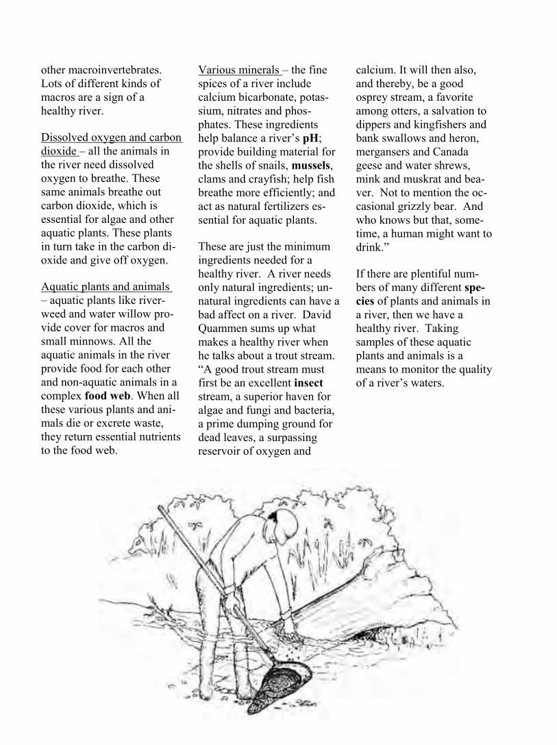
If there are plentiful num-bers of many different spe-cies of plants and animals in a river, then we have a healthy river. Taking samples of these aquatic plants and animals is a means to monitor the quality of a river’s waters.
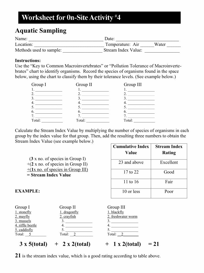
Aquatic Sampling Name: ________________________________ Date: ___________________________ Location: ______________________________ Temperature: Air ______Water ______ Methods used to sample: _________________ Stream Index Value: _______________
Instructions: Use the “Key to Common Macroinvertebrates” or “Pollution Tolerance of Macroinverte-brates” chart to identify organisms. Record the species of organisms found in the space below, using the chart to classify them by their tolerance levels. (See example below.)
Calculate the Stream Index Value by multiplying the number of species of organisms in each group by the index value for that group. Then, add the resulting three numbers to obtain the Stream Index Value (see example below.)
(3 x no. of species in Group I)
+(2 x no. of species in Group II) +(1x no. of species in Group III) = Stream Index Value
EXAMPLE: Group I Group II Group III 1. stonefly 1. dragonfly 1. blackfly 2. mayfly 2. crayfish 2. freshwater worm 3. mussels 3. ______________ 3. ______________ 4. riffle beetle 4. ______________ 4. ______________ 5. caddisfly 5. ______________ 5. ______________ Total: __5________ Total: __2_________ Total: __2________
3 x 5(total) + 2 x 2(total) + 1 x 2(total) = 21 21 is the stream index value, which is a good rating according to table above.
Group I Group II Group III 1. ______________ 1. ______________ 1. ______________ 2. ______________ 2. ______________ 2. ______________ 3. ______________ 3. ______________ 3. ______________ 4. ______________ 4. ______________ 4. ______________ 5. ______________ 5. ______________ 5. ______________ 6. ______________ 6. ______________ 6. ______________ 7. ______________ 7. ______________ 7. ______________ Total: ___________ Total: ____________ Total: ___________
Cumulative Index Value
Stream Index Rating
23 and above Excellent
17 to 22 Good
11 to 16 Fair
10 or less Poor
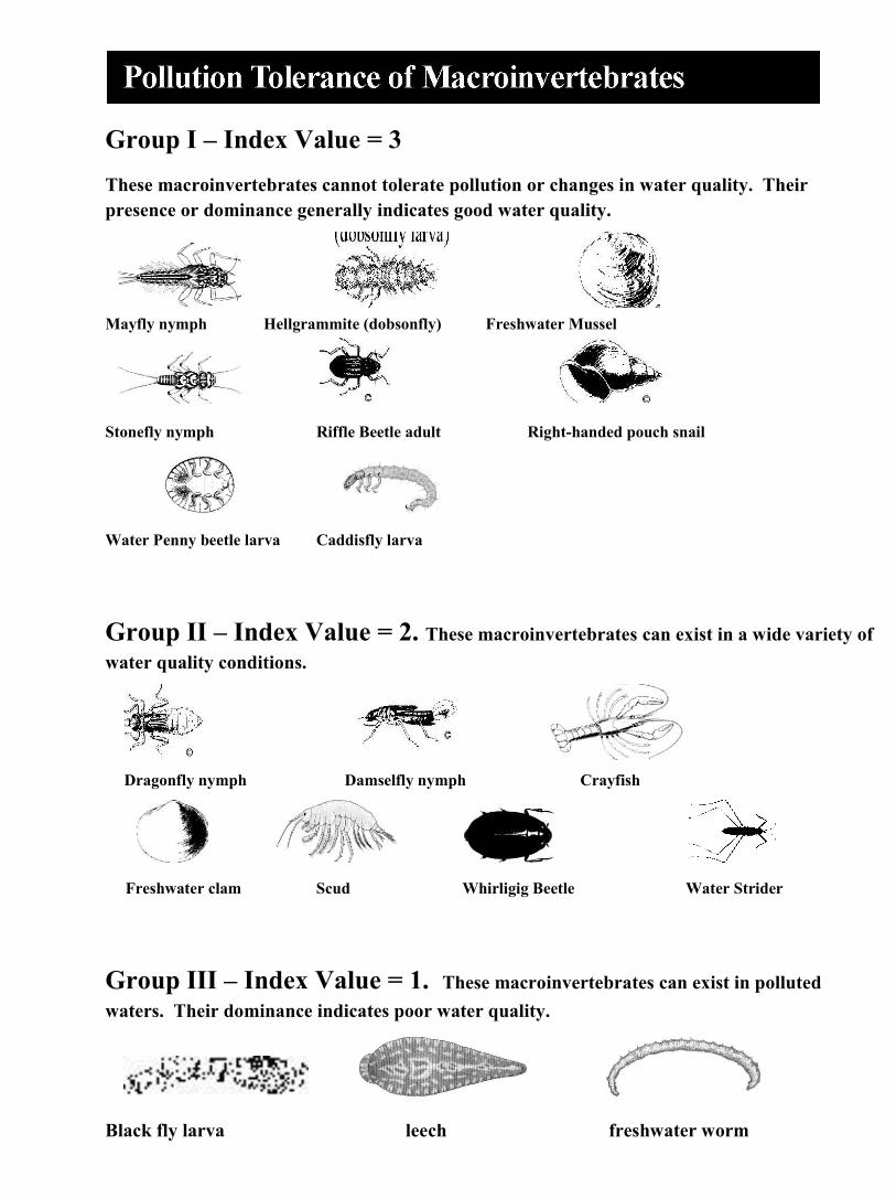
Group I – Index Value = 3 These macroinvertebrates cannot tolerate pollution or changes in water quality. Their presence or dominance generally indicates good water quality.
Mayfly nymph Hellgrammite (dobsonfly) Freshwater Mussel
Stonefly nymph Riffle Beetle adult Right-handed pouch snail
Water Penny beetle larva Caddisfly larva
Group II – Index Value = 2. These macroinvertebrates can exist in a wide variety of water quality conditions.
Dragonfly nymph Damselfly nymph Crayfish
Freshwater clam Scud Whirligig Beetle Water Strider
Group III – Index Value = 1. These macroinvertebrates can exist in polluted waters. Their dominance indicates poor water quality.
Black fly larva leech freshwater worm

Name: ________________________________ Date: _________________________
Instructions: You have just sampled a river and found the following macroinvertebrates: dragonfly nymphs, damselfly nymphs, freshwater clams, freshwater worms, scuds, crayfish, mayfly nymphs and black fly larvae. Use the “Pollution Tolerance of Macroinvertebrates” chart to classify the organisms by their tolerance levels and record below:
Calculate the Stream Index Value using the formula below.
(3 x no. of species in Group I) +(2 x no. of species in Group II) +(1x no. of species in Group III) = Stream Index Value
What is the Stream Index Value for
this river? _________
What is the Stream Index Rating? _________
List five factors (or ingredients) needed for a healthy river ecosystem. Make sure that you include at least two nonliving factors. Explain why each factor is important to the health of the river:
1. __________________________________________________________________
2. __________________________________________________________________
3. _____________________________________________________________________________ 4.______________________________________________________________________________
5. _____________________________________________________________________________
On the back of this paper, list three macroinvertebrates and, for each one, describe an adaptation that allows it to live in a particular aquatic habitat.
Group I Group II Group III 1. ______________ 1. ______________ 1. ______________ 2. ______________ 2. ______________ 2. ______________ 3. ______________ 3. ______________ 3. ______________ 4. ______________ 4. ______________ 4. ______________ 5. ______________ 5. ______________ 5. ______________ 6. ______________ 6. ______________ 6. ______________ 7. ______________ 7. ______________ 7. ______________ Total: ___________ Total: ____________ Total: ___________
Cumulative Index Value
Stream Index Rating
23 and above Excellent
17 to 22 Good
11 to 16 Fair
10 or less Poor
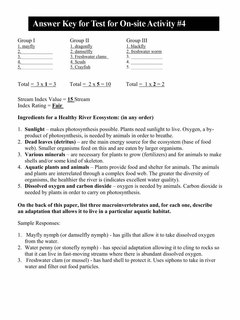
Group I Group II Group III 1. mayfly 1. dragonfly 1. blackfly 2.______________ 2. damselfly 2. freshwater worm 3.______________ 3. Freshwater clams 3. ______________ 4.______________ 4. Scuds 4. ______________ 5.______________ 5. Crayfish 5. ______________
Total = 3 x 1 = 3 Total = 2 x 5 = 10 Total = 1 x 2 = 2
Stream Index Value = 15 Stream Index Rating = Fair
Ingredients for a Healthy River Ecosystem: (in any order)
1. Sunlight – makes photosynthesis possible. Plants need sunlight to live. Oxygen, a by-product of photosynthesis, is needed by animals in order to breathe.
2. Dead leaves (detritus) – are the main energy source for the ecosystem (base of food web). Smaller organisms feed on this and are eaten by larger organisms.
3. Various minerals – are necessary for plants to grow (fertilizers) and for animals to make shells and/or some kind of skeleton.
4. Aquatic plants and animals – Plants provide food and shelter for animals. The animals and plants are interrelated through a complex food web. The greater the diversity of organisms, the healthier the river is (indicates excellent water quality).
5. Dissolved oxygen and carbon dioxide – oxygen is needed by animals. Carbon dioxide is needed by plants in order to carry on photosynthesis.
On the back of this paper, list three macroinvertebrates and, for each one, describe an adaptation that allows it to live in a particular aquatic habitat.
Sample Responses:
1. Mayfly nymph (or damselfly nymph) - has gills that allow it to take dissolved oxygen from the water.
2. Water penny (or stonefly nymph) - has special adaptation allowing it to cling to rocks so that it can live in fast-moving streams where there is abundant dissolved oxygen.
3. Freshwater clam (or mussel) - has hard shell to protect it. Uses siphons to take in river water and filter out food particles.
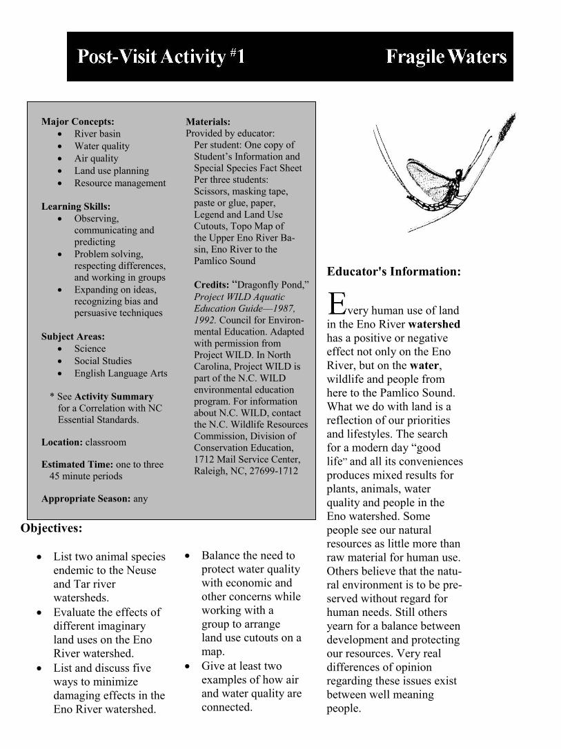
Major Concepts: River basin Water quality Air quality Land use planning Resource management
Learning Skills:
Observing, communicating and predicting
Problem solving, respecting differences, and working in groups
Expanding on ideas, recognizing bias and persuasive techniques
Subject Areas:
Science Social Studies English Language Arts
* See Activity Summary
for a Correlation with NC Essential Standards.
Location: classroom
Estimated Time: one to three 45 minute periods
Appropriate Season: any
Materials: Provided by educator:
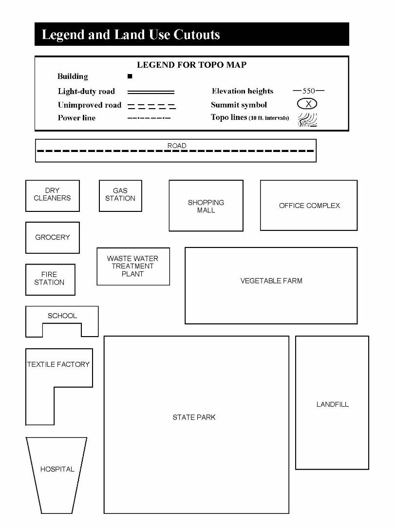
Per student: One copy of Student’s Information and Special Species Fact Sheet Per three students: Scissors, masking tape, paste or glue, paper, Legend and Land Use Cutouts, Topo Map of the Upper Eno River Ba-sin, Eno River to the Pamlico Sound
Credits: “Dragonfly Pond,” Project WILD Aquatic Education Guide––1987, 1992. Council for Environ-mental Education. Adapted with permission from Project WILD. In North Carolina, Project WILD is part of the N.C. WILD environmental education program. For information about N.C. WILD, contact the N.C. Wildlife Resources Commission, Division of Conservation Education, 1712 Mail Service Center, Raleigh, NC, 27699-1712
Educator's Information:
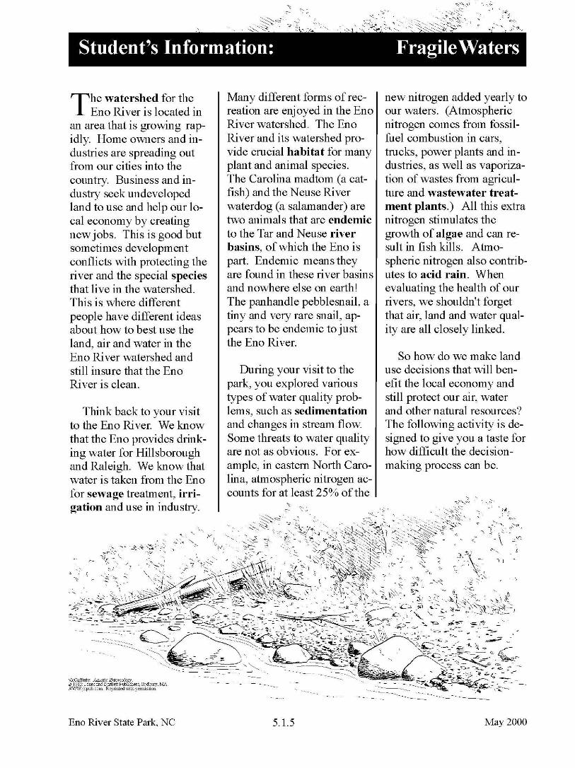
very human use of land in the Eno River watershed has a positive or negative effect not only on the Eno River, but on the water, wildlife and people from here to the Pamlico Sound. What we do with land is a reflection of our priorities and lifestyles. The search for a modern day “good life” and all its conveniences produces mixed results for plants, animals, water quality and people in the Eno watershed. Some people see our natural resources as little more than raw material for human use. Others believe that the natu-ral environment is to be pre-served without regard for human needs. Still others yearn for a balance between development and protecting our resources. Very real differences of opinion regarding these issues exist between well meaning people.
Objectives:
List two animal species endemic to the Neuse and Tar river watersheds.
Evaluate the effects of different imaginary land uses on the Eno River watershed.
List and discuss five ways to minimize damaging effects in the Eno River watershed.
Balance the need to
protect water quality with economic and other concerns while working with a group to arrange land use cutouts on a map.
Give at least two examples of how air and water quality are connected.
At the core of land use issues is the concept of growth. Growth in natural systems has inherent limits, imposed by a dynamic balance of energy between all parts of the system. Energy in natural systems is translated into food, water, shelter, space and continued survival. This means that the vitality of natural systems is expressed by their ability to be self-regulating. This capacity for self-regulation makes it possible for all natural members of an ecosystem to live in harmony. All life forms of any ecosystem must be considered. The macroinvertebrates in the water are just as necessary to a habitat as the plants and fish. It is this natural dynamic balance, with all its inherent and essential parts, that much of human land use has tended to disturb.
Human activities often go beyond the natural limits of a setting. Humans have the ability to import energy sources that allow a system to exceed its natural limits–– or to remove energy sources that are necessary for a sys-tem to stay in balance. For example, people can dam rivers to provide power, drinking water and irriga-tion. Water from the river can be used in factories, mills, sewage treatment and other industries that need large amounts of water to produce certain products. Combustion of fossil fuels and vaporization of animal wastes add nitrogen to the air
which eventually finds its way into our waters. All of these activities affect life in the Eno River watershed.
The purpose of this activity is to encourage students to wrestle with development, local economy and resource management issues. The stu-dents will use the Eno River watershed as a microcosm of environmental concerns in making management deci-sions. They will contend with the arrangement of overlapping and conflicting land uses in an effort to pre-serve the Eno River water-shed. When the students reach some kind of agree-ment about local issues, they will discuss how what they have done affects the river downstream. The activity ends with the idea that the planet is, in fact, a single river watershed.
Instructions:
1. Prepare copies of the Legend and Land Use Cutouts sheet, the Topo Map of the Upper Eno River Basin, the Student’s Information, and the Special Species Fact Sheet. Explain the activity. Tell the students that they will be responsible for ar-ranging the pattern of land use around the Eno River to minimize the impact on the river. Remind them that some of the land uses might be conflicting and therefore they will have to make some very tough management decisions. Ask
students to read the Student’s Information and Special Species Fact Sheet.
2. Divide the class into groups of three to five, with each group representing one of the interest groups (below) or taking on the role of the town commissioners. Stu-dents will stay in these groups until the end of the activity. Each group must decide where to place all the land uses.
Possible interest groups: • Residents - people who want to live there. • Farmers - want to use the land to raise food. • Businesses - want to use land for commerce and growth. • State park - wants to preserve and protect water-shed for plants and wild life, recreation, drinking water and historic sites. • Highway department -wants to build a bypass road to ease traffic congestion in town. • Textile factory - wants to construct a huge factory that would provide 500 jobs and boost local economy. • School representatives want to build a new school to accommodate more students due to rapid growth of the town. • Hospital representatives propose building a new hospital to service the
community in the future because of expected growth and development in the area.
• County and state representatives - believe it is essential to have a bigger landfill and a newer, more efficient wastewater treatment plant.
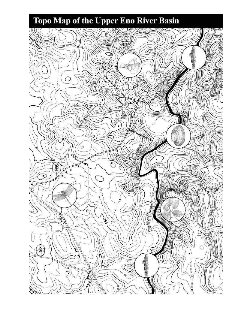
3. Give each group a copy of the Topo Map of the Upper Eno River Basin and the Legend and Land Use Cut-outs page. Read the following text to your students:
You will be using an en-largement of an actual topo-graphic map of the upper Eno River basin. Topo-graphic is derived from Greek words topos, meaning place, and graphein, meaning to write or draw. Thus, a topographic (topo) map is a drawing or pricture of a place. One feature on a topo map is contour lines. Con-tour lines are thin lines that indicate the contour of the land and its elevation. The distance between contour lines on your map is 10 feet. Where the lines are very close together, there is steep terrain. Level terrain appears where contour lines are fur-ther apart. In this activity, the steepness or flatness of the terrain will dictate where certain land uses can occur. For example, you would not put a landfill on a steep ridge. A legend explaining other map symbols is included on the Legend and Land Use Cutouts page.
Spend some time discussing features and symbols on the topo map. Practice locating ridges, summits, rivers, highways, etc. Then read the following text aloud:
Note: There are two species of plants and three species of animals on the map where they might naturally occur. These species are either state protected or have special habitat requirements. The purpose of placing these on the map is to make the de-cisions more realistic. Infor-mation on these species is given on the Special Species Fact Sheet.
1. Have the students cut out the land use pieces from the Legend and Land Use Cutouts page. When they fasten the cutouts to their topo map, suggest that they use small loops of tape. This will allow them to change their minds before they paste them down.
2. Place the following rules on the chalkboard:
• all land use cutouts must be used; the cutouts may be cut smaller • cutouts may touch, but may not overlap • no cutout, except for the state park, can touch or cover a “Special Species” circle • except for the state park and the vegetable farm, all cutouts must touch a
new or existing road • vegetable farm and landfill must be on relatively level land • both textile factory and wastewater treatment plant must touch the river • no cutout can touch or cover an existing building 1. Once the students have
cut out the necessary materials and are ready to make land use decisions, have them create a list of pros and cons for each land use. Guide the class discussion so the conse-quences of each land use are considered. Record these on the chalkboard.
2. Have the students work in their groups long enough to begin to seriously grapple with the challenge.
3. Invite each group to dis-play and describe their work in progress. Encourage discussion of their choices. In the discussions emphasize:
• no land use can be excluded • wildlife habitat must be preserved • everyone within their small group must agree Discuss how their plans will impact the various interest groups.
Look for the consequences of their proposed land use plans. Be firm about this being
a very difficult set of choices. Remind them that for certain habitats this is a “no-win” situation in many ways. The best that can be hoped for is that the land use plans will minimize the threats to the river and the special plants and animals.
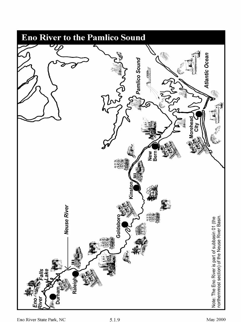
Assessment:
1. Pass out the Eno River to the Pamlico Sound sheet. Have each group connect their topo map to the Eno River section of this sheet. Ask one group to describe their plan to the class. Then, have all the students brain-storm possible effects that this land use plan could have on the water quality, air qual-ity, and people downstream. For example, you could em-phasize the effluent (and/or smoke and fumes) from the textile factory. How will it be treated? Where? By whom? Where will it go? What effect will it have on air and water quality in the river basin?
2. Ask the students to look again at all of the land uses in this activity. What could the people who are actually in charge of these various land uses do in their practices to minimize the damage to Eno River and the special species? Review technolo-gies that were discussed in the on-site activities, such as vegetative buffers and silt fences. Include other ideas that stu-dents may have heard about. For example, some industries
have developed new technol-ogy that allows them to re-move harmful waste using a scrubbing filter. Maybe such a filter could be used on their textile factory. Some com-munities have used new technology to collect meth-ane gas (a common gas gen-erated by decomposing gar-bage) from landfills and use it as a source of energy. 3. Ask the students to create a list of things they, personally, can do to begin to reduce the potentially damaging effects of their own lifestyles on the downstream habitats. If possible invite them to report periodically, throughout the school year, on their progress in carrying out these new practices. Discuss the concept that all the waters of the planet are, in fact, part of a single Eno River.
4. Display all the final land use plans for everyone to see and discuss. Analyze the merits of each of the ap-proaches. Ask each student to write a paragraph stating which land use plan would have the least harmful effect on the Eno River (or Neuse River Basin) and why. In ad-dition, ask them to describe at least three things that could be done to further minimize the damage to water quality in the river basin.
Extensions:
1. Review the Neuse River Basin map from Pre-visit Ac-tivity #1. Call the Division of Water Quality at (919) 733-5083 for a copy of the Neuse River Basinwide Water Quality Management Plan.
2. Take a field trip to Cliffs of the Neuse State Park near Goldsboro to collect similar data on the river the Eno feeds into, the Neuse. For more information contact:
Cliffs of the Neuse St.Park 345-A Park Entrance Road Seven Springs, NC 28578 (919) 778-6234
3. Collect newspaper articles on local water and land re-lated issues as a current events activity.
4. Learn more about environ-mental impact statements. Try to obtain actual state-ments concerning land use in your area. See what concerns are addressed in these documents.
5. Find out about zoning laws and land use regulations in your area. Would the plans the student groups proposed for the upper Eno River be allowed in your community?
6. Send a representative sample of the students’ land use plans to the park. (We would appreciate the feed-back.)
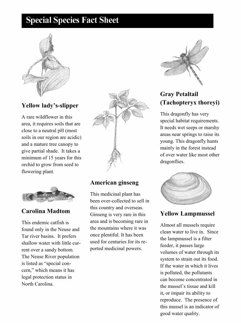
Yellow lady’s-slipper
A rare wildflower in this area, it requires soils that are close to a neutral pH (most soils in our region are acidic) and a mature tree canopy to give partial shade. It takes a minimum of 15 years for this orchid to grow from seed to flowering plant.
Carolina Madtom
This endemic catfish is found only in the Neuse and Tar river basins. It prefers shallow water with little cur-rent over a sandy bottom. The Neuse River population is listed as “special con-cern,” which means it has legal protection status in North Carolina.
American ginseng
This medicinal plant has been over-collected to sell in this country and overseas. Ginseng is very rare in this area and is becoming rare in the mountains where it was once plentiful. It has been used for centuries for its re-ported medicinal powers.
Gray Petaltail (Tachopteryx thoreyi)
This dragonfly has very special habitat requirements. It needs wet seeps or marshy areas near springs to raise its young. This dragonfly hunts mainly in the forest instead of over water like most other dragonflies.
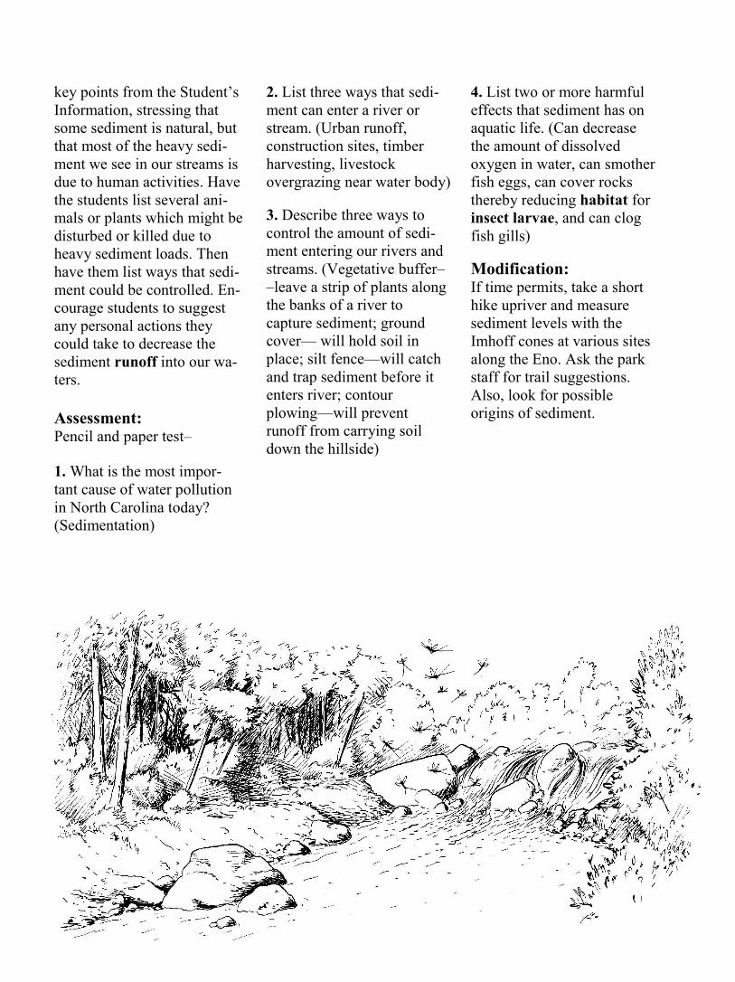
Yellow Lampmussel
Almost all mussels require clean water to live in. Since the lampmussel is a filter feeder, it passes large volumes of water through its system to strain out its food. If the water in which it lives is polluted, the pollutants can become concentrated in the mussel’s tissue and kill it, or impair its ability to reproduce. The presence of this mussel is an indicator of good water quality.
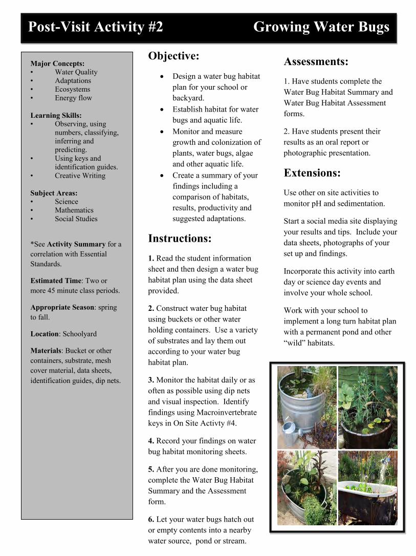
Post-Visit Activity #2 Growing Water Bugs
Major Concepts: • Water Quality • Adaptations • Ecosystems • Energy flow Learning Skills: • Observing, using numbers, classifying, inferring and predicting. • Using keys and identification guides. • Creative Writing Subject Areas: • Science • Mathematics • Social Studies
*See Activity Summary for a correlation with Essential Standards.
Estimated Time: Two or more 45 minute class periods.
Appropriate Season: spring to fall.
Location: Schoolyard
Materials: Bucket or other containers, substrate, mesh cover material, data sheets, identification guides, dip nets.
Objective:
Design a water bug habitat plan for your school or backyard.
Establish habitat for water bugs and aquatic life.
Monitor and measure growth and colonization of plants, water bugs, algae and other aquatic life.
Create a summary of your findings including a comparison of habitats, results, productivity and suggested adaptations.
Instructions: 1. Read the student information sheet and then design a water bug habitat plan using the data sheet provided.
2. Construct water bug habitat using buckets or other water holding containers. Use a variety of substrates and lay them out according to your water bug habitat plan.
3. Monitor the habitat daily or as often as possible using dip nets and visual inspection. Identify findings using Macroinvertebrate keys in On Site Activty #4.
4. Record your findings on water bug habitat monitoring sheets.
5. After you are done monitoring, complete the Water Bug Habitat Summary and the Assessment form.
6. Let your water bugs hatch out or empty contents into a nearby water source, pond or stream.
Assessments: 1. Have students complete the Water Bug Habitat Summary and Water Bug Habitat Assessment forms.
2. Have students present their results as an oral report or photographic presentation.
Extensions: Use other on site activities to monitor pH and sedimentation.
Start a social media site displaying your results and tips. Include your data sheets, photographs of your set up and findings.
Incorporate this activity into earth day or science day events and involve your whole school.
Work with your school to implement a long turn habitat plan with a permanent pond and other “wild” habitats.
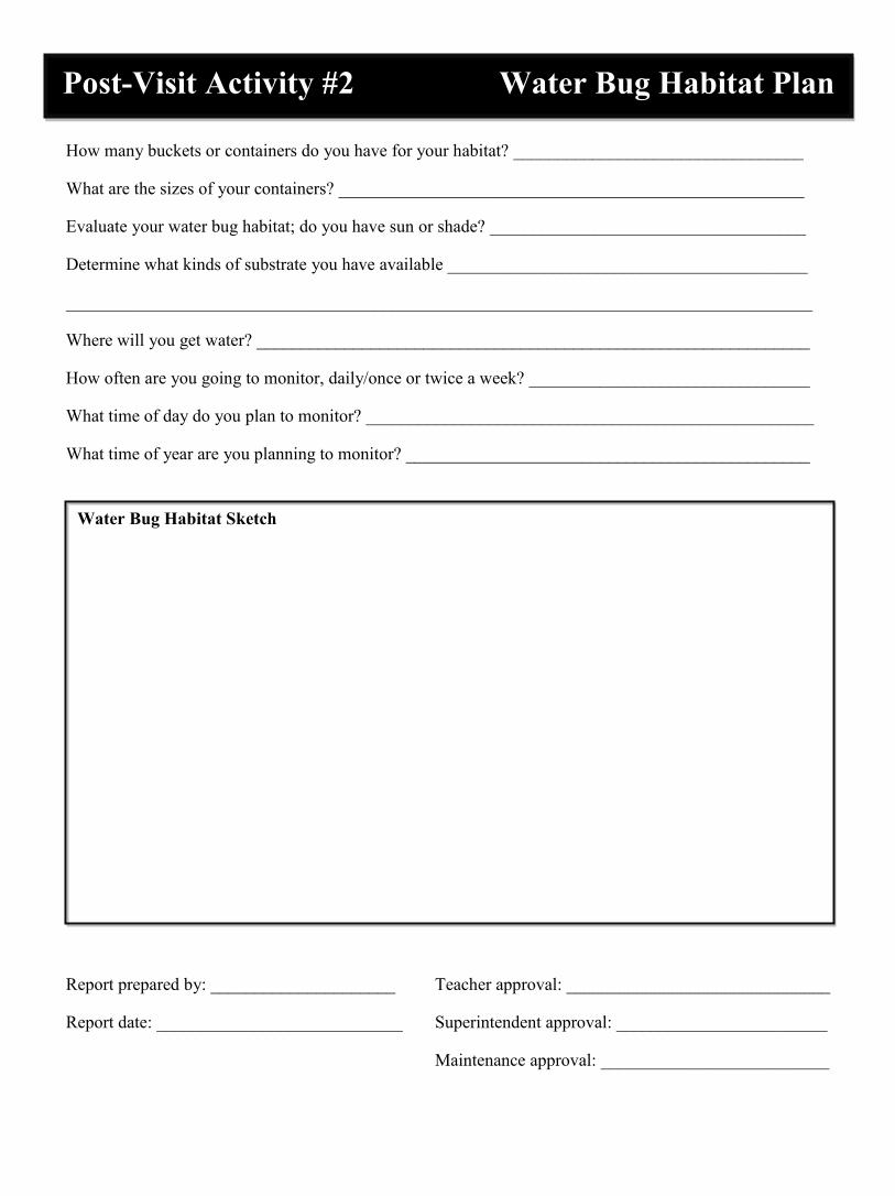
How many buckets or containers do you have for your habitat? _________________________________
What are the sizes of your containers? _____________________________________________________
Evaluate your water bug habitat; do you have sun or shade? ____________________________________
Determine what kinds of substrate you have available _________________________________________
_____________________________________________________________________________________
Where will you get water? _______________________________________________________________
How often are you going to monitor, daily/once or twice a week? ________________________________
What time of day do you plan to monitor? ___________________________________________________
What time of year are you planning to monitor? ______________________________________________
Report prepared by: _____________________ Teacher approval: ______________________________
Report date: ____________________________ Superintendent approval: ________________________
Maintenance approval: __________________________
Post-Visit Activity #2 Water Bug Habitat Plan
Water Bug Habitat Sketch
DATE:
DAY OF WEEK:
TIME: VISIT#:
TEMPERATURE:
WEATHER: LAST RAIN: NAME:
HABITAT #1
HABITAT #2
HABITAT #3
WATER LEVEL (low/medium/high)
WATER CLARITY (clear/murky/cloudy)
PLANT GROWTH (none/some/lots)
ALGAE GROWTH (none/some/lots)
WATER BUGS (fly larva)
WATER BUGS (worms)
WATER BUGS (beetles)
OTHER
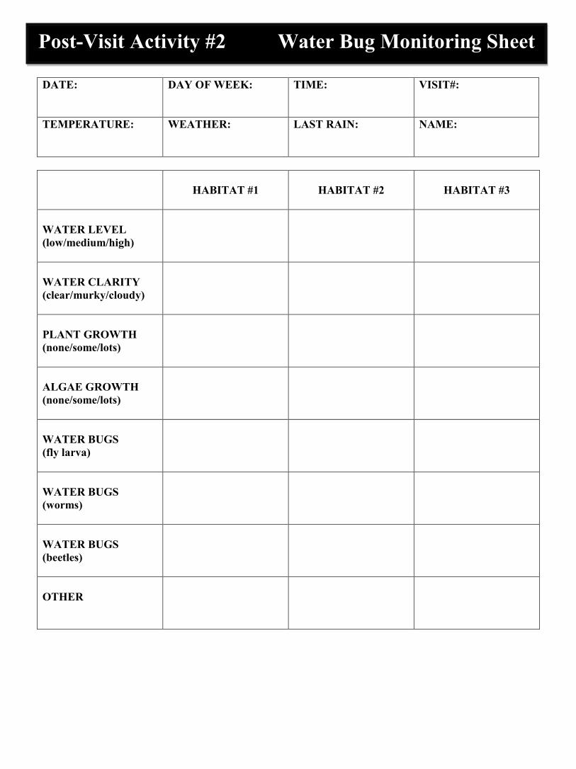
Post-Visit Activity #2 Water Bug Monitoring Sheet
Monitored from (dates): ___________________ to: ______________________ Habitat #1 Did the water level fluctuate from start to finish? _____________________________________________ What changes happened to the water clarity? _____________________________________________ How much plant life began to grow? How fast? _____________________________________________ Did any algae grow during monitoring? _____________________________________________ What water bugs were present on your 1st visit? _____________________________________________ What water bugs were present on your last visit? _____________________________________________ Habitat #2 Did the water level fluctuate from start to finish? _____________________________________________ What changes happened to the water clarity? _____________________________________________ How much plant life began to grow? How fast? _____________________________________________ Did any algae grow during monitoring? _____________________________________________ What water bugs were present on your 1st visit? _____________________________________________ What water bugs were present on your last visit? _____________________________________________ Habitat #3 Did the water level fluctuate from start to finish? _____________________________________________ What changes happened to the water clarity? _____________________________________________ How much plant life began to grow? How fast? _____________________________________________ Did any algae grow during monitoring? _____________________________________________ What water bugs were present on your 1st visit? _____________________________________________ What water bugs were present on your last visit? _____________________________________________
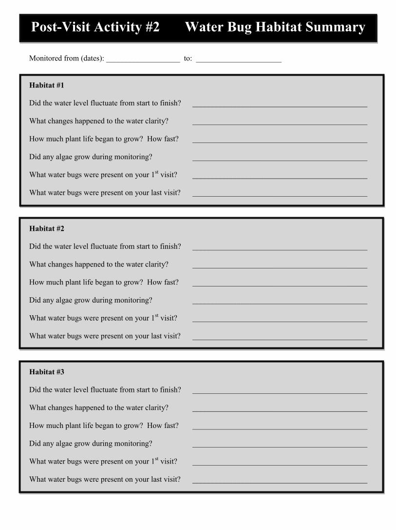
Post-Visit Activity #2 Water Bug Habitat Summary
What caused the water levels to fluctuate or change clarity? _________________________________ Which habitat location worked best for growing plants and why? _________________________________ _______________________________________________________________________________________ Which habitat location worked best for growing water bugs and why? ___________________________ _______________________________________________________________________________________ What suggestions would you make to best grow water bugs? _________________________________ _______________________________________________________________________________________ What did you learn from this experiment about how best to grow water bugs? _____________________ _______________________________________________________________________________________
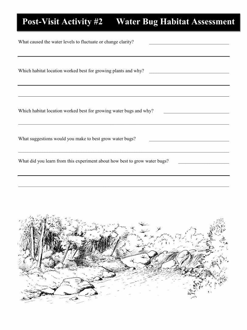
Post-Visit Activity #2 Water Bug Habitat Assessment
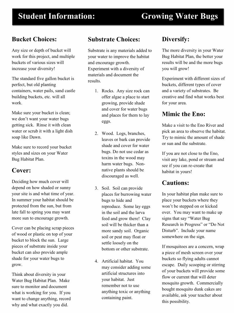
Student Information: Growing Water Bugs
Substrate Choices: Substrate is any materials added to your water to improve the habitat and encourage growth. Experiment with a diversity of materials and document the results.
1. Rocks. Any size rock can offer algae a place to start growing, provide shade and cover for water bugs and places for them to lay eggs.
2. Wood. Logs, branches, leaves or bark can provide shade and cover for water bugs. Do not use cedar as toxins in the wood may harm water bugs. Non- native plants should be discouraged as well.
3. Soil. Soil can provide places for burrowing water bugs to hide and reproduce. Some lay eggs in the soil and the larva feed and grow there! Clay soil will be thicker than a more sandy soil. Organic soil or peat may float or settle loosely on the bottom or other substrate.
4. Artificial habitat. You may consider adding some artificial structures into your habitat. Just remember not to use anything toxic or anything containing paint.
Bucket Choices: Any size or depth of bucket will work for this project, and multiple buckets of various sizes will increase your diversity!
The standard five gallon bucket is perfect, but old planting containers, water pails, sand castle building buckets, etc. will all work.
Make sure your bucket is clean; we don’t want your water bugs getting sick. Rinse it with clean water or scrub it with a light dish soap like Dawn.
Make sure to record your bucket styles and sizes on your Water Bug Habitat Plan.
Cover: Deciding how much cover will depend on how shaded or sunny your site is and what time of year. In summer your habitat should be protected from the sun, but from late fall to spring you may want more sun to encourage growth.
Cover can be placing scrap pieces of wood or plastic on top of your bucket to block the sun. Large pieces of substrate inside your bucket can also provide ample shade for your water bugs to grow.
Think about diversity in your Water Bug Habitat Plan. Make sure to monitor and document what is working for you. If you want to change anything, record why and what exactly you did.
Diversify: The more diversity in your Water Bug Habitat Plan, the better your results will be and the more bugs you will grow!
Experiment with different sizes of buckets, different types of cover and a variety of substrates. Be creative and find what works best for your area.
Mimic the Eno: Make a visit to the Eno River and pick an area to observe the habitat. Try to mimic the amount of shade or sun and the substrate.
If you are not close to the Eno, visit any lake, pond or stream and see if you can re-create that habitat in yours!
Cautions: In your habitat plan make sure to place your buckets where they won’t be stepped on or kicked over. You may want to make up signs that say “Water Bug Research in Progress” or “Do Not Disturb”. Include your name somewhere on the sign.
If mosquitoes are a concern, wrap a piece of mesh screen over your buckets so flying adults cannot escape. Daily scooping or stirring of your buckets will provide some flow or current that will deter mosquito growth. Commercially bought mosquito dunk cakes are available, ask your teacher about this possibility.
Acid – having a pH less than 7; the chemical state of water or other substance in which the hydrogen (H+) ions exceed the hydroxyl (OH–) ions. For example, a car’s battery acid has a pH of 1. See pH scale.
Acid Precipitation (including Acid Rain) – any form of precipitation that is acidic as a result of mixing with sulfur or nitrogen compounds in the atmosphere. Sulfur and nitrogen compounds can come from coal burning power plants and car emissions.
Adaptation – a change in the structure or activity of an organism that produces a better adjustment to its environment, thus enhancing its ability to survive and reproduce. For example, the flattened, oval shape of the larva of the riffle beetle (called a water penny) is an adaptation that helps it cling to the surface of rocks in swift flowing waters.
Aeration – the process of exposing to the air or of causing air to circulate through.
Algae – primitive one-celled or multi-cellular plants that contain chlorophyll, but have no true root, stem, or leaf. Normally found in water or damp places.
Algal Bloom – a heavy growth of algae in and on a body of water, usually resulting from high nitrate and phosphate concentrations entering water bodies from farm/lawn fertilizers and detergents. Phosphates also occur naturally in some rock formations.
Alkaline – see Base.
Ammonia – a colorless, strong smelling gas composed of nitrogen and hydrogen. (pH = 12)
Anatomy – the branch of biology that deals with the structure of plants and animals.
Aquatic Life – a plant or animal growing or living in or upon water.
Average – the numerical result obtained by dividing the sum of two or more quantities by the total number of quantities; for example, 2 + 4 + 6 + 8 = 20 and 20/4 = 5; therefore, 5 is the average of the four numbers.
Base – having a pH greater than 7; the chemical state of water or other substance in which the hydroxyl (OH–) ions exceed the hydrogen (H+) ions. For example, soap has a pH of 10. See pH scale.
Biochemistry – the branch of chemistry that deals with the life processes of plants and animals.
Biology – the science that deals with the origin, history, physical characteristics, life processes and habits of plants and animals.

Classification – the grouping of organisms into categories based on shared characteristics or traits. For example, any animal that has feathers is considered a bird and placed in the Class Aves. Furthermore, if the bird has its eyes in front rather than on the side of its head, it is a member of the Order Strigiformes (the owls).
Community – a group of plants and animals living in a specific region under similar conditions, and interacting with each other through food webs and other relationships.
Contour Lines – thin lines found on a topographical map that indicate elevation. They show the contour of the land.
Decomposer – an organism whose feeding action results in decay, rotting or decomposition. The primary decomposers are bacteria and fungi. They are very important parts of a healthy ecosystem.
Decomposition – to rot or to break apart into basic components. Decomposition makes nutrients, such as nitrogen and phosphorous, available for use by other organisms.
Delta – a usually triangular alluvial deposit at the mouth of a river.
Detritus – dead organic matter, such as fallen leaves, twigs, and other plant and animal material that exist in any ecosystem.
Dichotomous – divided into two parts, groups or classes, such as a dichotomous key. Using a dichotomous key, one can identify an unknown organism by following the one branch of each pair that better describes the organism.
Distribution – the act of scattering or spreading out; the geographic range of an organism.
Dissolved Oxygen (DO) – the amount of oxygen gas molecules dissolved in water. Fish and other
aquatic animals depend on DO for respiration. Ecosystem – plants, animals and their physical
surroundings that interact with environmental conditions, such as temperature and rainfall, forming
an interdependent system.
Effluent – a liquid flowing out. The outflow of a sewer, septic tank, etc.
Endangered Species – a species that verges on extinction in all or part of its range.

Endemic – found only in a particular region or area. For example, the Carolina madtom is a species of catfish found only in the Tar and Neuse rivers. Thus, it is endemic to the Tar and Neuse rivers.
Environmental Sustainability – the ability to meet the needs of the present without compromising the ability of future generations to meet their needs.
Erosion – the process by which soil particles are carried away by wind, water, freezing and thawing, or a combination of these factors.
Estuary – semi-enclosed area where fresh water from rivers meets salty water from the sea. Example: The Lower Neuse River Basin from New Bern to the Pamlico Sound.
Eutrophication – naturally-occurring changes that take place after a water body receives inputs of nutrients, mostly nitrates and phosphates, from erosion and runoff of surrounding lands; this process can be accelerated by human activities.
Evaporation – the natural process by which water changes into vapor.
Food Chain – the transfer of energy and material through a series of organisms as each one is fed upon by the next. For example:
Detritus —> caddisfly larvae —> sunfish —> otter
Food Web – the interlocking pattern of food chains which exist in an ecosystem.
Habitat – the environmental conditions of the area where a plant or animal naturally grows or lives; its environment.
Hydrosphere – the watering layer of earth’s surface. Indicator Species – an organism whose presence or absence in a particular environment can be used to determine the health of that particular environment.
Insect – any animal in the Class Insecta. Has a head, thorax, abdomen, and three pairs of legs on the thorax. As adults they usually have one or two pairs of wings attached to the thorax.
Irrigation – the pumping of water from ponds, lakes, or rivers through pipes or canals to supply crops with water during dry periods.
Key – an ordered list of significant characteristics of a group of organisms used to identify unknown species.
Larva – (larvae, plural) the immature form of an animal that changes structurally when it becomes an adult, usually by complex metamorphosis.
Latitude – measured in degrees, the distance north or south from the equator. For example, Durham is at 36° N latitude.
Longitude – the distance measured in degrees east or west of the prime meridian (0° longitude) at Greenwich, England. Durham is at 79° W longitude.
Macroinvertebrate – macro means large, invertebrate means without a backbone. An invertebrate usually large enough to be seen without the aid of magnification.
Metamorphosis – meta means change, morphe means form. A change in form, structure or function as a result of development. A physical transformation undergone by various animals during development from the larval stage to the adult form. For example, through metamorphosis, a hellgrammite (larval form) becomes a Dobsonfly (adult form). The change from tadpole (larval form) to frog (adult form) is another example of metamorphosis.
Molecular Biology – the branch of biology that deals with the chemical and physical composition, and the activities of the molecules of living matter.
Mussel – any of the various freshwater or saltwater bivalves (meaning the two shells), held together by a strong muscle.
Non-permeable – not open to passage or penetration, especially by fluids.
Nonpoint Source Pollution – pollution that cannot be traced to a specific point because it comes from many individual places or a widespread area (e.g., urban and agricultural runoff).
Nymph – the young of an insect that undergoes incomplete metamorphosis, differing from the adult primarily in size and structural proportions.
Organism – a plant or animal; any living thing.
pH – a measure of the power of the hydrogen ion (H+) activity in a substance.
pH Scale – a range of 0 to 14 used to measure the degree of acidity or basicity of a substance. A pH of 7 is neutral. See Acid and Base.

Photosynthesis – the chemical process carried on by green plants in which the cells that contain chlorophyll use light energy to produce glucose (a plant food) from carbon dioxide and water; oxygen is released as a by-product. See Respiration.
Plankton – collective term for the mostly microscopic plants (phytoplankton) and animals (zooplankton) that float or drift in oceans and fresh waters. These plants and animals are a very important food source in aquatic environments.
Point Source Pollution – pollution that can be traced to a single point source, such as a pipe or culvert (e.g., industrial and wastewater treatment plant discharges).
Pool – a deep still spot in a river, creek or stream.
Precipitation – a general term for all forms of falling moisture including rain, snow, hail or sleet.
Respiration – the process by which an organism takes in oxygen and releases carbon dioxide; breathing. See Photosynthesis.
Riffle – a shoal or gravel bar in a shallow part of a stream that produces a stretch of choppy ruffled water surface.
River Basin – the watershed of an entire river. It encompasses the many smaller watersheds of the river's tributaries or branches.
Runoff – rain, melted snow and other materials that drain or flow off surfaces such as city streets, roofs, suburban lawns and agricultural land.
Sediment – deposits of soil or organic matter that were suspended in water and then settled to the bottom. It is often deposited in the water by runoff.
Sedimentation – the deposition or accumulation of soil particles in water.
Sewage – liquid and solid waste mixed with water.
Soil – a collection of organic and inorganic particles, mainly composed of clay, silt, sand, and gravel.
clay -less than 1/256 of a millimeter (mm) in diameter silt -between 1/256 and 1/16 of a mm in diameter sand -between 1/16 and 2 mm in diameter gravel -over 2 mm in diameter
Species – a biological classification of organisms. All organisms of a single distinct kind that have a high degree of similarity, and can mate and produce fertile offspring.
Stewardship – the act of people taking responsibility to maintain and protect a clean and healthy environment.

Stream Index Value – the relative health of a water body. It is based on the tolerance or sensitivity of a macroinvertebrate to changes in water quality and calculated using a simple formula.
Taxonomy – a system of arranging animals and plants into natural, related groups based on some factor common to each, such as structure, embryology, biochemistry, etc.
Threatened Species – a species that could become endangered in the future if it is not given some kind of protection.
Topographic – an accurate and detailed drawing of surface features of a particular region. These surface features include mountains, valleys, rivers, lakes, highways, bridges, etc.
Tributary – a stream or river flowing into a larger stream or river. The Eno River is a tributary of the Neuse River.
Turbidity – cloudiness caused by particles suspended in water.
Volume – a quantity, bulk, mass, or amount. The amount of space occupied in three dimensions.
Wastewater Treatment Plant – a facility where household, business and industrial sewage are treated to remove harmful bacteria and chemicals.
Water – a colorless, transparent liquid occurring on the earth’s surface as rivers, lakes, oceans, etc. A chemical compound of hydrogen and oxygen, H
2O.
Water Treatment Plant – a facility where water is treated with chemicals, processed and distributed to homes, businesses and industries for drinking and other clean water uses.
Watershed – the total land area that drains directly or indirectly into a particular stream, river or lake.
Wetland – an area flooded by water frequently enough to support plants adapted to living in regularly or seasonally wet soil. Examples of wetlands are swamp forests, marshes, bogs, pocosins, beaver ponds and Carolina bays.
Borror, J. Donald and E. Richard White. 1990. A Field Guide to Insects of America North of Mexico. Houghton Mifflin Co., Boston, MA.
Coker, Robert E. 1954. Streams, Lakes, Ponds. University of North Carolina Press, Chapel Hill, NC.
Council for Environmental Education. 1987, 1992. Project WILD Aquatic Educa-tion Guide. For information contact: Wild-life Resources Commission, Conservation Education Division, 1712 Mail Service Center, Raleigh, NC, 27699-1712. Phone: (919) 733-7123 Web: http:// www.ncwildlife.org
Division of Water Quality. A variety of maps, river basin management plans, and other printed materials are available on their website: http://h2o.enr.state.nc.us/ wqs/ Phone: (919) 733-5083
Division of Water Resources. Stream Watch News, “pH What Does it Mean.” Feb. 1991. Division of Water Resources, 1611 Mail Service Center, Raleigh, NC, 27699-1611. Phone: (919) 733-4064 StreamWatch website: http:/www.dwr.ehnr.state.nc.us/wrps/ swhome.htm
Hall, Stephen and Dawson Sather. 1988. Inventory of the Natural Areas and Wildlife Habitats of Orange County, North Carolina. Sponsored by the Triangle Land Conservancy in coordination with the North Carolina Natural Heritage Program. For information, contact: Natural Heritage Program, Division of Parks & Recreation, 1615 Mail Service Center, Raleigh, NC, 27699-1615. Phone: (919) 715-8697 North Carolina Department of Transportation. 2000. “North Carolina Transportation Map.” Maps can be obtained by calling: 1-877-DOT-4YOU or 1-800-VISITNC.
Kejellstrom, Bjorn. 1975. Be Expert with Map & Compass, The “Orienteering” Handbook/New Revised Edition. Charles Scribner’s Sons, New York, NY.
LeGrand, Harry E. and Stephen P. Hall. 1993. Natural Heritage Program List of the Rare Animal Species of North Carolina. North Carolina Natural Heritage Program, Division of Parks and Recreation, 1615 Mail Service Center, Raleigh, NC 27699-1615. Phone: (919) 733-4181
Linnsennanier, Walter. 1972. Insects of the World. McGraw Hill Co., New York, NY.
McCafferty, Patrick W. and Arwin W. Provonsha, illustrator. 1983. Aquatic Entomology, The Fisherman’s and Ecologist’s Illustrated Guide to Insects and Their Relatives. Jones and Bartlett Pub-lishers, Sudbury, MA. WWW.jbpub.com Ilustrations reprinted with permission.
Mitchell, Mark and William Stapp. 1990. Field Manual for Water Quality Monitor-ing. An Environmental Education Program for Schools. Thomson-Shore Printers, Dexter, MI.
Nebel, Bernard and Edward Komondy. 1981. Environmental Science, The Way the World Works. Prentice-Hall Inc., Englewood Cliffs, NJ.
Needham, James and Paul Needham. 1962. A Guide to the Study of Freshwater Biology. Holden-Day Inc., Oakland, CA.
O’Toole, Christopher, ed. 1986. The Encyclopedia of Insects. Facts on File Inc., New York, NY.
Penak, W. Robert. 1989. Freshwater Invertebrates of the U.S. The Ronald Press Co., New York, NY.
Pfeiffer, C. Boyd and Mark Sosin. 1987. Aquatic Resources Education Curriculum. Kendall/Hunt Publishing Co.,Dubuque, IA.
Quammen, David. 1985. Natural Acts, A Sidelong View of Science and Nature. Nick Lyons Books, New York, NY.
Reid, K. George and Herbert Zim. 1967. Golden Guide, Pond Life. Golden Press Inc., New York, NY.
Taylor, Mark. 1989. Streamwatching with Kids, An Outing Leader’s Guide. Reprinted by North Carolina Wildlife Resources Commission, Conservation Education Division, 1712 Mail Service Center, Raleigh, NC, 27699-1712. Phone: (919) 733-7123
Tennessee Valley Authority. 1993. Environmental Resource Guide–– Nonpoint Source Pollution Prevention. For more information contact: TVA, Office of Natural Resources and Economic Development, Environmental/Energy Education Program, Knoxville, TN 37902.
United States Department of Agriculture. July 1986. Teaching Soil and Water Conservation, A Classroom and Field Guide. Soil Conservation Service, USDA, 4405 Bland Road, Raleigh, NC, 27609. Phone: (919) 790-2887 United States Department of Agriculture. 1989. Key to the Major Invertebrate Species of Stream Zones. Soil Conservation Service Publication SCS-TP-161, Water Quality Indicators Guide, United States Department of Agriculture,
4405 Bland Road, Raleigh, NC, 27609. Phone: (919) 790-2887
Wiessinger, John. 1990. Right Before Your Eyes, "All Eyes," #9009, and "Flying Dragons," #9020. Box 453, Ethna, NY, 13602.
Wildlife Resources Commission. March 1991. Wildlife in North Carolina. “Special Issue, Endangered Species." Also, No-vember 1999. Wildlife in North Carolina. "Special Issue, Rivers of North Carolina." Contact:Wildlife Resources Commission, Conservation Education Division, 1712 Mail Service Center, Raleigh, NC. 27699-1712. Phone: (919) 733-7123 Website: http://www.ncwildlife.org
Winborne, Ferne B. 1989. A Guide to Streamwalking. Division of Water Resources, Department of Environment and Natural Resources, 1611 Mail Service Center, Raleigh, NC, 27699-1611. Phone: (919) 733-4064

SCHEDULING WORKSHEET
Date request received_______________ Request received by______________________________
l) Name of group (school) _________________________________________________________
2)Contact person __________________________ phone________________________________
Address ________________________________________________________________________
3)Day/date/time of requested program _______________________________________________
4)Program desired and program length _______________________________________________
5)Meeting place _________________________________________________________________
6)Time of arrival at park _______________ Time of departure from park ______________
7)Number of students _________________ Age range (grade) _______________________
8)Number of chaperones _______________
9)Areas of special emphasis _______________________________________________________ 10) Special considerations of group (e.g. allergies, health concerns, physical limitations)_________ 11) Have you or your group participated in park programs before? If yes, please indicate previous programs attended: ____________________________________________________________ If no, mail the contact person an Educator's Guide. 12) Are parental permission forms required? _________ If yes do they have these forms? _______ If they do not, mail contact person a Parental Permission form. I, ________________________________, have read the entire Educator's Guide and understand and agree to all the conditions within it. Return to: Eno River State Park 6101 Cole Mill Road Durham, North Carolina 27705

PARENTAL PERMISSION FORM
Dear Parent:
Your child will soon be involved in an exciting learning adventure - an environmental education experience at Eno River State Park. Studies have shown that such “hands-on” learning programs improve children's attitudes and performance in a broad range of school subjects.
In order to make your child’s visit to “nature’s classroom” as safe as possible, we ask that you provide the following information and sign at the bottom. Please note that insects, poison ivy and other potential risks are a natural part of any outdoor setting. We advise that children bring appropriate clothing (long pants, rain gear, sturdy shoes) for their planned activities.
Child’s name ___________________________________________
Does your child:
Have an allergy to bee stings or insect bites?_____________________________________ If so, please have them bring their medication and stress that they, or the group leader, be able to administer it.
Have other allergies? ________________________________________________________
Have any other health problems we should be aware of?____________________________
In case of an emergency, I give permission for my child to be treated by the attending physician. I understand that I would be notified as soon as possible.
Parent’s signature date
Parent’s name _________________________________________ Home phone ______________
(please print) Work phone _______________
Family Physician’s name ________________________________ phone ___________________
Alternate Emergency Contact
Name________________________________________________ phone ___________________

NORTH CAROLINA PARKS & RECREATION PROGRAM EVALUATION
Please take a few moments to evaluate the program(s) you received. This will help us improve our service to you in the future.
1. Program title(s) _______________________________________________ Date ____________ Program leader(s) _______________________________________________________________
2. What part of the program(s) did you find the most interesting and useful? ___________________
3. What part(s) did you find the least interesting and useful?________________________________
4. What can we do to improve the program(s)?__________________________________________
5. General comments ______________________________________________________________
LEADERS OF SCHOOL GROUPS AND OTHER ORGANIZED YOUTH GROUPS PLEASE ANSWER THESE ADDITIONAL QUESTIONS:
1. Group (school) name _________________________________________________________
2. Did the program(s) meet the stated objectives or curriculum needs? ____________________ If not, why? ________________________________________________________________
Please return the completed form to park staff. Thank you.