Embed Size (px)
Citation preview

GEOTECHNICAL REPORT
TECHNICAL ASSISTANCE FOR REVIEW AND COMPLETION OF THE FEASIBILITY STUDY ON IMPROVING NAVIGATION CONDITIONS
ON THE ROMANIAN-BULGARIAN SECTOR OF DANUBE AND FURTHER STUDIES
Client: Beneficiary:
ADMINISTRAŢIA FLUVIATILĂ A DUNĂRII DE JOS, GALAŢI
HALCROW ROMANIA SRL
Project no: 4132 / 2017 Phase: FS

This project and its content cannot be modified, copied, duplicated or used, partially or totally, without a written
agreement from GEOSOND SRL and it cannot be used for another purposes than the ones they were elaborated for.
– TIMIŞOARA 2017 –
Technical Assistance for Revising and Complementing the
Feasibility Study Regarding the Improvement of Navigation
Conditions on the Romanian-Bulgarian Common Sector of the
Danube and Complementary Studies - FAST DANUBE
Sediu social: Platinei 25, 307160 Dumbravita, Timis
Punct de lucru: Memorandului 14, 300208 Timişoara, Timiş
RO 15984400, J35/2932/2003
Tel/fax: 0356.10.10.20, 0745.50.51.53 [email protected]
RO 56 BTRL 0360 1202 J559 44XX - Banca Transilvania Timisoara
RO53 TREZ 6215 069X XX00 6340 - Trezoreria Timisoara
ADMINISTRATIA FLUVIALA A DUNARII DE JOS, GALATI
Edition: 0 1 2 3 4 5
Revision: 0 1 2 3 4 5
DEVELOPMENT TEAM
Field works manager Geol. Eng. Dragoş PETRESCU
Edited by Geol. Eng. Valentin BOGDAN
Geol. Eng. Dragoş PETRESCU
Jur. Alexandra PASCU
Written by Geol. Eng. Valentin BOGDAN
Certified Af by Prof. PhD. Eng. Marin MARIN

This project and its content cannot be modified, copied, duplicated or used, partially or totally, without a written agreement from GEOSOND SRL and it cannot be used for another purposes than the ones they were elaborated for.
– TIMIŞOARA 2017 –
Page 1/29
Technical Assistance for Revising and Complementing the Feasibility Study Regarding the Improvement of Navigation Conditions on the Romanian-Bulgarian Common Sector of the Danube and Complementary Studies - FAST DANUBE
Sediu social: Platinei 25, 307160 Dumbravita, Timis Punct de lucru: Memorandului 14, 300208 Timişoara, Timiş RO 15984400, J35/2932/2003 Tel/fax: 0356.10.10.20, 0745.50.51.53 [email protected] RO 56 BTRL 0360 1202 J559 44XX - Banca Transilvania Timisoara RO53 TREZ 6215 069X XX00 6340 - Trezoreria Timisoara
ADMINISTRATIA FLUVIALA A DUNARII DE JOS, GALATI
Edition: 0 1 2 3 4 5 Revision: 0 1 2 3 4 5
CONTENTS
1. INTRODUCTION............................................................................................................. 2
2. GENERAL DATA ............................................................................................................ 5
3. SITE INVESTIGATIONS .................................................................................................. 12
4. LABORATORY TESTING ............................................................................................... 18
5. CONCLUSIONS AND RECOMANDATIONS ................................................................ 20
6. HOW THE SoW REQUIREMENTS WERE FULFILLED ....................................................... 27
7. STANDARDS USED ON THIS GEOTECHNICAL REPORT............................................... 28
8. BIBLIOGRAPHY ............................................................................................................ 29
APPENDIXES
BOREHOLE’S LOGS Appendixes 1.X – 60.X Site investigation location Appendix X.1 Borehole log Appendix X.2 Photographic documentation Appendixes X.3, X.4 DPH test (log and interpretation) Appendix X.5 Laboratory analyses Appendix X.6 LEGEND FOR BOREHOLE’S LOGS Appendix 61 DPH TESTS - USED CORRELATIONS Appendix 62 LIST OF SITE INVESTIGATION WORKS COORDINATES Appendix 63 SUMARY OF LABORATORY ANALYSES GEOTECHNICAL LONGITUDINAL SECTION
Appendix 64 Appendix 65

This project and its content cannot be modified, copied, duplicated or used, partially or totally, without a written agreement from GEOSOND SRL and it cannot be used for another purposes than the ones they were elaborated for.
– TIMIŞOARA 2017 –
Page 2/29
Technical Assistance for Revising and Complementing the Feasibility Study Regarding the Improvement of Navigation Conditions on the Romanian-Bulgarian Common Sector of the Danube and Complementary Studies - FAST DANUBE
Sediu social: Platinei 25, 307160 Dumbravita, Timis Punct de lucru: Memorandului 14, 300208 Timişoara, Timiş RO 15984400, J35/2932/2003 Tel/fax: 0356.10.10.20, 0745.50.51.53 [email protected] RO 56 BTRL 0360 1202 J559 44XX - Banca Transilvania Timisoara RO53 TREZ 6215 069X XX00 6340 - Trezoreria Timisoara
ADMINISTRATIA FLUVIALA A DUNARII DE JOS, GALATI
Edition: 0 1 2 3 4 5 Revision: 0 1 2 3 4 5
1. INTRODUCTION
1.1. The present geotechnical report was prepared at the request of our Client SC HALCROW ROMÂNIA SRL (contract No. 940/HRO/27.02.2017) in the name of the final Beneficiary - ADMINISTRATIA FLUVIALA A DUNARII DE JOS, GALATI, and its purpose is to establish the soil stratigraphy, the physical and mechanical characteristics of the soil in the active zone, and the general foundation conditions of the investigated sites.
1.2. The Geotechnical Report is written according to the Scope of Works (SoW), section II, for the project “Technical Assistance for Revising and Complementing the Feasibility Study Regarding the Improvement of Navigation Conditions on the Romanian-Bulgarian Common Sector of the Danube and Complementary Studies - FAST DANUBE”. The aim of this project is to increase the number of days/year when navigation on the river is possible; in Client’s opinion, this aim could be reached by placing several structures along the riversides or on the river’s bottom.
1.3. In order to know the subsurface characteristics for the eventual structures to be designed, this report, according to the SoW, has the purpose to provide geotechnical information in 60 points of investigation, placed on the both sides of the river, as follows:
• Stratigraphic description of the subsurface soils layers; • Determination of the physical and mechanical characteristics of the
foundation ground in the active zone; • Groundwater level measurement; • Establishing the general design and construction conditions for the
foundations works on the proposed site;
1.4. The geotechnical category of the future project is going to be established according to the guidelines of the NP 074-2014 geotechnical code. Below we present the initial geotechnical category, considered before the site investigation works begins:

This project and its content cannot be modified, copied, duplicated or used, partially or totally, without a written agreement from GEOSOND SRL and it cannot be used for another purposes than the ones they were elaborated for.
– TIMIŞOARA 2017 –
Page 3/29
Technical Assistance for Revising and Complementing the Feasibility Study Regarding the Improvement of Navigation Conditions on the Romanian-Bulgarian Common Sector of the Danube and Complementary Studies - FAST DANUBE
Sediu social: Platinei 25, 307160 Dumbravita, Timis Punct de lucru: Memorandului 14, 300208 Timişoara, Timiş RO 15984400, J35/2932/2003 Tel/fax: 0356.10.10.20, 0745.50.51.53 [email protected] RO 56 BTRL 0360 1202 J559 44XX - Banca Transilvania Timisoara RO53 TREZ 6215 069X XX00 6340 - Trezoreria Timisoara
ADMINISTRATIA FLUVIALA A DUNARII DE JOS, GALATI
Edition: 0 1 2 3 4 5 Revision: 0 1 2 3 4 5
*Note: the building importance level of the building will be finalized by the structural engineer.
Factors taken into consideration Rating Points
1. Field conditions Average soils 3
2. Groundwater Normal dewatering 2
3. Buildings importance level* Normal 3
4. Surroundings No risk 1
5. Seismic hazard zone (see figure 1) ag =0.15-0.25 g; Tc =0.7-1.0 s 2-3
Geotechnical risk Average 11-12
Figure 2 - Seismic zones of the investigated area - ag (source: UTCB, 2014)
Figure 1 - Seismic zones of the investigated area – Tc (source: UTCB, 2014)

This project and its content cannot be modified, copied, duplicated or used, partially or totally, without a written agreement from GEOSOND SRL and it cannot be used for another purposes than the ones they were elaborated for.
– TIMIŞOARA 2017 –
Page 4/29
Technical Assistance for Revising and Complementing the Feasibility Study Regarding the Improvement of Navigation Conditions on the Romanian-Bulgarian Common Sector of the Danube and Complementary Studies - FAST DANUBE
Sediu social: Platinei 25, 307160 Dumbravita, Timis Punct de lucru: Memorandului 14, 300208 Timişoara, Timiş RO 15984400, J35/2932/2003 Tel/fax: 0356.10.10.20, 0745.50.51.53 [email protected] RO 56 BTRL 0360 1202 J559 44XX - Banca Transilvania Timisoara RO53 TREZ 6215 069X XX00 6340 - Trezoreria Timisoara
ADMINISTRATIA FLUVIALA A DUNARII DE JOS, GALATI
Edition: 0 1 2 3 4 5 Revision: 0 1 2 3 4 5
1.5. The freezing depth is 0.7 – 0.8 m (according to the Romanian standard STAS 6054-1977).
1.6. In this geotechnical project, besides the Geosond’s specialists, the following subcontractors had participated:
Subcontractor’s name Field of activity
PF Petrescu Dragos DPH tests
Thelma Actual srl Drilling
Geo Proiect srl Laboratory analyses
Carmen Geoproiect srl Laboratory analyses
Dabiro Group srl, Fito Protect srl Bulgarian translation
Prof. PhD. Eng. Marin MARIN Af Report verification
1.7. The Project was started on 5th of April, and the works were carried as follows:
• Field works: 10.04.2017 – 20.05.2017 • Laboratory analyses: 21.04.2017 – 14.06.2017

This project and its content cannot be modified, copied, duplicated or used, partially or totally, without a written agreement from GEOSOND SRL and it cannot be used for another purposes than the ones they were elaborated for.
– TIMIŞOARA 2017 –
Page 5/29
Technical Assistance for Revising and Complementing the Feasibility Study Regarding the Improvement of Navigation Conditions on the Romanian-Bulgarian Common Sector of the Danube and Complementary Studies - FAST DANUBE
Sediu social: Platinei 25, 307160 Dumbravita, Timis Punct de lucru: Memorandului 14, 300208 Timişoara, Timiş RO 15984400, J35/2932/2003 Tel/fax: 0356.10.10.20, 0745.50.51.53 [email protected] RO 56 BTRL 0360 1202 J559 44XX - Banca Transilvania Timisoara RO53 TREZ 6215 069X XX00 6340 - Trezoreria Timisoara
ADMINISTRATIA FLUVIALA A DUNARII DE JOS, GALATI
Edition: 0 1 2 3 4 5 Revision: 0 1 2 3 4 5
2. GENERAL DATA
2.1. Geology of the site The Romanian – Bulgarian common sector of the Danube is about 470.5 km long; considering this distance, the geology of the investigated area is quite heterogeneous. From the geological point of view, the lower Danube flows through the Moesian Platform. This structural unit includes flattened or low hilly lands of northern Bulgaria and the Romanian (Wallachian) Plain in Romania. The basement is characterized by folded Paleozoic metamorphic rocks, overlaid by sedimentary deposits of Mesozoic and Neozoic age and covered by Pleistocene loess deposits. The lowlands along the Danube River on both sides are mainly shaped by Quaternary alluvial deposits. Locally, on the Bulgarian side there are outcrops of Neogene, Paleogene and Cretaceous deposits – see Fig 3. In terms of geomorphology, the study area belongs to the Romanian Plain – a large morphological unit, part of the Lower Danube Basin, located exclusively on the left bank of the Danube River. The Romanian Plain is formed by accumulation, driven by subsidence, of gravel, sand, marl, clay and loess deposits. It is a young Quaternary plain, in which erosion opened pre-Quaternary deposits only in some valleys in the north-western sector. Due to erosion, but also to tectonics, the Danube valley has an asymmetric profile. The great number of Carpathian rivers with radial directions pushed the Danube riverbed, forcing it to erode the right bank more and to form a complex system of terraces on the left. Bulgarian bank of the Danube River is high and steep. It was primarily the result of erosion, in contrast to the Romanian bank, which is flat and composed of several accumulation terraces. Along the Bulgarian Danube bank from Vidin to Silistra there are 12 separate valleys representing floodplain of the Danube.

This project and its content cannot be modified, copied, duplicated or used, partially or totally, without a written agreement from GEOSOND SRL and it cannot be used for another purposes than the ones they were elaborated for.
– TIMIŞOARA 2017 –
Page 6/29
Technical Assistance for Revising and Complementing the Feasibility Study Regarding the Improvement of Navigation Conditions on the Romanian-Bulgarian Common Sector of the Danube and Complementary Studies - FAST DANUBE
Sediu social: Platinei 25, 307160 Dumbravita, Timis Punct de lucru: Memorandului 14, 300208 Timişoara, Timiş RO 15984400, J35/2932/2003 Tel/fax: 0356.10.10.20, 0745.50.51.53 [email protected] RO 56 BTRL 0360 1202 J559 44XX - Banca Transilvania Timisoara RO53 TREZ 6215 069X XX00 6340 - Trezoreria Timisoara
ADMINISTRATIA FLUVIALA A DUNARII DE JOS, GALATI
Edition: 0 1 2 3 4 5 Revision: 0 1 2 3 4 5
Figure 3 - Geological map of the Romanian – Bulgarian boundary area
(from European surface geology map, USGS - Central Energy Resources Team, 2011)
From hydrogeological point of view, along the Danube’s Romanian – Bulgarian border, there are the following blocks of underground water:
• Romanian sector: ROJI06, ROOTO9, ROAG07, ROAG10, ROIL11, • Bulgarian sector: BG1G0000QAL001 - BG1G0000QAL012.
2.2. Below, we’ll present the geological structures of the Danube area (on both
Romanian and Bulgarian side) related to the underground water reservoirs delimited in both countries. 2.2.1. Romanian sector
2.2.1.1. ROJI06 body – Meadows and terraces of Danube
It develops along the Danube between km 845 and 684 (fluviatile kilometers). Boreholes: F1, F3, F4, F7, F8, F12, F15, F16, F20.
From lithological point of view, on the Danube’s meadow alluvial deposits are present, having around 5 – 16 m thickness. Those deposits are formed usually by gravels and cobbles in a coarse-medium sandy matrix, having a Quaternary age.

This project and its content cannot be modified, copied, duplicated or used, partially or totally, without a written agreement from GEOSOND SRL and it cannot be used for another purposes than the ones they were elaborated for.
– TIMIŞOARA 2017 –
Page 7/29
Technical Assistance for Revising and Complementing the Feasibility Study Regarding the Improvement of Navigation Conditions on the Romanian-Bulgarian Common Sector of the Danube and Complementary Studies - FAST DANUBE
Sediu social: Platinei 25, 307160 Dumbravita, Timis Punct de lucru: Memorandului 14, 300208 Timişoara, Timiş RO 15984400, J35/2932/2003 Tel/fax: 0356.10.10.20, 0745.50.51.53 [email protected] RO 56 BTRL 0360 1202 J559 44XX - Banca Transilvania Timisoara RO53 TREZ 6215 069X XX00 6340 - Trezoreria Timisoara
ADMINISTRATIA FLUVIALA A DUNARII DE JOS, GALATI
Edition: 0 1 2 3 4 5 Revision: 0 1 2 3 4 5
On the top it can be found finer formations: silty sands, sandy clays and locally, clays as lenticular intercalations. Sometimes the alluvial deposits are covered by loess or silty clays deposits.
On the east side, on Jiu-Olt sector, the meadow deposits on are represented, on the bottom by sands with gravel and cobbles which are becoming, near the Danube, clayey sands with gravel. On the top of this low horizon comes clayey silty sands.
2.2.1.2. ROOT09 Body – Danube Valley on Bechet – Turnu Magurele sector
This sector is between km 684 – 604 and the boreholes executed here are: F22, F25, F27, F40.
The Quaternary alluvial deposits are silty sands and sands (on top) followed by 3 – 8 m of gravels and cobbles in sandy matrix.
2.2.1.3. ROAG10 Body – Danube Valley on Turnu Magurele – Zimnicea sector
This sector is between km 604 – 540 and the boreholes executed here are: F26, F30, F32, F34.
The meadow area is 2 to 6 km wide and is formed by gravels, cobbles and fine sandy sands, in the following distribution:
• On bottom there are usually met sands with gravel and cobbles, with smaller particle size trend to the East. At Zimnicea, sands with gravel are predominant.
• In the middle of the vertical section there is a transition to sand with gravel deposits followed by sand and clayey sand. At Turnu Magurele area the transition is straight to loess deposits.
• On the top of the alluvial deposits there are clayey and silty deposits having loessoid aspect.
2.2.1.4. ROAG07 Body – Danube Valley, Giurgiu – Oltenita sector
It develops between km 540 – 432 sector and the boreholes executed here are: F36, F38, F41, F42, F44, F45, F46, F48.
The 3 – 10 km wide Danube’s meadow is formed by gravels and cobbles, sometimes with medium – fine sands, having a thickness of 5 – 15 m. Those deposits contains:

This project and its content cannot be modified, copied, duplicated or used, partially or totally, without a written agreement from GEOSOND SRL and it cannot be used for another purposes than the ones they were elaborated for.
– TIMIŞOARA 2017 –
Page 8/29
Technical Assistance for Revising and Complementing the Feasibility Study Regarding the Improvement of Navigation Conditions on the Romanian-Bulgarian Common Sector of the Danube and Complementary Studies - FAST DANUBE
Sediu social: Platinei 25, 307160 Dumbravita, Timis Punct de lucru: Memorandului 14, 300208 Timişoara, Timiş RO 15984400, J35/2932/2003 Tel/fax: 0356.10.10.20, 0745.50.51.53 [email protected] RO 56 BTRL 0360 1202 J559 44XX - Banca Transilvania Timisoara RO53 TREZ 6215 069X XX00 6340 - Trezoreria Timisoara
ADMINISTRATIA FLUVIALA A DUNARII DE JOS, GALATI
Edition: 0 1 2 3 4 5 Revision: 0 1 2 3 4 5
• Lower horizon – sands with gravel and cobbles; here can be observed a trend of decrease of particle size toward the Danube, to gravels, sands and clayey sands, locally – silty sands. This lithological sequence also appears on the vertical scale.
• Upper horizon: clays, sands and loess deposits.
2.2.1.5. ROIL11 Body – Danube Valley, Olteniţa - Harşova sector
It develops between km 432 – 374 and includes boreholes F49, F57, F59
The alluvial deposits complex has 5 – 25 m thickness and it is formed by silty sands, medium – fine sands and gravels and cobbles on the bottom.
The flood plain deposits consist:
• in the lower part, of sands with gravel and boulders, side passing, to Danube, and vertically, in sand with gravel, sandy clay, subordinate silty clay (Spanţov). Locally, sandy marls intercalations occur (Ciocăneşti).
• in the upper part, of clays, sandy clays and loessoid deposits.
In Giurgiu area, under the gravels and cobbles of the lower terrace of the Danube, under 15 – 25 m depth there can be found marls and sandstones (grey, white or green) having a Cretaceous age (Turonian – Senonian).
2.2.2. Bulgarian sector
The Bulgarian sector of the Danube is high and steep, as a result of erosion, in contrast to the Romanian one, which is more flat and with several terraces. On the Vidin – Silistra sector there are 12 zones with conserved low terraces which forms the Danube’s meadow.
The superficial geological formations are represented by alluvial deposits with a two-layer structure: a lower coarse layer with gravels and sands and an upper layer, more sandy and clayey. Under those deposits there are fractured / karstified limestones of lower Cretaceous age (K1), especially on the west side and Cretaceous marls and Pliocene clays in others areas.
2.2.2.1. BG1G0000QAL001 Body – Quaternary deposits on low area Bregovo – Novoselska
It develops on km 845 – 810 sector and includes boreholes F2 and F5.
In this area there is the meadow of Timok River and the Danube’s adjacent terraces. Here are alluvial deposits – sands and gravels – having 3 – 8 m thickness in the lower

This project and its content cannot be modified, copied, duplicated or used, partially or totally, without a written agreement from GEOSOND SRL and it cannot be used for another purposes than the ones they were elaborated for.
– TIMIŞOARA 2017 –
Page 9/29
Technical Assistance for Revising and Complementing the Feasibility Study Regarding the Improvement of Navigation Conditions on the Romanian-Bulgarian Common Sector of the Danube and Complementary Studies - FAST DANUBE
Sediu social: Platinei 25, 307160 Dumbravita, Timis Punct de lucru: Memorandului 14, 300208 Timişoara, Timiş RO 15984400, J35/2932/2003 Tel/fax: 0356.10.10.20, 0745.50.51.53 [email protected] RO 56 BTRL 0360 1202 J559 44XX - Banca Transilvania Timisoara RO53 TREZ 6215 069X XX00 6340 - Trezoreria Timisoara
ADMINISTRATIA FLUVIALA A DUNARII DE JOS, GALATI
Edition: 0 1 2 3 4 5 Revision: 0 1 2 3 4 5
terrace area and 26 m in the upper terrace; those deposits are covered by a layer of clay of 2 – 10 m thickness.
2.2.2.2. BG1G0000QAL002 Body – Quaternary deposits on Vidinska low area
It develops from Koshava (km 810) to Vidbol confluence (km 782) on a 28 km length and includes boreholes F9 and F10.
Alluvial deposits belong, from geologically point of view, to the uplifting Vidin – Plenishko. Their thickness is about 15 – 22 m (18 m on average) and they have 2 levels: a lower one, with gravel and sand (12 m average thickness) and a clayey upper one (12 – 14 m thickness).
2.2.2.3. BG1G0000QAL003 Body – Quaternary deposits on Archar – Orsoyska low area
It develops on the east side from the confluence with Archar River on a length of 16 km (768 – 752 km) and includes boreholes F11 and F14.
The alluvial Quaternary deposits are sitting on Pliocene sands (and partially Pliocene clays). They are formed by two horizons: a lower one, with sandy gravel, having 12 – 14 m average thickness and an upper one, with fine sands, sandy clays and clays (2 – 12 m thick).
2.2.2.4. BG1G0000QAL004 Body – Quaternary deposits on low area Tsibarska
This area is situated on central Lom Basin, on the Tsibritsa confluence, and has a 10 km length along the Danube (727 – 717 km). It includes borehole F17.
The alluvial deposits which form the Danube’s low terrace have the same two layers structure: a low layer with sand and gravel (8 – 9 m thick) and an upper layer with loess.
2.2.2.5. BG1G0000QAL005 Body – Quaternary deposits on Kozloduyska low area
This area develops along the Danube, between 704 – 685 km, from the western side of the town of Kozloduy to the Ogosta River confluence. It includes borehole F19.
The alluvial deposits have a thickness of 15 – 16 m and a two layers structure: a lower layer formed by sandy gravel (from 4 to 10 m thickness) and an upper clayey layer.
2.2.2.6. BG1G0000QAL006 Body – Quaternary deposits in low area of Ostrovska

This project and its content cannot be modified, copied, duplicated or used, partially or totally, without a written agreement from GEOSOND SRL and it cannot be used for another purposes than the ones they were elaborated for.
– TIMIŞOARA 2017 –
Page 10/29
Technical Assistance for Revising and Complementing the Feasibility Study Regarding the Improvement of Navigation Conditions on the Romanian-Bulgarian Common Sector of the Danube and Complementary Studies - FAST DANUBE
Sediu social: Platinei 25, 307160 Dumbravita, Timis Punct de lucru: Memorandului 14, 300208 Timişoara, Timiş RO 15984400, J35/2932/2003 Tel/fax: 0356.10.10.20, 0745.50.51.53 [email protected] RO 56 BTRL 0360 1202 J559 44XX - Banca Transilvania Timisoara RO53 TREZ 6215 069X XX00 6340 - Trezoreria Timisoara
ADMINISTRATIA FLUVIALA A DUNARII DE JOS, GALATI
Edition: 0 1 2 3 4 5 Revision: 0 1 2 3 4 5
This area has a 47 km length and it develops between Ogosta and Iskar rivers (their confluences with the Danube), between 685 – 638 km. It includes boreholes F21, F23, F24, F13.
This area belongs to the Danube’s terraces and it is sided through west, south and east by the slopes of high loess plateau.
The sedimentary logging is formed by alluvial deposits with two horizons: an upper one, with sandy clays having a 5 – 6 m thickness and a lower one with sands and gravels (7 – 8 m thick). Bellow this sequence, the Sarmatian deposits of Furen formation appears, represented by limestone, sandy limestone, sandstones and quarzitic sands, having about 50 m thickness.
2.2.2.7. BG1G0000QAL007 Body – Quaternary deposits in the low area of Karaboaz
It develops along the Danube River, between Iskar and Vit Rivers. (638 – 609 km). It includes boreholes F28 and F53. The alluvial Quaternary deposits are laying over the sandy – clayey Sarmatian formations. Through the east, the Quaternary lays directly over the Senonian limestones. The alluvial deposits have a 5 – 20 m thickness and they are formed by gravels and sands on the bottom and clayey sands on top (3 – 8 m).
2.2.2.8. BG1G0000QAL008 Body – Quaternary deposits in the low area of Belensko – Svishtovska
The area is a plateau along the Danube, from the east side of the Town of Nikopol to Svishtov City (598 – 553 km). It includes boreholes F29, F31 and F35.
This area is an old swamp, anthropicaly drained. The low floodplain of the Danube is represented by alluvial deposits under whom we can find chalky limestones (Mezdra formation – K2) on the east side and marly sandstones (f Trambeshka formation – K1) in the rest of the area.
The alluvial complex has 2 layers: sandy gravel on bottom (around 15 m thickness) and sandy clay and clays (3 – 5 m thickness).
2.2.2.9. BG1G0000QAL009 Body – Quaternary deposits in the low area of Vardim – Novgradska
Alluvial deposits are developed on a basin area on the east side of the Town of Vardim down to Krivina valley (546 – 537 km). Here are boreholes F37 and F39.
The alluvial formations are formed by medium gravels and sands (2 – 11 m thick) covered by sandy clay, having a thickness of 7 – 14 m.

This project and its content cannot be modified, copied, duplicated or used, partially or totally, without a written agreement from GEOSOND SRL and it cannot be used for another purposes than the ones they were elaborated for.
– TIMIŞOARA 2017 –
Page 11/29
Technical Assistance for Revising and Complementing the Feasibility Study Regarding the Improvement of Navigation Conditions on the Romanian-Bulgarian Common Sector of the Danube and Complementary Studies - FAST DANUBE
Sediu social: Platinei 25, 307160 Dumbravita, Timis Punct de lucru: Memorandului 14, 300208 Timişoara, Timiş RO 15984400, J35/2932/2003 Tel/fax: 0356.10.10.20, 0745.50.51.53 [email protected] RO 56 BTRL 0360 1202 J559 44XX - Banca Transilvania Timisoara RO53 TREZ 6215 069X XX00 6340 - Trezoreria Timisoara
ADMINISTRATIA FLUVIALA A DUNARII DE JOS, GALATI
Edition: 0 1 2 3 4 5 Revision: 0 1 2 3 4 5
2.2.2.10. BG1G0000QAL010 Body – Quaternary deposits in low area Brashlyanska
This is a low area extended along the Danube on a distance of 50 km, between Martin și Brashlyan (km 485 – 455). Here are boreholes F33, F54, F47, F51, F50.
The alluvial deposits are formed by gravel, sand and clay. The gravel and the sand are developed in the bottom and have an heterogeneous grain size distribution. On the top there is clay, clayey sand and loess re-mobilized and re-deposited. The total thickness of the alluviums varies from west through east from 2 – 3 m to 17 – 18 m. In the same direction, the sandy – gravely horizon is growing in thickness (from 0,6 – 1,0 m to 13 – 15 m) ant the clay / sandy clay horizon in getting thinner (from 7 – 8 m to 2 – 3 m).
2.2.2.11. BG1G0000QAL011 Body – Quaternary deposits in low area Popino – Garvanska
This low area extends along the Danube, between the Town of Popina and the Aydemir Valey (km 403 – 383). It includes boreholes F56, F58 and F59.
The meadow deposits are formed by a lower horizon of gravel and sand, usually coarse and heterogeneous by its grain sizes, and an upper one, sandy / clayey. The total thickness of the alluvium reaches 15 – 18 m, and the bottom horizon can reach 8 – 10 m in thickness. Usually, the thickness grows from west to the east.
2.2.2.12. BG1G0000QAL012 Body – Quaternary deposits of the low area Aydemirska
It developes between Aydemir Valey ans the City of Silistra (km 383 – 374 ) on a length of 9 km. It includes borehole F60.
The thickness of the alluvial deposits grows from the west to the east, from 14 – 15 m to 29 – 30 m. The sands – gravels horizon from the bottom has the same variation> from 2 – 3 m to 15 – 21 m.

This project and its content cannot be modified, copied, duplicated or used, partially or totally, without a written agreement from GEOSOND SRL and it cannot be used for another purposes than the ones they were elaborated for.
– TIMIŞOARA 2017 –
Page 12/29
Technical Assistance for Revising and Complementing the Feasibility Study Regarding the Improvement of Navigation Conditions on the Romanian-Bulgarian Common Sector of the Danube and Complementary Studies - FAST DANUBE
Sediu social: Platinei 25, 307160 Dumbravita, Timis Punct de lucru: Memorandului 14, 300208 Timişoara, Timiş RO 15984400, J35/2932/2003 Tel/fax: 0356.10.10.20, 0745.50.51.53 [email protected] RO 56 BTRL 0360 1202 J559 44XX - Banca Transilvania Timisoara RO53 TREZ 6215 069X XX00 6340 - Trezoreria Timisoara
ADMINISTRATIA FLUVIALA A DUNARII DE JOS, GALATI
Edition: 0 1 2 3 4 5 Revision: 0 1 2 3 4 5
3. SITE INVESTIGATIONS
3.1. Given the reason for the elaboration of the present geotechnical report and the requirements according to the SoW provided by the Client, the following geotechnical investigations were conducted:
• 60 geotechnical boreholes of 15,0 m depth each (see appendices 1.2, 2.2, … 60.2).
• 60 Dynamic cone penetration tests (Dynamic Probing Heavy - DPH), performed with the LMSR machinery – Geotool brand, performed down to 15,0 m depth or to refusal (N20 > 100). The DPH tests were performed at a distance of 3 – 10 m from the boreholes having the same code (DPH 1 was performed near the borehole F1). The results are presented on appendices 1.5, 2.5, … 60.5.
3.2. All site investigation points were executed at locations proposed by us or Client
or Beneficiary based on the requirements of the SoW. The final positions were all approved by the Client.
3.3. The boreholes were executed using two drilling equipment, as follows: • Beretta T44 crawler drilling rig, 4,4 tons weight. This rig was used for all
boreholes executed on the Bulgarian riverside, where the access was easier for the truck in which the rig and equipment was transported. This equipment was also used for some easy access points on Romanian side.
Figure 4 - Beretta T44 drilling rig and the transport truck

This project and its content cannot be modified, copied, duplicated or used, partially or totally, without a written agreement from GEOSOND SRL and it cannot be used for another purposes than the ones they were elaborated for.
– TIMIŞOARA 2017 –
Page 13/29
Technical Assistance for Revising and Complementing the Feasibility Study Regarding the Improvement of Navigation Conditions on the Romanian-Bulgarian Common Sector of the Danube and Complementary Studies - FAST DANUBE
Sediu social: Platinei 25, 307160 Dumbravita, Timis Punct de lucru: Memorandului 14, 300208 Timişoara, Timiş RO 15984400, J35/2932/2003 Tel/fax: 0356.10.10.20, 0745.50.51.53 [email protected] RO 56 BTRL 0360 1202 J559 44XX - Banca Transilvania Timisoara RO53 TREZ 6215 069X XX00 6340 - Trezoreria Timisoara
ADMINISTRATIA FLUVIALA A DUNARII DE JOS, GALATI
Edition: 0 1 2 3 4 5 Revision: 0 1 2 3 4 5
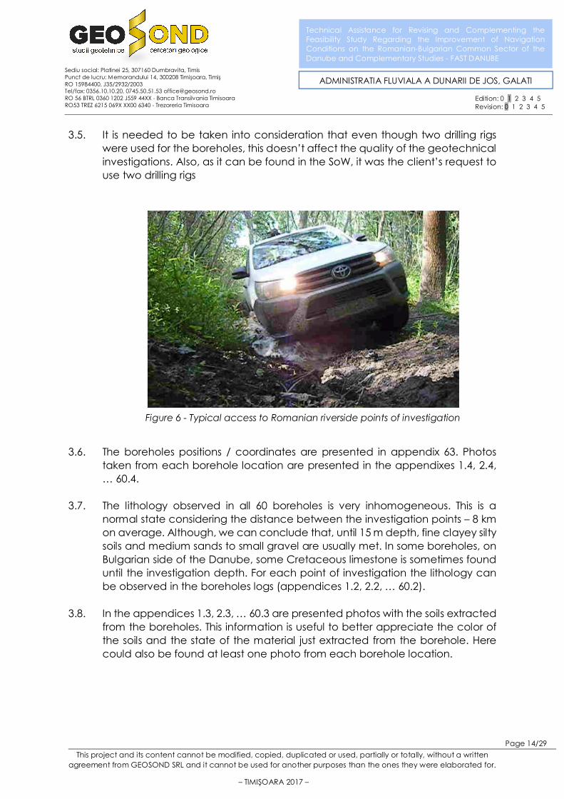
• Manual drilling tripod (light equipment – about 0,5 tons weight) was used for Romanian riverside points of investigation which were significantly more difficult to access. This small rig was transported by an 4x4 Toyota Hilux small truck, most of the time by unpaved/muddy roads.
3.4. The two drilling rigs used for the boreholes fit with the purpose of the study and made possible to reach 15m deep and extract the samples for lab tests. The crawler drilling rig was used mainly on Bulgarian territory due to geological structure and acces and on the Romanian territory where access was possible. Usage of the manual rig on Romanian territory was dictated by the access to the locations.
Figure 5 - Manual tripod drilling equipment
This project and its content cannot be modified, copied, duplicated or used, partially or totally, without a written agreement from GEOSOND SRL and it cannot be used for another purposes than the ones they were elaborated for.
– TIMIŞOARA 2017 –
Page 14/29
Technical Assistance for Revising and Complementing the Feasibility Study Regarding the Improvement of Navigation Conditions on the Romanian-Bulgarian Common Sector of the Danube and Complementary Studies - FAST DANUBE
Sediu social: Platinei 25, 307160 Dumbravita, Timis Punct de lucru: Memorandului 14, 300208 Timişoara, Timiş RO 15984400, J35/2932/2003 Tel/fax: 0356.10.10.20, 0745.50.51.53 [email protected] RO 56 BTRL 0360 1202 J559 44XX - Banca Transilvania Timisoara RO53 TREZ 6215 069X XX00 6340 - Trezoreria Timisoara
ADMINISTRATIA FLUVIALA A DUNARII DE JOS, GALATI
Edition: 0 1 2 3 4 5 Revision: 0 1 2 3 4 5
3.5. It is needed to be taken into consideration that even though two drilling rigs were used for the boreholes, this doesn’t affect the quality of the geotechnical investigations. Also, as it can be found in the SoW, it was the client’s request to use two drilling rigs
3.6. The boreholes positions / coordinates are presented in appendix 63. Photos
taken from each borehole location are presented in the appendixes 1.4, 2.4, … 60.4.
3.7. The lithology observed in all 60 boreholes is very inhomogeneous. This is a normal state considering the distance between the investigation points – 8 km on average. Although, we can conclude that, until 15 m depth, fine clayey silty soils and medium sands to small gravel are usually met. In some boreholes, on Bulgarian side of the Danube, some Cretaceous limestone is sometimes found until the investigation depth. For each point of investigation the lithology can be observed in the boreholes logs (appendices 1.2, 2.2, … 60.2).
3.8. In the appendices 1.3, 2.3, … 60.3 are presented photos with the soils extracted from the boreholes. This information is useful to better appreciate the color of the soils and the state of the material just extracted from the borehole. Here could also be found at least one photo from each borehole location.
Figure 6 - Typical access to Romanian riverside points of investigation

This project and its content cannot be modified, copied, duplicated or used, partially or totally, without a written agreement from GEOSOND SRL and it cannot be used for another purposes than the ones they were elaborated for.
– TIMIŞOARA 2017 –
Page 15/29
Technical Assistance for Revising and Complementing the Feasibility Study Regarding the Improvement of Navigation Conditions on the Romanian-Bulgarian Common Sector of the Danube and Complementary Studies - FAST DANUBE
Sediu social: Platinei 25, 307160 Dumbravita, Timis Punct de lucru: Memorandului 14, 300208 Timişoara, Timiş RO 15984400, J35/2932/2003 Tel/fax: 0356.10.10.20, 0745.50.51.53 [email protected] RO 56 BTRL 0360 1202 J559 44XX - Banca Transilvania Timisoara RO53 TREZ 6215 069X XX00 6340 - Trezoreria Timisoara
ADMINISTRATIA FLUVIALA A DUNARII DE JOS, GALATI
Edition: 0 1 2 3 4 5 Revision: 0 1 2 3 4 5
3.9. The most frequent soil type met in the boreholes is sand (fine/medium/coarse) and gravel (62% of all total 900 m drilled soil). After uncohesive soils comes the clay, met in 23% of total soil drilled layers. Limestone layers were met only in a small percentage – 6% - and only on the Bulgarian side of the Danube. Sometimes, this limestone layer seems to be karstified, because under a several meter of limestone we’ve met unconsolidated clay or sand, which could represent filling of old voids (see boreholes F13, F21, F52).
3.10. We present below a statistic regarding material type we have found in the boreholes.
3.11. The dynamic penetration tests (see appendices 1.5, 2.5, … 60.5), were performed using a heavy-weight dynamic penetrometer (DPH - GEOTOOL brand, Germany, type LMSR vk), that has the following characteristics: m hammer
weight = 50 kg, h height = 50 cm, Scone area= 15 cm2, angleconeα = 90°. The number of
blows required to drive the cone over a defined distance of 20 cm, reveals the dynamic penetration resistance, dR , of the crossed layer. From here, using
different relations, results the equivalent number of blows for the static penetration resistance (NSPT). The correlation was done using the computer program „Dynamic” produced by Geostru Software Italia. Based on the equivalent number of blows, NSPT, the geotechnical parameters of the active zone layers, presented below in boreholes logh, were calculated. The program
23%
5%
62%
0%6%
4%
Layers/Soil type distribution in all 60 boreholes
ARGILA - 23%
PRAF - 5%
NISIP-PIETRIS - 62%
BOLOVANIS - 0%
CALCAR - 6%
UMPLUTURI / DEPOZITEMIXTE / SOL VEGETAL - 4%

This project and its content cannot be modified, copied, duplicated or used, partially or totally, without a written agreement from GEOSOND SRL and it cannot be used for another purposes than the ones they were elaborated for.
– TIMIŞOARA 2017 –
Page 16/29
Technical Assistance for Revising and Complementing the Feasibility Study Regarding the Improvement of Navigation Conditions on the Romanian-Bulgarian Common Sector of the Danube and Complementary Studies - FAST DANUBE
Sediu social: Platinei 25, 307160 Dumbravita, Timis Punct de lucru: Memorandului 14, 300208 Timişoara, Timiş RO 15984400, J35/2932/2003 Tel/fax: 0356.10.10.20, 0745.50.51.53 [email protected] RO 56 BTRL 0360 1202 J559 44XX - Banca Transilvania Timisoara RO53 TREZ 6215 069X XX00 6340 - Trezoreria Timisoara
ADMINISTRATIA FLUVIALA A DUNARII DE JOS, GALATI
Edition: 0 1 2 3 4 5 Revision: 0 1 2 3 4 5
that processes the heavy dynamic cone penetration test (DPH) offers the geotechnical parameters needed for the calculation of the foundation ground characteristics, using among others, the following references: Benassi & Vannelli (1983), Sanglerat, U.S.D.M.S.M. – U.S. Design Manual Soil Mechanics, Schmertmann (1975, 1977, 1978), Fletcher (1965), Stroud & Butler (1975), Vesic (1970), Trofimenkov (1974), Meyerhof (1956), Gibbs & Holtz (1957), Skempton (1986), Schultze & Menzenbach (1961), Peck-Hanson-Thornburn-Meyerhof (1956), Sowers (1961), De Mello, Malcev (1964), Shioi-Fukuni (1982), Japanese National Railway (1982), Owasaki & Iwasaki, Terzaghi, Begemann (1974), Robertson e Campanella (1983), Imai & Tonouchi (1982), SHI-MING (1982) etc. The results obtained by those authors can be applied for different soil layers, so that choosing the geotechnical parameters should be done according to the stratigraphy met in the boreholes, the depositional environment of the soils.
3.12. In the appendix 62 is presented the method of how the DPH N20 parameter
was used to obtain, empirical, the geotechnical physic-mechanical parameters. Here are presented the bibliographic references used in the computation.
3.13. The DPH tests were executed near the corresponding borehole (they have the same numbering as the borehole) in order to appreciate the soils physic-mechanical characteristics. We have not included the parameters obtained
Figure 7 - Performing DPH test with LMSR Geotool equipment
This project and its content cannot be modified, copied, duplicated or used, partially or totally, without a written agreement from GEOSOND SRL and it cannot be used for another purposes than the ones they were elaborated for.
– TIMIŞOARA 2017 –
Page 17/29
Technical Assistance for Revising and Complementing the Feasibility Study Regarding the Improvement of Navigation Conditions on the Romanian-Bulgarian Common Sector of the Danube and Complementary Studies - FAST DANUBE
Sediu social: Platinei 25, 307160 Dumbravita, Timis Punct de lucru: Memorandului 14, 300208 Timişoara, Timiş RO 15984400, J35/2932/2003 Tel/fax: 0356.10.10.20, 0745.50.51.53 [email protected] RO 56 BTRL 0360 1202 J559 44XX - Banca Transilvania Timisoara RO53 TREZ 6215 069X XX00 6340 - Trezoreria Timisoara
ADMINISTRATIA FLUVIALA A DUNARII DE JOS, GALATI
Edition: 0 1 2 3 4 5 Revision: 0 1 2 3 4 5
by those DPH tests in the boreholes logs, but only in the report generated by the specialized software – Dynamic. Please follow the appendixes 1.5, 2.5, … 60.5 for the DPH tests results.

This project and its content cannot be modified, copied, duplicated or used, partially or totally, without a written agreement from GEOSOND SRL and it cannot be used for another purposes than the ones they were elaborated for.
– TIMIŞOARA 2017 –
Page 18/29
Technical Assistance for Revising and Complementing the Feasibility Study Regarding the Improvement of Navigation Conditions on the Romanian-Bulgarian Common Sector of the Danube and Complementary Studies - FAST DANUBE
Sediu social: Platinei 25, 307160 Dumbravita, Timis Punct de lucru: Memorandului 14, 300208 Timişoara, Timiş RO 15984400, J35/2932/2003 Tel/fax: 0356.10.10.20, 0745.50.51.53 [email protected] RO 56 BTRL 0360 1202 J559 44XX - Banca Transilvania Timisoara RO53 TREZ 6215 069X XX00 6340 - Trezoreria Timisoara
ADMINISTRATIA FLUVIALA A DUNARII DE JOS, GALATI
Edition: 0 1 2 3 4 5 Revision: 0 1 2 3 4 5
4. LABORATORY TESTING
4.1. As the Beneficiary’s SoW required we had extracted from the boreholes a
number of 240 samples (disturbed and undisturbed) in order to perform laboratory tests on soil samples. From all those 240 samples, laboratory tests were performed only on 235 of them; 5 samples were rock (limestone) samples on which the required laboratory analyses could not be done. According to our contract, the following laboratory tests have been performed (test name and resulted parameters):
• Particle size distribution • Atterberg limits
o Liquid limit o Plastic Limit o Moisture content o Plasticity index o Consistency index
• Oedometer test
o Porosity o Pore index o Volumetric dry weight o Natural volumetric weight o Oedometric modulus o Specific compaction o Coefficient of compaction
• Direct shear test, UU (undrained - unconsolidated)
o Friction angle o Cohesion
4.2. As we can see on the 3.8. diagram, the cohesive soils represents only 28% of
the total soils met in the boreholes. For that reason, not all the number of designed laboratory tests could be conducted. We present below a chart with the performed laboratory tests versus designed tests, estimated before the start of the project.

This project and its content cannot be modified, copied, duplicated or used, partially or totally, without a written agreement from GEOSOND SRL and it cannot be used for another purposes than the ones they were elaborated for.
– TIMIŞOARA 2017 –
Page 19/29
Technical Assistance for Revising and Complementing the Feasibility Study Regarding the Improvement of Navigation Conditions on the Romanian-Bulgarian Common Sector of the Danube and Complementary Studies - FAST DANUBE
Sediu social: Platinei 25, 307160 Dumbravita, Timis Punct de lucru: Memorandului 14, 300208 Timişoara, Timiş RO 15984400, J35/2932/2003 Tel/fax: 0356.10.10.20, 0745.50.51.53 [email protected] RO 56 BTRL 0360 1202 J559 44XX - Banca Transilvania Timisoara RO53 TREZ 6215 069X XX00 6340 - Trezoreria Timisoara
ADMINISTRATIA FLUVIALA A DUNARII DE JOS, GALATI
Edition: 0 1 2 3 4 5 Revision: 0 1 2 3 4 5
4.3. Because of the very large area on which the boreholes are located, a synthesis
of the laboratory results is not helping. Each borehole must be considered individually, with its lithology (presented in appendixes 1.2, 2.2, … 60.2), its laboratory tests results (appendixes 1.6, 2.6, … 60.6 and the appendix 64 - summary) and its DPH tests (appendixes 1.5, 2.5, … , 60.5).
4.4. Water samples were collected from the 10 boreholes which were analyzed in order to determine the aggression against the concrete. Results are presented in 3.6, 12.6, 19.6, 20.6, 32.6, 41.6, 46.6, 47.6, 55.6, 60.6.
0 20 40 60 80 100 120 140 160
Particle size distr. - aerometer
Particle size distr. - sieving
Attenberg limits
Natural volumetric weight
Swelling/Expanding characteristics
Direct shear
Oedometric test
Underground water chemical test
NUMBER OF ESTIMATED vs
PERFORMED LABORATORY TESTS
estimated to be performed tests performed tests
This project and its content cannot be modified, copied, duplicated or used, partially or totally, without a written agreement from GEOSOND SRL and it cannot be used for another purposes than the ones they were elaborated for.
– TIMIŞOARA 2017 –
Page 20/29
Technical Assistance for Revising and Complementing the Feasibility Study Regarding the Improvement of Navigation Conditions on the Romanian-Bulgarian Common Sector of the Danube and Complementary Studies - FAST DANUBE
Sediu social: Platinei 25, 307160 Dumbravita, Timis Punct de lucru: Memorandului 14, 300208 Timişoara, Timiş RO 15984400, J35/2932/2003 Tel/fax: 0356.10.10.20, 0745.50.51.53 [email protected] RO 56 BTRL 0360 1202 J559 44XX - Banca Transilvania Timisoara RO53 TREZ 6215 069X XX00 6340 - Trezoreria Timisoara
ADMINISTRATIA FLUVIALA A DUNARII DE JOS, GALATI
Edition: 0 1 2 3 4 5 Revision: 0 1 2 3 4 5
5. CONCLUSIONS AND RECOMANDATIONS
5.1. From the data presented above and the information obtained as a result of
the field and laboratory geotechnical works, we conclude the following characteristics of the investigated area:
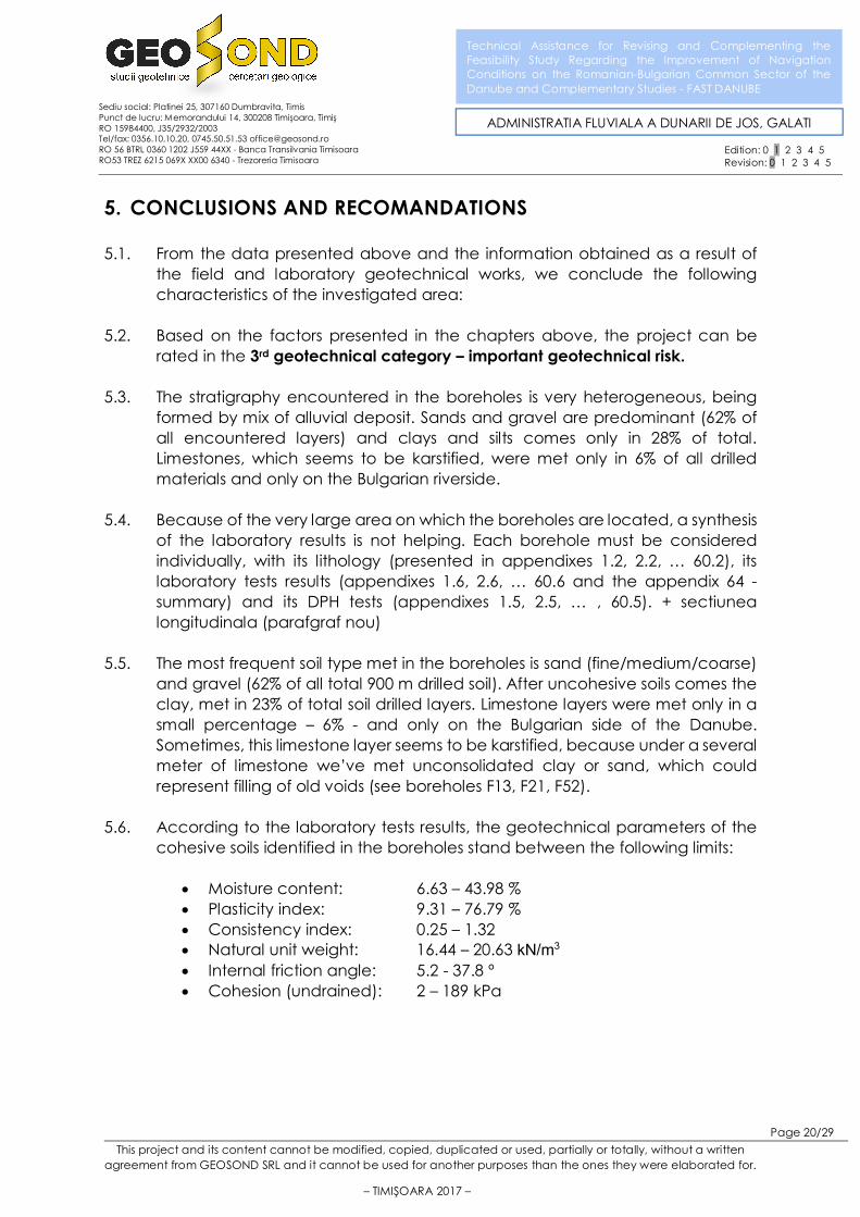
5.2. Based on the factors presented in the chapters above, the project can be rated in the 3rd geotechnical category – important geotechnical risk.
5.3. The stratigraphy encountered in the boreholes is very heterogeneous, being formed by mix of alluvial deposit. Sands and gravel are predominant (62% of all encountered layers) and clays and silts comes only in 28% of total. Limestones, which seems to be karstified, were met only in 6% of all drilled materials and only on the Bulgarian riverside.
5.4. Because of the very large area on which the boreholes are located, a synthesis of the laboratory results is not helping. Each borehole must be considered individually, with its lithology (presented in appendixes 1.2, 2.2, … 60.2), its laboratory tests results (appendixes 1.6, 2.6, … 60.6 and the appendix 64 - summary) and its DPH tests (appendixes 1.5, 2.5, … , 60.5). + sectiunea longitudinala (parafgraf nou)
5.5. The most frequent soil type met in the boreholes is sand (fine/medium/coarse) and gravel (62% of all total 900 m drilled soil). After uncohesive soils comes the clay, met in 23% of total soil drilled layers. Limestone layers were met only in a small percentage – 6% - and only on the Bulgarian side of the Danube. Sometimes, this limestone layer seems to be karstified, because under a several meter of limestone we’ve met unconsolidated clay or sand, which could represent filling of old voids (see boreholes F13, F21, F52).
5.6. According to the laboratory tests results, the geotechnical parameters of the cohesive soils identified in the boreholes stand between the following limits:
• Moisture content: 6.63 – 43.98 % • Plasticity index: 9.31 – 76.79 % • Consistency index: 0.25 – 1.32 • Natural unit weight: 16.44 – 20.63 kN/m3
• Internal friction angle: 5.2 - 37.8 º • Cohesion (undrained): 2 – 189 kPa

This project and its content cannot be modified, copied, duplicated or used, partially or totally, without a written agreement from GEOSOND SRL and it cannot be used for another purposes than the ones they were elaborated for.
– TIMIŞOARA 2017 –
Page 21/29
Technical Assistance for Revising and Complementing the Feasibility Study Regarding the Improvement of Navigation Conditions on the Romanian-Bulgarian Common Sector of the Danube and Complementary Studies - FAST DANUBE
Sediu social: Platinei 25, 307160 Dumbravita, Timis Punct de lucru: Memorandului 14, 300208 Timişoara, Timiş RO 15984400, J35/2932/2003 Tel/fax: 0356.10.10.20, 0745.50.51.53 [email protected] RO 56 BTRL 0360 1202 J559 44XX - Banca Transilvania Timisoara RO53 TREZ 6215 069X XX00 6340 - Trezoreria Timisoara
ADMINISTRATIA FLUVIALA A DUNARII DE JOS, GALATI
Edition: 0 1 2 3 4 5 Revision: 0 1 2 3 4 5
5.7. In the appendix 65 we present a geotechnical longitudinal section based on all performed boreholes.
5.8. Because all boreholes were executed near the river, the measured water level in each one is strongly related to the Danube’s level. We presented this level in each borehole lo g (see appendixes 1.2, 2.2 … 60.2). The chemical aggression towards concrete is specified on appendixes 3.6, 12.6, 19.6, 20.6, 32.6, 41.6, 46.6, 47.6, 55.6, 60.6.
5.9. The field works showed in the active zone of the future constructions the presence of soils with high to low compressibility. The compressibility modulus (and others geotechnical parameters obtained from all 235 collected samples) are presented in appendixes 1.6, 2.6, … 60.6. This is a summary of all laboratory data.
5.10. At the date when the geotechnical project was written (June, 2017) the client was not able to provide us the information about the type of constructions and their location. The aim of the geotechnical report was to provide to the Client a general view of soil conditions that he can encounter in the places where he will decide to design some hydrotechnical constructions.
5.11. In order to provide a better image of the entire area, we present below a table with some orientative foundation recommendation for each borehole location. It is needed to be taken into consideration that the values found in the table below are only estimations (at this point, with the information we have, it is impossible for us to accurately specify, for each borehole location the: minimum foundation depth and the allowable pressure).

This project and its content cannot be modified, copied, duplicated or used, partially or totally, without a written agreement from GEOSOND SRL and it cannot be used for another purposes than the ones they were elaborated for.
– TIMIŞOARA 2017 –
Page 22/29
Technical Assistance for Revising and Complementing the Feasibility Study Regarding the Improvement of Navigation Conditions on the Romanian-Bulgarian Common Sector of the Danube and Complementary Studies - FAST DANUBE
Sediu social: Platinei 25, 307160 Dumbravita, Timis Punct de lucru: Memorandului 14, 300208 Timişoara, Timiş RO 15984400, J35/2932/2003 Tel/fax: 0356.10.10.20, 0745.50.51.53 [email protected] RO 56 BTRL 0360 1202 J559 44XX - Banca Transilvania Timisoara RO53 TREZ 6215 069X XX00 6340 - Trezoreria Timisoara
ADMINISTRATIA FLUVIALA A DUNARII DE JOS, GALATI
Edition: 0 1 2 3 4 5 Revision: 0 1 2 3 4 5
Geotehcnical category Recomandations*
Borehole
/ position
(km) /
country
Field
condi-
tions
Ground-
water
Buildings
impor-
tance
level*
Surroun-
dings
Seismic
hazard
zone
Total score
(geotech-
nical
category)
Recoman-
ded
foundation
type
Minimum
foundation
depth
Allowable
pressure at min.
foundation depth
The scoring method is presented at 5.13. 6 – 9 LOW m (from the
borehole’s top level)
KPa
10 – 14
MEDIUM
15 – 21
HIGH
F1 / 845 /
RO 1 2 3 1 2 9
shallow
foundation 2.4 240
F2 / 839 /
BG 1 4 3 1 2 11
shallow
foundation 2 280
F3 / 838 /
RO 6 4 3 1 2 16
piles (deep
foundation) 5 200
F5 / 824 /
BG 3 2 3 1 2 11
piles (deep
foundation) 6.5 250
F4 / 821 /
RO 3 4 3 1 2 13
piles (deep
foundation) 4 220
F7 / 802 /
RO 6 2 3 1 2 14
piles (deep
foundation) 7 150
F9 / 799 /
BG 6 4 3 1 2 16
piles (deep
foundation) 6.5 200
F8 / 783 /
RO 3 2 3 1 2 11
shallow
foundation 3.8 200
F10 / 782
/ BG 6 4 3 1 2 16
piles (deep
foundation) 6.2 200
F11 / 775
/ BG 6 4 3 1 2 16
piles (deep
foundation) 8.5 200
F12 / 775
/ RO 6 4 3 1 2 16
piles (deep
foundation) 6 200
F15 / 758
/ RO 6 4 3 1 2 16
piles (deep
foundation) 5.5 200
F14 / 756
/ BG 6 4 3 1 2 16
piles (deep
foundation) 5.5 250
F16 / 737
/ RO 6 2 3 1 2 14
piles (deep
foundation) 5 250
F18 / 736
/ BG 3 2 3 1 2 11
shallow
foundation 1.5 250
F17 / 719
/ BG 3 2 3 1 2 11
shallow
foundation 3.5 280
F6 / 718 /
RO 6 4 3 1 2 16
piles (deep
foundation) 10 500

This project and its content cannot be modified, copied, duplicated or used, partially or totally, without a written agreement from GEOSOND SRL and it cannot be used for another purposes than the ones they were elaborated for.
– TIMIŞOARA 2017 –
Page 23/29
Technical Assistance for Revising and Complementing the Feasibility Study Regarding the Improvement of Navigation Conditions on the Romanian-Bulgarian Common Sector of the Danube and Complementary Studies - FAST DANUBE
Sediu social: Platinei 25, 307160 Dumbravita, Timis Punct de lucru: Memorandului 14, 300208 Timişoara, Timiş RO 15984400, J35/2932/2003 Tel/fax: 0356.10.10.20, 0745.50.51.53 [email protected] RO 56 BTRL 0360 1202 J559 44XX - Banca Transilvania Timisoara RO53 TREZ 6215 069X XX00 6340 - Trezoreria Timisoara
ADMINISTRATIA FLUVIALA A DUNARII DE JOS, GALATI
Edition: 0 1 2 3 4 5 Revision: 0 1 2 3 4 5
Geotehcnical category Recomandations*
Borehole
/ position
(km) /
country
Field
condi-
tions
Ground-
water
Buildings
impor-
tance
level*
Surroun-
dings
Seismic
hazard
zone
Total score
(geotech-
nical
category)
Recoman-
ded
foundation
type
Minimum
foundation
depth
Allowable
pressure at min.
foundation depth
The scoring method is presented at 5.13. 6 – 9 LOW m (from the
borehole’s top level)
KPa
10 – 14
MEDIUM
15 – 21
HIGH
F19 / 703
/ BG 3 4 3 1 2 13
shallow
foundation 1.5 300
F20 / 698
/ RO 6 4 3 1 2 16
piles (deep
foundation) 5.5 300
F21 / 683
/ BG 2 2 3 1 2 10
shallow
foundation 2.6 500
F23 / 678
/ BG 6 2 3 1 2 14
piles (deep
foundation) 7 250
F22 / 678
/ RO 6 4 3 1 2 16
piles (deep
foundation) 5 250
F24 / 661
/ BG 2 4 3 1 2 12
shallow
foundation 2.5 300
F25 / 661
/ RO 6 4 3 1 2 16
piles (deep
foundation) 4.5 230
F55 / 644
/ RO 6 4 3 1 2 16
piles (deep
foundation) 5.5 250
F13 / 641
/ BG 2 4 3 1 2 12
shallow
foundation 2 500
F27 / 633
/ RO 6 4 3 1 2 16
piles (deep
foundation) 4.5 300
F28 / 628
/ BG 3 2 3 1 2 11
piles (deep
foundation) 4.8 200
F53 / 608
/ BG 6 4 3 1 2 16
piles (deep
foundation) 6 250
F40 / 605
/ RO 3 4 3 1 2 13
shallow
foundation 2.5 220
F26 / 598
/ RO 3 2 3 1 2 11
shallow
foundation 3.5 250
F29 / 596
/ BG 6 2 3 1 2 14
piles (deep
foundation) 4.5 280
F30 / 580
/ RO 6 4 3 1 2 16
piles (deep
foundation) 6.5 300
F31 / 577
/ BG 2 2 3 1 2 10
shallow
foundation 1.5 300

This project and its content cannot be modified, copied, duplicated or used, partially or totally, without a written agreement from GEOSOND SRL and it cannot be used for another purposes than the ones they were elaborated for.
– TIMIŞOARA 2017 –
Page 24/29
Technical Assistance for Revising and Complementing the Feasibility Study Regarding the Improvement of Navigation Conditions on the Romanian-Bulgarian Common Sector of the Danube and Complementary Studies - FAST DANUBE
Sediu social: Platinei 25, 307160 Dumbravita, Timis Punct de lucru: Memorandului 14, 300208 Timişoara, Timiş RO 15984400, J35/2932/2003 Tel/fax: 0356.10.10.20, 0745.50.51.53 [email protected] RO 56 BTRL 0360 1202 J559 44XX - Banca Transilvania Timisoara RO53 TREZ 6215 069X XX00 6340 - Trezoreria Timisoara
ADMINISTRATIA FLUVIALA A DUNARII DE JOS, GALATI
Edition: 0 1 2 3 4 5 Revision: 0 1 2 3 4 5
Geotehcnical category Recomandations*
Borehole
/ position
(km) /
country
Field
condi-
tions
Ground-
water
Buildings
impor-
tance
level*
Surroun-
dings
Seismic
hazard
zone
Total score
(geotech-
nical
category)
Recoman-
ded
foundation
type
Minimum
foundation
depth
Allowable
pressure at min.
foundation depth
The scoring method is presented at 5.13. 6 – 9 LOW m (from the
borehole’s top level)
KPa
10 – 14
MEDIUM
15 – 21
HIGH
F32 / 570
/ RO 6 4 3 1 2 16
piles (deep
foundation) 6.5 250
F35 / 560
/ BG 6 2 3 1 2 14
piles (deep
foundation) 5.5 220
F34 / 555
/ RO 6 4 3 1 2 16
piles (deep
foundation) 4.5 200
F37 / 542
/ BG 6 4 3 1 2 16
piles (deep
foundation) 8 300
F36 / 538
/ RO 6 4 3 1 2 16
piles (deep
foundation) 7.5 300
F38 / 534
/ RO 3 1 3 1 2 10
shallow
foundation 3 200
F39 / 534
/ BG 6 2 3 1 2 14
piles (deep
foundation) 5 220
F43 / 526
/ BG 6 4 3 1 2 16
piles (deep
foundation) 4.5 250
F41 / 524
/ RO 6 2 3 1 2 14
piles (deep
foundation) 6.5 280
F42 / 520
/ RO 6 2 3 1 2 14
piles (deep
foundation) 5.5 280
F52 / 501
/ BG 3 1 3 1 3 11
shallow
foundation 2.5 220
F44 / 495
/ RO 6 4 3 1 3 17
piles (deep
foundation) 6 250
F33 / 482
/ BG 3 2 3 1 3 12
shallow
foundation 3.5 220
F45 / 475
/ RO 6 2 3 1 3 15
piles (deep
foundation) 5.5 250
F54 / 466
/ BG 3 4 3 1 3 14
shallow
foundation 2.5 250
F46 / 461
/ RO 6 2 3 1 3 15
piles (deep
foundation) 4.5 280
F47 / 453
/ BG 6 2 3 1 3 15
piles (deep
foundation) 7 300

This project and its content cannot be modified, copied, duplicated or used, partially or totally, without a written agreement from GEOSOND SRL and it cannot be used for another purposes than the ones they were elaborated for.
– TIMIŞOARA 2017 –
Page 25/29
Technical Assistance for Revising and Complementing the Feasibility Study Regarding the Improvement of Navigation Conditions on the Romanian-Bulgarian Common Sector of the Danube and Complementary Studies - FAST DANUBE
Sediu social: Platinei 25, 307160 Dumbravita, Timis Punct de lucru: Memorandului 14, 300208 Timişoara, Timiş RO 15984400, J35/2932/2003 Tel/fax: 0356.10.10.20, 0745.50.51.53 [email protected] RO 56 BTRL 0360 1202 J559 44XX - Banca Transilvania Timisoara RO53 TREZ 6215 069X XX00 6340 - Trezoreria Timisoara
ADMINISTRATIA FLUVIALA A DUNARII DE JOS, GALATI
Edition: 0 1 2 3 4 5 Revision: 0 1 2 3 4 5
Geotehcnical category Recomandations*
Borehole
/ position
(km) /
country
Field
condi-
tions
Ground-
water
Buildings
impor-
tance
level*
Surroun-
dings
Seismic
hazard
zone
Total score
(geotech-
nical
category)
Recoman-
ded
foundation
type
Minimum
foundation
depth
Allowable
pressure at min.
foundation depth
The scoring method is presented at 5.13. 6 – 9 LOW m (from the
borehole’s top level)
KPa
10 – 14
MEDIUM
15 – 21
HIGH
F48 / 435
/ RO 3 2 3 1 3 12
shallow
foundation 3 230
F51 / 432
/ BG 3 1 3 1 3 11
shallow
foundation 3 250
F49 / 422
/ RO 6 4 3 1 3 17
piles (deep
foundation) 6 250
F50 / 421
/ BG 3 2 3 1 3 12
shallow
foundation 3.5 300
F56 / 403
/ BG 6 4 3 1 3 17
piles (deep
foundation) 7.5 350
F57 / 401
/ RO 6 4 3 1 3 17
piles (deep
foundation) 6 300
F58 / 396
/ BG 6 4 3 1 3 17
piles (deep
foundation) 4.5 300
F59 / 387
/ RO 6 4 3 1 3 17
piles (deep
foundation) 6.5 350
F60 / 378
/ BG 6 2 3 1 3 15
piles (deep
foundation) 5 270
5.12. In the table above, the estimation of the allowable pressure and minimum foundation depths were based on:
• Performed DPH tests • Shearing laboratory tests • Compressibility laboratory tests
However, those values are, as we mentioned before, only estimated and orientative.
5.13. Below there is the NP07-2014 Standard’s recommendations regarding the method of quantifying geotechnical conditions used in Geotechnical Risks computation presented above.

This project and its content cannot be modified, copied, duplicated or used, partially or totally, without a written agreement from GEOSOND SRL and it cannot be used for another purposes than the ones they were elaborated for.
– TIMIŞOARA 2017 –
Page 26/29
Technical Assistance for Revising and Complementing the Feasibility Study Regarding the Improvement of Navigation Conditions on the Romanian-Bulgarian Common Sector of the Danube and Complementary Studies - FAST DANUBE
Sediu social: Platinei 25, 307160 Dumbravita, Timis Punct de lucru: Memorandului 14, 300208 Timişoara, Timiş RO 15984400, J35/2932/2003 Tel/fax: 0356.10.10.20, 0745.50.51.53 [email protected] RO 56 BTRL 0360 1202 J559 44XX - Banca Transilvania Timisoara RO53 TREZ 6215 069X XX00 6340 - Trezoreria Timisoara
ADMINISTRATIA FLUVIALA A DUNARII DE JOS, GALATI
Edition: 0 1 2 3 4 5 Revision: 0 1 2 3 4 5
Geotechnical category
Field conditions
Groundwater Buildings importance level*
Surroundings Seismic hazard zone
1 - good 1 - without dewatering 2 - low 1 - no risks 1 - ag<0.15g
3 - medium 2 - normal dewatering 3 - normal 3 - medium risks 2 - 0.15g≤ag<0.25g
6 - difficult 4- difficult dewatering 5 - exceptional 4 - high risks 3 - ag≥0.25g
5.14. Those recommendations will need to be changed after the following details
will be available: • Exact location of the construction and its geometry • Designed object / foundation • Particularity / Type of the construction • Geotechnical parameters of the soils in the exact points where the
constructions will be placed.
5.15. In this technical documentation there are presented interpretations and professional recommendations. These are partially based on the evaluation of the technical information, partially on other geotechnical reports for bordering sites and partially on our general experience regarding potential geotechnical conditions in the area. One has to keep in mind that the boreholes may not show possible unfavorable foundation conditions that may occur in between / near them. The content of this report cannot be used for other purposes. Each construction site for the designed objects must have its own site investigation works, based on the SoW provided by the designer.

This project and its content cannot be modified, copied, duplicated or used, partially or totally, without a written agreement from GEOSOND SRL and it cannot be used for another purposes than the ones they were elaborated for.
– TIMIŞOARA 2017 –
Page 27/29
Technical Assistance for Revising and Complementing the Feasibility Study Regarding the Improvement of Navigation Conditions on the Romanian-Bulgarian Common Sector of the Danube and Complementary Studies - FAST DANUBE
Sediu social: Platinei 25, 307160 Dumbravita, Timis Punct de lucru: Memorandului 14, 300208 Timişoara, Timiş RO 15984400, J35/2932/2003 Tel/fax: 0356.10.10.20, 0745.50.51.53 [email protected] RO 56 BTRL 0360 1202 J559 44XX - Banca Transilvania Timisoara RO53 TREZ 6215 069X XX00 6340 - Trezoreria Timisoara
ADMINISTRATIA FLUVIALA A DUNARII DE JOS, GALATI
Edition: 0 1 2 3 4 5 Revision: 0 1 2 3 4 5
6. HOW THE SOW REQUIREMENTS WERE FULFILLED
6.1. In the SoW provided by the Beneficiary, through the Client’s representatives, there were certain requirements regarding the content of the Geotechnical Report and also for the geotechnical site investigation works.
6.2. Our mission was not only to deliver all the data the Client had requested and respect the proposed calendar of the works, but also to provide more geotechnical information which could be needed for having a better image of the geological conditions along the Danube.
6.3. Below we present a table with those requirements and how this report fulfill them.
SoW requirements Method of fulfillment
SITE INVESTIGATIONS
- Geotechnical boreholes, on both
riversides - 60 boreholes were executed, 30 on
Romanian riverside, 30 on Bulgarian one - Distance between the investigation
points: 20 km - The average distance between boreholes
is 8 km, and the maximum distance is 20 km (see appendix 1.0, 63)
- Minimum depth of the boreholes: 15 m - All the boreholes were executed at 15 m depth from the surface
- Boreholes execution: 60 days from
project’s starting order - All the boreholes were executed in 44 days
from project’s starting order - 2 teams for boreholes execution, each
one with its own drilling equipment - 2 teams had participated at the boreholes
execution, each one with its own drilling rig, plus a 3rd team for DPHs
GEOTECHNICAL REPORT
- Boreholes logs and laboratory analyses
provided in 90 days from project’s
starting order
- Geotechnical Report has been delivered on July, 5th, meaning 90 days from project’s starting order
- Allowable pressure of the soils - Allowable pressure of foundation recommended level can be found on table, at 5.9. point of this report
- Al the geotechnical analyses results
provided on paper and digital format, in
Romanian, Bulgarian and English
languages
- All the geotechnical laboratory analyses can be found as appendixes on this report, and the digital are on an external memory card (also attached to this report). All the data are available in all three languages
This project and its content cannot be modified, copied, duplicated or used, partially or totally, without a written agreement from GEOSOND SRL and it cannot be used for another purposes than the ones they were elaborated for.
– TIMIŞOARA 2017 –
Page 28/29
Technical Assistance for Revising and Complementing the Feasibility Study Regarding the Improvement of Navigation Conditions on the Romanian-Bulgarian Common Sector of the Danube and Complementary Studies - FAST DANUBE
Sediu social: Platinei 25, 307160 Dumbravita, Timis Punct de lucru: Memorandului 14, 300208 Timişoara, Timiş RO 15984400, J35/2932/2003 Tel/fax: 0356.10.10.20, 0745.50.51.53 [email protected] RO 56 BTRL 0360 1202 J559 44XX - Banca Transilvania Timisoara RO53 TREZ 6215 069X XX00 6340 - Trezoreria Timisoara
ADMINISTRATIA FLUVIALA A DUNARII DE JOS, GALATI
Edition: 0 1 2 3 4 5 Revision: 0 1 2 3 4 5
7. STANDARDS USED ON THIS GEOTECHNICAL REPORT
NP 074 : 2014 Standard regulating geotechnical reports for constructions.
SR EN 1997-1:2006 Eurocode 7: Geotechnical design. Part 1: General rules
SR EN 1997-2:2007 Eurocode 7: Geotechnical design. Part 2: Soil investigation
SR EN ISO 14688-1:2004 Soil determinations and investigations. Classification of soils. Part 2: identification and description
SR EN ISO 14688-2:2006 Soil determinations and investigations. Classification of soils. Part 2: Classification principles
SR EN ISO 22476-2:2006 Geotechnical investigations and tests Part 2: Dynamic penetration test
GP 129 : 2014 Guide for geotechnical design
STAS 3300/1-85 Foundation soil. General computation principles.
STAS 3300/2-85 Foundation soil. Computation of the foundation soil for direct footings.
NP 112 : 2014 Standard for shallow foundation design
C 159-89 Technical instructions for the investigation of the foundation soil using the cone penetration test: static penetration, dynamic penetration, vibrating.
NP 125 : 2010 Standard for construction foundations on moisture-sensitive soils
NP 126 : 2010 Standard for construction foundations on shrink and swell soils

This project and its content cannot be modified, copied, duplicated or used, partially or totally, without a written agreement from GEOSOND SRL and it cannot be used for another purposes than the ones they were elaborated for.
– TIMIŞOARA 2017 –
Page 29/29
Technical Assistance for Revising and Complementing the Feasibility Study Regarding the Improvement of Navigation Conditions on the Romanian-Bulgarian Common Sector of the Danube and Complementary Studies - FAST DANUBE
Sediu social: Platinei 25, 307160 Dumbravita, Timis Punct de lucru: Memorandului 14, 300208 Timişoara, Timiş RO 15984400, J35/2932/2003 Tel/fax: 0356.10.10.20, 0745.50.51.53 [email protected] RO 56 BTRL 0360 1202 J559 44XX - Banca Transilvania Timisoara RO53 TREZ 6215 069X XX00 6340 - Trezoreria Timisoara
ADMINISTRATIA FLUVIALA A DUNARII DE JOS, GALATI
Edition: 0 1 2 3 4 5 Revision: 0 1 2 3 4 5
8. BIBLIOGRAPHY
1. Radu E, Radu Catalina, Ion B, Pandele Ada, 2014, The Danube Water Integrated Management (Water) Project - The Lithological and Hydrogeological Characterization of the Quaternary Deposits on the Left Side of the Danube, Between Vedea and Arges Rivers (Romania), 14th SGEM GeoConference, Proceedings Volume II, Albena, Bulgaria
2. Ivanov M, 2014, Hydrogeological analysis and conceptual model of shallow ground waters in the Belene valley/lowland – north Bulgaria, Conferinta stiintifica a INHGA, Bucuresti
3. Macaleț Rodica, Rădescu M, Minciună M.N, 2008, Consideraţii privind
corpurile de apă subterană din sudul României, GEO-ECO-MARINA nr. 14 – Supliment nr. 1
4. Angelova Dora, 2001, Quaternary Geology, Geomorphology and Tectonics
in the Iskar River Valley System, The Danubian Plain (Bulgaria), Bull. of Geological Society of Greece, vol. XXXIV/1
5. Angelova Dora, 2001, Quaternary Geology, Geomorphology and Tectonics
in the Ogosta River Valley System, The Danubian Plain (Bulgaria), Bull. Of Geological Society of Greece, vol. XXXIV/1
6. Bulgaria - State of the art of country and local situation, Report GEOSEE Project, 2014