Embed Size (px)
Citation preview

NWS Wilmington, OhioMay 2020
Regional Climate Summary
Regional Climate Summary
Unseasonably cold weather resulted in late season frost and freeze conditions during the first half of the month, with numerous nights of temperatures in the 20s and 30s through the first 2 weeks of the
month. An upper low allowed for cloudy and rainy conditions during the middle of the month before a warmer and more-summertime pattern evolved for the later portions of May.
1
Temperatures
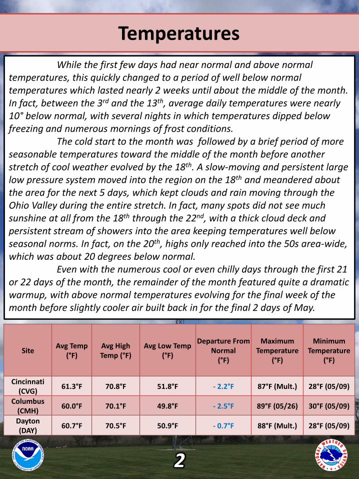
While the first few days had near normal and above normal temperatures, this quickly changed to a period of well below normal temperatures which lasted nearly 2 weeks until about the middle of the month. In fact, between the 3rd and the 13th, average daily temperatures were nearly 10° below normal, with several nights in which temperatures dipped below freezing and numerous mornings of frost conditions.
The cold start to the month was followed by a brief period of more seasonable temperatures toward the middle of the month before another stretch of cool weather evolved by the 18th. A slow-moving and persistent large low pressure system moved into the region on the 18th and meandered about the area for the next 5 days, which kept clouds and rain moving through the Ohio Valley during the entire stretch. In fact, many spots did not see much sunshine at all from the 18th through the 22nd, with a thick cloud deck and persistent stream of showers into the area keeping temperatures well below seasonal norms. In fact, on the 20th, highs only reached into the 50s area-wide, which was about 20 degrees below normal.
Even with the numerous cool or even chilly days through the first 21 or 22 days of the month, the remainder of the month featured quite a dramatic warmup, with above normal temperatures evolving for the final week of the month before slightly cooler air built back in for the final 2 days of May.
SiteAvg Temp
(°F)Avg High Temp (°F)
Avg Low Temp(°F)
Departure From Normal
(°F)
Maximum Temperature
(°F)
Minimum Temperature
(°F)
Cincinnati (CVG)
61.3°F 70.8°F 51.8°F - 2.2°F 87°F (Mult.) 28°F (05/09)
Columbus (CMH)
60.0°F 70.1°F 49.8°F - 2.5°F 89°F (05/26) 30°F (05/09)
Dayton (DAY)
60.7°F 70.5°F 50.9°F - 0.7°F 88°F (Mult.) 28°F (05/09)
2

Temperatures (Continued)
Temp Graph / Graphic #1
Temp Graph / Graphic #2
3

Temperatures (Continued)
4
Precipitation
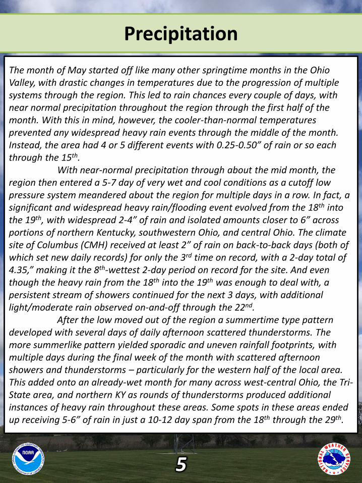
The month of May started off like many other springtime months in the Ohio Valley, with drastic changes in temperatures due to the progression of multiple systems through the region. This led to rain chances every couple of days, with near normal precipitation throughout the region through the first half of the month. With this in mind, however, the cooler-than-normal temperatures prevented any widespread heavy rain events through the middle of the month. Instead, the area had 4 or 5 different events with 0.25-0.50” of rain or so each through the 15th.
With near-normal precipitation through about the mid month, the region then entered a 5-7 day of very wet and cool conditions as a cutoff low pressure system meandered about the region for multiple days in a row. In fact, a significant and widespread heavy rain/flooding event evolved from the 18th into the 19th, with widespread 2-4” of rain and isolated amounts closer to 6” across portions of northern Kentucky, southwestern Ohio, and central Ohio. The climate site of Columbus (CMH) received at least 2” of rain on back-to-back days (both of which set new daily records) for only the 3rd time on record, with a 2-day total of 4.35,” making it the 8th-wettest 2-day period on record for the site. And even though the heavy rain from the 18th into the 19th was enough to deal with, a persistent stream of showers continued for the next 3 days, with additional light/moderate rain observed on-and-off through the 22nd.
After the low moved out of the region a summertime type pattern developed with several days of daily afternoon scattered thunderstorms. The more summerlike pattern yielded sporadic and uneven rainfall footprints, with multiple days during the final week of the month with scattered afternoon showers and thunderstorms – particularly for the western half of the local area. This added onto an already-wet month for many across west-central Ohio, the Tri-State area, and northern KY as rounds of thunderstorms produced additional instances of heavy rain throughout these areas. Some spots in these areas ended up receiving 5-6” of rain in just a 10-12 day span from the 18th through the 29th.
5

Precipitation (Continued)
6
May Monthly Rainfall Departure From Normal (In.)
+ 2-3”
+ 4-5”
+ 4-5”
+ 2-3”+ 1-2”
+ 1-2”
+ 2-3”

Precipitation (Continued)
7
SiteTotal
Precipitation(in.)
Departure From Normal
(in.)
Max Daily Precipitation(in./date)
Cincinnati (CVG) 5.77” + 0.84” 1.72” 05/18
Columbus (CMH) 6.29” + 2.12” 2.33” 05/18
Dayton (DAY) 5.78” + 1.12” 1.75” 05/18

Severe Weather
Thunderstorms developed along a cold front in Indiana, moving east across Ohio during the afternoon and early evening. Although
temperatures were only in the upper 50s to lower 60s, the storms became strong to severe, producing wind damage in many locations.
Later in the afternoon and evening, additional thunderstorms produced hail across southern Ohio and northern Kentucky.
8
May 10, 2020Wind and Hail
Storm reports
received from the
event

Severe Weather
A line of strong storms moved through generally near and north of Interstate 70. These storms brought gusty winds, wind damage, and
hail.
9
May 14, 2020Wind and Hail
Storm reports
received from the
event
Severe Weather
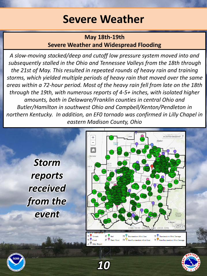
A slow-moving stacked/deep and cutoff low pressure system moved into and subsequently stalled in the Ohio and Tennessee Valleys from the 18th through the 21st of May. This resulted in repeated rounds of heavy rain and training
storms, which yielded multiple periods of heavy rain that moved over the same areas within a 72-hour period. Most of the heavy rain fell from late on the 18th
through the 19th, with numerous reports of 4-5+ inches, with isolated higher amounts, both in Delaware/Franklin counties in central Ohio and
Butler/Hamilton in southwest Ohio and Campbell/Kenton/Pendleton in northern Kentucky. In addition, an EF0 tornado was confirmed in Lilly Chapel in
eastern Madison County, Ohio
10
May 18th-19thSevere Weather and Widespread Flooding
Storm reports
received from the
event
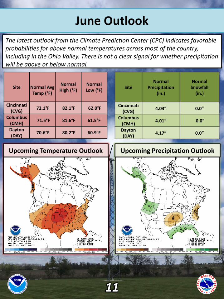
June Outlook
The latest outlook from the Climate Prediction Center (CPC) indicates favorable probabilities for above normal temperatures across most of the country, including in the Ohio Valley. There is not a clear signal for whether precipitation will be above or below normal.
Site Normal AvgTemp (°F)
Normal High (°F)
NormalLow (°F)
Cincinnati (CVG)
72.1°F 82.1°F 62.0°F
Columbus (CMH)
71.5°F 81.6°F 61.5°F
Dayton (DAY)
70.6°F 80.2°F 60.9°F
SiteNormal
Precipitation(in.)
Normal Snowfall
(in.)
Cincinnati (CVG)
4.03” 0.0”
Columbus (CMH)
4.01” 0.0”
Dayton (DAY)
4.17” 0.0”
Upcoming Temperature Outlook Upcoming Precipitation Outlook
11
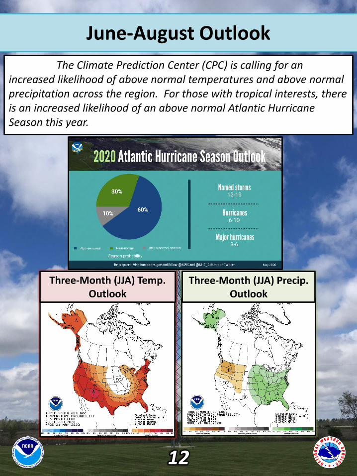
June-August Outlook
The Climate Prediction Center (CPC) is calling for an increased likelihood of above normal temperatures and above normal precipitation across the region. For those with tropical interests, there is an increased likelihood of an above normal Atlantic Hurricane Season this year.
Three-Month (JJA) Temp. Outlook
Three-Month (JJA) Precip. Outlook
12