Embed Size (px)
Citation preview
© 2009 by International Foundation of Hope
Nuristân Natural Resource Assessment
Submitted by
The International Foundation of Hope
for
LGCD
Funded by
USAID
Pursuant to.
LGCD RFP No. RFP-JLB-NINF-001 Nuristân Natural Resource Assessment
4 February 2009
Nuristân Natural Resource Assessment -- ii
© 2009 by International Foundation of Hope
Nuristân Natural Resource Assessment IFHope, Jalalabad, Afghanistan
Contents
1 Executive Summary............................................................................................................... 1 2 Introduction .......................................................................................................................... 3
2.1 Purpose and Scope of the Nuristân Natural Resource Assessment ..................................... 3 2.2 Background: An Overview of Nuristân............................................................................ 3 2.3 Previous Research on Resources and Resource Management in Nuristân ........................... 4 2.4 Historical Trends of Resource Management in Nuristân ................................................... 4
3 Resources and Resource Consumption in Nuristân................................................................... 5 3.1 The Governmental Terrain.............................................................................................. 5 3.2 The Resource Terrain ..................................................................................................... 6
3.2.1 Watersheds............................................................................................................. 6 3.2.2 Climate and Vegetation Zones ............................................................................... 12 3.2.3 Fauna................................................................................................................... 22 3.2.4 Gemstones and Minerals ....................................................................................... 23 3.2.5 Historical Resource Trends ................................................................................... 23
3.3 The Human Terrain...................................................................................................... 23 3.3.1 Ethnolinguistic Groups ......................................................................................... 24 3.3.2 Social-Organizational Principles ............................................................................ 24 3.3.3 Villages ............................................................................................................... 26
3.4 Subsistence-Level Resource Exploitation and Ownership ............................................... 30 3.4.1 Water Usage......................................................................................................... 30 3.4.2 Land Usage .......................................................................................................... 31
3.5 Commercial Resource Exploitation ............................................................................... 37 3.5.1 Forest Products..................................................................................................... 37 3.5.2 Arboriculture........................................................................................................ 38 3.5.3 Gemstones ........................................................................................................... 38 3.5.4 Livestock Products ............................................................................................... 38 3.5.5 Artisan Products ................................................................................................... 38 3.5.6 Commercial and Employment Income ................................................................... 39
4 Surveys............................................................................................................................... 40 4.1 Strategy and Design ..................................................................................................... 40 4.2 Survey Results and Assessment by Watershed and Provincial District ............................. 43
4.2.1 Alingar Watershed ................................................................................................ 45 4.2.2 Pech Watershed .................................................................................................... 59 4.2.3 LanDay Sin Watershed (not surveyed) ................................................................... 83
5 Conclusions and Recommendations ...................................................................................... 84 6 Bibliography ....................................................................................................................... 88 Appendix 1 – Native Inventories of Resources..............................................................Appendix 1-1 Appendix 2 – Survey Forms ........................................................................................Appendix 2-1 1 English ...............................................................................................................Appendix 2-1
1.1 Village-Level...............................................................................................Appendix 2-1 1.2 Neighborhood-Level ....................................................................................Appendix 2-3 1.3 Household-Level .........................................................................................Appendix 2-5 1.4 Resources .................................................................................................. Appendix 2-13
2 Pashto............................................................................................................... Appendix 2-22 2.1 Village-Level............................................................................................. Appendix 2-22 2.2 Neighborhood-Level .................................................................................. Appendix 2-24 2.3 Resources .................................................................................................. Appendix 2-31
Nuristân Natural Resource Assessment -- iii
© 2009 by International Foundation of Hope
List of Tables Table 1. Provincial Districts of Nuristân (after Strand 2008). .......................................................... 5 Table 2. Incidence of Calamities and Acts of Outside Assistance in Surveyed Households. .............. 6 Table 3. Water discharge at main streams and total outflow from districts. .................................... 10 Table 4. Stream discharge measured at various villages in all 5 districts. ....................................... 11 Table 5. Assessment of Springs in Nuristân Province. .................................................................. 12 Table 6. Landcover Types (after Favre and Kamal 2004) .............................................................. 13 Table 7. Landcover Types in the Alingar Watershed (after Favre and Kamal 2004: 192) ................ 13 Table 8. Landcover Types in the Kunar Watershed (after Favre and Kamal 2004: 193). ................. 13 Table 9. Average No. of trees per ha per district........................................................................... 17 Table 10. Volume of timber (cubic feet) per ha of forest area. ....................................................... 17 Table 11. Volume of smallwood per hectare (cubic feet) of forest area. ......................................... 17 Table 12. Status of regeneration in the forest area. ....................................................................... 18 Table 13. Average No. of seedlings per hectare of forest area. ...................................................... 19 Table 14. Assessment of Under-Forest Land Cover in Nuristân Province....................................... 19 Table 15. Assesment of Rangelands in Nuristân Province, Afghanistan. ........................................ 22 Table 16. Languages and Linguistic Groups in Nuristân Province (after Strand 1973, 1997, 2008). . 25 Table 17. Ethnic Groups by Provincial District (after Strand 1997, 2008). ..................................... 25 Table 18. Major Villages in the Alingar Watershed. ..................................................................... 27 Table 19. Major Villages in the Pech Watershed. ......................................................................... 27 Table 20. Major Villages in the LanDay-Sin Watershed. .............................................................. 27 Table 21. Demographic Statistics from Surveyed Villages. ........................................................... 29 Table 22. Water Usage. .............................................................................................................. 31 Table 23. Agricultural Production. .............................................................................................. 33 Table 24. Tree-Crop Production. ................................................................................................. 34 Table 25. Fodder Production: Average Kg. per Household............................................................ 35 Table 26. Animal Husbandry. ..................................................................................................... 36 Table 27. Forest Usage for Subsistance. ...................................................................................... 37 Table 28. Commercial Logging................................................................................................... 37 Table 29. Gemstone Production. ................................................................................................. 38 Table 30. External Employment. ................................................................................................. 39 Table 31. Villages Surveyed. ...................................................................................................... 41 Table 32. Surveyors‘ Assessment of Current Resource and Subsistence Quality in Nuristân. .......... 43 Table 33. Survey Respondents‘ Previous-Five-Year Assessments of Resources. ............................ 45 Table 34. Survey Respondents‘ Previous-Five-Year Assessments of Resources, Dôâb. .................. 45 Table 35. Surveyors‘ Assessment of Current Resource and Subsistence Quality, Dôâb. .................. 46 Table 36. Shuk. ......................................................................................................................... 47 Table 37. Wetsir. ....................................................................................................................... 48 Table 38. Palagal. ...................................................................................................................... 48 Table 39. Wâygalak. .................................................................................................................. 49 Table 40. Bajagal. ...................................................................................................................... 49 Table 41. Junyâ. ........................................................................................................................ 50 Table 42. Survey Respondents‘ Previous-Five-Year Assessments of Resources, Nurgrâm. ............. 51 Table 43. Surveyors‘ Assessment of Current Resource and Subsistence Quality, Nurgrâm.............. 51 Table 44. Awik. ......................................................................................................................... 53 Table 45. Kolatan. ..................................................................................................................... 54 Table 46. Malak......................................................................................................................... 55 Table 47. Titin. .......................................................................................................................... 56 Table 48. Malil. ......................................................................................................................... 57 Table 49. Wadawu. .................................................................................................................... 58 Table 50. Survey Respondents‘ Previous-Five-Year Assessments of Resources, Central District. .... 59 Table 51. Surveyors‘ Assessment of Current Resource and Subsistence Quality, Central District. ... 59 Table 52. Eshtiwe. ..................................................................................................................... 61 Table 53. Dewa. ........................................................................................................................ 61
Nuristân Natural Resource Assessment -- iv
© 2009 by International Foundation of Hope
Table 54. Pashki. ....................................................................................................................... 62 Table 55. Kântiwâ Ulyâ.............................................................................................................. 63 Table 56. Kântiwâ Suflâ. ............................................................................................................ 64 Table 57. Kusht. ........................................................................................................................ 65 Table 58. Survey Respondents‘ Previous-Five-Year Assessments of Resources, Wâmâ. ................. 66 Table 59. Surveyors‘ Assessment of Current Resource and Subsistence Quality, Wâmâ. ................ 66 Table 60. Wâw. ......................................................................................................................... 68 Table 61. Wâmâ. ....................................................................................................................... 69 Table 62. Bar Kalay. .................................................................................................................. 70 Table 63. Achanu....................................................................................................................... 71 Table 64. Caprigal. .................................................................................................................... 72 Table 65. Kordar........................................................................................................................ 73 Table 66. Survey Respondents‘ Previous-Five-Year Assessments of Resources, Wâygal. ............... 74 Table 67. Surveyors‘ Assessment of Current Resource and Subsistence Quality, Wâygal. .............. 75 Table 68. Wâygal Village. .......................................................................................................... 76 Table 69. Ameshoz. ................................................................................................................... 78 Table 70. Arans. ........................................................................................................................ 80 Table 71. Nishei Grâm. .............................................................................................................. 81 Table 72. Kund Kalay. ............................................................................................................... 82 Table 73. Gambir. ...................................................................................................................... 83 Table 74. Native Inventory of Hydrological Features (Strand 1999). .............................Appendix 1-1 Table 75. Native Inventory of Conifers (Strand 1999). .................................................Appendix 1-1 Table 76. Native Inventory of Broadleaf Forest Trees (Strand 1999). ............................Appendix 1-2 Table 77. Native Inventory of Rangeland Plants (Strand 1999). ....................................Appendix 1-3 Table 78. Native Inventory of Fauna in Eastern Nuristân (Strand 1999). ........................Appendix 1-6 Table 79. Native Inventory of Cultivated Plants (Strand 1999). .....................................Appendix 1-7 Table 80. Native Inventory of Cultivated Trees (Strand 1999).......................................Appendix 1-8 Table 81. Native Inventory of Fodder Types and Plants (Strand 1999)...........................Appendix 1-8 Table 82. Native Inventory of Gathered Edible Plants (Strand 1999). ............................Appendix 1-9 Table 83. Native Inventory of Dairy Products from Eastern Nuristân (Strand 1999). .... Appendix 1-10
List of Maps
Map 1. Nuristân Province: Political and Physical. .......................................................................... v Map 2. Watersheds of Nuristân. .................................................................................................... 6 Map 3. Gemstone-Mining Areas in Nuristân (shown in orange). ................................................... 23 Map 4. Ethnic Groups of Nuristân (after Strand 1997, 2008). ........................................................ 26 Map 5. Nuristân Province, showing surveyed districts. ................................................................. 42 Map 6. Dôâb District.................................................................................................................. 45 Map 7. Nurgrâm District. ........................................................................................................... 51 Map 8. Central District (Pârun and Kântiwâ). .............................................................................. 59 Map 9. Wâmâ District. ............................................................................................................... 66 Map 10. Wâygal District. ........................................................................................................... 74
List of Figures
Figure 1. Forest Cover in Eastern Afghanistan, 1977 vs. 2002 (source: UNOSAT)......................... 15 Figure 2. Kom Nuristâni Traditional Calendar, Showing Names of Months in White and Alignment with the Gregorian Calendar on 18 March 1969 (after Strand 1999). ............................ Appendix 1-10
Nuristân Natural Resource Assessment -- v
© 2009 by International Foundation of Hope
List of Graphs
Graph 1. Discharge curves on the Alingar River, 1978 (Favre and Kamal 2004: 192). ...................... 7 Graph 2. Discharge curves on the Pech River, 1978 (Favre and Kamal 2004: 194). .......................... 8 Graph 3. Discharge curves on the LanDay Sin, 1978 (Favre and Kamal 2004: 194). ......................... 9
The IFHope Team
Report Authors: Richard F. Strand, Jim Du Bruille, Irfranullah Sahibzada, Ziarat Gul
Field Teams: 5 IFHope monitoring staff 10 survey teams of 1 MAIL Representative and 1 Nuristâni Facilitator
Administrative and Office Team: Jim Du Bruille, Dr. Giuliano Finetto, Ziarat Gul, Abdul Rahman, Akbar Hussein Mirza
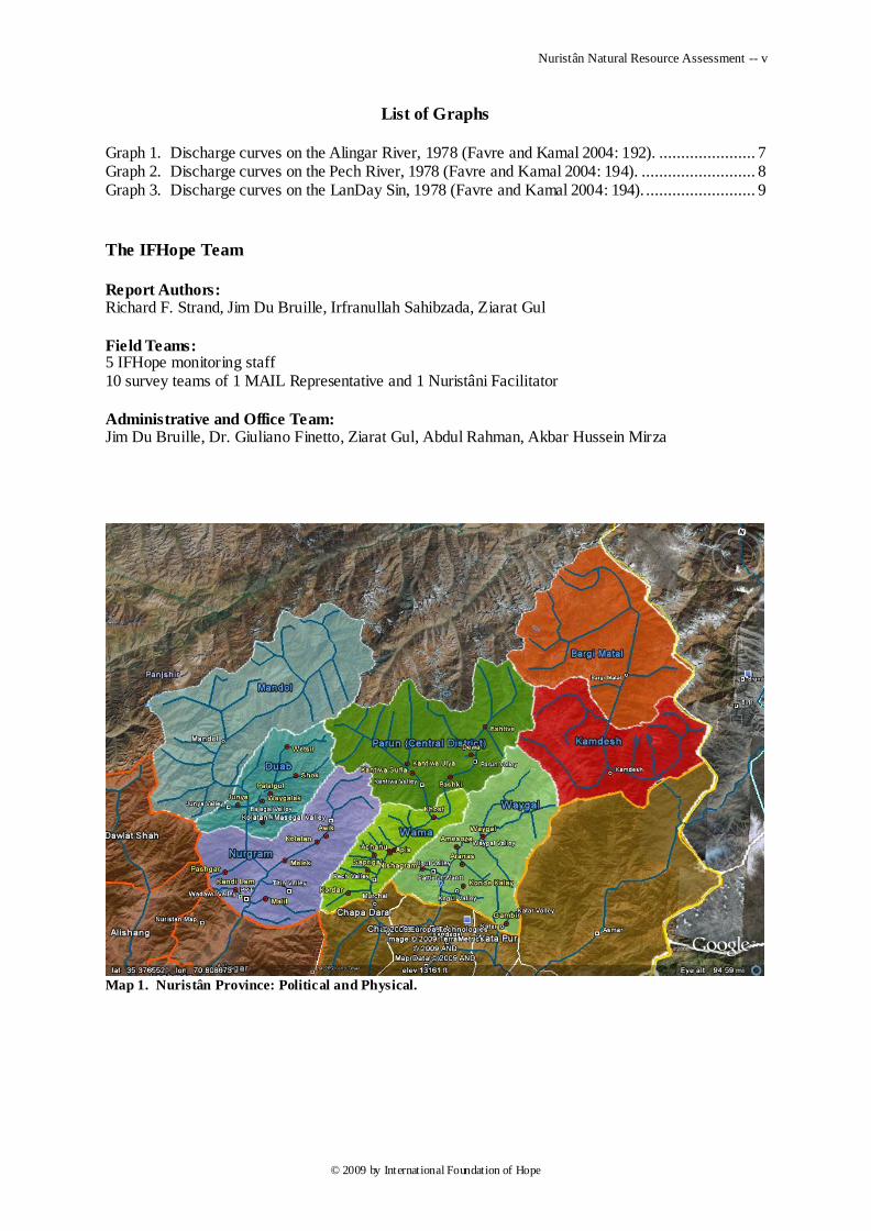
Map 1. Nuristân Province: Political and Physical.
Nuristân Natural Resource Assessment -- 1
© 2009 by International Foundation of Hope
1 Executive Summary
Pursuant to a grant funded by USAID through LGCD, IFHope conducted a natural resources assessment of Nuristan Province beginning in the fall of 2008. The natural resource bases of five of Nuristan‘s eight districts were surveyed including Dôâb, Nurgrâm, Wâmâ, Wâygal and the Central District (Pârun and Kântiwâ). The surveyors collected information on both the supply of available natural resources as well as demand and usage information by resource users.
A proper assessment requires an evaluation of change in the condit ion of natural resources over time. Unfortunately, due to the dearth of reliable resource information, there was little to no baseline information to compare with. To address that, the survey included informant interviews which asked for subjective assessments of change over the past five years for each of the natural resource categories.
Furthermore, one of the objectives of this project was to collect baseline data, so that further natural resource assessments can be more informed with a basis of compar ison. Some of this information appears as measurement data dsplayed in tables listed by resource sector in this document. The evaluation of the data demonstrates the nature of resource degradation and shows significant degradation of rangeland (pasture) and forest. A more detailed analysis is included under each resource section in Section 3.2 of this document.
The following natural resource sectors were evaluated: cropland, forest, pasture, livestock, water and mining. According to the findings of the Nuristân Natural Resource Assessment survey conducted in 30 of the province‘s communities in five provincial districts, survey results showed that all sectors of the resource base are deteriorating in Nuristan Province because of persistent drought and increasing population pressure.
Drought was mentioned by survey respondents as a major problem affecting the natural resource base. Consequences of drought range from moderate to severe, depending on altitude and westerliness. Each climatic zone has been adversely affected in most communities surveyed. Current assessments and recent environmental trends elicited from surveyors and surveyed residents appear in Table 32 and Table 33; they indicate drought as the major problem.
Increasing population pressure was given by most survey respondents as the second reason why the resource base is damaged and diminishing. Increased population means increased livestock pressure on forests and rangelands, as well as increased pressure to clear forestland for agriculture. The overall population is suffering from this increasing pressure on a decreasing supply of pasture and cropland. Pastureland is being lost through erosion and cropland is being lost through erosion and flooding. Women in particular are suffering, through increasing distances they have to travel to collect wood and water.
Traditional Nuristâni institutions of resource management worked well up to the onset of climatic warming and international hostilities in the 1970s. Since then lack of security and governance has allowed outsiders to plunder Nuristân‘s resources by undermining the traditional institutions of governance and regulation.
The fact that most of the areas surveyed are suffering from moderate to severe natural resources is due to a cycle of degradation. Population pressure is leading to overharvest of trees for fuel, building materials, and fodder, resulting in loss of ground cover leading to erosion, loss of pasture, rapid snow melt, downstream flooding, and further loss of pasture and arable land. A problem in one area will lead to a cycle of problems in other areas of the natural resource system.
The Nuristân Natural Resource Assessment has resulted in the recommendation for the development of a series of Integrated Catchment Development Programs (ICDP). These programs would be based on district administrative boundaries since Nuristan‘s district boundaries correspond to watershed catchment boundaries.
ICDPs would involve both a top-down approach with the Ministry of Agriculture, Irrigation, and Livestock (MAIL) taking the lead in developing a coordinated plan. Capacity building and technical support would be provided to assist with the development of a systematic plan that would be based on prioritized needs in a particular catchment, with consideration of the greatest risk to the overall
Nuristân Natural Resource Assessment -- 2
© 2009 by International Foundation of Hope
catchment, likelihood of success, sustainability, cost efficiency, and cost/benefit analysis, as well as stakeholder input.
The time-proven traditional resource management institution (called the ura, under, malavře˜, or irin in the Nuristâni languages) should have a central role at the village level. Working with the village elders and planning ministry responsible for an overall catchment plan, the ura should have a central role in implementing natural resource interventions at the village level. They would represent stakeholder interests to the planning process, as well as communicate overall catchment planning priorities to the villagers.
One overarching consideration is that NRM strategies should focus on livelihood enhancement where possible to incentivize the participants. Specific elements of an ICDP would include:
Fuelwood Production: Establish woodlots on private land close to villages.
Pasture Management/Slope Stabilization: Stabilize slopes with pasture regeneration program including perennial grasses and bushes/shrubs. Soil surface cover is more important than forest cover for protecting against soil erosion and can be accomplished more quickly and easily with grasses and shrubs than trees.
Forestry Management and Reforestation: Develop long term reforestation program in conjunction with village institutions using adaptable native species. Control logging by promoting community regulatory institutions, by interdicting outsiders from exploiting Nuristân‘s timber resources, and by reducing demand for firewood through more efficient cooking and heating technology;.
Orchard development: Incorporating lessons learned from previous orchard programs to establish adaptable fruit and nut orchards. Livelihoods will improve and there will be less pressure to harvest natural forest resources for sale.
Nursery establishment: Establish private nurseries to produce fuelwood saplings, saplings for reforestation and adaptable fruit and nut saplings for livelihood enhancement.
Irrigation enhancement: Implement irrigation enhancement programs to increase agricultural production, including water storage for livestock and small-scale irrigation, river bank protection using gabion weave or cement structures, culverts to reduce erosion, spring capture, stone check dams, and terracing programs. Improve irrigation efficiency by building intakes, installing hydraulic ram pumps and improving delivery systems.
Drinking water: Develop piping systems for water delivery from local springs. This would benefit women and reduce the distance they need to travel to collect water and reduce the need to obtain water from closer but lower quality river sources.
Crop Production: Provide training in basic scientific agriculture within the local ecosystem, focusing on improving crop yields through soil analysis, organic vs. commercial fertilizer usage, and pest and disease control.
Animal Husbandry: Improve veterinary practices and services, including identifying and treating common livestock disease and sanitary practices. Establish veterinary clinics (a frequent request from the villages surveyed.)
Mining: Provide training and assistance with locating gem and mineral deposits, evaluating gem deposits, operating mines, identifying and grading gemstones, and increasing mine production.
Education and Training: Provide environmental and conservational educational curricula starting in elementary school, and provide education to manage the development of resource commodities.
To ensure sustainability, an evaluative process should be implemented for all interventions that would strive for continuous improvement by looking beyond accomplishing project objectives. Five parameters would be considered including effectiveness, impact, efficiency, sustainability and relevance. Sub-projects should be implemented that focus on results and impact on stakeholders and the natural resource environment, rather than just on project deliverables.
Nuristân Natural Resource Assessment -- 3
© 2009 by International Foundation of Hope
2 Introduction
This report, henceforth the Nuristân Natural Resource Assessment (NNRA), summarizes the results of a natural resource assessment of Nuristân Province, pursuant to USAID/DAI RFP No. RFP-JLB-NINF-001, Nuristân Natural Resource Assessment
2.1 Purpose and Scope of the Nuristân Natural Resource Assessment
This report addresses the knowledge gap in the Nuristân PRT‘s understanding of the resource situation in Nuristân, as requested in the above-mentioned RFP:
Nursitan province has historically been a region with an economy closely tied to natural resources, in
particular its forest and timber trade, animal husbandry, selling dairy products, working in jewelry
mines, wood engraving & handcrafts. The lack of reliable natural resources baseline data limits
effective watershed and reforestation planning efforts and subsequent development. After an initial
review of available information by the PRT, a Natural Resources Assessment has been requested by
the PRT.
In past Nuristân is an underserved province with little donor activity. The purpose of this assessment
is to inform the development strategy of the Nuristân PRT…. (RFP, p. 3)
The NNRA integrates previous research with the results of a five-district survey of natural resources and their usage that was conducted as part of this assessment. Recommendations arising out of the data of the NNRA are proposed in this report‘s conclusion.
2.2 Background: An Overview of Nuristân
Nuristân lies on the southern slopes of the Hindu-Kush mountains in northeastern Afghanistan, encompassing the watersheds of the upper Alingar (Laghman) River in western Nuristân, the upper Pech River in central Nuristân, and the Landai Sin and Kunar Rivers in eastern Nuristân. It is the homeland of an ethnically unique group of tribal peoples, called Nuristânis, who fled and resisted Islam as it spread eastward. In 1895-96 the Nuristânis were subjugated by the Afghan ruler Abdur Rahmân Khân, and the people were obliged to abandon their ancient religious beliefs in favor of Islam.
Nuristânis comprise some fifteen ethnic groups speaking five separate languages. Pashto and Farsi are spoken among much of the adult male population as second languages.
In addition to the Nuristânis, smaller populations of Pashaî, Afghân, and Gujar peoples are included in Nuristân Province‘s western districts of Nurgrâm and Dôâb. These populations are ethnically and linguistically distinct from the ―true‖ Nuristâni population.
Nuristân Province comprises approximately 130 communities, ranging in size from 200 – 3000 inhabitants. No reliable census of the region exists; estimates of population range between one and two hundred thousand, with 125,700 as the Central Statistics Office‘s 2005 estimate.
Nuristânis manage their internal affairs through traditions of classic community-level democracy. Decisions affecting the community as a whole are made in open community councils, with the guidance of community elders. Within a community decisions and rules affecting resource management are enforced by an annually elected body of men, who are empowered to levy fines against transgressors. Disputes are always settled through mediation and the payment of just compensation. Infrastructure is maintained through traditionally organized work groups that encompass the entire adult male population. However, in the aftermath of the Soviet-Afghân war these traditional institutions of governance have been increasingly disrupted by jihadist activists.
The languages, cultures, and national characters of the Nuristânis differ markedly from those of the surrounding Afghans and Tajiks. These differences, along with the Nuristânis' relatively late acceptance of Islam, characterize them as ―wild men‖ (vahši) in the view of Afghanistan's majority populations, with the result that Nuristân has remained a backwater of development within the country.
Nuristân Natural Resource Assessment -- 4
© 2009 by International Foundation of Hope
2.3 Previous Research on Resources and Resource Management in Nuristân
Because of its ethnographic and strategic interest, Nuristân was the subject of several European scientific and reconnaissance expeditions from the late 1800‘s to the mid 20
th century, as reported by
Robertson (1896), Vavilov & Bukinich (1929), Scheibe (1937), and Køie and Rechinger (1954-1963). More recently, individual scholars have added to the knowledge of society and resources in Nuristân, including Humlum (1959), Fischer (1970), A. Y. Nuristâni (1973), Strand (1975), Petocz and Larsson (1977), Edelberg and Jones (1979), Katz (1981), Strand (1997-present), Favre and Kamal (2004), Larsson (2006), Strand (2008). The environmental assessment of Afghanistan published by the UNEP (2003) covers Nuristân in certain details.
Transcription of native terms herein follows Strand (2007).
2.4 Historical Trends of Resource Management in Nuristân
Until the onset of the Soviet-Afghan War in 1978 Nuristânis famously managed their pasture- and forestlands in a traditional way that minimized environmental degradation and maintained Nuristân‘s forests. The effectiveness of the Nuristânis‘ longstanding management practices is still visible in the contrast between the forested lands of the Nuristânis versus the denuded, degraded environment of neighboring lands managed by Afghâns.
Under the traditional system Nuristâni villagers annually elected a body of ―resource-policemen‖ (called ura, uri, iri:n, or malavňe in the various Nuristâni languages) to control horticultural harvesting and the transhumant cycle of livestock migration. These men had the power to fine villagers for transgressions against the environment, notably prohibitions to keep livestock away from agricultural growing-areas and to keep people from picking unripe tree products. Regulation of the yearly herding and picking schedules tended to minimize damage to the forests, as goats were funneled quickly through vulnerable woodlands to their summer residence in the mountain pastures. Pasturelands were used in well-scheduled rotation to minimize overgrazing.
Continuing degeneration of traditional Nuristâni institutions of resource management in the 100 years since the Afghâns conquered Nuristân has resulted in accelerating depletion of forestland and mountain pastureland, with consequential flooding and erosion of scarce farmland. Since the Soviet-Afghan war elections for the ―resource-police‖ have disappeared as communities have come under the control of commander- or cleric-dominated shoras.
Since the mid 1960‘s motorable roads have slowly penetrated Nuristân to allow commercial trade in timber and walnuts. In road-serviced areas revenues from timber cutting have transformed local economies from full subsistence to incipient consumerism. However, affected communities lacked institutional experience to deal with the large-scale operations of external timber merchants, and from the early 1990‘s until the Karzai government imposed a moratorium in 2003, many valleys were overlogged or even clear-cut. After feeling the effects of increased flooding and erosion caused by loss of forest cover, some Nuristâni communities have evolved institutional ways to regulate logging, as well as to distribute timber revenues. Local management of Nuristân‘s commercially-exploited resources remains an evolving issue.
Nuristân Natural Resource Assessment -- 5
© 2009 by International Foundation of Hope
3 Resources and Resource Consumption in Nuristân
This section integrates the results of the NNRA survey with previous research to portray an overall assessment of resources in Nuristân. The portrayal recognizes three systemically interacting levels of ―terrain,‖ which encompass and impact the overall resource base; they are:
the governmental terrain,
the resource terrain, and
the human terrain.
Where possible, native-language inventories of resource and social categories are given to help align the outsider‘s perspective with the local conceptualization of the environment. Native terminology is best documented for the Kâmviri dialect of Kâmkata-vari (see below; Table 16); terminology in other languages is less documented.
3.1 The Governmental Terrain
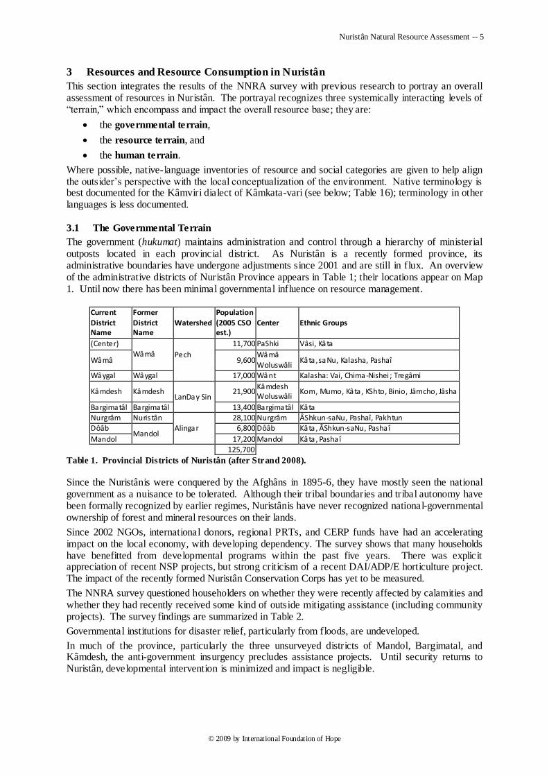
The government (hukumat) maintains administration and control through a hierarchy of ministerial outposts located in each provincial district. As Nuristân is a recently formed province, its administrative boundaries have undergone adjustments since 2001 and are still in flux. An overview of the administrative districts of Nuristân Province appears in Table 1; their locations appear on Map 1. Until now there has been minimal governmental influence on resource management.
Current
District Name
Former
District Name
Watershed
Population
(2005 CSO est.)
Center Ethnic Groups
(Center)
Wâmâ Pech
11,700 PaShki Vâsi, Kâta
Wâmâ 9,600 Wâmâ Woluswâli
Kâta , saNu, Kalasha, Pashaî
Wâygal Wâygal 17,000 Wânt Kalasha: Vai, Chima -Nishei ; Tregâmi
Kâmdesh Kâmdesh LanDay Sin
21,900 Kâmdesh Woluswâli
Kom, Mumo, Kâta , KShto, Binio, Jâmcho, Jâsha
Bargimatâl Bargimatâl 13,400 Bargimatâl Kâta Nurgrâm Nuris tân
Alingar
28,100 Nurgrâm ÂShkun-saNu, Pashaî, Pakhtun
Dôâb Mandol
6,800 Dôâb Kâta, ÂShkun-saNu, Pasha î
Mandol 17,200 Mandol Kâta , Pasha î 125,700
Table 1. Provincial Districts of Nuristân (after Strand 2008).
Since the Nuristânis were conquered by the Afghâns in 1895-6, they have mostly seen the national government as a nuisance to be tolerated. Although their tribal boundaries and tribal autonomy have been formally recognized by earlier regimes, Nuristânis have never recognized national-governmental ownership of forest and mineral resources on their lands.
Since 2002 NGOs, international donors, regional PRTs, and CERP funds have had an accelerating impact on the local economy, with developing dependency. The survey shows that many households have benefitted from developmental programs within the past five years. There was explicit appreciation of recent NSP projects, but strong criticism of a recent DAI/ADP/E horticulture project. The impact of the recently formed Nuristân Conservation Corps has yet to be measured.
The NNRA survey questioned householders on whether they were recently affected by calamities and whether they had recently received some kind of outside mitigating assistance (including community projects). The survey findings are summarized in Table 2.
Governmental institutions for disaster relief, particularly from floods, are undeveloped.
In much of the province, particularly the three unsurveyed districts of Mandol, Bargimatal, and Kâmdesh, the anti-government insurgency precludes assistance projects. Until security returns to Nuristân, developmental intervention is minimized and impact is negligible.
Nuristân Natural Resource Assessment -- 6
© 2009 by International Foundation of Hope
District: Dôâb Nurgrâm Central Wâmâ Wâygal Average
Calamities in past 5 yrs (average no. of years per household):
Drought n. years 4.3 3.9 3.9 2.0 2.4 3.3
Flood n. years 2.4 2.5 3.9 1.0 1.6 2.3
Pest/Disease n. years 3.4 0.0 4.0 1.4 1.6 2.1
Civil unrest n. years 0.0 0.0 5.0 0.0 21.1 5.2
Source of assistance received by family in last 5 years (% of households)
GoA Governmental bodies 20% 10% 40% 50% 95% 43%
NGOs 10% 10% 0 10% 75% 26%
International organizations 15% 10% 0 10% 95% 33%
Table 2. Incidence of Calamities and Acts of Outside Assistance in Surveyed Households.
3.2 The Resource Terrain
The resource terrain encompasses the hydrosphere, divided among three watersheds, the biosphere, divided among six major climate zones, and the geosphere, encompassing gem and mineral deposits.
3.2.1 Watersheds
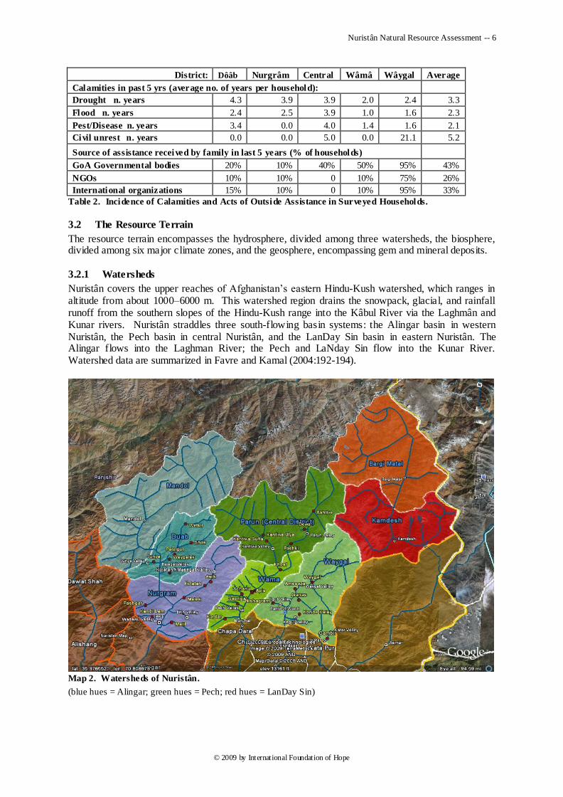
Nuristân covers the upper reaches of Afghanistan‘s eastern Hindu-Kush watershed, which ranges in altitude from about 1000–6000 m. This watershed region drains the snowpack, glacial, and rainfall runoff from the southern slopes of the Hindu-Kush range into the Kâbul River via the Laghmân and Kunar rivers. Nuristân straddles three south-flowing basin systems: the Alingar basin in western Nuristân, the Pech basin in central Nuristân, and the LanDay Sin basin in eastern Nuristân. The Alingar flows into the Laghman River; the Pech and LaNday Sin flow into the Kunar River. Watershed data are summarized in Favre and Kamal (2004:192-194).
Map 2. Watersheds of Nuristân.
(blue hues = Alingar; green hues = Pech; red hues = LanDay Sin)
Nuristân Natural Resource Assessment -- 7
© 2009 by International Foundation of Hope
Watersheds are drained by a hierarchy of watercourses, the levels of which are aptly recognized in the local languages (see Appendix 1, Table 74).
Springs are abundant in the region and are the primary drinking-water sources for most Nuristâni communities. Water from most strongly flowing springs is of good quality.
Mountain ponds and lakes are important sources of water for livestock and herdsmen during their summer sojourns in the alpine pastures.
Because of Nuristân‘s steep terrain and decreasing forest cover, floods are increasingly common and destructive in all watersheds.
3.2.1.1 The Alingar Watershed
The Alingar watershed arises on the crest of the Hindu Kush range in western Nuristân and completely drains the districts of Mandol, Dôâb, and Nurgrâm. Roughly two-thirds of the watershed lies in Nuristân; the lower third lies in eastern Laghmân Province.
From its source and throughout Mandol District the uppermost Alingar Valley is known locally as Řâmgal (otherwise known as the Pushâl River), becoming the Alingar proper at its juncture with the Kulem Valley. Řâmgal and Kulem are inhabited by Kâta-vari-speaking Nuristânis. Further down on the left bank lie the Bajagal (bâźâigal), Kolatân (mâse:gal), and Titin valleys, inhabited by Ashkun-speaking Nuristânis. On the right bank shorter and drier tributary valleys join the Alingar; notable are the Junyâ, Shâmâ, Pashagar, and Nangarach Valleys, inhabited primarily by Pashaîs.
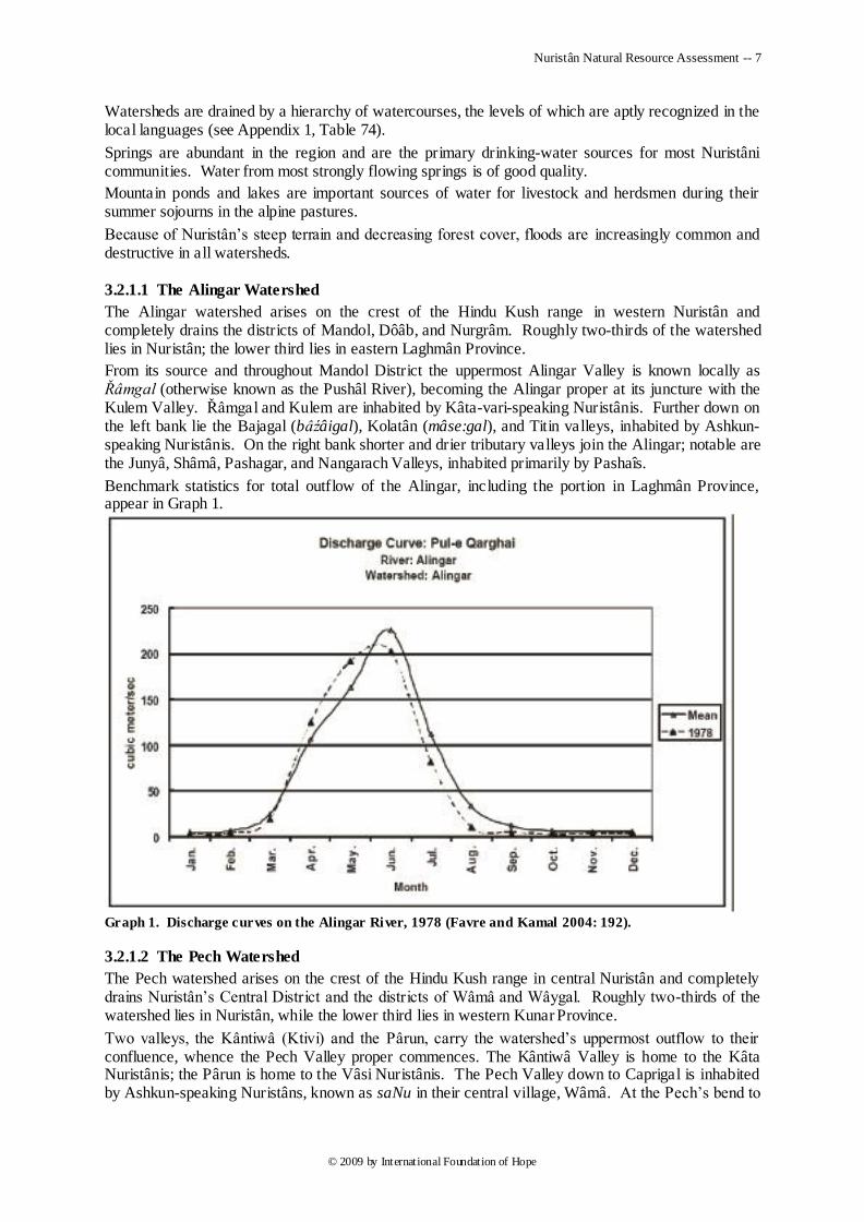
Benchmark statistics for total outflow of the Alingar, including the portion in Laghmân Province, appear in Graph 1.
Graph 1. Discharge curves on the Alingar River, 1978 (Favre and Kamal 2004: 192).
3.2.1.2 The Pech Watershed
The Pech watershed arises on the crest of the Hindu Kush range in central Nuristân and completely drains Nuristân‘s Central District and the districts of Wâmâ and Wâygal. Roughly two-thirds of the watershed lies in Nuristân, while the lower third lies in western Kunar Province.
Two valleys, the Kântiwâ (Ktivi) and the Pârun, carry the watershed‘s uppermost outflow to their confluence, whence the Pech Valley proper commences. The Kântiwâ Valley is home to the Kâta Nuristânis; the Pârun is home to the Vâsi Nuristânis. The Pech Valley down to Caprigal is inhabited by Ashkun-speaking Nuristâns, known as saNu in their central village, Wâmâ. At the Pech‘s bend to
Nuristân Natural Resource Assessment -- 8
© 2009 by International Foundation of Hope
the east the Kordar Valley enters from the west. Further east, in Kunar Province, the Pech receives the Wâygal and KaTâr Rivers, which drain Nuristân‘s Wâygal District, home to various KalaSha Nuristâni communities.
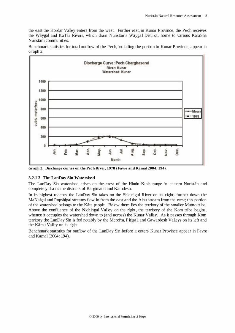
Benchmark statistics for total outflow of the Pech, including the portion in Kunar Province, appear in Graph 2.
Graph 2. Discharge curves on the Pech River, 1978 (Favre and Kamal 2004: 194).
3.2.1.3 The LanDay Sin Watershed
The LanDay Sin watershed arises on the crest of the Hindu Kush range in eastern Nuristân and completely drains the districts of Bargimatâl and Kâmdesh.
In its highest reaches the LanDay Sin takes on the Shkurigul River on its right; further down the MaNalgal and Popshigal streams flow in from the east and the Alnu stream from the west; this portion of the watershed belongs to the Kâta people. Below them lies the territory of the smaller Mumo tribe. Above the confluence of the Nichingal Valley on the right, the territory of the Kom tribe begins, whence it occupies the watershed down to (and across) the Kunar Valley. As it passes through Kom territory the LanDay Sin is fed notably by the Merořm, Pitigal, and Gawardesh Valleys on its left and the Kâmu Valley on its right.
Benchmark statistics for outflow of the LanDay Sin before it enters Kunar Province appear in Favre and Kamal (2004: 194).
Nuristân Natural Resource Assessment -- 9
© 2009 by International Foundation of Hope
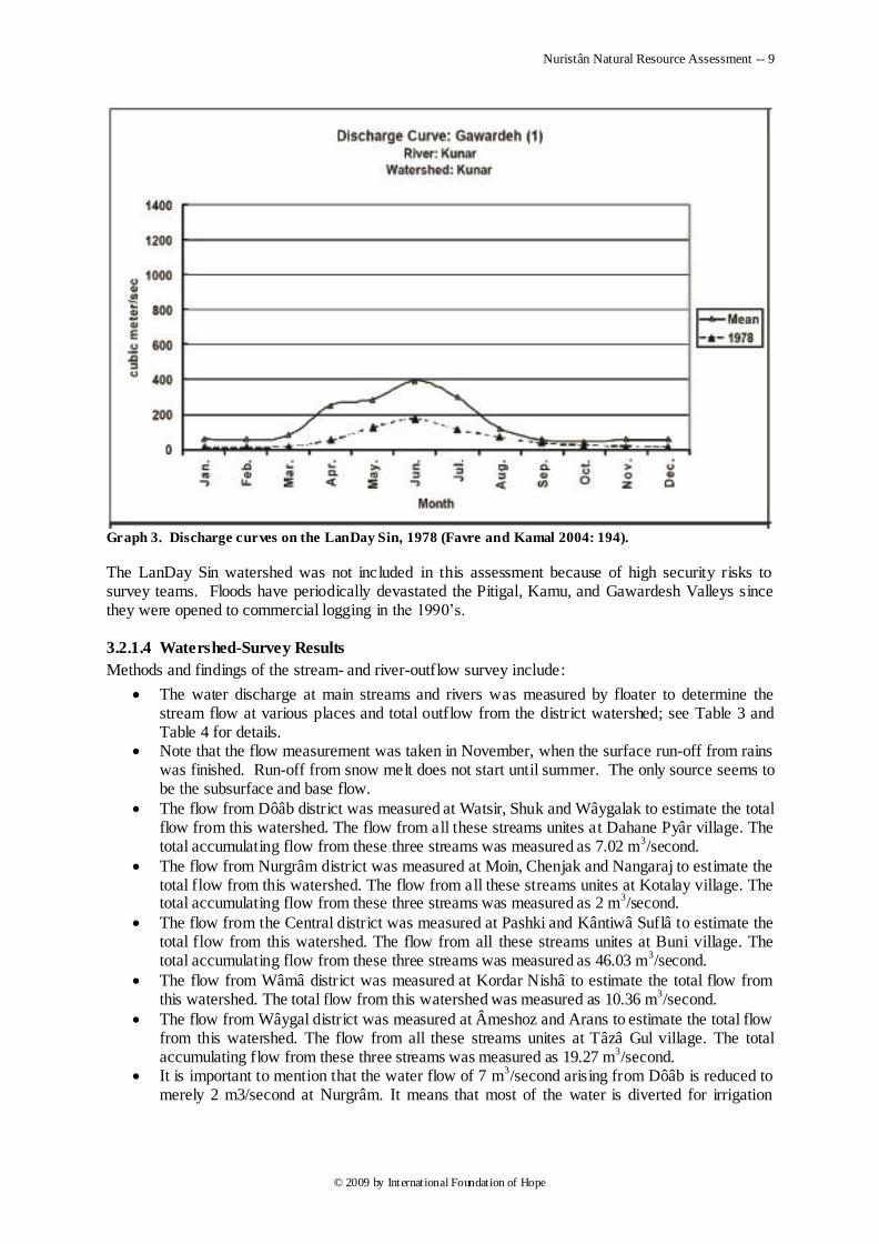
Graph 3. Discharge curves on the LanDay Sin, 1978 (Favre and Kamal 2004: 194).
The LanDay Sin watershed was not included in this assessment because of high security risks to survey teams. Floods have periodically devastated the Pitigal, Kamu, and Gawardesh Valleys since they were opened to commercial logging in the 1990‘s.
3.2.1.4 Watershed-Survey Results
Methods and findings of the stream- and river-outflow survey include:
The water discharge at main streams and rivers was measured by floater to determine the stream flow at various places and total outflow from the district watershed; see Table 3 and Table 4 for details.
Note that the flow measurement was taken in November, when the surface run-off from rains was finished. Run-off from snow melt does not start until summer. The only source seems to be the subsurface and base flow.
The flow from Dôâb district was measured at Watsir, Shuk and Wâygalak to estimate the total flow from this watershed. The flow from all these streams unites at Dahane Pyâr village. The total accumulating flow from these three streams was measured as 7.02 m
3/second.
The flow from Nurgrâm district was measured at Moin, Chenjak and Nangaraj to estimate the total flow from this watershed. The flow from all these streams unites at Kotalay village. The total accumulating flow from these three streams was measured as 2 m
3/second.
The flow from the Central district was measured at Pashki and Kântiwâ Suflâ to estimate the total flow from this watershed. The flow from all these streams unites at Buni village. The total accumulating flow from these three streams was measured as 46.03 m
3/second.
The flow from Wâmâ district was measured at Kordar Nishâ to estimate the total flow from this watershed. The total flow from this watershed was measured as 10.36 m
3/second.
The flow from Wâygal district was measured at Âmeshoz and Arans to estimate the total flow from this watershed. The flow from all these streams unites at Tâzâ Gul village. The total accumulating flow from these three streams was measured as 19.27 m
3/second.
It is important to mention that the water flow of 7 m3/second arising from Dôâb is reduced to
merely 2 m3/second at Nurgrâm. It means that most of the water is diverted for irrigation
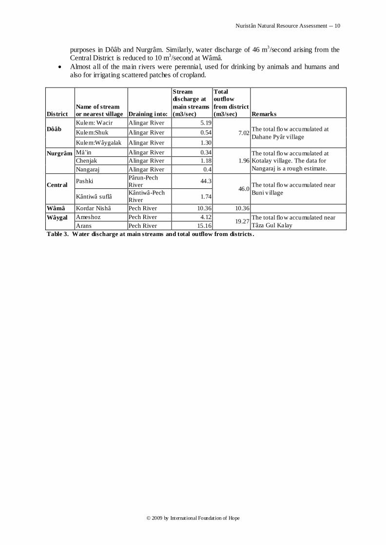
Nuristân Natural Resource Assessment -- 10
© 2009 by International Foundation of Hope
purposes in Dôâb and Nurgrâm. Similarly, water discharge of 46 m3/second arising from the
Central District is reduced to 10 m3/second at Wâmâ.
Almost all of the main rivers were perennial, used for drinking by animals and humans and also for irrigating scattered patches of cropland.
District
Name of stream
or nearest village Draining into:
Stream
discharge at
main streams
(m3/sec)
Total
outflow
from district
(m3/sec) Remarks
Dôâb
Kulem: Wacir Alingar River 5.19
7.02 The total flow accumulated at
Dahane Pyâr village Kulem:Shuk Alingar River 0.54
Kulem:Wâygalak Alingar River 1.30
Nurgrâm
Mâ‘in Alingar River 0.34
1.96
The total flow accumulated at
Kotalay village. The data for
Nangaraj is a rough estimate.
Chenjak Alingar River 1.18
Nangaraj Alingar River 0.4
Central
Pashki Pârun-Pech
River 44.3
46.0 The total flow accumulated near
Buni v illage Kântiwâ suflâ
Kântiwâ-Pech
River 1.74
Wâmâ Kordar Nishâ Pech River 10.36 10.36
Wâygal
Ameshoz Pech River 4.12 19.27
The total flow accumulated near
Tâza Gul Kalay Arans Pech River 15.16
Table 3. Water discharge at main streams and total outflow from districts .
Nuristân Natural Resource Assessment -- 11
© 2009 by International Foundation of Hope
District Village Draining into Discharge (m3/sec)
Dôâb
Shahdesh Alingar River 0.11
Shuk Kulem River 0.54
Soraj Alingar River 0.42
Geel Alingar River 12.69
Bahaderi Alingar River 0.21
Wacir Kulem River 5.19
Paglâm Kulem River 0.16
Wâygalak Kulem River 1.3
Wâygalak Kulem River 0.08
Chenjak Kulem River 1.18
Nurgrâm
Daaba Alingar River 3.66
Daaba Alingar River 3.45
Tongrak Kolatan River 0.13
Malikia Kolatan River 0.12
Ziarat Kalay Alingar River 0.31
Ziarat Kalay Alingar River 0.26
Kotgal Kolatan River 0.17
Galcha khel Kolatan River 0.10
Malil Alingar River 0.37
Moin Alingar River 0.34
Awik Kolatan River 0.10
Awik Koshogal river 1.05
Wâmâ
Kordar nishâ Pech River 10.36
Kordar kuz kalay Pech River 5.69
Barg desh Pech River 5.76
Central
Dewa Pârun River 15.22
Dewa Pârun River 28.56
Eshtiwe Pârun River 36.8
Eshtiwe Pârun River 34.86
Kântiwâ Suflâ Kântiwâ River 1.74
Kântiwâ Ulyâ Kântiwâ River 13.04
Kântiwâ Ulyâ Kântiwâ River 22.08
Pashki Pârun River 44.29
Pashki Pârun River 16.4
Wâygal
Kun Wâygal River 2.22
Gambir bar kalay KaTâr River 0.98
Gambir ghulam taa KaTâr River 0.05
Wâygal kuz kalay Wâygal River 2.21
Wâygal shachagal Wâygal River 1.30
Ameshoz Wâygal River 4.12
Arans Wâygal River 15.16
Nisheigrâm Wâygal River 4.55
Nisheigrâm bar kalay Wâygal River 0.28
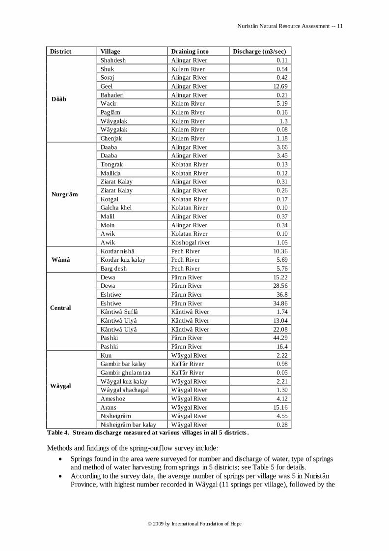
Table 4. Stream discharge measured at various villages in all 5 districts .
Methods and findings of the spring-outflow survey include:
Springs found in the area were surveyed for number and discharge of water, type of springs and method of water harvesting from springs in 5 districts; see Table 5 for details.
According to the survey data, the average number of springs per village was 5 in Nuristân Province, with highest number recorded in Wâygal (11 springs per village), followed by the
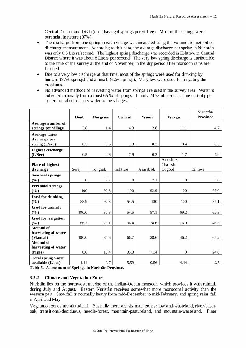
Nuristân Natural Resource Assessment -- 12
© 2009 by International Foundation of Hope
Central District and Dôâb (each having 4 springs per village). Most of the springs were perennial in nature (97%).
The discharge from one spring in each village was measured using the volumetric method of discharge measurement. According to this data, the average discharge per spring in Nuristân was only 0.5 Liters/second. The highest spring discharge was recorded in Eshtiwe in Central District where it was about 8 Liters per second. The very low spring discharge is attributable to the time of the survey at the end of November, in the dry period after monsoon rains are finished.
Due to a very low discharge at that time, most of the springs were used for drinking by humans (87% springs) and animals (62% springs). Very few were used for irrigating the croplands.
No advanced methods of harvesting water from springs are used in the survey area. Water is collected manually from a lmost 65 % of springs. In only 24 % of cases is some sort of pipe system installed to carry water to the villages.
Dôâb Nurgrâm Central Wâmâ Wâygal
Nuristân
Province
Average number of
springs per village 3.8 1.4 4.3 2.8 11.1 4.7
Average water
discharge per
spring (L/sec) 0.3 0.5 1.3 0.2 0.4 0.5
Highest discharge
(L/Sec) 0.5 0.6 7.9 0.3 1.7 7.9
Place of highest
discharge Soraj Tongrak Eshtiwe Asarabad,
Ameshoz
Chamsh
Dogool Eshtiwe
Seasonal s prings
(% ) 0 7.7 0 7.1 0 3.0
Perennial s prings
(% ) 100 92.3 100 92.9 100 97.0
Used for drinking
(% ) 88.9 92.3 54.5 100 100 87.1
Used for animals
(% ) 100.0 30.8 54.5 57.1 69.2 62.3
Used for irrigation
(% ) 66.7 23.1 36.4 28.6 76.9 46.3
Method of
harvesting of water
(Manual) 100.0 84.6 66.7 28.6 46.2 65.2
Method of
harvesting of water
(Pipes) 0.0 15.4 33.3 71.4 0 24.0
Total spring water
available (L/sec) 1.14 0.7 5.59 0.56 4.44 2.5
Table 5. Assessment of Springs in Nuristân Province .
3.2.2 Climate and Vegetation Zones
Nuristân lies on the northwestern edge of the Indian-Ocean monsoon, which provides it with rainfall during July and August. Eastern Nuristân receives somewhat more monsoonal activity than the western part. Snowfall is normally heavy from mid-December to mid-February, and spring rains fall is April and May.
Vegetation zones are altitudinal. Basically there are six main zones: lowland-wasteland, river-basin-oak, transitional-deciduous, needle-forest, mountain-pastureland, and mountain-wasteland. Finer
Nuristân Natural Resource Assessment -- 13
© 2009 by International Foundation of Hope
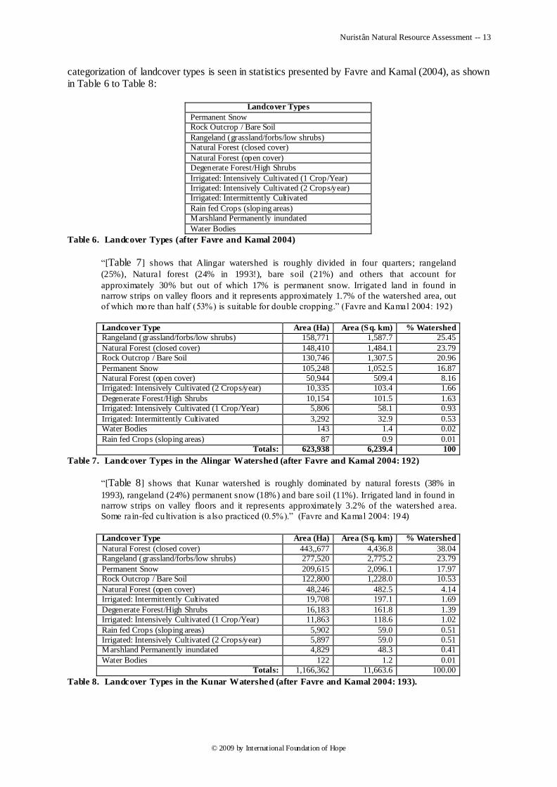
categorization of landcover types is seen in statistics presented by Favre and Kamal (2004), as shown in Table 6 to Table 8:
Landcover Types
Permanent Snow
Rock Outcrop / Bare Soil
Rangeland (grassland/forbs/low shrubs)
Natural Forest (closed cover)
Natural Forest (open cover)
Degenerate Forest/High Shrubs
Irrigated: Intensively Cultivated (1 Crop/Year)
Irrigated: Intensively Cultivated (2 Crops/year)
Irrigated: Intermittently Cultivated
Rain fed Crops (sloping areas)
Marshland Permanently inundated
Water Bodies
Table 6. Landcover Types (after Favre and Kamal 2004)
―[Table 7] shows that Alingar watershed is roughly divided in four quarters; rangeland
(25%), Natural forest (24% in 1993!), bare soil (21%) and others that account for
approximately 30% but out of which 17% is permanent snow. Irrigated land in found in
narrow strips on valley floors and it represents approximately 1.7% of the watershed area, out
of which more than half (53%) is suitable for double cropping.‖ (Favre and Kamal 2004: 192)
Landcover Type Area (Ha) Area (Sq. km) % Watershed
Rangeland (grassland/forbs/low shrubs) 158,771 1,587.7 25.45
Natural Forest (closed cover) 148,410 1,484.1 23.79
Rock Outcrop / Bare Soil 130,746 1,307.5 20.96
Permanent Snow 105,248 1,052.5 16.87
Natural Forest (open cover) 50,944 509.4 8.16
Irrigated: Intensively Cultivated (2 Crops/year) 10,335 103.4 1.66
Degenerate Forest/High Shrubs 10,154 101.5 1.63
Irrigated: Intensively Cultivated (1 Crop/Year) 5,806 58.1 0.93
Irrigated: Intermittently Cultivated 3,292 32.9 0.53
Water Bodies 143 1.4 0.02
Rain fed Crops (sloping areas) 87 0.9 0.01
Totals: 623,938 6,239.4 100
Table 7. Landcover Types in the Alingar Watershed (after Favre and Kamal 2004: 192)
―[Table 8] shows that Kunar watershed is roughly dominated by natural forests (38% in
1993), rangeland (24%) permanent snow (18%) and bare soil (11%). Irrigated land in found in
narrow strips on valley floors and it represents approximately 3.2% of the watershed a rea.
Some rain-fed cu ltivation is also practiced (0.5%).‖ (Favre and Kamal 2004: 194)
Landcover Type Area (Ha) Area (Sq. km) % Watershed
Natural Forest (closed cover) 443,,677 4,436.8 38.04
Rangeland (grassland/forbs/low shrubs) 277,520 2,775.2 23.79
Permanent Snow 209,615 2,096.1 17.97
Rock Outcrop / Bare Soil 122,800 1,228.0 10.53
Natural Forest (open cover) 48,246 482.5 4.14
Irrigated: Intermittently Cultivated 19,708 197.1 1.69
Degenerate Forest/High Shrubs 16,183 161.8 1.39
Irrigated: Intensively Cultivated (1 Crop/Year) 11,863 118.6 1.02
Rain fed Crops (sloping areas) 5,902 59.0 0.51
Irrigated: Intensively Cultivated (2 Crops/year) 5,897 59.0 0.51
Marshland Permanently inundated 4,829 48.3 0.41
Water Bodies 122 1.2 0.01
Totals: 1,166,362 11,663.6 100.00
Table 8. Landcover Types in the Kunar Watershed (after Favre and Kamal 2004: 193).
Nuristân Natural Resource Assessment -- 14
© 2009 by International Foundation of Hope
3.2.2.1 Climate
Nuristân‘s climate is mostly temperate, varying according to altitude. At 2000 m. altitude temperature ranges from 5° F. in winter to 98° F. in summer have been noted.
A current period of prolonged drought was a major theme of survey respondents throughout Nuristân As early as the late 1960‘s Nuristânis in the highest valleys began to notice serious diminishment of highland grassland (ZamânXân and Strand 1998). A comparison of the traditional herding calendars from 1891 (Robertson 1896) and 1969 (Strand, personal data) shows that the beginning of spring came earlier by about a month over the 78-year period. Since then the drought has steadily increased, affecting almost every region of the province. Survey respondents in Wâygal District did report a slight amelioration of drought during the last two years.
3.2.2.2 Cultivable Land
Relatively flat land (ptul, gâv'â:R, tol, ütnyok) suitable for cultivation is scarce in Nuristân‘s mountainous terrain. Table 7 and Table 8 show that only 3.13% of the Alingar watershed and 3.23% of the Kunar watershed is under some sort of cultivation. Flat alluvial deposits along watercourses form much of the arable ground in Nuristân. Communities located away from watercourses usually adjoin relatively level areas of arable mountain terrain, which do not need terracing. In some narrower valleys Nuristânis bring in regional Afghân or Chitrali experts to build steep agricultural terraces. Population increase has resulted in much arable forestland coming under clearing and cultivation in recent decades.
Five-year evaluations of cropland appear in Table 33.
3.2.2.3 Forests
Nuristân encompasses a major portion of Afghanistan's forests. There are two major forest zones: the needle forest, lying roughly between 2000 and 3000 m. in altitude, and the oak forest, lying between 1000 and 2000 m. Interspersed between the two zones and in the valley bottoms of larger rivers lie stands of broadleaf trees.
The needle-forest zone comprises deodar cedar, pine, fir, spruce, and juniper, with stands of birch at the highest elevations. The oak forest comprises at least three species of evergreen oak, the most ubiquitous being Quercus baloot. Broadleaf trees include numerous species of wild fruit and nut trees as well as willow, plane, poplar, cottonwood, olive, and other species. Native inventories of tree species are given in Appendix 1, Table 75, Table 76, and Table 80.
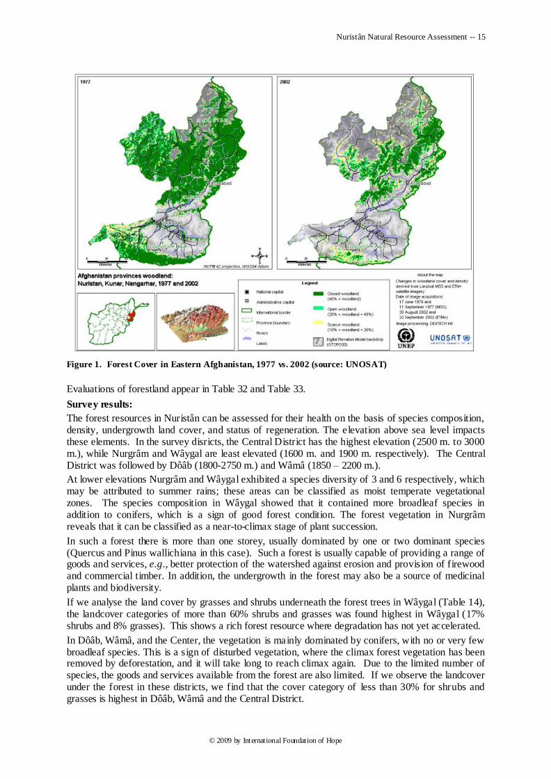
All indicators point to a decrease of up to 50% in forest cover across Afghanistan‘s eastern zone, as illustrated in Figure 1. Commercial logging, cutting for local building, clearing for cropland, and overcutting of firewood and fodder branches by local residents are responsible for much of the deforestation in the lower or more accessible portions of the forestland. But human consumption does not seem a probable cause for the extensive deforestation in the highest, northerly areas of Nuristân, as those areas are inaccessible to loggers. Climate change with concomitant drought would seem to be the leading culprit.
Regional Afghâns degrade the forest environment, as can be seen in a comparison of denuded Afghân-owned uplands vs. Nuristâni forests. Most human-caused forest depletion in Nuristân is attributable to exploitation by Afghân timber traders from both sides of the Durand Line.
Nuristân Natural Resource Assessment -- 15
© 2009 by International Foundation of Hope
Figure 1. Forest Cover in Eastern Afghanistan, 1977 vs. 2002 (source: UNOSAT)
Evaluations of forestland appear in Table 32 and Table 33.
Survey results:
The forest resources in Nuristân can be assessed for their health on the basis of species composition, density, undergrowth land cover, and status of regeneration. The elevation above sea level impacts these elements. In the survey disricts, the Central District has the highest elevation (2500 m. to 3000 m.), while Nurgrâm and Wâygal are least elevated (1600 m. and 1900 m. respectively). The Central District was followed by Dôâb (1800-2750 m.) and Wâmâ (1850 – 2200 m.).
At lower elevations Nurgrâm and Wâygal exhibited a species diversity of 3 and 6 respectively, which may be attributed to summer rains; these areas can be classified as moist temperate vegetational zones. The species composition in Wâygal showed that it contained more broadleaf species in addition to conifers, which is a sign of good forest condition. The forest vegetation in Nurgrâm reveals that it can be classified as a near-to-climax stage of plant succession.
In such a forest there is more than one storey, usually dominated by one or two dominant species (Quercus and Pinus wallichiana in this case). Such a forest is usually capable of providing a range of goods and services, e.g., better protection of the watershed against erosion and provision of firewood and commercial timber. In addition, the undergrowth in the forest may also be a source of medicinal plants and biodiversity.
If we analyse the land cover by grasses and shrubs underneath the forest trees in Wâygal (Table 14), the landcover categories of more than 60% shrubs and grasses was found highest in Wâygal (17% shrubs and 8% grasses). This shows a rich forest resource where degradation has not yet accelerated.
In Dôâb, Wâmâ, and the Center, the vegetation is mainly dominated by conifers, with no or very few broadleaf species. This is a sign of disturbed vegetation, where the climax forest vegetation has been removed by deforestation, and it will take long to reach climax again. Due to the limited number of species, the goods and services available from the forest are also limited. If we observe the landcover under the forest in these districts, we find that the cover category of less than 30% for shrubs and grasses is highest in Dôâb, Wâmâ and the Central District.
Nuristân Natural Resource Assessment -- 16
© 2009 by International Foundation of Hope
These three districts (Dôâb, Wâmâ and Central), being located at higher elevations, lie in the dry temperate climatic zone, where precipitation is mainly received in the form of snow and less in the form of rainfall. In such a climatic zone, the growing period is usually very short and the degradation caused to the resource base may take several decades to recover because of the harsh climate and short growing season. Elevation, man-made degradation, and deforestation contribute to the much lower tree count per hectare in Dôâb, Wâmâ and the Central districts.
The figures in the table of regeneration status (Table 12) also support the same conclusions. One can seed that nuber of seedlings in Wâygal and Nurgrâm is highest as compared to other three districts.
All these conclusions lead to the recommendation that deforestation and animal-grazing activities be curtailed in Wâygal and Nurgrâm districts to preserve the species diversity of the forest and also to ensure a sustained supply of environmental services and economic goods to the communits there. In the case of Dôâb, Wâmâ and the Center, where degradadtion has already taken place, rehabilitation activities may be supported through establishing nurseries, plantation campaigns, and awareness-raising activities to increase people‘s knowledge about the importance of resources, the degradation processes and its causes, and the need to protect their precious resources. In addition, farmland plantations and plantations in or around houses and communities may be promoted to provide an alternate source of fuel and timber to local communities.
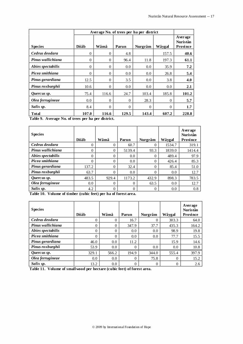
The figures given below provide an estimate of resource availability in the form of timber and fuelwood. The figures of fuelwood (small wood) and timber are on a per-hectare of forest area basis. The total tree count per hectare of the forest area in all 5 districts surveyed was 229.
Quercus spp., Pinus wallichiana and Cedrus deodara were the most abundant tree species having 101, 61 and 41 trees per hectare respectively in the forested area of Nuristân.
The highest number per hectare of Quercus spp. was found in Wâmâ, that of Pinus wallichiana in the Central District and that of Cedrus deodara in Wâygal. Quercus spp. were found in all 5 districts; see Table 9 for details.
The volume of timber per hectare pf the forest area was also estimated. The highest amount of timber present in the forest was that of Pinus wallichiana (1414 cubic feet per ha.), followed by Quercus spp. (784 cubic feet per ha.) and Cedrus deodara (319 cubic feet per ha.) respectively. Other commercial species like Abies spectabilis, Picea smithiana, and Pinus roxburghii were found in limited quantity; see Table 10 for details.
The fuelwood content of the forest in Nuristân was also estimated as small wood available on different trees growing within the forest area. According to the assessment, Quercus spp. were the highest source of fuelwood. Available fuelwood amount of this species was 398 cu. feet per ha., followed by Pinus wallichiana with 165 cft per ha. Quercus spp were most abundant in Wâmâ district, followed by Wâygal; see Table 11 for details.
The number of trees, timber and small wood quantities related to other species like olive, Picea smithiana and Abies spectabilis are shown in Table 9 to Table 11.
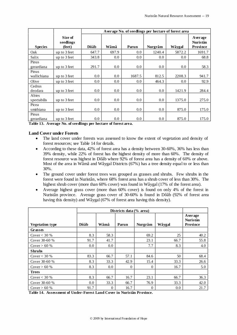
The status of regeneration of these species in the forest was also estimated. The number of seedlings of size less than 1 foot, 1 to 3 feet, and 3.1 to 5 feet was counted in sample plots.
According to the regeneration survey, the number of seedlings was highest for Quercus spp. (1692 seedlings per ha), followed by Pinus wallichiana (942 seedlings per ha.), Cedrus deodara (284 seedlings per ha), and Abies spectabilis (275 seedlings per ha.). Other species like Pinus gerardiana and Picea smithiana were also regenerating well in the forest. See Table 12 for details.
The mortality rate in new seedlings was highest in Quercus spp., followed by Abies spectabilis and Cedrus deodara respectively.
Nuristân Natural Resource Assessment -- 17
© 2009 by International Foundation of Hope
Species
Average No. of trees per ha per district
Dôâb Wâmâ Parun Nurgrâm Wâygal
Average
Nuristân
Province
Cedrus deodara 0 0 4.8 157.5 40.6
Pinus wallichiana 0 0 96.4 11.8 197.3 61.1
Abies spectabilis 0 0 0.0 0.0 35.9 7.2
Picea smithiana 0 0 0.0 0.0 26.8 5.4
Pinus gerardiana 12.5 0 3.5 0.0 3.8 4.0
Pinus roxburghii 10.6 0 0.0 0.0 0.0 2.1
Quercus sp. 75.4 116.6 24.7 103.4 185.8 101.2
Olea ferrugineae 0.0 0 0 28.3 0 5.7
Salix sp. 8.4 0 0 0 0 1.7
Total 107.0 116.6 129.5 143.4 607.2 228.8
Table 9. Average No. of trees per ha per district.
Species
Dôâb Wâmâ Parun Nurgrâm Wâygal
Average
Nuristân
Province
Cedrus deodara 0 0 60.7 0 1534.7 319.1
Pinus wallichiana 0 0 5139.4 93.3 1839.0 1414.4
Abies spectabilis 0 0 0.0 0 489.4 97.9
Picea smithiana 0 0 0.0 0 426.4 85.3
Pinus gerardiana 137.2 0 32.4 0 85.4 51.0
Pinus roxburghii 63.7 0 0.0 0 0.0 12.7
Quercus sp. 483.5 929.4 1173.2 432.9 898.3 783.5
Olea ferrugineae 0.0 0 0 63.5 0.0 12.7
Salix sp. 4.2 0 0 0 0.0 0.8
Table 10. Volume of timber (cubic feet) per ha of forest area.
Species
Dôâb Wâmâ Parun Nurgrâm Wâygal
Average
Nuristân
Province
Cedrus deodara 0 0 16.7 0 303.3 64.0
Pinus wallichiana 0 0 347.9 37.7 435.3 164.2
Abies spectabilis 0 0 0.0 0.0 98.9 19.8
Picea smithiana 0 0 0.0 0.0 77.7 15.5
Pinus gerardiana 46.0 0.0 11.2 15.9 14.6
Pinus roxburghii 53.9 0.0 0 0.0 0.0 10.8
Quercus sp. 329.1 566.2 194.9 344.0 555.4 397.9
Olea ferrugineae 0.0 0.0 0 75.8 0 15.2
Salix sp. 13.2 0.0 0 0 0 2.6
Table 11. Volume of smallwood per hectare (cubic feet) of forest area.

Nuristân Natural Resource Assessment -- 18
© 2009 by International Foundation of Hope
Species
Size of
seedlings
(feet)
No. of seedlings per ha of forest area
Dôâb Wâmâ Parun Nurgrâm Wâygal
Average
Nuristân
Province
Oak Less than 1 181.8 218.8 0.0 326.9 3211.1 787.7
1 to 3 193.2 250.0 0.0 480.8 1255.6 435.9
3.1 to 5 272.7 229.2 0.0 432.7 1405.6 468.0
Total 647.7 697.9 0.0 1240.4 5872.2 1691.7
Salix Less than 1 93.75 0.0 0.0 0.0 0.0 18.8
1 to 3 125 0.0 0.0 0.0 0.0 25.0
3.1 to 5 125 0.0 0.0 0.0 0.0 25.0
Total 343.75 0 0 0 0 68.75
Pinus
gerardiana Less than 1 125 0.0 0.0 0.0 0.0 25.0
1 to 3 41.7 0.0 0.0 0.0 0.0 8.3
3.1 to 5 125.0 0.0 0.0 0.0 0.0 25.0
Total 291.7 0.0 0.0 0.0 0.0 58.3
Pinus
wallichiana Less than 1 0.0 0.0 0.0 125.0 1583.3 341.7
1 to 3 0.0 0.0 500.0 437.5 333.3 254.2
3.1 to 5 0.0 0.0 1187.5 250.0 291.7 345.8
Total 0.0 0.0 1687.5 812.5 2208.3 941.7
Olive Less than 1 0.0 0.0 0.0 35.7 0.0 7.1
1 to 3 0.0 0.0 0.0 196.4 0.0 39.3
3.1 to 5 0.0 0.0 0.0 232.1 0.0 46.4
Total 0.0 0.0 0.0 464.3 0.0 92.9
Cedrus
deodara Less than 1 0.0 0.0 0.0 0.0 640.6 128.1
1 to 3 0.0 0.0 0.0 0.0 328.1 65.6
3.1 to 5 0.0 0.0 0.0 0.0 453.1 90.6
Total 0.0 0.0 0.0 0.0 1421.9 284.4
Abies
spectabilis Less than 1 0.0 0.0 0.0 0.0 708.3 141.7
1 to 3 0.0 0.0 0.0 0.0 250.0 50.0
3.1 to 5 0.0 0.0 0.0 0.0 416.7 83.3
Total 0.0 0.0 0.0 0.0 1375.0 275.0
Picea
smithiana Less than 1 0.0 0.0 0.0 0.0 125 25.0
1 to 3 0.0 0.0 0.0 0.0 500 100.0
3.1 to 5 0.0 0.0 0.0 0.0 250 50.0
Total 0.0 0.0 0.0 0.0 875.0 175.0
Pinus
gerardiana Less than 1 0.0 0.0 0.0 0.0 0.0 0.0
1 to 3 0.0 0.0 0.0 0.0 500 100.0
3.1 to 5 0.0 0.0 0.0 0.0 375 75.0
Total 0.0 0.0 0.0 0.0 875.0 175.0
Table 12. Status of regeneration in the forest area.
Nuristân Natural Resource Assessment -- 19
© 2009 by International Foundation of Hope
Species
Size of
seedlings
(feet)
Average No. of seedlings per hectare of forest area
Dôâb Wâmâ Parun Nurgrâm Wâygal
Average
Nuristân
Province
Oak up to 3 feet 647.7 697.9 0.0 1240.4 5872.2 1691.7
Salix up to 3 feet 343.8 0.0 0.0 0.0 0.0 68.8
Pinus
gerardiana up to 3 feet 291.7 0.0 0.0 0.0 0.0 58.3
Pinus
wallichiana up to 3 feet 0.0 0.0 1687.5 812.5 2208.3 941.7
Olive up to 3 feet 0.0 0.0 0.0 464.3 0.0 92.9
Cedrus
deodara up to 3 feet 0.0 0.0 0.0 0.0 1421.9 284.4
Abies
spectabilis up to 3 feet 0.0 0.0 0.0 0.0 1375.0 275.0
Picea
smithiana up to 3 feet 0.0 0.0 0.0 0.0 875.0 175.0
Pinus
gerardiana up to 3 feet 0.0 0.0 0.0 0.0 875.0 175.0
Table 13. Average No. of seedlings per hectare of forest area.
Land Cover under Forests
The land cover under forests was assessed to know the extent of vegetation and density of forest resources; see Table 14 for details.
According to these data, 42% of forest area has a density between 30-60%, 36% has less than 39% density, while 22% of forest has the highest density of more than 60%. The density of forest resource was highest in Dôâb where 92% of forest area has a density of 60% or above. Most of the area in Wâmâ and Wâygal Districts (67%) has a tree density equal to or less than 30%.
The ground cover under forest trees was grouped as grasses and shrubs. Few shrubs in the forest were found in Nuristân, where 68% forest area has a shrub cover of less than 30%. The highest shrub cover (more than 60% cover) was found in Wâygal (17% of the forest area).
Average highest grass cover (more than 60% cover) is found on only 4% of the forest in Nuristân province. Average grass cover of 30-60% is found in Dôâb (92% of forest area having this density) and Wâygal (67% of forest area having this density).
Vegetation type
Districts data (% area)
Dôâb Wâmâ Parun Nurgrâm Wâygal
Average
Nuristân
Province
Grasses
Cover < 30 % 8.3 58.3 69.2 25 40.2
Cover 30-60 % 91.7 41.7 23.1 66.7 55.8
Cover > 60 % 0.0 0.0 7.7 8.3 4.0
Shrubs
Cover < 30 % 83.3 66.7 57.1 84.6 50 68.4
Cover 30-60 % 8.3 33.3 42.9 15.4 33.3 26.6
Cover > 60 % 8.3 0.0 0 0 16.7 5.0
Trees
Cover < 30 % 8.3 66.7 16.7 23.1 66.7 36.3
Cover 30-60 % 0.0 33.3 66.7 76.9 33.3 42.0
Cover > 60 % 91.7 0 16.7 0 0.0 21.7
Table 14. Assessment of Under-Forest Land Cover in Nuristân Province.
Nuristân Natural Resource Assessment -- 20
© 2009 by International Foundation of Hope
3.2.2.4 Rangeland
Rangeland in Nuristân falls into highland and lowland zones. Highland grasslands (so˜, sâ˜, su, sa), found above the treeline from about 3000 m., supply the major source of fodder for dairy production. Scrubland mingles with the oak forests in the lowest and driest valleys to constitute a source for goat fodder in the winter.
Native inventories of rangeland plant species are given in Appendix 1, Table 77 and Table 81.
Survey results:
Rangeland is the largest land-use type in the survey area. This land supports a large population of livestock, mainly goats and cattle, which in turn provide a number of food items to the local population. The importance of this land resource for subsistence is thus very high. Areas other than forestland, cropland, and habitation may all be considered coming under this category. In addition, many areas under the forest are used for grazing livestock. Similarly, croplands when fallow are usually used for sedentary grazing by local herders.
The survey data show that the average land cover was not more than 63% and the total forage production per hectare was only 14 tones per hectare. In normal conditions this can be classified as a degraded resource, where overgrazing and improper resource use have led to weakening of the resource base. The land cover in the Central District and Nurgrâm is alarmingly low (35% and 49% respectively). This shows that degradation of range vegetation cover is at a high rate. Forage production is least in Parun (3.8 per hectare), which is much lower than normal range conditions.
The reduction of land cover also leads to invasion of the land by undesirable range vegetation species. Table 15 shows that wherever land cover is less, the emergence of unwanted species is greater, as in the Central and Wâmâ districts. The section on visible classification of rangeland degradation also supports this conclusion, where the percent of area under the category of very degraded is highest in Wâmâ, Central, and Nurgrâm districts. The visible signs of degradation in the form of soil erosion and landslides have emerged at many places.
All these observations lead us to conclude that rangelands are in a degraded condition, and that the process needs to be halted before the rangelands become unable to support the livestock of the area, and before the soil resource on hilly slopes becomes unstable due to lack of soil cover. The proper use of rangelands may be advocated at this stage, supported by range rehabilitation activities. After detailed consultations with the local communities, some sort of rotational or restricted grazing patterns may be adopted. Reseeding of land on degraded sites, coupled with plantation of multipurpose trees and shrubs suitable to that area, can be a good strategy against this degradation. To avert degradation process on highly degraded sites and slopes, soil conservation measures may be adopted to reduce soil erosion.
The following figures and facts provide an estimate of the availability of forage from rangelands.
The rangelands in 5 districts were surveyed, spreading over an elevation ranging from 1660 meters to 2700 meters above sea level, with an average alevation of 2073 meters above sea level.
The rangeland-attribute studies included rangeland vegetation cover, forage production, and range condition. See Table 15 for details of these parameters in the survey area.
According to the survey data, the average land cover on rangelands was 63% in all districts, including 48.1% for grasses, 7.6% for forbs and 7.6% for shrubs. The barren soil in rangelands was 13.1%, whereas 9.7% was found under rocks.
The highest ground cover was found in Wâmâ (82%) and lowest in the Central District (35%). A considerable portion of land in the Central District was under snow and could not be estimated for vegetation cover.
The weight of forage available in the form of grasses, forbs and browse from shrubs was estimated using a 1 meter square quadrate. The total forage available was 14.7 tones per hectare average in Nuristân Province. The highest forage was available in Dôâb (33.3 t/ha), followed by Wâygal (15.8 t/ha) and Nurgrâm (11.8 t/ha). It is important to note that the time
Nuristân Natural Resource Assessment -- 21
© 2009 by International Foundation of Hope
of survey was November, when most of the grasslands were shorn of grass for use as cattle fodder in winter months.
It is also important that the land cover was greater on northern aspects as compared to southern aspects in the range area. The degradation of land was more on northern aspects, indicating an over-grazing of land on northern aspects.
Various parts of the rangeland were categorized as very good, good, average, slightly degraded and very degraded. According to the survey data, 55% of rangeland could be categorized as average and 43.3% as slightly degraded. Only 10% and 21.7% of rangeland was categorized under very good and good conditions respectively.
Degraded rangelands were found in all five surveyed districts. The visible signs of degradation were sheet and gully erosion, landslides, and consequent loss of vegetation cover. Landslides were mainly found in Dôâb, Wâmâ, and the Central districts, whereas sheet erosion was highest in Dôâb (66.6%), Wâmâ (33.3%), and Wâygal (33.3%).
The range area was also invaded by unwanted range species. A total of 16 different species were recorded that were graded as unwanted, unpalatable and undesired by local people. The most abundant species found were zahar buti, leghoni, khar ghwagey, and dadem. These were reported in 27%, 23%, 2%, and 22% of surveyed villages, respectively.
Respondents‘ and surveyors‘ evaluations of pastureland appear in Table 32 and Table 33.
Nuristân Natural Resource Assessment -- 22
© 2009 by International Foundation of Hope
Attribute
District data average Av.
Nuristân
Province Dôâb Wâmâ Central Nurgrâm Wâygal
Slope (% ): 0 0 na 33.6 38 17.9
Elevation above sea level : 2133.8 2033.3 2700 1600 1900 2073.4
Land Cover (% ):
Land Cover grass 63.8 59.2 23.8 37.9 55.6 48.1
Land Cover forbs 6.6 14.0 6.9 3.2 7.3 7.6
Land Cover shrubs 5.7 8.5 5 8.5 10.3 7.6
Land Cover Barren soil 14.1 10.8 4.2 22.5 13.7 13.1
Land Cover Rocks 9.9 7.5 3.1 20.4 7.5 9.7
Average total cover 76 81.7 35.8 49.6 73.2 63.2
Forage weight (t/ha)):
Forage weight Grasses 24.75 6.1 2.5 8.8 14.9 11.4
Forage weight forbs 4.8 1.9 0.8 0.9 0.8 1.9
Forage weight Browse 3.7 1.1 0.5 2.2 0.1 1.5
Total forage 33.3 9.1 3.8 11.8 15.8 14.7
Range Condition
Average 41.7 83.3 50 75 25 55.0
Good: 50 0 0 25 33.3 21.7
Very good 8.3 0 0 0 41.7 10.0
Slightly degraded 33.3 58.3 41.7 25 58.3 43.3
Very degraded 0 25 8.3 8.3 0 8.3
Visible degradation
Landslides: 41.6 41.7 33.3 0 0 23.3
Soil erosion: 66.6 58.3 33.3 33.3 58.3 50.0
Reduced cover: 75 91.7 33.3 66.6 41.6 61.6
Unwanted s pecies (presence %
villages)
Dadem 41.7 25 41.6 0 0 21.7
Leghoni 33.3 58.3 0 0 22.9
Kharghwagey 25 75 8.3 0 0 21.7
Leraap 16.6 0 0 0 0 3.3
Sozakai 8.3 0 0 0 0 1.7
Mechee 0 16.6 0 0 0 3.3
Sagay 0 16.6 0 0 0 3.3
Zahar booti 0 66.6 66.6 0 0 26.6
Chakateek 0 0 8.3 0 0 1.7
Nemeer 0 0 25 0 0 5.0
Khatreez 0 0 0 0 16.6 3.3
Jao 0 0 0 0 8.3 1.7
Tantarak 0 0 0 0 8.3 1.7
Wartigey 0 0 0 0 8.3 1.7
Ghat t igey 0 0 0 0 8.3 1.7
None 50 0 66.6 100 66.6 56.6
Table 15. Assesment of Rangelands in Nuristân Province, Afghanistan.
3.2.3 Fauna
Nuristân‘s wild animals are under heavy pressure from loss of forest habitat and hunting. The leopard, markhor goat, monal pheasant, and musk deer, traditional icons in Nuristâni culture, are endangered, as are most other larger animals found in the region. A native inventory of fauna in eastern Nuristân appears in Table 78.
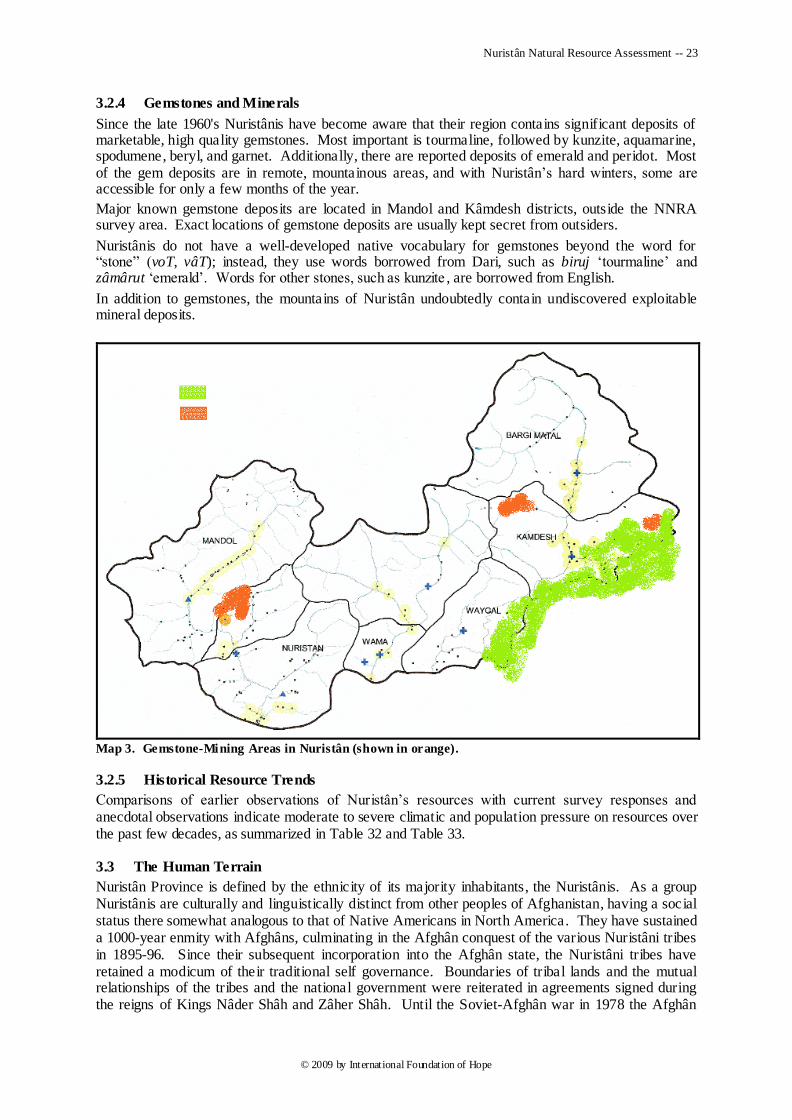
Nuristân Natural Resource Assessment -- 23
© 2009 by International Foundation of Hope
3.2.4 Gemstones and Minerals
Since the late 1960's Nuristânis have become aware that their region contains significant deposits of marketable, high quality gemstones. Most important is tourmaline, followed by kunzite, aquamarine, spodumene, beryl, and garnet. Additionally, there are reported deposits of emerald and peridot. Most of the gem deposits are in remote, mountainous areas, and with Nuristân‘s hard winters, some are accessible for only a few months of the year.
Major known gemstone deposits are located in Mandol and Kâmdesh districts, outside the NNRA survey area. Exact locations of gemstone deposits are usually kept secret from outsiders.
Nuristânis do not have a well-developed native vocabulary for gemstones beyond the word for ―stone‖ (voT, vâT); instead, they use words borrowed from Dari, such as biruj ‗tourmaline‘ and zâmârut ‗emerald‘. Words for other stones, such as kunzite , are borrowed from English.
In addition to gemstones, the mountains of Nuristân undoubtedly contain undiscovered exploitable mineral deposits.
Map 3. Gemstone-Mining Areas in Nuristân (shown in orange).
3.2.5 Historical Resource Trends
Comparisons of earlier observations of Nuristân‘s resources with current survey responses and anecdotal observations indicate moderate to severe climatic and population pressure on resources over the past few decades, as summarized in Table 32 and Table 33.
3.3 The Human Terrain
Nuristân Province is defined by the ethnicity of its majority inhabitants, the Nuristânis. As a group Nuristânis are culturally and linguistically distinct from other peoples of Afghanistan, having a social status there somewhat analogous to that of Native Americans in North America. They have sustained a 1000-year enmity with Afghâns, culminating in the Afghân conquest of the various Nuristâni tribes in 1895-96. Since their subsequent incorporation into the Afghân state, the Nuristâni tribes have retained a modicum of their traditional self governance. Boundaries of tribal lands and the mutual relationships of the tribes and the national government were reiterated in agreements signed during the reigns of Kings Nâder Shâh and Zâher Shâh. Until the Soviet-Afghân war in 1978 the Afghân
Nuristân Natural Resource Assessment -- 24
© 2009 by International Foundation of Hope
government ruled Nuristân relatively benignly, while engendering little respect for its governance or its claims of sovereignty over resources. Since then much or all of Nuristân has been under control of local jihadist commanders, many of whom have evolved under the influence of global jihadism from being secularly oriented defenders against ―Godless communism‖ in the 1970‘s to being radicalized defenders against ―Western infidelism‖ today.
3.3.1 Ethnolinguistic Groups
Linguistic and ethnographic scholars classify the peoples of Nuristân into a system based on the evolution of their languages, using time-tested classificatory methods that are analogous to those used in genetic evolutionary-tree reconstruction today. The languages spoken in Nuristân all belong to the Indo-Iranian branch of the Indo-European language family. The Nuristânis proper speak languages that form a distinct sub-branch within the Indo-Iranian branch. Non-Nuristâni ethnolinguistic populations included within Nuristân Province include Pashaî, Afghân, and Gujar groups in the western portions of Dôâb and Nurgrâm Districts, along with Pashaî-speaking people in southernmost Wâmâ District. Table 16 and Table 17 along with Map 4 summarize the distribution of ethnolinguistic groups in Nuristân Province.
Among the Nuristânis each of the named ethnic groups regards the others as distinctly foreign from themselves, much as the nationalities of Europe regard each other. However, there is a basic division, linguistically and culturally, between the northern Nuristânis and the southern Nuristânis. The former are further divided linguistically into two culturally distinct groups, the Vâsi of Pârun and the Kâmkata-speaking population of Kântivâ, Mandol, Dôâb, and the LanDay Sin watershed, who are divided into several tribes. The southern Nuristânis all call themselves ―KalaSha‖ but are further divided across three languages into various named tribal groups (see Table 16).
3.3.2 Social-Organizational Principles
Patrilineality is the basic organizing principle of Nuristâni society. Nuristânis fall into named tribal groups based on descent through the male line from a putative founding ancestor. Often the tribal name will reflect an ancient place of origin rather than a founder‘s actual name; thus, the Kâta are from Almond Grove (Kântivâ), the Kom are from Kâma (in Nangarhâr), the KShto are from Kust (in the Central District), etc. The southern Nuristânis reckon themselves in a hierarchy of ethnicity; thus in Wâygal District all the people are KalaSha, but they are in turn divided into the Vâi and the Chima-Nishei, with further divisions among the various villages.
In the strongly patriarchal Nuristâni household, seniority carries authority. The senior male in each household has total authority over household members; elder brothers have authority over younger ones.
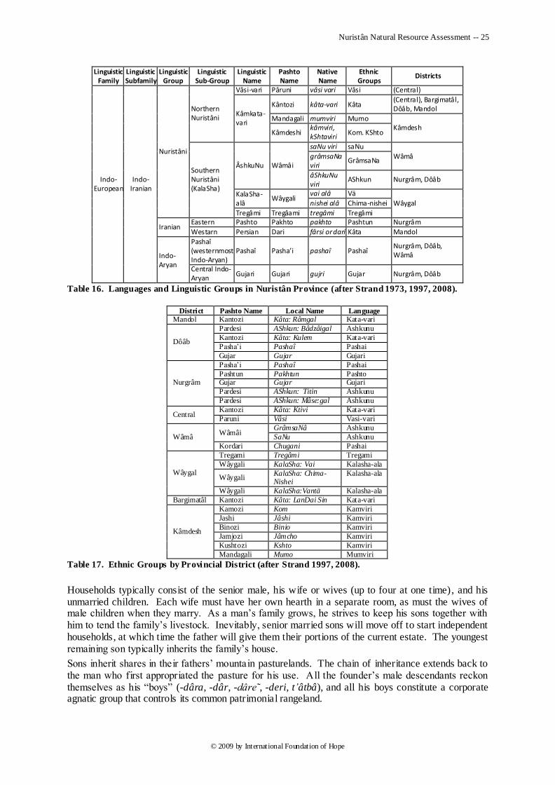
Nuristân Natural Resource Assessment -- 25
© 2009 by International Foundation of Hope
Linguistic Family
Linguistic Subfamily
Linguistic Group
Linguistic Sub-Group
Linguistic Name
Pashto Name
Native Name
Ethnic Groups
Districts
Indo-European
Indo-Iranian
Nuristâni
Northern Nuristâni
Vâsi-vari Pâruni vâsi vari Vâsi (Central)
Kâmkata-vari
Kântozi kâta-vari Kâta (Central), Bargimatâl, Dôâb, Mandol
Mandagali mumviri Mumo Kâmdesh
Kâmdeshi kâmviri, kShtaviri
Kom. KShto
Southern Nuristâni (KalaSha)
ÂshkuNu Wâmâi
saNu viri saNu
Wâmâ grâmsaNa viri
GrâmsaNa
âShkuNu viri
AShkun Nurgrâm, Dôâb
KalaSha-alâ
Wâygali vai alâ Vä
Wâygal nishei alâ Chima-nishei
Tregâmi Tregâami tregâmi Tregâmi
Iranian Eastern Pashto Pakhto pakhto Pashtun Nurgrâm
Westarn Persian Dari fârsi or dari Kâta Mandol
Indo-Aryan
Pashaî (westernmost Indo-Aryan)
Pashaî Pasha’i pashaî Pashaî Nurgrâm, Dôâb, Wâmâ
Central Indo-Aryan
Gujari Gujari gujri Gujar Nurgrâm, Dôâb
Table 16. Languages and Linguistic Groups in Nuristân Province (after Strand 1973, 1997, 2008).
District Pashto Name Local Name Language
Mandol Kantozi Kâta: Râmgal Kata-vari
Dôâb
Pardesi AShkun: Bâdzâigal Ashkunu
Kantozi Kâta: Kulem Kata-vari
Pasha‘i Pashaî Pashai
Gujar Gujar Gujari
Nurgrâm
Pasha‘i Pashaî Pashai
Pashtun Pakhtun Pashto Gujar Gujar Gujari
Pardesi AShkun: Titin Ashkunu
Pardesi AShkun: Mâse:gal Ashkunu
Central Kantozi Kâta: Ktivi Kata-vari
Paruni Vâsi Vasi-vari
Wâmâ Wâmâi
GrâmsaNâ Ashkunu
SaNu Ashkunu
Kordari Chugani Pashai
Wâygal
Tregami Tregâmi Tregami
Wâygali KalaSha: Vai Kalasha-ala
Wâygali KalaSha: Chima-Nishei
Kalasha-ala
Wâygali KalaSha:Vantä Kalasha-ala
Bargimatâl Kantozi Kâta: LanDai Sin Kata-vari
Kâmdesh
Kamozi Kom Kamviri
Jashi Jâshi Kamviri
Binozi Binio Kamviri
Jamjozi Jâmcho Kamviri
Kushtozi Kshto Kamviri
Mandagali Mumo Mumviri
Table 17. Ethnic Groups by Provincial District (after Strand 1997, 2008).
Households typically consist of the senior male, his wife or wives (up to four at one time), and his unmarried children. Each wife must have her own hearth in a separate room, as must the wives of male children when they marry. As a man‘s family grows, he strives to keep his sons together with him to tend the family‘s livestock. Inevitably, senior married sons will move off to start independent households, at which time the father will give them their portions of the current estate. The youngest remaining son typically inherits the family‘s house.
Sons inherit shares in their fathers‘ mountain pasturelands. The chain of inheritance extends back to the man who first appropriated the pasture for his use. All the founder‘s male descendants reckon themselves as his ―boys‖ (-dâra, -dâr, -dâre˜, -deri, t’âtbâ), and all his boys constitute a corporate agnatic group that controls its common patrimonial rangeland.
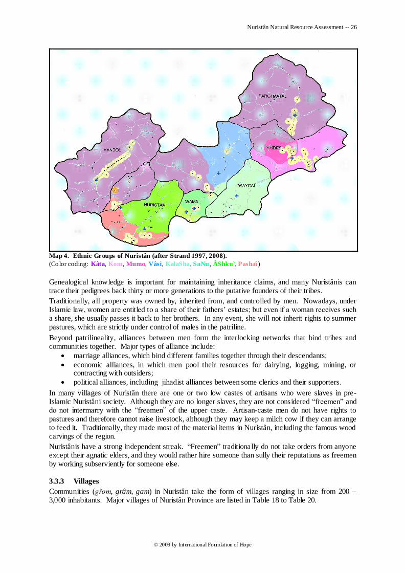
Nuristân Natural Resource Assessment -- 26
© 2009 by International Foundation of Hope
Map 4. Ethnic Groups of Nuristân (after Strand 1997, 2008).
(Color coding: Kâta, Kom, Mumo, Vâsi, KalaSha, SaNu, ÂShku˜, Pashaî )
Genealogical knowledge is important for maintaining inheritance claims, and many Nuristânis can trace their pedigrees back thirty or more generations to the putative founders of their tribes.
Traditionally, all property was owned by, inherited from, and controlled by men. Nowadays, under Islamic law, women are entitled to a share of their fathers‘ estates; but even if a woman receives such a share, she usually passes it back to her brothers. In any event, she will not inherit rights to summer pastures, which are strictly under control of males in the patriline.
Beyond patrilineality, alliances between men form the interlocking networks that bind tribes and communities together. Major types of alliance include:
marriage alliances, which bind different families together through their descendants;
economic alliances, in which men pool their resources for dairying, logging, mining, or contracting with outsiders;
political alliances, including jihadist alliances between some clerics and their supporters.
In many villages of Nuristân there are one or two low castes of artisans who were slaves in pre-Islamic Nuristâni society. Although they are no longer slaves, they are not considered ―freemen‖ and do not intermarry with the ―freemen‖ of the upper caste. Artisan-caste men do not have rights to pastures and therefore cannot raise livestock, although they may keep a milch cow if they can arrange to feed it. Traditionally, they made most of the material items in Nuristân, including the famous wood carvings of the region.
Nuristânis have a strong independent streak. ―Freemen‖ traditionally do not take orders from anyone except their agnatic elders, and they would rather hire someone than sully their reputations as freemen by working subserviently for someone else.
3.3.3 Villages
Communities (gřom, grâm, gam) in Nuristân take the form of villages ranging in size from 200 – 3,000 inhabitants. Major villages of Nuristân Province are listed in Table 18 to Table 20.
Nuristân Natural Resource Assessment -- 27
© 2009 by International Foundation of Hope
National Name Local Name Ethnic Group District Nangarach nangaraj Pashaî Nurgrâm
Malil malil Pashaî Nurgrâm Titin tit in Ashkun Nurgrâm
Kolatân kolatâ Ashkun Nurgrâm
Palagal pâřgˈal Kata Dôâb
Pyâr piâr Pashaî Dôâb
Nilâw pˈegal Kâta Dôâb
Anish ânˈiSh Kâta Mandol
Kiwisht kivˈiShT Kâta Mandol
Mandol mâniˈul Kâta Mandol
Linar lˈinâř Kâta Mandol
Gadwâl gâDu Kâta Mandol
Pushâl pˈushol Kâta Mandol
Table 18. Major Villages in the Alingar Watershed.
National Name Local Name Ethnic Group District Gambir gamir Tregâmi Wâygal Wânt vânt Vântä Wâygal
Nishe‘i nisheigrâm Kalasha: Nishei Wâygal
Arans Zhönchigal Kalasha: Vâi Wâygal
Âmeshos âmeshdesh Kalasha: Vâi Wâygal
Wâygal vägal Kalasha: Vâi Wâygal
Wâmâ sâma SaNu (Wâmâi) Wâmâ
AchaNu grâmsaNâ grâm GrâmsaNâ Wâmâ
Kântiwâ Ulyâ ktˈivi Kâta (Center)
Pashki ushˈüt Vâsi (Center)
Eshtiwe Shupˈu Vâsi (Center)
Table 19. Major Villages in the Pech Watershed.
National Name Local Name Ethnic Group District Pitigal pˈit igal Kom Kâmdesh Kâmu kâmˈu Kom Kâmdesh
Kâmdesh kˈombřom Kom Kâmdesh
Mandagal Suflâ mumˈořm Mumo Kâmdesh
Paprok pˈeruk Kâta Kâmdesh
Badmuk badˈamuk Kâta Bargimatâl
Bargimatâl břagˈamâTol Kâta Bargimatâl
Table 20. Major Villages in the LanDay-Sin Watershed.
Village communities are the primary social units in Nuristân. Their residents are typically from multiple agnatic groups of the same tribe, although smaller communities dominated by a single agnatic group are not uncommon. Neighborliness is a virtue that binds Nuristâni villagers together, as does a strong feeling of community. Community members govern themselves through open community meetings under the guidance of village politicians, who are called ―elders‖ in the local languages.
3.3.3.1 Demography
Official CSO estimates of population by district in Nuristân appear in Table 1; the estimate of total population for the whole province 125,000. This estimate is double the population of 60,000 estimated in the 1960‘s and seems more realistic than the higher estimates that appear in less-informed sources.
Nuristân Natural Resource Assessment -- 28
© 2009 by International Foundation of Hope
Survey results:
Doab
Village Name Shuk Watsar Palagal Wâygalak Bajagal Junyâ Total
Total No. of Males: 691 562 1,286 390 1,292 2,028 6,249
Total No. of Females: 690 511 1,221 370 1,005 2,040 5,838
No. of Male Children: 456 350 594 219 668 1,086 3,373
No. of Female Children: 437 291 683 219 520 1,249 3,399
Total 1,382 1,073 2,507 760 2,297 4,068 12,087
Houses 232 179 247 86 265 425 1,434
Neighborhoods 3 3 3 1 8 5 23
Avg. People/House 6.0 6.0 10.1 8.8 8.7 9.6 8.4
Male/Female Ratio 1.00 1.10 1.05 1.05 1.29 0.99 1.07
Nurgrâm
Village Name Awek Kolatan Malak Kandi Lâm Shod Lâm Malil Total
Total No. of Males: 59 1,124 510 1,214 699 592 4,198
Total No. of Females: 49 898 426 1,024 578 555 3,530
No. of Male Children: 41 819 362 865 548 369 3,004
No. of Female Children: 31 562 283 668 411 315 2,270
Total 108 2,022 936 2,238 1,277 1,147 7,728
Houses 18 304 138 342 153 220 1,175
Neighborhoods 1 6 3 4 7 4 25
Avg. People/House 6.0 6.7 6.8 6.5 8.3 5.2 6.6
Male/Female Ratio 1.20 1.25 1.20 1.19 1.21 1.07 1.19
Central District
Village Name Pashki Es htiwe Dewa Kântiwâ U. Kântiwâ S. Kusht Total
Total No. of Males: 558 599 634 790 1,139 203 3,923
Total No. of Females: 542 565 563 625 916 188 3,399
No. of Male Children: 399 427 460 553 875 164 2,878
No. of Female Children: 384 380 383 389 631 147 2,314
Total 1,100 1,164 1,197 1,415 2,055 391 7,322
Houses 160 177 175 236 266 39 1,053
Neighborhoods 5 5 4 4 4 5 27
Avg. People/House 6.9 6.6 6.8 6.0 7.7 10.0 7.0
Male/Female Ratio 1.03 1.06 1.13 1.26 1.24 1.08 1.15
Wâmâ
Village Name Achanu Wâmâ Paso Apiss Kordar Saprigal Total
Total No. of Males: 578 1,002 793 380 809 229 3,791
Total No. of Females: 554 797 700 367 790 302 3,510
No. of Male Children: 428 794 564 277 573 159 2,795
No. of Female Children: 375 578 469 258 552 232 2,464
Total 1,132 1,799 1,493 747 1,599 531 7,301
Houses 146 209 230 108 233 71 997
Neighborhoods 6 2 4 3 4 4 23
Avg. People/House 7.8 8.6 6.5 6.9 6.9 7.5 7.3
Male/Female Ratio 1.04 1.26 1.13 1.04 1.02 0.76 1.08
Wâygal
Village Name Nisheigram Ameshoz Gambir Arans Wâygal Kond Total
Total No. of Males: 1,332 497 849 934 1,197 636 5,445
Nuristân Natural Resource Assessment -- 29
© 2009 by International Foundation of Hope
Total No. of Females: 1,401 710 878 1,569 1,253 649 6,460
No. of Male Children: 783 377 563 898 686 475 3,782
No. of Female Children: 826 374 522 800 607 460 3,589
Total 2,733 1,207 1,727 2,503 2,450 1,285 11,905
Houses 517 233 283 622 444 249 2,348
Neighborhoods 6 4 3 4 3 7 27
Avg. People/House 5.3 5.2 6.1 4.0 5.5 5.2 5.1
Male/Female Ratio 0.95 0.70 0.97 0.60 0.96 0.98 0.84
Table 21. Demographic Statistics from Surveyed Villages.
Respondents from all villages stated that population has grown substantially over the past few decades.
3.3.3.2 Village Siting and Divisions
Communities are sited in well-watered, arable places that lie at the nexus of migratory herding routes between mountain pastures and winter quarters.
Large villages, such as Wâygal and Kâmdesh, comprise from two to four autonomous constituent villages, each with its own political leaders and mosque. All villages have named neighborhoods.
3.3.3.3 Dwellings
Nuristânis live in square, multi-storey, flat-roofed houses constructed of alternate layers of deodar-cedar timber and rock-and-clay mortar. On the ground floor is a storeroom and stable, the latter with a small section for human waste; above is the living room, which opens onto a veranda, and a toilet hole opening to the stable below. Human waste is collected in the latrine portion of the stable. The entire floor of the stable and its contents of human and animal waste is periodically covered with basketfuls of dried hollyoak leaves and allowed to compost. In the spring the women mix up the compost, load the composted mixture into large carrying baskets, and take it to their fields as fertilizer.
3.3.3.4 Community Governance
Nuristâni villages are traditionally democratic, with all male freemen having a say at community meetings. Governing bodies traditionally include ―community elders‖ and ―policemen‖ elected at an annual community meeting; in the recent chaotic times, less democratic ―shorâs‖ and ―committees‖ have taken the place of the traditional democratic institutions.
3.3.3.4.1 Elders
―Elders‖ (jeST, düSTö, diST'o) are civically motivated men who have achieved status through peacemaking or valorous deeds that defend the community. At the beginning of spring a certain number of ―community elders‖ (gřâmjeST) is chosen from the elders at large to manage community affairs for the coming year.
3.3.3.4.2 Resource Police
Policemen (ura, malavře˜, irin, ur'i) are elected annually at the beginning of spring. Their primary duty is to enforce through fines village laws that control resources. Such laws include keeping livestock out of cropland and interdicting the picking of tree crops before they are ripe. In some communities they also regulate forest cutting.
3.3.3.4.3 Councils and Committees
New forms of community government have emerged in much of post-Soviet-War Nuristân, under the influence of Islamist and Pakistani custom. Usually called ―councils‖ (shorâs), most of these governing bodies were formed by jihadist Soviet-War commanders or clerics; more recently, they were formed under incentives from OEF commanders, without full community support or claim to
Nuristân Natural Resource Assessment -- 30
© 2009 by International Foundation of Hope
institutional legitimacy. More secularly oriented ―committees‖ (kumeTâs) have appeared in villages like Pitigal; these function much as the ―community elders‖ used to, with the addition of overseeing the distribution of timber-contract revenues to community members; but resource policing is not a priority, and a separate body of policemen no longer exists.
3.4 Subsistence-Level Resource Exploitation and Ownership
The people of Nuristân live at a subsistence level, with an economy based on a mixture of agriculture, arboriculture, and animal husbandry. The mountainous environment supports these economic pursuits adequately to maintain the present population, but any accumulation of wealth derived from this traditional economy is mostly contained and redistributed within Nuristân and provides little benefit to raising the overall standard of living through external economic exchange.
The division of subsistence labor between males and females is based on what each gender brings to the dinner table. In the Nuristâni view, a ―balanced meal‖ consists of bread and ―mixings,‖ which implies dairy products (Strand 1975). The women supply the bread; the men supply the mixings.
To supply the bread, women do all the agricultural work, from plowing and planting through irrigation and weeding to harvesting and grinding of the grain. In addition, they must build fires to cook the bread, which entails their gathering of firewood after the crops are harvested, and they must supply the water to form the dough, as well as all other water for the household. Nuristâni women never involve themselves in dairy production, unlike Gujar and Afghân women.
Men are in charge of all livestock raising and dairy production. In addition, they may do the plowing, and they are responsible for harvesting walnuts and other tree crops.
All land in Nuristân is owned, either individually or corporately by the community or agnatic lineage. Pastureland rights are passed from father to son and are not sellable outside the agnatic inheritance group (the ―clan‖); other land may be sold, but not to tribal outsiders. Among the Vâsi in Pârun pasturelands are held in common by the entire village. In some communities owners of rights to unused pastureland lease them to tribal outsiders (Gujars and highland Afghan tribes), but such arrangenments often lead to hostilities between lessor and lessee. Needle-forest land is owned by the community as a whole.
All exploited land is named. The names of pasturelands, winter lands, forest lands, croplands, and water sources for each surveyed village appear in Section 4.2 below. These are meant to be used as starting points for more detailed mapping of Nuristân‘s resources in future studies.
3.4.1 Water Usage
Nuristâni settlements are predicated on the traditional abundance of water in the eastern Hindu Kush. Water from the numerous springs and mountain streams has been the mainstay of agricultural life and relatively salubrious human sustenance. But climate-change-induced drought over the last four decades has diminished the former abundance, while need for more cropland to feed an increasing population prompts more water consumption for irrigation.
Water from rivers and streams is community property; springs are sometimes owned, but usually they are community property. Individuals may build mills and even microhydropower generators along watercourses, with the agreement of any affected community members.
3.4.1.1 Irrigation
Irrigation water comes from watercourses and springs. Intake structures direct a portion of the water into stone-lined ditches, which often traverse steep terrain. Wooden aqueducts are common features of Nuristâni irrigation systems.
Irrigation works are maintained in common by the owners of the fields that they irrigate (often everyone in a village). During the summer each field owner has a periodic turn to take irrigation water. In some areas irrigation is done overnight, for better absorbsion.
In times of drought fights between women over irrigation turns become common, and in recent years fights between whole communities in Nuristân Province (Kâmdesh vs. Kushtoz, Wâigal vs. Arans, Juniâ vs. Piâr) have broken out over rights to drought-scarce water.
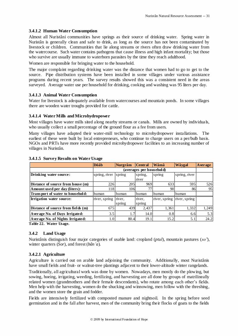
Nuristân Natural Resource Assessment -- 31
© 2009 by International Foundation of Hope
3.4.1.2 Human Water Consumption
Almost all Nuristâni communities have springs as their source of drinking water. Spring water in Nuristân is generally clean and safe to drink, as long as the source has not been contaminated by livestock or children. Communities that lie along streams or rivers often draw drinking water from the watercourse. Such water contains pathogens that cause illness and high infant mortality; but those who survive are usually immune to waterborn parasites by the time they reach adulthood.
Women are responsible for bringing water to the household.
The major complaint regarding drinking water was the distance that women had to go to get to the source. Pipe distribution systems have been installed in some villages under various assistance programs during recent years. The survey results showed this was a consistent need in the areas surveyed. Average water use per household for drinking, cooking and washing was 95 liters per day.
3.4.1.3 Animal Water Consumption
Water for livestock is adequately available from watercourses and mountain ponds. In some villages there are wooden water troughs provided for cattle.
3.4.1.4 Water Mills and Microhydropower
Most villages have water mills sited along nearby streams or canals. Mills are owned by individua ls, who usually collect a small percentage of the ground flour as a fee from users.
Many villages have adapted their water-mill technology to microhydropower installations. The earliest of these were built by local entrepreneurs, who continue to charge users on a per/bulb basis. NGOs and PRTs have more recently provided microhydropower facilities to an increasing number of villages in Nuristân.
3.4.1.5 Survey Results on Water Usage
Dôâb Nurgrâm Central Wâmâ Wâygal Average
(averages per household)
Drinking water source: spring, river spring spring,
river
spring spring, river
Distance of source from house (m) 226 205 969 633 595 526
Amount used per day (liters): 118 106 77 90 86 95
Trans port of water to household: human human human human human
Irrigation water source: river, spring river,
spring
river,
spring
river, spring river, spring
Distance of source from fields (m) 675 439 2,437 1,361 1,332 1,249
Average No. of Days Irrigated: 3.5 1.7 14.0 0.8 6.6 5.3
Average No. of Nights Irrigated: 1.0 80.4 19.1 15.2 5.1 24.2
Table 22. Water Usage.
3.4.2 Land Usage
Nuristânis distinguish four major categories of usable land: cropland (ptul), mountain pastures (so ), winter quarters (Sor), and forest (bân’a).
3.4.2.1 Agriculture
Agriculture is carried out on arable land adjoining the community. Additionally, most Nuristânis have small fields and fruit- or walnut-tree plantings adjacent to their lower-altitude winter rangelands.
Traditionally, all agricultural work was done by women. Nowadays, men mostly do the plowing, but sowing, hoeing, irrigating, weeding, fertilizing, and harvesting are all done by groups of matrilineally related women (grandmothers and their female descendants), who rotate among each other‘s fields. Men help with the harvesting, women do the shucking and winnowing, men follow with the threshing, and the women store the grain and fodder.
Fields are intensively fertilized with composted manure and nightsoil. In the spring before seed germination and in the fall after harvest, men of the community bring their flocks of goats to the fields
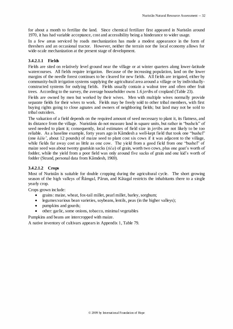
Nuristân Natural Resource Assessment -- 32
© 2009 by International Foundation of Hope
for about a month to fertilize the land. Since chemical fertilizer first appeared in Nuristân around 1970, it has had variable acceptance, cost and accessibility being a hinderance to wider usage.
In a few areas serviced by roads mechanization has made a modest appearance in the form of threshers and an occasional tractor. However, neither the terrain nor the local economy allows for wide-scale mechanization at the present stage of development.
3.4.2.1.1 Fields
Fields are sited on relatively level ground near the village or at winter quarters along lower-latitude watercourses. All fields require irrigation. Because of the increasing population, land on the lower margins of the needle forest continues to be cleared for new fields. All fields are irrigated, either by community-built irrigation systems supplying the agricultural area around a village or by individually-constructed systems for outlying fields. Fields usually contain a walnut tree and often other fruit trees. According to the survey, the average householder owns 1.6 jeribs of cropland (Table 23).
Fields are owned by men but worked by their wives. Men with multiple wives normally provide separate fields for their wives to work. Fields may be freely sold to other tribal members, with first buying rights going to close agnates and owners of neighboring fields; but land may not be sold to tribal outsiders.
The valuation of a field depends on the required amount of seed necessary to plant it, its flatness, and its distance from the village. Nuristânis do not measure land in square units, but rather in ―bushels‖ of seed needed to plant it; consequently, local estimates of field size in jeribs are not likely to be too reliable. As a baseline example, forty years ago in Kâmdesh a well-kept field that took one ―bushel‖ (one kâše˜, about 12 pounds) of maize seed to plant cost six cows if it was adjacent to the village, while fields far away cost as little as one cow. The yield from a good field from one ―bushel‖ of maize seed was about twenty goatskin sacks (tića) of grain, worth two cows, plus one goat‘s worth of fodder, while the yield from a poor field was only around five sacks of grain and one kid‘s worth of fodder (Strand, personal data from Kâmdesh, 1969).
3.4.2.1.2 Crops
Most of Nuristân is suitable for double cropping during the agricultural cycle. The short growing season of the high valleys of Řâmgal, Pârun, and Kâtagal restricts the inhabitants there to a single yearly crop.
Crops grown include:
grains: maize, wheat, fox-tail millet, pearl millet, barley, sorghum;
legumes:various bean varieties, soybeans, lentils, peas (in the higher valleys);
pumpkins and gourds;
other: garlic, some onions, tobacco, minimal vegetables
Pumpkins and beans are intercropped with maize.
A native inventory of cultivars appears in Appendix 1, Table 79.
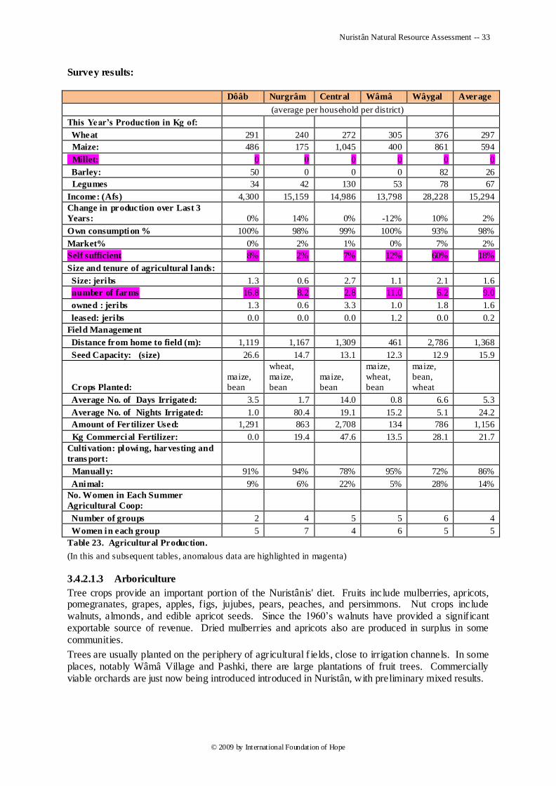
Nuristân Natural Resource Assessment -- 33
© 2009 by International Foundation of Hope
Survey results:
Dôâb Nurgrâm Central Wâmâ Wâygal Average
(average per household per district)
This Year’s Production in Kg of:
Wheat 291 240 272 305 376 297
Maize: 486 175 1,045 400 861 594
Millet: 0 0 0 0 0 0
Barley: 50 0 0 0 82 26
Legumes 34 42 130 53 78 67
Income: (Afs) 4,300 15,159 14,986 13,798 28,228 15,294
Change in production over Last 3
Years: 0% 14% 0% -12% 10% 2%
Own consumption % 100% 98% 99% 100% 93% 98%
Market% 0% 2% 1% 0% 7% 2%
Self sufficient 8% 2% 7% 12% 60% 18%
Size and tenure of agricultural lands:
Size: jeribs 1.3 0.6 2.7 1.1 2.1 1.6
number of farms 16.8 8.2 2.8 11.0 6.2 9.0
owned : jeribs 1.3 0.6 3.3 1.0 1.8 1.6
leased: jeribs 0.0 0.0 0.0 1.2 0.0 0.2
Field Management
Distance from home to field (m): 1,119 1,167 1,309 461 2,786 1,368
Seed Capacity: (size) 26.6 14.7 13.1 12.3 12.9 15.9
Crops Planted:
maize,
bean
wheat,
maize,
bean
maize,
bean
maize,
wheat,
bean
maize,
bean,
wheat
Average No. of Days Irrigated: 3.5 1.7 14.0 0.8 6.6 5.3
Average No. of Nights Irrigated: 1.0 80.4 19.1 15.2 5.1 24.2
Amount of Fertilizer Used: 1,291 863 2,708 134 786 1,156
Kg Commercial Fertilizer: 0.0 19.4 47.6 13.5 28.1 21.7
Cultivation: plowing, harvesting and
trans port:
Manually: 91% 94% 78% 95% 72% 86%
Animal: 9% 6% 22% 5% 28% 14%
No. Women in Each Summer
Agricultural Coop:
Number of groups 2 4 5 5 6 4
Women in each group 5 7 4 6 5 5
Table 23. Agricultural Production.
(In this and subsequent tables, anomalous data are highlighted in magenta)
3.4.2.1.3 Arboriculture
Tree crops provide an important portion of the Nuristânis' diet. Fruits include mulberries, apricots, pomegranates, grapes, apples, figs, jujubes, pears, peaches, and persimmons. Nut crops include walnuts, almonds, and edible apricot seeds. Since the 1960‘s walnuts have provided a significant exportable source of revenue. Dried mulberries and apricots also are produced in surplus in some communities.
Trees are usually planted on the periphery of agricultural f ields, close to irrigation channels. In some places, notably Wâmâ Village and Pashki, there are large plantations of fruit trees. Commercially viable orchards are just now being introduced introduced in Nuristân, with preliminary mixed results.
Nuristân Natural Resource Assessment -- 34
© 2009 by International Foundation of Hope
Survey results:
Dôâb Nurgrâm Central Wâmâ Wâygal Average
(average per household per district)
No. of Trees Owned: 19.8 11.9 10.9 24.8 10.9 15.6
Walnuts 8.8 5.1 3.6 12.8 5.0 7.1
Mulberries 7.2 5.2 4.6 5.2 2.5 5.0
Apples 2.8 2.3 7.8 11.1 2.0 5.2
Apricots 1.9 1.9 2.4 7.4 2.9 3.3
Grapes 2.3 2.1 3.1 4.5 2.0 2.8
Other 1.0 7.0 4.3 0.1 0.5 2.6
Last Year’s Production (kg):
Walnuts 345.0 87.7 139.6 273.1 140.2 197.1
Mulberries 149.8 68.4 36.2 22.8 34.7 62.4
Apples 37.5 7.5 113.6 30.1 34.8 44.7
Apricots 38.4 16.9 22.3 28.1 31.4 27.4
Grapes 63.5 33.7 29.7 30.2 45.9 40.6
Production (Kg/Tree):
Walnuts 39.1 17.1 38.8 21.3 28.0 28.8
Mulberries 20.7 13.2 7.8 4.4 13.7 12.0
Apples 13.6 3.2 14.6 2.7 17.4 10.3
Apricots 20.7 9.0 9.3 3.8 10.9 10.7
Grapes 27.2 15.8 9.5 6.7 22.4 16.3
Aims for growing fruit trees:
Market % 5% 5% 2% 30% 43% 37%
Own consumption % 92% 94% 62% 48% 52% 70%
Pleasure (garden) # 2% 3% 10% 0% 9% 4%
Table 24. Tree-Crop Production.
ADP/E Orchard Planting in 2008
There were 171,000 fruit and nut saplings planted by DAI-ADP/E in 2008. The surveyors (some of whom were involved in the project) made the following observations:
The trees were not distributed in a proper technical manner. The trees were taken to the districts and distributed to farmers without training and technical instruction on proper distance between trees and rows, digging planting holes, preparing basins, planting, heading back, irrigation and with little or no planting supervision.
The trees were damaged during transportation and it took a long time during the transportation and distribution. Many saplings were dry at planting.
After the trees were planted, there was no monitoring and follow up of the trees in the field.
The trees‘ survival percentage is: 1. Pârun planted by DAI and 5% alive 2. Dôâb planted by ACC, 20% alive 3. Nurgrâm planted by DAI, 70% alive 4. Wâygal planted by DAI 30% alive 5. Wâmâ planted by DAI, 25% alive
Farmers request for better results in the future:
Establishing fruit nurseries in the area where the planting will be done
Establishing forest nurseries and rehabilitate the forest
Establishing fruit orchards with adaptable verities/cultivars
Training farmers on nursery and orchard management
Nuristân Natural Resource Assessment -- 35
© 2009 by International Foundation of Hope
3.4.2.1.4 Fodder
Animal fodder comes from crop leftovers, planted fodder crops (alfalfa, clover), natural ground cover, and cut hollyoak branches.
Survey results:
Dôâb Nurgrâm Central Wâmâ Wâygal Average
Amount Grown (Alfalfa, etc.): 0 67 0 1 0 14
Amount from Harvest: 0 144 0 2,000 0 429
Amount from Grassland: 257 93 6,386 7,694 2,207 3,327
Income: (Afs) 2,749 4,892 67,249 3,884 18,687 19,492
Table 25. Fodder Production: Average Kg. per Household.
3.4.2.1.5 Food-Gathering
Gathered food is an important part of the local diet, especially in early springtime before new crops are available. A native inventory of gathered edible plants appears in Appendix 1, Table 82.
Two wild plants of excellent quality, morel mushrooms and cumin, have provided supplementary incomes for Nuristânis who live in the areas where they grow. As with other exports, these are sold to Pakistani middlemen.
3.4.2.2 Animal Husbandry
Almost half the subsistence economy of Nuristân depends on an indigenous dairy industry that produces cheese, butter, ghee, and curds. A native inventory of dairy products from eastern Nuristân appears in Appendix 1, Table 83. These are consumed regularly in every Nuristâni household and are also coveted and occasionally bought by the populations surrounding Nuristân. Goats and cattle are the currency of Nuristân and are traditionally valued at a ratio of from five to seven goats to one cow, depending on region. They provide both milk for dairying and meat for local consumption. Animal hides are an important by-product of livestock raising.
Stockraising follows a transhumant migratory round (col, câl) that takes the animals to mountain pasturelands in the summer and back through the village to low-lying quarters in the winter. The transhumant routes are traditionally well-controlled so as not to overgraze the forestland and pastures that are traversed on the way to and from the highest rangelands. Livestock are strictly excluded from cropland while it is producing, but they are brought to fertilize the fields for a month each in the spring and fall on their way to and from the mountain pastures. In general, transhumant scheduling is tighter in tribal areas where pastureland is scarce, such as in southern Wâygal District, but looser in tribal areas where pastureland is abundant, such as Kâmdesh.
It is important know the locations of transhumant migration routes, as these are potential pathways of overgrazing and habitat destruction. Names of the summer pastures and winter quarters used by each surveyed village appear in Section 4.2, as a starting point for more accurate mapping of rangeland use.
Among the northern Nuristâni tribes, scheduling of the migratory round and dairying activities is encoded in their traditional calendar systems, which divides the year into 180 summer days and 180 winter days. The calendar year starts in the spring on a date that varies from village to village according to current climatic conditions. Figure 2 of Appendix 1 shows the months of the calendar used by the Kom tribe.
Most households do not own enough animals or command enough manpower to maintain themselves as independent dairy producers. To provide themselves greater security and greater quantities of milk for more efficient processing in the summer pastures, Nuristâni men form small, ad-hoc dairy cooperatives (pâl’ei, palâ·i) during the summer. They pool their personnel and divide the season‘s produce proportionally. Scheduling and routing typically depends on the location of cooperative members‘ pastures, which are each used in turn.
Annual losses in livestock can amount to 15-20% as a result of predators (leopards and wolves), disease, falls, drowning, and poisoning. Aside from locally produced turpentine to treat mange, veterinary services are still largely inaccessible.
Nuristân Natural Resource Assessment -- 36
© 2009 by International Foundation of Hope
Survey results on animal husbandry appear in Table 26. Statistics on fodder production appear in Table 25.
Dôâb Nurgrâm Central Wâmâ Wâygal Average
(average per household per district)
Distance to Summer Pastures
(meters) 269 257 39,600 9,592 12,429
Fall 271 8,002 39,725 11,003 14,750
Distance to Winter Pastures
(meters) 272 8,008 39,746 11,886 14,978
Spring 267 7,959 39,599 11,988 14,953
No. men who pool goats and
labor during the summer:
No. Men in Summer Dairy
Coop with Householder: 3.3 3.1 3.7 4.6 6.2 4
No. of goats and sheep: 91 97 49 73 73 77
No. of Lactating Goats: 56 52 27 52 42 46
No. of Cattle: 92 58 55 81 22 61
No. of Lactating Cows: 4 3 5 6 4 5
This Year’s Production of
Cheese (Kg): 77 51 237 58 66 98
Ghee (Kg): 46 19 77 46 41 46
Curds (Kg): 96 43 106 835 185 253
% Change of Dairy Production
over Last 3 Years: 4 6 10 14 3 7
ManureProduction (Kg) 1,767 1,830 4,104 583 3,071 2,271
Animal Health:
Animals treated per year 8 2 1 2 2 3
Total expense (Afs) 1,947 5,429 1,766 7,218 2,434 3,759
Main diseases
FMD, bacteria, anthrax, anthertokzima, sephacx, PPR,
parasite, black leg, pneumonia, CCP, sheep pox, mange,
paposa, rinderpest, diarrhea
Animals vaccinated per year 2.2 1.7 0.0 0.0 1.1 1.0
Total expense (Afs) 75 3,210 2 30 167 697
Type vaccine FMD, PPR, Anthrax, ITV, Sheep Pox, CCPP
Table 26. Animal Husbandry.
3.4.2.3 Forests
Nuristânis exploit the forests for firewood, building material, and household furniture and utensils. Needle forests are public lands for the community that owns them, and anyone from the community may cut trees for building or firewood. In some forested areas local residents have expropriated plots of needle-forest land to be cleared for fields. Because of increasing pressure on the needle forests, some communities regulate the cutting of trees. Oak-forest land is owned by individuals, who use the oak branches for winter livestock feeding as well as for firewood.
Nuristân Natural Resource Assessment -- 37
© 2009 by International Foundation of Hope
Survey results:
Dôâb Nurgrâm Central Wâmâ Wâygal Average
(average per responding household per district)
Timber:
No. Trees Cut for Building: 22 3 37 9 4 15
Firewood:
Yearly Firewood Us age (Kg):
Hollyoak: 4,277 4,534 14,891 10,886 6,806 8,279
Conifer Wood: 228 855 1 0 292 275
Quantity of wood used (Kg per day): in
summer 10 10 21 24 11 15
in winter 21 18 52 56 137 57
Table 27. Forest Usage for Subsistance.
3.5 Commercial Resource Exploitation
Exceptions to a full subsistence economy occur in villages that have access to roads. Resource income derives from timber contracts, such as in Pitigal in Kâmdesh District, from gemstone mining, tree-crop sales, and other minor commercial pursuits.
Distributed throughout much of Nuristân are two natural resources, timber and gemstones, that can provide the basis for a significant boost in the region's economy, if managed and marketed properly. Within the last two decades these resources have begun to be exploited and sold on global markets, with some benefit to a portion of the population. Up till now haphazard exploitation practices have engendered ecological calamities in some locations.
Other traditional exports to surrounding regions include walnuts, apricot seeds, ghee, morel mushrooms, cumin, and animal hides.
3.5.1 Forest Products
Nuristân encompasses a major portion of Afghanistan's timber reserves. Deodar cedar is the primary timber commodity, with pine, fir, and spruce being less exploited. Because of the difficulty of the terrain, little commercial exploitation of Nuristân's forests occurred before the Soviet-Afghan war. As hostilities ceased after the fall of the communists, timber merchants from Pakistan aggressively moved into eastern Nuristân, enticing Nuristâni communities with meager amounts of much needed cash for the rights to whole valleys of timber. Some valleys were clear-cut, resulting in desiccation and loss of water resources. The timber merchants bulldozed roads into some valleys to more easily remove the cut timber, which is transported to Pakistan and sold as far away as the Arab Gulf States. They have made large profits on this trade with minimal investment, and the looting of Afghanistan's timber resources by outsiders engenders much of the hostility found along Afghanistan's eastern frontier.
The environmental degradation caused by large-scale timber cutting has given Nuristânis pause to reconsider their dealings with outsider timber merchants. They are now acutely aware of the dangers of clear-cutting, and they are strongly desirous to learn better ways to manage their most precious resource.
Survey results:
Dôâb Nurgrâm Central Wâmâ Wâygal Average
(average per responding household per district)
No. Trees Cut for Sale: 1 2 70 9 3 17
Household Income from Contract
Timber Revenue: 5,000 0 10,500 0 10,143 5,129
Table 28. Commercial Logging.
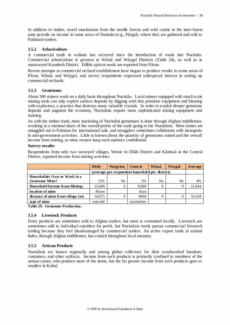
Nuristân Natural Resource Assessment -- 38
© 2009 by International Foundation of Hope
In addition to timber, morel mushrooms from the needle forests and wild cumin in the inter-forest zone provide an income in some areas of Nuristân (e.g., Pitigal), where they are gathered and sold to Pakistani traders.
3.5.2 Arboriculture
A commercial trade in walnuts has occurred since the introduction of roads into Nuristân. Commercial arboriculture is greatest in Wâmâ and Wâygal Districts (Table 24), as well as in unsurveyed Kamdesh District. Edible apricot seeds are exported from Pârun.
Recent attempts at commercial orchard establishment have begun to produce results in some areas of Pârun, Wâmâ, and Wâygal, and survey respondents expressed widespread interest in setting up commercial orchards.
3.5.3 Gemstones
About 500 miners work on a daily basis throughout Nuristân. Local miners equipped with small scale mining tools can only exploit surface deposits by digging with this primitive equipment and blasting with explosives, a practice that destroys many valuable crystals. In order to exploit deeper gemstone deposits and augment the economy, Nuristânis require more sophisticated mining equipment and training.
As with the timber trade, most marketing of Nuristâni gemstones is done through Afghan middlemen, resulting in a minimal share of the overall profits of the trade going to the Nuristânis. Most stones are smuggled out to Pakistan for international sale, and smugglers sometimes collaborate with insurgents in anti-government activities. Little is known about the quantity of gemstones mined and the overall income from mining, as mine owners keep such statistics confidential.
Survey results:
Respondents from only two surveyed villages, Wetsir in Dôâb District and Kântiwâ in the Central District, reported income from mining activities.
Dôâb Nurgrâm Central Wâmâ Wâygal Average
(average per respondent household per district)
Householder Own or Work in a
Gemstone Mine? 15% No 2% No No 4%
Household Income from Mining: 15,688 0 8,000 0 0 11,844
location of mine Mawe Kust
distance of mine from village (m) 14,875 0 6000 0 0 10,438
type of mine emerald tourmaline
Table 29. Gemstone Production.
3.5.4 Livestock Products
Dairy products are sometimes sold to Afghan traders, but most is consumed locally. Livestock are sometimes sold to individual outsiders for profit, but Nuristânis rarely pursue commercial livestock trading because they feel disadvantaged by commercial traders. An active export trade in animal hides, through Afghan middlemen, has existed throughout local memory.
3.5.5 Artisan Products
Nuristânis are known regionally and among global collectors for their woodworked furniture, containers, and other artifacts. Income from such products is primarily confined to members of the artisan castes, who produce most of the items, but the far greater income from such products goes to retailers in Kabul.
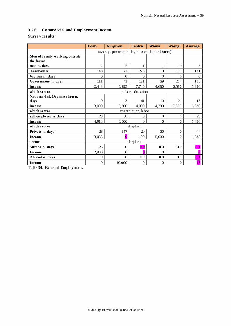
Nuristân Natural Resource Assessment -- 39
© 2009 by International Foundation of Hope
3.5.6 Commercial and Employment Income
Survey results:
Dôâb Nurgrâm Central Wâmâ Wâygal Average
(average per responding household per district)
Men of family working outside
the farm:
men n. days 2 2 1 1 19 5
hrs/month 148 22 278 9 199 131
Women n. days 0 0 0 0 0 0
Government n. days 111 41 181 29 214 115
income 2,443 6,295 7,746 4,680 5,586 5,350
which sector police, education
National-Int. Organization n.
days 0 3 41 0 21 13
income 3,000 5,300 4,000 4,300 17,500 6,820
which sector construction, labor
self employee n. days 29 30 0 0 0 29
income 4,913 6,000 0 0 0 5,456
which sector shepherd
Private n. days 26 147 20 30 0 44
Income 3,063 0 100 5,000 0 1,633
sector shepherd
Mining n. days 25 0 0.0 0.0 0.0 0.1
Income 2,900 0 0 0 0 6
Abroad n. days 0 50 0.0 0.0 0.0 0.1
Income 0 10,000 0 0 0 15
Table 30. External Employment.
Nuristân Natural Resource Assessment -- 40
© 2009 by International Foundation of Hope
4 Surveys
LGCD selected IFHope through an RfP process to conduct the NNRA survey in Nuristan. IFHope was tasked to conduct assessments in five districts including Nurgrâm, Wâmâ, Dôâb, Parun and Wâygal. Kamdesh, Mandol and Bargimatâl were not surveyed due to security issues. Veterinary vaccines were given to the livestock of community participants who assisted with conducting the assessment, as an act of good will and to manage expectations that would be raised during the assessment. 37,730 animals were vaccinated through the incentive program.
4.1 Strategy and Design
4.1.1 Technical Approach The technical approach included the following steps:
1. Identification of stakeholders through personal contacts including provincial and government officials and ministries, district leaders, village elders and shuras, villagers, the PRT, LGCD and USAID.
2. In cooperation with the stakeholders, develop an assessment plan in keeping with both the objectives of the assessment project and further utilization for the development of an NRMP. The plan defined geographic coverage, needed personnel, the security situation, the incentive program, and determined resources and staffing needed to undertake the assessment.
3. Obtain any existing resource assessments including aerial and satellite imagery from USG and Afghan government sources.
4. Design the survey/assessment instruments. 5. Gain approval and support from the various stakeholders for the implementation of the
assessment plan. 6. Maintaining close cooperation and communication with the stakeholders as a central
component of IFHope‘s implementation strategy. Problems encountered during implementation are more easily solved if there is good understanding and cooperation from the beginning.
7. Mobilize resources and undertake the assessment. 8. In conjunction with the assessment, ADA will coordinate a veterinary incentives program
working through ministry officials focusing on approximately 500 large ruminants per district. Vaccination and de-worming medication will be provided as will automatic injectors and training of basic veterinary workers (BVW) for each district.
9. IFHope will keep the stakeholders informed. 10. Assessment results will be tabulated, summarized and analyzed. 11. The primary end product of this project will be an assessment report summarizing the results
of the assessment for each district. The report will include an executive summary, assessment data as well as recommendations for the development of a natural resources management plan.
4.1.2 Teams and Scheduling
There were two survey teams in each of 5 districts: Nurgrâm, Doâb, Wâmâ, Central, and Wâygal. One team composed of two men: a MAIL representative of Afghân ethnicity; and a Nuristâni field researcher, from mixed but non-hostile Nuristâni ethnic groups and villages.
Each team surveyed six villages per district. Because of the lateness of the project‘s inception, the higher villages were surveyed first.
One test village was selected for survey followed by a return to IFHope office for evaluation and modification of survey forms and methodology.
Trusted Local Hosts. Through high-level provincial officials, the field staff were introduced down the chain of command (deputy governor to woluswâl or acting woluswâl) to a trustworthy village elder, who was responsible for putting them up for the 3-6 days of the survey. Such hosts were responsible for the safety of the field staff. They persona lly led the field staff from the woluswâli to the survey village and got them housed in the most suitable way. If a politically acceptable hujira was
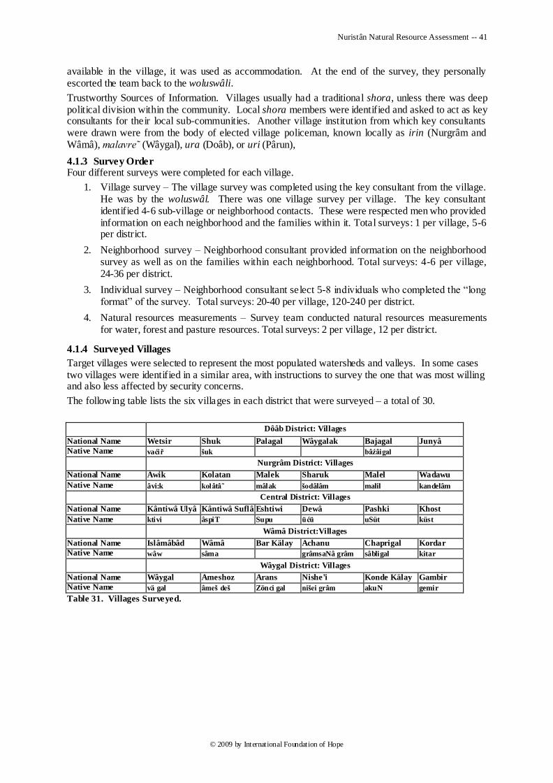
Nuristân Natural Resource Assessment -- 41
© 2009 by International Foundation of Hope
available in the village, it was used as accommodation. At the end of the survey, they personally escorted the team back to the woluswâli.
Trustworthy Sources of Information. Villages usually had a traditional shora, unless there was deep political division within the community. Local shora members were identified and asked to act as key consultants for their local sub-communities. Another village institution from which key consultants were drawn were from the body of elected village policeman, known locally as irin (Nurgrâm and Wâmâ), malavre˜ (Wâygal), ura (Doâb), or uri (Pârun),
4.1.3 Survey Order Four different surveys were completed for each village.
1. Village survey – The village survey was completed using the key consultant from the village. He was by the woluswâl. There was one village survey per village. The key consultant identified 4-6 sub-village or neighborhood contacts. These were respected men who provided information on each neighborhood and the families within it. Total surveys: 1 per village, 5-6 per district.
2. Neighborhood survey – Neighborhood consultant provided information on the neighborhood survey as well as on the families within each neighborhood. Total surveys: 4-6 per village, 24-36 per district.
3. Individual survey – Neighborhood consultant select 5-8 individuals who completed the ―long format‖ of the survey. Total surveys: 20-40 per village, 120-240 per district.
4. Natural resources measurements – Survey team conducted natural resources measurements for water, forest and pasture resources. Total surveys: 2 per village, 12 per district.
4.1.4 Surveyed Villages
Target villages were selected to represent the most populated watersheds and valleys. In some cases two villages were identified in a similar area, with instructions to survey the one that was most willing and also less affected by security concerns.
The following table lists the six villages in each district that were surveyed – a total of 30.
Dôâb District: Villages
National Name Wetsir Shuk Palagal Wâygalak Bajagal Junyâ
Native Name vaćiř šuk bâźâigal
Nurgrâm District: Villages
National Name Awik Kolatan Malek Sharuk Malel Wadawu
Native Name âvi:k kolâtâ mâlak šodâlâm malil kandelâm
Central District: Villages
National Name Kântiwâ Ulyâ Kântiwâ Suflâ Eshtiwi Dewâ Pashki Khost
Native Name ktivi âspiT Supu üćü uSüt küst
Wâmâ District:Villages
National Name Islâmâbâd Wâmâ Bar Kälay Achanu Chaprigal Kordar
Native Name wâw sâma grâmsaNâ grâm sâbligal kitar
Wâygal District: Villages
National Name Wâygal Ameshoz Arans Nishe’i Konde Kälay Gambir
Native Name vä gal âmeš deš Zönci gal nišei grâm akuN gemir
Table 31. Villages Surveyed.
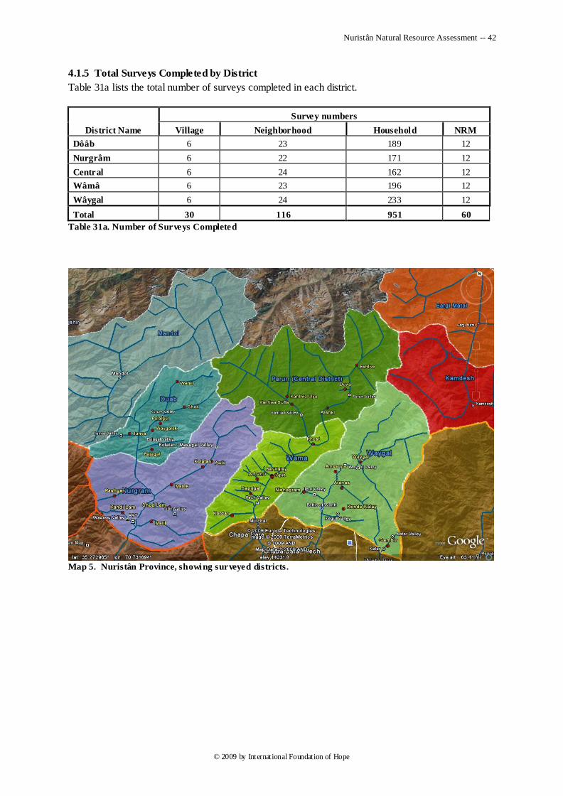
Nuristân Natural Resource Assessment -- 42
© 2009 by International Foundation of Hope
4.1.5 Total Surveys Completed by District
Table 31a lists the total number of surveys completed in each district.
District Name
Survey numbers
Village Neighborhood Household NRM
Dôâb 6 23 189 12
Nurgrâm 6 22 171 12
Central 6 24 162 12
Wâmâ 6 23 196 12
Wâygal 6 24 233 12
Total 30 116 951 60
Table 31a. Number of Surveys Completed
Map 5. Nuristân Province, showing surveyed districts.
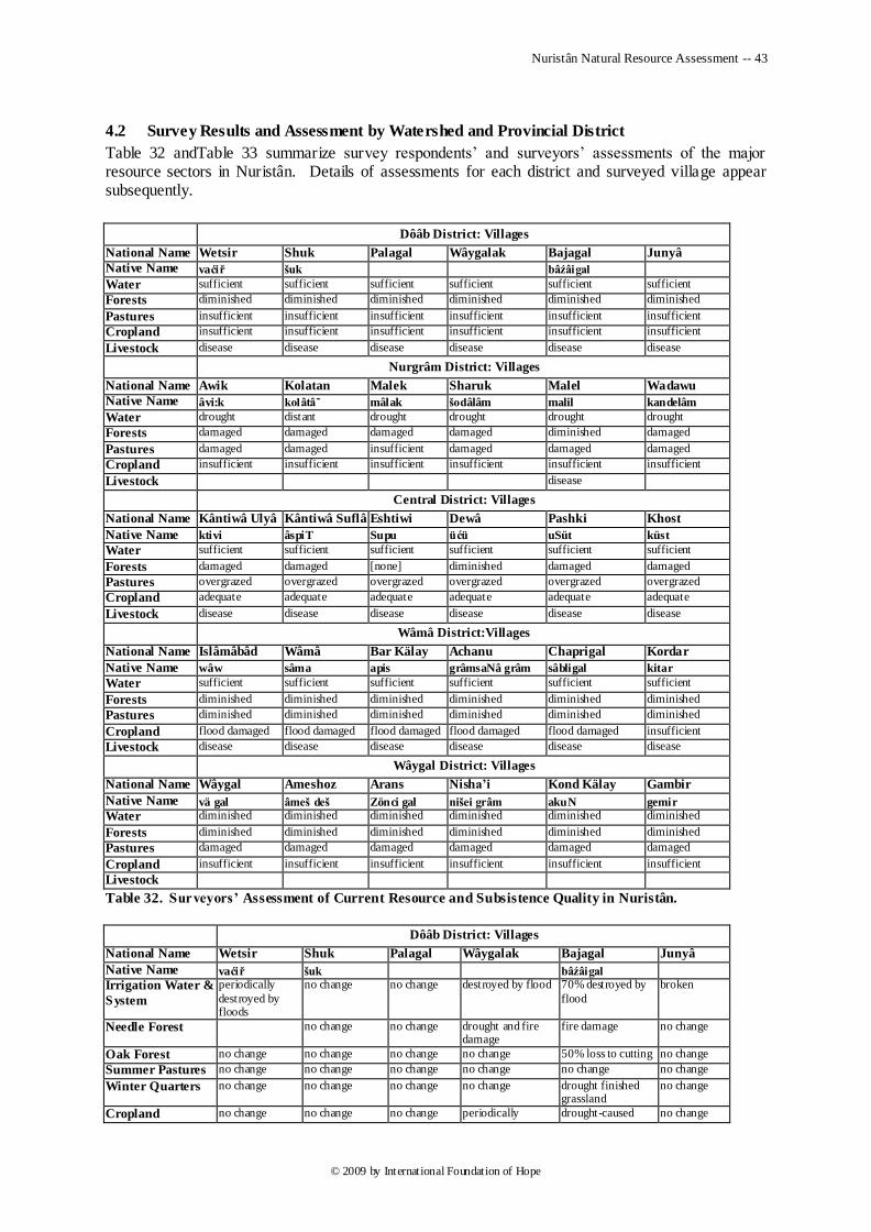
Nuristân Natural Resource Assessment -- 43
© 2009 by International Foundation of Hope
4.2 Survey Results and Assessment by Watershed and Provincial District
Table 32 andTable 33 summarize survey respondents‘ and surveyors‘ assessments of the major resource sectors in Nuristân. Details of assessments for each district and surveyed village appear subsequently.
Dôâb District: Villages
National Name Wetsir Shuk Palagal Wâygalak Bajagal Junyâ
Native Name vaćiř šuk bâźâigal
Water sufficient sufficient sufficient sufficient sufficient sufficient
Forests diminished diminished diminished diminished diminished diminished
Pastures insufficient insufficient insufficient insufficient insufficient insufficient
Cropland insufficient insufficient insufficient insufficient insufficient insufficient
Livestock disease disease disease disease disease disease
Nurgrâm District: Villages
National Name Awik Kolatan Malek Sharuk Malel Wadawu
Native Name âvi:k kolâtâ mâlak šodâlâm malil kandelâm
Water drought distant drought drought drought drought
Forests damaged damaged damaged damaged diminished damaged
Pastures damaged damaged insufficient damaged damaged damaged Cropland insufficient insufficient insufficient insufficient insufficient insufficient
Livestock disease
Central District: Villages
National Name Kântiwâ Ulyâ Kântiwâ Suflâ Eshtiwi Dewâ Pashki Khost
Native Name ktivi âspiT Supu üćü uSüt küst
Water sufficient sufficient sufficient sufficient sufficient sufficient
Forests damaged damaged [none] diminished damaged damaged
Pastures overgrazed overgrazed overgrazed overgrazed overgrazed overgrazed
Cropland adequate adequate adequate adequate adequate adequate
Livestock disease disease disease disease disease disease
Wâmâ District:Villages
National Name Islâmâbâd Wâmâ Bar Kälay Achanu Chaprigal Kordar
Native Name wâw sâma apis grâmsaNâ grâm sâbligal kitar
Water sufficient sufficient sufficient sufficient sufficient sufficient
Forests diminished diminished diminished diminished diminished diminished
Pastures diminished diminished diminished diminished diminished diminished
Cropland flood damaged flood damaged flood damaged flood damaged flood damaged insufficient
Livestock disease disease disease disease disease disease
Wâygal District: Villages
National Name Wâygal Ameshoz Arans Nisha’i Kond Kälay Gambir
Native Name vä gal âmeš deš Zönci gal nišei grâm akuN gemir
Water diminished diminished diminished diminished diminished diminished
Forests diminished diminished diminished diminished diminished diminished
Pastures damaged damaged damaged damaged damaged damaged
Cropland insufficient insufficient insufficient insufficient insufficient insufficient
Livestock
Table 32. Surveyors’ Assessment of Current Resource and Subsistence Quality in Nuristân.
Dôâb District: Villages
National Name Wetsir Shuk Palagal Wâygalak Bajagal Junyâ
Native Name vaćiř šuk bâźâigal
Irrigation Water &
System
periodically
destroyed by floods
no change no change destroyed by flood 70% destroyed by
flood
broken
Needle Forest no change no change drought and fire damage
fire damage no change
Oak Forest no change no change no change no change 50% loss to cutting no change
Summer Pastures no change no change no change no change no change no change
Winter Quarters no change no change no change no change drought finished grassland
no change
Cropland no change no change no change periodically drought-caused no change
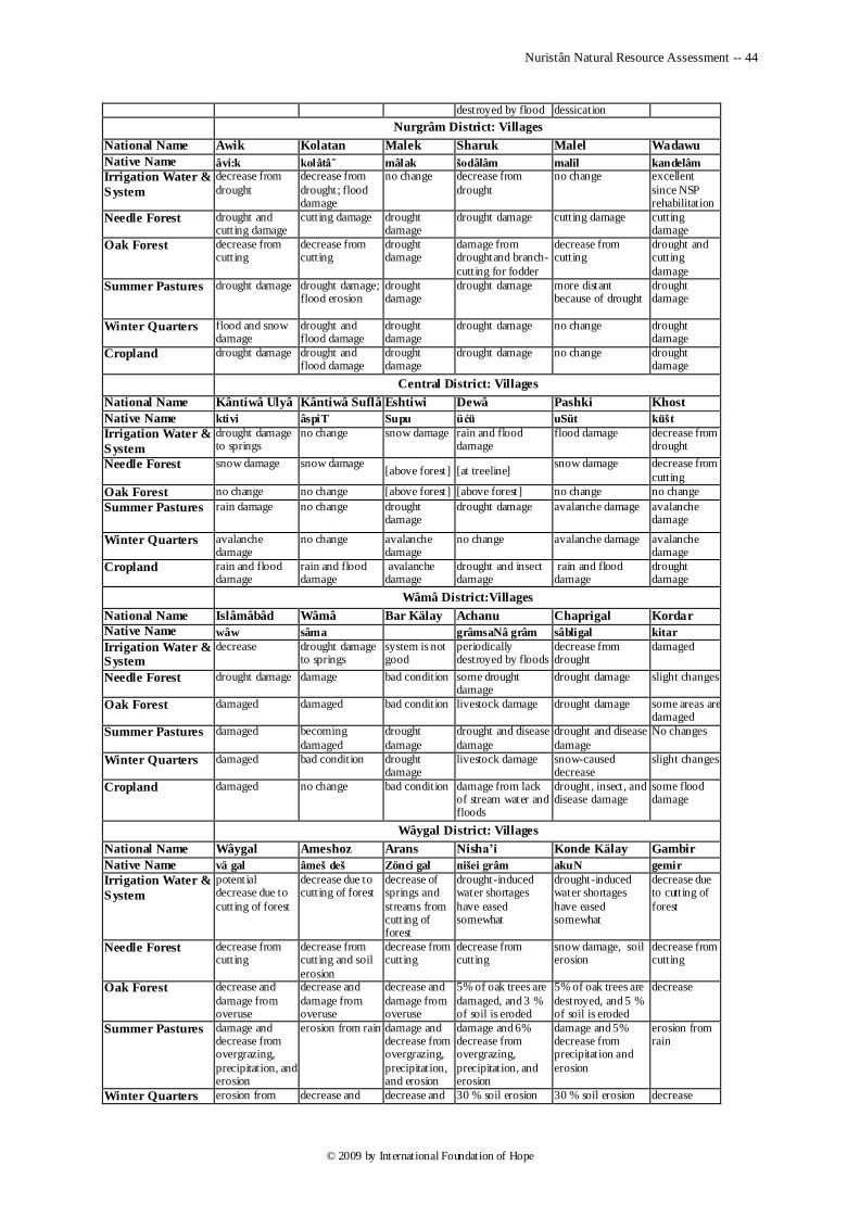
Nuristân Natural Resource Assessment -- 44
© 2009 by International Foundation of Hope
destroyed by flood dessication
Nurgrâm District: Villages
National Name Awik Kolatan Malek Sharuk Malel Wadawu
Native Name âvi:k kolâtâ mâlak šodâlâm malil kandelâm
Irrigation Water &
System
decrease from
drought
decrease from
drought; flood damage
no change decrease from
drought
no change excellent
since NSP rehabilitation
Needle Forest drought and cutting damage
cutting damage drought damage
drought damage cutting damage cutting damage
Oak Forest decrease from cutting
decrease from cutting
drought damage
damage from droughtand branch-
cutting for fodder
decrease from cutting
drought and cutting
damage
Summer Pastures drought damage drought damage; flood erosion
drought damage
drought damage more distant because of drought
drought damage
Winter Quarters flood and snow damage
drought and flood damage
drought damage
drought damage no change drought damage
Cropland drought damage drought and flood damage
drought damage
drought damage no change drought damage
Central District: Villages
National Name Kântiwâ Ulyâ Kântiwâ Suflâ Eshtiwi Dewâ Pashki Khost
Native Name ktivi âspiT Supu üćü uSüt küšt
Irrigation Water &
System
drought damage to springs
no change snow damage rain and flood damage
flood damage decrease from drought
Needle Forest snow damage snow damage [above forest] [at treeline]
snow damage decrease from
cutting
Oak Forest no change no change [above forest] [above forest] no change no change
Summer Pastures rain damage no change drought damage
drought damage avalanche damage avalanche damage
Winter Quarters avalanche damage
no change avalanche damage
no change avalanche damage avalanche damage
Cropland rain and flood damage
rain and flood damage
avalanche damage
drought and insect damage
rain and flood damage
drought damage
Wâmâ District:Villages
National Name Islâmâbâd Wâmâ Bar Kälay Achanu Chaprigal Kordar
Native Name wâw sâma grâmsaNâ grâm sâbligal kitar
Irrigation Water & System
decrease drought damage to springs
system is not good
periodically destroyed by floods
decrease from drought
damaged
Needle Forest drought damage damage bad condition some drought damage
drought damage slight changes
Oak Forest damaged damaged bad condition livestock damage drought damage some areas are damaged
Summer Pastures damaged becoming
damaged
drought
damage
drought and disease
damage
drought and disease
damage
No changes
Winter Quarters damaged bad condition drought damage
livestock damage snow-caused decrease
slight changes
Cropland damaged no change bad condition damage from lack of stream water and floods
drought, insect, and disease damage
some flood damage
Wâygal District: Villages
National Name Wâygal Ameshoz Arans Nisha’i Konde Kälay Gambir
Native Name vä gal âmeš deš Zönci gal nišei grâm akuN gemir
Irrigation Water &
System
potential decrease due to
cutting of forest
decrease due to cutting of forest
decrease of springs and
streams from cutting of forest
drought-induced water shortages
have eased somewhat
drought-induced water shortages
have eased somewhat
decrease due to cutting of
forest
Needle Forest decrease from cutting
decrease from cutting and soil
erosion
decrease from cutting
decrease from cutting
snow damage, soil erosion
decrease from cutting
Oak Forest decrease and
damage from overuse
decrease and
damage from overuse
decrease and
damage from overuse
5% of oak trees are
damaged, and 3 % of soil is eroded
5% of oak trees are
destroyed, and 5 % of soil is eroded
decrease
Summer Pastures damage and decrease from overgrazing,
precipitation, and erosion
erosion from rain damage and decrease from overgrazing,
precipitation, and erosion
damage and 6% decrease from overgrazing,
precipitation, and erosion
damage and 5% decrease from precipitation and
erosion
erosion from rain
Winter Quarters erosion from decrease and decrease and 30 % soil erosion 30 % soil erosion decrease
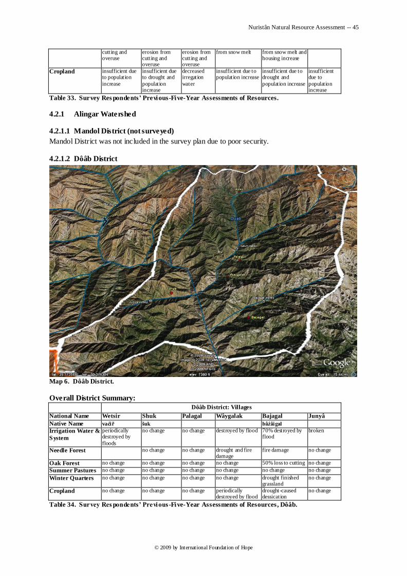
Nuristân Natural Resource Assessment -- 45
© 2009 by International Foundation of Hope
cutting and overuse
erosion from cutting and overuse
erosion from cutting and overuse
from snow melt from snow melt and housing increase
Cropland insufficient due to population
increase
insufficient due to drought and
population increase
decreased irregation
water
insufficient due to population increase
insufficient due to drought and
population increase
insufficient due to
population increase
Table 33. Survey Res pondents’ Previous-Five-Year Assessments of Resources.
4.2.1 Alingar Watershed
4.2.1.1 Mandol District (not surveyed)
Mandol District was not included in the survey plan due to poor security.
4.2.1.2 Dôâb District
Map 6. Dôâb District.
Overall District Summary:
Dôâb District: Villages
National Name Wetsir Shuk Palagal Wâygalak Bajagal Junyâ
Native Name vaćiř šuk bâźâigal
Irrigation Water &
System
periodically destroyed by
floods
no change no change destroyed by flood 70% destroyed by flood
broken
Needle Forest no change no change drought and fire damage
fire damage no change
Oak Forest no change no change no change no change 50% loss to cutting no change
Summer Pastures no change no change no change no change no change no change
Winter Quarters no change no change no change no change drought finished grassland
no change
Cropland no change no change no change periodically destroyed by flood
drought-caused dessication
no change
Table 34. Survey Res pondents’ Previous -Five-Year Assessments of Resources, Dôâb.
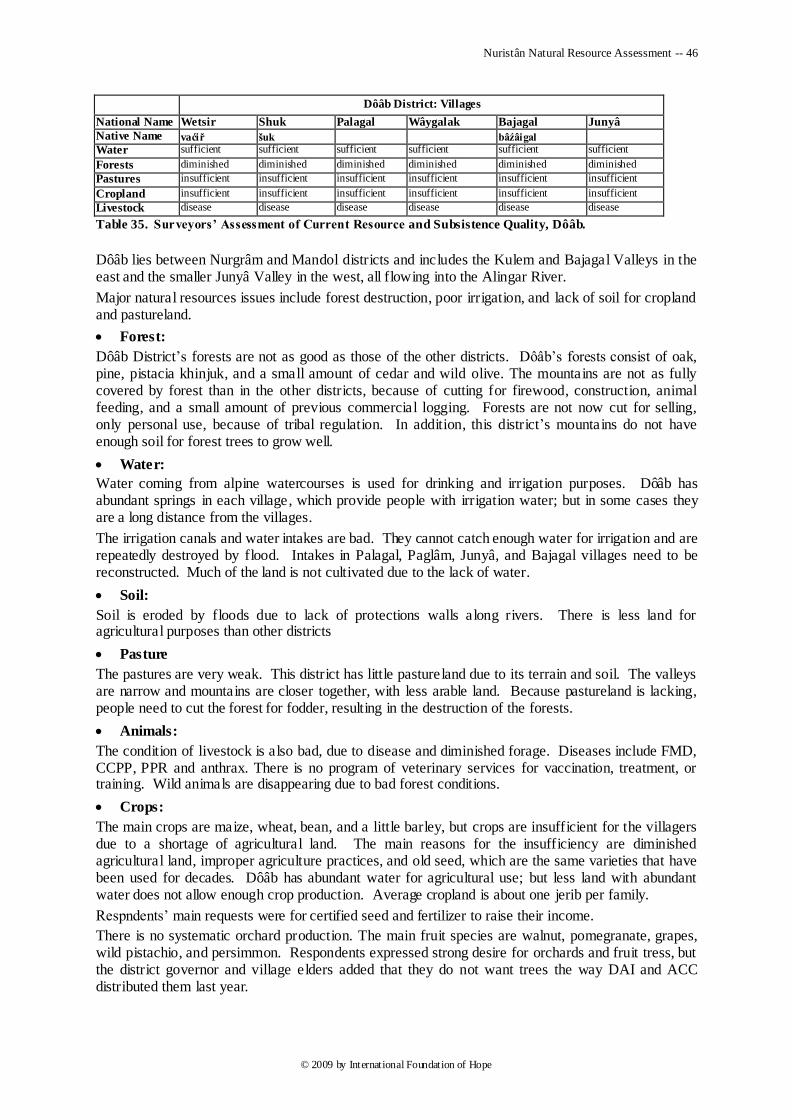
Nuristân Natural Resource Assessment -- 46
© 2009 by International Foundation of Hope
Dôâb District: Villages
National Name Wetsir Shuk Palagal Wâygalak Bajagal Junyâ
Native Name vaćiř šuk bâźâigal
Water sufficient sufficient sufficient sufficient sufficient sufficient
Forests diminished diminished diminished diminished diminished diminished
Pastures insufficient insufficient insufficient insufficient insufficient insufficient
Cropland insufficient insufficient insufficient insufficient insufficient insufficient
Livestock disease disease disease disease disease disease
Table 35. Surveyors’ Assessment of Current Resource and Subsistence Quality, Dôâb.
Dôâb lies between Nurgrâm and Mandol districts and includes the Kulem and Bajagal Valleys in the east and the smaller Junyâ Valley in the west, all flowing into the Alingar River.
Major natural resources issues include forest destruction, poor irrigation, and lack of soil for cropland and pastureland.
Forest:
Dôâb District‘s forests are not as good as those of the other districts. Dôâb‘s forests consist of oak, pine, pistacia khinjuk, and a small amount of cedar and wild olive. The mountains are not as fully covered by forest than in the other districts, because of cutting for firewood, construction, animal feeding, and a small amount of previous commercial logging. Forests are not now cut for selling, only personal use, because of tribal regulation. In addition, this district‘s mountains do not have enough soil for forest trees to grow well.
Water:
Water coming from alpine watercourses is used for drinking and irrigation purposes. Dôâb has abundant springs in each village, which provide people with irrigation water; but in some cases they are a long distance from the villages.
The irrigation canals and water intakes are bad. They cannot catch enough water for irrigation and are repeatedly destroyed by flood. Intakes in Palagal, Paglâm, Junyâ, and Bajagal villages need to be reconstructed. Much of the land is not cultivated due to the lack of water.
Soil:
Soil is eroded by floods due to lack of protections walls along rivers. There is less land for agricultural purposes than other districts
Pasture
The pastures are very weak. This district has little pastureland due to its terrain and soil. The valleys are narrow and mountains are closer together, with less arable land. Because pastureland is lacking, people need to cut the forest for fodder, resulting in the destruction of the forests.
Animals:
The condition of livestock is also bad, due to disease and diminished forage. Diseases include FMD, CCPP, PPR and anthrax. There is no program of veterinary services for vaccination, treatment, or training. Wild animals are disappearing due to bad forest conditions.
Crops:
The main crops are maize, wheat, bean, and a little barley, but crops are insufficient for the villagers due to a shortage of agricultural land. The main reasons for the insufficiency are diminished agricultural land, improper agriculture practices, and old seed, which are the same varieties that have been used for decades. Dôâb has abundant water for agricultural use; but less land with abundant water does not allow enough crop production. Average cropland is about one jerib per family.
Respndents‘ main requests were for certified seed and fertilizer to raise their income.
There is no systematic orchard production. The main fruit species are walnut, pomegranate, grapes, wild pistachio, and persimmon. Respondents expressed strong desire for orchards and fruit tress, but the district governor and village elders added that they do not want trees the way DAI and ACC distributed them last year.
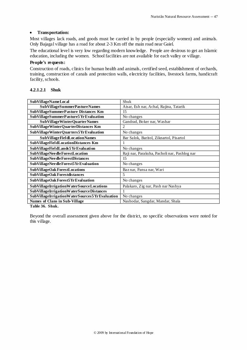
Nuristân Natural Resource Assessment -- 47
© 2009 by International Foundation of Hope
Transportation:
Most villages lack roads, and goods must be carried in by people (especially women) and animals. Only Bajagal village has a road for about 2-3 Km off the main road near Gaiel.
The educational level is very low regarding modern knowledge. People are desirous to get an Islamic education, including the women. School facilities are not available for each valley or village.
People’s requests:
Construction of roads, clinics for human health and animals, certified seed, establishment of orchards, training, construction of canals and protection walls, electricity facilities, livestock farms, handicraft facility, schools.
4.2.1.2.1 Shuk
SubVillageNameLocal Shuk
SubVillageSummerPastureNames Aisar, Esh nar, Achal, Rajina, Tatarik
SubVillageSummerPasture Distances Km 15
SubVillageSummerPasture5YrEvaluation No changes
SubVillageWinterQuarterNames Gandrad, Boker nar, Washar
SubVillageWinterQuarterDistances Km 2
SubVillageWinterQuarters5YrEvaluation No changes
SubVillageFieldLocationNames Bar Salok, Baritol, Ziknartol, Pisartol
SubVillageFieldLocationDistances Km 1
SubVillageFieldLands5YrEvaluation No changes
SubVillageNeedleForestLocation Raji nar, Paraksha, Pacholi nar, Pashlog nar
SubVillageNeedleForestDistances 15
SubVillageNeedleForest5YrEvaluation No changes
SubVillageOak ForestLocations Baz nar, Pansa nar, Wari
SubVillageOak Forestdistances 5
SubVillageOak Forest5YrEvaluation No changes
SubVillageIrrigationWaterSourceLocations Palakaro, Zig nar, Pash nar Nashya
SubVillageIrrigationWaterSourceDistances 1
SubVillageIrrigationWaterSources5YrEvaluation No changes
Names of Clans in Sub-Village Nashodar, Sangdar, Mandar, Shala
Table 36. Shuk.
Beyond the overall assessment given above for the district, no specific observations were noted for this village.
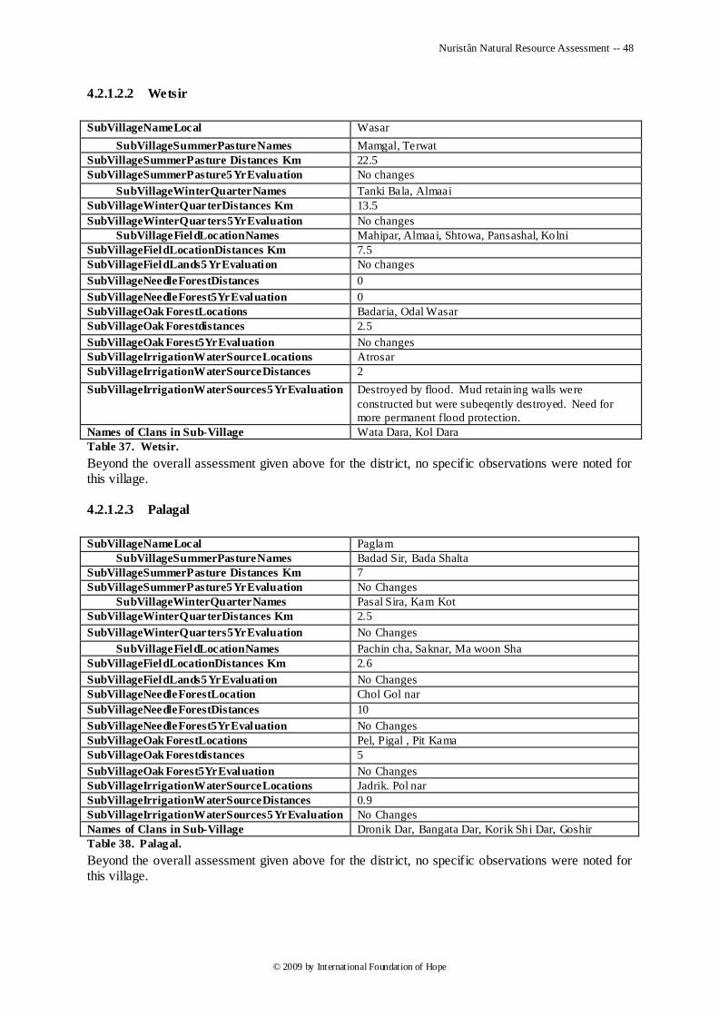
Nuristân Natural Resource Assessment -- 48
© 2009 by International Foundation of Hope
4.2.1.2.2 Wetsir
SubVillageNameLocal Wasar
SubVillageSummerPastureNames Mamgal, Terwat
SubVillageSummerPasture Distances Km 22.5
SubVillageSummerPasture5YrEvaluation No changes
SubVillageWinterQuarterNames Tanki Bala, Almaai
SubVillageWinterQuarterDistances Km 13.5
SubVillageWinterQuarters5YrEvaluation No changes
SubVillageFieldLocationNames Mahipar, Almaai, Shtowa, Pansashal, Kolni
SubVillageFieldLocationDistances Km 7.5
SubVillageFieldLands5YrEvaluation No changes
SubVillageNeedleForestDistances 0
SubVillageNeedleForest5YrEvaluation 0
SubVillageOak ForestLocations Badaria, Odal Wasar
SubVillageOak Forestdistances 2.5
SubVillageOak Forest5YrEvaluation No changes
SubVillageIrrigationWaterSourceLocations Atrosar
SubVillageIrrigationWaterSourceDistances 2
SubVillageIrrigationWaterSources5YrEvaluation Destroyed by flood. Mud retain ing walls were
constructed but were subeqently destroyed. Need for
more permanent flood protection.
Names of Clans in Sub-Village Wata Dara, Kol Dara
Table 37. Wetsir.
Beyond the overall assessment given above for the district, no specific observations were noted for this village.
4.2.1.2.3 Palagal
SubVillageNameLocal Paglam
SubVillageSummerPastureNames Badad Sir, Bada Shalta
SubVillageSummerPasture Distances Km 7
SubVillageSummerPasture5YrEvaluation No Changes
SubVillageWinterQuarterNames Pasal Sira, Kam Kot
SubVillageWinterQuarterDistances Km 2.5
SubVillageWinterQuarters5YrEvaluation No Changes
SubVillageFieldLocationNames Pachin cha, Saknar, Ma woon Sha
SubVillageFieldLocationDistances Km 2.6
SubVillageFieldLands5YrEvaluation No Changes
SubVillageNeedleForestLocation Chol Gol nar
SubVillageNeedleForestDistances 10
SubVillageNeedleForest5YrEvaluation No Changes
SubVillageOak ForestLocations Pel, Pigal , Pit Kama
SubVillageOak Forestdistances 5
SubVillageOak Forest5YrEvaluation No Changes
SubVillageIrrigationWaterSourceLocations Jadrik. Pol nar
SubVillageIrrigationWaterSourceDistances 0.9
SubVillageIrrigationWaterSources5YrEvaluation No Changes
Names of Clans in Sub-Village Dronik Dar, Bangata Dar, Korik Sh i Dar, Goshir
Table 38. Palagal.
Beyond the overall assessment given above for the district, no specific observations were noted for this village.
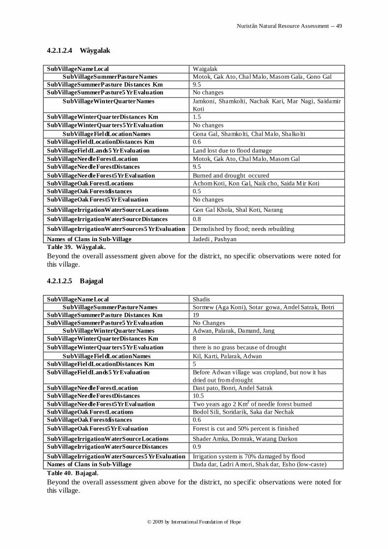
Nuristân Natural Resource Assessment -- 49
© 2009 by International Foundation of Hope
4.2.1.2.4 Wâygalak
SubVillageNameLocal Waigalak
SubVillageSummerPastureNames Motok, Gak Ato, Chal Malo, Masom Gala, Gono Gal
SubVillageSummerPasture Distances Km 9.5
SubVillageSummerPasture5YrEvaluation No changes
SubVillageWinterQuarterNames Jamkoni, Shamkolti, Nachak Kari, Mar Nagi, Saidamir
Koti
SubVillageWinterQuarterDistances Km 1.5
SubVillageWinterQuarters5YrEvaluation No changes
SubVillageFieldLocationNames Gona Gal, Shamkolti, Chal Malo, Shalko lti
SubVillageFieldLocationDistances Km 0.6
SubVillageFieldLands5YrEvaluation Land lost due to flood damage
SubVillageNeedleForestLocation Motok, Gak Ato, Chal Malo, Masom Gal
SubVillageNeedleForestDistances 9.5
SubVillageNeedleForest5YrEvaluation Burned and drought occured
SubVillageOak ForestLocations Achom Koti, Kon Gal, Naik cho, Saida Mir Koti
SubVillageOak Forestdistances 0.5
SubVillageOak Forest5YrEvaluation No changes
SubVillageIrrigationWaterSourceLocations Gon Gal Khola, Shal Koti, Narang
SubVillageIrrigationWaterSourceDistances 0.8
SubVillageIrrigationWaterSources5YrEvaluation Demolished by flood; needs rebuilding
Names of Clans in Sub-Village Jadedi , Pashyan
Table 39. Wâygalak.
Beyond the overall assessment given above for the district, no specific observations were noted for this village.
4.2.1.2.5 Bajagal
SubVillageNameLocal Shadis
SubVillageSummerPastureNames Sormew (Aga Koni), Sotar gowa, Andel Satrak, Botri
SubVillageSummerPasture Distances Km 19
SubVillageSummerPasture5YrEvaluation No Changes
SubVillageWinterQuarterNames Adwan, Palarak, Damand, Jang
SubVillageWinterQuarterDistances Km 8
SubVillageWinterQuarters5YrEvaluation there is no grass because of drought
SubVillageFieldLocationNames Kil, Karti, Palarak, Adwan
SubVillageFieldLocationDistances Km 5
SubVillageFieldLands5YrEvaluation Before Adwan village was cropland, but now it has
dried out from drought
SubVillageNeedleForestLocation Dast pato, Bonri, Andel Satrak
SubVillageNeedleForestDistances 10.5
SubVillageNeedleForest5YrEvaluation Two years ago 2 Km2 of needle forest burned
SubVillageOak ForestLocations Bodol Sili, Soridarik, Saka dar Nechak
SubVillageOak Forestdistances 0.6
SubVillageOak Forest5YrEvaluation Forest is cut and 50% percent is finished
SubVillageIrrigationWaterSourceLocations Shader Amka, Domrak, Watang Darkon
SubVillageIrrigationWaterSourceDistances 0.9
SubVillageIrrigationWaterSources5YrEvaluation Irrigation system is 70% damaged by flood
Names of Clans in Sub-Village Dada dar, Ladri Amori, Shak dar, Esho (low-caste)
Table 40. Bajagal.
Beyond the overall assessment given above for the district, no specific observations were noted for this village.
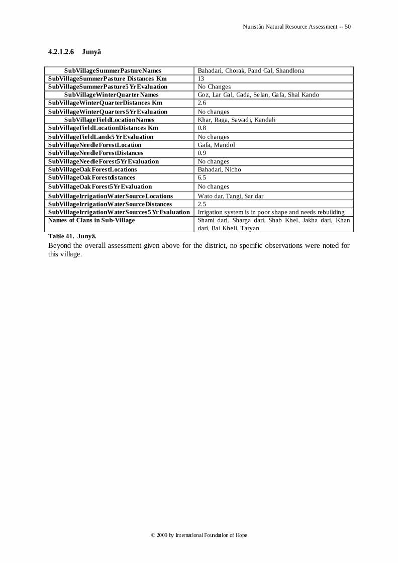
Nuristân Natural Resource Assessment -- 50
© 2009 by International Foundation of Hope
4.2.1.2.6 Junyâ
SubVillageSummerPastureNames Bahadari, Chorak, Pand Gal, Shandlona
SubVillageSummerPasture Distances Km 13
SubVillageSummerPasture5YrEvaluation No Changes
SubVillageWinterQuarterNames Goz, Lar Gal, Gada, Selan, Gafa, Shal Kando
SubVillageWinterQuarterDistances Km 2.6
SubVillageWinterQuarters5YrEvaluation No changes
SubVillageFieldLocationNames Khar, Raga, Sawadi, Kandali
SubVillageFieldLocationDistances Km 0.8
SubVillageFieldLands5YrEvaluation No changes
SubVillageNeedleForestLocation Gafa, Mandol
SubVillageNeedleForestDistances 0.9
SubVillageNeedleForest5YrEvaluation No changes
SubVillageOak ForestLocations Bahadari, Nicho
SubVillageOak Forestdistances 6.5
SubVillageOak Forest5YrEvaluation No changes
SubVillageIrrigationWaterSourceLocations Wato dar, Tangi, Sar dar
SubVillageIrrigationWaterSourceDistances 2.5
SubVillageIrrigationWaterSources5YrEvaluation Irrigation system is in poor shape and needs rebuilding
Names of Clans in Sub-Village Shami dari, Sharga dari, Shab Khel, Jakha dari, Khan
dari, Bai Kheli, Taryan
Table 41. Junyâ.
Beyond the overall assessment given above for the district, no specific observations were noted for this village.
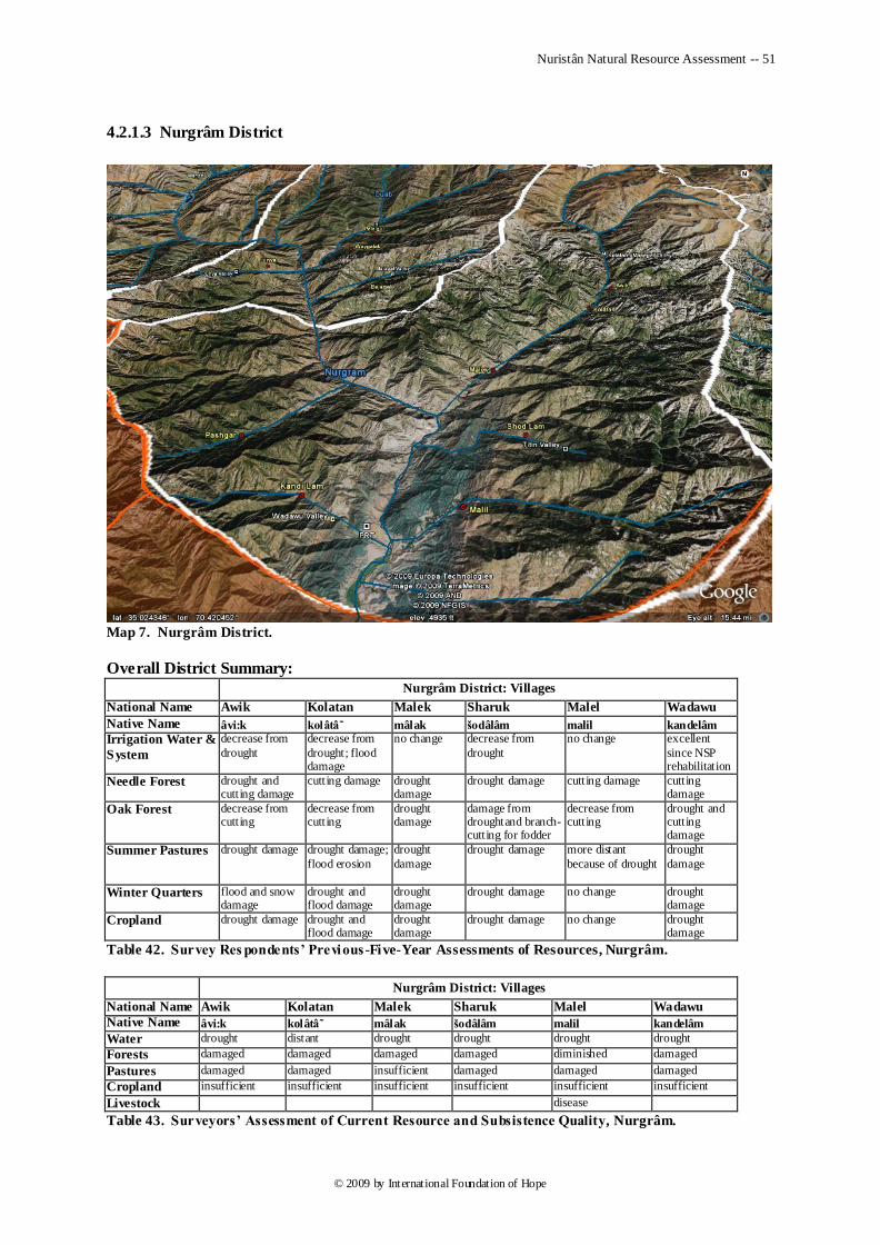
Nuristân Natural Resource Assessment -- 51
© 2009 by International Foundation of Hope
4.2.1.3 Nurgrâm District
Map 7. Nurgrâm District.
Overall District Summary:
Nurgrâm District: Villages
National Name Awik Kolatan Malek Sharuk Malel Wadawu
Native Name âvi:k kolâtâ mâlak šodâlâm malil kandelâm
Irrigation Water &
System
decrease from
drought
decrease from
drought; flood damage
no change decrease from
drought
no change excellent
since NSP rehabilitation
Needle Forest drought and cutting damage
cutting damage drought damage
drought damage cutting damage cutting damage
Oak Forest decrease from cutting
decrease from cutting
drought damage
damage from droughtand branch-cutting for fodder
decrease from cutting
drought and cutting damage
Summer Pastures drought damage drought damage;
flood erosion
drought
damage
drought damage more distant
because of drought
drought
damage
Winter Quarters flood and snow damage
drought and flood damage
drought damage
drought damage no change drought damage
Cropland drought damage drought and flood damage
drought damage
drought damage no change drought damage
Table 42. Survey Res pondents’ Previous -Five-Year Assessments of Resources, Nurgrâm.
Nurgrâm District: Villages
National Name Awik Kolatan Malek Sharuk Malel Wadawu
Native Name âvi:k kolâtâ mâlak šodâlâm malil kandelâm
Water drought distant drought drought drought drought
Forests damaged damaged damaged damaged diminished damaged
Pastures damaged damaged insufficient damaged damaged damaged Cropland insufficient insufficient insufficient insufficient insufficient insufficient
Livestock disease
Table 43. Surveyors’ Assessment of Current Resource and Subsistence Quality, Nurgrâm.
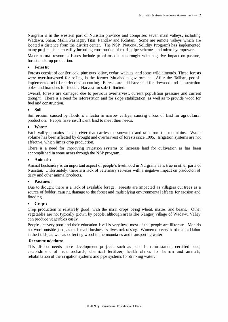
Nuristân Natural Resource Assessment -- 52
© 2009 by International Foundation of Hope
Nurgrâm is in the western part of Nuristân province and comprises seven main valleys, including Wadawu, Sham, Malil, Pashagar, Titin, Pandâw and Kolatan. Some are remote valleys which are located a distance from the district center. The NSP (National Solidity Program) has implemented many projects in each valley including construction of roads, pipe schemes and micro hydropower.
Major natural resources issues include problems due to drought with negative impact on pasture, forest and crop production.
Forests:
Forests consist of conifer, oak, pine nuts, olive, cedar, walnuts, and some wild almonds. These forests were over-harvested for selling in the former Mujahedin government. After the Taliban, people implemented tribal restrictions on cutting. Forests are still harvested for firewood and construction poles and branches for fodder. Harvest for sale is limited.
Overall, forests are damaged due to previous overharvest, current population pressure and current drought. There is a need for reforestation and for slope stabilization, as well as to provide wood for fuel and construction.
Soil
Soil erosion caused by floods is a factor in narrow valleys, causing a loss of land for agricultural production. People have insufficient land to meet their needs.
Water:
Each valley contains a main river that carries the snowmelt and rain from the mountains. Water volume has been affected by drought and overharvest of forests since 1995. Irrigation systems are not effective, which limits crop production.
There is a need for improving irrigation systems to increase land for cultivation as has been accomplished in some areas through the NSP program.
Animals:
Animal husbandry is an important aspect of people‘s livelihood in Nurgrâm, as is true in other parts of Nuristân. Unfortuately, there is a lack of veterinary services with a negative impact on producton of dairy and other animal products.
Pastures:
Due to drought there is a lack of available forage. Forests are impacted as villagers cut trees as a source of fodder, causing damage to the forest and multiplying environmental effects for erosion and flooding.
Crops:
Crop production is relatively good, with the main crops being wheat, maize, and beans. Other vegetables are not typically grown by people, although areas like Nangraj village of Wadawu Valley can produce vegetables easily.
People are very poor and their education level is very low; most of the people are illiterate. Men do not work outside jobs, as their main business is livestock raising. Women do very hard manual labor in the fields, as well as collecting wood in the mountains and transporting water.
Recommendations:
This district needs more development projects, such as schools, reforestation, certified seed, establishment of fruit orchards, chemical fertilizer, health clinics for human and animals, rehabilitation of the irrigation systems and pipe systems for drinking water.
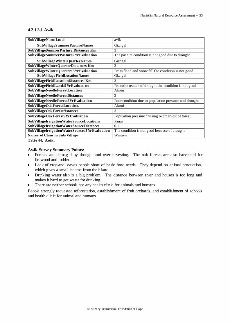
Nuristân Natural Resource Assessment -- 53
© 2009 by International Foundation of Hope
4.2.1.3.1 Awik SubVillageNameLocal avik
SubVillageSummerPastureNames Gizhgal
SubVillageSummerPasture Distances Km 3
SubVillageSummerPasture5YrEvaluation The pasture condition is not good due to drought
SubVillageWinterQuarterNames Gizhgal
SubVillageWinterQuarterDistances Km 3
SubVillageWinterQuarters5YrEvaluation From flood and snow fall the condition is not good
SubVillageFieldLocationNames Gizhgal
SubVillageFieldLocationDistances Km 3
SubVillageFieldLands5YrEvaluation From the reason of drought the condition is not good
SubVillageNeedleForestLocation Akoni
SubVillageNeedleForestDistances 3
SubVillageNeedleForest5YrEvaluation Poor condition due to population pressure and drought
SubVillageOak ForestLocations Akoni
SubVillageOak Forestdistances 3
SubVillageOak Forest5YrEvaluation Population pressure causing overharvest of forest.
SubVillageIrrigationWaterSourceLocations Panar
SubVillageIrrigationWaterSourceDistances 0.1
SubVillageIrrigationWaterSources5YrEvaluation The condition is not good because of drought
Names of Clans in Sub-Village Wâmâyi
Table 44. Awik.
Awik Survey Summary Points:
Forests are damaged by drought and overharvesting. The oak forests are also harvested for firewood and fodder.
Lack of cropland leaves people short of basic food needs. They depend on animal production, which gives a small income from their land.
Drinking water also is a big problem. The distance between river and houses is too long and makes it hard to get water for drinking.
There are neither schools nor any health clinic for animals and humans.
People strongly requested reforestation, establishment of fruit orchards, and establishment of schools and health clinic for animal and humans.
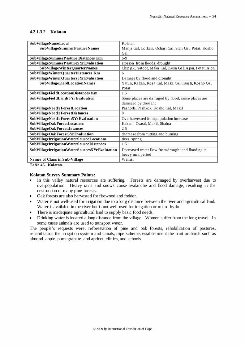
Nuristân Natural Resource Assessment -- 54
© 2009 by International Foundation of Hope
4.2.1.3.2 Kolatan
SubVillageNameLocal Kolatan
SubVillageSummerPastureNames Manja Gal, Lotkari, Ochari Gal, Stan Gal, Potat, Kosho
Gal
SubVillageSummerPasture Distances Km 6-9
SubVillageSummerPasture5YrEvaluation erosion from floods, drought
SubVillageWinterQuarterNames Chin jak, Yatoot, Maka Gal, Kosa Gal, A jon, Potat, Ajon
SubVillageWinterQuarterDistances Km 6
SubVillageWinterQuarters5YrEvaluation Damage by flood and drought
SubVillageFieldLocationNames
Yatun, Kaltan, Kosa Gal, Maka Gal Osasti, Kosho Gal,
Potat
SubVillageFieldLocationDistances Km 1.5
SubVillageFieldLands5YrEvaluation Some places are damaged by flood; some places are
damaged by drought
SubVillageNeedleForestLocation Pashoda, Pashkok, Kosho Gal, Makil
SubVillageNeedleForestDistances 8
SubVillageNeedleForest5YrEvaluation Overharvested from population increase
SubVillageOak ForestLocations Kaltan, Osasti, Makil, Shalna
SubVillageOak Forestdistances 2.5
SubVillageOak Forest5YrEvaluation decrease from cutting and burning
SubVillageIrrigationWaterSourceLocations river, spring
SubVillageIrrigationWaterSourceDistances 1.5
SubVillageIrrigationWaterSources5YrEvaluation Decreased water flow from drought and flooding in
heavy melt period
Names of Clans in Sub-Village Wâmâi
Table 45. Kolatan.
Kolatan Survey Summary Points:
In this valley natural resources are suffering. Forests are damaged by overharvest due to overpopulation. Heavy rains and snows cause avalanche and flood damage, resulting in the destruction of many pine forests.
Oak forests are also harvested for firewood and fodder.
Water is not well-used for irrigation due to a long distance between the river and agricultural land. Water is available in the river but is not well-used for irrigation or micro-hydro.
There is inadequate agricultural land to supply basic food needs.
Drinking water is located a long distance from the village. Women suffer from the long travel. In some cases animals are used to transport water.
The people‘s requests were: reforestation of pine and oak forests, rehabilitation of pastures, rehabilitation the irrigation system and canals, pipe scheme, establishment the fruit orchards such as almond, apple, pomegranate, and apricot, clinics, and schools.
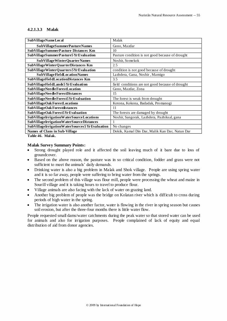
Nuristân Natural Resource Assessment -- 55
© 2009 by International Foundation of Hope
4.2.1.3.3 Malak
SubVillageNameLocal Malak
SubVillageSummerPastureNames Gono, Mazdar
SubVillageSummerPasture Distances Km 10
SubVillageSummerPasture5YrEvaluation Pasture condition is not good because of drought
SubVillageWinterQuarterNames Noshir, Somekok
SubVillageWinterQuarterDistances Km 2.5
SubVillageWinterQuarters5YrEvaluation condition is not good because of drought
SubVillageFieldLocationNames Lazhdera, Gana, Noshir , Mamigo
SubVillageFieldLocationDistances Km 3.5
SubVillageFieldLands5YrEvaluation field conditions are not good because of drought
SubVillageNeedleForestLocation Gono, Mazdar, Zona
SubVillageNeedleForestDistances 15
SubVillageNeedleForest5YrEvaluation The forest is weak from drought
SubVillageOak ForestLocations Kotona, Kokona, Badadak, Promanogi
SubVillageOak Forestdistances 11
SubVillageOak Forest5YrEvaluation The forests are damaged by drought
SubVillageIrrigationWaterSourceLocations Noshir, Sangorak, Lazhdera, Pazhiksal, gana
SubVillageIrrigationWaterSourceDistances 1
SubVillageIrrigationWaterSources5YrEvaluation No changes
Names of Clans in Sub-Village Dokik, Kamal Din Dar, Malik Kan Dar, Natun Dar
Table 46. Malak.
Malak Survey Summary Points:
Strong drought played role and it affected the soil leaving much of it bare due to loss of groundcover.
Based on the above reason, the pasture was in so critical condition, fodder and grass were not sufficient to meet the animals‘ daily demands.
Drinking water is also a big problem in Malak and Shok village. People are using spring water and it is so far away, people were suffering to bring water from the springs.
The second problem of this village was flour mill, people were processing the wheat and maize in Sourill village and it is taking hours to travel to produce flour.
Village animals are also facing with the lack of water on grazing land.
Another big problem of people was the bridge on Kolatan river which is difficult to cross during periods of high water in the spring.
The irrigation water is also another factor, water is flowing in the river in spring season but causes soil erosion, but after the three-four months there is little water flow.
People requested small dams/water catchments during the peak water so that stored water can be used for animals and also for irrigation purposes. People complained of lack of equity and equal distribution of aid from donor agencies.
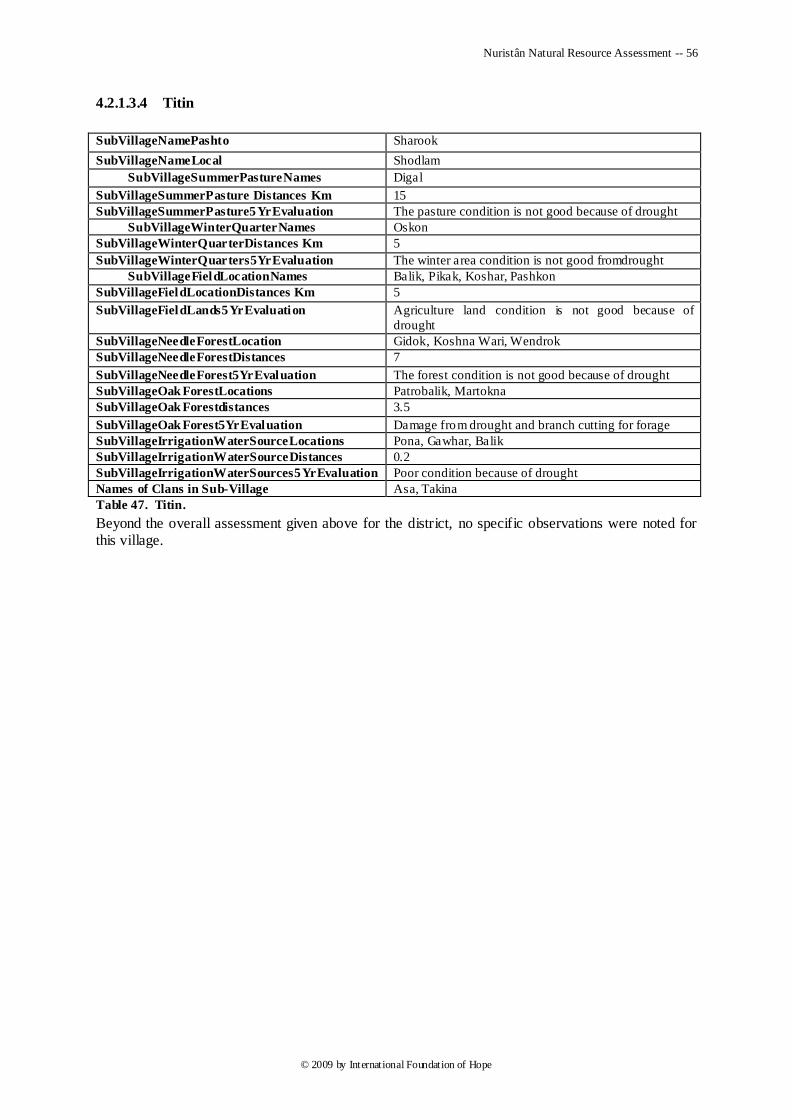
Nuristân Natural Resource Assessment -- 56
© 2009 by International Foundation of Hope
4.2.1.3.4 Titin
SubVillageNamePashto Sharook
SubVillageNameLocal Shodlam
SubVillageSummerPastureNames Digal
SubVillageSummerPasture Distances Km 15
SubVillageSummerPasture5YrEvaluation The pasture condition is not good because of drought
SubVillageWinterQuarterNames Oskon
SubVillageWinterQuarterDistances Km 5
SubVillageWinterQuarters5YrEvaluation The winter area condition is not good fromdrought
SubVillageFieldLocationNames Balik, Pikak, Koshar, Pashkon
SubVillageFieldLocationDistances Km 5
SubVillageFieldLands5YrEvaluation Agriculture land condition is not good because of
drought
SubVillageNeedleForestLocation Gidok, Koshna Wari, Wendrok
SubVillageNeedleForestDistances 7
SubVillageNeedleForest5YrEvaluation The forest condition is not good because of drought
SubVillageOak ForestLocations Patrobalik, Martokna
SubVillageOak Forestdistances 3.5
SubVillageOak Forest5YrEvaluation Damage from drought and branch cutting for forage
SubVillageIrrigationWaterSourceLocations Pona, Gawhar, Balik
SubVillageIrrigationWaterSourceDistances 0.2
SubVillageIrrigationWaterSources5YrEvaluation Poor condition because of drought
Names of Clans in Sub-Village Asa, Takina
Table 47. Titin.
Beyond the overall assessment given above for the district, no specific observations were noted for this village.
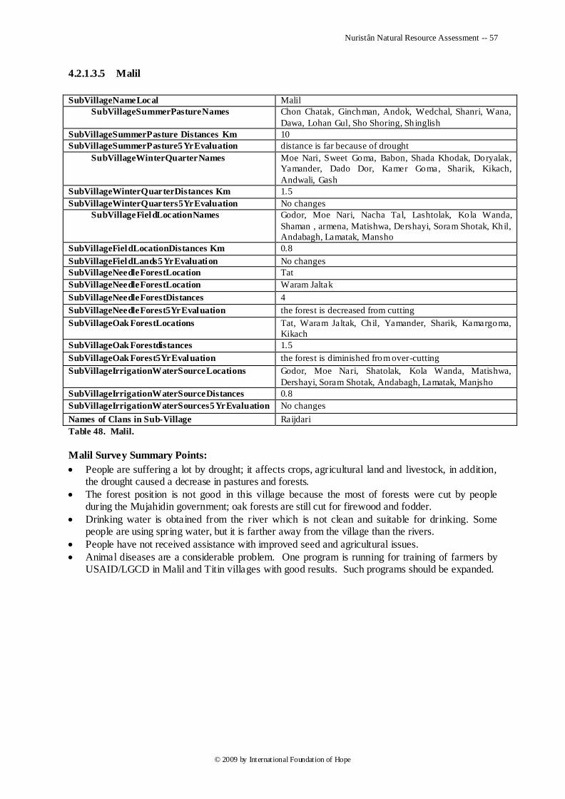
Nuristân Natural Resource Assessment -- 57
© 2009 by International Foundation of Hope
4.2.1.3.5 Malil
SubVillageNameLocal Malil
SubVillageSummerPastureNames
Chon Chatak, Ginchman, Andok, Wedchal, Shanri, Wana,
Dawa, Lohan Gul, Sho Shoring, Sh inglish
SubVillageSummerPasture Distances Km 10
SubVillageSummerPasture5YrEvaluation distance is far because of drought
SubVillageWinterQuarterNames
Moe Nari, Sweet Goma, Babon, Shada Khodak, Doryalak,
Yamander, Dado Dor, Kamer Goma, Sharik, Kikach,
Andwali, Gash
SubVillageWinterQuarterDistances Km 1.5
SubVillageWinterQuarters5YrEvaluation No changes
SubVillageFieldLocationNames
Godor, Moe Nari, Nacha Tal, Lashtolak, Kola Wanda,
Shaman , armena, Matishwa, Dershayi, Soram Shotak, Khil,
Andabagh, Lamatak, Mansho
SubVillageFieldLocationDistances Km 0.8
SubVillageFieldLands5YrEvaluation No changes
SubVillageNeedleForestLocation Tat
SubVillageNeedleForestLocation Waram Jaltak
SubVillageNeedleForestDistances 4
SubVillageNeedleForest5YrEvaluation the forest is decreased from cutting
SubVillageOak ForestLocations Tat, Waram Jaltak, Chil, Yamander, Sharik, Kamargoma,
Kikach
SubVillageOak Forestdistances 1.5
SubVillageOak Forest5YrEvaluation the forest is diminished from over-cutting
SubVillageIrrigationWaterSourceLocations
Godor, Moe Nari, Shatolak, Kola Wanda, Matishwa,
Dershayi, Soram Shotak, Andabagh, Lamatak, Manjsho
SubVillageIrrigationWaterSourceDistances 0.8
SubVillageIrrigationWaterSources5YrEvaluation No changes
Names of Clans in Sub-Village Raijdari
Table 48. Malil.
Malil Survey Summary Points:
People are suffering a lot by drought; it affects crops, agricultural land and livestock, in addition, the drought caused a decrease in pastures and forests.
The forest position is not good in this village because the most of forests were cut by people during the Mujahidin government; oak forests are still cut for firewood and fodder.
Drinking water is obtained from the river which is not clean and suitable for drinking. Some people are using spring water, but it is farther away from the village than the rivers.
People have not received assistance with improved seed and agricultural issues.
Animal diseases are a considerable problem. One program is running for training of farmers by USAID/LGCD in Malil and Titin villages with good results. Such programs should be expanded.
Nuristân Natural Resource Assessment -- 58
© 2009 by International Foundation of Hope
4.2.1.3.6 Wadawu
SubVillageNamePashto Ziarat Kali
SubVillageNameLocal Kandelam
SubVillageSummerPastureNames Waden, Batizh, Kojli Waro, Samok
SubVillageSummerPasture Distances Km 12
SubVillageSummerPasture5YrEvaluation The pasture areas are damaged by drought
SubVillageWinterQuarterNames Songloon, Andra Kandlo, Jang, Achmon
SubVillageWinterQuarterDistances Km 4.5
SubVillageWinterQuarters5YrEvaluation Winter quarters are damaged from drought
SubVillageFieldLocationNames Doranli, Olshata, Daranawak
SubVillageFieldLocationDistances Km 3.5
SubVillageFieldLands5YrEvaluation The agricultural land has low production because of drought
SubVillageNeedleForestLocation Samok, Kojli Waro, Jangla
SubVillageNeedleForestDistances 11
SubVillageNeedleForest5YrEvaluation Peope are cutting the forest for their home building
SubVillageOak ForestLocations Mechi, Mim, Andra Kandlo, Kojarit
SubVillageOak Forestdistances 5
SubVillageOak Forest5YrEvaluation The Oak Forest harmed from overharvest and drought
SubVillageIrrigationWaterSourceLocations Jandadora, Olshata, Sadarakati
SubVillageIrrigationWaterSourceDistances 3.5
SubVillageIrrigationWaterSources5YrEvaluation The stream condition is very very good becaus ( N.S.P
)Program Construction and rehabilitation efforts
Names of Clans in Sub-Village Marma Dari, Kalash Dari, Soz Khan Dari
Table 49. Wadawu.
Wadawu Survey Summary Points:
People‘s basic problem is drinking water as they are using the river. Springs are located far from their homes.
Forest were also cut in the past by people for construction purposes.
Pasture condition was not good due to the drought. The main problem for pastures is drought and lack of water in the area affecting both pastures and forests.
ADP-E trees survival rate was 70%. People are requesting more assistance with orchard establishment.
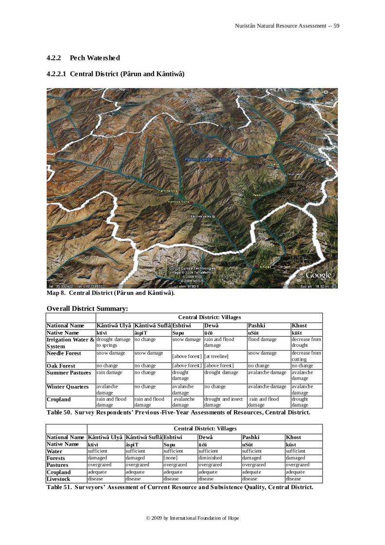
Nuristân Natural Resource Assessment -- 59
© 2009 by International Foundation of Hope
4.2.2 Pech Watershed
4.2.2.1 Central District (Pârun and Kântiwâ)
Map 8. Central District (Pârun and Kântiwâ).
Overall District Summary:
Central District: Villages
National Name Kântiwâ Ulyâ Kântiwâ Suflâ Eshtiwi Dewâ Pashki Khost
Native Name ktivi âspiT Supu üćü uSüt küšt
Irrigation Water &
System
drought damage to springs
no change snow damage rain and flood damage
flood damage decrease from drought
Needle Forest snow damage snow damage [above forest] [at treeline]
snow damage decrease from
cutting
Oak Forest no change no change [above forest] [above forest] no change no change
Summer Pastures rain damage no change drought damage
drought damage avalanche damage avalanche damage
Winter Quarters avalanche
damage
no change avalanche
damage
no change avalanche damage avalanche
damage
Cropland rain and flood damage
rain and flood damage
avalanche damage
drought and insect damage
rain and flood damage
drought damage
Table 50. Survey Res pondents’ Previous -Five-Year Assessments of Resources, Central District.
Central District: Villages
National Name Kântiwâ Ulyâ Kântiwâ Suflâ Eshtiwi Dewâ Pashki Khost
Native Name ktivi âspiT Supu üćü uSüt küst
Water sufficient sufficient sufficient sufficient sufficient sufficient
Forests damaged damaged [none] diminished damaged damaged
Pastures overgrazed overgrazed overgrazed overgrazed overgrazed overgrazed
Cropland adequate adequate adequate adequate adequate adequate
Livestock disease disease disease disease disease disease
Table 51. Surveyors’ Assessment of Current Resource and Subsistence Quality, Central District.
Nuristân Natural Resource Assessment -- 60
© 2009 by International Foundation of Hope
The Central District contains two major rivers, the Kântiwâ and the Pârun, which join at the southern end of the district to form the Pech River.
Major natural-resource issues include drought-impacted forests, poor irrigation and drinking-water infrastructure, low crop yields, and livestock diseases.
Forests:
Forests consist of pine nuts, other conifers, and some oak. Conifers are overharvested for home firewood, heating the stables for animals in winter, and building houses. The government is restricting forest harvest, but people are girdling the trees, and when they die after one year the trees are harvested. People are cutting only dead trees for firewood, but many trees are dying every year.
In addition, for the past 3-4 years drought has been a big problem, causing destruction of the forests. Mountains are bare from cutting and drought, and this process is continuing.
Another cause of damage to forests is avalanches.
Land (soil):
This district has less agricultural land but has good soil structure. Soil erosion is caused by floods, overharvesting of forests, and lack of protection walls.
Water:
Water for drinking is provided by spring and river, but in some areas people have problems with the long distance between river or spring and village. Spring water flows off into rivers, and people do not have a system to utilize it in their villages.
Irrigation water is sufficient in this district, but irrigation canals are in very poor condition. More than half the water is lost on the way between river and irrigated land.
Crops:
The main crops are maize, beans, and a little wheat. Because of the climate, most of the land produces one crop in a year. There is not enough yield, because of an outmoded agricultural system and non-use of chemical fertilizer and certified seed.
The main fruits grown are apple, apricot, grapes, jujube , and persimmon. Nuts include walnuts and pine nuts. Fruits produce very well, especially apples. One farmer planted apples on his half jerib of land; and although his orchard was not planted scientifically, it yielded 30,000 afs worth of crop, compared to only 2,000 afs worth of maize before the orchard was planted.
Animals:
People depend on livestock, but animal health is poor. Livestock are dying from different diseases because of unavailability of clinics and specialists. Because of lack of fodder, people are selling their animals in winter.
Pastures:
Pârun has abundant pasture, the only problem being snow during the winter. People store grasses in summer for winter feeding, but the storage system is bad because of the decay of grasses.
Fodder sources are pastures and the oak forest in the lower areas of the district, but both pastures and the oak forest are deteriorating from overgrazing.
Wildlife:
80% of the wildlife has disappeared because of habitat loss and hunting.
Roads:
Lack of roads is a problem for the people. Transportation of goods is done by animals and women.
Education:
This is the main problem in the area; most of the residents are illiterate. Schools and Islamic madrassas are not available for the younger generation.
Nuristân Natural Resource Assessment -- 61
© 2009 by International Foundation of Hope
Surveyors’ views based on the villagers ’ requests:
They need reforestation, rehabilitation of the pastures, animal health clinics, human health clinics, schools, roads, irrigation canals, water=distribution projects, establishment of fruit nurseries and orchards, certified seed, chemical fertilizer, and wildlife conservation.
4.2.2.1.1 Eshtiwe
SubVillageNamePashto Shupu
SubVillageNameLocal Shupu
SubVillageSummerPastureNames
Melik Gal, Tiwlis Gal, Tiz Bagal, Echem Gal, Shid kal
Gal, Abzhi Gal
SubVillageSummerPasture Distances Km 20
SubVillageSummerPasture5YrEvaluation affected by drought
SubVillageWinterQuarterNames Tanangak, Engam, Man Nish, Tat Lakm Aw arik, Aw
naryok
SubVillageWinterQuarterDistances Km 5
SubVillageWinterQuarters5YrEvaluation damaged by snow slide
SubVillageFieldLocationNames Naryok, zha rewk, Tansha , Toto Nak, Tochi, Bogom
SubVillageFieldLocationDistances Km 5
SubVillageFieldLands5YrEvaluation damaged by snow slide
SubVillageNeedleForestDistances [none]
SubVillageNeedleForest5YrEvaluation [none]
SubVillageOak Forestdistances [none]
SubVillageOak Forest5YrEvaluation [none]
SubVillageIrrigationWaterSourceLocations Chashma Awal (Spring one), Chashma Doyam (spring
two)
SubVillageIrrigationWaterSourceDistances 0.7
SubVillageIrrigationWaterSources5YrEvaluation Damage by the reason of snow slide
Names of Clans in Sub-Village Paksha, Pozhod, Pabadka, Aniw Watig, Piyag, Pazgam
Table 52. Es htiwe.
Beyond the overall assessment given above for the district, no specific observations were noted for this village.
4.2.2.1.2 Dewa
SubVillageNamePashto Padi,Pazgam,Pot Nomi
SubVillageNameLocal Padi,Pazgam,Pot Nomi
SubVillageSummerPastureNames Samgal, Ramgal, Tija, Shot To
SubVillageSummerPasture Distances Km 24
SubVillageSummerPasture5YrEvaluation affected by drought
SubVillageWinterQuarterNames Tip yash, , Sori, Erek, Tizha Rok
SubVillageWinterQuarterDistances Km 1
SubVillageWinterQuarters5YrEvaluation No changes
SubVillageFieldLocationNames Oskam, Chatka, Pazik, Tozhok
SubVillageFieldLocationDistances Km 0.8
SubVillageFieldLands5YrEvaluation affected by insects and drought
SubVillageOak Forestdistances [none]
SubVillageOak Forest5YrEvaluation [none]
SubVillageIrrigationWaterSourceLocations they use flood water
SubVillageIrrigationWaterSourceDistances 0.25
SubVillageIrrigationWaterSources5YrEvaluation damaged by rain and flooding
Names of Clans in Sub-Village Padi, Pazgam, Pot Nomi
Table 53. Dewa.
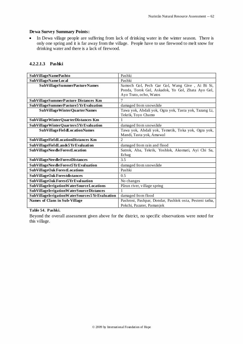
Nuristân Natural Resource Assessment -- 62
© 2009 by International Foundation of Hope
Dewa Survey Summary Points:
In Dewa village people are suffering from lack of drinking water in the winter season. There is only one spring and it is far away from the village. People have to use firewood to melt snow for drinking water and there is a lack of firewood.
4.2.2.1.3 Pashki
SubVillageNamePashto Pashki
SubVillageNameLocal Pashki
SubVillageSummerPastureNames
Samoch Gol, Pech Gar Gol, Wang Give , Ai Bi Si,
Ponda, Torok Gol, Askadok, Yo Gol, Zhata Ayo Gol,
Ayo Trato, ocho, Watos
SubVillageSummerPasture Distances Km 7
SubVillageSummerPasture5YrEvaluation damaged from snowslide
SubVillageWinterQuarterNames
Tawa yok, Abdali yok, Ogra yok, Tasta yok, Tazang Li,
Tekrik, Toyo Chamo
SubVillageWinterQuarterDistances Km 1
SubVillageWinterQuarters5YrEvaluation damaged from snowslide
SubVillageFieldLocationNames
Tawa yok, Abdali yok, Temet ik, Toka yok, Ogra yok,
Mandi, Tasta yok, Amawal
SubVillageFieldLocationDistances Km 2
SubVillageFieldLands5YrEvaluation damaged from rain and flood
SubVillageNeedleForestLocation Satrok, Aba, Tekrik, Yoshlok, Akomat i, Ayi Chi Sa,
Echag
SubVillageNeedleForestDistances 3.5
SubVillageNeedleForest5YrEvaluation damaged from snowslide
SubVillageOak ForestLocations Pashki
SubVillageOak Forestdistances 0.5
SubVillageOak Forest5YrEvaluation No changes
SubVillageIrrigationWaterSourceLocations Pârun river, v illage spring
SubVillageIrrigationWaterSourceDistances 1
SubVillageIrrigationWaterSources5YrEvaluation damaged from flood
Names of Clans in Sub-Village
Pashrost, Pashpar, Dondar, Pashlok osta, Pesteni tatba,
Pokchi, Pazater, Pamanjok
Table 54. Pashki.
Beyond the overall assessment given above for the district, no specific observations were noted for this village.
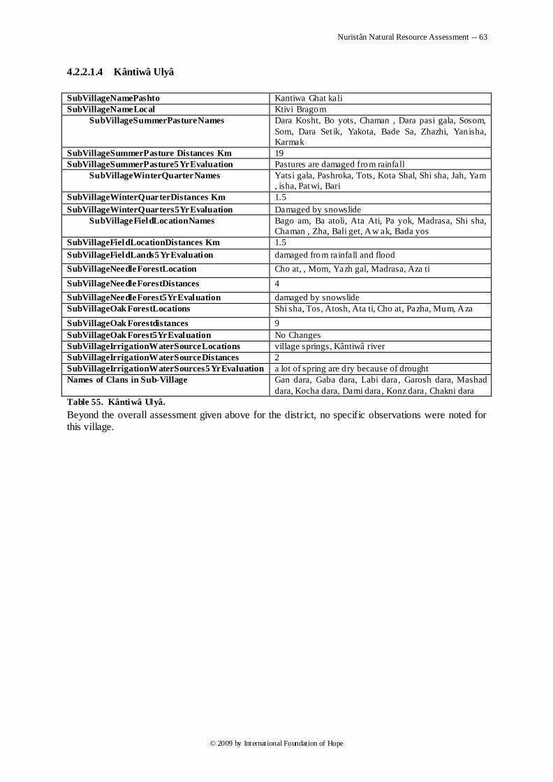
Nuristân Natural Resource Assessment -- 63
© 2009 by International Foundation of Hope
4.2.2.1.4 Kântiwâ Ulyâ
SubVillageNamePashto Kantiwa Ghat kali
SubVillageNameLocal Ktivi Bragom
SubVillageSummerPastureNames
Dara Kosht, Bo yots, Chaman , Dara pasi gala, Sosom,
Som, Dara Set ik, Yakota, Bade Sa, Zhazhi, Yanisha,
Karmak
SubVillageSummerPasture Distances Km 19
SubVillageSummerPasture5YrEvaluation Pastures are damaged from rainfall
SubVillageWinterQuarterNames
Yatsi gala, Pashroka, Tots, Kota Shal, Shi sha, Jah, Yam
, isha, Patwi, Bari
SubVillageWinterQuarterDistances Km 1.5
SubVillageWinterQuarters5YrEvaluation Damaged by snowslide
SubVillageFieldLocationNames
Bago am, Ba atoli, Ata Ati, Pa yok, Madrasa, Shi sha,
Chaman , Zha, Bali get, Aw ak, Bada yos
SubVillageFieldLocationDistances Km 1.5
SubVillageFieldLands5YrEvaluation damaged from rainfall and flood
SubVillageNeedleForestLocation Cho at, , Mom, Yazh gal, Madrasa, Aza ti
SubVillageNeedleForestDistances 4
SubVillageNeedleForest5YrEvaluation damaged by snowslide
SubVillageOak ForestLocations Shi sha, Tos, Atosh, Ata ti, Cho at, Pazha, Mum, Aza
SubVillageOak Forestdistances 9
SubVillageOak Forest5YrEvaluation No Changes
SubVillageIrrigationWaterSourceLocations village springs, Kântiwâ river
SubVillageIrrigationWaterSourceDistances 2
SubVillageIrrigationWaterSources5YrEvaluation a lot of spring are d ry because of drought
Names of Clans in Sub-Village
Gan dara, Gaba dara, Labi dara, Garosh dara, Mashad
dara, Kocha dara, Dami dara, Konz dara, Chakni dara
Table 55. Kântiwâ Ulyâ.
Beyond the overall assessment given above for the district, no specific observations were noted for this village.
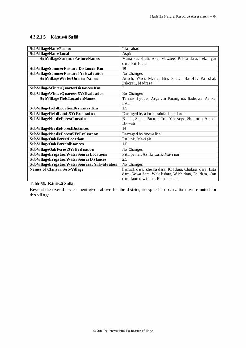
Nuristân Natural Resource Assessment -- 64
© 2009 by International Foundation of Hope
4.2.2.1.5 Kântiwâ Suflâ
SubVillageNamePashto Islamabad
SubVillageNameLocal Aspit
SubVillageSummerPastureNames
Marra sa, Shati, Asa, Mawaee, Palota dara, Tekar gar
dara, Patil dara
SubVillageSummerPasture Distances Km 10
SubVillageSummerPasture5YrEvaluation No Changes
SubVillageWinterQuarterNames
Anash, Wasi, Marra, Bin, Shata, Basolla, Kamshal,
Pakorati, Madrasa
SubVillageWinterQuarterDistances Km 3
SubVillageWinterQuarters5YrEvaluation No Changes
SubVillageFieldLocationNames Tarmashi youts, Arga am, Patang na, Badrosta, Ashka,
Patil
SubVillageFieldLocationDistances Km 1.5
SubVillageFieldLands5YrEvaluation Damaged by a lot of rainfall and flood
SubVillageNeedleForestLocation
Bean, , Shata, Patatok Tol, You seya, Shodrom, Anash,
Bo wati
SubVillageNeedleForestDistances 14
SubVillageNeedleForest5YrEvaluation Damaged by snowslide
SubVillageOak ForestLocations Patil pit, Mavi pit
SubVillageOak Forestdistances 1.5
SubVillageOak Forest5YrEvaluation No Changes
SubVillageIrrigationWaterSourceLocations Patil pa nar, Ashka wala, Mavi nar
SubVillageIrrigationWaterSourceDistances 2.5
SubVillageIrrigationWaterSources5YrEvaluation No Changes
Names of Clans in Sub-Village hemach dara, Zhema dara, Kol dara, Chakna dara, Lata
dara, Newa dara, Walok dara, W ich dara, Pal dara, Gan
dara, land rawi dara, Remach dara
Table 56. Kântiwâ Suflâ.
Beyond the overall assessment given above for the district, no specific observations were noted for this village.
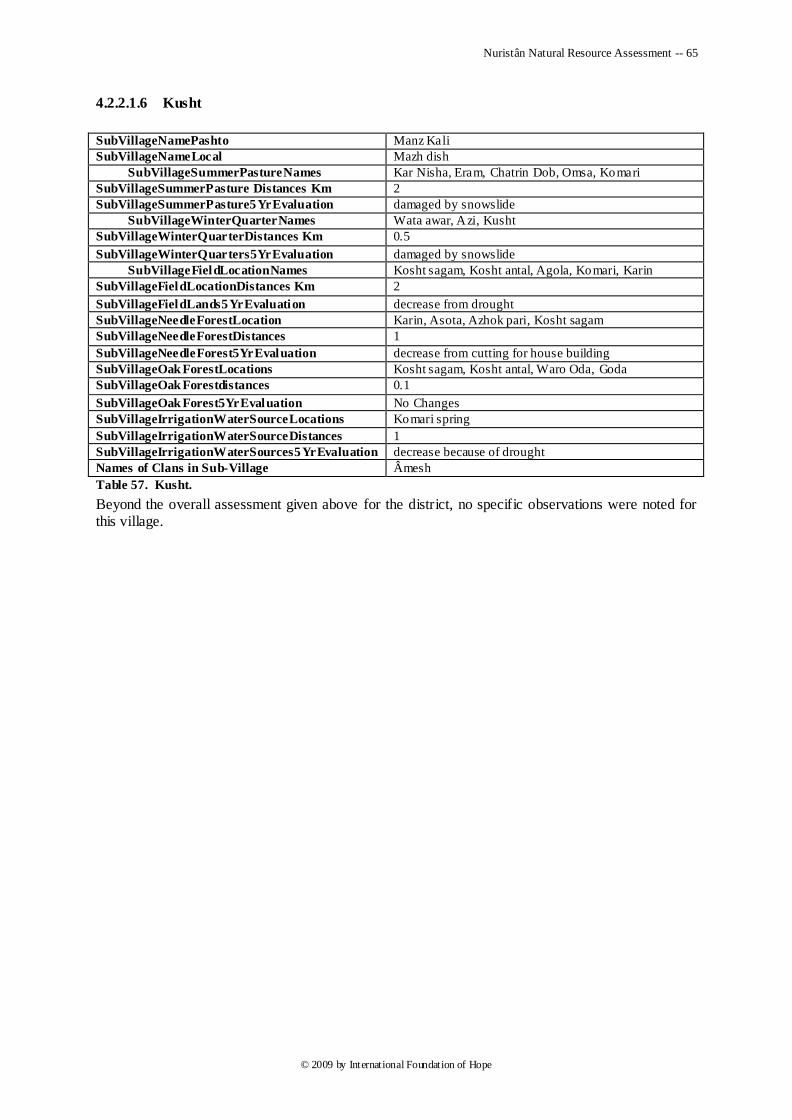
Nuristân Natural Resource Assessment -- 65
© 2009 by International Foundation of Hope
4.2.2.1.6 Kusht
SubVillageNamePashto Manz Kali
SubVillageNameLocal Mazh dish
SubVillageSummerPastureNames Kar Nisha, Eram, Chatrin Dob, Omsa, Komari
SubVillageSummerPasture Distances Km 2
SubVillageSummerPasture5YrEvaluation damaged by snowslide
SubVillageWinterQuarterNames Wata awar, Azi, Kusht
SubVillageWinterQuarterDistances Km 0.5
SubVillageWinterQuarters5YrEvaluation damaged by snowslide
SubVillageFieldLocationNames Kosht sagam, Kosht antal, Agola, Komari, Karin
SubVillageFieldLocationDistances Km 2
SubVillageFieldLands5YrEvaluation decrease from drought
SubVillageNeedleForestLocation Karin, Asota, Azhok pari, Kosht sagam
SubVillageNeedleForestDistances 1
SubVillageNeedleForest5YrEvaluation decrease from cutting for house building
SubVillageOak ForestLocations Kosht sagam, Kosht antal, Waro Oda, Goda
SubVillageOak Forestdistances 0.1
SubVillageOak Forest5YrEvaluation No Changes
SubVillageIrrigationWaterSourceLocations Komari spring
SubVillageIrrigationWaterSourceDistances 1
SubVillageIrrigationWaterSources5YrEvaluation decrease because of drought
Names of Clans in Sub-Village Âmesh
Table 57. Kusht.
Beyond the overall assessment given above for the district, no specific observations were noted for this village.
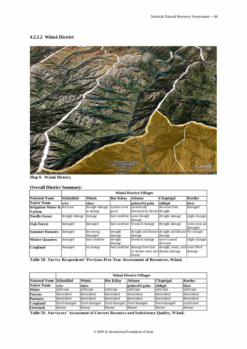
Nuristân Natural Resource Assessment -- 66
© 2009 by International Foundation of Hope
4.2.2.2 Wâmâ District
Map 9. Wâmâ District.
Overall District Summary:
Wâmâ District:Villages
National Name Islâmâbâd Wâmâ Bar Kälay Achanu Chaprigal Kordar
Native Name wâw sâma grâmsaNâ grâm sâbligal kitar
Irrigation Water &
System
decrease drought damage
to springs
system is not
good
periodically
destroyed by floods
decrease from
drought
damaged
Needle Forest drought damage damage bad condition some drought damage
drought damage slight changes
Oak Forest damaged damaged bad condition livestock damage drought damage some areas are damaged
Summer Pastures damaged becoming damaged
drought damage
drought and disease damage
drought and disease damage
No changes
Winter Quarters damaged bad condition drought damage
livestock damage snow-caused decrease
slight changes
Cropland damaged no change bad condition damage from lack
of stream water and floods
drought, insect, and
disease damage
some flood
damage
Table 58. Survey Res pondents’ Previous -Five-Year Assessments of Resources, Wâmâ.
Wâmâ District:Villages
National Name Islâmâbâd Wâmâ Bar Kälay Achanu Chaprigal Kordar
Native Name wâw sâma grâmsaNâ grâm sâbligal kitar
Water sufficient sufficient sufficient sufficient sufficient sufficient
Forests diminished diminished diminished diminished diminished diminished
Pastures diminished diminished diminished diminished diminished diminished
Cropland flood damaged flood damaged flood damaged flood damaged flood damaged insufficient
Livestock disease disease disease disease disease disease
Table 59. Surveyors’ Assessment of Current Resource and Subsistence Quality, Wâmâ.
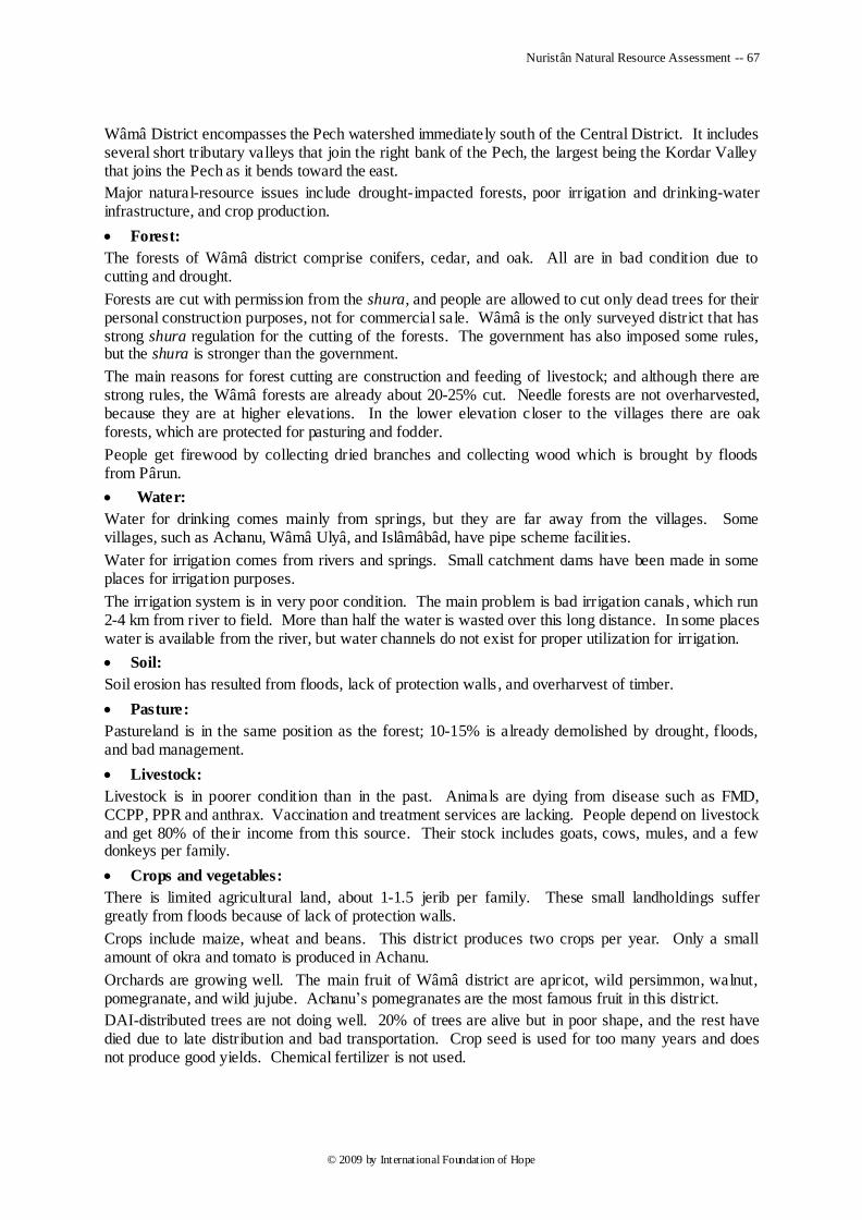
Nuristân Natural Resource Assessment -- 67
© 2009 by International Foundation of Hope
Wâmâ District encompasses the Pech watershed immediately south of the Central District. It includes several short tributary valleys that join the right bank of the Pech, the largest being the Kordar Valley that joins the Pech as it bends toward the east.
Major natural-resource issues include drought-impacted forests, poor irrigation and drinking-water infrastructure, and crop production.
Forest:
The forests of Wâmâ district comprise conifers, cedar, and oak. All are in bad condition due to cutting and drought.
Forests are cut with permission from the shura, and people are allowed to cut only dead trees for their personal construction purposes, not for commercial sale. Wâmâ is the only surveyed district that has strong shura regulation for the cutting of the forests. The government has also imposed some rules, but the shura is stronger than the government.
The main reasons for forest cutting are construction and feeding of livestock; and although there are strong rules, the Wâmâ forests are already about 20-25% cut. Needle forests are not overharvested, because they are at higher elevations. In the lower elevation closer to the villages there are oak forests, which are protected for pasturing and fodder.
People get firewood by collecting dried branches and collecting wood which is brought by floods from Pârun.
Water:
Water for drinking comes mainly from springs, but they are far away from the villages. Some villages, such as Achanu, Wâmâ Ulyâ, and Islâmâbâd, have pipe scheme facilities.
Water for irrigation comes from rivers and springs. Small catchment dams have been made in some places for irrigation purposes.
The irrigation system is in very poor condition. The main problem is bad irrigation canals , which run 2-4 km from river to field. More than half the water is wasted over this long distance. In some places water is available from the river, but water channels do not exist for proper utilization for irrigation.
Soil:
Soil erosion has resulted from floods, lack of protection walls , and overharvest of timber.
Pasture:
Pastureland is in the same position as the forest; 10-15% is already demolished by drought, floods, and bad management.
Livestock:
Livestock is in poorer condition than in the past. Animals are dying from disease such as FMD, CCPP, PPR and anthrax. Vaccination and treatment services are lacking. People depend on livestock and get 80% of their income from this source. Their stock includes goats, cows, mules, and a few donkeys per family.
Crops and vegetables:
There is limited agricultural land, about 1-1.5 jerib per family. These small landholdings suffer greatly from floods because of lack of protection walls.
Crops include maize, wheat and beans. This district produces two crops per year. Only a small amount of okra and tomato is produced in Achanu.
Orchards are growing well. The main fruit of Wâmâ district are apricot, wild persimmon, walnut, pomegranate, and wild jujube. Achanu‘s pomegranates are the most famous fruit in this district.
DAI-distributed trees are not doing well. 20% of trees are alive but in poor shape, and the rest have died due to late distribution and bad transportation. Crop seed is used for too many years and does not produce good yields. Chemical fertilizer is not used.
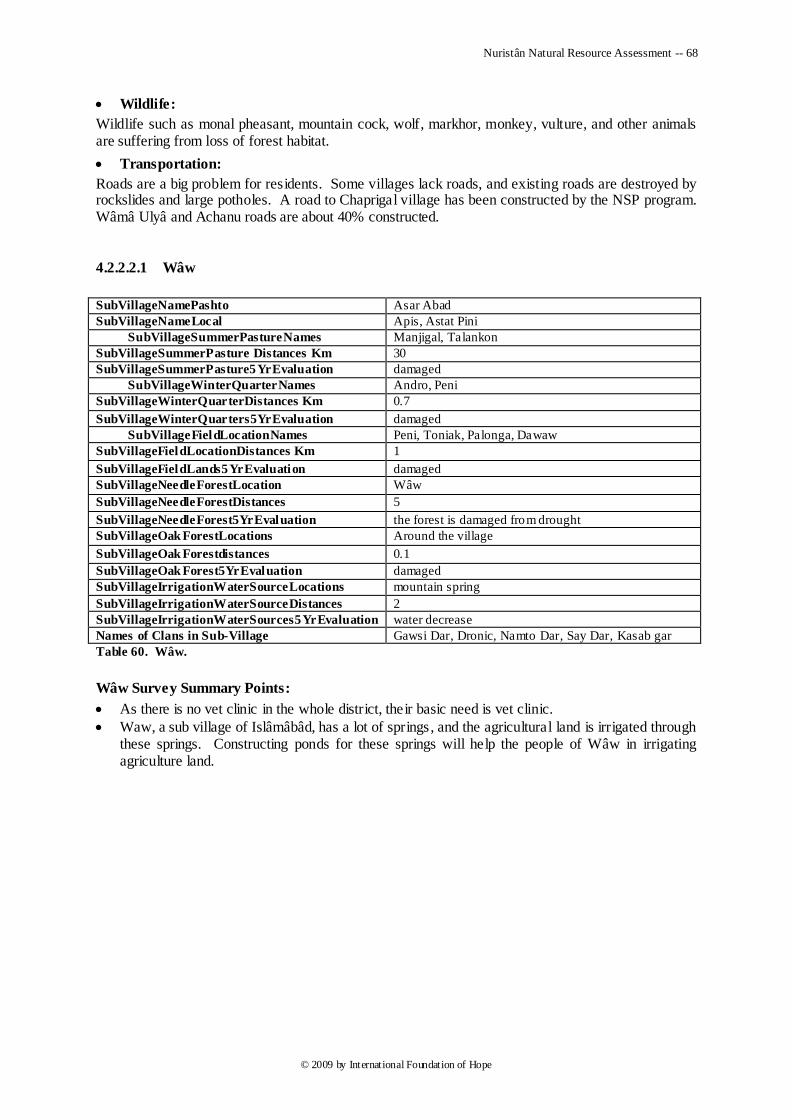
Nuristân Natural Resource Assessment -- 68
© 2009 by International Foundation of Hope
Wildlife:
Wildlife such as monal pheasant, mountain cock, wolf, markhor, monkey, vulture, and other animals are suffering from loss of forest habitat.
Transportation:
Roads are a big problem for residents. Some villages lack roads, and existing roads are destroyed by rockslides and large potholes. A road to Chaprigal village has been constructed by the NSP program. Wâmâ Ulyâ and Achanu roads are about 40% constructed.
4.2.2.2.1 Wâw
SubVillageNamePashto Asar Abad
SubVillageNameLocal Apis, Astat Pini
SubVillageSummerPastureNames Manjigal, Talankon
SubVillageSummerPasture Distances Km 30
SubVillageSummerPasture5YrEvaluation damaged
SubVillageWinterQuarterNames Andro, Peni
SubVillageWinterQuarterDistances Km 0.7
SubVillageWinterQuarters5YrEvaluation damaged
SubVillageFieldLocationNames Peni, Toniak, Palonga, Dawaw
SubVillageFieldLocationDistances Km 1
SubVillageFieldLands5YrEvaluation damaged
SubVillageNeedleForestLocation Wâw
SubVillageNeedleForestDistances 5
SubVillageNeedleForest5YrEvaluation the forest is damaged from drought
SubVillageOak ForestLocations Around the village
SubVillageOak Forestdistances 0.1
SubVillageOak Forest5YrEvaluation damaged
SubVillageIrrigationWaterSourceLocations mountain spring
SubVillageIrrigationWaterSourceDistances 2
SubVillageIrrigationWaterSources5YrEvaluation water decrease
Names of Clans in Sub-Village Gawsi Dar, Dronic, Namto Dar, Say Dar, Kasab gar
Table 60. Wâw.
Wâw Survey Summary Points:
As there is no vet clinic in the whole district, their basic need is vet clinic.
Waw, a sub village of Islâmâbâd, has a lot of springs, and the agricultural land is irrigated through these springs. Constructing ponds for these springs will help the people of Wâw in irrigating agriculture land.
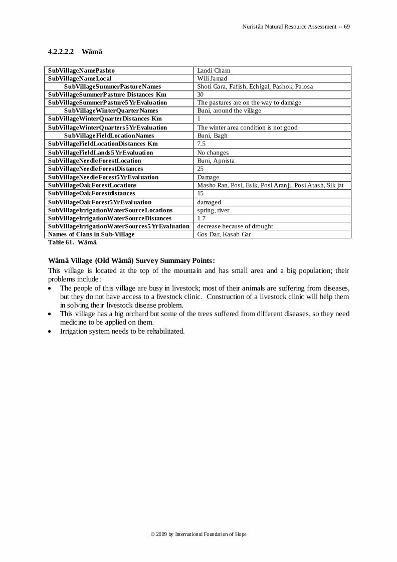
Nuristân Natural Resource Assessment -- 69
© 2009 by International Foundation of Hope
4.2.2.2.2 Wâmâ
SubVillageNamePashto Landi Cham
SubVillageNameLocal Wili Jamad
SubVillageSummerPastureNames Shoti Gara, Fafish, Ech igal, Pashok, Palosa
SubVillageSummerPasture Distances Km 30
SubVillageSummerPasture5YrEvaluation The pastures are on the way to damage
SubVillageWinterQuarterNames Buni, around the village
SubVillageWinterQuarterDistances Km 1
SubVillageWinterQuarters5YrEvaluation The winter area condition is not good
SubVillageFieldLocationNames Buni, Bagh
SubVillageFieldLocationDistances Km 7.5
SubVillageFieldLands5YrEvaluation No changes
SubVillageNeedleForestLocation Buni, Apnista
SubVillageNeedleForestDistances 25
SubVillageNeedleForest5YrEvaluation Damage
SubVillageOak ForestLocations Masho Ran, Posi, Es ik, Posi Aran ji, Posi Atash, Sik jat
SubVillageOak Forestdistances 15
SubVillageOak Forest5YrEvaluation damaged
SubVillageIrrigationWaterSourceLocations spring, river
SubVillageIrrigationWaterSourceDistances 1.7
SubVillageIrrigationWaterSources5YrEvaluation decrease because of drought
Names of Clans in Sub-Village Gos Dar, Kasab Gar
Table 61. Wâmâ.
Wâmâ Village (Old Wâmâ) Survey Summary Points:
This village is located at the top of the mountain and has small area and a big population; their problems include:
The people of this village are busy in livestock; most of their animals are suffering from diseases, but they do not have access to a livestock clinic. Construction of a livestock clinic will help them in solving their livestock disease problem.
This village has a big orchard but some of the trees suffered from different diseases, so they need medicine to be applied on them.
Irrigation system needs to be rehabilitated.
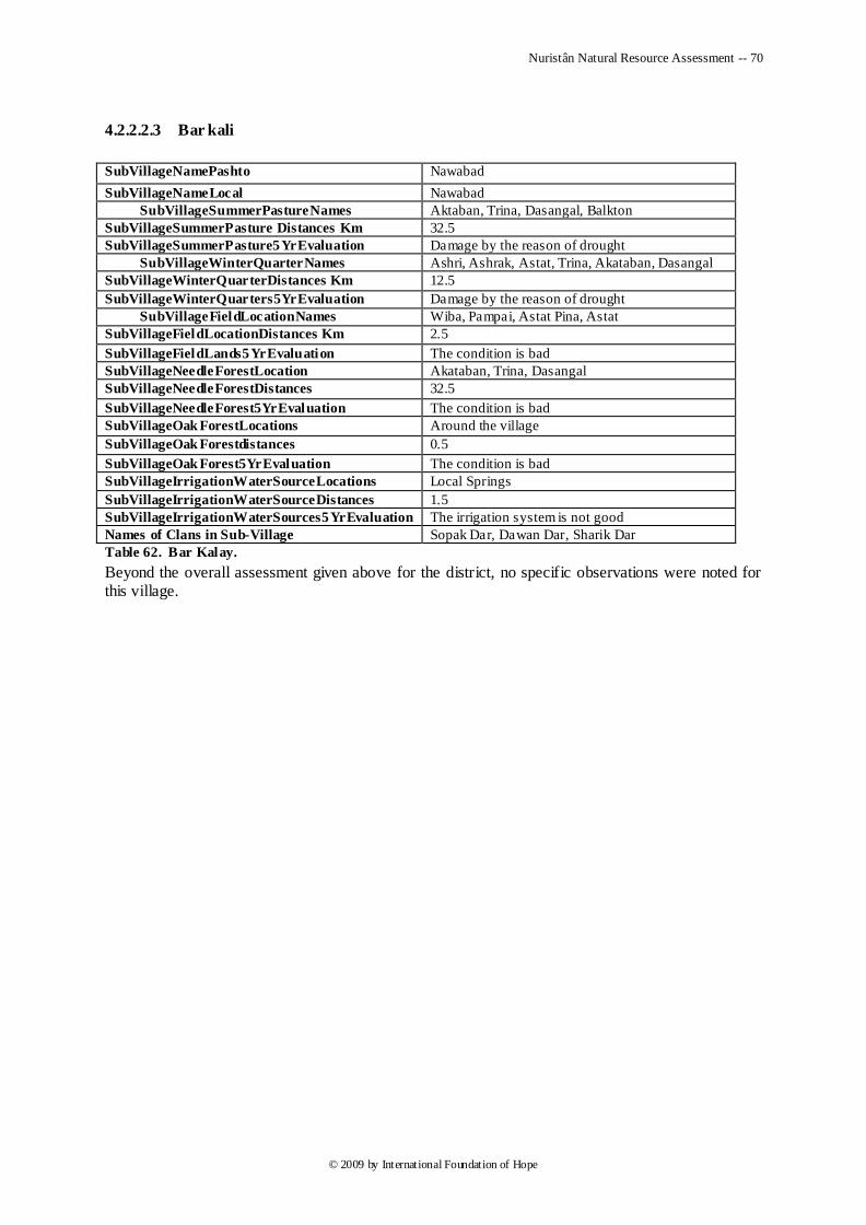
Nuristân Natural Resource Assessment -- 70
© 2009 by International Foundation of Hope
4.2.2.2.3 Bar kali
SubVillageNamePashto Nawabad
SubVillageNameLocal Nawabad
SubVillageSummerPastureNames Aktaban, Trina, Dasangal, Balkton
SubVillageSummerPasture Distances Km 32.5
SubVillageSummerPasture5YrEvaluation Damage by the reason of drought
SubVillageWinterQuarterNames Ashri, Ashrak, Astat, Trina, Akataban, Dasangal
SubVillageWinterQuarterDistances Km 12.5
SubVillageWinterQuarters5YrEvaluation Damage by the reason of drought
SubVillageFieldLocationNames Wiba, Pampai, Astat Pina, Astat
SubVillageFieldLocationDistances Km 2.5
SubVillageFieldLands5YrEvaluation The condition is bad
SubVillageNeedleForestLocation Akataban, Trina, Dasangal
SubVillageNeedleForestDistances 32.5
SubVillageNeedleForest5YrEvaluation The condition is bad
SubVillageOak ForestLocations Around the village
SubVillageOak Forestdistances 0.5
SubVillageOak Forest5YrEvaluation The condition is bad
SubVillageIrrigationWaterSourceLocations Local Springs
SubVillageIrrigationWaterSourceDistances 1.5
SubVillageIrrigationWaterSources5YrEvaluation The irrigation system is not good
Names of Clans in Sub-Village Sopak Dar, Dawan Dar, Sharik Dar
Table 62. Bar Kalay.
Beyond the overall assessment given above for the district, no specific observations were noted for this village.
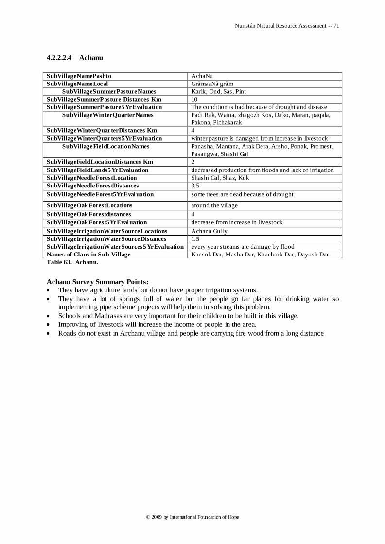
Nuristân Natural Resource Assessment -- 71
© 2009 by International Foundation of Hope
4.2.2.2.4 Achanu
SubVillageNamePashto AchaNu
SubVillageNameLocal GrâmsaNâ grâm
SubVillageSummerPastureNames Karik, Ond, Sas, Pint
SubVillageSummerPasture Distances Km 10
SubVillageSummerPasture5YrEvaluation The condition is bad because of drought and disease
SubVillageWinterQuarterNames
Padi Rak, Waina, zhagozh Kos, Dako, Maran, paqala,
Pakona, Pichakarak
SubVillageWinterQuarterDistances Km 4
SubVillageWinterQuarters5YrEvaluation winter pasture is damaged from increase in livestock
SubVillageFieldLocationNames
Panasha, Mantana, Arak Dera, Arsho, Ponak, Promest,
Pasangwa, Shashi Gal
SubVillageFieldLocationDistances Km 2
SubVillageFieldLands5YrEvaluation decreased production from floods and lack of irrigation
SubVillageNeedleForestLocation Shashi Gal, Shaz, Kok
SubVillageNeedleForestDistances 3.5
SubVillageNeedleForest5YrEvaluation some trees are dead because of drought
SubVillageOak ForestLocations around the village
SubVillageOak Forestdistances 4
SubVillageOak Forest5YrEvaluation decrease from increase in livestock
SubVillageIrrigationWaterSourceLocations Achanu Gully
SubVillageIrrigationWaterSourceDistances 1.5
SubVillageIrrigationWaterSources5YrEvaluation every year streams are damage by flood
Names of Clans in Sub-Village Kansok Dar, Masha Dar, Khachrok Dar, Dayosh Dar
Table 63. Achanu.
Achanu Survey Summary Points:
They have agriculture lands but do not have proper irrigation systems.
They have a lot of springs full of water but the people go far places for drinking water so implementing pipe scheme projects will help them in solving this problem.
Schools and Madrasas are very important for their children to be built in this village.
Improving of livestock will increase the income of people in the area.
Roads do not exist in Archanu village and people are carrying fire wood from a long distance
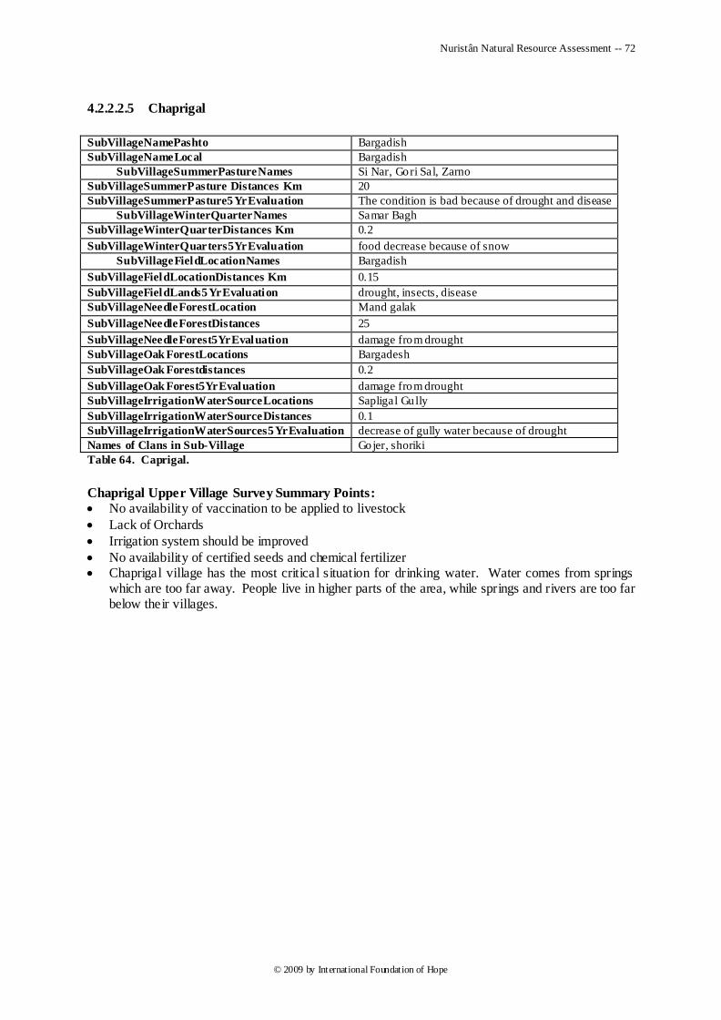
Nuristân Natural Resource Assessment -- 72
© 2009 by International Foundation of Hope
4.2.2.2.5 Chaprigal
SubVillageNamePashto Bargadish
SubVillageNameLocal Bargadish
SubVillageSummerPastureNames Si Nar, Gori Sal, Zarno
SubVillageSummerPasture Distances Km 20
SubVillageSummerPasture5YrEvaluation The condition is bad because of drought and disease
SubVillageWinterQuarterNames Samar Bagh
SubVillageWinterQuarterDistances Km 0.2
SubVillageWinterQuarters5YrEvaluation food decrease because of snow
SubVillageFieldLocationNames Bargadish
SubVillageFieldLocationDistances Km 0.15
SubVillageFieldLands5YrEvaluation drought, insects, disease
SubVillageNeedleForestLocation Mand galak
SubVillageNeedleForestDistances 25
SubVillageNeedleForest5YrEvaluation damage from drought
SubVillageOak ForestLocations Bargadesh
SubVillageOak Forestdistances 0.2
SubVillageOak Forest5YrEvaluation damage from drought
SubVillageIrrigationWaterSourceLocations Sapligal Gully
SubVillageIrrigationWaterSourceDistances 0.1
SubVillageIrrigationWaterSources5YrEvaluation decrease of gully water because of drought
Names of Clans in Sub-Village Gojer, shoriki
Table 64. Caprigal.
Chaprigal Upper Village Survey Summary Points:
No availability of vaccination to be applied to livestock
Lack of Orchards
Irrigation system should be improved
No availability of certified seeds and chemical fertilizer Chaprigal village has the most critical situation for drinking water. Water comes from springs
which are too far away. People live in higher parts of the area, while springs and rivers are too far below their villages.
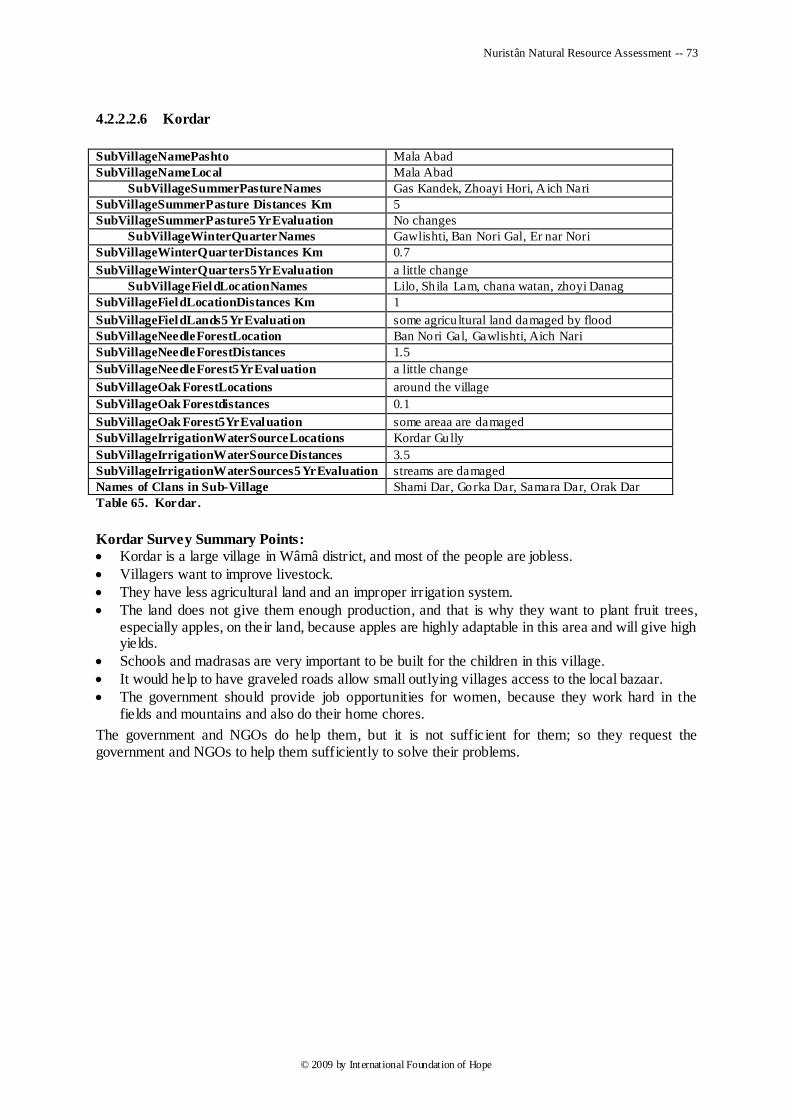
Nuristân Natural Resource Assessment -- 73
© 2009 by International Foundation of Hope
4.2.2.2.6 Kordar
SubVillageNamePashto Mala Abad
SubVillageNameLocal Mala Abad
SubVillageSummerPastureNames Gas Kandek, Zhoayi Hori, A ich Nari
SubVillageSummerPasture Distances Km 5
SubVillageSummerPasture5YrEvaluation No changes
SubVillageWinterQuarterNames Gawlishti, Ban Nori Gal, Er nar Nori
SubVillageWinterQuarterDistances Km 0.7
SubVillageWinterQuarters5YrEvaluation a little change
SubVillageFieldLocationNames Lilo, Sh ila Lam, chana watan, zhoyi Danag
SubVillageFieldLocationDistances Km 1
SubVillageFieldLands5YrEvaluation some agricu ltural land damaged by flood
SubVillageNeedleForestLocation Ban Nori Gal, Gawlishti, Aich Nari
SubVillageNeedleForestDistances 1.5
SubVillageNeedleForest5YrEvaluation a little change
SubVillageOak ForestLocations around the village
SubVillageOak Forestdistances 0.1
SubVillageOak Forest5YrEvaluation some areaa are damaged
SubVillageIrrigationWaterSourceLocations Kordar Gully
SubVillageIrrigationWaterSourceDistances 3.5
SubVillageIrrigationWaterSources5YrEvaluation streams are damaged
Names of Clans in Sub-Village Shami Dar, Gorka Dar, Samara Dar, Orak Dar
Table 65. Kordar.
Kordar Survey Summary Points:
Kordar is a large village in Wâmâ district, and most of the people are jobless.
Villagers want to improve livestock.
They have less agricultural land and an improper irrigation system.
The land does not give them enough production, and that is why they want to plant fruit trees, especially apples, on their land, because apples are highly adaptable in this area and will give high yields.
Schools and madrasas are very important to be built for the children in this village.
It would help to have graveled roads allow small outlying villages access to the local bazaar.
The government should provide job opportunities for women, because they work hard in the fields and mountains and also do their home chores.
The government and NGOs do help them, but it is not sufficient for them; so they request the government and NGOs to help them sufficiently to solve their problems.
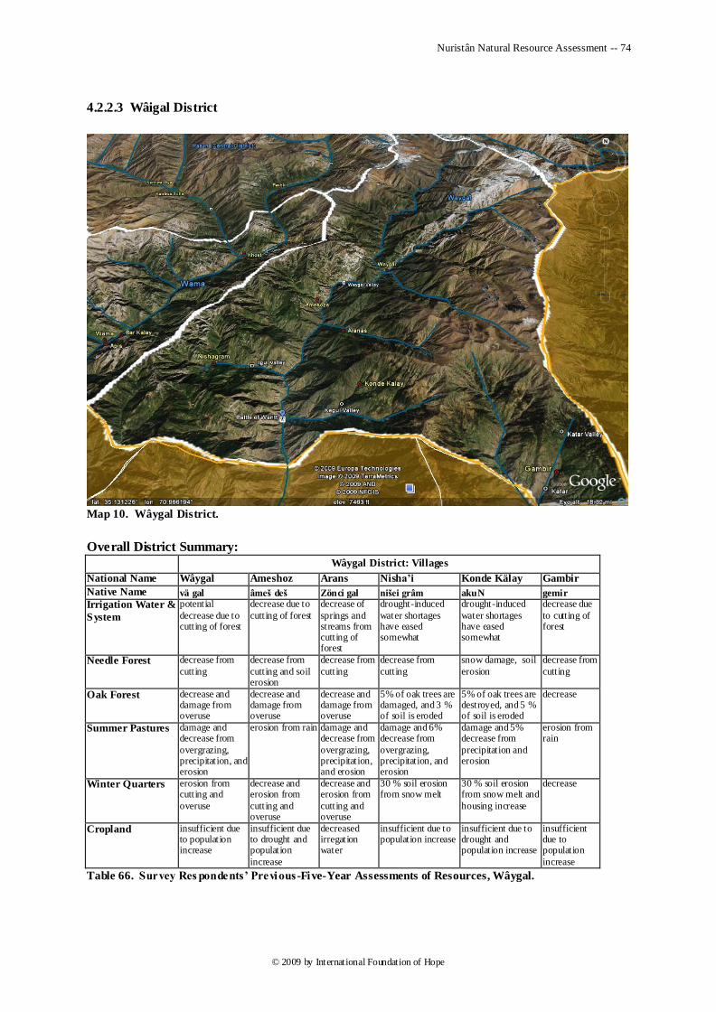
Nuristân Natural Resource Assessment -- 74
© 2009 by International Foundation of Hope
4.2.2.3 Wâigal District
Map 10. Wâygal District.
Overall District Summary:
Wâygal District: Villages
National Name Wâygal Ameshoz Arans Nisha’i Konde Kälay Gambir
Native Name vä gal âmeš deš Zönci gal nišei grâm akuN gemir
Irrigation Water &
System
potential
decrease due to cutting of forest
decrease due to
cutting of forest
decrease of
springs and streams from cutting of forest
drought-induced
water shortages have eased somewhat
drought-induced
water shortages have eased somewhat
decrease due
to cutting of forest
Needle Forest decrease from
cutting
decrease from
cutting and soil erosion
decrease from
cutting
decrease from
cutting
snow damage, soil
erosion
decrease from
cutting
Oak Forest decrease and damage from overuse
decrease and damage from overuse
decrease and damage from overuse
5% of oak trees are damaged, and 3 % of soil is eroded
5% of oak trees are destroyed, and 5 % of soil is eroded
decrease
Summer Pastures damage and decrease from
overgrazing, precipitation, and erosion
erosion from rain damage and decrease from
overgrazing, precipitation, and erosion
damage and 6% decrease from
overgrazing, precipitation, and erosion
damage and 5% decrease from
precipitation and erosion
erosion from rain
Winter Quarters erosion from cutting and
overuse
decrease and erosion from
cutting and overuse
decrease and erosion from
cutting and overuse
30 % soil erosion from snow melt
30 % soil erosion from snow melt and
housing increase
decrease
Cropland insufficient due to population increase
insufficient due to drought and population
increase
decreased irregation water
insufficient due to population increase
insufficient due to drought and population increase
insufficient due to population
increase
Table 66. Survey Res pondents’ Previous -Five-Year Assessments of Resources, Wâygal.
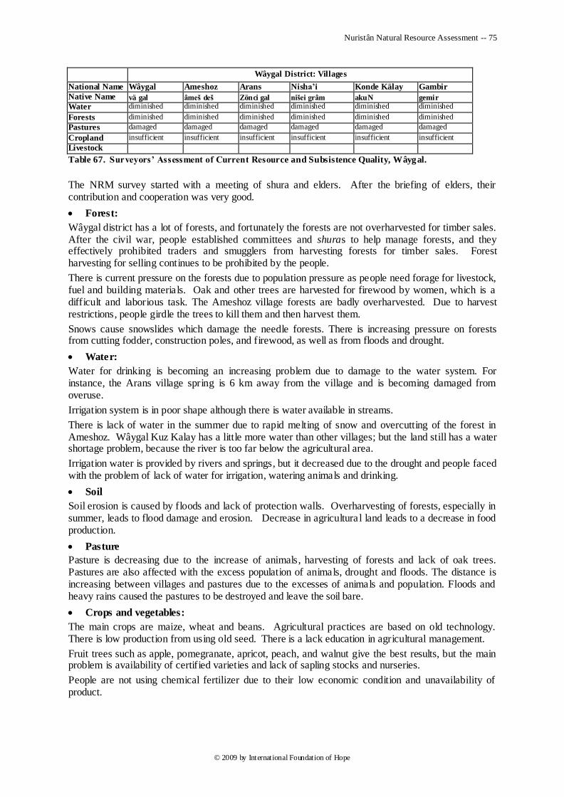
Nuristân Natural Resource Assessment -- 75
© 2009 by International Foundation of Hope
Wâygal District: Villages
National Name Wâygal Ameshoz Arans Nisha’i Konde Kälay Gambir
Native Name vä gal âmeš deš Zönci gal nišei grâm akuN gemir
Water diminished diminished diminished diminished diminished diminished
Forests diminished diminished diminished diminished diminished diminished
Pastures damaged damaged damaged damaged damaged damaged
Cropland insufficient insufficient insufficient insufficient insufficient insufficient
Livestock
Table 67. Surveyors’ Assessment of Current Resource and Subsistence Quality, Wâygal.
The NRM survey started with a meeting of shura and elders. After the briefing of elders, their contribution and cooperation was very good.
Forest:
Wâygal district has a lot of forests, and fortunately the forests are not overharvested for timber sales. After the civil war, people established committees and shuras to help manage forests, and they effectively prohibited traders and smugglers from harvesting forests for timber sales. Forest harvesting for selling continues to be prohibited by the people.
There is current pressure on the forests due to population pressure as people need forage for livestock, fuel and building materials. Oak and other trees are harvested for firewood by women, which is a difficult and laborious task. The Ameshoz village forests are badly overharvested. Due to harvest restrictions, people girdle the trees to kill them and then harvest them.
Snows cause snowslides which damage the needle forests. There is increasing pressure on forests from cutting fodder, construction poles, and firewood, as well as from floods and drought.
Water:
Water for drinking is becoming an increasing problem due to damage to the water system. For instance, the Arans village spring is 6 km away from the village and is becoming damaged from overuse.
Irrigation system is in poor shape although there is water available in streams.
There is lack of water in the summer due to rapid melting of snow and overcutting of the forest in Ameshoz. Wâygal Kuz Kalay has a little more water than other villages; but the land still has a water shortage problem, because the river is too far below the agricultural area.
Irrigation water is provided by rivers and springs, but it decreased due to the drought and people faced with the problem of lack of water for irrigation, watering animals and drinking.
Soil
Soil erosion is caused by floods and lack of protection walls. Overharvesting of forests, especially in summer, leads to flood damage and erosion. Decrease in agricultura l land leads to a decrease in food production.
Pasture
Pasture is decreasing due to the increase of animals, harvesting of forests and lack of oak trees. Pastures are also affected with the excess population of animals, drought and floods. The distance is increasing between villages and pastures due to the excesses of animals and population. Floods and heavy rains caused the pastures to be destroyed and leave the soil bare.
Crops and vegetables:
The main crops are maize, wheat and beans. Agricultural practices are based on old technology. There is low production from using old seed. There is a lack education in agricultural management.
Fruit trees such as apple, pomegranate, apricot, peach, and walnut give the best results, but the main problem is availability of certified varieties and lack of sapling stocks and nurseries.
People are not using chemical fertilizer due to their low economic condition and unavailability of product.
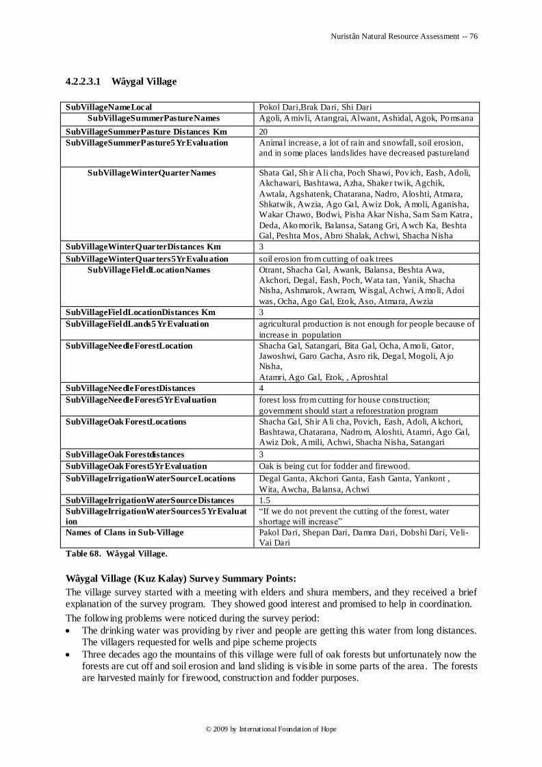
Nuristân Natural Resource Assessment -- 76
© 2009 by International Foundation of Hope
4.2.2.3.1 Wâygal Village
SubVillageNameLocal Pokol Dari,Brak Dari, Shi Dari
SubVillageSummerPastureNames Agoli, Amivli, Atangrai, Alwant, Ashidal, Agok, Pomsana
SubVillageSummerPasture Distances Km 20
SubVillageSummerPasture5YrEvaluation Animal increase, a lot of rain and snowfall, soil erosion,
and in some places landslides have decreased pastureland
SubVillageWinterQuarterNames Shata Gal, Sh ir A li cha, Poch Shawi, Pov ich, Eash, Adoli,
Akchawari, Bashtawa, Azha, Shaker twik, Agchik,
Awtala, Agshatenk, Chatarana, Nadro, Aloshti, Atmara,
Shkatwik, Awzia, Ago Gal, Awiz Dok, Amoli, Aganisha,
Wakar Chawo, Bodwi, Pisha Akar Nisha, Sam Sam Katra ,
Deda, Akomorik, Balansa, Satang Gri, Awch Ka, Beshta
Gal, Peshta Mos, Abro Shalak, Achwi, Shacha Nisha
SubVillageWinterQuarterDistances Km 3
SubVillageWinterQuarters5YrEvaluation soil erosion from cutting of oak trees
SubVillageFieldLocationNames Otrant, Shacha Gal, Awank, Balansa, Beshta Awa,
Akchori, Degal, Eash, Poch, Wata tan, Yanik, Shacha
Nisha, Ashmarok, Awram, Wisgal, Achwi, Amoli, Adoi
was, Ocha, Ago Gal, Etok, Aso, Atmara, Awzia
SubVillageFieldLocationDistances Km 3
SubVillageFieldLands5YrEvaluation agricultural production is not enough for people because of
increase in population
SubVillageNeedleForestLocation Shacha Gal, Satangari, Bita Gal, Ocha, Amoli, Gator,
Jawoshwi, Garo Gacha, Asro rik, Degal, Mogoli, A jo
Nisha,
Atamri, Ago Gal, Etok, , Aproshtal
SubVillageNeedleForestDistances 4
SubVillageNeedleForest5YrEvaluation forest loss from cutting for house construction;
government should start a reforestration program
SubVillageOak ForestLocations Shacha Gal, Sh ir A li cha, Povich, Eash, Adoli, Akchori,
Bashtawa, Chatarana, Nadrom, Aloshti, Atamri, Ago Gal,
Awiz Dok, Amili, Achwi, Shacha Nisha, Satangari
SubVillageOak Forestdistances 3
SubVillageOak Forest5YrEvaluation Oak is being cut for fodder and firewood.
SubVillageIrrigationWaterSourceLocations Degal Ganta, Akchori Ganta, Eash Ganta, Yankont ,
Wita, Awcha, Balansa, Achwi
SubVillageIrrigationWaterSourceDistances 1.5
SubVillageIrrigationWaterSources5YrEvaluat
ion
―If we do not prevent the cutting of the forest, water
shortage will increase‖
Names of Clans in Sub-Village Pakol Dari, Shepan Dari, Damra Dari, Dobshi Dari, Veli-
Vai Dari
Table 68. Wâygal Village.
Wâygal Village (Kuz Kalay) Survey Summary Points:
The village survey started with a meeting with elders and shura members, and they received a brief explanation of the survey program. They showed good interest and promised to help in coordination.
The following problems were noticed during the survey period:
The drinking water was providing by river and people are getting this water from long distances. The villagers requested for wells and pipe scheme projects
Three decades ago the mountains of this village were full of oak forests but unfortunately now the forests are cut off and soil erosion and land sliding is visible in some parts of the area. The forests are harvested mainly for firewood, construction and fodder purposes.

Nuristân Natural Resource Assessment -- 77
© 2009 by International Foundation of Hope
The pasture ranges are reduced because livestock increased and the forests are decreased near the village.
The Erâm area of this village has more agriculture land but there is no irrigation water to irrigate the land, the river is lower than the village and the people are not able to solve this problem.
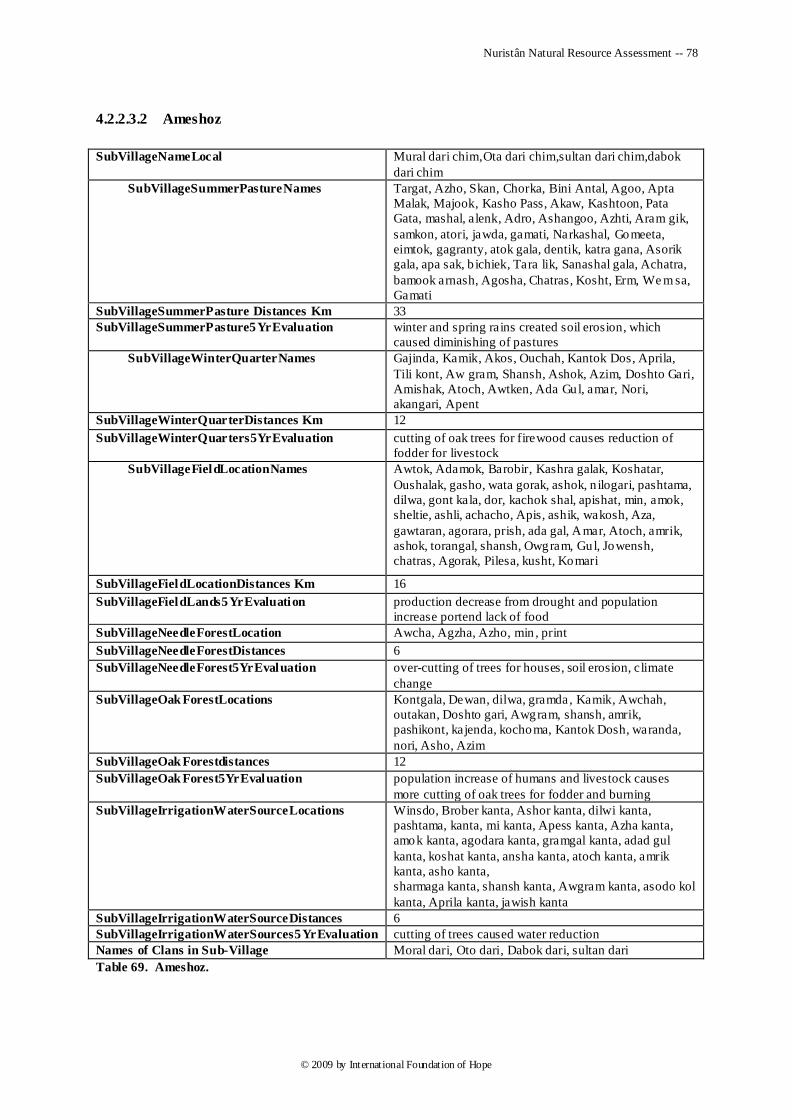
Nuristân Natural Resource Assessment -- 78
© 2009 by International Foundation of Hope
4.2.2.3.2 Ameshoz
SubVillageNameLocal Mural dari chim,Ota dari chim,sultan dari chim,dabok
dari chim
SubVillageSummerPastureNames Targat, Azho, Skan, Chorka, Bini Antal, Agoo, Apta
Malak, Majook, Kasho Pass, Akaw, Kashtoon, Pata
Gata, mashal, alenk, Adro, Ashangoo, Azhti, Aram gik,
samkon, atori, jawda, gamati, Narkashal, Gomeeta,
eimtok, gagranty, atok gala, dentik, katra gana, Asorik
gala, apa sak, b ichiek, Tara lik, Sanashal gala, Achatra,
bamook arnash, Agosha, Chatras, Kosht, Erm, We m sa,
Gamati
SubVillageSummerPasture Distances Km 33
SubVillageSummerPasture5YrEvaluation winter and spring rains created soil erosion, which
caused diminishing of pastures
SubVillageWinterQuarterNames Gajinda, Kamik, Akos, Ouchah, Kantok Dos, Aprila,
Tili kont, Aw gram, Shansh, Ashok, Azim, Doshto Gari,
Amishak, Atoch, Awtken, Ada Gul, amar, Nori,
akangari, Apent
SubVillageWinterQuarterDistances Km 12
SubVillageWinterQuarters5YrEvaluation cutting of oak trees for firewood causes reduction of
fodder for livestock
SubVillageFieldLocationNames Awtok, Adamok, Barobir, Kashra galak, Koshatar,
Oushalak, gasho, wata gorak, ashok, n ilogari, pashtama,
dilwa, gont kala, dor, kachok shal, apishat, min, amok,
sheltie, ashli, achacho, Apis, ashik, wakosh, Aza,
gawtaran, agorara, prish, ada gal, Amar, Atoch, amrik,
ashok, torangal, shansh, Owgram, Gul, Jowensh,
chatras, Agorak, Pilesa, kusht, Komari
SubVillageFieldLocationDistances Km 16
SubVillageFieldLands5YrEvaluation production decrease from drought and population
increase portend lack of food
SubVillageNeedleForestLocation Awcha, Agzha, Azho, min , print
SubVillageNeedleForestDistances 6
SubVillageNeedleForest5YrEvaluation over-cutting of trees for houses, soil erosion, climate
change
SubVillageOak ForestLocations Kontgala, Dewan, dilwa, gramda, Kamik, Awchah,
outakan, Doshto gari, Awgram, shansh, amrik,
pashikont, kajenda, kochoma, Kantok Dosh, waranda,
nori, Asho, Azim
SubVillageOak Forestdistances 12
SubVillageOak Forest5YrEvaluation population increase of humans and livestock causes
more cutting of oak trees for fodder and burning
SubVillageIrrigationWaterSourceLocations Winsdo, Brober kanta, Ashor kanta, dilwi kanta,
pashtama, kanta, mi kanta, Apess kanta, Azha kanta,
amok kanta, agodara kanta, gramgal kanta, adad gul
kanta, koshat kanta, ansha kanta, atoch kanta, amrik
kanta, asho kanta,
sharmaga kanta, shansh kanta, Awgram kanta, asodo kol
kanta, Aprila kanta, jawish kanta
SubVillageIrrigationWaterSourceDistances 6
SubVillageIrrigationWaterSources5YrEvaluation cutting of trees caused water reduction
Names of Clans in Sub-Village Moral dari, Oto dari, Dabok dari, sultan dari
Table 69. Ameshoz.
Nuristân Natural Resource Assessment -- 79
© 2009 by International Foundation of Hope
Ameshoz Survey Summary Points:
Survey started on 28th
of November in this village, first we met the elders and Islamic scholars and explained our survey program to them and then started the survey. The following points were noticed during the survey period: Forests were more affected than in the past due to the excess of population and animals. Oak
forests were harvested for feeding the animals and firewood.
Due to the cutting of the forests, the mountains cannot hold the snow for a long period. Snows are melting from rain and sunlight because of deforestation.
When the snow melts and rain occurs, it causes floods and destruction of agricultural lands and irrigation canals. After the summer season, the water availability is very low causing many problems for irrigation.
Irrigation water is provided by spring and a pipe scheme project that seems to work sufficiently well and people do not have much problem with delivery, only availability.
Lack of water has caused another problem, the non-availability of flour mills. People are traveling 4-5 Km distances to reach the flour mills.
Nuristân Natural Resource Assessment -- 80
© 2009 by International Foundation of Hope
4.2.2.3.3 Arans
SubVillageNameLocal Let dari chem
SubVillageSummerPastureNames Amish Ban, Aso Soma, Shankri, Kondah, Shogi,
Asrank, Azhok Brisa, Barsa, Aga Dak, Trimt ia, Maisa,
Lon Gal, Antlogal, Darom Sana
SubVillageSummerPasture Distances Km 40
SubVillageSummerPasture5YrEvaluation increase of animals, soil erosion, landslides, much
snowfall in winter, and much rain in summer all have
negative impact on pastureland
SubVillageWinterQuarterNames Adishi, Amish Ban, Shi Kaw, Acha Nisha, Bashti
Garam, Ori Wa, Ataza, Abanla, Ensa, Ensa Patai, Amar
Gana, Jamch Gal
SubVillageWinterQuarterDistances Km 25
SubVillageWinterQuarters5YrEvaluation soil erosion, human food decreasing
SubVillageFieldLocationNames Awtrant,Kachora, Atoa, Wat Majic, Chokari, Ashari,
Konda, Azhda, Gada Onaw, Sata Gal, Ako kani, Apro
Rik, Ensa, Amar Gana, Ataza, Nish Garam, Shink,
Garmatal, Akshok
SubVillageFieldLocationDistances Km 9
SubVillageFieldLands5YrEvaluation irrigation water decreased from cutting of forest; need
improved seeds and orchards
SubVillageNeedleForestLocation Adishi, Shogi, Amish Ban, Shankri, Konda
SubVillageNeedleForestDistances 7
SubVillageNeedleForest5YrEvaluation increased deforestation from cutting of trees for house
construction
SubVillageOak ForestLocations Acha Nisha, Ataza, Bishti Gram, Amar Gana, Deshda,
Adeshe, Adrang, Tapi Kaw, Akshok, Azhda, Soor Gal
SubVillageOak Forestdistances 24.5
SubVillageOak Forest5YrEvaluation population increase of people and livestock has brought
negative effects to the oak forest
SubVillageIrrigationWaterSourceLocations Desh Kanta, Bishti Gram, Konda, Abanla, Chokri
,Ashari,
Shink Kanta, Garamtal Kanta, Washam Kanta, Darop
Kanta,
Aso Kanta, Shoki Kanta, Ashikal Kanta, Amokia
SubVillageIrrigationWaterSourceDistances 6
SubVillageIrrigationWaterSources5YrEvaluation cutting of forest decreased water and dried up springs
Names of Clans in Sub-Village Jini Opiji, Kabod Way Opiji, Kawik Opiji, Eris Opiji,
Nadi Shang Opij, Wai Deen Opiji, Kacha Malo Opiji,
Alam Khan Opiji, Drapdari
Table 70. Arans.
Arans Survey Summary Points:
This village survey started with a meeting of elders and Islamic scholars of this village who were briefed about the survey program.
The following problems were noticed during the survey period:
Forests are affected due to overcutting for fire wood, construction use, and livestock feeding.
One problem is lack of education in sustainable forest management.
Water comes from the mountains and used for drinking and irrigation purposes. Twenty years previously MADERA constructed MHP (Micro Hydropower) in this village, but now it is not working well.
Canal rehabilitation is a big demand, because most of the water is lost before it reaches the land.
Nuristân Natural Resource Assessment -- 81
© 2009 by International Foundation of Hope
Since the plants and crops are growing well, most of the community members are requesting Orchard establishment projects.
4.2.2.3.4 Nishei Grâm
SubVillageNameLocal Atrö Chem,Brom Chem, Pem Chem, Mia
Chem,Shüvala Chem
SubVillageSummerPastureNames Oshag, Naskana, Wasa, Somani, Damgal, Sari Gal,
Wani, Awot, Goshing, Adri, Sees, Abongera, Achalak,
Ashtagal, Awsha, Boshgon
SubVillageSummerPasture Distances Km 9.5
SubVillageSummerPasture5YrEvaluation soil erosion and snow load has damages pastures 6%
SubVillageWinterQuarterNames Shpa Dark, Pashog, Abiti, Damagal, Golser, Doshigal,
Watita, Abli Grog, Ashla, Magarma
SubVillageWinterQuarterDistances Km 5.4
SubVillageWinterQuarters5YrEvaluation 60% increase in population and much snowfall has
caused erosion of 30 % of the soil
SubVillageFieldLocationNames Awtrant, Pit, Matigal, Mori, Abit i, Pril, Awtgorwega,
Domalish, Akongal, Fim, Kalog
SubVillageFieldLocationDistances Km 4
SubVillageFieldLands5YrEvaluation increase of population caused lack of food
SubVillageNeedleForestLocation Bartolag, Achlak, Adorigal, Bosh Kon, Magar, Ashalwi,
Galag, Agola, Watadog, Gawmera, Kalmata
SubVillageNeedleForestDistances 7
SubVillageNeedleForest5YrEvaluation forest is in danger from cutting of trees for construction
SubVillageOak ForestLocations Arwi, Tiz, Ayon Gabar, Achalak, Ashtigar, Awshal,
Boshi, Kon
SubVillageOak Forestdistances 5
SubVillageOak Forest5YrEvaluation 5% Oak trees are damages, and 3% soil erosion
SubVillageIrrigationWaterSourceLocations Masti Gul, Mori, Tiz, Agola, Magar, Par Tong
SubVillageIrrigationWaterSourceDistances 6.5
SubVillageIrrigationWaterSources5YrEvaluation three years ago there was severe drought and water
shortage, nowadays water has increased a little b it
Names of Clans in Sub-Village Astan dare˜, PaTül dare˜, Kosuk dare˜, KaNmin dare˜,
Sanki dare˜, Sunarat dare˜, Nali dare˜, DamDe dare˜,
BuRa dare˜, Břam dare˜, Shüvala
Table 71. Nishei Grâm.
Beyond the overall assessment given above for the district, no specific observations were noted for this village.
Nuristân Natural Resource Assessment -- 82
© 2009 by International Foundation of Hope
4.2.2.3.5 Kond Kalay
SubVillageNameLocal Waram Chem, Baram Chem, Sholi Chem, Kantodok,
Pakam Ten
SubVillageSummerPastureNames Awin, Sorik, Agtakov, Paro list, Dewri, Nil Panti,
Ashtara, Gala, Chal Barsik, Kev Maro, Marang ji
Takra, Berim Dâ, Ganja Pori, Shamoral
SubVillageSummerPasture Distances Km 10.7
SubVillageSummerPasture5YrEvaluation Soil erosion from winter snowfall damaged 5% of
pasture
SubVillageWinterQuarterNames Zardok, Paratol, Azhodak, gotla, Apla wart, Azhn doq,
Kolo, Kana, Bali Kanda, Prichi Wat, Want Gata,
Koshal, Badrist
SubVillageWinterQuarterDistances Km 4.5
SubVillageWinterQuarters5YrEvaluation 5% house increase and in winter much snowfall
damaged 30% of rangeland, fo rest, and soil
SubVillageFieldLocationNames Awtrant, Baratol, Azandok, Sovrik, Pakamten, Gotla,
Aran, Amirik, Bali Kanda, Wânt Gata, Wânt
SubVillageFieldLocationDistances Km 6
SubVillageFieldLands5YrEvaluation population increase and drought have caused lack of
food
SubVillageNeedleForestLocation Awchag, Agat Kaw, Sorik Ban, Dewri, Nil Panti,
Komro, Ashtara Gala, Ameen Cho, Chal Barseek,
Marangji Takra, Shamral, Ganja Pori
SubVillageNeedleForestDistances 11
SubVillageNeedleForest5YrEvaluation much snowfall in winter has damaged needle forest
through soil erosion
SubVillageOak ForestLocations Agototok, Amrik, Okashri, Pakamten, Soram Shal,
Andrish, Barata, Chit i Gal, Ganisha, Kolo Kana, Bali
Kanda, Prichi Wat, Agol Shal, Badrinst, Want Gata,
Kanto Doak, Kosha, Ashokora, Shtan
SubVillageOak Forestdistances 9.5
SubVillageOak Forest5YrEvaluation 5% of oak forest is fin ished and 5% soil erosion has
occured
SubVillageIrrigationWaterSourceLocations Pakamten Gata, Mata Manik Gata, Oadok Gata, Atrom ,
otla Gata, Baram Got la Gata, Deshi Gata, Zardok Gata,
Awimcha Gata, Om Och Gata, Dama Grok Gata
SubVillageIrrigationWaterSourceDistances 2.6
SubVillageIrrigationWaterSources5YrEvaluation three years ago water was less but now a days is ok
Names of Clans in Sub-Village Mast Khan dare˜, Dolok dare˜, Magol Khan dare˜,
Chira dare˜, Chanlo dare˜, Tora dare˜, Bröjan
Table 72. Kund Kalay.
Beyond the overall assessment given above for the district, no specific observations were noted for this village.
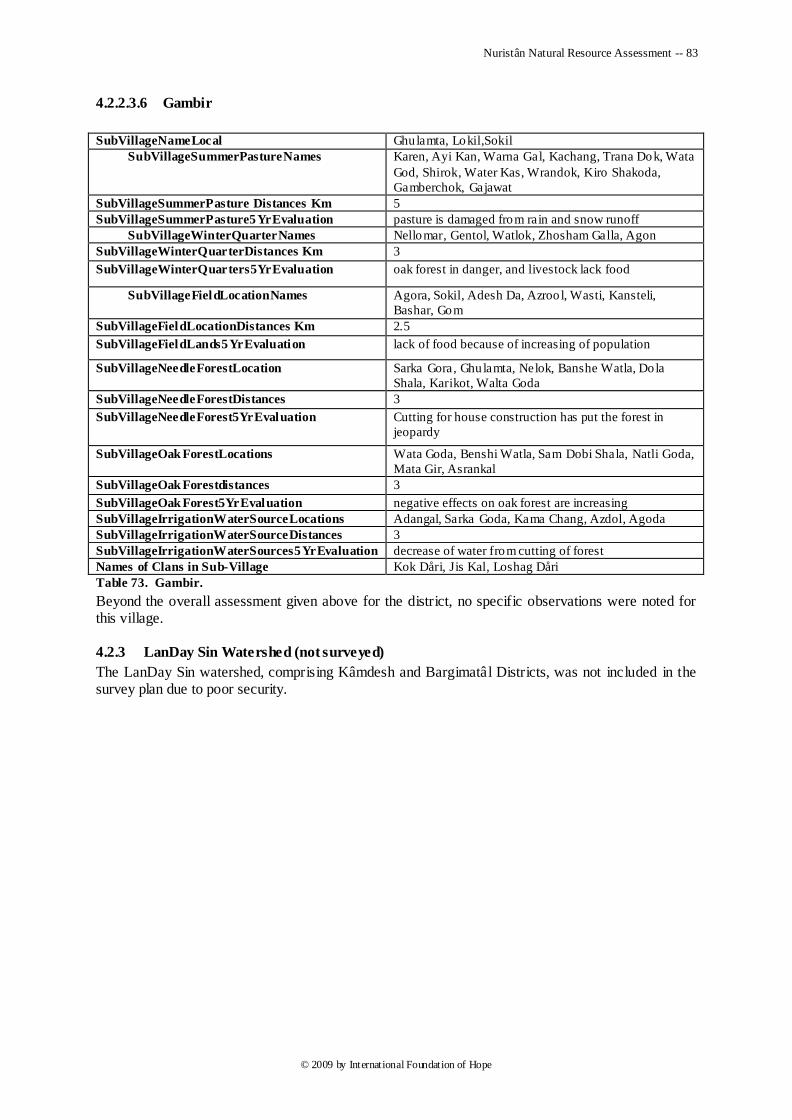
Nuristân Natural Resource Assessment -- 83
© 2009 by International Foundation of Hope
4.2.2.3.6 Gambir
SubVillageNameLocal Ghulamta, Lokil,Sokil
SubVillageSummerPastureNames
Karen, Ayi Kan, Warna Gal, Kachang, Trana Dok, Wata
God, Shirok, Water Kas, Wrandok, Kiro Shakoda,
Gamberchok, Gajawat
SubVillageSummerPasture Distances Km 5
SubVillageSummerPasture5YrEvaluation pasture is damaged from rain and snow runoff
SubVillageWinterQuarterNames Nellomar, Gentol, Watlok, Zhosham Galla, Agon
SubVillageWinterQuarterDistances Km 3
SubVillageWinterQuarters5YrEvaluation oak forest in danger, and livestock lack food
SubVillageFieldLocationNames
Agora, Sokil, Adesh Da, Azroo l, Wasti, Kansteli,
Bashar, Gom
SubVillageFieldLocationDistances Km 2.5
SubVillageFieldLands5YrEvaluation lack of food because of increasing of population
SubVillageNeedleForestLocation
Sarka Gora, Ghulamta, Nelok, Banshe Watla, Dola
Shala, Karikot, Walta Goda
SubVillageNeedleForestDistances 3
SubVillageNeedleForest5YrEvaluation Cutting for house construction has put the forest in
jeopardy
SubVillageOak ForestLocations
Wata Goda, Benshi Watla, Sam Dobi Shala, Natli Goda,
Mata Gir, Asrankal
SubVillageOak Forestdistances 3
SubVillageOak Forest5YrEvaluation negative effects on oak forest are increasing
SubVillageIrrigationWaterSourceLocations Adangal, Sarka Goda, Kama Chang, Azdol, Agoda
SubVillageIrrigationWaterSourceDistances 3
SubVillageIrrigationWaterSources5YrEvaluation decrease of water from cutting of forest
Names of Clans in Sub-Village Kok Dåri, Jis Kal, Loshag Dåri
Table 73. Gambir.
Beyond the overall assessment given above for the district, no specific observations were noted for this village.
4.2.3 LanDay Sin Watershed (not surveyed)
The LanDay Sin watershed, comprising Kâmdesh and Bargimatâl Districts, was not included in the survey plan due to poor security.
Nuristân Natural Resource Assessment -- 84
© 2009 by International Foundation of Hope
5 Conclusions and Recommendations
I. Summary:
Most of the areas surveyed are suffering from moderate to severe natural resources degradation. Population pressure is leading to over harvest of trees for fuel, building materials and fodder resulting in loss of ground cover leading to erosion, loss of pasture, rapid snow melt, downstream flooding and further loss of pasture and arable land. The problems are not isolated. A problem in one area will lead to a cycle of problems in other areas of the natural resource system.
Drought was mentioned by survey respondents as a major problem affecting the natural resource base. Consequences of drought range from moderate to severe, depending on altitude and westerliness. Each climatic zone has been adversely affected in most communities surveyed. Current assessments and recent environmental trends elicited from surveyors and surveyed residents appear in Table 32 and Table 33; they indicate drought as the major problem.
Increasing population pressure was given by most survey respondents as the second reason why the resource base is damaged and diminishing. Increased population means increased livestock pressure on forests and rangelands, as well as increased pressure to clear forestland for agriculture. The overall population is suffering from this increasing pressure on a decreasing supply of pasture and crop land. Pastureland is being lost through erosion and cropland is being lost through erosion and flooding. Women in particular are suffering through increasing distance they have to travel to collect wood and water.
Traditional Nuristâni institutions of resource management worked well up to the onset of climatic warming and international hostilities in the 1970s. Since then the lack of security and governance has allowed outsiders to plunder Nuristân‘s resources by undermining the traditional institutions of governance and regulation.
These problems are complex in that they are connected and interrelated. Dealing with one issue of natural resource management without understanding the whole and the interactions involved would have limited results. Especially at the natural resources management planning level, there should be a comprehensive and systematic approach.
II. Recommendations for Mitigation:
A. Natural Resource Mitigation: Natural Resource Mitigation should be planned as part of a comprehensive and integrated approach. Rather than focusing on just one natural resource problem, an integrated approach would consider the relationship between the differing resources affected, how impacts are felt in different parts of a catchment basin and how the management of one resource affects another. As mentioned previously, deforestation causes soil erosion, loss of pasture, downstream flooding and further loss of arable land downstream. It is important to understand that the resources are part of an integrated ecosystem and should be managed as such.
For the interventions to have a positive impact on watershed conditions, the adoption of the following principles is encouraged. The principles were proposed by Perez and Tschinkel (2003):
• Concentrate on contiguous sites defined by the threats to the landscape, chances of success and cost-effectiveness of the investment, where landscape and economic improvement will be self-evident.
• Include all stakeholders in watershed management rather than only the poor farmers in the target areas, as is the current practice among most development organizations.
• Select preventive rather than curative activities, and base them on land use capacity and income generating potential for maximum cost-effectiveness.
• Treat farmers, large and small, as informed clients to whom development organizations are accountable and who are capable of deciding what is good for them in the light of their resources, priorities and values.
B. Natural Resource Management for Nuristân: NRM management for Nuristân presents some unique challenges. Stakeholders are not accustomed to working together in committees to solve issues affecting a larger population or to address issues as complex as NRM. District shuras exist but
Nuristân Natural Resource Assessment -- 85
© 2009 by International Foundation of Hope
they are very limited in effectiveness and do not typically meet often. They tend to be non-functional or dysfunctional. This report is recommending an approach that factors in cultural considerations and that includes both a top-down and bottom-up approach.
Top-Down Planning: Overall NRM planning should be entrusted to a line ministry. The Environment Directorate supposedly operates directly under President Karzai, but it is unclear how active it is. If that Directorate is empowered, it would make sense to work with it as the lead planning agency. Otherwise MAIL would be appropriate since their responsibilities encompass many areas of NRM. There would need to be coordination with MRRD, but one Ministry should take the lead. The lead ministry would have the responsibility for intervention planning that encompasses an entire catchment area. This is important since Nuristâni‘s have a difficult time working together in a village structure let alone groups of villages in a catchment area that may cross cultural and linguist boundaries.
The lead Ministry would look at entire catchment and take the responsibility for planning interventions. Although interventions will contain discreet program elements, planners are encouraged to adopt a systems approach and address the entire watershed catchment as a planning unit. As a method of prioritization this includes for each catchment determining the following (suggested by Perez and Tschinkel 2003):
1. Where is the greatest risk of watershed degradation in the future?
2. Where is the highest probability of showing sustainable success quickly?
3. Where is the highest benefit for expended cost and effort?
Since district boundaries in Nuristân correspond exactly to catchment boundaries, a natural division for watershed catchment management would be at the district level. Further divisions would be based on populations inhabiting side valleys, their feeder streams and corresponding catchments. Watershed management projects need to start with rapid but systematic analyses of the nature and roles of stakeholders in the watershed. These analyses will be critical to design interventions that address the threats to and opportunities for watershed management created by the stakeholders‘ conditions and goals. Again, because of the linguistic and cultural diversity within Nuristân, and a cultural framework that does not support cooperative planning and decision making between villages, an outside ministry would be best positioned to undertake planning activities.
Existing ministries do not yet have the capacity to undertake such systematic planning activities that address s many areas of Natural Resource Management. One of the first steps therefore would be to develop a capacity building program using outside experts to work with line ministries to develop a systematic approach and integrated catchment development plan.
Bottom-up Approach: Of the existing and traditional cultural structures in Nuristân, the time-proven traditional resource management institution called the ura, under, malavře˜, or irin, should have a central role at the village level. They control fruit harvest, transhumance migration, and forest cutting. They are elected annually by the villagers to act as ―resource police‖ and have an important role in natural resource management. Working with the village elders and planning ministry responsible for an overall catchment plan, the ura should have a central role in implementing natural resource interventions at the village level. They would represent stakeholder interests to the planning process as well as communicate overall catchment planning priorities to the villagers.
To be effective, watershed management requires interagency and multi-user interactions and agreements regarding land-use decisions. It is critical for program implementers to engage in dialogue with citizens, village leaders and local governments to promote planning, management and evaluation of upland and downstream activities as a whole. This will require bridging several local government, cultural and political boundaries (i.e., village, sub-villages, tribes, and districts) within the watershed, fostering an understanding of environmental interactions and taking into account the many government, religious and customary laws and local norms that regulate access to natural resources. All of these considerations should be part of an Integrated Catchment Development Program (ICDP).
C. Integrated Catchment Development Program (ICDP): Components of an Integrated Catchment Development Program (ICDP) would some of the following elements. They should be
Nuristân Natural Resource Assessment -- 86
© 2009 by International Foundation of Hope
selected based on prioritized needs in a particular catchment following the criteria outlined above with consideration to greatest risk to the overall catchment, likelihood of success, sustainability, cost efficiency and cost/benefit analysis as well as stakeholder input.
One overarching consideration is that NRM strategies should focus on livelihood enhancement where possible to incentivize the participants. Other catchment development programs, including lessons learned by Mercy Corps in from a Kunduz Watershed Program implemented in 2007, have emphasized the importance of focusing on livelihood enhancement.
Fuelwood Production: Provide alternative source of fuelwood and building materials. Establish woodlots on private land close to villages. These will have beneficial impact on women who have to travel great distances to collect wood. Use faster growing trees for fuel wood and building material. Given the shortage of arable land, this might have to be combined with irrigation programs that increase the land available for planting.
Pasture Management/Slope Stabilization: Stabilize slopes with pasture regeneration program including perennial grasses and bushes/shrubs. Soil surface cover is more important than forest cover for protecting against soil erosion and can be accomplished more quickly and easily with grasses and shrubs than trees. Develop pasture management committees to monitor progress and regulate use. Pasture management plans need to be improved to include seeding plans and long-term rotations, perennial grasses.
Forestry Management and Reforestation: Reforestation is too long term to protect against soil erosion. Develop a long-term reforestation program in conjunction with village institutions using adaptable native species. Develop training and education programs in forestry management, including basic ecology and forest management, reforestation methods, selecting trees for harvesting, minimizing damage to cut trees, transportation methods, and marketing of timber.
Control logging by promoting community regulatory institutions, by interdicting outsiders from exploiting Nuristân‘s timber resources, and by reducing demand for firewood through more efficient cooking and heating technology. Afghâns and Gujars have a track record of degrading the environment, as can be seen in a comparison of denuded Afghân lands vs. Nuristâni forests. Most of the human-caused forest degradation in Nuristân can be attributed to exploitation by Afghân timber traders from both sides of the Durand Line. Keep the Afghâns and Gujars out of Nuristân, and let the Nuristânis maintain their own environment in the way they used to.
Orchard development: Most respondents expressed desire for assistance orchard establishment. Modify the minimally successful ADP/E program by incorporating lessons learned to establish adaptable fruit and nut orchards. Livelihoods will improve and there will be less pressure to harvest natural forest resources for sale. An education and training program should focus on the basics: planting, pruning, fertilizing; establishing nursery stock; pest and disease control; marketing techniques for fruits and nuts.
Nursery establishment: Establish private nurseries to produce fuelwood saplings, saplings for reforestation and adaptable fruit and nut saplings for livelihood enhancement. Community nurseries would not be sustainable.
Irrigation enhancement: Implement irrigation enhancement programs to increase agricultural production, including water storage for livestock and small-scale irrigation, river bank protection using gabion weave or cement structures, culverts to reduce erosion of roads where streams cross them, spring capture to provide water for hillside tree plots , stone check-dams, and terracing programs. Improve irrigation efficiency by building intakes, installing hydraulic ram pumps and improve delivery systems.
Drinking water: Develop piping system for water delivery from local springs. This would benefit women and reduce the distance they need to travel to collect water and reduce the need to obtain water from closer, but lower quality river sources.
Crop Production: Provide training in basic scientific agriculture within the local ecosystem, focusing on improving crop yields through soil analysis , organic vs. commercial fertilizer usage, and pest and disease control. Evaluate alternative crops that have cash income potential. Provide access
Nuristân Natural Resource Assessment -- 87
© 2009 by International Foundation of Hope
to certified seed and chemical fertilizer, which could improve subsistence-crop yields; but cropland is so scarce that producing commercial yields will be a challenge.
Animal Husbandry: Improve veterinary practices and services, including identifying and treating common livestock diseases and sanitary practices. Establish veterinary clinics (a frequent request of the villages surveyed). Provide training and support in dairy practices, including biological processes in dairy production, sanitary practices, and marketing techniques.
Mining: Provide training and assistance for locating gem and mineral deposits, evaluating gem deposits, operating mines, identifying and grading gemstones, increasing mine production, reducing damage to gem crystals during mining, marketing rough-cut gems, and establishing an Internet-based gem market for foreign buyers.
Education and Training: Provide environmental and conservational educational curricula starting in elementary school, and provide education to manage the development of resource commodities. NRM education would address and be part of each of the resource areas cited above. Curricula should be developed in the local languages to reinforce cultural acceptance.
Other Relevant Areas: Although these are not directly part of NRM, the following areas are important and do exert a significant impact on natural resources and/or natural resource management programs:
provide education for family planning and birth control;
stabilize inter-ethnic conflict zones by settling tribal-boundary disputes;
ensure security; environmental concerns fall well below security concerns in the volatile, hostile environment of Nuristân.
Evaluation and Continuous Improvement: Finally, it is suggested that interventions be developed based on feedback from farmers and other stakeholders. Too often USAID and its prime contractors focus on deliverables and accomplishing objectives. While these are important steps in project implementation, they are only first steps in what should be an integrative evaluative process. The lead author of this section, Du Bruille, developed a five point evaluation scheme used to evaluate the largest Afghan NGO working in Afghanistan in 1994. The approach included answering five basic questions and is recommended for interventions planned for Nuristân:
1. EFFECTIVENESS: Did the project meet its objectives. Too often evaluation stops here.
2. IMPACT: What were the results of achieving the objectives; what difference did the intervention make in the lives of the stakeholders?
3. EFFICIENCY: At what cost? What was the relationship between cost and resulting impact? What was the measure of bang for the buck?
4. SUSTAINABILITY: Can the impact of the project be sustained on its own or with limited additional input? Will it last? Can it be spread to other areas?
5. RELEVANCE: This question involves taking a step back and looking at overall development goals or at an organization‘s vision and mission. Do the answers to the previous four questions contribute to overarching objectives?
Evaluation should be an ongoing process that seeks participation from farmers and other stakeholders and continues to modify its approach, evaluate assumptions and strive for continuous improvement.
D. Follow-up Assessment and Natural Resource Monitoring
One of the objectives of the NNRA was to establish benchmark data. To gain the most long-term value of this assessment, periodic and regular follow-up natural resource assessments should be conducted in the surveyed districts. Through the information gathered, a much greater sense of natural resource degradation could be obtained by evaluating impact over time. Also some of the measurements were seasonally based, such as stream flow, and should be measured at different times of the year to further establish baseline data. A few data points in the current survey are questionable (highlighted in magenta in this document) and may reflect poor translation in one of the three survey languages with a misunderstanding of the questions asked or a recording error. These data should be revisited during follow up assessments.
Nuristân Natural Resource Assessment -- 88
© 2009 by International Foundation of Hope
6 Bibliography
Edelberg, Lennart, and Schuyler Jones. Nuristân. Graz: Akademische Druck- u. Verlagsanstalt, 1979.
Favre, Raphy, and Gulam Monowar Kamal. Watershed Atlas of Afghanistan. Swiss Agency for Development and Cooperation, FAO, AIMS, Kabul, 2004.
Fischer, D. "Waldverbreitung, bäuerliche Waldwirtschaft und kommerzielle Waldnutzung im östlichen Afghanistan." Afghanische Studien 2 (1970).
Humlum, J. La géographie de l'Afghanistan. Copenhagen, 1959.
Katz, David J. Kafir to Afghan: Religious Conversion, Political Incorporation and Ethnicity in the Wâygal Valley, Nuristân. Los Angeles: UCLA Ph.D. Dissertation, 1981.
Køie, M., and K. H. Rechinger. Symbolae Afghanicae: Enumeration and description of the plants collected by L Edelberg and M. Køie on the Third Danish Expedition to Central Asia. 5 vols. København: Det Kongelige Danske Videnskabernes Selskab, 1954-1963.
Larsson, Katarina. Provincial Survey of Nuristân. Stockholm: Swedish Committee for Afghanistan, 2006.
Nuristâni, Ahmad Yusuf. "The Palae of Nuristâni (A Type of Cooperative Dairy and Cattle Farming)." In Vergleichende Kulturgeographie der Hochgebirge des südlichen Asien , by Carl Rathjens, Carl Troll and Harald Uhlig, 177-181. Wiesbaden: Franz Steiner Verlag, 1973.
Perez, Carlos, and Henry Tschinkel. Improving Watershed Management in Developing Countries: A Framework for Prioritising Sites and Practices. Network Paper No. 129, Agricultural Research & Extension Network, July 2003.
Petocz, Ronald G., and John Y. Larsson. Ecological reconnaissance of western Nuristân with recommendations for management. Kâbul: United Nations Development Programme, Food and Agriculture Organization of the United Nations [and] Department of Forests and Range, Ministry of Agriculture, 1977.
Robertson, George Scott. The Káfirs of the Hindu-Kush. London: Lawrence & Bullen, Ltd., 1896.
Scheibe, Arnold (ed). Deutsche im Hindukusch: Bericht der Deutschen Hindukusch Ekspedition 1935 der Deutschen Forschungsgemeinschaft. Berlin: Deutsches Forschungsgemeinschaft, 1937.
Strand, Richard F. "Notes on the Nûristânî and Dardic Languages." Journal of the American Oriental Society 93, no. 3 (1973): 297-305.
—. "The Changing Herding Economy of the Kom Nuristâni." Afghanistan Journal 2, no. 4 (1975): 123-134.
—. Richard Strand's Nuristân Site. 1997[-present]. http://users.sedona.net/~strand.
—. "Lexicons of the Hindu-Kush: Kâmviri Lexicon." Richard Strand's Nuristân Site. 1999. http://users.sedona.net/~strand/lngFrameL.html.
—. "Transcription and Pronunciation of the Nuristâni Languages." Richard Strand's Nuristân Site. 2007. http://users.sedona.net/~strand/Nuristâni/phon.html.
—. Nuristân Provincial Handbook: A Guide to the People and the Province. Arlington, VA: IDS International, 2008. UNEP [United Nations Environment Programme]. Afghanistan Post-Conflict Environmental Assessment. Geneva, Switzerland: UNEP, 2003.
Vavilov, N. I., and D. D. Bukinich. Agricultural Afghanistan. Leningrad, 1929.
Zamân Xân and Strand, Richard F. "Topics in Vâsi Ethnography: 9. Animal Husbandry." Richard Strand's Nuristân Site. 1998. http://users.sedona.net/~strand/Nuristâni/Vasi/VasiCulture/Zaman9.html.
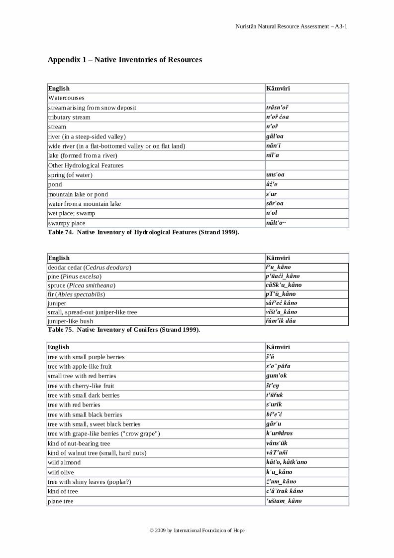
Nuristân Natural Resource Assessment – A3-1
© 2009 by International Foundation of Hope
Appendix 1 – Native Inventories of Resources
English Kâmviri
Watercourses
stream arising from snow deposit trâsn'oř
tributary stream n'oř ćoa
stream n'oř
river (in a steep-sided valley) gâl'oa
wide river (in a flat-bottomed valley or on flat land) nân'i
lake (fo rmed from a river) nil'a
Other Hydrolog ical Features
spring (of water) uns'oa
pond âź'o
mountain lake or pond s'ur
water from a mountain lake sâr'oa
wet place; swamp n'ol
swampy place nâlt'o~
Table 74. Native Inventory of Hydrological Features (Strand 1999).
English Kâmviri
deodar cedar (Cedrus deodara) ř'u_kâno
pine (Pinus excelsa) p'üaći_kâno
spruce (Picea smitheana) câSk'u_kâno
fir (Abies spectabilis) pT'ü_kâno
juniper sâř'eć kâno
small, spread-out juniper-like tree višt'a_kâno
juniper-like bush řâm'ik dâa
Table 75. Native Inventory of Conifers (Strand 1999).
English Kâmviri
tree with small purple berries š'ü
tree with apple-like fruit s'o˜ pâřa
small tree with red berries gum'ok
tree with cherry-like fruit št'eŋ
tree with small dark berries t'üřuk
tree with red berries s'urik
tree with small black berries bř'e˜ć
tree with small, sweet black berries gâr'u
tree with grape-like berries ("crow grape") k'ur#dros
kind of nut-bearing tree vâns'ük
kind of walnut tree (small, hard nuts) vâT'uňi
wild almond kât'o, kâtk'ano
wild olive k'u_kâno
tree with shiny leaves (poplar?) ź'um_kâno
kind of t ree c'â˜trak kâno
plane tree 'uštam_kâno
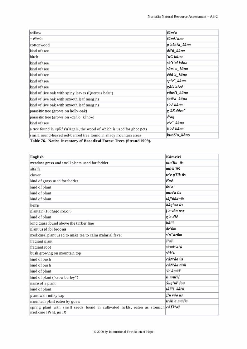
Nuristân Natural Resource Assessment – A3-2
© 2009 by International Foundation of Hope
willow řâm'o
= řâm'o řâmk'ano
cottonwood p'okořa_kâno
kind of t ree âź'ü_kâno
birch 'oC kâno
kind of t ree sâ˜t'ul kâno
kind of t ree sârv'o_kâno
kind of t ree ćâň'a_kâno
kind of t ree sp'e˜_kâno
kind of t ree gâls'ařeć
kind of live oak with spiny leaves (Quercus balut) vâns'i_kâno
kind of live oak with smooth leaf marg ins źaň'o_kâno
kind of live oak with smooth leaf marg ins t'eć kâno
parasitic tree (grows on holly-oak) g'âS dâro
parasitic tree (grows on «zañ'o_kâno») ć'oŋ
kind of t ree c'e˜_kâno
a tree found in «pRâs'ü˜#gal», the wood of which is used for ghee pots k'eć kâno
small, round-leaved red-berried tree found in shady mountain areas kunS'o_kâno
Table 76. Native Inventory of Broadleaf Forest Trees (Strand 1999).
English Kâmviri
meadow grass and small plants used for fodder nin'ila=üs
alfalfa mü·k'üS
clover tr'e pTik üs
kind of g rass used for fodder ř'oć
kind of p lant üv'o
kind of p lant mus'a üs
kind of p lant tâj'üňa=üs
hemp bâŋ'oa üs
plantain (Platago major) j'a vâa por
kind of p lant g'o dić
long grass found above the timber line bâl'i
plant used for brooms dr'üm
medicinal plant used to make tea to calm malarial fever s'o˜ drüm
fragrant plant š'aš
fragrant root sâmk'ařü
bush growing on mountain top sâk'u
kind of bush câN'âa üs
kind of bush câN'âa tâňi
kind of p lant 'ić âmâř
kind of p lant ("crow barley") k'ur#řić
name of a plant Suŋ'uř ćoa
kind of p lant tâň'i_kâřü
plant with milky sap ź'u vâa üs
mountain plant eaten by goats trâk'a mâćia
spring plant with small seeds found in cultivated fields, eaten as stomach
medicine [Psht. jin'ïR]
câTk'oš
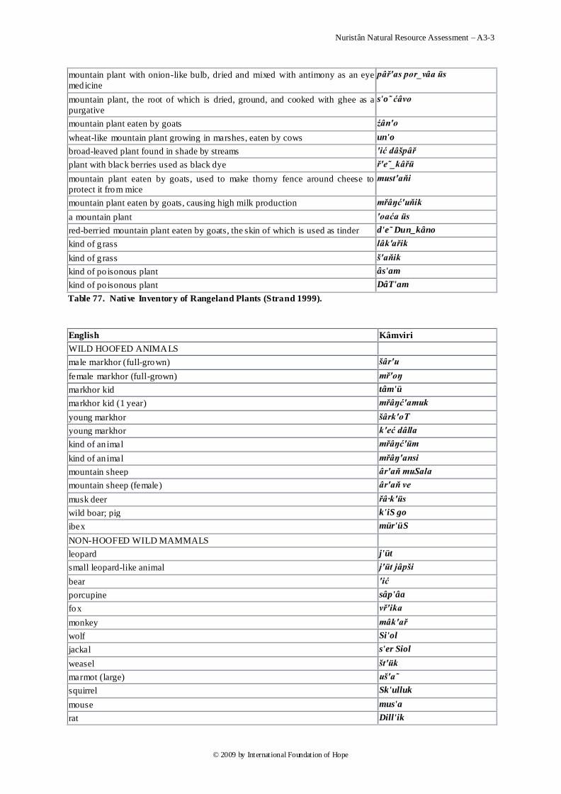
Nuristân Natural Resource Assessment – A3-3
© 2009 by International Foundation of Hope
mountain plant with onion-like bulb, dried and mixed with antimony as an eye
medicine
pâř'as por_vâa üs
mountain plant, the root of which is dried, ground, and cooked with ghee as a
purgative
s'o˜ ćâvo
mountain plant eaten by goats źân'o
wheat-like mountain plant growing in marshes, eaten by cows un'o
broad-leaved plant found in shade by streams 'ić dâšpâř
plant with black berries used as black dye ř'e˜_kâřü
mountain plant eaten by goats, used to make thorny fence around cheese to
protect it from mice
must'aňi
mountain plant eaten by goats, causing high milk production mřâŋć'uňik
a mountain plant 'oaća üs
red-berried mountain plant eaten by goats, the skin of which is used as tinder d'e˜ Dun_kâno
kind of g rass lâk'ařik
kind of g rass š'aňik
kind of po isonous plant âs'am
kind of po isonous plant DâT'am
Table 77. Native Inventory of Rangeland Plants (Strand 1999).
English Kâmviri
WILD HOOFED ANIMALS
male markhor (full-grown) šâr'u
female markhor (full-grown) mř'oŋ
markhor kid tâm'ü
markhor kid (1 year) mřâŋć'amuk
young markhor šârk'oT
young markhor k'eć dâlla
kind of an imal mřâŋć'üm
kind of an imal mřâŋ'ansi
mountain sheep âr'aň muSala
mountain sheep (female) âr'aň ve
musk deer řâ·k'üs
wild boar; pig k'iS go
ibex mür'üS
NON-HOOFED WILD MAMMALS
leopard j'üt
small leopard-like animal j'üt jâpši
bear 'ić
porcupine sâp'âa
fox vř'ika
monkey mâk'ař
wolf Si'ol
jackal s'er Siol
weasel št'ük
marmot (large) uš'a˜
squirrel Sk'ulluk
mouse mus'a
rat Dill'ik
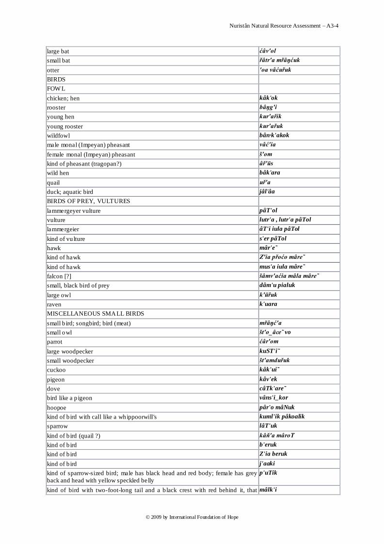
Nuristân Natural Resource Assessment – A3-4
© 2009 by International Foundation of Hope
large bat ćâv'ol
small bat řâtr'a mřâŋćuk
otter 'oa vâćuřuk
BIRDS
FOW L
chicken; hen kâk'ok
rooster bâŋg'i
young hen kur'ařik
young rooster kur'ařuk
wildfowl bân·k'akok
male monal (Impeyan) pheasant vâć'ia
female monal (Impeyan) pheasant š'om
kind of pheasant (tragopan?) âř'üs
wild hen bâk'ara
quail uř'a
duck; aquatic bird jâl'âa
BIRDS OF PREY, VULTURES
lammergeyer vulture pâT'ol
vulture lutr'a , lutr'a pâTol
lammergeier âT'i iula pâTol
kind of vu lture s'er pâTol
hawk mâr'e˜
kind of hawk Z'ia přoćo mâre˜
kind of hawk mus'a iula mâre˜
falcon [?] šâmv'aćia mâla mâre˜
small, black bird of prey dâm'u pialuk
large owl k'üřuk
raven k'uara
MISCELLANEOUS SMALL BIRDS
small b ird; songbird; bird (meat) mřâŋć'a
small owl št'o_âce˜ vo
parrot ćâr'om
large woodpecker kuST'i˜
small woodpecker št'amduřuk
cuckoo kâk'ui
pigeon kâv'ek
dove câTk'are
bird like a p igeon vâns'i_kor
hoopoe pâr'o mâNuk
kind of b ird with call like a whippoorwill's kuml'ik pâkoalik
sparrow lâT'uk
kind of b ird (quail ?) kâň'a mâroT
kind of b ird b'eruk
kind of b ird Z'ia beruk
kind of b ird j'aaki
kind of sparrow-sized bird; male has black head and red body; female has grey
back and head with yellow speckled belly
p'uTik
kind of bird with two-foot-long tail and a b lack crest with red behind it, that mâlk'i
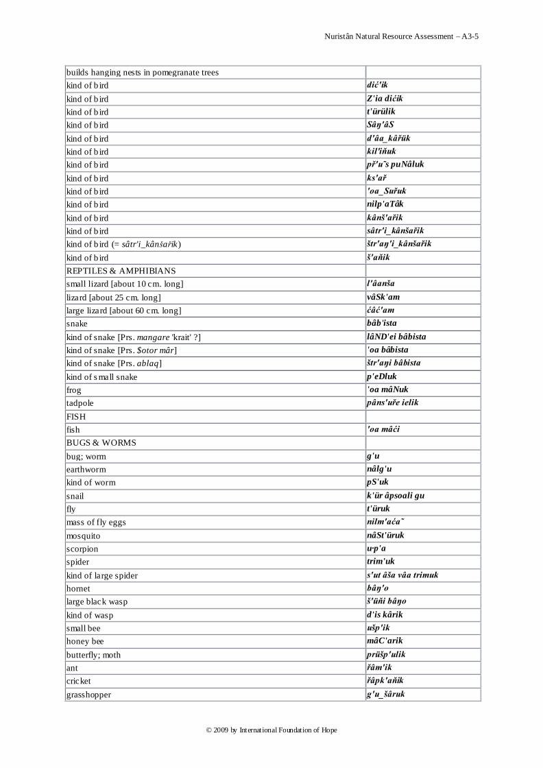
Nuristân Natural Resource Assessment – A3-5
© 2009 by International Foundation of Hope
builds hanging nests in pomegranate trees
kind of b ird dić'ik
kind of b ird Z'ia dićik
kind of b ird t'ürülik
kind of b ird Sâŋ'âS
kind of b ird d'âa_kâřük
kind of b ird kil'iňuk
kind of b ird př'u˜s puNâluk
kind of b ird ks'ař
kind of b ird 'oa_Suřuk
kind of b ird nilp'aTâk
kind of b ird kânš'ařik
kind of b ird sâtr'i_kânšařik
kind of b ird (= sâtr'i_kânšařik) štr'aŋ'i_kânšařik
kind of b ird š'aňik
REPTILES & AMPHIBIANS
small lizard [about 10 cm. long] l'âanša
lizard [about 25 cm. long] vâSk'am
large lizard [about 60 cm. long] ćâć'am
snake bâb'ista
kind of snake [Prs. mangare 'krait' ?] lâND'ei bâbista
kind of snake [Prs. $otor mâr] 'oa bâbista
kind of snake [Prs. ablaq] štr'aŋi bâbista
kind of s mall snake p'eDluk
frog 'oa mâNuk
tadpole pâns'uře ielik
FISH
fish 'oa mâći
BUGS & WORMS
bug; worm g'u
earthworm nâlg'u
kind of worm pS'uk
snail k'ür âpsoali gu
fly t'üruk
mass of fly eggs nilm'aća˜
mosquito nâSt'üruk
scorpion u·p'a
spider trim'uk
kind of large spider s'ut âša vâa trimuk
hornet bâŋ'o
large black wasp š'üňi bâŋo
kind of wasp d'is kârik
small bee ušp'ik
honey bee mâC'arik
butterfly; moth prüšp'ulik
ant řâm'ik
cricket řâpk'aňik
grasshopper g'u_šâruk
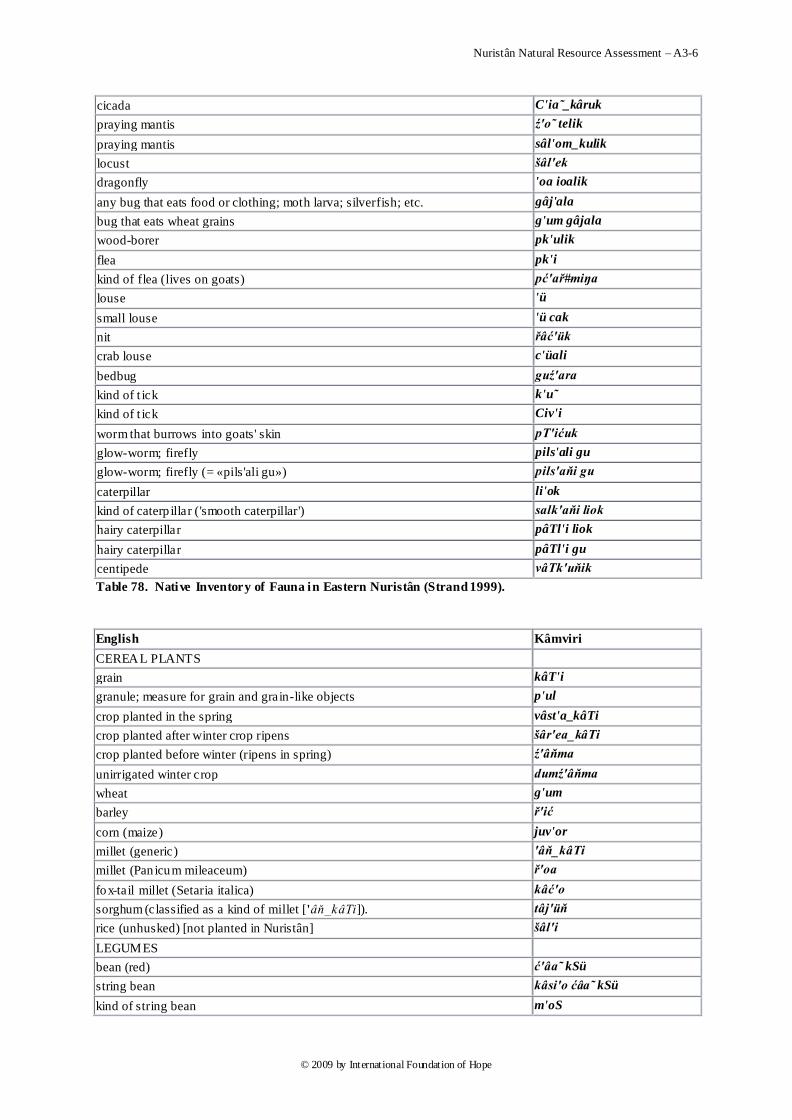
Nuristân Natural Resource Assessment – A3-6
© 2009 by International Foundation of Hope
cicada C'ia˜_kâruk
praying mantis ź'o˜ telik
praying mantis sâl'om_kulik
locust šâl'ek
dragonfly 'oa ioalik
any bug that eats food or clothing; moth larva; silverfish; etc. gâj'ala
bug that eats wheat grains g'um gâjala
wood-borer pk'ulik
flea pk'i
kind of flea (lives on goats) pć'ař#miŋa
louse 'ü
small louse 'ü cak
nit řâć'ük
crab louse c'üali
bedbug guź'ara
kind of t ick k'u˜
kind of t ick Civ'i
worm that burrows into goats' skin pT'ićuk
glow-worm; firefly pils'ali gu
glow-worm; firefly (= «pils'ali gu») pils'aňi gu
caterpillar li'ok
kind of caterp illar ('smooth caterpillar') salk'aňi liok
hairy caterpillar pâTl'i liok
hairy caterpillar pâTl'i gu
centipede vâTk'uňik
Table 78. Native Inventory of Fauna in Eastern Nuristân (Strand 1999).
English Kâmviri
CEREAL PLANTS
grain kâT'i
granule; measure for grain and grain-like objects p'ul
crop planted in the spring vâst'a_kâTi
crop planted after winter crop ripens šâr'ea_kâTi
crop planted before winter (ripens in spring) ź'âňma
unirrigated winter crop dumź'âňma
wheat g'um
barley ř'ić
corn (maize) juv'or
millet (generic) 'âň_kâTi
millet (Pan icum mileaceum) ř'oa
fox-tail millet (Setaria italica) kâć'o
sorghum (classified as a kind of millet ['âň_kâTi]). tâj'üň
rice (unhusked) [not planted in Nuristân] šâl'i
LEGUMES
bean (red) ć'âa˜ kSü
string bean kâsi'o ćâa˜ kSü
kind of string bean m'oS
Nuristân Natural Resource Assessment – A3-7
© 2009 by International Foundation of Hope
soybean kS'ü
mung bean c'ül mo
kind of red lentil [Prs. «dâl-e nask»] ćün'uk
pea Z'üm
VEGETABLES
squash (pumpkin-shaped) âl'oa
gourd 'oa_âve˜_âloa
onion câk'uNuk
potato âl'u
pepper m'oc
MISCELLANEOUS CULTIVATED PLANTS AND PLANT PRODUCTS
cotton pâc'a vâruk
tobacco tâmk'ü
opium târi'ok
Table 79. Native Inventory of Cultivated Plants (Strand 1999).
walnut iâmř'’u
mulberry kuml'ik
black mulberry Z'ia_kumlik
pink mulberry br'âmkuni
white mulberry kâš'ari kumlik
small white mulberry m'us kumlik
variety of mulberry mišk'oni kumlik
wild mulberry ź'ül kumlik
fig kiv'it
variety of large fig ("Kâbul fig") kobl'i kivit
pomegranate âm'âř
variety of pomegranate ("sour pomegranate") câN'âa âmâř
variety of pomegranate âr'usâa âmâř
variety of pomegranate câN'âa muri âmâř
apricot ćar'i˜
variety of apricot with edible seed vić'☠ćari˜
apricot with bitter nut inside pit kâř'âa ćari˜
apple pâř'a
variety of apple ("sour apple") câN'âa pâřa
variety of apple ("sweet apple") m'uri pâřa
variety of apple ("sweet and sour apple") câN'âa muri pâřa
variety of apple ("bitter apple") kâř'âa pâřa
peach âr'u
variety of peach buC'a vâa âru
variety of peach CâC'a˜_âru
pear T'um
wild pear T'âŋari
jujube sunš'a
species of jujube bât'ar
species of jujube [Prs. sonjet] bil'a˜_sunša
grape dr'os
Nuristân Natural Resource Assessment – A3-8
© 2009 by International Foundation of Hope
bunch of grapes (measure) ř'oć
red grape ât'eC dros
kind of red grape mâC'ia˜ dros
large green grape kârT'uk dros
variety of grape 'oa mâřuk dros
variety of grape ('cow-teat grape') g'o cuk dros
variety of grape lâŋ'aNo dros
variety of grape sk'anšol dros
variety of grape ("black-crunchy grape") Z'ia pTaňi dros
variety of grape ("round-raceme grape") puNr'a řoć dros
variety of grape ("rat grape") Dill'ik dros
variety of grape ("pumpkin -leaved grape") âl'oa por vâa dros
variety of grape ("sling grape") mit'i·oNi dros
persimmon gâlm'unuk
Table 80. Native Inventory of Cultivated Trees (Strand 1999).
FODDER
fodder 'üs tüs
corn or millet stalk used for fodder kâT'e˜
fodder from crop planted after winter crop šâr'ea_kâTe˜
straw; chaff p'üř
empty millet ear used for fodder t'üs
large pieces of straw left after threshing gâN·p'üř
chaff trućp'üř
haystack (measure) g'oT
stack of grass or grain stalks 'üs goT
stack of straw p'üř goT
pile of grass, stalks, etc. b'o
FODDER PLANTS
meadow grass and small plants used for fodder nin'ila=üs
alfalfa mü·k'üS
kind of g rass used for fodder ř'oć
clover tr'e pTik üs
Table 81. Native Inventory of Fodder Types and Plants (Strand 1999).
EDIBLE WILD GREEN PLANTS
greens ć'o
mint vř'i˜uk
lambs quarter trâtr'a
coriander [?] kânl'ik
nettle dâć'ü˜
edible plant v'iS
edible plant ź'uňik
kind of ed ible p lant dâň'alik
edible plant that grows in cult ivated fields g'um üs
kind of ed ible p lant found in winter-crop fields («lâm'aroT» dialect) gulgul'â·Ti
Nuristân Natural Resource Assessment – A3-9
© 2009 by International Foundation of Hope
kind of wild onion k'u pon
kind of wild onion âr'uS
leek (wild) p'on
kind of wild turnip cânl'ü_kuřuk
wild rhubarb ćâv'o
rhubarb-like p lant âr'os
wild strawberry b'üm ânSuk
cumin âi'o
thyme [Prs. «zamc»] sâtrk'aň
MUSHROOMS
morel mushroom g'o kTluk
white morel mushroom kâš'ara go kTluk
black morel mushroom Z'ia go kTluk
kind of ed ible mushroom (like morel) u·'i vo go kTluk
edible mushroom gřân·ć'ok
Table 82. Native Inventory of Gathered Edible Plants (Strand 1999).
English Kâmviri
milk ź'u
milk products d'iamatia
pre-Islamic ritual offering of dairy products l'oa
raw milk âmź'u
"skin" on milk; cream p'ic
cream ź'u pic
colostrum (unboiled) kâtź'u
boiled colostrum břâkź'a
yoghurt tr'üa źu
butter nuř'i
unclarified part of melted butter přâš'ol
ghee ân'ua
ghee made from goats' milk vâs'e_ânua
buttermilk niv'o
buttermilk solids sâc'uŋ
dried buttermilk curds câN'o bâTa
liquid part of buttermilk Ck'ala=oa
starter for milk fermentation â·'ü
curdled milk used to make cheese gř'âa źu
lumps in gřâa źu gřut'uk
whey (from gřâa źu) il'a
curdled il’a ćk'ara=küN
solid part of ćk’arküN ćk'ara
liquid part of ćk’arküN ćk'ara=Ckala=oa
"pre-cheese" formed by squeezing together gřut’uk přâl'ia
liquid squeezed out of přâlia št'ü
přâlia ready for eating kilt'in
cheese kil'âř
Nuristân Natural Resource Assessment – A3-10
© 2009 by International Foundation of Hope
small cheese kilpř'oć
soft cheese made in midwinter ź'e˜ kilpřoć
cheese made from milk after goats eat hollyoak leaf buds in early spring vâ˜ćpř'u˜s kilâř
cheese made from the curds that form from adding one part buttermilk to two parts boiling milk
âm'iS
food (normally a dairy product) eaten with bread miS'oa
cheese pickled in brine or vinegar câNst'a bâTa
Table 83. Native Inventory of Dairy Products from Eastern Nuristân (Strand 1999).
January
February
March
April
May
JuneJuly
August
September
October
November
December
g'eř du
p'âTli
muns'ini l'u˜
mât'a˜
gic'ei
vi r 'iu˜tâsk'a
mâř'a mo
âi 'u
d'u bo˜
âš'andro˜
dâr'a˜
p'☠tâřa sta
Figure 2. Kom Nuristâni Traditional Calendar, Showing Names of Months in White and Alignment with
the Gregorian Calendar on 18 March 1969 (after Strand 1999).
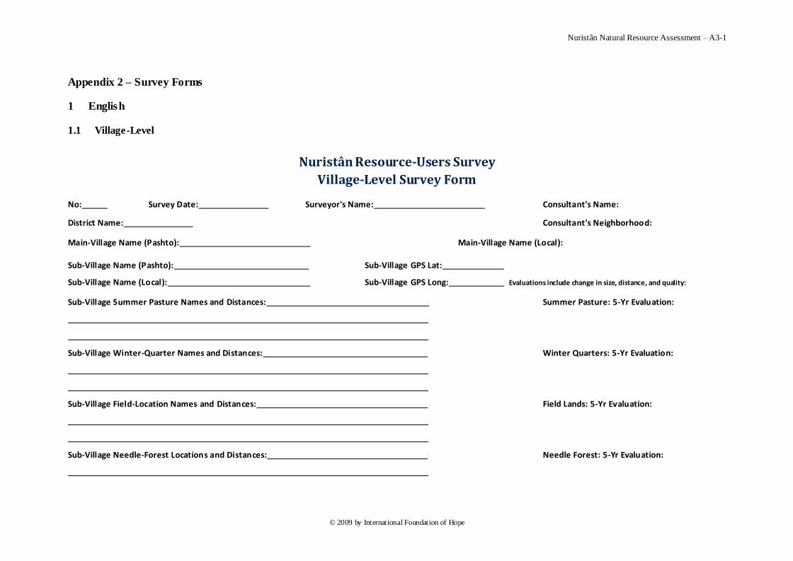
Nuristân Natural Resource Assessment – A3-1
© 2009 by International Foundation of Hope
Appendix 2 – Survey Forms
1 English
1.1 Village-Level
Nuristân Resource-Users Survey
Village-Level Survey Form
No: Survey Date: Surveyor's Name: Consultant's Name:
District Name: Consultant's Neighborhood:
Main-Village Name (Pashto): Main-Village Name (Local):
Sub-Village Name (Pashto): Sub-Village GPS Lat:
Sub-Village Name (Local): Sub-Village GPS Long: Evaluations include change in size, distance, and quality:
Sub-Village Summer Pasture Names and Distances: Summer Pasture: 5-Yr Evaluation:
Sub-Village Winter-Quarter Names and Distances: Winter Quarters: 5-Yr Evaluation:
Sub-Village Field-Location Names and Distances: Field Lands: 5-Yr Evaluation:
Sub-Village Needle-Forest Locations and Distances: Needle Forest: 5-Yr Evaluation:
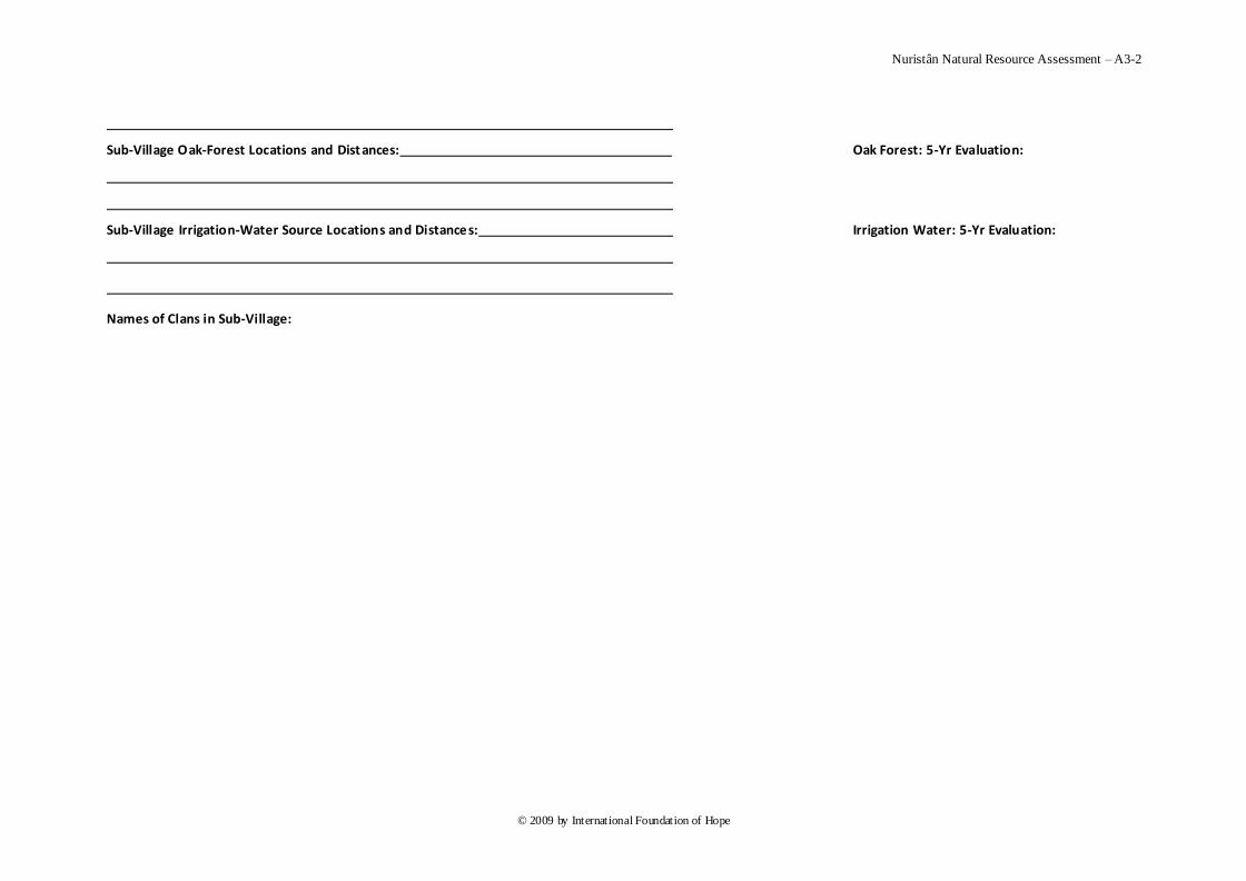
Nuristân Natural Resource Assessment – A3-2
© 2009 by International Foundation of Hope
Sub-Village Oak-Forest Locations and Dist ances: Oak Forest: 5-Yr Evaluation:
Sub-Village Irrigation-Water Source Locations and Distances: Irrigation Water: 5-Yr Evaluation:
Names of Clans in Sub-Village:
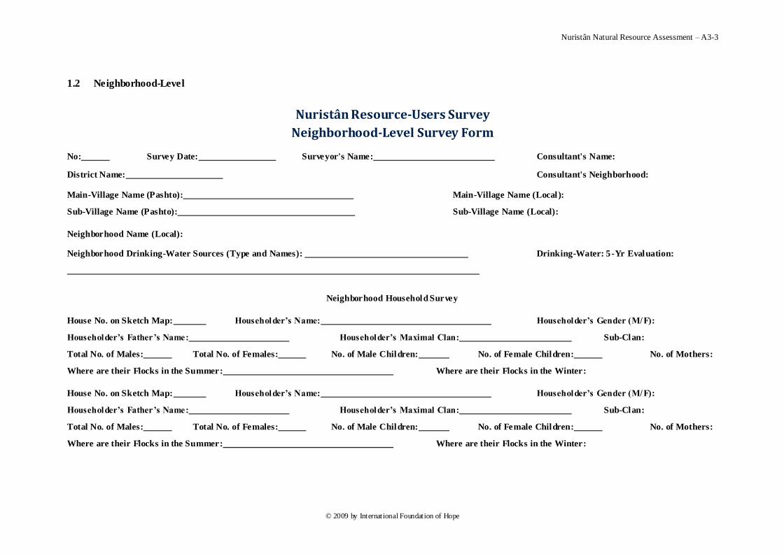
Nuristân Natural Resource Assessment – A3-3
© 2009 by International Foundation of Hope
1.2 Neighborhood-Level
Nuristân Resource-Users Survey
Neighborhood-Level Survey Form
No: Survey Date: Surveyor's Name: Consultant's Name:
District Name: Consultant's Neighborhood:
Main-Village Name (Pashto): Main-Village Name (Local):
Sub-Village Name (Pashto): Sub-Village Name (Local):
Neighborhood Name (Local):
Neighborhood Drinking-Water Sources (Type and Names): Drinking-Water: 5 -Yr Evaluation:
Neighborhood Household Survey
House No. on Sketch Map: Householder’s Name: Householder’s Gender (M/F):
Householder’s Father’s Name: Householder’s Maximal Clan: Sub-Clan:
Total No. of Males: Total No. of Females: No. of Male Children: No. of Female Children: No. of Mothers:
Where are their Flocks in the Summer: Where are their Flocks in the Winter:
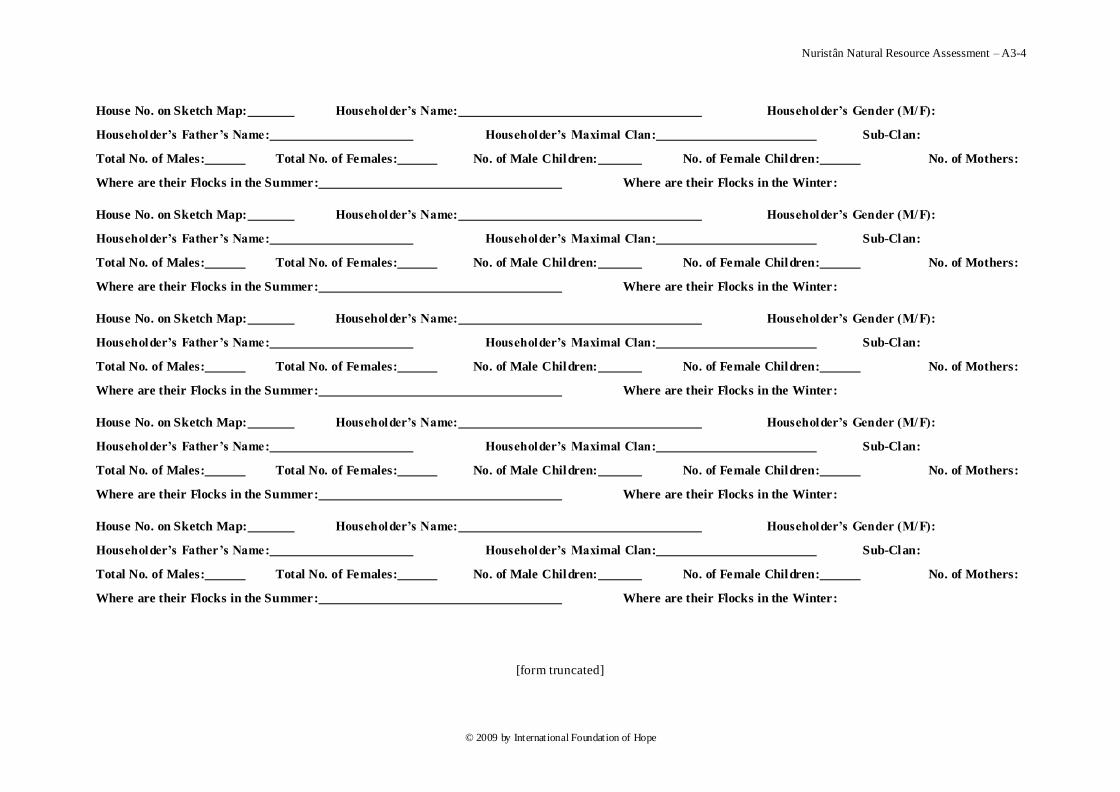
Nuristân Natural Resource Assessment – A3-4
© 2009 by International Foundation of Hope
House No. on Sketch Map: Householder’s Name: Householder’s Gender (M/F):
Householder’s Father’s Name: Householder’s Maximal Clan: Sub-Clan:
Total No. of Males: Total No. of Females: No. of Male Children: No. of Female Children: No. of Mothers:
Where are their Flocks in the Summer: Where are their Flocks in the Winter:
[form truncated]
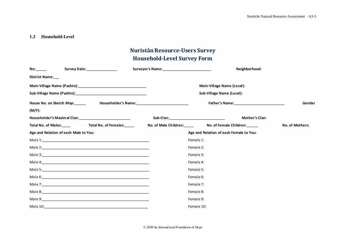
Nuristân Natural Resource Assessment – A3-5
© 2009 by International Foundation of Hope
1.3 Household-Level
Nuristân Resource-Users Survey
Household-Level Survey Form
No: Survey Date: Surveyor's Name: Neighborhood:
District Name:
Main-Village Name (Pashto): Main-Village Name (Local):
Sub-Village Name (Pashto): Sub-Village Name (Local):
House No. on Sketch Map: Householder’s Name: Father’s Name: Gender
(M/F):
Householder’s Maximal Clan: Sub-Clan: Mother’s Clan:
Total No. of Males: Total No. of Females: No. of Male Children: No. of Female Children: No. of Mothers:
Age and Relation of each Male to You: Age and Relation of each Female to You:
Male 1: Female 1:
Male 2: Female 2:
Male 3: Female 3:
Male 4: Female 4:
Male 5: Female 5:
Male 6: Female 6:
Male 7: Female 7:
Male 8: Female 8:
Male 9: Female 9:
Male 10: Female 10:
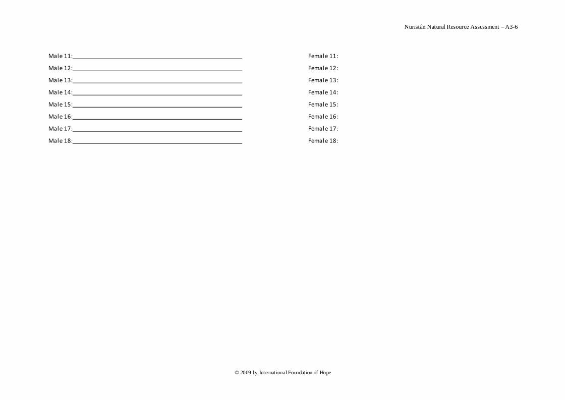
Nuristân Natural Resource Assessment – A3-6
© 2009 by International Foundation of Hope
Male 11: Female 11:
Male 12: Female 12:
Male 13: Female 13:
Male 14: Female 14:
Male 15: Female 15:
Male 16: Female 16:
Male 17: Female 17:
Male 18: Female 18:
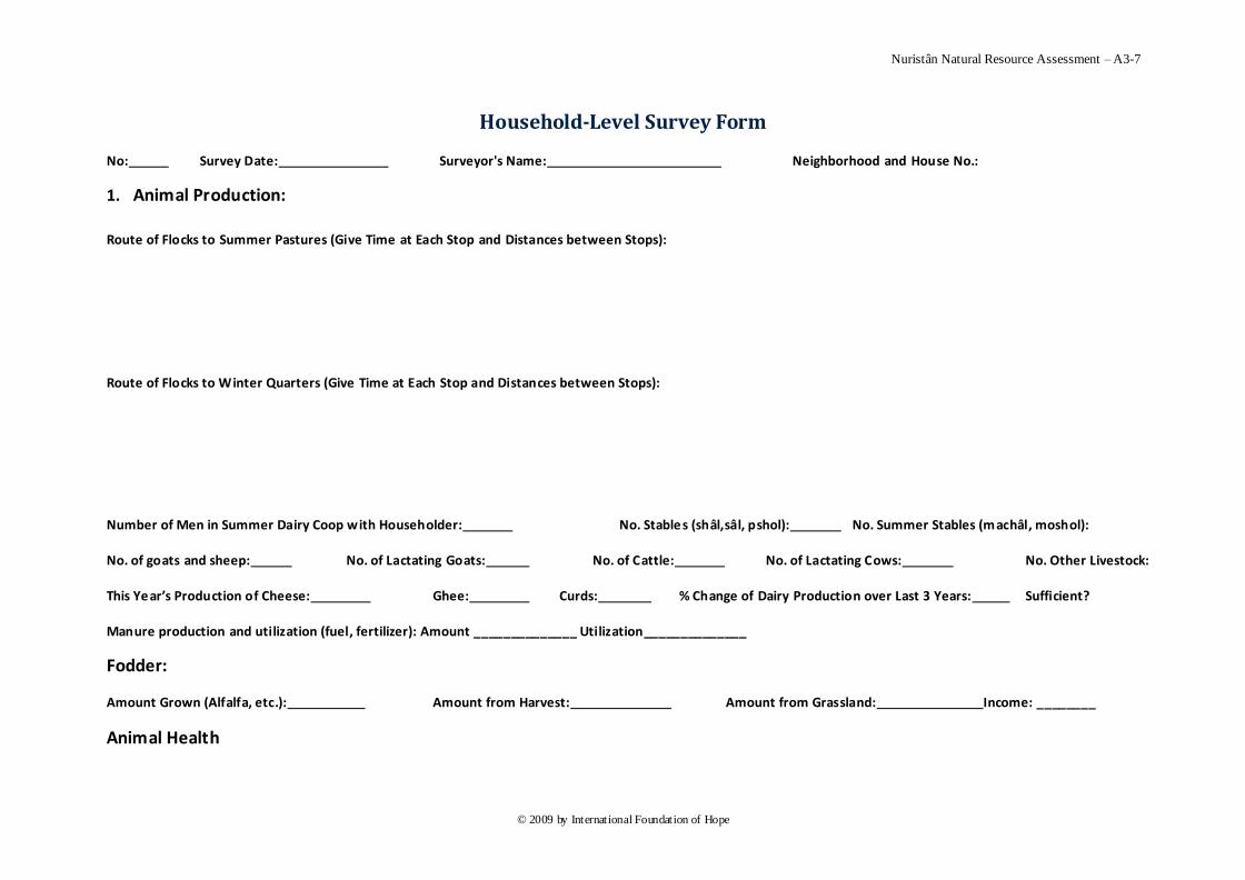
Nuristân Natural Resource Assessment – A3-7
© 2009 by International Foundation of Hope
Household-Level Survey Form
No: Survey Date: Surveyor's Name: Neighborhood and House No.:
1. Animal Production:
Route of Flocks to Summer Pastures (Give Time at Each Stop and Distances between Stops):
Route of Flocks to Winter Quarters (Give Time at Each Stop and Distances between Stops):
Number of Men in Summer Dairy Coop with Householder: No. Stables (shâl,sâl, pshol): No. Summer Stables (machâl, moshol):
No. of goats and sheep: No. of Lactating Goats: No. of Cattle: No. of Lactating Cows: No. Other Livestock:
This Year’s Production of Cheese: Ghee: Curds: % Change of Dairy Production over Last 3 Years: Sufficient?
Manure production and utilization (fuel, fertilizer): Amount ______________ Utilization______________
Fodder:
Amount Grown (Alfalfa, etc.): Amount from Harvest: Amount from Grassland: Income: ________
Animal Health
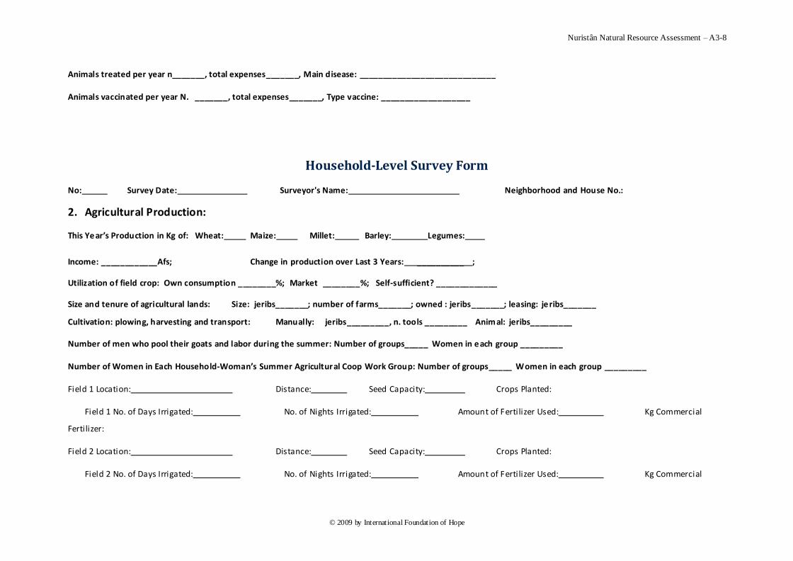
Nuristân Natural Resource Assessment – A3-8
© 2009 by International Foundation of Hope
Animals treated per year n_______, total expenses_______, Main disease: _____________________________
Animals vaccinated per year N. _______, total expenses_______, Type vaccine: ___________________
Household-Level Survey Form
No: Survey Date: Surveyor's Name: Neighborhood and House No.:
2. Agricultural Production:
This Year’s Production in Kg of: Wheat: Maize: Millet: Barley: Legumes:
Income: ____________Afs; Change in production over Last 3 Years: __________ ;
Utilization of field crop: Own consumption ________%; Market ________%; Self-sufficient? _____________
Size and tenure of agricultural lands: Size: jeribs_______; number of farms_______; owned : jeribs_______; leasing: jeribs_______
Cultivation: plowing, harvesting and transport: Manually: jeribs_________, n. tools _________ Animal: jeribs_________
Number of men who pool their goats and labor during the summer: Number of groups_____ Women in each group _________
Number of Women in Each Household-Woman’s Summer Agricultural Coop Work Group: Number of groups_____ Women in each group _________
Field 1 Location: Distance: Seed Capacity: Crops Planted:
Field 1 No. of Days Irrigated: No. of Nights Irrigated: Amount of Fertilizer Used: Kg Commercial
Fertilizer:
Field 2 Location: Distance: Seed Capacity: Crops Planted:
Field 2 No. of Days Irrigated: No. of Nights Irrigated: Amount of Fertilizer Used: Kg Commercial
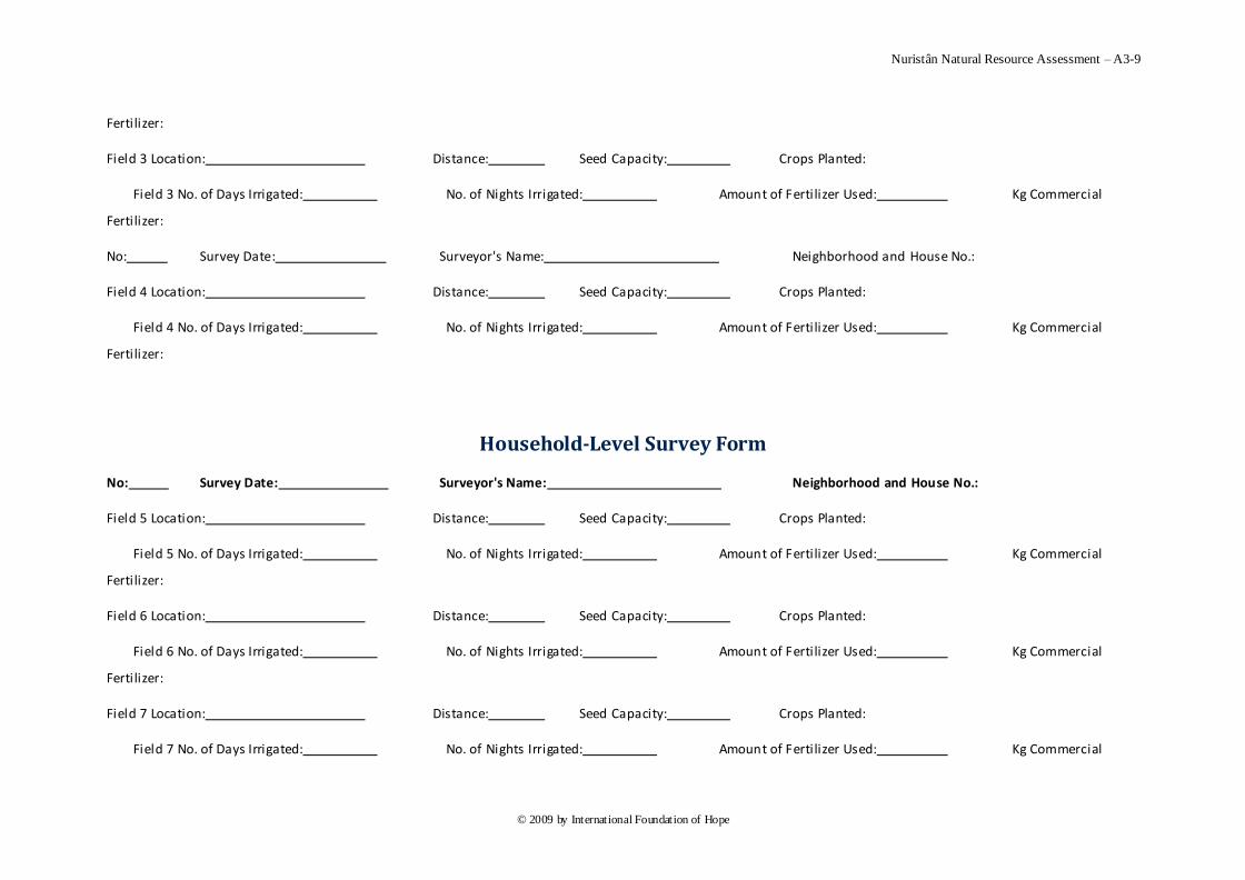
Nuristân Natural Resource Assessment – A3-9
© 2009 by International Foundation of Hope
Fertilizer:
Field 3 Location: Distance: Seed Capacity: Crops Planted:
Field 3 No. of Days Irrigated: No. of Nights Irrigated: Amount of Fertilizer Used: Kg Commercial
Fertilizer:
No: Survey Date: Surveyor's Name: Neighborhood and House No.:
Field 4 Location: Distance: Seed Capacity: Crops Planted:
Field 4 No. of Days Irrigated: No. of Nights Irrigated: Amount of Fertilizer Used: Kg Commercial
Fertilizer:
Household-Level Survey Form
No: Survey Date: Surveyor's Name: Neighborhood and House No.:
Field 5 Location: Distance: Seed Capacity: Crops Planted:
Field 5 No. of Days Irrigated: No. of Nights Irrigated: Amount of Fertilizer Used: Kg Commercial
Fertilizer:
Field 6 Location: Distance: Seed Capacity: Crops Planted:
Field 6 No. of Days Irrigated: No. of Nights Irrigated: Amount of Fertilizer Used: Kg Commercial
Fertilizer:
Field 7 Location: Distance: Seed Capacity: Crops Planted:
Field 7 No. of Days Irrigated: No. of Nights Irrigated: Amount of Fertilizer Used: Kg Commercial
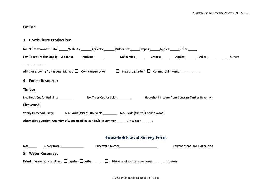
Nuristân Natural Resource Assessment – A3-10
© 2009 by International Foundation of Hope
Fertilizer:
3. Horticulture Production:
No. of Trees owned: Total Walnuts: Apricots: Mulberries: Grapes: Apples: Other:
Last Year’s Production (kg): Walnuts: Apricots: Mulberries: Grapes: Apples: Other: _____ Other:
______ _______
Aims for growing fruit trees: Market Own consumption Pleasure (garden) Commercial Income: ____________
4. Forest Resource:
Timber:
No. Trees Cut for Building: No. Trees Cut for Sale: Household Income from Contract Timber Revenue:
Firewood:
Yearly Firewood Usage: No. Cords (kshtru) Hollyoak: No. Cords (kshtru) Conifer Wood:
Alternative question: Quantity of wood used (kg per day): in summer_______, in winter_______,
Household-Level Survey Form
No: Survey Date: Surveyor's Name: Neighborhood and House No.:
5. Water Resource:
Drinking water source: River , spring , other_______ , Distance of source from house _________meters

Nuristân Natural Resource Assessment – A3-11
© 2009 by International Foundation of Hope
Amount used per day (liters): ______________ Transport of water supply to the household: Human , Animal , other__________
Irrigation water source: River , spring , other_______ , Dist ance of source from fields _________meters
6. Gemstones:
Does Householder Own or Work in a Gemstone Mine? ____ Household Income from Mining:
Location of Mine: ____________ Distance of Mine from Village: ________ Type of Mine: _________ Mine annual production ___________
7. Resource Ownership Rights
Permanent forestry , describe forestry ownership _____________________, Share of community rights ___________
Pasture , describe pasture ownership _____________________ , Share of community rights ___________
Cropland , describe cropland ownership_____________________, Share of community rights ___________
Describe water rights ________________________________________________, Share of com munity water rights ___________
Household-Level Survey Form
No: Survey Date: Surveyor's Name: Neighborhood and House No.:
8. Employment:
Number person of family working outside the farm: Men n. days______ hours/day_____ Women n. days_______ hrs/day____
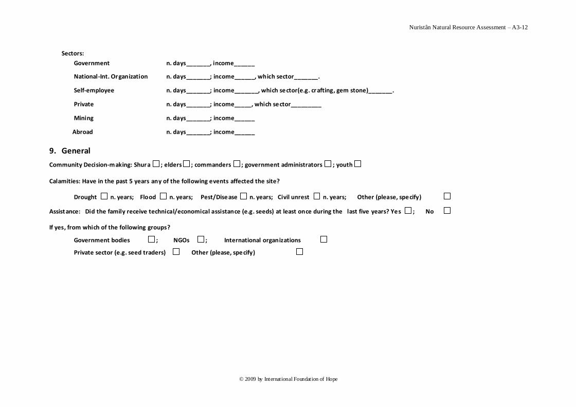
Nuristân Natural Resource Assessment – A3-12
© 2009 by International Foundation of Hope
Sectors:
Government n. days_______, income______
National-Int. Organization n. days_______; income______, which sector_______.
Self-employee n. days_______; income_______, which sector(e.g. crafting, gem stone)_______.
Private n. days_______; income_____, which sector_________
Mining n. days_______; income______
Abroad n. days_______; income______
9. General
Community Decision-making: Shura ; elders ; commanders ; government administrators ; youth
Calamities: Have in the past 5 years any of the following events affected the site?
Drought n. years; Flood n. years; Pest/Disease n. years; Civil unrest n. years; Other (please, specify)
Assist ance: Did the family receive technical/economical assistance (e.g. seeds) at least once during the last five years? Yes ; No
If yes, from which of the following groups?
Government bodies ; NGOs ; International organizations
Private sector (e.g. seed traders) Other (please, specify)
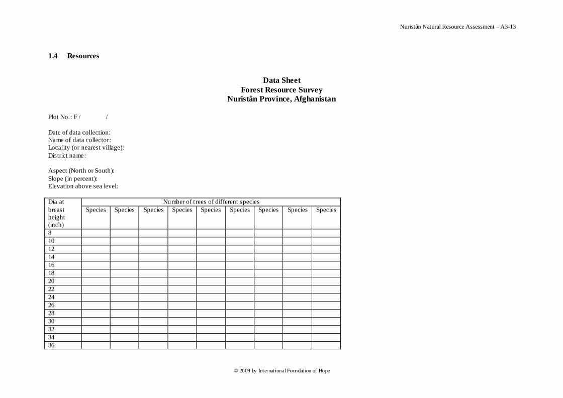
Nuristân Natural Resource Assessment – A3-13
© 2009 by International Foundation of Hope
1.4 Resources
Data Sheet
Forest Resource Survey
Nuristân Province, Afghanistan
Plot No.: F / /
Date of data collection:
Name of data collector:
Locality (or nearest village):
District name:
Aspect (North or South):
Slope (in percent):
Elevation above sea level:
Dia at
breast
height
(inch)
Number of t rees of different species
Species Species Species Species Species Species Species Species Species
8
10
12
14
16
18
20
22
24
26
28
30
32
34
36

Nuristân Natural Resource Assessment – A3-14
© 2009 by International Foundation of Hope
38
40
42
44
46
48
50
52
54
56
58
60
62
64
above
Plot No.:
Species:
Diameter at breast height
(inch)
Number of t rees
8.
9.
10.
11.
12.
13.
14.
15.
16.
17.
18.
19.
20.
21.
22.
Nuristân Natural Resource Assessment – A3-15
© 2009 by International Foundation of Hope
23.
24.
25.
26.
27.
28.
29.
30.
31.
32.
33.
34.
35.
36.
37.
38.
39.
40.
41.
42.
43.
44.
45.
46.
47.
48.
49.
50.
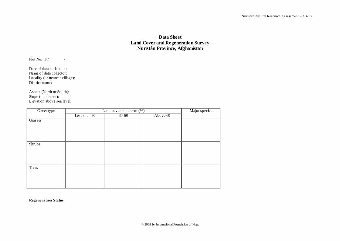
Nuristân Natural Resource Assessment – A3-16
© 2009 by International Foundation of Hope
Data Sheet
Land Cover and Regeneration Survey
Nuristân Province, Afghanistan
Plot No.: F / /
Date of data collection:
Name of data collector:
Locality (or nearest village):
District name:
Aspect (North or South):
Slope (in percent):
Elevation above sea level:
Cover type Land cover in percent (%) Major species
Less than 30 30-60 Above 60
Grasses
Shrubs
Trees
Regeneration Status
Nuristân Natural Resource Assessment – A3-17
© 2009 by International Foundation of Hope
Count number of seedlings in a circle of 5 meter radius.
Seedling
size (feet)
Number of seedlings
Species Species Species Species Species Species Species Total
Below 1
1-3
3-5
Total
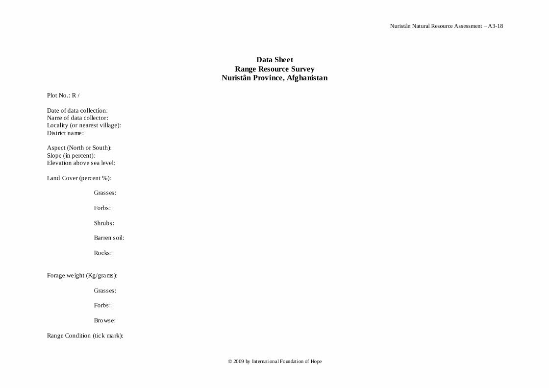
Nuristân Natural Resource Assessment – A3-18
© 2009 by International Foundation of Hope
Data Sheet
Range Resource Survey
Nuristân Province, Afghanistan
Plot No.: R /
Date of data collection:
Name of data collector:
Locality (or nearest village):
District name:
Aspect (North or South):
Slope (in percent):
Elevation above sea level:
Land Cover (percent %):
Grasses:
Forbs:
Shrubs:
Barren soil:
Rocks:
Forage weight (Kg/grams):
Grasses:
Forbs:
Browse:
Range Condition (tick mark):
Nuristân Natural Resource Assessment – A3-19
© 2009 by International Foundation of Hope
Average:
Good:
Very good:
Slightly degraded:
Very degraded
Visib le degradation (tick mark):
Landslides:
Soil erosion:
Reduced cover:
Unwanted species:
Any unwanted species (names):
1.
2.
3.
Nuristân Natural Resource Assessment – A3-20
© 2009 by International Foundation of Hope
Data Sheet
River/stream Survey
Nuristân Province, Afghanistan
Plot No.: W / /
Date of data collection:
Name of data collector:
Locality (or nearest village):
District name:
Catchments name:
River type: Seasonal Perennial:
Method of measurement: Volumetric Floater
Uses: Drinking Animals Irrigation
Water sample number:
Section Velocity Area Flow
(m3/sec)
Flow
(Cusec) Distance
(m)
Time
(Sec)
m/sec Width (m) Depth (m) m 2
1
2
3
Total
Nuristân Natural Resource Assessment – A3-21
© 2009 by International Foundation of Hope
Data Sheet
Spring Survey
Nuristân Province, Afghanistan
Plot No.: W / /
Date of data collection:
Name of data collector:
Locality (or nearest village):
District name:
Catchments name:
Spring type: Seasonal Perennial:
Method of measurement: Volumetric Floater
Water sample number:
Uses: Drinking Animals Irrigation
Water collection method: Manual Pipes
Number of springs in the village:
S. No. Time (Sec) Volume (Liters) Liters/sec Cusec
1
2
3
Average
Nuristân Natural Resource Assessment – A3-22
© 2009 by International Foundation of Hope
2 Pashto
2.1 Village-Level
د نورستان دمنابعو د استعمالونکو سروي
د کلي دسطحي يا ليول د سروي فورمو
: وثش : دسشي يټ : د سشي ککي م د هطاس يا
:وکاس م
: د لسالي م :د هطاس ياوکاس ګاډيتب
(:پښت)د ا صلي کلي م ( :ژت پ هحلي) د اصلي کلي م
(:پښت)د فشعي کلي م GPSد فشعي کلي عشض الثلذ :
: د فشعي کلي م پ هحلي ژت GPSد فشعي کلي طل الثلذ :
:د فشعي کلي د دتي د څړ ځاي ه افاصلي د اذاصي فاصلي ا کيفيت د
:تغيشات اسصياتي
:پځ کل اسصياتي : ړ ځاييد دتي څ
:پځ کل اسصياتي: د ژهي د سيو د فشعي کلي د ژهي د سيو ه ا فاصلي
: د فشعي کلي دصساعتي ساحي د هقيعت ه ا فاصلي : اسصياتي د کش د ځوکي پځ کل
: د فشعي کلي د ستي پاڼ ځګل هقعت ا فاصلي د ستي پاڼ ځګل پځ کل
: اسصياتي
:د فشعي کلي د څيړ ي د ځګل هقعيت افاصلي د څيړي د ځګل پځ کل
: اسصياتي
سشي دقشيې د
فسه
Nuristân Natural Resource Assessment – A3-23
© 2009 by International Foundation of Hope
: د فشعي کلي د ات خسد هاتع هقعت ا فاصلي د ات خس د ات پځ کل
: اسصياتي
: پ فشعي کلي کي د قاه ه
Nuristân Natural Resource Assessment – A3-24
© 2009 by International Foundation of Hope
2.2 Neighborhood-Level
دنورستان د منابعوداستعمال سروي
دکورنۍ په اساش دسروي کولو فورمه
________________________دضري کنکي نم _____________ : دضري نيټو___________ نوبر
_________________________________: ګبنډيتة
______________________________ :دلطالۍ نم
هحلي )دعوهي قريي نم __________________________________ (:پښت)دعوهي قريي نم
___________________________________________(:ژبو
هحلي )دکلي نم ____________________________________________(پښت)دکلي نم
_________________________________________________(ژبو
_____________________:نم يغړد ۍدکرن ___________: ېک نقشو پو دکرنوبر
لي يغړد ۍدکرن______________(ينوښځ نبرينو،)جنص_________________:دپالرنم
هرني ___________________________:قم فرعي _____________________________:قم
____________________________:قم
___________:تعذاد دىلکبن ________:تعذاد ينوټلښځد _________:تعذاد نبرينولدټ
___________:تعذاد دهينذ ______:دهبشهبنجينکتعذاد
:ستاسي دهرښځينه خپلوان عمر :ستاسي دهرنارينه خپلوان عمر
. 1 __________________________________________________:نبرينو
_________________________________________________:ښځينو. 2 __________________________________________________:نبرينو
_________________________________________________:ښځينو. 3 __________________________________________________:نبرينو
_________________________________________________:ينوښځ. 4 __________________________________________________:نبرينو
_________________________________________________:ښځينو
. 5 __________________________________________________:نبرينو
_________________________________________________:ښځينو
افشادي سشي
فسه
Nuristân Natural Resource Assessment – A3-25
© 2009 by International Foundation of Hope
. 6 __________________________________________________:نبرينو
_________________________________________________:ښځينو. 7 __________________________________________________:نبرينو
_________________________________________________:ښځينو. 8 __________________________________________________:نبرينو
_________________________________________________:ښځينو. 9 __________________________________________________:نبرينو
_________________________________________________:ښځينو
. 10 __________________________________________________:نبرينو
________________________________________________:ښځينو
. 11 _______________________________________________:نبرينو
________________________________________________:ښځينو
دکورنۍ په اساش دسروي کولو فورمه
____________________________دضري کنکي نم ________________ : ضري نيټو___________ نوبر
__________________________________: ګبنډيتة
:دمالذارۍ څخه حاصالت
دىر بنذيس خت ا دبنذيسدخت ترهنځ هطبفو ښئي : )څړځبين تو درهي دخشي کل نبت پو اړي کې
_________________________________________________
________________________________________________________________________________________________
___________________________________
________________________________________________________________________________________________
________________________________________________________________________________________________
______________________________________________________________________
-_____خت ترهنځ هطبفو ښيي دىر بنذيس خت ا دبنذيسد: )پو ژهي کې څړځبين تو درهي دخشي کل نبت
Nuristân Natural Resource Assessment – A3-26
© 2009 by International Foundation of Hope
__________________________________
دسهي تعذاد پ تاډ کي ______ :داسي تعذاد کم چې پ اړي کې دس اسي سش يځاي کاسکي
(shâl,sâl, pshol):_____ _داړي دسهي تعذاد(machâl, moshol)_____
دضيذ _________:دسهي تعذاد_______:يذ سکک تض تعذاددض_______:دتض ا پس تعذاد
_________:دس څاسي ضويش________ :سککغاګاتعذاد
پ ____________:هستي _____________ :غړي_____________ :پ دي کال کې دکچ ا پيش حاصل
______________%:تيش دسي کل کې دسځي تليذتپيش
د ( کيل ګشام) ___________________________:د سشي پ ډل )دحياي سشي تليذ ا دغي استعوال
:حياي تغزي(کيل ګشام)______________________________ :سخت لپاس
دعلفچش څخ _______________دتليذ اذاص______________(سضق))دعلفي ثاتات کشل ضي اذاص
افغاي ________ عايذ_____________الست ساغلي اذاص
: دڅارويو روغتيا
اساسي اسغي ګاي ______________هجوعي هصاسف __________دڅاسيد عالج تعذاد پ کال کې
______________________________________________
داکسيي ډل ____________هجوعي هصاسف ____________ دڅاسي اکسيي کل تعذاد پ کال کې
__________________________________________________
دکورنۍ په اساش دسروي کولو فورمه
____________________________دضري کنکي نم ________________ : ضري نيټو___________ نوبر
____________________________________: ګبنډيتة
: زراعتي توليذات
پلي _________________ اربشي ________________ جار __________________ غنن (: کيلوګرام)ددي کال توليد
افغبني _____________ عبيذ _________________________لرنکي فصلنو
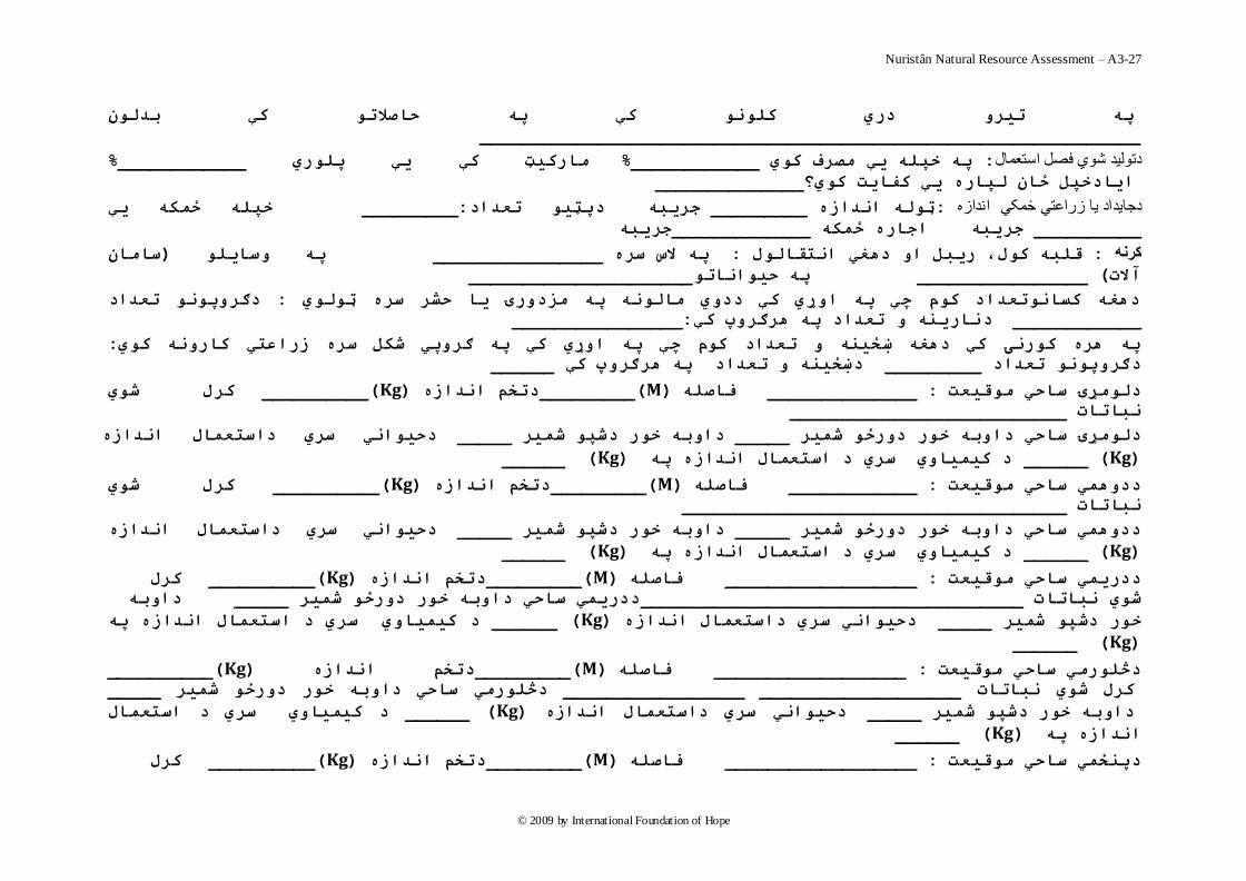
Nuristân Natural Resource Assessment – A3-27
© 2009 by International Foundation of Hope
پو تير دري کلن کې پو حبصالت کې بذلى
______________________________________________________________
% ____________هبرکيټ کې يې پلري % ____________پو خپلو يې هصرف کي : دتوليد شوي فصل استعمال
______________ايبدخپل ځبى لپبره يې کفبيت کي؟
خپلو ځوکو يې _________ :دپټي تعذادجريبو _________ ټلو انذازه : اندازه دجايداد يا زراعتي ځمکي
جريبو_____________جريبو اجبره ځوکو __________
ضبهبى )پو ضبيل ________________پو الش ضره : قلبو کل، ريبل ا دىغي انتقبلل : کرنه
_____________________ پو حيانبت________________ ( آالت
دګرپن تعذاد : دىغو کطبنتعذاد کم چې پو اړي کې ددي هبلنو پو هسدرۍ يب حشر ضره ټلي
________________:نبرينو تعذاد پو ىرګرپ کېد____________
: و اړي کې پو ګرپي شکل ضره زراعتي کبرنو کيپو ىره کرنۍ کې دىغو ښځينو تعذاد کم چې پ
______دښځينو تعذاد پو ىرګرپ کې _________ دګرپن تعذاد
کرل شي __________ (Kg)دتخن انذازه _________(M)فبصلو ______________ : دلهړۍ ضبحي هقيعت
__________________________نببتبت
دحياني ضري داضتعوبل انذازه _____ دابو خر دشپ شوير _____ خر درځ شوير دلهړۍ ضبحي دابو
(Kg ) ______ د کيويبي ضري د اضتعوبل انذازه پو(Kg )______
کرل شي __________ (Kg)دتخن انذازه _________(M)فبصلو ____________ : ددىوي ضبحي هقيعت
____________________ ________________نببتبت
دحياني ضري داضتعوبل انذازه _____ دابو خر دشپ شوير _____ ددىوي ضبحي دابو خر درځ شوير
(Kg ) ______ د کيويبي ضري د اضتعوبل انذازه پو(Kg )______
کرل __________ (Kg)دتخن انذازه _________(M)فبصلو __________________ : ددريوي ضبحي هقيعت
دابو _____ ددريوي ضبحي دابو خر درځ شوير ____________________________________شي نببتبت
د کيويبي ضري د اضتعوبل انذازه پو ______ ( Kg)دحياني ضري داضتعوبل انذازه _____ خر دشپ شوير
(Kg ) ______
__________ (Kg)دتخن انذازه _________(M)فبصلو _________ _________: دڅلرهي ضبحي هقيعت
_____ دڅلرهي ضبحي دابو خر درځ شوير ___________________ _________________ کرل شي نببتبت
د کيويبي ضري د اضتعوبل ______ ( Kg)دحياني ضري داضتعوبل انذازه _____ دابو خر دشپ شوير
______ ( Kg)پو انذازه
کرل __________ (Kg)دتخن انذازه _________(M)فبصلو __________________ : دپنځوي ضبحي هقيعت
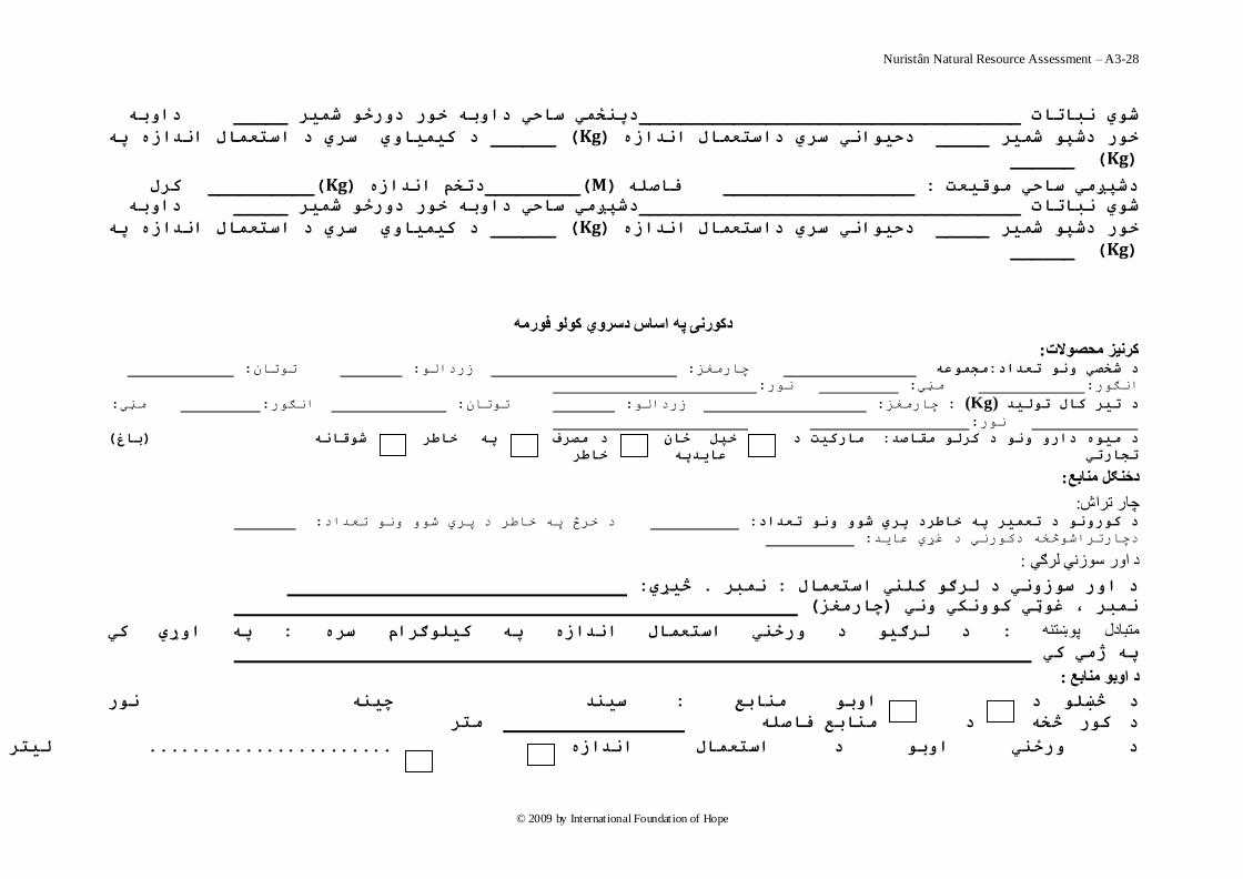
Nuristân Natural Resource Assessment – A3-28
© 2009 by International Foundation of Hope
دابو _____ دپنځوي ضبحي دابو خر درځ شوير ____________________________________شي نببتبت
د کيويبي ضري د اضتعوبل انذازه پو ______ ( Kg)ه دحياني ضري داضتعوبل انذاز_____ خر دشپ شوير
(Kg ) ______
کرل __________ (Kg)دتخن انذازه _________(M)فبصلو __________________ : دشپږهي ضبحي هقيعت
دابو _____ دشپږهي ضبحي دابو خر درځ شوير ____________________________________شي نببتبت
د کيويبي ضري د اضتعوبل انذازه پو ______ ( Kg)دحياني ضري داضتعوبل انذازه _____ ر دشپ شوير خ
(Kg ) ______
دکورنۍ په اساش دسروي کولو فورمه
:کرنيس محصوالت : تتاى : صسدال : چاسهغض هجوعو :د شخصي ن تعذاد
:س : هڼي :ساګ
: هڼي :اګس : تتاى : صسدال : چاسهغض: (Kg)د تير کبل تليذ
:س
( ببغ)شقبنو د هصرف پو خبطر خپل ځبى هبرکيت د : د هيه دار ن د کرل هقبصذ
تجبرتي عبيذپو خبطر
:دځنګل منابع
:چار تراش : د خشڅ پ خاطش د پشي ض تعذاد : د کرن د تعوير پو خبطرد پري ش ن تعذاد
: دچاستشاضڅخ دکسي د غړي عايذ
:د اور سوزني لرګي
: څيړي. نوبر : وبل د ار ضزني د لرګ کلني اضتع
( چبرهغس)نوبر ، غټي کنکي ني
پو اړي کي : د لرګي د رځني اضتعوبل انذازه پو کيلګرام ضره : متبادل پوښتنو
پو ژهي کي
: د اوبو منابع
د د څښل نر ضينذ چينو : اب هنببع
هتر وهنببع فبصل د د کر څخو
د رځني اب د اضتعوبل انذازه انطبى ، حياى ، نر : ل ضيلو ليتر د ګړ د اب راړ .......................
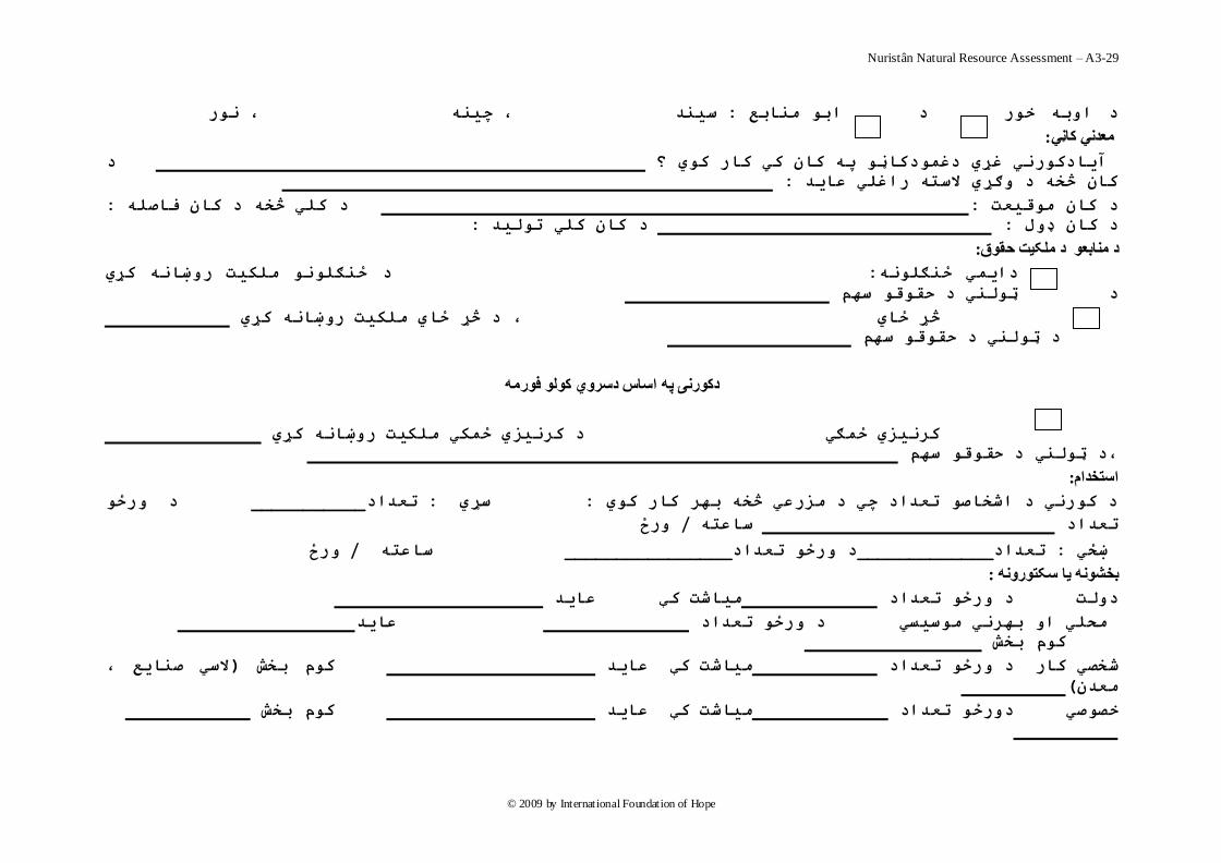
Nuristân Natural Resource Assessment – A3-29
© 2009 by International Foundation of Hope
د هتر بع فبصلو ، ، د هسرعي څخو د هن ، نر ، چينو ضينذ : اب هنببع د ابو خر
:معذني کاڼي
د آيبدکرني غړي دغودکبڼ پو کبى کي کبر کي ؟
: کبى څخو د ګړي الضتو راغلي عبيذ
: د کلي څخو د کبى فبصلو :هقيعت د کبى
: د کبى کلي تليذ : د کبى ډل
: د منابعو د ملکيت حقوق
د ځنګلن هلکيت رښبنو کړي : دايوي ځنګلنو
د ټلني د حقق ضين
څړ ځبي ، د څړ ځبي هلکيت رښبنو کړي
ين د ټلني د حقق ض
دکورنۍ په اساش دسروي کولو فورمه
کرنيسي ځوګي د کرنيسي ځوکي هلکيت رښبنو کړي
،د ټلني د حقق ضين
: استخذام
د رځ ___________دتعذا :ضړي : د کرني د اشخبص تعذاد چي د هسرعي څخو بير کبر کي
رځ /ضبعتو تعذاد
رځ /ضبعتو ________________د رځ تعذاد_____________تعذاد: ښځي
: بخشونه يا سکتورونه
عبيذ هيبشت کې د رځ تعذاد دلت
عبيذ د رځ تعذاد هحلي ا بيرني هضيطي
کم بخش
الضي صنبيع ، )کم بخش عبيذ هيبشت کې د رځ تعذاد کبر شخصي
(هعذى
کم بخش عبيذ هيبشت کې درځ تعذاد خصصي
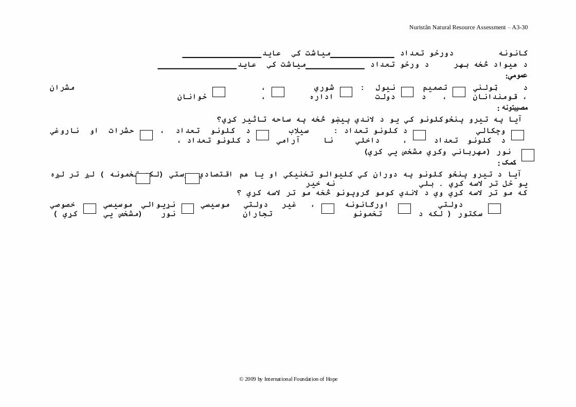
Nuristân Natural Resource Assessment – A3-30
© 2009 by International Foundation of Hope
عبيذ بشت کېهي درځ تعذاد کبننو
عبيذ هيبشت کې د رځ تعذاد د ىياد څخو بير
:عمومي
هشراى شري ، : نيل تصوين د ټلني
دلت اداره ، ځانبى ، قهنذانبى ، د
:مصيبتونه
کلن کي ي د النذي پيښ څخو پو ضبحو تبثير کړي؟ تير پنځ آيب پو
حشرات ا نبرغي د کلن تعذاد ، ضيالة : د کلن تعذاد چکبلي
د کلن تعذاد ، داخلي نب آراهي د کلن تعذاد ،
( هيرببني کړي هشخص يي کړي)نر
:کمک
لږ تر لږه ( لکو تخونو )آيب د تير پنځ کلن پو دراى کي کليال تخنيکي ا يب ىن اقتصبدي هرضتي
نو خير بلي . ي ځل تر الضو کړي
کو ه تر الضو کړي ي د النذي که ګرپن څخو ه تر الضو کړي ؟
ارګبننو ، غير دلتي هضيطي نړيالي هضيطي خصصي دلتي
تجبراى هشخص يي )نر ( کړي تخون لکو د ) ضکتر
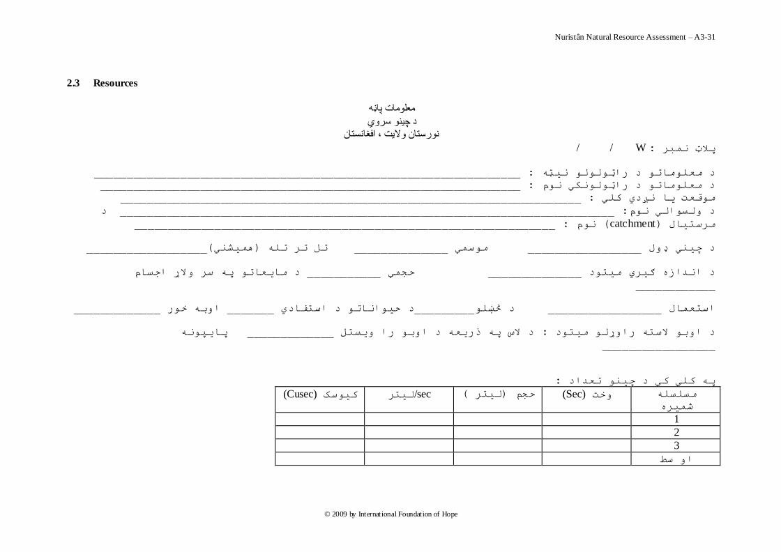
Nuristân Natural Resource Assessment – A3-31
© 2009 by International Foundation of Hope
2.3 Resources
معلومات پاڼو
د چينو سروي نورستان واليت ، افغانستان
/ / W:پالټ وثش
________________________________________________________________: هات د ساټلل يټ د هعل
_______________________________________________________________: د هعلهات د ساټلکي م
_____________________________________________________________________: هقعت يا ږدي کلي
د __________________________________________________________________________ : د لسالي م
_______________________________________________________________: م ( catchment)هشستيال
__________________ (ويطي)تل تش تل ______________ هسوي _________________ د چيي ډل
د هايعات پ سش الړ اجسام___________ حجوي ______________ د اذاص ګيشي هيتد ____________
_____________ات خس _______ د حياات د استفادي _________د څښل_________________ استعوال
پايپ _____________ د الط پ رسيع د ات سا يستل : هيتد د ات الست ساړل
_________________
: پ کلي کي د چي تعذاد
هسلسل
ضويش
(Cusec)کيسک ليتشsec/ (ليتش )حجن (Sec)خت
1
2
3
ا سط
Nuristân Natural Resource Assessment – A3-32
© 2009 by International Foundation of Hope
معلومات پاڼو ويالو سروي /د سيندونو
نورستان واليت ، افغانستان
/ / W: پالټ وثش
________________________________________________________________: د هعلهات د ساټلل يټ
_______________________________________________________________: د هعلهات د ساټلکي م
_____________________________________________________________________: لي هقعت يا ږدي ک
__________________________________________________________________________ : د لسالي م
_______________________________________________________________: م ( catchment)دهشسيتال
__________________ (ويطي)تل تش تل ______________ هسوي _________________ : دسيذ ډل
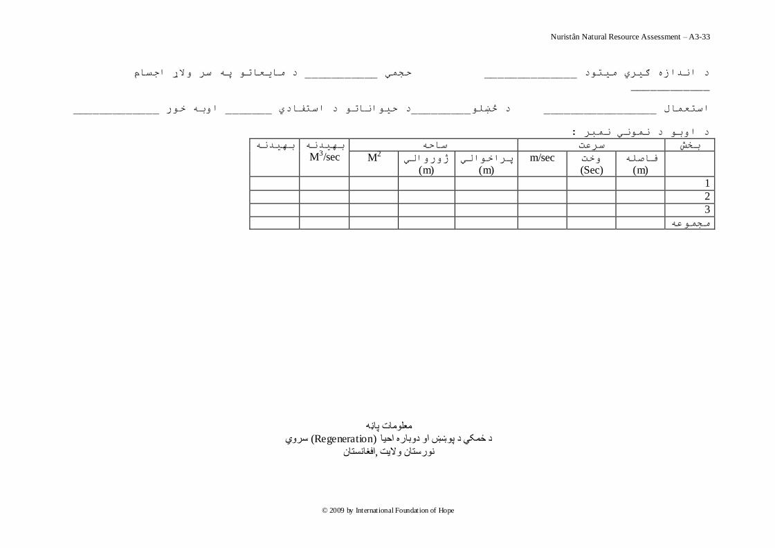
Nuristân Natural Resource Assessment – A3-33
© 2009 by International Foundation of Hope
د هايعات پ سش الړ اجسام___________ حجوي ______________ د اذاص ګيشي هيتد ____________
_____________ات خس _______ د استفادي د حياات _________د څښل_________________ استعوال
: د ات د وي وثش
تيذ ساح سشعت تخص
M3/sec تيذ
فاصل
(m) خت
(Sec) m/sec پشاخالي
(m) ژسالي
(m) M2
1
2
3
هجوع
معلومات پاڼو سروي (Regeneration)ره احيا د ځمکي د پوښښ او دوبا
افغانستان,نورستان واليت

Nuristân Natural Resource Assessment – A3-34
© 2009 by International Foundation of Hope
/ / F: پالټ وثش
________________________________________________________________: د هعلهات د ساټلل يټ
_______________________________________________________________: د هعلهات د ساټلکي م
_____________________________________________________________________: هقعت يا ږدي کلي
__________________________________________________________________________: د لسالي م
____________________________________________________________________( ضوال يا جب)هسيش
____________________________________________________________________( پ فيصذي سش )هيالى
______________________________________________________________: د تحش د سطحي څخ لړالي
پ فيصذي سش د ځوکي پښښ د پښښ ډل
(%) عستشي اا
څخ صيات 60د 60 -- 30 څخ لږ 30د
اښ
تټي
ي
: د دتاس احيا ضع
: د پځ هتش پ دايش کي د يالګي ضويشل
د د يا لګي دااعتعذاد هجوع
يالګيقذ
پ فټ سش ع ع ع ع ع
د ي فټ
کن

Nuristân Natural Resource Assessment – A3-35
© 2009 by International Foundation of Hope
1—3
3—5
هجوع
Nuristân Natural Resource Assessment – A3-36
© 2009 by International Foundation of Hope
(Sheet)معلومات پاڼو
د ځنګلونو د منابعو سروي نورستا ن واليت ، افغانستان
/ / F: پالټ وثش
________________________________________________________________: د هعلهات د ساټلل يټ
_______________________________________________________________: د هعلهات د ساټلکي م
_____________________________________________________________________: هقعت يا ږدي کلي
__________________________________________________________________________: د لسالي م
____________________________________________________________________( ضوال يا جب)هسيش
____________________________________________________________________( پ فيصذي سش )هيالى
______________________________________________________________: د تحش د سطحي څخ لړالي
:
ي پ د سي
لړالي
( ايچ)قطش
د هختلف ااع د تعذاد اناع اناع اناع اناع اناع اناع اناع اناع اناع
8
10
12
14
16
18
20
22
24
26
28
30
32
34
36

Nuristân Natural Resource Assessment – A3-37
© 2009 by International Foundation of Hope
38
40
42
44
46
48
50
52
54
56
58
Nuristân Natural Resource Assessment – A3-38
© 2009 by International Foundation of Hope
د سيي پ
لړالي
( ايچ)قطش
تلف ااع د تعذادد هخ اناع اناع اناع اناع اناع اناع اناع اناع اناع
60
62
64
66
68
70
72
74
76
78
80
82
84
86
88
09
92
94
96
98
100
102
104
106
108
110
112

Nuristân Natural Resource Assessment – A3-39
© 2009 by International Foundation of Hope
114
116
118
120
122
124
126
128
لذي
پست
Nuristân Natural Resource Assessment – A3-40
© 2009 by International Foundation of Hope
: پالټ وثش
: ااع
د سيي پ د تعذاد
لړالي
(ايچ)قطش
8
10
12
14
16
18
20
22
24
26
28
30
32
34
36
38
40
42
44
46
48
50
52
54
56
Nuristân Natural Resource Assessment – A3-41
© 2009 by International Foundation of Hope
58
60
62
64
66
68
70
72
74
76
78
80
82
84
86
88
: پالټ وثش
: ااع
د سيي پ د تعذاد
لړالي
(ايچ)قطش
90
92
94
96
98
100
102
104
Nuristân Natural Resource Assessment – A3-42
© 2009 by International Foundation of Hope
106
108
110
112
114
116
118
120
122
124
126
128
130
132
134
136
138
140
142
144
146
148
150
152
154
156
158
160
162
164
166
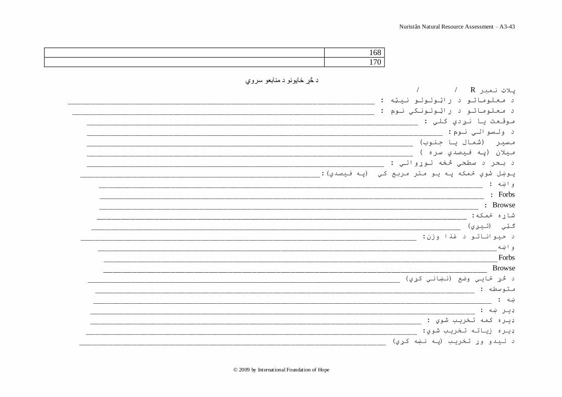
Nuristân Natural Resource Assessment – A3-43
© 2009 by International Foundation of Hope
168
170
د څړ ځايونو د منابعو سروي
/ / Rپالټ وثش
________________________________________________________________: د هعلهات د ساټلل يټ
_______________________________________________________________: د هعلهات د ساټلکي م
_____________________________________________________________________: هقعت يا ږدي کلي
__________________________________________________________________________: د لسالي م
____________________________________________________________________( ضوال يا جب)هسيش
____________________________________________________________________( پ فيصذي سش )هيالى
______________________________________________________________: د سطحي څخ لړالي د تحش
__________________________________________________(:پ فيصذي)پښل ضي ځوک پ ي هتش هشتع کي
________________________________________________________________________________ :اښ
Forbs :________________________________________________________________________________
Browse :_______________________________________________________________________________
_____________________________________________________________________________ :ضاړ ځوک
_____________________________________________________________________________ (تيږي)ګټي
______________________________________________________________________ :د حياات د غزا صى
___________________________________________________________________________________اښ
Forbs__________________________________________________________________________________
Browse ________________________________________________________________________________
_________________________________________________________________( ښاي کړي)د څړ ځايي ضع
_______________________________________________________________________________: هتسط
___________________________________________________________________________________ :ښ
________________________________________________________________________________: ډيش ښ
_____________________________________________________________________: ډيش کو تخشية ضي
_____________________________________________________________________: ډيش صيات تخشية ضي
________________________________________________________________( پ ښ کړي)تخشية د ليذ ړ
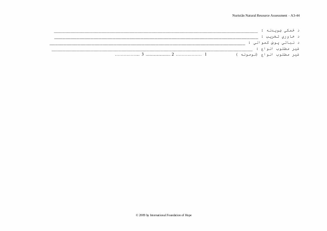
Nuristân Natural Resource Assessment – A3-44
© 2009 by International Foundation of Hope
_________________________________________________________________________ :د ځوکي ښيذ
_________________________________________________________________________: د خاسي تخشية
______________________________________________________________________: د ثاتي پښ کوالي
________________________________________________________________________ :غيش هطلب ااع
3 ...…………….................... ... 2 ……………… 1 ( ه )غيش هطلب ااع
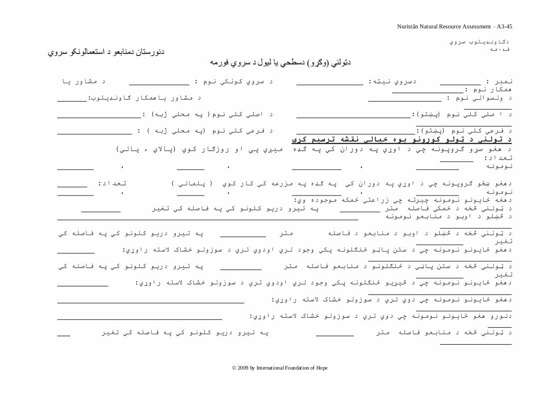
Nuristân Natural Resource Assessment – A3-45
© 2009 by International Foundation of Hope
دنورستان دمنابعو د استعمالونکو سروي دسطحي يا ليول د سروي فورمو( وګړو) دټولني
د هطاس يا : د سشي ککي م : دسشي يټ : وثش
:وکاس م
:س ياوکاس ګاډيتبد هطا : د لسالي م
( :پ هحلي ژت) د اصلي کلي م (:پښت)د ا صلي کلي م
( : پ هحلي ژت )د فشعي کلي م (:پښت)د فشعي کلي م
د تلني د ټل کرن يه خيبلي نقشو ترضين کړۍ
( پاالي ، پالي)ي پۍ ا سصګاس کي د غ سړ ګشپ چي د اړي پ دساى کي پ ګډ هيږ
: تعذاد
، ، ، ه
: تعذاد( پلوالي ) دغ ښځ ګشپ چي د اړي پ دساى کي پ ګډ پ هضسع کي کاس کي
، ، ، ه
:دغ ځاي ه چيشت چي صساعتي ځوک هجد ي
پ تيش دسي کل کي پ فاصل کي تغيش د ټلي څخ د ځوکي فاصل هتش
هاتع ه د څښل د ات د
پ تيش دسي کل کي پ فاصل کي د ټلي څخ د څښل د ات د هاتع د فاصل هتش
تغيش
: دغ ځاي ه چي د ستي پاڼ ځګل پکي جد لشي ادي تشي د سصل خطاک الست ساړي
پ تيش دسي کل کي پ فاصل کي لي څخ د ستي پاڼي د ځګل د هاتع فاصل هتش د ټ
تغيش
: دغ ځاي ه چي د څيړي ځګل پکي جد لشي ادي تشي د سصل خطاک الست ساړي
: ست ساړيدغ ځاي ه چي دي تشي د سصل خطاک ال
: دس غ ځاي ه چي دي تشي د سصل خطاک الست ساړي
پ تيش دسي کل کي پ فاصل کي تغيش د ټلي څخ د هاتع فاصل هتش
سشي دګاډيتب
فسه
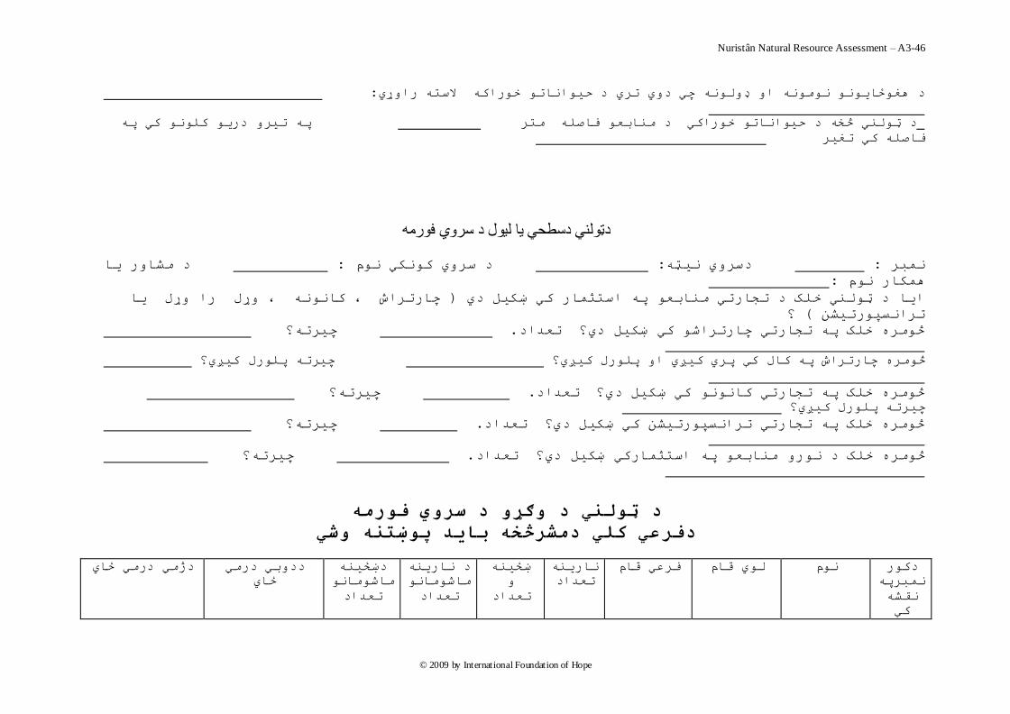
Nuristân Natural Resource Assessment – A3-46
© 2009 by International Foundation of Hope
: ات خساک الست ساړيد غځاي ه ا ډل چي دي تشي د حيا
پ تيش دسي کل کي پ د ټلي څخ د حياات خساکي د هاتع فاصل هتش
فاصل کي تغيش
دټولني دسطحي يا ليول د سروي فورمو
هطاس يا د : د سشي ککي م : دسشي يټ : وثش
:وکاس م
چاستشاش ، کا ، ړل سا ړل يا ) ايا د ټلي خلک د تجاستي هاتع پ استثواس کي ښکيل دي
؟( تشاسپستيطي
چيشت؟ . څهش خلک پ تجاستي چاستشاض کي ښکيل دي؟ تعذاد
چيشت پلسل کيږي؟ سل کيږي؟ څهش چاستشاش پ کال کې پشي کيږي ا پل
چيشت؟ . څهش خلک پ تجاستي کا کي ښکيل دي؟ تعذاد
چيشت پلسل کيږي؟
چيشت؟ . څهش خلک پ تجاستي تشاسپستيطي کي ښکيل دي؟ تعذاد
چيشت؟ . اتع پ استثواسکي ښکيل دي؟ تعذادڅهش خلک د س ه
د ټلني د ګړ د ضري فرهو
دفرعي کلي دهشرڅخو ببيذ پښتنو شي
دکس
وثشپ
قط
کې
اسي فشعي قام لي قام م
تعذاد
ښځي
تعذاد
د اسي
هاضها
تعذاد
دښځي
هاضها
تعذاد
ددتي دسهي
ايځ
دژهي دسهي ځاي

Nuristân Natural Resource Assessment – A3-47
© 2009 by International Foundation of Hope
د ټلني د ګړ د ضري فرهو
دفرعي کلي دهشرڅخو ببيذ پښتنو شي
Nuristân Natural Resource Assessment – A3-48
© 2009 by International Foundation of Hope
د ټلني د ګړ د ضري فرهو
کلي دهشرڅخو ببيذ پښتنو شيدفرعي
Nuristân Natural Resource Assessment – A3-49
© 2009 by International Foundation of Hope
د ټلني د ګړ د ضري فرهو
دفرعي کلي دهشرڅخو ببيذ پښتنو شي
د ټلني د ګړ د ضري فرهو
دفرعي کلي دهشرڅخو ببيذ پښتنو شي
دکس
وثشپ
اسي فشعي قام لي قام م
تعذاد
ښځي
د اسي
هاضها
دښځي
هاضها
ددتي دسهي
ځاي
دژهي دسهي ځاي

Nuristân Natural Resource Assessment – A3-50
© 2009 by International Foundation of Hope
قط
کې
تعذاد تعذاد عذادت