Embed Size (px)
Citation preview
NSW Aquifer Interference Policy
NSW Government policy for the licensing and assessment of aquifer interference activities
Publisher
NSW Department of Primary Industries, a division of NSW Department of Trade and Investment, Regional Infrastructure and Services.
NSW Aquifer Interference Policy: NSW Government policy for the licensing and assessment of aquifer interference
activities First published: September 2012
ISBN 978 1 74256 338 1
© State of New South Wales through Department of Trade and Investment, Regional Infrastructure and Services 2012.
This publication is copyright. You may download, display, print and reproduce this material in an unaltered form only (retaining this notice) for your personal use or for non-commercial use within your organisation. To copy, adapt, publish, distribute or commercialise any of this publication you will need to seek permission from the Department of Trade and Investment, Regional Infrastructure and Services.
Disclaimer The information contained in this publication is based on knowledge and understanding at the time of writing (July 2012). However, because of advances in knowledge, users are reminded of the need to ensure that information on which they rely is up to date and to check the currency of the information with the appropriate officer of the Department of Primary Industries or the user’s independent advisor.
Publication number: 11445
NSW Aquifer Interference Policy
iii | DPI - NSW Office of Water, September 2012
Contents
1. Introduction ..................................................................................................................................1
1.1 Purpose of this Policy...........................................................................................................1
1.2 What is an aquifer? ..............................................................................................................1
1.3 What is aquifer interference? ...............................................................................................1
1.4 What this Policy covers ........................................................................................................3
2. Licensing the water taken through aquifer interference ..........................................................4
2.1 Proponents’ responsibilities for holding licences .................................................................7
2.2 Dealing with perpetual inflow volumes .................................................................................9
2.3 Licensing outside water sharing plan areas .........................................................................9
3. Assessment process for aquifer interference activities ....................................................... 10
3.1 Environmental Planning and Assessment Act 1979 ......................................................... 10
3.2 Framework for assessing the impacts of aquifer interference activities on water
resources .......................................................................................................................... 11
3.2.1 Aquifer impact assessment................................................................................... 12
3.2.2 Additional considerations ...................................................................................... 25
3.2.3 What is required from proponents? ...................................................................... 25
3.3 Defined minimal impact aquifer interference activities ...................................................... 28
4. Security deposits and penalties .............................................................................................. 30
5. Glossary ..................................................................................................................................... 31
NSW Aquifer Interference Policy
1 | DPI - NSW Office of Water, September 2012
1. Introduction
1.1 Purpose of this Policy
The purpose of this Aquifer Interference Policy (“this Policy”) is to explain the role and
requirements of the Minister administering the Water Management Act 2000 (“the Minister”)
in the water licensing and assessment processes for aquifer interference activities under the
Water Management Act 2000 and other relevant legislative frameworks.
This Policy:
1. clarifies the requirements for obtaining water licences for aquifer interference
activities under NSW water legislation; and
2. establishes and objectively defines considerations in assessing and providing advice
on whether more than minimal impacts might occur to a key water-dependent asset.
Importantly, this Policy will assist proponents of aquifer interference activities in preparing the
necessary information and studies to be used by the Minister in the assessment of project
proposals that have some level of aquifer interference.
Furthermore, this Policy will form the basis of the assessment and subsequent advice
provided by the Minister (or the NSW Office of Water) at the various stages of an
assessment under the Environmental Planning and Assessment Act 1979.
1.2 What is an aquifer?
Under the Water Management Act 2000 an aquifer is a geological structure or formation, or
an artificial landfill, that is permeated with water or is capable of being permeated with water.
More generally, the term ‘aquifer’ is commonly understood to mean a groundwater system
that is sufficiently permeable to allow water to move within it, and which can yield productive
volumes of groundwater. Groundwater is all water that occurs beneath the ground surface in
the saturated zone. A groundwater system is any type of saturated geological formation that
can yield anywhere from low to high volumes of water. For the purposes of this Policy the
term aquifer has the same meaning as groundwater system and includes low yielding and
saline systems.
1.3 What is aquifer interference?
The Water Management Act 2000 defines an aquifer interference activity as that which
involves any of the following:
the penetration of an aquifer,
the interference with water in an aquifer,
the obstruction of the flow of water in an aquifer,
NSW Aquifer Interference Policy
2 | DPI - NSW Office of Water, September 2012
the taking of water from an aquifer in the course of carrying out mining or any other
activity prescribed by the regulations, and
the disposal of water taken from an aquifer in the course of carrying out mining or any
other activity prescribed by the regulations.
Examples of aquifer interference activities include mining, coal seam gas extraction, injection
of water, and commercial, industrial, agricultural and residential activities that intercept the
water table or interfere with aquifers. The Water Management (General) Regulation 2011
states that an aquifer interference activity also includes the extraction of sand and the
extraction of road base material.
Aquifer interference activities may take water from the water source in which they exist as
well as connected groundwater and surface water sources. Even where there is no take of
water, aquifer interference activities can still affect the functioning of aquifers which can
impact water users and dependent ecosystems.
Appropriate disposal of water extracted as a result of activities such as coal seam gas extraction also needs to be considered in order to manage impacts on aquifers and river systems as well as to reflect the economic value of that water. Any disposal options will need to also consider any relevant water or land pollution issues as well as waste disposal, as required by the Protection of the Environment Operations Act 1997.
This Policy applies to all aquifer interference activities but has been developed in particular to
address the following high risk activities:
mining activities such as open cut voids, underground mine workings and the
disposal of water taken from an aquifer including water taken as part of coal seam
gas extraction;
other extractive industries, such as sand and gravel extraction, as defined in the
State Environmental Planning Policy (Mining, Petroleum Production and Extractive
Industries) 2007;
coal seam gas activities, including those related to both exploration and production
other large projects which require dewatering such as for the construction and
maintenance of associated works, such as buildings, roads and other civil works;
injection works used to transmit water into an aquifer; and’
activities with the potential to contaminate groundwater or result in unacceptable
loss of storage or structural damage to an aquifer.
The use of chemicals in the process of hydraulic fracturing (also known as “fracking”), will be
regulated under the Petroleum (Onshore) Act 1991 and the Environmental Planning and
Assessment Act 1979.
NSW Aquifer Interference Policy
3 | DPI - NSW Office of Water, September 2012
1.4 What this Policy covers
Aquifer interference activities may or may not take water from the water source in which they
occur. They may take water from connected groundwater and surface water sources.
Water is taken when it is specifically required to be used as part of an activity, for example
the washing or processing of ore. Water is also taken incidentally where the take is required
to allow the effective and safe operation of the activity, for example dewatering to allow
mining or coal seam gas extraction. In all cases, the activity is taking water from a water
source. Many of these water sources are at or near full commitment and have extraction
limits set by water sharing plans. If there is unaccounted take, less water is available for the
environment and other users that have a legal right to access water in the aquifer or
connected water sources.
To comply with extraction limits set by water sharing plans it is important that the volumetric
take of water by aquifer interference activities is appropriately licensed and accounted for.
Section 2 of this Policy covers water licensing requirements under the Water Act 1912 or
Water Management Act 2000.
Mining and coal seam gas development proposals on strategic agricultural land will need to
be assessed by a gateway panel before they can proceed to development application
lodgement. Part of this assessment requires consideration of the impacts of the proposal on
aquifers against the Aquifer Interference Policy. Further information on the gateway process
can be found at http://www.planning.nsw.gov.au/
Nothing in this Policy exempts an activity from any requirement to obtain an Environmental
Protection Licence under the Protection of the Environment Operations Act 1997 in relation
to waste disposal and preventing and minimising pollution of water or land.
NSW Aquifer Interference Policy
4 | DPI - NSW Office of Water, September 2012
2. Licensing the water taken through aquifer interference
The water management framework for NSW and the National Water Initiative are
underpinned by objectives and principles aimed at the sustainable management of water
sources. Water sharing plans set extraction limits and rules for water access, available water
determinations, account management and trading in order to protect water sources and their
dependent ecosystems, whilst recognising the social and economic benefits of the
sustainable and efficient use of water.
All water taken by aquifer interference activities, regardless of its quality, needs to be
accounted for within these extraction limits. This is to protect environmental water and the
lawful taking of water from groundwater and surface water sources by other users. The
processes for obtaining licences under the Water Management Act 2000, the licence type
and the entitlement volumes are all relevant for ensuring that the aquifer interference activity
has adequate water in its water account to cover the take of water by that activity.
A water licence is required under the Water Management Act 2000 (unless an exemption
applies or water is being taken under a basic landholder right) where any act by a person
carrying out an aquifer interference activity causes:
the removal of water from a water source; or
the movement of water from one part of an aquifer to another part of an aquifer; or
the movement of water from one water source to another water source, such as:
o from an aquifer to an adjacent aquifer; or
o from an aquifer to a river/lake; or
o from a river/lake to an aquifer.
A water licence is required whether water is taken for consumptive use or whether it is taken
incidentally by the aquifer interference activity. For example, dewatering of groundwater
during building construction and groundwater filling and evaporating from a void post-activity
requires a water licence (unless an exemption applies) even where that water is not being
used consumptively as part of the activity’s operation.
The volume of water taken from a water source(s) as a result of an activity needs to be
predicted prior to project approval and then measured and reported in annual returns or
environmental management reports. This may require additional detailed monitoring and
more frequent reporting, prepared by the licence holder and submitted to the Minister who
would then assess the robustness and reliability of the predictions with respect to being fit-
for-purpose. These volumetric reporting requirements are important as they allow the
Minister to:
verify predictions made in proposals, including assessments as to the likely take of
groundwater from the aquifer in which the activity exists or any other connected
aquifers or surface water sources and enable appropriate water licences to be held;
NSW Aquifer Interference Policy
5 | DPI - NSW Office of Water, September 2012
ensure water taken is consistent with the amount of water available in the licensee’s
water allocation account, to protect environmental water and the security of other
authorised water users; and
assess whether the total extraction exceeds the limit established for a water source
by a water sharing plan (ie in water sources now covered by the Water Management
Act 2000).
A water licence gives its holder a share of the pool of water available for extraction. The
water access licence must hold sufficient share component and water allocation to account
for the take of water from the relevant water source at all times.
Where the water sharing plan provides for unassigned water in a water source, the Minister
may declare that the right to apply for an aquifer access licence in that water source can be
acquired by auction, tender or other means. This is done through a controlled allocation
order made under section 65 of the Water Management Act 2000. There is no unassigned
water in the aquifers that are highly connected to surface water sources in NSW.
The Water Management Act 2000 includes the concept of ensuring “no more than minimal
harm” for both the granting of water access licences and the granting of approvals (see
Section 3). Water access licences are not to be granted unless the Minister is satisfied that
adequate arrangements are in force to ensure that no more than minimal harm will be done
to any water source as a consequence of water being taken under the licence.
Where a water access licence has been applied for by a method consistent with a controlled
allocation process then adequate arrangements are in force to ensure that no more than
minimal harm will occur. This is because the controlled allocation process allows for the
allocation of a proportion of the unassigned water within the relevant water source using a
conservative approach. Furthermore, unassigned water can only occur where total water
requirements within a water source are less than the long-term average annual extraction
limit specified in the relevant water sharing plan.
Where the water is to be taken from a water source that has no unassigned water or
insufficient unassigned water to account for any inflows to the activity (either surface or
groundwater) then water entitlements will need to be purchased from an existing licensed
user.
In this situation, a licence application for a zero share licence may be required and the issue
of this licence will not cause more than minimal harm to occur. This is because, it cannot be
used to take water until either water allocations or entitlements are also purchased via an
approved access licence dealing.
Any access licence dealing requiring the Minister’s consent will need to consider the
requirements of section 71Y of the Water Management Act 2000, including the water
management principles. These principles require water sources to be protected and social
and economic benefits to be maximised. Therefore, consideration of whether to approve an
access licence dealing should find the optimum balance of these requirements. To the extent
that these matters have already been identified and considered under the EP&A Act
assessment, then that process and its outcomes should be taken into account.
NSW Aquifer Interference Policy
6 | DPI - NSW Office of Water, September 2012
Aquifer interference activities may induce flow from adjacent groundwater sources or flow
from connected surface water sources to compensate for the water taken from the aquifer in
which the activity is occurring or to fill the void created in the aquifer. Flows induced from
other water sources also constitute take of water. In all cases, separate access licences are
required to account for the take from all individual water sources.
For example, alluvial aquifers generally overlie deeper hard rock aquifers. In NSW, these
vertically layered aquifers may be managed as separate water sources. Where an aquifer
interference activity is taking water from a groundwater source, and this take is causing the
movement of water into the groundwater source from an adjacent, overlying or underlying
groundwater source, separate aquifer access licences are required for the groundwater
source and for any adjacent, overlying or underlying groundwater sources.
An access licence with a share component which specifies a surface water source is
required to account for the take of water where the activity is taking water from a connected
surface water source. For example, where an aquifer interference activity is taking water
from a groundwater source, and this take is causing the movement of water from a
connected regulated or unregulated river water source into the groundwater source, then an
access licence in the regulated or unregulated river water source is required to account for
the take of water from that water source and another access licence in the groundwater
source is required for the remainder of the take.
In addition, where an aquifer interference activity is incidentally taking water from a river it
must be returned to that river when river flows are at levels below which water users are not
permitted to pump.
Penalties are defined in the Water Management Act 2000 for illegal take of water, examples
of which include:
unlicensed or unauthorised take of water (s. 60A);
contravention of the terms and conditions of an access licence (s. 60B);
taking water for which there is no or insufficient water allocation (s. 60C); and
taking water otherwise than by means of a nominated water supply work (s. 60D).
In order to comply with section 60D of the Water Management Act 2000, State significant
development projects which do not have an approval under the Water Management Act 2000
will need to nominate on their water access licence the water supply work that is causing
water to be taken. For example, where an open cut or underground coal mine is taking water
indirectly from a connected river and thus is having the effect of diverting water flowing to or
from a water source, then the mine workings will need to be the nominated water supply
work.
In these instances, some conditions may be imposed on the water access licence which
relate to the taking of water as a result of the works that have been approved in the
development consent. This might include appropriate monitoring networks and measurement
strategies to ensure the take of water from all affected water sources can be accurately
quantified and reported.
NSW Aquifer Interference Policy
7 | DPI - NSW Office of Water, September 2012
Compliance action and penalties may apply under the Water Management Act 2000 in the
event that there is insufficient water allocation to account for the take of water during an
activity’s life. Such a situation can be rectified through adjustments to held entitlements,
purchasing water allocations on the temporary water market or through remediation action to
reduce the actual take of water
Examples of situations that may result in an increased take of water include:
causing or enhancing hydraulic connection between aquifers or between a
groundwater source and a surface water source that is not accounted for;
interception of groundwater that can not be accounted for;
2.1 Proponents’ responsibilities for holding licences
It is the proponent’s responsibility to ensure that the necessary licences are held with
sufficient share component and water allocation to account for all water taken from a
groundwater or surface water source as a result of an aquifer interference activity, both for
the life of the activity and after the activity has ceased.
In determining the type and the number of water licences required, either through the water
trading market or by licence application, the following will need to be considered:
which water source(s) will the activity take water from;
a prediction of the total amount of water that will be taken from each connected
groundwater or surface water source on an annual basis as a result of the activity
and after closure of the activity, as described in section 3.2.3. In some instances
where the take of water might have potentially significant impacts on water sources
or their dependent ecosystems or other authorised water users, then the predictions
should be based on complex groundwater modelling conducted in accordance with
the Australian Groundwater Modelling Guidelines, as described in section 3.2.3;
how and in what proportions this take will be assigned to the affected aquifers and
connected surface water sources, even if take predictions are not based on
groundwater modelling;
how any relevant licence exemptions might relate to the water to be taken by the
activity;
the characteristics of the water requirements such as whether it is taken at a fixed
rate or varying in time, i.e. is it ongoing, constant, unavoidable - which, in the case of
regulated rivers, means that high security water may be required to account for the
water requirements - or is it climatically/time varying or controllable in some way -
which, in the case of regulated rivers, implies general security water is likely to be
adequate to account for the water taken;
whether there are sufficient water entitlements and water allocations that are able to
be obtained to cover the characteristics of the water requirements. Consideration
must also be given to the water sharing plan rules by which water is credited to
water accounts on an annual basis and by which those accounts may be managed
NSW Aquifer Interference Policy
8 | DPI - NSW Office of Water, September 2012
(eg, carryover rules for unused water allocations) to provide the flexibility required to
ensure there is sufficient water in accounts to cover the take of water;
how this water will be obtained - by what mechanism and what licence category,
consistent with any trading rules specified in either the Minister’s access licence
dealing principles and/or relevant water sharing plans. Consideration will also need
to be given to the possibility and effect of low water allocations in regulated river
systems. For example, if high security entitlements have been purchased to cover
the ongoing take of water from a regulated river water source, then there may be
years of low water allocations due to low water availability. This may result in
insufficient water allocation being credited to the high security licence account. One
way to cover this shortfall would be to enter the temporary water trading market and
purchase water allocations credited to other licences. The costs and ability to
undertake this sort of trade (ie, the market depth) during these low allocation times
will need to be understood;
the effect that activation of existing entitlement may have on future available water
determinations for the proposed licence category and entitlement volume;
actions required both during operation and post-closure to minimise the risk of
inflows to a mine void as a result of flooding, since these are very difficult to account
for volumetrically. Therefore, set-back distances from rivers should be no less than
that required to ensure structural integrity of the river bank during flooding events.
Levee banks or landforms should also be constructed at the appropriate time to
prevent at least a 1 in 100 year flood from entering the site either during or after
operation. In some instances, where the implications of such inflows are significant,
levee bank levels may be required to be higher; and
a strategy for accounting for any water taken beyond the life of the operation of the
project, such as continuing to hold the appropriate amount of licence entitlement to
cover the ongoing volumetric impact or surrendering a component of licence
entitlement at the end of the project. Where a licence or part of a licence has been
surrendered to the Minister, a security deposit or condition of consent under the
EP&A Act may account for or require the upfront payment of fees and subsequently
the licence may be retained for the period of ongoing take of water or cancelled.
Where uncertainty in the predicted inflows may have a significant impact on the environment
or other authorised water users, the applicant will also need to specifically report on the
following:
any potential for causing or enhancing hydraulic connection between aquifers or
between groundwater and surface water sources, and quantification of this risk in
the volumetric inflow estimates;
quantification of any other uncertainties in the groundwater or surface water impact
modelling conducted for the activity; and
strategies in place for monitoring actual and reassessing any predicted take of water
and how any changes in these requirements will be accounted for, including
analysis of water market depth and/or in-situ mitigation and remediation options.
NSW Aquifer Interference Policy
9 | DPI - NSW Office of Water, September 2012
2.2 Dealing with perpetual inflow volumes
Many large aquifer interference activities continue to take water from groundwater or
connected surface waters well after the activity has ceased, eg open cut mining. The post-
closure continued take of water until an aquifer system reaches equilibrium may extend from
months to centuries after cessation, depending on the scale of the activity, recharge
relationships and aquifer characteristics. Where there is ongoing take of water, the licence
holder must retain a water licence for the period until the system returns to equilibrium or
surrender it to the Minister. Accordingly, the trading of water that has been acquired to
account for inflows during the life of the activity will be limited so that aquifer access licences
and associated water accounts properly cater for the ongoing take of water after an aquifer
interference activity has ceased. Given the likelihood of a less active mine management
regime post-closure, surrendering of licence entitlements, that adequately cover any likely
future low available water determination periods is preferable.
The Minister will approve outward dealings (sales) involving water licences which are
currently used to account for the take of water by an aquifer interference activity only if
satisfied that a hydrogeological study demonstrates that the volume of water to be traded out
is no longer being nor will be taken. Such dealings might be initiated in the event that pre-
operation predictions were found to over-estimate inflows and therefore there is excess water
held, or post-closure where the ongoing inflows are less than those accounted for by the held
licences during the life of the mine.
2.3 Licensing outside water sharing plan areas
In water sources where water sharing plans do not yet apply, an aquifer interference activity
that is taking groundwater is required to hold a water licence under Part 5 of the Water Act
1912. Where an aquifer interference activity is also taking surface water a water licence is
required under Part 2 of the Water Act 1912. For example, where an aquifer interference
activity is taking groundwater, and this is causing water to move from a connected surface
water source into the groundwater source, a Part 2 water licence is required to account for
the amount of water taken from the surface water source and a Part 5 water licence is
required for the water taken from the groundwater source.
Until water sharing plans apply across the whole State, it is possible for the Water Act 1912
to apply in a groundwater source and the Water Management Act 2000 to apply in a
connected surface water source or vice versa. Where this occurs and the aquifer interference
activity is effectively taking water from both water sources then licences will be required
under each Act.
The requirements for proponents detailed in sections 2.1 and 2.2 of this Policy also apply to
applicants for a Water Act 1912 licence. An application for a licence made under the Water
Act 1912 will be assessed on the same considerations as an application for an access
licence made under the Water Management Act 2000.
NSW Aquifer Interference Policy
10 | DPI - NSW Office of Water, September 2012
3. Assessment process for aquifer interference activities
Some aquifer interference activities can have significant impacts on water sources such as
aquifers and rivers, their dependent ecosystems and other water users. These impacts can
continue for decades or even centuries after the cessation of the activity. Therefore, a
comprehensive assessment framework is required for large scale aquifer interference
activities.
3.1 Environmental Planning and Assessment Act 1979
Part 4, Division 4.1 and Part 5.1 of the Environmental Planning and Assessment Act 1979
(EP&A Act) provides a streamlined approval process for the assessment and determination
of State significant development and State significant infrastructure respectively.
The Minister for Planning and Infrastructure has delegated his decision-making authority for
all State significant development and State significant infrastructure applications lodged by
private developers to the Planning Assessment Commission (or to senior officers of the
Department of Planning and Infrastructure if there are fewer than 25 objections by members
of the public and the local council has not objected). The Planning and Assessment
Commission will also determine all applications where a reportable political donation has
been made. The Minister will continue to determine applications lodged by Government
agencies.
An additional process – a gateway process - will apply to State significant development
applications for mining or coal seam gas extraction on strategic agricultural land as defined in
a relevant Strategic Regional Land Use Plan. The gateway process will involve a panel which
is intended to provide a tailored mechanism to assess the potential impacts of these
proposals on strategic agricultural land and resources. The panel will deliver greater rigor to
the scientific assessment process.
An independent panel of experts will be established to undertake the gateway assessment.
Proposals assessed to satisfy specified criteria relating to its agricultural and aquifer impacts
can be certified to proceed to the development application stage. Other proposals that the
panel considers do not fully satisfy these criteria will be issued with conditional certificates,
outlining matters that must be addressed at the development application stage in order to
better address potential agricultural and/or aquifer impacts. Such matters could include, for
example, the requirement for additional studies or physical amendments to the project.
Under the State Environmental Planning Policy (Mining, Petroleum Production and Extractive
Industries) 2007 the Minister for Primary Industries will be required to provide advice to the
gateway panel, which will be made public, on aquifer impacts either:
(a) at the gateway stage (for example, relevant State significant mining and coal seam
gas proposals on Strategic Agricultural Land); and
(b) during the assessment of the relevant development application.
This advice will be based on the considerations specified in section 3.2 of this Policy.
NSW Aquifer Interference Policy
11 | DPI - NSW Office of Water, September 2012
Under the Environmental Planning and Assessment Regulation, the Director-General of the
Department of Planning and Infrastructure must consult relevant public authorities when
preparing the environmental assessment requirements for State significant development.
The Department of Planning and Infrastructure will consult with the NSW Office of Water
when preparing these requirements for any State significant development. NSW Office of
Water’s advice to the Department of Planning and Infrastructure will be based on the
requirements of this Policy and will be made publicly available. Therefore the Environmental
Planning and Assessment Act 1979 works with the Water Management Act 2000 to deliver
the appropriate water management outcomes for State significant development, State
significant infrastructure and other projects.
3.2 Framework for assessing the impacts of aquifer interference activities on water resources
The assessment of aquifer interference activities seeking approval under the EP&A Act will
be made on a case by case basis for each particular project in accordance with this Policy.
The NSW Office of Water’s assessment of impacts on water sources and water dependent
ecosystems and subsequent advice and proposed conditions of approval as input to the
planning process for a project is based on an “account for, mitigate, avoid/ prevent, and
remediate” approach. In practice this means the assessment and subsequent advice will be
based on the proponents’:
1. (a) ability to demonstrate that they have the ability to obtain the necessary licences
in order to account for the take of water from any relevant water source. The
requirements for this are detailed in Section 2 of this Policy. Where there is
concern that the necessary licence entitlements cannot easily be obtained, the
proposal should include mitigation or avoidance strategies in order to
reduce the take of water to a point where it can be accounted for; or
(b) ability to demonstrate that the proposal has been designed in such a way as to
prevent the take of water where applicants are unable to meet the
requirements specified in point 1 above; and
2. ability to demonstrate that adequate arrangements will be in place to ensure that
the minimal impact considerations specified in Table 1 and section 3.2.2 can
be met; and
3. proposed remedial actions for impacts greater than those that were predicted
as part of the relevant approval. The requirement for remedial actions may occur
where modelled predictions were inaccurate or where planned mitigation, prevention
or avoidance strategies have failed. The assessment will include:
(a) consideration of the potential types and risks of unforeseen impacts that may
occur during the operational phase or post-closure of the aquifer interference
activity; and
(b) whether the proposed mitigation, prevention or avoidance strategies will
minimise these risks; and
NSW Aquifer Interference Policy
12 | DPI - NSW Office of Water, September 2012
(c) whether the proposed remedial actions are adequate, should the proposed risk
minimisation strategies in (b) fail; and
(d) advice on what further mitigation, prevention, avoidance or remedial actions
may be required; and
(e) appropriate conditions that maintain any mitigation, prevention, avoidance or
remediation actions until they are no longer required to keep the impacts at or
below the predicted levels.
By accounting for the take of water, existing water shares between the environment and all
other water users are maintained. By avoiding the take of water other water related impacts
on water sources and their dependent ecosystems and on other water users may also be
avoided. By avoiding the take of water, the proponent can also reduce the cost of purchasing
entitlement in fully committed water sources and associated ongoing water charges and also
minimise the costs of any mitigation or prevention strategies.
Before the Minister provides advice to either the gateway process, the Planning Assessment
Commission or the Minister for Planning the NSW Office of Water will undertake an
assessment of the project’s ability to achieve points 1 to 3 above.
The NSW Office of Water’s assessment will determine the potential level of impact relative to
the considerations in Table 1 and will identify where further mitigation, prevention or
avoidance measures would be necessary to meet the Level 1 minimal impact considerations
or, under the Level 2 minimal impact considerations, what further studies are necessary to
assess whether the project will not prevent the long-term viability of a relevant dependent
ecosystem or significant site. The assessment includes determining the rigour of impact
predictions and the suitability of proposed mitigation, prevention or avoidance strategies.
As part of the assessment process, there may be no suitable or practical mitigation or
prevention options and therefore the proponent may be asked to avoid impacts by modifying
the proposed activity.
3.2.1 Aquifer impact assessment
The Water Management Act 2000 includes the concept of ensuring “no more than minimal
harm” for both the granting of water access licences (see Section 2) and the granting of
approvals. Aquifer interference approvals are not to be granted unless the Minister is
satisfied that adequate arrangements are in force to ensure that no more than minimal harm
will be done to any water source, or its dependent ecosystems, as a consequence of its
being interfered with in the course of the activities to which the approval relates.
While aquifer interference approvals are not required to be granted, the minimal harm test
under the Water Management Act 2000 is not activated for the assessment of impacts.
Therefore, this Policy establishes and objectively defines minimal impact considerations as
they relate to water-dependent assets and these considerations will be used as the basis for
providing advice to either the gateway process, the Planning Assessment Commission or the
Minister for Planning.
The minimal impact considerations have been developed for impacts on groundwater
sources, connected water sources, and their dependent ecosystems, culturally significant
sites and water users.
NSW Aquifer Interference Policy
13 | DPI - NSW Office of Water, September 2012
Before the Minister provides advice to either the gateway process, the Planning Assessment
Commission or the Minister for Planning, the NSW Office of Water will assess the potential
impacts of the aquifer interference activity against the minimal impact considerations
specified in Table 1, as well as any specific rules in a relevant water sharing plan, based on
the information provided in the proponent’s Environmental Assessment.
There are two levels of minimal impact considerations specified in Table 1. If the predicted
impacts are less than the Level 1 minimal impact considerations, then these impacts will be
considered as acceptable.
Where an activity’s predicted impacts are greater than the Level 1 minimal impact
considerations specified in Table 1, but these predicted impacts exceed the Level 1
thresholds by no more than the accuracy of an otherwise robust model, then the project will
be considered as having impacts that are within the range of acceptability, with extra
monitoring and potential mitigation or remediation required during operation, should the
project be approved. In such instances, the Minister’s advice will include a request that
appropriate conditions be imposed to ensure the impacts of the activity are acceptable. This
may include for example, adaptive management conditions requiring the proponent to
monitor the actual impacts of the proposal and take action to mitigate or remediate the
impacts that exceed the Level 1 thresholds.
Where the predicted impacts are greater than the Level 1 minimal impact considerations by
more than the accuracy of an otherwise robust model, then the assessment will involve
additional studies to fully assess these predicted impacts. If this assessment shows that the
predicted impacts do not prevent the long-term viability of the relevant water-dependent
asset, as defined in Table 1, then the impacts will be considered to be acceptable.
Groundwater source categories
Groundwater sources have been divided into “highly productive” and “less productive”. Highly
productive groundwater is defined in this Policy as a groundwater source that is declared in
the Regulations and will be based on the following criteria:
a) has total dissolved solids of less than 1,500 mg/L, and
b) contains water supply works that can yield water at a rate greater than 5 L/sec.
Highly productive groundwater sources are further grouped into the following categories:
1. Alluvial;
2. Coastal sands;
3. Porous rock;
a) Great Artesian Basin - Eastern Recharge and Southern Recharge;
b) Great Artesian Basin – Surat, Warrego and Central;
c) other porous rock; and
4. Fractured rock.
NSW Aquifer Interference Policy
14 | DPI - NSW Office of Water, September 2012
The Great Artesian Basin groundwater sources were categorised separately because of the
Basin’s unique hydrogeology and management requirements.
The categories of less productive groundwater sources are:
1. Alluvial;
2. Porous rock;
3. Fractured rock.
Minimal impact considerations
For each of the highly productive and less productive groundwater sources thresholds for key
minimal impact considerations have been developed. These thresholds deal with water table
and groundwater pressure drawdown as well as groundwater and surface water quality
changes.
This Policy will adopt an adaptive management approach to the minimal impact
considerations which means they will be regularly reviewed and updated, if required, based
on scientific information and experience during implementation.
NSW Aquifer Interference Policy
15 | DPI - NSW Office of Water, September 2012
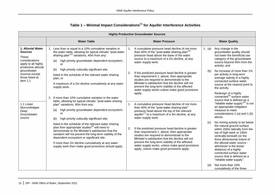
Table 1 – Minimal Impact Considerations(1) for Aquifer Interference Activities
Highly Productive Groundwater Sources
Water Table Water Pressure Water Quality
1. Alluvial Water Sources
These considerations apply to all highly productive alluvial groundwater sources except those listed at item 1.1
1. Less than or equal to a 10% cumulative variation in the water table, allowing for typical climatic “post-water sharing plan”
(2) variations, 40m from any:
(a) high priority groundwater dependent ecosystem; or
(b) high priority culturally significant site;
listed in the schedule of the relevant water sharing plan; or
A maximum of a 2m decline cumulatively at any water supply work.
2. |f more than 10% cumulative variation in the water table, allowing for typical climatic “post-water sharing plan” variations, 40m from any:
(a) high priority groundwater dependent ecosystem; or
(b) high priority culturally significant site;
listed in the schedule of the relevant water sharing plan then appropriate studies
(5) will need to
demonstrate to the Minister’s satisfaction that the variation will not prevent the long-term viability of the dependent ecosystem or significant site.
If more than 2m decline cumulatively at any water supply work then make good provisions should apply.
1. A cumulative pressure head decline of not more than 40% of the ”post-water sharing plan”
(2)
pressure head above the base of the water source to a maximum of a 2m decline, at any water supply work.
2. If the predicted pressure head decline is greater than requirement 1. above, then appropriate studies are required to demonstrate to the Minister’s satisfaction that the decline will not prevent the long-term viability of the affected water supply works unless make good provisions apply.
1. (a) Any change in the groundwater quality should not lower the beneficial use category of the groundwater source beyond 40m from the activity; and
(b) No increase of more than 1% per activity in long-term average salinity in a highly connected surface water source at the nearest point to the activity.
Redesign of a highly connected
(3) surface water
source that is defined as a “reliable water supply”
(4) is not
an appropriate mitigation measure to meet considerations 1.(a) and 1.(b) above.
(c) No mining activity to be below the natural ground surface within 200m laterally from the top of high bank or 100m vertically beneath (or the three dimensional extent of the alluvial water source - whichever is the lesser distance) of a highly connected surface water source that is defined as a “reliable water supply”.
(d) Not more than 10% cumulatively of the three
1.1 Lower Murrumbidgee Deep Groundwater source
1. A cumulative pressure head decline of not more than 40% of the “post-water sharing plan” pressure head above the top of the relevant aquifer
(7) to a maximum of a 3m decline, at any
water supply work.
2. If the predicted pressure head decline is greater than requirement 1. above, then appropriate studies are required to demonstrate to the Minister’s satisfaction that the decline will not prevent the long-term viability of the affected water supply works, unless make good provisions apply, unless make good provisions apply.
NSW Aquifer Interference Policy
16 | DPI - NSW Office of Water, September 2012
Highly Productive Groundwater Sources
Water Table Water Pressure Water Quality
dimensional extent of the alluvial material in this water source to be excavated by mining activities beyond 200m laterally from the top of high bank and 100m vertically beneath a highly connected surface water source that is defined as a “reliable water supply”.
2. If condition 1.(a) is not met then appropriate studies
will need to
demonstrate to the Minister’s satisfaction that the change in groundwater quality will not prevent the long-term viability of the dependent ecosystem, significant site or affected water supply works.
If condition 1.(b) or 1.(d) are not met then appropriate studies are required to demonstrate to the Minister’s satisfaction that the River Condition Index category of the highly connected surface water source will not be reduced at the nearest point to the activity.
If condition 1.(c) or (d) are not met, then appropriate studies are required to demonstrate to the Minister’s satisfaction that:
- there will be negligible river bank or high wall instability risks;
- during the activity’s operation and post-closure, levee banks
NSW Aquifer Interference Policy
17 | DPI - NSW Office of Water, September 2012
Highly Productive Groundwater Sources
Water Table Water Pressure Water Quality
and landform design should prevent the Probable Maximum Flood from entering the activity’s site; and
- low-permeability barriers between the site and the highly connected surface water source will be appropriately designed, installed and maintained to ensure their long-term effectiveness at minimising interaction between saline groundwater and the highly connected surface water supply;
2. Coastal sands water sources
1. Less than or equal to 10% cumulative variation in the water table, allowing for typical climatic “post-water sharing plan” variations, 40m from any:
(a) high priority groundwater dependent ecosystem; or
(b) high priority culturally significant site;
listed in the schedule of the relevant water sharing plan.
A maximum of a 2m decline cumulatively at any water supply work.
2. If more than 10% cumulative variation in the water table, allowing for typical climatic “post-water sharing plan” variations, 40m from any:
(a) high priority groundwater dependent ecosystem; or
(b) high priority culturally significant site;
1. A cumulative pressure head decline of not more than a 2m decline, at any water supply work.
2. If the predicted pressure head decline is greater than requirement 1. above, then appropriate studies are required to demonstrate to the Minister’s satisfaction that the decline will not prevent the long-term viability of the affected water supply works unless make good provisions apply.
1. Any change in the groundwater quality should not lower the beneficial use category of the groundwater source beyond 40m from the activity.
2. If condition 1 is not met then appropriate studies
will need to
demonstrate to the Minister’s satisfaction that the change in groundwater quality will not prevent the long-term viability of the dependent ecosystem, significant site or affected water supply works.
NSW Aquifer Interference Policy
18 | DPI - NSW Office of Water, September 2012
Highly Productive Groundwater Sources
Water Table Water Pressure Water Quality
listed in the schedule of the relevant water sharing plan then appropriate studies (including the hydrogeology, ecological condition and cultural function) will need to demonstrate to the Minister’s satisfaction that the variation will not prevent the long-term viability of the dependent ecosystem or significant site.
If more than 2m decline cumulatively at any water supply work then make good provisions should apply.
3. Porous Rock Water Sources
1. Less than or equal to 10% cumulative variation in the water table, allowing for typical climatic “post-water sharing plan” variations, 40m from any
(a) high priority groundwater dependent ecosystem, or
(b) high priority culturally significant site,
listed in the schedule of the relevant water sharing plan.
A maximum of a 2m decline cumulatively at any water supply work.
2. If more than 10% cumulative variation in the water table, allowing for typical climatic “post-water sharing plan” variations, 40m from any:
(a) high priority groundwater dependent ecosystem; or
(b) high priority culturally significant site;
listed in the schedule of the relevant water sharing plan then appropriate studies (including the hydrogeology, ecological condition and cultural function) will need to demonstrate to the Minister’s
1. A cumulative pressure head decline of not more than a 2m decline, at any water supply work.
2. If the predicted pressure head decline is greater than requirement 1. above, then appropriate studies are required to demonstrate to the Minister’s satisfaction that the decline will not prevent the long-term viability of the affected water supply works unless make good provisions apply.
1. Any change in the groundwater quality should not lower the beneficial use category of the groundwater source beyond 40m from the activity.
2. If condition 1 is not met then appropriate studies
will need to
demonstrate to the Minister’s satisfaction that the change in groundwater quality will not prevent the long-term viability of the dependent ecosystem, significant site or affected water supply works.
3.1. Great Artesian Basin Eastern Recharge Groundwater Source and Southern Recharge Groundwater Source
1. (a) Less than 0.2m cumulative variation in the groundwater pressure, allowing for typical climatic “post-water sharing plan” variations, 40m from any:
(i) high priority groundwater dependent ecosystem; or
(ii) high priority culturally significant site;
listed in the schedule of the relevant water sharing plan.
(b) A cumulative pressure level decline of not more than 15m, allowing for typical climatic “post-water sharing plan” variations.
NSW Aquifer Interference Policy
19 | DPI - NSW Office of Water, September 2012
Highly Productive Groundwater Sources
Water Table Water Pressure Water Quality
satisfaction that the variation will not prevent the long-term viability of the dependent ecosystem or culturally significant site.
If more than 2m decline cumulatively at any water supply work then make good provisions should apply.
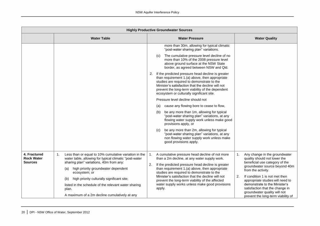
(c) The cumulative pressure level decline of no more than 10% of the 2008 pressure level above ground surface at the NSW State border, as agreed between NSW and Qld.
2. If the predicted pressure head decline is greater than requirement 1.(a). above, then appropriate studies are required to demonstrate to the Minister’s satisfaction that the decline will not prevent the long-term viability of the dependent ecosystem or culturally significant site.
Pressure level decline should not
(a) cause any flowing bore to cease to flow,
(b) be any more than 1m, allowing for typical “post-water sharing plan” variations, at any flowing water supply work unless make good provisions apply, or
(c) be any more than 2m, allowing for typical “post-water sharing plan” variations, at any non flowing water supply work unless make good provisions apply.
3.2 Great Artesian Basin
Surat Groundwater Source and Warrego Groundwater Source and Central Groundwater Source
Not applicable 1. (a) Less than 0.2m cumulative variation in the groundwater pressure, allowing for typical climatic “post-water sharing plan” variations, 40m from any:
(i) high priority groundwater dependent ecosystem; or
(ii) high priority culturally significant site;
listed in the schedule of the relevant water sharing plan.
(b) A cumulative pressure level decline of not
NSW Aquifer Interference Policy
20 | DPI - NSW Office of Water, September 2012
Highly Productive Groundwater Sources
Water Table Water Pressure Water Quality
more than 30m, allowing for typical climatic “post-water sharing plan” variations.
(c) The cumulative pressure level decline of no more than 10% of the 2008 pressure level above ground surface at the NSW State border, as agreed between NSW and Qld.
2. If the predicted pressure head decline is greater than requirement 1.(a) above, then appropriate studies are required to demonstrate to the Minister’s satisfaction that the decline will not prevent the long-term viability of the dependent ecosystem or culturally significant site.
Pressure level decline should not
(a) cause any flowing bore to cease to flow,
(b) be any more than 1m, allowing for typical “post-water sharing plan” variations, at any flowing water supply work unless make good provisions apply, or
(c) be any more than 2m, allowing for typical “post-water sharing plan” variations, at any non flowing water supply work unless make good provisions apply.
4. Fractured Rock Water Sources
1. Less than or equal to 10% cumulative variation in the water table, allowing for typical climatic “post-water sharing plan” variations, 40m from any:
(a) high priority groundwater dependent ecosystem; or
(b) high priority culturally significant site;
listed in the schedule of the relevant water sharing plan.
A maximum of a 2m decline cumulatively at any
1. A cumulative pressure head decline of not more than a 2m decline, at any water supply work.
2. If the predicted pressure head decline is greater than requirement 1.(a) above, then appropriate studies are required to demonstrate to the Minister’s satisfaction that the decline will not prevent the long-term viability of the affected water supply works unless make good provisions apply.
1. Any change in the groundwater quality should not lower the beneficial use category of the groundwater source beyond 40m from the activity.
2. If condition 1 is not met then appropriate studies
will need to
demonstrate to the Minister’s satisfaction that the change in groundwater quality will not prevent the long-term viability of
NSW Aquifer Interference Policy
21 | DPI - NSW Office of Water, September 2012
Highly Productive Groundwater Sources
Water Table Water Pressure Water Quality
water supply work.
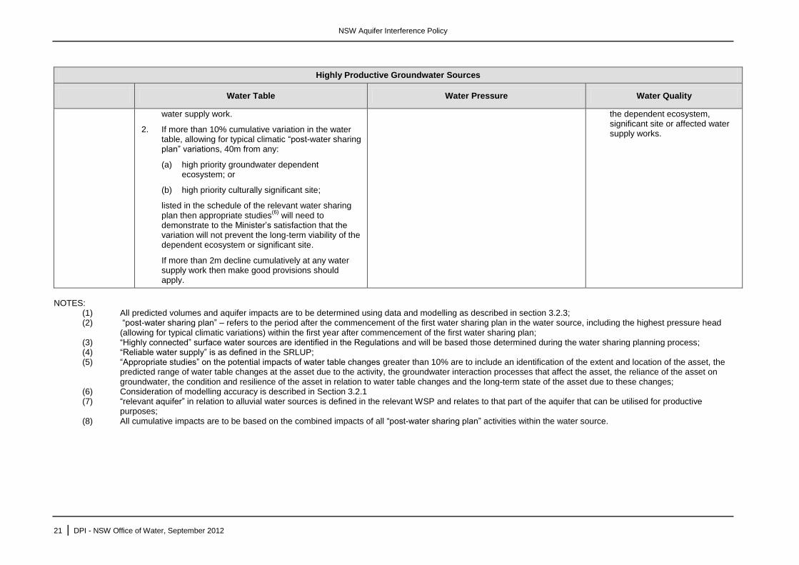
2. If more than 10% cumulative variation in the water table, allowing for typical climatic “post-water sharing plan” variations, 40m from any:
(a) high priority groundwater dependent ecosystem; or
(b) high priority culturally significant site;
listed in the schedule of the relevant water sharing plan then appropriate studies
(6) will need to
demonstrate to the Minister’s satisfaction that the variation will not prevent the long-term viability of the dependent ecosystem or significant site.
If more than 2m decline cumulatively at any water supply work then make good provisions should apply.
the dependent ecosystem, significant site or affected water supply works.
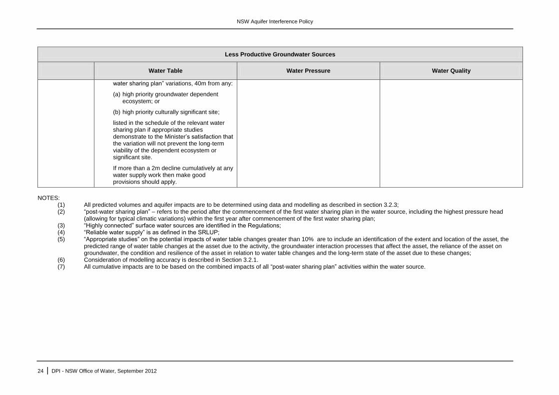
NOTES:
(1) All predicted volumes and aquifer impacts are to be determined using data and modelling as described in section 3.2.3; (2) “post-water sharing plan” – refers to the period after the commencement of the first water sharing plan in the water source, including the highest pressure head
(allowing for typical climatic variations) within the first year after commencement of the first water sharing plan; (3) “Highly connected” surface water sources are identified in the Regulations and will be based those determined during the water sharing planning process; (4) “Reliable water supply” is as defined in the SRLUP; (5) “Appropriate studies” on the potential impacts of water table changes greater than 10% are to include an identification of the extent and location of the asset, the
predicted range of water table changes at the asset due to the activity, the groundwater interaction processes that affect the asset, the reliance of the asset on groundwater, the condition and resilience of the asset in relation to water table changes and the long-term state of the asset due to these changes;
(6) Consideration of modelling accuracy is described in Section 3.2.1 (7) “relevant aquifer” in relation to alluvial water sources is defined in the relevant WSP and relates to that part of the aquifer that can be utilised for productive
purposes; (8) All cumulative impacts are to be based on the combined impacts of all “post-water sharing plan” activities within the water source.
NSW Aquifer Interference Policy
22 | DPI - NSW Office of Water, September 2012
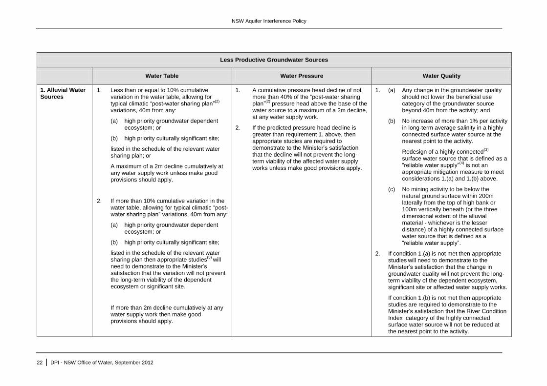
Less Productive Groundwater Sources
Water Table Water Pressure Water Quality
1. Alluvial Water Sources
1. Less than or equal to 10% cumulative variation in the water table, allowing for typical climatic “post-water sharing plan”
(2)
variations, 40m from any:
(a) high priority groundwater dependent ecosystem; or
(b) high priority culturally significant site;
listed in the schedule of the relevant water sharing plan; or
A maximum of a 2m decline cumulatively at any water supply work unless make good provisions should apply.
2. If more than 10% cumulative variation in the water table, allowing for typical climatic “post-water sharing plan” variations, 40m from any:
(a) high priority groundwater dependent ecosystem; or
(b) high priority culturally significant site;
listed in the schedule of the relevant water sharing plan then appropriate studies
(5) will
need to demonstrate to the Minister’s satisfaction that the variation will not prevent the long-term viability of the dependent ecosystem or significant site.
If more than 2m decline cumulatively at any water supply work then make good provisions should apply.
1. A cumulative pressure head decline of not more than 40% of the “post-water sharing plan”
(2) pressure head above the base of the
water source to a maximum of a 2m decline, at any water supply work.
2. If the predicted pressure head decline is greater than requirement 1. above, then appropriate studies are required to demonstrate to the Minister’s satisfaction that the decline will not prevent the long-term viability of the affected water supply works unless make good provisions apply.
1. (a) Any change in the groundwater quality should not lower the beneficial use category of the groundwater source beyond 40m from the activity; and
(b) No increase of more than 1% per activity in long-term average salinity in a highly connected surface water source at the nearest point to the activity.
Redesign of a highly connected(3)
surface water source that is defined as a “reliable water supply”
(4) is not an
appropriate mitigation measure to meet considerations 1.(a) and 1.(b) above.
(c) No mining activity to be below the natural ground surface within 200m laterally from the top of high bank or 100m vertically beneath (or the three dimensional extent of the alluvial material - whichever is the lesser distance) of a highly connected surface water source that is defined as a “reliable water supply”.
2. If condition 1.(a) is not met then appropriate studies
will need to demonstrate to the
Minister’s satisfaction that the change in groundwater quality will not prevent the long-term viability of the dependent ecosystem, significant site or affected water supply works.
If condition 1.(b) is not met then appropriate studies are required to demonstrate to the Minister’s satisfaction that the River Condition Index category of the highly connected surface water source will not be reduced at the nearest point to the activity.
NSW Aquifer Interference Policy
23 | DPI - NSW Office of Water, September 2012
Less Productive Groundwater Sources
Water Table Water Pressure Water Quality
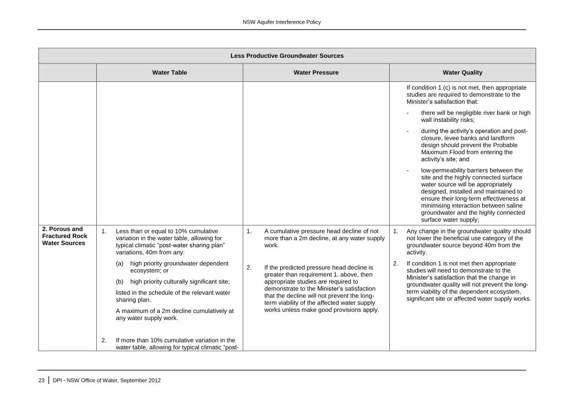
If condition 1.(c) is not met, then appropriate studies are required to demonstrate to the Minister’s satisfaction that:
- there will be negligible river bank or high wall instability risks;
- during the activity’s operation and post-closure, levee banks and landform design should prevent the Probable Maximum Flood from entering the activity’s site; and
- low-permeability barriers between the site and the highly connected surface water source will be appropriately designed, installed and maintained to ensure their long-term effectiveness at minimising interaction between saline groundwater and the highly connected surface water supply;
2. Porous and Fractured Rock Water Sources
1. Less than or equal to 10% cumulative variation in the water table, allowing for typical climatic “post-water sharing plan” variations, 40m from any:
(a) high priority groundwater dependent ecosystem; or
(b) high priority culturally significant site;
listed in the schedule of the relevant water sharing plan.
A maximum of a 2m decline cumulatively at any water supply work.
2. If more than 10% cumulative variation in the water table, allowing for typical climatic “post-
1. A cumulative pressure head decline of not more than a 2m decline, at any water supply work.
2. If the predicted pressure head decline is greater than requirement 1. above, then appropriate studies are required to demonstrate to the Minister’s satisfaction that the decline will not prevent the long-term viability of the affected water supply works unless make good provisions apply.
1. Any change in the groundwater quality should not lower the beneficial use category of the groundwater source beyond 40m from the activity.
2. If condition 1 is not met then appropriate studies
will need to demonstrate to the
Minister’s satisfaction that the change in groundwater quality will not prevent the long-term viability of the dependent ecosystem, significant site or affected water supply works.
NSW Aquifer Interference Policy
24 | DPI - NSW Office of Water, September 2012
Less Productive Groundwater Sources
Water Table Water Pressure Water Quality
water sharing plan” variations, 40m from any:
(a) high priority groundwater dependent ecosystem; or
(b) high priority culturally significant site;
listed in the schedule of the relevant water sharing plan if appropriate studies demonstrate to the Minister’s satisfaction that the variation will not prevent the long-term viability of the dependent ecosystem or significant site.
If more than a 2m decline cumulatively at any water supply work then make good provisions should apply.
NOTES:
(1) All predicted volumes and aquifer impacts are to be determined using data and modelling as described in section 3.2.3; (2) “post-water sharing plan” – refers to the period after the commencement of the first water sharing plan in the water source, including the highest pressure head
(allowing for typical climatic variations) within the first year after commencement of the first water sharing plan; (3) “Highly connected” surface water sources are identified in the Regulations; (4) “Reliable water supply” is as defined in the SRLUP; (5) “Appropriate studies” on the potential impacts of water table changes greater than 10% are to include an identification of the extent and location of the asset, the
predicted range of water table changes at the asset due to the activity, the groundwater interaction processes that affect the asset, the reliance of the asset on groundwater, the condition and resilience of the asset in relation to water table changes and the long-term state of the asset due to these changes;
(6) Consideration of modelling accuracy is described in Section 3.2.1. (7) All cumulative impacts are to be based on the combined impacts of all “post-water sharing plan” activities within the water source.
NSW Aquifer Interference Policy
25 | DPI - NSW Office of Water, September 2012
3.2.2 Additional considerations
In addition to the considerations specified in section 3.2.1 any advice provided to a gateway
panel, the Planning and Assessment Commission or the Minister for Planning on a State
significant development or State significant infrastructure will also consider the potential for:
acidity issues to arise, for example exposure of acid sulphate soils;
waterlogging or water table rise to occur, which could potentially affect land use,
groundwater dependent ecosystems and other aquifer interference activities.
Specific limits will be determined on a case-by-case basis, depending on the
sensitivity of the surrounding land and groundwater dependent ecosystems to
waterlogging and other aquifer interference activities to water intrusion.
In the case of petroleum exploration and production (including coal seam gas) activities the
Minister will also consider and provide advice on:
whether the design, construction and operation of a bore is likely to modify the
existing hydraulic connection between aquifers. The Minister’s advice will consider
whether bore construction is likely to cause or enhance hydraulic connection between
aquifers, based on a consideration of whether the “Code of Practice for Coal Seam
Gas Well Integrity” will be complied with;
whether hydraulic fracturing activities is likely to modify the existing hydraulic
connection between aquifers. The Minister’s advice will consider whether hydraulic
fracturing activities are likely to cause or enhance hydraulic connection between
aquifers, based on a consideration of whether the “Code of Practice for Coal Seam
Gas Fracture Stimulation” will be complied with; and
the method for disposal of extracted water. In the case of petroleum production
(including coal seam gas) activities, the method for the disposal of extracted water
should not involve the use of evaporation ponds, as defined the Petroleum (Onshore)
Regulation 2007.
This issue will be primarily dealt with via a prohibition of evaporation ponds under the
Petroleum (Onshore) Regulation 2007, with the alternate method of disposal stipulated as
conditions on the development consent under the EP&A Act. Alternate disposal options
might include reinjection to an aquifer, discharge to a river, on-selling to a nearby industry,
agricultural development or potable water supply. Any adopted option will require treatment
of discharges to an appropriate water quality standard such that they would have minimal
impact on any proposed receiving waters and not affect their beneficial use category (if
applicable). Alternate disposal options will therefore need to consider any relevant water or
land pollution issues and waste disposal, including those that may be required by the
Protection of the Environment Operations Act 1997.
3.2.3 What is required from proponents?
A risk management approach to assessing the potential impacts of aquifer interference activities will be adopted, where the level of detail required to be provided by the proponent is proportional to a combination of the likelihood of impacts occurring on water sources, users and dependent ecosystems and the potential consequences of these impacts.
NSW Aquifer Interference Policy
26 | DPI - NSW Office of Water, September 2012
In addition to the volumetric water licensing considerations specified in section 2, the
proponent of an activity that may result in aquifer interference will need to provide the
following to enable the assessment of the activity against the minimal impact considerations
in Table 1 and the additional considerations in section 3.2.2:
establishment of baseline groundwater conditions including groundwater depth,
quality and flow based on sampling of all existing bores in the area potentially
affected by the activity, any existing monitoring bores and any new monitoring bores
that may be required under an authorisation issued under the Mining Act 1992 or the
Petroleum (Onshore) Act 1991; and
a strategy for complying with any water access rules applying to relevant categories
of water access licences, as specified in relevant water sharing plans. For example,
returning water of an acceptable quality to the affected water source during periods
when flows are at levels below which water users are not permitted to pump;
details of potential water level, quality or pressure drawdown impacts on nearby
water users who are exercising their right to take water under a basic landholder
right. Consideration will need to be given to any relevant distance restriction
requirements that may be specified in any relevant water sharing plan or any
remediation measures to address these impacts;
details of potential water level, quality or pressure drawdown impacts on nearby
licensed water users in connected groundwater and surface water sources;
details of potential water level, quality or pressure drawdown impacts on
groundwater dependent ecosystems;
details of potential for increased saline or contaminated water inflows to aquifers
and highly connected river systems;
details of the potential to cause or enhance hydraulic connection between aquifers;
details of the potential for river bank instability, or high wall instability or failure to
occur;
details of the method for disposing of extracted water (in the case of coal seam gas
activities);
If a project is approved, then the conditions of approval should include the following:
details of an effective and independently assessed (by the Minister)
groundwater/surface water level/pressure, flow and quality monitoring program
through all phases of the activity;
details of appropriate water measurement devices, regimes or methods such as
water meters or other water measurement methods to measure actual take resulting
from the activity;
details of appropriate reporting procedures including timely notification systems for
reporting the results of monitoring and metering programs against the licensing and
approval requirements specified by this Policy; and
NSW Aquifer Interference Policy
27 | DPI - NSW Office of Water, September 2012
details of contingency plans or remedial measures to be employed where it is found
that take by or impacts from the activity are outside of the licensing and approval
requirements specified by this Policy.
Proponents of any project that may be defined as an aquifer interference activity under the
Water Management Act 2000 will also be required to provide estimates of all quantities of
water that are likely to be taken from any water source during and following cessation of the
activity and all predicted impacts associated with the activity, based on the following
minimum requirements:
if the Gateway process applies, estimated based on a simple modelling platform that
is:
o developed using the available baseline data that has been collected at
an appropriate frequency and scale; and
o determined to be fit-for-purpose to the satisfaction of the Minister; and
if a development consent under Part 4, Division 4.1 of the EP&A Act applies or for
any mining or CSG production activity not subject to the Gateway, estimated based
on complex modelling platform that is:
o calibrated and validated (where practical) to the available baseline data
that has been collected at an appropriate frequency and scale and over
a sufficient period of time to incorporate typical temporal variations. In
instances where an activity has a high likelihood of causing more than
minimal harm to a “reliable water supply”, at least 2 years of baseline
data is required; and
o consistent with the Australian Groundwater Modelling Guidelines; and
o independently reviewed and determined to be robust and reliable, and
deemed fit-for-purpose to the satisfaction of the Minister; and
in all other processes, estimated based on a desk-top analysis that is:
o developed using the available baseline data that has been collected at
an appropriate frequency and scale; and
o determined to be fit-for-purpose to the satisfaction of the Minister.
if a development consent under Part 4, Division 4.1 or Part 5.1 of the EP&A Act has
been granted or for any approved mining or CSG production activity that was not
subject to the Gateway, the NSW Office of Water will recommend that a condition of
approval require that the maximum of the predicted annual water quantities are to
be licensed from the commencement of the activity regardless of when water will
actually commence to be taken. This is required to eliminate any risk of there being
insufficient market depth from which to obtain the necessary water entitlements at
any point in time in the future. The proponent should therefore demonstrate during
the planning assessment process that these licences can be acquired if
development consent is granted;
NSW Aquifer Interference Policy
28 | DPI - NSW Office of Water, September 2012
Proponents of aquifer interference activities should contact the NSW Office of Water to
obtain relevant information and assistance.
3.3 Defined minimal impact aquifer interference activities
There are a number of activities that are considered as having a minimal impact on water-
dependent assets, these include:
grey water re-use on gardens;
sampling and coring using hand held equipment;
trenching and costeaning;
access tracks;
building and work pads;
shallow pit toilets;
monitoring bores and wells that are:
o required by an order, or approved voluntary management proposal, under Part
3 of the Contaminated Land Management Act 1997, or
o required by a development consent under Part 4 or an approval under Part 5.1,
of the Environmental Planning and Assessment Act 1979, or required or
undertaken as a result of an environmental assessment under Part 5 of that Act,
or
o required by a condition of an environment protection licence under the
Protection of the Environment Operations Act 1997; or
o required under the Protection of the Environment Operations (Underground
Petroleum Storage Systems) Regulation 2008; or
o constructed and operated by the Ministerial Corporation; and
constructed and decommissioned in accordance with standards equivalent to the
Minimum Construction Requirements for Water Bores in Australia and that all bore
construction, geology - location, driller and company details, depth, drilling method,
diameter, geology, water bearing zones, water entry design, backfilling, casing/liner
info, gravel pack, disinfection, development details, pump test details, water levels,
and water quality information be recorded and provided on request from the NSW
Office of Water.
leachate ponds and sumps if constructed, operated and abandoned in accordance
with appropriate standards and guidelines as determined by the Minister;
septic tanks, associated trenches and pit toilets if constructed, operated and abandoned in accordance with the “Environment and Health Protection Guidelines: On-Site Sewage Management for Single Households” (January 1998 – prepared
NSW Aquifer Interference Policy
29 | DPI - NSW Office of Water, September 2012
jointly by NSW EPA; NSW Health; Dept of Local Govt; DLWC; and Dept of Urban Affairs and Planning) as may be updated from time to time;
sewage holding ponds if lined with an impervious layer and otherwise constructed,
operated and decommissioned in accordance with the requirements of the NSW
State Groundwater Quality Protection Policy;
construction and on-going use of waste liquid/effluent storage and irrigation reuse
schemes providing these are carried out in accordance with their planning and other
approvals;
construction and on going use of tailings and ash dams if lined with an impervious
layer providing these are carried out in accordance with their planning and other
approvals; and
construction and on-going use of aquaculture ponds if lined with an impervious layer
providing these are carried out in accordance with their planning and other
approvals.
Core holes, stratigraphic (chip) holes, geo-environmental and geotechnical bores,
works or activities (the latter as listed in AS 1726) intersecting the water table if they
are decommissioned in such a way as to restore aquifer isolation to that which
existed prior to the construction of the bore, work or activity and that the
decommissioning is conducted within a period of 28 days following completion of the
bore, work or activity;
caverns, tunnels, cuttings, trenches and pipelines (intersecting the water table) if a
water access licence is not required;
underground storage tanks if constructed, maintained and monitored to appropriate
standards and guidelines as determined by the Minister, which would be required to
be lined with an impervious layer to ensure there is no ongoing take of water; and
construction and on-going use of maturation and holding or storage ponds if lined
with an impervious layer, subject to the requirements of section 3.2.2 in relation to
water extracted as part of petroleum production (including coal seam gas) activities.
The impacts of an exploration activity on surface and ground water will be assessed under Part 5 of the Environmental Planning and Assessment Act 1979. In order to assess environmental impacts of an exploration activity under the Mining Act 1992 or the Petroleum (Onshore) Act 1991, the Division of Resources and Energy of the Department of Trade, Investment, Regional Infrastructure and Service (DTIRIS) may require the applicant to prepare a Review of Environmental Factors (REF). An REF is a document that provides a description of the proposed activity, an overview of the likely environmental impacts of the exploration activity, including impacts on surface and ground water, and proposed mitigation measures. Further information on REFs is contained in the Environmental Impact Assessment Guidelines published by the Division of Resources and Energy of DTIRIS.
NSW Aquifer Interference Policy
30 | DPI - NSW Office of Water, September 2012
4. Security deposits and penalties
A security deposit is a bank guarantee or sum of money held by the Government to cover the costs of remediation works for unforseen impacts or ongoing post-closure activities. The effect of security deposits is to assign the risk of unforseen and ongoing impacts to the proponent of the aquifer interference activity and not other water users or the environment.
In providing advice to the Minister for Planning or the Planning Assessment Commission, the Minister may recommend that a security deposit be held relating to the potential water issues.
The actual amount calculated to be deposited will reflect the level of risk to the aquifer or its dependent ecosystems from the proposed activity. This amount will be determined on a case by case basis.
It is important that proponents perform all of their obligations under their water licences and relevant approvals. A security deposit or appropriate insurance policy may be required as a condition of a planning approval to provide for the cost of performing the proponent’s obligations in the event that they fail to perform those obligations.
Independent of security deposit requirements, surrendering of water access licences is a ‘make good’ provision which may account for ongoing post-closure take of water, provided water management costs and the net present value of any charges associated with this ongoing take of water and the surrendered licences are met.
There are tier 1 and 2 offences in the Water Management Act 2000 - for example, under s.60A for taking water without an access licence, under s.60B for contravening any term or condition of a licence, and under s.60C for not holding sufficient water allocations (volume).
NSW Aquifer Interference Policy
31 | DPI - NSW Office of Water, September 2012
5. Glossary
A number of the terms used in this Policy are defined in the Water Act 1912 or Water
Management Act 2000. Additional terms used in this Policy are defined below.
Aquifer interference activity – is defined in the dictionary of the Water Management Act
2000.
Coal seam gas – The gas, usually methane, contained within coal beds or shale strata.
Costeaning – is the digging of a trench or pit cut across the conjectured line of outcrop of a
seam or ore body to expose the full width.
Dewatering – Removal of water from an aquifer as part of the construction phase of a
development or part of ongoing mining activities to maintain access, serviceability and/or
safe operating conditions.
Evaporation pond – as defined in the Petroleum (Onshore) Regulation 2007.
Highwall – The unexcavated face of exposed overburden and coal or ore in an opencast
mine or the face or bank of the uphill side of a contour strip-mine excavation.
Hydraulic connection - A path or conduit allowing fluids to be connected. The degree to
which a groundwater system can respond hydraulically to changes in hydraulic head.
Hydraulic fracturing – Also known as ‘fracking’, is the process of initiating and propagating
fractures in rocks by injecting a fluid (typically water), proppant (typically sand) and chemicals
under high pressure.
Incidental water – Water that is taken by an aquifer interference activity that is incidental to
the activity; including water that is encountered within and extracted from mine workings,
tunnels, basements or other aquifer interference structures that must be dewatered to
maintain access, serviceability and/or safe operating conditions. This water is not actually
required to be used as part of the process of carrying out that activity,